environmental impact assessment - world bank · 2.2 selection of forest types and tree species ......
TRANSCRIPT

World Bank Loan Project
Environmental Impact Assessment
for
Shandong Ecological Afforestation Project
(SEAP)
EIA Agency: Shandong Academy of Environmental Science July 2009·Jinan
E2221 v1P
ublic
Dis
clos
ure
Aut
horiz
edP
ublic
Dis
clos
ure
Aut
horiz
edP
ublic
Dis
clos
ure
Aut
horiz
edP
ublic
Dis
clos
ure
Aut
horiz
edP
ublic
Dis
clos
ure
Aut
horiz
edP
ublic
Dis
clos
ure
Aut
horiz
edP
ublic
Dis
clos
ure
Aut
horiz
edP
ublic
Dis
clos
ure
Aut
horiz
ed

2
CONTENTS PREFACE ············································································· 1
CHAPTER1. INTRODUCTIOIN ·················································· 3
1.1 BACKGROUND……………………………………………………………………………………3
1.2 COMPLIANCE WITH RELEVANT POLICIES ·························································· 4
1.3 ASSESSMENT SCOPE AND FACTOR ··································································· 6
1.4 FOCUS OF ASSESSMENT ·················································································· 8
1.5 RELEVANT POLICIES AND REGULATIONS ·························································· 8
1.6 EVALUATION CRITERION ··············································································· 10
1.7 EIA EXPERTS TEAM....................................................................................................................10
CHAPTER 2 PROJECT DESCRIPTION ······································· 11
2.1 PROJECT INFORMATION ················································································· 11
2.2 SELECTION OF FOREST TYPES AND TREE SPECIES ············································· 13
2.3 AFFORESTATION MODELS ·············································································· 14
2.4 PLANTING TECHNOLOGIES ············································································· 15
2.5 PROJECT COST AND FINANCING ······································································ 17
2.6 PROJECT CONSTRUCTION PERIOD AND YEALY PROGRESS ································· 17
2.7 TRAINING AND TECHNOLOGY PROMOTION ······················································ 17
CHAPTER 3 BASELINE NATURAL AND SOCIAL ENVIRONMENTS 19
3.1 NATURAL CONDITIONS ·················································································· 19
3.2 ECOLOGICAL STATUS AND ASSESSMENT………………………………………………….36
3.3 SOCIAL CONDITIONS ······················································································ 44
CHAPTER 4 PUBLIC CONSULTATION. ····································· 45
4.1 TECHNICAL APPROACH AND CONTENT OF PUBLIC PARTICIPATION ···················· 45
4.2 INVESTIGATION RESULTS OF PUBLIC PARTICIPATION. ······································ 49
4.3 INVESTIGATION CONCLUSION OF PUBLIC PARTICIPATION ································· 51
4.4 PUBLIC SUGGESTIONS ···················································································· 51

3
CHAPTER 5 ENVIRONMENTAL IMPACT ANALYSIS. ·················· 52
5.1 NEGATIVE IMPACTS ······················································································· 52
5.2 POSITIVE IMPACTS ························································································· 54
5.3 ASSESSMENT OF THE IMPACT ON SOCIAL AND ECONOMIC ENVIRONMENT · 60
CHAPTER 6 ALTERNATIVE ANALYSIS ···································· 62
6.1 GENERAL INTRODUCTION ·············································································· 62
6.2 ANALYSIS ON IMPACT OF PROJECT AND NON-PROJECT ····································· 62
6.3 ANALYSIS ON PROJECT IMPLEMENTATION DESIGN ··········································· 63
CHAPTER 7 ENVIRONMENTAL MANAGEMENT AND MONITORING
PLAN ················································································· 67
7.1 ENVIRONMENTAL MANAGEMENT OF WB FOREST PROJECTS IN SHANDONG PROVINCE
························································································································ 67
7.2 RESPONSIBLE UNIT AND DUTY FOR THE ENVIRONMENTAL MANAGEMENT ········· 68
7.3 COUNTER MEASURES ····················································································· 70
7.4 ENVIRONMENTAL MONITORING PLAN ····························································· 76
7.5 ENVIRONMENTAL TRAINING/REGULATION ENFORCEMENT PLAN ······················ 80
CHAPTER 8 CONCLUSIONS ··················································· 83
8.1 PROJECT INTRRDUCTION. ··············································································· 83
8.2 COMPLIANCE WITH RELEVANT POLICIES ························································· 83
8.3 Baseline of NATURAL AND SOCIAL ENVIRONM ··················································· 83
8.4 PUBLIC PARTICIPATION ·················································································· 84
8.5 ENVIRONMENTAL IMPACT ANALYSIS ······························································ 84
8.6 ALTERNATIVE ANALYSIS ··············································································· 84
8.7 ENVIRONMENTAL MANAGEMENT AND MONITORING PLAN ······························· 84
8.8 GENERAL CONCLUSIONS ················································································ 84

Preface Shandong Province is one of the ten coastal provinces in China, lying in the lower reache of
the Yellow River. Shandong Province is located between longitude 114°19'53″ and 112°43'
(a range of 8°23′07″) east and latitude 34°22'52″and 38°15' 02″ (a range of 3°52′10″)
north (with some islands reach to 38°23'). It is 700km long from east to west, and 420km
wide from north to south. 139 counties/cities/districts of 17 prefectures are affiliated to
Shandong Province.Shandong is mostly flat in terrain. The northwestern and western parts of
the province are all part of the vast North China Plain. The center of the province is more
mountainous. The east of the province is the hilly Shandong Peninsula extending into the sea.
Shandong's topography is complicated and interwoven with nine types of landform,
including plains, basins, hills, terraces, deltas and mountains. Plains and mountainous area
account for 55% and 15.5% of the province's territory, while hilly areas are 13.2%, lowlying
areas are 4.1%, lake areas are 4.4% and other areas are 7.8% of the province's territory.
The total forest area in Shandong Province is 2.93 million hm2 and the timber storage
volume is 82 million m3, forest coverage percentage is only 13.44%, ranking low among the
China‟s provinces. According to the statistics data of 6th national forest resources survey,
only less than one third of 82,384km2 water & soil conservation area is covered by forests.
Due to the low forest coverage and fragile ecological environment, the natural disasters, such
as soil erosion, drought, desertification and flooding are frequent problems in Shandong
Province, which not only leads to low agricultural productivity, affecting living conditions of
local people and but also degrades the qualities of nature resources. Shandong government
has invested a lot on planting trees and afforestation to improve the status of forest resources
to some extent. However, these new forests are mainly high-yielding forest plantations
planted on lands with better soil condition. Recent years, people are paying more attention
on environment. Thus the main task for forestry has transferred to construct public welfare
forest in the land areas with low productivity and put sustainable development as the focus
of future efforts. In compliance with the government planning, the proposed project will
construct lots of regional ecological forests in Shandong Province to improve local
ecological environment and provide more public service to the society
This project involves 30 counties of 9 prefectures, i.e.Weifang City, Taian City, Jining City,

2
Weihai City, Rizhao City, Laiwu City, Dongying City, Binzhou City and Linyi City. The
proposed project will construct ecological afforestation covering a total area of 65972.6hm2,
including re-vegetating of 38343.5 hm2 degraded mountainous areas, accounting for 58.1%
of the whole project; and stabilizing 27629.1m2 saline coastal areas, 41.9% of the whole
project. The implementation period for this project is 6 years.
In terms of < THE LAW ON ENVIRONMENTAL IMPACT ASSESMENT OF THE
PEOPLE'S REPUBLIC OF CHINA> and World Bank requirements, EIA for Shandong
ecological afforestation project (SEAP) is categorized as B. Shandong PMO consigns
Shandong Academy of Environmental Science (SAES) to conduct EIA report for the project.
SAES started the work in accordance with relevant EIA requirements and prepared a draft
working plan. On a basis of the on-site visit and investigation, SAES completes this EIA
report for SEAP.
During the preparation of the EIA report, sincerely thanks would go to xperts and officials of
relevant authorities for the great supports and assistance.

3
Chapter 1 Project introduction
1.1 Background Forestry in Shandong is transforming from conventional forestry to modern forestry, and
intensively managed forest plantation focusing on the timber production is steadily replaced
by the protection forests. Ecological and green Shandong Province is undergoing and
stepping into a key stage.
According to statistics of the 6th forest resources survey in 2002, it is shown the percentage
of forest cover is only 13.44%, ranking 22nd among China‟s provinces. And the areas and
stock volume of forest in Shandong Province rank 24th and 26th respectively in China. Forest
coverage per capita is 0.023 hm2 in Shandong Province, only 17.31% of the national average
level of 0.13hm2, and 3.5% of the world average level at 0.644hm2. Based on the
investigation of barren mountains in 2008, 3,750,000 Mu1 mountains are not yet planted.
Stock volume is low and is unevenly distributed in the province, and environmental
conditions is fragile.
With the open policy in forestry sector, forest resources and quality have been much
improved since 1990s. The development of forestry in Shandong Province has not only
increasde the timber supply, brought income for local farmers, but also improved local
environmental conditions and brought significant social and environmental effects.The
previous World Bank projects implemented in Shandong Province are welcomed by local
people and has received positive comments from the World Bank as well as the related
national authorities.
In order to further develop forest resources, optimize forestry ecological structure, improve
forest qualities, and promote the construction of Eco-Shandong Province, Shandong
government submitted the project proposal (document number: SDRC [2006]185) of
Shandong Forestry Sustainable Development Project to National Development and Reform
Committee (NDRC), applying for World Bank loan. Later, Shandong Forestry Bureau
completed the project design document according to „Temparory Measures for the
Administration of the Reserve Funds for Repaying the Loans Granted by International
Financial Organizations and Foreign Governments „ (Decree No. 28, 2005). In 2007, the
1 Chinese measurement unit for area, 1 ha = 15 mu.

4
project was listed as the candidate proejects during 2008~2010 financial year by NDRC.
Based on the current conditions of forestry in Shandong, 30 project counties/cities/districts
of 9 project prefectures (Dongying, Weifang, Tai‟an, Weihai, Rizhao,laiwu,Binzhou and
Linyi), distributed respectively in degraded mountainous area and saline coastal area, are
identified to participate in the project.
1.2 Compliance with relevant policies 1.2.1 Compliance with the requirements of ‘Outlines of National Ecological
Environment Protection’ and ‘Guidelines of Industrial restructure’
One of the main tasks indicated in „Outlines of National Ecological Environment Protection‟
is protecting and rehabilitating ecological function, following the principals of giving
priority to environment protection, performing positive roles in rehabilitation, taking tailor
measures to suit local conditions etc, incorporating ecological rehabilitation project under
implementation or to be implemented, strengthening environmental protection of regional
ecosystem and maintaining regional ecological functions through the following measures: (1)
improving water reservation capacity; (2) rehabilitating water and soil conservation function;
(3) strengthening sand drifting function; (4) improving capacity of flood storage; (5)
increasing biodiversity and (6) protecting ocean ecological function.
The project sites involved are suffering serious water and soil erosion in Shandong Province,
with wide spreads of sensitive ecological areas. After the implementation of the proposed
project, forest area in these cities could be added by 65972.6hm2, this has significant
meanings on increasing forest resources, improving regional ecological environment to
ensure human living conditions at the project sites for local residents. This project accords
with the requirements of national ecological environment protection program.
In a conclusion, the proposed project is an ecological shelter forest afforestation project, and
belongs to the sort of “shelter forest” in the agric-forestry industry which is encouraged
according to „Prior Industrial Categories for Industrial Restructure‟ issued by NDRC in
2005.
1.2.2 Compliance with ‘General Planning of Land Use in Shandong’
In the „General Plan of Land Use in Shandong Province (1997-2010)‟, it is indicated that
5
land use by 2010 should comply with the following objectives: (i) increasing land
afforestation coverage, protection natural resources and bio-diversity, improving ecological
environment, realizing the sustainable development of natural resources step by step. (ii)
Land pollution and water and soil erosion are primarily under control, land quality is greatly
improved. By the end of 2010, water and soil erosion and polluted lands in mountainous
areas and plains are basically rehabilitated, and lands are used rationally.
The overall targets of this project is developing ecological shelter forests in scales in fragile
ecological regions and increasing forestry resources to increase water and soil conservation
capacity and improve ecological environment through developing afforestation models and
corresponding techniques. The implementation of the project is in compliance with the
requirements of „Overall Land Use Planning of Shandong Province (1997-2010)‟.
1.2.3 Compliance with ‘Decisions on accelerating forestry development and building up
a green Shandong Province’
Afforesting national trerritory is a basis policy of People‟s Republic of China, People‟s
Government of Shandong Province also invest a lot to promote afforestation in Shandong.
Especially in recent years, with the rapid economic growth, Shandong government
established series of policies on promoting ecological environment and building up a green
Shandong Province through planting trees and afforestation to improve environment
conditions and achieve sustainable development. In the document of „Decisions on
accelerating forestry development and building up a green Shandong Province‟, it is
indicated that by the end of 2010, the forest cover percentage should reach step by step,
cropland with 25° degree slope and ecologically fragile ares should be converted into
forestlands. The standing committee of Shandong People‟s congress has approved „Planning
on Ecological Shandong Construction „ in Sept 2003. The indicators like forest coverage in
mountainous areas, re-vegetation rate of degraded land and biodiversity ratio are stated in the
planning.
Forestry is the main part of terrestrial ecosystem as priority in ecosystem construction. The
status of ecological construction in proposed projects site is the same as other places in
Shandong Province and around China. The task of ecological construction is tough because
forest resources, especially ecological shelter forest are of low quantities, uneven distribution,
low qualities, low forest coverage and inferior ecological benefits. Large-scale bald
mountainous areas, terraces and croplands need to be afforested, which is far from the

6
requirements of constructing eco-province and green Shandong as well as water
conservation.
The objectives of proposed project financed by World Bank is to improve Shandong
ecological environment by adopting advanced afforestation technologies and afforestation
models in selected fragile areas of 30 proejct counties of 9 project cities, and by planting a
range of trees, shrubs and herbs species, covering an area of 65972.6 hm2. Such afforestation
would help to improve ecological environment in Shandong Province, stabilize ecology
system functions and develop a sustainable model for forestry industry to accelerate the
progress of Shandong eco-province construction program.
1.3 Assessment scope and factors 1.3.1 Assessment scopes
According to the principles to define assessment scope in „Technical Guidance on
Environmental Impact Assessment for Afforestation Project‟ and the geographical type of
project site, the assessment scope is as follows.
① The EIA range for mountainous areas involve an extended area of 200m at upper
reaches and 1000m at lower reaches at a vertical boundary of hillsides where the project
locates.
② The EIA range for plain areas involves an extended area of 200m to 300m out of the
boundary of project sites.
③ The EIA range for mountainous should extend to involve the downstream sensitive
objectives in the project areas.
④ The EIA range for afforestation project locations at downwind direction should be
extended on some extent.
1.3.2 Assessment factors
According to the afforestation process, the project EIA factors can be related to tree species,
planting density, land preparation, cultivation, fertilizer and pesticide etc. The factors will be
defined according to the relevance on surrounding circumstance caused by the processes
mentioned above. The natural circumstances factors refer to saline area stabilization, soil and
water erosion, diseases and insect, floor vegetation. Table 1.3-1 shows the relevance of each
EIA factors.
Table 1.3-1 Identification of assessment factors for Environmental impact analysis

7
Afforestation steps
Saline area stabilization
Water
resource
protection
Soil & water
erosion
Air
purifi
cation
Disease and insect
Ground vegetation
Reaginal
micro-climate
Landscape
pattern
Economy
and society
Tree species +2 +2 +3 +2 +2 +3 +2 +2 +2 Planting density —— +2 -2 +1 +2 —— -1 -1 Land
preparation -1 —— -2 -2 —— -2 —— -2 -2
Tending —— —— —— +2 +2 —— +2 +1 +2
Afforestation -1 +2 -2 +1 —— -1 —— +1 +1 Fertilizer +2 -1 —— -1 —— —— —— —— +2 Pesticides spraying
—— -1 —— -1 +3 —— —— —— +2
Notes:1 =Slight impact. 2 = Moderate impact. 3 = Significant impact.
“-”= Negative impact “+”= Positive impact During the project period, factors selected for anaylsis are as follows: aline areas
improvement, water resource protection, water & soil erosion, air purification, pest and
diseases, regional micro-climate, landscape patterns and economic and social impact etc.
1.4 Assessment key points The key points of the EIA work is selected on a basis of the project impacts on ecological
environment, combined the regional characteristics of sub-project locations and selected
assessment factors. During the construction period, the project will lay emphasis on
preventing and mitigating the water and soil erosion caused by construction works,
protecting natural vegetation, undergrowth plants, keeping soil fertility balance inside the
project area, mitigating pollutions caused by pesticide and fertilizer application, preventing
damage by disease and insect. During operating period, the work emphasis should covert to
stabilizing integrity of regional ecosystem and identification of effective measures on
rehabilitation of coastal saline areas, treating water and soil erosion
1.5 Relevant documentation Environmental impact assessment for this project is carried out in terms of relevant laws and
regulations of China on EIA and technical requirement of the Bank, the following documents
are applied to implement the EIA work:
1.5.1 Laws, regulations and specifications at national and provincial level
(1) Environmental Protection Law of the People‟s Republic of China

8
(2) Forest Law of the People‟s Republic of China
(3) Law of the People‟s Republic of China on the Protection of Wild Animals
(4) Water Law of the People's Republic of China
(5) Pollution Prevention and Control Law of the People‟s Republic of China
(6) Law of the People's Republic of China on Water and Soil Conservation
(7) Law of the people‟s republic of China on environmental impact assessment
(8) Regulations of the People‟s Republic of China on Nature Reserves
(9)Regulations of the People‟s Republic of China on Wild Animals
(10) Outline of National Ecological Environment Protection
(11) Outline of 11th Five-year Plan of National Economical and Social Development
(12) Outline of Environmental Protection in Fragile Ecology Area
(13) Regulations on the Administration of Construction Project Environmental
Protection, issued by State Environmental Protection Ministry (SEPM)
(14) Decision on Implementing Scientific Concept of Development and Strengthening
Environmental Protection by the State Council
(15) Circular on the Administration on Environmental Impact Assessment of
Construction Project with International Financial Organizations Loans, Huanjianzi
[1993]324
(16)Regulations on Environmental Protection Administration Category on
Construction Projects by SEPM
(17) Regulations on Forest Pest Control, issued by State Forestry Administration (SFA)
(18) Interim Measures on the Afforestation Quality Control
(19) Technological Guidelines for Environmental Impact Assessment of Reforestation.
Projects
1.5.2 World Bank policies
(1)Operational Policy OP4.01: Environmental Assessment (Jan. 1999)
(2)Operational Policy OP4.09: Pest Management
(3)Operational Policy OP4.36: Forestry
(4)Operational Policy OP 4.11: Physical Culture Resources
(5)Bank Procedure BP 4.04: Natural Habitats
1.5.3 Technical regulations
9
(1)Technical Guidelines for Environmental Impact Assessment
(2)Technical Guidelines for Environmental Impact Assessment: Ecological
Environment of Nature Resource Development
(3)Comprehensive Control Regulations on Soil and Water Conservation
(4)Technical Regulation on Water and Soil Conservation Planning of Development and
Construction Projects
(5)World Bank Operational Policy: OP4.01 (Environmental Assessment), OP4.04
(Natural Habitats), OP4.09 (Pest Management), OP4.11 (Cultural Property), OP4.36
(Forestry) and the World Bank Policy on Disclosure of Information.
1.5.4 Relevant documentation of the project
(1) Commitment letter
(2) Feasibility Study Report of World Bank Loan Project: Shandong Ecological
Afforestation Project
(3) Aid Memoirs of Shandong Ecological Afforestation Project by World Bank
missions
1.6 Evaluation criterion (1)Standard for water and soil erosion prevention (GB50434-2008)
(2)Standard for Pesticides Safety Use (GB4285-89)
(3)Pesticides Classification recommended by World Health Organization by hazard and
guidelines to classification, 2004-01(WHO/PCS/01.4)
1.7 EIA experts team EIA team includes 2 staff, and 3 experts from Shandong Normal University, Shandong
Academy of Forestry Science and Shandong Agriculture University as project leading team,
with strong background on afforestation and ecology fields to give their expertise on the
project. The executive agency of the EIA is Shandong Academy of Environmental Science
with EIA certificate class-A [Guo Huan Ping Zheng Zi Di No. 2402]issued by SEPM.

10
Chapter 2 Project Description
2.1 Project information This project involves 9 prefectures of Weifang City, Taian City, Jining City, Weihai City,
Rizhao City, Laiwu City, Dongying City, Binzhou City and Linyi City, and , involving 30
projeect counties, 330 towns,3210 villagies, 8314 sub-compartments. The proposed project
will construct ecological afforestation covering a total area of 65972.6hm2, including
re-vegetating of 38343.4 hm2 degraded mountainous areas, accounting for 58.1% of the
whole project; and stabilizing 27629.2m2 saline coastal areas, 41.9% of the whole project.
The implementation period for this project is 6 years.
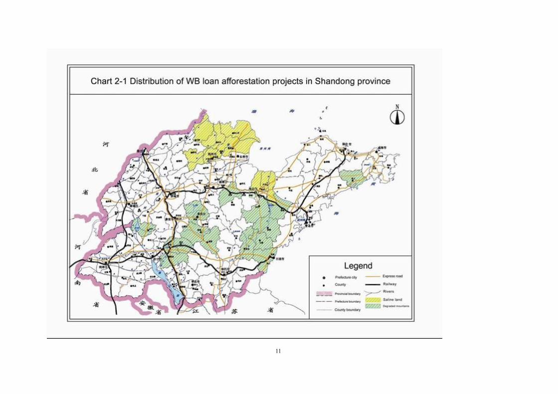
Table 2.1-1 shows the subproject contents and construction scales. The general layout of
project sites is shown in chart 2-1.
11

12
(1) Re-vegetation of degraded mountainous areas involves Weifang City, Jining City, Taian
City, Weihai City, Rizhao City, Laiwu City and Linyi City, covering an area of 38343.4 hm2
totally.
Through re-vegetation at above mentioned cities areas, the forest cover will be increased by
1.4%. This component will improve the forestry quality and management levels, together
with comprehensive treatment of water and soil erosion to mitigate deterioration of local
fragile ecosystem, improve regional environment and increasing people living conditions.
(2) Protective plantations on saline coastal areas involve Dongying City, Weifang City,
Binzhou City, covering an area of 27629.2hm2.
This component will increase forestry resources and improve forest coverage by 1.4% at
saline coastal areas through protective plantation, improve local biodiversity through
increasing plant species at this area. The protective plantation has obviously effect on
preventing desertification, salinization and improving local ecological system to maintain a
sustainable development.
Table 2.1-1 Sub-components and construction scales
Project Component Sub-projects at city and county level
Re-vegetation of Degraded Mountainous Areas Afforesting 38343.4 hm2 area, 58.1% of total project area.
Weifang City (6627.0hm2): Qizhou County, Anqiu County, Weicheng Distric, Zhucheng County, Gaomi County Jining City(): Qufu County, Zhoucheng County, Sishou County and Jiaxiang County Tai‟an City (8074.2hm2): Zulaishan Forest Farm, Xintai County, Dongping County Weihai City (3457.8hm2): Rushan County
Rizhao City (4256.7hm2): Donggang District, Lanshan District, Wulian County, Juxian County Laiwu City (2713.6hm2 ): Xueye Developing zone
Linyi City (6551.2 hm2): Mengyin County, Yishui County
Protective Plantations on Saline Coastal Areas Afforesting 27629.2 hm2, 41.9% of total project area.
Dongying City (13555.7 hm2): Lijin County, Hekou District, Kenli County Weifang City (6259.4 hm2): Hanting District, Changyi County, Gaomi County Binzhou City (9093.0 hm2): Bincheng District, Zhanghua County, Wudi County, Huimin County, and Development Zone.
2.2 Selection of forest types and tree species The protective forest should select economical trees which help to retain water and soil,
prevent wind. The forest plan should abide the following rules.
(1) Water resource retain forest: Select needle and broad leaved trees which have high body,
13
wde crown, aboundant dead wood and leaves, deep and big root, grow steadly with strong
fastness, such as locust, ailanthus altissima, chestnut, walnut tree, persimmon tree, peach
trees, apricot tree jujube trees.
(2) Water and soil conservation forest: Select needle and broad leaved trees which have
strong adaptability with big root, abundant deadwood and strong attachment, such as
arborvitae, conifer, smoke tree, honey locust, black poplar, ailanthus altissimo, melia
azedarach linn, chestnut tree, walnut tree, persimmon tree, peach trees, apricot tree jujube
trees and tea plants etc. Associated species include bretschneidera sinensis, quercus silage,
chinese pricklyash trees, honeysuckle and diospyros lotus.
(3) Wind prevetntion forest: Select trees which have big body, and can bear saline and
drought, such as elm, ash, willow, poplar, smoke tree, ailanthus altissima, melia azedarach
linn, peach trees, apricot tree, jujube tree, toona, and indigo bush, angustifolia.salix, nitraia,
and etc.
2.3 Afforestation models The project will focus on constructing ecological shelter forest and developing a
multifunctional, beneficial integrated shelter forestry system. The project includes two
components: re-vegetation of degraded mountainous areas in middle-south part of Shandong
Province, and protective improvement of coastal saline areas in Huanghe Delta of north part
of Shandong Province. Different afforestation model should be selected for different regions.
(1) Afforestation models for protective improvement of coastal saline areas
This region is silted from the sand of the Yellow River, with young soil which is easy to be
salinized. Due to water, salt in soil, water level, physiognomy, there are less woody but more
herbal plants, less plant types, simple structures, forest cover rate is low, natural disease
occur frequently. Design models involve Y-1, Y-2, Y-3, Y-4 and Y-5.
(2) Afforestation model for re-vegetation of degraded mountainous areas
This region is original ares of main rivers in Shandong Province, concentrated place of
degraded mountains, with serious water and soil erosion, and most ecological sensitive areas.
Design models involve S-1, S-2, S-3, S-4, S-5, S-6, S-7 and S-8.
2.4 Reforestation technologies 2.4.1 Forestland cleaning
Forestland cleaning should be done before land preparation to remove weeds and scrubs.
This process will improve sanitation and land conditions to continue land preparation,

14
plantation and cultivation, creating better growing conditions for new vegetated plants. As
the proposed project sites are mostly uncultivated lands and waste hills and covering by
weeds, the surface is almost bare in late autumn and winter. It is suggested to start vegetation
in spring without any necessary for land cleaning. Therefore, the environmental impact in
this section could be very negligible.
2.4.2 Land preparation
(1) Methods and best time: the target areas will be prepared in cavernous shape in advance of
one season, usually before raining seasons or in autumn or winter.
(2) Requirements for land preparation: For flat gradient hills, horizontal ditches with 0.5m
width and 0.3~0.5m depth will be suitable. At coastal saline areas, horizontal ditches with
0.5-0.6m width and 0.5m depth will be suitable. In serious saline areas, platforms should be
made 1-2 rain seasons before planting. In slight saline areas, salt isolation layer should be
covered in planting spot bottom.
Spot soil preparation is suitable for steep hills, histie lands with severe water and soil erosion.
Cofferdams will be constructed around this area to protect original vegetation and prevent
soil erosion.
2.4.3 Planting
(1) Season and method: the afforestation is suggested in spring or rainy seasons, the methods
for myrtie, ansu asricot and holm oak are sowing and planting top trunk for locust trees.
(2) Planting density:
Costal saline areas: 600~1500plants/hm2 for shelter forestry and 333~400 plants/hm2 for
economic forestry.
Degraded mountainous areas: 2000~2800plants/hm2 for Chinese arbor-vitae and 1200~2000
plants/hm2 for Lodgepole pine.
600~1500 plants/hm2 for other seeds and 333~400 plants/hm2 for economic forestry
The density data for different trees is shown in table 2.3-2 and 2.3-3.
2.4.4 Planting seasons and methods
Vegetation methods include tree planting and direct seeding. Deciduous species will have the
blades in 1~2 years. Tea plants could use direct seeding afforestation way. Vegetation in

15
spring generally uses "apocrine" way, and accords with specific conditions for different trees.
Conifer and arborvitae with early germination are used to be planted when soil thaw at the
surface. Walnut, black poplar and economic trees should be planted in axillary bud growing
times. Rainy season is suitable to plant conifers and arborvitae within 3 days after raining.
2.4.5 Enrichment planting
For forest survival at 41~85% or dead trees in scales even with survival rate over 85%, it is
suggest to re-planting in the next year with same tree species and conditions.
2.4.6 Tending and management
Cultivation management measures include:
(1) Cultivating and weeding
Loosening soil and removing weeds could create good growing conditions for planted trees.
This would be implemented in spring and autumn once respectively after vegetation and
keeping for 2~3 years. The frequency for weeding is suggested once a year, for economic
trees this frequency could be increased according to its growth.
(2) Fertilizing
According to practices, commercial tree species will use 1~3 years to grow into young trees,
fertilizer quantity is 0.3kg for each tree. For 4~6 year old trees, fertilizer quantity is
0.3~0.5kg per tree, for 7~10 year trees, the fertilizer quantity is 0.5kg, for over 10 years tree,
the dosage of fertilizer could be added on some extent. The time for fertilizing should be
arranged before summit of trees growth. For inter planting, little or none fertilizer is
suggested for trees. After inter planting, the fertilizer quantity should be increased year by
year. Fertilizer for commercial trees is mainly readily available fertilizer, together organic
fertilizer. For plants in fixed position, additional fertilizer should be applied tree times in the
first three yeas annually with 100g compound fertilizer for each plant, after three years, the
frequency for additional fertilizer could be decreased to twice per year with 250g compound
fertilizer for each plant.
(3) Irrigating
Irrigation for intensive forests should be applied when necessary as the climate features of
Shandong Province and keep water retention ration over 60%. Irrigation for commercial

16
trees should be no less that twice annually and 2~3 times for economic trees.
(4) Pruning
For fast-growing and high-yield plantation of poplar trees, pruning is necessary to cut 1/3
buds at lower sides of branches in spring to keep canopy heights at 2/3.
Proper pruning could help to improve trees quality and growth. The requirement for pruning
is to keep canopy heights at 2/3~1/2. For locust trees and other broad leaf trees, pruning
should be carried out in the next year after planting, totally two or three times pruning in
three years and keep canopy height at 1/2.
2.5 Project cost and financing The project would have an estimated total cost of CNY743.07 million, including CNY
74.214 million construction expense and CNY 37.107 million supporting funds. US$ 60
million of World Bank loan will be financed for this project and the others will be domestic
financing resources.
2.6 Project construction period and yearly progress It is expected that the project would be implemented over six-year period, namely from 2009
to 2014, with the four-year period for afforestation and two-year period for tending of young
growth. The reforestation component is planned to cover 65972.6hm2 with 13727.8hm2
(21%) in the 1st year, 19437.1hm2 (29.5%) in the 2nd year, 19453.1hm2 (29.5%) in the 3rd
year and 13354.6hm2 (20%) in the 4th year.
2.7 Training and technology promotion 2.7.1 Human resources development and technical trainings
The organization at all level has established with functional management. The working staff
at forestry authorities, especially technicians is plenty, and rural surplus labors are abundant
in project areas, which are human resources for this project. According to the requirements
of Shandong Province and the Bank, exploring human resources potentials and promoting
technical trainings to organize a team with good performances on management and
technique aspects to ensure successful implementation of the project. The training programs
include project management, cultivation technologies, vegetation technologies, forestry
management and protection, environmental protection and information system etc.

17
According to the project design for personnel training, study tours will be arranged for
technicians in this project.
2.2.2 Technology extension
Shandong has a complete system of technology promotion agencies in forestry industry at all
levels, which is capable to implement technology promotion for this project. In former
afforestation projects financed by the Bank, the advanced seeding techniques with superior
provenances, superior clone and fast-growing and high-yield plantation has taken positive
effects on these projects. The achievement of the former projects mentioned will also be
promoted for this project to ensure better scientific services at overall projects.
Chapter 3 Natural and Environmental Status and Social
Environment
3.1 Natural condistions
3.1.1 Location
Shandong Province is a significant coastal province in East China, located on the lower
reaches of the Yellow River. Shandong Province is located between latitude 34°22.9' and
38°42.01' north (with some islands reach to 38°23'), and longitude 114°47'50' and 112°42'3'
east. It is 700km wide from east to west, and 420km long from north to south. The total areas
of Shandong territory is 156,700 km2, 1.6% of the national territory. 3.1.2 Geographical features
The geographical features of Shandong Province is basin-range structure, including
southwestern basin-range, eastern basin-range and northern basin-range. Shandong is mostly
flat in terrain. The northwestern, western, and southwestern parts of the province are all part
of the vast North China Plain. The center of the province is more mountainous, with the
Taishan Mountains, Lushan Mountains, and Mengshan Mountains being the most prominent.
The east of the province is the hilly Shandong Peninsula extending into the sea; it separates
Bohai Sea in the northwest from the Yellow Sea to the east and south. The highest peak of
Shandong is the highest peak in the Taishan area: Jade Emperor Peak, with a height of 1545
m. The total areas of plains and basin are 97920 km2, 64% of the total area of Shandong
territory; the total areas of mountainous area are 53397 km2, 34.9% of the total area of
Shandong territory; Lakes and rivers cover an area of 1683 km2, 1.1% of the total of
Shandong.

18
3.1.3 Climate
Shandong has a warm-temperate monsoonal climate, with hot, rainy summers and dry, sunny
winters. It has a mean annual temperature of 11°C~14°C. The extreme temperature in
summer is around 36°C~43°C, while in winter is -11°C~20°C. The rainfall is not even
during the year; about 60%~70% will happen in June, July and August and rainstorms
happen frequently in the three months. From September to November, a mean annual
precipitation is usually 100-200 mm. From December to next May, the annual precipitation
is less than 100mm. A mean annual sunlight is 2300~2890 hours, relative sunshine duration
is 52%~65%.
Table 3.1-1 Wind information at coastal areas
Place Year
Maximum wind speed in
the year (m/s)
Wind direction
Month Date
extreme wind speed in the year
(m/s)
Wind direction
Month Date
Lijin 2006 14.6 ENE 4 11 20.4 WNW 4 19
Lijin 2007 12.7 NNE 3 4 19.3 NNE 3 4
Lijin 2008 12.6 W 4 2 20.6 ENE 3 18
Hekou 2006 13.9 NW 4 19 20.1 WNW 4 19
Hekou 2007 13.1 WNW 12 30 20.5 NW 10 28
Hekou 2008 16 NW 4 25 22.7 WNW 4 25
Dongying 2006 11.3 NNW 4 19 20.6 NNW 4 19
Dongying 2007 10.9 NNW 2 14 21 NNW 2 14
Dongying 2008 9.9 W 4 2 20.2 W 4 2
Kenli 2006 11.1 ENE 4 11 18.8 NE 4 11
Kenli 2007 10.6 NE 5 9 19.4 NNE 10 28
Kenli 2008 12.6 ENE 3 18 18 ENE 3 18
Weifang 2006 13.7 NNW 6 7 23.4 NNW 6 7
Weifang 2007 11.2 SW 7 29 24 S 7 31
Weifang 2008 11.9 NNE 3 18 20.7 NNW 4 25
Rushan 2006 15.5 NNW 4 12 24.4 NNW 4 12
Rushan 2007 15.4 NW 2n 2n 24.7 NNW 3 5
Rushan 2008 12.3 N 1 12 20.3 N 1 12
3.1.4 Soil
Soil areas cover 12.11 million hm2, which is 77.3% of the total land area in Shandong,
including brown soil, cinnamon soil, aquent soil, black soil and saline soil.
The so-called Shandong brown soils are found over most of the two major hill masses in
eastern hilly areas and cinnamon soil spreads in middle and southern low mountainous areas,
aquent oil is found in Yellow River flood plain in the northwest in Shandong and saline soil

19
is found in lowland areas and coastal plains in northwestern Shandong. Soil salt content
could reach above 0.4% and even up to 1.5%.
3.1.5 Surface and underground water resources
Shandong Province has a mean annual precipitation of 676.5 mm in recent years with 25.209
billion m3 of total water resources, of which, surface water (amount of river flow) at 16.389
billion m3 and groundwater at 14.23 billion m3, with repetition statistical amount at 5.41
billion m3. Surface water resource per capita is only 182.16 m3.
20
Table 3.1-1 Water resources information for project sites
Project location
mean annual
precipitation
(mm)
Total water resources
(0.1 billion m3
Main rivers and streams in the area
Weifang 718.1 27.28
Surface drainages system in Weifang areas includes Wei River, Mi River, Bailang River and Jiaolai River. The other rivers and streams are branches of the mentioned drainages.
Laiwu 711 6.3
Rivers and streams in Laiwu areas belong to Wen River system and Zi Rvier system. The biggest drainage of Wen River water system is Mouwen River with Yingwen River the largest branch (one origin of Xueye Reservoir). For Zi River water system, the main drainages refer to Hezhuang River.
Rizhao 795.1 16.97
Muhe River is one of the areas abundant in water resources in Shandong and eastern China. There is a total of 1.697 billion m3 water resource, including 1.491 billion m3 surface water resources. Mu River with numerous branches is the largest drainage in Rizhao area. There are 515 reservoirs in Rizhao city. Qingfengleng reservoir, Rizhao reservoir, Qiangkuang reservoir, Xiaoshiyang reservoir are large-scale reservoirs and some medium sized reservoirs with total storage capacity of 1.28 billion m3.
Rushan 790.4 5.05
Rivers in Rushan city belong to peninsula water system; Rushan River and Huanglei River are two main steams flowing into the sea joint with south coast. Huanglei River starts from Mouping district of Yantai City with 48.6 km length covering a drainage area of 651.7km2 in Rushan city. Longjiaoshan reservoir with 0.111 billion m3 water storage is the biggest one in Rushan city.
Binzhou 574.70 20.93
Locating between Yellow River and Hai River, belongs to Huai River basin and Hai River basin. Ha River Basin covers Coxing county and Zouping County.
Linyi 818.9 53.92
There are three main steams in Linyi City, Dongwen River in the south, Zihe River in northeast and Meng River in southeast, belonging to Yi River branch of Huai River Basin.
Jining 653 8.7
Located across Yellow River system and Huai River system. Rivers and streams over 50 km2 in this area reach 93 rivers. There are 5 large and medium reservoirs and more than 260 small-scale reservoirs.
Taian 732 9.42
Surface drainage system including Huai River, Mi River, Bailang River and Jiaolai River, and hundreds of small steams and branches of the four main steams.
Dongying 537.4 103.52 More than 20 rivers and streams, such as Xiaoqinghe River, Zi River, Nihezi River etc,
Rivers in Shandong belong to area of Huanhe River, Haihe River and Huaihe River, or flow

21
directly into sea. The average density of rivers is 0.24 km/km2, there are more than 1000
rivers longer than 50km, important rivers include Huanhe river, Tuhaihe river, Majiahe river,
Yihe river, Dawenhe river, Xiaoqinghe river, Jiaolaihe river, Weihe river, Daguhe river,
Wulonghe river, Dagujiahe river, Sihe river, Wanfuhe river, Zhuzhaoxinhe river, and etc.
Lakes in Shandong mainly situated in touch strip of Luzhongnan hill area and Luxi plain
area, total area is 1496.6km2, water storage is 2.353 billion m3, Nansi lake (from south to
north, involves Weishan lake, Zhaoyang lake, Dushang lske and Nanyang lake) and
Dongping lake are the bigger ones.
Coastline in Shandong is 3024.4km, 1/6 of the coastline in China. There are more than 20
natural gulves, Miaodao isle is composed by 18 islands, area is 52.5km2, and it is the biggest
isle in Shandong Province. Beach area is 3000km2, water body area in less than 15 marine,
contour line is 13,000km2, and offing sea area is 170,000km 2.
3.1.6 Animals and plants resources
3.1.6.1Animal resources
There are 450 species of inland wild vertebrates in Shandong Province, in which there are 55
species of mammals, 362 species of birds, 25 species of reptiles and 8 species of amphibians.
There are such kinds of beasts as foxes, wolves, badgers, ocelots, jackals, weasels,
hedgehogs and hares, and some amphibians reptiles such as Eremias argus, Eremias
brenchleyi, Schincella huanrensis, Eumeces elegans, hagworm, and Oriental Fire-bellied
Toad;Buthus martensii Scorpions in Arachnida.
3.1.6.2 Plant resources
There are 2321 species of vascular bundle plants, in which there are 1887 species of
angiosperm, 184 species of gymnosperm and 250 species of fern. The forest resources
distribution of Shandong Province is shown in Fig. 3-1.

22
Fig. 3-1 Forest resources distribution of Shandong Province

23
3.1.6.3 Forest cover types and distribution
(1)Coniferous forests spread widely, mainly including red pines, Pinus tabulaeformis and
Platycladus Orientals
In Shandong Province, coniferous forests spread most widely, mainly in Jiaodong Peninsula
and the mountainous area in the middle and south of the province. They are natural and
semi-natural secondary forest. In addition, the shore protection forests are in coastal area.
The zonal coniferous forests are humoral and evergreen; whose primary deifications are red
pines, Pinus tabulaeformis, Pinus thunbergii and Platycladus orientalis.
(2)Broad leaved forests are mainly Robina pseudoacacia, Quercus acutissima and poplar
and willow forest.
The zonal vegetation types of Shandong are broad leaved forests, spreading around the
mountainous area and plains. The edificato and dominant species of community composition
are Fagaceae family, birch family, poplar and willow family, elm family, bean family,
walnut family and figwort family. On mountainous area and hills, there are mainly Quercus
acutissima, Quercus Variabilis, live oak, Alnus, Pterocarya stenoptera and little Chinese
white poplar. On the plain area, mainly poplars, willows, paulownias and elms appear.
(3)Bamboo forests are mainly glaucous bamboo forests and mao-bamboo forests
There are few bamboo species in Shandong Province in a small area. Glaucous bamboos
spread a bit in Rizhao and Jiaonan of Jiaodong Hills and the mountainous area in the middle
and sough of Shandong Province. Mao-bamboos spread mainly Rushan, Haiyang and
Rizhao.
3.1.7 Forest types distribution
There are 8169764 hm2 forst in project areas. Table 3.1-2 shows the distribution of different
type forest lands.

24
Table 3.1-2 Land area distribution Unit:hm2 , m3, 10000
Living wood
Forest land
Sparse land Boundary trees Scattered trees Subtotal
Arbor land Bamboo land
Pure forest Mixed forest
Area Storage Area Storage Area Storage Area Storage Area Storage Num Storage Storage
Total 53835591 1554103 38406116 1384823 33852025 169280 4554091 207 14518 394955 92139 14031117 532 1003403
Dongying 1240190 55331 1085633 52981 1025223 2350 60410 30 544 150200 11 4357
Weifang 9230200 275824 7528509 225824 6163778 50000 1364731 2200 60048 57207 1561443 120 80200
Jining 8516473 153750 2826798 152326 2823238 1424 3560 1213 42582 6999 5569773 77320
Taian 9019615 193763 8179468 135615 6375828 58148 1803640 2 1927 7225 3024 330565 502357
Weihai 2603000 169236 2203000 152567 1775000 16669 428000 7 531 8000 2100 368000 28 24000
Rizhao 2883870 143620 1968935 139784 1891935 3836 77000 198 950 24053 3542 851807 373 39075
Binzhou 3773387 150326 2674249 150326 2674249 2263 880036 219102
Laiwu 1378856 61853 939524 41000 622774 20853 316750 1267 13047 3293 369293 56992
Linyi 15190000 350400 11000000 334400 10500000 16000 500000 6400 240000 13167 3950000
total 24340271 842256 16406775 780044 14266087 62212 2140688 191 7131 151737 32150 7543452 546 238307
Degraded mountain areas
Total 17655064 616175 11618723 559242 9682537 56933 1936186 191 7091 150937 28383 5753487 447 131917
Weicheng 162149 5072 146790 5072 146790 211 15359
Anqiu 996000 43400 582952 40200 524952 3200 58000 260 12477 816 399768 4 803
Zhucheng 1326965 46400 658553 32651 348190 13749 310363 209 1300 3086 667112
Qinzhou 816020 26850 794365 21480 635486 5370 158879 730 21595 1006 60
Qufu 667090 16480 339237 16340 331212 140 8025 136 356 667 327415 82
Sishui 890800 27227 433200 27227 433200 536 12600 547 442400 2600
Zoucheng 1166547 33422 713847 32862 680516 560 33331 443 6800 722 436200 5 9700
Jiaxiang 842366 16533 521794 16497 519668 36 2126 105 2195 903 317276 1101

25
Julai 420717 6757 420170 5907 358867 850 61303 2 52 408 139
Dongping 1196487 13133 609119 8600 398875 4533 210244 757 35111 11907 552257
Xintai 1890000 50200 1033600 48000 993000 2200 40600 856000 400
Rushan 450000 45845 375833 41719 342009 4126 33824 479 1783 243 57041 65 15343
Donggang 391160 26679 274595 26679 274595 70 897 116565
Lanshan 302700 20407 122500 20407 122500 113 560 180200
Juxian 1118000 34540 765630 34540 765630 563 1053 916 348242 8 3075
Wulian 924000 59654 700000 55818 623000 3836 77000 5 388 23000 1058 165000 365 36000
Laicheng 1240512 43234 855746 28231 558786 15003 296960 1091 13047 3189 314776 56943
Mengyin 1182152 57491 1033582 56111 951020 1380 82562 666 3885 665 144685
Yishui 1671399 42851 1237210 40901 674241 1950 562969 1 676 15327 990 413131 5731
Coastal saline areas
Total 6685207 226081 4788052 220802 4583550 5279 204502 40 800 3767 1789965 99 106390
Hekou 69000 11622 54000 11622 54000 140 14000 1000
Lijin 326000 10667 215000 10667 215000 278 111000
Kenli 845190 11677 816633 10471 756223 1206 60410 126 25200 11 3357
Hanting 191599 7290 49667 7290 49667 684 140342 1590
Changyi 924401 19392 532101 15319 388009 4073 144092 40 800 580 390000 3 1500
Gaomi 1800000 40300 1209000 40300 1209000 580 520000 85 71000
Bincheng 597000 13089 330000 13089 330000 550 243000 24000
Huimin 1600000 29974 1344000 29974 1344000 64 254000 2000
Wudi 198202 42067 191195 42067 191195 200 6067 940
Zhanhua 132600 36349 45600 36349 45600 544 86160 840
Developing zone 1215 3654 856 3654 856 21 196 163

26
3.1.8 Land use in the constructing area
The total ground area of the project is 8169764 hm2, whose woodland area is 2248210 hm2.
There are 347688hm2 of wood land without standing trees and the land area suitable to plant
trees. There is plenty of land for forestation. The 9 cities and 30 counties within the project
area have abundant land resources to satisfy the demands of the project construction, without
occupying the cultivated land. Table 3.1-3 shows the statistic information of different land
use status.
27
Table 3.1-3 Land use in project Unit:hm2
Total Total area
Forest land
Not forest land
Forest cover rate
Green rate
Total
Forest land
Scattered
Shrub
Spare
Nursery
No tree land Suitable land Production land
Subtotal
Arbor
Bam
boo
Total
Pure forests
Mixed
Subtotal
Cut
Burn land
Others
Subtotal
Degraded
mountains
Sand land
Others
Dongying 8169764 2248210 1554310 1554103 1384823 169280 207 1451
8 13766
2 15687
2 3641
2 5251
1 4227 126 48158 29517
7 19008
2 9291 95804 748 5921554 19 27
Weifang 792300 199048 55331 55331 52981 2350 30 58881 354 1667 33554 600 32954 49231 9355 39876 593252 7.0 11.
6
Jining 1544339 356203 275824 275824 225824 50000 2200 8677 12043 5687 4697 151 4546 47072 41595 3500 1977 3 1188136 17.9
29.0
Taian 1068500 217054 153750 153750 152326 1424 1213 3769 16617 13186 8714 2 8712 19805 17675 2130 851446 14.
4 32.
9
Weihai 776200 238104 193765 193763 135615 58148 2 1927 3592 19207 7025 12128 11785 343 460 538096 25.0
36.9
Rizhao 569800 217454 169243 169236 152567 16669 7 531 18252 10105 990 1277 1277 17056 6133 10923 352346 29.7
37.0
Binzhou 530304 174325 143818 143620 139784 3836 198 950 9112 4478 541 1069 274 126 669 14072 6920 1146 6006 285 355979 27.
1 33.
5
Laiwu 945300 256688 150326 150326 150326 3892 32221 883 69366 33386 1992 33988 688612 15.9
21.4
Linyi 224621 77334 61853 61853 41000 20853 1267 1087 2647 33 10447 7233 180 3034 147287 27.5
33.1
total 1718400 512000 350400 350400 334400 16000 6400 30400 59200 6400 3200 3200 56000 56000 1206400 20.4
22.9
4615892 1170436 842447 842256 780044 62212 191 7131 79877 30995 8174 5166 900 129 4137 19564
1 95513 4928 95200 1005 3445456 18 29
Degraded mountain areas
Total 2934247 797981 616366 616175 559242 56933 191 7091 30670 29122 3751 3762 879 12
9 2754 106229 83242 1428 21559 990 2136266 21 30
Weicheng 27230 7843 5072 5072 5072 239 279 771 771 1480 1480 2 19387 18.
6 22.
6
Anqiu 171000 48667 43400 43400 40200 3200 260 186 622 733 3466 3466 122333 25.
4 29.
1

28
Zhucheng 520270 51026 46400 46400 32651 13749 209 208 1465 130 2614 1481 1133 469244 8.9 29.
5
Qinzhou 156900 49663 26850 26850 21480 5370 730 4300 836 280 16667 16667 107237 17.
1 20.
5
Qufu 89593 19331 16480 16480 16340 140 136 192 915 267 1341 649 692 70262 18.
4 27.
0
Sishui 111896 40100 27227 27227 27227 536 559 121 11657 5300 6357 71796 24.
3 29.
1
Zoucheng 97161 22264 16533 16533 16497 36 105 701 264 128 4533 2975 1558 74897 17.
0 30.
5
Jiaxiang 161297 45540 33422 33422 32862 560 443 131 3952 77 7515 5737 1778 115757 20.
7 24.
3
Julai 10035 10035 6759 6757 5907 850 2 52 9 2354 2072 282 861 67.
4 80.
2
Dongping 134000 18874 13133 13133 8600 4533 757 28 978 32 3946 3946 115126 9.8 24.
0
Xintai 194600 63380 50200 50200 48000 2200 5869 840 6471 5328 1143 131220 25.
8 30.
7
Rushan 165400 69652 45845 45845 41719 4126 479 11943 5034 74 1277 1277 5000 4000 1000 95748 27.
7 38.
0
Donggang 172482 55735 43234 43234 28231 15003 1091 1000 1900 25 8485 6451 2034 116747 25.
1 32.
0
Lanshan 103509 30630 26749 26679 26679 70 1130 781 204 612 612 1154 1154 72879 25.
8 33.
1
Juxian 75860 23364 20520 20407 20407 113 1207 287 1350 1350 52496 27.
0 32.
5
Wulian 194933 47334 34540 34540 34540 563 5960 2150 9 65 65 4047 2743 1146 158 147599 17.
7 28.
5
Laicheng 144441 70063 59659 59654 55818 3836 5 388 2017 326 34 373 264 62 47 7139 1433 5706 127 74378 41.
3 43.
5
Mengyin 160160 70184 57491 57491 56111 1380 666 1529 790 148 9560 9560 89976 35.
9 39.
3
Yishui 243480 54296 42852 42851 40901 1950 1 676 1345 1235 74 664 615 2 47 7450 7450 189184 20.
3 24.
5
Coastal saline areas
Total 1681645 372455 226081 226081 220802 5279 40 49207 1873 4423 1404 21 1383 89412 12271 3500 73641 15 1309190 13.
4 18.
9
Hekou 213879 42726 11622 11622 11622 20800 354 600 9350 9350 171153 5.4 15.
7
Lijin 166560 27183 10667 10667 10667 11867 7 23 21 2 4619 3501 1118 139377 6.4 15.
7

29
Kenli 220400 59274 11677 11677 10471 1206 14141 200 1381 1381 31860 866 30994 15 161126 5.3 19.
2
Hanting 87230 8776 7290 7290 7290 963 223 300 300 78454 8.4 18.
4
Changyi 181200 28521 19392 19392 15319 4073 40 314 193 3062 5520 3720 1800 152679 10.
7 21.
4
Gaomi 160500 43780 40300 40300 40300 100 3380 1680 1700 116720 25.
1 27.
7
Bincheng 87522 23656 13089 13089 13089 67 10500 10500 63866 15.
0 23.
0
Huimin 135631 31266 29974 29974 29974 24 1268 668 600 104365 22.
1 36.
5
Wudi 197500 44870 42067 42067 42067 1267 1536 1536 152630 21.
3 24.
6
Zhanhua 211363 56313 36349 36349 36349 798 100 19066 19066 155050 17.
2 18.
0 Developing
zone 1986
0 6090 3654 3654 3654 20 363 40 2013 2013 13770 18.4
21.7

30
3.1.9 Relevant sensitive targets in the project area
3.1.9.1 Relation of project sites with state sensitive protection zone
The project covers 9 cities and 30counties, most of the project sites are far from sensitive
targets, such as natural protection zone, landscape area, world cultural and natural heritage
site, fresh water protection area and important wetland of state and province. Some project
sites are close to the sensitivities, the following table shows distances from project sites to
sensitive targets in some counties.
Table 3.1-4 Distances from some project sites to sensitive targets
Num Location Sensitive target Distance Note(Grade)
1 Dongying Shandong Yellow River Delta
National Nature Reserve 8km State
3.1.9.2 Regional environmental status of Yellow River Delta
(1) Natural geographical conditions
The Yellow River Delta locates at the west coastline of Bohai Sea, along the Gulf of
Bohai. The delta has a warm temperate climate, between 118°11''E~119°15''E and
37°11''N~38°13''N. The height of current Yellow River delta is lower than 15m, mostly
plains leads to a low ratio at 1/8000~1/12000. The Yellow River delta is one of the largest
river deltas in China, with abundant marine resources, wetlands and good climate conditions.
Yellow River Delta is formed from Yellow River diversions and crevasse-splays, natural
levees and flood plains. Since 1855 the reversion of the Yellow River diversion into the
Bohai Sea in Shandong, the diversion of low branches of Yellow River is frequent. Statistics
shows that the crevasse has changed more than fifty times with eleventh large diversions.
The Yellow River shifted from the Diaokou course to the Qingshuigou course in 1976, and
shifted again at the north bank of the Qingshuigou course in 1996. As a result, the entire
modern Yellow River Delta has experienced complicated patterns of erosion and accretion.
Yellow River delta covers across 96km from the south to north and 57km from the west to
ease, locating at 118°28′E~119°28′E,37°18′N~38°15′N. Sensing images is staring from
Yellow Sea Zero meter line to calculate the area of Yellow River Delta and find the
formation history on compares and analysis of coastal and areas.

31
The factors caused the evolution are mainly of runoff and sedimentation capacity, ocean
dynamics, diversion construction. Therefore, the Yellow River Delta land area is closely
related with the change of the quantity of sedimentation. Due to after effect in the following
years by river load, thus the soil loads at different periods of Yellow River could reflect the
evolution of delta formation. Chart 3.3 shows the curves of accumulated soil load. From this
chart, it indicates three stages of accumulation changes in 1976~1985, 1986~1997 and
1998~2004 of fast formation, medium accumulation and slow accumulation, which accords
with the three periods of delta area change. It is proved the delta land formation is closely
related with accumulation rate.
(2) Current Land utilization of Yellow River Delta
This part is an analysis of land use at Yellow River Delta National Nature Reserve, including
changes of land utilization density, land utilization structure and patterns. Map 3.4 shows the
land use situations at different periods.

32
Map 3.4 Land utilization evolution of Yellow River Delta
Map 3.5 Land utilization evolution patterns of Yellow River Delta (1984~1991)
Land use features in this period were that totally 4319 hm2 decreased water areas were used
as grassland, accounting for 32% of water areas. It is shown that grassland growth was
mostly from decreased water areas. From map 3.5, we could learn that this area was situated
in the northeast of natural reserve, near ancient braided Yellow River. These areas were
covered by common reeds and cogon grass and in 1991 it was developed as grassland. The
second largest areas in the map are degraded grassland which was difficult for further
development with an area of 4149.7 hm2 of 8.9% of the total. The third largest areas are
grassland turned from cogon grass areas with an area of 3530 hm2 of 7.57% of the total. It is
shown that grassland areas have changed a lot in 1984~1991 with area increase and decrease
all time.
(3) Yellow River Delta National Nature Reserve

33
Shandong Yellow River Delta National Nature Reserve was established as a local reserve in
Dec 1990 approved by People‟s Government of Dongying City. In Nov 1991 this natural
reserve was approved as a provincial reserve by People‟s Government of Shandong Province,
in Oct 1992 was accepted as National Natural Reserve by the State Council.
Shandong Yellow River Delta National Nature Reserve is situated around the Yellow River
Estuary, which faces the Bohai Sea in the North (see appended map 3.6), covering a total
area of 153,000 hectare, including core regions of 79,000 hectare and buffer regions of
11,000 hectare. Based on state regulations, any units or persons are prohibited entering core
regions, no new projects are constructed in order to protect existing ecosystem in core
regions; only approved units and persons undertaking scientific research and observation can
enter the buffer regions; non-pollution, non-resource destroyed projects and site view
projects can be constructed in experimental regions, which is 63,000 hm2.
The nearest distance from the project site to the protection region is about 8km, there are no
adverse impacts.
All project sites are far from protection regions and relics.

34
The planting site of the planned project is 8km away from the experimental zone of the
conservation area.
(3) Natural succession rules of new wetland vegetations
Fig. 3.7 Succession process of modern Yellow River Delta vegetation
Generally speaking, with the sea regressing and the land advancing, Suaeda
heteroptera Kita, as the pioneer community with high salt resistance, scatters in the
tidal flat with more than 1% of soil salinity or bare land (normally below the tide level
of 1.6m, and the total dissolved solid of phreatic water is higher than 50g/L). The
settlement of Suaeda heteroptera Kita improves the poor habitat to a great extent. On
the one hand, the rotten Suaeda heteroptera Kita can increase the humus in soil to
enrich the soil nutrient. On the other hand, it increase the coverage rate of t he earth‟s
surface, to decrease the evaporation of surface water of soil and slow down the speed
of collecting underground salt to the surface. Meanwhile, water and soil are reserved,
the ground is relatively run up, and the ground water level is reduced. With the soil
salinity decreasing to some degree (0.6%~1.0%, and the total dissolved solid of phreatic water is no
more than 30g/L), Tamarix chinensis scrub and Suaeda heteroptera Kitag companied with
Aeluropus littoralis var. sinensis gradually successes where there are Tamarix chinensis
sources. The community gradually develops to Aeluropus littoralis var. sinensis meadow.
In the low and wet area, Phragmites communis of a companion specie, gradually develops to
Natural willow community, dry cultivated land
Forest land, dry cultivated land
Floodplain wetland
Fresh water Phragmites
communis community
Imperata cylindrica and weed community
Halarch sere
Coastal tidal flat
Tamarix chinensis community
Aeluropus littoralis var.
sinensis and wormwood community
Suaeda heteroptera Kita community
Imperata cylindrica and weed community
Natural disasters, hum
an disturb
Hydroarch sere
Salinization
Abandoning cultivation
Flood
35
an edificato to hydroarch meadow represented by Phragmites communis marsh. Meanwhile,
through the action of salt secretion and accumulation of dead twigs and deciduous leaves, Tamarix
chinensis and Aeluropus littoralis var. sinensis also decrease the soil salinity to no more than
0.6%, and increase the soil fertility. The vegetation gradually succeeds to weed mesophytic
meadow mainly with wormwood, Setaria viridis and Imperata cylindrica. At this point, if the
upriver seeds of Salix purpurea or Salix matsudana Koidz coming with the washed silt by Yellow
River, fall in a suitable habitat, some part of weed meadow or Phragmites communis and Triarrhena
communities are replaced by Salix purpurea or Salix matsudana Koidz, or by the man-made
forest of Robina pseudoacacia, forming the climax of this region. And some part of
the region is cultivated to farmland.
3.2 Ecological status and assessment
3.2.1 General status and assesment
The project is planned to be constructed in 9 cities of Weifang, Jining, Tai‟an, Weihai,
Rizhao, Laiwu, Linyi, Dongying and Binzhou. These cities are located in four ecological
areas of Ludong hilly ecological area, Luzhongnan mountainous and hilly ecological area,
Luxinan plain and lake ecological area, Lubei plain and Yellow River Delta ecological area.
Table 3.2-1Ecological status of the project regions
Region Scope
Main
ecological
function
Main ecological problems Direction and task
Ludong
hilly
ecological
area
Weifang,
Weihai,
Rizhao,
Linyi
Conserving
water
resources
and runoff
regulation
of every
rivers in the
peninsula,
and
maintain of
forest
ecological
system and
species
diversity.
The first is shortage of fresh water
resources, causing the rivers are dry up
and settingoff and polluted. The second
is overuse of groundwater, causing
seawater intrusion. The third is the
proportion of young and middle-aged
coniferous forest is big, causing a low
forest ecological function.
The main direction and tasks of protection
and development are as follows: to enhance
the protection of secondary natural forest,
actively promoting closing hillsides for
afforestation, carrying out conversion of
cropland to forest, increasing construction
of water and soil conservation forest and
water conservation forest to increase the
capability of water conservation; to adjust
water scientifically and properly to release
conflict of water usage; to build a
water-saving society entirely to increase the
efficiency of water usage; to strictly control
groundwater mining to basicly resolve the
problem of serious groundwater overuse,
and to keep within limits of seawater
intrusion; to build the coast protection

36
forest; to protect the biological diversity.
Luzhongn
an
mountain
ous and
hilly
ecological
area
Weifang,
Jining,
Tai‟an,
Laiwu,
Linyi
Conserving
water
resources,
water and
soil
conservatio
n and
maintain of
species
diversity
The first is the thin forest cover,
causing a weak capability of water
resources conservation and serious
water and soil losses. The second is
overuse of groundwater in partial area,
causing tundish zones, and karst
collapse happens now and then..
.The main direction and tasks of protection
and development are as follows: to contruct
water and soil conservation forest in a large
area, to recover natural forest and increase
forest coverage rate; to fasten the
construction of natural protection zones and
functional protection zones of river
headwaters; to increase the benefits of small
watershed management to control water and
soil losses; to stop illegal mining mineral
resources, and to strengthen management
and treatment of natural landscapes around
cities; to strictly limit mining groundwater
in limestone area.
Luxibei
plain and
lake
ecological
area
To the
south of
Yellow
River, to
the west of
Canal and
lake belt,
extending
to the
southwest
provincial
boundary,
including
entire or
partial
Jining,
Tai‟an and
Heze.
water
storage and
diversion,
self-purific
ation, and
protection
of bird
diversity
and fishery
resources.
The first is water shortage in lake area,
fastened speed of paludification and
eutrophication of lakes, and decrease
of biological diversity. The second is
shortage of ecological protection forest
in river basin, decrease of storage and
diversion capacity of lakes and
reservoirs, and decrease of wetland
function. The third is severe water
pollution impacts greatly the water
quality of lake area and South to North
Water Diversion, causing a potential
problem of water quality safety and
ecological safety. The fourth is serious
sinking of the surface of mining area,
enlarging gradually.
The main direction and tasks of protection
and development are as follows: to build
nature reserve and wetland function
protection zones on national level, to protect
the typical, entire and natural ecological
system of lake wetland and habitats of rare
and endangered birds and water birds; to
strengthen pollution control in lake basin,
adopting effective measures to guarantee
the ecological and water quality safety of
South to North Water Diversion to keep
paludification within limits.
3.2.2 Status of soil degradation in the assessed area
3.2.2.1 Status of water and soil losses
The status of water and soil losses of Shandong Province is shown in Table 3.2-2, and
its distribution in Fig. 3-8

37
Table 3.2-2 Status of water and soil losses of Shandong Province Area of water and soil losses in Shandong (K hm2) (A)
Percentage of A in the total area
Percentage of A in total area of water and soil losses
Main intensity of water power erosion around the province
Area (hm2) (B)
Percentage of B in total area of water and soil losses
Total in the
province 3601.0:
Cultivated land
1566.7
Grassland 304.5
22.93% of the total
area
20.42% of the
Cultivated land
30.45% of the
grassland
——
43.51% of the
Cultivated land
8.64% of the
grassland
Medium water
power erosion
Strong water
power erosion
159.61
97.52
44.32%
27.08%
Table 3.2-3 shows the investigation of water and soil losses of the assessed area in 2000.
Table 3.2-3 Investigation of water and soil losses of the assessed area in 2000
City
Area of water and
soil losses (K hm2)
(A)
Percentage of A in
total area of water
and soil losses(%)
Total area (K hm2)
(B)
Percentage of A in
B(%)
Weifang 401.4 11.15 1600.5 25.08
Dongying 338.1 9.39 792.3 42.67
Linyi 608.8 16.91 1720.2 35.39
Jining 187.1 5.20 1119.4 16.71
Bingzhou 188.2 5.23 903.3 20.84
Rizhao 245.2 6.81 534.8 45.84
Laiwu 176.1 4.89 224.6 78.40
Tai‟an 17.41 4.84 77.62 22.43
22.57 6.27 59.68 37.82
From the above, in the assessed area, the mountains are high, the slopes are steep, and the
soil is barren and drought with short water. It is hard for forestation. The vulnerable
ecological environment has not been improved ultimately only partially. The barren
mountains and lands suitable for forestation of Shandong Province mostly are located in this
area, with the most serious water and soil losses. Meanwhile, the most ecological sensitive
patches mostly are located in this area. The ecological environment is extremely vulnerable.
The natural disasters of water and soil losses, drought and floods happen frequently.
Strengthening the system construction of comprehensive protection forest, controlling water

38
and soil losses and reinforcing the forest‟s maintain function of water resources, matter the
overall situation of social and economic development and the people‟s living in the
catchment area of Yellow River, Huaihe River and Haihe River, as well as the project area,
which is also the key point area of ecological construction around Shandong and China.
3.2.2.2 Status of soil salinization
Table 3.2-4 shows the distribution of saline soil in Shandong Province in 2000. Fig. 3-9
shows the status distribution of saline-alkali soils of Shandong Province.
Table 3.2-4 The distribution of saline soil in Shandong Province in 2000 Total area of saline soil (Khm2) (A) Percentage of A in the total area Percentage of A in total area of
water and soil losses
Total in the province 1400.6:
Cultivated land 8155.5
Grassland 585.1
8.92% of the total area
10.63% of the Cultivated land
58.51% of the grassland
——
58.23% of the Cultivated land
41.77% of the grassland

39
Fig. 3.8 Status distribution of water and soil losses in Shandong Province

40
Fig. 3.9 Distribution status of saline land in Shandong Province
41
According to ancient statistics information, from the point of view of intensity, most
salinized soil of the province is light and extremely heavy. The light salinized area is 320,100
hm2, 31.14% of the total salinized area of the province, mainly spreading in Dongying and
Binzhou. The extremely heavy salinized area is 442,900 hm2, 43.10% of the total salinized,
mainly spreading in Dongying, Binzhou and Weifang. The soil is easy to salinizated because
of wate, soil salt content, ground water level, total dissoloved solid and topographyic feature
in Dongying, Weifang, and Binzhou which are located in the project area.
3.2.2.3 Status of wind hazard
(1) Hurricane. Hurricane in project regions is wind bigger than 8 grade. Based on 30 years of
weather data,hurricane occurs 8 to 53 days in a year.Table 3.2-5 shows the detail.
Table 3.2-5 Hurricane days in project region Unit:day
City Month Ave
yearly Most Lest
1 2 3 4 5 6 7 8 9 10 11 12
Binzhou,
Dongying 1.2 1.4 3.7 5.6 3.9 2.0 0.9 0.8 0.3 1.2 1.0 0.8 22.9 43 8
Weifang 2.3 2.2 3.5 4.8 2.8 2.2 1.2 0.9 0.5 1.5 2.2 1.3 25.4 53 8
(2) Dry hot wind. Dry hot wind often occurs in May and June,5 days a year. Light hot wind
occurs for 3.4 days, heavy hot wind occurs for 1.6 days with highest temprature over 35℃.
There is no clear difference in coastal saline project regions.See Fig 3-10.
德州
聊城
菏泽
枣庄
济宁
泰安
济南
淄博
潍坊
滨州
东营
烟台
威海
青岛
临沂
日照
河
北
省
河
南
省 安徽省
江 苏 省
122
3
4
5
56
7
7
6
5
4
3
21
121° 122°
35°
36°
37°
年平均干热风日数分布图图1
Fig 3-10 Distribution of dry hot wind yearly
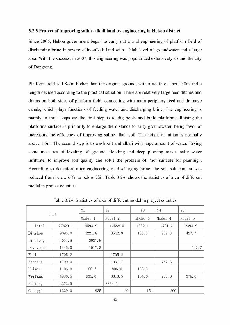
42
3.2.3 Project of improving saline-alkali land by engineering in Hekou district
Since 2006, Hekou government began to carry out a trial engineering of platform field of
discharging brine in severe saline-alkali land with a high level of groundwater and a large
area. With the success, in 2007, this engineering was popularized extensively around the city
of Dongying.
Platform field is 1.8-2m higher than the original ground, with a width of about 30m and a
length decided according to the practical situation. There are relatively large feed ditches and
drains on both sides of platform field, connecting with main periphery feed and drainage
canals, which plays functions of feeding water and discharging brine. The engineering is
mainly in three steps as: the first step is to dig pools and build platforms. Raising the
platforms surface is primarily to enlarge the distance to salty groundwater, being favor of
increasing the efficiency of improving saline-alkali soil. The height of taitian is normally
above 1.5m. The second step is to wash salt and alkali with large amount of water. Taking
some measures of leveling off ground, flooding and deep plowing makes salty water
infiltrate, to improve soil quality and solve the problem of “not suitable for planting”.
According to detection, after engineering of discharging brine, the soil salt content was
reduced from below 6‰ to below 2‰. Table 3.2-6 shows the statistics of area of different
model in project counties.
Table 3.2-6 Statistics of area of different model in project counties
Unit Y1 Y2 Y3 Y4 Y5
Model 1 Model 2 Model 3 Model 4 Model 5
Total 27629.1 6593.9 12588.0 1332.1 4721.2 2393.9
Binzhou 9093.0 4221.8 3542.9 133.3 767.3 427.7
Bincheng 3037.8 3037.8
Dev zone 1445.0 1017.3 427.7
Wudi 1705.2 1705.2
Zhanhua 1799.0 1031.7 767.3
Huimin 1106.0 166.7 806.0 133.3
Weifang 4980.5 935.0 3313.5 154.0 200.0 378.0
Hanting 2273.5 2273.5
Changyi 1329.0 935 40 154 200

43
gaomi 1378.0 0 1000 0 0 378
Dongying 13555.6 1437.1 5731.6 1044.8 3753.9 1588.2
Lijin 4637.1 2951.7 32.4 1653
Hekou 5287.4 920 1060 807.4 1680 820
Kenli 3631.1 517.1 1719.9 205.0 420.9 768.2
Note: Y1 andY2, saline﹤2‰;Y3:saline 2‰~3‰;Y4:saline﹥3‰;Y5:ditch roads。
3.3 Social environment Based on 2008 economy and society bulletin of Shandong Province, Shandong
Province governs 17 cities and 140 counties, total population is 93,670,000,
increasing rate is 3.3%, 70,450,230 are farmers. GDP was 3107,21billion RMB, range
2nd in the country, per-capita GDP 33,083RMB, increased 12.1%. Primary industry increased
300,27billion RMB and 5.1%, secondaty industry increased 1770,22 billion RMB and 12.1%,
tertiary industry increased 1036,72 billion RMB and 14.0%. Tabel 3.3-1shows economic
status in the project cities.
Table 3.3-1 Economic situation of target cities
Target cities
GDP(billion Yuan)
Rate of primary industry(%)
Rate of secondary industry(%)
Rate of tertiary industry (%)
Total population (2008)
Agricultural population
Annual income per capita of
farmers in 2007
Weifang 249.180 11 58 30 862.5 794.1 7072
Tai‟an 151.330 11 55 34 545.6 287.4 6046
Jining 212.216 12 56 32 822.75 260.6 5965
Weihai 178.035 7 61 31 252.23 172.6 4701
Rizhao 77.314 11 41 29 281.71 186.31 5319 Laiwu 45.579 15 53 32 125.35 76.82 5321
Dongying 205.262 3 77 20 183.97 70 5869
Binzhou 123.683 14 84 25 37 371.5 5328
Linyi 195.860 12 51 37 1024.73 754 5383

44
Chapter 4 Public participation
According to the requirements of The Law of Environmental Impact Assessment of The
People‟s Republic of China and World Bank, the chapter of public participation was written
in this report. This is to guanrantee the public rights of knowing and decision-making and to
know the public comments and suggestions. This is also to strengthen the participation of the
public in the constructing project, and to embody the “people-oriented” principle and
construction of harmonious society.
4.1 Technical approach and content of public participation 4.1.1 Investigation methods
The investigation method combined the following approaches such as putting up bulletins in
the project area, publishing in the newspaper, holding meeting of villagers and symposia,
interviewing the public, questionnaires and consulting. Some farmers‟ houses were visited to
deeply understand the usage of current woodland, pesticides and fertilizers, their state of
living standard and their understanding and attitude to the project. The investigation of
public participation also was helped by the social assessment group. They undertook a deep
social investigation on the social impact of the project.
4.1.2 Investigation range
(1) Investigating families and individuals
This investigation covered 30 counties and forestry centers involved in this project. Three
representative counties, Zhanhua, Xintai and Shanxian were visited. The local farmers were
visited, having an informal discussion. Meanwhile, the questionnaires of public participation
were handed out to different classes in the area where the project was located. 1000 were
handed out and 978 were returned. The investigating objectd included authority employees,
technicians and farmers.
The investigation papers were filled and collected in site, from August 6th to 20th,2008, the
results were documented on August30th 2008.
The investigation pic is shown in 4-1.

45
(2) Expert consulting
This EIA employed some experts from Forest Science Research Institute of Shandong
Province, Shandong Agriculture University and Shandong Normal University to form an
expert group. The experts consulted the report during compiling.
4.1.3 Publicity
The main publicty of environmental information involves, a. name and general introduction
of the project; b. construction unit and contact methods; c. EIA unit and contact methods;
d.process and content of EIA; e. main items of public opinions; f. methods to put in opinions
and suggestion
Table 4.1-1 shows the detail of publicity

46
Table 4.1-1 EIA publicity Name and
general introductionof
the project
WB loan afforeastation project in Shandong Province, construction scale is 65972.6hm2, total investment is 743,070,000RMB
Construction unit and contact
methods
Shandong Forest Bureau, contact phone is 13969025049, contacter is Yin Yanbo
EIA unit and contact
methods
6th department of Shandong Environmental Protection Scientific Research Academy, contact phone is 0531-85870069, contacter is Sun Qian
Content of EIA
General instruction, possible impacts, measures, conclusions.
Main notes Investigate the public opinios on project construction Ways to put in opinions
Phone, mail, and talk
Figure 4-2 and 4-3 show the 1st and the 2nd proclainm on July 10th,2008 and July 9th,
2009.
Query time for domestic report is from May 31, 2009 to June 30, 2009, site is in PMO of
Shandong Forest Bureau.
Fig.4-2 The 1st proclamation
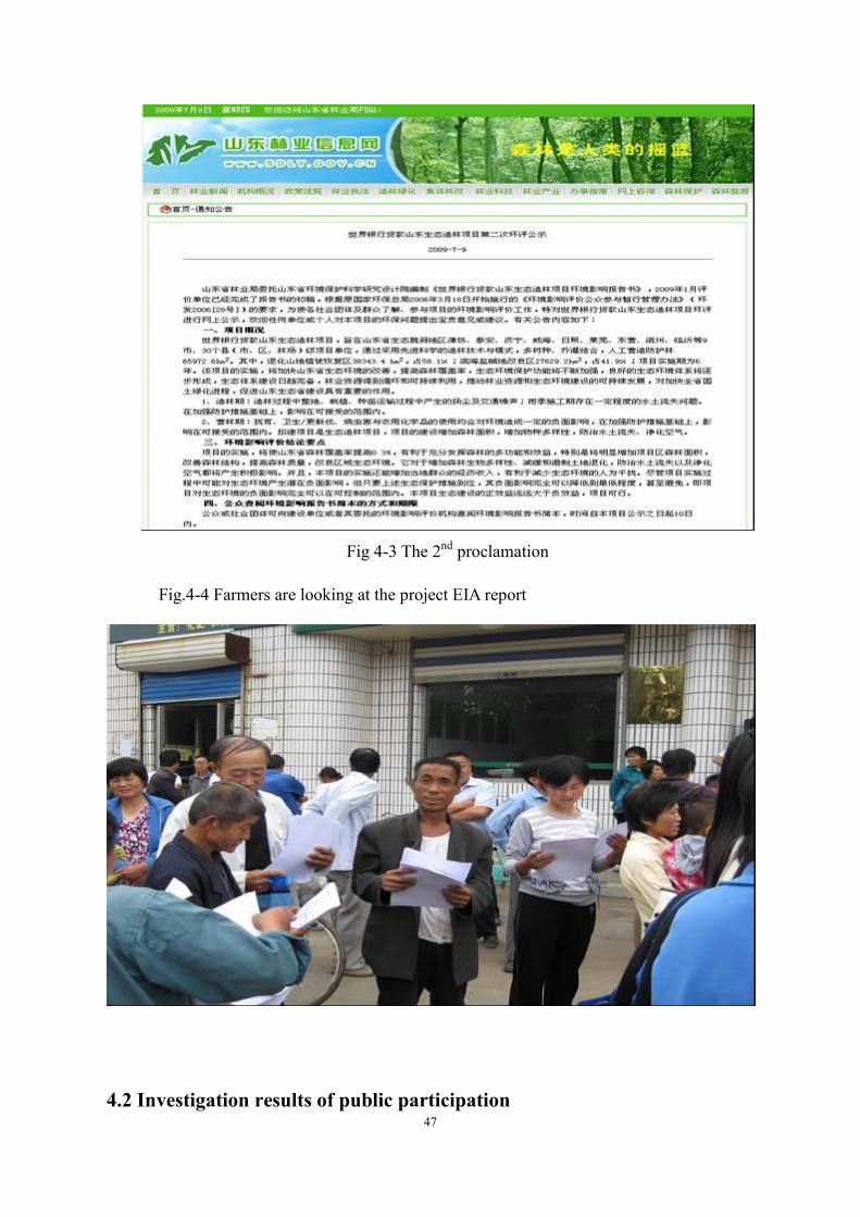
47
Fig 4-3 The 2nd proclamation
Fig.4-4 Farmers are looking at the project EIA report
4.2 Investigation results of public participation

48
4.2.1 Investigation results of questionnaires
The investigation results of public participation showed that the public participating in the
investigation supported the project construction. They thought that the project construction
would be favor of developing the local economy and improving the local ecological
environment.
Table 4.2-1 Investigation results
Age
<18 years old 18~34 years old 35~54 years
old
>55years old
49 342 440 147
5% 35% 45% 15%
Educated level
Elementar school 初中 Junior high school Senior high
school and
technical
secondary
school
Junior college and
the above
332 420 117 109
34% 43% 12% 11%
Profession
Farmer Employees in forestry
authority
Others ——
812 143 23 ——
83% 15% 2% ——
Investigation content
Do you know the ecological forestation project of
Shandong Province?
Know Heard Don‟t know
880 98 0
90% 10% 0
What do you think of the local ecology?
Good Not good Don‟t know
851 0 127
87% 0 13%
Do you think the project construction will promote
the increasing of local economy and living standard
of farmers?
Yes No Don‟t know
978 人 0 0
100% 0 0
Do you think the project construction will improve
the local ecological environment?
Yes No Don‟t know
978 persons 0 0
100% 0 0
What‟s the environmental issues you are mostly
concerned about?
Pollution of fertilizers
and pesticides
Water and soil
erosion Pests and dissease
234 persons 518 persons 226 persons

49
24% 53% 23% The relevant laws and regulations will be carried out to guanrantee the negative environmental impacts of the project to be controlled to the minimum during constructing and managing the forest. On this precondition, can you accept the negative environmental impacts of constructing the project?
Yes No No comment
978 persons 0 0
100% 0 0
Considering the various impacts after the
comprehensive project was built, do you think the
project is feasible or not?
Feasible
Not feasible (please write down your
reasons in the next line)
No comment
978 persons 0 0
100% 0 0
4.2.2 Collection of experts’ advices
An expert consulting meeting was held during investigation. The main advices of the experts
were as follows:
1. The developing construction of the project should be brought into the developing plan of
Shandong forestry. The afforestation with World Bank loans will greatly promote the
comprehensive development of Shandong forestry. However, the management of
environmental protection should be enhanced to limit the ecological environmental impacts
to the minimum.
2. Developing various forest category should be in a proper proportion, and the biological
diversity should be paid more attention.
3. It should be made clear if there is any ecological function zone of natural protection
within and nearby the project area, to clarify which part of land can be cultivated, and which
part cannot.
4. The project development should avoid the constructive damage, deforestation damage,
pesticides and fertilizers, water and soil losses, and damage of biological diversity. The
feasible and practical environmental measures should be proposed to limit the environmental
impacts of the project construction to the minimum.
5. The mixed forest should be contructed, and decrease properly the planting density to
promote the young woods to be crown closure as soon as possible.
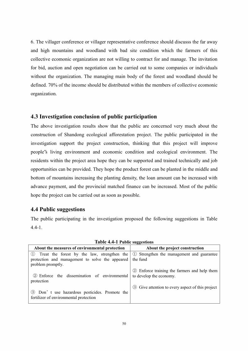
50
6. The villager conference or villager representative conference should discusss the far away
and high mountains and woodland with bad site condition which the farmers of this
collective ecomonic organization are not willing to contract for and manage. The invitation
for bid, auction and open negotiation can be carried out to some companies or individuals
without the organization. The managing main body of the forest and woodland should be
defined. 70% of the income should be distributed within the members of collective ecomonic
organization.
4.3 Investigation conclusion of public participation The above investigation results show that the public are concerned very much about the
construction of Shandong ecological afforestation project. The public participated in the
investigation support the project construction, thinking that this project will improve
people‟s living environment and economic condition and ecological environment. The
residents within the project area hope they can be supported and trained technically and job
opportunities can be provided. They hope the product forest can be planted in the middle and
bottom of mountains increasing the planting density, the loan amount can be increased with
advance payment, and the provincial matched finance can be increased. Most of the public
hope the project can be carried out as soon as possible.
4.4 Public suggestions The public participating in the investigation proposed the following suggestions in Table
4.4-1.
Table 4.4-1 Public suggestions
About the measures of environmental protection About the project construction ① Treat the forest by the law, strengthen the protection and management to solve the appeared problem promptly.
② Enforce the dissemination of environmental protection
③ Don’t use hazardous pesticides. Promote the fertilizer of environmental protection
① Strengthen the management and guarantee the fund
② Enforce training the farmers and help them to develop the economy.
③ Give attention to every aspect of this project

51
Chapter 5 Environmental Impact Analysis
Shandong ecological afforestation project will be favor of increasing tree species in planting
sites, phytomass, and biological diversity, efficiently control water and soil losses, improving
saline-alkali soil, protecting biological diversity, furthermore, improving local ecological
environment. The environmental impacts of the project are mainly positive. However, if the
measures are not proper during the project construction, the negative impacts will also be
caused. This section will analysis the potential negative environmental impact and propose
the corresponding measures in EMP to realize the sustainable development of the project
construction.
5.1 Negative impacts 5.1.1 Environmental impact of tree species arrangement
The unsuitable selection of tree species is easy to cause a low surviving rate and bad growth
of trees. If the arrangement is single and the area of pure forest is too large, some bad
consequence will be caused such as pests, a unstable stand structure and a bad landscape.
5.1.2 Environmental impact of planting density
If the planting density is too big, the stand will be caused to be closed too early, and the
nutrient space is too small, to restrain the survive of the shrubs and herbs, influencing the
trees growing thicker, so that the percentage of cut-turn is low and the protecting function
decreases. If the planting density is too small, the trees will be slowly to become a forest, and
the woodland will not be closed for a long time, also the protection function won‟t work. At
the beginning of planting coniferous trees, the density can be properly increased, to insure
the health and stable growth of the stand. If the planting density is too small, the young trees
can not be crown closure, the woods will become to some kind of trees like little old men.
So, plant density should be determined by the reginal land condition and tree properties,
otherwise the protection objective cannot be achieved.
5.1.3 Environmental impact ofwoodland cleaning
The cleaning is one of the steps before land preparation for planting, whose objects are
weeds and shrubs. The aim is to improve the sanitation and site condition of the woodland to
be convenient for preparing the ground, planting and to fostering, to create a good
developing condition for the young trees. As the most part of the project is uncultivated
barren mountains and lands, the covering is weed. The ground is nearly barren after the weed
dried up in fall and winter. The planting often is taken in spring and rain season, then the

52
land can be prepared rather than cleaning. Therefore, the environmental impact of cleaning
will not be considered.
5.1.4 Environmental impact of preparing land and tending
During the land preparation, the soil is to be turned over to change the original slope shape
and the runoff on the surface, providing the condition directly for the rain washing the
sediment, thereby the water and soil losses of the woodland will be influenced. Especially,
the plow layer on the hill slope is relatively thin. When it rains a lot in summer and fall, as
the ground is slope, and the infiltration is slow, then the runoff amount in the surface
increases in a short time. The surface fertile soil is easy to be washed away by rain.
The losses of water and soil in the first and second year of land preparation will be the most
serious. In the following years, the soil erosion amount will decrease year by year, normally,
approaching the same in the 5th year. The hole shape method of land preparation will be
adopted in the plain area for this project, and fish scale pits adopted in the mountainous area.
This will cause a relatively small soil loss amount, compared with the traditional
whole-cultivation and belt-cultivation.
In addition, the activities in land preparation will change the existing surface vegetation
coverage, soil structure and character, causing flying dust pollution in a small range. Taking
some protecting measures as protecting original vegetations, finishing weirs and cofferdam
and reversed terrace and so on, the negative environmental impact of land preparation and
breaking will be reduced as slight as possible.
5.1.5 Environmental impact of constructing the working trails
The potential environmental impact of constructing the working trails mainly presents on: a
amount of vegetations will be damaged; when digging and filling the roadbed, the surface
soil will be loosed, and meanwhile, some slide scopes will be formed, which will cause
water and soil losses during construction if raining, and will also influence on the natural
landscape.
5.1.6 Environmental impact of using pesticides and fertilizers
5.1.6.1 Environmental impact of using pesticides
(1) Some kinds and amount of pesticides will be used during raising seedling and controlling
plant diseases and insect pests. Using pesticides will kill insect pests as well as a lot of
helpful natural enemies of pests, causing the reduction of biological diversity in the forest
region and specie unbalance. In addition, it can also harm wild animals directly. Selecting

53
some pesticides with less toxin and low residues or without public hazards will lighten the
harmful environmental impact.
(2)If the pesticides are used improperly, the nearby water quality will be affected and the soil
polluted.
5.1.6.2 Environmental impact of using fertilizers
(1) If the fertilizers are be overused during raising seedling and managing the woodland, the
nearby water body will be eutrophicated. If the fertilizers are used for a long time, the
physical and chemical characters of soil will be changed, the soil hardened, and the soil
fertility decreased.
(2) If the fertilizers are used improperly, for example, broadcasting on the surface, they will
be lost, and the water resources will be polluted.
5.2 Positive impacts
The forestation project will produce a huge ecological benefit for the local, which mainly
present on the following aspects as modifying soil, maintaining water resources, preventing
water and soil losses, adjusting microclimate and the environment, cleaning the air,
wind-proof and sand fixation, and so on.
5.2.1 Modifying soil
After the seawater fall back in the littoral area of Binzhou, Dongying and Weifang, a large
amount of salt is left in the soil, and then the salinization happens. The dominant factors to
cause salinization are: the first is that the evaporation amount is larger than precipitation, the
ground water and soil water containing salt move upward because of evaporation, then the
salt crystal is left in the surface to cause the phenomenon of soil salinization; the second is
that the lower the bury of groundwater, the larger the evaporation amount, the water evaporating to the
surface to cause the phenomenon of salinization.
The vegetation coverage rate will increase very quickly after afforesting. The air humidity in
woodland will increase, and air temperature and wind speed will decrease. The water
evaporation of soil will decrease, part of which replaced by plant transpiration, consequently
the phenomenon of salinization will decrease.

54
According to some research information, comparing the determination results of soil salinity
within and without the tree crown growing for 4~5 years, the salinity in the soil layer of
0~20 cm under the tree crown is significantly reduced by 44.14%, compared with the soil
without the tree crown. The salinity in the soil layer of 20~40cm is slightly reduced.
However, in contrast, the salinity in the soil layer deeper than 40cm under the tree crown
increases. The forestation can make the ground coverage inhibit effectively soil salinization,
especially reduce significantly the salinity in the surface soil layer, promote the eluviation of
soil salinity, and realize the effect of soil desalinization. The determination results of bulk
density of soil in woodland and barren land shows that they are lower in the soil layer of 0~
40cm than them in the corresponding barren land outside the woods. So the soil permeability
is good, and the soil quality is loose, which are in favor of microbial activities and
accumulation and activation of nutrients. The determination results of soil water content and
soil porosity also shows that the woodland is better than the barren land outside the woods.
On the one hand, the tree growth activates the propagation of a great deal soil microorganism.
On the other hand, the dead twigs and deciduous leaves are decomposed to the main sources
of soil organic matter, effective nitrogen and active phosphorus, and in favor of increasing
soil organic matter. When the soil microorganism increases, its activities and the respiration
of plant root system emit CO2, becoming carbonic acid after dissolved in water. The root
system of halophyte excrete some organic acid, such as citric acid and malic acid. These
acids promote the dissolving of P, K and Ca, thus improve the soil fertility allroundly.
5.2.2 Maintaining water resources and soil The project designed 8 afforestation models whose water and soil maintain ability are
simulated.
(1) Simulating method:
The 8 models are classified by coniferous, coniferous and broadleaved, broadleaved forests.
Count their water and soil maintaining effects and compare with forestation-suitable land.
Table 5.2-1 shows the model types.

55
Table 5.2-1 Model types
Type Region Location Main trees Other trees Forest type
1
Lime mountain
Top Platycladus orientalis
Protect existing shrubs vines and herbaceous Coniferous
2
Middle
Platycladus orientalis
Prunus armeniaca or Prunus davidiana, Protect existing shrubs vines and herbaceous
Coniferous and
broadleaved
3
Platycladus orientalis,
Robina pseudoacacia,
Cotinus coggygria
Melia azedarach, Ailanthus altissima, Gleditsia sinensis Protect existing shrubs vines and herbaceous
Coniferous and
broadleaved
4 Bottom
Populus aigeiros, Juglans regia, Diospyros
kaki, Peach, Pyrus
bretschneideri, Prunus
armeniaca, Date, Pumica
granatum
Platycladus orientalis, Ailanthus altissima, Melia azedarach, Toona sinensis, Gleditsia sinensis, Lonicera japonica, Lonicera japonica, Protect existing shrubs vines and herbaceous
Coniferous and
broadleaved
5
Sand mountain
Top Pinus thunbergii Protect existing shrubs vines and herbaceous Coniferous
6 Middle
Pinus thunbergii ,
Robina pseudoacacia
Cotinus coggygria, Melia azedarach, Sorbus pohuashanensis , Ailanthus altissima, Diospyros
lotus, Protect existing shrubs vines and herbaceous
Coniferous and
broadleaved
7
Bottom
Populus aigeiros, Juglans regia, Diospyros kaki, Peach, Pyrus bretschneideri, Prunus armeniaca, Date, Pumica granatum
Pinus thunbergii, Sorbus pohuashanensis, Lonicera japonica, Lonicera japonica , Toona sinensis, Diospyros lotus, Protect existing shrubs vines and herbaceous
Coniferous and
broadleaved
8 Tea Pinus thunbergii, Ginkgo biloba Coniferous
and broadleaved
(2) Counting method:
A. Soil erosion and runoff
Runoff(kg/hm2)=Water(kg)×)area(Region
)10000(2
2
m
m
Soil erosion(kg/hm2)=)( areaRegion
)10000()kgSand( 2
2
m
m

56
B. Water storage
Water storage in soil is counted by weight method.
C. Saturation water in soil and water storage soil layer
Saturation water in soil Saturation water in soil. Water storage soil layer= Extent of porosity(%)×Thickness(m)×104m2
(3)Results
All results are based on research of Pro. Yang Jihua. Table 5.2-2 Effect of water and soil maintaining Unit: t/hm2.year
Type Region
Place Forest type
Soil Water
Soil erosion
Soil erosion after project implemented
Reduce Water storage
Water storage after project implemented
Increse
1
Lime
Top Coniferous 61 6 55 1541 1710 169
2
Middle
Coniferous and
broadleaved 61 6 55 1541 1710 169
3 Coniferous
and broadleaved
61 3 58 1541 1924 383
4 Bottom Coniferous
and broadleaved
62 11 51 2034 3184 1150
5
Sand
Top Coniferous 61 6 55 1541 1613 72
6 Middle Coniferous
and broadleaved
61 3 58 1541 1890 349
7
Bottom
Coniferous and
broadleaved 62 13 49 2034 3179 1145
8 Coniferous
and broadleaved
62 11 51 2034 3096 1062
It can be concluded from the table that the 8 models have extinct water and soil maintaining
functions.
The dead twigs and deciduous leaves on the surface layer of forest soil decompose into
humus, increasing the organic matter in soil. This makes the soil have a good aggregate
structure.
57
5.2.3 Wind-proof Based on local condition, 5 afforestation models are designed, and their wind-proof effects
are as follows.
① Model 1 and model 2
See table 3.2-6. They are suitable for coastal saline land with salt less than 2‰. Model 1
plants Populus aigeiros, Juglans regia, Diospyros kaki, and model 2 plants Peach, Pyrus
bretschneideri, Prunus armeniaca, Date, Pumica granatum, and they form mixed forest and
farmland ecosystem, which may promote wind-proof ability. The effectiveness of
wind-proof of farmland ecosystem is 22.4-47%.
② Model 3
It is suitable for coastal saline land with salt of 2-3‰. Model 3 plants Pinus thunbergii,
Sorbus pohuashanensis, Lonicera japonica, Lonicera japonica, Toona sinensis, Diospyros
lotus, to form shrub and arbor mixed forest, increase vegetation cover rate, modify saline
land, and defense wind. Its effectiveness of wind-proof is as model 1 and 2.
③ Model 4
It is suitable for coastal saline land with salt more than 3‰. Model 4 plants Fraxinus
chinensis, Tamarix chinensis, Nitraria sibirica, Salix psammophila, to form shrub and arbor
mixed forest, increase vegetation cover rate, modify saline land, and defense wind.
○4 Model 5
It is suitable for existing ditch road. Model 5 plants Platycladus orientalis, Robina
pseudoacacia, Cotinus coggygria, to modify saline land, and defense wind.
Overall, the 5 models have extinct wind-proof effect.
5.2.4Analysis of cleaning air
The forests can absorb some harmful gas like SO2, reduce the pollution of photochemical
smog and cleanse radioactive substances. Therefore, the forests can play a significant
function on cleaning air and protecting human health. In addition, the forests can obviously
obstruct dust, reducing floating dust in the air.
SO2 is the largest in amount of harmful gases, most widely spreading, and more harmful.
And the woods have a certain capability to resist it. The absorption, degradation,
accumulation and migration of the woods to the air pollutants, are no doubt a cleaning

58
function to air pollution. According to some relevant references, the absorption capacity of deciduous
broadleaved forest is 88.65 kg/(hm2·a), and that of coniferous forest is 215.60 kg/(hm2·a).
The plants can play functions of blocking, filting and adsorbing dust, especially woody
plants, their functions are more obvious. The reasons for woody plants to adsorb and block
dust are firstly that they can reduce the wind speed to make dust fallen down, secondly their
coarse faces of leaves can adsorb and block a great deal of dust with slime and grease.
5.2.5 Regulating the regional microclimate
The land preparation and water and soil conservation will cause the change of underlying
surface character of local land surface, roughness change, and increasing of water storage
amount. This will change the balance of water, heat, radiation and other matter between the
local atmosphere and underlying surface, furthermore, impact the local microclimate
character.
(1) Regulating temperature
As the reflectivity of forest vegetation is obviously lower than open land or wild land, the
wind speed in forest zone decreases, and the heat exchange between the air and the ground
weakens obviously. And the tree crown and wet soil can absorb more the sun radiation, part
of which is consumed in water evaporation and transpiration from the forest leaves. Thus the
air temperature and ground temperature are relatively stable, do not suddenly rise and fall
between day and night, reducing the harm of frost.
(2) Increasing humidity and foggy days
With increasing the forest coverage, the intercepted and dammed rain and run-off will
increase the transpiration of forests, water circulation, air humidity and the number of foggy
days. On the other hand, as the air continuously convecting, the dispersion and exchange of
vapor among air masses keep going on, producing an humidification effect around the
forests.
(3) Increasing precipitation
59
That it rains much or less in a region, depends on its latitude, distance from the ocean and
nearby topography, especially on the influence of atmospheric circulation and monsoon.
However, with the changes of underlying surface character of land, the forest vegetation
coverage will increase, and the rain intention amount will increase as well, which will fasten
the local water circulation. Because of the increasing of underlying surface roughness, the
tree crown will play an action of raising the airflow and enhancing convection and exchange
of airflow. This will increase the amount of precipitation in warm seasons in the project area
and the leeward neighborhood.
6.2.6 Analysis of impact on landscape structure
The forestation area is original wild mountains and land uncultivated, where the ground
cover plant is weed. When the weed dries up in fall and winter, the ground is barren. After
forestation, the local forest coverage rate will increase, obviously improving the landscape
structure of the area.
5.3Assessment of the impact on social and economic environment
The project area is mainly located in some regions where the mountain area is large, planting
task on wild mountains is heavy, the ecological environment is vulnerable, and the water and
soil losses is serious. At present, the economy of villages and towns in the project area is thin
and weak, the planting structure is single, and the resident income is low. The
implementation of forest resources of sustainable developing project, not only fastens the
steps of forestation, breeds forest resources, and improves the ecological environment, but
also promotes the transfer of surplus labor to secondary and tertiary industry, enlarges the
employing routs of farmers, and increases the farmers‟ income. This is an effective road to
construct new socialism villages with great realistic and profound historical significance.
This project is conducted a ecological construction in economic backward areas,with the
help of World Bank loan and the local financing. This will inject some new financial sources
to the local economy. The economic trees will help to increase the farmer‟s income.

60
Chapter 6 Alternative project analysis
6.1 General introduction
The alternative project analysis is to compare the project impact with non-project impact,
and the impact caused by different afforestation modes, and to recommend the project from
environmental view.
6.2 Analysis on impact of project and non-project
The direct and indirect impact with or without the project to the ecological environment is
obviously different, see table 6.2-1
Table 6.2-1 Impact with or without the project
Impact With the project Without the project
Direct impact
Favorable impacts 1. Afforestation will form stable forest
system, improve the forest cover area, maintain water and soil, conserve water resource, and prevent wind damage and soil salinity.
2. Environmental beauty and forest sight will be improved.
3. Large of deadwood will be degraded to organic matter including nitrogen and phosphorus, which may active edaphon.
4. Due to afforestation in saline area, the forest cover rate will be rapidly increased, humidity will rise, temperature and wind speed will be lowered, soil evaporation will be reduced by vegetation and soil salinity will be reduced.

61
Adverse impact 1. Unsuitable afforestation may destroy
original vegetation, disturb soil to cause new water and soil erosion, and impact the surroundings.
2. Unsuitable pesticide and fertilizer use may impact the soil function and ecology, pollute water resource and quality.
3. Dust may be caused by soil dig and transportation mobiles in local area.
1. The mountain without suitable management has little natural vegetation and has been excessively disturbed, fire is potential, water and soil erosion is severe, land is getting degraded, forest is not improved to prevent pest damage.
2. The degraded forestland is not protected properly, which may lose all vegetation.
3. The area of saline soil is getting larger.
Indirect impact
Deserted mountains become less, water conservation ability is improved by forest system, saline land is improved, wind and dust is well prevented, living surroundings are getting much better in the project area, especially in Jining city and Binzhou city. Some area will increase land usage rate with plantation in forest. Habitat for wildlife becomes larger, which may form ecological path and protect diversity.
1. Natural forest and public forest is damaged with increasingly wood demand. Diversity is in threatened.
2. Due to little management, forest is getting degraded, which may cause water and soil erosion, animal disappear and severe ecological tragedy.
Comprehensively impact compare
Forest cover rate and quality will rise; ecology system will be improved by suitable afforestation and management. But improper afforestation design and construction has certain adverse impact.
Deserted mountains have little vegetation, forest cover rate will be lowered, water and soil erosion is getting severe, ecology system will be damaged and poverty is caused indirect.
Recommended option
Recommended Not recommended
6.3 Analysis on project implementation design
6.3.1 Afforestation model selection
Afforestation model selection: It is technical measure design in fact, including seeds,
forestland, cleaning, land dealing, density, and vegetation confirm, foster management,
pesticide prevention, fertilizer and etc. Seed and forestland selection have been mentioned
62
before, this chapter will compare and analyze other technical design items and traditional
afforestation model, to make out the conclusion on environmental impact of afforestation
options, see 6.3-2。
Table 6.3-2 Impact of different afforestation model
Impact Implementation
measures Afforestation model of the
project Traditional afforestation
model
Ecological
impact
Land condition
Bad land condition and coastal
saline area: mineralization degree
of underground water is about 3
g/l, salt is 2.0 ‰ ~ 3.0 ‰ ;
Degraded retain mountains; lime
rock, sand rock mountains. These
areas locates out of the way with
barren soil, inconvenient
transportation, big surface slope,
more stones, less suitable
vegetation and weak biological
environement.
Areas with condition of thick soil
layer, fertility and wetness, high
organic content.
Forestland
cleaning
Use block and strip cleaning
method, keep raw grass area,
reduce water and soil erosion,
lower soil nutrient, help to keep
ecological diversity
Damage vegetation, cause water
and soil erosion, go against to
ecological diversity
Land dealing
Use block and strip cleaning
method, keep raw grass area,
build land martin and dam,
control slope angel, reduce land
surface damage, surface dig area
is 10-25%, adopt effective water
and soil conservation measure
Totally dig the land, surface dig
area is 30-100%, part or all
vegetation is destroyed, water and
soil erosion is severe.

63
Afforestation
density
Adopt a density less than that of
NAP, 600-1500 per hm2 in
coastal saline area; economical
tree is 333-400 per hm2;
2000-2800 per hm2 in side of
degraded mountains; black pine
is 1200-2000 per hm2. The
density will prevent ruderal harm,
promote springwood gloomy as
soon as possible in prophase,
form suitable assorted stable
structure, by proper foster, keep
enough sunshine, promote the
ability of harm prevention and
ecological defense in anaphase
The density is 2000-350 per hm2,
tree grown makes little sunshine,
little shrub and grass under trees,
and forest has weak prevention
ability and incurs pesticide.
Plant model
Block or strip mixed forest has
advantages of thick head, big
leaf, complex structure, which is
better than pure forest.
The project plants different trees
together to fully use sunshine,
water and nutriment, to restrain
water resource soil.
Mixed forest can ensure some
trees grow due to favorable
relations of deferent kinds of
trees. For example, if poplar and
acacia are planted together, old
small poplar will not appear. And
mixed forest can prevent insect
growing by destroy their
migration and food.
In hill areas, palmer is popular, and
in plain lake areas cerambycidae
damages poplar. The reason is that
single tree provides abundant food for
insects.
Plant
Use more first grade seedling,
tear nutrition bag and keep
nutrient tightness, survive rate is
high, seedling grows fast, help to
water and soil conservation.
Use less first grade seedling,
nutrition bag may not be all teared
and nutrient is loosen, survive rate
is low, seedling grows slowly,
against to water and soil
conservation.

64
Foster and
management
Loosen soil and remove grass in
time, keep suitable assorted
structure, promote prevention
ability and diversity.
Form single arbor structure due to
unsuitable grass remove in
seedling time and foster in
mature time, prevention ability
and diversity can not be
promoted
Fertilizer
Based on nutrition in the soil and
grow demand, use prescription
fertilizer, form suitable forest
structure, promote water and soil
conservation.
Fertilizer is not suitable, forest
structure form slowly, nutrition in
soil may dissolve to make water
over nutrition.
Comprehensive
assessment
Based on site condition to select
seeds, design the measures of
cleaning, digging, plant, foster,
and environmental protection
according to afforestation mode.
Density is suitable, forest grows
fast, keep certain condition for
other vegetation, keep raw grass
area, form mixed forest, reduce
the impact on diversity, lower
water and soil erosion, reduce the
adverse impact of the project.
Afforestation design is not suitable,
density is too high, pesticide is
over used, fertilizer is not
suitable, management is not
sufficient, which may cause
slow growth, lower diversity and
quantity, go against to water and
soil conservation, and make
bigger adverse impact to
ecological environment.
Conclusion Recommend Not recommend
65
Chapter 7 Environmental management and monitoring plan
7.1 Environmental management of WB forest projects in Shandong Province
7.1.1 Environmental management experience
Shandong Province has implemented “State afforestation project”, “Forest resource
development and protection project” and “Forest sustainable development project”, which
invested 431,800,000 RMB, and planted 1.606×10⁵ hm2.
(1) Establish project management organizations. Project lead group and management office
are built by province, sity and county, which are fromed by finance, forest and relevant
departments, equipped by specialists of forest, environmental protection and finance.
(2) Establish management support system. Based on WB project management system,
establish 10 project support system, which involve organization, plan, quality control,
financial management, monitoring, training, and etc.
(3) Make out rules. More than 20 regularions and rules are made for project management,
financial mangment, check up, monitoring, and etc.
(4) Supervise construction quality strictly. Apply united mangement model of training,
guidance and checkup.
(5) Pay more attention on training.
(6) Establish 3 team and 1 point. Establish 3 teams for pest forecast, pest prevention and
treatment, environmental supervision.
7.1.2 Main lessons
(1) Types of forest are unique. In the 3 WB project, 160,600hm2 forest is made, main trees
are polar, acacia, date, chestnut, and etc. There are 132,000 hm2 Polar, 82.2% of the total area.
Due to the sigle type, the forest has a weak ablity to resist pests.
(2) Farmers have their costom in using pestiside. They like using common chemicals as
pestiside. Pilot is needed to change their costoms in selecting and using pestisides.
All the experiences are reffered for the project, the chapter puts forward the countermeasures,
monitoring and training plan based on potential adverse impact, and also gives out duty of
66
project units in different periods.
7.2 Responsible unit and duty for the environmental management
Table 7.2-1 Role of PMOs and environmental supervision
Periods Organization Responsibility Note
Design and preparation
PMO of SFB
1. Responsible for implementation and management of the project construction.
2. Carry out state laws and regulations on forest. 3. Implement provincial forest regulations. 4. Organize cities to edit relevant plan and options. 5. Make rules and management methods and implement. 6. Put forward annual work plan. 7. Coordinate seed providing. 8. Ensure the project abide state environmental laws, coordinate relevant organizations to supervise and manage the project. 9. Responsible for the quality management. 10. Responsible for technical direction and training. 11. Responsible for information and document collection,
report; Provide consultation service.
5 staff
Provincial forest stations
1. Ensure the project abide state and provincial laws on vegetation.
2. Direct city and county to protect vegetation. 3. Responsible for vegetation quarantine. 4. Promote new vegetation protection technologies. 5. Responsible for provincial monitoring and forecast of insect and disease.
6. Direct city and county to prevent and treat insect and disease. 7. Organize to terminate insect and disease incidents.
5 staff
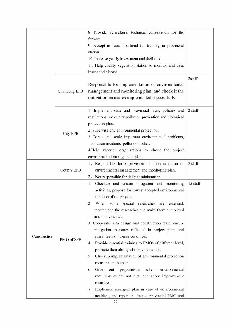
67
8. Provide agricultural technical consultation for the farmers. 9. Accept at least 1 official for training in provincial station 10. Increase yearly investment and facilities. 11. Help county vegetation station to monitor and treat insect and disease.
Shandong EPB Responsible for implementation of environmental management and monitoring plan, and check if the mitigation measures implemented successfully.
2staff
City EPB
1. Implement state and provincial laws, policies and regulations; make city pollution prevention and biological protection plan. 2. Supervise city environmental protection. 3. Direct and settle important environmental problems, pollution incidents, pollution bother.
4.Help superior organizations to check the project environmental management plan.
2 staff
County EPB 1、 Responsible for supervision of implementation of
environmental management and monitoring plan. 2、 Not responsible for daily administration.
2 staff
Construction
PMO of SFB
1. Checkup and ensure mitigation and monitoring activities, propose for lowest accepted environmental function of the project.
2. When some special researches are essential, recommend the researches and make them authorized and implemented.
3. Cooperate with design and construction team, ensure mitigation measures reflected in project plan, and guarantee monitoring condition.
4 Provide essential training to PMOs of different level, promote their ability of implementation.
5. Checkup implementation of environmental protection measures in the plan.
6. Give out propositions when environmental requirements are not met, and adopt improvement measures.
7. Implement emergent plan in case of environmental accident, and report in time to provincial PMO and
15 staff

68
local EPB.
City PMOs
1. Implement monitoring plan, including supervise and urge monitoring organizations.
2. Report regularly environmental function in construction and running stage to relevant EPB and WB.
3. Deal with environmental appeals and receive supervision of environmental protection organizations.
4. Arrange essential visits of representatives from WB, EPB and monitoring stations.
5. Supervise and urge construction team bide relevant regulations.
6. Other relevant tasks.
10 staff
County PMOs
1. Organize study and attend project training. 2. Help to implement environmental management and monitoring plan, responsible for routine environmental protection management of the afforestation project, collect data and report to relevant officers. 3. Publicize and popularize suitable environmental protection technologies. 4. Responsible for documentation.
20 staff
Farmaers
1. Afforestation and fostering 2. Abide scientific criterion. 3. Improve conver rate yearly 4. Prevent fire 5. Prevent pest diseases.
400
Running
Shandong Monitoring Center
Responsible for monitoring in provincial area and workout annual environmental quality report
30 staff
County Monitoring Stations
1. Data report and documentation. 2. Monitor and report. 3. Instrument maintenance. 4. Attend training, accept examination. 5 City and county monitoring stations are responsible for water and soil monitoring and report to provincial monitoring station.
60 staff
Note: Design and preparation period: before agreement signed; Planting period: the former 4

69
years of planting; Foster and management: running period; Managed by local govments after
construction and checkup.
7.3 Countermeasures Table 7.3-1 is environmental management plan
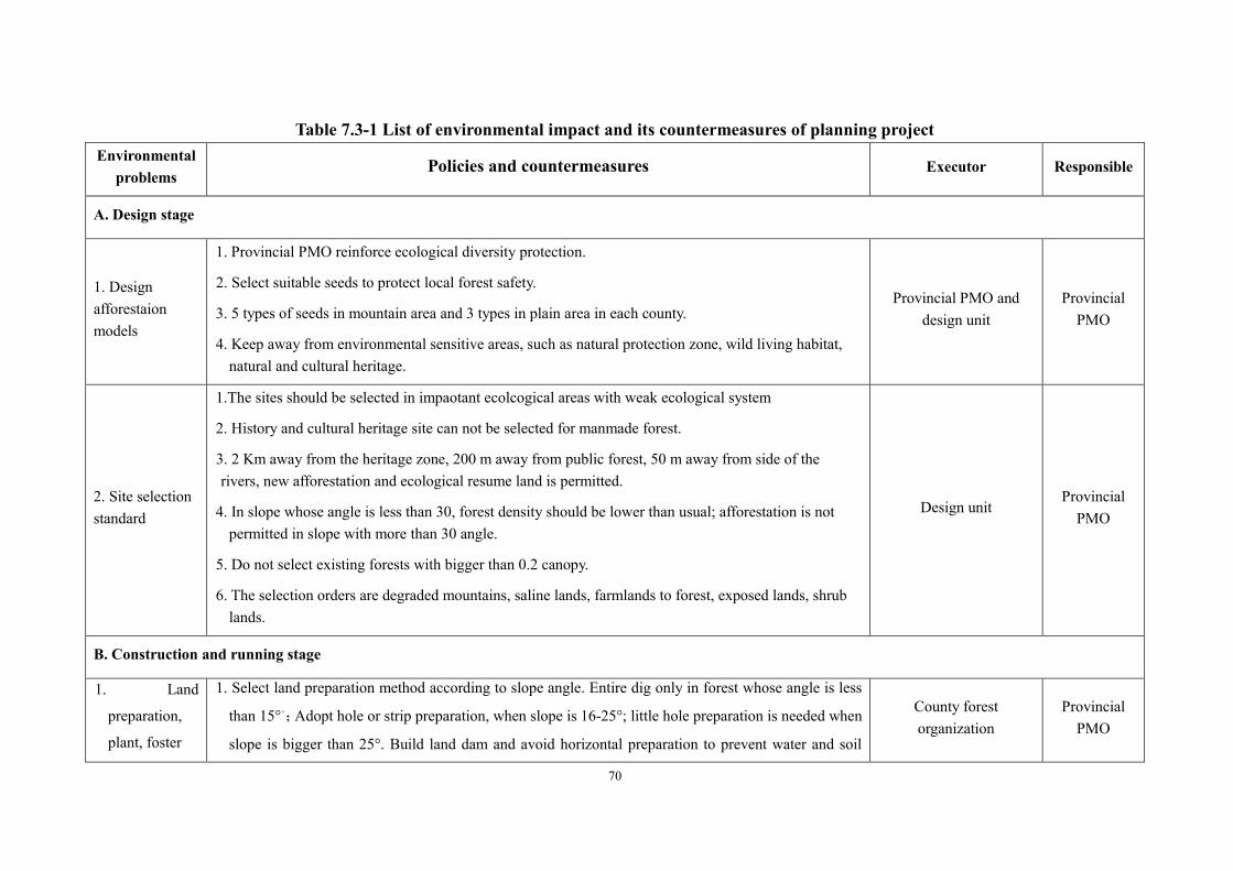
70
Table 7.3-1 List of environmental impact and its countermeasures of planning project Environmental
problems Policies and countermeasures Executor Responsible
A. Design stage
1. Design afforestaion models
1. Provincial PMO reinforce ecological diversity protection.
2. Select suitable seeds to protect local forest safety.
3. 5 types of seeds in mountain area and 3 types in plain area in each county.
4. Keep away from environmental sensitive areas, such as natural protection zone, wild living habitat, natural and cultural heritage.
Provincial PMO and design unit
Provincial PMO
2. Site selection standard
1.The sites should be selected in impaotant ecolcogical areas with weak ecological system
2. History and cultural heritage site can not be selected for manmade forest.
3. 2 Km away from the heritage zone, 200 m away from public forest, 50 m away from side of the rivers, new afforestation and ecological resume land is permitted.
4. In slope whose angle is less than 30, forest density should be lower than usual; afforestation is not permitted in slope with more than 30 angle.
5. Do not select existing forests with bigger than 0.2 canopy.
6. The selection orders are degraded mountains, saline lands, farmlands to forest, exposed lands, shrub lands.
Design unit Provincial
PMO
B. Construction and running stage
1. Land
preparation,
plant, foster
1. Select land preparation method according to slope angle. Entire dig only in forest whose angle is less
than 15°。;Adopt hole or strip preparation, when slope is 16-25°; little hole preparation is needed when
slope is bigger than 25°. Build land dam and avoid horizontal preparation to prevent water and soil
County forest organization
Provincial PMO

71
Environmental problems
Policies and countermeasures Executor Responsible
erosion.
2. Keep existed vegetation and cover land surface by deadwood.
3. Adopt part soil loosen for young forest fostering, keep surface vegetation. Foster after planting,
promote shrub and grass growing. Forbid collecting deadwood.
4. Advocate using mixed fertilizer, organic and prescription fertilizer.
2.Plant
1. Small group is that the area is less than 20 hec in mountains, less than 35hec in coastal areas.
2. Unique seed forest area: Model 1 and 5 has no limitation, others should be less than 2 hec.
3. In mountains, isolaltion band should be 3 to 10 meters wide.
4.In mixed forests, the dominant tree should be less than 70% of the total trees.
5.In saline lands, mixed forests should be more than 75% in model 1,2 and 3. Model 4 and 5 has no
limitation.
County forest organization
3.Tending
1. Intercrop: Select land preparation method according to slope angle. Entire dig only in forest
whose angle is less than 15°。;Adopt hole or strip preparation, when slope is 16-25°; little hole
preparation is needed when slope is bigger than 25°. Build land dam and avoid horizontal
preparation to prevent water and soil erosion.
2. Cut grass: Adopt part soil loosen for young forest fostering, keep surface vegetation. Foster after
planting, promote shrub and grass growing. Forbid collecting deadwood.
3. Fertilizer: Advocate using mixed fertilizer, organic and prescription fertilizer. Protect deadwood and
land surface vegetation..
4. Irrigation: Wash pesticide container away from water resource, agriculture irrigation water can be
used.
5. Herd forbidden: All herd is forbidden.
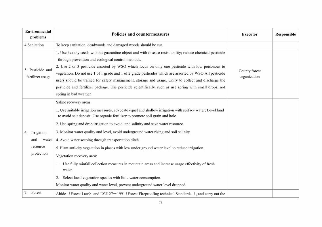
72
Environmental problems
Policies and countermeasures Executor Responsible
4.Sanitation To keep sanitation, deadwoods and damaged woods should be cut.
5. Pesticide and
fertilizer usage
1. Use healthy seeds without guarantine object and with disease resist ability; reduce chemical pesticide
through prevention and ecological control methods.
2. Use 2 or 3 pesticide assorted by WSO which focus on only one pesticide with low poisonous to
vegetation. Do not use 1 of 1 grade and 1 of 2 grade pesticides which are assorted by WSO.All pesticide
users should be trained for safety management, storage and usage. Unify to collect and discharge the
pesticide and fertilizer package. Use pesticide scientifically, such as use spring with small drops, not
spring in bad weather.
County forest organization
6. Irrigation
and water
resource
protection
Saline recovery areas:
1. Use suitable irrigation measures, advocate equal and shallow irrigation with surface water; Level land to avoid salt deposit; Use organic fertilizer to promote soil grain and hole.
2. Use spring and drop irrigation to avoid land salinity and save water resource.
3. Monitor water quality and level, avoid underground water rising and soil salinity.
4. Avoid water seeping through transportation ditch.
5. Plant anti-dry vegetation in places with low under ground water level to reduce irrigation..
Vegetation recovery area:
1. Use fully rainfall collection measures in mountain areas and increase usage effectivity of fresh water.
2. Select local vegetation species with little water consumption.
Monitor water quality and water level, prevent underground water level dropped.
7. Forest Abide 《Forest Law》 and LYJ127-1991《Forest Fireproofing technical Standards 》, and carry out the

73
Environmental problems
Policies and countermeasures Executor Responsible
fireproofing followings:
1.The fireproofing of the project should be involved in forest fireproofing system of local county.
2.Forbid field fire in fireproofing time.
3. Issue regulations fort fireproofing, strengthen fireproofing team.
4. Equip essential fireproofing team, set up watch tower, set fireproofing isolation strip, equip communication facilities.
5.Soil salinity and water resource protection
Saline land improvement area:
1. Use suitable irrigation measures, advocate equal and shallow irrigation with surface water; Level land to avoid salt deposit; Use organic fertilizer to promote soil grain and hole.
2. Use spring and drop irrigation to avoid land salinity and save water resource.
3. Monitor water quality and level, avoid underground water rising and soil salinity.
4. Avoid water seeping through transportation ditch.
5. Plant anti-dry vegetation in places with low under ground water level to reduce irrigation..
Vegetation recovery area:
3. Use fully rainfall collection measures in mountain areas and increase usage effectivity of fresh water.
4. Select local vegetation species with little water consumption.
5. Monitor water quality and water level, prevent underground water level dropped.
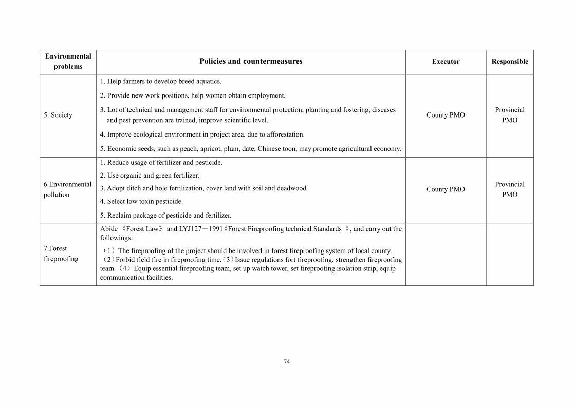
74
Environmental problems
Policies and countermeasures Executor Responsible
5. Society
1. Help farmers to develop breed aquatics.
2. Provide new work positions, help women obtain employment.
3. Lot of technical and management staff for environmental protection, planting and fostering, diseases and pest prevention are trained, improve scientific level.
4. Improve ecological environment in project area, due to afforestation.
5. Economic seeds, such as peach, apricot, plum, date, Chinese toon, may promote agricultural economy.
County PMO Provincial
PMO
6.Environmental pollution
1. Reduce usage of fertilizer and pesticide.
2. Use organic and green fertilizer.
3. Adopt ditch and hole fertilization, cover land with soil and deadwood.
4. Select low toxin pesticide.
5. Reclaim package of pesticide and fertilizer.
County PMO Provincial
PMO
7.Forest fireproofing
Abide 《Forest Law》 and LYJ127-1991《Forest Fireproofing technical Standards 》, and carry out the followings:
(1)The fireproofing of the project should be involved in forest fireproofing system of local county. (2)Forbid field fire in fireproofing time.(3)Issue regulations fort fireproofing, strengthen fireproofing team.(4)Equip essential fireproofing team, set up watch tower, set fireproofing isolation strip, equip communication facilities.

75
7.4 Environmental monitoring plan
The basic aim of the project environmental monitoring plan includes the followings,
7.4.1 Monitoring executants
The provincial PMO is responsible for the monitoring plan, the county PMO work under the
guidance of provincial PMO. City and county monitoring stations are responsible for local
monitoring of surface and underground water, Shandong Forest Bureau monitors the
manmade ecological forest, forest diseases and pests prevention station is responsible for
pesticide usage and management plan of diseases and pests prevention. Provincial PMO
should signs agreements with relevant monitoring stations before project launch. County
environmental supervise staffs is responsible for monitoring implementation according to
management and monitoring plan.
7.4.2 Monitoring report system and outlay
Monitoring report system is as Fig 8.2-1. The monitoring station should compile report after
each task and report to provincial PMO and higher-up organizations. PMO and
environmental organizations will improve the reported problems. In construction and
running periods, PMO should submit annual environmental management and monitoring
plan, which should also be sent to Shandong EPB and SEPM.
Total outlay for monitoring is 1,050,000RMB, which will come from city and county
matching funds.
Table 7.4-1 Monitoring outlay(10000RMB,%)
Monitoring items Outlay
10,000 RMB %
1 Investigation of ecological diversity 15 7.5
2 Property and salt determine of soil 30 15.0
3 Monitoring of water maintain and soil erosion degree 20 10.0
4 Wind-proof effective monitoring of protection forest in
coastal saline lands 20 10.0
5 Forest pest and disease monitoring 20 10.0
Total 105 52.5
7.4.3 Selection of monitoring items and sites
Based on(1)research and observation of manmade forest in the last 30 years;(2)Some
general investigation on forest vegetation in Shandong Province; and(3)experience from

76
other places, monitoring plan is made as follows:
Supervise staffs monitor the impact caused by main factors, including soil erosion, soil
fertility, and water quality, though field investigation and lab analysis. If career man needed,
the organization held certificate should sign sub agreements, and work under guidance of
project office. The monitoring will centralize in 3 project counties in running period, which
are typical in location importance, topography and physiognomy, fragile environment,
economy, and natural heritage. 6 provincial monitoring sites are set in Xintai, Mengyin,
Rushan, Juxian, Hekou and Zhanhua; 1 county monitoring site is set in each county, and 30
sample lands are selected.
Monitoring content is as table 7.4-1。

77
Table 7.4-1 List of environmental monitoring plan in every stage
Monitoring objects
Monitoring index, methods, frequency and sites Implement units Supervision
units
1. Vegetation diversity
1. Monitoring items: vegetation in the forests, including type, number, cover rate, distribution and growth.
2. Methods: Select typical regions, set up at least 3 samples, each one is 10×10m2, count the types, number and living condition, work out biological diversity.
3.Frequency: Once in the 1st,3rdand 6th year of the project, time is 9 days
4. Sites: 6 provincial monitoring sites are set in Xintai, Mengyin, Rushan, Juxian, Hekou and Zhanhua; 1 county monitoring site is set in each county, and 30 sample lands are selected.
PMO PMO
2. soil fertility and salt
1. Monitoring items: Judge soil fertility by organic, TN, P, TKa, Ca, Mg and pH, monitor underground water level.
2. Methods: Select typical regions, based on state monitoring rules.
3.Frequency: Once in the 1st,3rdand 6th year of the project, time is 6 days
4. Sites: 6 provincial monitoring sites are set in Xintai, Mengyin, Rushan, Juxian, Hekou and Zhanhua; 1 county monitoring site is set in each county, and 30 sample lands are selected.
Environmental supervise staff and forest
organization
PMO
3. Water retain and soil erosion
1. Monitoring items: Rainfall, water containing in deadwood and soil, soil erosion, surface water runoff 2. Methods: Select typical regions, based on state monitoring rules.
3.Frequency: Once in the 1st,3rdand 6th year of the project, time is 6 days
4. Sites: 6 provincial monitoring sites are set in Xintai, Mengyin, Rushan, Juxian, Hekou and Zhanhua; 1 county monitoring site is set in each county, and 30 sample lands are selected.
Provincial monitoring station
PMO
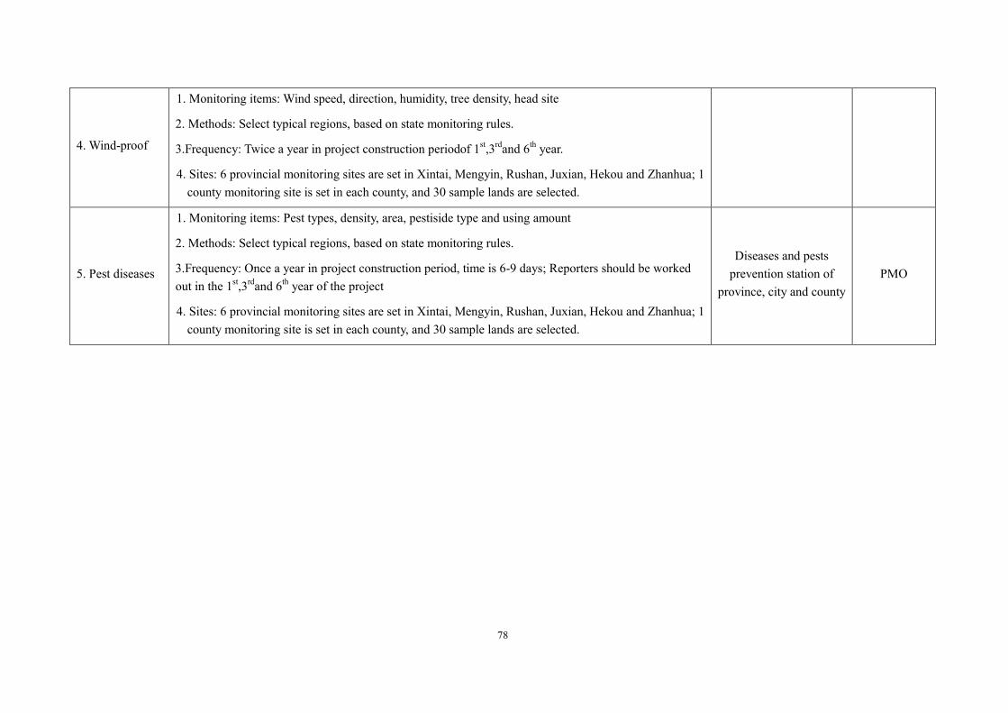
78
4. Wind-proof
1. Monitoring items: Wind speed, direction, humidity, tree density, head site
2. Methods: Select typical regions, based on state monitoring rules.
3.Frequency: Twice a year in project construction periodof 1st,3rdand 6th year.
4. Sites: 6 provincial monitoring sites are set in Xintai, Mengyin, Rushan, Juxian, Hekou and Zhanhua; 1 county monitoring site is set in each county, and 30 sample lands are selected.
5. Pest diseases
1. Monitoring items: Pest types, density, area, pestiside type and using amount
2. Methods: Select typical regions, based on state monitoring rules.
3.Frequency: Once a year in project construction period, time is 6-9 days; Reporters should be worked out in the 1st,3rdand 6th year of the project
4. Sites: 6 provincial monitoring sites are set in Xintai, Mengyin, Rushan, Juxian, Hekou and Zhanhua; 1 county monitoring site is set in each county, and 30 sample lands are selected.
Diseases and pests prevention station of
province, city and county PMO

7.4.4 Monitoring
Project construction may bring some negative impacts to natural vegetation, soil, ecological
diversity and diseases and pests. In running period, the potential impacts are mainly soil
erosion, surface and underground water, pesticide usage, diseases and pest prevention, soil
fertility and ecological diversity. The monitoring plan in running period is to find out
impacts caused by the project, improve environmental management and monitoring plan in
next step to prevent bigger negative impacts.
7.5 Environmental training/regulation enforcement plan The training objective is to ensure officials of the project to reinforce their ability to
implement the environment management and monitoring plan. Staff from the forestry centers
and companies could be involved. But the training fee is charged by them not by the project.
To ensure the quality of the training, the candidates receive the training should have collegial
level, and their specialty should be natural science, such as forestry management, water
resource, ecology, soil and agriculture.
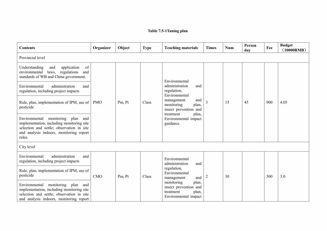
Table 7.5-1Taning plan
Contents Organizer Object Type Teaching materials Times Num Person day Fee Budget
(10000RMB)
Provincial level
Understanding and application of environmental laws, regulations and standards of WB and China government.
PMO Pm, Pt Class
Environmental administration and regulation, Environmental management and monitoring plan, insect prevention and treatment plan, Environmental impact guidance.
3 15 45 900 4.05
Environmental administration and regulation, including project impacts
Rule, plan, implementation of IPM, use of pesticide
Environmental monitoring plan and implementation, including monitoring site selection and settle; observation in site and analysis indoors, monitoring report rules.
City level
Environmental administration and regulation, including project impacts
CMO Pm, Pt Class
Environmental administration and regulation, Environmental management and monitoring plan, insect prevention and treatment plan, Environmental impact
2 30 500 3.0 Rule, plan, implementation of IPM, use of pesticide
Environmental monitoring plan and implementation, including monitoring site selection and settle; observation in site and analysis indoors, monitoring report

81
rules. guidance.
County level
Base knowledge of environmental monitoring; Understanding on vegetation degradation, biological system; Bird identification; Bio-diversity monitoring methods; Principle of soil erosion control. County
forest organization
Afforestation
units
Class,
workshop
Environmental administration and regulation, Environmental management and monitoring plan, insect prevention and treatment plan, Environmental impact guidance.
1 400 400 70 2.8
Main environmental protection measures
Identification, prevention and treatment of insects, use of pesticide

82
Chapter 8 Conclusions
8.1 Project intrrduction
This project involves 9 prefectures, involving Weifang City, Taian City, Jining City, Weihai
City, Rizhao City, Laiwu City, Dongying City, Binzhou City and Linyi City, and 30 counties.
The proposed project will construct ecological afforestation covering a total area of
65972.6hm2, including re-vegetating of 38343.5 hm2 degraded mountainous areas,
accounting for 58.1% of the whole project; and stabilizing 27629.1m2 saline coastal areas,
41.9% of the whole project. The implementation period for this project is 6 years.
8.2 Compliance with relevant policies
The project is compliant with “National Ecological Environment Protection Program”,
“Guiding Catalogue of Industrial Structure Regulation“, “General plan for land use in
Shandong Province”, “Determination on speed forest construction to build green Shandong”,
and etc.
8.3 Natural and Environmental Status and Social Environment
The mean annual precipitation is 550-950 mm,reduced from sountheast to northwest.
32.62% of provincial control rivers meet demands of water function regions, the main
pollutans are COD and NH3-N.
Selectble land in project areas is sufficient for project construction, without using arable
land.
The nearest distance from the project site to Shandong Yellow River Delta National Nature
Reserve is about 8km, there is no adverse impacts.
The main ecological problems are water and soil erosion, land salinization and wind.
The projct sites will locate in above 3 weak ecological regions, including degraded
mountains, saline plain and wind hurricane regions.
8.4 public participation
The result of questionnaires and expert consulting show that 100% people investigated
regard the project will improve local ecological environment, and support the project
construction.
8.5 Environmental impact analysis
Shandong ecological afforestation project will be favor of increasing tree species in planting
sites, phytomass, and biological diversity, efficiently control water and soil losses, improving
saline-alkali soil, protecting biological diversity, furthermore, improving local ecological

83
environment. The environmental impacts of the project are mainly positive. However, if the
measures are not proper during the project construction, the negative impacts will also be
caused. This section will analysis the potential negative environmental impact and propose
the corresponding measures in EMP to realize the sustainable development of the project
construction.
8.6 Alternative project analysis
The project is necessary to build based on analysis on impact of project and afforestation
models. Compared with tranditional model, the project afforestation model is more advanced
in site selection, forestland, cleaning, land dealing, density, and vegetation confirm, foster
management, pesticide prevention, fertilizer and etc.
8.7 Environmental management and monitoring plan
Based on experience and lessons of former projects in Shandong Province, the
environmental management and monitoring plan is worked out, which involes
countermeasures, monitroring and training plan, dutie of relevant units in periods of design,
construction and running.
8.8 General introduction
The project implementation will raise the forest cover rate to 0.3%, which is helpful to exert
multi-function and benefit of the forest, especially increase the forest area, improve forest
structure, promote forest quality and local ecological environment. It also will bring
favorable impact to forest diversity, reduce soil degradation, and prevent water and soil
erosion and clean air. The project also can increase local economy, and reduce artificial
impact to the environment. Although the project may bring some negative impact, the impact
can be controlled lower or avoided by ecological protection measures. The favorable benefit
is much bigger than negative impact.