environmental hazard management plan (ehmp) for the ... · final environmental hazard management...
TRANSCRIPT

Final
Environmental Hazard Management Plan (EHMP) for the Abandoned Fuel Pipeline Site 24 Marine Corps Base Hawaii, Kaneohe, Oahu, Hawaii
February 2013
Department of the Navy Naval Facilities Engineering Command, Hawaii 400 Marshall Road JBPHH, Hawaii 96860-3139
Environmental Technical Services Contract Number N62742-11-D-1821, CTO 0016


Final
Environmental Hazard Management Plan (EHMP) for the Abandoned Fuel Pipeline Site 24 Marine Corps Base Hawaii, Kaneohe, Oahu, Hawaii February 2013 Prepared for:
Department of the Navy Naval Facilities Engineering Command, Hawaii 400 Marshall Road JBPHH, Hawaii 96860-3139
Prepared by:
98-030 Hekaha Street, Unit 9 Aiea, HI 96701
Prepared under:
Environmental Technical Services Contract Number N62742-11-D-1821, CTO 0016


Final EHMP for Abandoned Fuel Pipeline Site 24 MCB Hawaii, Kaneohe, Oahu, Hawaii
Table of Contents September 2012
i
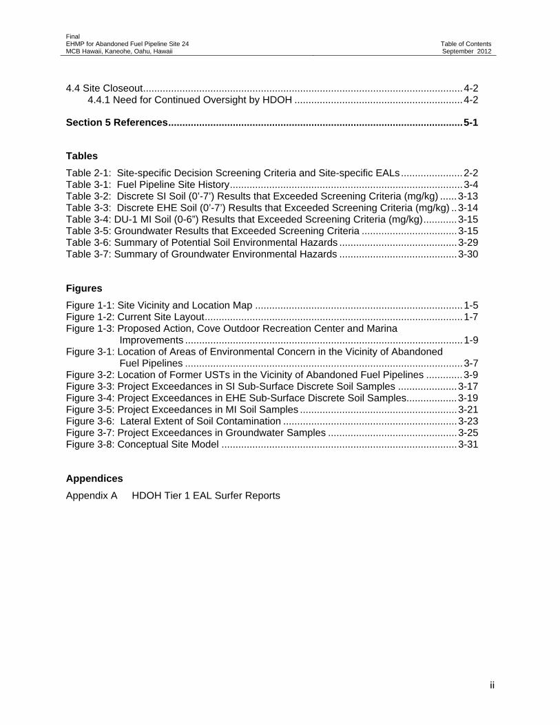
Table of Contents Section Page
List of Acronyms .................................................................................................................. iii
Executive Summary .......................................................................................................... ES-1
Section 1 Introduction ....................................................................................................... 1-1
1.1 Project Identification and Approvals ............................................................................... 1-1 1.2 Project Purpose ............................................................................................................. 1-2 1.3 Site Location .................................................................................................................. 1-3 1.4 Site Description .............................................................................................................. 1-3 1.5 Surrounding Areas ......................................................................................................... 1-3 1.6 Site Uses ........................................................................................................................ 1-4 1.7 Climate ......................................................................................................................... 1-11 1.8 Topography, Elevation, and Surface ............................................................................ 1-11 1.9 Geology and Hydrogeology ......................................................................................... 1-11
1.9.1 Regional Geology and Hydrogeology ............................................................... 1-11 1.9.2 Site Geology ...................................................................................................... 1-11 1.9.3 Site Hydrogeology ............................................................................................. 1-12 1.9.4 Groundwater Use Classification ........................................................................ 1-12 1.9.5 Surface Water ................................................................................................... 1-12
1.10 Flora and Fauna ......................................................................................................... 1-13 1.10.1 Biological Site Setting ..................................................................................... 1-13 1.10.2 Sensitive Ecological Resources ...................................................................... 1-13
Section 2 Development of the Environmental Hazard Evaluation and Environmental Hazard Management Plan ................................................................................................. 2-1
2.1 Identification of Contaminants of Concern ..................................................................... 2-2
Section 3 Environmental Hazard Evaluation ................................................................... 3-1
3.1 Previous Investigations .................................................................................................. 3-1 3.2 Current Site Conditions ................................................................................................ 3-11 3.3 Target Indicator Contaminants ..................................................................................... 3-11 3.4 Project-Specific Decision Screening ............................................................................ 3-11
3.4.1 Soil .................................................................................................................... 3-12 3.4.2 Groundwater ..................................................................................................... 3-15
3.5 Potential Human Health and Environmental Hazards .................................................. 3-27 3.5.1 COPCs and Affected Media .............................................................................. 3-27 3.5.2 Exposure Pathways .......................................................................................... 3-27 3.5.3 Fate and Transport ............................................................................................ 3-28 3.5.4 Soil Environmental Hazards .............................................................................. 3-28 3.5.5 Groundwater Environmental Hazards ............................................................... 3-29
Section 4 Environmental Hazard Management Plan ...................................................... 4-1
4.1 Monitoring ...................................................................................................................... 4-1 4.2 Administrative Boundaries ............................................................................................. 4-1 4.3 Administrative Notices ................................................................................................... 4-2
Final EHMP for Abandoned Fuel Pipeline Site 24 MCB Hawaii, Kaneohe, Oahu, Hawaii
Table of Contents September 2012
ii
4.4 Site Closeout .................................................................................................................. 4-2 4.4.1 Need for Continued Oversight by HDOH ............................................................ 4-2
Section 5 References ......................................................................................................... 5-1
Tables
Table 2-1: Site-specific Decision Screening Criteria and Site-specific EALs ...................... 2-2 Table 3-1: Fuel Pipeline Site History ................................................................................... 3-4 Table 3-2: Discrete SI Soil (0’-7’) Results that Exceeded Screening Criteria (mg/kg) ...... 3-13 Table 3-3: Discrete EHE Soil (0’-7’) Results that Exceeded Screening Criteria (mg/kg) .. 3-14 Table 3-4: DU-1 MI Soil (0-6”) Results that Exceeded Screening Criteria (mg/kg) ............ 3-15 Table 3-5: Groundwater Results that Exceeded Screening Criteria .................................. 3-15 Table 3-6: Summary of Potential Soil Environmental Hazards .......................................... 3-29 Table 3-7: Summary of Groundwater Environmental Hazards .......................................... 3-30
Figures
Figure 1-1: Site Vicinity and Location Map .......................................................................... 1-5 Figure 1-2: Current Site Layout ............................................................................................ 1-7 Figure 1-3: Proposed Action, Cove Outdoor Recreation Center and Marina
Improvements ................................................................................................... 1-9 Figure 3-1: Location of Areas of Environmental Concern in the Vicinity of Abandoned
Fuel Pipelines ................................................................................................... 3-7 Figure 3-2: Location of Former USTs in the Vicinity of Abandoned Fuel Pipelines ............. 3-9 Figure 3-3: Project Exceedances in SI Sub-Surface Discrete Soil Samples ..................... 3-17 Figure 3-4: Project Exceedances in EHE Sub-Surface Discrete Soil Samples.................. 3-19 Figure 3-5: Project Exceedances in MI Soil Samples ........................................................ 3-21 Figure 3-6: Lateral Extent of Soil Contamination .............................................................. 3-23 Figure 3-7: Project Exceedances in Groundwater Samples .............................................. 3-25 Figure 3-8: Conceptual Site Model .................................................................................... 3-31
Appendices
Appendix A HDOH Tier 1 EAL Surfer Reports
Final EHMP for Abandoned Fuel Pipeline Site 24 MCB Hawaii, Kaneohe, Oahu, Hawaii
Acronyms
February 2013
iii
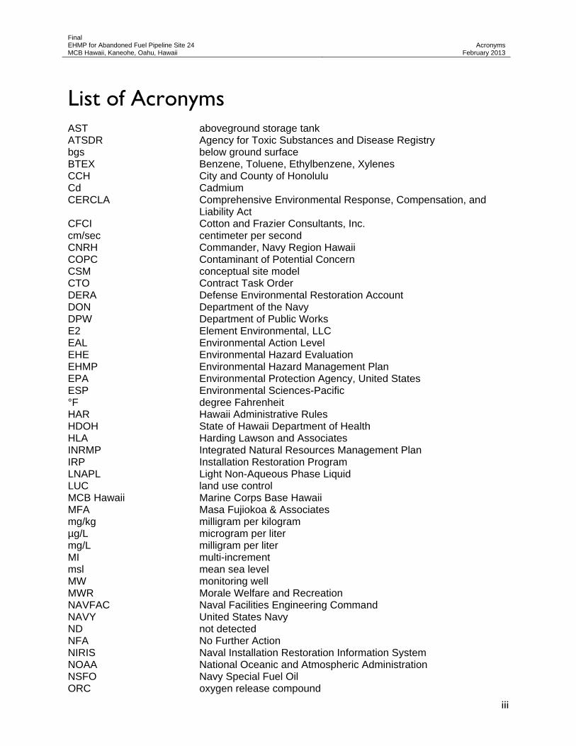
List of Acronyms AST aboveground storage tank ATSDR Agency for Toxic Substances and Disease Registry bgs below ground surface BTEX Benzene, Toluene, Ethylbenzene, Xylenes CCH City and County of Honolulu Cd Cadmium CERCLA Comprehensive Environmental Response, Compensation, and
Liability Act CFCI Cotton and Frazier Consultants, Inc. cm/sec centimeter per second CNRH Commander, Navy Region Hawaii COPC Contaminant of Potential Concern CSM conceptual site model CTO Contract Task Order DERA Defense Environmental Restoration Account DON Department of the Navy DPW Department of Public Works E2 Element Environmental, LLC EAL Environmental Action Level EHE Environmental Hazard Evaluation EHMP Environmental Hazard Management Plan EPA Environmental Protection Agency, United States ESP Environmental Sciences-Pacific °F degree Fahrenheit HAR Hawaii Administrative Rules HDOH State of Hawaii Department of Health HLA Harding Lawson and Associates INRMP Integrated Natural Resources Management Plan IRP Installation Restoration Program LNAPL Light Non-Aqueous Phase Liquid LUC land use control MCB Hawaii Marine Corps Base Hawaii MFA Masa Fujiokoa & Associates mg/kg milligram per kilogram µg/L microgram per liter mg/L milligram per liter MI multi-increment msl mean sea level MW monitoring well MWR Morale Welfare and Recreation NAVFAC Naval Facilities Engineering Command NAVY United States Navy ND not detected NFA No Further Action NIRIS Naval Installation Restoration Information System NOAA National Oceanic and Atmospheric Administration NSFO Navy Special Fuel Oil ORC oxygen release compound

Final EHMP for Abandoned Fuel Pipeline Site 24 MCB Hawaii, Kaneohe, Oahu, Hawaii
Acronyms
February 2013
iv
PA Preliminary Assessment PACNAVFACENGCOM Pacific Division, Naval Facilities Engineering Command PAH Polynuclear Aromatic Hydrocarbon PAL Project Action Level Pb lead PID photoionization detector PRG Preliminary Remediation Goals QC quality control SCP Hawaii State Contingency Plan SI Site Investigation TGM Technical Guidance Manual TPH Total Petroleum Hydrocarbons TPH-DRO Total Petroleum Hydrocarbons as Diesel Range Organics TPH-GRO Total Petroleum Hydrocarbons as Gasoline Range Organics TPH-RRO Total Petroleum Hydrocarbons as Residual Oil Range Organics UIC Underground Injection Control US United States USDA Unite States Department of Agriculture USMC United States Marine Corps UST underground storage tank VOC Volatile Organic Compound WCP Wil Chee Planning, Inc. WMA Wildlife Management Area

Final EHMP for Abandoned Fuel Pipeline Site 24 MCB Hawaii, Kaneohe, Oahu, Hawaii
Executive Summary
February 2013
ES-1
Executive Summary This document presents an Environmental Hazard Evaluation (EHE) and Environmental Hazard Management Plan (EHMP) for the Navy Special Fuel Oil (NSFO) release from the Abandoned Fuel Pipeline Site located near the Marina at Marine Corps Base Hawaii (MCB Hawaii) in Kaneohe, Oahu, Hawaii. In addition, the EHE/EHMP compiles information from all previous investigations performed relative to the NSFO pipeline release at the Abandoned Fuel Pipeline Site. Naval Facilities Engineering Command, Hawaii authorized this EHE/EHMP under contract number N62742-11-D-1821, Contract Task Order 0016.
The EHE and EHMP in this document follow the Hawaii State Contingency Plan (Hawaii Administrative Rules [HAR] 11-451), HAR 11-281, and the following Hawaii Department of Health (HDOH) guidance documents:
Technical Guidance Manual for the Implementation of the Hawai’i State Contingency Plan Interim Final – June 21, 2009.
Evaluation of Environmental Hazards at Sites with Contaminated Soil and Groundwater, Volume 1: User’s Guide, Hawai’i Edition Summer 2008 (updated March 2009).
Screening for Environmental Hazards at Sites with Contaminated Soil and Groundwater, Volume 2: Background Documentation for the Development of Tier 1 Environmental Action Levels, Appendices 2-11, Summer 2008.
Long-Term Management of Petroleum-Contaminated Soil and Groundwater, 2007.
According to the Long-Term Management of Petroleum-Contaminated Soil and Groundwater (HDOH 2007), the principal objectives of an EHE/EHMP are as follows:
Assess the concentrations of the chemicals of potential concern (COPCs);
Document changes to the free-phase product plume over time;
Evaluate potential environmental hazards that are present; and
Recommend continued monitoring and site closeout procedures.
The overall objective of the EHE presented in this document is to evaluate the following potential environmental hazards:
Direct exposure;
Vapor intrusion;
Leaching;
Ecotoxicity; and
Gross contamination.
These hazards were evaluated using HDOH Tier 1 Environmental Action Levels (EALs) (HDOH 2011) with respect to potential effects on human health and ecological populations under the following conditions: current site conditions; conditions during known, near-term construction activities; and anticipated future uses of the site.

Final EHMP for Abandoned Fuel Pipeline Site 24 MCB Hawaii, Kaneohe, Oahu, Hawaii
Executive Summary
February 2013
ES-2
Both an EHE and an EHMP have been prepared to address contaminated subsurface soil and groundwater at and near the NSFO fuel pipeline release site at the Abandoned Fuel Pipeline site. The EHE describes the contaminants of concern and associated hazards, any soil or groundwater exposure hazards, and future site development plans. An EHMP has been developed as environmental hazards have been identified and long-term management is necessary.
In summary, the EHMP includes the following:
Description of the contaminants of concern and associated hazards;
Administrative boundaries;
Administrative notices; and
A site closeout plan.
Background
The project site occupies an area on the southern perimeter of MCB Hawaii. According to a utilities drawing (USM-33) reviewed at the Department of Public Works (DPW), two eight-inch diameter pipelines exit the 10,000-barrel capacity AST S-125 and travel in a southwesterly direction under Buildings 131 and 132 until reaching D Street, where they run parallel to one another on opposite sides of the street. Both fuel pipelines currently terminate near the beginning of the Fueling Pier. The pipelines are buried at a depth of between 3 to 5 feet bgs.
A site plan dated circa 1945 indicates that an eight-inch diameter pipeline carrying “Navy Special Crude” traversed the west side of the Boathouse Building along the adjacent paved road. This pipeline originates from a large AST (Tank S-125) located about ¼-mile inland from the pier.
The last load of NSFO was received in February 1986 and the lines were abandoned in place during the same year. The lines were pressure tested in June 1986 by Fuel Division personnel. The lines failed to hold 40 pounds of pressure and a leak was discovered during the test when oil began surfacing at the concrete water valve pipe located in the Boathouse parking lot. The area of the release was excavated and the lines were patched with water plug cement. At the same time, the line was cut and capped at the beginning of the pier and at the tank. Thus, the contamination at the Fuel Pipeline project site originated from releases from the pipelines that occurred a minimum of 25 years ago.
A series of environmental investigations have been conducted in the vicinity of the abandoned fuel pipelines since 1984 related to the removal of nearby Above Ground Storage Tanks (ASTs), Underground Storage Tanks (USTs) and historic releases from the abandoned fuel pipelines (Luecker et al, 1984; CFCI 1995; ESP 1997; MFA 2001; WCP 2003; WCP 2008; WCP 2009; E2, 2010). Figures 1-4 and 1-5 show the general areas where these previous environmental investigations have been conducted. Specifically, soil samples collected from the vicinity of the former UST KB-12 and from the general area of the future Cove Outdoor Recreation Center have encountered contamination in the vicinity of the capillary fringe (between 5- to 8-feet bgs) related to historic releases from one of the subject fuel pipelines. Figures 1-6 and 1-7 depict the concentration of TPH-DRO and the carcinogenic PAH benzo[a]pyrene, respectively, measured in site soils as a function of depth. These figures clearly show that the soil contamination at the site is concentrated in the capillary fringe, from a depth range of around 5.5 to 7 feet bgs. The

Final EHMP for Abandoned Fuel Pipeline Site 24 MCB Hawaii, Kaneohe, Oahu, Hawaii
Executive Summary
February 2013
ES-3
contamination encountered in the vicinity of the abandoned fuel pipelines is extremely viscous and quantifies as TPH-DRO and TPH-RRO.
The contaminated soil samples contained no volatiles and low levels of lead and PAH compounds, while groundwater collected from the area contained high concentrations of TPH-DRO and TPH-RRO and low levels of BTEX and PAH compounds. The lead and cadmium levels measured during previous environmental sampling at the site did not exceed the Tier 1 screening levels. However, the previous sampling only covered a small portion (less than 10%) of the area where historic releases from the pipeline may have occurred. The HDOH (per their TGM) typically asks for data on these metal’s concentrations at sites where oil has been potentially released to the environment, so lead and cadmium are included as site COPCs.
The maximum concentrations detected in the soil and groundwater samples are summarized in Tables 3-2 and 3-3, respectively. These samples were collected during these investigations and located in the general vicinity of the project site. The historic environmental data in these tables were tabulated along with the EALs associated with the scenario that groundwater at the site is not a current or potential drinking water resource and the nearest surface water body is within 150 meters (Tables B-2 and D-1c for soil and groundwater, respectively) for comparison (HDOH 2011). The columns highlighted in green represent data for soil and groundwater contamination measured at sites that are believed to have been impacted by historic releases from the subject abandoned fuel pipelines.
Current Site Conditions
The Abandoned Fuel Pipeline site spans multiple facilities, including a recycling station, boat storage yard, the future Recreation Center, and all other marina facilities. There are no immediate plans to change the nature of the site use. The most recent environmental study completed for the site was the EHE/SI completed by Element Environmental (E2) in 2012.
The new Recreational Center directly adjacent to the marina was under construction during the EHE/SI fieldwork investigation and construction is almost complete.
Project-specific decision screening criteria were identified by comparing analytical results for soil and groundwater (E2 2012) to HDOH Tier 1 EALs for Unrestricted Land Use (HDOH 2011). Analytes with concentrations exceeding Tier 1 EALs were identified as contaminants of potential concern (COPCs) and then compared against site-specific EALs for the Construction and Trench Worker Exposure Scenario (using EAL Surfer [HDOH 2011]). The Construction and Trench Worker Exposure Scenario EALs were used to evaluate the potential human health and environmental hazards associated with the Abandoned Fuel Pipeline site contaminants. The following analytes were identified as Abandoned Fuel Pipeline site COPCs, exceeding both HDOH Tier 1 and Tier 2 EALs:
Soil – TPH-DRO; and
Groundwater – TPH-DRO and lead.
Risk Evaluation
The Abandoned Fuel Pipeline site encompasses an area used for the recycling center, boat storage and the Boathouse Marina facilities, and the future Cove Outdoor Recreational Center. The future land use for the site will remain the same. The site is bordered by Kaneohe Bay to

Final EHMP for Abandoned Fuel Pipeline Site 24 MCB Hawaii, Kaneohe, Oahu, Hawaii
Executive Summary
February 2013
ES-4
the south and east. Buildings in the vicinity of the site include former Exchange Service Station and associated Pump Canopy (Buildings 131/132), the Boathouse (Building 128), the Small Boat Repair Shop (Building 129), and the Waterfront Operations Facility (Building 107). Most of the site consists of paved areas such as the recycling center, the boat storage areas, D Street, and the areas around Building 128. The marina parking area is relatively level packed earth. Abandoned and active underground utilities are present beneath the surface of the release site. At the time of the SI, construction was underway for the new Cove Outdoor Recreational Facility. Given these land uses, the current and/or future receptors evaluated were onsite occupational workers (i.e., Boathouse personnel), onsite construction workers, and ecological receptors (i.e., biota living in and around the project site, including in Kaneohe Bay). Potential transport mechanisms to be considered include direct contact, air transport, bio-uptake, storm water runoff, and leaching to groundwater. Potential exposure routes include ingestion, dermal contact, and inhalation of vapors and particulates.
Potentially complete pathways and exposure routes for each receptor include the:
Ecological Receptor who is exposed to: Contaminated groundwater discharge to Kaneohe Bay through ingestion or
dermal contact. Onsite current or future construction worker who is exposed to:
Direct contact through incidental ingestion and dermal contact; Contaminated groundwater through ingestion, dermal contact and inhalation of
VOCs.
In accordance with the guidelines presented in Long-Term Management of Petroleum Contaminated Soil and Groundwater (HDOH 2007), preparation of an EHMP that identifies the nature of the petroleum contamination present, the potential environmental concerns posed by the contamination, and appropriate measures to ensure that these concerns are adequately addressed was recommended. At the Abandoned Fuel Pipeline site, contaminated soils exceeding EALs have been identified due to the presence of residual petroleum hydrocarbons in the subsurface soils. To provide notice of this potential hazard for future construction projects, MCB Hawaii will enter an Administrative Boundary based on the established extent of the soil contamination.
Administrative Notices will include the following information pertaining to the Administrative Boundary:
Soils excavated from the site may contain elevated concentrations of TPH and metals, and require proper handling and disposal in accordance with the following guidelines:
- Clean and petroleum-impacted soil will not be mixed.
- Petroleum-impacted soil will be re-deposited in the same area and as much as possible, at the same depth that it was originally encountered.
- The excavation should be filled with clean material, to minimize human contact with petroleum-impacted soil.
- Excavated petroleum-impacted soil shall be transported off site for disposal. Soil shall be sampled and tested to ensure compliance with HDOH and disposal facility guidelines and permit requirements.
Excavation machinery decontamination and personal protective equipment may be required for operations in this area.

Final EHMP for Abandoned Fuel Pipeline Site 24 MCB Hawaii, Kaneohe, Oahu, Hawaii
Executive Summary
February 2013
ES-5
The release at the Abandoned Fuel Pipeline site occurred prior to 1994, when the site contamination was first detected. The nature and extent of soil and groundwater contamination in the vicinity of the Abandoned Fuel Pipelines has been delineated, and the potential environmental hazards have been identified and managed. Due to the depth of contamination (at depths of 4.5 to 6 feet bgs), exposure to human and ecological receptors is limited to direct exposure to construction workers during subsurface excavation. An additional round of groundwater monitoring will be conducted to verify that the contaminant plume is stable. If the contaminant plume is found to be stable, a request will be submitted for issuance of a Conditional NFA Letter based upon available site data and HDOH guidance. Future management of the contaminated soil and groundwater would be conducted by the United States Navy (Navy) without further HDOH oversight.

Final EHMP for Abandoned Fuel Pipeline Site 24 MCB Hawaii, Kaneohe, Oahu, Hawaii
Executive Summary
February 2013
ES-6
This page intentionally left blank.

Final EHMP for Abandoned Fuel Pipeline Site 24 MCB Hawaii, Kaneohe, Oahu, Hawaii
Section 1 Introduction
February 2013
1-1
Section 1 Introduction
1.1 Project Identification and Approvals
Project Name: Environmental Hazard Management Plan (EHMP) for Abandoned Fuel Pipeline Site 24
Marine Corps Base Hawaii (MCB Hawaii), Kaneohe, Oahu, Hawaii
Contract Number: N62742-11-D-1821, CTO 0016
Project Number: 120036
Project Location: MCB Hawaii, Kaneohe, Oahu, Hawaii
Date of Issue: February 2013
*Approvals:
Approvals:
Steven Spengler, PhD, Project Manager, Element Environmental, LLC Date
Ryan Yamauchi, PE, President, Element Environmental, LLC Date
*Approvals are solely internal approvals and do not indicate approval by any outside individual, agency, or entity.

Final EHMP for Abandoned Fuel Pipeline Site 24 MCB Hawaii, Kaneohe, Oahu, Hawaii
Section 1 Introduction
February 2013
1-2
1.2 Project Purpose
This document presents an Environmental Hazard Management Plan (EHMP) for a release of Navy Special Fuel Oil (NSFO) near the new Recreation Center Building and adjacent Boathouse Building (128), located on the Marine Corps Base Hawaii (MCB Hawaii), in Kaneohe, Oahu, Hawaii (the site, project site, release site). The EHMP describes the contaminants of concern, defines the extent and magnitude of contaminated soil and groundwater left in place at the release site, summarizes identified environmental concerns and associated hazards posed by the contamination, discusses future site plans, and provides a framework for long-term management of site contamination. Naval Facilities Engineering Command (NAVFAC) Hawaii authorized this EHMP under Contract Number N62742-11-D-1821, Contract Task Order (CTO) 0016.
The EHMP follows the Hawaii State Contingency Plan (SCP) (Hawaii Administrative Rules [HAR] 11-451), HAR 11-281, and the following State of Hawaii Department of Health (HDOH) guidance documents:
Technical Guidance Manual (TGM) for the Implementation of the Hawai’i State Contingency Plan, Interim Final – June 21, 2009.
Evaluation of Environmental Hazards at Sites with Contaminated Soil and Groundwater, Volume 1: User’s Guide, Hawai’i Edition Summer 2008 (updated March 2009).
Screening for Environmental Hazards at Sites with Contaminated Soil and Groundwater, Volume 2: Background Documentation for the Development of Tier 1 Environmental Action Levels, Appendices 2-11, Summer 2008.
Long-Term Management of Petroleum-Contaminated Soil and Groundwater, 2007.
The abandoned pipelines originate from a large aboveground storage tank (AST, Tank S-125) located about ¼-mile inland from the Finger Pier (see Figures 1-1 and 1-2). A site plan dated circa 1945 indicates that an 8-inch diameter pipeline carrying “Navy Special Crude” traversed the west side of the Boathouse Building along the adjacent paved road. Navy Special Crude, also known as NSFO, is a highly viscous ship fuel that is created by blending Bunker B (Fuel Oil #5) with light petroleum distillates. NSFO has a specific gravity similar to water, is a light non-aqueous phase liquid (LNAPL), and requires heating in order to be pumped (Global Security 2010). NSFO has a viscosity of 170 centistokes at ambient temperature, which is 250 times that of gasoline at 0.68 centistokes. The high viscosity of NSFO renders this petroleum product relatively immobile when it is released into subsurface soils.
The last load of NSFO was received in February 1986 and the lines were abandoned in place during the same year. The lines were pressure tested in June 1986 by Fuel Division personnel. The lines failed to hold 40 pounds of pressure and a leak was discovered during the test when oil began surfacing at the concrete water valve pipe located in the Boathouse parking lot. The area of the release was excavated and the lines were patched with water plug cement. At the same time, the line was cut and capped at the beginning of the pier and at the tank. Thus, the contamination at the Fuel Pipeline project site originated from releases that occurred from the pipelines a minimum of 25 years ago.

Final EHMP for Abandoned Fuel Pipeline Site 24 MCB Hawaii, Kaneohe, Oahu, Hawaii
Section 1 Introduction
February 2013
1-3
This EHMP present data from the previous Environmental Hazard Evaluation/Site Investigation (EHE/SI) conducted for the area of contamination in and around the NSFO release at the Abandoned Fuel Pipeline site (E2, 2012). It evaluates the existing data and provides final management recommendations based on the findings of the data evaluation.
1.3 Site Location
MCB Hawaii is located on the windward (southeast) side of Oahu, and occupies the entire 2,951-acre Mokapu Peninsula. MCB Hawaii is bordered to the west by Kaneohe Bay, to the north by the Pacific Ocean, to the east by Kailua Bay, and to the south by fishponds. South of the fishponds, MCB Hawaii is bordered by Kaneohe Bay Drive, the City and County of Honolulu (CCH) Kailua Regional Wastewater Treatment Plant, and the residential communities of Kaneohe and Kailua. The abandoned fuel pipelines are located near the southern perimeter of MCB Hawaii adjacent to the installation’s marina facilities (Figures 1-1 and 1-2).
1.4 Site Description
The project site occupies an area on the southern perimeter of MCB Hawaii. According to a utilities drawing (USM-33) reviewed at the Department of Public Works (DPW), two eight-inch diameter pipelines exit the 10,000-barrel capacity AST S-125 and travel in a southwesterly direction under Buildings 131 and 132 until reaching D Street, where they run parallel to one another on opposite sides of the street (Figure 1-3). Both fuel pipelines currently terminate near the beginning of the Fueling Pier. The pipelines are believed to be buried at a depth of between 3 to 5 feet below ground surface (bgs).
A site plan dated circa 1945 indicates that an eight-inch diameter pipeline carrying “Navy Special Crude” traversed the west side of the Boathouse Building along the adjacent paved road. This pipeline originates from a large AST (Tank S-125) located about ¼-mile inland from the pier. Navy Special Crude, also known as NSFO is a highly viscous ship fuel that is created by blending Bunker B (Fuel Oil #5) with light petroleum distillates. NSFO has a specific gravity similar to water, is a LNAPL, and requires heating in order to be pumped (Global Security, 2010). NSFO has a viscosity of 170 centistokes at ambient temperature, which is 250 times that of gasoline at 0.68 centistokes. The high viscosity of NSFO renders this petroleum product relatively immobile when it is released into subsurface soils.
1.5 Surrounding Areas
The structures located in the vicinity of the abandoned fuel lines include the former Exchange Service Station and associated Pump Canopy (Buildings 131/132), the Boathouse (Building 128), the Small Boat Repair Shop (Building 129), and the Waterfront Operations Facility (Building 107). Currently, the future Recreation Center for the marina facilities is under construction at a site located just to the north and directly adjacent to the Boathouse Building 128.

Final EHMP for Abandoned Fuel Pipeline Site 24 MCB Hawaii, Kaneohe, Oahu, Hawaii
Section 1 Introduction
February 2013
1-4
1.6 Site Uses
The Abandoned Fuel Pipeline site spans multiple facilities, including a recycling station, boat storage yard, the future Recreation Center, and associated marina facilities. There are no immediate plans to change the nature of the site use.

FIGURE NO.:
1-1
PROJECT TITLE:
ENVIRONMENTAL HAZARD MANAGEMENT PLAN FOR
THE ABANDONED FUEL PIPELINE (MCB HAWAII SITE 24)
FIGURE TITLE:
SITE VICINITY AND LOCATION MAP
DATE:
FEB 2013

Final EHMP for Abandoned Fuel Pipeline Site 24 MCB Hawaii, Kaneohe, Oahu, Hawaii
Section 1 Introduction
February 2013
1-6
This page intentionally left blank.

FIGURE NO.:
1-2
PROJECT TITLE:
ENVIRONMENTAL HAZARD MANAGEMENT PLAN FOR THE
ABANDONED FUEL PIPELINE (MCB HAWAII SITE 24)
FIGURE TITLE:
CURRENT SITE LAYOUT
DATE:
FEB 2013

Final EHMP for Abandoned Fuel Pipeline Site 24 MCB Hawaii, Kaneohe, Oahu, Hawaii
Section 1 Introduction
February 2013
1-8
This page intentionally left blank.

FIGURE NO.:
1-3
PROJECT TITLE:
ENVIRONMENTAL HAZARD MANAGEMENT PLAN FOR THE
ABANDONED FUEL PIPELINE (MCB HAWAII SITE 24)
FIGURE TITLE:
PROPOSED ACTION, COVE OUTDOOR RECREATION CENTER
AND MARINA IMPROVEMENTS (MCB HAWAII SITE 24)
DATE:
FEB 2013

Final EHMP for Abandoned Fuel Pipeline Site 24 MCB Hawaii, Kaneohe, Oahu, Hawaii
Section 1 Introduction
February 2013
1-10
This page intentionally left blank.

Final EHMP for Abandoned Fuel Pipeline Site 24 MCB Hawaii, Kaneohe, Oahu, Hawaii
Section 1 Introduction
February 2013
1-11
1.7 Climate
The overall climate on Oahu is warm and humid year round. The average daily temperature on Oahu ranges between 65 and 85 degrees Fahrenheit (°F) with relative humidity ranging from 30 to 90% (Juvik and Juvik 1998). Based on a 38-year study at MCB Hawaii, the mean daily temperature at the project site is 71.6 °F and the average annual rainfall is 38.9 inches. Prevailing northeasterly tradewinds occur at MCB Hawaii throughout the year at a mean wind speed of 7 knots (Harding Lawson and Associates [HLA] 1999).
Northeasterly tradewinds prevail over Oahu approximately 80% of the time, with average wind speeds ranging from 10 to 15 miles per hour. The tradewinds blow most strongly and consistently from April through November. Southerly or “Kona” winds occur roughly less than half the time during the months of December through March. The northeasterly tradewinds carry a large quantity of moisture from the Pacific Ocean to the island. Orographic lifting as the tradewinds encounter the Ko’olau mountain range causes the air temperature to drop and air moisture to precipitate. The mean annual precipitation at the upper reaches of the Ko’olau Mountains is approximately 150 inches, and the windward side of the island generally experiences more rainfall than the leeward side. The orographic effect also tends to produce most of the precipitation in the form of passing showers in the evenings and early mornings.
1.8 Topography, Elevation, and Surface
The ground surface at the Abandoned Fuel Pipelines project site (MCB Hawaii Site 24) is relatively flat with a ground elevation that varies between five to eight feet above mean sea level (amsl). The project site consists largely of paved parking lots and roadways. Rainfall runoff drains to collection sumps that convey storm water to the small inlet harbor located adjacent to the marina facility.
1.9 Geology and Hydrogeology
1.9.1 Regional Geology and Hydrogeology
MCB Hawaii is located on Mokapu Peninsula, on the windward side of the island of Oahu. The topography of the peninsula is dominated by three remnant hydromagmatic volcanic features (Ka’au or Pyramid Rock, Pu’u Hawaii Loa, and Ulupa’u Crater), which erupted during the post-erosional phase of volcanism on the island (Honolulu Volcanic Series) between 500,000 to 1,000,000 years ago. The volcanic activity associated with these eruptions produced layered ash deposits, which blanketed much of MCB Hawaii. The ash eventually underwent a cementing process that transformed the originally unconsolidated ash into a cemented tuff. Large fluctuations in sea levels produced coral reefs atop the base of these volcanic vents, which today comprise much of the peninsula’s relatively porous, calcareous land surface. Other portions of the peninsula are covered by sand dunes created by the prevailing tradewinds blowing the sand present on the long beaches fringing the windward Mokapu shores.
1.9.2 Site Geology
The United States Department of Agriculture (USDA 1972) mapped the soils in the vicinity of the Abandoned Fuel Pipelines site as Mixed Fill. The soils in this area were created during outward

Final EHMP for Abandoned Fuel Pipeline Site 24 MCB Hawaii, Kaneohe, Oahu, Hawaii
Section 1 Introduction
February 2013
1-12
expansion of the original shoreline starting in 1939 and continuing up until the mid-1960s (Luecker et al. 1984). The fill material is primarily composed of coral reef and shell fragments with some marine mud dredged from Kaneohe Bay. The fill material is generally five to ten-feet thick and typically overlie shallow coral reef.
1.9.3 Site Hydrogeology
The shallow groundwater table surface is located at between 5.5 to 7 feet bgs at the site. The rate at which groundwater travels through the subsurface fill materials at the project site can be highly variable. Fill areas composed of clean coral can have hydraulic conductivities as high as 10-1 centimeter per second (cm/sec) while muddy fill material’s conductivities can be as low as 10-5 cm/sec. In general, the fill material is somewhat less conductive than the underlying reef limestone material (Luecker et al. 1984).
1.9.4 Groundwater Use Classification
The aquifer identification and classification maps designate the aquifer systems on Mokapu Peninsula the same as those present in the nearby town of Kailua. According to this designation, the groundwater beneath the project site consists of a shallow, basal, unconfined sedimentary aquifer that is currently used, is ecologically important, is low in salinity (i.e., between 250 to 1,000 milligrams per liter [mg/L] chloride), is irreplaceable, and has a high vulnerability to contamination (Mink and Lau 1990).
A deeper aquifer (located several hundred feet below sea level at the project site) is designated a basal, confined, dike/flank lava aquifer that is currently used for drinking water and is considered to be irreplaceable with a low vulnerability to contamination (Mink and Lau 1990). Despite this designation, MCB Hawaii does not contain a viable drinking water source and lies seaward of the Underground Injection Control (UIC) line. The UIC line was developed by the HDOH to delineate the boundary between non-drinking water aquifers and underground sources of drinking water throughout the state. Areas that are seaward of the UIC line are considered to be located above non-drinking water aquifers.
1.9.5 Surface Water
No long-term surface water exists at the site itself. The closest permanent surface water body is Kaneohe Bay, directly bordering the site to the south.
The southern portion of the MCB Hawaii installation is covered by 129 acres of designated wetland areas, including heavily-vegetated wetlands, remnant ancient Hawaiian fishponds (Nu’upia Ponds), and mudflats (Drigot 2001).
Kaneone Bay is directly influenced by storm water runoff (from 11 perennial streams) from the surrounding watershed as well as by exchange of sea water from the ocean. Kaneohe Bay is approximately 8 miles in length and 3 miles in width with a total area of 15,000 acres (Holthus 1986). Two depth zones distinguish the bay: a shallow zone between 5-20 feet is found throughout the bay; and a deeper zone designated as the lagoon bottom reaches depths of between 40-45 feet. The mean depth is approximately 33 feet (Roy 1970).
The State of Hawaii classifies Kaneohe Bay as a Class AA marine embayment (water quality limited), and Kaneohe Marine Corps Air Station as a Class II shallow draft harbor to be

Final EHMP for Abandoned Fuel Pipeline Site 24 MCB Hawaii, Kaneohe, Oahu, Hawaii
Section 1 Introduction
February 2013
1-13
protected. The objective is to have Class AA waters “remain in their natural pristine state as nearly as possible with an absolute minimum of pollution or alteration of water quality from any human-caused source or actions”. In addition, Class II marine bottom ecosystems may include “all uses compatible with the protection and propagation of fish, shellfish, and wildlife, and with recreation. Any action which may permanently or completely modify, alter, consume, or degrade marine bottoms…may be allowed upon securing approval in writing from the director...” (HAR Chapter 11–54).
1.10 Flora and Fauna
Unless otherwise noted, the following information was obtained directly from the MCB Hawaii’s Integrated Natural Resources Management Plan (Drigot 2001).
1.10.1 Biological Site Setting
Sea cliffs and sand dunes at Mokapu Peninsula support unique strand vegetation. Mokapu Peninsula’s 500-yard marine buffer zone contains diverse organisms (e.g., coral colonies, sponges, bryozoans, sabellid worms, tunicates, 200 fish species, and sea turtles [Honu, or Chelonia mydas], etc.). A regional Hawaiian Stilt recovery study, invasive species management study, and bird monitoring, which confirmed the large number of endangered stilts and the general bird biodiversity on MCB Hawaii lands, was conducted in conjunction with preparation of the Integrated Natural Resources Management Plan (INRMP) for MCB Hawaii. The Hawaiian Stilts most commonly frequent the wetland areas located across the harbor inlet and to the west of the Abandoned Fuel Pipeline site.
1.10.2 Sensitive Ecological Resources
Mokapu’s 482-acre Nu'upia Ponds Wildlife Management Area (WMA) is a prime breeding area for endangered Hawaiian stilt (Ae’o, Himantopus mexicanus knudseni), and hosts 3 other endangered Hawaiian waterbirds and 50 other species of native and migratory shorebirds and seabirds. Wedge-tailed shearwater seabirds (Puffinus pacificus chlororhynchus) dig nest burrows along the eastern pond shoreline. Sixteen native fish species are found in the ponds (e.g., mullet or ama'ama (Mugil cephalus), milkfish or awa (Chanos chanos), ladyfish or awa'awa (Elops hawaiiensis), threadfin or moi (Polydactylis sexfilis), barracuda or kaku (Sphyraena barracuda), flagtail or aholehole (Kuhlia sandvicensis), bonefish or o'io (Albula vulpes), goby or o'opu-kai (Oxyurichthys lonchotus), etc.). The 23-acre Ulupa'u WMA is one of only two red-footed booby (‘A, or Sula sula rubripes) colonies in the main Hawaiian Islands, with 3,000 birds. About one-half of Nu’upia Ponds WMA acreage is delineated wetland. There are also several acres of coastal wetlands along the Kaneohe Bay-facing shoreline and 3 half-acre freshwater wetland ponds on Klipper Golf Course. These ponds attract endangered waterbirds: Ae'o (Hawaiian Stilt), as well as 'Alae 'ula, (Hawaiian gallinule or Gallinula chloropus sandvicensis); 'Alae ke'oke'o, (Hawaiian Coot or Fulica americana alai), or Koloa (Hawaiian Duck or Koloa-Mallard hybrids). They also attract native Black-crowned Night Herons ('Auku'u, Nycticorax nycticorax hoactii), and migratory birds, notably Great Frigatebirds ('Iwa, Fregata minor palmerstoni), who dive into these ponds to catch a drink or small fish.

Final EHMP for Abandoned Fuel Pipeline Site 24 MCB Hawaii, Kaneohe, Oahu, Hawaii
Section 1 Introduction
February 2013
1-14
This page intentionally left blank.

Final EHMP for Abandoned Fuel Pipeline Site 24 MCB Hawaii, Kaneohe, Oahu, Hawaii
Section 2 Development of the Environmental Hazard Evaluation and
Environmental Hazard Management Plan February 2013
2-1
Section 2 Development of the Environmental Hazard Evaluation and Environmental Hazard Management Plan The Abandoned Fuel Pipeline site is considered a petroleum hydrocarbon contaminated site and, therefore, not regulated by the Comprehensive Environmental Response, Compensation, and Liability Act (CERCLA) because petroleum is not considered a hazardous substance under that law. The State of Hawaii’s SCP (HAR 11-451), HAR 11-281, Screening for Environmental Hazards at Sites with Contaminated Soil and Groundwater (HDOH 2008), and Long-Term Management of Petroleum-Contaminated Soil and Groundwater (HDOH 2007) provide regulatory oversight for closeout and management of residual petroleum.
The SCP approach requires the development of an EHE and, when appropriate, an EHMP. The EHE and EHMP for the Abandoned Fuel Pipeline site serve the following purposes:
To identify and evaluate potential environmental hazards to human health and ecological receptors from residual petroleum at the site;
To evaluate whether No Further Action (NFA) or Conditional NFA are appropriate; and
To prepare general guidelines for management and continued product monitoring at the site.
The overall objective of the EHE is to evaluate potential environmental hazards, including direct exposure, vapor intrusion, leaching, ecotoxicity, and gross contamination. These hazards were evaluated using HDOH Tier 1 Environmental Action Levels (EALs) (HDOH 2009a) with respect to potential effects on human and ecological populations under the following conditions: current site conditions and anticipated future uses of the site.
Both an EHE and an EHMP have been prepared to address subsurface contamination resulting from the release of NSFO at the Abandoned Fuel Pipeline site, likely prior to 1962. EHMPs are developed for sites where potential environmental hazards have been identified and long-term management is necessary. An EHMP includes the following components:
Monitoring of free-phase product thickness;
Administrative boundaries;
Administrative notices; and
A site closeout plan.
Administrative boundaries define areas that contain subsurface petroleum contamination at concentrations that may pose environmental hazards to specific site users. Administrative notices are provided to limit exposure of the identified site users to the petroleum-containing subsurface soil. Additional details of administrative boundaries and notices are provided in the EHMP.

Final EHMP for Abandoned Fuel Pipeline Site 24 MCB Hawaii, Kaneohe, Oahu, Hawaii
Section 2 Development of the Environmental Hazard Evaluation and
Environmental Hazard Management Plan February 2013
2-2
2.1 Identification of Contaminants of Concern
Project-specific decision screening criteria were identified by comparing analytical results for soil and groundwater (E2 2012) to HDOH Tier 1 EALs for Unrestricted Land Use (HDOH 2009a). Analytes with concentrations exceeding Tier 1 EALs were identified as contaminants of potential concern (COPCs) and then compared against site-specific EALs developed for the construction and trench worker exposure scenario (using EAL Surfer [HDOH 2011]). The construction and trench worker exposure EALs were used to evaluate the potential human health and environmental hazards associated with Abandoned Fuel Pipeline site contaminants due to the site contamination being confined to the capillary fringe at the site, which is encountered at depths of greater than 4.5 feet bgs at the site.
Table 2-1 presents the project-specific decision screening criteria (HDOH Tier 1 and Tier 2 EALs) identified for the project.
Table 2-1: Site-specific Decision Screening Criteria and Site-specific EALs
Soil (mg/kg) Groundwater (µg/L)
Analyte Tier 1 EAL
Unrestricted Land Use
Tier 2 EAL For Construction/Trench
Worker Scenario
Tier 2 EAL For Construction/ Trench
Worker Scenario TPH by Modified EPA Method 8015
TPH-DRO 500 500 640
TPH-RRO 500 250,000 -
Metals using EPA Method 6020A
Lead - - 5.6
PAHs using EPA Method 8270C
Acenaphthene 120 11,381 -
Anthracene 4.3 70,924 -
Benzo[a]anthracene 1.5 179 -
Benzo(a)pyrene 0.15 18 -
Benzo[b]fluoranthene 1.5 179 -
Chrysene 10 17,223 -
Dibenzo[a,h]anthracene 0.15 18 -
Fluoranthene 87 10,500 -
1-Methylnaphthalene 0.79 290 -
2-Methylnaphthalene 0.87 700 -
Phenanthrene 69 9,346 -
Pyrene 44 7,640 -
VOCs using EPA Method 8260B
1,2-Dibromoethane 0.00087 0.86 -
1,2,3-Trichloropropane 0.0013 0.1 -
cis-1,3-Dichloropropene 0.13 47 -
trans-1,3-Dichloropropene 0.13 47 - Notes: Tier 1 EAL – Unrestricted, drinking water not threatened; distance to surface water is less than 150 meters, Table B-2 (HDOH 2009a). Tier 2 EAL – Direct Exposure Action Levels for Construction/Trench Worker Exposure Scenario, Table I-3 (Construction DE) (HDOH 2009a).

Final EHMP for Abandoned Fuel Pipeline Site 24 MCB Hawaii, Kaneohe, Oahu, Hawaii
Section 3 Environmental Hazard Evaluation
February 2013
3-1
Section 3 Environmental Hazard Evaluation The EHE process was developed by the HDOH to serve as a link between SI activities and the proposed response activities to be undertaken and evaluated in a Remedial Alternatives Analysis. The EHE is intended to identify potential environmental hazards associated with contaminant concentrations in site media through comparison with HDOH EALs established for common environmental hazards. A summary of these common environmental hazards are listed below:
Contaminated Soil
Direct exposure: exposure to contaminants via incidental ingestion, dermal absorption, and inhalation of vapors or dust in outdoor air
Vapor intrusion: emission of volatile contaminants from soil into overlying buildings
Leaching: leaching of contamination from soil by infiltration of surface water (rainfall, irrigation, etc.) and downward migration of leachate into underlying groundwater
Terrestrial ecotoxicity: toxicity to terrestrial flora and fauna
Gross contamination: potentially mobile free product, odors, aesthetics, explosive hazards, and general resource degradation
Contaminated Groundwater
Drinking water toxicity: toxicity concerns associated with contamination of groundwater used as a current or potential drinking water source
Vapor intrusion: emission of volatile contaminants from groundwater into overlying buildings
Aquatic ecotoxicity: discharges of contaminated groundwater to surface water bodies and toxicity to aquatic organisms, including fish and shellfish used for human consumption
Gross contamination: potentially mobile free product, odors, aesthetics, explosive hazards, and general resource degradation
3.1 Previous Investigations
A series of environmental investigations have been conducted in the vicinity of the abandoned fuel pipelines since 1984 related to the removal of nearby ASTs, underground storage tanks (USTs) and historic releases from the abandoned fuel pipelines (Luecker et al. 1984; CFCI 1995; ESP 1997; MFA 2001; WCP 2003; WCP 2008; WCP 2009; E2 2010). Figures 3-1 and 3-2 show the general areas where these previous environmental investigations have been conducted. Specifically, soil samples collected from the vicinity of the former UST KB-12 and from the general area of the future Cove Outdoor Recreation Center have encountered contamination in the vicinity of the capillary fringe (between 5- to 8-feet bgs) related to historic releases from one of the subject fuel pipelines. The concentration of Total Petroleum Hydrocarbons as Diesel Range Organics (TPH-DRO) and the carcinogenic Polynuclear Aromatic Hydrocarbon (PAH) benzo[a]pyrene measured in site soils are concentrated in the

Final EHMP for Abandoned Fuel Pipeline Site 24 MCB Hawaii, Kaneohe, Oahu, Hawaii
Section 3 Environmental Hazard Evaluation
February 2013
3-2
capillary fringe, from a depth range of around 5.5 to 7 feet bgs. The contamination encountered in the vicinity of the abandoned fuel pipelines is extremely viscous and quantifies as TPH-DRO and TPH-Residual Oil Range Organics (TPH-RRO).
The contaminated soil samples contained no volatiles and low levels of lead and PAH compounds, while groundwater collected from the area contained high concentrations of TPH-DRO and TPH-RRO and low levels of Benzene, Toluene, Ethylbenzene, Xylenes (BTEX) and PAH compounds. The lead and cadmium levels measured during previous environmental sampling at the site did not exceed the Tier 1 screening levels. However, the previous sampling only covered a small portion (less than 10%) of the area where historic releases from the pipeline may have occurred. The HDOH (per their Technical Guidance Manual [TGM]) typically asks for data on these metal’s concentrations at sites where oil has been potentially released to the environment, so lead and cadmium are included as site COPCs. The historic environmental data in these tables were tabulated along with the EALs associated with the scenario that groundwater at the site is not a current or potential drinking water resource and the nearest surface water body is within 150 meters (Tables B-2 and D-1c for soil and groundwater, respectively) for comparison (HDOH 2009).
In March 1994, an excavation performed for a utility repair near the roadway in front of Building 128 encountered a thick oil product in the subsurface. A letter dated March 30, 1994 from the Commanding Officer, Marine Corps Air Station, Kaneohe Bay to the Commander of the Pacific Division, Naval Facilities Engineering Command (PACNAVFACENGCOM) requested PACNAVFACENGCOM’s assistance in determining the extent of possible soil/groundwater petroleum contamination from the two abandoned eight-inch fuel pipelines (United States Marine Corps [USMC], 1994). This letter stated that a strong petroleum odor was encountered and visual soil contamination observed during excavation for a recent construction project in the vicinity of the pipelines. The letter requested that PACNAVFACENGCOM take the necessary steps to initiate the Preliminary Assessment (PA)/SI process for these two pipelines to determine if any remedial action is required. This letter included a memorandum, dated March 15, 1994 and prepared by Mr. Ron W. Vargas of the Fuel Division, which summarized the available historic information for the abandoned fuel pipelines. According to Mr. Vargas, the pipelines were installed prior to 1952, but there was no record of leakage from the pipelines in the general area of the Morale Welfare and Recreation [MWR] marina since he began working at the installation in June 1962. However, he noted that the soil contamination observed in the area indicates that a great amount of oil discharged at some point in time prior to June 1962. The last load of NSFO was received in February 1986 and the lines were abandoned in place during the same year. The lines were pressure tested in June 1986 by Fuel Division personnel. The lines failed to hold 40 pounds of pressure and a leak was discovered during the test when oil began surfacing at the concrete water valve pipe located in the Boathouse (Building 128) roadhouse parking lot. The area of the release was excavated and the lines were patched with water plug cement. At the same time, the line was cut and capped at the end of the pier and at the tank.
A work order (Request Number 94-11-055) dated March 23, 1994 from the Supply Officer to the Facilities Department was issued requesting the eight-inch NSFO fuel line leading from the start of Finger Pier (S-149) to tank S-125 be purged of product and removed in its entirety if at all possible. This work order also requested the purge of product and removal of the other eight-inch line running parallel to the leaking NSFO fuel line. A memorandum dated April 25, 1994 from the Commander of the Pacific Division, Naval Facilities Engineering Command to the

Final EHMP for Abandoned Fuel Pipeline Site 24 MCB Hawaii, Kaneohe, Oahu, Hawaii
Section 3 Environmental Hazard Evaluation
February 2013
3-3
Commanding General, MCB Hawaii stated that the two abandoned fuel oil pipelines at the station were eligible for Defense Environmental Restoration Account (DERA) funding and would be added to the Navy Installation Restoration Program (IRP) list. According to Mr. James Abbott of the MCB Hawaii Environmental Compliance and Protection Department, the leaking line was abandoned in place and was scheduled for investigation under the Navy IRP in the future in 1995 (Cotton and Frazier Consultants, Inc. [CFCI] 1995).
Pipeline-related contamination was detected again during UST removal work just to the north of Building 128 (CFCI 1995). It was concluded that the observed contamination in the vicinity of USTs at the investigation site largely originated from leakage of Navy Special Crude from the pipeline fronting the investigation site. A 1999 letter from the HDOH acknowledged receipt of the CFCI report and requested further assessment of the release discovered at the site (HDOH 1999). The UST site was assigned a Facility Identification Number of 9-102100 and a Release Identification Number of 00-0031 by the HDOH.
From October 21 to December 13, 2011, an EHE and SI was conducted at the Abandoned Fuel Pipeline site to delineate the extent of contamination known to be present at the site, and to evaluate the entire length of the pipeline for COPCs.
The SI found a limited amount of relatively low levels of petroleum contamination in a roughly 2,000 square foot area located near the bend in the fuel pipeline and in a single borehole located in the vicinity of the former Exchange Service Station (Buildings 131/132). High levels of TPH-RRO in exceedance of Tier 1 Project Action Levels (PALs) and very high levels of TPH-DRO (in exceedance of Tier 2 PALs) were measured in boreholes covering an area of approximately 36,000 square foot drilled in the vicinity of future Cove Outdoor Recreation Center building and across the adjacent street to the west. The contamination also extends to the southwestern edge of Building 1698 (the Marina Boathouse). Trace levels of Volatile Organic Compounds (VOCs) (probably laboratory contaminants) and PAHs were measured in some of these TPH-contaminated soils in low to sub-ppm levels that slightly exceeded Tier 1 PALs. The triplicate multi-increment (MI) samples collected from the footprint of the future Cover Outdoor Recreation Center exceeded Tier 1 levels for 4 PAHs and TPH-RRO, and Tier 2 levels for TPH-DRO. All other laboratory results obtained on these MI soils from the site were either quantified as non-detect (ND) or were below the analyte’s associated Tier 1 PALs.
The shape of subsurface contamination encountered at the site suggests that historic releases of fuel were confined to a relatively short (less than 100 foot) length of the fuel pipeline. The releases from the fuel pipeline have spread less than 40 feet in the direction of the marina and approximately 80 feet across the street and unpaved parking lot in the opposite direction. The relatively limited amount of contaminant migration that has occurred from the pipeline in the 25 or more years since the release likely occurred indicates that the contamination does not pose any significant risk to the marina or other nearby potential receptors.
A summary of the environmental history of the fuel pipelines is compiled in Table 3-1 below.

Final EHMP for Abandoned Fuel Pipeline Site 24 MCB Hawaii, Kaneohe, Oahu, Hawaii
Section 3 Environmental Hazard Evaluation
February 2013
3-4
Table 3-1: Fuel Pipeline Site History
Date Occurrence Comments/Reference
c. 1945 – 1951
A site plan c. 1945 references an eight-inch pipeline carrying Navy Special Crude, and a memo from base personnel (Mr. Ron W. Vargas of the Fuel Division) states that, based on historical information, the pipelines were installed prior to 1952.
Date is projected because there are no official records
documenting installation.
c. 1945-1962
Mr. Vargas believed that large amounts of oil were released to the environment from the fuel lines prior to June 1962.
March 30, 1994 memorandum
February 1986
The last load of Navy Special Crude was received in Tank S-125. March 30, 1994 memorandum
June 1986
1) The lines fail pressure test and fuel leak detected in the Building 128 parking lot.
2) The area of release was excavated and the lines patched with cement.
3) The fuel line was cut and capped at the end of the pier and at the tank.
March 30, 1994 memorandum
March 1994
1) Base personnel encountered fuel contamination during utility repair work conducted in front of Building 128.
2) Fuel line leading from the start of Finger Pier S-149 to Tank S-125 scheduled to be purged, and a parallel eight-inch line scheduled to be removed.
Work Request (Maintenance Management) Number 94-11-
055 dated March 23, 1994
April 1994 The fuel pipelines were added to the IRP list. April 25, 1994 Naval Facilities
Engineering Command Memorandum
March 1995 A black oily substance encountered during removal of a 50,000-gallon JP-5 Diesel Fuel AST (KB-2) and a 1,000-gallon Gasoline UST (KB-12) located just to the north of Building 128. Substance not related to removed tanks.
CFCI, 1995
1997
Three USTs (KB-8, KB-10, and KB-11) located near fuel pipeline and Building 107were removed in 1997. Petroleum-contaminated soil observed in the 24-foot long, 25-foot wide, and 10-foot deep excavation, but believed to be related to releases from these USTs, not the adjacent fuel pipeline. Sixty (60) cubic yards of impacted soil and 10 cubic yards of sand were removed from the vicinity of these former USTs.
Environmental Sciences-Pacific (ESP), 1997
1999
The HDOH acknowledged receipt of the 1995 CFCI report and requested further assessment of the fuel pipeline attributed release discovered at the site. The site is assigned a Release Identification Number of 00-0031 by the HDOH.
HDOH, 1999
2001 Additional removal and remedial investigations were conducted at the KB-8, KB-10, and KB-11 UST site.
Masa Fujiokoa & Associates (MFA) 2001
2003
A remedial investigation of the UST KB-12 site conducted in 2003 encountered a black viscous, petroleum product near the water table surface in seven of eight borings. Contamination was estimated to cover a rectangular area, approximately 60-feet long by 50-feet wide with a thickness of one foot (estimated contaminated soil volume about 111 cubic yards).
Wil Chee Planning, Inc. (WCP), 2003
2003 The HDOH issued a letter that stated NFA was required at the UST KB-12 site, but contamination from the nearby pipeline still needs investigation.
HDOH, 2003

Final EHMP for Abandoned Fuel Pipeline Site 24 MCB Hawaii, Kaneohe, Oahu, Hawaii
Section 3 Environmental Hazard Evaluation
February 2013
3-5
Date Occurrence Comments/Reference
2007-2009
Three rounds of oxygen release compound (ORC) injection and groundwater sampling was conducted at the former KB-8, KB-10, and KB-11 UST site. The HDOH requested the preparation of a final UST closure report for the site and one additional round of groundwater sampling at the site.
WCP, 2008 and 2009; HDOH, 2008 and 2009
April 2010
A subsurface investigation was conducted in the vicinity of Buildings 128 and 3063, in areas that had been tentatively scheduled for placement of the future Recreation Center building. A total of 50 primary and Quality Control (QC) soil samples were collected from 15 boreholes drilled at various distances from one of the abandoned fuel pipelines. Three groundwater monitoring wells were also installed at the site.
Detected soil contamination is typically encountered near the capillary fringe (depth between 5.5 to 7 feet bgs). The soil contamination encountered was quantified as TPH-DRO and TPH-RRO, and contained no volatiles and low levels of lead and PAH compounds. The site groundwater contained high concentrations of TPH-DRO and TPH-RRO and low levels of BTEX and PAH compounds.
E2, 2010
Oct – Dec 2011
An SI/EHE investigation was conducted in the vicinity of the marina and the length of the pipeline from the tank where it originates to the dock.
The shape of subsurface contamination encountered at the site suggests that historic releases of fuel were confined to a relatively short (less than 100 foot) length of the fuel pipeline. The releases from the fuel pipeline have spread less than 40 feet in the direction of the marina and approximately 80 feet across the street and unpaved parking lot in the opposite direction. The relatively limited amount of contaminant migration that has occurred from the pipeline in the 25 or more years since the release likely occurred indicates that the contamination poses little significant risk to the marina or other nearby potential receptors. Long-term groundwater monitoring and an EHMP are recommended.
E2, 2012

Final EHMP for Abandoned Fuel Pipeline Site 24 MCB Hawaii, Kaneohe, Oahu, Hawaii
Section 3 Environmental Hazard Evaluation
February 2013
3-6
This page intentionally left blank.

FIGURE NO.:
3-1
PROJECT TITLE:
ENVIRONMENTAL HAZARD MANAGEMENT PLAN FOR THE
ABANDONED FUEL PIPELINE (MCB HAWAII SITE 24)
FIGURE TITLE:
LOCATION OF AREAS OF ENVIRONMENTAL CONCERN IN THE
VICINITY OF ABANDONED FUEL PIPELINES (MCB HAWAII SITE 24)
DATE:
FEB 2013

Final EHMP for Abandoned Fuel Pipeline Site 24 MCB Hawaii, Kaneohe, Oahu, Hawaii
Section 3 Environmental Hazard Evaluation
February 2013
3-8
This page intentionally left blank.

FIGURE NO.:
3-2
PROJECT TITLE:
ENVIRONMENTAL HAZARD MANAGEMENT PLAN FOR THE
ABANDONED FUEL PIPELINE (MCB HAWAII SITE 24)
FIGURE TITLE:
LOCATION OF FORMER USTs IN THE VICINITY OF
ABANDONED FUEL PIPELINES (MCB HAWAII SITE 24)
DATE:
FEB 2013

Final EHMP for Abandoned Fuel Pipeline Site 24 MCB Hawaii, Kaneohe, Oahu, Hawaii
Section 3 Environmental Hazard Evaluation
February 2013
3-10
This page intentionally left blank.

Final EHMP for Abandoned Fuel Pipeline Site 24 MCB Hawaii, Kaneohe, Oahu, Hawaii
Section 3 Environmental Hazard Evaluation
February 2013
3-11
3.2 Current Site Conditions
The most recent environmental study completed for the site was the EHE/SI completed by E2 in 2012. No remedial work has been performed on the site in the vicinity of the existing boathouse and the new Recreational Center where the majority of contamination was discovered during the recently completed SI (E2 2012). ORC was used to residual the low residual levels of TPH contamination present near the former KB-8, KB-10, and KB-11 UST sites located just to the west of Finger Pier (WCP 2008, 2009).
The new Recreational Center directly adjacent to the marina was under construction during the EHE/SI fieldwork investigation and construction was largely completed by December 2012.
3.3 Target Indicator Contaminants
The Abandoned Fuel Pipelines transported “Navy Special Crude” (also known as Navy Special Fuel Oil, NSFO) to the pier over a roughly 40 year period between around 1945 up until 1986 through a roughly ¼-mile long fuel pipeline system that currently consists of two eight-inch diameter transmission pipes leading from an AST to the pier. NSFO is a highly viscous ship fuel that is created by blending Bunker B (Fuel Oil #5) with light petroleum distillates. NSFO has a specific gravity similar to water, is a LNAPL, and requires heating in order to be pumped (Global Security 2010). NSFO has a viscosity of 170 centistokes at ambient temperature, which is 250 times that of gasoline at 0.68 centistokes. The high viscosity of NSFO renders this petroleum product relatively immobile when it is released into subsurface soils and groundwater. The EHE/SI (E2 2012) identified the following chemical groups as target indicator contaminants for soil and groundwater impacted by NSFO: TPH-) as gasoline range organics (GRO), DRO, and RRO; VOCs, including BTEX; PAH compounds; and Lead (Pb) and Cadmium (Cd).
3.4 Project-Specific Decision Screening
Analytical results for soil and groundwater samples collected during the EHE/SI (E2 2012) were compared to appropriate HDOH Tier 1 EALs (initial project-specific decision screening criteria) and Tier 2 EALs (site-specific decision screening criteria). The Tier 1 EALs used are associated with Unrestricted Land Use for sites where groundwater is not a current or potential source of drinking water and the site is less than 150 meters to a surface water body. The site-specific Tier 2 EALs evaluated are associated with the construction and trench worker exposure scenario due to site contamination at the site being restricted to the capillary fringe at depths of greater than 4.5 feet bgs.
The following analytes were identified as Abandoned Fuel Pipeline site COPCs, by virtue of the presence of site contamination that exceeded both the HDOH Tier 1 and Tier 2 EALs:
Soil – TPH-DRO; and
Groundwater – TPH-DRO and lead.

Final EHMP for Abandoned Fuel Pipeline Site 24 MCB Hawaii, Kaneohe, Oahu, Hawaii
Section 3 Environmental Hazard Evaluation
February 2013
3-12
3.4.1 Soil
The field work conducted at the SI site detected low levels of petroleum related contamination in a single borehole located near the former gas station and in boreholes drilled in a roughly 2,000 square foot area by the bend in the fuel pipelines (or the “elbow”) in the boat storage area. These analytical laboratory detections were consistent with the slightly elevated down-hole photoionization detector (PID) readings measured in these same areas. Elevated down-hole PID readings and TPH-DRO concentrations were observed in boreholes drilled in an approximately 36,000 square foot area at the EHE site. The subsurface contamination extended roughly 80 feet to the west from the pipelines towards the helipad area and roughly 40 feet in the direction of the marina. The contamination does not extend to the north under the boat ramp and the adjacent boat storage unit. To the southwest, minor levels of contamination were found in a few boreholes (i.e., under the existing building used for kayak storage). Contamination seems to have extended just to the southwestern edge of the Building 1698 (the Marina Boathouse). Low to sub-ppm concentrations of some VOC and PAH compounds were measured in contaminated soils containing elevated TPH-DRO contamination. The vertical extent of contamination at the site is encountered in the 1 to 1.5 feet thick capillary fringe, which is influenced by the magnitude of the tidal efficiency present in the aquifer at varying distances inland from the shoreline and the marina inlet. The site specific Tier 2 analysis indicated that the only soil contaminant that exceeds threshold levels is TPH-DRO (Tier 2 EAL of 500 milligrams per kilogram [mg/kg]). The environmental concern related to this level of TPH-DRO contamination is related to potential nuisance and odor concerns, neither of which exists at the Abandoned Fuel Pipeline site under natural (i.e., unexcavated) conditions.
Tables 3-2 through 3-4 summarize and Figures 3-3 through 3-5 depict soil results that exceeded the Tier 1 and Tier 2 EALs for Unrestricted Land Use, for the discrete SI, discrete EHE, and MI samples, respectively. Figure 3-6 shows the areas that contained subsurface soils that exceeded Tier 1 action levels (typically TPH-DRO).

Final EHMP for Abandoned Fuel Pipeline Site 24 MCB Hawaii, Kaneohe, Oahu, Hawaii
Section 3 Environmental Hazard Evaluation
February 2013
3-13
Table 3-2: Discrete SI Soil (0’-7’) Results that Exceeded Screening Criteria (mg/kg)
Method Analyte Tier 1 PAL1
Tier 2 PAL2
BH-1 BH-2 BH-17 BH-38 BH-39^ BH-40 BH-41 BH-42^ BH-50 BH-55^ BH-56 BH-62
VOCs (8260B)
1,2-Dibromoethane 0.00087 0.86 ND ND ND ND 0.00188 0.00158 ND 0.00174 ND ND ND 0.00156
1,2,3-Trichloropropane 0.0013 0.1 0.0036 0.0036 ND ND 0.004 0.0032 R 0.0036 R 0.095 ND ND ND 0.0032
PAHs (8270C-
LL)
1-Methylnapthalene 0.79 290 ND ND ND ND 27 16 ND ND 4.3 7.4 ND ND
2-Methylnapthalene 0.87 700 ND ND ND ND 38 10 ND ND 0.52 1.6 ND ND
Anthracene 4.3 71,000 ND ND ND ND 2.8 4.5 0.4 ND 2.1 2.3 1 ND
Benzo(a)anthracene 1.5 180 ND ND ND 0.05 1.1 2 0.19 0.083 1.1 1.4 0.61 0.056
Benzo(a)pyrene 0.15 18 ND ND ND 0.034 0.6 0.97 0.11 0.047 0.55 0.97 0.36 0.027
Dibenz(a,h)anthracene 0.15 18 ND ND ND ND ND ND ND ND ND 0.17 ND ND
TPH- (8015B)
TPH-DRO 500 500 ND ND 630 4,100 25,000 8,700 2,600 2,800 11,000 10,000 8,100 810
TPH-RRO 500 250,000 ND ND ND ND ND ND ND ND 8,500 8,700 7,100 710
Notes: ND – Not detected above the respective detection limit Shaded – Indicates the result is in exceedance of the PAL (blue – Tier 1 PAL and red – Tier 1 and Tier 2 PAL) 1State of Hawaii Department of Health Environmental Action Levels, Environmental Management Division, Fall 2011. Screening for Environmental Concerns at sites with unrestricted use, drinking water source is NOT threatened, and surface water body is located within 150 meters (Table B-2). 2State of Hawaii Department of Health Environmental Action Levels, Environmental Management Division, Fall 2011. Direct Exposure Action Levels for Construction/Trench Worker Exposure Scenario, Table I-3 (Construction DE). ^ The highest value from duplicate results is shown.

Final EHMP for Abandoned Fuel Pipeline Site 24 MCB Hawaii, Kaneohe, Oahu, Hawaii
Section 3 Environmental Hazard Evaluation
February 2013
3-14
Table 3-3: Discrete EHE Soil (0’-7’) Results that Exceeded Screening Criteria (mg/kg)
Method Analyte Tier 1 PAL1
Tier 2 PAL2
EH-07 EH-09 EH-10 EH-11^ EH-12 EH-14 EH-16 EH-17^ EH-22
VOCs (8260B)
1,2-Dibromoethane 0.00087 0.86 ND ND ND ND ND ND ND ND ND
1,2,3-Trichloropropane
0.0013 0.1 0.0036 ND ND ND ND ND ND ND ND
cis-1,3-Dichloropropene
0.13 47 ND ND 0.38 ND ND ND ND ND ND
trans-1,3-Dichloropropene
0.13 47 ND ND 0.46 ND ND ND ND ND ND
PAHs (8270C-
LL)
1-Methylnapthalene 0.79 290 ND ND 51 6.6 ND ND ND ND ND
2-Methylnapthalene 0.87 700 ND 63 88 2 ND ND ND ND ND
Anthracene 4.3 71,000 ND 5.7 4.4 0.82 0.57 ND ND ND ND
Benzo(a)anthracene 1.5 180 0.45 2.4 1.4 0.58 0.4 ND 0.1 0.14 ND
Benzo(a)pyrene 0.15 18 0.26 1 0.72 0.45 0.33 ND 0.058 0.073 ND
Dibenz(a,h)anthracene
0.15 18 ND ND ND ND ND ND ND ND 0.015
TPH- (8015B)
TPH-DRO 500 500 5,100 32,000 10,000 5,200 4,200 1,400 1,700 2,400 410
TPH-RRO 500 250,00
0 4,600 24,000 ND 4,500 3,900 1,700 2,000 2,200 1,400
Notes: ND – Not detected above the respective detection limit Shaded – Indicates the result is in exceedance of the PAL (blue – Tier 1 PAL and red – Tier 1 and Tier 2 PAL) 1State of Hawaii Department of Health Environmental Action Levels, Environmental Management Division, Fall 2011. Screening for Environmental Concerns at sites with unrestricted use, drinking water source is NOT threatened, and surface water body is located within 150 meters (Table B-2). 2State of Hawaii Department of Health Environmental Action Levels, Environmental Management Division, Fall 2011. Direct Exposure Action Levels for Construction/Trench Worker Exposure Scenario, Table I-3 (Construction DE). ^ The highest value from duplicate results is shown.

Final EHMP for Abandoned Fuel Pipeline Site 24 MCB Hawaii, Kaneohe, Oahu, Hawaii
Section 3 Environmental Hazard Evaluation
February 2013
3-15
Table 3-4: DU-1 MI Soil (0-6”) Results that Exceeded Screening Criteria (mg/kg)
Method Analyte Tier 1 PAL1
Tier 2 PAL2 EF001 EF002 EF003
PAHs (8270D-
SIM)
1-Methylnapthalene 0.79 290 0.900 ND 4.97
2-Methylnapthalene 0.87 696 ND ND 2.25
Benzo(a)anthracene 1.5 179 2.10 2.35 1.98
Benzo(a)pyrene 0.15 18 1.15 ND ND
TPH- (8015C)
TPH-DRO 500 500 18,400 29,500 20,000
TPH-RRO 500 235,595 16,500 21,700 14,500
Notes: ND – Not Detected above the detection limit Shaded – Indicates the result is in exceedance of the PAL (blue – Tier 1 PAL and red – Tier 1 and Tier 2 PAL) 1State of Hawaii Department of Health Environmental Action Levels, Environmental Management Division, 2009. Screening for Environmental Concerns at sites with unrestricted use, drinking water source is NOT threatened, and surface water body is located within 150 meters. Interim Final. March 2009.
3.4.2 Groundwater The Abandoned Fuel Pipeline site does not contain any BTEX, VOCs, or PAHs COPCs in the groundwater at concentrations that exceed the PALs. Lead was detected above the Tier 1 EAL (5.6 µg/L) in eight monitoring wells, ranging in concentrations from 10.9 to 54.9 µg/L. However, detection of lead in the equipment and source water blank suggests that some of the lead detected in the collected groundwater samples may be either a sampling or laboratory artifact. TPH-DRO was detected in primary and duplicate groundwater samples collected from MW 21 at concentrations of 730 and 760 µg/L, which both exceed the Tier 1 EAL of 640 µg/L. A thin sheen of free-phase petroleum product was observed in a single groundwater monitoring well (MW-12) during SI sampling activities (E2 2012). Table 3-5 summarizes and Figure 3-7 depicts groundwater results that exceeded the Tier 1 EAL for Unrestricted Land Use at the Abandoned Fuel Pipeline site.
Table 3-5: Groundwater Results that Exceeded Screening Criteria
Well Number Lead (µg/L) TPH-DRO (ug/L)
11 45.3 ND
15 17.8 * ND
16 16.7 ND
17 14.9 * ND
18 54.9 ND
19 35.9 ND
20 14.9 ND
21^ ND 760
22 10.9 * ND
Tier 1 EAL Unrestricted Land Use 5.6 640 Notes: Tier 1 EAL for Unrestricted Land Use for soil where groundwater is not a current or potential source of drinking water and the site is < 150 meters to a surface water body (HDOH 2009a). µg/L = micrograms per liter. Shaded – Indicates the result exceeds the HDOH Tier 1 EAL. *Lead was detected in the source water blank. ^ The highest value from duplicate results is shown.

Final EHMP for Abandoned Fuel Pipeline Site 24 MCB Hawaii, Kaneohe, Oahu, Hawaii
Section 3 Environmental Hazard Evaluation
February 2013
3-16
This page intentionally left blank.

FIGURE NO.:
3-3
PROJECT TITLE:
ENVIRONMENTAL HAZARD MANAGEMENT PLAN FOR THE
ABANDONED FUEL PIPELINE (MCB HAWAII SITE 24)
FIGURE TITLE:
PROJECT EXCEEDANCES IN SI SUB-SURFACE
DISCRETE SOIL SAMPLES [mg/kg]
DATE:
FEB 2013

Final EHMP for Abandoned Fuel Pipeline Site 24 MCB Hawaii, Kaneohe, Oahu, Hawaii
Section 3 Environmental Hazard Evaluation
February 2013
3-18
This page intentionally left blank.

FIGURE NO.:
3-4
PROJECT TITLE:
ENVIRONMENTAL HAZARD MANAGEMENT PLAN FOR THE
ABANDONED FUEL PIPELINE (MCB HAWAII SITE 24)
FIGURE TITLE:
PROJECT EXCEEDANCES IN EHE SUB-SURFACE
DISCRETE SOIL SAMPLES [mg/kg]
DATE:
FEB 2013

Final EHMP for Abandoned Fuel Pipeline Site 24 MCB Hawaii, Kaneohe, Oahu, Hawaii
Section 3 Environmental Hazard Evaluation
February 2013
3-20
This page intentionally left blank.

FIGURE NO.:
3-5
PROJECT TITLE:
ENVIRONMENTAL HAZARD MANAGEMENT PLAN FOR THE
ABANDONED FUEL PIPELINE (MCB HAWAII SITE 24)
FIGURE TITLE:
PROJECT EXCEEDANCES IN MI SOIL SAMPLES
(mg/kg)
DATE:
FEB 2013

Final EHMP for Abandoned Fuel Pipeline Site 24 MCB Hawaii, Kaneohe, Oahu, Hawaii
Section 3 Environmental Hazard Evaluation
February 2013
3-22
This page intentionally left blank.

FIGURE NO.:
3-6
PROJECT TITLE:
ENVIRONMENTAL HAZARD MANAGEMENT PLAN FOR THE
ABANDONED FUEL PIPELINE (MCB HAWAII SITE 24)
FIGURE TITLE:
LATERAL EXTENT OF SOIL CONTAMINATION
DATE:
FEB 2013

Final EHMP for Abandoned Fuel Pipeline Site 24 MCB Hawaii, Kaneohe, Oahu, Hawaii
Section 3 Environmental Hazard Evaluation
February 2013
3-24
This page intentionally left blank.

FIGURE NO.:
3-7
PROJECT TITLE:
ENVIRONMENTAL HAZARD MANAGEMENT PLAN FOR THE
ABANDONED FUEL PIPELINE (MCB HAWAII SITE 24)
FIGURE TITLE:
PROJECT EXCEEDANCES IN GROUNDWATER
SAMPLES [ug/L]
DATE:
FEB 2013

Final EHMP for Abandoned Fuel Pipeline Site 24 MCB Hawaii, Kaneohe, Oahu, Hawaii
Section 3 Environmental Hazard Evaluation
February 2013
3-26
This page intentionally left blank.

Final EHMP for Abandoned Fuel Pipeline Site 24 MCB Hawaii, Kaneohe, Oahu, Hawaii
Section 3 Environmental Hazard Evaluation
February 2013
3-27
3.5 Potential Human Health and Environmental Hazards
Residual contamination at a site may pose environmental hazards. A potential environmental hazard is identified when COPC concentrations in soil or groundwater exceed both initial and site-specific Tier 1 EALs. A site-specific EAL exceedance identifies potential receptors, as well as the exposure path necessary to create a hazard. Evaluation of potential receptors and exposure pathways to subsurface soil and to groundwater assessed by this EHE/SI include current and future onsite receptors (i.e., industrial/commercial workers, onsite construction/trench workers) and offsite receptors.
3.5.1 COPCs and Affected Media
The Conceptual Site Model (CSM) for the Abandoned Fuel Pipeline is presented in Figure 3-8 and is briefly discussed in this section. The CSM identifies potential exposure pathways for the human and ecological receptors that were evaluated for this EHE. A complete exposure pathway requires four key elements: chemical sources, transport mechanisms, potentially exposed human or ecological receptors, and routes of exposure to impacted media. All four factors are required for a complete exposure pathway; if any one factor is missing, the pathway is considered incomplete. Because an incomplete pathway does not pose a potential hazard, incomplete pathways will not be evaluated in the EHE.
Based on information presented in the SI (E2 2012), NSFO potentially leaked from the pipelines sometime over a span of 25 years, from roughly 1945 to pipeline closure 1986. The pipelines were pressure tested in June 1986 and a leak was discovered. At the time of the discovery, an excavation was done to patch the pipes, and the pipes were cut and capped at the pier and the AST. The EHE/SI was conducted by E2 in late 2011. TPH-DRO was detected in the soil in levels exceeding the site-specific Tier 2 EALs. TPH-DRO and Lead exceeded the Tier 1 EALs for groundwater.
Impacted media include subsurface soil and groundwater in the vicinity of the release.
3.5.2 Exposure Pathways
The Abandoned Fuel Pipeline site encompasses an area used for the recycling center, boat storage and the Boathouse Marina facilities, and the future Cove Outdoor Recreational Center. The future land use for the site will remain the same. The site is bordered by Kaneohe Bay to the south and east. Buildings in the vicinity of the site include former Exchange Service Station and associated Pump Canopy (Buildings 131/132), the Boathouse (Building 128), the Small Boat Repair Shop (Building 129), and the Waterfront Operations Facility (Building 107). Most of the site consists of paved areas such as the recycling center, the boat storage areas, D Street, and the areas around Building 128. The marina parking area is relatively level packed earth. Abandoned and active underground utilities are present beneath the surface of the release site. At the time of the SI, construction was underway for the new Cove Outdoor Recreational Facility. Given these land uses, the current and/or future receptors evaluated were onsite occupational workers (i.e., Boathouse personnel), onsite construction workers, and ecological receptors (i.e., biota living in and around the project site, including in Kaneohe Bay). Potential transport mechanisms to be considered include direct contact, air transport, bio-uptake, storm water runoff, and leaching to groundwater. Potential exposure routes include ingestion, dermal contact, and inhalation of vapors and particulates.

Final EHMP for Abandoned Fuel Pipeline Site 24 MCB Hawaii, Kaneohe, Oahu, Hawaii
Section 3 Environmental Hazard Evaluation
February 2013
3-28
Potentially complete pathways and exposure routes for each receptor include the:
1. Ecological Receptor who is exposed to: Contaminated groundwater discharge to Kaneohe Bay through ingestion or
dermal contact. 2. Onsite current or future construction worker who is exposed to:
Direct contact through incidental ingestion and dermal contact; Contaminated groundwater through ingestion, dermal contact and inhalation of
VOCs. 3.5.3 Fate and Transport
Factors that may impact contaminant fate and transport at the site include the presence of shallow groundwater that is likely influenced by ocean tides and the presence of numerous abandoned and functional underground utilities and pipelines on the site and in the vicinity.
3.5.4 Soil Environmental Hazards
Based on the data collected during the SI, the initial conservative Tier 1 screening identifies potential hazards related to the soil and groundwater concentrations measured at the Abandoned Fuel Pipeline site. However, previous environmental sampling in the area had shown that little contamination exists in the upper 4.5 feet of soils at the project site. Rather, the soil contamination is encountered at depths at least 4.5 feet bgs at the site in the vicinity of the groundwater capillary fringe. The conservative exposure scenarios assumed when deriving the Tier 1 EALs are therefore not relevant for the environmental conditions present at the Fuel Pipeline site. For the site-specific Tier 2 screening analysis, the more realistic Construction/Trench Worker exposure scenario was utilized.
The TPH-DRO level measured in the subsurface soils (ranging from 630 to 25,000 mg/kg) within 13 borings at the SI site exceeded the Tier 2 screening level of 500 mg/kg. The TPH-DRO level measured in the subsurface soils (ranging from 760 to 32,000 mg/kg) within 10 borings at the EHE site also exceeded the Tier 2 screening level of 500 mg/kg. However, this Tier 2 screening level for TPH-DRO contaminated soils is based upon “gross-contamination” concerns related to potential odor and nuisance concerns. The marina workers that work adjacent to the most heavily contaminated subsurface areas delineated during this study have not historically reported detecting any odors at the project site. Minor odors were detected at the site during the ongoing construction of the new Cove Outdoor Recreation Center building when workers excavated a large open pit to below the groundwater level in the northeastern corner of the construction site to allow installation of water lines for the new building. The groundwater in this excavation contained a thin sheen of NSFO floating on the water table and minor visual staining of the soil was evident in the approximately one foot thick capillary fringe above the shallow water table. No odor was detected in this area after this excavation was backfilled.
With respect to potential vapor intrusion issues at the site, the new building has a poured concrete slab foundation with a minimum thickness of six inches. In addition, the interior of the new single story building is quite tall (about 15 feet high), which further mitigates against potential vapor intrusion hazards at the site (related to the contamination floating on the water table). As a result, it is believed that no vapor intrusion concerns exist at the site.

Final EHMP for Abandoned Fuel Pipeline Site 24 MCB Hawaii, Kaneohe, Oahu, Hawaii
Section 3 Environmental Hazard Evaluation
February 2013
3-29
The CSM for the Abandoned Fuel Pipeline site (Figure 3-7) shows that the receptors identified for the site are onsite occupational workers (i.e., Boathouse personnel), onsite construction workers, and ecological receptors (i.e., biota living in and around the project site, including Kaneohe Bay). There are no complete exposure pathways for industrial or construction workers under the current land use because the on-going construction of the new recreational building is essentially complete. However, future industrial or construction workers can potentially be exposed to COPCs in the subsurface soil.
Table 3-6, below, summarizes the potential environmental hazards of COPCs in soil that are present at concentrations that exceed site-specific EALs, as determined by the HDOH Surfer Summary Reports included in Appendix A. Only TPH-DRO is a direct exposure concern in soil (see Figure 3-6 for the diesel soil plume location).
Table 3-6: Summary of Potential Soil Environmental Hazards
Analyte
Human Health Risks Gross
Contamination Leaching
Terrestrial Ecotoxicity Direct
Exposure
Soil Vapor
Intrusion
TPH-DRO Yes -- Yes Yes No
Notes: TPH-DRO = Total Petroleum Hydrocarbons as Diesel Fuel. -- = Not applicable to the specific COPC. Yes = exposure pathway potentially complete and COPC above Site Specific EAL. No = exposure pathway incomplete and/or COPC below Site Specific EAL.
Although HDOH Surfer Summary Reports indicate TPH-DRO pose direct exposure risk, the Abandoned Fuel Pipeline site is not considered a potential human health hazard because the site is largely paved and the TPH-DRO contamination is only present at depths of greater than 4.5 feet bgs. The exposure pathway is incomplete.
HDOH Surfer Summary Reports indicate that gross contamination is a potential environmental concern; however, there have been no reports of odors or associated nuisance with the residual TPH-DRO contamination that is present around the capillary fringe at the site. Thus, under undisturbed conditions, this exposure pathway is incomplete.
HDOH Surfer Summary Reports indicate leaching to groundwater is a significant potential environmental concern. However, the COPCs have already leached to the groundwater at the site, and groundwater sampling results indicate that the COPC plume is essentially stagnant due to the high viscosity of the NSFO material.
3.5.5 Groundwater Environmental Hazards
The human receptors identified for the site (see the CSM on Figure 3-7) are current and future industrial and construction workers. The SI/EHE soil groundwater data indicate that significant soil and groundwater contamination are almost entirely confined to the area fronting Building 128 where groundwater contamination was first encountered in March 1994. There are no complete exposure pathways, as detailed below:
Pathways are incomplete for occupational workers and ecological receptors because groundwater is located a minimum of approximately 5 feet bgs, there is no point of

Final EHMP for Abandoned Fuel Pipeline Site 24 MCB Hawaii, Kaneohe, Oahu, Hawaii
Section 3 Environmental Hazard Evaluation
February 2013
3-30
exposure such as a spring, and shallow groundwater is not a current or likely future source of drinking water. Potentially complete for future construction workers that may be exposed to groundwater during excavation activity.
Pathways are incomplete for the current and future onsite workers because the waters in
the marina inlet where the groundwater would likely discharge is not utilized for swimming. Ingestion of contaminated groundwater is potentially complete for ecological receptors in the marina inlet. Dermal adsorption by ecological receptors due to discharge of groundwater into Kaneohe Bay is also potentially complete.
Pathways are incomplete for the current and future onsite workers because the coastline
where the groundwater would likely discharge is not utilized for swimming. Inhalation of VOCs by ecological receptors due to discharge of groundwater into Kaneohe Bay or the ocean is VOCs considered incomplete due to low levels of volatile compounds detected in the shallow groundwater at the site during previous environmental investigations.
Table 3-7, below, summarizes the potential environmental hazards of COPCs in groundwater that are present at concentrations that exceed site-specific EALs, as determined by the HDOH Surfer Summary Reports included in Appendix A. There are potentially complete direct exposure concerns in groundwater for future onsite construction water.
Table 3-7: Summary of Groundwater Environmental Hazards
Analyte
Human Health Risks Gross
Contamination Impacts to Aquatic
Habitats Drinking Water
Soil Vapor
Intrusion
TPH-DRO Yes -- Yes Yes
Lead Yes -- No Yes
Note: -- = Not applicable to the specific COPC
HDOH Surfer Summary Reports indicate that impact to drinking water is a significant potential environmental concern. However, the shallow groundwater at the site is very brackish and not used for drinking water purposes. In addition, there are no nearby drinking water wells that could potentially be impacted by the limited groundwater contamination present at the Abandoned Fuel Pipeline site.
Although HDOH Surfer Summary Reports indicate gross contamination of groundwater is a significant potential environmental concern (with respect to TPH-DRO), groundwater occurs at depths ranging from 4 to 7 feet bgs and there is no exposure unless there is construction that requires excavation to groundwater.
HDOH Surfer Summary Reports indicate impact to aquatic habitats is a potential environmental concern; however, the source of the contamination has been removed (the pipeline has been plugged), the COPCs have already leached to the groundwater at the site, and the resultant contaminant plume is essentially stagnant. The groundwater sample results from the SI indicate that COPCs have not migrated a significant distance from the original release site and are not discharging into the nearby inlet that is connected to Kaneohe Bay where exposure to aquatic receptors could potentially occur.

FIGURE 3-8CONCEPTUAL SITE MODEL
ENVIRONMENTAL HAZARD MANAGEMENT PLAN FOR ABANDONED FUEL PIPELINE (MCBH SITE 24)MARINE CORPS BASE HAWAII, KANEOHE, HAWAII
Exposure Pathway ReceptorsCurrent Land Use Future Land Use
Contributing Source Transport Mechanism Exposure Route
Onsite Occupational
WorkersEcological Receptors
Onsite Occupational
Workers
Onsite Construction
WorkersEcological Receptors Rationale
Incomplete Incomplete Incomplete Potentially Complete Incomplete Incidental ingestion of contaminated subsurface soil by onsite workers is only feasible for
future construction worker/trenching scenarios.
Incomplete Incomplete Incomplete Potentially Complete Incomplete
Contact with contaminated subsurface soil by onsite workers or ecological receptors is incomplete due to the depth to contamination. Dermal exposure is only potentially complete for future onsite construction workers during excavation work to depths near the groundwater surface at the site.
Incomplete Incomplete Incomplete Insignificant IncompleteAir transport and inhalation of VOCs by onsite workers is insignificant due to the depth to contamination and the paucity of volatile contaminants detected at the site during previous environmental sampling.
Incomplete Incomplete Incomplete Insignificant IncompleteAir transport and inhalation of particulates by onsite occupational workers and ecological receptors is incomplete. Inhalation of contaminated particles by future onsite construction workers is considered insignificant.
Subsurface Soil
Direct Contact
Incidential Ingestion
Dermal Contact
Air Transport Inhalation of VOCs
Inhalation of Particulates
Incomplete Incomplete Incomplete Incomplete IncompleteIncomplete for current and future onsite workers because workers are not expected to ingest any site plants or animals. Incomplete for ecological receptors due to the depth to site contamination and the paucity of vegetation at the site.
Incomplete Incomplete Incomplete Incomplete IncompleteIncomplete for the current and future onsite workers because surface water is not used as a drinking water source and runoff will not come into contact with site contamination which is only present at depth at the site.
Incomplete Incomplete Incomplete Incomplete IncompleteIncomplete for the current and future onsite workers because runoff emanating from the site would not come into contact with site contamination which is only present at depth at the project site.
Incomplete Incomplete Incomplete Potentially Complete Incomplete
Incomplete for occupational workers and ecological receptors because groundwater is located a minimum of approximately 5 ft bgs, there is no point of exposure such as a spring, and shallow groundwater is not a current or likely future source of drinking water. Potentially complete for future construction workers that may be exposed to groundwater during excavation activity.Incomplete for occupational workers and ecological receptors because groundwater is
Bio-uptakeIngestion of
Plants / Animals
Stormwater Runoff to Ocean
Incidential Ingestion
Dermal Contact
Leaching to Groundwater Ingestion
Incomplete Incomplete Incomplete Potentially Complete Incomplete
Incomplete for occupational workers and ecological receptors because groundwater is located a minimum of approximately 5 ft bgs and there is no point of exposure such as a spring. Potentially complete for future construction workers that may be exposed to groundwater during excavation activity.
Incomplete Potentially Complete Incomplete Incomplete Potentially
Complete
Incomplete for the current and future onsite workers because the waters in the marina inlet where the groundwater would likely discharge is not utlized for swimming. Potentially complete for ecological receptors.
Incomplete Potentially Complete Incomplete Incomplete Potentially
Complete
Incomplete for the current and future onsite workers because the coastline where the groundwater would likely discharge is not utlized for swimming. Dermal adsorption by ecological receptors due to discharge of groundwater into Kaneohe Bay is potentially complete.
Incomplete Incomplete Incomplete Incomplete Incomplete
Incomplete for the current and future onsite workers because the coastline where the groundwater would likely discharge is not utlized for swimming. Inhalation of VOCs by ecological receptors due to discharge of groundwater into Kaneohe Bay or the ocean is considered incomplete due to low levels of volatile compounds detected in the shallow
Dermal Contact
Inhalation of VOCs
Discharge of Groundwater to Kaneohe
Bay
Ingestion
Dermal Contact
Inhalation of VOCs considered incomplete due to low levels of volatile compounds detected in the shallow
groundwater at the site during previous environmental investigations.
Potentially Complete
Potentially Complete
Potentially Complete Incomplete Potentially
Complete
Potentially complete for current and future onsite workers because recreational fishing is conducted near the portions of the project site where contaminated groundwater could potentially discharge. Potentially complete for marine benthic organisms (fish and shellfish) inhabiting sediments in the nearshore environment because these receptors could contact site contaminants through the discharge of groundwater into Kaneohe Bay. Potentially complete for ecological receptors that may potentially ingest these organisms.
Bio-uptake Ingestion of Fish/Shellfish

Final EHMP for Abandoned Fuel Pipeline Site 24 MCB Hawaii, Kaneohe, Oahu, Hawaii
Section 3 Environmental Hazard Evaluation
February 2013
3-32
This page intentionally left blank.

Final EHMP for Abandoned Fuel Pipeline Site 24 MCB Hawaii, Kaneohe, Oahu, Hawaii
Section 4 Environmental Hazard Management Plan
February 2013
4-1
Section 4 Environmental Hazard Management Plan Based on the data presented in the EHE, the identification of soil and groundwater above site-specific EALs within the Abandoned Fuel Pipeline site requires MCB Hawaii to manage the residual subsurface contamination to prevent unmitigated exposures to site users and ecological receptors.
4.1 Monitoring
A single round of groundwater monitoring will be performed within the next year. Sampling will be conducted in the 13 monitoring wells that were installed at the site during the SI. The resulting groundwater monitoring report will evaluate whether the contaminant plume remains stable and whether the groundwater contamination levels are similar to the levels measured during the initial round of groundwater monitoring. If the additional round of groundwater sampling results exceeds the TPH-related COPC concentrations measured during the first round of groundwater sampling by more than 25%, the Navy will discuss these results with HDOH to determine future actions.
4.2 Administrative Boundaries
At the Abandoned Fuel Pipeline site, contaminated soils exceeding EALs have been identified due to the presence of residual petroleum hydrocarbons in the capillary fringe. To provide notice of this potential hazard for future construction projects, MCB Hawaii will enter an Administrative Boundary based on the established extent of the soil contamination as delineated on Figure 3-6.
Information regarding this boundary will be entered into the Naval Installation Restoration Information System (NIRIS). Once operational, the NIRIS system will include a Web-based tool called “LUC [Land Use Control] Tracker,” that allows MCB Hawaii and NAVFAC personnel to effectively manage their LUCs. LUC information, such as reports and maps, are uploaded to the LUC Tracker, thereby allowing users to run various queries to obtain specific LUC data for a site. Until the LUC Tracker is functional, MCB Hawaii will continue to manage administrative notices through project reviews. The MCB Hawaii environmental staff follows the NEPA process to identify construction activities that could possibly encounter contamination. All construction projects at MCB Hawaii must have approved NEPA documentation (CATEX, EA, or EIS) before these projects can proceed. The MCB Hawaii Facilities Engineering Department requires any project that disturbs the ground to apply for a dig permit. They will not issue an approved dig permit until they have an approved CATEX for the project. The MCB Hawaii Facilities Planning Department has a GIS layer that shows all areas with building restrictions (including IR sites).
This NEPA documentation is reviewed by MCB Hawaii environmental staff, and during this review, sites that potentially contain contaminated soil and groundwater are identified. If the potential contamination at the site is believed to be petroleum related, the guidance outlined in the NAVFAC letter dated April 30, 1998 is followed (Appendix B).

Final EHMP for Abandoned Fuel Pipeline Site 24 MCB Hawaii, Kaneohe, Oahu, Hawaii
Section 4 Environmental Hazard Management Plan
February 2013
4-2
4.3 Administrative Notices
Administrative Notices will include the following information pertaining to the Administrative Boundary:
Soils excavated from the site may contain elevated concentrations of TPH-DRO, and require proper handling and disposal in accordance with the following guidelines:
- Clean and petroleum-impacted soil will not be mixed.
- Petroleum-impacted soil will be re-deposited in the same area and as much as possible, at the same depth (i.e., near the depth of the capillary fringe) that it was originally encountered.
- The excavation should be filled with clean material, to minimize human contact with petroleum-impacted soil.
- Excavated petroleum-impacted soil shall be transported off site for disposal. Soil shall be sampled and tested to ensure compliance with HDOH and disposal facility guidelines and permit requirements.
Excavation machinery decontamination and personal protective equipment may be required for operations in this area.
4.4 Site Closeout
The release at the Abandoned Fuel Pipeline site occurred prior to 1994, the year that the site contamination was first detected. The nature and extent of soil and groundwater contamination has been delineated. Due to the depth of contamination (at depths of 4.5 to 6 feet bgs), exposure to human and ecological receptors is limited to direct exposure to construction workers during subsurface excavation.
If the additional round of groundwater monitoring verifies that the contaminant plume is stable, the Navy will request HDOH concurrence on issuing a Conditional NFA for the Abandoned Fuel Pipeline site. A Conditional NFA denotes that all response actions have been completed at the site, but long-term management activities remain to address the Abandoned Fuel Pipeline site subsurface soil and groundwater contamination.
4.4.1 Need for Continued Oversight by HDOH
The extent of residual petroleum hydrocarbons in subsurface soils beneath the Abandoned Fuel Pipeline site has been well defined, and the potential environmental hazards have been identified and managed. The additional round of groundwater monitoring will determine whether the contaminant plume is stable. If the contaminant plume is deemed stable, it is recommended that HDOH issue a Conditional NFA Letter based upon available site data and HDOH guidance, and that future management of the contaminated soil and groundwater may be conducted by the Navy without further HDOH oversight.

Final EHMP for Abandoned Fuel Pipeline Site 24 MCB Hawaii, Kaneohe, Oahu, Hawaii
Section 5 References
February 2013
5-1
Section 5 References Agency for Toxic Substances and Disease Registry [ATSDR] 2011. Chapter 3. Chemical and
Physical Information for JP-5 and JP-8. http://www.atsdr.cdc.gov/toxprofiles/tp121-c3.pdf
Commander, Navy Region Hawaii (CNRH) 2008. O‘ahu Integrated Cultural Resources Management Plan. October.
Cotton and Frazier Consultants, Inc. (CFCI). 1995. Underground Storage Tank Closure Report, Underground Storage Tanks KB-2, KB-3, KB-4, KB-5 and KB-12, Marine Corps Base Hawaii, Kaneohe, Oahu, Hawaii. Report dated July 19, 1995.
Department of the Navy (DON). 1994. Letter from Commander, Pacific Division, Naval Facilities Engineering Command to Commanding General, Marine Corps Base Hawaii dated April 25, 1994 Subject: Investigation of Past Contaminated Sites.
Drigot, Diane. 2001. Marine Corps Base Hawaii Integrated Natural Resources Management Plan and Environmental Assessment (MCBH INRMP/EA) (2002 – 2006), November 2001.
Element Environmental, LLC (E2) 2012. Environmental Hazard Evaluation (EHE) and Site Inspection (SI) for Abandoned Fuel Pipeline (MCB Hawaii Site 24), Marine Corps Base Hawaii, Kaneohe, Hawaii. June.
——— 2010. Environmental Sampling Cove Outdoor Recreation Center and Marina Improvements Project Marine Corps Base Hawaii. Letter report prepared for Belt Collins Hawaii, Ltd. April.
——— 2011. Final Work Plan, Environmental Hazard Evaluation for Abandoned Fuel Pipeline (MCB Hawaii Site 24), Marine Corps Base Hawaii, Kaneohe, Hawaii. Department of the Navy, Naval Facilities Engineering Command, Hawaii, Contract Number N62742-09-D-1957, CTO HC05. August.
Environmental Protection Agency, United States (EPA). 2011. EPA Region 9 Preliminary Remediation Goals (PRGs) Tables. San Francisco. June.
Environmental Sciences-Pacific, Inc. (ESP). 1997. Final Underground Storage Tank Closure Report, 2,000-Gallon Gasoline Tank (KB-10), 2,000-Gallon Diesel Tank (KB-11), and 1,500-Gallon Used Oil Tank (KB-8), Mariana, Marine Corps Base Hawaii, Kaneohe, Oahu, Hawaii. Report dated February 26, 1997.
Hawaii Department of Health (HDOH). 1997. Letter dated September 25, 1997 from Steven
Y.K. Chang, Chief of the Solid and Hazardous Waste Branch to Mr. Randall Hu regarding Building 78 and Building 127, Facility I.D. 9-102096/Release I.D. 950052 and Facility I.D. 9-102099/Release I.D. 950076.
——— 1999. Letter dated November 29, 1999 from Steven Y.K. Chang, Chief of the Solid and Hazardous Waste Branch to Commanding General/Mr. Jeff Larson regarding Building 128, UST KB-12, Facility ID No. 9-102100 / Release ID No. 000031.

Final EHMP for Abandoned Fuel Pipeline Site 24 MCB Hawaii, Kaneohe, Oahu, Hawaii
Section 5 References
February 2013
5-2
——— 2003. Letter dated December 31, 2003 from Steven Y.K. Chang, Chief of the Solid and Hazardous Waste Branch to Major R.L. Rouse regarding Building 128, UST KB-12, Facility ID No. 9-102100 / Release ID No. 000031.
——— 2004. Letter dated September 7, 2004 from Steven Y.K. Chang, Chief of the Solid and Hazardous Waste Branch to Lt. Colonel D.F. Levi regarding the Remedial Investigation and Release Response Report, MCBB Building 78, KB-8 and Building 127, KB-10 & KB-11, Facility ID No. 9-102096 / Release ID No’s. 9-50052 and 9-50076.
——— 2007. Long-Term Management of Petroleum Contaminated Soil and Groundwater. Addendum to Screening for Environmental Concerns at Sites with Contaminated Soil and Groundwater. Hazard Evaluation and Emergency Response Office. June.
——— 2008. Letter dated May 5, 2008 from Steven Y.K. Chang, Chief of the Solid and Hazardous Waste Branch to Mr. Jeff Larson regarding the MCB Hawaii, Building 78 (KB- 8) and Building 127 (KB-10 & KB-11), Facility ID No. 9-102096 / Release ID No’s. 9-50052 and 9- 50076.
——— 2009a. Evaluation of Environmental Hazards at Sites with Contaminated Soil and Groundwater, Volume 1: User’s Guide, Hawai’i Edition. Prepared by: Hawaii Department of Health, Environmental Management Division. Summer 2008 (updated March 2009).
——— 2009b. EAL Surfer, March 2009. Prepared by the State of Hawaii Department of Health Office of Hazard Evaluation and Emergency Response. March.
——— 2009c. Letter dated April 23, 2009 from Steven Y.K. Chang, Chief of the Solid and Hazardous Waste Branch to Mr. Jeff Larson regarding the MCB Hawaii, Building 78 (KB- 8) and Building (KB-10 & KB-11), Facility ID No. 9-102096 / Release ID No’s. 9-50052 and 9-50076.
——— 2011. Screening for Environmental Hazards at Sites with Contaminated Soil and Groundwater. Hawaii Department of Health, Environmental Management Division. Fall 2011 Update.
Juvik, Sonia P. and James O. Juvik, eds. et al (Juvik and Juvik). 1998. Atlas of Hawaii, Third Edition. Department of Geography, University of Hawaii Press. November.
Luecker, E.B., J.E. Edkins, J.R. Francis, N. Morgan, R.J. Watts, and L. Lay. 1984. Navy Assessment and Control of Installation Pollutants. Initial Assessment Study of Marine Corps Air Station Kaneohe Bay, Hawaii, UIC: M00318. Assessment report prepared by the Naval Energy and Environmental Support Activity, Port Hueneme, California.
Masa Fujioka & Associates (MFA). 2001. Tank Removal Report. Removal of a 3,000-Gallon
Previously Closed Used Oil Underground Storage Tank, United States Marine Corps Project KB0123, Pier 149, Kaneohe, MCPH, HDOH Facility ID # 9-102096. Report dated August 29, 2001.
Mink, J.F. and L.S. Lau. 1990. Aquifer Identification and Classification of Oahu: Groundwater Protection Strategy for Hawaii (February 1990 (rev); vii + 28 pp.), Water Resources Research Center, Technical Report Number 179.

Final EHMP for Abandoned Fuel Pipeline Site 24 MCB Hawaii, Kaneohe, Oahu, Hawaii
Section 5 References
February 2013
5-3
United States Department of Agriculture, Soil Conservation Service (USDA SCS). 1972. Soil Survey of Islands of Kauai, Oahu, Maui, Molokai, and Lanai, State of Hawaii. In cooperation with the University of Hawaii Agricultural Experiment Station. Washington. August.
United States Marine Corps (USMC). 1991. Letter from Commanding Officer, Marine Corps Air Station, Kaneohe Bay to Commander, Pacific Division Engineering Command, Subject: Investigation of Soil Contamination at Marine Air Squadron-2 (Adjacent to Building 1361). Letter dated December 16, 1991.
———. 1992. Letter from Commanding Officer, Marine Corps Air Station, Kaneohe Bay to Commander, Pacific Division Engineering Command, Subject: Investigation of Past Contaminated Sites. Letter dated September 28, 1992.
———. 1994. Letter from Commanding Officer, Marine Corps Air Station, Kaneohe Bay to Commander, Pacific Division Naval Facilities Engineering Command (Code 182) dated March 30, 1994 Subject: Investigation of Soil/Groundwater Contamination from Navy Special Fuel Oil Pipeline.
Wil Chee Planning, Inc. (WCP). 2003. Remedial Investigation and Release Response Report, MCB Hawaii- Building 128, KB-12, Remedial Investigation of Various Former UST Sites at Marine Corps Base Hawaii and Camp Smith, Oahu, Hawaii. Report dated November 2003.
———. 2004. Remedial Investigation and Response Report, MCB Hawaii- Building 78, KB-8 and MCB HAWAII Building 127, KB-10 and KB-11, Remedial Investigation of Various Former UST Sites at Marine Corps Base Hawaii and Camp Smith, Oahu, Hawaii. June.
———. 2008. Letter Report titled, KB-08, KB-10 and KB-11, Remedial Investigation and Remedial Action of Former Underground Tank Sites at Various Marine Corps Installations, Oahu, Hawaii (W9128A-04-D-0019, Task Order 0004): Baseline Soil Sampling and Groundwater Monitoring Results, February 2008.
———. 2009. Release Response Report titled, Marine Corps Base Hawaii, Former Tanks KB-08, KB-10 and KB-11, Remedial Investigation and Remedial Action of Former Underground Tank Sites at Various Marine Corps Installations (W9128A-04-D-0019, Task Order 0004): Report dated September 2009.

Final EHMP for Abandoned Fuel Pipeline Site 24 MCB Hawaii, Kaneohe, Oahu, Hawaii
Section 5 References
February 2013
5-4
This page intentionally left blank.

Appendix A HDOH Tier 1 EAL Surfer Reports


1Tier 1 EAL SURFER SUMMARY REPORTHawai'i DOH (Fall 2011; rev Jan 2012)
Site Name: Abandoned Fuel Pipeline Site (MCB Hawaii Site 24)Site Address: MCB Hawaii, Kaneohe, Oahu, Hawaii
Site ID Number:Date of EAL Search: 1/31/2013
Unrestricted
Nondrinking Water Resource
< 150m
Selected Chemical of Concern:
Soil (mg/kg): 32000Groundwater (ug/L): 760
Soil Gas (ug/m3): -
UnitsTier 1
Action Level
2Potential Hazard?
3Referenced Table
Direct Exposure: mg/kg 5.0E+02 Yes Table I-1Vapor Emissions To Indoor Air: mg/kg (Use soil gas) - Table C-1b
Terrestrial Ecotoxicity: mg/kg site-specific No Table LGross Contamination: mg/kg 5.0E+02 Yes Table F-2
Leaching (threat to groundwater): mg/kg 5.0E+02 Yes Table E-1Background: mg/kg -
Final Soil Tier 1 EAL: mg/kg 5.0E+02Basis: Direct Exposure
UnitsTier 1
Action Level
2Potential Hazard?
3Referenced Table
Drinking Water (Toxicity): ug/L - - Table D-1cVapor Emissions To Indoor Air: ug/L (Use soil gas) - Table C-1a
Aquatic Ecotoxicity: ug/L 6.4E+02 Yes Table D-4aGross Contamination: ug/L 2.5E+03 No Table G-2
Final Groundwater Tier 1 EAL: ug/L 6.4E+02Basis: Aquatic Ecotoxicity
Other Tier 1 EALs: Units EAL
2Potential Hazard?
3Referenced Table
Shallow Soil Gas: ug/m3 1.3E+05 - Table C-2
Indoor Air: ug/m31.3E+02 - Table C-3
Notes:
3. Referenced tables presented in Appendix 1 of EHE guidance document (HDOH 2011).
Reference: HDOH 2011, Evaluation of Environmental Hazards at Sites with Contaminated Soil and Groundwater (Fall 2011): Hawai'i Department of Health, Hazard Evaluation and Emergency Response, http://hawaii.gov/health/environmental/hazard/index.html
Input Site Concentrations
Soil Environmental Hazards
1. Include Surfer Summary Report in appendices of Environmental Hazard Evaluation (EHE) for contaminants that exceed Tier 1 EALs (refer to Chapter 3 of main text).
Groundwater Environmental Hazards
2. Environmental hazard could exist of concentration of contaminant exceeds action level.
Groundwater Utility:
Selected Site Scenario
Land Use:
Distance To NearestSurface Water Body:
TPH (middle distillates)
4. EAL Surfer - Surfer Report


1Tier 1 EAL SURFER SUMMARY REPORTHawai'i DOH (Fall 2011; rev Jan 2012)
Site Name: Abandoned Fuel Pipeline Site (MCB Hawaii Site 24)Site Address: MCB Hawaii, Kaneohe, Oahu, Hawaii
Site ID Number:Date of EAL Search: 1/31/2013
Unrestricted
Nondrinking Water Resource
< 150m
Selected Chemical of Concern:
Soil (mg/kg): 19.5Groundwater (ug/L): 54.9
Soil Gas (ug/m3): -
UnitsTier 1
Action Level
2Potential Hazard?
3Referenced Table
Direct Exposure: mg/kg 2.0E+02 No Table I-1Vapor Emissions To Indoor Air: mg/kg - - Table C-1b
Terrestrial Ecotoxicity: mg/kg site-specific No Table LGross Contamination: mg/kg 1.0E+03 No Table F-2
Leaching (threat to groundwater): mg/kg (Use batch test) - Table E-1Background: mg/kg 7.3E+01
Final Soil Tier 1 EAL: mg/kg 2.0E+02Basis: Direct Exposure
UnitsTier 1
Action Level
2Potential Hazard?
3Referenced Table
Drinking Water (Toxicity): ug/L - - Table D-1cVapor Emissions To Indoor Air: ug/L - - Table C-1a
Aquatic Ecotoxicity: ug/L 5.6E+00 Yes Table D-4aGross Contamination: ug/L 5.0E+04 No Table G-2
Final Groundwater Tier 1 EAL: ug/L 5.6E+00Basis: Aquatic Ecotoxicity
Other Tier 1 EALs: Units EAL
2Potential Hazard?
3Referenced Table
Shallow Soil Gas: ug/m3 - - Table C-2
Indoor Air: ug/m3- - Table C-3
Notes:
3. Referenced tables presented in Appendix 1 of EHE guidance document (HDOH 2011).
Reference: HDOH 2011, Evaluation of Environmental Hazards at Sites with Contaminated Soil and Groundwater (Fall 2011): Hawai'i Department of Health, Hazard Evaluation and Emergency Response, http://hawaii.gov/health/environmental/hazard/index.html
Input Site Concentrations
Soil Environmental Hazards
1. Include Surfer Summary Report in appendices of Environmental Hazard Evaluation (EHE) for contaminants that exceed Tier 1 EALs (refer to Chapter 3 of main text).
Groundwater Environmental Hazards
2. Environmental hazard could exist of concentration of contaminant exceeds action level.
Groundwater Utility:
Selected Site Scenario
Land Use:
Distance To NearestSurface Water Body:
LEAD
4. EAL Surfer - Surfer Report


Appendix B NAVFAC Letter Dated April 30, 1998


