environmental flow regime for the lower collie river
TRANSCRIPT

Looking after all our water needs
SCT_Online Print_Final_A4.indd 1 31/05/10 11:08 AM
Environmental flow regime for the lower Collie River, Shentons Elbow reach


Environmental flow regime for the lower Collie River, Shentons Elbow reach
Looking after all our water needs
Department of Water
Environmental water report series
Report no. 21
August 2011

Department of Water 168 St Georges Terrace Perth Western Australia 6000 Telephone +61 8 6364 7600 Facsimile +61 8 6364 7601 National Relay Service 13 36 77 www.water.wa.gov.au
© Government of Western Australia 2011
August 2011
This work is copyright. You may download, display, print and reproduce this material in unaltered form only (retaining this notice) for your personal, non-commercial use or use within your organisation. Apart from any use as permitted under the Copyright Act 1968, all other rights are reserved. Requests and inquiries concerning reproduction and rights should be addressed to the Department of Water. ISSN 1833-6582 (print) ISSN 1833-6590 (online)
ISBN 978-1-921907-64-7 (online)
Acknowledgements
This report was prepared by Adam Green and Katherine Bennett of the Department of Water’s Environmental Water Planning section.
The Department of Water would like to thank the following for their contribution to this publication. Hydrological, hydrographic and hydraulic support was provided by the departments Mr Leith Bowyer, Ms Jacqui Durrant, Mr Ashley Ramsay and Mr Robert Gibbs. Advice on river ecology and the modelling was also provided by Dr Andrew Storey from the University of Western Australia and Mr Rob Donohue from the department.
This project is funded in part by the Australian Government’s Water for the Future initiative.
For more information about this report, please contact Katherine Bennett. Telephone: 08 6364 6567 Email: [email protected]
Disclaimer
This document has been published by the Department of Water. Any representation, statement, opinion or advice expressed or implied in this publication is made in good faith and on the basis that the Department of Water and its employees are not liable for any damage or loss whatsoever which may occur as a result of action taken or not taken, as the case may be in respect of any representation, statement, opinion or advice referred to herein. Professional advice should be obtained before applying the information contained in this document to particular circumstances.
This publication is available at our website <www.water.wa.gov.au> or for those with special needs it can be made available in alternative formats such as audio, large print, or Braille.

Environmental flow regime for the lower Collie River – Shentons Elbow reach
____________________________________________________________________________________________________________
Department of Water iii
Contents Summary ................................................................................................................... vii 1 Background ............................................................................................................. 1
1.1 Objectives of this study ....................................................................................................... 2
2 The lower Collie River catchment ............................................................................ 3
2.1 The environmental flow regime study site .......................................................................... 6 2.2 Climate ................................................................................................................................ 6 2.3 Hydrology ............................................................................................................................ 7 2.4 Water resource development and management ................................................................ 8
3 Ecological values ................................................................................................... 10
3.1 Vegetation ......................................................................................................................... 10 3.2 Aquatic invertebrates ........................................................................................................ 11 3.3 Fish ................................................................................................................................... 13 3.4 Amphibians ....................................................................................................................... 14 3.5 Tortoises ........................................................................................................................... 16 3.6 Mammals .......................................................................................................................... 16 3.7 Carbon sources and ecosystem productivity ................................................................... 17
4 Components of the flow regime and their ecological functions .............................. 18
4.1 Summer low flows............................................................................................................. 18 4.2 Autumn and winter low flows ............................................................................................ 18 4.3 Active channel flows ......................................................................................................... 19 4.4 Winter high flows .............................................................................................................. 19
5 How the environmental flow regime was determined ............................................ 21
5.1 Overall approach .............................................................................................................. 21 5.2 Selection of study site ....................................................................................................... 23 5.3 Development of daily flow records ................................................................................... 23
Current flow ........................................................................................................................................... 24 Undammed flow ..................................................................................................................................... 24 Catchment flow ...................................................................................................................................... 24
5.4 Ecological and flow objectives .......................................................................................... 25 5.5 Cross-sectional survey of the river channel ..................................................................... 27 5.6 Construction of the hydraulic model ................................................................................. 28 5.7 Identification of ecological flow thresholds ....................................................................... 29
Summer breeding habitat for cobbler .................................................................................................... 30 Macroinvertebrate habitat ...................................................................................................................... 30 Pool water quality .................................................................................................................................. 30 Upstream spawning migration of native fish .......................................................................................... 31 Active channel maintenance .................................................................................................................. 31 Inundation of trailing vegetation ............................................................................................................. 32 Inundation of riverine benches ............................................................................................................... 32 Bankfull and overbank flows .................................................................................................................. 32
6 Modelling the environmental flow regime .............................................................. 33
6.1 Evaluation of the environmental flow regime ................................................................... 34 Summer breeding habitat for cobbler and low flow macroinvertebrate habitat ...................................... 35 Pool water quality and connectivity ........................................................................................................ 36

Environmental flow regime for the lower Collie River – Shentons Elbow reach
____________________________________________________________________________________________________________
iv Department of Water
Upstream spawning migration of small-bodied native fish ..................................................................... 37 Winter habitat for macroinvertebrates .................................................................................................... 38 Large-bodied fish passage (cobbler) ..................................................................................................... 39 Maintenance of the low flow channel ..................................................................................................... 40 Inundation of trailing vegetation ............................................................................................................. 41 Inundation of low benches ..................................................................................................................... 42 Inundation of high benches .................................................................................................................... 44 Bankfull and overbank flows .................................................................................................................. 45
7 Discussion and conclusion .................................................................................... 47
7.1 The environmental flow regime ........................................................................................ 47 7.2 Maintaining the environmental flow regime ...................................................................... 48 7.3 Using the environmental flow study .................................................................................. 50 7.4 Future studies and monitoring .......................................................................................... 51
Appendices ................................................................................................................ 52
Shortened forms ........................................................................................................ 58
Glossary .................................................................................................................... 59
References and additional reading ............................................................................ 60
Appendices
Appendix A — Information on fish species of the lower Collie River ......................... 52
Appendix B — Expert panel members ....................................................................... 56
Appendix C — Monthly flow and environmental flow regime for Shentons Elbow reach ..................................................................................................................... 57
Figures
Figure 1 Location of the lower Collie River and the EF regime study reach ................... 2 Figure 2 Cleared and uncleared land, gauging stations and farm dams ........................ 5 Figure 3 Rainfall record at Roelands station (009657) ................................................... 7 Figure 4 Comparison of ‘current’ flows with modelled ‘undammed’ flows ...................... 8 Figure 5 Riparian vegetation of the lower Collie River – Shentons Elbow reach .......... 11 Figure 6 Representative hydrograph of a typical South West stream .......................... 18 Figure 7 Flow chart showing steps in the PADFLOW method ..................................... 22 Figure 8 Schematic diagram of a river reach showing the surveyed data points. ........ 28 Figure 9 Structure of the HEC-RAS hydraulic model for Shentons Elbow reach. ........ 29 Figure 10 Evaluation – ‘summer habitat for cobbler and low flow habitat’ objective ....... 36 Figure 11 Evaluation – ‘pool water quality and connectivity’ ecological objective .......... 37 Figure 12 Evaluation – ‘upstream spawning migration’ ecological objective .................. 38 Figure 13 Evaluation – ‘winter habitat for macroinvertebrates’ ecological objective ....... 39 Figure 14 Evaluation – ‘large-bodied fish passage (cobbler)’ ecological objective ......... 40 Figure 15 Evaluation – ‘maintenance of the low-flow channel’ ecological objective ....... 41 Figure 16 Evaluation – ‘inundation of trailing vegetation’ ecological objective ............... 42 Figure 17 Evaluation – ‘inundation of low benches’ ecological objective ....................... 44 Figure 18 Evaluation – ‘inundation of high benches’ ecological objective ...................... 45 Figure 19 Evaluation – ‘bankfull and overbank flows’ ecological objective .................... 46 Figure 20 Daily flow for ‘undammed’, ‘current’ and ‘EF’ regimes. .................................. 48

Environmental flow regime for the lower Collie River – Shentons Elbow reach
____________________________________________________________________________________________________________
Department of Water v
Tables
Table 1 Habitat and breeding biology of frogs ................................................................ 15 Table 2 Ecological objectives, flow objectives and ecological flow thresholds ............... 26 Table 3 ‘Current’ daily flow proportion retained to form environmental flow regime ....... 34 Table 4 Annual flows (current) and environmental flow regime – 1997 to 2009 ............. 47 Table 5 Ecological objectives and whether they are met by ‘catchment’ flows ............... 50

Environmental flow regime for the lower Collie River – Shentons Elbow reach
____________________________________________________________________________________________________________
vi Department of Water

Environmental flow regime for the lower Collie River – Shentons Elbow reach
____________________________________________________________________________________________________________
Department of Water vii
Summary The environmental flow regime is one component considered in the planning and management of water resources. The degree to which environmental flow regime is achieved is balanced with current and future demands for consumptive use as well as water to maintain in situ social and cultural values. This report describes the development of an environmental flow regime for the lower reaches of the Collie River, downstream of the Wellington Reservoir and Burekup Weir. The lower Collie River is a heavily modified, westerly flowing river system in the south-west of Western Australia.
Whilst the lower reaches of the Collie River are highly modified through damming, land clearing and the effects agriculture, they still contain high value native species including native fish, marron and gilgies. Two species that exist in the study area, the water rat and freshwater mussel, are listed by the Department of Environment and Conservation as priority 4, meaning they are ‘rare, near threatened and require regular monitoring’.
Given the ecological values in the lower Collie River below Burekup Weir, the objective of this study is to determine an environmental flow regime that will:
• maintain the presence of the current in-stream and riparian, native biota
The environmental flow regime is the timing, magnitude and duration of flows determined to achieve the study objective. The modelled environmental flow regime does this by preserving particular components of the streamflow regime to minimise further degradation and maintain important ecological functions, such as:
• summer flows to maintain pool habitat and water quality
• winter baseflow to inundate breeding habitat and enable fish to migrate upstream
• intermittent higher winter flows to scour the channel of sediment, flush organic matter into the stream and maintain a diversity of habitat.
The modelled flow regime has been determined by sampling a representative reach of the lower Collie River, below Burekup Weir. Shentons Elbow reach was chosen because the river runs through agricultural land typical of the lower Collie River and therefore represents the current land use, habitat and hydraulic features.
Streamflow at the Shentons Elbow reach is highly influenced by releases from Wellington Reservoir and the subsequent overflows at Burekup Weir. Licensed water entitlements from the dam are likely to increase from 68 GL/year to 85.1 GL in the next few years, reducing the water available for winter releases from Wellington Reservoir. This, together with a drying climate, is likely to reduce streamflow in the lower Collie river below Wellington Reservoir and Burekup Weir. It is therefore increasingly important that an environmental flow regime is determined and incorporated into licensing and planning decisions.

Environmental flow regime for the lower Collie River – Shentons Elbow reach
____________________________________________________________________________________________________________
viii Department of Water
The environmental flow regime was generated using the ‘Proportional abstraction of daily flows’ (PADFLOW) method, a new approach developed by the Department of Water for the highly variable river systems in the south-west region. The PADFLOW process uses the ‘River ecologically sustainable yield model’ (RESYM) software, and increases rigour and transparency in water resource planning.
The modelled environmental flow regime is based on streamflow in Shentons Elbow reach from 1997 to 2009 and therefore reflects the rainfall, water use, and release practices from Wellington Reservoir and Burekup Weir during this period.
The modelled environmental flow regime retains much of the variability present in the current (1997 to 2009) flow regime. The annual environmental flow regime is approximately 84% of the current yearly flow within this reach and ranges between a minimum of 16 GL/year and a maximum of 85 GL/year. About 40% of the environmental flow regime is supplied by rainfall and runoff between Wellington Reservoir and Shentons Elbow reach. The remaining 60% is maintained by a combination of releases from Wellington Reservoir and overflow not captured by Wellington Reservoir in wet years.
Since the development of the environmental flow regime, it has been used to inform decision making in the Lower Collie river surface water allocation plan (DoW 2011a). The environmental flow regime was compared to modelled streamflows that resulted from various licensing, consumptive use, environmental release and climate change scenarios for Wellington Reservoir, to assess the potential risks to the ecology and subsequently help to select a licensing scenario for Wellington Reservoir, and define the amount of water available for abstraction in the lower Collie River. This is explained further in the Lower Collie river surface water allocation plan methods report (DoW 2011b) and the Wellington Reservoir water balance simulation (DoW 2011c).
Environmental flow regime for the lower Collie River – Shentons Elbow reach
_________________________________________________________________________________________________________
Department of Water 1
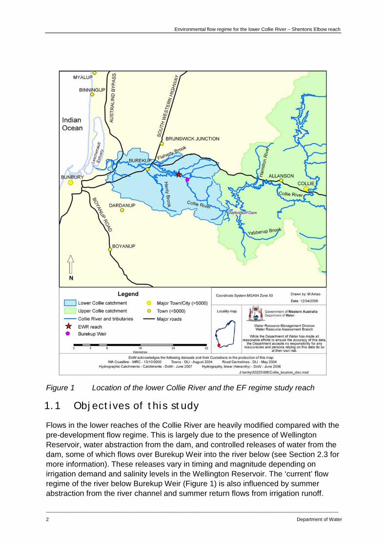
1 Background This report presents the results of a study designed to determine an environmental flow regime for the lower Collie River, in the south-west of Western Australia. The environmental flow regime aims to maintain important ecological values and functions and is relevant from Burekup Weir to the extent of tidal influence approximately 3.5 km downstream of the South Western Highway (Figure 1).
This study has recently informed water resource planning and management decisions in the lower Collie surface water allocation plan (DoW 2011a), to determine if and when water may be available for allocation.
Environmental flow studies consider the flow-dependency of aquatic taxa such as fish, invertebrates, amphibians and aquatic plants, as well as the importance of surface water to terrestrial and riparian species. They consider the aquatic and riparian ecosystem as a whole, and examine the relationships between the water regime and biodiversity, riverine food webs, ecological processes and individual species.
The environmental flow regime was generated using the ‘Proportional abstraction of daily flows’ (PADFLOW) method. According to the ‘natural flows paradigm’ which underpins the PADFLOW approach, the natural regime of flow is responsible for the evolution of the observed ecological state of a river (Poff 1997). The flow regime influences which species are present in rivers, and governs the processes that support a healthy, resilient aquatic ecosystem. The natural flows paradigm suggests that environmental flow studies should consider the total flow environment including the natural duration and frequency of ecologically important flow events, the annual and inter-annual flow regime, seasonal patterns of flow and long-term trends in flow volume. Further information about how the various components of the flow regime influence ecological processes is given in Section 4.
This study considers the natural and current flow regimes, as well as the ecological objectives for the lower Collie River, to define an environmental flow regime that maintains important ecological values and functions.
Environmental flow regime for the lower Collie River – Shentons Elbow reach
____________________________________________________________________________________________________________
2 Department of Water
Figure 1 Location of the lower Collie River and the EF regime study reach
1.1 Objectives of this study
Flows in the lower reaches of the Collie River are heavily modified compared with the pre-development flow regime. This is largely due to the presence of Wellington Reservoir, water abstraction from the dam, and controlled releases of water from the dam, some of which flows over Burekup Weir into the river below (see Section 2.3 for more information). These releases vary in timing and magnitude depending on irrigation demand and salinity levels in the Wellington Reservoir. The ‘current’ flow regime of the river below Burekup Weir (Figure 1) is also influenced by summer abstraction from the river channel and summer return flows from irrigation runoff.

Environmental flow regime for the lower Collie River – Shentons Elbow reach
_________________________________________________________________________________________________________
Department of Water 3
In addition to the changes in the flow regime resulting from the management of Wellington Reservoir and the irrigation industry, land-use changes and clearing have also contributed to the ‘current’ flow regime, channel morphology and the ecological condition of the river, catchment and riparian zone. Large areas of the lower Collie River catchment have been cleared of native vegetation and developed for agriculture.
Given current land-use and water supply practices from Wellington Reservoir are likely to continue, the objective of the EF regime for the lower Collie River was to:
• maintain the presence of the current in-stream and riparian, native biota.

Environmental flow regime for the lower Collie River – Shentons Elbow reach
____________________________________________________________________________________________________________
4 Department of Water
2 The lower Collie River catchment The Collie River is located in the south-west of Western Australia, approximately 150 km south of Perth. It is an easterly flowing system stretching for approximately 150 km and discharges into Leschenault Estuary, 5 km north-east of the town of Bunbury (Figure 1).
The lower Collie River catchment has an area of 283 km2 and has its upstream extent at Wellington Reservoir (Figure 2). Burekup Weir is located approximately 14 km below Wellington Reservoir and is used to divert water released from the reservoir for irrigation in summer. The lower Collie catchment includes the town of Burekup and the tributaries Flaherty Brook and Henty Brook (Figure 2). In its middle and lower catchment, the lower Collie River flows through agricultural land (Figure 2). Beef grazing is the dominant land use in the lower half of the lower Collie, with dairy grazing, horticulture, viticulture and hobby farms less common. The area between Wellington Reservoir and Burekup Weir is largely national park managed by the Department of Environment and Conservation. This section of river has a catchment area of 60 km2 (Bennett & Green 2011).
Figure 2 shows the areas of cleared and uncleared land, the locations of the gauging stations Rose Road (612043) and Mungulup Tower (612002) and the location of farm dams.

Environmental flow regime for the lower Collie River – Shentons Elbow reach
_________________________________________________________________________________________________________
Department of Water 5
Figure 2 Cleared and uncleared land, gauging stations and farm dams
Environmental flow regime for the lower Collie River – Shentons Elbow reach
____________________________________________________________________________________________________________
6 Department of Water
2.1 The environmental flow regime study site
A 990 m stretch of the lower Collie River (Shentons Elbow reach) was selected as an EF regime study site representative of the lower Collie River below Burekup Weir, downstream to the extent of tidal influence. The upstream extent of Shentons Elbow reach is approximately 14 km downstream of Wellington Reservoir and 6.2 km downstream of Burekup Weir (Figure 1). The reach runs through agricultural (beef grazing) and horticultural (citrus orchards) land with moderate condition riparian vegetation. Section 5.2 discusses the selection of Shentons Elbow reach as an EF regime study.
2.2 Climate
The region’s climate is temperate with warm, dry summers and cool, wet winters. Average daytime temperatures can range from 16.5 °C in winter to 30.4 °C during summer (Weatherzone 2009).
Rainfall in the lower Collie River catchment is seasonal and highly predictable. Rainfall in the catchment is typically derived from cold fronts crossing the coast in winter, however high intensity summer storms occasionally occur as a result of ex-tropical cyclones bringing rain from the north-west (DoW 2011d).
Mean annual total rainfall over the catchment is fairly consistent. The three Bureau of Meteorology rainfall stations – Wokalup (009642), Brunswick Junction (009513) and Roelands (009657) – have a long-term (1900–2009) average ranging from 1049 mm at Wokalup to 921 mm at Roelands (DoW 2011d).
There is an observed decreasing trend in the annual rainfall record from these stations with the short-term (1975–2009) means ranging from 9% to 13% lower than the long-term average (1900–2009). The decline in rainfall has continued with the mean annual rainfall from 2000 to 2009 decreasing by a further 9% compared to the short-term average (DoW 2011d).

Environmental flow regime for the lower Collie River – Shentons Elbow reach
_________________________________________________________________________________________________________
Department of Water 7
Figure 3 Rainfall record at Roelands station (009657)
2.3 Hydrology
This study used daily flow data from two streamflow gauges on the Collie River – Rose Road (612043) and Mungulup Tower (612002) (refer to Section 5.3). Rose Road gauging station is located in the lower Collie River catchment, 1.5 km upstream of the Collie River’s confluence with Henty Brook (Figure 2) and therefore records overflows from Burekup Weir, as well as gains and losses between Burekup Weir and Rose Road gauging station. Mungulup Tower gauging station is located in the Collie River’s upper catchment, 22 km upstream of Wellington Reservoir and records the majority of inflow into Wellington Reservoir (Figure 2). These gauges were used to model additional streamflow sets used to develop the environmental flow regime for the lower Collie river, Shentons Elbow reach (Section 5.3).
Streamflow in the lower Collie is highly seasonal and largely coincides with rainfall, with 66% of the annual flow occurring from June to September (inclusive) for the lower Collie river catchment, compared with 75% to 89% for the Brunswick and Wellesley rivers respectively (DoW 2011d).
During the period post-1975 the south-west Western Australia region has experienced a decline in the May to July rainfall of 10 to 15% (from the 1900 to 1974 average) (Bates et al 2008). The rainfall decline has contributed to a severe reduction in runoff, with an average change in runoff of 2 to 3% for every 1% change in rainfall (Fu et al 2007).
In addition to this, streamflow in the lower Collie River below Burekup Weir is modified from its natural, pre-development flow regime. This is primarily due to
-600
0
600
1200
1800
2400
3000
3600
4200
4800
0
200
400
600
800
1000
1200
1400
1600
1900 1910 1920 1930 1940 1950 1960 1970 1980 1990 2000
Dev
iatio
n fr
om th
e m
ean
(mm
)
Ann
ual r
ainf
all (
mm
)
Roelands - 009657
Annual rainfall (mm) Long term mean (902 mm)
1975-2009 mean (800 mm) 2000-2009 mean (761 mm)
Cumulative deviation from the mean

Environmental flow regime for the lower Collie River – Shentons Elbow reach
____________________________________________________________________________________________________________
8 Department of Water
agricultural development and the construction and management of Wellington Reservoir and Burekup Weir.
The hydrology at the Shentons Elbow reach is heavily influenced by releases and overflows from Wellington Reservoir and the subsequent flow of water over Burekup Weir. Water is released from Wellington Reservoir either as scour water in winter or to supply the irrigation industry in summer. While most irrigation releases from Wellington Reservoir are diverted into irrigation channels at Burekup Weir, some water flows over Burekup Weir in summer due to operational limitations.
Winter scour releases from Wellington Reservoir are not diverted and they therefore flow over Burekup Weir and contribute to winter flows below the weir. The summer and winter overflow at Burekup Weir, together with rainfall and runoff below the weir, make up the observed flow regime.
Figure 4 compares the observed flow at the Shentons Elbow reach from 2004 to 2007, with the flow that would occur without modifications from abstraction, Wellington Reservoir and the Burekup Weir (‘undammed’ flow). Streamflow records from Rose Road (612043) and Mungulup Tower (612002) gauging stations were used to derive the two daily flow time-series (see Section 5.3). This comparison demonstrates that observed flows are significantly less than the ‘undammed’ flows during winter, and also the ecologically critical autumn months. Observations in the summer period show that flows are occasionally higher than what would be experienced in the reach under ‘undammed’ conditions. This is likely to be the result of overflows at Burekup Weir during the irrigation season.
Figure 4 Comparison of ‘current’ flows with modelled ‘undammed’ flows
2.4 Water resource development and management
Wellington Reservoir was built in 1933 and provides water for the surrounding irrigation industry in the Collie irrigation district, predominantly irrigated pasture for
0
1000
2000
3000
4000
5000
6000
Flow
(ML/
day)
Current flow
Undammed flow

Environmental flow regime for the lower Collie River – Shentons Elbow reach
_________________________________________________________________________________________________________
Department of Water 9
grazing (beef and dairy). Water is released from Wellington Reservoir in summer to supply the irrigation industry and in winter as a scour release, to reduce salinity levels in the reservoir. Scour releases typically occur between June and September and begin when criteria to determine the optimum scour time are triggered. These criteria are dependent on the current storage volume in the reservoir, the salinity level in the bottom layer of the reservoir, and the salinity difference between the top and bottom layers of the reservoir (DoW 2011c).
Summer irrigation releases are diverted at Burekup Weir. However, some leakage and overflow occurs at Burekup Weir during summer due to operational constraints. Winter scour releases are not diverted and flow over the Burekup Weir and through the lower reaches of the Collie River into Leschenault Estuary.
Total water use from the lower Collie catchment below Wellington Reservoir is 1501.7 ML (DoW 2011b). Only about 60 ML of commercial water is taken from the main channel below Burekup Weir, most of which is direct take in summer. Outside the main channel, there are about 25 commercial on-stream farm dams, most of which are on Henty Brook and store about 1 GL of water in total. Many more exist for stock and domestic purposes and have storage capacities less than 8 ML (unpublished data, DoW 2010).
Flow gauging and numerical models suggest farm dams have a relatively small effect on the magnitude of mid-winter flows as most are full by this time (Sinclair Knight Merz 2007). However, models also show that interception of catchment runoff by on-stream dams can reduce the magnitude of flows in summer and the seasonal ‘shoulder’ periods between April and June, and November and January.

Environmental flow regime for the lower Collie River – Shentons Elbow reach
____________________________________________________________________________________________________________
10 Department of Water
3 Ecological values and functions One of the objectives of this study is to define a flow regime for the lower Collie River, below Burekup Weir that will maintain existing ecological values. It is therefore important to:
• describe the existing condition of the river ecosystem
• define how the various components of the ecosystem depend on the flow regime.
The ecological values of the lower Collie River and the relationships between flow and ecological values are discussed in the following sections. These sections draw heavily on a literature review and targeted sampling program for the lower Collie River, which were undertaken to identify water-dependent ecological values (WRM 2009). For detailed information about the life-history characteristics of flora and fauna species, their degree of water dependence, and other general biological information, please refer to WRM (2009).
3.1 Vegetation
The lower Collie catchment below Burekup Weir is predominantly developed agricultural land. The condition of the riparian vegetation tends to deteriorate from the top of the catchment to the bottom of the catchment. Jarrah (Eucalyptus marginata), marri (Corymbia calophylla) and blackbutt (Eucalyptus patens) forest exists in the steep-sided valley areas just below Burekup Weir (WRM 2009). These species disappear as the river flows through gently sloping agricultural land on the coastal plain. The lowland sections of the catchment are highly degraded with weed species such as pasture grasses, willow and blackberry dominating the understorey. In these areas, the overstorey comprises woodlands of flooded gum (Eucalyptus rudis) and swamp paperbark (Melaleuca rhapiophylla) (WRC 2003; WRM 2009).
Fringing riparian vegetation is generally composed of twigrush (Baumea sp.) and sedges (Leptocarpus sp. and Lepidosperma sp.), while water ribbon (Triglochin sp.), water milfoil (Myriophyllum sp.) and pond weed (Potamogeton tricarinatus) are the dominant aquatic species (WRM 2009). The condition of the riparian vegetation in the Shentons Elbow study reach is shown in Figure 5.

Environmental flow regime for the lower Collie River – Shentons Elbow reach
_________________________________________________________________________________________________________
Department of Water 11
Figure 5 Riparian vegetation of the lower Collie River – Shentons Elbow reach
Relatively little is known about the magnitude and duration of flows that are important for maintaining the health and vigour of riparian vegetation. Environmental factors that influence plant vigour and are affected by river flow include:
• bank soil-moisture content
• the proximity of groundwater to the root zone
• the period and season of flooding that inundates the floodplain and riparian vegetation.
In Australian riparian zones, the greatest numbers of plant species germinate during autumn under waterlogged conditions, while the least number of species germinate during summer (Britton & Brock 1994). Research has found that seed set, seedling establishment and recruitment for tree species such as flooded gum and swamp paperbark are closely tied to flow events. For example, germination and survival of seedlings can be influenced by infrequent winter high flows, which pick up seeds and move them to open areas in full sunlight. Year-old tree seedlings often do not survive if they are inundated in their first winter after germination (Pen 1999).
3.2 Aquatic invertebrates
As part of this study the macroinvertebrate community was sampled at several sites including the lower Collie River, Henty Brook and Harris River (WRM 2009). This study collected a total of 129 taxa. The vast majority of these taxa were Insecta (85%–89%) with the remainder largely comprising Mollusca and Crustacea.
Surveys conducted by Storey (2003) and Storer et al. (2011) found marron (Cherax cainii) and gilgies (Cherax quinquecarinatus) and unclassified freshwater shrimp. Of these three species, marron was the most commonly encountered species.

Environmental flow regime for the lower Collie River – Shentons Elbow reach
____________________________________________________________________________________________________________
12 Department of Water
Gilgies have a range from Moore River to Bunbury. They exploit almost a full range of freshwater environments from semi-permanent swamps to deep rivers (Austin & Knott 1996). Gilgies dig short burrows into damp bed or banks, retreating into them in periods of low water level to prevent their gills drying out and avoid desiccation (Donohue et al 2010;WRM 2007b). Shipway (1951) suggested they are able to tolerate more extreme environmental conditions than marron and may survive longer periods out of water. Gilgies are more commonly found in areas of higher flow velocity and dissolved oxygen concentrations than marron (Lynas et al. 2006).
Marron require larger, deeper pools as refugia than gilgies (Beatty et al 2006). Prior to European settlement, the distribution of marron was thought to extend from Harvey to Albany (Morrissy 1978) but now extends from Hutt River, near Geraldton, to Esperance in the south-east (Beatty et al. 2003;Lawrence & Morrissy 2000).
Spring and summer spawning is a common life-history characteristic of aquatic invertebrates in Western Australia’s south-west. Few species breed in winter, in more than one season, or year round. Three-quarters of the species sampled from the upper and lower Collie River were known to breed in spring-summer, 20% were capable of breeding year round, and less than 5% breed during winter (WRM 2009). Therefore spring and summer flows that provide breeding habitat for these species should be maintained (WRM 2009).
Invertebrate diversity depends on the complexity and diversity of habitat, since many species are essentially restricted to particular habitats (Humphries et al. 1996; Kay et al. 2001). Aquatic invertebrates occupy a wide range of habitat types including pools, riffles and sandy runs between pools, and dams of organic debris. Riffles and sandy runs tend to support a higher density and variety of invertebrates than other aquatic habitats. For example, oligochaetes, freshwater crayfish, larvae of dragonfly and damselfly species, chironomid and caddisfly are associated with habitats such as snags, rocks, macrophyte beds and trailing riparian vegetation. To maintain the distribution and abundance of these taxa, it is important to include flows in an EF regime that ensure these habitats are inundated.
Studies have found stream permanence to be an overall determinant of the abundance and diversity of aquatic invertebrate fauna (e.g. Bunn et al. 1986 & 1989).
Most aquatic invertebrates do not have physiological or life-history strategies that allow them to survive seasonal drying, although some strategies include:
• flying to neighbouring waterbodies (adult insects)
• burrowing into moist sediments (oligochaetes and gilgies)
• a desiccation-resistant stage in their life cycle (usually as an egg) and may undergo diapause during summer (gastropods, cladocerans, copepods and ostracods), (Donohue et al. 2009).
Ephemeral and permanent streams both have distinctive aquatic faunal communities (ARL 1989; Storey et al. 1990). Some invertebrates are found only in intermittent streams (Bunn et al. 1989), while other species show large differences in numbers in permanent compared with intermittent streams (Bunn et al. 1986). When developing

Environmental flow regime for the lower Collie River – Shentons Elbow reach
_________________________________________________________________________________________________________
Department of Water 13
an environmental flow regime for rivers in the South West, it is important to consider the seasonality of the natural flow regime, including periods of no flow.
Water quality also affects macroinvertebrate assemblages. The freshwater mussel (Westralunio carteri) has been found in the lower Collie River downstream of Burekup Weir. Freshwater mussels are classified by the Department of Environment and Conservation as a Priority 4 species, indicating they are in need of monitoring. They are believed to be in decline due to secondary salinisation and heavy siltation (WRM 2009).
For more detailed information on the invertebrate fauna of the lower Collie River, refer to WRM (2009).
3.3 Fish
South-west Western Australia has relatively few species of native freshwater fish and a high degree of endemism compared with the rest of the continent (Pusey et al. 1989). Of the endemic species, the western minnow (Galaxias occidentalis), western pygmy perch (Edelia vittata) and nightfish (Bostockia porosa) are the most abundant and widespread (Donohue et al. 2009). There is anecdotal evidence that the distributions of both pouched lamprey (Geotria australis) and freshwater cobbler (Tandanus bostocki) are becoming increasingly restricted in the South West due to habitat loss and flow regulation (WRM 2008a).
Targeted fish sampling below Burekup Weir was undertaken by WRM (2003 & 2009) and Storer et al. (2011). These surveys revealed the presence of six native fish species including western pygmy perch, (Edelia vittata), western minnow (Galaxias occidentalis), swan river goby (Pseudogobius glorum), southwest goby, (Afurcagobius suppositus), nightfish (Bostockia porosa) and freshwater cobbler (Tandanus bostocki).
Two species of exotic fish, mosquitofish (Gambusia holbrooki) and trout (Oncorhynchus mykiss) were also recorded by WRM (2009). Ecological and life-history information these species (excluding the southwest goby) is provided in Appendix 1.
The breeding ecology of native species is strongly related to flow, as migration patterns are triggered by flow events, and sufficient water levels are required to provide access to spawning habitat (Donohue et al. 2009). Western minnow, pygmy perch and nightfish undertake upstream migrations in winter and spring for breeding (Pen 1999). With the onset of winter flows in June or July, fish move upstream from summer pools to small side tributaries to spawn on flooded vegetation and submerged reed beds (Donohue et al. 2009). Cobbler migrate and spawn during late spring and summer (Beatty et al. 2006; Morrison 1988; WRM 2003). However, it is presumed they move between pools opportunistically, when flows permit, to find suitable breeding habitat.
There are many natural obstacles that could impede upstream migration of fish, such as steep gradients, logs, shallow riffles and rock bars as well as infrastructure
Environmental flow regime for the lower Collie River – Shentons Elbow reach
____________________________________________________________________________________________________________
14 Department of Water
obstacles such as road culverts, weirs and dams. Natural flow regimes include high flows spells that submerge obstacles, allowing fish to move upstream.
An important consideration is the length of time that elapses between the onset of cues for breeding and migration (such as changes in water temperature and day length) and the submerging of barriers to upstream migration. If flows do not drown out barriers, migrating fish will congregate downstream until the critical flow is achieved. During this time, predation on the congregation of fish may be intense, and may particularly affect gravid females that are ready to spawn (Donohue et al 2009).
Generally, 10 cm of water over all barriers is considered sufficient for upstream migration of small-bodied fish and 20 cm for large-bodied fish, such as freshwater cobbler. Fish passage pulses should last 24 hours (Storey 2003). Presumably, a series of winter high spells is required for fish to navigate upstream in a reach containing a series of barriers, such as a sequence of pools and riffles. Freshwater cobbler also requires pools with a minimum depth of 80 cm in summer as breeding habitat (Bennett & Green 2011).
Flows are required that maintain water depths that inundate trailing and aquatic riparian vegetation, a favoured spawning habitat for some native fish species. Flooded vegetation and shallow, flooded off-river areas also provide sheltered, low velocity nursery areas for growing juveniles. Flooding in winter and spring must be maintained to ensure breeding success and strong recruitment (Donohue et al. 2009).
The duration and frequency of inundation of trailing and fringing vegetation can influence recruitment success. For example, if water levels fall too soon, or fluctuate greatly, fish eggs may be left above the water line and may dry out. Storey (pers. comm. 2010) suggests a winter baseflow that inundates trailing vegetation interspersed with fish passage pulses would be beneficial for recruitment. Ideally, spawning habitat would be inundated while eggs hatch (72 hours for western pygmy perch) and for a few weeks following spawning events to provide fry with protection from predation (Beatty pers. comm. 2010).
In many rivers in the South West, flows of sufficient magnitude occur for the whole of winter, including Lefroy Brook, Margaret River, Wilyabrup Brook and Capel River, or for the whole year, as in Brunswick River (Bennett & Green 2011). Even in ephemeral streams like Cowaramup Brook, spawning habitat flows occur for most of winter (June to September in most years) (Bennett & Green 2011).
Poor recruitment years occur naturally during periods of low rainfall. Given the short breeding life of some native fish (2 to 3 years), it is expected short sequences of poor breeding years could be withstood, but any more than two poor breeding years could be detrimental to the population size, resilience, and age distribution.
3.4 Amphibians
Three frog species have been recorded from the area surrounding Shentons Elbow reach: Glauert’s froglet (Crinia glauerti), the squelching froglet (C. insignifera) and the
Environmental flow regime for the lower Collie River – Shentons Elbow reach
_________________________________________________________________________________________________________
Department of Water 15
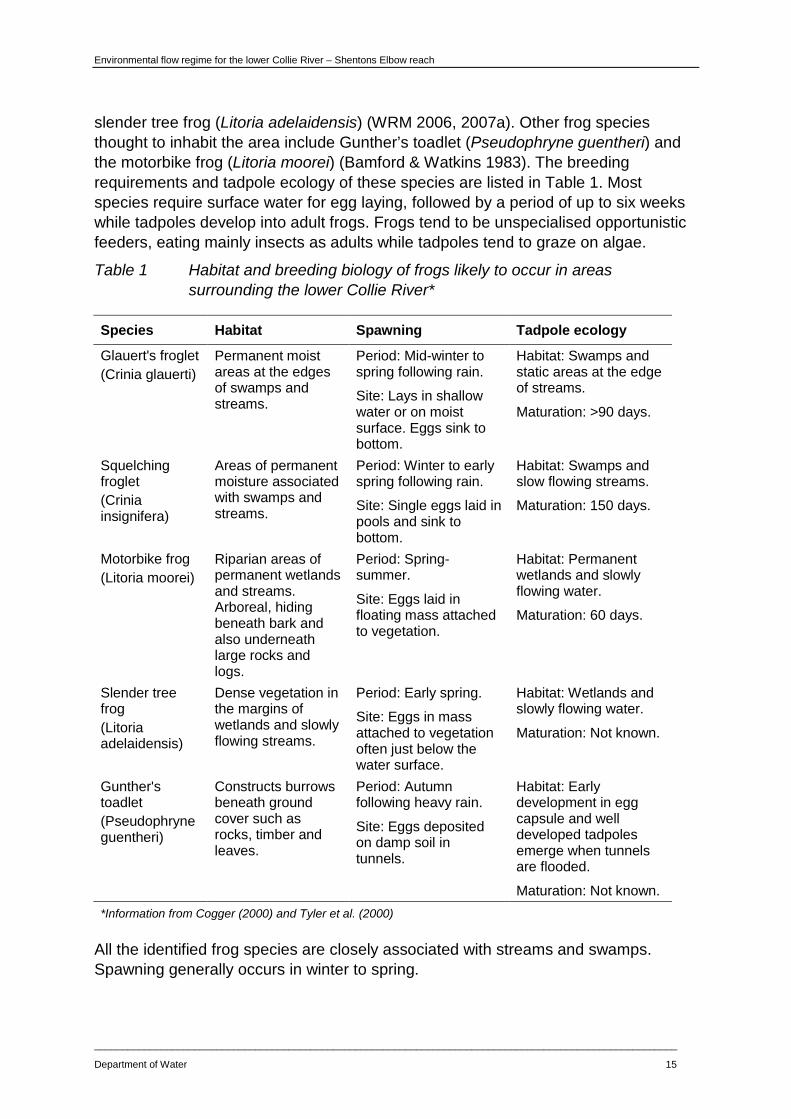
slender tree frog (Litoria adelaidensis) (WRM 2006, 2007a). Other frog species thought to inhabit the area include Gunther’s toadlet (Pseudophryne guentheri) and the motorbike frog (Litoria moorei) (Bamford & Watkins 1983). The breeding requirements and tadpole ecology of these species are listed in Table 1. Most species require surface water for egg laying, followed by a period of up to six weeks while tadpoles develop into adult frogs. Frogs tend to be unspecialised opportunistic feeders, eating mainly insects as adults while tadpoles tend to graze on algae.
Table 1 Habitat and breeding biology of frogs likely to occur in areas surrounding the lower Collie River*
Species Habitat Spawning Tadpole ecology
Glauert's froglet (Crinia glauerti)
Permanent moist areas at the edges of swamps and streams.
Period: Mid-winter to spring following rain.
Site: Lays in shallow water or on moist surface. Eggs sink to bottom.
Habitat: Swamps and static areas at the edge of streams.
Maturation: >90 days.
Squelching froglet (Crinia insignifera)
Areas of permanent moisture associated with swamps and streams.
Period: Winter to early spring following rain.
Site: Single eggs laid in pools and sink to bottom.
Habitat: Swamps and slow flowing streams.
Maturation: 150 days.
Motorbike frog (Litoria moorei)
Riparian areas of permanent wetlands and streams. Arboreal, hiding beneath bark and also underneath large rocks and logs.
Period: Spring-summer.
Site: Eggs laid in floating mass attached to vegetation.
Habitat: Permanent wetlands and slowly flowing water.
Maturation: 60 days.
Slender tree frog (Litoria adelaidensis)
Dense vegetation in the margins of wetlands and slowly flowing streams.
Period: Early spring.
Site: Eggs in mass attached to vegetation often just below the water surface.
Habitat: Wetlands and slowly flowing water.
Maturation: Not known.
Gunther's toadlet (Pseudophryne guentheri)
Constructs burrows beneath ground cover such as rocks, timber and leaves.
Period: Autumn following heavy rain.
Site: Eggs deposited on damp soil in tunnels.
Habitat: Early development in egg capsule and well developed tadpoles emerge when tunnels are flooded.
Maturation: Not known. *Information from Cogger (2000) and Tyler et al. (2000)
All the identified frog species are closely associated with streams and swamps. Spawning generally occurs in winter to spring.

Environmental flow regime for the lower Collie River – Shentons Elbow reach
____________________________________________________________________________________________________________
16 Department of Water
3.5 Tortoises
Storer et al 2011, caught five long-necked tortoise (Chelodina oblonga) in one sampling point, west of the South West Highway on the lower Collie river. The long-necked tortoise is commonly encountered in the rivers of the South West and lives in river pools, perennially flowing streams and rivers, and areas with soft soil adjacent to river banks. The diet of the long-necked tortoise includes tadpoles, fish and aquatic invertebrates. In permanently flowing waters the long-necked tortoise has two breeding periods – in September to October and again in December to January – while in ephemeral river systems they tend to breed once a year in spring (WRM 2007b). They construct their nests in sandy soil and eggs may take up to seven months to hatch. If local conditions deteriorate, tortoises can migrate long distances overland or aestivate in situ in burrows constructed in soft sediments, (WRM 2007b). The survival of the long-necked tortoise depends on the presence of permanent water and on nearby areas of soft, damp soil in which to lay their eggs.
3.6 Mammals
Of the mammal species known to inhabit the region through which the lower Collie River flows, a number are reliant on the riparian vegetation zone either as habitat, or as a food source (Donohue et al. 2009).
WRM (2009) noted water rat (Hydromys chrysogaster) feeding platforms and their burrows at several sites along the lower Collie River. Water rats are classified by the Department of Environment and Conservation as a Priority 4 species, indicating they are rare or near threatened and are in need of monitoring. They are found in rivers, swamps, lakes and drainage channels. They have broad, partially webbed hind feet, water-repellent fur, and a thick tail. Water rats are water-dependent and are known to suffer heat stress without access to water. They construct nesting burrows in banks that are stabilised by riparian vegetation. Water rats restrict their movements to shallower waters less than two metres deep and forage along the shoreline for food such as crayfish, mussels, fish, plants, invertebrates and smaller mammals and birds. They depend on aquatic food webs, the presence of healthy riparian vegetation and the processes that maintain them. The range of water rats has declined in the South West region due to secondary salinisation and clearing of riparian vegetation (WRM 2007b).
Examples of other water reliant mammals include the brush-tailed phascogale (Phascogale tapoatafa), quenda or southern brown bandicoot (Isoodon obesulus), western ringtail possum (Pseudocheirus occidentalis), and brushtail possum (Trichosurus vulpecula) (Taylor 2006). The two species of possums and the brush-tailed phascogale are reliant upon dense vegetation and the availability of hollow-bearing trees, which often occur near rivers and streams. Quenda occur only in areas with dense covering vegetation, such as the margins of wetlands, Banksia woodland and jarrah forest. The quokka (Setonix brachyurus) and the western grey kangaroo (Macropus fuliginosus) are also likely to inhabit the study area and frequent the riparian zone.

Environmental flow regime for the lower Collie River – Shentons Elbow reach
_________________________________________________________________________________________________________
Department of Water 17
3.7 Carbon sources and ecosystem productivity
Aquatic ecosystems rely on energy inputs – in the form of organic carbon – from catchments and riparian zones (WRC 2000). Flow-related processes that control the availability of carbon need to be considered in developing environmental flow regimes. Factors that influence the production of carbon in rivers include light penetration, temperature and nutrient levels.
Some carbon enters rivers as fine particulate matter derived from upstream terrestrial vegetation. This process requires the connection of downstream and upstream river reaches. A significant proportion of organic matter in streams in the South West comes from woody debris that is either washed into the river from the riparian zone or from direct litter fall from overhanging vegetation.
Carbon may also enter river systems as dissolved organic and inorganic carbon in groundwater and soil water. Direct inputs of carbon from in-stream production (phytoplankton and benthic algae) and processing of carbon through fungal, microbial and invertebrate pathways are important in maintaining food webs.
The mass of carbon can determine the total standing biomass of aquatic fauna, as well as the biomass of non-aquatic fauna that use the river system as a food source (such as piscivorous birds and reptiles that feed on aquatic species). The availability of different types of carbon affects the abundance and biomass of species, competition for resources and, over evolutionary time scales, speciation and food web relationships such as the evolution of functional feeding groups in invertebrates.

Environmental flow regime for the lower Collie River – Shentons Elbow reach
____________________________________________________________________________________________________________
18 Department of Water
4 Components of the flow regime and their ecological functions A river channel is a highly dynamic system, with a flow regime that varies seasonally and annually (Figure 6). Different components of the flow have particular ecological functions and have a direct influence on the structure of aquatic communities and food webs in the South West region’s rivers (Pen 1999). Ecologically relevant elements of the flow regime in the region’s rivers are explained in the sections below.
Figure 6 Representative hydrograph of a typical South West stream with different
flow components labelled
4.1 Summer low flows
Summer low flows, including trickle flows, can maintain water levels and depth in the dry period and can control water temperature. Summer low flows also maintain the circulation and water movement in pools, which prevents stratification and the depletion of oxygen by respiration processes in stream sediments.
In addition, summer low flows maintain habitat in shallow areas of the river, such as riffles and sandy runs, which are important for aquatic invertebrates. The turbulent flow in these areas oxygenates flow and improves the water quality of summer refuges such as pools (Pen 1999). Finally, summer low flows provide a longitudinal connection between downstream and upstream reaches and pools, and allow continued downstream carbon movement.
4.2 Autumn and winter low flows
Autumn and winter low flows occur in the early part of the flow season or during winter after prolonged periods of low rainfall and runoff. Flow during winter is variable between years but is generally very reliable in the south-west of Western Australia, starting around May.

Environmental flow regime for the lower Collie River – Shentons Elbow reach
_________________________________________________________________________________________________________
Department of Water 19
Early-season low flows that occur with the onset of winter rains are particularly important for aquatic fauna, as they relieve late summer stress in pool habitats. As pools dry out, water quality can deteriorate significantly as the temperature rises and dissolved oxygen levels decline. Also, as the volume of water declines, there is increased competition between species for space and resources. Predatory pressure from birds and other predators also increases owing to the greater density of fish and aquatic fauna in the remaining water (Pen 1999).
Early low flows are also a trigger for breeding migrations in some fish species, together with changes in day length and ambient temperature.
4.3 Active channel flows
The morphology of a river channel changes in response to flow events that have the energy to scour the channel, and mobilise and deposit sediment and organic debris. In describing an environmental flow regime it is important to recognise the importance of channel-forming flows and their role in maintaining a healthy and resilient ecosystem. A well-defined low-flow channel is characteristic of many rivers in Western Australia’s south-west and can often be seen as a ‘secondary’ channel within the wider river channel.
The low-flow channel is maintained by winter flows that have sufficient energy, frequency and duration to regularly scour banks. Within the low-flow channel is what is known as the active channel, because the flows that maintain an open channel occur in most years and the channel is therefore actively eroding (Pen 1999).
The low-flow and active channels are an important structural feature of rivers and streams. The low-flow channel contains the bulk of functional habitats in rivers, such as riffles, aquatic vegetation and the pools that are so important as deep-water habitat and summer refugia.
The active channel is often overhung by fringing plants and fringing aquatic vegetation. The extent of the active channel can be seen in places as a line of scoured bare earth within the low-flow channel, below which vegetation is less dense or completely absent. The flows that produce and maintain low-flow channels also tend to be those that inundate overhanging and fringing vegetation, and provide cover for fauna such as macroinvertebrates, as well as spawning habitat for native fish such as pygmy perch (Pen 1999).
Flows reach the active channel regularly in winter following rainfall and reach the top of the low-flow channel two or three times a year in South West river systems (WRC 2000). The duration of active channel flows following rainfall is also influenced by the storage capacity of soils, soil porosity and seepage to channels from saturated soil profiles.
4.4 Winter high flows
Winter high flows include the range of flows that are responsible for creating and maintaining the morphology of the whole river channel and that shape the extent of

Environmental flow regime for the lower Collie River – Shentons Elbow reach
____________________________________________________________________________________________________________
20 Department of Water
the floodplain. Winter high flows inundate the middle and higher sections of a river channel and are responsible for the creation of channel features such as benches.
Winter high flows fulfil a variety of ecological functions. By scouring channels they control encroachment of riparian vegetation into the river. Winter high flows also scour sediment and organic matter creating deep pools that provide summer refugia for fish and other fauna as flow declines in summer (Pen 1999). Scouring of organic matter from pools also decreases biological oxygen demand, and therefore helps to maintain oxygen levels within the range tolerated by dependent species.
Winter high flows include flows that inundate the entire width and depth of the channel, equalling or exceeding ‘bankfull’ height (i.e. the highest vertical extent of the main river channel). The magnitude of a bankfull flow usually increases with distance downstream within a catchment, as more water is discharged into the main channel from tributaries.
Flood flows (i.e. flows that reach or exceed bankfull height) occur in mid winter due to heavy rain on saturated soils. Flood flows are generally of short duration and occur at a frequency of about one flood event every one, two or three years in the south-west of Western Australia. Due to the damming of the lower Collie River (by Wellington Reservoir and Burekup Weir), bankfull and flood flows at the Shentons Elbow study reach occur at a far lower frequency of around one event in every 10 to 15 years.
Flows that result in water depths greater than the bankfull height inundate floodplains and fill wetlands that are habitat for frogs and native fish. Riparian and floodplain vegetation require occasional inundation to disperse seed, help seed set, and soak soil profiles to promote successful germination.
Environmental flow regime for the lower Collie River – Shentons Elbow reach
_________________________________________________________________________________________________________
Department of Water 21
5 How the environmental flow regime was determined
5.1 Overall approach
An environmental flow regime for Shentons Elbow reach of the lower Collie River was determined using an approach called the ‘Proportional abstraction of daily flows’ (PADFLOW). The PADFLOW approach ‘constructs’ an EF regime by retaining a proportion of daily flow from an existing flow record. The volume of daily flow retained is calculated with reference to known ecologically important flows (Donohue et al. 2009, 2010).
The PADFLOW method uses the ‘River ecological sustainable yield model’ (RESYM) software, developed by the Department of Water in 2007. RESYM allows us to manipulate and display flow regimes against ecologically important flow thresholds. A panel can use RESYM in a workshop setting to iteratively develop a suitable environmental flow regime. The panel adjusts the proportion of flow retained from an existing flow regime and assesses changes in the frequency and duration of flows above ecologically important thresholds (e.g. Donohue et al. 2009 & 2010). For this study, the expert panel included experts in water resource management, channel morphology, channel hydraulics, hydrology, vegetation and aquatic ecology (Appendix A). In this report, the term ‘EF regime’ will be used to refer to the RESYM-generated flow regime. The term ‘current’ flow will be used to refer to the observed flow record for the study reach from 1 May 1996 to 27 January 2010 (see Section 5.3).

Environmental flow regime for the lower Collie River – Shentons Elbow reach
____________________________________________________________________________________________________________
22 Department of Water
Step 2Daily flow record for study reach
Step 1Select study reach
Step 3Identify ecological values
Step 5Topographic survey of channel
(cross-sections)
Step 4Define ecological and flow
objectives
Step 6Construct hydraulic model
(HEC-RAS)
Step 7Identify ecological flow thresholds
(RAP)
Step 8Parameterise EF model (RESYM)
Step 9Evaluate modelled EF regime
Does EF regime meet objectives?
Step 10Specify environmental flow regime
(EF regime)
Yes
No
Figure 7 Flow chart showing steps in the proportional abstraction of daily flows
(PADFLOW) method

Environmental flow regime for the lower Collie River – Shentons Elbow reach
_________________________________________________________________________________________________________
Department of Water 23
5.2 Selection of study site
Environmental flow regime studies are based on detailed research carried out at particular sites. Study sites are selected to represent the hydraulics and ecology of river reaches. Shentons Elbow reach, below Burekup Weir was chosen because it runs through agricultural land typical of the lower Collie River, and therefore has representative habitat and hydraulic features. This reach also maintains a channel that is not too highly eroded and modified which makes it easier to identity critical hydraulic points and habitat types, that are important to preserve.
The Shentons Elbow reach of the lower Collie River was selected as an EF regime study site as it possessed the following characteristics:
• representative land use and topography of the majority of the lower Collie River, below Burekup Weir
• good channel form with low levels of erosion
• presence of typical hydraulic and habitat features (i.e. sequences of pools and riffles, constrictions)
• more suitable gradient for hydraulic modelling than alternative reaches within the lower Collie River, i.e. some slope but not too much
• moderate condition of riparian vegetation
• proximity to Rose Road gauging station.
The selected EF regime study reach is a 990 m stretch of the Collie River, located between Bunbury and Collie (Figure 1). The reach runs through mainly agricultural land (beef grazing) with some horticulture. The upstream extent of the reach is approximately 14 km downstream of Wellington Reservoir and 6.2 km downstream of Burekup Weir (Figure 1).
Riparian vegetation within the study site has been described as typical for rural regions in the South West and is characterised by an understory of weeds and pasture (WRM 2009). The morphology of the river channel appears to be semi-intact, largely held together by large trees and kikuyu although undercutting, bank widening and sedimentation are occurring. Sections of the river further downstream (west of the highway) were considered more severely degraded and eroded than east of the highway (WRM 2009). Shentons Elbow reach was chosen to be representative of the lower reaches of the Collie River from Burekup Weir, downstream to approximately 3.5 km west of the South Western Highway at the upstream extent of the salt wedge.
5.3 Development of daily flow records
To model an EF regime, RESYM requires a daily flow time-series covering a period that represents the variation found in the ‘natural’ or ‘current’ flow regime (Donohue et al. 2009, 2010). As previously discussed, flow in Shentons Elbow reach is highly modified due to the presence of Wellington Reservoir, Burekup Weir, releases from Wellington Reservoir and summer extraction from the river channel. In determining

Environmental flow regime for the lower Collie River – Shentons Elbow reach
____________________________________________________________________________________________________________
24 Department of Water
an EF regime for Shentons Elbow reach three modelled flow records were used to provide an indication of
• current flows in the reach
• flows in the reach in an ‘undammed’ environment
• flows in the reach if no water was released from Wellington Reservoir.
The three daily flow time-series’ used in this study are described below.
Current flow
Flow at the Shentons Elbow reach from 1 May 1996 to 31 December 2009 was developed using the flow record from Rose Road gauging station 612043 (Figure 2). Gauged flow at Rose Road was scaled, based on catchment area, to give a representation of flows further upstream, at the study reach. The ‘current’ flow record is a daily time series running from 1 May 1996 to 27 January 2010.
Undammed flow
Due to the unnatural, highly modified nature of flows in the Collie River below Wellington Reservoir and Burekup Weir, the ‘undammed’ flow was used to represent a more natural flow regime and provide guidance on the timing and duration of flows that would be expected in the system’s natural state, as opposed to the current, highly modified state.
The ‘undammed’ flow record was derived by adding together three daily flow records:
• a flow record from Mungulup Tower gauging station (Figure 2)
• a modelled flow record of catchment runoff into Wellington Reservoir downstream of Mungulup Tower
• a modelled flow record of catchment runoff downstream of Wellington Reservoir to the Shentons Elbow study reach (see ‘catchment flow’ below).
The streamflow at Mungulup Tower retains much of its natural variability. Combining data from the Mungulup Tower flow record with the two modelled catchment flow records (above and below Wellington Reservoir) gives an indication what a natural (and undammed) flow record for the study reach would be like. The ‘undammed’ flow record is a daily time series running from 1 January 1975 to 31 December 2007.
Catchment flow
A modelled flow record of rainfall, runoff and groundwater inputs between Wellington Reservoir and the study reach was scaled, based on catchment area, from data generated by CSIRO, (CSIRO 2009) at Rose Road gauging station (612043), approximately 8 km downstream of the study reach (Figure 2).
The resulting flow record gives an indication of what flows in the study reach would be like if no water was released from Wellington Reservoir and is useful when
Environmental flow regime for the lower Collie River – Shentons Elbow reach
_________________________________________________________________________________________________________
Department of Water 25
analysing how releases from Wellington Reservoir contribute to achieving the various ecological objectives discussed in Section 5.4.
The ‘catchment’ flow record is a daily time series running from 1 January 1975 to 31 December 2007.
5.4 Ecological and flow objectives
The fourth stage of the PADFLOW method involves describing the ecological and flow objectives that maintain in-stream and riparian vegetation, habitat for aquatic invertebrates, native fish, amphibians and mammals, ecological processes (carbon sources) and channel morphology (WRM 2005a, 2005b).
The ecological objectives (Table 2) were used to develop a set of flow objectives that are expected to maintain the current ecological values in the lower Collie River. These flow objectives were used as parameters in the hydraulic modelling software to identify the ecologically important flow thresholds (described in Section 5.7) that achieves the ecological objectives in Table 2.

Environmental flow regime for the lower Collie River – Shentons Elbow reach
____________________________________________________________________________________________________________
26 Department of Water
Table 2 Ecological objectives, flow objectives and the ecological flow thresholds for Shentons Elbow reach, lower Collie River
Ecological objective Flow objective Ecological flow threshold
m3/s ML/day
Maintain summer breeding habitat for cobbler
Minimum 80 cm water depth in pools
0.05 4.3
Provide summer habitat for macroinvertebrates
Water depth of 5 cm over 50% of width of riffle runs
0.05 4.3
Maintain water quality and dissolved oxygen levels in pools for summer refuge of aquatic fauna Downstream carbon movement maintained by connectivity between pools
Minimum flow velocity of 0.01 m/s
0.07 6.0
Allow upstream spawning migration of small-bodied native fish
Minimum thalweg depth of 10 cm at shallowest cross-section
0.28 24
Provide winter habitat for macroinvertebrates
Water depth of 5 cm over entire width of riffle runs
0.41 35
Allow upstream spawning migration of cobbler
Minimum thalweg depth of 20 cm at shallowest cross-section
1.20 104
Scour and maintain low-flow channel Prevent incursion of terrestrial vegetation
Inundate active channel 1.56 135
Inundate trailing vegetation, providing fish cover and spawning sites
Inundate trailing vegetation
1.92 166
Inundate low benches to flush organic matter into river system and inundate trailing and emergent vegetation
Inundate low benches 3.75 324
Inundate high benches to flush organic matter into river system High-energy flows to scour pools and maintain channel morphology
Inundate high benches 12.3 1060
Bankfull flows to flush organic matter into river system Inundate channel and floodplain riparian vegetation High-energy flows to scour pools and maintain channel morphology
Inundate top of bank 33.3 2880

Environmental flow regime for the lower Collie River – Shentons Elbow reach
_________________________________________________________________________________________________________
Department of Water 27
5.5 Cross-sectional survey of the river channel
To construct a hydraulic model of the lower Collie River channel, a topographic survey of the study site was carried out in November 2008 (Step 5 in Figure 7). To characterise the shape and variability of the channel profile along the study site’s 990 m, a total of 30 channel cross-sections were surveyed. The cross-sections were taken at important hydraulic and ecological features such as rock bars, backwaters, pools, riffles, large woody debris and channel constrictions.
Figure 8 shows how the locations of cross-sections were selected and point data collected on each cross-section.
To allow for the calibration of the hydraulic model described in Section 5.6 below, discharge measurements were taken during the survey and related to measured water depths on the cross-sections.

Environmental flow regime for the lower Collie River – Shentons Elbow reach
____________________________________________________________________________________________________________
28 Department of Water
Figure 8 Schematic diagram of a river reach. The upper diagram shows the point
data surveyed as part of a cross-section. The lower diagram shows the longitudinal layout of cross-sections along a river reach.
5.6 Construction of the hydraulic model
The cross-sections from the study site were used to construct a hydraulic model of the river channel using the US Army Corps of Engineers’ ‘Hydrologic engineering centre’s river analysis system’ (HEC-RAS). To calibrate the model four discharge measurements were taken and related to surveyed water levels at an upstream and

Environmental flow regime for the lower Collie River – Shentons Elbow reach
_________________________________________________________________________________________________________
Department of Water 29
downstream cross-section. A diagram of the hydraulic model created for the lower Collie River study site (Shentons Elbow reach) is shown in Figure 9.
.
Figure 9 Structure of the HEC-RAS hydraulic model for the representative study
reach (Shentons Elbow reach) in the lower Collie River. The blue trace shows the water level at the time of the channel surveys.
5.7 Identification of ecological flow thresholds
Ecological flow thresholds are the flow rates required to achieve the ecological and flow objectives set out in Table 2 (Step 7 in Figure 7). The ecological flow thresholds were identified using the outputs of the hydraulic model (HEC-RAS) and the ‘River analysis package’ (RAP) model. The outputs from the hydraulic model were imported into RAP to display the relationship between flow rates, water depths and channel geometry at various points of the lower Collie River channel. Depending on the flow objective, such points could include rock bars, benches, pools, riffles or the height of riparian vegetation. RAP was used to manipulate flow rates to determine the ecological flow thresholds at Shentons Elbow reach, that achieve the ecological and flow objectives in Table 2.
The RAP output includes ‘rating curves’, which graphically relate changes in discharge to changes in water depth or the wetted width of channel at one or a combination of cross-sections based on user-defined ‘queries’ of the model (e.g. see WRM 2008b).
989
959 902
876
818
790 770
753
704 683 655
608
521
375
279
181
102
60 38.5
Shentons Elbow _v2 Plan: Plan 01 28/04/2010 Legend
WS 0.001
Ground
Bank Sta
Inef f

Environmental flow regime for the lower Collie River – Shentons Elbow reach
____________________________________________________________________________________________________________
30 Department of Water
It should be noted, that each flow threshold may fulfil multiple ecological objectives including some at flows below the threshold, as well as other ecological outcomes not specifically considered in this study.
The determination of the ecological flow thresholds in Table 2 are described below.
Summer breeding habitat for cobbler
Cobbler are known to spawn between late spring and summer and prefer slow flowing pools within the main river channel as breeding habitat (WRC 2003). There is anecdotal evidence to suggest that cobbler nest in hip-deep water. It is important to maintain this depth (approximately 80 cm) in significant pools of the lower Collie River to avoid putting breeding populations of cobbler under duress.
Two significant pools from Shentons Elbow reach (cross-sections 14 and 30) were included in the hydraulic analysis. According to the model, zero flow was required to achieve the thalweg depth of 80 cm in cross-section 14, so the ecologically critical value was taken as the flow required to inundate the pool at cross-section 30 to a minimum depth of 80 cm.
The flow required to reach 80 cm depth in the pool at cross-section 30 in Shentons Elbow reach was:
• 4.3 ML/day (0.05 m3/s).
Macroinvertebrate habitat
Riffle zones provide habitat for a broad range of fauna and tend to support a diverse community of macroinvertebrate species. To maintain the value of riffles as habitat, RAP was parameterised so that the hydraulic model would determine the flow rate that would inundate:
• 50% of the width of riffle cross-sections to a depth of 5 cm in summer
• 100% of the width of riffle cross-sections to a depth of 5 cm in winter.
This calculation was done individually for each cross-section located on a riffle run (cross-sections 13, 16, 18, 19, 23 and 29) and the average value was taken as the ecological flow threshold for the study reach. Based on the predictions of the hydraulic model, the instantaneous flow rate required to inundate riffle habitat in Shentons Elbow reach to a depth of 5 cm was:
• 4.3 ML/day (0.05 m3/s) to inundate 50% of the riffles in summer
• 35 ML/day (0.41 m3/s) to inundate 100% of the width of the riffles in winter.
Pool water quality
To maintain pool water quality and aquatic habitat a minimum average bulk water velocity of 0.01 m/s in pools is recommended. This is the minimum water velocity required to prevent stratification and maintain dissolved oxygen at more than 4 mg/L (WRM 2008b). This also maintains summer refuge pools for native fish and aquatic invertebrates, and connectivity between pools for carbon transfer. Only cross-

Environmental flow regime for the lower Collie River – Shentons Elbow reach
_________________________________________________________________________________________________________
Department of Water 31
sections across river pools (cross-sections 7, 10, 14 and 30) were included in the hydraulic analysis.
The flow required to achieve a mid-pool water velocity of 0.01 m/s in Shentons Elbow reach was:
• 6.0 ML/day (0.07 m3/s).
Upstream spawning migration of native fish
The water-level criterion for upstream migration of small-bodied native fish was set at 10 cm minimum depth over shallow sections and barriers. This criterion is considered conservative for small species such as pygmy perch, western minnow, nightfish and small cobbler (<100 mm total length).
The minimum water-level depth criterion of 20 cm for upstream migration of large-bodied fish has recently been confirmed for adult freshwater cobbler longer than 180 mm total length in the Blackwood River (Beatty et al. 2008). Cobbler have been reported in the lower Collie River, near Shentons Elbow reach (WRM 2009).
A rocky riffle at cross-section 23 was the shallowest feature surveyed in the study reach, and therefore the cross-section most likely to impede fish migration within this reach.
The ecological flow threshold required to achieve the minimum depth criteria of 10 cm over the shallowest cross-section for small bodied fish passage was:
• 24 ML/day (0.28 m3/s).
The ecological flow threshold to achieve the minimum depth criteria of 20 cm over the shallowest cross-section for large bodied-fish (cobbler) was:
• 104 ML/day (1.20 m3/s).
Active channel maintenance
The ecological flow threshold for maintaining an open, low-flow channel was defined as the flow required to fill the depth of the active channel. The elevation of the active channel was surveyed as the point on the bank above which vegetation is stable and below which the bank is bare and without extensive vegetation.
Cross-sections that encompassed shallow, depth-controlling riffle features (cross-sections 13, 16, 18, 21, 23 and 26) were used to determine the flow required to inundate the active channel because riffle features display a change in water level at smaller flow intervals and are therefore more accurate. The flow required to inundate the active channel was determined individually for the riffle cross-sections and averaged to give the ecological flow threshold for the study reach.
The average flow required to inundate the active channel in Shentons Elbow reach was:
• 135 ML/day (1.56 m3/s).

Environmental flow regime for the lower Collie River – Shentons Elbow reach
____________________________________________________________________________________________________________
32 Department of Water
Inundation of trailing vegetation
The active channel is typically the lowest height on a river channel where overhanging or trailing vegetation is present and can be inundated as spawning habitat for native fish. Only those cross-sections where significant spawning habitat was observed at active channel height were used in the RAP analysis (cross-sections 11, 20, 22 and 26). The flow required to reach to active channel height was determined individually for these cross-sections and averaged to give a ecological flow threshold for the study reach.
The average flow required to inundate the trailing vegetation as spawning habitat in Shentons Elbow reach was:
• 166 ML/day (1.92 m3/s).
Inundation of riverine benches
The inundation of benches floods emergent macrophytes and aquatic and trailing vegetation. These constitute good habitat for fauna such as frogs and invertebrates. Flows of this magnitude also wash woody debris and leaf detritus into the river providing habitat and organic carbon which also support species diversity and food webs (WRM 2008b).
In Shentons Elbow reach, low-elevation benches were surveyed at nine cross-sections and high-elevation benches were surveyed at seven cross-sections.
In RAP, inundation of a riverine bench was defined as the water level needed to inundate the entire lateral extent of a particular bench. The flow rate required to inundate benches was determined individually for each relevant cross-section and the values averaged to give the ecological flow threshold for the study reach.
The average flows needed to inundate channel benches along the study site were:
• 324 ML/day (3.75 m3/s) for low-elevation benches
• 1060 ML/day (12.26 m3/s) for high-elevation benches.
Bankfull and overbank flows
The height of the ‘top of bank’ was noted during the field survey. Only those cross-sections with a well-defined top of bank (cross-sections 13, 16, 21 and 22) were used in the hydraulic analysis of bankfull (or overbank) flows.
The flow required for water levels to reach the top of the bank was calculated individually for each cross-section using RAP, and averaged to determine the ecological flow threshold.
The average discharge required to achieve a bankfull flow in the study reach was calculated as:
• 2880 ML/day (33.3 m3/s).

Environmental flow regime for the lower Collie River – Shentons Elbow reach
_________________________________________________________________________________________________________
Department of Water 33
6 Modelling the environmental flow regime As described in Section 5.3, three historical flow records were used to determine an environmental flow regime for the Shentons Elbow reach of the lower Collie River. A brief description of the three flow records is given below. Although the time series above run for differing time periods, for this report, the flow regimes were only displayed on the bar charts below from 1997 to 2009. This was done to display only complete years available for the time series, making the bar charts easier to read.
The flow regimes are described fully in Section 5.3. Briefly, they are:
• ‘Current’ flow
− a modelled flow record that represents observed flows in the study reach. The ‘current’ flow record is a daily time-series running from 1 May 1996 to 27 January 2010.
• ‘Undammed’ flow
− a modelled flow record giving an indication of what a more natural flow regime for the study reach would look like. The ‘undammed’ flow record is a daily time-series running from 1 January 1975 to 31 December 2007.
• ‘Catchment’ flow
− a modelled flow record of catchment flow between Wellington Reservoir and the Shentons Elbow reach, to give an indication of what current flows in the study reach would be like if no water was released from Wellington Reservoir and Burekup Weir. The ‘catchment’ flow record is a daily time-series running from 1 January 1975 to 31 December 2007.
A modelled EF regime was produced in RESYM by retaining a proportion of daily flow from the ‘current’ flow record for the Shentons Elbow reach, with reference to the ‘undammed’ and ‘catchment’ flow and the ecological flow thresholds in Table 2. An expert panel (see Section 5.1 and Appendix A) imported the flow series above into RESYM and varied the proportion of ‘current' flow retained (Table 3), producing various EF regimes. The panel evaluated each version of the modelled EF regime with respect to the magnitude and timing of flows above the ecological flow thresholds and their ecological objectives using bar charts and other RESYM outputs.

Environmental flow regime for the lower Collie River – Shentons Elbow reach
____________________________________________________________________________________________________________
34 Department of Water
The bar charts (Figure 10 and Figure 19), show the frequency and duration of flows above individual ecological flow thresholds (Table 2), for the ‘undammed’, ‘current’ and ‘catchment’ flow records against the modelled EF regime.
Based on the ecological significance of the differences between the EF regime and other historical flows, the model parameters were adjusted and the model re-run until it was agreed amongst the panel that the EF regime was consistent with the objectives of the study (steps 9 and 10 in Figure 7).
The panel considered the frequency and duration of flow spells greater than the ecological flow threshold both within years and across years.
The RESYM parameters used to generate the final EF regime for Shentons Elbow reach of the lower Collie River are shown in Table 3. These parameters apply to the ‘current flow’ regime at the Shentons Elbow reach and indicate the proportion of flow for different flow ranges that must be retained to achieve the ecological objectives. When developing the flow regime, between 15 and 20 flow ranges were used. These could be combined into six flow ranges in the final version(Table 3). As a result of the way the final set of model parameters are derived, most of the ecological flow thresholds are encompassed within the lowest two flow ranges. The highest two flow ranges cover very infrequent events that currently occur in Shentons Elbow reach less than once a year.
Table 3 Proportion of the ‘current’ daily flow volume that was retained within each flow class to form the environmental flow regime for Shentons Elbow reach
Flow range ML/day
EF regime as a percentage of ‘current’ daily flow
0 < 12 100 ≥ 12 < 146 70 ≥ 146 < 313 80 ≥ 313 < 939 90 ≥ 939 < 4070 100 ≥ 4070 70
6.1 Evaluation of the environmental flow regime
The frequency and duration above the ecological flow thresholds (listed in Table 2) in the final EF regime compared to the ‘current’, ‘undammed’ and ‘catchment’ flow records is shown in the bar charts below in Figure 10 to Figure 19. The bar charts display the period from 1 January 1997 to 31 December 2009. Note however that the ‘undammed’ and ‘catchment’ flow records were not available beyond 2007).
Environmental flow regime for the lower Collie River – Shentons Elbow reach
_________________________________________________________________________________________________________
Department of Water 35
Summer breeding habitat for cobbler and low flow macroinvertebrate habitat
A flow of 4.3 ML/day is needed to maintain the low flow riffle habitat for macroinvertebrates and also to maintain pool depths for cobbler nesting habitat (Table 3).
The panel members felt that it was important to maintain the ‘current’ low-flow regime in the EF regime due to the already highly modified nature of flows in the reach and predictions of a drying climate. To achieve this, the frequency and duration of flows below 4.3 ML/day in the EF regime needed to match exactly that found in the ‘current’ flow regime. The panel found that retaining 100% of the ‘current’ flow in the 0 to 12 ML/day range for the EF regime achieved this (Table 3). The critical period for this flow is in summer during the spawning period for cobbler and breeding period for many species of aquatic macroinvertebrates. Figure 10 shows that the frequency and duration of flows above 4.3 ML/day in the ‘current’ and ‘EF regime’ are identical over the period of record, with flows of this magnitude regularly present during the cobbler spawning period in summer, critical low-flow period of spring and summer when it is important to maintain habitat for macroinvertebrates.
Although ‘catchment’ flows from Wellington Reservoir to Shentons Elbow reach meet this objective during critical period of spring and summer, it is not met always met in autumn and early winter, whereas it is met all year around in the ‘current’ and ‘EF’ regime and therefore additional water is required from Wellington Reservoir to maintain this ecological flow threshold throughout the year. It is important to note that ‘catchment’ flows between Wellington Reservoir and Burekup Weir are likely to get interrupted at Burekup Weir in summer due to irrigation diversions. To determine what flows are required over Burekup Weir to meet this threshold catchment flows from Burekup Weir to the Shentons Elbow reach need to be determined.

Environmental flow regime for the lower Collie River – Shentons Elbow reach
____________________________________________________________________________________________________________
36 Department of Water
Legend – modelled EF regime (red bars), ‘undammed flow’ (black bars), ‘catchment flow’ (yellow bars),‘current
flow’ (blue bars)
Figure 10 Frequency and duration of flows that meet the ecological flow threshold of 4.3 ML/day for ‘summer breeding habitat for cobbler and low flow macroinvertebrate habitat’
Pool water quality and connectivity
A minimum flow rate of 6 ML/day is required in the Shentons Elbow reach to maintain pool connectivity, reduce stress on aquatic fauna and maintain water quality in pools (Table 2). Any abstraction from the reach when flow is below 6 ML/day will increase the duration of summer stress compared with the current state.
Because changes in the summer flow regime pose a risk to ecosystems, the panel took the position that the frequency and duration of flows below 6 ML/day in the EF regime should match exactly what was found in the ‘current’ flow regime. Therefore RESYM was set up to retain 100% of the current daily flow in the 0 to 12 ML/day range (Table 3).
Figure 11 shows that ‘undammed’ flows stayed above 6 ML/day for the period of record indicating that the river is naturally permanent. ‘Current’ flows in Shentons Elbow typically only fall below 6 ML/day for short periods of generally less than one week during late summer and autumn. ‘Catchment’ flows show that without some additional release from Wellington Reservoir in summer in dry years, i.e. post-2001, flows will fall below the threshold for sustained periods of time, particularly during late summer and autumn. The same pattern is not observed in the ‘current’ flow record and is the result of leakages and overflows from Burekup Weir during the irrigation season (see Section 2.3). To determine what flows are required over Burekup Weir to meet this threshold catchment flows from Burekup Weir to the Shentons Elbow reach need to be determined.
Jan Feb Mar A pr May Jun Jul A ug Sep Oct N ov D ec
1997199819992000200120022003200420052006200720082009

Environmental flow regime for the lower Collie River – Shentons Elbow reach
_________________________________________________________________________________________________________
Department of Water 37
As Figure 11 shows, the duration of flows above 6 ML/day in the modelled EF regime is identical to what is found in the ‘current’ flow regime. Due to the already highly modified nature of flow in the study reach and given ‘undammed’ flow doesn’t fall below the threshold, maintaining the current summer ‘stress relief’ flows in the EF regime was of utmost importance.
Legend – modelled EF regime (red bars), ‘undammed flow’ (black bars), ‘catchment flow’ (yellow bars),‘current
flow’ (blue bars)
Figure 11 Frequency and duration of flows that meet the ecological flow threshold of 6.0 ML/day for ‘pool water quality and connectivity’
Upstream spawning migration of small-bodied native fish
An instantaneous flow rate of 24 ML/day is required to allow for upstream migration of small-bodied native fish in Shentons Elbow reach (Table 2). To provide for this objective, RESYM was set up to retain 70% of the natural daily flow in the 12 to 146 ML/day range (Table 3).
The frequency and duration of flows above 24 ML/day in the EF regime are compared with those of the other flow records in Figure 12. The critical period for upstream migration of small-bodied fish for spawning is from around June to September. Flows that allow the passage of small-bodied fish in the ‘current’ regime occurred intermittently throughout summer and autumn and more consistently during the critical periods of winter and spring. These flows occur for longer in the ‘undammed’ record.
The EF regime spells closely replicate the ‘current’ flow spells, and occur from June to the end of October for most of the years on record. Although fish passage events do not need to occur throughout the whole of winter, in most permanent streams in the South West, flows are such that they can. Therefore the panel decided the frequency, duration and timing of flows above 24 ML/day in the ‘current’ flow regime represented a typical fish migration scenario and that the EF regime should be
Jan Feb Mar A pr May Jun Jul A ug Sep Oct N ov D ec
1997199819992000200120022003200420052006200720082009

Environmental flow regime for the lower Collie River – Shentons Elbow reach
____________________________________________________________________________________________________________
38 Department of Water
similar. Based on this the EF regime is expected to meet the water requirements for spawning migration of small native fish in Shentons Elbow reach. It is interesting to note that the ‘catchment’ flow closely matches the ‘current’ and EF regime for low winter flows and suggests this threshold isn’t reliant on releases from Wellington Reservoir.
Legend – modelled EF regime (red bars), ‘undammed flow’ (black bars), ‘catchment flow’ (yellow bars),‘current
flow’ (blue bars)
Figure 12 Frequency and duration of flows that meet the ecological flow threshold of 24 ML/day for ‘upstream spawning migration of small-bodied native fish’
Winter habitat for macroinvertebrates
A flow of 35 ML/day is required to inundate the entire width of riffles for winter invertebrate habitat in Shentons Elbow reach (Table 2). This objective is winter-critical, with the main period of interest being May to October. To provide for this objective, RESYM was set up to retain 70% of the ‘current’ daily flow in the 12 to 146 ML/day range (Table 3).
Figure 13 compares the frequency and duration of flows above 35 ML/day in the EF regime with those of the other flow records. ‘Current’ flows over the ecological flow threshold generally occurred from winter to spring with sporadic periods of flow over the threshold during summer and autumn. ‘Undammed’ flows closely replicated ‘current’ flows during winter and spring but were rarely present between summer and autumn. The presence of summer–autumn flows above 35 ML/day in the ‘current’ flow record are most likely due to intermittent flows over Burekup Weir during the irrigation season. In the ‘catchment’ flow record, flows above the threshold were only present during the winter months.
During the critical winter months of May to October, flows over 35 ML/day in the EF regime closely replicated those in the ‘current’ record. Some of the shorter duration
Jan Feb Mar A pr May Jun Jul A ug Sep Oct N ov D ec
1997199819992000200120022003200420052006200720082009

Environmental flow regime for the lower Collie River – Shentons Elbow reach
_________________________________________________________________________________________________________
Department of Water 39
spells of this flow in the ‘current’ record during summer and autumn were not replicated in the EF regime. As inundation of macroinvertebrate habitat is a winter-critical objective and these flows would rarely occur during summer and autumn in a natural, undammed environment (refer to black bars in Figure 13) the differences were considered insignificant.
Based on the close similarities between the ‘current’ and EF regime flows over 35 ML/day between the critical months of May to October, the expert panel concluded that the RESYM parameters in Table 3 met the ecological objectives of maintaining winter macroinvertebrate habitat in Shentons Elbow reach. It is interesting to note that the ‘catchment’ flow is only slightly more restricted than the EF regime for this threshold and suggests that not much water would need to be released from the Wellington Reservoir during winter to meet this threshold.
Legend – modelled EF regime (red bars), ‘undammed flow’ (black bars), ‘catchment flow’ (yellow bars),‘current
flow’ (blue bars)
Figure 13 Frequency and duration of flows that meet the ecological flow threshold of 35 ML/day for ‘winter habitat for macroinvertebrates’
Large-bodied fish passage (cobbler)
A discharge of 104 ML/day in Shentons Elbow reach is required to submerge obstacles to at least 20 cm and allow movement of the only large-bodied fish in the lower Collie River, the cobbler, between river pools (Table 2). The critical period for this flow is between late spring and summer, when cobbler migrate upstream to spawn. To provide for this objective, RESYM was set up to retain 70% of daily flow in the range of 12 to 104 ML/day (Table 3). The frequency and duration of flows above 104 ML/day in the EF regime are compared with those for the flow records in Figure 14. In the majority of years on record, flows above the threshold in the ‘undammed’ and ‘current’ records occur continuously during winter and early spring but are rarely present during summer and
Jan Feb Mar A pr May Jun Jul A ug Sep Oct N ov D ec
1997199819992000200120022003200420052006200720082009

Environmental flow regime for the lower Collie River – Shentons Elbow reach
____________________________________________________________________________________________________________
40 Department of Water
autumn. During the critical period of late spring and summer, ‘current’ flows are above the threshold for periods of less than a week in about half the years of the 13-year record. Because of this the panel thought it was important not to lose many more of these events in the EF regime.
The modelled EF regime generally shows similar characteristics to the ‘current’ flow with the exception of some years, when the ‘current’ flow rose above 104 ML/day for a few days and the EF regime remained below. It was the panel’s opinion that the slight reduction in migration opportunities over the 13 years of record would not be likely to have an adverse effect on cobbler populations in Shentons Elbow reach.
The ‘catchment’ flows never reach the threshold flow of 104 ML/day during the critical period which indicates that cobbler migration flows are completely reliant on releases from Wellington Reservoir.
Legend – modelled EF regime (red bars), ‘undammed flow’ (black bars), ‘catchment flow’ (yellow bars),‘current
flow’ (blue bars)
Figure 14 Frequency and duration of flows that meet the ecological flow threshold of 104 ML/day for ‘large-bodied fish passage (cobbler)’
Maintenance of the low flow channel
A discharge of 135 ML/day is required to reach the active channel in Shentons Elbow reach (Table 2). It is important that this flow occurs at regular intervals to mobilise sediment, scour pools and limit encroachment of terrestrial vegetation. To provide for this objective, RESYM was set up to retain 70% of daily flow in the range of 12 to 146 ML/day (Table 3).
Figure 15 compares the frequency and duration of flows above 135 ML/day in the EF regime with that of the flow records. ‘Current’ flows sufficient to inundate the active channel generally commenced between May and June and ceased by October to November, with the duration varying between years. ‘Undammed’ flows over 135 ML/day were slightly more consistent over winter than ‘current’ flows.
Jan Feb Mar A pr May Jun Jul A ug Sep Oct N ov D ec
1997199819992000200120022003200420052006200720082009

Environmental flow regime for the lower Collie River – Shentons Elbow reach
_________________________________________________________________________________________________________
Department of Water 41
‘Catchment’ flows over the threshold were less frequent over the same period and often occurred as intermittent spells of flow lasting a few days to a week. The expert panel concluded that the inter-annual frequency of active channel flows in the EF regime should be similar to the ‘current’ flow regime and therefore the pattern of flows greater than 135 ML/day in the ‘current’ flow were closely matched by the EF regime for the majority of years on record. The only notable difference between the two records was during summer and autumn where periods of flow in the ‘current’ record lasting a few days were not met by the EF regime. These slight differences are not expected to affect the maintenance of the low-flow channel. Note that ‘catchment’ flows over the threshold are much less frequent than the EF regime and therefore the EF regime for this threshold cannot be met without releases from Wellington Reservoir and overflow at Burekup Weir.
Legend – modelled EF regime (red bars), ‘undammed flow’ (black bars), ‘catchment flow’ (yellow bars),‘current
flow’ (blue bars)
Figure 15 Frequency and duration of flows that meet the ecological flow threshold of 135 ML/day for ‘maintenance of the low-flow channel’
Inundation of trailing vegetation
A flow of 166 ML/day is required in Shentons Elbow reach to inundate trailing and emergent vegetation as spawning habitat for native fish (Table 2). The critical period for spawning for small bodied fish is between June and September. To provide for this objective, the panel agreed that retaining 80% of the ‘current’ daily flow in the 146 to 313 ML/day range for the EF regime would maintain the flow’s ecological function (Table 3).
Figure 16 compares the frequency and duration of flows above 166 ML/day in the EF regime flow with those of the flow records. Flows sufficient to inundate trailing vegetation occurred between June and October in the ‘undammed’ flow record, and typically remain above the ecological flow threshold for three to four months. ‘Current’
Jan Feb Mar A pr May Jun Jul A ug Sep Oct N ov D ec
1997199819992000200120022003200420052006200720082009

Environmental flow regime for the lower Collie River – Shentons Elbow reach
____________________________________________________________________________________________________________
42 Department of Water
flows in the study reach over 166 ML/day occur over a similar period but are of shorter duration than the ‘undammed’ events, and are often interspersed with spells of up to a month below the threshold. The expert panel considered this objective to be of significant importance in preserving native fish populations in the lower Collie River. For successful recruitment, spawning habitat should be available for bursts of about four weeks, and preferably for the duration of the spawning season.
The frequency and duration of flows in the ‘current’ record was considered to provide good spawning habitat. During the critical period for spawning, flows in the EF regime over 166 ML/day are almost identical to those in the ‘current’ record, generally starting and finishing within a few days of the ‘current’ flows and therefore they meet the water requirements for inundation of trailing vegetation in Shentons Elbow reach.
Note that flows above 166 ML/day in the ‘catchment’ record (see yellow bars in Figure 16 Legend – modelled EF regime (red bars), ‘undammed flow’ (black bars), ‘catchment flow’ (yellow bars),‘current
flow’ (blue bars)
Figure 16) are much less frequent than the EF regime and typically only last for a few days to one month before falling below the threshold for a similar duration. Therefore the EF regime for this threshold cannot be met without releases from Wellington Reservoir and overflow at Burekup Weir.
Legend – modelled EF regime (red bars), ‘undammed flow’ (black bars), ‘catchment flow’ (yellow bars),‘current
flow’ (blue bars)
Figure 16 Frequency and duration of flows that meet the ecological flow threshold of 166 ML/day for ‘inundation of trailing vegetation’
Inundation of low benches
A flow of 324 ML/day is required to inundate low-elevation benches in Shentons Elbow reach (Table 2). Flows that inundate low benches in river channels flush carbon into the river system and inundate fringing vegetation. This objective is winter-
Jan Feb Mar A pr May Jun Jul A ug Sep Oct N ov D ec
1997199819992000200120022003200420052006200720082009

Environmental flow regime for the lower Collie River – Shentons Elbow reach
_________________________________________________________________________________________________________
Department of Water 43
critical, with the main period of interest being May to October. To provide for this objective, the panel agreed that retaining 90% of the ‘current’ flow in the 313 to 939 ML/day range would maintain the ecological functions of the flow (Table 3).
Figure 17 compares the frequency and duration of flows above 324 ML/day in the EF regime with those of the flow records. Flows sufficient to inundate low benches were recorded in all years in the ‘undammed’ and ‘current’ records and in 7 of the 11 years in the ‘catchment’ record.
Natural ‘undammed’ flows and ‘current’ flows over 324 ML/day typically occurred between June and October and varied in duration across years. Undammed spells were consistent over the winter–spring period, generally only falling below the threshold for a few days at a time, whereas spells in the ‘current’ regime were always of shorter duration and often fell below the threshold for periods of up to one month. In the years where ‘catchment’ flows exceeded 324 ML/day, it was only for a few days at a time and often just one event for the year.
It is important that this flow occurs at regular intervals to fulfil the ecological functions of flooding emergent macrophytes and flushing organic carbon into the river, but neither the frequency nor duration of spells needs to be identical to the natural frequency. However, in determining an EF regime for the study reach, the expert panel considered that these flows should be protected from being lost in dry years (e.g. 1998, 2001 and 2006).
As the EF regime and ‘current’ flow spells were almost identical during the critical months of May to October, the expert panel concluded that the RESYM parameters in Table 3 met the objective of inundating low benches in the lower reaches of the Collie River.
Flows of this magnitude are almost non-existent in the catchment record, indicating that the majority of these events are achieved through releases from Wellington Reservoir.

Environmental flow regime for the lower Collie River – Shentons Elbow reach
____________________________________________________________________________________________________________
44 Department of Water
Legend – modelled EF regime (red bars), ‘undammed flow’ (black bars), ‘catchment flow’ (yellow bars),‘current
flow’ (blue bars)
Figure 17 Frequency and duration of flows that meet the ecological flow threshold of 324 ML/day for ‘inundation of low benches’
Inundation of high benches
A winter flow of 1060 ML/day is required to inundate high-elevation benches in Shentons Elbow reach (Table 2). Flows that inundate high benches in river channels scour pools and maintain channel morphology, and provide carbon to river ecosystems by washing accumulated detritus and leaf litter from low benches into the channel. The expert panel agreed that retaining 100% of ‘current’ flow in the 939 to 4070 ML/day range for the EF regime would maintain the ecological functions of the flow (Table 3).
The frequency and duration of flows above 1060 ML/day in the EF regime flow are compared with those of the flow records in Figure 18. Flows above the threshold in the ‘undammed’ record occurred in all years except 2001, the second lowest rainfall year in the area since 1900 (Figure 3). These flows were typically spells of up to two weeks’ duration between July and September, interspersed with spells of similar duration below the ecological flow threshold. ‘Current’ flows over the ecological flow threshold are greatly diminished from the ‘undammed’ flows. They were only present in 4 of the 13 years of record (1999, 2000, 2005 and 2009) and occurred as spells of a few days to two weeks duration with longer spells below the threshold than above. ‘Catchment’ flows did not exceed 1060 ML/day during the period of record (1997–2007).
Flows over 1060 ML/day in the EF regime were identical to those in the ‘current’ flow. The panel emphasised the importance of these flows occurring at regular intervals, but neither the frequency nor duration needed to be identical to the ‘undammed’ frequency to maintain the flow’s ecological function. However, the expert panel felt
Jan Feb Mar A pr May Jun Jul A ug Sep Oct N ov D ec
1997199819992000200120022003200420052006200720082009

Environmental flow regime for the lower Collie River – Shentons Elbow reach
_________________________________________________________________________________________________________
Department of Water 45
that the differences in the frequency and duration between the ‘undammed’ and ‘current’ records were substantial and that diminishing these flows further from the ‘current’ regime in the EF regime would present a risk, particularly to the channel form of the system. With events in the EF regime occurring with identical frequency and duration to those in the ‘current’ record the panel concluded that the scouring function of the flow was not likely to be compromised.
Legend – modelled EF regime (red bars), ‘undammed flow’ (black bars), ‘catchment flow’ (yellow bars),‘current
flow’ (blue bars)
Figure 18 Frequency and duration of flows that meet the ecological flow threshold of 1060 ML/day for ‘inundation of high benches’
Bankfull and overbank flows
A flow of 2880 ML/day is required to achieve a depth equal to or exceeding bankfull height in Shentons Elbow reach (Table 2). The expert panel agreed that retaining 100% of ‘current’ flow in the 939 to 4070 ML/day range for the EF regime and 70% of flows greater than 4070 ML/day would preserve the ‘current’ regularity of bankfull and overbank flows, and subsequent floodplain inundation (Table 3).
Figure 19 compares the frequency and duration of flows above 2880 ML/day in the EF regime with those of the flow records. Flows only exceeded 2880 ML/day in the ‘undammed’ record. Only 5 of the 11 years in the ‘undammed’ record had flows sufficient to inundate the top of bank in Shentons Elbow reach. Bankfull flows were present in the ‘undammed’ record between May and September for periods of less than one week’s duration. There were between one and three short events in the years where these flows occurred.
As the EF regime was derived from the ‘current’ flow record, it also had no flows above 2880 ML/day during the period 1997 to 2009. Flows above this threshold did occur in 1996 but are not shown here because there was not a complete record for the year. These flows only occur in the ‘current’ regime in years with very high
Jan Feb Mar A pr May Jun Jul A ug Sep Oct N ov D ec
1997199819992000200120022003200420052006200720082009

Environmental flow regime for the lower Collie River – Shentons Elbow reach
____________________________________________________________________________________________________________
46 Department of Water
overflow events from Wellington Reservoir. RESYM was parameterised so that if flows of this magnitude occurred in the ‘current’ flow regime, they would also occur with the same frequency and duration in the EF regime.
Legend – modelled EF regime (red bars), ‘undammed flow’ (black bars), ‘catchment flow’ (yellow bars),‘current
flow’ (blue bars)
Figure 19 Frequency and duration of flows that meet the ecological flow threshold of 2880 ML/day for ‘bankfull and overbank flows’
Jan Feb Mar A pr May Jun Jul A ug Sep Oct N ov D ec
1997199819992000200120022003200420052006200720082009

Environmental flow regime for the lower Collie River – Shentons Elbow reach
_________________________________________________________________________________________________________
Department of Water 47
7 Discussion and conclusion
7.1 The environmental flow regime
As the environmental flow regime is generated as a percentage of ‘current’ daily flow, its volume varies with ‘current’ flow between years. Over all years on record (1997–2009), the EF regime for Shentons Elbow reach averaged around 84% of the ‘current’ annual flow, and varied between 77% and 89%, in accordance with the total annual discharge and the regime of flow in any particular year (Table 4).
Table 4 Annual flows (current), and the environmental flow regime between 1997 and 2009 in the Shentons Elbow reach
Year Current flow GL
EF regime GL
EF regime as % of ‘current’ flow
1997 64.4 54.0 84 1998 39.1 31.5 81 1999 95.6 84.6 88 2000 86.4 76.2 88 2001 28.6 23.4 82 2002 40.7 34.2 84 2003 34.2 28.2 82 2004 35.6 29.3 82 2005 69.9 60.6 87 2006 21.0 16.2 77 2007 47.2 39.9 85 2008 49.7 42.6 86 2009 91.7 82.0 89
Average 54.2 46.4 84 Minimum 21.0 16.2 77 Maximum 95.6 84.6 89
The monthly ‘current’ flows and flows for the environmental flow regime are given in Appendix C.
The environmental flow regime determined by the expert panel is expected to maintain the current ecological values and long-term evolutionary capacity of the biota at the Shentons Elbow reach and minimise further effects on the current ecological values and condition of the river system. With the addition of catchment rainfall and runoff downstream of the Shentons Elbow reach, it is also expected to maintain ecological values and river condition to the extent of the saltwater interface a few kilometres downstream of the South West Highway.
While the environmental flow regime shows little departure from the ‘current’ flow regime, Figure 20 shows that the ‘current’ flow record is already highly modified from the ‘undammed’ record. As discussed in Section 6.1 the expert panel believed that

Environmental flow regime for the lower Collie River – Shentons Elbow reach
____________________________________________________________________________________________________________
48 Department of Water
departing further from the ‘current’ flow regime than the environmental flow regime, would put the current values at risk.
Figure 20 Daily flow in 2006 and 2007 for ‘undammed’, ‘current’ and ‘EF’ regime
showing the difference between the flow regimes.
7.2 Maintaining the environmental flow regime
Environmental flow regimes can be maintained by:
• managing abstraction from a river to ensure water remaining in the river meets the EF regime
• releasing water from storages to maintain flow rates in the river
• a combination of both the above methods.
There is some runoff generated within the catchment from rainfall below the Burekup Weir. This provides some water for ecological values, but most ecological objectives require additional water to be provided by overflow at Burekup Weir and releases from Wellington Reservoir (Table 5).
Using a comparison of the environmental flow and the ‘catchment’ flow in the bar charts in Section 6.1, Table 5 was developed. This table shows that low flows are generally maintained by ‘catchment’ flow between Wellington Reservoir and the Shentons Elbow reach for most of the year, but tend to diminish at the end of summer, autumn and sometimes into early winter. Some additional water is therefore needed during this time to maintain low flows until rainfall begins.
It is important to note that while catchment flows from Wellington Reservoir to the Shentons Elbow reach meet some ecological flow thresholds, ‘catchment’ flows between Wellington Reservoir and Burekup Weir are likely to get interrupted at Burekup Weir in summer due to irrigation diversions. To determine what flows are
0
500
1000
1500
2000
2500
3000
3500
Flo
w (M
L/d
ay)
Undammed flow
Current flow
EF regime

Environmental flow regime for the lower Collie River – Shentons Elbow reach
_________________________________________________________________________________________________________
Department of Water 49
required over Burekup Weir to meet these critical flows, it is necessary that catchment flows from Burekup Weir to the Shentons Elbow are determined. This will enable us specify and manage the environmental flows required from Burekup Weir and Wellington Reservoir during the irrigation season.
Low winter flows to maintain small-bodied fish migration, and winter macroinvertebrate habitat is met by ‘catchment’ flows generated by rainfall and runoff. However, higher ecological flow thresholds, also during winter, are not met entirely by ‘catchment’ flows and therefore require releases and overflows from Wellington Reservoir and Burekup Weir.
To manage the effects associated with any modifications to the ‘current’ flow regime, hydraulic and ecological monitoring can be undertaken to identify whether the desired flow regime is being achieved, identify any changes to the ecology and enable management to be adapted to prevent unacceptable risks to the environment.

Environmental flow regime for the lower Collie River – Shentons Elbow reach
____________________________________________________________________________________________________________
50 Department of Water
Table 5 Ecological objectives and whether they are met by ‘catchment’ flows generated between Wellington Reservoir and the Shentons Elbow reach
Ecological objective Ecological flow threshold
ML/day
Is EF met by ‘catchment’
flow?
What season does ‘catchment’ flow not meet EF?
Pool habitat for cobbler spawning
4.3
Macroinvertebrate habitat 4.3 x Autumn/early winter
Maintain water quality and dissolved oxygen in pools
6.0 x Autumn/early winter
Small-bodied fish passage 24
Winter macroinvertebrate habitat
35
Large-bodied fish passage (cobbler)
104 x Early summer
Active channel flow (channel maintenance and carbon inputs)
135 xx Winter/spring
Inundate trailing vegetation 166 xx Winter/spring
Low benches – carbon input and inundating trailing vegetation
324 xx Winter/spring
High benches – carbon input and channel scouring
1060 xx Winter
Top of bank – inundate floodplain vegetation and channel forming flows
2880 xx Winter
– objectives met by ‘catchment’ flows generated between Wellington Reservoir and the Shentons Elbow reach
x – objectives needing some flow from Wellington Reservoir and Burekup Weir to be met, and the seasons the additional flows are needed
xx – objectives needing significant flow from Wellington Reservoir and Burekup Weir to be met, and the seasons the additional flows are needed
7.3 Using the environmental flow study
Since the environmental flow regime for the lower Collie River has been developed, it has been used in the setting of allocation limits for the river between the Burekup Weir and the Leschenault Estuary, as part of the Lower Collie River surface water allocation plan (DoW 2011a).
Environmental flow regime for the lower Collie River – Shentons Elbow reach
_________________________________________________________________________________________________________
Department of Water 51
Because the ‘current’ flow downstream of the Burekup Weir is highly reliant on overflows and releases from Wellington Reservoir and Burekup Weir, it is likely that the ‘current’ flow regime and possibly the environmental flow regime at Shentons Elbow reach will be affected by:
• the volume and timing of water abstraction from Wellington Reservoir
• environmental releases from Wellington Reservoir
• a drying climate.
The effect of the above points on the flow regime at the Shentons Elbow reach were modelled for various scenarios, using a water balance model for the Wellington Reservoir (DoW 2011c) and Burekup Weir. The EF regime was compared to the flow regimes developed using the water balance model to assess and select a licensing scenario for Wellington Reservoir, and define the amount of water available for abstraction in the lower Collie River, whilst meeting the EF regime. This is explained further in the Lower Collie river surface water allocation plan methods report (DoW 2011b).
7.4 Future studies and monitoring
The environmental flow study will be used to determine the flow regime that must flow over Burekup Weir during the irrigation season. Currently spill and leakage from the Burekup Weir during the irrigation season are sufficient to meet the low flow requirements below it, but if the weir and the irrigation diversion infrastructure are upgraded it will be necessary to specify targeted releases from Burekup Weir. To do this, infrastructure needs to be put in place to measure how much water is flowing over Burekup Weir.
To confirm the accuracy of the modelled relationship between flow and water depth, monitoring is required to test whether the ecological flow thresholds predicted by the hydraulic model achieve the desired water level and flow objective in the field.
To check that the allocation and management of the stream is appropriate, and confirm that the flows remaining in the system are consistent with those expected under the allocation scenario, streamflow below the Burekup Weir should be analysed.
In addition to streamflow analysis, ecological monitoring can be undertaken to confirm that the ecosystems and processes (ecological objectives) are also being maintained in line with the assumptions of linkages between flow, habitat and ecology in this report. This would inform an adaptive management response such as changes to rules for abstracting water or environmental releases, were it required.

Environmental flow regime for the lower Collie River – Shentons Elbow reach
____________________________________________________________________________________________________________
52 Department of Water
Appendices
Appendix A — Information on fish species of the lower Collie River
Western minnow (Galaxia occidentalis)
The western minnow prefers to migrate upstream, moving into streams to spawn between June and September, peaking around August when water temperatures increase (WRM 2003). The preferred habitat for spawning is flooded or overhanging vegetation.
Although there is little research into the period taken for minnow eggs to hatch, Beatty (pers. comm. 2010) suggests one day of fish passage flows followed by two to three days of flows that that inundate overhanging vegetation and allow eggs to hatch would be beneficial for recruitment. Ideally, spawning habitat would be inundated for a few weeks following spawning to provide fry with protection from predation. Storey (pers. comm. 2010) suggests a winter baseflow that inundates trailing vegetation interspersed with fish passage pulses.
Western minnows are sexually mature by the end of their first year and some spawn the next year. Therefore, while adults may survive one poor breeding year to breed the next year, more than one poor breeding year in a row could be detrimental to the population.
Winter flow is considered to be a trigger for migration and spawning of native fish in the south-west of Western Australia. Beatty et al. (2006) found migration to be positively correlated to discharge during major flow periods of August to December in the Blackwood River.
Minnows are considered good swimmers and have been observed jumping through ‘V-notch’ weirs (WRM 2003) and crawling up wet rocks (ARL 1990) to traverse barriers.
Nightfish (Bostockia porosa)
Nightfish have a wide distribution in the South West from Hill River north of Perth to Kalgan River (Morgan et al. 1998). The preferred habitat for nightfish is under ledges, rocks, root mats and inundated vegetation (WRM 2003). Nightfish move into streams and slower flowing water in winter and spawn in late August to November (Beatty pers. comm. 2010) when streamflow, temperature and day length have increased (WRM 2003). Nightfish are found in waters 60 cm to 1.6 m deep and prefer slow flows, however nightfish have been observed negotiating waters 1 cm deep with flows up to 2 to 4 m/s (WRM 2003). In a study on the Blackwood River, Beatty et al. (2006) found upstream migration events to be ambiguous. However, there was relatively weak upstream migration in September in the Blackwood system. Upstream migration was correlated with mean dissolved oxygen levels during the flow period in tributaries.

Environmental flow regime for the lower Collie River – Shentons Elbow reach
_________________________________________________________________________________________________________
Department of Water 53
While most males reach sexual maturity by the end of the first year, females mature at the end of their second year. As with western minnows, Pen and Potter (1990) found the majority of nightfish in the Collie River (sampled above Wellington Reservoir) were one and two years old, although fish up to six years old were also found. This suggests that short sequences of poor breeding years could be tolerated but any more than one or two poor breeding years would be detrimental to breeding populations.
Swan River goby (Pseudogobius olorum)
The Swan River goby has a very widespread distribution and habitat range. Its distribution in the South West is from Kalbarri to Esperance and it inhabits estuaries, rivers and streams, freshwater and hypersaline lakes and can tolerate extreme salinities and temperatures (Morgan et al. 1998). It is most commonly associated with muddy bottoms and sometimes weedy or rocky areas (WRM, 2003) and is generally abundant throughout its range (Morgan, 1998). Within the lower Collie River the Swan River goby was abundant at most sites below the Burekup Weir (WRM 2003).
The Swan River goby spawns in autumn and in spring, and while some adults survive to breed twice, most only breed once and survive less than one year (Morgan et al. 1998). This means autumn and spring breeding is important every year for the health of the population.
The female lays approximately 150 eggs on the underside of a rock or log. The male fans the eggs during the four-day incubation period. Larvae are planktonic and are swept into estuaries and migrate back into rivers as juveniles (WRM 2003).
Little is known about the migratory habits of the Swan River goby, but given its poor swimming ability it is possible that it is relatively sedentary (WRM 2003). In a study on the Blackwood River, no notable migration was noted in the tributaries and little in the main channel (Beatty et al. 2006). The only periods that upstream movement was greater than downstream movement in the Blackwood River were December at one site and March at another site, when discharge decreased and spawning possibly occurred.
Given this, it is likely that the Swan River goby does not require high flows for spawning habitat under rocks and logs, or migration. Together with its tolerance of salinity, it is probably tolerant of salinity levels and reduced winter flows in the Collie River.
Western pygmy perch (Edelia vittata)
Together with western minnows, western pygmy perch are widely distributed endemic fish in the south-west of Western Australia, ranging from the Moore River in Gingin to the Philips River east of Albany (Morgan et al. 1995). Within this range western pygmy perch are abundant in rivers, streams, lakes and pools. Its habitat requirements are riparian vegetation or other cover provided by submerged macrophytes, algae or snags. Pygmy perch are rarely found in open or deep water (Morgan et al. 1995), and are usually associated with slower flowing water of

Environmental flow regime for the lower Collie River – Shentons Elbow reach
____________________________________________________________________________________________________________
54 Department of Water
approximately 0.2–0.3 m/s, a mean water depth of 0.5 m and maximum depth of 1.5 m (Thorburn 1999). Compared to nightfish and western minnows, pygmy perch show a greater preference for lateral flooded margins than tributaries (Pen & Potter 1991).
Western pygmy perch are multiple spawners that breed between July and November, peaking around September to mid October (Morgan et al. 1995; WRM 2003). Females lay 20 to 60 eggs at six to eight week intervals, which stick to flooded vegetation. Shipway (1949) noted eggs hatch after 60 to 72 hours and the larval stage lasts two to three weeks after eggs hatch. Shipway (1949) suggests that individuals spawn from July to January in the Canning River when food is plentiful.
Sexual maturity is reached at the end of the first year and adults usually survive for three years or more (WRM 2003). Given that pygmy perch breed repeatedly and for a long season and survive for three years or more, they are likely to be able to withstand poor breeding years better than western minnows and nightfish, assuming other conditions such as salinity, temperature and food are suitable. However, to be sure of this, information on their sensitivity to other aspects of breeding success such as salinity and temperature would need to be investigated. Beatty et al. (2008) investigated the salinity tolerances of western minnows and western pygmy perch in the Blackwood River and found 95% of both adult western minnows and western pygmy perch lost equilibrium (i.e. became stressed to the point that they would have died if they weren’t removed from the trial) within 72 hours at a median salinity of between 15 600 ppm and 15 800 ppm. This suggests adults of both species are tolerant of salinity levels in the Collie River (~1000 ppm). Beatty et al. (2006) found more pygmy perch in fresher Blackwood tributaries and 97% of variation between tributaries of upstream migration was explained by dissolved oxygen levels, indicating they like well oxygenated water.
Freshwater cobbler (Tandanus bostocki)
Tandanus bostocki is the only catfish in south-western Australia and it is restricted to this area between the Franklin (Walpole) and Moore River (Gingin) (Allen 1982). Smaller cobbler feed on insect larvae and ostracods, while older fish feed mostly on marron and fish (Morgan et al. 1995).
Cobbler reach sexual maturity between two and five years of age, at a weight of around 500 g (Morrison 1988). Large cobbler inhabit deeper pools of the main channel of the river, migrate and spawn between November and February (WRM 2003). In the Blackwood River migration peaked around late spring and summer and was stronger where groundwater discharge is greatest. Migration was positively correlated with both increases in temperature and discharge. Spawning coincided with migration (Beatty et al. 2006).
Morrison (1988) noted spawning between November and January and that females produce around 5000 eggs. The male constructs an oval or circular nest of 0.6 to 2.0 m in diameter made out of gravel and rocks with sand in the middle. Eggs hatch

Environmental flow regime for the lower Collie River – Shentons Elbow reach
_________________________________________________________________________________________________________
Department of Water 55
in about seven days. Anecdotal evidence suggests cobbler spawn and nest in water of about 75 cm depth.

Environmental flow regime for the lower Collie River – Shentons Elbow reach
____________________________________________________________________________________________________________
56 Department of Water
Appendix B — Expert panel members
Dr Andrew Storey Principal Ecologist – Wetland Research and Management
Mr Robert Donohue Ecologist – Department of Water
Ms Katherine Bennett Ecologist – Department of Water
Mr Adam Green Ecologist – Department of Water
Ms Jacqueline Durrant Hydrologist – Department of Water

Environmental flow regime for the lower Collie River – Shentons Elbow reach
_________________________________________________________________________________________________________
Department of Water 57
Appendix C — Monthly current and environmental flows for Shentons Elbow reach
All data in the table are given in ML.
Year Data Jan Feb Mar Apr May Jun Jul Aug Sep Oct Nov Dec Total1997 Current flow 1.0 1.6 2.6 2.8 2.5 11.1 8.8 12.8 10.3 2.8 5.5 2.5 64.4
EF regime 0.7 1.3 1.9 2.1 2.0 9.8 7.4 11.4 9.1 2.1 4.4 1.9 54.01998 Current flow 1.1 1.0 1.4 4.5 0.7 4.4 2.2 5.3 5.8 10.7 1.2 1.0 39.1
EF regime 0.7 0.7 1.0 3.6 0.5 3.7 1.6 4.2 4.7 9.3 0.8 0.7 31.51999 Current flow 1.2 1.3 2.8 3.4 2.6 5.2 16.7 15.6 15.6 27.3 2.2 1.8 95.6
EF regime 0.9 0.9 2.0 2.5 1.9 4.2 15.2 14.0 14.0 26.0 1.7 1.3 84.62000 Current flow 3.0 1.7 2.1 2.5 2.7 2.7 23.9 20.9 20.1 4.6 1.1 0.9 86.4
EF regime 2.2 1.2 1.5 1.8 1.9 2.1 22.5 19.1 18.5 3.7 0.8 0.7 76.22001 Current flow 0.6 0.7 0.8 1.7 1.3 0.4 0.6 3.7 10.6 6.2 1.0 0.9 28.6
EF regime 0.4 0.5 0.6 1.2 1.0 0.3 0.5 2.9 9.4 5.4 0.7 0.6 23.42002 Current flow 0.6 0.7 0.9 0.3 0.2 1.6 10.4 12.8 9.2 2.6 0.6 0.7 40.7
EF regime 0.4 0.5 0.7 0.2 0.2 1.2 9.2 11.2 7.8 1.9 0.4 0.5 34.22003 Current flow 0.7 0.4 1.2 0.9 0.5 1.3 11.6 9.1 4.2 2.2 1.4 0.7 34.2
EF regime 0.5 0.3 0.8 0.7 0.4 1.0 10.3 7.8 3.3 1.6 1.0 0.5 28.22004 Current flow 0.8 0.6 0.7 0.5 1.0 4.2 13.0 9.0 2.8 1.3 1.0 0.7 35.6
EF regime 0.6 0.5 0.5 0.3 0.7 3.3 11.6 7.7 2.0 0.9 0.7 0.5 29.32005 Current flow 0.5 0.4 0.9 0.5 5.7 12.8 7.2 6.1 10.9 16.9 6.0 1.9 69.9
EF regime 0.3 0.3 0.6 0.4 5.0 11.4 5.9 5.1 9.5 15.8 5.0 1.4 60.62006 Current flow 1.4 1.1 2.1 1.3 0.7 0.3 0.9 5.3 5.5 1.1 0.6 0.7 21.0
EF regime 1.0 0.8 1.6 0.9 0.5 0.3 0.7 4.4 4.5 0.8 0.4 0.5 16.22007 Current flow 0.9 1.0 1.1 0.7 0.3 1.0 4.8 13.7 9.4 11.3 1.4 1.6 47.2
EF regime 0.6 0.7 0.8 0.5 0.3 0.7 4.0 12.4 8.0 9.9 1.0 1.1 39.92008 Current flow 1.6 1.3 1.0 1.4 1.4 3.2 19.9 15.8 1.3 1.1 0.9 0.9 49.7
EF regime 1.1 0.9 0.7 1.0 0.9 2.5 18.2 14.2 0.9 0.8 0.6 0.6 42.62009 Current flow 1.0 1.5 1.0 1.7 3.2 4.9 16.2 16.3 28.2 11.4 3.3 3.2 91.7
EF regime 0.7 1.0 0.7 1.2 2.5 4.3 14.9 14.6 27.4 10.0 2.4 2.4 82.0mean Current flow 1.1 1.0 1.4 1.7 1.8 4.1 10.5 11.3 10.3 7.7 2.0 1.3 54.2mean EF regime 0.8 0.7 1.0 1.3 1.4 3.5 9.4 9.9 9.2 6.8 1.5 1.0 46.4
Environmental flow regime for the lower Collie River – Shentons Elbow reach
____________________________________________________________________________________________________________
58 Department of Water
Shortened forms ARL Aquatic Research Laboratory
CSIRO Commonwealth Scientific and Industrial Research Organisation
DoW Department of Water
EF regime Environmental flow regime
HEC-RAS Hydrological Engineering Center, United States Army Corps of Engineers, River Analysis System
PADFLOW Proportional abstraction of daily flows (modelling approach)
RAP River analysis package
RESYM River ecologically sustainable yield model
WRC Water and Rivers Commission
WRM Wetland Research and Management
Environmental flow regime for the lower Collie River – Shentons Elbow reach
_________________________________________________________________________________________________________
Department of Water 59
Glossary Abstraction
The permanent or temporary withdrawal of water from any source of supply, so that it is no longer part of the resources of the locality.
Aestivate Become inactive during drought, including slowing down bodily functions.
Allocation limit Annual volume of water set aside for use from a water resource.
Climate change
A change of climate which is attributed directly or indirectly to human activity that alters the composition of the global atmosphere and which is in addition to natural climate variability observed over comparable time periods.
Diapause A period of suspended development.
Ecological flow thresholds
Ecological flow thresholds are the flow rates required to achieve the ecological and flow objectives within the study reach
Environmental flow regime
The environmental flow regime (EF regime) of a river is the timing, magnitude and duration of flows determined to achieve the study objectives.
Ecological values
The natural ecological processes occurring within water-dependent ecosystems and the biodiversity of these systems.
Inter-annual Between years.
Reliability of supply
The frequency with which water allocated under a water access entitlement is able to be supplied in full. Referred to in some states as ‘high security’ and ‘general security’. For example, if consumptive users receive their full allocation for seven years out of 10, reliability of supply would be 70%.
Scour release Release of water from Wellington Reservoir to manage salinity levels within the reservoir.
Thalweg The deepest continuous line along the river channel – represents the flow path during very low flows.

Environmental flow regime for the lower Collie River – Shentons Elbow reach
60 Department of Water
References and additional reading Allen, G.R 1982, A field guide to inland fishes of Western Australia. Western
Australian Museum, Perth
Aquatic Research Laboratory 1989, Canning Reservoir catchment; lower Canning River catchment; Serpentine/Gooralong Brook catchments; Dirk Brook catchment; North Dandalup Pipehead Dam catchment results and recommendations 1988, Stream fauna study, Aquatic Research Laboratory, University of Western Australia, report to the Water Authority of Western Australia, Perth.
——1990, Habitat differences in Upland forested streams. Stream fauna study, Aquatic Research Laboratory, University of Western Australia, report to the Water Authority of Western Australia.
ARL – see Aquatic Research Laboratory
Austin CM, & Knott B 1996, ‘Systematics of the freshwater crayfish genus Cherax Erichson (Decapoda: Parastacidae) in south-western Australia: electrophoretic, morphological and habitat variation’, Australian Journal of Zoology 44: pp. 223–58.
Bamford MJ & Watkins D 1983 Kemerton wetlands: the vertebrate fauna and its regional significance, unpublished report to Alcoa of Australia Ltd.
Bates BC, Hope P, Ryan B, Smith I and Charles S 2008, Key findings from the Indian Ocean Climate Initiative and their impact on policy development in Australia. Climate Change, 89 (3-4), 339-334. doi: 10.1007/s10584-007-9390-9.
Beatty, SJ, McAleer, FJ & Morgan, DL 2006, Fish and crayfish migrations of the Blackwood River: influenced of surface and groundwater, unpublished report by Centre for Fish & Fisheries Research, Murdoch University for the Department of Water, Perth.
——2008, Interannual variation in fish migration patterns and habitats of the Blackwood River and its tributaries: annual progress report, report prepared for the Department of Water by the Centre for Fish and Fisheries Research, Murdoch University, Perth.
Beatty SJ, Morgan D & Gill HS 2003, ‘Reproductive biology of the large freshwater crayfish Cherax cainii in south-western Australia’, Marine and Freshwater Research 54: pp. 597–608.
Bennett K & Green A 2011, Environmental flow regime for the lower Collie River – Wellington Reach, Environmental water report series, Report no. 22, Department of Water, Western Australia.

Environmental flow regime for the lower Collie River – Shentons Elbow reach
Department of Water 61
Britton DL & Brock MA 1994, ‘Seasonal germination from wetland seedbanks’, Australian Journal of Marine and Freshwater Research, 45: 1445–57.
Bunn SE, Davies PM & Edward DHD 1989, ‘The association of Glacidorbis occidentalis Bunn & Stoddart (Gastropoda: Glacidorbidae) with intermittently- flowing forest streams in south-western Australia’, Journal of the Malacology Society of Australia, 10: 25–34.
Bunn SE, Edward DHD & Loneragan NR 1986, ‘Spatial and temporal variation in the macroinvertebrate fauna of streams of the northern jarrah forest, Western Australia: community structure’, Freshwater Biology, 16: 67–91.
Cogger HG 2000, Reptiles and amphibians of Australia, Reed New Holland, Sydney. CSIRO 2009, Surface water yields in south-west Western Australia, A report to the
Australian Government from the CSIRO South-West Western Australia Sustainable Yields Project, CSIRO Water for a Healthy Country Flagship, Australia.
Department of Water 2010, Farm dams spatial dataset, Department of Water, Perth.
—— 2011a, Lower Collie surface water allocation plan: for public comment, Department of Water, Perth.
——2011b, Lower Collie surface water allocation plan methods report, Department of Water, Perth.
——2011c, Wellington Reservoir water balance simulation, a summary of the Two Res model, Western Australia; water availability under a range of possible demand scenarios, Department of Water, Perth.
——2011d, Surface water hydrology of the lower Collie catchment, Department of Water, Perth.
Donohue R, Green A, Bennett K, Pauli N, Lynas J & Storey A 2009, Ecological water requirements of the Brunswick River, Environmental Water report no. 7, Department of Water, Perth.
Donohue R, Green A, Pauli N, Storey A, Lynas J & Bennett K 2010, Ecological water requirements of Cowaramup Brook, Environmental water report No. 10, Department of Water, Perth.
DoW – see Department of Water
Fu G, Charles S and Chiew F 2007, A two-parameter climate elasticity of streamflow index to assess climate change effects on annual streamflow. Water Resource Research, 43 (W11419, doi: 10.1029/2007WR005890).
Humphries, P, Davies, PE & Mulcahy, ME 1996, ‘Macroinvertebrate assemblages of littoral habitats in the Macquarie and Mersey rivers, Tasmania: implications for

Environmental flow regime for the lower Collie River – Shentons Elbow reach
62 Department of Water
management of regulated rivers’, Regulated Rivers: Research and Management, 12: 99–122.
Kay, WR, Halse, SA, Scanlon, MD & Smith, MJ 2001, ‘Distribution and environmental tolerances of aquatic macroinvertebrate families in the agricultural zone of south-western Australia’, Journal of the North American Benthological Society, 20: 182–199.
Lawrence CS & Morrissy NM 2000, ‘Genetic improvement of marron Cherax tenuimanus (Smith) and yabbies Cherax spp. in Western Australia’, Aquaculture Research 31: pp. 69–82.
Lynas J, Storey AW, Armstrong K, Prince & Knott B 2006, ‘Invasion by the exotic crayfish, Cherax destructor (Clark) (Parastacidae) into habitats of local crayfish near Perth, Western Australia’, Freshwater Crayfish 15: pp. 176–188.
McLaughlin, A & Jeevaraj, C 1994, The Brunswick River Flood Study Hydrology. Water Authority of Western Australia Report No. WS137.
Morgan DL, Gill HS & Potter IC 1995, Life cycle, growth and diet of Balston’s pygmy perch in its natural habitat of acidic pools in south-western Australia. Journal of Fish Biology 47: 808-825
—— 1998, Distribution, identification and biology of freshwater fishes in south-western Australia. Records of the Western Australian Museum. Supplement No 56. Western Australian Museum, Perth
Morrison P 1988, Reproductive biology of two species of plotosid catfish, Tandanus bostocki and Cnidoglanis macrocephalus, from south-western Australia, PhD Thesis, The University of Western Australia, Perth.
Morrissy NM 1978, ‘The past and present distribution of marron, Cherax tenuimanus, in Western Australia’, Fisheries Research Bulletin of Western Australia, 22: pp. 1–38.
Pen, L 1999, Managing our rivers: A guide to the nature and management of the streams of south-west Western Australia, Water and Rivers Commission, Perth.
Pen, LJ, Potter, IC 1990, Biology of the Nightfish Bostockia porosa Castelnau in a south-western Australian river. Australian Journal of Marine & Freshwater Research 41:627-646.
—— 1991, Biology of the Western pygmy perch Edelia vittata and comparisons with two other teleost species endemic to south-western Australia. Environmental Biology of Fishes 31: 365-380.
Poff LN, Allan JD, Bain MB, Karr JR, Prestegaard KL, Richter BD, Sparks RE & Stromberg JC 1997, ‘The natural flow regime: A paradigm for river conservation and restoration’, BioScience, 47, 769–84.

Environmental flow regime for the lower Collie River – Shentons Elbow reach
Department of Water 63
Pusey, BT, Storey, AW, Davies, PM & Edward, DHD 1989, ‘Spatial variation in fish communities in two south-western Australian river systems’, Journal of the Royal Society of Western Australia, 71: pp. 69–75.
Shipway B 1949, Notes on the natural history of the pigmy perch (Nannoperca vittata). W. Aust. Naturalist 2(1):1-9.
—— 1951, ‘The natural history of the marron and other freshwater crayfishes of south-western Australia. Part 1’, Western Australian Naturalist 3: pp. 7–12.
Sinclair Knight Merz 2007, Impacts of farm dams in seven catchments in Western Australia, report prepared for the Department of Water, Western Australia.
Storer T, White G, Galvin L, O’Neill K, van Looij E & Kitsios A 2011, The Framework for the assessment of river and wetland health for south-west Western Australia: project summary and results, Final Report, Department of Water, Western Australia.
Storey AW 2003, Wellington Below – EWR review: Fish community including migration requirements, unpublished report by Wetland Research and Management for the Water and Rivers Commission, Perth
Storey AW, Bunn SE, Davies PM & Edward DH 1990, ‘Classification of the macroinvertebrate fauna of two river systems in south-western Australia in relation to physical and chemical parameters’, Regulated Rivers: Research and Management, 5: 217–232.
Taylor, L 2006, River action plan for the Brunswick River, unpublished draft report to the Leschenault Catchment Council, Western Australia.
Thorburn D 1999, The broad and fine scale habitat associations of the fish fauna of the Blackwood River and its tributaries. B.Sc. (Hons) thesis. Murdoch University.
Tyler MJ, Smith LA & Johnstone RE 2000, Frogs of Western Australia, Western Australian Museum, Perth.
Water and Rivers Commission 2000, Environmental water provisions policy for Western Australia, Statewide policy no. 5, Waters and Rivers Commission, Perth.
—— 2003, Wellington below – EWR review: Channel morphology/survey, unpublished report by the Water and Rivers Commission, Perth.
Watts R, Storey AW, Hebbert D & Edward D 1995, Genetic and morphometric variability in populations of the western minnow, Galaxias occidentalis Ogilby in streams and rivers of the Darling Range and Swan Coastal Plain. Journal of Marine and Freshwater Research 46:769-777.
Weatherzone 2009, www.weatherzone.com.au, viewed 29 July 2009.

Environmental flow regime for the lower Collie River – Shentons Elbow reach
64 Department of Water
Wetland Research and Management 2003, Wellington Below – EWR review: Fish community including migration requirements, unpublished report by Wetland Research and Management for the Water and Rivers Commission, Perth.
—— 2005a, Ecological water requirements of Hill River – intermediary assessment, report prepared by Wetland Research and Management for Department of Environment and Northern Agricultural Catchment Council, Perth.
—— 2005b, Ecological water requirement of Augustus River – intermediary assessment, report prepared by Wetland Research and Management for Worsley Alumina, Western Australia.
—— 2006, Burekup Project: Baseline aquatic biology and water quality study, unpublished report to Iluka Resources Limited by Wetland Research and Management, Western Australia.
—— 2007a, Preliminary ecological water requirements of Collie River east branch: Risk assessment of salinity mitigation diversion scenarios, unpublished report by Wetland Research and Management to the Department of Water, Perth.
—— 2007b, Ecological values of seven south-west rivers: Desktop review, report by Wetland Research and Management for the Department of Water, Perth.
—— 2007c, Ecological water requirements for Margaret River (draft), unpublished draft report by Wetland Research and Management for the Department of Water, Perth.
—— 2008a, Aquatic fauna sampling: Identifying ecological values for the south-west EWRs project, report prepared by Wetland Research and Management for the Department of Water, Perth.
—— 2008b, Ecological water requirements of Cowaramup Brook, unpublished report by Wetland Research and Management for the Department of Water, Perth.
—— 2009, Collie River Ecological Values Assessment 2008, unpublished report by Wetland Research and Management to the Department of Water, Perth.
WRM – see Wetland Research and Management
Additional reading
Davies PM & Creagh S 2000, Lower Collie River including Henty Brook environmental water requirements, Report 21/99, unpublished report to the Water Corporation of Western Australia, Perth.
Welker Environmental Consultancy & Streamtec 2002, Lower Collie River and Henty Brook preliminary environmental water provisions: Discussion paper, unpublished report to the Water and Rivers Commission, Perth.


Department of Water168 St Georges Terrace, Perth, Western Australia
PO Box K822 Perth Western Australia 6842Phone: 08 6364 7600
Fax: 08 6364 7601www.water.wa.gov.au
SCT_Online Print_Final_A4.indd 2 31/05/10 11:08 AM
WT7508 0 0811