environmental assessment farson/eden salinity control .... cultural resources...
TRANSCRIPT

U.S. Department of the Interior Bureau of Reclamation Provo Area Office Provo, Utah December 2010
Environmental Assessment Farson/Eden Salinity Control Project E-7, E-8, and Westside Laterals Sweetwater County, Wyoming PRO-EA-010-009 Eden Project, Wyoming Upper Colorado Region Provo Area Office Provo, Utah

Mission Statements The mission of the Department of the Interior is to protect and provide access to our Nation’s natural and cultural heritage and honor our trust responsibilities to Indian Tribes and our commitments to island communities. The mission of the Bureau of Reclamation is to manage, develop, and protect water and related resources in an environmentally and economically sound manner in the interest of the American public.

U.S. Department of the Interior Bureau of Reclamation Provo Area Office Provo, Utah December 2010
Environmental Assessment Farson/Eden Salinity Control Project E-7, E-8, and Westside Laterals Sweetwater County, Wyoming PRO-EA-010-009 Eden Project, Wyoming Upper Colorado Region Provo Area Office Provo, Utah prepared by Rafael Lopez Provo Area Office Provo, Utah Phone: 801-379-1185 [email protected]

Contents
Page Chapter 1: Purpose and Need for the Proposed Action .................................... 1
1.1. Introduction and Background .................................................................... 1 1.2. Purpose and Need for the Proposed Action ............................................... 1 1.3. Background ................................................................................................ 1
1.3.1 Colorado River Basin Salinity Control Program ............................... 1 1.3.2 Eden Canal E-7, E-8, and Westside Laterals Salinity Control Project..................................................................................................................... 2
1.4 Decision to be Made ................................................................................... 5 1.5 Permits and Authorizations ......................................................................... 5 1.6. Relationship to Other Projects ................................................................... 6
Chapter 2: Alternatives ........................................................................................ 8 2.1. Introduction ................................................................................................ 8 2.2. No Action Alternative ................................................................................ 8 2.3 Action Alternative ....................................................................................... 9
2.3.1. Pipeline Construction Procedures ................................................... 12 2.3.1.2. Trench Excavation ................................................................. 13 2.3.1.3. Pipe and Appurtenance Installation ....................................... 13 2.3.1.4. Crossings ................................................................................ 13 2.3.1.5. Quality Control Procedures.................................................... 14
2.3.2. Construction Staging Areas ............................................................ 14 2.3.3. Land Disturbance ............................................................................ 16 2.3.4. Transportation Requirements .......................................................... 16 2.3.5. Standard Operating Procedures ....................................................... 16
Chapter 3: Affected Environment and Environmental Consequences .......... 17 3.1 Introduction ............................................................................................... 17 3.2. Resources Eliminated from Analysis ....................................................... 17 3.3. Affected Environment .............................................................................. 18
3.3.1. Air Quality ...................................................................................... 18 3.3.2. Water Resources ............................................................................. 18 3.3.3. Water Quality .................................................................................. 18 3.3.4. Upland Vegetation Resources ......................................................... 19 3.3.5. Wetlands and Riparian Resources .................................................. 19 3.3.6. Fish and Wildlife Resources ........................................................... 22 3.3.7. Special Status Species ..................................................................... 22
3.3.7.1. Federally Listed Species ........................................................ 22 3.3.7.2. State Sensitive Species ........................................................... 25 3.3.7.3. Special Concern Species ........................................................ 26

3.3.8. Cultural Resources ...................................................................... 28 3.3.8.1 Cultural History ...................................................................... 29 3.3.8.2 Cultural Resources Status ....................................................... 29
3.3.9. Paleontological Resources .............................................................. 31 3.3.10. Soil Sedimentation and Erosion .................................................... 31 3.3.11. Indian Trust Assets ....................................................................... 32 3.3.12. Environmental Justice ................................................................... 32 3.3.13. Public Safety, Access, and Transportation ................................... 32
3.4. Environmental Consequences .................................................................. 33 3.4.1. Air Quality ...................................................................................... 33 3.4.2. Water Resources ............................................................................. 33 3.4.3. Water Quality .................................................................................. 33 3.4.4. Upland Vegetation Resources ......................................................... 34 3.4.5. Wetlands and Riparian Resources .................................................. 34 3.4.6. Fish and Wildlife Resources ........................................................... 36 3.4.7. Special Status Species ..................................................................... 37 3.4.8. Cultural Resources .......................................................................... 38 3.4.9 Paleontological Resources ............................................................... 38 3.4.10. Soil, Erosion and Sedimentation ................................................... 39 3.4.11. Indian Trust Assets (ITAs)............................................................ 39 3.4.12. Environmental Justice ................................................................... 39 3.4.14. Transportation ............................................................................... 40 3.4.15. Summary of Environmental Consequences .................................. 40
Chapter 4: Environmental Commitments ........................................................ 42 Chapter 5: Consultation and Coordination ...................................................... 45
5.1 Introduction ............................................................................................... 45 5.2 Native American Consultation .................................................................. 45 5.3 Paleontological Resources ........................................................................ 45 5.4 Wyoming State Historic Preservation Office ........................................... 46
Chapter 6: Preparers .......................................................................................... 47 Chapter 7: References ........................................................................................ 48 Appendix A Appendix B Appendix C Appendix D Appendix E Appendix F

1
Chapter 1: Purpose and Need for the Proposed Action
1.1. Introduction and Background
This document is an Environmental Assessment (EA) analyzing the potential effects of the Farson/Eden Canal Salinity Control project, located in Sweetwater County, Wyoming. The Federal action is whether the Bureau of Reclamation (Reclamation) should authorize the use of Federal funds to replace the Eden Canal’s existing E-7, E-8, and Westside laterals with a pipeline. This EA has been prepared as required by the National Environmental Policy Act (NEPA), the Council on Environmental Quality (CEQ) and the U.S. Department of the Interior (Interior) regulations implementing NEPA. This EA will analyze the potential impacts of the proposed action. As required by the NEPA implementing regulations, if potentially significant impacts to the environment are identified, an Environmental Impact Statement (EIS) will be prepared. If no significant impacts are identified, a Finding of No Significant Impact (FONSI) will be issued by Reclamation.
1.2. Purpose and Need for the Proposed Action
The purpose of the proposed action is to replace the existing unlined earthen E-7, E-8, and Westside laterals with a pipeline. This pipeline would reduce seepage which dissolves salts in the soils and eventually carries the salts to the Upper Colorado River Basin. The need for the proposed action is to reduce the salinity contributions to the Upper Colorado River Basin that result from the existing Eden Canal laterals, consistent with the purposes of the Colorado River Basin Salinity Control Program.
1.3. Background
1.3.1 Colorado River Basin Salinity Control Program The purpose of the Colorado River Basin Salinity Control Program is to “protect the quality of water available in the Colorado River” (www.usbr.gov/uc/progact/salinity/). The Colorado River provides water for more than 23 million people and irrigation for more than 4 million acres of land in the United States, as well as water for about 2.3 million people and 500,000 irrigated acres in the Republic of Mexico. Controlling the salinity of the Colorado River remains one of the most important challenges facing Reclamation. High

2
salinity levels make it difficult to grow winter vegetables and popular fruits. In water systems, it plugs and destroys municipal and household pipes and fixtures. Recent salinities in the lower portion of the Colorado River are typically about 700 mg/L, but in the future may range between 600 and 1,200 mg/L, depending upon the amount of water in the river system. Salinity damages in the United States portion of the Colorado River Basin range between $500 million to $750 million per year and could exceed $1.5 billion per year if future increases in salinity are not controlled.
1.3.2 Eden Canal E-7, E-8, and Westside Laterals Salinity Control Project The project is located in Sweetwater County, Wyoming, near the towns of Farson and Eden approximately 40 miles north of Rock Springs, Wyoming (Figure 1.1: Project Location). The project area extends from one mile north of Farson to two miles south of Eden (Figure 1.2: Project Area). The existing Eden Canal off-farm laterals comprise approximately 25 miles of unlined earthen laterals that provide irrigation water to approximately 5,649 acres of irrigated land. The irrigated land includes 509 acres of flood irrigation and 5,140 acres of center pivot sprinkler irrigation. The major irrigated crops in this area include alfalfa, grass hay, barley, oats, and field peas. As a component of Reclamation’s Eden Project (completed in 1959), the Eden Canal Laterals are operated by the Eden Valley Irrigation and Drainage District (EVIDD) under a contract with Reclamation. The Eden Project also includes the Big Sandy Dam and Reservoir, the Eden Dam and Reservoir, Little Sandy Canal, the Means Canal, and a lateral and drainage system. The E-7, E-8, and Westside laterals are approximately 4.1 miles, .9 miles, and 16.9 miles long, respectively, for a combined length of 21.9 miles. The proposed pipeline to replace the open E-7, E-8, and Westside laterals would also be a combined length of 21.9 miles. This project is part of a larger salinity control project being undertaken by EVIDD. In January 2010, Reclamation prepared an EA and FONSI for the piping of the Eden Canal E-13 lateral. Independently, the piping of E-13 is anticipated to reduce the annual salinity loading of the Colorado River Basin by a total of 832 tons. Collectively including the proposed action, analyzed in this EA, the Farson-Eden Salinity Control Project would reduce the annual salinity contributions by 6,594 tons.

3
Figure 1.1: Project Location

4
Figure 1.2: Project Area

5
1.4 Decision to be Made
Reclamation must decide whether to authorize use of Federal Salinity Control Program funds by the Eden Valley Irrigation and Drainage District for the replacement of the existing E-7, E-8, and Westside laterals with pipelines.
1.5 Permits and Authorizations
If the proposed action is approved, the following permits would be required prior to project implementation:
• 404 Permit - This permit (if required) would be issued to the applicant by the U.S. Army Corps of Engineers (Corps) and complies with Section 404 of the Clean Water Act (CWA) for actions on waters of the United States and jurisdictional wetlands.
• Stream Alteration Permit – This permit (if required) would be issued to the applicant by the Wyoming Department of Environmental Quality and would comply with Section 404 of the Clean Water Act for small projects not affecting wetlands.
• Wyoming Pollution Discharge Elimination Permit – This permit (if required) would be issued to the applicant by the Wyoming Division of Water Quality and would comply with Section 402 of the Clean Water Act for actions disturbing more than one acre of ground or any discharge.
• Easements with landowners – Right-of-way would be obtained through Grants of Easement. These easements are required for the following project objectives:
o Protect Reclamation’s facilities from encroachment
o Ensure the ability to access and perform operations and maintenance on Reclamation’s facilities
Compliance with the following laws and Executive Orders (E.O.) are also required prior to and during project implementation: Natural Resource Protection Laws
• Endangered Species Act of 1973 (ESA) as amended, (16 U.S.C. 1531-1544, 87 Stat. 884)
• Clean Water Act (CWA) of 1972 as amended (33 U.S.C. 1251 et seq.)
• Migratory Bird Treaty Act of 1918 (MBTA) (16 U.S.C. 703-712)
• Bald and Golden Eagle Protection Act of 1940 (BGEPA) (16 U.S.C. 668-668c)

6
• Comprehensive Environmental Response Compensation and Liability Act of 1980 (CERCLA) (42 U.S.C. 9601)
• Superfund Amendments and Reauthorization Act of 1986 (SARA) (6 U.S.C. Public Law 107-296)
• Resource Conservation and Recovery Act of 1979 (RCRA) (42 U.S.C. 9601)
Cultural Resource Laws
• National Historic Preservation Act (NHPA) of 1966 (16 U.S.C. 470 et seq.)
• Archaeological Resources Protection Act (ARPA) of 1979 (16 U.S.C. 470aa-470mm et seq.)
• Archaeology and Historic Preservation: Secretary of the Interior’s Standards and Guidelines (48 FR 44716)
Native American Laws
• American Indian Religious Freedom Act (AIRFA) of 1978 (42 U.S.C. 1996 and 1996a)
• Enhancing the Intergovernmental Partnership (E.O. 12875, October 26, 1993 [58 Federal Register 58093])
• Native American Graves Protection and Repatriation Act (NAGPRA) of 1990 (25 U.S.C. 3001 et seq.)
• Consultation and Coordination with Indian Tribal Governments (E.O. 13084, May 14, 1998 [63 Federal Register 27655])
• Indian Sacred Sites (E.O. 13007, May 24, 1996 [61 Federal Register 26771])
•
Paleontological Resource Laws • Paleontological Resources Preservation Act (PRPA) of 2009 (Section
6301-6312 of the Omnibus Land Management Act of 2009 [Public Law 111-11 123 Stat. 991-1456]).
1.6. Relationship to Other Projects
• WYDOT US 191. WYDOT is in the process of developing roadway improvement alternatives for US 191 through the project area.
• Farson/Eden Salinity Control Project, E-13 Lateral. This project to replace 5 miles of the unlined earthen Eden Canal E-13 lateral with a

7
pipeline was approved by Reclamation through an EA and FONSI in January 2010.
• Farson/Eden Salinity Control Project, Phase III M-1 and M-1B Laterals. This project, funded under the American Recovery and Reinvestment Act of 2009, was approved by Reclamation through completion of a categorical exclusion checklist.

8
Chapter 2: Alternatives
2.1. Introduction
The proposed action analyzed in this EA is Reclamation’s authorization for use of Federal funds for the enhancement deemed most suitable for the laterals under the present conditions including the execution of any easements for required land acquisition as described in Section 2.3. This EA will be used to determine the potential effects on the human and natural environment and will serve to guide Reclamation’s decision, along with other pertinent information, about whether or not to implement the proposed action. The proposed action (Action Alternative) is analyzed in comparison to a No Action Alternative in order to determine potential effects. If Reclamation decides to implement the proposed action, the Eden Valley Irrigation and Drainage District would be authorized to proceed with piping the E-7, E-8, and Westside laterals of the Eden Canal in order to reduce the salinity of the Upper Colorado River Basin. If authorized to proceed, EVIDD would construct, operate, and maintain these new pipelines in places of the open E-7, E-8 and Westside laterals. As a feature of the Eden Valley Project, the new pipeline, existing and newly acquired easements would be owned by the United States, administered by Reclamation, and operated by EVIDD under contract with Reclamation.
2.2. No Action Alternative
Under the No Action Alternative, Reclamation would not authorize use of Federal funds for the piping of the E-7, E-8, and Westside laterals. Under the No Action Alternative, the existing open laterals would continue to be used for delivering irrigation water with no proposed improvements for reducing or eliminating seepage. Currently, approximately 50% of irrigation water traveling through these laterals is lost to seepage. The seepage leads to the dissolving of salts in the sandy soils, which ultimately leads to an increase in salinity of the Colorado River. Under the No Action Alternative, 5,762 tons of salt would continue to reach the Colorado River every year (Jacobson, 2008). In addition, the loss of water due to seepage requires far greater than necessary water appropriation for agricultural use, due to the inefficiency of the existing unlined canal system.

9
2.3 Action Alternative
Under the proposed Action Alternative, Reclamation would authorize the use of Federal funds to replace the E-7, E-8, and Westside laterals with pipelines. This action would reduce the salinity loading of the Colorado River by a total of 5,762 tons annually (Table 2.1 Estimated Salt Reduction per Lateral). Piping these laterals would also reduce the amount of water lost through seepage, making more water available for irrigation. Additionally, piping these laterals would reduce the amount of ongoing system maintenance. Ongoing maintenance includes: removing the debris from the channels; clearing overgrown vegetation; and replacing outdated valves and gates.
Table 2.1 Estimated Salt Reduction per Lateral
Lateral Tons/year Westside 4,737
E-7 899 E-8 126
Sum 5,762 Source: Jacobson, Kib. Bureau of Reclamation.
Mail Correspondence. 28 March 2008.
The Westside lateral is approximately 89,232 feet long, from the diversion on the Means Canal to the end of service. The approximate maximum pipe diameter would be 60 inches and decrease along the length of the pipeline to 12 inches at the end of the lateral. There are two proposed alignments for the piping of the Westside lateral. The first proposed alignment, Westside Lateral Option A, would stay within the existing lateral alignment for the entire length of the canal except in two locations where the alignment would deviate for an approximate total of 5,500 feet (Figure 2.1, Proposed Alignment). Westside Lateral Option B would follow the existing canal alignment with the exception of two locations where the alignment would deviate for an approximate total of 7,600 feet. Option B would require a stream crossing of the Big Sandy River (Figure 2.1, Proposed Alignment). The proposed piping of the E-7 lateral would stay entirely within the existing lateral. The E-7 lateral is approximately 21,648 feet long, from the diversion on the Eden Canal to the end of the line. The approximate maximum pipe diameter would be 48 inches at the start of the line and would decrease to 12 inches at the end of the lateral. The proposed piping of the E-8 lateral would include abandoning the existing E-8 alignment. The new E-8 lateral alignment would run a diversion off the E-7 lateral approximately .5 miles west of the existing E-8 diversion (Figure 2.1, Proposed Alignment). The E-8 lateral is approximately 4,752 feet long, from the diversion point off the E-7 lateral to the end of the line. The new pipeline for the

10
E-8 lateral would have an approximate maximum diameter of 12 inches and would continue with this diameter to the end of the lateral. Easements New easements would be obtained from landowners, whether public or private, where the existing canal alignment and the proposed pipeline alignment deviate. All acquired easements from adjacent property owners will be in the name of the United States. Where deviation from the existing alignment occurs, a 50 foot wide permanent easement would be needed for operation and maintenance of the pipeline. Additionally, a 100 foot wide temporary easement is required for construction only in areas where the alignment deviates from the existing alignment. The alignment of the E-7 pipeline would remain within existing Reclamation property, and no right-of-way or easements would be needed. New easements would be required along E-8 and the Westside laterals. The E-8 pipeline would require 5.4 acres of new permanent easement and 10.9 acres of temporary easement. The Westside Lateral Option A would require 6.3 acres of new permanent easement and 12.6 acres of temporary easement. The Westside Lateral Option B would require 8.7 acres of new permanent easement and 17.4 acres of temporary easement.

11
Figure 2.1: Proposed Alignment

12
All new easements will be granted and associated facilities will be constructed in accordance with the Engineering and O&M Guidelines for Crossings (Reclamation, 2008).
Table 2.2 Maximum Impact Acreage of Laterals
Lateral Construction Easement
Permanent Easement
E-7 --- --- E-8 10.9 Acres 5.4 Acres
Westside Option A 6.3 Acres 12.6 Acres Westside Option B 8.7 Acres 17.4 Acres
Turnouts, Drains, Services and Meters The project would install new turnout structures within the laterals that would include trash cleaning capability using an intake screen system. A flow measurement instrument would be installed at the beginning of each pipeline, by means of an external ultrasonic flow meter. Flow measurement instruments would also be installed at each of the irrigation service locations. This would provide distribution and allocation of the delivered water for improvements of on-farm irrigation water management. Drains would be installed at the end of each pipeline and at key locations to facilitate the draining of the laterals. Irrigation services would consist of pipes being stubbed across the property line with a valve. The aforementioned flow meter is included to control and monitor the flow. If the land owner uses flood irrigating exclusively, riprap and an additional control structure would be provided. Supervisory Control and Data Acquisition (SCADA) System A SCADA system would be installed along the Eden Canal along each diversion point and at the Big Sandy Reservoir. The SCADA would be used to monitor flows and to deliver flows according to water users’ needs; and, allow for control of that water from the diversion gates on the dam. This would eliminate both seepage losses and administrative losses.
2.3.1. Pipeline Construction Procedures Construction of the pipeline would likely occur in the following sequence:
• Flagging of the construction zone
• Mobilization of the construction equipment
• Delivery of pipe to construction site
• Excavation of the trench
• Fusing of pipe

13
• Placement of pipe within the trench
• Backfill around pipe and compaction of backfill
• Clean up and restoration of areas disturbed by construction
• Planting and reseeding of disturbed areas for re-vegetation \
2.3.1.2. Trench Excavation Trenches approximately five feet wide would be excavated for pipe installation. The trenches would be approximately eight feet deep in the existing lateral. Excavation would be performed with the use of appropriately sized construction equipment to minimize disturbance to the surrounding area. All excavated material would be stockpiled to the side of the trenches, and be used as backfill after pipe installation. In critical areas, such as established agricultural lands, and wetlands, top soil would be separated from other material in order to preserve it to be placed as the last layer.
2.3.1.3. Pipe and Appurtenance Installation The pipes would be transported by a tractor trailer from the manufacturer to the staging areas. From the staging areas, they would either be transported by a loader to the work site or fused into longer sections and drug to the work site. Existing access roads would be used to transport pipe to the work site. Each section of pipe would be fused together with a pipe fuser and then placed in the prepared trench. At various points determined during design, construction would be required to install drain valves, air-vacuum valves, and air-release valves. These valves would be installed to facilitate filling and operation of the system, and to allow any excess water at the end of the irrigation season to drain from the pipes. The air-vacuum valves are typically installed on top of the pipe to vent air during pipe filling and to allow air into the pipe while it drains. After installing the pipe, backfill would be placed around the pipe. In critical areas, including wetlands and established agricultural areas, the preserved top soil would be placed last to minimize impacts and facilitate a speedy recovery. Backfill would be mechanically compacted. Soil in work areas would be spread evenly, to blend with the natural topography and maintain local drainage patterns. Stockpiled topsoil would then be spread evenly over previously vegetated areas and reseeded with native or agricultural vegetation species, as appropriate. In areas with a new alignment, the abandoned section of the laterals would be allowed to dry up naturally. In locations where there is excess or a shortage of material, a slight swale or hump would be incorporated into the cross section.
2.3.1.4. Crossings Existing drainage crossings would be maintained during construction. Additional crossings may be necessary under the Lower Farson Cutoff Road and under US 191. The installation of new drainage crossings would not require the closure of

14
either roadway, although there may be some minor traffic impacts as construction vehicles enter and exit the roads.
2.3.1.5. Quality Control Procedures After backfilling and completion of construction activities, the contractor would provide quality control of construction through visual inspection and hydrostatic testing. Each segment or reach of pipe would be filled with water and pressurized for hydro testing through contractor-supplied pumps to ensure that the system operates to design specifications. If the pipe leaks or breaks, it would be repaired and re-tested until it meets specifications. After testing a segment, the water may be pumped into the next segment for testing.
2.3.2. Construction Staging Areas Construction staging areas have been identified throughout the project area (Figure 2.2: Staging Areas). The staging area would be used to stockpile the pipe, equipment, and construction vehicles. Staging areas have been assessed to determine potential project impacts during the duration of construction. This is discussed further in Section 3 of this document.

15
Figure 2.2: Staging Areas

16
2.3.3. Land Disturbance The proposed pipeline alignment described in Section 2.3 totals approximately 21.9 miles in length and would require a maximum construction width of 100 feet. Construction activities would be confined to this 100-foot width where there are existing easements. New easements for sections of the pipeline that deviate from the alignment of the existing canal would be 50 feet wide for both construction and operation.
2.3.4. Transportation Requirements Transportation to the project would follow existing access roads parallel to the laterals to minimize disturbance to the existing vegetation. These roads are currently used for service access to the lateral, are already disturbed and would be within the proposed construction easement. Temporary access roads would be necessary for construction outside the existing alignment. These temporary access roads would be recontoured and re-vegetated with native plant material following completion of construction. Permanent access roads for ongoing maintenance parallel to the new segments along E-8 would also be necessary.
2.3.5. Standard Operating Procedures Standard Operating Procedures (SOPs) would be followed (except for under unforeseen conditions) during construction, operation, and maintenance of the proposed action to avoid or minimize adverse impacts on people and natural resources. The SOPs and features of the proposed action have been formulated to avoid or minimize adverse impacts. A preconstruction meeting with Reclamation, the contractor, and the Irrigation Company’s representative would be held prior to commencing construction. During construction, weekly meetings would be held to assess the progress of the work. Specifics of restoration will be outlined in the SOPs and/or right-of-way easements. Specifics of restoration procedures include the determination of what native vegetation is appropriate for the different construction zones, reseeding rates, landscaping, re-vegetation, and noxious weed removal and control. Monitoring and treatment will continue until the success criteria are met for two successive years without human intervention. These actions will provide that disturbed areas are returned to a natural state as appropriate. Chapter 3 presents the impact analysis for resources after SOPs have been successfully implemented.
17
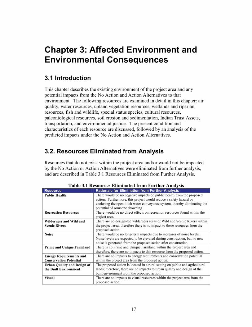
Chapter 3: Affected Environment and Environmental Consequences
3.1 Introduction
This chapter describes the existing environment of the project area and any potential impacts from the No Action and Action Alternatives to that environment. The following resources are examined in detail in this chapter: air quality, water resources, upland vegetation resources, wetlands and riparian resources, fish and wildlife, special status species, cultural resources, paleontological resources, soil erosion and sedimentation, Indian Trust Assets, transportation, and environmental justice. The present condition and characteristics of each resource are discussed, followed by an analysis of the predicted impacts under the No Action and Action Alternatives.
3.2. Resources Eliminated from Analysis
Resources that do not exist within the project area and/or would not be impacted by the No Action or Action Alternatives were eliminated from further analysis, and are described in Table 3.1 Resources Eliminated from Further Analysis.
Table 3.1 Resources Eliminated from Further Analysis Resource Rationale for Elimination from Further Analysis Public Health There would be no negative impacts on public health from the proposed
action. Furthermore, this project would reduce a safety hazard by enclosing the open ditch water conveyance system, thereby eliminating the potential of someone drowning.
Recreation Resources There would be no direct effects on recreation resources found within the project area.
Wilderness and Wild and Scenic Rivers
There are no designated wilderness areas or Wild and Scenic Rivers within the project area; therefore there is no impact to these resources from the proposed action.
Noise There would be no long-term impacts due to increases of noise levels. Noise levels are expected to be elevated during construction, but no new noise is generated from the proposed action after construction.
Prime and Unique Farmland There is no Prime and Unique Farmland within the project area and therefore, there are no impacts to this resource from the proposed action.
Energy Requirements and Conservation Potential
There are no impacts to energy requirements and conservation potential within the project area from the proposed action.
Urban Quality and Design of the Built Environment
The proposed action is located in a rural setting on public and agricultural lands; therefore, there are no impacts to urban quality and design of the built environment from the proposed action.
Visual There are no impacts to visual resources within the project area from the proposed action.

18
3.3. Affected Environment
3.3.1. Air Quality Air Quality is regulated by the U.S. Environmental Protection Agency (EPA) and the Wyoming Division of Air Quality. The National Ambient Air Quality Standards (NAAQS) established by the EPA under the Clean Air Act (CAA) specify limits of air pollutants for carbon monoxide, particulate matter (PM 10 & PM 2.5), ozone, sulfur dioxide, lead, and nitrogen. The project area is in attainment for all criteria pollutants. However, in March of 2009, Wyoming Governor Dave Freudenthal formally requested that portions of Sweetwater County be designated by the EPA as a non-attainment area for ozone (Letter to EPA, March 2009). While the project area is in the portion of Sweetwater County that might be designated as a non-attainment area, EPA has not yet formally responded to the Governor’s request. The attainment designation is not anticipated to change prior to the construction of the proposed action.
3.3.2. Water Resources The project area is within the Big Sandy Sub-basin, a component of the Green River Basin. The Green River Basin is the largest tributary of the Colorado River. The Big Sandy Sub-basin’s headwaters originate in the Wind River mountain range in western Wyoming. Water resources within the Big Sandy Sub-basin include the Big Sandy River, the Little Sandy River, the Big Sandy Dam and Reservoir, the Eden Dam and Reservoir, the Little Sandy Canal, the Means Canal, the Eden Canal, the Westside, Farson and Eden laterals, and associated drain lines. The Big Sandy Dam and Reservoir are located 10 miles north of Farson, Wyoming. Below the Big Sandy Reservoir, water is diverted along a lateral system to irrigate lands in the Eden project area. Eden Reservoir is an off-channel reservoir fed from the Little Sandy River and from the Big Sandy Dam. Three major canals stem from the Eden Reservoir: the Little Sandy Canal which is 4 miles in length; the Means Canal which is 6 miles in length; and the Eden Canal which is 10.8 miles in length. Their diversion capacities are 150, 635, and 475 cubic feet per second, respectively. In addition to these canals, the Westside, Farson, and Eden lateral systems have an aggregate length of 94 miles and are used to distribute irrigation water for agricultural uses. These laterals range in capacity from 6 to 160 cubic feet per second (Eden Project, 2009).
3.3.3. Water Quality The Eden Canal laterals and drainage ditches in the project area are classified by the Wyoming Department of Environmental Quality as Class 4A waterways. Class 4A waterways are waters where aquatic life uses are not attainable, pursuant to the provisions of Section 33 of the Clean Water Act. Uses designated on Class 4 waters (of which Class 4A waters fall within) include recreation, wildlife, industry, agriculture and scenic value. Class 4A designations are based upon the

19
knowledge that a water body is an artificial, man-made conveyance and has been determined not to support aquatic life uses (Wyoming Surface Water Standards, September 2008). The Eden Canal laterals and drainage system provide flood irrigation to agricultural users. Flood irrigation causes excess soil moisture, infiltration of water vertically downward through the soil to a shale layer, and horizontal movement of water downstream. Irrigation seepage into shallow aquifers is the source of many saline seeps. As the water migrates through the soil it dissolves and gathers salts. The seeps and springs within the Eden project area contribute an estimated 116,000 tons of salt annually to the Colorado River Basin. This salt loading degrades the water quality of the basin and its tributaries.
3.3.4. Upland Vegetation Resources Much of the land in the project area is comprised of human-altered vegetation, primarily used for agriculture. Agricultural activities in the project area have replaced native upland vegetation with alfalfa and pasture grasses. Non-agricultural vegetation such as cheatgrass and thistle is more common in disturbed areas along roads. In addition to the human-altered environment, the vegetation in the project area is dominated by upland vegetation species. Upland vegetation species in the project area include big sagebrush (Artemisia tridentata), a low growing shrub that is known to grow in deep, somewhat moist soils, as well as extremely dry rocky areas; rabbit-brush (Chrysothamnus spp. ), a deciduous shrub with bright white or yellow flowers that is a member of the Asteraceae family; western wheatgrass (Pascopyrum smithii) a common, native grass that is the state grass of Wyoming; crested wheatgrass (Agropyron cristatum), a drought-tolerant grass species in the Poaceae family; and blue-bunch wheatgrass (Pseudoroegneria spicata), a tall forage grass that is found in areas with deep soils.
3.3.5. Wetlands and Riparian Resources The project area contains both naturally occurring riparian areas and those that have occurred due to the presence of the Eden Canal laterals and drainage system. Wetlands and riparian areas are common along the Big Sandy River. These are classified as Riverine systems. A Riverine system is bounded on the landward side by upland, by the channel bank (including natural and man-made levees), or by wetlands dominated by trees, shrubs, persistent emergents, mosses, or lichens. The Riverine system includes all wetlands and deepwater habitats contained in natural or artificial channels periodically or continuously containing flowing water which forms a connecting link between the two bodies of standing water. Palustrine wetlands may occur in the channel, but they are not part of the Riverine system. A 23 acre artificial wetland area created by seepage from the E-8 lateral is located approximately 400 feet south of the E-8 lateral end point (Figure 3.1: Artificial Wetland in Project Area).

20
The species prevalent in the riparian areas include: baltic rush (Juncus balticus), a common rush that occurs most abundantly at low to mid elevations; creeping meadow foxtail (Alopecurus arundinaceus), a relatively tall grass that is common along wetted ditches and channels that is moderately salt tolerant; and common spikerush (Eleocharis paustris), a native perennial species that is fairly common in moist habitats.

21
Figure 3.1: Artificial Wetland in Project Area

22
3.3.6. Fish and Wildlife Resources Wildlife habitat in the project area can be categorized into three general categories: upland sagebrush and sedges; riparian and wetland; and human-altered/agricultural environments. The upland sagebrush and sedges habitat is found mostly on public lands managed by Reclamation and adjacent to the Bureau of Land Management (BLM) areas. Species that may use the upland habitat areas include the sandhill crane (Grus canadensis), red-tailed hawk (Buteo jamaicensis,) and antelope (Antilocapra Americana). Riparian and wetland areas provide habitat for waterfowl such as the mallard duck (Anas platyrhynchos). No aquatic animal or fish species were identified in the laterals or adjacent canals of the project area. The human-altered/agricultural lands are home to antelope (Antilocapra Americana), badger (Taxidea taxus), ground squirrel (Spermopohilius elegans), and various small rodents.
3.3.7. Special Status Species
3.3.7.1. Federally Listed Species The Endangered Species Act of 1973 (16 U.S.C. 1531-1543) protects federally listed endangered, threatened, proposed, and candidate plant and animal species and their critical habitats. Candidate species are those for which the United States Fish and Wildlife Service (USFWS) has sufficient data to list as threatened or endangered, but for which proposed rules have not yet been issued. Threatened species are those that are likely to become endangered in the foreseeable future throughout all or a significant portion of their range. The USFWS has identified nine federally listed species including six endangered, one threatened, and two candidate species that may potentially exist within or downstream from the project area. (Appendix A, USFWS Letter). Endangered Species
The black-footed ferret is 18 to 24 inches long, and weighs one-and-a-half to two-and-a-half pounds, with males slightly larger than females. It is a slender, wiry animal with a black face mask, black feet, and a black-tipped tail. It has short legs with large front paws and claws developed for digging (USFWS Species Profile, July 2009). The black-footed ferret is known to inhabit white-tailed prairie dog towns or complexes. The species was listed as Endangered on March 11, 1967.
Black-footed Ferret (Mustela nigripes)
The blowout penstemon is a perennial herb with stems less than 12 inches tall. The inflorescence is 2-6 inches long and has 6-10 compact whorls of milky-blue to pale lavender flowers. Blowout penstemon flowers from May until early June. Known populations in Wyoming are found between 6,680-7,440 feet. However, recent surveys have indicated that systemic surveys may be warranted in some lower elevations where active sand blowout features occur. The blowout
Blowout Penstemon (Penstemon haydenii)

23
penstemon was listed as Endangered on October 1, 1987 (NatureServe Comprehensive Species Report, 2009).
The bonytail is a large freshwater minnow, up to 2 feet, with a long, slender caudal peduncle. This warm water species appears to favor main-stem rivers regardless of turbidity, usually in or near deep swift water, in flowing pools and eddies just outside the main current. Spawning likely occurs in spring over rocky substrates. Flooded bottomland habitats appear to be important growth and conditioning areas, particularly as nursery habitats for young. The bonytail was formerly widespread through much of the Colorado River Basin but is now widely extirpated and very rare, with no known self-sustaining populations. The species was listed as Endangered on April 23, 1980 (NatureServe Comprehensive Species Report, 2009).
Bonytail (Gila elegans)
The Colorado pikeminnow is a large freshwater minnow that may reach a length of 6 feet. Adults are highly mobile and prefer medium to large rivers. Young prefer small, quiet backwaters. The species makes extensive spawning migration (up to 124 miles one way) and spawning occurs in late spring. Their habitat is restricted to large rivers within the Colorado River Basin. The Colorado pikeminnow was listed as Endangered on March 11, 1967 (NatureServe Comprehensive Species Report, 2009).
Colorado Pikeminnow (Ptychocheilus lucius)
The humpback chub is a large freshwater minnow with a slender caudal peduncle and a hump behind the head in large mature individuals. Spawning occurs in spring after peak water flow. Adults use various habitats, including deep turbulent currents and shaded ledges. Young prefer habitat over non-rocky substrate. The species population is restricted to the Colorado River system. The humpback chub was listed as Endangered on March 11, 1967 (NatureServe Comprehensive Species Report, 2009).
Humpback Chub (Gila cypha)
The razorback sucker is a freshwater sucker fish with a large sharp keel on the nape. The species is usually found swimming in schools. Spawning occurs in late winter to early spring and in groups of hundreds of individuals. Habitat includes backwaters and eddies of medium to large rivers, and flood lowlands which serve as breeding areas. The species population is restricted to the Colorado River Basin. The razorback sucker was listed as Endangered on October 23, 1991 (NatureServe Comprehensive Species Report, 2009).
Razorback Sucker (Xyrauchen texanus)
Threatened Species
Listed as a Threatened species in January 1993, the Ute ladies’-tresses is a member of the orchid family found mostly in wetlands and riparian areas.
Ute Ladies’-tresses (Spiranthes diluvialis)

24
Numerous, vanilla-scented, small white or ivory colored flowers arranged in a gradual spiral are found along the length of the stem during flowering. The species requires open habitat, and populations decline if trees and shrubs invade the habitat. They are not tolerant of permanent standing water, and do not compete well with aggressive species such as reed canary grass. Candidate Species
The yellow-billed cuckoo, as the name suggests, has a yellow lower mandible. It has rufous wings, which contrast against gray-brown wing coverts and upper parts, and white under parts. Large white spots can be noted on its long black undertail. It is a neotropical migrant, which winters in South America. Breeding often coincides with the appearance of massive numbers of cicadas, caterpillars, or other large insects. Its incubation/nesting period is the shortest of any known bird, because it is one of the last neotropical migrants to arrive in North America and chicks have very little rearing time before embarking on their transcontinental migration (Alsop 2001). Yellow-billed cuckoos are considered a riparian obligate and are usually found in large tracts of cottonwood/willow habitats with dense sub-canopies. Yellow-billed cuckoos are a Candidate species.
Yellow-billed Cuckoo (Coccyzus americanus)
Greater Sage-grouse (Centrocercus urophasianus) Greater sage-grouse inhabit sagebrush plains, foothills, and mountain valleys. Sagebrush is the dominant plant species in quality sage-grouse habitat, but a good understory of grasses, forbs, and associated wet meadow areas are essential for optimum habitat. Male sage-grouse gather on traditional "strutting grounds" (also called leks) during March and April, and females visit the grounds during the first part of April, with nesting beginning in April. Their principal winter food item is sagebrush leaves. During summer, the fruiting heads of sagebrush, leaves and flower heads of clovers, dandelions, grasses and other plants are taken; and insects are also a food source during the summer months. Sagebrush eradication and intensive use of lands by domestic livestock have reduced sage-grouse numbers. Sage-grouse range is declining in Wyoming in both quantity and quality. Some moderate to poor quality habitat is present near and within the project area, but no individuals were observed during the field reconnaissance. At the time of the Biological Assessment, sage-grouse were listed as State Sensitive Species. On March 5, 2010, USFWS added the greater sage-grouse to the Candidate species list. The list of threatened, endangered or candidate species with potential habitat that may be affected by the proposed action is found in Table 3.2 Federally Listed Species with Potential Habitat in the Project Area. No occurrences of these species have been documented within the project area, and none were observed in the project area during a June 2009 site survey, July 2009 site visit and a March 2010 site visit.

25
Table 3.2 Federally Listed Species with Potential Habitat in the Project Area
Species/Critical Habitat
Status Document Occurrences
in Project Area Black-footed Ferret ( Mustela nigripes) Endangered No Blowout Penstemon (Penstemon haydenii) Endangered No
Bonytail (Gila elegans), Colorado River Fish
Colorado Pikeminnow (Ptychocheilus lucius), Humpback Chub (Gila cypha), Razorback Sucker (Xyrauchen texanus)
Endangered Endangered Endangered Endangered
No
Ute Ladies’-tresses (Spiranthes diluvialis) Threatened No
Yellow-billed Cuckoo (Coccyzus americanus) Candidate No Greater Sage Grouse (Centrocercus urophasianus)
Candidate No
3.3.7.2. State Sensitive Species Section 06D of the ESA defines State Sensitive Species as those species that could become endangered or extinct within the state. Two species were identified as sensitive by the USFWS for the project area vicinity: the bald eagle and the mountain plover. Bald Eagle (Halieaeetues leucocephalus) The bald eagle is a large bird of prey. Adults possess a white head, a large bright yellow bill, and dark plumage. Immature bald eagles are dark with variable amounts of light splotching on the body, underwing covert, flight feathers, and tail base. The bald eagle roosts primarily in forested canyons or tall cottonwoods along streams and reservoirs. Migration of bald eagles from breeding areas generally takes place between September and December. The species clutch size is 1-3, and incubation lasts about five weeks. On June 28, 2007, the USFWS removed the bald eagle from the endangered species list. The bald eagle is still protected under the Bald Eagle Protection Act and the Migratory Bird Act (NatureServe Comprehensive Species Report, 2009). Mountain Plover (Charadrius montanus) The mountain plover is a medium-sized ground bird. It is misnamed, as it lives on level land. Unlike most plovers, this one is usually not found near bodies of water or even on wet soil; it prefers dry habitat with short grass (usually due to grazing) and bare ground. The mountain plover is 8 to 9.5 inches (20 to 24 cm) long and weighs about 3.7 ounces (105 grams). In appearance it is typical of Charadrius plovers, except that unlike most, it has no band across the breast. The upper parts are sandy brown and the underparts and face are whitish. There are black feathers on the fore-crown and a black stripe from each eye to the bill (the

26
stripe is brown and may be indistinct in winter); otherwise the plumage is plain (USFWS Species Profile, July 2009). Table 3.3 State Sensitive Species with Potential Habitat in the Project Area
Species/Critical Habitat Scientific Name Status
Documented Occurrence in Project Area
Bald Eagle Halieaeetues leucocephalus
State Sensitive
No
Mountain Plover Charadrius montanus
State Sensitive
No
3.3.7.3. Special Concern Species The BLM identifies nine species of special concern occurring in Sweetwater County. These species include the Utah mountain lilac (Ceanothus martini), dwarf mountain mahogany (Cercocarpus ledifolius var. intricatus [Cercocarpus intricatus]), fullstem (Chamaechaenactis scaposa), Greene’s rabbitbrush (Chrysothamus greenei), Cedar Rim thistle (Cirsium aridum), Ownbey’s thistle (Cirsium ownbeyi), slender cryptantha (Cryptantha gracillis), Rollins’ catseye (Cryptantha rollinsii) and the western dodder (Cuscuta occidentalis). Utah Mountain Lilac (Ceanothus martinii) The Utah mountain lilac is a non-thorny multi-branched low shrub. The species possesses shiny leaves and white flowers which bloom in the late spring. This species occurs in mountain brush, sagebrush, thinly wooded rocky slopes, ridge, and canyon bottoms. The Wyoming population occurs on steep sagebrush slopes or mountain shrub communities (Wyoming Natural Diversity Database, 2009).
Dwarf Mountain Mahogany (Cercocarpus intricatus) This intricately-branching shrub or small tree can reach heights of up to 7 feet. Leaves are very thin and needlelike; oblong to linear. This species’ elevation range falls between 4,000 and 8,500 feet. Flowering and fruiting occurs in June and July. Dwarf mountain mahogany grows on rocky slopes, sandstone outcrops, and sandy desert hills (Wyoming Natural Diversity Database, 2009). Fullstem (Chamaechaenactis scaposa) Fullstem is a caespitose perennial forb which grows .75 -3.5 inches tall with a deep caudex crowned by remnant leaf bases. Disk flowers are cream colored to pink and have a pappus of membranous scales. Flowering generally occurs from May to mid-June, and fruiting occurs from early to mid-early June. Fullstem typically occurs in cushion plant communities on sparsely vegetated calcareous clay barrens, rims and benches with a lag surface of shale flakes or in dry washes on extremely fine clay shales at 6,350 to 7,400 feet in elevation (Wyoming Natural Diversity Database, 2009).

27
Greene Rabbitbrush (Chrysothamnus greenei) Greene rabbitbrush is a multi-branched, white-bark stemmed shrub with yellow disk flowers. Flowering occurs in late July to September. The species is found in dry, open, rocky places on desert flats at 7,000 feet (Wyoming Natural Diversity Database, 2009). Cedar Rim Thistle (Cirsium aridum) Cedar Rim thistle is a perennial, taprooted herb with a loosely to densely woolly-hairy stem. Flowering and fruiting occurs from June to July with lavender flowers and cream-colored fruit with fine brown streaks. The species is found on barren, chalky hills, gravelly slopes, and fine textured, sandy-shaley draws. Populations are found mostly in sparsely vegetated openings with big sagebrush grasslands at 5800 to 7500 feet (Wyoming Natural Diversity Database, 2009). Ownbey’s Thistle (Cirsium ownbeyi) Ownbey’s thistle is a perennial taprooted herb with white to pink flowers. Flowering occurs primarily from late June to early August, while fruiting occurs from July to September. The species is found primarily on semi-barren rims or steep slopes of broken gray slate at 6440-8200 feet. Most occurrences are on sandy clay soils. Populations may also occur on roadcuts (Wyoming Natural Diversity Database, 2009). Slender Cryptantha (Cryptantha gracilis) Slender cryptantha is a slender, erectly branched annual with dense spreading hairs. Flowering and fruiting typically occurs from April to July. The species is typically found on coarse slate in sagebrush communities or with junipers on slopes and in washes at 6040-6900 feet (Wyoming Natural Diversity Database, 2009). Rollins’ Catseye (Cryptantha rollinsii) Rollins’ catseye is a densely bristly forb with a white, funnel-shaped corolla. Flowers appear May to June and fruit is present through July. The species is found on shale ridges, in salt and mixed desert scrub, sagebrush, pinyon-juniper and mountain brush communities. Wyoming populations are found in cushion plant communities on ridgetops and slopes with sandy soils or sandstone slate flakes between 6,040 to 7,820 feet (Wyoming Natural Diversity Database, 2009). Western Dodder (Cuscuta occidentalis) Western dodder is a rootless, annual parasitic herb with slender, twining, yellowish stems and a lance-shaped corolla. The species flowers June to August. The western dodder is found in big sagebrush communities at 6,400 to 7,600 feet (Wyoming Natural Diversity Database, 2009). Although the project area may provide habitat for species of concern, the field survey did not identify any special concern species within the vicinity of the project area.

28
Table 3.4 Special Concern Species with Potential Habitat in the Project Area
Species Scientific Name Heritage Rank
Documented Occurrence in Project Area
Utah mountain lilac
Ceanothus martinii G4/S1 No
Dwarf mountain mahogany
Cercocarpus ledifolius var. intricatus [Cercocarpus
intricatus]
G5T4/S1 No
Fullstem Chamaechaenactis scaposa
G4/ S1S2 No
Greene rabbitbrush
Chrysothamnus greenei G5/S1 No
Cedar Rim thistle
Cirsium aridum G2Q/S2 No
Ownbey's thistle
Cirsium ownbeyi G3/S2 No
Slender cryptantha
Cryptantha gracilis G5/S1 No
Rollins' catseye
Cryptantha rollinsii G3/S1 No
Western dodder
Cuscuta occidentalis G5/S1 No
3.3.8. Cultural Resources Cultural resources are defined as physical or other expressions of human activity or occupation. Such resources include culturally significant landscapes, prehistoric and historic archaeological sites as well as isolated artifacts or features, traditional cultural properties, Native American and other sacred places, and artifacts and documents of cultural and historic significance. Section 106 of the National Historic Preservation Act of 1966 (NHPA), mandates that Reclamation take into account the potential effects of a proposed Federal undertaking on historic properties. Historic properties are defined as any prehistoric or historic district, site, building, structure, or object included in, or eligible for, inclusion in the National Register of Historic Places (NRHP). Potential effects of the described alternatives on historic properties are the primary focus of this analysis. The affected environment for cultural resources is identified as the APE (area of potential effects), in compliance with the regulations to Section 106 of the NHPA (36 CFR 800.16). The APE is defined as the geographic area within which federal actions may directly or indirectly cause alterations in the character or use

29
of historic properties. The APE for this proposed action is limited to the proposed pipeline corridor, access roads, and staging areas.
3.3.8.1 Cultural History The archaeological record in the Eden Valley area spans thousands of years, from the Paleo-Indian Period through historic times. Pioneers in the early nineteenth century passed through this arid valley on their way to the milder climates of Oregon and California, stopping only to water their livestock at the Big Sandy Creek and rest for the night. Very few gave the area a second thought until the growth of the ranching industry in the late 1800's. Even then, the cold, prohibitive climate and desert-like water conditions deterred the less hardy settlers from making their homes permanent. By the late nineteenth century, it was clear that if settlements in the valley were to prosper, the construction of an irrigation project was necessary. The result was the Eden Project. The Eden Project, named for its proximity to the town of Eden, Wyoming, predominately serves farms in the northern section of Sweetwater County in the northeastern corner of the Green River Basin (Klajic 2000). Features of the Eden Project include Big Sandy Dam and Reservoir, Eden Dam and Reservoir, Little Sandy Canal, Means Canal, Eden Canal, and a lateral and drainage system. The Eden Canal was originally constructed, beginning in 1907, by the Eden Irrigation and Land Company. Work continued on the canal until 1914, when it was considered largely complete (Kail 1998). During the late 1930’s, Reclamation and the Department of Agriculture investigated the canal and surrounding irrigation area, eventually determining that a plan of development and rehabilitation was necessary. A plan was approved in 1940 as a Great Plains project under the water conservation provision of the Interior Department Appropriation Act of 1940, and included work to the Eden Canal, as well as the construction of the Big Sandy Dam and Reservoir, the Means Canal, and a series of lateral canals. Due to a long delay in construction caused by World War II, completion of the project was re-authorized by an act of Congress on June 28, 1949 (Klajic 2000). Construction was recommenced in 1950 and completed in 1970 resulting in a final project configuration of 3 dams (Eden Dam, Big Sandy Creek Dam, and Little Sandy Diversion Dam). One dike (Big Sandy Dike), 2 reservoirs (Eden Reservoir and Big Sandy Creek Reservoir), 2 main canals (Little Sandy Canal and Means Canal), and 2 laterals (Westside and Farson Laterals)(Klajic 2000).
3.3.8.2 Cultural Resources Status A Class I literature review and a Class III cultural resource inventory were completed for the APE, defined in the Action Alternative and analyzed for the proposed action, by SWCA Environmental Consultants between March and June 2010. A total of 549.2 acres were inventoried. Five new sites, two previously recorded sites, and one isolate were identified as a result of the inventory.

30
In accordance with 36 CFR 800.4, the sites were evaluated for significance in terms of NRHP eligibility. The significance criteria applied to evaluate cultural resources are defined in 36 CFR 60.4 as follows: The quality of significance in American history, architecture, archeology, engineering, and culture is present in districts, sites, buildings, structures, and objects that possess integrity of location, design, setting, materials, workmanship, feeling, and association and:
A. that are associated with events that have made a significant contribution to the broad patterns of our history; or
B. that are associated with the lives of persons significant in our past; or
C. that embody the distinctive characteristics of a type, period, or method of construction, or that represent the work of a master, or that possess high artistic values, or that represent a significant and distinguishable entity whose components may lack individual distinction, or D. that have yielded, or may be likely to yield, information important in prehistory or history.
Three sites identified during the Class III cultural resource inventory are recommended eligible for the NRHP. Two of the sites will be avoided, but the third site, the Westside Lateral, will be adversely affected by the proposed action. The Westside Lateral has made a significant contribution to the settlement and economic development of the area. The proposed action would cause an alteration to the characteristics of the Westside Lateral which make the lateral eligible for the NRHP and would, therefore, have an effect on the property according to 36 CFR 800.16(i). Pursuant to 36 CFR 800.5, the criteria of adverse effect were applied to the Westside Lateral. An adverse effect is defined as an effect that could diminish the integrity of a historic property’s location, design, setting, materials, workmanship, feeling, or association. The proposed action would diminish the integrity of the Westside Lateral and would have an adverse effect to the historic property. In compliance with 36 CFR 800.4(d)(2) and 36 CFR 800.11(e), a copy of the cultural resource inventory report and a recommendation of historic properties affected were submitted to the Wyoming State Historic Preservation Office (WYSHPO) the Advisory Council on Historic Preservation (ACHP), and tribes which may attach religious or cultural significance to historic properties possibly affected by the proposed action for consultation. Reclamation received concurrence from the WYSHPO in a letter dated September 23, 2010. WYSHPO determined that the Westside Lateral is a historic property

31
eligible for listing on the NRHP. WYSHPO also determined that the proposed action would have an adverse effect on the Westside Lateral. Pursuant to 36 CFR 800.6(c), a Memorandum of Agreement (MOA) will be developed to resolve the adverse effects to the Westside Lateral. Signatories to the MOA would include Reclamation, WYSHPO, the Eden Valley Irrigation and Drainage District (EVIDD), and if they choose to participate, the ACHP.
3.3.9. Paleontological Resources A paleontological literature search and field survey were conducted between April 8-10, 2010 for the project area by Georgia Knauss, B.S. and Paul C. Murphy, Ph.D. of SWCA Environmental Consultants, Sheridan, Wyoming. Seven new non-significant fossil occurrences were documented during the field survey. However, the fossils documented at these fossil sites do not necessarily indicate a likelihood of subsurface fossils because it appears that the fossils and rocks in which they are preserved were transported to the APE as fill during previous construction activities, and are not eroding naturally from the rocks immediately underlying the APE. SWCA recommended immediate surface and subsurface clearance for the entire APE except during excavations into previously undisturbed ground along the proposed Westside Lateral pipeline where there is no existing canal. In these areas, SWCA recommends a paleontological monitor be on site. If bedrock of the Laney Shale Member (lithified layers of in-situ and/or sandstone) is encountered anywhere within the APE during construction and a paleontological monitor is not present, construction activities should cease until a Reclamation-permitted paleontologist arrives on site. In addition, if any subsurface bones or other potential fossils are unearthed during construction and a paleontological monitor is not present, Reclamation must be contacted immediately and work in the area of discovery should cease until a Reclamation-permitted paleontologist can assess the discovery, determine its significance, and make additional recommendations.
3.3.10. Soil Sedimentation and Erosion The soils in the project area were mapped by the Natural Resource Conservation Service (NRCS) on June 30, 2008 (Eden Project Soil Report, 2008). The soils in the project area are primarily comprised of sandy loams and loamy sands with a 0 to 6 percent slope. The composition of the soil in the project area includes Vonason loamy sand (49.7%), Means-Farson sandy loams (10. 3%), gunbarrel loamy sands (9.2%), Farson sandy loam (7.5%), and Shellcreek silty clay (5.8%). The project area also contains a few small areas of wind deposited sand dune soils and heavy clay soils. The upland vegetation areas contain soils with shallow shale bedrock. Soil erosion is common within the project area, in areas surrounding ditches and in areas that receive periods of heavy wind (NRCS Soil Survey, 2009).

32
3.3.11. Indian Trust Assets Indian Trust Assets (ITA’s) are legal interests in property held in trust by the United States for federally recognized Indian tribes or individuals. The Department of the Interior’s policy is to recognize and fulfill its legal obligations to identify, protect and conserve the trust resources of federally recognized Indian tribes and tribal members and to consult with the tribes on a government-to-government basis whenever plans or actions affect tribal trust resources, trust assets, or tribal safety (please refer to the Departmental manual, 512 DM 2). Under this policy, as well as Reclamation’s ITA policy, Reclamation is committed to carrying out its activities in a manner which avoids adverse impacts to ITAs when possible, and to mitigate or compensate for such impacts when it cannot. All impacts to ITAs, even those considered insignificant, must be discussed in the trust analyses in NEPA compliance documents and appropriate compensation or mitigation must be implemented. Trust assets may include lands, minerals, hunting and fishing rights, traditional gathering grounds, and water rights. Impacts to ITAs are evaluated by assessing how the action affects the use and quality of ITAs. Any action that adversely affects the use, value, quality or enjoyment of an ITA is considered to have an adverse impact on the resources. There are no known ITAs in the project area vicinity, and no ITA concerns were identified through tribal consultation.
3.3.12. Environmental Justice Executive Order 12898 established environmental justice as a federal agency priority to ensure that minority and low income populations are not disproportionately impacted by federal actions. The information obtained from the U. S. Census indicates that a minority population does exist in the project area. According to 2000 U. S. Census data, Eden has a total population of 506 residents. Of these residents 497 (98. 2%) are white, while the remaining 9 residents are identified as an ethnic minority. Sweetwater County, in comparison, has a total population of 37,613, with 32,586 (86. 6%) identified as white only, with the remaining 5,027 (13. 4%) identified as an ethnic minority. Therefore, the census data suggests that although an ethnic minority population may be located within the project area, there is not a low-income minority population in the project area. The median income for Eden is $52,625, while the median income for Sweetwater County is $46,537.
3.3.13. Public Safety, Access, and Transportation Transportation resources in the area include US Highway 191, State Highway 28, and local roads. US 191 provides access between Rock Springs and Pinedale and is the only major highway in this area. The Wyoming Department of Transportation (WYDOT) is currently in the process of preparing a corridor rehabilitation and improvement plan for US 191. State Highway 28 provides east-west access between Lander and Kemmerer. Local roads in the area are developed on a grid system and provide local access and mobility for residents.

33
3.4. Environmental Consequences
The environmental consequences section discusses potential impacts to the project area resources from the No Action and Action Alternatives.
3.4.1. Air Quality No Action Alternative Under the No Action Alternative there would be no adverse effects to air quality. Action Alternative Under the Action Alternative there would be no long-term impacts to local air quality. Fugitive dust generation from construction activities would have a temporary, short-term effect on the air quality in the project area. The fugitive dust would be generated by excavation activities and the movement of construction equipment on unpaved roads. Best Management Practices (BMPs,) such as watering for dust control to minimize fugitive dust will be implemented. Impacts due to construction activities would be temporary and would cease once the project was completed.
3.4.2. Water Resources No Action Alternative Under the No Action Alternative, water from the laterals would continue to seep into the soil and ultimately contribute to the concentrated salt loads to the Colorado River Basin. This seepage would result in the loss of approximately fifty percent of the irrigation water that runs through the E-7, E-8, and Westside laterals. Action Alternative The Action Alternative would eliminate seepage from the E-7, E-8, and Westside laterals. This would result in an estimated fifty-percent increase in water traveling to agricultural users along the laterals, thereby improving the efficiency of the irrigation system.
3.4.3. Water Quality No Action Alternative Under the No Action Alternative, there would be long-term minor to moderate adverse impacts to the water quality of the Colorado River Basin. Salt loads from the deep percolation of seepage from the E-7, E-8, and Westside laterals would continue to degrade water quality in the Basin. Action Alternative The Action Alternative would reduce seepage from the E-7, E-8, and Westside laterals. The reduced seepage will result in an estimated 5,762 fewer tons of salt from reaching the Colorado River Basin annually. This would result in minor

34
long-term reduced salinity in the Colorado River Basin and improvement in the long-term water quality of the Colorado River.
3.4.4. Upland Vegetation Resources No Action Alternative Under the No Action Alternative, heavy equipment used during routine maintenance of the ditch would continue to have minor impacts on the upland vegetation in the project area. These plant communities would remain in their current condition, and are not anticipated to experience sizeable gains or losses from maintenance activities. Action Alternative Under the Action Alternative, much of the area disturbed by construction activities would be in upland and agricultural areas. Most of the areas where construction would take place are already altered from their natural state. Construction would occur outside the growing season, between October and May, and would occur within a 50 - to 100-foot wide construction easement. Upland areas would experience short-term losses. Brush and grasses would be impacted during construction by the operation of construction equipment, excavation, and the staging of materials. All areas disturbed by construction activities would be re-contoured and reseeded. After completion of the re-contouring and reseeding, relatively minor native habitat would be permanently lost when compared to the current condition. Upland vegetation communities would likely be reestablished, and some previously disturbed areas may see an increase in native species compositions after reseeding. Areas that are disturbed may be more vulnerable to non-native species and noxious weed infestation. These non-native species typically recover more quickly after a disturbance than native species. To minimize impact to native vegetation, previously disturbed areas would be used for construction activities, where possible. Cultivated lands that are disturbed by construction activities will be reseeded with an appropriate agricultural mix. Best Management Practices would be followed to reduce impacts, including placing staging and material sources outside of sensitive areas. Construction materials and equipment would be washed to remove dirt, seeds from weeds, and to reduce the possibility of infestation by non-native species. After any surface disturbance, proper rehabilitation procedures would be followed to prevent the infestation of invasive species. This would include seeding mixtures of desirable native species and agricultural grasses, where appropriate and post-construction treatment to control noxious and invasive species.
3.4.5. Wetlands and Riparian Resources No Action Alternative Riparian habitat would remain in its current condition, experiencing minor fluctuations in quantity and quality, as naturally occurring precipitation patterns vary. Routine ditch maintenance would continue to disturb these areas, and the area is likely to see an increase in the composition and infestation of noxious and non-native species, due to their ability to thrive in disturbed areas. Though

35
periodically removed within the ditch during maintenance, these plant species would likely increase their dominance within the project area, resulting in degradation of habitat quality.
Action Alternative Many of the wetland and riparian habitats in the project area are ditch-induced and supported by seepage from the ditch. Under the Action Alternative, the majority of long-term project impacts to riparian resources would occur in ditch-induced wetland and riparian habitats. The proposed action would take place entirely within the existing lateral prism except for the new E-8 alignment; Westside Lateral Option A, and Westside Lateral Option B (described in Section 2.3). The construction of the new E-8 alignment is anticipated to have indirect impacts to 23 acres of an artificial wetland which is located 400 feet south of the existing E-8 lateral. Westside Lateral Option A would not impact any wetland areas. Westside Lateral Option B would temporarily impact 1.72 acres of wetlands with the Big Sandy River crossing. This project’s impacts are covered under the CWA Section 404(f) exemption. Under this exemption, no permit is required for the project’s irrigation system, that may impact wetlands and other waters associated with the irrigation ditches. Riparian habitat would be impacted by the piping of the laterals. Piping of the lateral would result in a total loss of ditch-induced riparian habitat. These areas may see increases in non-native species including tamarisk and Russian olive; these two species may be able to out-compete native species for limited water supplies when irrigation flows cease. The amount of riparian habitat within the ditch prisms that would be lost under the Action Alternative is approximately 39.96 acres (plus the 23 acres off of E-8 for a total riparian loss of 62.96 acres). As required by the Colorado River Basin Salinity Control Act (43 U.S.C. 1571-1599), any wildlife values lost as a result of project implementation must be replaced by EVIDD through habitat replacement and management plans approved by Reclamation following coordination with Federal and state wildlife officials. Replacement habitat must be of an equal or greater value to the habitat lost by the proposed project, and must be managed to maintain its value for the life of the salinity control project (50 years). Riparian habitat will also be managed during construction under the guidelines set forth in the Colorado River Basin Salinity Control Act and E.O. 11990. To minimize impact to native riparian vegetation, previously disturbed areas would be used for construction activities, where possible. Best Management Practices would be followed to reduce construction impacts. After any surface disturbance, proper rehabilitation procedures would be followed to prevent the infestation of invasive riparian species. This would include seeding mixtures of desirable native riparian species.

36
3.4.6. Fish and Wildlife Resources No Action Alternative Under the No Action Alternative, terrestrial wildlife habitat would remain in its current condition, and there would be no gains or losses to the wildlife habitat. Salinity loading of the Colorado River drainage would continue at current rates, which may affect water quality within the drainage, thereby continuing to impact the wildlife using the area. Action Alternative The upland wildlife habitat impacted by the proposed action would result in minor short-term impacts to all wildlife species present in the project area. There would be some upland habitat, approximately 9 acres, temporarily lost due to pipeline construction but similar habitat is available in the surrounding areas. After construction, areas disturbed by construction would be re-contoured, replanted, and reseeded with native vegetation except in agricultural fields, where appropriate crop seeds would be used. Best Management Practices would be followed to minimize impacts, including placing staging sites and access outside of sensitive or highly valuable habitats. After any surface disturbance, proper rehabilitation procedures would be followed to prevent the infestation of invasive weed species. This would include seeding disturbed areas with mixtures of desirable native species, including grasses, shrubs, and forbs. During the construction period and during pipeline maintenance there could be a short-term displacement (approximately three to six months) of wildlife that normally occupies the immediate project area. Construction would occur from autumn through early spring to avoid disturbance during critical periods of time for nesting or fawning for many wildlife species. All construction activities would occur within a 50 - to 100-foot wide area along the Proposed Pipeline Alignment. Generally, animals would move easily and find alternative areas for forage and cover, and may return after construction and maintenance operations have been completed. Some upland habitats would experience short-term disturbance until native vegetation components within these areas are restored (two to three growing seasons). Impacts to small mammals, especially burrowing animals, could include direct mortality and displacement during construction activities. Most small mammal species would likely experience reduced populations in direct proportion to the amount of disturbed habitat. These species and habitats are relatively common throughout the area, so the loss would be minor. Impacts to big game would include short-term disturbance and displacement of late summer and fall incidental use during the construction period. It is anticipated, due to the minor amount of habitat disturbance, that minor to no impact to wintering big game populations would occur.

37
Impacts to raptors and other avian species would include minor short-term disturbance and displacement during construction, with no long-term impacts after construction. Those species, including avian and amphibian species, which are dependent on wetland and riparian habitats, would experience a long-term (greater than five years) loss of habitat as described above. The proposed action would result in a decrease in salinity, which would improve water quality in the Colorado River and potentially indirectly benefit fish within the Colorado River System. The total habitat value that would be lost long-term would be replaced through acquired replacement habitat to be proposed by the applicant and approved by Reclamation.
3.4.7. Special Status Species Federally Listed Species No Action Alternative There would continue to be minor direct or indirect impacts to threatened, endangered, or candidate species from continued salt loading in the Colorado River Basin. Salinity loading of the Colorado River Basin would continue at current rates due to seepage from the E-7, E-8 and Westside laterals, which will impact water quality within the drainage, thereby impacting wildlife using the area. Any impacts to federally listed species and their habitat from the salt loading would continue. Action Alternative There have been no documented occurrences of any federally listed threatened, endangered or candidate species within the project area. Biological site surveys completed in May and June 2009 determined that there would be no effect to any federally listed species from the proposed action. (Appendix C, Biological Assessment). Construction activities would not take place in the immediate proximity of any natural stream. The E-7, E-8, and Westside laterals do not connect directly to the Green or Colorado Rivers through surface channels or waterways. As a result, no impact to endangered fish species within the Colorado River Basin would result from sedimentation entering the laterals during construction activities. The proposed action may result in long-term, minor depletions of flows to the Colorado River Basin due to reduced seepage. The proposed action would result in a long-term decrease in salinity which would increase water quality in the Colorado River and may therefore contribute to cumulative benefits for endangered fish species from improved water quality.

38
State Sensitive Species No Action Alternative There would be no impact to State Sensitive Species under the No Action Alternative. Action Alternative There have been no documented occurrences of any Wyoming State Sensitive Species within the project area. Habitat for these species does exist within or adjacent to the project area, therefore there would be no effect to State Sensitive Species under the proposed action. Special Concern Species No Action Alternative There would be no impact to State Sensitive Species under the No Action Alternative. Action Alternative There have been no documented occurrences of any Wyoming State Sensitive Species within the project area. Habitat for these species does exist within or adjacent to the project area. Effects of the development of the proposed action on State Sensitive Species would be similar to effects on general upland vegetation.
3.4.8. Cultural Resources No Action Alternative Under the No Action Alternative, there would be no adverse effects to cultural resources. There would be no need for ground disturbance for any pipe installation, staging areas, or access roads. The existing conditions would remain intact and would not be affected. Action Alternative Under the Action Alternative, there would be an adverse effect to the Westside Lateral. The existing unlined earthen irrigation lateral would be replaced with a pipeline and buried. Mitigation measures for the adverse effect to the Westside Lateral will be outlined in a MOA in accordance with 36 CFR 800.6(c).
3.4.9 Paleontological Resources No Action Alternative Under the No Action Alternative there would be no adverse effects to paleontological resources. There would be no need for ground disturbance for any pipe installation, staging areas, or access roads. The existing conditions would remain intact and would not be affected Action Alternative Under the Action Alternative, there would be ground-disturbing activities which have the potential to disturb subsurface fossil material. Paleontological monitoring is recommended during excavation into previously undisturbed

39
ground along the proposed Westside Lateral pipeline where there is no existing lateral.
3.4.10. Soil, Erosion and Sedimentation No Action Alternative Under the No Action Alternative there would be no adverse effects to soil erosion and sedimentation. Soil erosion from water and wind would continue in the area at the current rate. Action Alternative Under the Action Alternative, soil would be excavated, compacted and re-graded during construction. In the short-term period, during and immediately following construction, erosion and sedimentation would increase. Best Management Practices would be employed to minimize the potential for impacts from erosion and sedimentation. The proposed pipeline alignment would be reseeded, and over the long-term the soil would return to a pre-project condition once vegetation is established.
3.4.11. Indian Trust Assets (ITAs) No Action Alternative The No Action Alternative would have no impact on ITAs. Action Alternative Since there are no ITAs within the project vicinity, implementation of the proposed action would have no effect on ITAs.
3.4.12. Environmental Justice No Action Alternative The No Action Alternative would have no impact on Environmental Justice populations. Action Alternative The project area lies on privately and publicly owned land in Sweetwater County, Wyoming. After a review of the United States 2000 census information and socioeconomic data available for Sweetwater County, populations that could potentially be affected by the proposed project were evaluated. There were no minorities or low-income population centers in the vicinity of the project area. Furthermore, implementation of the Action Alternative would not disproportionately (unequally) affect any low-income or minority communities near the project area. The proposed action would not involve population relocation, health hazards, hazardous waste, property takings, or substantial economic impacts. The proposed action would therefore have no adverse effects to human health or the environment and would not disproportionately affect minority and low-income populations.

40
3.4.14. Transportation No Action Alternative The Wyoming Department of Transportation (WYDOT) is currently in the process of preparing a corridor rehabilitation and improvement plan for U.S. 191. These planned roadway improvements would have no effect on the irrigation laterals identified for piping. Action Alternative The proposed action may cause limited delays along U.S. 191 due to construction vehicles entering and exiting the highway. Emergency dispatch service for Eden is operated from the Eden Valley Fire District in Farson. Service from the fire station would not be impacted by the Action Alternative. Although no temporary road closures are planned, any temporary road or access closure will be coordinated with local law enforcement and emergency services. The public will also be notified of any road closures that take place due to the proposed action.
3.4.15. Summary of Environmental Consequences
Resource Issue Alternatives No Action Action
Air Quality No Effect Minor short-term effects due to fugitive dust and equipment exhaust from construction activity. Mitigate with Best Management Practices (BMPs).
Water Quality Continued salt loading of the Colorado River Basin. Long-term minor to moderate impacts.
The Proposed Project would result in an estimated 5,762 fewer tons of salt from entering the Colorado River Basin annually; thereby reducing the salinity and improving water quality. There would be long-term benefits to water quality from the decreased salinity.
Upland Vegetation Resources
No Effect Short-term upland vegetation loss with the potential for an increase in invasive plants. Best Management Practices will be employed to decrease the likelihood of invasive species.

41
Wetland and Riparian Resources
No Effect There would be permanent loss of riparian areas along the lateral channels once they are piped.
Fish and Wildlife Resources
Direct and indirect impacts may occur due to continued salt loading of nearby waterways.
Minor short-term disturbance and displacement during construction. Downstream habitat may be improved as a result of long-term increased water quality. There would be permanent loss of 62.96 acres of riparian areas once the laterals are piped. A Habitat Replacement Plan as required by the salinity legislation will be implemented to replace wildlife values foregone.
Special Status Species- Federally Listed Threatened, Endangered, and Candidate Species
Minor direct and indirect impacts may occur due to continued salt loading of nearby waterways.
No Effect
Special Status Species- State Sensitive Species
No Effect No Effect
Special Concern Species
No Effect No Effect. Individual plants were not identified within the project area, but there may be some short-term disturbance to potential habitat during construction (3 to 6 months) and during maintenance activities.
Special Status- Other Sensitive Plant Species
No Effect No Effect. There may be some short-term disturbance to potential habitat during construction (3 to 6 months) and during maintenance activities.
Cultural Resources No Effect Adverse effect to historic property (Westside Lateral). Mitigation measures developed in an MOA.
Paleontology No Effect Potential effects to subsurface fossils during construction.
Soil Erosion and Sedimentation
No Effect Minor short-term effects due to runoff during and shortly after construction activity. Mitigate with Best Management Practices.
Indian Trust Assets No Effect No Effect

42
Environmental Justice No Effect No Effect Transportation WYDOT rehabilitation/
improvements to U.S. 191
Work along U.S. 191 would cause minor temporary disruption, and traffic volume would increase temporarily during construction. Traffic on Eden Second East would be restricted during construction activity under the road.
Cumulative Effects No Effect Cumulative impacts from the proposed action and related actions were assessed during the resource evaluation (Chapters 3 & 4). This analysis determined that there were no adverse cumulative impacts.
Chapter 4: Environmental Commitments The following environmental commitments would be implemented as an integral part of the proposed action for the piping of Eden Canal E7, E-8, and Westside laterals. 1. Standard Reclamation Best Management Practices – Standard reclamation best management practices would be applied during construction activities to minimize environmental effects and would be implemented by construction personnel or included in contract specifications. 2. Additional Analysis – If the proposed action were to change significantly from the alternative described in this EA, additional environmental analyses would be undertaken as necessary. 3. State Stream Alteration Permit – Before implementing the selected alternative, the contractor would obtain a State Stream Alteration Permit (if required) from the Department of Natural Resources. The conditions and requirements of the State Stream Alteration Permit would be strictly adhered to the contractor. 4. Cultural Resources – Any person who knows or has reason to know that he/she has inadvertently discovered possible human remains on Federal land,

43
must provide immediate telephone notification of the discovery to Reclamation’s Provo Area Office archaeologist. Work will stop until the proper authorities are able to assess the situation onsite. This action will promptly be followed by written confirmation to the responsible Federal agency official, with respect to Federal lands. The WYSHPO and interested Native American tribal representatives would be promptly notified. Consultation would begin immediately. This requirement is prescribed under the Native American Graves Protection and Repatriation Act (43 CFR Part 10); and the Archaeological Resources Protection Act of 1979 (16 U.S.C. 470). A MOA will be executed to mitigate for the adverse effect to the Westside Lateral. Mitigation for the adverse effects to the lateral, set forth in the stipulations of the MOA, must be completed before construction activities associated with the proposed action begin. 5. Paleontological Resources – Monitoring is required for all construction activities outside of the existing lateral alignments as well as those impacting the bedrock layer of the Laney Shale Member of the Green River Formation. Anyone who inadvertently discovers possible paleontological resources must stop work immediately and contact the Reclamation’s Provo Area Office archaeologist. Work would stop until the proper authorities are able to assess the discovery. 6. Construction Activities Confined to the Surveyed Corridor – All construction activities would be confined to the one hundred foot wide corridor that has been surveyed for cultural, paleontological, and biological resources. 7. Roads – Existing roads would be used whenever possible for project activities. New access roads would be necessary along the new E-8 alignment. 8. Disturbed Areas – During construction topsoil would be saved and then redistributed after completion of construction activities. Subsequently, disturbed areas resulting from the project would be smoothed, shaped, contoured and reseeded to as near their pre-project condition as practicable. Seeding and planting would occur at appropriate times with weed-free seed mixes of native plants and agricultural grasses, distributed where appropriate. 9. Air Quality – Best management practices would be implemented to control fugitive dust during construction. The contractor would follow the EPA’s recommended control methods for aggregate storage pile emissions to minimize dust generation, including periodic watering of equipment, staging areas, and dirt/gravel roads. All loads that have the potential of leaving the bed of the truck during transportation would be covered or watered to prevent the generation of fugitive dust. Construction machinery and operation/maintenance vehicles would be routinely maintained to ensure that engines remain tuned and emission-control equipment is properly functioning as required by law. Additionally, the contractor would comply with all Wyoming State air quality regulations.

44
10. Habitat Replacement – A plan to replace wildlife values foregone will be prepared by the applicant and approved by Reclamation following coordination with the USFWS and Wyoming Department of Game and Fish. Total acreage of wildlife habitat predicted to be lost is 39.96 acres of riparian habitat along the lateral prism plus 23 acres of a nearby artificial wetland from the E-8 lateral.
11. Sage Grouse Monitoring- Prior to initiating construction activities, and as the project proceeds, the applicant will ensure that surveys and monitoring will be conducted to ensure that Greater sage grouse leks do not exist within the construction area. If there are leks present in the area, the applicant and contractor shall notify the Wyoming Department of Game and Fish and Reclamation’s Provo Area Office biologist. Regardless of the presence of leks, any observation of sage grouse will lead to monitoring by a biologist to ensure that impacts to sage grouse are avoided.

45
Chapter 5: Consultation and Coordination
5.1 Introduction
Reclamation’s public involvement process presents the public with opportunities to obtain information about a given project and allows all interested parties to participate in the project through written comments. The key objective is to create and maintain a well-informed, active public that assists decision makers throughout the process, culminating in the implementation of an alternative. This section of the EA discusses public involvement activities undertaken to date for the Farson/Eden Canal piping project.
5.2 Native American Consultation
Reclamation conducted Native American consultation throughout the public involvement process. Consultation letters and copies of the Class III cultural resource inventory report were sent to the Ute Indian Tribe of the Uintah and Ouray Reservation, the Arapahoe Tribe of the Wind River Reservation, the Shoshone Tribe of the Wind River Reservation, and the Shoshone-Bannock Tribes of the Fort Hall Reservation of Idaho. This consultation will be conducted in compliance with 36 CFR 800.2(c)(2) on a government-to-government basis. Through this effort each tribe is given a reasonable opportunity to identify any concerns about historic properties; to advise on the identification and evaluation of historic properties, including those of traditional religious and cultural importance; to express their views on the effects of the proposed action on such properties; and to participate in the resolution of adverse effects. Tribal consultation for this proposed project is pending.
5.3 Paleontological Resources
A paleontological literature search and field inventory was conducted between April 8-10, 2010 for the proposed project APE, by SWCA Environmental Consultants, Sheridan, Wyoming. A copy of the field inventory report is in Appendix D.

46
5.4 Wyoming State Historic Preservation Office
A copy of the Class III cultural resource inventory report and a recommendation of historic properties affected for the proposed project were submitted to the WSHPO (Appendix E, WYSHPO letter). WYSHPO concurred with Reclamation’s recommendation of historic properties affected in a letter dated September 23, 2010 (Appendix F). The WYSHPO will be a signatory to the MOA to mitigate the adverse effects to the Westside Lateral.

47
Chapter 6: Preparers The following table provides a list of the agency representatives and consultants who participated in the preparation of the Draft Environmental Assessment.
Table 6.1. List of Preparers Name Title/Position Contributions Agency Representatives Beverley Heffernan, BA Environmental
Protection Specialist, Bureau of Reclamation, Provo Area Office
Project coordination, Environmental Justice, Indian Trust Assets
Rafael Lopez, BA Biologist, Bureau of Reclamation, Provo Area Office
Coordination and Biological Resource Oversight
Brian Joseph, MA Archaeologist, Bureau of Reclamation, Provo Area Office
Cultural Resources and Paleontological Resources
Consultants Brian Deeter, PE Engineer, J-U-B
Engineers, Inc. Project Manager
Jason Snedaker, PE Engineer, J-U-B Engineers, Inc.
Alternative Analysis
Ross Wilson, PE Engineer, J-U-B Engineers, Inc.
Alternative Analysis
Alex Beseris, BA Environmental Manager, J-U-B, Engineers, Inc.
NEPA Oversight
Marti Hoge, MA Environmental Planner, J-U-B Engineers, Inc.
Alternative Analysis Affected Environment Environmental Consequences Environmental Commitments
Andy Ashton, BA Gateway Mapping, Inc.
GIS, Document Graphics
Vincent Barthels, BS Biologist, J-U-B Engineers, Inc.
Biological and Wetland Resources
Todd Kohler SWCA Environmental Consultants
Cultural Resources and Paleontological Resources
Amerina Wuenschel SWCA Environmental Consultants
Cultural Resources and Paleontological Resources

48
Chapter 7: References Alsop, Fred J. 2001. Birds of North America. DK Publishers, Inc. NY: NY. Comprehensive Species Report. NatureServe. Accessed July 9, 2009. http://www.natureserve.org/explorer/servlet/NatureServe?init=Species. Custom Soil Resource Report for Eden Valley Area, Wyoming, Parts of Sweetwater and Sublette Counties: Eden Canal. United States Department of Agriculture, Natural Resource Conservation Service, August 13, 2009. Endangered Species Profile. U.S. Fish and Wildlife Service. Accessed July 9, 2009. http://www.fws.gov/endangered. Jacobson, Kib. Bureau of Reclamation. Mail Correspondence. March 28, 2008. Kail, C. and R. Kail. 1998. Class III Cultural Resource Inventory of the Veritas Geophysical Clay Butte 3D Seismic Project, Sweetwater County, Wyoming. Kail Consulting, Ltd. On file, Wyoming State Historic Preservation Office Cultural Records Division, Laramie, WY. Klajic, Leisl A. 2000. The Eden Project. Bureau of Reclamation History Program, Denver, CO. On file, Bureau of Reclamation, Denver, CO. Plant Species of Special Concern. University of Wyoming. Accessed May 27, 2009. http://uwadmnweb.uwyo.edu/wyndd/info.asp?p=2655. Soil Survey of Eden Valley Area, Sweetwater and Sublette Counties, (1990). United States Department of Agriculture, Soil Conservation Service. Accessed May 26, 2009. http://soildatamart.nrcs.usda.gov/manuscripts/WY636/0/Eden_Valley.pdf. Sweetwater County Comprehensive Plan: County Goals, Objectives, and Implementation Strategies. Fall 2002. Water Quality Standards for Salinity Colorado River System. October 2008. Colorado River Basin Salinity Control Forum. Accessed June 2, 2009. http://www.coloradoriversalinity.org/docs/2008%20Review.pdf. Wyoming Department of Administration and Information, Economic Analysis Division. Decennial Census Wyoming Data. Accessed June 2, 2009. http://eadiv.state.wy.us/demog_data/demog_data.html.

49
Wyoming Department of Environmental Quality. Surface Water Standards, September 2008. Accessed June 24, 2009. http://deq.state.wy.us/wqd/watershed/surfacestandards. Wyoming Natural Diversity Database. University of Wyoming. Accessed July 9, 2009. http://uwadmnweb.uwyo.edu/wyndd.

Appendix A

Appendix B

Appendix C

Appendix D

Appendix E

Appendix F