environmental assessment davis & weber counties canal
TRANSCRIPT

Environmental Assessment Davis & Weber Counties Canal Company Improvement Project Davis County, Utah PRO-EA-10-007 Provo Area Office Upper Colorado Region Provo, Utah
U.S. Department of the Interior Bureau of Reclamation Provo Area Office Provo, Utah December 2009

Mission Statements The mission of the Department of the Interior is to protect and provide access to our Nation’s natural and cultural heritage and honor our trust responsibilities to Indian Tribes and our commitments to island communities. The mission of the Bureau of Reclamation is to manage, develop, and protect water and related resources in an environmentally and economically sound manner in the interest of the American public.

U.S. Department of the Interior Bureau of Reclamation Provo Area Office Provo, Utah December 2009
Environmental Assessment Davis & Weber Counties Canal Company Improvement Project Davis County, Utah PRO-EA-10-007 Prepared by Provo Area Office Upper Colorado Region Contact: Beverley C. Heffernan Provo Area Office Upper Colorado Region E-mail: [email protected] Phone: 801-379-1161


Contents
Page Chapter 1: Purpose and Need for the Proposed Action ................................... 1 Chapter 2: Alternatives ....................................................................................... 7 Chapter 3: Affected Environment and Environmental Consequences ......... 11
3.1. Introduction ............................................................................................. 11 3.2. Resources Eliminated from Analysis ....................................................... 11 3.3. Affected Environment ............................................................................. 12
3.3.1 Air Quality ...................................................................................... 12 3.3.2. Water Resources ............................................................................. 12 3.3.3. Water Quality .................................................................................. 12 3.3.4. Wetlands and Vegetation Resources ............................................... 13 3.3.5. Wildlife Resources .......................................................................... 14 3.3.6. Threatened, Endangered and Sensitive Species .............................. 15
3.3.6.1. Federally Listed Species ........................................................ 15 3.3.6.2. State Sensitive Species ........................................................... 17
3.3.7. Cultural Resources .......................................................................... 17 3.3.7.1 Cultural Resources Status ....................................................... 18
3.3.8. Paleontological Resources .............................................................. 18 3.3.9. Soil Sedimentation and Erosion ...................................................... 19 3.3.10. Indian Trust Assets ....................................................................... 19 3.3.11. Public Safety, Access, and Transportation ................................... 19
3.4. Environmental Consequences .................................................................. 20 3.4.1. Air Quality ...................................................................................... 20 3.4.2. Water Resources ............................................................................. 20 3.4.3. Water Quality .................................................................................. 20 3.4.4. Wetlands and Vegetation Resources ............................................... 21 3.4.5. Wildlife Resources .......................................................................... 22 3.4.6. Threatened, Endangered and Sensitive Species .............................. 22 3.4.7. Cultural Resources .......................................................................... 23 3.4.8. Paleontological Resources .............................................................. 24 3.4.9. Soil, Erosion and Sedimentation ..................................................... 24 3.4.10. Indian Trust Assets (ITAs)............................................................ 24 3.4.11. Transportation ............................................................................... 24 3.4.12. Summary of Environmental Consequences .................................. 25
Chapter 4: Environmental Commitments ....................................................... 27 Chapter 5: Consultation and Coordination ..................................................... 29
5.1 Introduction ............................................................................................... 29 5.2 Native American Consultation .................................................................. 29 5.3 Utah State Historic Preservation Office .................................................... 29 5.4 Utah Department of Wildlife Resources ................................................... 30 5.5 Utah Geological Survey ............................................................................ 30
Chapter 6: Preparers ......................................................................................... 31 Chapter 7: References ....................................................................................... 33


Chapter 1: Purpose and Need for the Proposed Action Introduction The Davis and Weber Counties Canal Company (DWCCC) has asked the Bureau of Reclamation Provo Area Office (Reclamation) to approve its proposal to use Federal funds authorized by the American Recovery and Reinvestment Act of 2009 (ARRA), to make improvements to its canal system in Davis County, Utah. This Environmental Assessment (EA), prepared in accordance with the National Environmental Policy Act (NEPA) and the Council on Environmental Quality (CEQ) and the Department of the Interior regulations implementing NEPA, analyzes and discloses the potential effects of the proposed project to the human environment. Background The Davis and Weber Counties Canal Company (DWCCC) was established in 1884. One of the first projects by the DWCCC was developing an earthen reservoir (East Canyon Reservoir) on East Canyon Creek in Morgan County. The East Canyon Reservoir was developed for water storage to accommodate expanding farmlands in Davis and Weber Counties. At its inception, the reservoir had a capacity of 3,850 acre-feet. In 1964, a dam was constructed to accommodate greater storage capacity. Today, the current capacity of East Canyon Reservoir is approximately 48,000 acre-feet. In 1926, the DWCCC was instrumental in securing funding from Reclamation for the construction of Echo Reservoir. DWCCC owns approximately 40 percent of the water stored in Echo Reservoir. Echo and East Canyon Reservoirs are the main water storage areas for the DWCCC and an integral part of the Weber Basin Project. Water from both the East Canyon Reservoir and Echo Reservoir is released into the Weber River. Water from the Weber River is diverted into the Davis and Weber Canal system. This canal provides water to over 90 irrigation ditches, 4 secondary water reservoirs, pressure irrigation systems owned and operated by DWCCC, and into the Roy and Syracuse irrigation sub-districts. Since its establishment in 1884, the water from the DWCCC system has been used for irrigation. Approximately 77.5 percent of the water delivered today is for agricultural use, irrigating a range of crops including alfalfa, corn, grain, onions, peppers, and tomatoes. The DWCCC serves over 41,000 acres, with approximately 21,530 acres being agricultural lands. The service area has experienced incredible residential growth in the past ten years, requiring more water for secondary and municipal use. A pressurized secondary water system
1

2
was developed to deliver untreated water for residential uses. The secondary system accounts for the remaining 22.5 percent of the total deliverable water. Due to the age of the canal system, DWCCC loses approximately 8,745 acre-feet annually due to seepage from the canal and the dilapidated river gates. Segments of the canal wall have experienced severe undercutting and deteriorating concrete. After a rock slide, a 150 foot portion of the canal had to be piped with a corrugated metal pipe. Another area has a 100 foot long wood flume bridge to span across what appears to have been another slide that took place many years ago. No dates could be found for when the metal pipe and wood flume were installed. The gate has been repaired several times throughout the years to keep it in service. While necessary, these interim improvements have not provided a solution to eliminate water loss or to provide efficient water delivery. All of the facilities to be replaced are over 100 years old. The project location is near the base of Weber Canyon (Figure 1, Project Vicinity). The service area of DWCCC includes communities located in Weber, Davis, Summit, and Morgan Counties, including the cities of West Point, Clinton, Kaysville, Roy, Syracuse, and portions of Layton and South Weber. DWCCC also serves the irrigation sub-districts of Roy and Syracuse for secondary water use. Purpose and Need for Action The proposed action is needed to improve water delivery and efficiency. The purpose of the project is for DWCCC to use ARRA funds to replace a deteriorating canal liner, the canal headworks in the Weber River, the forebay channel and associated gates. The purpose of the proposed improvements is to conserve water, increase availability of water, increase the efficiency of the existing facilities, and replace deteriorated facilities before they can no longer function.

Figure 1. Project Location
3
3

Decisions to be Made If the Proposed Action is selected, Reclamation would authorize the use of Federal funds to replace the canal headworks in the Weber River, the forebay channel, all associated gates, and a portion of open canal liner with a box culvert. Permits and Authorizations If the Proposed Action is approved, the following permits would be required prior to project implementation:
• Stream Alteration Permit – This permit would be issued through the Utah State Engineers Office, Department of Natural Resources and complies with Section 404 of the Clean Water Act for small projects not affecting wetlands.
• Utah Pollution Discharge Elimination Permit – This permit (if required) would be issued to the contractor by the Utah Division of Water Quality and complies with Section 402 of the Clean Water Act for actions disturbing more than one acre of ground or any discharge.
Compliance with the following Laws and Executive Orders (E.O.) is also required prior to and during project implementation: Natural Resource Protection Laws
• Endangered Species Act of 1973 (ESA) (16 U.S.C. 1531-1544, 87 Stat. 884)
• Clean Water Act (CWA) of 1972 (33 U.S.C. 1251 et seq.)
• Migratory Bird Treaty Act of 1918 (MBTA) (16 U.S.C. 703-712)
• Bald and Golden Eagle Protection Act of 1940 (BGEPA) (16 U.S.C. 668-668c)
• Comprehensive Environmental Response Compensation and Liability Act of 1980 (CERCLA) (42 U.S.C. 9601)
• Superfund Amendments and Reauthorization Act of 1986 (SARA) (6 U.S.C. Public Law 107-296)
• Resource Conservation and Recovery Act of 1979 (RCRA) (42 U.S.C. 9601)
Cultural Resource Laws
• National Historic Preservation Act (NHPA) of 1966 (16 U.S.C. 470 et seq.)
• Archaeological Resources Protection Act (ARPA) of 1979 (16 U.S.C. 470aa-470mm et seq.)
• Archaeology and Historic Preservation: Secretary of the Interior’s Standards and Guidelines (48 FR 44716)
4

Native American Laws
• American Indian Religious Freedom Act of 1978 (AIRFA) (42 U.S.C. 1996 and 1996a)
• Enhancing the Intergovernmental Partnership (E.O. 12875, October 26, 1993 [58 Federal Register 58093])
• Native American Graves Protection and Repatriation Act (NAGPRA) of 1990 (25 U.S.C. 3001 et seq.)
• Consultation and Coordination with Indian Tribal Governments (E.O. 13084, May 14, 1998 [63 Federal Register 27655])
• Indian Sacred Sites (E.O. 13007, May 24, 1996 [61 Federal Register 26771]) Relationship to Other Projects Recent projects in the proposed project vicinity include the Spring 2009 replacement of 2,300 feet of open canal in Weber Canyon with a box culvert. In Fall 2008, Rocky Mountain Pipeline installed a 16” oil line through this area. In the summer of 2009, Questar replaced their 16” natural gas line through this same area. In 2009, the Utah Department of Transportation (UDOT) completed a rehabilitation of the existing roadway pavement, storm drains, retaining wall, and bridge on I-84 through Weber Canyon. The Weber Basin Water Conservancy District (WBWCD) is in the process of stabilizing the Gateway Canal area to protect against landslide hazards. No construction activities are currently in process. At this time, no foreseeable projects are scheduled to occur after the completion of the proposed project analyzed in this EA.
5

6

Chapter 2: Alternatives Introduction The proposed action analyzed in this EA is Reclamation’s authorization for use of Federal funds for DWCCC to make the proposed improvements to their canal system. This EA will be used to determine the potential effects on the human and natural environment and will serve to guide Reclamation’s decision, along with other pertinent information, about whether or not to implement the proposed action. The proposed action is analyzed in comparison to a No Action Alternative in order to determine potential effects. If Reclamation decides to implement the proposed action, the DWCCC would be authorized to proceed with the replacement of the canal headworks in the Weber River, the forebay channel, all associated gates, and to replace a portion of open canal liner with a box culvert. If authorized to proceed, DWCCC would construct, operate, and maintain this system. No Action Alternative Under the No Action Alternative, Reclamation would not authorize use of Federal funds for the replacement of the canal headworks in the Weber River, the forebay channel, all associated gates, and replacement of a portion of open canal liner with a box culvert. Under the No Action Alternative, water loss and seepage would continue to occur due to the use of the existing gates and headworks. Manual operations and maintenance would continue which would not reduce seepage or improve water delivery efficiency. Approximately 8,745 acre-feet of water is lost annually to seepage. Loss of water due to seepage requires far greater than necessary water appropriation for agricultural use, due to the inefficiency of the existing canal system. With these facilities being nearly 100 years old, they could fail at any time and stop water delivery to all water users who rely on the canal for water. Action Alternative Under the Proposed Action Alternative, Reclamation would authorize the use of Federal funds to replace the canal headworks in the Weber River, the forebay channel, all associated gates, and to replace a portion of open canal liner with a box culvert. Improvements would reduce the amount of water lost through seepage; improve delivery and efficiency making more water available for irrigation; replace aging gates; and update headworks technology. The project would replace two sections of the canal. The first improvement section includes the replacement of 620 feet of the forebay channel and overflow and regulator gates adjacent to the Weber River (Figure 2, Project Improvements).
7

The forebay channel would be replaced with an open reinforced concrete rectangular channel. The regulator gates would be replaced with a radial gate to control the water entering the canal and a hinged crest (overshot) gate to return excess water to the Weber River. The second section includes the replacement of 1,400 feet of the canal near the north of Weber Canyon (Figure 2, Project Improvements). The open canal would be replaced with an eight-foot wide reinforced concrete box culvert. The canal headworks in the Weber River would be replaced with new concrete structures, walkways, four tainter gates, and updated with automated technology to eliminate the current manually controlled operation. The automation system would consist of adding the Supervisory Control and Data Acquisition (SCADA) system to monitor and adjust water delivery flow more efficiently according to user needs. Easements No permanent easements for right-of-way or temporary easements for construction would be required. Canal Excavation As described above, 620 feet of the forebay channel would be replaced with a concrete box culvert. This work would not require excavation outside the existing canal alignment and should be limited to removing the existing canal floor. The box culvert would be backfilled and have one foot of road base fill material placed over it. All excavated material would be stockpiled on site and be used as backfill once the culvert is installed. A maintenance access road currently exists adjacent to the canal which would minimize any disturbance to the surrounding area. Crossings Existing canal crossings would not be disturbed during construction. No new crossings or drains are required for this action. Transportation Requirements Transportation routes would utilize existing local, county, state transportation routes, and existing access roads. No traffic rerouting or disruption to traffic in the area is anticipated, or construction of additional access roads would be required. It assumed that all construction activities would occur from the access. In the event that I-84 traffic could be disrupted from construction activities, the contractor would be required to obtain all and any necessary permits from the Utah Department of Transportation. Standard Operating Procedures Standard Operating Procedures (SOPs) would be followed (except for unforeseen conditions that would require modifications) during construction, operation, and maintenance of the Proposed Action to avoid or minimize adverse impacts on people and natural resources. A preconstruction meeting with Reclamation, the contractor, and DWCCC’s representative would be held prior to starting work.
8

9
The SOPs and features of the Proposed Action have been formulated to avoid or minimize adverse impacts. Chapter 3 presents the impact analysis for resources after SOPs have been successfully implemented. Specifics of restoration would be outlined in the SOPs and/or right-of-way easements. These documents would include success criteria for restoration of disturbed areas. Specifics of restoration procedures include the determination of what native vegetation is appropriate for the different construction zones, reseeding rates, landscaping, re-vegetation, and noxious weed removal. Monitoring and treatment would continue until the success criteria are met for two successive years without human intervention. These actions would ensure that disturbed areas are returned to a natural state as appropriate.

Figure 2. Project Improvements
10

Chapter 3: Affected Environment and Environmental Consequences
3.1. Introduction
This chapter describes the existing environment of the project area and any potential impacts to that environment from the proposed action. The following resources are examined in detail in this chapter: air quality, water resources, upland vegetation resources, wetlands and riparian resources, fish and wildlife, special status species, cultural resources, paleontological resources, soil erosion and sedimentation, Indian Trust Assets, and transportation. The present condition and characteristics of each resource are discussed, followed by an analysis of the predicted effects under the No Action and Action Alternatives.
3.2. Resources Eliminated from Analysis
Resources that do not exist within the project area and/or would not be impacted by the No Action or Action Alternatives were eliminated from further analysis, and are described in Table 3.1 Resources Eliminated from Further Analysis.
Table 3.1 Resources Eliminated from Further Analysis
Resource Rationale for Elimination from Further Analysis Public Health There would be no negative impacts on public
health from the proposed action. Recreation Resources There would be no direct effects on recreation
resources found within the project area. Wilderness and Wild and Scenic Rivers
There are no designated wilderness areas or Wild and Scenic Rivers within the project area; therefore there is no impact to these resources from the proposed action.
Noise There would be no long-term impacts due to increases of noise levels. Noise levels are expected to be elevated during construction, but no new noise is generated from the proposed action after construction.
Prime and Unique Farmland There is no Prime and Unique Farmland within the project area and therefore, there are no impacts to this resource from the proposed action.
11

Energy Requirements and Conservation Potential
There are no impacts to Energy Requirements and Conservation Potential within the project area from the proposed action.
Urban Quality and Design of the Built Environment
There are no impacts to Urban Quality and Design of the Built Environment from the proposed action.
Visual There are no impacts to visual resources within the project area from the proposed action.
Environmental Justice There would be no effects to minority or low-income populations.
3.3. Affected Environment
3.3.1 Air Quality Air Quality is regulated by the U. S. Environmental Protection Agency (EPA) and the Utah Division of Air Quality. The National Ambient Air Quality Standards (NAAQS) established by the EPA under the Clean Air Act (CAA) specify limits of air pollutants for carbon monoxide, particulate matter (PM 10 & PM 2. 5), ozone, sulfur dioxide, lead, and nitrogen.
3.3.2. Water Resources The Weber River provides a supplemental water supply for irrigation of 109,000 acres of highly developed farmlands in Weber and Davis Counties. Five reservoirs store and release water into the Weber River: Echo, Rockport, Lost Creek, East Canyon and Smith and Morehouse. Echo Reservoir is operated as a seasonal reservoir with no hold over water storage. This reservoir stores and delivers 73,960 acre-feet annually to various water users located primarily along the Wasatch Front. The remaining four reservoirs store and deliver substantially less than Echo Reservoir. The largest subscriber to the Weber River is the Davis and Weber Counties Canal Company (DWCCC) which controls roughly 40 percent of the reservoir capacity or 29,154 acre-feet annually. DWCCC combines their stored water from Echo Reservoir with 27,554 acre-feet of stored water in East Canyon Reservoir and their direct flow water rights to deliver approximately 70,000 acre-feet of water for irrigation. Over 21,000 acre-feet of water from the Weber River Project is delivered to five other large subscribers: the Hooper Irrigation Company, Wilson Irrigation Company, Plain City, Weber Basin Water Conservancy District, and Warren Irrigation Company.
3.3.3. Water Quality Under Section 303(d) of the CWA, each state is required to identify those water bodies that are not supporting their beneficial uses. Through this assessment rivers and/or segments of rivers are classified into the following categories: “fully supporting” its beneficial uses (good to excellent water quality), “partially supporting” its beneficial uses (meets the standards most of the time), and “not supporting” its beneficial uses (frequently the water quality standards are not
12

met). Water quality is generally considered from the source providing the irrigation water. The water quality standards for the Weber River are based on a Class 3A stream and a 4-day average for aquatic wildlife. The Weber River upstream and downstream of the project area is assessed as fully supporting its beneficial uses. In the project area, the Weber River is assessed fully supporting its beneficial use (Utah Division of Water Quality, 2009). The state water quality standards for the pollutants of concern for the Weber River are shown in Table 3.3.1.
Table 3.3.1 State Standards and Background Concentrations
Pollutant State Standard (mg/L) Weber River Background
Concentrations (mg/L) Total Copper 0.0090 Non-Detect Total Lead 0.0025 Non-Detect Total Zinc 0.12 Non-Detect TSS 25 21 TDS 0.0090 Non-Detect 1200 291 Source: Utah Division of Water Quality
Over the last 20 years, the Weber River has exceeded water quality standards for phosphorus, pH and dissolved oxygen. Violations of phosphorous standards have occurred quite frequently during this time period, while violations of pH and dissolved oxygen standards have occurred only a few times. Water quality data from the Weber River were collected at USGS Station 492100, located near the mouth of the Weber Canyon and the project area. Neither the Utah Department of Water Quality nor Reclamation requires monitoring of water quality within irrigation canals
3.3.4. Wetlands and Vegetation Resources Wetland and Riparian Habitat No wetland or riparian areas exist near or along the forebay channel or the upper portion of the canal. The conditions are not conducive for supporting riparian or wetland habitat primarily due to the fact that both segments of the canal are constructed within a concrete channel liner. Wetlands and riparian areas are common along the Weber River. These are classified as Riverine systems. A Riverine system is bounded on the landward side by upland, by the channel bank (including natural and man-made levees), or by wetlands dominated by trees, shrubs, persistent emergents, mosses, or lichens. The Riverine system includes all wetlands and deepwater habitats contained in natural or artificial channels periodically or continuously containing flowing water or which forms a connecting link between the two bodies of standing water.
13

Upland islands or Palustrine wetlands may occur in the channel, but they are not part of the Riverine system. The areas of riparian and marsh wetland habitat along the Weber River consists mostly of cattail (Typha latifolia) along with becked sedge (Carex rostrata), Sandbar wouldow (Salix exigus), yellow sweet-clover (Melilotus officinalis), Canada thistle (Crisium arvense), choke cherry (Prunus virginiana), elderberry (Sambucus glauca), sumack (Rhus spp.), astragalus (Astragalus spp.), Kentucky bluegrass (Poa pratensis), and woolly mullein (Verbascum thapsus). Several cottonwood (Populus Angustifolia) groves exist in areas along the Weber River. Sedge (Carex spp.) and rush (Juncus spp.) communities stabilize the banks of the Weber River. Wouldows (Salix spp.) are dispersed throughout the area with alfalfa (Melilotus officinalis), Indian ricegrass (Oryzopsis hymenoides), crested wheatgrass (Agropyron cristatum), intermediate wheatgrass (Agropyron intermedium), curlycup gumweed (Grindelia squarrosa), bluebunch wheatgrass (Agropyron spicatum), cheatgrass (Bromus tectorum), Canada thistle, and blue spruce (Picea pungens). Upland Habitat Both nonnative and native species of upland vegetation are found within the project area. Upland habitat consists mainly of big sagebrush (Artemisia tridentata) and rabbit brush (Chrysothamnus spp.). Other species present include yellow sweet-clover, golden currant (Ribes aureum), basin wildrye (Elymus cinereus), crested wheatgrass, intermediate wheatgrass, Canada thistle, four wing saltbush (Atriplex canecens), curlycup gumweed, juniper (Juniperus scopulorum), pepper weed (Lepidium perfoliatum), service berry (Amelanchier alnifolia), Indian ricegrass, and woolly mullen.
3.3.5. Wildlife Resources Big Game The steep foothills within the canyon are covered mostly with sagebrush, grassland and various tree communities. This area provides big game habitat for summer and a winter use areas for mule deer (Odocoileus hemionus), whitetailed deer (Odocoileus virginianus), and occasionally elk (Cervus elaphus nelsoni). Large herds of deer are seen wintering in the general area. Mountain lion (Felis concolor) occasionally use this area but are rarely seen. Smaller Mammals Other mammals common within the project area include yellow-bellied marmot (Marmota plaviventris), badger (Tasidea taxus), least chipmunk (Eutamias minimus), golden-mantled ground squirrel (Spermophilus lateralis), meadow vole (Microtus montanus), northern pocket gopher (Thomomys talpoides), deer mouse (Peromyscus maniculatus), porcupine (Erethizon dorsatum), coyote (Canis latrans), and striped skunk (Mephitis mephitis). Furbearers such as beaver (Castor canadensis), mink (Mustela vison), and muskrat (Ondatra zibethicus) use the wetland and riparian habitat around the embankments of the Weber River.
14

Raptors Birds of prey, or raptors, have been observed within or adjacent to the project area. Cottonwood trees along the river provide nesting habitat for raptors such as the golden eagle (Aquila chrysaetos), and red-tailed hawk (Buteo jamaicensis) and roosting sites for the great horned owl (Bubo virginianus) and bald eagle (Haliaeetus leucocephalus). Golden eagles have been observed nesting within one-half mile of Echo Dam, approximately twenty eight miles east of the project area. Other raptors observed in the area are the American kestrel (Falco sparverius), osprey (Pandion haliaetus), sharp-shinned hawk (Accipter striatus), northern harrier (Circus cyaneus), and turkey vulture (Cathartes aura). Upland Game Birds Upland game birds known to occur in the area include the ring-necked pheasant (Phasianus colchicus), sage grouse (Centrocerus urophasianus), mourning dove (Zenaida macroura), and chukar (Alectoris chukar). Other species that may occur in the area include the ruffed grouse (Bonasa umbellus), blue grouse (Dendrapagus obscurus), and California quail (Lophortyx californicus). Reptiles and Amphibians A number of reptiles occur in the general area of the project including the wandering garter snake (Thamnophis elegans), Great Basin gopher snake (Pituophis catenifer), Great Basin rattlesnake (Crotalus viridis), milk snake (Lampropeltis triangulum), smooth green snake (Opheodrys vernalis), and mountain king snake (Lampropeltis pyromelana). The tiger salamander (Ambystoma tigrinum), boreal chorus frog (Pseudacris triseriata), leopard frog (Rana pipiens), and Woodhouse’s toad (Bufo woodhousei) may also occur in the area.
3.3.6. Threatened, Endangered and Sensitive Species Federal agencies are required to ensure that any action federally authorized, funded, or carried out would not adversely affect a federally listed threatened or endangered species.
3.3.6.1. Federally Listed Species The Endangered Species Act (ESA) of 1973 (16 U.S.C. 1531-1543) protects federally listed endangered, threatened, proposed, and candidate plant and animal species and their critical habitats. Candidate species are those for which the United States Fish and Wildlife Service (USFWS) has sufficient data to list as threatened or endangered, but for which proposed rules have not yet been issued. Threatened species are those that are likely to become endangered in the foreseeable future throughout all or a significant portion of their range. The USFWS has identified two federally listed species, including one threatened and one candidate species, which may potentially exist within the project area.
15
Threatened Species Canada Lynx (Lynx canadensis) The Canada lynx is normally found in dense forested areas with an abundance of windfalls, swamps and brushy thickets (Maas 1997). Lynx require heavy cover for concealment when stalking their prey, which is primarily snowshoe hare. In addition, lynx are most likely to persist in areas that receive deep snow, for which the lynx is highly adapted (Maas 1997). In the western U.S., lynx are generally found only above 4,000 feet in elevation, with a shift to increasingly higher elevations as latitudes become more southerly (McKelvey et al. 2000). In Utah, suitable habitat for lynx is generally found at elevations between 7,300 – 10,000 feet in the Uinta Range, where the primary vegetation is Engelmann spruce (Picea engelmannii), white fir (Abies concolor), subalpine fir (Abies lasiocarpa), and lodgepole pine (Pinus contorta) forests (Ruediger et al. 2000). Candidate Species Yellow-billed Cuckoo (Coccyzus americanus) The yellow-billed cuckoo, as the name suggests, has a yellow lower mandible. It has rufous wings, which contrast against gray-brown wing coverts and upper parts, and white under parts. Large white spots can be noted on its long black undertail. It is a neotropical migrant, which winters in South America. Breeding often coincides with the appearance of massive numbers of cicadas, caterpillars, or other large insects. Its incubation/nesting period is the shortest of any known bird, because it is one of the last neotropical migrants to arrive in North America and chicks have very little rearing time before embarking on their transcontinental migration (Alsop 2001). Yellow-billed cuckoos are considered a riparian obligate and are usually found in large tracts of cottonwood/wouldow habitats with dense sub-canopies. The list of threatened, endangered or candidate species with potential habitat that may be affected by the proposed action is found in Table 3.2 below. No occurrences of these species have been documented within the project area, and none were observed in the project area during a site visit in August 2009.
Table 3.2 Federally Listed Species with Potential Habitat in the Project Area
Species/Critical Habitat
StatusDocument Occurrences in
Project Area Canada Lynx (Lynx canadensis) Threatened No
Yellow-billed Cuckoo (Coccyzus americanus) Candidate No
16

3.3.6.2. State Sensitive Species Section 06D of the ESA defines State Sensitive Species as those species that could become endangered or extinct within the state. The State Sensitive Species list was obtained from the Utah Division of Wildlife Resources (UDWR). The list identifies species possibly located in Davis and Weber Counties which may occur within the project area. UDWR has recent records of occurrence for Bonneville cutthroat trout (a Utah Sensitive Species) within a 0.5-mile radius of the project area. Bonneville Cutthroat Trout (Oncorhynchus clarki utah) The Bonneville cutthroat trout is a subspecies of cutthroat trout native to tributaries of the Great Salt Lake. Most of the fish's current and historic range is in Utah, but they are also found in Idaho, Wyoming, and Nevada. This species is one of 14 recognized subspecies of cutthroat trout native to the western United States. Bonneville cutthroat trout evolved primarily as a lake-dwelling population inhabiting Lake Bonneville during the Pleistocene. After the Bonneville flood Lake Bonneville desiccated and the subspecies became restricted to stream-dwelling populations in the isolated river drainages. Because the river systems are naturally isolated, the Bonneville basin has been divided into Geographic Management Units (GMUs). The isolation has resulted in much phenotypic variation among populations. Bonneville cutthroat trout primarily eat insects, but large individuals also eat other fish. They spawn near the mouths of streams over gravel substrate in the springtime, having an incubation period of 24 to 25 days (USFWS Species Profile, 2009).
3.3.7. Cultural Resources Cultural resources are defined as physical or other expressions of human activity or occupation. Such resources include culturally significant landscapes, prehistoric and historic archaeological sites as well as isolated artifacts or features, traditional cultural properties, Native American and other sacred places, and artifacts and documents of cultural and historic significance. Section 106 of the National Historic Preservation Act of 1966 (NHPA), mandates that Reclamation take into account the potential effects of a proposed Federal undertaking on historic properties. Historic properties are defined as any prehistoric or historic district, site, building, structure, or object included in, or eligible for, inclusion in the National Register of Historic Places (NRHP). Potential effects of the described alternatives on historic properties are the primary focus of this analysis. The affected environment for cultural resources is identified as the APE (area of potential effects), in compliance with the regulations to Section 106 of the NHPA (36 CFR 800.16). The APE is defined as the geographic area within which federal actions may directly or indirectly cause alterations in the character or use
17

of historic properties. The APE for this proposed action includes the canal itself as well as a 7.5 meter (25-foot) wide corridor along both sides of the canal between the headworks and the previously re-lined open channel west of the wooden flume. The APE encompasses all sections of the canal that would be affected by the proposed action, as well as those areas along the sides of the canal that could be disturbed by heavy equipment during construction activities.
3.3.7.1 Cultural Resources Status A Class I literature review and a Class III cultural resource inventory were completed for the APE, defined in the action alternative and analyzed for the proposed action, by SWCA Environmental Consultants in October 2009. A total of 4.9 acres were inventoried during the Class III inventory to determine if the proposed action would affect cultural resources. One cultural resource site was identified during the inventory. In accordance with 36 CFR 800.4, the site was evaluated for significance in terms of NRHP eligibility. The significance criteria applied to evaluate cultural resources are defined in 36 CFR 60.4 as follows: The quality of significance in American history, architecture, archeology, engineering, and culture is present in districts, sites, buildings, structures, and objects that possess integrity of location, design, setting, materials, workmanship, feeling, and association and
1. that are associated with events that have made a significant contribution to the broad patterns of our history; or
2. that are associated with the lives of persons significant in our past; or
3. that embody the distinctive characteristics of a type, period, or method of construction, or that represent the work of a master, or that possess high artistic values, or that represent a significant and distinguishable entity whose components may lack individual distinction; or
4. that have yielded, or may be likely to yield, information important in prehistory or history.
The cultural resource site identified during the Class III cultural resource inventory, the Davis-Weber Canal, is recommended eligible for the NRHP under criterion A.
3.3.8. Paleontological Resources A paleontological file search was conducted in 2009 for the project APE by the Utah Geological Survey (UGS). Martha Hayden, Paleontological Assistant with the UGS, was consulted regarding the potential for encountering previously documented and presently unknown paleontological resources in the vicinity of the project APE. The UGS reply dated October 29, 2009, stated that there are no paleontological localities in the project area. Quaternary and Recent alluvial deposits that are exposed in the project APE have a low potential for yielding significant fossil localities.
18

3.3.9. Soil Sedimentation and Erosion Soil information was obtained from the Natural Resource Conservation Service (NRCS) in October, 2009 (DWCCC Soil Report, 2009). The composition of the soil in the project area includes Cobbly alluvial land (Co), Kilburn sandy loam, (Kbc), 3 to 6 percent slope, and Ridd rocky sandy loam, (RkG2), 30 to 70 percent slopes, eroded. Cobbly alluvial land is categorized as poorly drained and is common in flood prone areas. Cobbly alluvial land is identified within the project area adjacent to the Weber River. Kilburn sandy loam is categorized as well drained as is commonly found in deltas and stream terraces. Ridd rocky sandy loam is categorized as well drained and is commonly found along mountainsides.
3.3.10. Indian Trust Assets Indian Trust Assets (ITAs) are legal interests in property held in trust by the United States for Indian tribes or individuals. The Department of the Interior’s policy is to recognize and fulfill its legal obligations to identify, protect, and conserve the trust resources of federally recognized Indian tribes and tribal members, and to consult with tribes on a government-to-government basis whenever plans or actions affect tribal trust resources, trust assets, or tribal safety (please refer to Departmental manual, 512 DM 2). Under this policy, as well as Reclamation’s ITA policy, Reclamation is committed to carrying out its activities in a manner which avoids adverse impacts to ITAs when possible, and to mitigate or compensate for such impacts when it cannot. All impacts to ITAs, even those considered nonsignificant, must be discussed in the trust analyses in NEPA compliance documents and appropriate compensation or mitigation must be implemented. Trust assets may include lands, minerals, hunting and fishing rights, traditional gathering grounds, and water rights. Impacts to ITAs are evaluated by assessing how the action affects the use and quality of ITAs. Any action that adversely affects the use, value, quality or enjoyment of an ITA is considered to have an adverse impact to the resources. There are no known ITAs in the project area vicinity, and no ITA concerns were identified by potentially affected tribes during the tribal consultation process.
3.3.11. Public Safety, Access, and Transportation Transportation resources in the area include US Interstate 84, State Highway 89, and local roads. I-84 provides east west access through Weber Canyon. The eastbound lanes of I-84 pass directly over the diversion structure of the Davis Weber Canal. State Highway 89 provides north south access between many of the local communities along the Wasatch Front. The project location can be accessed from Weber Road via Cornia Road. Both Cornia and Weber are local county roads. Cornia Road is partially paved while Weber Road is not. Weber Road serves primarily as an access road to the canal.
19

3.4. Environmental Consequences
The environmental consequences section discusses potential impacts to the project area resources from the No Action and Action Alternatives. The No Action Alternative is used as a baseline to measure the impacts against from the Action Alternative.
3.4.1. Air Quality No Action Alternative Under the No Action Alternative there would be no effect to air quality. Action Alternative Under the Action Alternative there would be no long-term impacts to local air quality. Short term fugitive dust generation from construction activities could have a temporary and minor adverse effect on the air quality in the project area. The fugitive dust would be generated by excavation activities and the movement of construction equipment on unpaved roads. Best Management Practices (BMPs) such as watering for dust control to minimize fugitive dust, would be implemented. Impacts due to construction activities would be temporary and would cease once the project was completed.
3.4.2. Water Resources No Action Alternative Under the No Action Alternative, there would be a long term impact to water resources from the continued seepage in the canal. Water loss would continue from poorly functioning gates, and seeping canal lining. This seepage would result in the loss of approximately ten-percent of the irrigation water that runs through the forebay channel, the upper portion, and gates. Continued operation and maintenance would have a negligible improvement on water loss and water delivery. Action Alternative The Action Alternative would reduce seepage from the forebay channel, gates, and upper portion. This would result in an estimated ten-percent increase in water traveling to agricultural users along the lateral, thereby improving the efficiency of the irrigation system.
3.4.3. Water Quality No Action Alternative Under the No Action Alternative, since no construction would occur, there would be no temporary construction-related water quality impacts, and no long-term water quality impacts. Continued operation and maintenance would have no negligible change in water quality either favorably or negatively.
20

Action Alternative Replacement of the diversion gates will require work within the Weber River. Long-term impacts to water quality are not anticipated to occur from the proposed gate replacement. To minimize short-term temporary impacts to water quality, BMPs would be employed during construction activities. The following permits could be required to protect water quality, dependent upon the construction methods and handing of potential process or discharge waters from the construction activities:
1. If construction activities include dewatering and discharge to the river, a Utah Pollution Discharge Elimination System (UPDES) permit would be required from the Utah Division of Water Quality.
2. A Storm Water Permit under Section 402 of the Clean Water Act may be
required from the Utah Division of Water Quality if storm water runoff is to be discharged as a point source into the Weber River.
3. A Stream Alteration Permit from the State of Utah Department of Natural
Resources, Division of Water Rights may be required under Section 404 of the Clean Water Act and Utah statutory criteria of stream alteration described in the Utah Code. This permit would be required if any work/access is associated with the Weber River.
3.4.4. Wetlands and Vegetation Resources No Action Alternative Wetland and vegetation within the riverine areas would remain in its current condition, experiencing minor fluctuations in quantity and quality, as naturally occurring precipitation patterns vary. Routine canal maintenance would continue to disturb areas with vegetation and potentially increase the composition and infestation of noxious and non-native species, due to their ability to thrive in disturbed areas. These plant species would likely increase their dominance within the project area, resulting in degradation of habitat quality. Action Alternative A minimal amount of vegetation exists within the project area as a result of disturbance from the operation of the canal. The upper portion of the canal contains the highest amount of vegetation, approximately 0.38 acres adjacent to the canal plume. Upland vegetation would be disturbed during construction. Most of the vegetation within the construction zone have been disturbed previously and have a strong component of nonnative species and weeds. All disturbed areas would be re-contoured and re-vegetated with appropriate native species to minimize noxious and non-native species. No long term negative effects would occur from the proposed project.
21

Short-term temporary disturbances to riparian areas would occur from work within the water bed to replace the gate. Replacement of the diversion gates would not result in a loss of riparian areas. Best management practices would be required as identified in the stream alteration permit.
3.4.5. Wildlife Resources No Action Alternative Under the No Action Alternative, wildlife habitat would remain in its current condition, and there would be no gains or losses to the wildlife habitat. Action Alternative Under the Action Alternative, there would be no long term detrimental effects to wildlife dependent upon water resources. Access to the Weber River would not be changed thereby affecting any opportunity for wildlife to access the river. During construction, temporary negative impacts would occur to wildlife resources within the project area. Construction activities could cause stress to some wildlife species from noise, dust, and temporary displacement. Construction methods to replace the gate in the Weber River would occur in two phases, thereby maintaining one channel of water passage uninterrupted for the duration of construction. Construction would also occur during low flow of the river thereby minimizing the potential for turbity. Impacts to big game would include short term disturbance and displacement of late summer and fall incidental use during the construction period. It is anticipated, due to the minor amount of habitat disturbance, no impact to wintering big game populations would occur. Impacts to raptors and other avian species would include minor short term disturbance and displacement during construction, with no long-term impacts after construction.
3.4.6. Threatened, Endangered and Sensitive Species Federally Listed Species No Action Alternative There would be no impact to threatened, endangered or candidate species under the No Action Alternative. Action Alternative The Action Alternative would not result in any impacts to threatened, endangered and candidate species. There have been no documented occurrences of any federally-listed threatened, endangered or candidate species within the project area.
22

State Sensitive Species No Action Alternative There would be no effects to State Sensitive Species under the No Action Alternative. Action Alternative One State Sensitive Species, the Bonneville cutthroat trout, has been identified as occurring within ½ mile of the project area. Habitat for this species does exist within or adjacent to the project area. The impacts from the Action Alternative on the Bonneville cutthroat trout are anticipated to be similar to effects on general wildlife. Construction activities may cause some stress to the species due to an increase in stream sedimentation. During construction, one channel would remain open at all times to allow for uninterrupted water passage. Impacts from construction activities would be temporary and would be avoided or reduced by compliance with the state stream alteration permit and Best Management Practices.
3.4.7. Cultural Resources No Action Alternative Under the No Action Alternative, there would be no adverse affects to cultural resources. There would be no need for ground disturbance associated with construction activities. Existing conditions would continue. Action Alternative As stated in Section 3.3.7.1, during the Class III cultural resource inventory, the Davis-Weber Canal was found to be eligible for the NRHP under criterion A. The proposed action would cause an alteration to the characteristics of the Davis-Weber Canal which make it eligible for the NRHP and will, therefore, have an effect on the property according to 36 CFR 800.16(i). Pursuant to 36 CFR 800.5, the criteria of adverse effect were applied to the Davis-Weber Canal. An adverse effect is defined as an effect that could diminish the integrity of a historic property’s location, design, setting, materials, workmanship, feeling, or association. The proposed action will diminish the integrity of the Davis-Weber Canal and will have an adverse effect to the historic property. In compliance with 36 CFR 800.4(d)(2) and 36 CFR 800.11(e), a copy of the cultural resource inventory report and a determination of historic properties affected have been submitted to the Utah State Historic Preservation Office (SHPO), the Advisory Council on Historic Preservation (ACHP), and tribes which may attach religious or cultural significance to historic properties possibly affected by the proposed action for consultation. SHPO concurred with Reclamation’s determination in a letter dated November 17, 2009. Pursuant to 36 CFR 800.6(c), a Memorandum of Agreement (MOA) will be developed to resolve the adverse effects to the Davis-Weber Canal. Signatories to the MOA will include Reclamation, SHPO, and the Davis and Weber Counties
23

Canal Company. The Memorandum of Agreement must be executed prior to project implementation.
3.4.8. Paleontological Resources No Action Alternative Under the No Action Alternative, there would be no adverse effects to paleontology. There would be no need for ground disturbance associated with construction activities. Existing conditions would continue. Action Alternative Under the Action Alternative, there would be ground disturbing activities which have the potential to disturb subsurface fossil material. Unless fossils are discovered as a result of construction activities, however, the Action Alternative would have no effect on paleontological resources.
3.4.9. Soil, Erosion and Sedimentation No Action Alternative Under the No Action Alternative, there would be no adverse effects to soil erosion and sedimentation. Soil erosion from water and wind would continue in the area at the current rate. Action Alternative Under the Action Alternative, soil would be excavated, compacted and re-graded during construction. In the short-term period, during and immediately following construction, erosion and sedimentation would increase. Best Management Practices would be employed to minimize the potential for impacts from erosion and sedimentation.
3.4.10. Indian Trust Assets (ITAs) No Action Alternative The No Action Alternative would have no impact on ITAs. Action Alternative Since there are no ITAs within the project vicinity, implementation of the Action Alternative would have no effect on ITAs.
3.4.11. Transportation No Action Alternative The No Action Alternative would have no impact on transportation or circulation in the area. Action Alternative The project site is currently accessed by a county road which is used primarily to service the canal. No new access roads would be required for the proposed improvements. The Action Alternative would not require closure of any roads. There would no impacts to transportation under the Action Alternative.
24
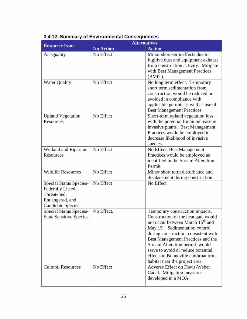
3.4.12. Summary of Environmental Consequences
Resource Issue Alternatives No Action Action
Air Quality No Effect Minor short-term effects due to fugitive dust and equipment exhaust from construction activity. Mitigate with Best Management Practices (BMPs).
Water Quality No Effect No long term effect. Temporary short term sedimentation from construction would be reduced or avoided in compliance with applicable permits as well as use of Best Management Practices
Upland Vegetation Resources
No Effect Short-term upland vegetation loss with the potential for an increase in invasive plants. Best Management Practices would be employed to decrease likelihood of invasive species.
Wetland and Riparian Resources
No Effect No Effect. Best Management Practices would be employed as identified in the Stream Alteration Permit
Wildlife Resources No Effect Minor short term disturbance and displacement during construction.
Special Status Species- Federally Listed Threatened, Endangered, and Candidate Species
No Effect No Effect
Special Status Species- State Sensitive Species
No Effect. Temporary construction impacts. Construction of the headgate would not occur between March 15th and May 15th. Sedimentation control during construction, consistent with Best Management Practices and the Stream Alteration permit, would serve to avoid or reduce potential effects to Bonneville cutthroat trout habitat near the project area.
Cultural Resources No Effect Adverse Effect on Davis-Weber Canal. Mitigation measures developed in a MOA.
25

Paleontology No Effect Potential effects (but considered unlikely) to subsurface fossils during construction
Soil Erosion and Sedimentation
No Effect Minor short-term effects due to runoff during and shortly after construction activity. Mitigate with Best Management Practices (BMPs).
Indian Trust Assets No Effect No Effect Transportation No Effect No Effect
26

Chapter 4: Environmental Commitments The following environmental commitments would be implemented as an integral part of the proposed action.
1. Standard Reclamation Management Practices – Standard Reclamation management practices would be applied during construction activities to minimize environmental effects and would be implemented by construction personnel or included in contract specifications.
2. Additional Analysis – If the proposed action were to change significantly
from the proposed action described in this EA, additional environmental analyses would be undertaken as necessary.
3. State Stream Alteration Permit – Before implementing the selected
alternative, the contractor would obtain a State Stream Alteration Permit from the Department of Natural Resources. The conditions and requirements of the State Stream Alteration Permit would be strictly adhered to the contractor.
4. Cultural Resources – Any person who knows or has reason to know that
he/she has inadvertently discovered possible human remains on Federal land, he/she must provide immediate telephone notification of the discovery to Reclamation’s Provo Area Office archaeologist. Work will stop until the proper authorities are able to assess the situation onsite. This action will promptly be followed by written confirmation to the responsible Federal agency official, with respect to Federal lands. The SHPO and interested Native American tribal representatives will be promptly notified. Consultation will begin immediately. This requirement is prescribed under the Native American Graves Protection and Repatriation Act (43 CFR Part 10); and the Archaeological Resources Protection Act of 1979 (16 U.S.C. 470).
5. Cultural Resources - A Memorandum of Agreement among
Reclamation, SHPO, and the DWCCC, to mitigate the adverse effect to the Davis-Weber Canal, must be executed by all parties prior to project implementation.
6. Paleontological Resources – Should paleontological resources be
encountered by the proponent during ground disturbing actions, construction must be suspended until a qualified paleontologist can be contacted to assess the find.
27

7. Construction Activities Confined to the Surveyed Corridor – All construction activities would be confined to project area that has been surveyed for cultural, paleontological, and biological resources. No construction activity would occur outside of this area.
8. Roads – Existing roads would be used for all project activities. New
access roads would not be necessary.
9. Disturbed Areas – During construction, any topsoil excavated would be saved and then redistributed after completion of construction activities. Subsequently, disturbed areas resulting from the project would be smoothed, shaped, contoured and reseeded to as near their pre-project condition as practicable. Seeding and planting would occur at appropriate times with weed-free seed mixes of native plants distributed where appropriate.
10. Air Quality – Best management practices would be implemented to
control fugitive dust during construction. The contractor would follow the EPA’s recommended control methods for aggregate storage pile emissions to minimize dust generation, including periodic watering of equipment, staging areas, and dirt/gravel roads. All loads that have the potential of leaving the bed of the truck during transportation would be covered or watered to prevent the generation of fugitive dust. Construction machinery and operation/maintenance vehicles would be routinely maintained to ensure that engines remain tuned and emission-control equipment is properly functioning as required by law. Additionally, the contractor would comply with all Utah State air quality regulations.
11. Special Status Species - In order to avoid or reduce potential adverse
effects to Bonneville cutthroat trout habitat near the project area, sediment control procedures consistent with the state stream alteration permit and Best Management Practices must be implemented.
28

Chapter 5: Consultation and Coordination
5.1 Introduction
Reclamation’s public involvement process presents the public with opportunities to obtain information about a given project and allows all interested parties to participate in the project through written comments. The key objective is to create and maintain a well-informed, active public that assists decision makers throughout the process, culminating in the implementation of an alternative. In addition to the activities discussed below, this EA has been mailed to the public and made available on the Internet (www.usbr.gov/uc, click on ‘Environmental Documents’ and click on the specific link for this EA) for a 30-day review and comment period prior to consideration of whether or not to execute a Finding of No Significant Impact (FONSI) and authorize implementation of the proposed action. All comments received will be reviewed, together with the EA, before making a final decision on the proposed action.
5.2 Native American Consultation
Reclamation conducted Native American consultation throughout the public involvement process and preparation of the EA. Consultation letters and copies of the Class III cultural resource inventory report were sent to the Northwestern Band of Shoshoni Nation of Utah. This consultation was conducted in compliance with 36 CFR 800.2(c)(2) on a government-to-government basis. Through this effort the tribe is given a reasonable opportunity to identify any concerns about historic properties; to advise on the identification and evaluation of historic properties, including those of traditional religious and cultural importance; to express their views on the effects of the proposed action on such properties; and to participate in the resolution of adverse effects. Reclamation received no response regarding effects to historic properties from the Northwestern Band of Shoshoni Nation of Utah.
5.3 Utah State Historic Preservation Office
A copy of the Class III Cultural Resource report and a determination of historic properties affected for the proposed project were submitted to the SHPO. SHPO concurrence with Reclamation’s determination was received in a letter dated November 17, 2009. Pursuant to 36 CFR 800.6(c), a Memorandum of Agreement
29

(MOA) is being developed with the SHPO to resolve the adverse effects to the Davis-Weber Canal.
5.4 Utah Department of Wildlife Resources
Coordination has occurred with the Utah Department of Wildlife resources pertaining to state sensitive species.
5.5 Utah Geological Survey
A paleontological file search was conducted by Martha Hayden, Paleontological Assistant with the Utah Geological Survey (UGS). File search results and recommendations from the UGS were received in a letter dated October 29, 2009.
30

Chapter 6: Preparers The following table provides a list of the agency representatives and consultants who participated in the preparation of the Draft Environmental Assessment.
Table 6.1 List of Preparers
Name Title/Position Contributions Agency Representatives Beverley Heffernan, BA Environmental
Protection Specialist, Bureau of Reclamation, Provo Area Office
NEPA compliance, Environmental Justice, Indian Trust Assets
Rafael Lopez, BA Biologist, Bureau of Reclamation, Provo Area Office
Coordination and Biological Resource Oversight
Brian Joseph, MA Archaeologist, Bureau of Reclamation, Provo Area Office
Cultural Resources and Paleontological Resources
Russ Findlay, MS Biologist, Bureau of Reclamation, Provo Area Office
Threatened, Endangered, Sensitive, and Candidate Species
Consultants Bryce Wilcox, PE Engineer, J-U-B,
Engineers, Inc. Project Manager
Tracy Allen, PE Engineer, J-U-B, Engineers, Inc.
Design Engineer
Alex Beseris, BA Environmental Manager, J-U-B, Engineers, Inc.
NEPA Oversight Purpose and Need Biological Resources Affected Environment
Mike Worrall, PE Engineer, J-U-B, Engineers, Inc.
Document Quality Control
Marti Hoge, MA Environmental Planner, J-U-B Engineers, Inc.
Affected Environment Environmental Consequences Environmental Commitments
Andy Aston Gateway Mapping, Inc
GIS, Document Graphics
Sheri Ellis, PhD Paleontologist, SWCA Environmental Consultants.
Cultural and Archeological Resources
31

32

33
Chapter 7: References Alsop, Fred J. 2001. Birds of North America. DK Publishers, Inc. NY: NY. Biotics Database. 2005. Utah Division of Wildlife Resources, NatureServe, and the network of Natural Heritage Programs and Conservation Data Centers. Comprehensive Species Report. NatureServe. Accessed July 9, 2009. http://www.natureserve.org/explorer/servlet/NatureServe?init=Species. Sigler, W. F. and J. W. Sigler. 1996. Fishes of Utah[:] a natural history. University of Utah Press. Salt Lake City.

1