environmental assessment #567 louisiana coastal area (lca ... 567.pdf · lca budmat program –...
TRANSCRIPT
LCA BUDMAT Program – Barataria Bay Waterway Project Environmental Assessment #567
Environmental Assessment #567
Louisiana Coastal Area (LCA) Beneficial Use of Dredged Material Program, Barataria Bay Waterway at Jefferson
Parish, Louisiana
February 11, 2019
Prepared by: U.S Army Corps of Engineers
New Orleans District
P a g e | i
CONTENTS 1.0 Introduction ............................................................................................................ 1
1.1 Proposed Action .................................................................................................... 1 1.2 Project Authority .................................................................................................... 3 1.3 Purpose and Need for the Proposed Action .......................................................... 3 1.4 Data Gaps and Uncertainties ................................................................................. 3 1.5 Prior NEPA Documents ......................................................................................... 4 1.6 Public Concerns .................................................................................................... 5 1.7 Prior Beneficial Use Studies and Reports .............................................................. 5
2.0 Alternatives Including the Proposed Action ........................................................ 6 2.1 No-Action Alternative Description ......................................................................... 7 2.2 Proposed Action Project Description .................................................................... 8
3.0 Affected Environment ............................................................................................ 8 3.1 Description of the Study Area ............................................................................... 9 3.2 Description of the Watershed ............................................................................. 11
3.2.1 Sea Level Change ......................................................................................... 11 3.2.2 Climate .......................................................................................................... 12 3.2.3 Geology ......................................................................................................... 12
3.3 Relevant Resources ........................................................................................... 13 3.3.1 Navigation ................................................................................................... 15 3.3.2 Wetlands ....................................................................................................... 15 3.3.3 Aquatic Resources/Fisheries ......................................................................... 16 3.3.4 Essential Fish Habitat ................................................................................... 17 3.3.5 Wildlife .......................................................................................................... 18 3.3.6 Threatened, Endangered, and Protected Species ........................................ 19 3.3.7 Water and Sediment Quality ......................................................................... 21 3.3.8 Air Quality ...................................................................................................... 21 3.3.9 Cultural Resources ........................................................................................ 23 3.3.10 Recreational Resources .............................................................................. 23 3.3.11 Aesthetics (Visual Resources) .................................................................... 26 3.3.12 Socioeconomic Resources and Environmental Justice ............................... 26
4.0 Environmental Consequences ............................................................................ 36 4.1 Navigation ............................................................................................................ 37 4.2 Wetlands .............................................................................................................. 37 4.3 Aquatic Resources/Fisheries ............................................................................... 38 4.4 Essential Fish Habitat .......................................................................................... 39 4.5 Wildlife ................................................................................................................. 40 4.6 Threatened, Endangered, and Protected Species ............................................... 41 4.7 Water and Sediment Quality ................................................................................ 42 4.8 Air Quality ............................................................................................................ 43 4.9 Cultural Resources .............................................................................................. 43 4.10 Recreational Resources .................................................................................... 44 4.11 Aesthetics (Visual Resources) ........................................................................... 45 4.12 Socioeconomic Resources ................................................................................ 45 4.13 Hazardous, Toxic and Radioactive Waste ......................................................... 46

LCA BUDMAT Program – Barataria Bay Waterway Project Environmental Assessment #567
P a g e | ii
5.0 Cumulative Impacts Analysis.............................................................................. 46 6.0 Mitigation .............................................................................................................. 47 7.0 Coordination and Public Involvement ................................................................ 47 8.0 Compliance with Environmental Laws and Regulations .................................. 48 9.0 Conclusion............................................................................................................ 54 10.0 Prepared By .......................................................................................................... 54 11.0 References ............................................................................................................ 55 FIGURES Figure 1. LCA BUDMAT Barataria Bay Waterway features ............................................. 2 Figure 2. Barataria Bay Waterway Project Area ............................................................ 10 TABLES Table 1. Prior Reports of Beneficial Use of Dredged Materials ....................................... 5
Table 2. Relevant Resources and Their Institutional, Technical, and Public Importance ...................................................................................................................................... 13 Table 3. Essential Fish Habitat for Life Stages .............................................................. 18
Table 4. National Ambient Air Quality Standards .......................................................... 22 Table 5. Recreational Features in the Barataria Basin .................................................. 24
Table 6. Total Population 2010-2016 ............................................................................ 26 Table 7. Population by Age ........................................................................................... 27 Table 8. Housing Units .................................................................................................. 28
Table 9. Racial Composition - Socio-Economic Study Area .......................................... 29 Table 10. Property Value, 2016 ..................................................................................... 30
Table 11. 2016 Household Income ............................................................................... 31 Table 12. Employment, 2016 ........................................................................................ 32
Table 13. Education Level ............................................................................................. 33 Table 14. Minority Population, 2016 .............................................................................. 35 Table 15. Low Income Population ................................................................................. 36
Table 16. Relevant Resources Impacts In and Near the Project Area .......................... 36 APPENDICES Appendix A: Figures Appendix B: Agency Coordination Appendix C: WVA Fact Sheets Appendix D: Engineering Plans Appendix E: 404(b)(1) Appendix F: Acronyms Appendix G: Best Management Practices for Marine Mammal Protection

P a g e | 1
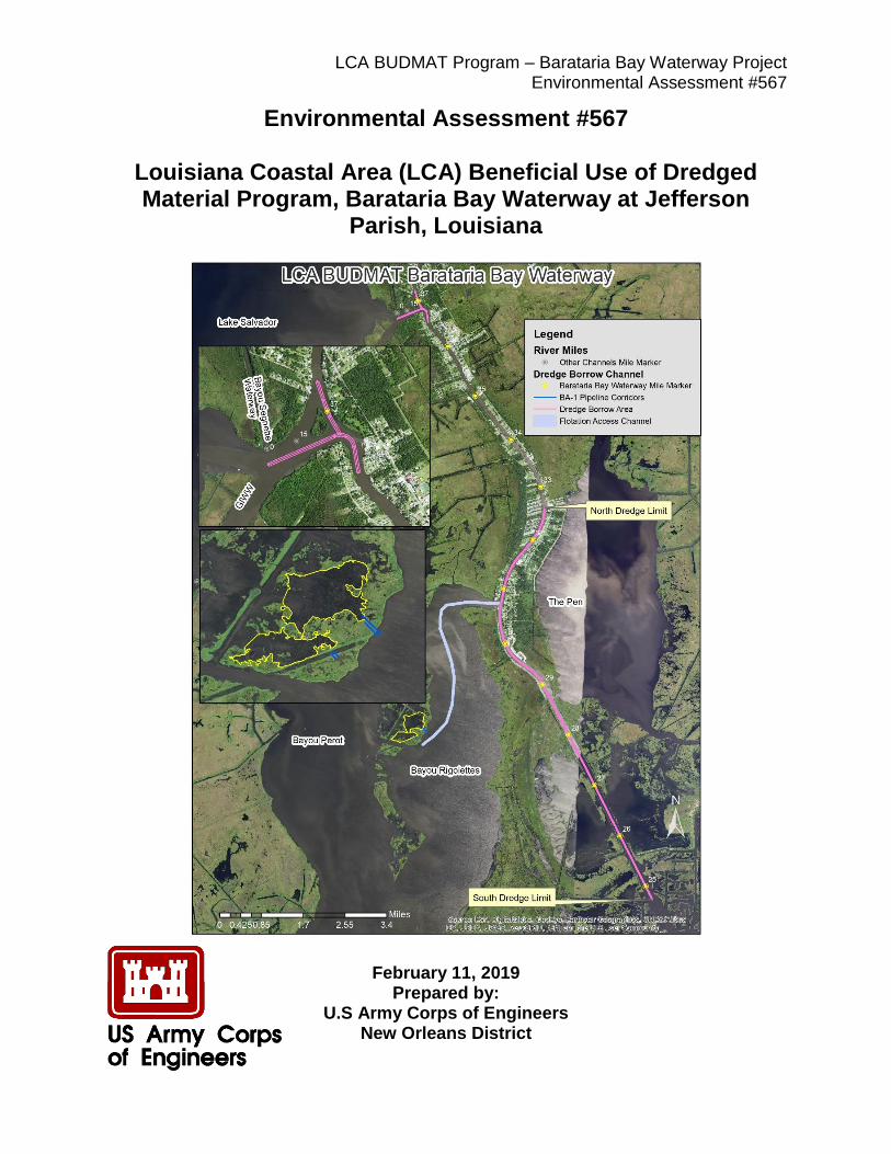
1.0 INTRODUCTION The U.S. Army Corps of Engineers (USACE; see Appendix F for a list of acronyms included in this document), Mississippi River Valley Division, Regional Planning and Environment Division South, has prepared this Environmental Assessment (EA) #567 for New Orleans District (CEMVN) to evaluate the potential impacts of using approximately 764,000 cubic yards of dredged material from the Barataria Bay Waterway Federal Navigation Channel (BBW) to create approximately 75 acres, or approximately 17.0 average annual habitat units (AAHUs), of fresh-intermediate marsh over the 50 year period of analysis. This EA has been prepared in accordance with the National Environmental Policy Act of 1969 (NEPA) and the Council on Environmental Quality’s Regulations (40 Code of Federal Regulations [CFR] §1500-1508), as reflected in the USACE Engineering Regulation (ER) 200-2-2. This EA provides sufficient information on the potential adverse and beneficial environmental effects to allow the District Commander, CEMVN, to make an informed decision on the appropriateness of an Environmental Impact Statement (EIS) or a Finding of No Significant Impact (FONSI). 1.1 Proposed Action Alternative BA-1 East The proposed Project (See Figure 1) consists of a marsh creation site (site) of approximately 75 acres, referred to as Alternative BA-1 East. The site is located in the narrow corridor of wetlands that separate Bayou Perot and Bayou Rigolettes. The site perimeter would measure approximately 8,500 continuous linear feet (ft). The site would reach a target final elevation of +0.6 ft North American Vertical Datum 1988 (NAVD88), with a maximum tolerance of +/-0.5 ft (+0.1 ft to +1.1 ft NAVD88) after material settlement. An approximately 105-acre flotation access channel and two pipeline corridors will be dredged to provide access to the site. Material placed at the site will be held in place using natural shoreline and minimum retention methods.
LCA BUDMAT Program – Barataria Bay Waterway Project Environmental Assessment #567
P a g e | 2
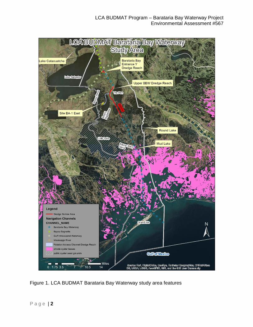
Figure 1. LCA BUDMAT Barataria Bay Waterway study area features
LCA BUDMAT Program – Barataria Bay Waterway Project Environmental Assessment #567
P a g e | 3
1.2 Project Authority The Water Resources Development Act of 2007, Title VII, Section 7006 (Public Law [PL] 110-114) authorizes construction of the Louisiana Coastal Area Program (LCA) ecosystem restoration program. The authority includes requirements for comprehensive coastal restoration planning, program governance, beneficial use of dredged material, feasibility studies for restoration plans, project modification investigations, restoration project construction, demonstration projects, and other elements. This authorization was recommended in the 31 January 2005, Report of the Chief of Engineers for the LCA program. Section 7006(d) authorizes a program for the beneficial use of material dredged from federally maintained waterways. 1.3 Purpose and Need for the Proposed Action The purpose of the proposed action is to restore marsh in coastal Louisiana by maximizing the beneficial use of dredged material from the operation and maintenance (O&M) of the federally-authorized BBW within Jefferson Parish, LA. The materials removed from the BBW would be deposited in a manner to maximize habitat output above the limitations on disposal that are imposed on the federal navigation project by the Federal Standard. The Federal Standard requires disposal of dredged material utilizing the least costly alternative that is consistent with sound engineering practices and environmental standards. The LCA Beneficial Use of Dredged Material (BUDMAT) Program would fund the incremental cost of placement above the Federal Standard. Louisiana has 30 percent of the total coastal marsh and accounts for 90 percent of the coastal marsh loss in the lower 48 states (Dahl 2000, Field et al. 1991, USGS 2003). There is widespread public support to avert further loss of coastal habitats and to beneficially use dredged material in support of that effort. In response to the recognition of the need to reduce Louisiana Coastal wetland loss, activities like the proposed project that are conducted under the LCA BUDMAT Program would optimize the use of dredged materials resulting from the maintenance of federally maintained navigation channels in support of ecosystem restoration beneficial use projects. 1.4 Data Gaps and Uncertainties Because natural systems are complex and consist of an intricate web of variables that influence the existence and condition of other variables within the system, all restoration projects contain certain inherent uncertainties. The effects of tropical storms, increased sea level rise, and climate change on each project’s performance are uncertain and are addressed through future projections based on existing information. All models used for this study rely on mathematical representations of current and future conditions to quantify and predict the future success and benefits of these mitigation projects. No model can account for all relevant variables in an evolving coastal system. Additionally, there is inherent risk in reducing complex natural systems to mathematic expressions driven by simplified interactions of key variables. As such, how the proposed projects would actually perform and the benefits that would result from their creation are a ‘best

LCA BUDMAT Program – Barataria Bay Waterway Project Environmental Assessment #567
P a g e | 4
guess’ based on what we presently know about existing ecosystems and the results of already constructed restoration projects. 1.5 Prior NEPA Documents 2010, Final Programmatic EIS entitled “Louisiana Coastal Area Beneficial Use of Dredged Material Program” with a signed record of decision (ROD) dated 13 August 2010. This document presented the findings of the study, which was conducted to establish the structure and management architecture of the BUDMAT Program to take greater advantage of existing sediment resources made available by the maintenance activities of authorized Federal navigation channels to achieve restoration objectives in coastal Louisiana. 2004, Programmatic EIS entitled “Louisiana Coastal Area, Louisiana, Ecosystem Restoration Program, November 2004” (2004 LCA BUDMAT PEIS) with a signed ROD dated 18 November 2005. This document described the purpose of the LCA program. 2000, EA #316 entitled “Barataria Bay Waterway: Grand Terre Island Beach Nourishment, Jefferson Parish, Louisiana” with a FONSI signed 6 September 2000. This document evaluated the potential impacts associated with the proposed designation and use of a disposal site for dredged material removed from the Barataria Bay Waterway bar channel. 1995, EA #214 entitled “Barataria Bay Waterway, Louisiana: Wetland Development along the Barataria Bay Waterway and Restoration of Queen Bess Island, Jefferson Parish, Louisiana” with a FONSI signed 12 February 1996. This document evaluated the potential environmental impacts associated with the placement of dredged material for the purpose of wetland creation. 1990, EA #114 entitled “Barataria Bay Waterway: Queen Bess Island Restoration” with a FONSI signed 11 April 1990. This document evaluated the impacts associated with the restoration of Queen Bess Island utilizing material removed from the Barataria Bay Waterway. 1985, EA #48 entitled “Barataria Bay Waterway, Louisiana Marsh Creation” with a FONSI signed 2 May 1985. This document assessed the need for, and impacts associated with, marsh creation along the inland reaches of the Barataria Bay Waterway. 1976, Final EIS entitled “Bayou Segnette Waterway, Louisiana and Barataria Bay Waterway, Louisiana.” This document assessed the impacts associated with the maintenance of the two federal channels, Bayou Segnette Waterway and Barataria Bay Waterway.
LCA BUDMAT Program – Barataria Bay Waterway Project Environmental Assessment #567
P a g e | 5
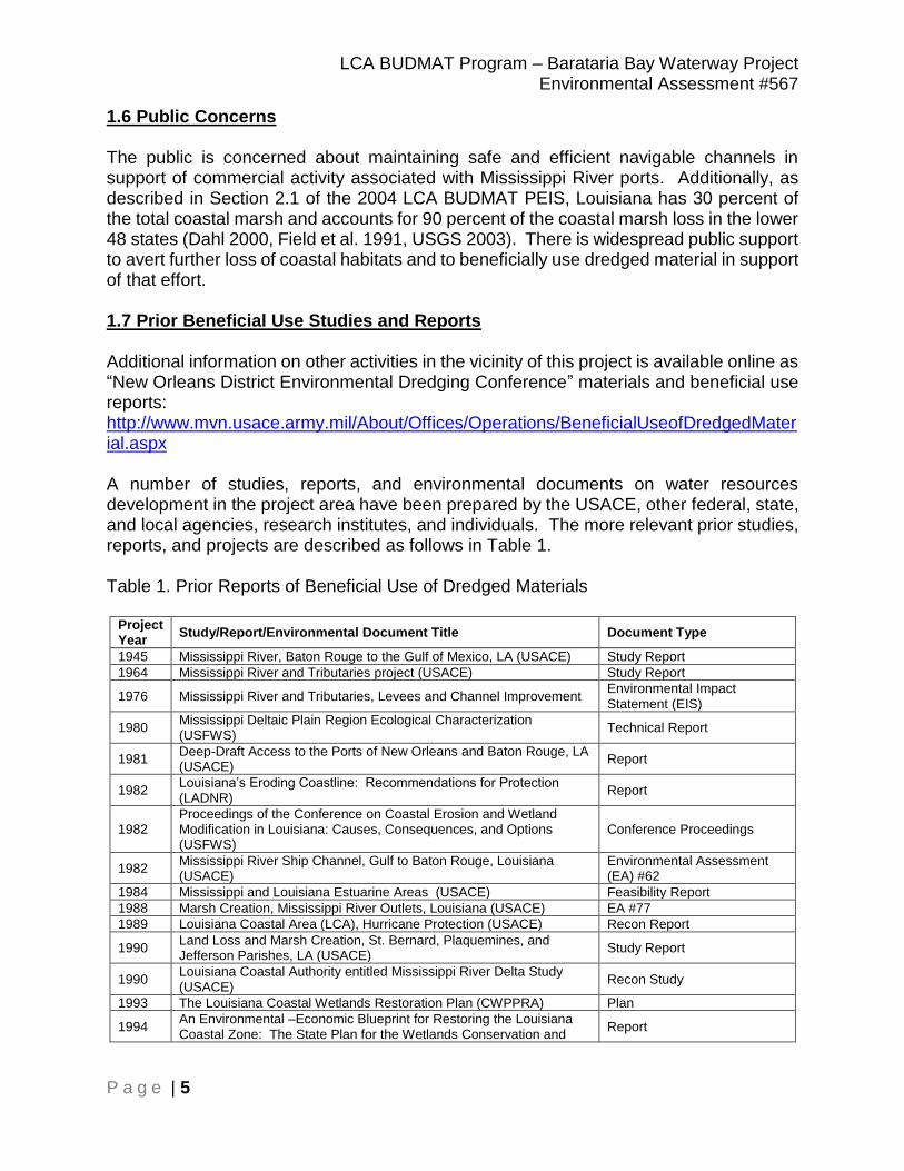
1.6 Public Concerns The public is concerned about maintaining safe and efficient navigable channels in support of commercial activity associated with Mississippi River ports. Additionally, as described in Section 2.1 of the 2004 LCA BUDMAT PEIS, Louisiana has 30 percent of the total coastal marsh and accounts for 90 percent of the coastal marsh loss in the lower 48 states (Dahl 2000, Field et al. 1991, USGS 2003). There is widespread public support to avert further loss of coastal habitats and to beneficially use dredged material in support of that effort. 1.7 Prior Beneficial Use Studies and Reports Additional information on other activities in the vicinity of this project is available online as “New Orleans District Environmental Dredging Conference” materials and beneficial use reports: http://www.mvn.usace.army.mil/About/Offices/Operations/BeneficialUseofDredgedMaterial.aspx A number of studies, reports, and environmental documents on water resources development in the project area have been prepared by the USACE, other federal, state, and local agencies, research institutes, and individuals. The more relevant prior studies, reports, and projects are described as follows in Table 1. Table 1. Prior Reports of Beneficial Use of Dredged Materials
Project Year
Study/Report/Environmental Document Title Document Type
1945 Mississippi River, Baton Rouge to the Gulf of Mexico, LA (USACE) Study Report
1964 Mississippi River and Tributaries project (USACE) Study Report
1976 Mississippi River and Tributaries, Levees and Channel Improvement Environmental Impact Statement (EIS)
1980 Mississippi Deltaic Plain Region Ecological Characterization (USFWS)
Technical Report
1981 Deep-Draft Access to the Ports of New Orleans and Baton Rouge, LA (USACE)
Report
1982 Louisiana’s Eroding Coastline: Recommendations for Protection (LADNR)
Report
1982 Proceedings of the Conference on Coastal Erosion and Wetland Modification in Louisiana: Causes, Consequences, and Options (USFWS)
Conference Proceedings
1982 Mississippi River Ship Channel, Gulf to Baton Rouge, Louisiana (USACE)
Environmental Assessment (EA) #62
1984 Mississippi and Louisiana Estuarine Areas (USACE) Feasibility Report
1988 Marsh Creation, Mississippi River Outlets, Louisiana (USACE) EA #77
1989 Louisiana Coastal Area (LCA), Hurricane Protection (USACE) Recon Report
1990 Land Loss and Marsh Creation, St. Bernard, Plaquemines, and Jefferson Parishes, LA (USACE)
Study Report
1990 Louisiana Coastal Authority entitled Mississippi River Delta Study (USACE)
Recon Study
1993 The Louisiana Coastal Wetlands Restoration Plan (CWPPRA) Plan
1994 An Environmental –Economic Blueprint for Restoring the Louisiana Coastal Zone: The State Plan for the Wetlands Conservation and
Report
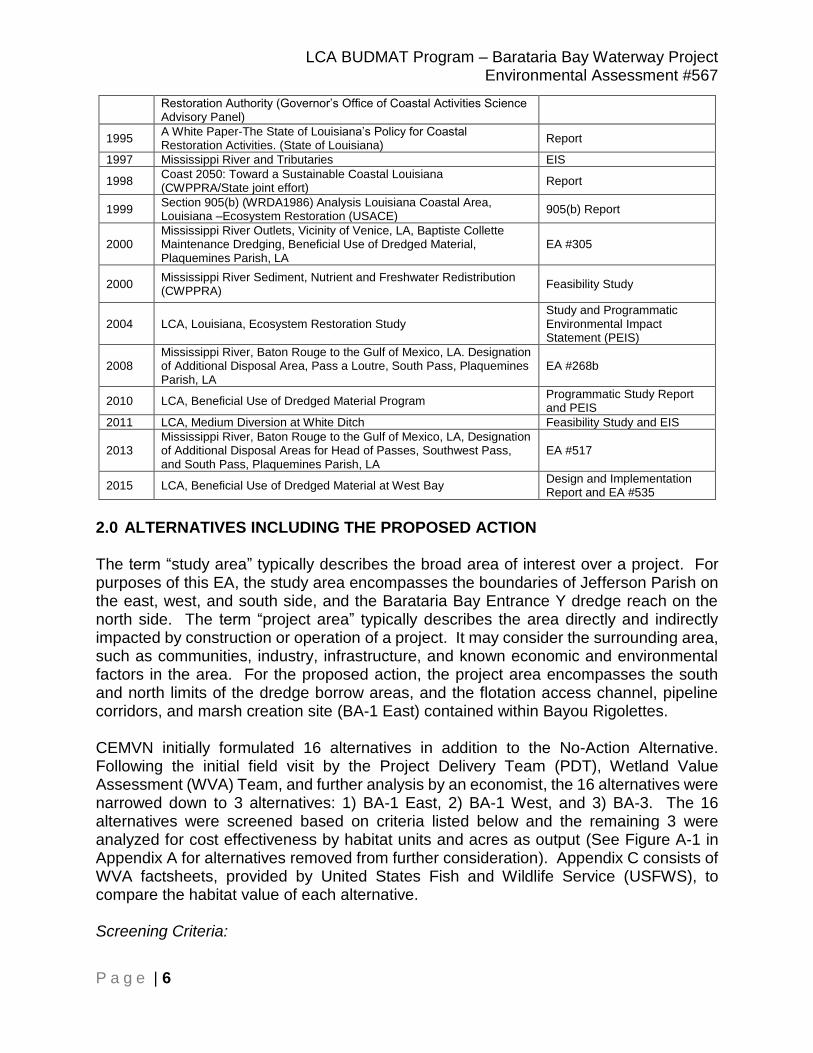
LCA BUDMAT Program – Barataria Bay Waterway Project Environmental Assessment #567
P a g e | 6
Restoration Authority (Governor’s Office of Coastal Activities Science Advisory Panel)
1995 A White Paper-The State of Louisiana’s Policy for Coastal Restoration Activities. (State of Louisiana)
Report
1997 Mississippi River and Tributaries EIS
1998 Coast 2050: Toward a Sustainable Coastal Louisiana (CWPPRA/State joint effort)
Report
1999 Section 905(b) (WRDA1986) Analysis Louisiana Coastal Area, Louisiana –Ecosystem Restoration (USACE)
905(b) Report
2000 Mississippi River Outlets, Vicinity of Venice, LA, Baptiste Collette Maintenance Dredging, Beneficial Use of Dredged Material, Plaquemines Parish, LA
EA #305
2000 Mississippi River Sediment, Nutrient and Freshwater Redistribution (CWPPRA)
Feasibility Study
2004 LCA, Louisiana, Ecosystem Restoration Study Study and Programmatic Environmental Impact Statement (PEIS)
2008 Mississippi River, Baton Rouge to the Gulf of Mexico, LA. Designation of Additional Disposal Area, Pass a Loutre, South Pass, Plaquemines Parish, LA
EA #268b
2010 LCA, Beneficial Use of Dredged Material Program Programmatic Study Report and PEIS
2011 LCA, Medium Diversion at White Ditch Feasibility Study and EIS
2013 Mississippi River, Baton Rouge to the Gulf of Mexico, LA, Designation of Additional Disposal Areas for Head of Passes, Southwest Pass, and South Pass, Plaquemines Parish, LA
EA #517
2015 LCA, Beneficial Use of Dredged Material at West Bay Design and Implementation Report and EA #535
2.0 ALTERNATIVES INCLUDING THE PROPOSED ACTION The term “study area” typically describes the broad area of interest over a project. For purposes of this EA, the study area encompasses the boundaries of Jefferson Parish on the east, west, and south side, and the Barataria Bay Entrance Y dredge reach on the north side. The term “project area” typically describes the area directly and indirectly impacted by construction or operation of a project. It may consider the surrounding area, such as communities, industry, infrastructure, and known economic and environmental factors in the area. For the proposed action, the project area encompasses the south and north limits of the dredge borrow areas, and the flotation access channel, pipeline corridors, and marsh creation site (BA-1 East) contained within Bayou Rigolettes. CEMVN initially formulated 16 alternatives in addition to the No-Action Alternative. Following the initial field visit by the Project Delivery Team (PDT), Wetland Value Assessment (WVA) Team, and further analysis by an economist, the 16 alternatives were narrowed down to 3 alternatives: 1) BA-1 East, 2) BA-1 West, and 3) BA-3. The 16 alternatives were screened based on criteria listed below and the remaining 3 were analyzed for cost effectiveness by habitat units and acres as output (See Figure A-1 in Appendix A for alternatives removed from further consideration). Appendix C consists of WVA factsheets, provided by United States Fish and Wildlife Service (USFWS), to compare the habitat value of each alternative. Screening Criteria:

LCA BUDMAT Program – Barataria Bay Waterway Project Environmental Assessment #567
P a g e | 7
The site must support some kind of critical infrastructure.
The site must not overlap any existing environmental restoration projects.
The site must be sized to utilize all of the anticipated dredged material at an elevation conducive to the construction of a successful marsh platform.
The site must be able to contain dredged material through natural shoreline and minimum retention (e.g., hay bales, core logs, sandbags, earthen fill, etc.).
The site must have appropriate access to enable transport of the dredged material from the BBW to the site.
2.1 No-Action Alternative Description NEPA requires that in analyzing alternatives to a proposed action, a federal agency must consider an alternative of “No Action.” In the Future without Project (FWOP), or No-Action alternative, the proposed action would not be implemented and the predicted additional environmental gains (e.g. coastal storm surge protection and marsh habitat creation) would not be achieved. Dredged material from the BBW would continue to be disposed of within the Federal Standard, and the existing disposal areas would continue to be used for disposal of maintenance-dredged material. Without implementation of the proposed action, other federal, state, local, and private restoration efforts may still occur within or near the proposed project area, the Louisiana state coastal area, and the nation’s coastal areas. Some of these other efforts include the following: -The BUDMAT program will continue to provide ecosystem restoration opportunities. -The 2017 Louisiana’s Comprehensive Master Plan for a Sustainable Coast (State Master Plan) (Source: http://coastal.la.gov/our-plan/2017-coastal-master-plan/) is partially funded. The 2017 State Master Plan indicates that the Coastal Protection and Restoration Authority Board of Louisiana (CPRAB) has, since 2007:
Benefited 36,000 acres of coastal habitat
Identified and used dozens of different Federal, state, local and private funding sources of projects
Completed or funded construction of 135 projects
Constructed or is currently constructing 60 miles of barrier islands/berms -There are currently 153 active CWPPRA projects throughout coastal Louisiana. In September 2016, 108 projects were completed, benefiting over approximately 100,000 acres. 17 projects are currently under active construction with 23 additional projects approved and in the engineering and design phase of development (source: https://lacoast.gov/new/About/FAQs.aspx).
LCA BUDMAT Program – Barataria Bay Waterway Project Environmental Assessment #567
P a g e | 8
2.2 Proposed Action Project Description Alternative BA-1 East The proposed Project, referred to as Alternative BA-1 East, consists of a marsh creation site (site) of approximately 75 acres using dredged material sourced from the Barataria Bay Waterway Federal navigation channel (BBW). The site is located in the narrow corridor of wetlands that separates Bayou Perot and Bayou Rigolettes in Jefferson Parish, LA. (See Appendix D; Engineering Plate R-01) The site perimeter is approximately 8,500 continuous linear feet. Dredged material would be placed in the site. The site would have a target final elevation of +0.6 ft North American Vertical Datum 1988 (NAVD88), with a maximum tolerance of +/-0.5 ft (+0.1 ft to +1.1 ft NAVD88) after material settlement has occurred following the deposition of the material. The gross volume of dredged material is approximately 764,000 cubic yards of material. Sources of the material include: the Barataria Bay Entrance Y; the upper BBW reach; and a flotation access channel that will be dredged from BBW to the project site. For the construction of the site, the material dredged from the BBW would be loaded onto barges, transported to a designated pump-out location adjacent to the site, and then offloaded using a temporary pipeline. Material removed from the flotation access channel would be transported to the site where it would be incorporated into the site. Since Bayou Rigolettes is too shallow for loaded barges to traverse, the flotation access channel would be dredged in state-owned water bottoms to allow for ingress and egress of the barges and equipment required for the construction of the site (i.e., dredged material, temporary pipeline, earth moving equipment, etc.). Barge-loaded equipment would be used for construction. The material excavated from the water bottoms from the creation of the flotation access channel would be placed in the site. The approximately 105-acre flotation access channel from the BBW to the project site would be approximately 200 feet wide and 3.5 miles long. Temporary pipeline corridors would be required for accessing the site at ground level. The pipeline corridor to the north portion of the site would be approximately 50 feet wide by 450 feet long and the pipeline corridor to the south portion of the site would be approximately 50 feet wide by 1,300 feet long. These pipeline corridors total approximately 2.0 acres.
Dredged material placed in the site would be held in place using natural shoreline and through the use of minimum retention (e.g., hay bales, core logs, sandbags, earthen fill, etc.). 3.0 AFFECTED ENVIRONMENT NEPA requires that in analyzing alternatives, a federal agency must consider an alternative of “No Action.” The No Action Alternative evaluates the impacts associated with not implementing the proposed action and represents the Future Without Project (FWOP) condition against which alternatives considered in detail are compared. This
LCA BUDMAT Program – Barataria Bay Waterway Project Environmental Assessment #567
P a g e | 9
analysis provides a benchmark, enabling decision makers to compare the magnitude of environmental effects of implementing a proposed action. Under the Civil Works Planning process, an inventory of the critical resources (physical, demographic, economic, social, and natural, etc.) relevant to the problems and opportunities under consideration in the planning area is developed. Then, a forecast of the inventory’s condition at the future date of the 50-year period of analysis is performed. Those changes in conditions are determined by the impact of all ongoing actions, man-made or natural, upon the resources if no alternatives are implemented as part of this evaluation. Sections 3.1 to 3.3 of this EA describes the historic and existing conditions of the affected environment. The description of the affected environment establishes the environmental baseline and thresholds of environmental change against which to measure the direct, indirect, and cumulative effects of an alternative necessary to support a fully informed decision-making process. 3.1 Description of the Study Area
The study area is located in southeast Louisiana, within Jefferson Parish. It is bound on the north by Lake Salvador near Bayou Villars. The east boundary follows the east Jefferson Parish boundary, which runs south from the Gulf Intracoastal Waterway (GIWW, near River Mile 10), southeast of the Pen, and down south through Round Lake before terminating at the east end of Grand Terre. The west boundary follows the Jefferson Parish western boundary, which runs from Lake Cataouatche, east of Couba Island, and through the center of Bayou Perot and Little Lake before terminating west of Elmers Island. The southern boundary is contained within the Gulf of Mexico. Existing land classification/land use within the study area include fresh-intermediate and brackish marsh coastal wetlands, agriculture, urban development, privately-owned oyster leases, a public oyster seed bed within Turtle Bay and Little Lake, and oil and gas pipelines. Within the study area, the Barataria Bay Waterway (BBW) is a federally-maintained channel that extends from the Gulf Intracoastal Waterway near Lafitte, Louisiana (BBW River Mile 37) south to the Gulf of Mexico between Grand Isle and Grand Terre (BBW River Mile 0).
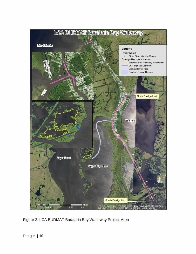
P a g e | 10
Figure 2. LCA BUDMAT Barataria Bay Waterway Project Area

P a g e | 11
The Barataria Bay Waterway (BBW) includes the Bar Channel and 3 other reaches. These four (4) reaches are detailed below. (1) Upper Reach. The upstream limit of the Upper Reach is the GIWW Channel and it extends through the Bay Channel. The project would use material dredged between River Mile 36 to 24. (2) Bay Channel. The Bay Channel upstream limit is the terminus of the Upper Reach and extends downstream to Barataria Pass where the project intersects the Bar Channel. This reach extends from River Mile 24 to 0. (3) Bayou Rigaud. Bayou Rigaud is an auxiliary channel for the Port of Grand Isle. It extends westerly from the Bay Channel between Grand Isle and Fifi Island. This reach is 4.3 miles long. (4) Bar Channel. The Bar Channel upstream limit is Barataria Pass and extends downstream 1.8 miles into the Gulf of Mexico. The Bar Channel reach extends from River Mile 0 to -1.8. For the proposed action, the project area encompasses the south and north limits of the dredge borrow areas in the Upper Reach, and the flotation access channel, pipeline corridors, and marsh creation site (BA-1 East) contained within Bayou Rigolettes (see Figure 2). 3.2 Description of the Watershed
The study area is located within the Barataria Basin, which is part of the larger Mississippi River Watershed. The Barataria Basin (“the Basin”) is bounded to the north by the Mississippi River starting east in Ascension Parish to west in Plaquemines Parish, then the south is the Gulf of Mexico and the western boundary follows Bayou Lafourche. Major features in the Basin include: Lac des Allemands and its adjacent wetlands in St. John the Baptist Parish, Lakes Cataouatche, Salvador and the adjacent wetlands in St. Charles Parish, the Pen and Barataria Bay and adjacent wetlands in Jefferson Parish, Lake Judge Perez, Bay Batiste, and Bastian Bay as well as adjacent wetlands and small lakes and waterbodies in Plaquemines Parish, Louisiana. The site is located in Jefferson Parish within the East Central Louisiana Coastal Watershed (Hydrologic Unit Code [HUC] 08090301), also known as the Barataria Basin watershed. A chain of barrier islands separates the Basin from the Gulf of Mexico. The southern half of the Basin consists of tidally influenced marshes connected to a large bay system behind the barrier islands. 3.2.1 Sea Level Change ER 1100-2-8162 states potential relative sea level change must be considered in every USACE coastal activity as far inland as the extent of estimated tidal influence. Benefits calculated using the Wetland Value Assessment (WVA) incorporated the fresh-intermediate marsh type for the site with medium sea-level change scenario to determine benefit outcomes over the 50-year period of analysis. The low and high sea level change

LCA BUDMAT Program – Barataria Bay Waterway Project Environmental Assessment #567
P a g e | 12
rates were not run. Under the “high” sea-level change scenario, any alternative would likely underperform very soon after construction since the wetland portion of the project would be inundated beyond wetland vegetation tolerances as sea-level changes. This would be a result of not enough material being placed initially to compensate for sea-level change over time. However, under the “low” sea level change scenario, alternatives would likely not perform or the benefits would be minimal for an extended period post-construction until sea level change reaches a point that is conducive for wetland function, growth, and sustainability. This would be a result of placing so much material initially that the site would not functionally be a wetland until the deposition site is at an appropriate elevation conducive for wetland function, growth, and sustainability. Because any alternative involves a one-time beneficial use disposal event, using only the intermediate sea level change scenario presents the most reasonable expectation for calculating benefits over the 50-year period of analysis. 3.2.2 Climate The climate in the study area is humid, subtropical with a strong maritime character. Warm, moist southeasterly winds from the Gulf of Mexico prevail throughout most of the year, with occasional cool, dry fronts dominated by northeast high pressure systems. The influx of cold air occurs less frequently in autumn and only rarely in summer. Tropical storms and hurricanes are likely to affect the area 3 out of every 10 years, with severe storm damage approximately once every 2 or 3 decades. The majority of these storms occur between early June and November. The largest recent hurricanes were Katrina and Rita in 2005 which caused damage in the study area. Hurricanes Gustav and Ike in 2008, and more recently, Isaac in 2012, caused additional damage in the study area. Summer thunderstorms are common, and tornadoes strike occasionally. Average annual temperature in the area is 67°F, with mean monthly temperatures ranging from 82°F in August to 52°F in January. Average annual precipitation is 57.0 inches, varying from a monthly average of 7.5 inches in July, to an average of 3.5 inches in November. The 2014 USACE Climate and Resiliency Policy Statement states the “USACE shall continue to consider potential climate change impacts when undertaking long-term planning, setting priorities, and making decisions affecting its resources, programs, policies, and operations.” The LCA BUDMAT Program is not intended to construct ecosystem restoration projects that last in perpetuity. A healthy and resilient coastal complex is dynamic, not static, and is subject to the ebb and flow of the various effects, adverse or beneficial, that impact conditions at any given point in time. The most significant impact on coastal wetlands resulting from climate change is sea level change. 3.2.3 Geology Soil composition is subject to change as floodwaters and storm surges deposit new sediments. The soil around the site is composed predominantly of Lafitte and Clovelly soil types. These soils are classified as continuously flooded deep, poorly drained and permeable mineral clays and mucky clays. Lafitte soils are alkaline soils extending to a depth approximately 50 to 100 inches and are typically contained in the deep interlevee
LCA BUDMAT Program – Barataria Bay Waterway Project Environmental Assessment #567
P a g e | 13
basin. Clovelly soils are moderately alkaline soils with an organic layer extending to a depth of around 50 inches and are in the low natural levees along waterways. Both soil types are rapidly permeable with organic layers and slower with clayey layers, and the total subsidence potential is high.
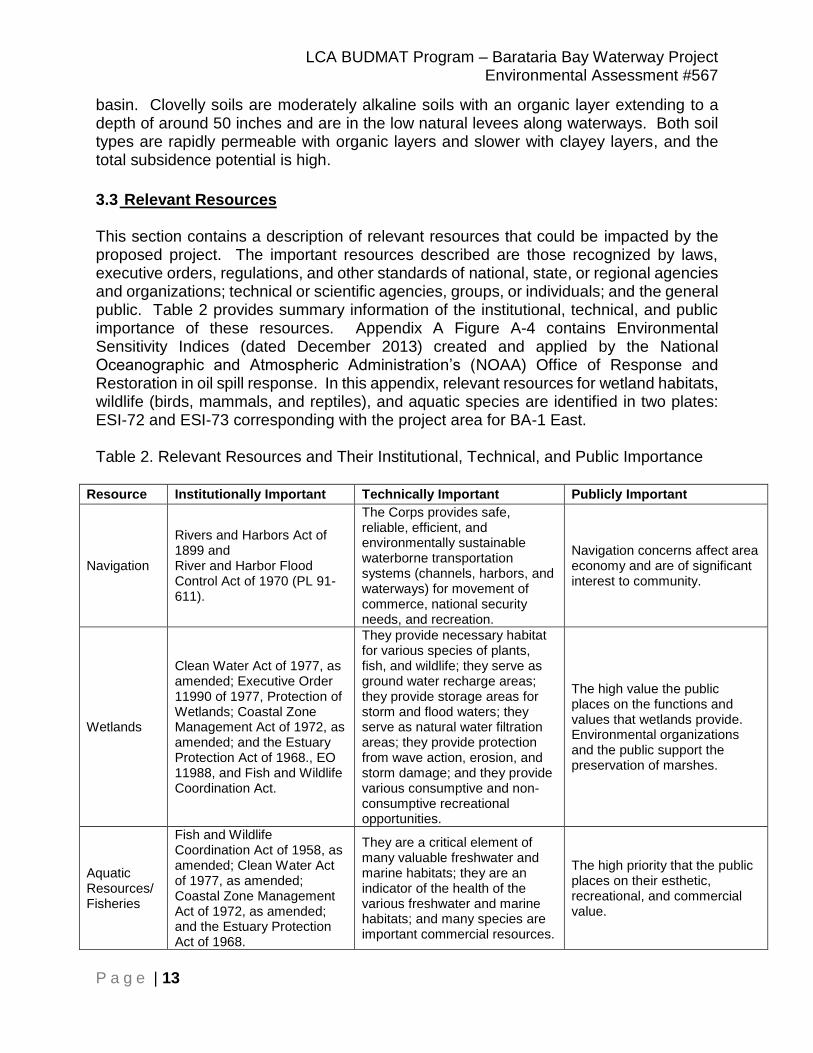
3.3 Relevant Resources
This section contains a description of relevant resources that could be impacted by the proposed project. The important resources described are those recognized by laws, executive orders, regulations, and other standards of national, state, or regional agencies and organizations; technical or scientific agencies, groups, or individuals; and the general public. Table 2 provides summary information of the institutional, technical, and public importance of these resources. Appendix A Figure A-4 contains Environmental Sensitivity Indices (dated December 2013) created and applied by the National Oceanographic and Atmospheric Administration’s (NOAA) Office of Response and Restoration in oil spill response. In this appendix, relevant resources for wetland habitats, wildlife (birds, mammals, and reptiles), and aquatic species are identified in two plates: ESI-72 and ESI-73 corresponding with the project area for BA-1 East. Table 2. Relevant Resources and Their Institutional, Technical, and Public Importance
Resource Institutionally Important Technically Important Publicly Important
Navigation
Rivers and Harbors Act of 1899 and River and Harbor Flood Control Act of 1970 (PL 91-611).
The Corps provides safe, reliable, efficient, and environmentally sustainable waterborne transportation systems (channels, harbors, and waterways) for movement of commerce, national security needs, and recreation.
Navigation concerns affect area economy and are of significant interest to community.
Wetlands
Clean Water Act of 1977, as amended; Executive Order 11990 of 1977, Protection of Wetlands; Coastal Zone Management Act of 1972, as amended; and the Estuary Protection Act of 1968., EO 11988, and Fish and Wildlife Coordination Act.
They provide necessary habitat for various species of plants, fish, and wildlife; they serve as ground water recharge areas; they provide storage areas for storm and flood waters; they serve as natural water filtration areas; they provide protection from wave action, erosion, and storm damage; and they provide various consumptive and non-consumptive recreational opportunities.
The high value the public places on the functions and values that wetlands provide. Environmental organizations and the public support the preservation of marshes.
Aquatic Resources/ Fisheries
Fish and Wildlife Coordination Act of 1958, as amended; Clean Water Act of 1977, as amended; Coastal Zone Management Act of 1972, as amended; and the Estuary Protection Act of 1968.
They are a critical element of many valuable freshwater and marine habitats; they are an indicator of the health of the various freshwater and marine habitats; and many species are important commercial resources.
The high priority that the public places on their esthetic, recreational, and commercial value.

LCA BUDMAT Program – Barataria Bay Waterway Project Environmental Assessment #567
P a g e | 14
Resource Institutionally Important Technically Important Publicly Important
Essential Fish Habitat (EFH)
Magnuson-Stevens Fishery Conservation and Management Act of 1996, Public Law 104-297
Federal and state agencies recognize the value of EFH. The Act states, EFH is “those waters and substrate necessary to fish for spawning, breeding, feeding or growth to maturity.”
Public places a high value on seafood and the recreational and commercial opportunities EFH provides.
Wildlife
Fish and Wildlife Coordination Act of 1958, as amended and the Migratory Bird Treaty Act of 1918
They are a critical element of many valuable aquatic and terrestrial habitats; they are an indicator of the health of various aquatic and terrestrial habitats; and many species are important commercial resources.
The high priority that the public places on their esthetic, recreational, and commercial value.
Threatened, Endangered, and Protected Species
The Endangered Species Act of 1973, as amended; the Marine Mammal Protection Act of 1972; and the Bald Eagle Protection Act of 1940.
USACE, USFWS, NMFS, NRCS, EPA, LDWF, and LDNR cooperate to protect these species. The status of such species provides an indication of the overall health of an ecosystem.
The public supports the preservation of rare or declining species and their habitats.
Cultural Resources
National Historic Preservation Act of 1966, as amended; the Native American Graves Protection and Repatriation Act of 1990; and the Archeological Resources Protection Act of 1979
State and Federal agencies document and protect sites. Their association or linkage to past events, to historically important persons, and to design and construction values; and for their ability to yield important information about prehistory and history.
Preservation groups and private individuals support protection and enhancement of historical resources.
Recreation Resources
Federal Water Project Recreation Act of 1965 as amended and Land and Water Conservation Fund Act of 1965 as amended
Provide high economic value of the local, state, and national economies.
Public makes high demands on recreational areas. There is a high value that the public places on fishing, hunting, and boating, as measured by the large number of fishing and hunting licenses sold in Louisiana; and the large per-capita number of recreational boat registrations in Louisiana.
Aesthetics (Visual Resources)
USACE ER 1105-2-100, and National Environmental Policy Act of 1969, the Coastal Barrier Resources Act of 1990, Louisiana’s National and Scenic Rivers Act of 1988, and the National and Local Scenic Byway Program.
Visual accessibility to unique combinations of geological, botanical, and cultural features that may be an asset to a study area. State and Federal agencies recognize the value of beaches and shore dunes.
Environmental organizations and the public support the preservation of natural pleasing vistas.
Air Quality Clean Air Act of 1963, Louisiana Environmental Quality Act of 1983.
State and Federal agencies recognize the status of ambient air quality in relation to the NAAQS.
Virtually all citizens express a desire for clean air.

LCA BUDMAT Program – Barataria Bay Waterway Project Environmental Assessment #567
P a g e | 15
Resource Institutionally Important Technically Important Publicly Important
Water Quality
Clean Water Act of 1977, Fish and Wildlife Coordination Act, Coastal Zone Mgt Act of 1972, and Louisiana State & Local Coastal Resources Act of 1978.
USACE, USFWS, NMFS, NRCS, EPA, and State DNR and wildlife/fishery offices recognize value of fisheries and good water quality and the national and state standards established to assess water quality.
Environmental organizations and the public support the preservation of water quality and fishery resources and the desire for clean drinking water.
Socio-Economic Resources
River and Harbor Flood Control Act of 1970 (PL 91-611).
N/A
Social concerns and items affecting area economy are of significant interest to community.
3.3.1 Navigation Existing Conditions Within the study area, there is one federally maintained navigation feature, the Barataria Bay Waterway (BBW), which serves as a navigation route connecting the Gulf of Mexico with the interior of the central coast of Louisiana, providing direct access to the maritime and offshore support interests. The BBW cuts through and provides pathways to several natural waterways including Bayou Rigolettes, Bayou Saint Denis, and Mud Lake before discharging into Barataria Bay north of Grand Isle. These natural waterways and the site are not currently used for any navigation purposes, but small vessels might potentially access portions of the project area for recreational opportunities. The BBW has direct influence on the Basin barrier shoreline as its mouth is situated in Bayou Rigaud on the eastern end of Grand Isle. Periodic maintenance dredging of the BBW for navigation purposes also provides additional opportunities for the beneficial use of dredged material on Grand Isle and Grand Terre. 3.3.2 Wetlands Existing Conditions Existing grounds within the study area are a mixture of shallow open-water, fragmented marsh, remnant bayou ridges, and oil and gas canals with adjacent spoil banks. The wetland community in the project area is fresh-intermediate and brackish marsh. Spartina patens (saltmeadow cordgrass) is the predominant vegetation. Large aggregations of decaying organic material accumulate along the fringes and are the primary basis of the detrital food chain. The banks of the canals and bayous are slightly elevated and often support Spartana alterniflora (smooth cordgrass), Borrichia frutescens (sea ox-eye), and Iva frutescens (marsh elder). Shrubs are occasionally covered with the parasitic vine, Cuscuta gronovii (common dodder). Tidal currents and wave action in open bodies of water such as brackish bays and estuaries exert dominant erosional processes on coastal wetlands in the study area. The
LCA BUDMAT Program – Barataria Bay Waterway Project Environmental Assessment #567
P a g e | 16
rates of these processes accelerate as barrier islands are significantly reduced by coastal erosion. The effects of tides and wind-driven waves are lessened in bays which are well protected by barrier islands. Unfortunately, inshore barrier islands and coastal wetlands in this region are almost non-existent and coastal marshes open directly upon the Basin. On a 17 July 2018 site visit of Alternative BA-1 East, the following emergent vegetation were prevalent within the site: Crotalaria spp. (rattle box), Althaea officinalis (marsh-mallow), and Sagittaria lancifolia (bulltongue). A diverse variety of submerged aquatic vegetation included Ruppia maritima (widgeon grass), Vallisneria americana (wild celery), Eichhornia crassipes (water hyacinth), Najas guadalupensis (southern naiad), Ceratophyllum demersum (coontail), Myriophyllum spicatum (Eurasian watermilfoil), and small amounts of Salvinia molesta (giant salvinia). 3.3.3 Aquatic Resources/Fisheries Existing Conditions Fish are highly mobile, and seasonal movements of fish populations are widespread. The result is that marine fish penetrate inland fresh water habitats, while fresh water species are sometimes found in environments that are more saline. The lower reaches of fresh water streams generally serve as nursery areas for a variety of fish and shellfish from the Gulf of Mexico. Estuaries represent some of the most productive habitats in the world. The Gulf of Mexico Fishery Management Council lists the following federally managed species or species groups as being potentially found in coastal Louisiana, and therefore, potentially found in the study area: Farfantepenaeus aztecus (brown shrimp), Litopenaeus setiferus (white shrimp), Sciaenops ocellatus ( red drum), Pogonias cromis (b lack drum) and Scomberomorus maculatus (Spanish mackerel). The commercial fishery resources in the Barataria Basin are primarily estuarine and marine in nature. Commercially important species include Crassostrea virginica (American oyster), brown shrimp and white shrimp, Callinectes sapidus (blue crab), Brevoortia patronus (Gulf menhaden), Micropogonias undulatus (Atlantic croaker), Leiostomus xanthurus (Spot), Cynoscion arenarius (sand seatrout), Cynoscion nebulosus (spotted seatrout), Paralichthys lethostigma (southern flounder) and Mugil cephalus (striped mullet). Finfish harvest in the area has been severely reduced since the Louisiana Marine Resources Conservation Act of 1995 restricted gillnet use in Louisiana. The study area supports rich populations of phytoplankton, zooplankton, benthos, macroinvertebrates, and numerous small fishes. These organisms constitute vital components of the aquatic food chain. White shrimp, brown shrimp, red drum, Spanish mackerel, and bull sharks are likely to be present in the Basin. For a listing of aquatic species found in the project area, see Fish and Invertebrate listings in Environmental Sensitivity Indices (Figure A-4 in Appendix A).
LCA BUDMAT Program – Barataria Bay Waterway Project Environmental Assessment #567
P a g e | 17
The landings of shellfish are subject to year-to-year variations dictated by environmental conditions in the estuaries. Different species use the same location in different seasons, and different life stages of the same species use different locations in and out of the estuaries. Species diversity peaks in the spring and summer, and is typically low in the winter. Some marine species have estuarine-dependent life stages, typically larval and juvenile stages, which use estuaries as nursery habitat. Larvae or juveniles immigrate on incoming tides and take advantage of the high productivity of the estuary. In the bar channel of the BBW, shellfish and Menippe adina (Gulf stone crabs) may be present in the study area. Gulf stone crabs are benthic omnivores, feeding on various crustaceans, mollusks, fish, and detritus. Juveniles are most abundant from November to May and occur in the northern portions of the estuaries. The juveniles prefer areas with soft, mud substrate. After 1-1.5 years, the crabs then move from shallow areas into larger bays and bayous as adults where they will live for at least one more year. Louisiana’s coastal estuaries are among the most productive in the Nation (Chew D.L.). Louisiana has historically been an important contributor to the Nation’s domestic fish and shellfish production, and one of the primary contributors to the Nation’s food supply for protein. Landings in 2007 for commercial fisheries in coastal Louisiana, estimated at 951 million pounds, were the largest for any state in the contiguous U.S. and second only to Alaska (National Marine Fisheries Service, 2008). These landings represent over 10% of the total landings in the U.S., with a value of approximately $259.6 million. Oysters are another valuable resource in the Barataria Basin. Oysters have been harvested for commercial sale for at least 150 years. No oyster leases are located within the project area. However, privately-owned oyster leases are located approximately 14 miles south of the marsh creation site, and public oyster seeding beds are located approximately 4.5 miles south of the marsh creation site. The saltmarsh topminnow (Fundulus jenkinsi) may occur within Bayou Barataria. This species has an S3 state rank and is considered rare in Louisiana. Pollution and habitat destruction are major threats with habitat alteration being the most serious threat to this species. 3.3.4 Essential Fish Habitat Existing Conditions Specific categories of Essential Fish Habitat (EFH) include all estuarine waters and substrates (mud, sand, shell, rock, and associated biological communities), including the sub-tidal vegetation (seagrasses and algae) and adjacent inter-tidal vegetation (marshes and mangroves). Most of the study area, unless previously impounded, fits into one of these categories. The Gulf of Mexico Fishery Management Council, through the generic amendment of the Fishery Management Plans for the Gulf of Mexico, lists the following federally managed species or species groups as being potentially found in coastal
LCA BUDMAT Program – Barataria Bay Waterway Project Environmental Assessment #567
P a g e | 18
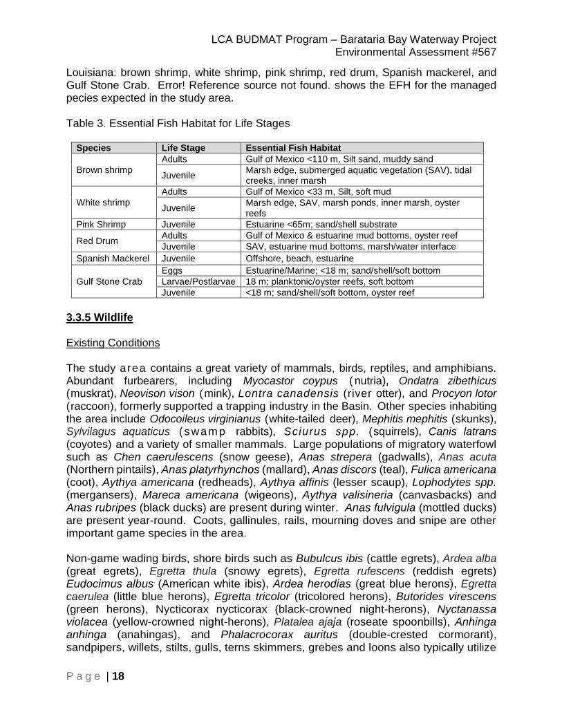
Louisiana: brown shrimp, white shrimp, pink shrimp, red drum, Spanish mackerel, and Gulf Stone Crab. Error! Reference source not found. shows the EFH for the managed pecies expected in the study area. Table 3. Essential Fish Habitat for Life Stages
Species Life Stage Essential Fish Habitat
Brown shrimp
Adults Gulf of Mexico <110 m, Silt sand, muddy sand
Juvenile Marsh edge, submerged aquatic vegetation (SAV), tidal creeks, inner marsh
White shrimp
Adults Gulf of Mexico <33 m, Silt, soft mud
Juvenile Marsh edge, SAV, marsh ponds, inner marsh, oyster reefs
Pink Shrimp Juvenile Estuarine <65m; sand/shell substrate
Red Drum Adults Gulf of Mexico & estuarine mud bottoms, oyster reef
Juvenile SAV, estuarine mud bottoms, marsh/water interface
Spanish Mackerel Juvenile Offshore, beach, estuarine
Gulf Stone Crab
Eggs Estuarine/Marine; <18 m; sand/shell/soft bottom
Larvae/Postlarvae 18 m; planktonic/oyster reefs, soft bottom
Juvenile <18 m; sand/shell/soft bottom, oyster reef
3.3.5 Wildlife Existing Conditions The study area contains a great variety of mammals, birds, reptiles, and amphibians. Abundant furbearers, including Myocastor coypus ( nutria), Ondatra zibethicus (muskrat), Neovison vison (mink), Lontra canadensis (river otter), and Procyon lotor (raccoon), formerly supported a trapping industry in the Basin. Other species inhabiting the area include Odocoileus virginianus (white-tailed deer), Mephitis mephitis (skunks), Sylvilagus aquaticus ( swa m p rabbits), Sciurus spp. (squirrels), Canis latrans (coyotes) and a variety of smaller mammals. Large populations of migratory waterfowl such as Chen caerulescens (snow geese), Anas strepera (gadwalls), Anas acuta (Northern pintails), Anas platyrhynchos (mallard), Anas discors (teal), Fulica americana (coot), Aythya americana (redheads), Aythya affinis (lesser scaup), Lophodytes spp. (mergansers), Mareca americana (wigeons), Aythya valisineria (canvasbacks) and Anas rubripes (black ducks) are present during winter. Anas fulvigula (mottled ducks) are present year-round. Coots, gallinules, rails, mourning doves and snipe are other important game species in the area. Non-game wading birds, shore birds such as Bubulcus ibis (cattle egrets), Ardea alba (great egrets), Egretta thula (snowy egrets), Egretta rufescens (reddish egrets) Eudocimus albus (American white ibis), Ardea herodias (great blue herons), Egretta caerulea (little blue herons), Egretta tricolor (tricolored herons), Butorides virescens (green herons), Nycticorax nycticorax (black-crowned night-herons), Nyctanassa violacea (yellow-crowned night-herons), Platalea ajaja (roseate spoonbills), Anhinga anhinga (anahingas), and Phalacrocorax auritus (double-crested cormorant), sandpipers, willets, stilts, gulls, terns skimmers, grebes and loons also typically utilize

LCA BUDMAT Program – Barataria Bay Waterway Project Environmental Assessment #567
P a g e | 19
the area (See Figure A-3 in Appendix A for a listing of bird species in the project area). The American alligator (Alligator mississippiensis) is also abundant in fresh to intermediate marsh and is caught commercially for its hide and meat. Various raptors such as Haliaeetus leucocephalus (bald eagles), Pandion haliaetus (osprey) Strix varia (barred owls), Buteo lineatus (red-shouldered hawks), Circus hudsonius (northern harriers), and Falco sparverius (American kestrels) utilize the area and feed on fish, rabbits, waterfowl, seabirds, and carrion (Ehrlich et al. 1988); however no known nests were identified within 1,500 feet of the project during recent field investigations. Numerous terrestrial invertebrates are found throughout the study area. The most notable are insects such as mosquitos, deer flies, horseflies, and biting midges. 3.3.6 Threatened, Endangered, and Protected Species Existing Conditions Factors regarding the existing conditions for threatened and endangered species in the study area principally stem from the alteration, degradation, and loss of barrier habitats; and human disturbance. The continued high rate of land loss throughout the study area over the past 100 years continues to reduce available coastland resources to threatened and endangered species. This creates increased intra- and interspecific competition for rapidly depleting resources between not only the various threatened and endangered species but also other more numerous fauna. Scaphirhynchus albus (the pallid sturgeon) is an endangered, bottom-oriented fish that inhabits large river systems from Montana to Louisiana. Within this range, pallid sturgeon tend to select main channel habitats in the Mississippi River. Many life history details and subsequent habitat requirements of this fish are not known. However, the pallid sturgeon is believed to utilize Louisiana riverine habitat during reproductive stages of its life cycle. Habitat loss through river channelization and dams has adversely affected this species throughout its range. Acipenser oxyrhynchus oxyrhynchus (the Atlantic sturgeon) live in rivers and coastal waters from Canada to Florida. Hatched in the freshwater of rivers, Atlantic sturgeon head out to sea as juveniles, and return to their birthplace to spawn, or lay eggs, when they reach adulthood. The most significant threats to Atlantic sturgeon are unintended catch in some commercial fisheries, dams that block access to spawning areas, poor water quality (which harms development of sturgeon offspring), dredging of spawning areas, and water withdrawals from rivers, and vessel strikes. Sea turtles typically frequent the Louisiana coast as they forage in estuarine waters. Any of the turtles could potentially inhabit the general vicinity of the coastal portions of the study area. Both green and hawksbill sea turtles are more tropical in their distribution and are rarely seen in the north-central Gulf of Mexico. The remaining species have been sighted in Louisiana coastal waters. Pelecanus occidentalis (the brown pelican) is a year-round resident that typically forages on fishes throughout the study area. In winter, spring, and summer, nests are built in

LCA BUDMAT Program – Barataria Bay Waterway Project Environmental Assessment #567
P a g e | 20
mangrove trees or other shrubby vegetation, although occasional ground nesting may occur. Small coastal islands and sand bars are typically used as loafing areas and nocturnal roosting areas. Charadrius melodus (the piping plover) as well as its designated critical habitat, occur along the Louisiana coast. Piping plovers may winter in or near the study area, frequenting shorelines, outer beaches and intertidal mud and sand flats and may be present for 8 to 10 months, arriving from the breeding grounds as early as late July and remaining until late March or April. Piping plovers feed extensively on intertidal beaches, mudflats, sand flats, algal flats, and wash-over passes with no or very sparse emergent vegetation; they also require un-vegetated or sparsely vegetated areas for roosting. Roosting areas may have debris, detritus, or micro-topographic relief offering refuge to plovers from high winds and cold weather. Piping plovers' diets typically consist of insects, worms, crustaceans, and occasionally mollusks. Calidris canutus (the red knot) is a medium-sized shorebird that also resides along the Louisiana coast, and could therefore potentially reside within the study area. During migration and on their wintering grounds, red knots forage along sandy beaches, tidal mudflats, salt marshes, and peat banks. Observations along the Texas coast indicate that red knots forage on beaches, oyster reefs, and exposed bay bottoms, and they roost on high sand flats, reefs, and other sites protected from high tides. In wintering and migration habitats, red knots commonly forage on bivalves, gastropods, and crustaceans. Trichechus manatus (West Indian manatees) are large, gray aquatic mammals also known as sea cows. The average adult manatee is about 9.8 feet long and weighs between 800-1,200 pounds. Manatees can be found in shallow, slow-moving rivers, estuaries, salt water bays, canals, and coastal areas, so they have the potential to be found within the study area. Manatees migrate within the United States. They are concentrated in Florida in the winter, but they can be found in summer months as far west as Texas and as far north as Virginia. Manatees are completely herbivorous on aquatic plants and can consume 10-15 percent of their body weight daily. West Indian manatees have no natural enemies, and it is believed they can live over 60 years. The manatee has declined in numbers due to collisions with boats and barges, entrapment in flood control structures, poaching, habitat loss, and pollution. On October 9, 2018, USFWS announced a proposal to list the eastern black rail as a threatened species and to provide measures under section 4(d) of the ESA that are tailored to our current understanding of the conservation needs of the eastern black rail. The eastern black rail (Laterallus jamaicensis ssp.) is the smallest of North America’s rail species, breeding from New York to Florida along the Atlantic Coast and in Florida and Texas along the Gulf Coast.

LCA BUDMAT Program – Barataria Bay Waterway Project Environmental Assessment #567
P a g e | 21
3.3.7 Water and Sediment Quality Existing Conditions Historic and current water quality issues for rivers and streams in coastal Louisiana include the transport of nutrients, pesticides, synthetic organic compounds, trace elements, suspended sediment, and bacteria. The Louisiana Department of Health and Hospitals coordinates with the Louisiana Department of Environmental Quality (LDEQ), the Louisiana Department of Wildlife and Fisheries (LDWF), and the Louisiana Department of Agriculture and Forestry to issue water body advisories aimed at protecting the public’s health. The LDEQ assesses four categories for water use under the Louisiana Environmental Regulatory Code (Louisiana Administrative Code [LAC] Title 33, Chapter 11) that would apply to the study area: Primary Contact Recreation, Secondary Contact Recreation, Fish and Wildlife Propagation, and Oyster Propagation. Primary Contact Recreation includes activities such as swimming, water skiing, tubing, snorkeling, skin diving, and other activities that involve prolonged body contact with water and probable ingestion. Secondary Contact Recreation includes fishing, wading, and recreational boating, and other activities that involve only incidental or accidental body contact and minimal probability of ingesting water. Fish and Wildlife Propagation includes the use of water by aquatic biota for aquatic habitat, food, resting, reproduction, and cover, including indigenous fishes and invertebrates, reptiles, amphibians, and other aquatic biota consumed by humans. Oyster Propagation includes the use of water to maintain biological systems that support economically important species of oysters, clams, mussels, and other mollusks consumed by humans so that their productivity is preserved and the health of human consumers of these species is protected. According to the 2016 Louisiana Water Quality Inventory: Integrated Report, Subsegment LA020901: Bayou Rigolettes and Bayou Perot to Little Lake (Estuarine) is currently supporting its designated uses of primary contact recreation, secondary contact recreation, fish and wildlife propagation, and oyster propagation. 3.3.8 Air Quality Existing Conditions National ambient air quality standards (NAAQS; see Table 4) have been set by the EPA for six common pollutants (also referred to as criteria pollutants) including: ozone, particulate matter, carbon monoxide (CO), nitrogen dioxide, sulfur dioxide, and lead. States are required by the Code of Federal Regulations to report to the EPA annual emissions estimates for point sources (major industrial facilities) emitting greater than, or equal to, 100 tons per year of volatile organic compounds, nitrogen dioxide, sulfur dioxide, particulate matter less than 10 microns in size; 1,000 tons per year of CO; or 5 tons per year of lead. Since ozone is not an emission, but the result of a photochemical reaction, states are required to report emissions of volatile organic compounds, which are
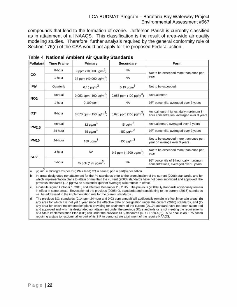
LCA BUDMAT Program – Barataria Bay Waterway Project Environmental Assessment #567
P a g e | 22
compounds that lead to the formation of ozone. Jefferson Parish is currently classified as in attainment of all NAAQS. This classification is the result of area-wide air quality modeling studies. Therefore, further analysis required by the general conformity rule of Section 176(c) of the CAA would not apply for the proposed Federal action. Table 4. National Ambient Air Quality Standards
Pollutant Time Frame Primary Secondary Form
CO
8-hour 9 ppm (10,000 μg/m3) NA
Not to be exceeded more than once per year 1-hour 35 ppm (40,000 μg/m
3) NA
Pbb Quarterly 0.15 μg/m3 0.15 μg/m
3 Not to be exceeded
NO2 Annual 0.053 ppm (100 μg/m
3) 0.053 ppm (100 μg/m
3) Annual mean
1-hour 0.100 ppm NA 98th percentile, averaged over 3 years
O3c 8-hour 0.070 ppm (150 μg/m3) 0.070 ppm (150 μg/m
3)
Annual fourth-highest daily maximum 8-hour concentration, averaged over 3 years
PM2.5 Annual 12 μg/m
3 15 μg/m
3 Annual mean, averaged over 3 years
24-hour 35 μg/m3 150 μg/m
3 98th percentile, averaged over 3 years
PM10 24-hour 150 μg/m3 150 μg/m
3
Not to be exceeded more than once per year on average over 3 years
SO2d
3-hour NA 0.5 ppm (1,300 μg/m3)
Not to be exceeded more than once per year
1-hour 75 ppb (195 μg/m3) NA
99th percentile of 1-hour daily maximum concentrations, averaged over 3 years
a μg/m3
= micrograms per m3; Pb = lead; O3 = ozone; ppb = part(s) per billion.
b In areas designated nonattainment for the Pb standards prior to the promulgation of the current (2008) standards, and for which implementation plans to attain or maintain the current (2008) standards have not been submitted and approved, the previous standards (1.5 µg/m3 as a calendar quarter average) also remain in effect.
c Final rule signed October 1, 2015, and effective December 28, 2015. The previous (2008) O3 standards additionally remain in effect in some areas. Revocation of the previous (2008) O3 standards and transitioning to the current (2015) standards will be addressed in the implementation rule for the current standards.
d The previous SO2 standards (0.14 ppm 24-hour and 0.03 ppm annual) will additionally remain in effect in certain areas: (b) any area for which it is not yet 1 year since the effective date of designation under the current (2010) standards, and (2) any area for which implementation plans providing for attainment of the current (2010) standard have not been submitted and approved and which is designated nonattainment under the previous SO2 standards or is not meeting the requirements of a State Implementation Plan (SIP) call under the previous SO2 standards (40 CFR 50.4(3)). A SIP call is an EPA action requiring a state to resubmit all or part of its SIP to demonstrate attainment of the require NAAQS.

LCA BUDMAT Program – Barataria Bay Waterway Project Environmental Assessment #567
P a g e | 23
3.3.9 Cultural Resources Existing Conditions Section 106 of the National Historic Preservation Act of 1966, as amended and codified in Title 54 of the United States Code; NEPA of 1969 (PL 91-190), as amended; and other applicable laws and regulations require Federal agencies to take into account the effects of their undertaking on the environment and any significant cultural resources within the project area of the proposed undertaking, as well as its area of potential effect (APE). Typically, these studies require archival searches and field surveys to identify any cultural resources. When significant cultural resources are recorded, efforts are made to minimize adverse effects and preserve the resource(s) in place. If any significant cultural resources cannot be avoided and would be adversely impacted, an appropriate mitigation plan would be implemented to recover data that would be otherwise lost due to the undertaking. No cultural resource investigations have been conducted that include the boundaries of the proposed disposal area. However, the evidence of the historic maps and soil maps does not suggest that previous habitation could have occured at the disposal site, and if transitory activities occurred, they have been deeply buried or already destroyed by natural processes. A site visit was made by USACE archaeologist Dr. Paul Hughbanks, and very little solid land was observed. The high land observed was defined as dredge piles from the numerous canals, and no high land contained any artifacts or remnants of any past cultural activity. In their study of the Bayou L’Ours watershed, Earth Search Inc. (1995) cite Britsch and Dunbar (1990) to state that in marsh areas like the current project areas only the crest of natural levees resulting from the small distributaries that may dissect them survive, and often these have subsided beyond recognition. No such traces of any natural levees were identified during the site visit. Using the aforementioned evidence for the past nature of landscape within the currently proposed disposal areas for beneficial use of dredged material, CEMVN has concluded that no historic properties are affected by the proposed project. 3.3.10 Recreational Resources Existing Conditions Recreational activities that are popular in the Barataria Basin include motor boating for pleasure, fishing, crabbing, shrimping, hunting, and passive recreational activities, such as observation of wildlife and nature study. Along the Barataria Bay Waterway are numerous intersecting channels providing recreational users with water access into the adjacent marshes and lakes.

LCA BUDMAT Program – Barataria Bay Waterway Project Environmental Assessment #567
P a g e | 24
Wetlands and open water in the Basin and the project area provide important habitat for a multitude of fish species. The dynamic and highly productive ecosystems of coastal marshes provide valuable detrital material and nutrients that provide a food source for primary producers, zooplankton, benthic organisms, and nekton, which are crucial to the food web. Shallow open water areas provide nursery habitat for a variety of aquatic organisms. Recreational fishing opportunities exist in the Basin because of the abundance of fish that are attracted to the highly productive ecosystem in terms of providing a food source and a nursery habitat. The Basin contains numerous state- and federally-managed parks, wildlife management areas (WMA’s) and open spaces, typically used for active and consumptive recreational activities (Table 5). Numerous water bodies in the study area provide boating and fishing opportunities. Table 5. Recreational Features in the Barataria Basin
Recreational Area
Location Land Management Agency
Size (acres) Key Recreational Features
Barataria Basin
Salvador /Timken Wildlife Management Area
St. Charles Parish, LA
LDWF 34,520 Boat access available
Hunting, trapping, and fishing
Wisner WMA Jefferson Parish, LA
Edward Wisner Donation Advisory Committee
21,621 Boat access available
Hunting and fishing
Grand Isle State Park
Jefferson Parish, LA
Louisiana State Parks
120 Beach and bay access
One trail (2.5 miles)
Campground
Canoe, paddle boat, and surf bike rental
Jean Laffite National Historical Park and Preserve
Jefferson Parish, LA
National Park Service
20,000 (Barataria Preserve)
Nine trails totaling 7.45 miles and three boardwalks totaling 2.4 miles
Four boat ramps and non-motorized boating
Hunting, hiking, canoeing, biking, picnicking, and photography activities
Grand Isle State Park. Grand Isle State Park is located on Grand Isle, Louisiana, and provides beach access along the Gulf of Mexico. Campsites are available both for premium camping access and for tent camping on the beach. A 2.5-mile nature trail is located at the park. Grand Isle State Park also operates a canoe, paddle boat, and surf bike rental facility (Louisiana State Parks 2014).
LCA BUDMAT Program – Barataria Bay Waterway Project Environmental Assessment #567
P a g e | 25
Salvador WMA. The Salvador WMA is located in St. Charles Parish, Louisiana, along the northwestern shore of Lake Salvador. The Salvador WMA was acquired by the Louisiana Department of Wildlife and Fisheries (LDWF) in 1968 and is approximately 30,000 acres. Access to the Salvador WMA is limited to boat travel. The area is primarily freshwater marsh and open water habitats. Several large stands of cypress timber are evident in the northern portions. These stands of trees grow on old natural stream levees. Game species include waterfowl, deer, rabbits, squirrels, rails, gallinules, and snipe. Furbearing animals present are mink, nutria, muskrat, raccoon, opossum, and otter. The Salvador WMA supports a large population of alligators, as well as providing nesting habitat for bald eagle. Freshwater fishing is available on the Salvador WMA (LDWF 2014). Timken WMA. The Timken WMA, located in St. Charles Parish, is a 3,000-acre marsh island that is leased by the LDWF from the City Park Commission of New Orleans. The Timken WMA is identified as Couba Island on maps; however, it was named the Timken WMA after the former landowner who donated it to the City of New Orleans. The Timken WMA is located immediately east of the Salvador WMA. Like the Salvador WMA, the Timken WMA consists of freshwater to intermediate marsh and provides excellent habitat for waterfowl, furbearers, and alligators as well as recreational opportunities for hunting, trapping, fishing, boating, and birding (LDWF 2014). National Parks and Seashores. There is one National Park near the study area, the Jean Lafitte National Historic Park and Preserve (JLNHPP), which includes various units that are within or near the study area: the Barataria Preserve, the Chalmette Battlefield, and the Chalmette National Cemetery, and the French Quarter Visitor Center. The 28,600-acre park and preserve is managed by the National Park Service. The Barataria Preserve, which is located near the study area, contains approximately 20,000 acres. There are four management zones in the core of the JLNHPP: the natural zone, the cultural resource zone, the park development zone, and the other-use zone. The natural zone was designated to help preserve the core area’s natural values (USACE 2008). A day-use parking area, canoe launching areas, and hiking trails are within the park development zone. Free programs and events are also held in the park development zone. JLNHPP is open year-round and offers several outdoor activities in its Barataria Preserve. The Barataria Preserve Unit includes a visitor center, day-use parking areas, and canoe and hiking trails. Typical visitor activities include bird watching, wildlife viewing, hunting, hiking, canoeing, biking, picnicking, and photography. Water-oriented sports, including fishing, waterfowl hunting, and boating, occur in areas of the park with water access. The preserve also has active squirrel, nutria, rabbit, deer, and waterfowl hunting programs (USACE 2008). Four boat launch sites are located in the study area. Seaway Marina is a for fee public launch located in Lafitte, LA on Bayou Barataria near the end of LA 45. Joe’s Landing, also on Bayou Barataria, offers dual launches and a hoist for fee. A third launch on Bayou Barataria, located on LA 45 at Goose Bayou Bridge at the Cochlear Shipyard Marina, is
LCA BUDMAT Program – Barataria Bay Waterway Project Environmental Assessment #567
P a g e | 26
semi-private and offers public launches for a fee. Finally, a fourth launch on Bayou Barataria is located on Highway 303. 3.3.11 Aesthetics (Visual Resources) Existing Conditions The proposed site is located in the State of Louisiana’s Barataria Bay and is a small piece of the massive Mississippi River Delta Complex. The study area consists of a patchwork of fresh-intermediate marsh and brackish marsh. This particular area is devoid of any type of development save a few small petrochemical industrial complexes and pipeline canals accessible by boat. Highway 3257 is the nearest major thoroughfare and provides no view sheds into the immediate project area. Other thoroughfares in the area include the Barataria Bay Waterway, which also offers no view sheds into the immediate project area. The area remains relatively natural and scenic and is a haven for recreational opportunities such as fishing and nature observation, especially in the numerous canals and other natural waterways that traverse through the marshes in the area. View sheds to the project site are offered only from aircraft and boat. 3.3.12 Socioeconomic Resources and Environmental Justice Existing Conditions The decennial U.S. Census completed in 2010 and the five-year average (2012-2016) estimates from the American Community Survey (ACS) data were queried to obtain relevant socioeconomic data for this analysis. The ACS data is tabulated by the U.S. Census Bureau and was procured using American Fact Finder website extraction tool. Socioeconomic data is presented for three geographic areas that are located along the Barataria Bay Waterway or are near the location of the proposed dredged material placement sites. The three areas included in the socio-economic assessment include the town of Jean Lafitte, the Lafitte Census of Designated Places (CDP) and Barataria CDP (See Figure A-3 in Appendix A for the geographic area boundaries). According to the U.S. Census 2016 American Community Survey, the total population of the socio-economic study area (census years 2000-2016) is 3,719, down nearly 26% from 2000 (Table 6). One of the reasons for such a large reduction in population, in all three areas, is the impacts of Hurricane Katrina and other tropical events occurring during this time period forcing many to leave the vulnerable area. Almost 50 percent of the socio-economic study area residents live in the town of Jean Lafitte. Table 6. Total Population 2010-2016
Census Census Population Estimate from ACS
Percent Change
Geography April 1, 2000 April 1, 2010 2016 2000-2016
Jean Lafitte 2,137 1,903 1,888 -11.65%
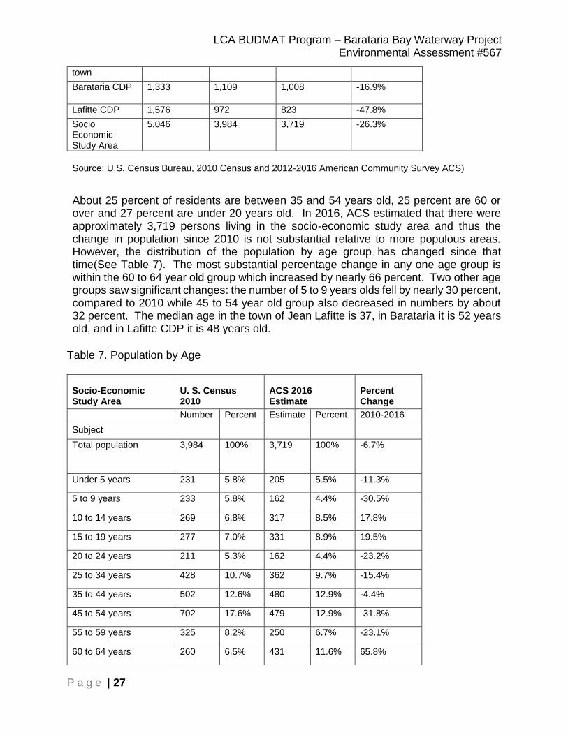
LCA BUDMAT Program – Barataria Bay Waterway Project Environmental Assessment #567
P a g e | 27
town
Barataria CDP 1,333 1,109 1,008 -16.9%
Lafitte CDP 1,576 972 823 -47.8%
Socio Economic Study Area
5,046 3,984 3,719 -26.3%
Source: U.S. Census Bureau, 2010 Census and 2012-2016 American Community Survey ACS)
About 25 percent of residents are between 35 and 54 years old, 25 percent are 60 or over and 27 percent are under 20 years old. In 2016, ACS estimated that there were approximately 3,719 persons living in the socio-economic study area and thus the change in population since 2010 is not substantial relative to more populous areas. However, the distribution of the population by age group has changed since that time(See Table 7). The most substantial percentage change in any one age group is within the 60 to 64 year old group which increased by nearly 66 percent. Two other age groups saw significant changes: the number of 5 to 9 years olds fell by nearly 30 percent, compared to 2010 while 45 to 54 year old group also decreased in numbers by about 32 percent. The median age in the town of Jean Lafitte is 37, in Barataria it is 52 years old, and in Lafitte CDP it is 48 years old.
Table 7. Population by Age
Socio-Economic Study Area
U. S. Census 2010
ACS 2016 Estimate
Percent Change
Number Percent Estimate Percent 2010-2016
Subject
Total population 3,984 100% 3,719 100% -6.7%
Under 5 years 231 5.8% 205 5.5% -11.3%
5 to 9 years 233 5.8% 162 4.4% -30.5%
10 to 14 years 269 6.8% 317 8.5% 17.8%
15 to 19 years 277 7.0% 331 8.9% 19.5%
20 to 24 years 211 5.3% 162 4.4% -23.2%
25 to 34 years 428 10.7% 362 9.7% -15.4%
35 to 44 years 502 12.6% 480 12.9% -4.4%
45 to 54 years 702 17.6% 479 12.9% -31.8%
55 to 59 years 325 8.2% 250 6.7% -23.1%
60 to 64 years 260 6.5% 431 11.6% 65.8%
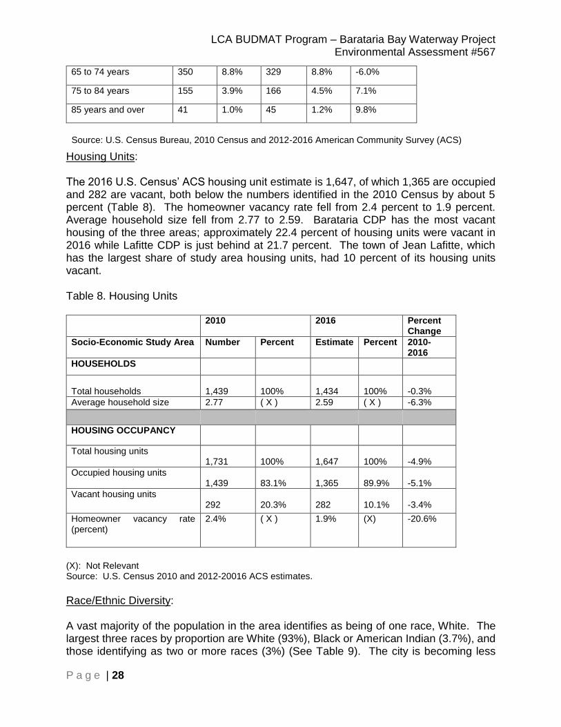
LCA BUDMAT Program – Barataria Bay Waterway Project Environmental Assessment #567
P a g e | 28
65 to 74 years 350 8.8% 329 8.8% -6.0%
75 to 84 years 155 3.9% 166 4.5% 7.1%
85 years and over 41 1.0% 45 1.2% 9.8%
Source: U.S. Census Bureau, 2010 Census and 2012-2016 American Community Survey (ACS)
Housing Units: The 2016 U.S. Census’ ACS housing unit estimate is 1,647, of which 1,365 are occupied and 282 are vacant, both below the numbers identified in the 2010 Census by about 5 percent (Table 8). The homeowner vacancy rate fell from 2.4 percent to 1.9 percent. Average household size fell from 2.77 to 2.59. Barataria CDP has the most vacant housing of the three areas; approximately 22.4 percent of housing units were vacant in 2016 while Lafitte CDP is just behind at 21.7 percent. The town of Jean Lafitte, which has the largest share of study area housing units, had 10 percent of its housing units vacant. Table 8. Housing Units
2010 2016 Percent Change
Socio-Economic Study Area Number Percent Estimate Percent 2010-2016
HOUSEHOLDS
Total households
1,439
100%
1,434
100%
-0.3%
Average household size 2.77 ( X ) 2.59 ( X ) -6.3%
HOUSING OCCUPANCY
Total housing units 1,731
100%
1,647
100%
-4.9%
Occupied housing units 1,439
83.1%
1,365
89.9%
-5.1%
Vacant housing units 292
20.3%
282
10.1%
-3.4%
Homeowner vacancy rate (percent)
2.4% ( X ) 1.9% (X) -20.6%
(X): Not Relevant Source: U.S. Census 2010 and 2012-20016 ACS estimates.
Race/Ethnic Diversity: A vast majority of the population in the area identifies as being of one race, White. The largest three races by proportion are White (93%), Black or American Indian (3.7%), and those identifying as two or more races (3%) (See Table 9). The city is becoming less

LCA BUDMAT Program – Barataria Bay Waterway Project Environmental Assessment #567
P a g e | 29
diversified, compared to 2010. The Black/African American and Asian populations have decreased in the study area since 2010 while those identifying as American Indian have increased since 2010. Hispanic or Latino populations have decreased over the last 6 years by nearly 50 percent. Table 9. Racial Composition - Socio-Economic Study Area
Subject 2010-2016
Percent Change
RACE Number Percent Estimate Percent 2010-2016
Total population 3,984 100.0% 3,719 100.0% -6.7%
One Race 3,894 97.7% 3,606 97.0% -7.4%
White 3,647 91.5% 3,444 92.6% -5.6%
Black or African American 105 2.6% 5 0.1% -95.2%
American Indian and Alaska Native
95 2.4% 138 3.7% 45.3%
Asian 32 0.8% 0 0.0% -100.0%
Native Hawaiian and Other Pacific Islander
0 0.0% 0 0.0% 0.0%
Some Other Race 15 0.4% 19 0.5% 26.7%
Two or More Races 90 2.3% 113 3.0% 25.6%
Subject 2010-2016
Percent Change
HISPANIC OR LATINO Number Percent Estimate Percent 2010-2016
Total population 3,984 100% 3,719 100% -6.7%
Hispanic or Latino (of any race)
123 3.1% 62 1.7% -49.6%
Mexican 44 1.1% 25 0.7% -43.2%
Puerto Rican 8 0.2% 0 0.0% -100.0%
Cuban 14 0.4% 0 0.0% -100.0%
Other Hispanic or Latino* 57 1.4% 37 1.0% -35.1%
Not Hispanic or Latino 3,861 96.9% 3,657 98.3% -5.3%
*Note: This category is composed of people whose origins are from the Dominican Republic, Spain, and Spanish-speaking Central or South American countries. It also includes general origin responses such as "Latino" or "Hispanic." Source: U.S. Census, 2010, U.S. Census and ACS 2012-2016.

LCA BUDMAT Program – Barataria Bay Waterway Project Environmental Assessment #567
P a g e | 30
Property Value: According to the U.S. Census Bureau’s American Community Survey, the largest percentage of homes located in the socio-economic study area (22.9%) are valued $50,000 to $99,999. Most of these homes are located in the Barataria CDP. Nearly 40 percent of the homes in the Lafitte CDP are valued $300,000 to $499,999. The median housing value is just below $200,000 (Table 10). Table 10. Property Value, 2016
Subject Jean Lafitte town Lafitte CDP Barataria CDP Socio-Economic Study Area
VALUE Estimate Percent Estimate Percent Estimate Percent Estimate Percent
Owner-occupied units
568 100% 270 100% 400 100% 1,238 100%
Less than $50,000
54 9.5% 21 7.8% 43 10.8% 118 9.5%
$50,000 to $99,999
117 20.6% 23 8.5% 144 36.0% 284 22.9%
$100,000 to $149,999
133 23.4% 55 20.4% 51 12.8% 239 19.3%
$150,000 to $199,999
97 17.1% 38 14.1% 71 17.8% 206 16.6%
$200,000 to $299,999
82 14.4% 24 8.9% 66 16.5% 172 13.9%
$300,000 to $499,999
76 13.4% 109 40.4% 18 4.5% 203 16.4%
$500,000 to $999,999
6 1.1% 0 0.0% 7 1.8% 13 1.1%
$1,000,000 or more
3 0.5% 0 0.0% 0 0.0% 3
0.2%
Median (dollars)
142,800 (X) 191,700 (X) 107,600 (X)
Note: An '(X)' means that the estimate is not applicable or not available.
Source: U.S. Census Bureau, 2012-2016 American Community Survey 5-Year Estimates
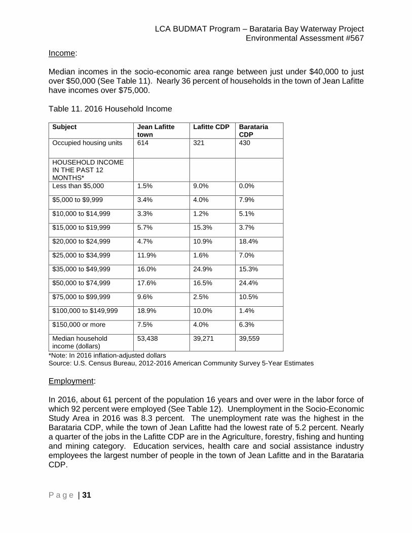
LCA BUDMAT Program – Barataria Bay Waterway Project Environmental Assessment #567
P a g e | 31
Income: Median incomes in the socio-economic area range between just under $40,000 to just over $50,000 (See Table 11). Nearly 36 percent of households in the town of Jean Lafitte have incomes over $75,000. Table 11. 2016 Household Income
Subject Jean Lafitte town
Lafitte CDP Barataria CDP
Occupied housing units 614 321 430
HOUSEHOLD INCOME IN THE PAST 12 MONTHS*
Less than $5,000 1.5% 9.0% 0.0%
$5,000 to $9,999 3.4% 4.0% 7.9%
$10,000 to $14,999 3.3% 1.2% 5.1%
$15,000 to $19,999 5.7% 15.3% 3.7%
$20,000 to $24,999 4.7% 10.9% 18.4%
$25,000 to $34,999 11.9% 1.6% 7.0%
$35,000 to $49,999 16.0% 24.9% 15.3%
$50,000 to $74,999 17.6% 16.5% 24.4%
$75,000 to $99,999 9.6% 2.5% 10.5%
$100,000 to $149,999 18.9% 10.0% 1.4%
$150,000 or more 7.5% 4.0% 6.3%
Median household income (dollars)
53,438 39,271 39,559
*Note: In 2016 inflation-adjusted dollars Source: U.S. Census Bureau, 2012-2016 American Community Survey 5-Year Estimates Employment: In 2016, about 61 percent of the population 16 years and over were in the labor force of which 92 percent were employed (See Table 12). Unemployment in the Socio-Economic Study Area in 2016 was 8.3 percent. The unemployment rate was the highest in the Barataria CDP, while the town of Jean Lafitte had the lowest rate of 5.2 percent. Nearly a quarter of the jobs in the Lafitte CDP are in the Agriculture, forestry, fishing and hunting and mining category. Education services, health care and social assistance industry employees the largest number of people in the town of Jean Lafitte and in the Barataria CDP.

LCA BUDMAT Program – Barataria Bay Waterway Project Environmental Assessment #567
P a g e | 32
Table 12. Employment, 2016
Industry Jean Lafitte town
Lafitte CDP
Barataria CDP
Socio-Economic Study Area
Subject
Number Percent
Population 16 yrs and over 1,442 674 878 2,994
In Labor Force 922
299
601
1,822
Civilian employed population 16 years and over
874
299
497
1,670
Unemployment Rate 5.2% 0% 17.3% (X) 8.3%
Agriculture, forestry, fishing and hunting, and mining
57
76
51
184
11.0%
Construction 109
16
33
158
9.5%
Manufacturing 124
12
46
182
10.9%
Wholesale trade 20
-
31
51
3.1%
Retail trade 71
7
66
144
8.6%
Transportation and warehousing, and utilities
103
13
55
171
10.2%
Information 8
-
-
8
0.5%
Finance and insurance, and real estate and rental and leasing
40
62
26
128
7.7%
Professional, scientific, and management, and administrative and waste management services
46
-
-
46
2.8%
Educational services, and health care and social assistance
140
54
83
277
16.6%
Arts, entertainment, and recreation, and accommodation and food services
66
38
60
164
9.8%
Other services, except public administration
29
15
22
66
4.0%
Public administration 61
6
24
91
5.4%
Source: U.S. Census Bureau, 2012-2016 American Community Survey 5-Year Estimates

LCA BUDMAT Program – Barataria Bay Waterway Project Environmental Assessment #567
P a g e | 33
Education Level: Table 13 shows the range in education level for two population groups in the Barataria/Lafitte area. For those residents 18 – 24 years old, nearly 83 percent have at least a high school degree, with 55 percent having at least some college education or better. Approximately 16 percent of residents 25 years and over have an Associate’s, Bachelor’s or Graduate/Professional degree.
Table 13. Education Level
Source: U.S. Census Bureau, 2012-2016 American Community Survey 5-Year Estimates
Jean Lafitte town, Louisiana
Lafitte CDP Barataria CDP Soicio-Economic Study Area
Subject Estimate Percent Estimate Percent Estimate Percent Estimate Percent
Population 18 to 24 years
173 (X) 72 (X) 44 (X) 289 100.0%
Less than high school graduate
27 15.6% 14 19.4% 9 20.5% 50 17.3%
High school graduate (includes equivalency)
57 32.9% 24 33.3% 0 0.0% 81 28.0%
Some college or associate's degree
69 39.9% 34 47.2% 35 79.5% 138 47.8%
Bachelor's degree or higher
20 11.6% 0 0.0% 0 0.0% 20 6.9%
Population 25 years and over
1,209 (X) 554 (X) 779 (X) 2,542 100.0%
Less than 9th grade
161 13.3% 126 22.7% 92 11.8% 379 14.9%
9th to 12th grade, no diploma
151 12.5% 29 5.2% 191 24.5% 371 14.6%
High school graduate (includes equivalency)
444 36.7% 227 41.0% 294 37.7% 965 38.0%
Some college, no degree
264 21.8% 51 9.2% 99 12.7% 414 16.3%
Associate's degree
66 5.5% 71 12.8% 55 7.1% 192 7.6%
Bachelor's degree
118 9.8% 37 6.7% 41 5.3% 196 7.7%
Graduate or professional degree
5 0.4% 13 2.3% 7 0.9% 25 1.0%

LCA BUDMAT Program – Barataria Bay Waterway Project Environmental Assessment #567
P a g e | 34
Minority and low-income populations (Environmental Justice): At a national level, environmental justice concerns have primarily focused on populations considered to be minority and/or low-income. However, since environmental justice is defined as the fair treatment and meaningful involvement of all people, the final decision should be whether the affected area is likely to, or is already, impacted by greater adverse effects than a demographically similar reference community. As with socio-economic data, the five-year average (2011-2016) American Community Survey (ACS) data was queried to obtain relevant information associated with environmental justice. This ACS data is tabulated by the U.S. Census Bureau (USCB) and was procured from the national, state, county and local perspective in order to provide a multi-level geographical analysis. In order to identify whether the potential alternatives may disproportionately affect minorities or impoverished citizens, an analysis was conducted utilizing census block groups obtained from ACS. Detailed Block Group data was compiled using ACS 2011-2016 data. The following information was collected from specific census block groups in the study area. Racial and Ethnic Characteristics – race and ethnic populations in each census block of the study area were characterized using the following racial categories: Hispanic White (for which demographic data is reported as one category by the USCB), Black or African American, American Indian and Alaska Native, Asian, Native Hawaiian and Other Pacific Islander, Persons of Hispanic Origin, and Other. These categories are consistent with the affected populations requiring study under Executive Order 12898. Percentage of Minority Population – As defined by the USCB, the minority population includes all non-Whites and White-Hispanic persons. According to Council of Environmental Quality (CEQ) guidelines, “Minority populations should be identified where either: (a) the minority population of the affected area exceeds 50 percent or (b) the minority population percentage of the affected area is meaningfully greater than the minority population percentage in the general population or other appropriate unit of geographic analysis.” See Figure A-3 in Appendix A for a map displaying the block group locations in relation to the study area. Low-Income Population – The percentage of persons living below the poverty level, as defined in the 2011-2016 ACS, was one of the indicators used to determine the low-income population in a given census block or tract. Low-income population is defined as a Census Block Group with 20 percent or more of its residents below the poverty threshold. Minority and population below poverty level percentages are shown in Table 14 for the town of Jean Lafitte, and the Lafitte and Barataria CDPs. A vast majority of the population in the area is White, with only 6.5 percent of the population a minority. Hispanics comprise just under 1.7 percent of the population in 2016.
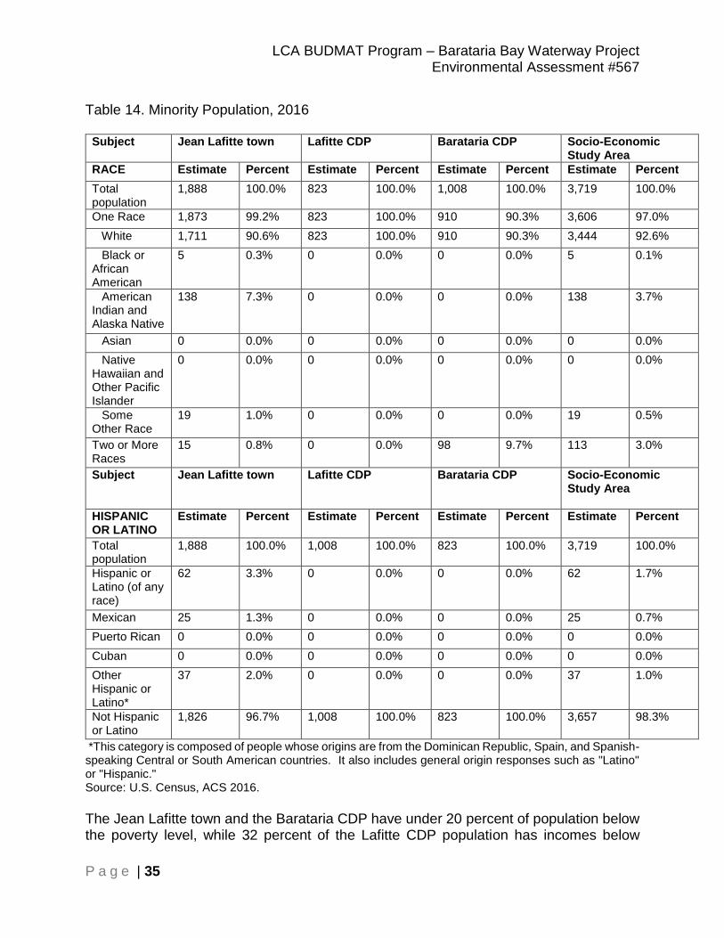
LCA BUDMAT Program – Barataria Bay Waterway Project Environmental Assessment #567
P a g e | 35
Table 14. Minority Population, 2016
Subject Jean Lafitte town Lafitte CDP Barataria CDP Socio-Economic Study Area
RACE Estimate Percent Estimate Percent Estimate Percent Estimate Percent
Total population
1,888 100.0% 823 100.0% 1,008 100.0% 3,719 100.0%
One Race 1,873 99.2% 823 100.0% 910 90.3% 3,606 97.0%
White 1,711 90.6% 823 100.0% 910 90.3% 3,444 92.6%
Black or African American
5 0.3% 0 0.0% 0 0.0% 5 0.1%
American Indian and Alaska Native
138 7.3% 0 0.0% 0 0.0% 138 3.7%
Asian 0 0.0% 0 0.0% 0 0.0% 0 0.0%
Native Hawaiian and Other Pacific Islander
0 0.0% 0 0.0% 0 0.0% 0 0.0%
Some Other Race
19 1.0% 0 0.0% 0 0.0% 19 0.5%
Two or More Races
15 0.8% 0 0.0% 98 9.7% 113 3.0%
Subject Jean Lafitte town Lafitte CDP Barataria CDP Socio-Economic Study Area
HISPANIC OR LATINO
Estimate Percent Estimate Percent Estimate Percent Estimate Percent
Total population
1,888 100.0% 1,008 100.0% 823 100.0% 3,719 100.0%
Hispanic or Latino (of any race)
62 3.3% 0 0.0% 0 0.0% 62 1.7%
Mexican 25 1.3% 0 0.0% 0 0.0% 25 0.7%
Puerto Rican 0 0.0% 0 0.0% 0 0.0% 0 0.0%
Cuban 0 0.0% 0 0.0% 0 0.0% 0 0.0%
Other Hispanic or Latino*
37 2.0% 0 0.0% 0 0.0% 37 1.0%
Not Hispanic or Latino
1,826 96.7% 1,008 100.0% 823 100.0% 3,657 98.3%
*This category is composed of people whose origins are from the Dominican Republic, Spain, and Spanish-speaking Central or South American countries. It also includes general origin responses such as "Latino" or "Hispanic." Source: U.S. Census, ACS 2016.
The Jean Lafitte town and the Barataria CDP have under 20 percent of population below the poverty level, while 32 percent of the Lafitte CDP population has incomes below
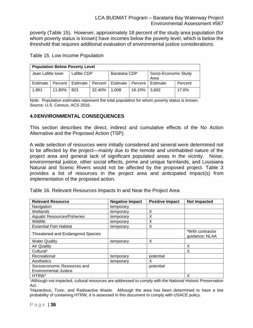
LCA BUDMAT Program – Barataria Bay Waterway Project Environmental Assessment #567
P a g e | 36
poverty (Table 15). However, approximately 18 percent of the study area population (for whom poverty status is known) have incomes below the poverty level, which is below the threshold that requires additional evaluation of environmental justice considerations. Table 15. Low Income Population
Population Below Poverty Level
Jean Lafitte town Lafitte CDP Barataria CDP Socio-Economic Study Area
Estimate Percent Estimate Percent Estimate Percent Estimate Percent
1,861 11.80% 823 32.40% 1,008 16.10% 3,692 17.6%
Note: Population estimates represent the total population for whom poverty status is known. Source: U.S. Census, ACS 2016.
4.0 ENVIRONMENTAL CONSEQUENCES This section describes the direct, indirect and cumulative effects of the No Action Alternative and the Proposed Action (TSP). A wide selection of resources were initially considered and several were determined not to be affected by the project—mainly due to the remote and uninhabited nature of the project area and general lack of significant populated areas in the vicinity. Noise, environmental justice, other social effects, prime and unique farmlands, and Louisiana Natural and Scenic Rivers would not be affected by the proposed project. Table 3 provides a list of resources in the project area and anticipated impact(s) from implementation of the proposed action. Table 16. Relevant Resources Impacts In and Near the Project Area Relevant Resource Negative Impact Positive Impact Not Impacted
Navigation temporary
Wetlands temporary X
Aquatic Resources/Fisheries temporary X
Wildlife temporary X
Essential Fish Habitat temporary X
Threatened and Endangered Species *With contractor
guidance; NLAA
Water Quality temporary X
Air Quality X
Cultural1 X
Recreational temporary potential
Aesthetics temporary X
Socioeconomic Resources and Environmental Justice
potential
HTRW2 X 1Although not impacted, cultural resources are addressed to comply with the National Historic Preservation Act. 2Hazardous, Toxic, and Radioactive Waste. Although the area has been determined to have a low probability of containing HTRW, it is assessed in this document to comply with USACE policy.

LCA BUDMAT Program – Barataria Bay Waterway Project Environmental Assessment #567
P a g e | 37
4.1 Navigation Future Conditions with No Action There would be no anticipated impacts to navigation without implementation of the Proposed Action (TSP). O&M activities such as dredging the BBW and disposing of materials in one of the already approved dredged material disposal sites would continue. Future Conditions with the Proposed Action Dredges and disposal pipelines may cause minor and temporary interference of navigation by blocking sections of the BBW, but are not expected to interfere significantly with shipping traffic. Dredging operations would be closely coordinated with representatives of the navigation industry and a Notice to Mariners would be posted by the US Coast Guard. Beneficial use-placement of dredged material in BA-1 East could cause minor disruptions to small vessels using portions of the project area; however, the effects on navigation would be mainly temporary. Portions of BA-1 East may become inaccessible to some watercraft as wetland vegetation eventually colonizes the area; however, the shallow nature of the area currently limits most vessel access. 4.2 Wetlands Future Conditions with No Action Without implementation of the Proposed Action, wetlands in the vicinity of the Proposed Action would continue to be directly and indirectly impacted by the present natural and anthropogenic factors. Approximately one football field of marsh becomes submerged in water about every 34 minutes with rapid loss to about every 100 minutes at slower rates (Couvillion et al. 2017). Coastwide rates of wetland change have varied from -83.5 +/- 11.8 km^2 per year to -28.01 +/- 16.37 km^2 per year (Couvillion et al. 2017). Saltwater intrusion would continue to impact vulnerable marsh habitats further inland as the Barataria Bay rim marshes continues to degrade, causing them to either convert type or convert to open water. Subsidence and erosional land loss would continue at the present rate. The overall habitat value and acreage of the remaining wetlands would decline with the No Action Alternative. Vast acreages of wetlands have been lost and would continue to be lost in this portion of the Deltaic Plain. Tidal currents and wave action in open bodies of water such as brackish bays and estuaries exert dominant erosional processes on coastal wetlands in the study area. The rates of these processes accelerate as barrier islands are significantly reduced by coastal erosion. The effects of tides and wind-driven waves are lessened in bays which are well protected by barrier islands. Unfortunately, inshore barrier islands and coastal wetlands in this region are almost non-existent and coastal marshes open directly upon the Basin. Destruction of these coastal marshes and barrier islands protecting Jefferson Parish may

LCA BUDMAT Program – Barataria Bay Waterway Project Environmental Assessment #567
P a g e | 38
have numerous adverse effects upon the fishing and shellfish industry, recreational and commercial navigation, public housing, and wildlife resources. Future Conditions with the Proposed Action Access from the Barataria Bay Waterway (BBW) to the site would require dredging of approximately 105 acres of open water. Additionally, approximately 2.0 acres of existing fresh-intermediate marsh would be temporarily impacted from placement of pipelines into the site. Within the site, approximately 1.75 acres of existing fresh-intermediate marsh and approximately 73.0 acres of open water would be directly impacted from placement of the fill material for marsh creation. Dredged material would be discharged by a mechanical dredge into shallow open-water areas to a height no greater than +0.6 NAVD88. Dredged slurry would be allowed to overflow existing emergent marsh vegetation, but would not be allowed to exceed a height of about one foot above the existing marsh substrate. It is expected that dredged material would settle to elevations conducive to wetlands development after dewatering and compaction. Upon completion of dredging and disposal activities, any use of the pipeline corridors that results in impacts to existing marsh would be backfilled to approximately the elevation of the surrounding marsh after settlement in an effort to restore these degraded corridors to pre-project marsh elevations. Any existing wetlands impacted would be restored to pre-project elevation and would re-vegetate naturally. See the 404(b)(1) Analysis in Appendix E for further details about wetlands development. The proposed action would also offer some wave impact reduction to existing wetlands in the project area. Restored marsh would provide additional foraging, breeding, nesting, and nursery areas, as well as refugia for a multitude of estuarine-dependent and commercially important fish and shellfish, migratory waterfowl, wildlife, and several species of wading, diving, and shore birds, and help to offset the substantial wetlands loss currently taking place in the project area. Thus, positive direct and indirect impacts to wetlands and wetland-related resources would be expected with implementation of the proposed action. The proposed action would prevent an overall loss in the Basin of fresh-intermediate marsh habitat. Constructing the approximately 75 acre marsh creation site, or approximately 17.0 average annual habitat units (AAHUs), when added to other past, present, and reasonably foreseeable ecosystem restoration and mitigation projects in the Basin would help retard the loss of wetlands. There would be an overall loss of open water habitat in the Basin, but no permanent adverse impacts are anticipated because this habitat is prevalent throughout the Basin. 4.3 Aquatic Resources/Fisheries Future Conditions with No Action

LCA BUDMAT Program – Barataria Bay Waterway Project Environmental Assessment #567
P a g e | 39
Without implementation of the Proposed Action, BA-1 East would remain as shallow open water and eroding marsh. The average depth of open-water area would continue to increase as a consequence of continued subsidence, erosion, and land loss, and the resulting loss of marsh and associated vegetation to open water would have an adverse impact on fish and shellfish populations inhabiting the area. The pattern of expanding open water bays would diminish opportunities for species that typically utilize emergent wetland habitats. The average depth of open-water areas would continue to increase and the amount of open water less than or equal to 1.5 feet deep is expected to decrease. Wetland vegetation loss would degrade the quality of the area for fisheries as food sources and nursery habitat decline. Future Conditions with the Proposed Action With implementation of the Proposed Action (TSP), there would be minimal direct impacts to fisheries in the bay area as a temporary increase in turbidity of the surrounding area is expected to occur during the placement of material. Mobile fishery species would be able to avoid the sediment from the discharge pipe and areas of increased turbidity associated with disposal, thereby minimizing the impact to those species. Fisheries access would be coordinated with NMFS and USFWS prior to construction of dikes and closures. Brown shrimp, white shrimp, and blue crab may directly benefit from the abundance of detritus pumped providing a food source. Red drum and neonate bull shark may also be potentially temporarily impacted by the proposed action from the construction of the marsh creation site. Oysters should not be impacted due to their distance from BA-1 East and the containment controlling the sediment plume. Some benthic and macroinvertebrate mortality would occur from the placement of dredged material. However, in time, the populations in the area should return to those of pre-project conditions. The increase in land to water interface would result in positive impacts to fisheries by providing additional and improved habitat. Bayou Perot and Bayou Rigolletes would be temporarily impacted adversely from the sediment plume generated by construction activities, but post-project benefits from the created fresh-intermediate marsh habitat and storm surge protection should outweigh the detriments. Indirect effects from the placement of dredged material within the site would temporarily increase turbidity, but most fish would likely vacate the area and are expected to return once the plume settles. 4.4 Essential Fish Habitat Future Conditions with No Action Without implementation of the Proposed Action (TSP), no direct impacts to EFH would occur. However, land loss in BA-1 East, due to subsidence, sea level change, and saltwater intrusion would likely continue at the current rate. Therefore, indirect impacts to EFH would likely occur as existing fresh-intermediate marsh areas continue to be converted to open water due to natural and anthropogenic factors in this portion of the Deltaic Plain.

LCA BUDMAT Program – Barataria Bay Waterway Project Environmental Assessment #567
P a g e | 40
Future Conditions with the Proposed Action With implementation of the Proposed Action (TSP), initially some EFH for brown shrimp, white shrimp, and red drum would be temporarily impacted by filling shallow open water areas and mud bottoms with dredged material. Within a growing season, some fresh-intermediate marsh vegetation should establish in marsh creation areas and provide marsh edge/water interface, smaller marsh ponds, and mud bottoms. The areas created could potentially provide more EFH for the ecosystem than pre-project conditions once the material settles to marsh elevation. Benthic organisms within BA-1 East would be lost with the placement of the material. However, creation of fresh-intermediate marsh would benefit the fishery by adding nutrients and detritus to the existing food web and indirectly contribute to the overall productivity of the estuary. 4.5 Wildlife Future Conditions with No Action Without implementation of the Proposed Action (TSP), land loss in BA-1 East would likely continue at the present rate resulting in a reduction of habitat diversity and availability for resident terrestrial wildlife such as nutria, muskrat, mink, and river otter; migratory waterfowl such as snow geese, gadwalls, pintails, mallard, teal, coot, redheads, lesser scaup, mergansers, wigeons, canvasbacks and black ducks; and other avian species such as ibis, egrets, cormorants, terns, gulls, skimmer, pelicans, and various raptors. Recently constructed CWPPRA and beneficial use projects could result in the creation of wetland habitat within the surrounding areas which would provide valuable and diverse habitat for foraging, refugia, nesting, and loafing of terrestrial wildlife, migratory waterfowl, and other avian species. Future Conditions with the Proposed Action With implementation of the Proposed Action (TSP), direct, temporary impacts would potentially occur from displacement of wildlife near the sediment discharge pipe. The sediment discharge pipe is usually installed in shallow open water areas. Wildlife that stays in the area of discharge should relocate to adjacent habitat during construction and return after construction is completed. In the long term, after a growing season, the areas are expected to self-colonize and provide more habitat for terrestrial wildlife and avian fauna. Discharge of dredged material and a turbidity plume could indirectly affect phytoplankton productivity in adjacent areas but the overall effect on primary productivity in the estuary would be negligible. Migratory waterfowl and other avian species would be affected throughout the period that birds are present. Migratory waterfowl typically arrive during late August through January while other species live year-round. Duck species prefer shallow open water habitat which is abundant in the project vicinity, and they are expected to relocate to adjacent areas during construction. Mudflats would provide feeding areas for shorebirds,

LCA BUDMAT Program – Barataria Bay Waterway Project Environmental Assessment #567
P a g e | 41
waterfowl, and other wildlife. In general, creating marsh in the bay area and reducing wetland loss in the receiving area would preserve wildlife habitat. 4.6 Threatened, Endangered, and Protected Species Future Conditions with No Action Without implementation of the Proposed Action, no direct impacts to endangered species or their critical habitat would occur. Existing conditions would persist and listed species would likely continue to be subject to institutional recognition and further regulations and federal management. Indirect impacts would result in the continued degradation and loss of designated critical habitat and its primary constituents for the threatened piping plover and red knot. Other listed species could also be adversely impacted by the continued degradation including: green sea turtle, hawksbill sea turtle, Kemp’s Ridley sea turtle, leatherback sea turtle, loggerhead sea turtle, and the West Indian manatee. Future Conditions with the Proposed Action Although threatened or endangered species may occur within the study area, their presence within the project area is highly unlikely. The project area does not contain critical habitat for federally-listed species, and the open water areas surrounding the project area would allow them to easily avoid the project activities. Therefore, the proposed action is unlikely to cause adverse direct or indirect impacts to (i.e., not likely to adversely affect) federally-listed threatened or endangered species, or their critical habitat, under the jurisdiction of USFWS. Additionally, CEMVN has concluded that no critical habitat for any threatened, endangered, or candidate species under the purview of NMFS has been designated within the project area, and that there would be no adverse impacts (i.e., no effect) to any of the NMFS federally-listed species that could potentially occur within the project area. With coordination from US Fish and Wildlife Service (USFWS) and National Marine Fisheries Service (NMFS), it was found that both the pallid sturgeon and Atlantic sturgeon are not in the project area. The foraging habitat of piping plovers and red knots includes intertidal beaches in barrier headlands and barrier islands, sand, mud, and/or algal flats, between annual low tide and annual high tide, none found within the project area. The brown pelican resides on coastal islands and mangroves and would also not be in the project area (Table 17). The NLAA determination for the West Indian manatee includes Standard Manatee Conditions for In-Water Activities (See Section 8). Table 17. Threatened (T), Endangered (E), & Protected (P) Species in Project Area
Scientific name Common name and status (T, E, or P)
Found in Study Area
Found in Project Area
Determination of Effects
Haliaeetus Bald Eagle (P) Yes No Not likely to

LCA BUDMAT Program – Barataria Bay Waterway Project Environmental Assessment #567
P a g e | 42
leucocephalus Adversely Affect (NLAA)
Pelecanus occidentalis Brown Pelican (E) Yes No NLAA
Acipenser oxyrinchus Atlantic Sturgeon (T) Yes No NLAA
Scaphirhynchus albus Pallid Sturgeon (E) Yes No NLAA
Charadrius melodus Piping Plover (T) Yes No NLAA
Calidris canutus Red Knot (T) Yes No NLAA
Trichechus manatus West Indian Manatee (T)
Yes Yes NLAA
Lepidochelys kempii Kemp’s Ridley Sea Turtle (E)
Yes No NLAA
Chelonia mydas Green Sea Turtle (T) Yes No NLAA
Eretmochelys imbricata Hawksbill Sea Turtle (T)
Yes No NLAA
Caretta caretta Loggerhead Sea Turtle (E)
Yes No NLAA
Dermochelys coriacea Leatherback Sea Turtle (E)
Yes No NLAA
If West Indian manatees, bottlenose dolphins, or sea turtles are present, best management practices (BMPs) would be implemented to avoid potential direct impacts (See Appendix G). The marsh habitat around the site is not suitable for bald eagle nesting. 4.7 Water and Sediment Quality Future Conditions with No Action Without implementation of the Proposed Action, no direct impacts to water quality or sediment quality would occur. Indirect impacts as a result of not implementing the proposed action would be the continued degradation of water quality as the area continues to erode as a result of wave activity. Future Conditions with the Proposed Action Implementation of the Proposed Action (TSP) would primarily result in impacts associated with the discharge of dredged material and associated effluent waters during construction. Proposed marsh creation and restoration features would not result in either long-term or short-term water quality impacts to the adjacent aquatic ecosystem. Potential impacts of dredged material effluent discharges would include increased turbidity and decreased oxygen concentrations, are expected to be short-lived and would likely result in temporary and minor impacts to water quality, if any. A reduction in light penetration may indirectly affect phytoplankton (i.e., primary) productivity in the area as the amount of photosynthesis carried out by phytoplankton is

LCA BUDMAT Program – Barataria Bay Waterway Project Environmental Assessment #567
P a g e | 43
reduced. Localized temporary pH changes, as well as a reduction in DO levels, may also occur during construction efforts. Water quality is expected to return to pre-construction conditions soon after the completion of disposal activities associated with the proposed project. The Proposed Action, which is not expected to have any permanent adverse effect on water quality of the receiving site, would be evaluated as part of the Section 404(b)(1) Evaluation (Appendix E). To comply with Section 401 of the Clean Water Act, an application for Water Quality Certification was filed with the Louisiana Department of Environmental Quality and is currently pending. 4.8 Air Quality Future Conditions with No Action Jefferson Parish is currently in attainment for all Federal NAAQS pollutants. In the future, without the implementation of the Proposed Action, it is likely that the quality of ambient air would not be adversely affected. Future Conditions with the Proposed Action During construction of this project, an increase in air emissions could be expected. These emissions could include exhaust emissions from operations of various types of non-road construction equipment such as a cutterhead and mechanical dredge. Fugitive dust emissions are not anticipated during construction. Any site-specific construction effects to air quality would be temporary, and air quality would return to pre-construction conditions shortly after the completion of construction activities. Because the project area is in a parish in attainment of NAAQS, a conformity analysis is not required. 4.9 Cultural Resources Future Conditions with No Action Direct and indirect impacts to cultural resources resulting from implementation of the no action alternative would be similar to the impacts of the proposed action. Future Conditions with the Proposed Action Dredging of material from previously maintained waterways will not affect historic properties. Archival research and a site visit show the proposed disposal area has been brackish marsh and frequently flooded, and is not considered a potential location for undiscovered historic properties. This evidence leads USACE to conclude that no historic properties will be affected by the proposed action, including the creation of the site (See Appendix B for SHPO and Tribal concurrence).

LCA BUDMAT Program – Barataria Bay Waterway Project Environmental Assessment #567
P a g e | 44
No cultural resources are known or expected within the site. If previously unidentified cultural resources are discovered, those resources would be evaluated for significance and eligibility for listing to the National Register of Historic Places (NRHP) and additional consultation would be conducted with the State Historic Preservation Office (SHPO) and Federally-recognized Indian tribes. Identified cultural resources that are determined to be significant and eligible for listing or are listed on the NRHP would be avoided. If avoidance is not possible, strategies would be developed in consultation with the SHPO and Federally-recognized Indian tribes to mitigate for adverse effects to significant cultural resources. 4.10 Recreational Resources Future Conditions with No Action Marsh loss would continue under the No Action alternative. Loss of intertidal, emergent wetlands to shallow, unvegetated open water would result in decreased fishery production and therefore have negative impacts on recreation fishing. Conversion of intertidal marsh and associated submerged aquatic vegetation to large, unvegetated open-water areas as a consequence of continued subsidence and erosion could diminish habitat value for all wildlife species. The result is a loss of emergent marsh and diminished capacity of the area to support fish and wildlife populations. Recreational resources in the project area that would be most affected in the Future Without Action are those related to loss of wetlands/marshes and habitat diversity. Many recreational activities are based on aquatic resources and directly relate to the habitat and species in an area. Loss of marshland and an increase in open water is expected to have impacts on recreational fishing and hunting over the project life. Fishery habitats would decline as spawning places in the marsh are destroyed. Larger open water areas are forming, resulting in less shallow waters available as nursery habitat for spawning of fish. Future Conditions with the Proposed Action The recreational resources discussed in the existing conditions section are unlikely to be directly impacted by construction of the TSP. Recreational opportunities in the project area may increase with increased formulation of emergent marsh and other fish and wildlife habitats because an increase in habitat would likely result in increased fish and wildlife usage of the project area. In the short-term, dredging and placement activities would increase turbidity in the project area where work is being performed. This turbidity would disrupt most recreational activities (e.g., boat access, etc.) occurring within the immediate vicinity of the area of work; however, these adverse impacts would be temporary and short-lived.

LCA BUDMAT Program – Barataria Bay Waterway Project Environmental Assessment #567
P a g e | 45
Positive long-term benefits would be realized from the deposition of dredged material into shallow open water areas and onto eroding marsh which would become continuous, intermediate marsh. Marsh plants consisting of emergent and/or submergent vegetation would become established, complementing the already existing fish and wildlife habitat and future recreational activities in the area. Recreation fishing opportunities could increase due to the increase in fisheries habitat in the project area. 4.11 Aesthetics (Visual Resources) Future Conditions with No Action Under the no action alternative, no direct, indirect, or cumulative impacts to visual resources would occur at the proposed project area. Visual resources would evolve from existing conditions in a natural process over the course of time. Future Conditions with the Proposed Action The visual resources of the project corridor would be temporarily impacted by construction activities related to implementing the proposed action and by transport activities needed to move equipment and materials to and from the site. However, this temporary impact would most likely affect visual resources from boating and other water traffic only. Cumulative impacts to the visual character could continue in the project area with implementation of the proposed action. Other similar activities in the vicinity have and will continue to affect visual quality in the project area. However, projects of this scope will serve to impact the region in a positive way by contributing renewed natural scenery, wildlife habitat, and significant contrast to open water areas. 4.12 Socioeconomic Resources Future Conditions with No Action Under the no action alternative, dredging and placement of material into marsh and open water would not take place. Loss of wetlands would continue at the pace it has over the last several years. Impacts to socio-economic resources would be similar to those in the recent past. Future Conditions with the Proposed Action The wetlands surrounding the greater New Orleans metropolitan area operate as a natural buffer to lessen storm impacts, and are an important part of the overall storm damage reduction system. Restoration of wetlands in Jefferson Parish, especially in the Barataria Basin, would reduce the risks of storm surge and storm damage to the greater New Orleans metropolitan area and aid in the reduction of risk to both loss of life and damage to homes, businesses, and local infrastructure. The socio-economic conditions
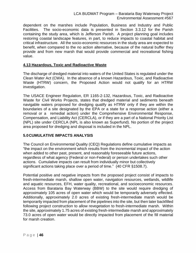
LCA BUDMAT Program – Barataria Bay Waterway Project Environmental Assessment #567
P a g e | 46
dependent on the marshes include Population, Business and Industry and Public Facilities. The socio-economic data is presented in Section 3.3.12 for the Parish containing the study area, which is Jefferson Parish. A project planning goal includes restoring coastal landscape features, in part, to reduce impacts to coastal habitat and critical infrastructure. All the socio-economic resources in the study area are expected to benefit, when compared to the no action alternative, because of the natural buffer they provide and from new marsh that would provide commercial and recreational fishing value. 4.13 Hazardous, Toxic and Radioactive Waste The discharge of dredged material into waters of the United States is regulated under the Clean Water Act (CWA). In the absence of a known Hazardous, Toxic, and Radioactive Waste (HTRW) concern, the Proposed Action would not qualify for an HTRW investigation. The USACE Engineer Regulation, ER 1165-2-132, Hazardous, Toxic, and Radioactive Waste for Civil Works Projects, states that dredged material and sediments beneath navigable waters proposed for dredging qualify as HTRW only if they are within the boundaries of a site designated by the EPA or a state for a response action (either a removal or a remedial action) under the Comprehensive Environmental Response, Compensation, and Liability Act (CERCLA), or if they are a part of a National Priority List (NPL) site under CERCLA (NPL is also known as Superfund). No portion of the project area proposed for dredging and disposal is included in the NPL. 5.0 CUMULATIVE IMPACTS ANALYSIS The Council on Environmental Quality (CEQ) Regulations define cumulative impacts as “the impact on the environment which results from the incremental impact of the action when added to other past, present, and reasonably foreseeable future actions, regardless of what agency (Federal or non-Federal) or person undertakes such other actions. Cumulative impacts can result from individually minor but collectively significant actions taking place over a period of time.” (40 CFR §1508.7). Potential positive and negative impacts from the proposed project consist of impacts to fresh-intermediate marsh, shallow open water, navigation resources, wetlands, wildlife and aquatic resources, EFH, water quality, recreational, and socioeconomic resources. Access from Barataria Bay Waterway (BBW) to the site would require dredging of approximately 105 acres of open water which would be temporarily adversely effected. Additionally, approximately 2.0 acres of existing fresh-intermediate marsh would be temporarily impacted from placement of the pipelines into the site, but then later backfilled following project construction to allow revegetation to fresh-intermediate marsh. Within the site, approximately 1.75 acres of existing fresh-intermediate marsh and approximately 73.0 acres of open water would be directly impacted from placement of the fill material for marsh creation.
LCA BUDMAT Program – Barataria Bay Waterway Project Environmental Assessment #567
P a g e | 47
Overall, the cumulative impacts of the proposed action are a net benefit of approximately 17.0 AAHUs of fresh-intermediate marsh. This is expected to have long-term benefits to wetlands, EFH, fisheries and wildlife resources, water quality, and potentially to socio-economic resources and recreational opportunities in the project area. Cumulatively, the Basin would benefit from the creation of approximately 75 acres of fresh-intermediate marsh with additional acres of marsh created from other previously constructed 2017 State Master Plan and CWPPRA projects. Future reasonably foreseeable projects would accrue further benefits for any constructed marsh projects in the vicinity. Because fresh-intermediate marsh has been shown to provide a greater reduction in hurricane storm surge than open water, created marsh habitat would offer a benefit in minimizing hurricane damage. 6.0 MITIGATION An assessment of the potential environmental impacts to important resources found that the approved project and the proposed changes would have only minimal and insignificant impacts to resources in the project area. Any losses of fisheries resources related to the removal of shallow open water bottom by placement of dredged material are out-weighed by the considerable fisheries benefits anticipated from the beneficial use of material dredged from the Barataria Bay Entrance Y, upper BBW reach, and flotation access channel from BBW to the project site. The placement of dredged material would create approximately 75 acres of productive marsh, marsh-related EFH (e.g., marsh edge, inner marsh, tidal creeks, marsh/water interface, etc.), and other aquatic habitat in the surrounding waters. With the creation of marsh and other productive habitat types in the proposed disposal areas, the long-term and cumulative impacts of the placement of dredged material are generally beneficial. Beneficial utilization of the dredged material for marsh creation would result in overall positive environmental benefits including a net increase of valuable breeding, nesting, foraging, and cover habitat utilized by a wide variety of fish and wildlife species. Therefore, no wetlands mitigation is required. 7.0 COORDINATION AND PUBLIC INVOLVEMENT A Public Notice for EA #567 will be published in the Baton Rouge and New Orleans Advocate for 30 days beginning Month XX, XXXX and ending Month XX, XXXX. Preparation of this EA and FONSI is being coordinated with appropriate Congressional, federal, Tribal, state, and local interests, as well as environmental groups and other interested parties. The following agencies, as well as other interested parties, are receiving copies of the draft EA and draft FONSI: U.S. Department of the Interior, Fish and Wildlife Service U.S. Environmental Protection Agency, Region VI U.S. Department of Commerce, National Marine Fisheries Service U.S. Natural Resources Conservation Service, State Conservationist Coastal Protection and Restoration Authority Board of Louisiana Advisory Council on Historic Preservation

LCA BUDMAT Program – Barataria Bay Waterway Project Environmental Assessment #567
P a g e | 48
Governor's Executive Assistant for Coastal Activities Louisiana Department of Wildlife and Fisheries Louisiana Department of Natural Resources, Coastal Management Division Louisiana Department of Natural Resources, Coastal Restoration Division Louisiana Department of Environmental Quality Louisiana State Historic Preservation Officer Jefferson Parish Government 8.0 COMPLIANCE WITH ENVIRONMENTAL LAWS AND REGULATIONS There are many federal and state laws pertaining to the enhancement, management and protection of the environment. Federal projects must comply with environmental laws, regulations, policies, rules and guidance. Compliance with laws would be accomplished upon 30-day public and agency review of this EA #567 and associated Finding of No Significant Impact. Executive Order (E.O.) 11988 Floodplain Management Executive Order 11988 directs federal agencies to reduce flood loss risk; minimize flood impacts on human safety, health, and welfare; and restore and preserve the natural and beneficial values served by flood plains. Agencies must consider alternatives to avoid adverse and incompatible development in the flood plain. If the only practical alternative requires action in the flood plain, agencies must design or modify their action to minimize adverse impacts. The proposed action represents the least environmentally damaging alternative to accomplish the needed risk reduction system modifications. Clean Air Act of 1972 The Clean Air Act (CAA) sets goals and standards for the quality and purity of air. It requires the Environmental Protection Agency to set National Ambient Air Quality Standards (NAAQS) for pollutants considered harmful to public health and the environment. The project area is in Jefferson Parish, which is currently in attainment of NAAQS. The Louisiana Department of Environmental Quality is not required by the CAA and Louisiana Administrative Code, Title 33 to grant a general conformity determination. Clean Water Act of 1972 – Section 401 and Section 404 The Clean Water Act (CWA) sets and maintains goals and standards for water quality and purity. Section 401 requires a Water Quality Certification from the Louisiana Department of Environmental Quality (LDEQ) that a proposed project does not violate established effluent limitations and water quality standards. Coordination with LDEQ for a State Water Quality Certification remains ongoing for the proposed marsh creation site as of the time of public review. As required by Section 404(b)(1) of the CWA, an evaluation to assess the short- and long-term impacts associated with the discharge of dredged and fill materials into waters of the United States resulting from this Project has been completed. The Section 404(b)(1) public notice would be mailed for concurrent public and agency review with draft EA #567
LCA BUDMAT Program – Barataria Bay Waterway Project Environmental Assessment #567
P a g e | 49
on February 7, 2019. The 404(b)(1) and public notice is included in Appendix E of this EA #567 and would be signed upon completion of public review and comment. Coastal Zone Management Act of 1972 The Coastal Zone Management Act (CZMA) requires that "each federal agency conducting or supporting activities directly affecting the coastal zone shall conduct or support those activities in a manner which is, to the maximum extent practicable, consistent with approved state management programs." Coordination with LDNR with Coastal Zone Permit C20190004 remains ongoing with intent to modify the permit to allow soil borings on the site for geotechnical analysis. Endangered Species Act of 1973 The Endangered Species Act (ESA) is designed to protect and recover threatened and endangered (T&E) species of fish, wildlife and plants. On January 30, 2019, The USFWS issued a NLAA letter for listed T&E species, including the West Indian manatee, migratory shorebirds, and species of management concern (i.e. rare and very species) that are known to occur or believed to occur within the vicinity of the project area. No plants were identified as being threatened or endangered in the project area (See T&E Species concurrence letter in Appendix B). The proposed action would include Standard Manatee Conditions for In-Water Activities with the contractor instructing all personnel regarding the potential presence of manatees in the project area, and the need to avoid collisions with these animals. If a manatee(s) is sighted within 100 yards of the project area, moving equipment must be kept at least 50 feet away from the manatee or shut down. There would be restrictions on vessel operation, restrictions on the use of siltation barriers, and mandatory signage designed to avoid any harm to manatees in the project area. More specific information would be contained in the dredging contracts. EA #567 will be made available to agencies and CEMVN expects that USFWS will concur in its determination that the project will have no adverse effect to threatened and endangered species. Fish and Wildlife Coordination Act of 1934 The Fish and Wildlife Coordination Act (FWCA) provides authority for the USFWS involvement in evaluating impacts to fish and wildlife from proposed water resource development projects. It requires that fish and wildlife resources receive equal consideration to other project features. It requires federal agencies that construct, license or permit water resource development projects to first consult with the USFWS, NMFS and state resource agencies regarding the impacts on fish and wildlife resources and measures to mitigate these impacts. Section 2(b) requires the USFWS to produce a Coordination Act Report (FWCAR) that details existing fish and wildlife resources in a project area, potential impacts due to a proposed project and recommendations for a project. The USFWS reviewed the proposed marsh creation project described in EA #567 and provided a draft FWCAR with project specific recommendations on December 14, 2018, and coordination is ongoing. The FONSI would be signed pending completion of all coordination.

LCA BUDMAT Program – Barataria Bay Waterway Project Environmental Assessment #567
P a g e | 50
The Draft FWCAR can be found in Appendix B and CEMVN’s responses to the USFWS recommendations are as follows: 1. West Indian manatee conservation measures from the Future Fish and Wildlife Resources section of this report should be included in all contracts, plans, and specifications for in-water work in areas where the manatee may occur. Response 1 – Concur. Manatee conservation procedures would be included in all contracts, plans, and specifications for in-water work in areas where the manatee may occur. 2. Avoid adverse impacts to water bird colonies through careful design of project features and timing of construction. Should on-site contractors and/or inspectors observe potential nesting activity, coordination with the LDWF and the Service should occur. Response 2 - Concur. Bird abatement procedures would be implemented to prevent wading birds (i.e., herons, egrets, night-herons, ibis, and roseate spoonbills), anhingas, and/or cormorants from nesting during their nesting period. In the event that implementation of the bird abatement plan is not successful and nesting does occur, all activity occurring within 1,000 feet of a nesting colony would be restricted to the non-nesting period. For nesting brown pelicans, activity should be avoided within 2,000 feet of the colony. Activity would be restricted within 650 feet of nesting black skimmers, gulls, and terns. 3. The impacts to Essential Fishery Habitat should be discussed with the NMFS to determine if the project complies with the Magnuson-Stevens Fishery Conservation and Management Act (MSFCMA), Magnuson-Stevens Act; P.L. 104-297, as amended) and its implementing regulations. Response 3 - Concur. The NMFS is a part of the Project Delivery Team. 4. Access corridors across existing wetlands should be avoided if possible. Impacted wetlands should be restored to a substrate elevation similar to the surrounding marsh. Flotation access channels in open water should be backfilled upon project completion. Post-construction surveys (e.g., centerline surveys) should be taken to ensure access channels have been adequately backfilled. That information should be provided to the natural resource agencies for review.
Response 4 - Concur. Access corridors across existing wetlands would be avoided if possible. If existing wetlands are impacted they would be restored to pre-project elevation and expected to re-vegetate naturally. If needed, at CEMVN’s discretion, post-construction surveys would be taken and provided to the natural resource agencies for review. 5. To ensure that dredged material is placed to specified elevations, we recommend that the USACE use an updated NAVD88 datum (i.e., current geoid) consistent with the
LCA BUDMAT Program – Barataria Bay Waterway Project Environmental Assessment #567
P a g e | 51
NAVD88 datum that is referenced for the elevations of existing marsh and water level in the project area. Response 5: Concur. GEOID is a model of global mean sea level that is used to measure precise surface elevations for the project area. 6. Further detailed planning of project features (e.g., Design Documentation Report, Engineering Documentation Report, Plans and Specifications, or other similar documents) should be coordinated with the Environmental Protection Agency (EPA), Louisiana Department of Natural Resources (LDNR), LDWF, NMFS, and USFWS. The USFWS shall be provided an opportunity to review and submit recommendations on the all work addressed in those reports as authorized in FWCA Sections 2a, 2e, and 2f (48 Stat. 401, as amended; 16 U.S.C. 661 et seq.) which states that any water resource development project with a federal nexus will coordinate with the USFWS (including NMFS and the state equivalent, in this case LDWF) during all levels of planning, engineering and construction. Response 6 - Concur. 7. Any proposed change in project features or plans should be coordinated in advance with the EPA, LDNR, LDWF, NMFS, and USFWS. Response 7 - Concur. CEMVN will continue to coordinate with the resource agencies. 8. The LCA BUDMAT program specifies that monitoring and adaptive management plans are required for beneficial use habitat creation projects. The USACE should coordinate with the USFWS during development of those plans. Response 8 – Concur. The Corps has coordinated with USFWS on various aspects of the project throughout development. A monitoring plan was developed to determine ecological success of this project and has been communicated to USFWS via the draft report (See Appendix H). All projects implemented under the LCA BUDMAT Program were considered and evaluated for application of adaptive management pursuant to the requirements of WRDA 2007, Section 2039 and Implementation guidance for Section 2039, and it was determined that only projects characterized by high uncertainty in achieving results will need to include specific costs and actions for adaptive management. The uncertainty and risks associated with success of LCA BUDMAT Program projects in general, and this proposed project specifically, were considered to be “low.” Therefore, a detailed cost and adaptive management plan is not warranted for this project. 9. The USFWS recommends that the USACE contact the USFWS for additional consultation if: 1) the scope or location of the proposed project is changed significantly, 2) new information reveals that the action may affect listed species or designated critical habitat; 3) the action is modified in a manner that causes effects to listed species or designated critical habitat; or 4) a new species is listed or critical habitat designated.
LCA BUDMAT Program – Barataria Bay Waterway Project Environmental Assessment #567
P a g e | 52
Additional consultation as a result of any of the above conditions or for changes not covered in this consultation should occur before changes are made and or finalized. Response 9 – Concur. Further consultation with USFWS would occur for the abovementioned reasons if they arise. Hazardous, Toxic, and Radioactive Waste The discharge of dredged material into waters of the United States is regulated under the CWA. In the absence of a known Hazardous, Toxic, and Radioactive Waste (HTRW) concern, the proposed action would not qualify for an HTRW investigation. Engineer Regulation (ER) 1165-2-132 provides that in the Planning, Engineering and Design (PED) Phase that, for proposed project in which the potential for HTRW problems has not been considered, an HTRW initial assessment, as appropriate for a reconnaissance study, should be conducted as a first priority. If the initial assessment indicates the potential for HTRW, testing, as warranted and analysis similar to a feasibility study should be conducted prior to proceeding with the project design. The NFS (non-federal sponsor), Jefferson Parish, would be responsible for planning and accomplishing any HTRW response measures, and would not receive credit for the costs incurred. An ASTM E 1527-05 Phase 1 Environmental Site Assessment (ESA), HTRW 16-01 dated 17 July 2018, was completed for the project area and a copy is being maintained on file at CEMVN. The probability of encountering HTRW for the proposed action is low based on the initial site assessment. If a recognized environmental condition (REC) is identified in relation to the project area, the U.S. Army Corps of Engineers, New Orleans District would take the necessary measures to avoid the REC so that the probability of encountering or disturbing HTRW would continue to be low. Magnuson-Stevens Fisheries Conservation and Management Act The Magnuson-Stevens Fishery Conservation and Management Act, as amended, PL 104-208, addresses the authorized responsibilities for the protection of Essential Fish Habitat (EFH) by NMFS in association with regional fishery management councils. Coordination of the changes proposed in this EA will take place during the public comment period. EA #567 will be made available to agencies and CEMVN expects no effect to Essential Fish Habitat. Migratory Bird Treaty Act The project area is known to support colonial nesting wading/water birds (e.g., herons, egrets, ibis, night-herons and roseate spoonbills) and shorebirds (terns and gulls). Based on review of existing data, site visits, and with the use of USFWS guidelines, the CEMVN finds that implementation of the proposed actions would have no effect on colonial nesting water/wading birds or shorebirds. USFWS and USACE biologists would survey the proposed project area before construction to confirm no nesting activity as suitable habitat and the potential for nesting exist within the project area. If active nesting exists within 1,000 feet (water birds) or 1,300 feet (shorebirds) of construction activities then USACE, in coordination with USFWS, would develop specific measures to avoid adverse impacts

LCA BUDMAT Program – Barataria Bay Waterway Project Environmental Assessment #567
P a g e | 53
to those species. A detailed nesting prevention plan may be necessary in order to deter birds from nesting within the aforementioned buffer zones of the Project footprint in order to avoid adverse impacts to these species. If a nesting prevention plan is necessary, it would be prepared in coordination with USFWS. The bald eagle was removed from the List of Endangered and Threatened Species in August 2007 but continues to be protected under the Bald and Golden Eagle Protection Act (BGEPA) and the Migratory Bird Treaty Act of 1918, as amended (MBTA). During nesting season, construction must take place outside of USFWS/LDWF buffer zones. A Corps Biologist and USFWS Biologist would survey for nesting birds. This would be done prior to the start of construction. E.O. 12898 Environmental Justice USACE is obligated under E.O. 12898 of 1994 and the Department of Defense’s Strategy on Environmental Justice of 1995, which direct federal agencies to identify and address any disproportionately high adverse human health or environmental effects of federal actions to minority and/or low-income populations. Minority populations are those persons who identify themselves as Black, Hispanic, Asian American, American Indian/Alaskan Native, Pacific Islander, or some other race or a combination of two or more races. A minority population exists where the percentage of minorities in an affected area either exceeds 50 percent or is meaningfully greater than in the general population. Low-income populations are those whose income is the Census Bureau’s statistical poverty threshold for a family of four. The Census Bureau defines a “poverty area” as a census tract or block numbering area with 20 percent or more of its residents below the poverty threshold level and an “extreme poverty area” as one with 40 percent or more below the poverty threshold level. Because the population within the study area does not meet the threshold for being a minority population or a poverty area, this project does not require additional evaluation of environmental justice considerations. National Historic Preservation Act of 1966 Section 106 of the National Historic Preservation Act of 1966, as amended, requires federal agencies to take into account the effects of their undertakings on historic properties and afford the Advisory Council on Historic Preservation a reasonable opportunity to comment on such undertakings. The procedures in 36 CFR Part 800 define how federal agencies meet these statutory responsibilities. The Section 106 process seeks to accommodate historic preservation concerns with the needs of Federal undertakings through consultation among the agency official and other parties with an interest in the effects of the undertaking on historic properties, including the SHPO or Tribal Historic Preservation Officer (THPO) and any Tribe that attaches religious or cultural significance to historic properties that may be affected by an undertaking. The goal of consultation is to identify historic properties potentially affected by the undertaking, assess its effects and seek ways to avoid, minimize or mitigate any adverse effects on historic properties. Consultation pursuant to Section 106 has been completed and a finding of no historic properties affected, was coordinated for the original Project goals as presented in EA #567, with a letter dated December 4, 2018 to the SHPO, and a response dated January 7, 2019 (Appendix B).

LCA BUDMAT Program – Barataria Bay Waterway Project Environmental Assessment #567
P a g e | 54
Tribal Consultation NEPA, Section 106 of the National Historic Preservation Act, EO 13175 (“Consultation and Coordination with Indian Tribal Governments”), the American Indian Religious Freedom Act, and related statutes and policies have a consultation component. In accordance with CEMVN’s responsibilities under NEPA, Section 106, and EO 13175, CEMVN will offer the following federally-recognized Indian Tribes the opportunity to review and comment on the potential of the proposed action to significantly affect protected tribal resources, tribal rights, or Indian lands: Alabama-Coushatta Tribe of Texas, Chitimacha Tribe of Louisiana, Choctaw Nation of Oklahoma, Coushatta Tribe of Louisiana, Mississippi Band of Choctaw Indians, Jena Band of Choctaw Indians, Seminole Tribe of Florida, Seminole Nation of Oklahoma, Tunica-Biloxi Tribe of Louisiana Muscogee Nation of Louisiana. On December 4, 2018, letters were mailed to the tribal leaders requesting input regarding the proposed action. There were 2 responses received by January 4, 2019, which marked the end of the comment and review period (December 20, 2018 and Jan 4, 2019). 9.0 CONCLUSION CEMVN has assessed the environmental impacts of the recommended TSP on relevant resources in EA #567 and has determined that the proposed action would have no significant adverse impact on the human and natural environment. The proposed action would allow for the beneficial use of material dredged from routine maintenance dredging of a federal navigation channel to be deposited in the project area for marsh and ridge creation and restoration. Beneficial use-placement of dredged material in the proposed site would result in the creation of approximately 75 acres (17.0 AAHUs) of fresh-intermediate marsh habitat over the 50 year period of analysis. 10.0 PREPARED BY EA #567 and the associated FONSI were prepared by Daniel Meden, Biologist, U.S. Army Corps of Engineers, New Orleans District; Regional Planning and Environment Division South, MVN-PDS-C; 7400 Leake Avenue; New Orleans, Louisiana 70118.
Title/Topic Team Member
Environmental Manager, Navigation, Wetlands, Aquatic Resources/Fisheries, EFH, Wildlife, Threatened, Endangered, and Protected Species, Water and Sediment Quality, Appendices
Daniel Meden, CEMVN-PDS-C
Plan Formulation Louise Williams, CEMVN-PDP-F
Geographic Information System Eric Williams, CEMVN-PDS-N Lee Neher, CEMVN-ED-L
Threatened and Endangered Species Coordination
Daniel Meden, CEMVN-PDS-C

LCA BUDMAT Program – Barataria Bay Waterway Project Environmental Assessment #567
P a g e | 55
Water Quality, 404 (b)(1) Whitney Hickerson, CEMVN-EDH
Cultural Resources, Tribal Consultation Paul Hughbanks, CEMVN-PDS-N
Aesthetics John Milazzo, CEMVN-PDS-N
Recreation, Environmental Justice, Socioeconomics
Andrew Perez, CEMVN-PDS-N
Air Quality, HTRW Joseph Musso, CEMVN-PDC-C
Cumulative Impacts Daniel Meden, CEMVN-PDS-C, William Klein, CEMVN-PDS-C
District Quality Control Eric Willliams, CEMVN-PDS-N, Jared Everitt, CEMVN-PDP-W
Assistant District Counsel Maurya Kilroy, CEMVN-OC Ann Tran, CEMVN-OC Gloria Croft, CEMVN-OC
Project Manager Daimia Jackson, CEMVN PM-BC
Engineering Jason Binet, CEMVN-ED-LW Kim Tessitore, CEMVN-ED-LW
Tribal Consultation Jason Emery, CEMVN-PDS-N
11.0 REFERENCES
Britsch, L.D. and J.B. Dunbar. 1990. Geomorphic Investigation of Davis Pond, Louisiana.
Department of the Army, Wateways Experimental Station, Corps of Engineers, Vicksburg, Mississippi.
Chew, DL. Louisiana Coastal Area, Louisiana. Freshwater Diversion to Barataria and
Breton Sound Basins. Feasibility Study. Volume 1. Draft Main Report. Draft Environmental Impact Statement. Retrieved 4 January 2019 from https://apps.dtic.mil/docs/citations/ADA143558.
Couvillion, B.R.; Beck, H.; Schoolmaster, D., and Fischer, M. 2017. Land area change in
coastal Louisiana (1932 to 2016). U.S. Geological Survey Scientific Investigations Map 3381, 16 p. pamphlet.
Earth Search, Inc. 1995. Cultural Resource Survey and Testing of Natural Resources
Conservation Service Project BA-2 Supplement No. 2. Earth Search, Inc. New Orleans, LA.
Programmatic EIS entitled “Louisiana Coastal Area Beneficial Use of Dredged Material
Program” with a signed ROD dated August 13, 2010. Programmatic EIS entitled “Louisiana Coastal Area, Louisiana, Ecosystem Restoration
Program, November 2004” with a signed ROD dated November 18, 2005.