environment directorate, lancashire county council
TRANSCRIPT


Environment Directorate, Lancashire County CouncilPrinted on recycled paper. 84073.
ww
w.w
estp
enni
nem
oors
.com

Belthorn VillageBelthorn VillageBelthorn VillageBelthorn Village
Heritage T
rail
Heritage T
railOne in a series of villa
ge One in a series of villa
ge
based Heritage Trails within based Heritage Trails within
the West Pennine Moorsthe West Pennine Moors
BelthornHeritage TrailMAP & GUIDEMAP & GUIDE

Belthorn Village
Belthorn Village
Heritage TrailHeritage Trail
This is one in a series of Villagebased Heritage Trails, written jointly by localcommunities and Countryside Services operatingwithin the West Pennine Moors Partnership.Belthorn was a small, traditional coal mining andhand weaving village of approximately 220 housesand is situated on the edge of the West PennineMoors in East Lancashire between Blackburn andHaslingden. At over 1,000 feet above sea level,Belthorn is one of the highest villages in Lancashireand this walk is set in the hillside around the villageand can be quite strenuous in parts.You should allow approximately 2 hours for thewalk, which is about 21/4 miles (3.5km) long. Beforesetting out it is advisable that the correct clothing isworn, dependent on the time of year. A 1:25,000scale map may also come in handy. Except for anyhot dry period during summer, stout walking bootsare strongly recommended.Some features of this walk, such as stiles or fences,may change over time.You should therefore always take an up-to-datemap so that you can check your whereabouts ifthe signs quoted are not present.
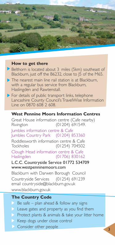
How to get thereBelthorn is located about 3 miles (5km) southeast ofBlackburn, just off the B6232, close to J5 of the M65.The nearest main line rail station is at Blackburn,with a regular bus service from Blackburn,Haslingden and Rawtenstall.For details of public transport links, telephoneLancashire County Council’s TravelWise InformationLine on 0870 608 2 608.
West Pennine Moors Information CentresGreat House information centre (Cafe nearby)Rivington (01204) 691549.Jumbles information centre & CafeJumbles Country Park (01204) 853360Roddlesworth information centre & CafeTockholes (01254) 704502Clough Head information centre & CafeHaslingden (01706) 830162L.C.C. Countryside Service 01772 534709www.westpenninemoors.com Blackburn with Darwen Borough CouncilCountryside Services (01254) 691239email [email protected]
The Country CodeBe safe – plan ahead & follow any signsLeave gates and property as you find themProtect plants & animals & take your litter homeKeep dogs under close controlConsider other people
3

4
The walk starts and finishes at the DogInn and is approximately 3.5km (21/4 miles) in length.1.The ‘Dog Inn’ is easily found in the centre ofthe village on Belthorn Road. If we start our walkhere, you will see the drum shop directlyopposite.Originally the ‘Grimshaw Park Co-op’ store, itprovided the main source of provisions for villagers.There are still residents in the village who workedthere as youngsters. At the side of the drum shopis Holden Street, where the last remaining villageshop/post office is located. This is your last chanceto stock up with crisps, chocolate and soft drinks.2. Continue along Holden Street (which wasbuilt around 200 years ago for handloom weavers)until you come to a swing gate, which gives youaccess to the recreation ground. Walk clockwisearound the perimeter.If you look to the far distance (NNE) you will
probably see 2 plumes of white smoke. These arethe flues of ‘Ribble Valley Cement’ of Clitheroe andto their right the mass of Pendle Hill, famous for itswitches long ago. In the middle distance you cansee a line of traffic on the M65 and the largeresidential area of Accrington.3. Continue around the perimeter, passing a ‘dogbin’ for your pets’ convenience should it be required.When you reach the wall end turn right intoDonkey Ginnel, running adjacent to the villagecemetery. Continue through to Chapel Street withits short stone cobbled road surface and so on toBelthorn Road.

If you look downhill from thispoint you will see a terrace of cottages on theright hand side. These were built over 200 yearsago, originally with no back doors. The only accesswas via the front door; their toilets (privies) weresited on the opposite side of the road where thedetached bungalows now stand.4. Turn left up Belthorn Road and you come toBelthorn Primary School on your left. A shortdistance further up the hill you will see 2 similarstone-built bungalows on the right-hand side.This is where the previous school once stood andthe bungalows now occupying the site were largelybuilt of recovered stone from the old school.Further up the hill and again on the right you willsee a large detached house. This was originally an Inn and was built in 1792 by Robert Yates andknown as ‘Bell in the Thorn’. Just before the top of the hill, Bank Fold Lane falls away sharply. Theadjacent corner house was once Belthorn PoliceStation and the village constable resided here.5. Continue straight ahead, coming off the highwayon to an unmade bridleway called Tower View.The house on the corner of Belthorn Road andTower View was once a windmill and, dependenton the weather on the day of your walk, you willunderstand why it was sited just there. From thislocation you can see Blackpool Tower sticking upon the horizon and just to the left you can see‘The Big One’ on the Pleasure Beach. Further tothe left is Darwen Tower and to the left again youwill see the TV and radio transmission mast atWinter Hill above Horwich. If it is particularlyclear, look towards Blackpool and you can see theRiver Ribble estuary. 5
6
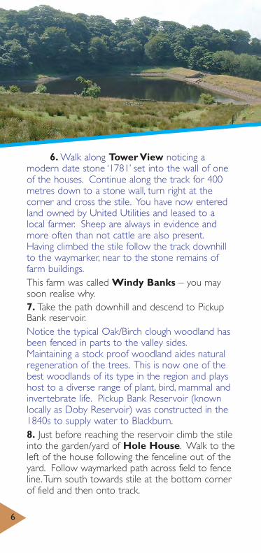
6. Walk along Tower View noticing amodern date stone ‘1781’ set into the wall of oneof the houses. Continue along the track for 400metres down to a stone wall, turn right at thecorner and cross the stile. You have now enteredland owned by United Utilities and leased to alocal farmer. Sheep are always in evidence andmore often than not cattle are also present.Having climbed the stile follow the track downhillto the waymarker, near to the stone remains offarm buildings.This farm was called Windy Banks – you maysoon realise why.7. Take the path downhill and descend to PickupBank reservoir.Notice the typical Oak/Birch clough woodland hasbeen fenced in parts to the valley sides.Maintaining a stock proof woodland aides naturalregeneration of the trees. This is now one of thebest woodlands of its type in the region and playshost to a diverse range of plant, bird, mammal andinvertebrate life. Pickup Bank Reservoir (knownlocally as Doby Reservoir) was constructed in the1840s to supply water to Blackburn.8. Just before reaching the reservoir climb the stileinto the garden/yard of Hole House. Walk to theleft of the house following the fenceline out of theyard. Follow waymarked path across field to fenceline.Turn south towards stile at the bottom cornerof field and then onto track.

The following is a short and verysteep optional detour to the ‘New Inn’.After crossing the stream at Dick Bridge climb thestile ahead of you to walk steeply uphill crossingthe broken wall to the top. Go over a stile in thewall and walk to the left to the house.
This is the former ‘New Inn’. An inscribedstone flag set into the wall above the porch reads,“New Inn, licensed dealer in foreign and Britishspirits, ale, beer, porter, tobacco, by order 1837”.Apparently, many years ago, prisoners beingtransferred between the courts in Manchester andLancaster Prison would be lodged there overnightand shackled to the walls of the cellar. This wasalso the site of Dick Bridge Mills, c1780, whichclosed after the construction of the reservoir.Retrace your steps back to Dick Bridge.9. Follow the track with the stream to your rightperhaps catching glimpses of Brown Trout and Gigfish temporarily trapped in deeper pools. Cross asecond small bridge and turn sharp right followingthe track back up to Belthorn.Approximately 400 metres along this track youshould notice the remains of the old collierysidings on the left-hand side. If you look down the hillside you will see what appears to be theremains of a boundary wall or hedge. This is in fact all that is left of a double track narrow gaugerailway line. Many years ago, coal mining was alocal industry with sites in the area of the GraneRoad. This rail track was used to transport thecoal from Belthorn to a lower level. The methodused was to fill small wagons with coal at the topof the hill, the weight of which propelled them 7

8
downhill, at the same time pulling the empty,lighter wagons up the hill to be filled in their turn.10. Just past the colliery workings at an S-bendin the track, look again into the field on the left andnotice a small, square, low-walled compound withtwo Sycamore trees.This is in fact a recently restored burial ground forthe once locally prominent Scholes family. Lookingsouth back to the ‘New Inn’, notice to the right onthe pinnacle of a hill a second similar graveyard.Many people believe these small graveyards to beQuaker burial grounds. This graveyard along withthe second New Inn both have headstones, whichis the giveaway. Quakers did reside in the area anda third much larger burial ground exists nearbywithout any memorial stones. Their basic lifestylehad no need for such indulgences.11. From now on you are steadily climbing uphill,passing isolated cottages and formerfarmhouses all on the left-hand side.Many years ago Bank Fold House, (now namedLower Bank Fold Farm) whose gable faces the left-hand side of the lane, was the home of a ‘lady’occupied in the ‘oldest profession’, who providedher service to passing miners on their way to andfrom the coal mines at the bottom of the hill.It was said she sat in a rocking chair on the side of the veranda plying her trade.12. Turn sharp left and walk past the frontage ofLower Bank Fold Farm. Looking uphill to yourright, the gable end of Higher Bank Fold Lane Farmwill be visible.
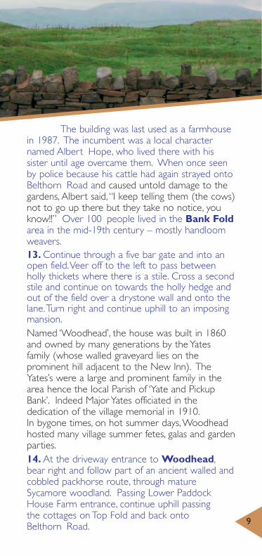
The building was last used as a farmhousein 1987. The incumbent was a local characternamed Albert Hope, who lived there with hissister until age overcame them. When once seenby police because his cattle had again strayed ontoBelthorn Road and caused untold damage to thegardens, Albert said, “I keep telling them (the cows)not to go up there but they take no notice, youknow!!” Over 100 people lived in the Bank Foldarea in the mid-19th century – mostly handloomweavers.13. Continue through a five bar gate and into anopen field.Veer off to the left to pass betweenholly thickets where there is a stile. Cross a secondstile and continue on towards the holly hedge andout of the field over a drystone wall and onto thelane.Turn right and continue uphill to an imposingmansion.Named ‘Woodhead’, the house was built in 1860and owned by many generations by the Yatesfamily (whose walled graveyard lies on theprominent hill adjacent to the New Inn). TheYates’s were a large and prominent family in thearea hence the local Parish of ‘Yate and PickupBank’. Indeed Major Yates officiated in thededication of the village memorial in 1910.In bygone times, on hot summer days,Woodheadhosted many village summer fetes, galas and gardenparties.14. At the driveway entrance to Woodhead,bear right and follow part of an ancient walled andcobbled packhorse route, through matureSycamore woodland. Passing Lower PaddockHouse Farm entrance, continue uphill passing the cottages on Top Fold and back onto Belthorn Road. 9

Explore! Discover! Enjoy! The West Pennine Moors
10
The corner cottage (No29) was the home of thelast handloom weaver in Belthorn.Make your way back to your form of transportand we hope you have enjoyed your day in andaround our beautiful village of Belthorn.Additional InformationOrdnance Survey Explorer Series, Sheet No.287‘West Pennine Moors’ shows all the publicrights of way in the area.
Explore 90 square miles of unspoiltmoorlands, numerous reservoirs and beautifulwoodlandsDiscover hidden valleys and explore some ofthe many historic villagesEnjoy getting close to nature – see curlews,peregrines and brown haresWander the long distance walk, the WittonWeavers’Way – the full 32 miles or one offour shorter circular walksLarge areas of the West Pennine Moors aredesignated ‘Open Access’. See OrdnanceSurvey Explorer series Map No. 287 WestPennine Moors.


Farm
Parking
Public House
Cafe/Information
Toilet Facilities
Building
Heritage Trail
Woodlands
P
P
ST
FormColle
1
10
1
13
14
© Crown copyright. Lancashire County Council. Licence No. 100023320 2007.

TART
HoleHouse
DickBridge
Bank Fold
mer ery
Windy Banks
TowerView
Belthorn
PickupBank
Reservoir
School
12
3
4
8
11
12
9
5
6
7
