environment and ecology - amazon web services · components of ecosystem there are four basic...
TRANSCRIPT

ENVIRONMENT AND
ECOLOGY
SYLLABUS
Prelims:
General issues on Environmental Ecology, Bio-diversity
and Climate Change – that do not require subject
specialization.
Mains:
GS Paper 3: Conservation, environmental pollution and
degradation, environmental impact assessment

TOPICS BASED ON PREVIOUS QUESTIONS Basic Concepts of Ecology
Endangered Fauna
National Parks, Sanctuaries, Reserves etc.
International Conventions
Legislation associated with conservation
Conservation organisations
Reports
BIOSPHERE AND WORKING OF
ECOSYSTEMS
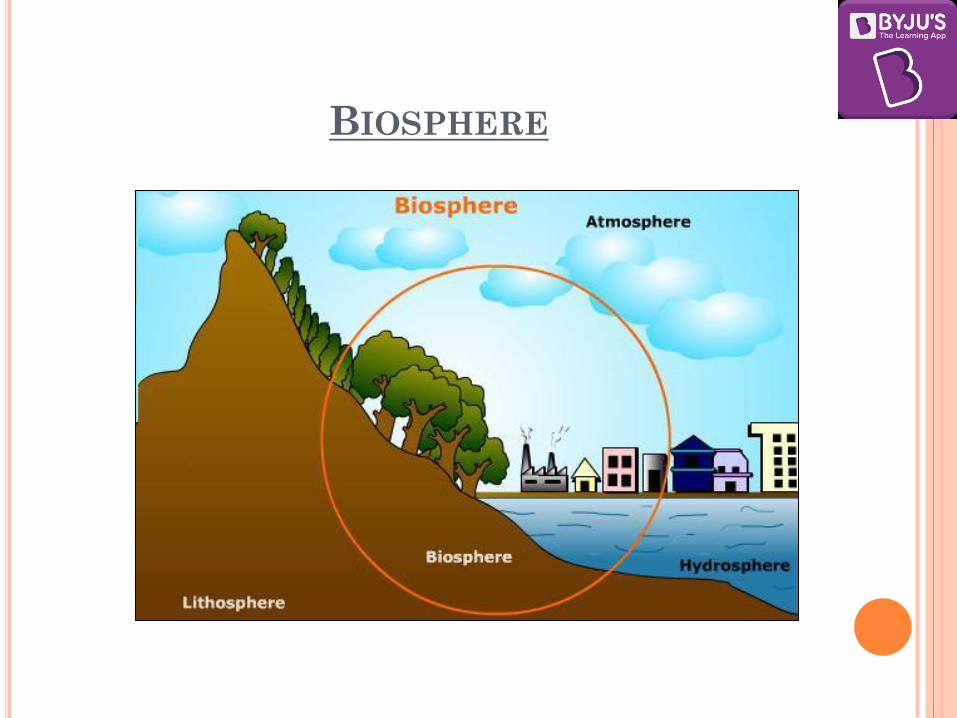
Biosphere
Biosphere is that part of lithosphere, hydrosphere and
atmosphere where plants and animals live.
Biosphere contains all life forms on earth.
The biosphere consists of -
1. all the living organisms (the biotic component),
2. energy and physical environment (the abiotic component)
There are continuous interactions between living
organisms and physical environment and among the living
organisms themselves.
BIOSPHERE
BIOSPHERE
The biosphere consists of two major systems viz.
(i) terrestrial biomes systems
(ii) aquatic biomes systems.
The terrestrial biomes systems are further comprised of three subsystems viz.,
(i) plant system,
(ii) animal system and
(iii) soil system.
These subsystems are intimately interrelated among themselves through the cyclic pathways of movements and transfer of energy and materials.

BIOSPHERE
The aquatic biomes systems are also composed of three
sub-systems viz. :
(i) Plant system,
(ii) Animal system,
(iii) Nutrients.
These three sub-systems of aquatic biomes system of the
biosphere are also intimately interrelated through cyclic
pathways of movements of energy and matter among
themselves.

ECOLOGY
Ecology can be defined as a scientific study of the interactions of organisms with their physical environment and with each other.
The term ecology is derived from the Greek word ‘oikos’ meaning ‘house’, combined with the word ‘logy’ meaning the ‘science of’ or ‘the study of ’. Literally, ecology is the study of the earth as a ‘household’, of plants, human beings, animals and micro-organisms.
A German zoologist Ernst Haeckel, who used the term as ‘oekologie’ in 1869, became the first person to use the term ‘ecology’.
The study of interactions between life forms (biotic) and the physical environment (abiotic) is the science of ecology.
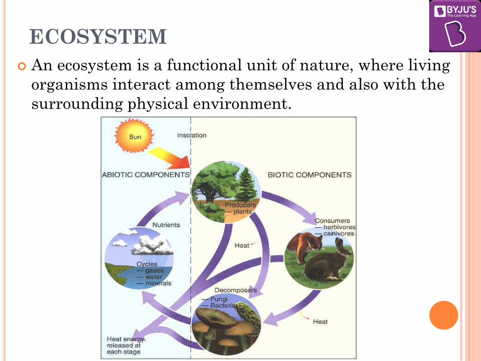
ECOSYSTEM
An ecosystem is a functional unit of nature, where living
organisms interact among themselves and also with the
surrounding physical environment.

COMPONENTS OF ECOSYSTEM
There are four basic components of an ecosystem –
1. The abiotic part, which is the non-living environment.
2. The producers or autotrophs, the green plants capable
of producing their own food by using the energy of
sunlight to make carbohydrates from water and carbon
dioxide; this process is called photosynthesis.
3. There are the consumers or heterotrophs. These are
animals which obtain their food by eating plants or other
animals. The heterotrophs in any ecosystem can be
divided into groups by their feeding habits:
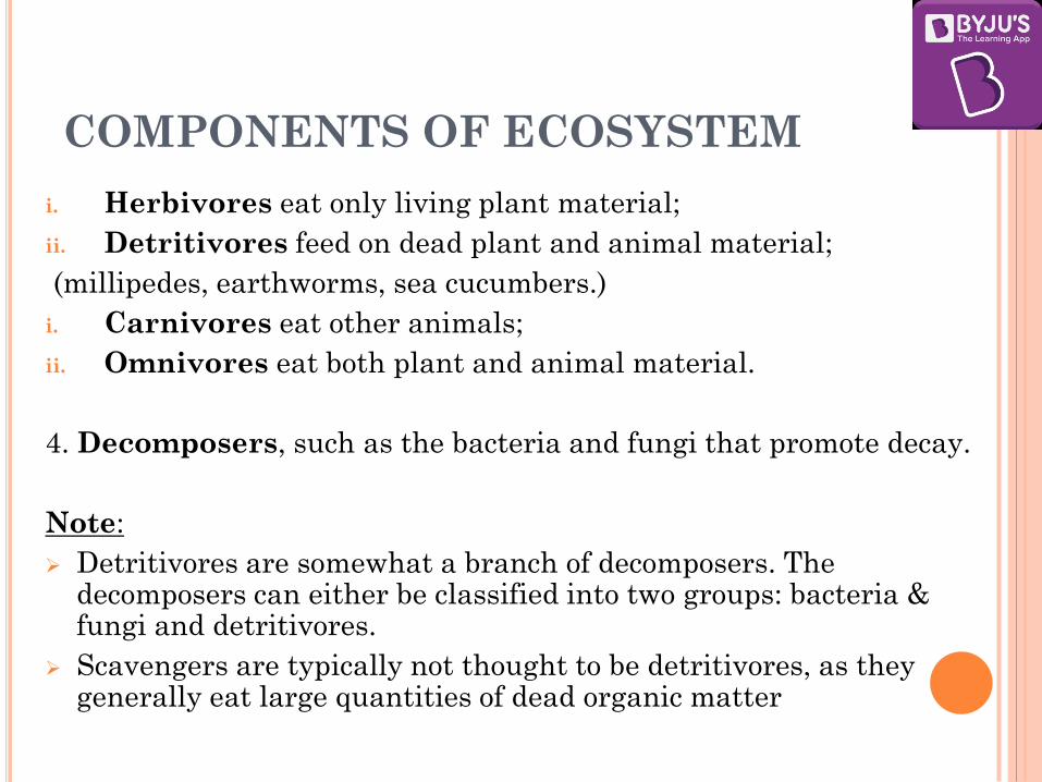
COMPONENTS OF ECOSYSTEM
i. Herbivores eat only living plant material;
ii. Detritivores feed on dead plant and animal material;
(millipedes, earthworms, sea cucumbers.)
i. Carnivores eat other animals;
ii. Omnivores eat both plant and animal material.
4. Decomposers, such as the bacteria and fungi that promote decay.
Note:
Detritivores are somewhat a branch of decomposers. The decomposers can either be classified into two groups: bacteria & fungi and detritivores.
Scavengers are typically not thought to be detritivores, as they generally eat large quantities of dead organic matter

TYPES OF ECOSYSTEM
Terrestrial Ecosystem
The ecosystem which is found only on landforms.
The main factor which differentiates the terrestrial ecosystems from the aquatic ecosystems is the relative shortage of water in the terrestrial ecosystems and as a result the importance that water attains in these ecosystems due to its limited availability.
Another factor is the better availability of light in these ecosystems as the environment is a lot cleaner in land than it is in water.
The main types of terrestrial ecosystems are the forest ecosystems, the desert ecosystems, the grassland ecosystems and the mountain ecosystems.
Aquatic Ecosystem
An ecosystem which exists in a body of water.
The aquatic ecosystems are mainly of two types, the freshwater ecosystems and the marine ecosystems.

ENERGY FLOW IN ECOSYSTEM
Sun is the primary source of energy for all ecosystems on
Earth. Of the incident solar radiation less than 50 per cent of
it is photosynthetically active radiation (PAR).
PAR refers to the solar radiation that photosynthetic
organisms are able to use in the process of photosynthesis.
Plants capture only 2-10 per cent of the PAR and this small
amount of energy sustains the entire living world.
The energy of sunlight fixed in food production by green plants
is passed through the ecosystem by food chains and webs from
one trophic level to the next. In this way, energy flows through
the ecosystem.

THE TROPHIC STRUCTURE OF ECOSYSTEMS
The organisation and pattern of feeding in an
ecosystem is known as the trophic structure.
The levels through which food energy passes from one
group of organism to the other group are called trophic
levels.

FOOD CHAIN
The chain of transformation and transfer of food
energy in the ecosystem from one group of organism to
another group through a series of steps or levels is called
food chain.
Two types of food-chains are recognised:
1. Grazing food-chain
2. Detritus food chain

GRAZING FOOD-CHAIN
In a grazing food-chain, the first level starts with
plants as producers and ends with carnivores as
consumers at the last level, with the herbivores being at
the intermediate level.
There is a loss of energy at each level which may be
through respiration, excretion or decomposition.
The trophic levels involved in a food chain range from
3 to 5 and energy is lost at each level.


DETRITUS FOOD CHAIN
This type of food chain goes from dead organic matter
into microorganisms and then to organisms
feeding on detritus (detrivores) and their
predators.
Such ecosystems are thus less dependent on direct
solar energy.
These depend chiefly on the influx of organic matter
produced in another system.
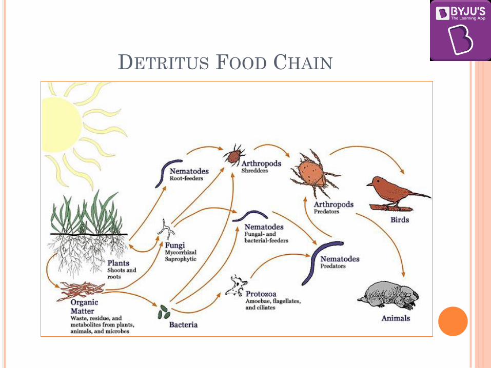
DETRITUS FOOD CHAIN

FOOD WEB
When the feeding relationship in a natural ecosystem
become more complicated, the food chain does not
remain simple and linear rather it is also complicated by
several inter-connected overlapping food chains.
This happens when greater number of species feed on
many kinds of prey.
Such complicated food chain is called food web.

ENERGY FLOW IN ECOSYSTEM
Energy is passed through the system in food chains and webs.
The flow of energy in ecosystems is unidirectional.
The important point to note is that the amount of energy decreases at successive trophic levels.
The number of trophic levels in the grazing food chain is restricted as the transfer of energy follows 10 per cent law – only 10 per cent of the energy is transferred to each trophic level from the lower trophic level.
Storage of energy in the system is shown by the amount of living material in both the plants and animals present.
ENERGY FLOW IN ECOSYSTEM
The amount of living material present is called the
standing crop.
This can be expressed in several ways but is usually
shown as biomass (living material) per unit area,
measured as dry weight, ash weight or calorific value.
Usually the amount of standing crop in each trophic
level decreases with each step on the food chain away
from the plants.
This can be shown diagrammatically by Ecological
pyramids.
ECOLOGICAL PYRAMID
It is a graphical representation designed to show
the biomass, bio productivity or the number of
organisms at each trophic level in a given ecosystem.
The base of each pyramid represents the producers or
the first trophic level while the apex represents tertiary
or top level consumer.
The three ecological pyramids that are usually studied
are:
1. pyramid of numbers
2. pyramid of biomass
3. pyramid of energy.

PYRAMID OF NUMBERS
Pyramid of Numbers is the pyramid formed by the
number of species present from one trophic level to
higher trophic levels.
The population of each organism in a food chain can be
shown in a sort of bar chart called as pyramid of
numbers.
The more organisms there are, the wider the bar.
The producer in the food chain always goes at the
bottom of the pyramid of numbers.

PYRAMID OF NUMBERS


PYRAMID OF BIOMASS
Biomass pyramid includes the total weight of the
organic matter (total biomass) of each trophic level.
Biomass is the mass of living material in each
organism multiplied by the total number of organisms in
that trophic level.
Pyramids of biomass usually are a true pyramid
shape (each level is smaller than the one below it).
The biomass in each trophic level is always less than the
trophic level below.
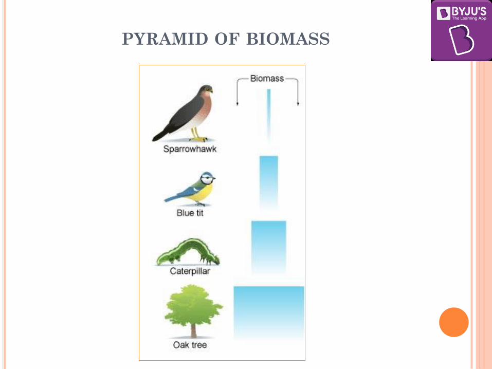
PYRAMID OF BIOMASS
PYRAMID OF ENERGY
Energy Pyramid is the pyramid representing total
amount of energy present at each trophic level of food
chain in a natural ecosystem per unit area per unit time.
The energy is expressed in kilocalories per square meter
per day or per year. (Kcal/m2/day or year)
An energy pyramid’s shape shows how the amount of
useful energy that enters each level — chemical energy
in the form of food — decreases as it is used by the
organisms in that level.
The energy that enters a community is ultimately lost to
the living world as heat.

PYRAMID OF ENERGY

INFERENCES
A given organism may occupy more than one trophic
level simultaneously. For example, a sparrow is a
primary consumer when it eats seeds, fruits, peas, and a
secondary consumer when it eats insects and worms.
In most ecosystems, all the pyramids of number, of
energy and biomass are upright, i.e., producers are
more in number and biomass than the herbivores, and
herbivores are more in number and biomass than the
carnivores.
Also energy at a lower trophic level is always more than
at a higher level.
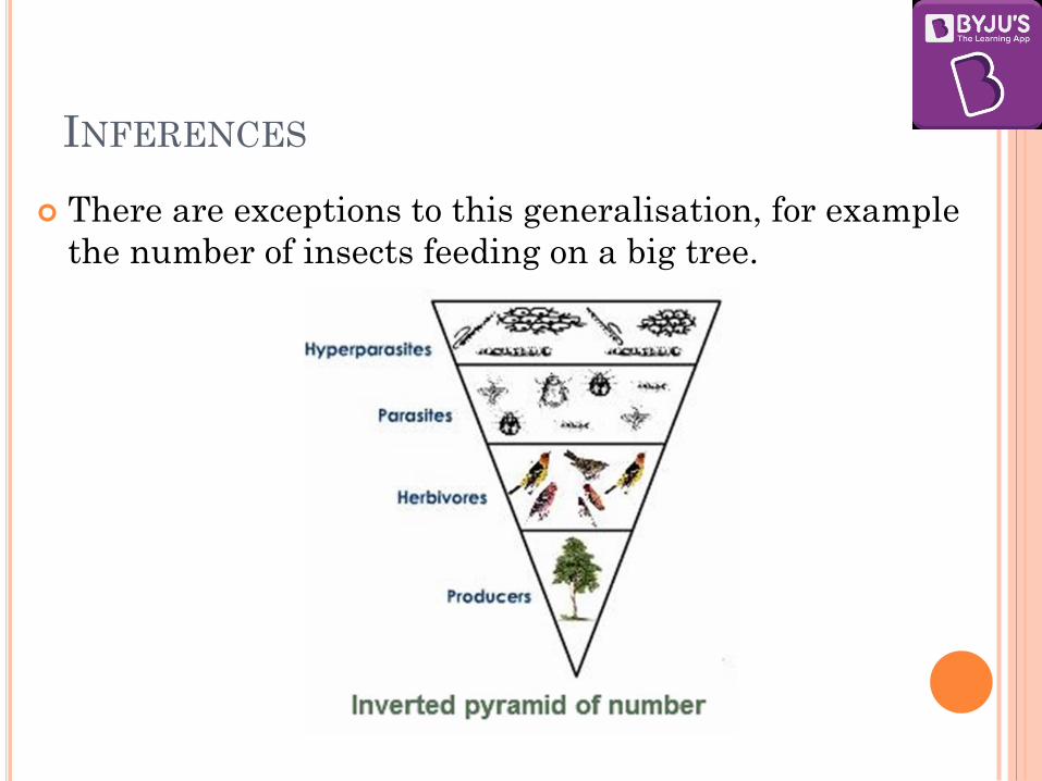
INFERENCES
There are exceptions to this generalisation, for example
the number of insects feeding on a big tree.

INFERENCES The pyramid of biomass in sea is also generally
inverted because the biomass of fishes far exceeds that of
phytoplankton.

INFERENCES
Pyramid of energy is always upright, can
never be inverted, because when energy flows
from a particular trophic level to the next trophic
level, some energy is always lost as heat at each
step

PRODUCTIVITY
In ecosystems the rate of production of organic matter
is known as productivity. Its classified into two:
1. Primary productivity refers to production at the
autotroph level, and
2. Secondary productivity refers to production at the
heterotroph level.
Primary gross productivity will depend on the efficiency of
photosynthesis and the amount of light energy coming
into the system.
The intensity and duration of sunlight varies globally
so that the potential for gross primary productivity will
vary greatly with different ecosystems.

PRODUCTIVITY
Primary productivity depends on the plant species
inhabiting a particular area. It also depends on a variety
of environmental factors, availability of nutrients
and photosynthetic capacity of plants. Therefore, it
varies in different types of ecosystems.
Secondary productivity will depend on the conversion
of plant substances to animal substances.
The efficiency of transfer of energy from one trophic level
to the next is known as ecological efficiency.

ESTIMATED NET PRODUCTIVITY OF CERTAIN
ECOSYSTEMS (IN KILOCALORIES/M2/YEAR)
Tropical rain forest 15,000
Coastal marsh 12,000
Temperate deciduous forest 5,000
Ocean close to shore 2,500
Tall-grass prairie 2,000
Open ocean 800
Desert 500
ECOLOGICAL NICHE
The role and position that an organism takes in
the ecosystem is known as its ecological niche.
Species vary in the breadth of the roles performed.
Some animals are specialists in their feeding habits-
such as the koala bear, which eats only eucalyptus
leaves—and others are generalists, consuming a wide
variety of food.
The majority of animals occupy a broad ecological
niche and so are generalists in their feeding habits.

ECOLOGICAL NICHE

ENVIRONMENT AND ECOLOGY
CLASS II
DECOMPOSITION
The important steps in the process of decomposition are:
1. Fragmentation,
2. Leaching,
3. Catabolism,
4. Humification and
5. Mineralisation.
Fragmentation - Detritivores (e.g., earthworm) break down detritus into smaller particles.
Leaching - By the process of leaching, water soluble inorganic nutrients go down into the soil horizon and get precipitated as unavailable salts.
Catabolism - Bacterial and fungal enzymes degrade detritus into simpler inorganic substances.

DECOMPOSITION Humification – It leads to accumulation of a dark
coloured amorphous substance called humus that is
highly resistant to microbial action and undergoes
decomposition at an extremely slow rate. Being
colloidal in nature it serves as a reservoir of
nutrients.
Mineralization - The humus is further degraded by
some microbes and release of inorganic nutrients
occurs by the process known as mineralization.
It is important to note that all the above steps in
decomposition operate simultaneously on the detritus
(raw material for decomposition).

DECOMPOSITION
Decomposition is largely an oxygen-requiring process.
The rate of decomposition is controlled by –
Chemical composition of detritus and
Climatic factors.
Chemical composition of detritus - In a particular
climatic condition,
decomposition rate is slower if detritus is rich in lignin
and chitin and
decomposition rate is quicker, if detritus is rich in
nitrogen and water-soluble substances like sugars.

DECOMPOSITION
Climatic factors - Temperature and soil moisture
are the most important climatic factors that regulate
decomposition through their effects on the activities of
soil microbes.
Warm and moist environment favours decomposition
low temperature and anaerobiosis inhibit decomposition
resulting in build up of organic materials.
BIO MAGNIFICATION
Bio magnification, also known as bio amplification, is the
process by which harmful substances become more
concentrated in the bodies of consumers as one moves up
the food chain (trophic levels).
When chemicals or pesticides are let into rivers or lakes
they are consumed by aquatic organisms like fish, which
in turn are consumed by large birds, animals or humans.
These harmful substances become concentrated in
tissues, internal organs as it moves up the food chain.

BIO MAGNIFICATION
Following substances have the potential to bio magnify:
1. Polychlorinated Biphenyls used as insulators in
transformers and fire retardants.
2. Poly nuclear aromatic hydrocarbons which are
present in petroleum products.
3. Heavy metals like Mercury, copper, cadmium,
chromium, lead, nickel, zinc, tin (TBT or tributyltin).
4. Cyanides used in fishing and gold leaching.

EFFECTS OF BIO MAGNIFICATION
1. High concentrations of DDT in some bird species
caused failure of eggs by thinning the shells and in
humans it causes breast & other cancers, male
infertility, miscarriages & low birth weight,
developmental delay, nervous system & liver damage
2. Polychlorinated Biphenyls can affect the immune
system, fertility, child development and possibly
increase the risk of certain cancers.
3. Mercury poisoning interferes with the nervous
system development in foetuses and young children.


BIOACCUMULATION V/S BIO MAGNIFICATION
An important distinction between the bioaccumulation and
bio magnifications is that bioaccumulation occurs within a trophic level.
It is the increase in concentration of a substance in certain tissues (usually in fatty tissue.) of organisms' bodies due to absorption from food and the environment.
The longer the half-life of the substance the greater is the risk of poisoning though levels of toxins are not very high in the environment.
Bioaccumulation varies between individual organisms as well as between species.
Large, fat, long-lived individuals or species with low rates of metabolism or excretion of a chemical will bio accumulate more than small, thin, short-lived organisms.
Thus, an old lake trout may bio accumulate much more than a young bluegill in the same lake.

NUTRIENT CYCLES (BIO-GEO CHEMICAL
CYCLES)
The flow of energy in ecosystems is one-way. In contrast, the nutrients which are needed to produce organic material are circulated round the system and are re-used several times.
All natural elements are capable of being absorbed by plants, usually as gases from the air or as soluble salts from the soil, but only oxygen, carbon, hydrogen and nitrogen are needed in large quantities. These substances are known as macronutrients and form the basis of fats, carbohydrates and proteins.
Other nutrients, such as magnesium, sulphur and phosphorus are needed in minute amounts and are known as micronutrients.
There are two basic types of cycle, gaseous cycles, in which the reservoir pool is the atmosphere, and sedimentary cycles, in which the reservoir pool is the Earth's crust.

WATER CYCLE
The hydrological cycle describes the movement of water on, in, and above the earth.
The distribution of water on earth is quite uneven. Many locations have plenty of water while others have very limited quantity.
The hydrological cycle is the circulation of water within the earth’s hydrosphere in different forms i.e. the liquid, solid and the gaseous phases.
About 71 per cent of the planetary water is found in the oceans. The remaining is held as freshwater in glaciers and icecaps, groundwater sources, lakes, soil moisture, atmosphere, streams and within life.
Nearly 59 per cent of the water that falls on land returns to the atmosphere through evaporation from over the oceans as well as from other places.
The remainder runs-off on the surface, infiltrates into the ground or a part of it becomes glacier


CARBON CYCLE

Carbon cycle is mainly the conversion of carbon dioxide.
This conversion is initiated by the fixation of carbon dioxide from the atmosphere through photosynthesis.
Such conversion results in the production of carbohydrate, glucose that may be converted to other organic compounds.
Some of the carbohydrates are utilised directly by the plants itself.
During the process, more Carbon dioxide is generated and is released through its leaves or roots during the day.
The remaining carbohydrates not being utilised by the plant become part of the plant tissue.
Plant tissues are either being eaten by the herbivorous animals or get decomposed by the microorganisms.
The herbivores convert some of the consumed carbohydrates into carbon dioxide for release into the air through respiration.
The micro-organisms decompose the remaining carbohydrates after the animal dies.
The carbohydrates that are decomposed by the micro-organisms then get oxidised into carbon dioxide and are returned to the atmosphere.
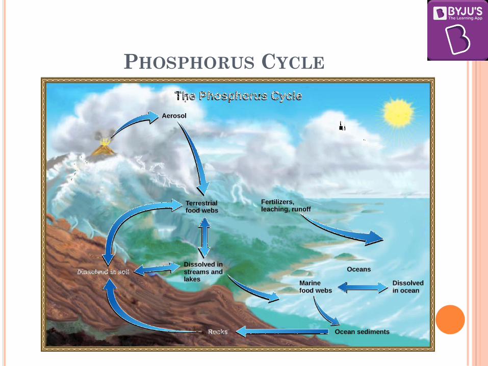
PHOSPHORUS CYCLE

PHOSPHORUS CYCLE
The phosphorus cycle is an example of a sedimentary
cycle which is easily disrupted.
Phosphates in the soil are taken into plants for
protein synthesis and are passed through the food
chains of ecosystems.
When plant and animal bodies and their excretory
products decompose, the phosphorus is released to
the soil where it can either be taken back into
plants or washed out by rainfall into drainage
systems which ultimately take it to the sea.
If this happens it will be incorporated in marine
sediments and so lost from the exchange pool.

PHOSPHORUS CYCLE
One important route for the rapid return of phosphorus from these sediments occurs where there are upwelling ocean currents. These bring phosphorus to the surface waters, where it is taken into marine food chains.
The depletion of phosphorus from the exchange pool is compensated very slowly by the release of the element from the phosphate rocks of the reservoir pool. This occurs by the process of erosion and weathering.
The phosphorus cycle can be easily disrupted by the use of phosphate fertilisers in modern agriculture.
Most manufactured phosphate fertilisers are produced from phosphate rocks but are rapidly lost from the exchange pool to marine deposits as they are easily leached from the soil.

NITROGEN CYCLE
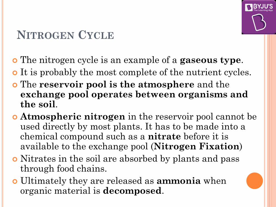
NITROGEN CYCLE
The nitrogen cycle is an example of a gaseous type.
It is probably the most complete of the nutrient cycles.
The reservoir pool is the atmosphere and the exchange pool operates between organisms and the soil.
Atmospheric nitrogen in the reservoir pool cannot be used directly by most plants. It has to be made into a chemical compound such as a nitrate before it is available to the exchange pool (Nitrogen Fixation)
Nitrates in the soil are absorbed by plants and pass through food chains.
Ultimately they are released as ammonia when organic material is decomposed.

NITROGEN CYCLE The ammonia is changed back to nitrates by the action of
bacteria.
If the nitrates are not reabsorbed by plants they may be lost from the exchange pool in two ways:
first, by leaching from the soil to shallow marine sediments (in this case they may be returned in the droppings of marine birds in the same way as phosphorus);
second, nitrates may be lost from the soil by being broken down by denitrifying bacteria, and the nitrogen contained in them being released to the atmosphere.
The conversion of gaseous nitrogen to nitrate occurs in two main ways.
1. electrical action during thunderstorms,
2. nitrogen-fixing organisms.
These are mostly bacteria, algae and fungi, and either operates by themselves in the soil or in an association with a plant, particularly those in the legume family, such as clover.
THE OXYGEN CYCLE
The cycling of oxygen is a highly complex process.
Oxygen occurs in a number of chemical forms and
combinations.
It combines with nitrogen to form nitrates and with
many other minerals and elements to form various
oxides such as the iron oxide, aluminium oxide and
others.
Much of oxygen is produced from the decomposition
of water molecules by sunlight during
photosynthesis and is released in the atmosphere
through transpiration and respiration processes
of plants.

ECOLOGICAL SUCCESSION
Ecological succession is the process of change in the species structure of an ecological community over time.
There will be changes in the types of plants and animals living there as conditions are ameliorated by the organisms themselves.
Typically there will be a sequence of different assemblages of species, each known as a seral stage or sere; each seral stage will alter the environment slightly.
Succession is an orderly process involving predictable changes in species structure leading to a stable, self perpetuating community, called the climax

ECOLOGICAL SUCCESSION

ECOLOGICAL SUCCESSION
There are two main types of succession -
1. Primary succession is the series of community changes which occur on an entirely new habitat which has never been colonized before. For example, a newly quarried rock faces or sand dunes. The establishment of a new biotic community is generally slow. Before a biotic community of diverse organisms can become established, there must be soil. Depending mostly on the climate, it takes natural processes several hundred to several thousand years to produce fertile soil on bare rock.
2. Secondary succession is the series of community changes which take place on a previously colonized, but disturbed or damaged habitat. For example, after felling of trees in woodland, land clearance or a fire.
3. Since some soil or sediment is present, Secondary succession is faster than primary succession.

BIOTIC POTENTIAL
Populations vary in their capacity to grow. The maximum rate at which a population can increase when resources are unlimited and environmental conditions are ideal is termed the population's biotic potential. Each species will have a different biotic potential due to variations in:
1. the species' reproductive span (how long an individual is capable of reproducing)
2. the frequency of reproduction (how often an individual can reproduce)
3. "litter size" (how many offspring are born each time)
4. survival rate (how many offspring survive to reproductive age)
There are always limits to population growth in nature. Populations cannot grow exponentially indefinitely. Exploding populations always reach a size limit imposed by the shortage of one or more factors such as water, space, and nutrients or by adverse conditions such as disease, drought and temperature extremes.
The factors which act jointly to limit a population's growth are termed the environmental resistance.

ECOTONE An ecotone is a transitional area between two
different ecosystems, such as a forest and grassland.
It has some of the characteristics of each bordering
biological community and often contains species
not found in the overlapping communities.
An ecotone may exist along a broad belt or in a small
pocket, such as a forest clearing, where two local
communities blend together.
An ecotone area often has a higher density of
organisms of one species and a greater number of
species than are found in either flanking community.
Ecotones also appear where one body of water meets
another (e.g., estuaries and lagoons) or at the boundary
between the water and the land (e.g., marshes).

EDGE EFFECT
Ecotones often have a larger number of species and
larger population densities than the communities on
either side.
This tendency for increased biodiversity within the
ecotone is referred to as the "edge effect."
Those species which occur primarily or most abundantly
in the ecotones are called "edge" species.

ENVIRONMENT AND ECOLOGY
CLASS III

BIODIVERSITY
Biodiversity is a combination of two words,
Bio – meaning life; and
Diversity – meaning variety.
Biodiversity is formally defined by the Convention on
Biological Diversity (CBD) as: “the variability among
living organisms from all sources including, among
others, terrestrial, marine and other aquatic ecosystems
and the ecological complexes of which they are part; this
includes diversity within species, between species
and of ecosystems”.

BIODIVERSITY
In simple terms, biodiversity is the number and variety
of organisms found within a specified geographic region.
It refers to the varieties of plants, animals and micro-
organisms, the genes they contain and the ecosystems
they form.
It relates to the variability among living organisms on
the earth, including the variability within and between
the species and that within and between the ecosystems.


BIODIVERSITY OF INDIA India comprises only 2.4% of the world’s land area,
but its share of the global species diversity is an impressive 8.1%.
There is diversity of ecological habitats like forests, grassland, wetlands, coastal and marine ecosystems, and desert ecosystems.
India is considered one of the world’s 17 “megadiverse” countries in terms of biodiversity.
India has four global biodiversity hot spots
1. Eastern Himalaya,
2. Indo-Burma,
3. Western Ghats and Sri Lanka, and
4. Sundaland.

MEGA-DIVERSE COUNTRIES
The megadiverse countries are a group of countries that harbour the majority of the Earth's species and are therefore considered extremely biodiverse.
Conservation International identified 17 megadiverse countries in 1998.
Together, these 17 countries harbour more than 70% of the earth's species.
All megadiverse countries are located in, or partially in, tropical or subtropical regions. All are located in, or partially in, tropical or subtropical regions.
The identified Megadiverse Countries are: United States of America, Mexico, Colombia, Ecuador, Peru, Venezuela, Brazil, Democratic Republic of Congo, South Africa, Madagascar, India, Malaysia, Indonesia, Philippines, Papua New Guinea, China and Australia.

MEGA-DIVERSE COUNTRIES

MEGA-DIVERSE COUNTRIES
The principle criterion is endemism, first at the species level and then at higher taxonomic levels such as genus and family.
To qualify as a Megadiverse Country, a country must:
Have at least 5000 species of endemic plants.
Have marine ecosystems on its borders.
Despite endemism being the main criterion, thresholds for the criteria are flexible and countries have been considered individually based on all criteria.
In 2002, Mexico formed a separate organization focusing on Like-Minded Megadiverse Countries, consisting of countries rich in biological diversity and associated traditional knowledge. This organization does not include all the megadiverse countries as identified by Conservation International. India is a member.
CONSERVATION INTERNATIONAL (CI)
It is an American nonprofit environmental organization headquartered in Arlington, Virginia.
Its goal is to protect nature as a source of food, fresh water, livelihoods and a stable climate.
CI was founded in 1987 with the goal of protecting nature for the benefit of people..
In 1989, CI formally committed to the protection of biodiversity hotspots, ultimately identifying 35 such hotspots around the world and contributing to their protection. The model of protecting hotspots became a key way for organizations to do conservation work
CI updated its mission in 2008 to focus explicitly on the connections between human well-being and natural ecosystems.

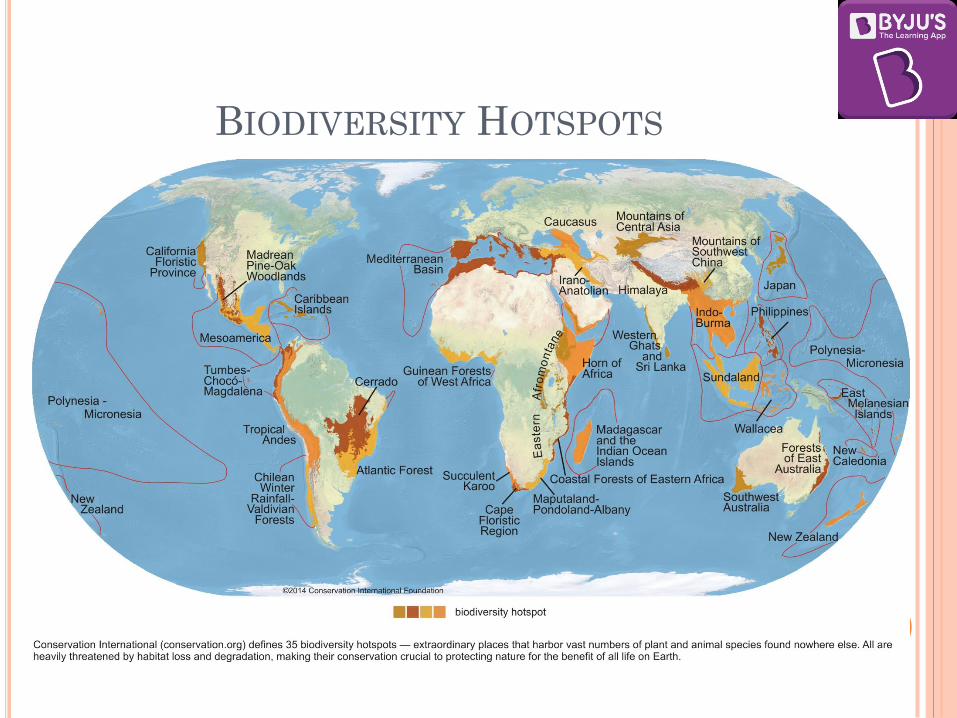
BIODIVERSITY HOTSPOTS
The British biologist Norman Myers coined the term
"biodiversity hotspot" in 1988 as a biogeographic region
characterized both by exceptional levels of plant
endemism and by serious levels of habitat loss.
In 1990 Myers added a further eight hotspots, including
four Mediterranean-type ecosystems.
Conservation International (CI) adopted Myers’
hotspots as its institutional blueprint in 1989, and in
1996, the organization made the decision to undertake a
reassessment of the hotspots concept.
Three years later an extensive global review was
undertaken, which introduced quantitative thresholds
for the designation of biodiversity hotspots.

BIODIVERSITY HOTSPOTS
According to CI, to qualify as a hotspot a region must
meet two strict criteria:
1. it must contain at least 1,500 species of vascular plants
(> 0.5% of the world’s total) as endemics, and
2. it has to have lost at least 70% of its original habitat.
Currently 35 regions have been designated as
Biodiversity Hotspots by CI
BIODIVERSITY HOTSPOTS

BIODIVERSITY HOTSPOTS IN INDIA
Himalaya: Includes the entire Indian Himalayan region
(and that falling in Pakistan, Tibet, Nepal, Bhutan,
China and Myanmar)
Indo-Burma: Includes entire North-eastern India,
except Assam and Andaman group of Islands (and
Myanmar, Thailand, Vietnam, Laos, Cambodia and
southern China)
Sundaland: Includes Nicobar group of Islands (and
Indonesia, Malaysia, Singapore, Brunei, Philippines)
Western Ghats and Sri Lanka: Includes entire
Western Ghats (and Sri Lanka)

BIODIVERSITY HOTSPOTS IN
INDIA

LEVELS OF BIODIVERSITY
Biodiversity can be discussed at three levels:
1. Genetic diversity,
2. Species diversity and
3. Ecosystem diversity.

GENETIC BIODIVERSITY
Genetic biodiversity refers to the variation of genes
within species.
Groups of individual organisms having certain
similarities in their physical characteristics are called
species.
Human beings genetically belong to the homo-sapiens
group and also differ in their characteristics such as
height, colour, physical appearance, etc., considerably.
This is due to genetic diversity.
The genetic diversity is essential for a healthy breeding
of population of species.
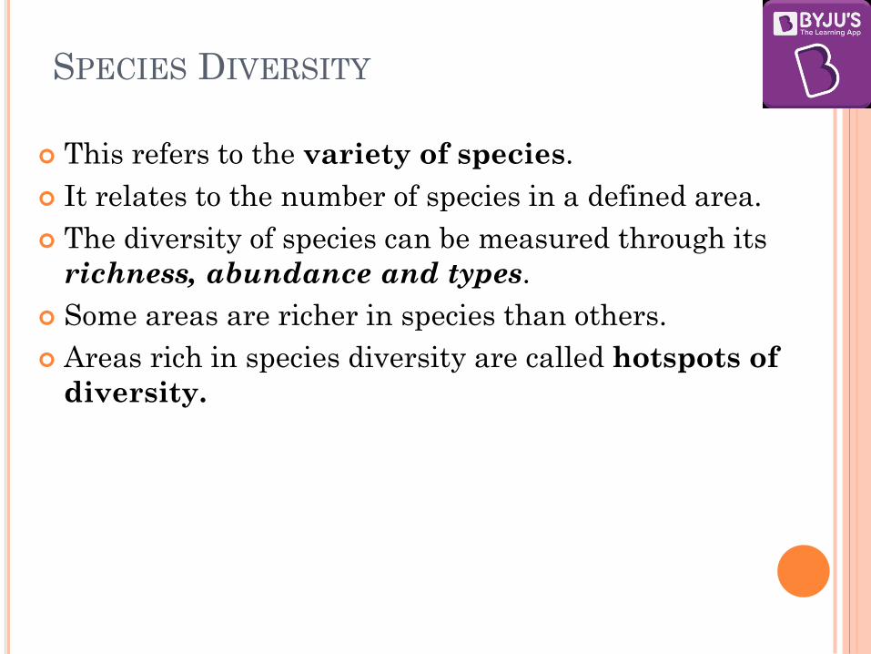
SPECIES DIVERSITY
This refers to the variety of species.
It relates to the number of species in a defined area.
The diversity of species can be measured through its
richness, abundance and types.
Some areas are richer in species than others.
Areas rich in species diversity are called hotspots of
diversity.

ECOSYSTEM DIVERSITY
The broad differences between ecosystem types and the
diversity of habitats and ecological processes occurring
within each ecosystem type constitute the ecosystem
diversity.
The boundaries of communities (associations of species)
and ecosystems are not very rigidly defined.
Thus, the demarcation of ecosystem boundaries is
difficult and complex.

LEVELS OF BIODIVERSITY

PATTERNS OF BIODIVERSITY Latitudinal gradients: Tropical forests are very rich
in bio-diversity.
As one approaches the Polar Regions, one finds
larger and larger populations of fewer and fewer
species. Eg: Penguins, Polar Bear
With very few exceptions, tropics (latitudinal range
of 23.5° N to 23.5° S) harbour more species than
temperate or polar areas.
Decline in richness with latitude may be faster in
the Northern than in the Southern Hemisphere.
The peaks in richness may not lie actually at the
Equator itself but some distance away.

WHAT IS SO SPECIAL ABOUT TROPICS THAT MIGHT
ACCOUNT FOR THEIR GREATER BIOLOGICAL DIVERSITY?
Various hypotheses have been given. Some important ones are:
Speciation is generally a function of time, unlike temperate
regions subjected to frequent glaciations in the past,
tropical latitudes have remained relatively undisturbed for
millions of years and thus, had a long evolutionary time
for species diversification.
Tropical environments, unlike temperate ones, are less
seasonal, relatively more constant and predictable. Such
constant environments promote niche specialisation and
lead to a greater species diversity.
There is more solar energy available in the tropics, which
contributes to higher productivity; this in turn might
contribute indirectly to greater diversity.

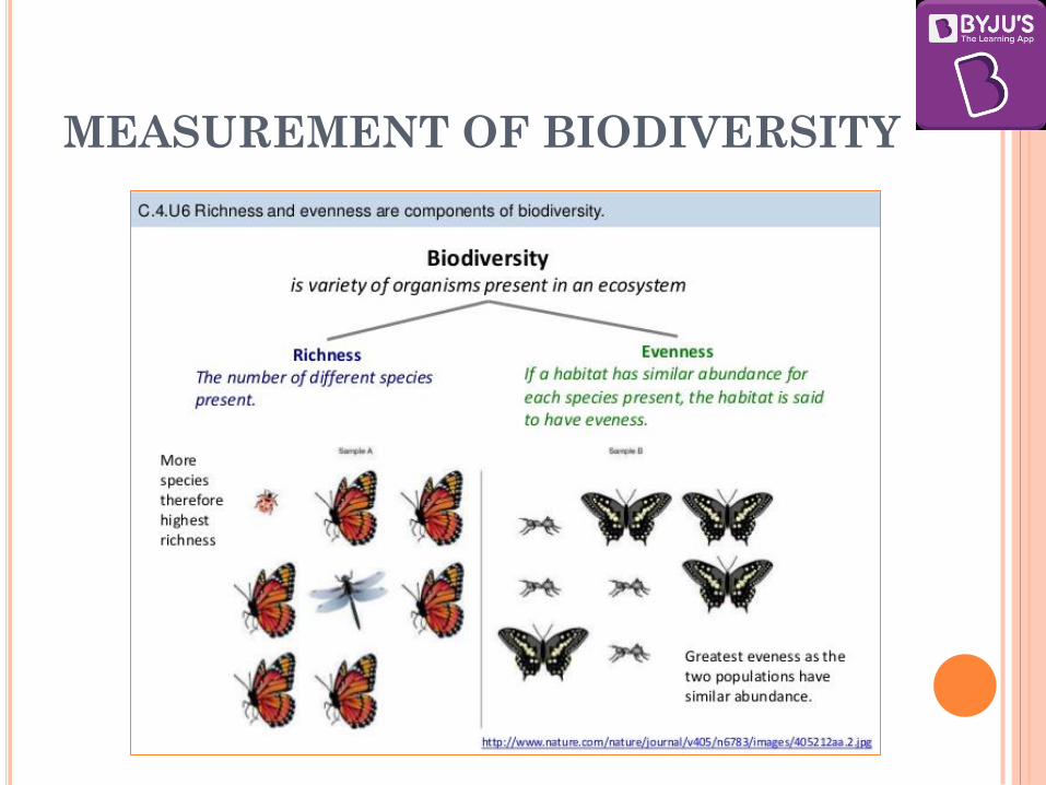
MEASUREMENT OF BIODIVERSITY
The two main factors taken into account when measuring
diversity are richness and evenness.
1. Species richness: It is the number of different species
represented in an ecological community, landscape or
region.
2. Species evenness: Evenness is a measure of the
relative abundance of the different species making up
the richness of an area.
MEASUREMENT OF BIODIVERSITY
MEASUREMENT OF BIODIVERSITY
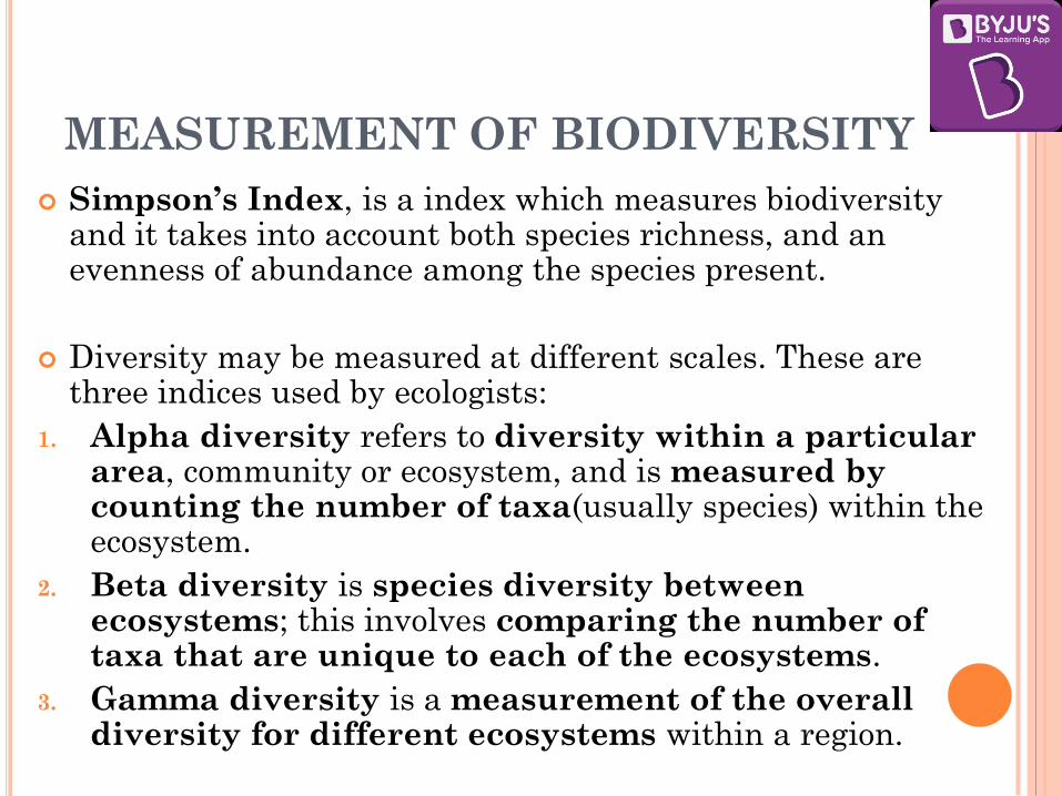
Simpson’s Index, is a index which measures biodiversity and it takes into account both species richness, and an evenness of abundance among the species present.
Diversity may be measured at different scales. These are three indices used by ecologists:
1. Alpha diversity refers to diversity within a particular area, community or ecosystem, and is measured by counting the number of taxa(usually species) within the ecosystem.
2. Beta diversity is species diversity between ecosystems; this involves comparing the number of taxa that are unique to each of the ecosystems.
3. Gamma diversity is a measurement of the overall diversity for different ecosystems within a region.

MEASUREMENT OF BIODIVERSITY
The more diverse an ecosystem, better are the chances
for the species to survive through adversities and
attacks, and consequently, is more productive.
Hence, the loss of species would decrease the ability of
the system to maintain itself.
Just like a species with a high genetic diversity, an
ecosystem with high biodiversity may have a greater
chance of adapting to environmental change.
In other words, the more the variety of species in an
ecosystem, the more stable the ecosystem is likely to be.
IMPORTANCE OF BIODIVERSITY
1. ECOLOGICAL ROLE
2. ECONOMIC ROLE
3. SCIENTIFIC ROLE
4. SOCIAL/CULTURAL ROLE

1. ECOLOGICAL ROLE
Species of many kinds perform some or the other
functions in an ecosystem. Every organism, besides
extracting its needs, also contributes something
useful to other organisms.
Species capture and store energy, produce and
decompose organic materials, help to cycle water and
nutrients throughout the ecosystem, fix atmospheric
gases and help regulate the climate.
Thus, they help in soil formation, reducing pollution,
protection of land, water and air resources.
These functions are important for ecosystem function
and human survival.

2. ECONOMIC ROLE
Biodiversity is an important resource in day-to-day life.
One important part of biodiversity is ‘crop diversity’,
which is also called agro-biodiversity.
Biodiversity is seen as a reservoir of resources to be
drawn upon for the manufacture of food,
pharmaceutical, and cosmetic products.
This concept of biological resources is responsible for the
deterioration of biodiversity.
Some of the important economic commodities that
biodiversity supplies to humankind are: food crops,
livestock, forests, fish, medicinal resources, etc.

3. SCIENTIFIC ROLE
Biodiversity is important because each species can give
us some clue as to how life evolved and will continue to
evolve.
Biodiversity also helps in understanding how life
functions and the role of each species in sustaining
ecosystems of which we are also a species.

4. SOCIAL/CULTURAL ROLE
Diversity of nature provides us aesthetic pleasure.
It provides us recreational avenues and rich biological
diversity encourages tourism in the region.
Many communities and cultures have co-evolved with
the surroundings and the resources provided by a
biologically diverse environment.
Hence, it performs an important social role as well.
Important services which it provides are:
Recreation and Relaxation
Tourism especially eco-tourism
Art, Design and Inspiration
Spiritual experiences and a sense of place

CAUSES OF BIODIVERSITY LOSSES
1. Natural causes like floods, earthquakes and other natural disasters.
2. Habitat loss and fragmentation:
This is the most important cause driving animals and plants to extinction. The most dramatic examples of habitat loss come from tropical rain forests. Once covering more than 14% of the earth’s land surface, these rain forests now cover no more than 6%.
Besides total loss, the degradation of many habitats by pollution also threatens the survival of many species. When large habitats are broken up into small fragments due to various human activities, mammals and birds requiring large territories and certain animals with migratory habits are badly affected, leading to decline of population.
Habitat loss is caused by deforestation, over-population, pollution, global warming etc.

CAUSES OF BIODIVERSITY LOSSES
3. Over-exploitation:
Over-hunting, over-fishing or over-collecting of a species can quickly lead to its decline.
Changing consumption patterns of humans is often cited as the key reason for this unsustainable exploitation of natural resources.
Many species extinctions in the last 500 years (Steller’s sea cow, passenger pigeon) were due to overexploitation by humans.
4. Alien species invasions: When alien species are introduced unintentionally or deliberately for any purpose, some of them turn invasive, and cause decline or extinction of indigenous species.

CAUSES OF BIODIVERSITY LOSSES
5. Co-extinctions: When a species becomes extinct, the
plant and animal species associated with it in an
obligatory way also become extinct. When a host fish
species becomes extinct, its unique assemblage of
parasites also meets the same fate.
6. Global climate change: Both climate variability and
climate change cause biodiversity loss. Species and
populations may be lost permanently, if they are not
provided with enough time to adapt to changing
climatic conditions.
7. Hunting and Poaching: Because of this, not only the
particular species become prone to extinction but also
the other species dependent on that species.
BIODIVERSITY CONSERVATION
There are two approaches in biodiversity conservation:
1. In situ conservation: It is the approach of
protecting an endangered plant or animal species
in its natural habitat, either by protecting or
cleaning up the habitat itself, or by defending the
species from predators. Some methods under it are:
Biosphere Reserves
National Parks
Wild-life Sanctuaries

BIODIVERSITY CONSERVATION
2. Ex-situ conservation:
In this approach, threatened animals and plants are taken
out from their natural habitat and placed in special
setting where they can be protected and given special care.
Zoological parks, botanical gardens and wildlife safari
parks serve this purpose.
In recent years ex situ conservation has advanced beyond
keeping threatened species in enclosures.
Now gametes of threatened species can be preserved in
viable and fertile condition for long periods using
cryopreservation techniques, eggs can be fertilised in vitro,
and plants can be propagated using tissue culture methods.
Seeds of different genetic strains of commercially important
plants can be kept for long periods in seed banks.
INTERNATIONAL UNION FOR CONSERVATION
OF NATURE (IUCN)
The IUCN is an international organization working in the field of nature conservation and sustainable use of natural resources.
IUCN was established in 1948.
It was previously called the International Union for Protection of Nature (1948–1956) and the World Conservation Union (1990–2008).
Its headquartered in Gland, Switzerland.
It is involved in data gathering and analysis, research, field projects, advocacy, lobbying and education.
IUCN's mission is to "influence, encourage and assist societies throughout the world to conserve nature and to ensure that any use of natural resources is equitable and ecologically sustainable."
INTERNATIONAL UNION FOR
CONSERVATION OF NATURE (IUCN)
Over the past decades, IUCN has widened its focus beyond conservation ecology and now incorporates issues related to gender equality, poverty alleviation and sustainable business in its projects.
Unlike other international NGOs, IUCN does not itself aim to mobilize the public in support of nature conservation.
It tries to influence the actions of governments, business and other stakeholders by providing information and advice, and through lobbying and partnerships.
IUCN has observer and consultative status at the United Nations, and plays a role in the implementation of several international conventions on nature conservation and biodiversity.

INTERNATIONAL UNION FOR
CONSERVATION OF NATURE (IUCN)
IUCN is the only international observer organization
in the UN General Assembly with expertise in issues
concerning the environment.
It was involved in establishing the World Wide Fund for
Nature (WWF) and the World Conservation
Monitoring Centre.
IUCN provides advice to environmental conventions such
as the Convention on Biological Diversity, CITES and
the Framework Convention on Climate Change.
It advises UNESCO on natural world heritage.
It produces the IUCN Red List of Threatened Species
and the IUCN Red List of Ecosystems
INTERNATIONAL UNION FOR
CONSERVATION OF NATURE (IUCN)
The IUCN has classified the species of plants and animals into various categories for the purpose of their conservation which are as follows:
1. Extinct (EX) – No known individuals remaining.
2. Extinct in the wild (EW) – Known only to survive in captivity, or as a naturalized population outside its historic range.
3. Critically endangered (CR) – Extremely high risk of extinction in the wild.
4. Endangered (EN) – High risk of extinction in the wild.
5. Vulnerable (VU) – High risk of endangerment in the wild.
6. Near threatened (NT) – Likely to become endangered in the near future.
7. Least concern (LC) – Lowest risk. Does not qualify for a more at-risk category. Widespread and abundant taxa are included in this category.
8. Data deficient (DD) – Not enough data to make an assessment of its risk of extinction.
9. Not evaluated (NE) – Has not yet been evaluated against the criteria.

INTERNATIONAL UNION FOR
CONSERVATION OF NATURE (IUCN)
Species are classified by the IUCN Red List into nine
groups, set through criteria such as –
rate of decline,
population size,
area of geographic distribution and degree of population
distribution fragmentation.
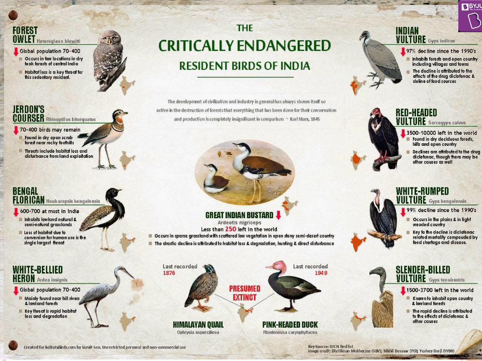

CRITICALLY ENDANGERED MAMMALS
1. Himalayan Brown/Red Bear
2. Pygmy Hog
3. Andaman White-toothed Shrew
4. Kondana Rat
5. Large Rock Rat or Elvira Rat
6. Namdapha Flying Squirrel
7. Malabar Civet
8. Sumatran Rhinoceros
9. Kashmir stag/Hangul

‘ENDANGERED’ MAMMALS
1. Red Panda
2. Wild ass/ khur
3. Dhole/ Asiatic wild dog or Indian wild dog
4. Eld’s deer/ thamin or brow-antlered deer
5. Golden langur
6. Himalayan / White-bellied Musk Deer
7. Hispid hare/ Assam rabbit
8. Hog deer
9. Lion-tailed macaque/ wanderoo
10. Chita / Tibetian Antelope
11. Nilgiri langur/ Nilgiri leaf monkey
12. Nilgiri tahr
‘Endangered’ Marine Mammals
1. Freshwater / river dolphin

ENVIRONMENT AND ECOLOGY
CLASS IV
VERTICAL STRATIFICATION OF
PLANT COMMUNITIES
The development of different species of plant community of a given region takes place through the processes of adaptation, competition and natural selection.
Different species of plants are evolved in a habitat having favourable environmental conditions wherein different species of plant community grow together having different life-forms. This results in the development of various strata or layers between the soil surface or ground surface and the tree canopy.
This vertical layering pattern or vertical stratification of plants is the result of competition among various species of plant community to get sunlight.
On an average, there are four vertical strata of plant community in a given region mainly in the deciduous forests of the temperate regions

VERTICAL STRATIFICATION OF
PLANT COMMUNITIES
VERTICAL STRATIFICATION OF
PLANT COMMUNITIES
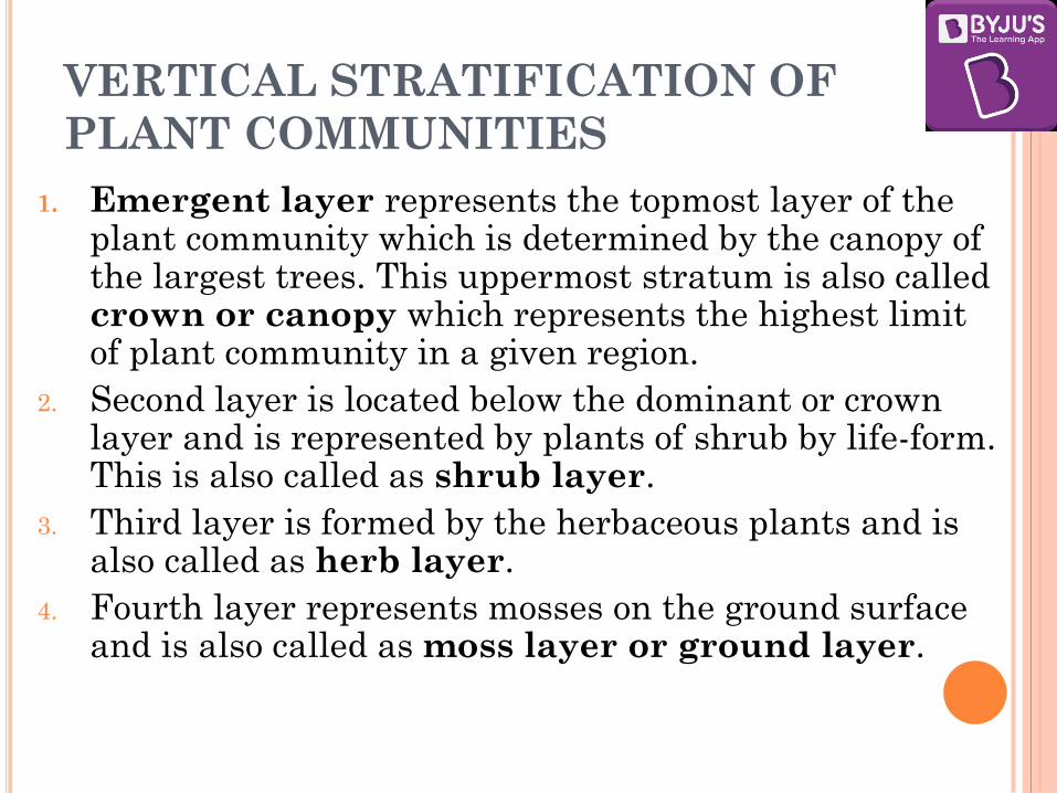
1. Emergent layer represents the topmost layer of the plant community which is determined by the canopy of the largest trees. This uppermost stratum is also called crown or canopy which represents the highest limit of plant community in a given region.
2. Second layer is located below the dominant or crown layer and is represented by plants of shrub by life-form. This is also called as shrub layer.
3. Third layer is formed by the herbaceous plants and is also called as herb layer.
4. Fourth layer represents mosses on the ground surface and is also called as moss layer or ground layer.

INDIA STATE OF FOREST REPORT 2015
"India State of Forest Report (ISFR)", a biennial report is
published by the Forest Survey of India(FSI) since
1987.
Regular assessment of forest cover is being done by FSI
using remote sensing satellite data.
India’s forest and tree cover has increased by 5,081 sq.
km.
The North Eastern states of India account for one fourth
of the country’s forest cover.
Mangroves cover has increased by 112 sq. km as
compared to the previous assessment.

INDIA STATE OF FOREST REPORT 2017
It has revealed that total forest and tree cover in
India has increased of over 8,021 sq km (about
80.20 million hectare) which is a one percent increase
from 2015.
Key Findings:
The total forest and tree cover is 24.39% of geographical
area of the country.
The increase in forest cover has been observed in Very
Dense Forest (VDF) which absorbs maximum carbon
dioxide.
It is followed by increase in forest cover in open
forest.
INDIA STATE OF FOREST REPORT 2017
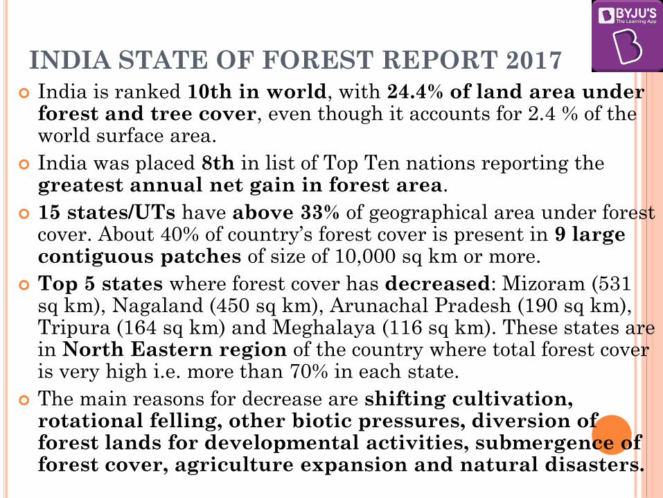
India is ranked 10th in world, with 24.4% of land area under forest and tree cover, even though it accounts for 2.4 % of the world surface area.
India was placed 8th in list of Top Ten nations reporting the greatest annual net gain in forest area.
15 states/UTs have above 33% of geographical area under forest cover. About 40% of country’s forest cover is present in 9 large contiguous patches of size of 10,000 sq km or more.
Top 5 states where forest cover has decreased: Mizoram (531 sq km), Nagaland (450 sq km), Arunachal Pradesh (190 sq km), Tripura (164 sq km) and Meghalaya (116 sq km). These states are in North Eastern region of the country where total forest cover is very high i.e. more than 70% in each state.
The main reasons for decrease are shifting cultivation, rotational felling, other biotic pressures, diversion of forest lands for developmental activities, submergence of forest cover, agriculture expansion and natural disasters.

INDIA STATE OF FOREST REPORT 2017
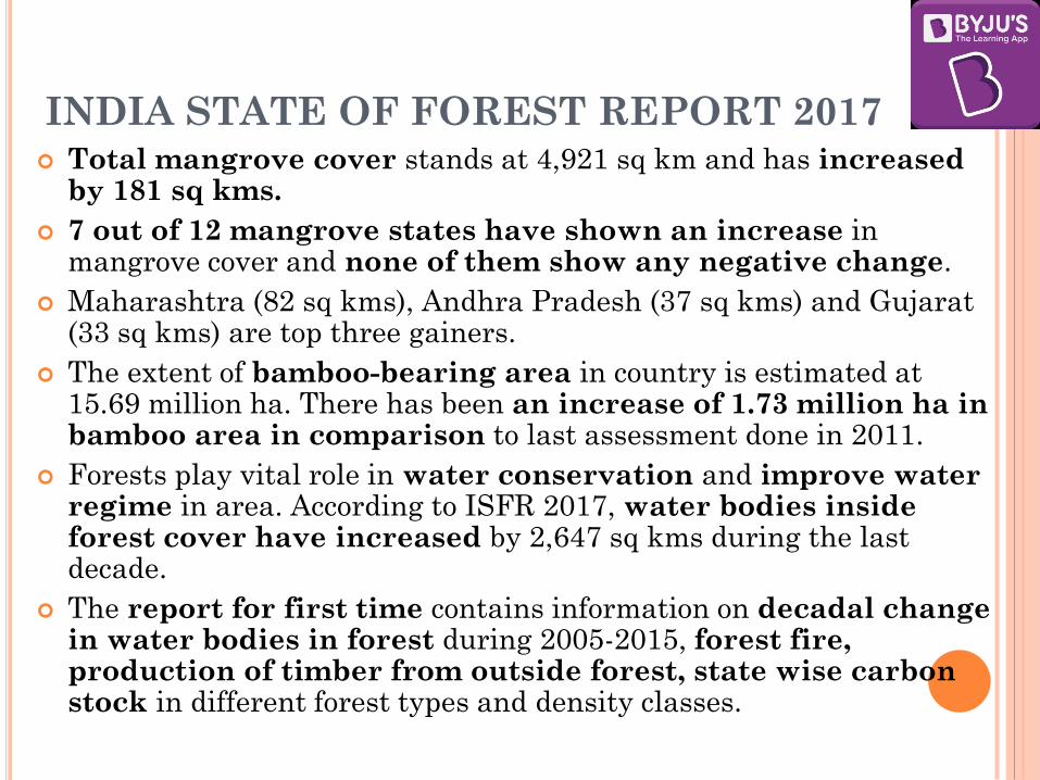
INDIA STATE OF FOREST REPORT 2017 Total mangrove cover stands at 4,921 sq km and has increased
by 181 sq kms.
7 out of 12 mangrove states have shown an increase in mangrove cover and none of them show any negative change.
Maharashtra (82 sq kms), Andhra Pradesh (37 sq kms) and Gujarat (33 sq kms) are top three gainers.
The extent of bamboo-bearing area in country is estimated at 15.69 million ha. There has been an increase of 1.73 million ha in bamboo area in comparison to last assessment done in 2011.
Forests play vital role in water conservation and improve water regime in area. According to ISFR 2017, water bodies inside forest cover have increased by 2,647 sq kms during the last decade.
The report for first time contains information on decadal change in water bodies in forest during 2005-2015, forest fire, production of timber from outside forest, state wise carbon stock in different forest types and density classes.
CLASSIFICATIONS OF FORESTS
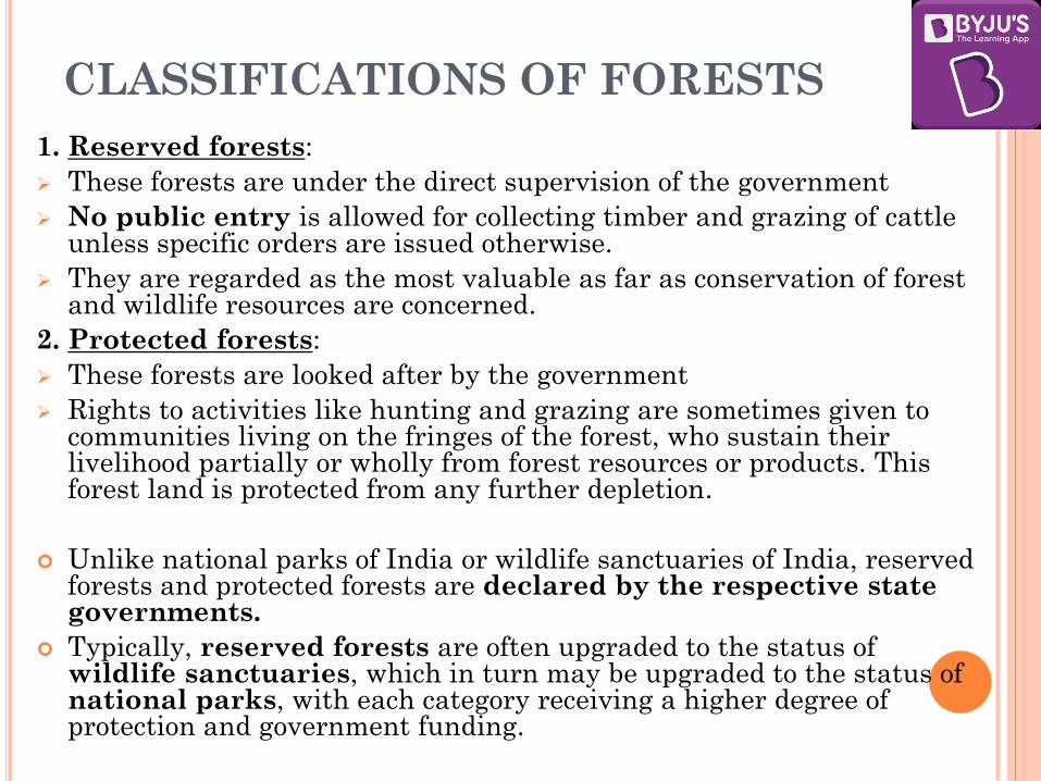
1. Reserved forests:
These forests are under the direct supervision of the government
No public entry is allowed for collecting timber and grazing of cattle unless specific orders are issued otherwise.
They are regarded as the most valuable as far as conservation of forest and wildlife resources are concerned.
2. Protected forests:
These forests are looked after by the government
Rights to activities like hunting and grazing are sometimes given to communities living on the fringes of the forest, who sustain their livelihood partially or wholly from forest resources or products. This forest land is protected from any further depletion.
Unlike national parks of India or wildlife sanctuaries of India, reserved forests and protected forests are declared by the respective state governments.
Typically, reserved forests are often upgraded to the status of wildlife sanctuaries, which in turn may be upgraded to the status of national parks, with each category receiving a higher degree of protection and government funding.

CLASSIFICATIONS OF FORESTS
3. Wildlife sanctuaries:
They are established under IUCN category II
protected areas.
India has around 537 wildlife sanctuaries
4. National parks:
They are established under IUCN category
II protected areas.
India has around 120 national parks
No human activity is permitted inside the national park
except for the ones permitted by the Chief Wildlife
Warden of the state under the conditions given in the
Wildlife Protection Act

CLASSIFICATIONS OF FORESTS
5. Biosphere reserves:
The Indian government has established 18 Biosphere Reserves in India, (categories roughly corresponding to IUCN Category V Protected areas), which protect larger areas of natural habitat (than a National Park or Animal Sanctuary), and often include one or more National Parks and/or preserves, along with buffer zones that are open to some economic uses.
Protection is granted not only to the flora and fauna of the protected region, but also to the human communities who inhabit these regions, and their ways of life.
Ten of the 18 biosphere reserves are a part of the World Network of Biosphere Reserves, based on the UNESCO Man and the Biosphere (MAB) Programme

MAN AND THE BIOSPHERE PROGRAMME (MAB)
Launched in 1971 by UNESCO, it is an
intergovernmental scientific programme that aims to
establish a scientific basis for the improvement of
relationships between people and their environments.
MAB’s work engages fully with the international
development agenda—specially with the SDGs and
the Post 2015 Development Agenda
The MAB programme provides a unique platform for
cooperation on three interlinked
issues: biodiversity loss, climate change and sustainable
development.

MAN AND THE BIOSPHERE PROGRAMME (MAB)
World Network of Biosphere Reserves - Biosphere reserves are areas comprising terrestrial, marine and coastal ecosystems.
Biosphere reserves are nominated by national governments and remain under the sovereign jurisdiction of the states where they are located. Their status is internationally recognized.
Biosphere reserves have three interrelated zones :
1. The core area comprises a strictly protected ecosystem that contributes to the conservation of landscapes, ecosystems, species and genetic variation.
2. The buffer zone surrounds or adjoins the core areas, and is used for activities compatible with sound ecological practices that can reinforce scientific research, monitoring, training and education.
3. The transition area is the part of the reserve where the greatest activity is allowed, fostering economic and human development that is socio-culturally and ecologically sustainable

MAB BIOSPHERE RESERVES IN INDIA
1. Nilgiri (2000) – TN, Kerala, Karnataka
2. Gulf of Mannar (2001) - TN
3. Sunderban (2001) – West Bengal
4. Nanda Devi (2004) - Uttarakhand
5. Nokrek (2009) - Meghalaya
6. Pachmarhi (2009) – Madhya Pradesh
7. Similipal (2009) - Odisha
8. Achanakmar-Amarkantak Biosphere Reserve (2012) –
Chhattisgarh, MP
9. Nicobar Islands (2013) – Andaman & Nicobar
10. Agasthyamalai Biosphere Reserve (2016) – Kerala, TN

NATIONAL FOREST POLICY 1988
India adopted a forest policy in 1952, which was further modified in 1988. According to the new forest policy, the Government will emphasise sustainable forest management in order to conserve and expand forest reserve on the one hand, and to meet the needs of local people on the other.
The forest policy of the Government of India aims at:
bringing 33% of the geographical areas under forest cover;
maintaining environmental stability and to restore forests where ecological balance was disturbed;
conserving the natural heritage of the country, its biological diversity and genetic pool;
checks soil erosion, extension of the desert lands and reduction of floods and droughts;
increasing the forest cover through social forestry and afforestation on degraded land;
increasing the productivity of forests to make timber, fuel, fodder and food available to rural population dependant on forests, and encourage the substitution of wood;
Creating of a massive people’s movement involving women to encourage planting of trees, stop felling of trees and thus, reduce pressure on the existing forest.

SOCIAL FORESTRY
Social forestry means the management and protection of
forests and afforestation on barren lands with the purpose of
helping in the environmental, social and rural development.
The National Commission on Agriculture (1976) has
classified social forestry into three categories.
1. Urban forestry pertains to the raising and management of
trees on public and privately owned lands in and around urban
centres such as green belts, parks, roadside avenues, industrial
and commercial green belts, etc.
2. Rural forestry lays emphasis on promotion of agro-forestry
and community-forestry.
Agro-forestry is the raising of trees and agriculture crops on
the same land inclusive of the waste patches. It combines
forestry with agriculture, thus, altering the simultaneous
production of food, fodder, fuel, timber and fruit.

SOCIAL FORESTRY
Community forestry:
It involves the raising of trees on public or community land
such as the village pasture and temple land, roadside, canal
bank, strips along railway lines, and schools etc.
Community forestry programme aims at providing benefits
to the community as a whole.
Community forestry provides a means under which the
people of landless classes can associate themselves in tree
raising and thus, get those benefits which otherwise are
restricted for landowners.
3. Farm forestry: It is a term applied to the process under
which farmers grow trees for commercial and non-commercial
purposes on their farm lands. Forest departments of various
states distribute seedlings of trees free of cost to small and
medium farmers.

ECO SENSITIVE ZONES
The National Wildlife Action Plan (2002–2016) of the MoEFCC stipulated that state governments should declare land falling within 10 km of the boundaries of national parks and wildlife sanctuaries as eco fragile zones or ESZs under section 3 (v) of the Environmental (Protection) Act, 1986.
The purpose of the ESZ was to provide more protection to the parks by acting as a shock absorber or transition zone.
Transition zones around protected forest areas would minimise forest depletion and man-animal conflict.
The protected areas are based on the core and buffer model of management. The core area has the legal status of being a national park. The buffer area, however, does not have legal status of being a national park and could be a reserved forest, wildlife sanctuary or tiger reserve.
This will help in protecting endangered species.
This will also promote eco-tourism.

ECO-SENSITIVE ZONE GUIDELINES
The guidelines proposed that the boundary had to be site specific, decided in consultation with a field based team comprising representatives from the forest department, revenue department and Panchayat Raj institution.
Though ESZ does not affect the ownership rights of people on land resources, it restricts land-use change. Activities such as widening of roads, construction or expansion of buildings, change of the agriculture system and erection of electric cables will also be regulated by a monitoring committee, mostly comprising of government officials, as per the master plan of the ESZ.
It mentioned that the ESZs are not anti-people and do not intend to hamper their everyday activities.

CONCERNS OF LOCAL PEOPLE
Locals claim that it is against their livelihood.
There is no compensation for damage to crops by
animals.
Man-animal conflict may increase.
Local people will be treated as encroachers.
There are no policies to regulate tourism. Hotels and
mega resorts, dominate the area and locals are restricted
to low paying jobs. The locals are not enthusiastic in the
ecotourism business as mass tourism gives them tough
competition.

OTHER ISSUES WITH ESZ
Worried about how the process would hit development and
apparently under pressure from mining and industry lobbies, the states have excluded several ecologically important areas around wildlife parks and sanctuaries from being protected.
The presence of minerals and resources near Protected Areas has disrupted the identification of ESZs in many states too.
The communities around eco-sensitive areas are also in uproar because they have been excluded from the process of identifying and governing the eco-sensitive zones (ESZs).
Also the ESZ guidelines do not restrict the current tourism practices or put any restriction on the vehicular pollution in the area.

WESTERN GHATS AND VARIOUS COMMITTEES
Western Ghats Ecology Expert Panel (WGEEP) headed by Madhav Gadgil was formed by MoEF in 2010.
It’s recommendations were:
Make entire Western Ghats region ecologically-sensitive area. This would be divided into two parts: The protected areas which will be the national parks and wildlife sanctuaries; three Ecological Sensitive Zones (ESZ) viz. ESZ-1, ESZ-2 and ESZ-3, with different degrees of protection.
Highest protection in ESZ-1 and ESZ-2 categories. It recommended that the government should put an indefinite moratorium on new environmental clearances for mining in ESZ-1 and ESZ-2 and phasing out of mining from ESZ-1 by 2015. The continuation of existing mining in ESZ-2 under strict regulation with an effective system of social audit.
It also recommended that no new dams based on large-scale storage be permitted in ESZ-1.
The demarcation of the ESZs should be based on participation from local communities and local bodies

WESTERN GHATS AND VARIOUS COMMITTEES
It also recommended constitution of a Western Ghats
Ecology Authority (WGEA), as a statutory authority under
the Ministry of Environment and Forests to focus on local
participation and sustainability.
There was a lot of controversy and criticism of the
recommendations as states felt that it would hamper energy
and development projects. The ban on dams adversely
impacted power sector.
Locals also were against the report as the perception was that
it would adversely impact livelihood.
Then, the Kasturirangan committee was constituted to
examine the WGEEP report.

KASTURIRANGAN COMMITTEE The recommendations of the 10 member high-level working
group (HLWG), headed by Kasturirangan were:
Instead of the total area of Western Ghats, only 37% of the
total area be brought under ESA
Complete ban on mining, quarrying and sand mining in ESA.
Distinguished between cultural and natural landscape.
Current mining areas in the ESA should be phased out
within the next five years, or at the time of expiry of mining
lease, whichever is earlier
No thermal power should be allowed and hydropower
projects be allowed only after detailed study.
There were criticisms of these recommendations as it used
aerial survey methods and remote sensing techniques
for demarcation without examining ground realities.
Also, there was no power to gram sabhas.

RECENT DEVELOPMENTS
MoEF has said that as per the Kasturirangan Committee
report, commercial mining and polluting industries would be
strictly banned in areas identified as eco sensitive zones in
Western Ghats.
He also said that every State will be given full opportunity for
development works and the Union Ministry is currently going
through the proposals submitted by State Ministers.
Since more than 4,000 villages fall in the proposed eco-
sensitive zones, consultation with local population was on to
seek their recommendation on the plan of action and the
process would be completed soon.
ENVIRONMENT AND ECOLOGY
CLASS V

WETLANDS
Wetlands are defined as lands transitional between
terrestrial and aquatic eco-systems where the
water table is usually at or near the surface or the land
is covered by shallow water.
The land area is saturated with water, either
permanently or seasonally, such that it takes on the
characteristics of a distinct ecosystem.
The primary factor that distinguishes wetlands from
other land forms or water bodies is the characteristic
vegetation of aquatic plants, adapted to the unique
hydric soil (saturated soil with anaerobic conditions).

WETLANDS
Under the Ramsar International Wetland
Conservation treaty, wetlands are defined as:
Article 1.1.: Wetlands are areas of marsh, fen,
peatland or water, whether natural or artificial,
permanent or temporary, with water that is static or
flowing, fresh, brackish or salt, including areas of
marine water the depth of which at low tide does not
exceed six metres.
Article 2.1.: Wetlands may incorporate riparian and
coastal zones adjacent to the wetlands, and islands or
bodies of marine water deeper than six metres at low
tide lying within the wetlands.

CLASSIFICATION
According to Ramsar Convention, three major classes are
identified:
1) Marine/Coastal Wetlands
2) Inland Wetlands
3) Human-made Wetlands
These are subdivided by the type of water: fresh /
saline / brackish / alkaline; further may be subdivided
based on whether they are permanent or temporary.

CLASSIFICATION

THE FOUR MAIN TYPES OF WETLANDS
1. MARSH
It is a wetland that is dominated by herbaceous
rather than woody plant species.
Marshes can often be found at the edges of lakes and
streams, where they form a transition between the
aquatic and terrestrial ecosystems.
They are often dominated by grasses, rushes or reeds. If
woody plants are present they tend to be low-growing
shrubs.

THE FOUR MAIN TYPES OF WETLANDS
2. SWAMP
A swamp is a wetland that is forested.
Swamps are characterized by slow-moving to stagnant
waters.
They are usually associated with adjacent rivers or lakes.
The water of a swamp may be fresh water, brackish water
or seawater.
Some of the world's largest swamps are found along major
rivers such as the Amazon, the Mississippi, and the Congo.
Peat swamp forests are swamp forests where waterlogged
soils prevent woody debris from fully decomposing, which
over time creates a thick layer of acidic peat.
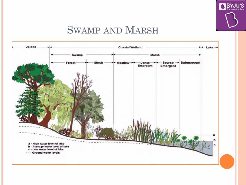
SWAMP AND MARSH

THE FOUR MAIN TYPES OF WETLANDS
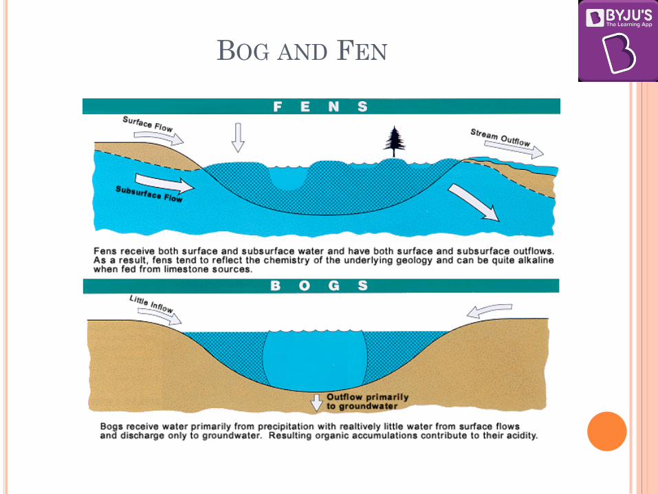
Mire- A mire is a wetland without forest cover, dominated by
peat-forming plants. There are two types of mires:-
3. BOG
A Bog is a mire that accumulates peat.
A Bog is dome shaped landform, is higher than the surrounding landscape, and obtains most of its water from rainfall.
The gradual accumulation of decayed plant material in a bog functions as a carbon sink.
The characteristic is acidic surface water, low in nutrients. These are the features of cold, temperate boreal climate of Northern Hemisphere.
4. FEN
The difference with Bog is that a Fen is served by both groundwater and rainfall and is therefore, is slightly acidic, neutral or alkaline.
It is relatively rich in minerals.
It is located on a slope, flat or a depression.
They are also features of cold climates such as in Western Europe.
BOG AND FEN

BOG AND FEN

ECOLOGY OF WETLANDS
Wetlands are neither aquatic nor terrestrial.
Wetlands have some of the same features as deep-water
systems like species of algae, vertebrates, and
invertebrates.
Most wetlands share with terrestrial ecosystems a flora
dominated by vascular plants, although the species
composition of wetlands generally differs from that of
uplands.
Wetlands often are found at the interface of terrestrial
ecosystems (such as upland forests and grasslands) and
aquatic systems (such as lakes, rivers, and estuaries).

ECOLOGY OF WETLANDS
1. Hydrology –
Hydrology controls the abiotic and biotic characteristics of wetlands.
Abiotic characteristics such as soil colour, texture, and water quality depend on the distribution and movement of water.
It also influences the structure and function of wetland ecosystems through its influence on species richness, productivity, rates of organic matter accumulation, and nutrient cycling.
Sources of hydrological flows into wetlands are predominantly precipitation, surface water, and ground water.
Water flows out of wetlands by evapotranspiration, surface runoff, and sub-surface water outflow.
Hydrodynamics (the movement of water through and from a wetland) affects hydro periods (temporal fluctuations in water levels) by controlling the water balance and water storage within a wetland.
Hydrology may restrict species richness in areas subject to long-term flooding while enhancing it in areas with variable hydroperiods.
Similarly, productivity is typically lower in permanently flooded, stagnant wetlands than in slow-flowing, seasonally flooded ones.

ECOLOGY OF WETLANDS
2. Soil Acidity/Alkalinity –
Low mineral content yields fewer nutrients and a lower
pH.
Acidic conditions inhibit the ability of most plants
to take up nutrients.
3. Oxygen Availability –
The inundation or saturation of wetland soils by water
leads to the formation of anaerobic conditions as
oxygen is depleted faster than it can be replaced by
diffusion.
WETLAND COMMUNITIES AND
ECOSYSTEMS
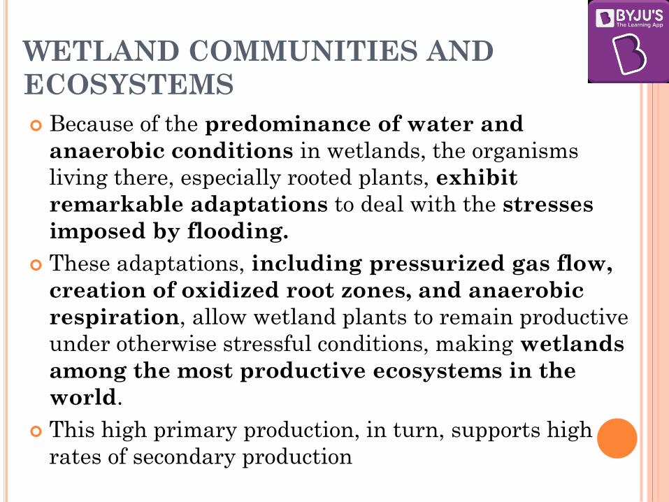
Because of the predominance of water and
anaerobic conditions in wetlands, the organisms
living there, especially rooted plants, exhibit
remarkable adaptations to deal with the stresses
imposed by flooding.
These adaptations, including pressurized gas flow,
creation of oxidized root zones, and anaerobic
respiration, allow wetland plants to remain productive
under otherwise stressful conditions, making wetlands
among the most productive ecosystems in the
world.
This high primary production, in turn, supports high
rates of secondary production

MANGROVES
Mangroves are an example of tropical coastal vegetation, which shows number of
adaptations to wetland conditions. For a plant to survive in this environment it
must tolerate broad ranges of salinity, temperature, and moisture, as well as a
number of other key environmental factors — thus only a select few species make
up the mangrove tree community. Some of the adaptations are:
They are salt tolerant, also called Halophytes. They have a complex salt
filtration systems and a complex root system to cope with salt water
immersion and wave action. They can also store salts in cell vacuoles.
Adapted to low oxygen (Anoxic) conditions – Pneumatophores, which are
specialised root-like structures which stick out of the soil like straws for
breathing. They also absorb gases like nitrogen directly and store them.
Lenticles are pores in the bark which also help absorb air.
Buttress roots, which are aerial extensions of lateral surface roots and form
only in certain species. Buttress roots stabilize the tree, especially in shallow,
saturated, nutrient poor soils.
Vivipary Germination – Seeds germinate while being attached to the parent
tree, unlike most other plants whose seeds germinate in the soil. Once matured,
it is called propagule, it drops into the water which transports it. This is how
survival of offspring is ensured.
Limiting the water loss through restriction of opening of stomata.

IMPORTANCE OF WETLANDS
While covering only 6% of the Earth's surface, wetlands provide a disproportionately high number of ecosystem services, in addition to maintaining biodiversity. Some important uses of wetlands:
Aquaculture: Wetlands are used to harvest fish/aquatic animals for human consumption and pharmaceuticals.
Flood control: they act as a barrier to absorb excess water.
Groundwater replenishment: The surface water which is the water visibly seen in wetland systems only represents a portion of the overall water cycle which also includes atmospheric water and groundwater. Wetland systems are directly linked to groundwater and a crucial regulator of both the quantity and quality of water found below the ground.
Shoreline stabilisation and storm protection: Tidal and inter-tidal wetland systems protect and stabilize coastal zones. Coral reefs and mangroves provide a protective barrier to coastal shoreline.

IMPORTANCE OF WETLANDS
Nutrient retention/Sediment traps : Wetland vegetation
up-take and store nutrients found in the surrounding soil and water.
Water purification: Many wetland systems possess bio filters, hydrophytes, and organisms that in addition to nutrient up-take abilities have the capacity to remove toxic substances that have come from pesticides, industrial discharges, and mining activities.
Reservoirs of biodiversity
Wetland products: Apart from aquaculture products, wetland systems naturally produce an array of vegetation and other ecological products that can harvested for personal and commercial use. Some important products: rice, sago palm, nipa palm, honey from mangroves, Fuel wood, Salt (produced by evaporating seawater), Animal fodder, Traditional medicines (e.g. from mangrove bark), Fibres for textiles, Dyes and tannins.
IMPORTANCE OF WETLANDS
Cultural values
Recreation and tourism
Climate change mitigation and adaptation:
Wetlands perform two important functions in relation to climate change.
They have mitigation effects through their ability to sink carbon, and adaptation effects through their ability to store and regulate water.
However, coastal wetlands, such as tropical mangroves and temperate salt marshes are also emitters of nitrous oxide (N2O).
In Southeast Asia, peat swamp forests and soils are source of CO2.
Rice fields are source of methane.

WETLAND DISTRIBUTION IN INDIA
Indian wetlands are grouped as:
1. Himalayan wetlands: Ladakh and Zanskar (Pangong Tso, Tso Morad, Chantau, Noorichan, Chushul and Hanlay marshes); Kashmir Valley (Dal, Anchar, Wular, Haigam, Malgam, Haukersar and Kranchu lakes); Central Himalayas (Nainital, Bhimtal and Naukuchital); Eastern Himalayas (Numerous wetlands in Sikkim, Assam, Arunachal Pradesh, Meghalaya, Nagaland and Manipur, Beels in the Brahmaputra and Barak valley)
2. Indo-Gangetic wetlands: The Indo-Gangetic flood plain is the largest wetland system in India, extending from the river Indus in the west to Brahmaputra in the east. This includes the wetlands of the Himalayan terai and the Indo-Gangetic plains.
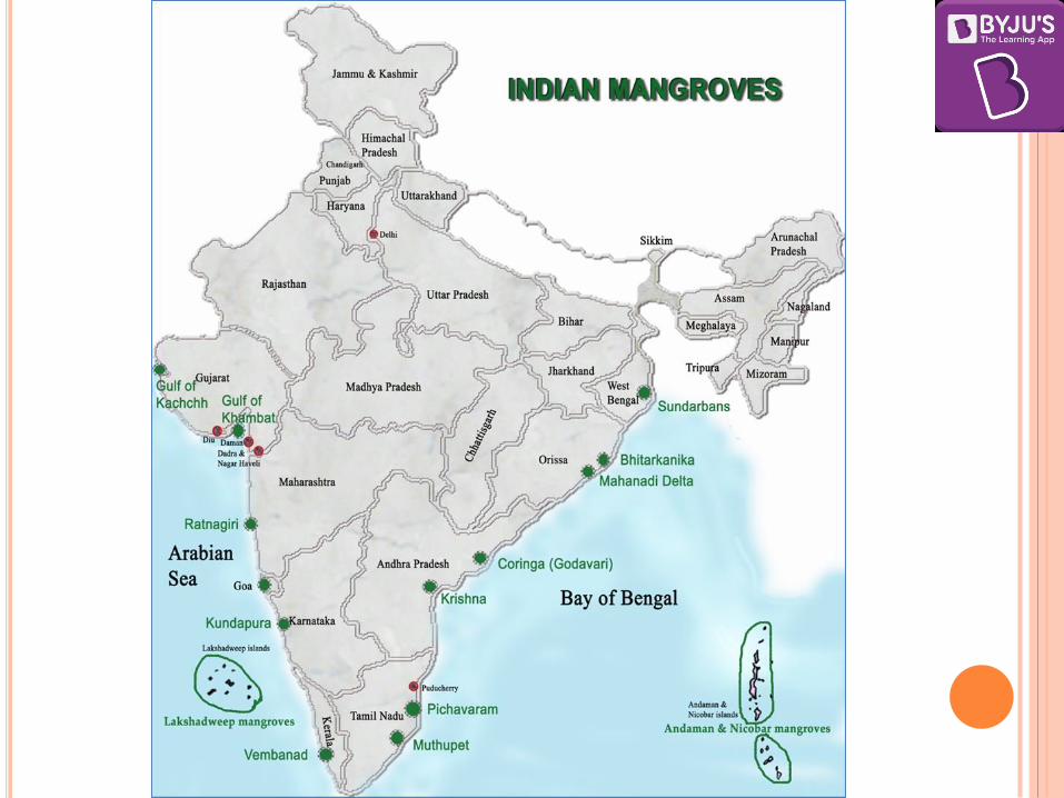
3. Coastal wetlands: The vast intertidal areas, mangroves and lagoons along the 7500 km long coastline in West Bengal, Orissa, Andhra Pradesh, Tamil Nadu, Kerala, Karnataka, Goa, Maharashtra and Gujarat; Mangrove forests of Sunderbans, Andaman and Nicobar Islands; Offshore coral reefs of Gulf of Kutch, Gulf of Mannar, Lakshwadeep and Andaman and Nicobar Islands.
4. Deccan: A few natural wetlands, but innumerable small and large reservoirs and several water storage tanks in almost every village in the region.
CAUSES OF WETLAND LOSS IN INDIA
Human Causes:
Drainage for agriculture, forestry and mosquito control
Dredging and stream channelization for navigation and food protection
Filling for solid waste disposal, roads
Conservation for aquaculture/mariculture
Construction of dykes, dams and seawalls for flood control
Discharge of pesticide, herbicide, nutrients from domestic sewage
Mining of wetlands for peat, coal, gravel, phosphate and other minerals
Ground water abstraction
Sediment diversion by dams, deep channels
Hydrological alterations by canals, roads and other structures
Subsidence due to extraction of ground water oil, gas and other minerals
CAUSES OF WETLAND LOSS IN INDIA
Natural Causes:
Subsidence
Sea level rise
Drought
Hurricane and other storms
Erosion
Biotic effects (natural as well as induced due to
disturbances)
WETLAND PROTECTION EFFORTS IN
INDIA
Though India is signatory to both Ramsar Convention
on Wetlands and the Convention of Biological
Diversity, there is no clear cut regulatory framework
for conservation of wetlands.
It is indirectly influenced by number of other legal
instruments like - The Indian Fisheries Act – 1857, The
Indian Forest Act – 1927, Wildlife (Protection) Act –
1972, Water (Prevention and Control of Pollution)Act –
1974, 1977, Environmental (Protection) Act – 1986,
Coastal Zone Regulation Notification – 1991, etc.

NATIONAL WETLAND CONSERVATION
PROGRAMME (NWCP)
Government of India operationalized National Wetland Conservation Programme (NWCP) in closed collaboration with concerned State Government during the year 1985/86.
Under the programme 115 wetlands have been identified till now by the Ministry which require urgent conservation and management initiatives (there are 26 Ramsar sites).
The Scheme aims for conservation and wise use of wetlands in the country so as to prevent their further degradation. It has the following objectives:
to lay down policy guidelines for conservation and management of wetlands in the country;
to undertake intensive conservation measures in priority wetlands;
to monitor implementation of the programme; and
to prepare an inventory of Indian wetlands.
Conservation and management of wetlands is primarily vested with the State/UTs, who are in physical possession of the area.
In 1993, National Lake Conservation Plan (NLCP) was carved out of NWCP to focus on lakes particularly those located in urban and peri-urban areas which are subjected to anthropogenic pressures.
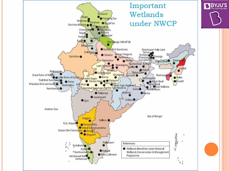

THE NATIONAL ENVIRONMENTAL POLICY
2006
It recognized the importance of wetlands in providing numerous ecological services.
The policy accepted that there is no formal system of wetland regulation in the country outside the international commitments made in respect of Ramsar sites and thus there is a need of legally enforceable regulatory mechanism for identified valuable wetlands, to prevent their degradation and enhance their conservation.
Based on the directives of National Environment Policy, 2006 and recommendations made by National Forest Commission, Central Government notified the Wetlands (Conservation and Management) Rules, 2010.
Under it, Central Wetlands Regulatory Authority (CWRA) has been constituted.
The rules put restrictions on the activities such as reclamation, setting up industries in vicinity, solid waste dumping, manufacture or storage of hazardous substances, discharge of untreated effluents, any permanent construction, etc. within the wetlands.
It also regulates activities (which will not be permitted without the consent of the State government) such as hydraulic alterations, unsustainable grazing, harvesting of resources, releasing treated effluents, aquaculture, agriculture and dredging.
The wetlands included under it are:
(1) wetlands selected under Ramsar Convention;
(2) wetlands in ecologically sensitive and important areas;
(3) wetlands recognized as UNESCO World Heritage site;
(4) high altitude wetlands
(5) wetland complexes below an elevation of 2500 m with an area equal to or greater than 500 ha;
(6) any other wetland identified by the Authority (Wetlands Rules, 2010).

RAMSAR CONVENTION ON WETLAND
The Convention on Wetlands, signed in Ramsar, Iran, in 1971, is an
intergovernmental treaty which provides the framework for national action and international cooperation for the conservation and wise use of wetlands and their resources.
There are presently 169 Contracting Parties to the Convention, with 2,234 wetland sites, totalling 215 million hectares, designated for inclusion in the Ramsar List of Wetlands of International Importance.
Ramsar Convention is the only global environment treaty dealing with a particular ecosystem.
The Ramsar Convention on Wetlands was developed as a means to call international attention to the rate at which wetland habitats were disappearing, in part due to a lack of understanding of their important functions, values, goods and services.
Governments that join the Convention are expressing their willingness to make a commitment to helping to reverse that history of wetland loss and degradation.
RAMSAR CONVENTION ON WETLAND
In addition, many wetlands are international systems lying
across the boundaries of two or more countries, or are part of river basins that include more than one country.
The health of these and other wetlands is dependent upon the quality and quantity of the trans-boundary water supply from rivers, streams, lakes, or underground aquifers.
This requires framework for international discussion and cooperation toward mutual benefits.
Major obligations of countries which are party to the Convention are:
Designate wetlands for inclusion in the List of Wetlands of International Importance.
Promote, as far as possible, the wise use of wetlands in their territory.
Promote international cooperation especially with regard to trans-boundary wetlands, shared water systems, and shared species.
Create wetland reserves.


CRITERIA FOR REPRESENTATIVE OR UNIQUE
WETLANDS
A wetland is identified as being of international importance if it meets
the criteria that were approved under Montreux Record of the Ramsar Convention. Some of these are:
Sites containing representative, rare or unique wetland types
A wetland should be considered internationally important if it supports vulnerable, endangered, or critically endangered species or threatened ecological communities.
Supports populations of plant and/or animal species important for maintaining the biological diversity of a particular biogeographic region.
Regularly supports 20,000 or more waterbirds.
Supports a significant proportion of indigenous fish subspecies and contributes to global biological diversity.
Important source of food for fishes, spawning ground, nursery and/or migration path on which fish stocks, either within the wetland or elsewhere, depend.
Regularly supports 1% of the individuals in a population of one species or subspecies of wetland dependent non-avian animal species.
MONTREUX RECORD
It is a register of wetland sites on the list of wetlands of
international importance where changes in ecological
character have occurred or are occurring, or are likely to
occur as a result of technological developments,
pollution or other human interference.
It is maintained as part of Ramsar List.
Currently, two wetlands of India are in Montreux
record viz.
1. Keoladeo National Park, Rajasthan and
2. Loktak Lake, Manipur.
Further, Chilka Lake was placed in the record but was
later removed from it.

WETLANDS INTERNATIONAL
Wetlands International is a not-for-profit
organization based in the Netherlands.
It works to sustain and restore wetlands and their
resources for people and biodiversity.
Wetlands International's work ranges from research and
community-based field projects to advocacy and
engagement with governments, corporate and
international policy fora and conventions.
International Waterbird Census

WETLANDS INTERNATIONAL
Wetlands International has been the driving force behind
the development of the Central Asian Flyway initiative.
The Central Asian Flyway covers the areas used by species
of birds with the main migratory routes through
Central Asia.
It has also been referred to as “Central Asian-Indian
Flyway” or as “Central Asian-South Asian Flyway”.
As such, the area extends from the Arctic Ocean in the
North until the Indian Ocean in the South (including
islands in that region) and thus covers territories of 30
Asian and East European countries.
It overlaps with the African Eurasian flyway in the
West, and the East Asian flyways in the East.

CUVETTE CENTRALE REGION AND THE
BRAZZAVILLE DECLARATION

CUVETTE CENTRALE REGION AND THE
BRAZZAVILLE DECLARATION
Cuvette Centrale region is the world’s largest tropical peatlands located in Congo Basin.
To protect the Cuvette Centrale region in the Congo Basin from unregulated land use and prevent its drainage and degradation, the Democratic Republic of Congo (DRC), the Republic of Congo and Indonesia have jointly signed the Brazzaville declaration that promotes better management and conservation of this globally important carbon store.
Global Peatlands Initiative: The declaration was signed on the sidelines of the Third Partners Meeting of the Global Peatlands Initiative, taking place in Brazzaville, Republic of Congo.
Peatlands: Peatlands are wetlands that contain a mixture of decomposed organic material, partially submerged in a layer of water, lacking oxygen. The complex biodiversity of the peatlands means they are home to a variety of species, but their high carbon content makes them uniquely vulnerable to incineration if they are drained.
About the Global Peatlands Initiative:
The Global Peatlands Initiative is an effort by leading experts and institutions to save peatlands as the world’s largest terrestrial organic carbon stock and to prevent it being emitted into the atmosphere.

List of Ramsar Sites in India Sl
No Wetland State Salient Features
1. Ashtamudi Wetland Kerala A natural backwater in Kollam district. River Kallada and Pallichal drains into it. It forms an estuary with Sea at Neendakara
which is a famous fishing harbour in Kerala. National Waterway 3 passes through it.
2. Bhitarkanika Mangroves Odisha The core area of Bhitarkanika Wildlife Sanctuary was declared Bhitarkanika National Park.
Bhitarkanika Wildlife Sanctuary includes Gahirmatha Marine Wildlife Sanctuary.
Bhitarkanika Mangroves, a part of Bhitarkanika Wildlife Sanctuary were designated a Ramsar Wetland of International Importance in 2002.
It is famous for its salt water crocodiles and Olive ridley sea turtle.
3. Bhoj Wetland Madhya Pradesh
The Bhoj Wetland consists of two lakes located in the city of Bhopal.
The two lakes are the Bhojtal and the Lower Lake.
It is a manmade reservoir. A total of more than 20,000 birds are observed
annually. The largest bird of India, the sarus crane (Grus
antigone) is found here.
4. Chandra Taal Himachal Pradesh
It is a lake situated in the Spiti part of the Lahul and Spiti district.
It is one of two high-altitude wetlands of India which have been designated as Ramsar sites.
5. Chilika Lake Odisha Chilka Lake is a brackish water lagoon at the mouth of the Daya River
It is spread over the Puri, Khurda and Ganjam districts of Odisha state on the east coast of India.
It is the largest coastal lagoon in India and the second largest lagoon in the world.

The lagoon hosts over 160 species of birds in the peak migratory
season. Birds from as far as the Caspian Sea, Lake Baikal, Aral Sea and other remote parts of Russia, Kirghiz steppes of Mongolia, Central and southeast Asia, Ladakh and Himalayas come here.
In 1981, Chilika Lake was designated the first Indian wetland of international importance under the Ramsar Convention.
Birds: White bellied sea eagles, greylag geese, purple moorhen, jacana, flamingos, egrets, gray and purple herons, Indian roller, storks, white ibis, spoonbills, brahminy ducks, shovellers, pintails, and more.
Nalbana Island is the core area of the Ramsar designated wetlands of Chilika Lake.
Nalbana was notified in 1987 and declared a bird sanctuary in 1973 under the Wildlife Protection Act.
The Irrawaddy dolphin (Orcaella brevirostris) is the flagship species of Chilika lake.
Chilka is home to the only known population of Irrawaddy dolphins in India.
It is classified as critically endangered, in five of the six other places it is known to live.
6. Deepor Beel Assam It is located to the south-west of Guwahati city, in Kamrup district of Assam
It is a permanent freshwater lake, in a former channel of the Brahmaputra River
It acts as a natural storm water reservoir during the monsoon season for the Guwahati city
Some of the globally threatened species of birds like spot billed pelican, lesser adjutant stork, Baer’s pochard, Pallas' sea eagle, greater adjutant stork
Among the large number of migratory water fowl, the Siberian crane regularly migrates to this habitat during its annual journey.
Considering the richness of the bird varieties found in the beel, the BirdLife International has declared Deepor Beel as an Important Bird Area (IBA) with high priority for conservation

Wild Asian elephants, leopard, jungle
cat and the protected barking deer, Chinese porcupine and sambar are found in the beel.
7. East Calcutta Wetlands West Bengal The wetland forms an urban facility for treating the city’s waste water
The wetland provides about 150 tons of fresh vegetables daily, as well as some 10,500 tons of table fish per year.
8. Harike Wetland Punjab An important site for breeding, wintering and staging birds, supporting over 200,000 Anatidae (ducks, geese, swans, etc.) during migration.
9. Hokera Wetland Jammu and Kashmir
Hokera wetland is only 10 km away from Srinagar.
68 waterfowl species like Large Egret, Great Crested Grebe, Little Cormorant, Common Shelduck, Tufted Duck and endangered White-eyed Pochard, coming from Siberia, China, Central Asia, and Northern Europe.
10. Kanjli Wetland Punjab The Kanjli Wetland is one of the manmade wetlands in India
The Kali Bein River formerly a main tributary of the Beas River feeds the Wetland and the Lake.
It recharges the ground water, drains excessive rainwater from sensitive crops like wheat, potato, etc. and acts as a sponge by absorbing the flood waters.
The mammals in the wetland are the Indian civet, mongoose, Indian porcupine, squirrel and common Indian hare.
11. Keoladeo National Park Rajasthan A complex of ten artificial, seasonal lagoons, varying in size, situated in a densely populated region.
Placed on the Montreux Record in 1990 due to “water shortage and an unbalanced grazing regime”.
Additionally, the invasive growth of the grass Paspalum distichum has changed the ecological character of large areas of the site, reducing its suitability for certain water bird species,

notably the Siberian crane.
12. Kolleru Lake Andhra Pradesh
It is one of the largest freshwater lakes in India and forms the largest shallow freshwater lake in Asia
It is located between Krishna and Godavari deltas.
The Atapaka Bird Sanctuary is located here
13. Loktak Lake Manipur Loktak Lake is the largest freshwater lake in the north-eastern region.
It is famous for the phumdis (heterogeneous mass of vegetation, soil and organic matter at various stages of decomposition) floating over it which form the floating islands.
Keibul Lamjao is the only floating national park in the world.
The park is the last natural refuge of the endangered Sangai (the brow-antlered deer), one of three subspecies of Eld's deer
14. Nalsarovar Bird Sanctuary
[Declared as Ramsar site in 2012. Most recent Ramsar Site in India]
Gujarat A natural freshwater lake (a relict sea) that is the largest natural wetland in the Thar Desert Biogeographic Province and represents a dynamic environment with salinity and depth varying depending on rainfall.
Besides a few mammalian species including the endangered wild ass and the black buck, its migratory bird population includes rosy pelicans, flamingoes, white storks, brahminy ducks and herons. Thousands of migratory waterfowl flock to this sanctuary just after the Indian monsoon season.
The wetland is also a lifeline for a satellite population of the endangered Indian Wild Ass (Equus hemionus khur) which uses this area in the dry season.
15. Point Calimere Wildlife and Bird Sanctuary
Tamil Nadu One of the last remnants of Dry Evergreen Forests.
Habitat:Dry Evergreen Forests, Mangrove & Wetlands.
Winter Migrants : Spoon Billed Sandpiper, Greater Flamingos.
16. Pong Dam Lake Himachal A water storage reservoir created in 1975 on
Pradesh the Beas River in the low foothills of the
Himalaya on the northern edge of the Indo-Gangetic plain.
17. Renuka Lake Himachal Pradesh
A natural wetland with freshwater springs and inland subterranean karst formations, fed by a small stream flowing from the lower Himalayan out to the Giri river.
There are 103 species of birds of which 66 are residents, e.g. Crimson-breasted barbet, Mayna, Bulbul, Pheasants, Egrets, Herons, Mallards and Lapwing.
Among ungulates Sambhar, Barking deer and Ghorals are also abundant in the area.
The lake has high religious significance and is named after the mother of Hindu sage Parshuram, and is thus visited by thousands of pilgrims and tourists.
18. Ropar Wetland Punjab A human made wetland of lake and river formed by the 1952 construction of a barrage for diversion of water from the Sutlej River for drinking and irrigation supplies.
The site is an important breeding place for the nationally protected Smooth Indian Otter, Hog Deer, Sambar, and several reptiles, and the endangered Indian Pangolin is thought to be present.
Some 35 species of fish play an important role in the food chain, and about 150 species of local and migratory birds are supported.
19. Rudrasagar Lake Tripura It is a natural sedimentation reservoir
It is a potential Important Bird Area and attracts a large number of waterfowl in winter.
Among the rarer species recorded are the endangered Baer's Pochard and near-threatened Ferruginous Duck.
A palace known as Neermahal (Water Palace) is situated near the north-east bank of the lake. It constructed by the then Tripura king Maharaja Bir Bikram Kishore Manikya Bahadur between 1935–1938 as a summer resort.
20. Sambhar Lake Rajasthan The Sambhar Salt Lake, India’s largest inland salt lake.

Sambhar has been designated as a Ramsar site
(recognized wetland of international importance) because the wetland is a key wintering area for tens of thousands of flamingos and other birds that migrate from northern Asia.
The specialized algae and bacteria growing in the lake provide striking water colours and support the lake ecology that, in turn, sustains the migrating waterfowl. There is other wildlife in the nearby forests, where Nilgai move freely along with deer and foxes.
21. Sasthamkotta Lake Kerala It is the largest freshwater lake in Kerala, situated in Kollam district.
22. Surinsar-Mansar Lakes Jammu and Kashmir
It is situated near Jammu and shares the legend and sanctity of Lake Manasarovar.
It is a wild life sanctuary housing jungle life like Spotted Deer, Nilgai etc. besides other water birds.
One can also witness the traditional and typical distinct life style of Gujjar and Backarwals wearing ethnic costume, living in open Kullhas around on the hills of Mansar Lake.
23. Tsomoriri Jammu and Kashmir
A freshwater to brackish lake lying at 4,595m above sea level. The site is said to represent the only breeding ground outside of China for one of the most endangered cranes, the Black-necked crane (Grus nigricollis), and the only breeding ground for Bar-headed geese in India.
The Great Tibetan Sheep or Argali (Ovis ammon hodgsoni) and Tibetan Wild Ass (Equus kiang) are endemic to the Tibetan plateau, of which the Changthang is the westernmost part.
24. Upper Ganga River (Brijghat to Narora Stretch)
Uttar Pradesh The river provides habitat for IUCN Red listed Ganges River Dolphin, Gharial, Crocodile, 6 species of turtles, otters, 82 species of fish and more than hundred species of birds.
25. Vembanad-Kol Wetland Kerala Largest lake of Kerala. Famous tourist locations like Alappuzha and
Kumarakom, known for house boats falls here.

River mouths of Pamba-Achenkovil rivers in
Vembanad forms one of the unique wetland topography of Kerala, the Kuttanad. It is below sea level and is famous for exotic fish varieties and Paddy fields that are below sea level.
26. Wular Lake Jammu and Kashmir
The largest freshwater lake in India. The lake basin was formed as a result
of tectonic activity and is fed by the Jhelum River.
The Tulbul Project is a "navigation lock-cum-control structure" at the mouth of Wular Lake and has been a source of dispute between India and Pakistan as per the Indus Water Treaty.

List of Biodiversity Hotspots, Biosphere Reserves, IUCN Red List and Wetlands in India
Biodiversity Hotspots of the World
I. Africa
1) Cape Floristic Region 2) Coastal Forests of Eastern Africa 3) Eastern Afromontane 4) Guinean Forests of West Africa 5) Horn of Africa 6) Madagascar and the Indian Ocean
Islands 7) Maputaland-Pondoland-Albany 8) Succulent Karoo
II. Asia-Pacific
9) East Melanesian Islands 10) Himalayas 11) Indo-Burma 12) Japan 13) Mountains of Southwest China 14) New Caledonia 15) New Zealand 16) Philippines 17) Polynesia-Micronesia 18) Southwest Australia 19) Forests of Eastern Australia (new) 20) Sundaland 21) Wallacea 22) Western Ghats and Sri Lanka
III. Europe and Central Asia
23) Caucasus 24) Irano-Anatolian 25) Mediterranean Basin 26) Mountains of Central Asia
IV. North and Central America
27) California Floristic Province 28) Caribbean Islands 29) Madrean Pine-Oak Woodlands 30) Mesoamerica
V. South America
31) Atlantic Forest 32) Cerrado 33) Chilean Winter Rainfall-Valdivian Forests 34) Tumbes-Chocó-Magdalena 35) Tropical Andes
Plants: The hotspots hold at least 150,000 endemic plant species, 50 percent of the world’s total vascular plants. Vertebrates: Overall, 11,980 mammals, birds, reptiles and amphibians are endemic to the hotspots (42 percent of all terrestrial vertebrates), while a total of 22,022 vertebrate species occur in the hotpots (77 percent of the world's total). In addition, there are more than 3,400 freshwater fish species endemic to the hotspots, which is likely to be an underestimate. Vegetation: The biodiversity hotspots once stretched across 15.7 percent of the Earth’s land surface,
however 86 percent of the hotspots’ original habitat has already been destroyed. Today, the intact
remnants of the hotspots now cover only 2.3 percent of the Earth’s land surface.
Biodiversity Hotspots in India:
1. The Himalayas:
It includes the entire Indian Himalayan region (and that falling in Pakistan, Tibet, Nepal, Bhutan, China and Myanmar).
The region is geologically young and shows high altitudinal variation. Together, the Himalayan mountain system is the world's highest, and home to the world's highest peaks, which include Mount Everest and K2.
Some of the world's major river systems arise in the Himalayas, and their combined drainage basin is home to some 3 billion people (almost half of Earth's population) in 18 countries.
The Himalayas have profoundly shaped the cultures of South Asia; many Himalayan peaks are sacred in Hinduism, Buddhism and Sikhism.
Geologically, the origin of the Himalayas is the impact of the Indian tectonic plate traveling northward at 15cm per year to impact the Eurasian continent, about 40-50 million years ago. The formation of the Himalayan arc resulted since the lighter rocks of the seabeds of that time were easily uplifted into mountains. An often-cited fact used to illustrate this process is that the summit of Mount Everest is made of marine limestone.
Biodiversity: The Himalayan hotspot has nearly 163 globally threatened species including the One-horned Rhinoceros, the Wild Asian Water buffalo and in all 45 mammals, 50 birds, 17 reptiles, 12 amphibians, 3 invertebrate and 36 plant species. The Relict Dragonfly is an endangered species found here with the only other species in the genus being found in Japan. The region is also home to the Himalayan Newt, the only salamander species found within Indian limits.
There are an estimated 10,000 species of plants in the Himalayas, of which one-third are endemic and found nowhere else in the world. Five families are completely endemic to this region. Many plant species are found even in the highest reaches of the Himalayan Mountains. A few threatened endemic bird species such as the Himalayan Quail, Cheer pheasant, Western tragopan are found here, along with some of Asia's largest and most endangered birds such as the Himalayan vulture and White-bellied heron.
The Saola, a bovine, is one of the world's rarest mammals. The Himalayas are home to over 300 species of mammals, a dozen of which are endemic. Mammals like the Golden langur, The Himalayan tahr, the pygmy hog, Langurs, Asiatic wild dogs, sloth bears, Gaurs, Muntjac, Sambar, Snow leopard, Black bear, Blue sheep, Takin, the Gangetic dolphin, wild water buffalo, swamp deer call the Himalayan ranged their home. The only endemic genus in the hotspot is the Namadapha flying squirrel which is critically endangered and is described only from a single specimen from Namdapha National Park.
2. Indo-Burma:
Includes entire North-eastern India, except Assam and Andaman group of Islands (and Myanmar, Thailand, Vietnam, Laos, Cambodia and southern China)

It is spread out from Eastern Bangladesh to Malaysia and includes North-Eastern India south
of Brahmaputra, Myanmar, the southern part of China’s Yunnan province, Lao People’s
Democratic Republic, Cambodia, Vietnam and Thailand.
The Indo-Burma region is spread over 2 million sq. km of tropical Asia.
Since this hotspot is spread over such a large area and across several major landforms, there
is a wide diversity of climate and habitat patterns in this region.
Biodiversity: Much of this region is still a wilderness, but has been deteriorating rapidly in the past few decades. In recent times, six species of large mammals have been discovered here: Large-antlered muntjac, Annamite muntjac, Grey-shanked douc, Annamite striped rabbit, Leaf deer, and the Saola. This region is home to several primate species such as monkeys, langurs and gibbons with populations numbering only in the hundreds. Many of the species, especially some freshwater turtle species, are endemic. Almost 1,300 bird species exist in this region including the threatened white-eared night-heron, the grey-crowned crocias, and the orange-necked partridge. It is estimated that there are about 13,500 plant species in this hotspot, with over half of them endemic. Ginger, for example, is native to this region.
3. Sundaland:
Sundaland is a region in South-East Asia that covers the western part of the Indo-Malayan archipelago. It includes Thailand, Malaysia, Singapore, Brunei and Indonesia.
India is represented by the Nicobar Islands. The United Nations declared the islands a World Biosphere Reserve in 2013. The islands have a rich terrestrial and marine ecosystem that includes mangroves, coral reefs
and sea grass beds. The marine biodiversity includes several species such as whales, dolphins, dugong, turtles,
crocodiles, fishes, prawns, lobsters, corals and sea shells. The primary threat to this biodiversity comes from over exploitation of marine resources. In
addition, the forests on the island also need to be protected.
4. Western Ghats and Sri Lanka:
This hotspot includes the entire Western Ghats and Sri Lanka. The Western Ghats are a chain of hills that run along the western edge of peninsular India.
Their proximity to the ocean and through orographic effect, they receive high rainfall. These regions have moist deciduous forest and rain forest.
The region shows high species diversity as well as high levels of endemism. Nearly 77% of the amphibians and 62% of the reptile species found here are found nowhere else. Sri Lanka, which lies to the south of India, is also a country rich in species diversity. It has been connected with India through several past glaciation events by a land bridge almost 140km wide.
The region shows biogeographical affinities to the Malayan region. Along with Sri Lanka, this region also shows some faunal similarities with the Madagascan region especially in the reptiles and amphibians. Examples include the Sibynophis snakes, the Purple Frog and Sri Lankan lizard genus Nessia which appears similar to the Madagascan genus Acontias.

Biodiversity: There are over 6000 vascular plants belonging to over 2500 genera in this hotspot, of which over 3000 are endemic. Much of the world's spices such as black pepper and cardamom have their origins in the Western Ghats. The highest concentration of species in the Western Ghats is believed to be the Agasthyamalai Hills in the extreme south. The region also harbors over 450 bird species, about 140 mammalian species, 260 reptiles and 175 amphibians. Over 60% of the reptiles and amphibians are completely endemic to the hotspot. Remarkable as this diversity is, it is severely threatened today. The vegetation in this hotspot originally extended over 190,000 square kms. Today, it’s been reduced to just 43,000 sq. km. In Sri Lanka, only 1.5% of the original forest cover still remains. The important populations include Asian elephant, Nilgiri tahr, Indian tigers, lion tailed macaque [All Endangered], Indian Giant squirrel [Least Concern], etc.
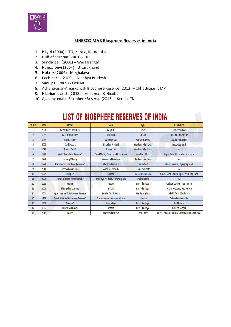
UNESCO MAB Biosphere Reserves in India
1. Nilgiri (2000) – TN, Kerala, Karnataka 2. Gulf of Mannar (2001) - TN 3. Sunderban (2001) – West Bengal 4. Nanda Devi (2004) - Uttarakhand 5. Nokrek (2009) - Meghalaya 6. Pachmarhi (2009) – Madhya Pradesh 7. Similipal (2009) - Odisha 8. Achanakmar-Amarkantak Biosphere Reserve (2012) – Chhattisgarh, MP 9. Nicobar Islands (2013) – Andaman & Nicobar 10. Agasthyamalai Biosphere Reserve (2016) – Kerala, TN

International Union for Conservation of Nature (IUCN)
The IUCN is an international organization working in the field of nature conservation and sustainable use of natural resources.
IUCN was established in 1948. It was previously called the International Union for Protection of Nature (1948–1956) and the
World Conservation Union (1990–2008). It’s headquartered in Gland, Switzerland. It is involved in data gathering and analysis, research, field projects, advocacy, lobbying and
education. IUCN's mission is to "influence, encourage and assist societies throughout the world to conserve
nature and to ensure that any use of natural resources is equitable and ecologically sustainable." Over the past decades, IUCN has widened its focus beyond conservation ecology and now
incorporates issues related to gender equality, poverty alleviation and sustainable business in its projects.
Unlike other international NGOs, IUCN does not itself aim to mobilize the public in support of nature conservation.
It tries to influence the actions of governments, business and other stakeholders by providing information and advice, and through lobbying and partnerships.
IUCN has observer and consultative status at the United Nations, and plays a role in the implementation of several international conventions on nature conservation and biodiversity.
IUCN is the only international observer organization in the UN General Assembly with expertise in issues concerning the environment.
It was involved in establishing the World Wide Fund for Nature (WWF), CITES and the World Conservation Monitoring Centre.
IUCN provides advice to environmental conventions such as the Convention on Biological Diversity, CITES and the Framework Convention on Climate Change.
It advises UNESCO on natural world heritage. It produces the IUCN Red List of Threatened Species (Flora and Fauna) and the IUCN Red List of
Ecosystems
The IUCN classification is as follows:
1) EXTINCT (EX) A taxon is Extinct when there is no reasonable doubt that the last individual has died.
2) EXTINCT IN THE WILD (EW)
A taxon is Extinct in the Wild when it is known only to survive in cultivation, in captivity or as a naturalized population (or populations) well outside the past range.
3) CRITICALLY ENDANGERED (CR)
A taxon is Critically Endangered when the best available evidence indicates that it meets any of the criteria A to E for Critically Endangered, and it is therefore considered to be facing an extremely high risk of extinction in the wild.
4) ENDANGERED (EN)
A taxon is endangered when the best available evidence indicates that it meets any of the criteria A to E for Endangered, and it is therefore considered to be facing a very high risk of extinction in the wild.

5) VULNERABLE (VU) A taxon is Vulnerable when the best available evidence indicates that it meets any of the criteria A to E for Vulnerable, and it is therefore considered to be facing a high risk of extinction in the wild.
6) NEAR THREATENED (NT)
A taxon is Near Threatened when it has been evaluated against the criteria but does not qualify for Critically Endangered, Endangered or Vulnerable now, but is close to qualifying for or is likely to qualify for a threatened category in the near future.
7) LEAST CONCERN (LC)
A taxon is Least Concern when it has been evaluated against the criteria and does not qualify for Critically Endangered, Endangered, Vulnerable or Near Threatened. Widespread and abundant taxa are included in this category.
8) DATA DEFICIENT (DD)
A taxon is Data Deficient when there is inadequate information to make a direct, or indirect, assessment of its risk of extinction based on its distribution and/or population status.
9) NOT EVALUATED (NE) A taxon is Not Evaluated when it has not yet been evaluated against the criteria.

Important Indian Species on the IUCN Red List Critically Endangered Mammals Endangered Mammals Critically Endangered Birds
1. Himalayan Brown/Red
Bear 2. Pygmy Hog 3. Andaman White-
toothed Shrew 4. Kondana Rat 5. Large Rock Rat or
Elvira Rat 6. Namdapha Flying
Squirrel 7. Malabar Civet 8. Sumatran Rhinoceros 9. Kashmir stag/hangul
1. Red Panda 2. Wild ass/ khur 3. Dhole/ Asiatic wild
dog or Indian wild dog 4. Eld’s deer/ thamin or
brow-antlered deer 5. Golden langur 6. Himalayan / White-
bellied Musk Deer 7. Hispid hare/ Assam
rabbit 8. Hog deer 9. Lion-tailed macaque/
wanderoo 10. Chita / Tibetian
Antelope 11. Nilgiri langur/ Nilgiri
leaf monkey 12. Nilgiri tahr
1. Great Indian
Bustard 2. Forest Owlet 3. Spoon Billed
Sandpiper 4. Jerdon’s Courser 5. Bengal Florican 6. White Bellied
Heron 7. Himalayan Quail 8. Siberian Crane 9. Sociable Lapwing 10. Pink-headed Duck 11. White-rumped
Vulture 12. Indian Vulture 13. Slender-billed
Vulture 14. Red-headed
Vulture
Endangered Marine Mammals
1. Freshwater / river dolphin
‘Critically Endangered’ Mammals
1. Himalayan Brown/Red Bear (Ursus arctos isabellinus)
Distribution: Nepal, Tibet, north India, and north Pakistan. Threats: loss of suitable habitat and persecution by humans.

2. Pygmy Hog (Porcula salvania)
Is the world’s smallest wild pig. This species constructs a nest throughout the year. It is one of the most useful indicators of the management status of grassland habitats. The grasslands where the pygmy hog resides are crucial for the survival of other threatened
species such as Indian Rhinoceros, Swamp Deer, Wild Buffalo, Hispid Hare, Bengal Florican and Swamp Francolin.
Habitat: Relatively undisturbed, tall ‘terai’ grasslands. Distribution: Previously spread across India, Nepal, and Bhutan. Now only found in Assam
(Manas Wildlife Sanctuary and its buffer reserves). Pygmy hog-sucking Louse (Haematopinus oliveri), a parasite that feeds only on Pygmy Hogs will
also fall in the same risk category of critically endangered as its survival is linked to that of the host species.
Threats: The main threats are loss and degradation of grasslands, dry-season burning, livestock grazing and afforestation of grasslands. Hunting is also a threat.
3. Andaman White-toothed Shrew (Crocidura andamanensis)
Distribution: It is endemic to the South Andaman Island of India. They are usually active by twilight or in the night. Threats: Habitat loss due to selective logging, natural disasters such as tsunami and drastic
weather change are thought to contribute to current population declines.
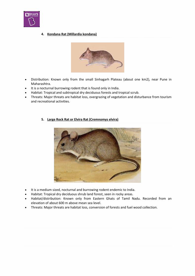
4. Kondana Rat (Millardia kondana)
Distribution: Known only from the small Sinhagarh Plateau (about one km2), near Pune in Maharashtra.
It is a nocturnal burrowing rodent that is found only in India. Habitat: Tropical and subtropical dry deciduous forests and tropical scrub. Threats: Major threats are habitat loss, overgrazing of vegetation and disturbance from tourism
and recreational activities.
5. Large Rock Rat or Elvira Rat (Cremnomys elvira)
It is a medium sized, nocturnal and burrowing rodent endemic to India. Habitat: Tropical dry deciduous shrub land forest, seen in rocky areas. Habitat/distribution: Known only from Eastern Ghats of Tamil Nadu. Recorded from an
elevation of about 600 m above mean sea level. Threats: Major threats are habitat loss, conversion of forests and fuel wood collection.

6. Namdapha Flying Squirrel (Biswamoyopterus biswasi)
It is a unique (the only one in its genus) flying squirrel that is restricted to a single valley in the Namdapha N.P. (or) W.L.S. in Arunachal Pradesh.
Habitat: Tropical forest. Habitat/distribution: Found only in Namdapha Tiger Reserve in Arunachal Pradesh. Threats: Hunted for food.
7. Malabar Civet (Viverra civettina)
It is endemic to India and was first reported from Travancore, Kerala. It is nocturnal in nature and found exclusively in the Western Ghats. Habitat: Wooded plains and hill slopes of evergreen rainforests. Habitat/distribution: Western Ghats. Threats: Deforestation and commercial plantations are major threats.
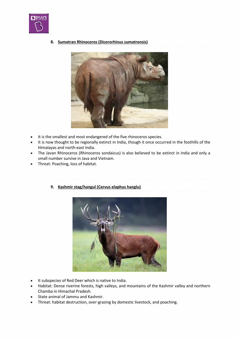
8. Sumatran Rhinoceros (Dicerorhinus sumatrensis)
It is the smallest and most endangered of the five rhinoceros species. It is now thought to be regionally extinct in India, though it once occurred in the foothills of the
Himalayas and north-east India. The Javan Rhinoceros (Rhinoceros sondaicus) is also believed to be extinct in India and only a
small number survive in Java and Vietnam. Threat: Poaching, loss of habitat.
9. Kashmir stag/hangul (Cervus elaphus hanglu)
It subspecies of Red Deer which is native to India. Habitat: Dense riverine forests, high valleys, and mountains of the Kashmir valley and northern
Chamba in Himachal Pradesh. State animal of Jammu and Kashmir. Threat: habitat destruction, over-grazing by domestic livestock, and poaching.

‘Endangered’ Mammals
1. Red Panda
Status: Moved from Vulnerable to Endangered recently. Red panda is endemic to the temperate forests of the Himalayas. Habitat: Sikkim and Assam, northern Arunachal Pradesh. Threats: habitat loss and fragmentation, poaching, and inbreeding depression.
2. Wild ass/ khur (Equus hemionus khur)
Distribution: Mostly occurs in Rann of Kutch region. Population steadily increasing. Today, its last refuge lies in the Indian Wild Ass Sanctuary, Little Rann of Kutch. Threat – Diseases, habitat degradation due to salt activities, Invasive species Prosopis juliflora
shrub, and encroachment and grazing by the Maldhari.

3. Dhole/ Asiatic wild dog or Indian wild dog (Cuon alpinus)
Distribution: They occur in most of India south of the Ganges, particularly in the Central Indian Highlands and the Western and Eastern Ghats of the southern states.
In north-east India, they inhabit Arunachal Pradesh, Assam, Meghalaya, and West Bengal. Threats: Habitat loss, depletion of its prey base, competition from other predators, persecution
and possibly diseases from domestic and feral dogs.
4. Eld’s deer/ thamin or brow-antlered deer (Panolia eldii)
Distribution: Keibul Lamjao National Park (KLNP), Manipur. Threats: Overgrazing, loss of grassland habitat.

5. Golden langur (Trachypithecus geei)
Primate, is an Old World monkey Distribution – small region of western Assam and in the neighbouring foothills of the Black
Mountains of Bhutan. Threats: Deforestation, human encroachments.
6. Himalayan / White-bellied Musk Deer
Habitat: Kashmir, Kumaon and Sikkim. Threat: poaching & illegal trade for its musk. Only males produce the musk.
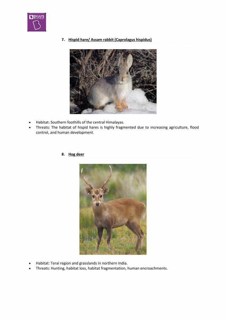
7. Hispid hare/ Assam rabbit (Caprolagus hispidus)
Habitat: Southern foothills of the central Himalayas. Threats: The habitat of hispid hares is highly fragmented due to increasing agriculture, flood
control, and human development.
8. Hog deer
Habitat: Terai region and grasslands in northern India. Threats: Hunting, habitat loss, habitat fragmentation, human encroachments.

9. Lion-tailed macaque/ wanderoo (Macaca silenus)
Endemic to the Western Ghats. Avoid human presence and they do not live, feed or travel through plantations. Habitat: Evergreen forests in the Western Ghats range. Threat: Habitat fragmentation due to spread of agriculture and tea, coffee, teak and cinchona,
construction of water reservoirs and human settlements to support such activities.
10. Chita / Tibetian Antelope
Status – Endangered. Habitat : Tibet cold desert. Threat : The antelope is threatened by hunting for its fine wool which is used to make the
shahtoosh scarves, meat, magnificent horns.

11. Nilgiri langur/ Nilgiri leaf monkey (Trachypithecus johnii)
Habitat: Hilly areas of Western Ghats in Tamil Nadu and Kerala. Threats: Habitat degradation, development activities, introduction of exotic tree species.
12. Nilgiri tahr
The Nilgiri tahr is the largest of the three tahr species, inhabit montane grasslands of Western Ghats. It is the state animal of Tamil Nadu.
Threats: Habitat loss, overgrazing, illegal hunting.
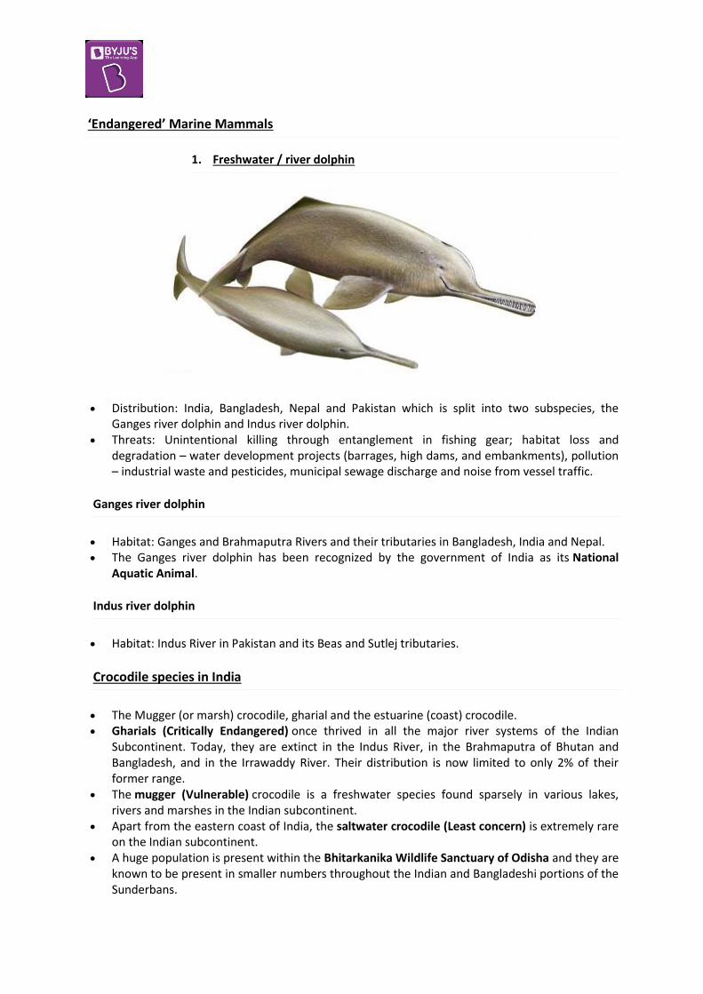
‘Endangered’ Marine Mammals
1. Freshwater / river dolphin
Distribution: India, Bangladesh, Nepal and Pakistan which is split into two subspecies, the Ganges river dolphin and Indus river dolphin.
Threats: Unintentional killing through entanglement in fishing gear; habitat loss and degradation – water development projects (barrages, high dams, and embankments), pollution – industrial waste and pesticides, municipal sewage discharge and noise from vessel traffic.
Ganges river dolphin
Habitat: Ganges and Brahmaputra Rivers and their tributaries in Bangladesh, India and Nepal. The Ganges river dolphin has been recognized by the government of India as its National
Aquatic Animal.
Indus river dolphin
Habitat: Indus River in Pakistan and its Beas and Sutlej tributaries.
Crocodile species in India
The Mugger (or marsh) crocodile, gharial and the estuarine (coast) crocodile. Gharials (Critically Endangered) once thrived in all the major river systems of the Indian
Subcontinent. Today, they are extinct in the Indus River, in the Brahmaputra of Bhutan and Bangladesh, and in the Irrawaddy River. Their distribution is now limited to only 2% of their former range.
The mugger (Vulnerable) crocodile is a freshwater species found sparsely in various lakes, rivers and marshes in the Indian subcontinent.
Apart from the eastern coast of India, the saltwater crocodile (Least concern) is extremely rare on the Indian subcontinent.
A huge population is present within the Bhitarkanika Wildlife Sanctuary of Odisha and they are known to be present in smaller numbers throughout the Indian and Bangladeshi portions of the Sunderbans.

(Zoom in to the image for clear view)


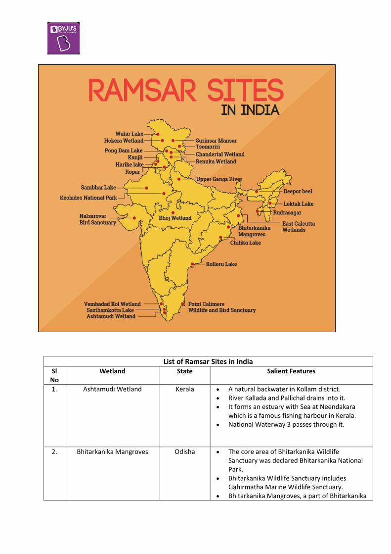
List of Ramsar Sites in India Sl
No Wetland State Salient Features
1. Ashtamudi Wetland Kerala A natural backwater in Kollam district. River Kallada and Pallichal drains into it. It forms an estuary with Sea at Neendakara
which is a famous fishing harbour in Kerala. National Waterway 3 passes through it.
2. Bhitarkanika Mangroves Odisha The core area of Bhitarkanika Wildlife Sanctuary was declared Bhitarkanika National Park.
Bhitarkanika Wildlife Sanctuary includes Gahirmatha Marine Wildlife Sanctuary.
Bhitarkanika Mangroves, a part of Bhitarkanika

Wildlife Sanctuary were designated a Ramsar Wetland of International Importance in 2002.
It is famous for its salt water crocodiles and Olive ridley sea turtle.
3. Bhoj Wetland Madhya Pradesh
The Bhoj Wetland consists of two lakes located in the city of Bhopal.
The two lakes are the Bhojtal and the Lower Lake.
It is a manmade reservoir. A total of more than 20,000 birds are observed
annually. The largest bird of India, the sarus crane (Grus
antigone) is found here.
4. Chandra Taal Himachal Pradesh
It is a lake situated in the Spiti part of the Lahul and Spiti district.
It is one of two high-altitude wetlands of India which have been designated as Ramsar sites.
5. Chilika Lake Odisha Chilka Lake is a brackish water lagoon at the mouth of the Daya River
It is spread over the Puri, Khurda and Ganjam districts of Odisha state on the east coast of India.
It is the largest coastal lagoon in India and the second largest lagoon in the world.
The lagoon hosts over 160 species of birds in the peak migratory
season. Birds from as far as the Caspian Sea, Lake Baikal, Aral Sea and other remote parts of Russia, Kirghiz steppes of Mongolia, Central and southeast Asia, Ladakh and Himalayas come here.
In 1981, Chilika Lake was designated the first Indian wetland of international importance under the Ramsar Convention.
Birds: White bellied sea eagles, greylag geese, purple moorhen, jacana, flamingos, egrets, gray and purple herons, Indian roller, storks, white ibis, spoonbills, brahminy ducks, shovellers, pintails, and more.
Nalbana Island is the core area of the Ramsar designated wetlands of Chilika Lake.
Nalbana was notified in 1987 and declared a bird sanctuary in 1973 under the Wildlife Protection Act.

The Irrawaddy dolphin (Orcaella brevirostris) is the flagship species of Chilika lake.
Chilka is home to the only known population of Irrawaddy dolphins in India.
It is classified as critically endangered, in five of the six other places it is known to live.
6. Deepor Beel Assam It is located to the south-west of Guwahati city, in Kamrup district of Assam
It is a permanent freshwater lake, in a former channel of the Brahmaputra River
It acts as a natural storm water reservoir during the monsoon season for the Guwahati city
Some of the globally threatened species of birds like spot billed pelican, lesser adjutant stork, Baer’s pochard, Pallas' sea eagle, greater adjutant stork
Among the large number of migratory water fowl, the Siberian crane regularly migrates to this habitat during its annual journey.
Considering the richness of the bird varieties found in the beel, the BirdLife International has declared Deepor Beel as an Important Bird Area (IBA) with high priority for conservation
Wild Asian elephants, leopard, jungle cat and the protected barking deer, Chinese porcupine and sambar are found in the beel.
7. East Calcutta Wetlands West Bengal The wetland forms an urban facility for treating the city’s waste water
The wetland provides about 150 tons of fresh vegetables daily, as well as some 10,500 tons of table fish per year.
8. Harike Wetland Punjab An important site for breeding, wintering and staging birds, supporting over 200,000 Anatidae (ducks, geese, swans, etc.) during migration.
9. Hokera Wetland Jammu and Kashmir
Hokera wetland is only 10 km away from Srinagar.
68 waterfowl species like Large Egret, Great Crested Grebe, Little Cormorant, Common Shelduck, Tufted Duck and endangered White-

eyed Pochard, coming from Siberia, China, Central Asia, and Northern Europe.
10. Kanjli Wetland Punjab The Kanjli Wetland is one of the manmade wetlands in India
The Kali Bein River formerly a main tributary of the Beas River feeds the Wetland and the Lake.
It recharges the ground water, drains excessive rainwater from sensitive crops like wheat, potato, etc. and acts as a sponge by absorbing the flood waters.
The mammals in the wetland are the Indian civet, mongoose, Indian porcupine, squirrel and common Indian hare.
11. Keoladeo National Park Rajasthan A complex of ten artificial, seasonal lagoons, varying in size, situated in a densely populated region.
Placed on the Montreux Record in 1990 due to “water shortage and an unbalanced grazing regime”.
Additionally, the invasive growth of the grass Paspalum distichum has changed the ecological character of large areas of the site, reducing its suitability for certain water bird species, notably the Siberian crane.
12. Kolleru Lake Andhra Pradesh
It is one of the largest freshwater lakes in India and forms the largest shallow freshwater lake in Asia
It is located between Krishna and Godavari deltas.
The Atapaka Bird Sanctuary is located here
13. Loktak Lake Manipur Loktak Lake is the largest freshwater lake in the north-eastern region.
It is famous for the phumdis (heterogeneous mass of vegetation, soil and organic matter at various stages of decomposition) floating over it which form the floating islands.
Keibul Lamjao is the only floating national park in the world.
The park is the last natural refuge of the endangered Sangai (the brow-antlered deer), one of three subspecies of Eld's deer

14. Nalsarovar Bird Sanctuary
[Declared as Ramsar site in 2012. Most recent Ramsar Site in India]
Gujarat A natural freshwater lake (a relict sea) that is the largest natural wetland in the Thar Desert Biogeographic Province and represents a dynamic environment with salinity and depth varying depending on rainfall.
Besides a few mammalian species including the endangered wild ass and the black buck, its migratory bird population includes rosy pelicans, flamingoes, white storks, brahminy ducks and herons. Thousands of migratory waterfowl flock to this sanctuary just after the Indian monsoon season.
The wetland is also a lifeline for a satellite population of the endangered Indian Wild Ass (Equus hemionus khur) which uses this area in the dry season.
15. Point Calimere Wildlife and Bird Sanctuary
Tamil Nadu One of the last remnants of Dry Evergreen Forests.
Habitat:Dry Evergreen Forests, Mangrove & Wetlands.
Winter Migrants : Spoon Billed Sandpiper, Greater Flamingos.
16. Pong Dam Lake Himachal Pradesh
A water storage reservoir created in 1975 on the Beas River in the low foothills of the Himalaya on the northern edge of the Indo-Gangetic plain.
17. Renuka Lake Himachal Pradesh
A natural wetland with freshwater springs and inland subterranean karst formations, fed by a small stream flowing from the lower Himalayan out to the Giri river.
There are 103 species of birds of which 66 are residents, e.g. Crimson-breasted barbet, Mayna, Bulbul, Pheasants, Egrets, Herons, Mallards and Lapwing.
Among ungulates Sambhar, Barking deer and Ghorals are also abundant in the area.
The lake has high religious significance and is named after the mother of Hindu sage Parshuram, and is thus visited by thousands of pilgrims and tourists.
18. Ropar Wetland Punjab A human made wetland of lake and river formed by the 1952 construction of a barrage
for diversion of water from the Sutlej River for drinking and irrigation supplies.
The site is an important breeding place for the nationally protected Smooth Indian Otter, Hog Deer, Sambar, and several reptiles, and the endangered Indian Pangolin is thought to be present.
Some 35 species of fish play an important role in the food chain, and about 150 species of local and migratory birds are supported.
19. Rudrasagar Lake Tripura It is a natural sedimentation reservoir
It is a potential Important Bird Area and attracts a large number of waterfowl in winter.
Among the rarer species recorded are the endangered Baer's Pochard and near-threatened Ferruginous Duck.
A palace known as Neermahal (Water Palace) is situated near the north-east bank of the lake. It constructed by the then Tripura king Maharaja Bir Bikram Kishore Manikya Bahadur between 1935–1938 as a summer resort.
20. Sambhar Lake Rajasthan The Sambhar Salt Lake, India’s largest inland salt lake.
Sambhar has been designated as a Ramsar site (recognized wetland of international importance) because the wetland is a key wintering area for tens of thousands of flamingos and other birds that migrate from northern Asia.
The specialized algae and bacteria growing in the lake provide striking water colours and support the lake ecology that, in turn, sustains the migrating waterfowl. There is other wildlife in the nearby forests, where Nilgai move freely along with deer and foxes.
21. Sasthamkotta Lake Kerala It is the largest freshwater lake in Kerala, situated in Kollam district.
22. Surinsar-Mansar Lakes Jammu and Kashmir
It is situated near Jammu and shares the legend and sanctity of Lake Manasarovar.
It is a wild life sanctuary housing jungle life like Spotted Deer, Nilgai etc. besides other

water birds.
One can also witness the traditional and typical distinct life style of Gujjar and Backarwals wearing ethnic costume, living in open Kullhas around on the hills of Mansar Lake.
23. Tsomoriri Jammu and Kashmir
A freshwater to brackish lake lying at 4,595m above sea level. The site is said to represent the only breeding ground outside of China for one of the most endangered cranes, the Black-necked crane (Grus nigricollis), and the only breeding ground for Bar-headed geese in India.
The Great Tibetan Sheep or Argali (Ovis ammon hodgsoni) and Tibetan Wild Ass (Equus kiang) are endemic to the Tibetan plateau, of which the Changthang is the westernmost part.
24. Upper Ganga River (Brijghat to Narora Stretch)
Uttar Pradesh The river provides habitat for IUCN Red listed Ganges River Dolphin, Gharial, Crocodile, 6 species of turtles, otters, 82 species of fish and more than hundred species of birds.
25. Vembanad-Kol Wetland Kerala Largest lake of Kerala. Famous tourist locations like Alappuzha and
Kumarakom, known for house boats falls here. River mouths of Pamba-Achenkovil rivers in
Vembanad forms one of the unique wetland topography of Kerala, the Kuttanad. It is below sea level and is famous for exotic fish varieties and Paddy fields that are below sea level.
26. Wular Lake Jammu and Kashmir
The largest freshwater lake in India. The lake basin was formed as a result
of tectonic activity and is fed by the Jhelum River.
The Tulbul Project is a "navigation lock-cum-control structure" at the mouth of Wular Lake and has been a source of dispute between India and Pakistan as per the Indus Water Treaty.