empire electric site - interim remedial measure decision document
TRANSCRIPT

Interim Remedial Measure Decision Document
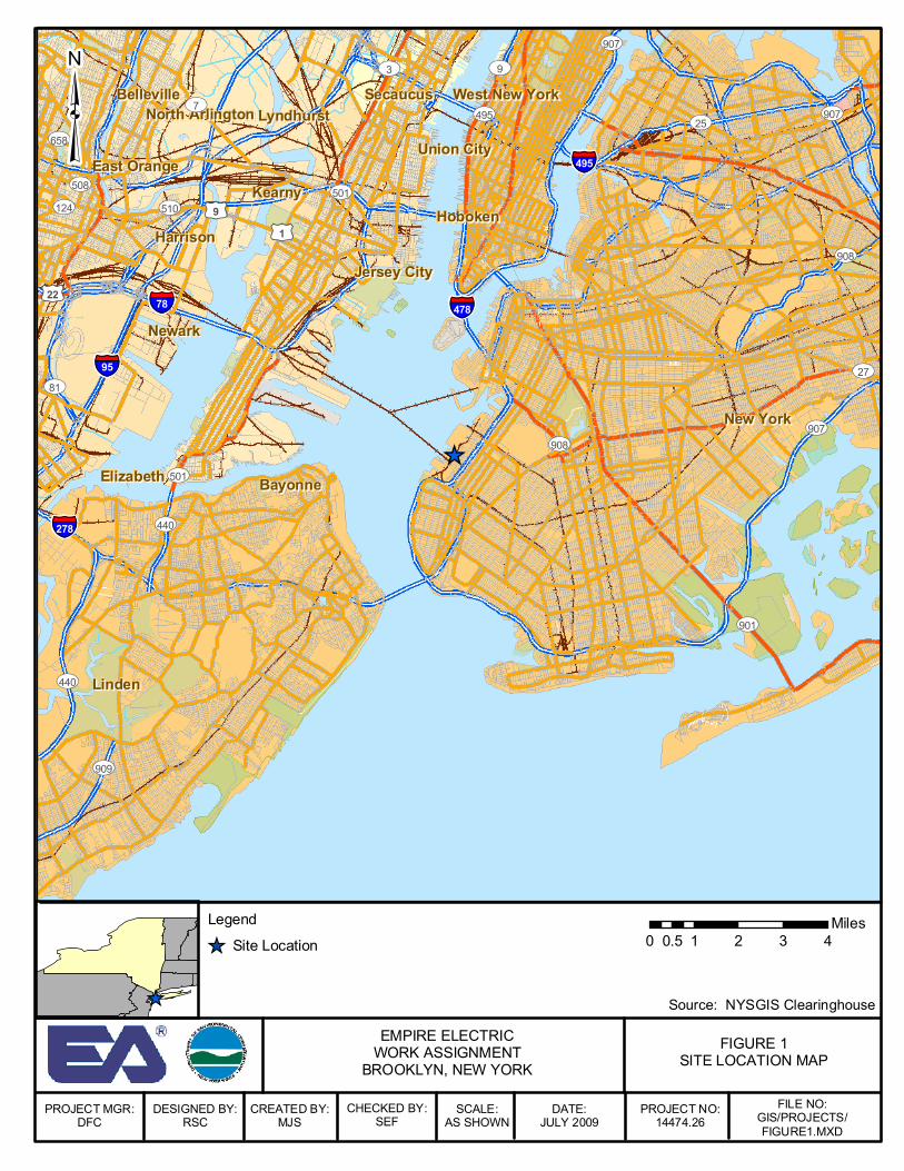
Empire Electric Site Brooklyn, Kings County, New York
Site No. 224015 September 2012
Statement of Purpose and Basis This Decision Document presents an interim remedial measure (IRM) consisting of building demolition which has been identified by the Division of Environmental Remediation (DER) of the Department of Environmental Conservation as necessary for the protection of public health and the environment at the Empire Electric site. Description of the Site Location: The Empire Electric Company site is located at 5200 1st Avenue in Brooklyn, New York on the southwest corner of 52nd Street and 1st Avenue (see attached figures). Site Features: The site contains a deteriorated, vacant, red brick building that covers the entire site. The site consists of a 100 ft × 240 ft parcel (Section 1, Block 803, Lot 9). Directly adjacent to the northwest of the Site is an occupied 100 ft × 140 ft parcel (Block 803, Lot 6) that contains a contiguous structure scheduled to remain. This building shares a common wall and adjoining steel truss roofing structure with the Empire Electric building. Current Zoning/Use(s): The Empire Electric building is vacant and inactive. The area is primarily industrial in nature, with a potato chip manufacturing plant (Utz), a New York City Department of Sanitation vehicle maintenance and storage building, an overnight courier (DHL), the former BUG - Kings County Works manufactured gas plant site, and the waterfront (Bush Terminal docks) in the general vicinity. Historic Use(s): The building was constructed in 1892 by the Brooklyn City Railroad Company for use as a power plant for the municipally owned trolley system. The building was used for electrical generation until the 1930s when the trolley system was abandoned. The facility was conveyed to the city of New York in 1940. In 1951, the property was sold and the parcel was subdivided into two lots (Lot 9 and Lot 6). On 5 September 1951, Lot 9 was sold to Empire Electric which operated on Lot 9, the eastern two-thirds of the building, from 1951 to December 1986 when the property was once again sold. During at least some of this time period, activities within the building included rehabilitation of electrical transformers containing polychlorinated biphenyls. The site has been vacant since at least 1998 and is currently roofless and in severally deteriorated condition. Scaffolding has been erected around the perimeter to protect passer-bys on the sidewalks from falling bricks.

Site Geology and Hydrogeology: The Site is situated approximately 1,200 feet from the Upper New York Bay at the western end of the borough of Brooklyn The Site is topographically relatively flat, located approximately 16 feet above mean sea level (msl) and slopes gradually up from the Hudson River. Site soil beneath the building consists primarily of fill and debris materials, underlain by sand and gravel, and beneath these layers, bedrock. The water table beneath the Site occurs at a depth of approximately 17 to 21 feet below ground surface (bgs). Regional groundwater flow direction is to the west, toward the Upper New York Bay. The depth to bedrock is unknown, but is likely greater than 100 feet bgs. Surface drainage generally follows the topography, and flow is northwest along 52nd Street toward the Upper New York Bay. Storm water drains are present along 52nd Street and First Avenue. Surface run-off collects in these drains and then flows directly into the Upper New York Bay. Nature and Extent of Contamination Based upon investigations conducted to date, the primary contaminants of concern are PCBs. Building material (brick and mortar contained PCB concentrations in excess of 50 ppm, the New York State and Federal Toxic Substance Control Act (TSCA) definition of PCB hazardous waste, in 35 percent of the 165 analyzed samples. Sample analysis of the floor slabs indicated, 60 percent of the concrete slab on the main floor and 80 percent of the concrete slab in the basement area exceed this criteria and are therefore classified as a State/TSCA hazardous waste. Grease/oil samples collected from building material in the basement present on nearly 70 percent of brick pillar surfaces, also exceeded the TSCA criteria of 50 ppm total PCBs. Fifty-two of the 165 building material samples collected and analyzed contained levels of PCB contamination ranging from 51 ppm to 33,000 ppm. A limited number of soil samples which could be collected from beneath the basement floor exceeded the 1ppm surface/10ppm subsurface soil cleanup presumptive remedy for PCB contamination in soil. Two of these soil samples also exceeded the hazardous waste levels. Further characterization of the vertical and horizontal extent of the PCB contamination is needed but is precluded by the limited access in the basement areas. The site presents a significant environmental threat due to the potential for PCB releases from source areas both within and beneath the building. Basis and Description of the IRM Building demolition has been determined necessary to both complete the remedial investigation and to eliminate a continued potential source of contaminant release, transport, and exposure to the public and environment in the vicinity of the Site. The protection of public health extends not only to the chemical contamination but also to the potential physical hazards represented by the Site (see attached photos).
The Remedial Investigation of the nature and extent of subsurface contamination cannot be completed with the building remaining: A reasonable basis exists to believe PCB contamination has been released to the environment beneath the building. Concentrations of PCBs in building material samples collected from the basement floor slab ranged from to 2.0 ppm to 7,900 ppm. Twenty-nine of the 85 basement samples indicate PCB concentrations above 50 ppm. A limited sub-surface investigation has been completed at the site, and PCBs have been found in soil under the building at SB-05 as high as 160ppm. Further definition of soil quality beneath the building, and an assessment of potential remedial options, is necessary. However, the building does not allow access for sampling equipment to perform the necessary sampling. Entering the building with a large track mounted drill rig is unsafe because of compromised integrity of the first floor concrete surface and damaged flooring structure. The logistics and size of brick, pyramid-shaped supports in the basement further limit access for a small drill rig to sample through the basement. Fill material consisting of crushed brick debris beneath the building slab makes it unlikely that a hand sampler could be used. In any event, the personnel responsible for operation of any potential sampling equipment within the basement would be at risk from the physical hazards posed by the dilapidated building. The building in itself is a continued potential source of contaminant release and exposure, and this source cannot feasibly be eliminated without removing the structure. The building structure is contaminated with PCBs as high as 33,000 ppm, and it is noted above that the PCBs have been released to the environment. These high concentrations of PCBs have permeated the brick at a depth greater than a quarter inch in some areas. Brick coring samples at this depth contain PCB contamination greater than 50 ppm. The depth that PCBs have penetrated the brick does not allow the PCBs to be cleaned from the brick by using an abrasive method. Epoxy coating the brick surface to encapsulate the PCB contamination has also been determined to not be a viable alternative. To help preserve the epoxy coating, the integrity of the building would need to be repaired at significant cost (a new roof would have to be constructed and the building would have to be made secure). The epoxy coating, if successful at preventing exposure to contamination, would require continued inspection and maintenance. Long term costs associated with maintaining the epoxy coating, building integrity, and security is not quantifiable, but is expected to be significant. The cost of demolishing the building and disposing of the contaminated material is significant, but this option eliminates the assumption of potentially unlimited long-term costs associated with other options. Furthermore, this option allows for a more rapid completion of the investigation of the full nature and extent of contamination and enhances the future use potential of the property. Therefore, the Department finds building demolition with off-site disposal of PCB-contaminated building materials to be an appropriate interim remedial measure at this point.
Declaration The selected IRM is protective of human health and the environment, complies with State and Federal requirements that are legally applicable or relevant and appropriate to the remedial action, and is an appropriate interim remedial measure. ___________________________________ __________________________________ Date Robert Cozzy, Director Remedial Bureau B Division of Environmental Remediation
_̂
New YorkNew York
NewarkNewark
Jersey CityJersey City
KearnyKearny
BayonneBayonneElizabethElizabeth
SecaucusSecaucusBellevilleBellevilleLyndhurstLyndhurst
HobokenHobokenHarrisonHarrison
North ArlingtonNorth Arlington
Union CityUnion City
West New YorkWest New York
LindenLinden
East OrangeEast Orange
§̈¦95
§̈¦478
§̈¦278
§̈¦78
§̈¦495
£¤9
£¤1
£¤22
UV901
UV907
UV7
UV440
UV9
UV908
UV81
UV501UV510
UV909
UV27
UV25UV658
UV508
UV495
UV3
UV124
UV907
UV907
UV908
UV440
UV501
PROJECT MGR:DFC
FIGURE 1SITE LOCATION MAP
EMPIRE ELECTRICWORK ASSIGNMENT
BROOKLYN, NEW YORK
DESIGNED BY:RSC
CREATED BY:MJS
CHECKED BY:SEF
SCALE:AS SHOWN
DATE:JULY 2009
PROJECT NO:14474.26
FILE NO:GIS/PROJECTS/FIGURE1.MXD
_̂ Source: NYSGIS Clearinghouse
³
Legend_̂ Site Location 0 1 2 3 40.5
Miles

WAREHOUSE
DEPARThiPn OF SANITATION
S. SRYBINK BUILDING
Source: Lawler, ~ a t u s k ~ & Skelly Engineers LLP,, Pearl River, New York Figure 2-1 Sample Location Plan.
FACILITY MAIN FLOOR PLAN AND SURROUNDING VICINITY EMPIRE ELECTRIC COMPANY
APPROX. SCALE


