emodnet thematic lot n° 2 - europa
TRANSCRIPT

EMODnet Thematic Lot n° 2
EMODnet Phase 2 – Annual (interim) report
Reporting Period: 16 October 2013 to 15 October 2014
Date: 28/10/2014

EMODnet Annual Report 1 – Lot 2 Geology
Table of Contents
List of abbreviations and acronyms ............................................................................................................ 3
1. Introduction ......................................................................................................................................... 3
2. Highlights in this reporting period ....................................................................................................... 5
3. Summary of the work done ................................................................................................................. 6
4. Challenges encountered during the reporting period ......................................................................... 7
5. Allocation of project resources ............................................................................................................ 8
6. Meetings held since last report ......................................................................................................... 10
7. Work package updates ...................................................................................................................... 11
8. User Feedback ................................................................................................................................... 31
9. Outreach and communication activities............................................................................................ 33
10. Updates on Progress Indicators ..................................................................................................... 35
Indicator 1 - Volume of data made available through the portal .................................................... 35
Indicator 2 - - Organisations supplying each type of data based on (formal) sharing agreements and broken down into country and organisation type (e.g. government, industry, science). ............. 35
Indicator 3 - Organisations that have been approached to supply data with no result, including type of data sought and reason why it has not been supplied. ............................................................ 35
Indicator 4 - Volume of each type of data and of each data product downloaded from the portal 35
Annex 1 .................................................................................................................................................. 37
Annex 2.................................................................................................................................................39
2

EMODnet Annual Report 1 – Lot 2 Geology
List of abbreviations and acronyms EGDI – European Geological Data Infrastructure EMSC – European-Mediterranean Seismological Centre EuroGeoSurveys – The Geological Surveys of Europe EUROSION – Project to provide the European Commission with recommendations for policy-making and information management practices to address coastal erosion in Europe, after thorough assessment of knowledge gained from past experiences and of the current status and trends of European coasts. MESH – Mapping European Seabed Habitats MeshAtlantic – Mapping European Seabed Habitats of the Atlantic Ocean OAI-PMH – Open Archives Initiative – Protocol for Metadata Harvesting OGC-CSW – Open Geospatial Consortium – Catalog Service for the Web
1. Introduction The EMODnet-Geology Project is one of seven that brings together information on the Geology, Chemistry, Biology, Physics, Bathymetry, Seabed Habitats, and Human Activities in the European marine environment. During the preparatory phase of EMODnet (2009-2012), 14 organisations from 14 countries demonstrated that geological information could be compiled and harmonised at 1:1 million scale to provide map information and supporting data for parts of the regional seas of Europe. In 2013, an expanded group of mainly geological survey organisations from 30 countries was successful in being awarded the contract to deliver similar information for the entire European seas (see Figure 1). The current EMODnet-Geology Project started in October 2013 and will run for 3 years, ending in October 2016. The group consists of 36 partners who are able to provide geological information from all of the European seas shown in Figure 1 and, by including organisations from Iceland, Norway and Russia, to expand the information coverage into the North Atlantic Ocean and to the margins of the Arctic (Barents Sea and White Sea). The information that will be included in the project is principally that held by the project partners, although other organisations contribute to the geological mapping objectives in many of the participating countries. The geology data that were compiled in the preparatory phase and in the current project includes:
• Sea-bed substrate (sediment layer at the seafloor); • Sediment accumulation rate ; • Sea-floor geology - lithology (bedrock geology beneath the surficial sediment and Quaternary
deposits); • Sea-floor geology - stratigraphy ; • Coastal behaviour;
3

EMODnet Annual Report 1 – Lot 2 Geology
• Mineral occurrences (e.g. oil and gas, aggregates, metallic minerals) ; • Geological events and probabilities (e.g earthquakes, submarine landslides, volcanic centres).
Figure 1. The European regional seas included in the EMODnet Programme. The EMODnet-Geology consortium includes partners who hold information from all seas with the exception of the African and Middle Eastern sectors of the Mediterranean and the eastern Black Sea. The consortium includes the following organisations 1. Natural Environment Research Council – British Geological Survey (NERC-BGS United Kingdom); 2. Geological Survey of Finland (GTK); 3. Geological Survey of Sweden (SGU); 4. Geological Survey of Norway (NGU); 5. Geological Survey of Denmark and Greenland (GEUS); 6. Jardfeingi (Faroe Islands); 7. Iceland GeoSurvey (ISOR); 8. A.P Karpinsky Russian Geological Institute (VSEGEI); 9. Geological Survey of Estonia (GSE); 10. Latvijas Vidas Geologijas un Meteorologijas Centr (LEGMC; Latvia); 11. Lithuanian Geological Survey (LGT); 12. Polish Geological Institute (PGI); 13. Federal Institute for Geosciences and Natural Resources (BGR, Germany); 14. TNO –Geological Survey of the Netherlands; 15. Royal Belgian Institute of Natural Sciences (RBINS); 16. Bureau de Recherches Géologiques et Minieres (BRGM, France); 17. IFREMER (France); 18. Geological Survey of Ireland (GSI); 19. Geological Survey of Spain (IGME); 20. Instituto Português do Mar e da Atmosfera (IPMA, Portugal); 21. Istitituto Superiore per la Protezione e la Ricerca Ambientale. Servizio Geologico d'Italia (ISPRA); 22. Geological Survey of Slovenia (GeoZs); 23. Croatian Geological Survey (HGI); 24. Geological Survey of Montenegro (GEOZAVOD); 25. Geological Survey of Albania; 26. EKBAA- National Center for Sustainable Development (Greece); 27. Hellenic Center for Marine Research, Greece (HCMR); 28. Institute of Oceanology – Bulgarian Academy of Science (IO-BAS); 29. National Research and Development Institute for Marine Geology and Geoecology (GeoEcoMar, Romania); 30. Geological Institute of Romania (GIR); 31. Prychornomorsrge (Ukraine); 32. Dokuz Eylul University (Turkey); 33. Geological Survey of Cyprus; 34. Continental Shelf Department of the Ministry of Transport and Infrastructure (Malta); 35 Centre for Environment, Fisheries and Aquaculture Science (CEFAS, United Kingdom); 36. University of Sussex (United Kingdom).
4
EMODnet Annual Report 1 – Lot 2 Geology
The partnership consists of the geological survey organisations of all of the maritime countries of the European Union. Twenty-four of the project partners are also members of the Geological Surveys of Europe (EuroGeoSurveys), which exists to promote the work of the geological surveys and therefore provides a long-term association under which the project partners collaborate. As the principal holders of marine geological information, the partnership also ensures that data from all of the European regional seas (including the entire Baltic, Greater North Sea, Celtic Seas, Bay of Biscay and the Iberian Coast, Macaronesia and the Adriatic Sea) are provided to the project. The project will build on information primarily held by the project partners, but will also connect to other owners of information using Web Map Services (WMS), as for example by linking to the European-Mediterranean Seismological Centre (EMSC), which compiles information on earthquake activities. By doing so, the project will not recreate information that is held elsewhere. The development of a web delivery mechanism using open source standards also aims to ensure the long-term sustainability of the project by delivering the best available and up-to-date marine geological information held by the project partners. A characteristic of the EMODnet-Geology Project is that the main focus is on harmonised interpreted map information rather than the underlying data that have been used to create the interpreted geological outputs. However, the web delivery system is designed to be able to access data catalogs of information held by each partner organisation and therefore has the potential to access more detailed information (maps and data) at national level. This aspect of the system is considered important to the long-term sustainability of the EMODnet-Geology outputs as it will provide access to the national sources of information where the partner organisations maintain their information resources.
2. Highlights in this reporting period The first year of the project has focused on identifying the geological information that exist in each country represented in the project and constructing a new EMODnet-Geology portal. Initially the priority has been to assess information held by each participating organisation, although as the year has progressed information that is publicly available has been included (e.g see Workpackage 5 report in Section 7). The main highlights of the reporting period have been the progress in assembling sea-bed substrate information in Workpackage 3. Workpackages 4 (Sea-floor geology) and 6 (Minerals) have also made significant progress in assembling information that exists for the European seas. The hghlights of the reporting period are:
• assessment of all sea-bed substrate information available at 1:250 000 scale: • preliminary sea-bed substrate maps; the first to be produced for the European seas at 1:250
000 scale: • delivery of preliminary sea-bed substrate map to the Seabed Habitats Project in June 2014: • assessment of pre-Quaternary geology and available scales: • development of project web portal based on the principles of free and open-source software • dissemination at national and inernational level and contribution to other European projects
(EGDI-Scope) and initiatives (European Continental Shelf Prehistoric Research).
5

EMODnet Annual Report 1 – Lot 2 Geology
3. Summary of the work done The first year of the EMODnet-Geology Project has been focused on the construction of the products and portal as outlined in the GANNT chart presented in the project workplan, which described this phase continuing from month 1 (November 2013) to month 12 (October 2014). The main areas of progress have been in collating information for workpackages 3 (sea-bed substrate), 4 (sea-floor geology), 7 (minerals) and 8 (web services and technology). Information for workpackages 5 (coastal behavior) and 6 (geological events and probabilities) commenced during the year, however due to delays in starting both workpackages this work will continue into the early months of the second year of the project (see Section 5 for the effort spent on each workpackage and the progress reported for each in Section 7). The second phase of the project (November 2014 to October 2015) will concentrate on ‘consolidation of the data products’ as outlined in the project workplan. This phase will identify and incorporate further data sources that can be used within the EMODnet-Geology Project and make links to existing sources of information (such as the European-Mediterranean Seismological Centre to provide access to earthquake information). The third year will be the ‘convergence’ phase of the project when the information collated during the first two years will be developed within the web services, although information will be made available as it becomes available throughout the project duration. The newly designed web portal will be launched early in the second year of the project following an evaluation that took place in September/October 2014.
6

EMODnet Annual Report 1 – Lot 2 Geology
4. Challenges encountered during the reporting period
Main challenge Measures taken
Delivery of the first version of the sea-bed substrate map by July 2014 to provide the EMODnet Seabed Habitats Project with the information necessary to create habitat maps.
Work on compiling and harmonising information at 1:250 000 scale commenced immediately and Guidelines for harmonisation were issued in early 2014. The preliminary information layer was issued to the Seabed Habitat Project in June 2014 and will be updated with broadscale information where there are no 1:250 000 maps available.
Harmonisation of sea-bed substrate information interpreted using more than 30 different national sediment classification schemes.
National classification systems harmonised into an agreed EMODnet scheme. The harmonisation of data has included evaluation of the different classification schemes used in each country, and classification or translation of the national data into the shared EMODnet classification system. (See Workpackage 3 report in Section 7).
Generalisation of information in areas where maps had been compiled at a more detailed scale than the target scale for harmonisation (1:250 000).
Maps have been generalised following cartographic principles established in the MESH Project and tested during the EMODnet-Geology preparatory phase. (See Workpackage 3 report in Section 7).
Delivery of sea-floor geology information according to INSPIRE standards.
The Workpackage 4 leader issued guidelines for semantic translation to One-Geology Europe and INSPIRE standards.
Agreed project coastline is strongly generalised making it difficult to show information in places where the coastline is intricate.
Countries have supplied detailed coastline where necessary to display information in areas where the coastline is too generalised.
Representing geological events and probabilities that are relevant to specific countries or regions, which were not included in the list requested in the project tender.
Workpackage 6 leader issued a questionnaire to all project partners asking them to identify geological events that are a specific problem to their areas with a view to incorporation in the project outputs (see Workpackage 6 report in Section 7).
Similarities in the information being requested for mineral occurrences by the EMODnet-Geology Project and where they are being explored and exploited as requested by the EMODnet Human Activities Project.
Contact made between the EMODnet-Geology Workpackage 7 leader and the Co-ordinator of the Human Activities Lot. Agreement reached on the remit of both projects (see Workpackage 7 report in Section 7).
7

EMODnet Annual Report 1 – Lot 2 Geology
5. Allocation of project resources The percentage of effort spent on achieving the objectives of each workpackage are variable and difficult to assess with any precision at this stage in the project. In some workpackages (1,9 and 10), such as Project Management, Dissemination and Liaison with other EMODnet lots, the effort could be considered on a pro-rata basis for the overall project duration of 3 years, i.e 33 percent of the effort has been spent.
Workpackage 2, which was initiated at the start of the project to source the information that would be delivered aimed for completion by the beginning of January. Although the sourcing of information is an ongoing process, the main information sources were largely identified during this process therefore the effort on compiling national datasets is considered to be about 90% of the total commitment to this workpackage.
Each of the information workpackages (workpackages 3 to 7) have progressed at varying rates. Workpackage 3 was the initial priority as the outputs required were essential to the progress of the Seabed Habitats Project (see Section 7 of this report). The effort in compiling information to an agreed classification scheme was intense during the first 6 months of the project and resulted in the delivery of harmonised information by June 2014. However an estimate of how much information was available at 1:250 000 scale gave a figure of 20%, which means that the areas where broadscale information is available will be compiled at 1:1 million scale. This work will commence during the second year of the project using the harmonisation principles developed during the preparatory phase of the project. The overall effort spent on Workpackage 3 is considered to be about 50%.
Workpackage 4 (sea-floor geology) has so far completed the inventory of available information for the pre-Quaternary geology and has delivered overviews of national information. Some work is required to implement the INSPIRE standards however this is ongoing and a draft of the maps showing age and lithology are making good progress. The addition of a Quaternary geology map to the workpackage has led to discussion about the features that should be included, some of which are necessary for other workpackages, therefore a small Working Group was established at the end of the first year to identify and define the relevant features. Th estimated percentage of effort spent on Workpackage 4 is about 50%.
Workpackage 5 (coastal behaviour) started later than the other workpackages due to the Workpackage leader being unavailable to start the work until mid-2014. However, many of the principles for assessing the information required for the coastal zone were established during the preparatory phase (e.g. the update of the EUROSION data) and so good progress has been made in national updates as reported in Section 7, and a start has been made to identify published literature that are available to provide information on coastal erosion. The estimated effort spent on this workpackage is 30%.
Workpackage 6 (geological events and probabilities) will make use of existing information using Web Map Services where possible (e.g the European-Mediterranean Seismological Centre as a source of earthquake information). The Workpackage leader identified that there were other geological events
8

EMODnet Annual Report 1 – Lot 2 Geology
that were relevant to the project and issued a questionnaire to identify these. Consequently, the Working Group mentioned above (related to Workpackage 4) will agree which features should be included in the Workpackage 6 outputs and provide definitions to the group. The estimated effort spend on this workpackage is 40%.
Workpackage 7 (minerals) has identified all of the types of information that the project partners should deliver from their national areas. Table 2 in Section 7 shows good progress (considering that there are no offshore mineral occurrences in many of the countries involved in the project). Compilation of the GIS layers are therefore at a relatively advanced stage, estimated to have spent about 55% of the effort required to complete the information.
Workpackage 8 establishes the mechanism for the delivery of the EMODnet-Geology web services. As these are a necessary requirement at a relatively early stage in the project, significant effort has been spent on assessing the options and developing a prototype system that has been under review towards the end of the reporting year with a view to launching during the early part of the second year of the project (November 2014). Further development will be required as the project progresses; however the effort spent on this activity is estimated to be 65% of the total.
In general, at the end of the first phase of the project (the ‘construction of the products and portal’ phase) the overall effort spent on the deliverables is mostly in line with the project workplan. The next phase, the ‘consolidation of data products’ phase from November 2014 to October 2015 will see the public release of the EMODnet-Geology outputs using open-source software and Web Map Services.
9

EMODnet Annual Report 1 – Lot 2 Geology
6. Meetings held since last report Date Location Topic Short Description 21-22 January 2014 Lisbon, Portugal Full Project Meeting Presentation of the
project workplan to the partners including project management and financial information. Reports by each partner on results of workpackage 2 (geological data specification and sourcing). Presentations by each workpackage leader on plans for development of information in each category of deliverable.
September 30 – October 1 2014
Sliema, Malta Full Project Meeting Progress reports at the end of the first year of the project. Presentations by Project Co-ordinator and workpackage leaders plus progress reports by each partner.
10

EMODnet Annual Report 1 – Lot 2 Geology
7. Work package updates Workpackage 1. Project Management (led by the British Geological Survey)
Objectives: To manage the overall project, ensure delivery of the outputs and outcomes as agreed with the European Commission. To assess and evaluate the project and its results.
The EMODnet-Geology Project contract was signed on October 16 2013. Work on the project commenced immediately with partners starting the exercise of compiling inventories of available data for each workpackage (Workpackage 2). The project kick-off meeting was held in Lisbon, Portugal on 21-22 January 2014 hosted by the Instituto Português do Mar e da Atmosfera (IPMA) at which all but 2 partners were able to participate. The objectives of the project were described by the Project Co-ordinator and the timescale for achieving the objectives according to the project workplan were presented along with financial information and other project management procedures. A second project meeting was held in Sliema, Malta on September 30-October 1 2014, hosted by the Continental Shelf Department of the Maltese Ministry for Transport and Infrastructure. Once again 34 of the 36 partner organisations were represented. The meeting was opened by Minister for Transport and Infrastructure, Joe Mizzi (see Annex 1 for transcript of the Minister’s speech). The Project Co-ordinator has provided bimonthly progress reports to the Secretariat and the European Commission according to schedule and has attended all of the EMODnet Steering Group meetings throughout the year.
Workpackage 2. Geological data specification and sourcing (led by the British Geological Survey)
Objectives: To prepare and provide access to the information required to deliver 1:250 000 maps of the sea-bed substrate (improving where possible the current resolution of the classes and data), the rate of accumulation and/or sedimentation on the sea-floor; geological boundaries and faults; geological events and event probabilities and minerals. For the coast, information will be provided on rate of sedimentation and erosion, and the coastal typology and/or behavioural description. The access to partners’ data will use the standards developed in the Geo-Seas Project. The data products (maps) will use the standards developed in the ur-EMODnet-Geology Project.
During the initial months of the project each partner was asked to compile inventories of the information that would be used to contsruct the outputs for workpackages 3 to 7. These assessments were presented according to schedule at the 1st project meeting held in Lisbon on the 21-22 January. Information was subsequently delivered to the workpakcage leaders according to the guidelines that they distributed to the project group during the first part of the ‘Construction of the products and portal’ phase of the project, which started in month 4 (February 2014). The sourcing of further information is an ongoing objective throughout the project: progress during the first year is reported in the following sections describing workpackages 3-7.
Workpackage 3. Sea-bed substrate (led by the Geological Survey of Finland (GTK)) Objective: To compile and harmonise all available sea-bed substrate information at a scale of 1:250 000 to deliver the sea-bed substrate component of Section 2.4 of the tender documents and all available
11

EMODnet Annual Report 1 – Lot 2 Geology
information on the rate of accumulation and sedimentation on the sea floor. Index map The aim of Workpackage 3 is to produce a fully populated GIS layer of harmonised sea-bed substrate information, including confidence information based on the density of the information used to create the geological interpretations (based on principles established during the preparatory phase of EMODnet from 2009-2012 - ur-EMODnet-Geology Project (Stevenson et al. 2011, 2012)). In addition, a model for semi-automated classification of acoustic data for spatial modelling of substrate data will be provided by a case study led by the Centre for Environment, Fisheries and Aquaculture Science (Cefas, United Kingdom).
During this reporting period, WP3 has focused on identifying the available sea-bed substrate data (index map) as well as creating a scheme for sea-bed substrate classification, translating available data into the scheme, generalising the data at 1:250 000 scale where possible and combining the first version of the sea-bed substrate map (data) at 1:250 000 scale for the study area. Information on the rate of accumulation and sedimentation, and a confidence assessment of the substrate map will be provided during the later stages of the EMODnet-Geology Project.
The compilation of the sea-bed substrate map for Workpackage 3 has included the following phases: 1. Compilation of an index map that shows the available data/map coverage and identifies information gaps. 2. Harmonisation. The national sea-bed substrate data have been translated into the EMODnet-Geology substrate classification system. 3. Generalisation. The maps have been generalised to the target scale (1:250 000) if not originally at this scale. 4. Combination. The national sea-bed substrate maps have been compiled into a European sea-bed substrate map/EMODnet-Geology sea-bed substrate map. 5. Confidence analyses of the sea-bed substrate map (BGS). 6. Update of the map. During the 1st year of the project, Workpackage 3 has focused on steps 1 to 4. The first period has been very intensive, because the sea-bed substrate dataset was required by the EMODnet Seabed Habitat Lot in July 2014. The workpackage leader provided guidelines for partners at each step (Kaskela et al. 2014 a, b), which partners have then implemented individually. The first guidance document focused on compiling an index map visualizing the data/maps of sea-bed substrate that are available for the project (Kaskela et al., 2014 a). The index map has enabled analysis of the data coverage and available scales as well as sediment classification systems in use. The second guidance document gave instructions on the harmonisation of national sea-bed substrates into a shared EMODnet substrate classification scheme (Kaskela et al., 2014 b). In addition, if the national data was more detailed than the target scale of 1: 250 000, the data had to be generalised following the principles presented in the Guidelines II. The harmonised and generalised sea-bed substrate data, which project partners delivered to GTK by June 2014, were provided to the EMODnet Sea-bed Habitat Lot and serves as a base layer to which further information can be added as it becomes available.
Workpackage 3 started by mapping the available data coverage i.e. by collating an index map of
12

EMODnet Annual Report 1 – Lot 2 Geology
national sea-bed mapping. The project partners provided information on where and what kind of sea-bed substrate data/maps are available for the project from their national waters including the EEZs (Figure 2). The index shapefile includes an attribute table that contains information about metadata. The index map includes data from more than 50 organisations and there are more than 400 different map types.
Figure 2. Coverage of the sea-bed substrate data available for the EMODnet-Geology Project (October 2014). The light blue areas refer to broadscale data that are mainly provided by the ur-EMODnet and the EMODnet Seabed Habitats Lot. As agreed with the EMODnet Seabed Habitats Project, Workpackage 3 aimed to produce sea-bed surface substrate data at a scale of 1: 250 000 by June 2014. The index map shows that such information (or more detailed) is mainly available from the coastal areas of Europe and the Atlantic Ocean (Figure 2). To provide full coverage of the European seas, the project partners will compile data at a scale of 1:1 million where more detailed information are not available, which will take place during the second year of the project. An exercise was conducted to compare the data coverage with the sea area coverage included in the Marine Strategy Framework Directive (MSFD). The results show the variation between data coverage and the mapping scales between the sea areas, with in total about 20 % of the MSFD seas mapped at 1:250 000 or more detailed scale. Data gaps represent about 40 % of the MSFD area. Sea-bed substrate classification schema The Workpackage 3 index map also shows that there are many sediment classification systems being used in sea-bed mapping in Europe (Figure 3). Traditionally, European countries have conducted their marine geological surveys according to their own national standards and classified substrates on the
13

EMODnet Annual Report 1 – Lot 2 Geology
grounds of their national classification schemes. These national classifications have now been harmonised into a shared EMODnet schema. The harmonisation of data has included evaluation of the different classification schemes used in each country, classification or translation of the national data into the shared EMODnet classification system (taking into account integration with hydrographic, chemical and biological lots) and compilation of maps into a sea-bed substrate map of European sea areas.
Figure 3. Summary of the more than 30 different sediment classification systems used to map the European sea floor. During the 1st Project Meeting in January 2014 it was decided that the Folk sediment classification scheme would be adopted for the project, to include all 15 substrate classes and also data on rock & boulders if possible. As it was expected that it would not be feasible to include all 16 classes from all European seas, a hierarchy of Folk classifications (Figure 4) was created with 16, 7 and 5 classes. All of the 16 classes can be united into the 5 classes. Sediment distribution is one of the primary parameters necessary for habitat mapping. The EMODnet substrate classification schema has therefore been developed in co-ordination with the Seabed Habitats Project. The 5-class system is almost the same as that used in the ur-EMODnet-Geology Project (Stevenson et al. 2011, 2012) except that the cut-off between “mud to muddy sand” and sand has been changed from 4:1 to 9:1 to support the combination of 16 classes to 5 classes.
14

EMODnet Annual Report 1 – Lot 2 Geology
Figure 4. The Folk sediment triangle and the hierarchy of combined Folk classification developed for the EMODnet-Geology Project. Grain size Workpackage 3 has aimed to identify and show differences in grain-size classification schemes between national surveys. In the ur-EMODnet-Geology Project, a table with grain-size limits was drafted for use in different classification systems. This has now been updated with grain-size limits provided by the new project partners. The current table includes 19 different grain-size systems that are used in different sea areas and countries. Sea-bed substrate classification process The EMODnet-Geology partners have harmonised their available sea-bed substrate data according to instructions provided by the Workpackage leader. Like the index shape file, the sea-bed substrate shapefile also includes an attribute table that contains information related to the reclassification. Due to the challenging timeline, the substrate reclassification scheme is simple and provides only an approximation for the substrate material from the uppermost 30 cm of the sediment column. The vertical limit of 30 cm was agreed during the ur-EMODnet-Geology Project as it correlates with the sample resolution in the majority of cases (~ box corer and Van Veen Grab sampler). The reclassification approach is the same as in the ur-EMODnet Project (Stevenson et al. 2011, 2012) due
15

EMODnet Annual Report 1 – Lot 2 Geology
to its simplicity and transparency. As mentioned above, each country has conducted their marine geological surveys according to their own national survey standards. Therefore the "national" sea-bed substrate data that was not originally in the Folk classification system has been reclassified. The first step in the reclassification has been to analyze the surface material. At best, the substrate content has been examined from the vast archive of surface samples and grain-size analysis. If this has not been possible, the project partners have carried out an expert-based interpretation of the surface sediments and the predicted surface sediment has been translated into the agreed Folk classification hierarchy. The project partners were advised to use the most detailed Folk classification (16-7-5 Folk classes) possible (Figure 4). Due to fundamental differences in data (e.g. grain-size limits) it is not always possible to make one-to-one translation of the national substrate category into the Folk category. Thus the resulting class might be more of "compromise" that includes the majority of the substrate variation in that class. Generalisation If sea-bed substrate information was provided at a more detailed scale than 1:250 000, the maps have been generalised according to the principles set by the Workpackage leader. The generalisation procedure has been implemented in an ArcGIS environment. The workpackage has followed the cartographic principles established in the MESH project (Foster-Smith, R. & al., 2007) and tested in the ur-EMODnet-Geology Project (Stevenson et al. 2011, 2012). Accordingly, the smallest cartographic unit (polygon) on a map of the scale 1:250 000 is about 0.3 km2. If the sea-bed surface substrate data is on a broader scale, it has not been included in the dataset at present. However the coverage of the broadscale data is shown in the substrate map (Folk code = 8). Combining individual maps GTK has combined all available spatial datasets at a scale of 1:250 000 into a sea-bed substrate map of the seafloor. As far as we know this is the first sea-bed substrate map for the European Seas on a scale of 1:250 000 (Figures 5, 6 and 7). The coverage of the current sea-bed substrate data does not entirely correlate with the area shown in the index map with data at 1:250 000 scale (or more detailed) as some of the project partners are still in the process of either collating or digitizing their sea-bed substrate data. The aim is to combine these datasets into the EMODnet sea-bed substrate data as soon as they become available. However, the areas with ongoing mapping efforts are included in the maps (Folk code 7). The current version will be updated and so should be regarded as a 1st draft not as the final output which will be completed during the second phase of the project (consolidation of data products). In addition to the data at 1:250 000 scale, Workpackage 3 has received some generalised sea-bed substrate datasets. The datasets covering the Mediterranean Sea and the Black Sea on a scale of 1:1 000 000 have been provided by the EMODnet Seabed Habitats Project (distributed by the Hellenic Centre for Marine Research, HCMR). These and the ur-EMODnet-Geology data will provide a good basis for the production of the broadscale sea-bed substrate information to infill areas between those mapped at 1:250 000 scale for the European Seas during the next phase of the WP3.
16

EMODnet Annual Report 1 – Lot 2 Geology
The EMODnet-Geology sea-bed substrate map was distributed to the project partners and the EMODnet Seabed Habitats Lot on 19th June 2014. The maps are not yet available to the general public, but will be uploaded onto GTK's server and to EMODnet portal during the next phase of the project. Confidence The confidence of the EMODnet sea-bed substrate data/maps will be analysed and presented in map format once the map has been completed. The confidence analysis is currently being developed on the basis of the scheme adopted during the ur-EMODnet-Geology and MESH projects. The methodology will be available by spring 2015 and the confidence map completed by spring 2016. Geological features In addition to the sea-bed substrates included in the Folk classification, the project team will provide a list of geologically important surface features/materials that are not included in the classification and will aim to produce an explanatory feature layer. This would include features such as mobile sediments, hard clays and till areas. Workpackage 3 will advance this topic during the second year of the EMODnet-Geology Project.
Figure 5. The EMODnet Geology sea-bed substrate information at 1:250 000 scale for the European Seas; hierarchy of 16 classes.
17

EMODnet Annual Report 1 – Lot 2 Geology
Figure 6. The EMODnet Geology sea-bed substrate information at 1:250 000 scale for the European Seas; hierarchy of 7 classes.
Figure 7. The EMODnet Geology Sea-bed substrate information at 1:250 000 scale for the European Seas; hierarchy of 5 classes.
18

EMODnet Annual Report 1 – Lot 2 Geology
Sediment accumulation Workpackage 3 will also collect and present data on accumulation/sedimentation rates for recent fine grained/soft sediments. The data will be primarily compiled as point-source information. However if and where the data density allows, sediment accumulation will be presented as contoured maps. The maps will be completed during the second year of the EMODnet-Geology Project. Case study Finally, Workpackage 3 includes a module that models the substrate and other terrain derivatives (e.g. morphology and sea-bed dynamics) from acoustic data layers to serve as case studies on deriving biologically relevant (and EUNIS compatible) datasets. This case study is performed by Cefas. Cefas has started the data collection and the modelling work is currently in progress. Workpackage 4. Sea-floor geology (led by the Federal Institute for Geosciences and Natural Resources, Germany (BGR)). Objective: To compile and harmonise all available sea-bed geology (outcrop and sub-Quaternary) information at a scale of 1:250 000 where possible. During the reporting period the main achievements have been to make an inventory of available data; develop a procedure to collect and compile data according to INSPIRE standards (data model and geology classifications); create and distribute Guidelines for the delivery of information; and to collect the pre-Quaternary datasets and adapt to the adopted coastline. The workpackage guidelines included information on the semantic transformation of information to INSPIRE standards; the vocabulary and definitions to be used to describe the age (geochronology), lithology, structures, and genesis of the bedrock geology. Progress in compiling information is summarised in Figures 8 to 12. In the EMODnet-Geology project proposal, the group also proposed to compile information on the Quaternary geology of the sea floor (sediments deposited during the last (approximately) 2 million years). These data were excluded from the ur-EMODnet-Geology project and not specified in the tender documents for the full EMODnet Programme, however these are known to be of relevance to a wide range of users of the sea-bed environment. It was acknowledged that although the scope of the project would not allow full integration and harmonisation of the Quaternary geology of the European offshore area, the merger of regional transnational products would provide a basis for targeting future research. This activity was originally described under Workpackage 3, however at the 1st project meeting in Lisbon it was agreed that it would be included in Workpackage 4. At the 2nd project meeting in Malta, a Working Group was established to consider features that would be included in the EMODnet-Geology output, as some of the features are common to a number of workpackages incuding the Quaternary geology (see also Workpackage 6). Some of the features in the preliminary assessment include: mud volcanos; cold seeps (an area of the ocean floor where hydrogen sulfide, methane and other hydrocarbon-rich fluid seepage occurs); pockmarks (concave crater-like depression of the type that occurs in profusion on muddy seafloors); glacial scour marks; landslides
19

EMODnet Annual Report 1 – Lot 2 Geology
Figure 8. Status of sea-floor geology (pre-Quaternary) available for Workpackage 4.
Figure 9. Overview of the scale at which data have been compiled at national level.
20

EMODnet Annual Report 1 – Lot 2 Geology
Figure 10. Status of lithological information.
Figure 11. Status of pre-Quaternary age information.
21

EMODnet Annual Report 1 – Lot 2 Geology
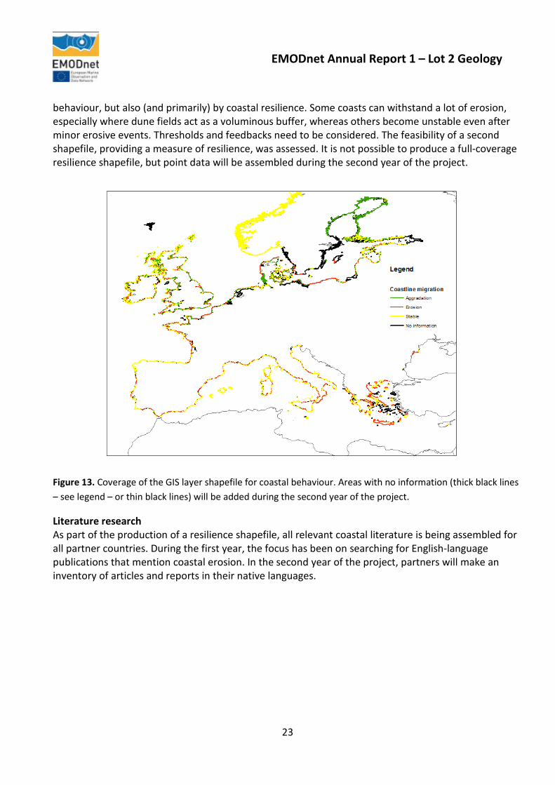
Figure 12. Status of information available for geological faults that can be represented at 1:250 000 scale. (common to Workpackage 6); active faults; turbidites (sediment or rock redeposited from, or inferred to have been deposited from, a turbidity current); seamounts; submarine canyons; and submarine fans. Workpackage 5. Coastal behaviour (led by TNO – Geological Survey of the Netherlands). Objective: To classify the coastal behaviour and typology of each country represented in the project partnership. A classification system for coastal types will be applied and areas of erosion and sedimentation in the coastal zone of each participating country will be shown on the resulting map layer. To date, the GIS map (shapefile) and metadata for coastal behaviour, as produced for the greater North Sea and the Baltic Sea in the ur-EMODnet-Geology Project (using EUROSION data supplemented with new data for Norway, Lithuania, Poland, Belgium and the Netherlands), was expanded to cover the coastlines of the European Seas that are included in the full EMODnet-Geology Project. Data for Bulgaria (part), Cyprus (part), France (part), Greece, Italy, Malta, Portugal, Romania (part), Slovenia and Spain are now included (Figure 13). Data for Albania, Bulgaria (part), Croatia, Cyprus (part), Faroe Islands, Georgia, Iceland, Montenegro, Romania (part), Russia (part), Turkey, Ukraine and the United Kingdom are being compiled and will be added as they become available.
Behaviour versus resilience The current GIS map provides information about coastal erosion versus aggradation, but cannot be used as an indicator or predictor of safety. Flooding risks are determined not only by coastline
22
EMODnet Annual Report 1 – Lot 2 Geology
behaviour, but also (and primarily) by coastal resilience. Some coasts can withstand a lot of erosion, especially where dune fields act as a voluminous buffer, whereas others become unstable even after minor erosive events. Thresholds and feedbacks need to be considered. The feasibility of a second shapefile, providing a measure of resilience, was assessed. It is not possible to produce a full-coverage resilience shapefile, but point data will be assembled during the second year of the project.
Figure 13. Coverage of the GIS layer shapefile for coastal behaviour. Areas with no information (thick black lines – see legend – or thin black lines) will be added during the second year of the project.
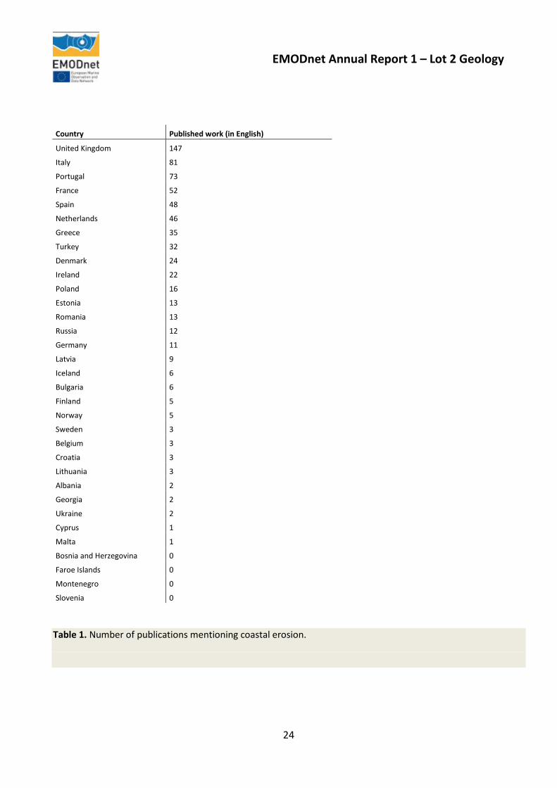
Literature research As part of the production of a resilience shapefile, all relevant coastal literature is being assembled for all partner countries. During the first year, the focus has been on searching for English-language publications that mention coastal erosion. In the second year of the project, partners will make an inventory of articles and reports in their native languages.
23
EMODnet Annual Report 1 – Lot 2 Geology
Country Published work (in English)
United Kingdom 147
Italy 81
Portugal 73
France 52
Spain 48
Netherlands 46
Greece 35
Turkey 32
Denmark 24
Ireland 22
Poland 16
Estonia 13
Romania 13
Russia 12
Germany 11
Latvia 9
Iceland 6
Bulgaria 6
Finland 5
Norway 5
Sweden 3
Belgium 3
Croatia 3
Lithuania 3
Albania 2
Georgia 2
Ukraine 2
Cyprus 1
Malta 1
Bosnia and Herzegovina 0
Faroe Islands 0
Montenegro 0
Slovenia 0
Table 1. Number of publications mentioning coastal erosion.
24

EMODnet Annual Report 1 – Lot 2 Geology
Workpackage 6. Geological events and probabilities. (led by the Istitituto Superiore per la Protezione e la Ricerca Ambientale. Servizio Geologico d'Italia (ISPRA)).
Objective: To identify and map the locations of all significant geological events and provide information on probabilities of occurrence where available. These will include sites of submarine landslides, earthquake epicentres and volcanic centres located in the offshore study areas as specified in Section 2.4 of the tender documents.
During the reporting year, activity has been focused on which parameters should be used to characterise the events and which relevant information should be listed in the attribute table of each GIS layer. Furthermore, the extension (compared to the ur-EMODnet-Geology project) of the European seas to include the Mediterranean and the North Atlantic has drawn attention to other geological events in addition to the mandatory features. Consequently, a questionnaire was sent out to all partners to assess the geological events that are relevant to each country. On the basis of the answers received, it was proposed for example to include information related to tectonics and tsunamis. A data format with a list of possible characteristics to be included for each feature was circulated to each partner. All of the features to be represented and their characteristics have been defined based on the partners’ feedback.
The GIS layer architecture was then elaborated in order to provide the guidelines for compilation of Workpackage 6 information, which were discussed at the project meeting in Malta in October 2014 and will be distributed by the end of the year. It was agreed to continue to rely on the European-Mediterranean Seismological Centre (EMSC) for the project’s earthquake catalogue to avoid duplication. However, attributes that better characterise earthquakes have been identified and will be provided in the future development of Workpackage 6 outputs.
During the discussions related to Workpackage 6 it became clear that several of the features related to geological events and probabilities could also be represented in some of the other workpackages (e.g landslides, pockmarks). It was therefore decided to create a Working Group, consisting of a subset of the project partners, which is tasked with identifying and defining these features to prevent duplications or overlaps (see Workpackage 4 above).
Workpackage 7. Minerals (led by the Geological Survey of Ireland (GSI)). Objective: To identify and map areas of minerals (including aggregates, oil and gas and metalliferous minerals) in each of the participating countries based on information available to the project partners, including publicly-available information (published scientific papers etc.) To arrange web-mapping services with holders of data on mineral resources. The Workpackage 7 data requirements were detailed in a presentation given at the EMODnet-Geology Kick-off meeting in Lisbon. Comprehensive task Guidelines were then compiled by the workpackage leader and disseminated to all project partners on March 11th 2014. The Guidelines detail the data and attributes required for the workpackage.
25

EMODnet Annual Report 1 – Lot 2 Geology
Discussions also took place with the Project Co-ordinator of the EMODnet Human Activities Lot in order to clarify both project remits, as some of our partners had been asked to provide similar data to both the Geology and Human Activities lots. After discussions with the coordinators of the Human Activities Project (COGEA, Italy), two similarities with the Human Activities Lot were defined, namely that the Human Activities Lot are mapping hydrocarbon extraction – currently requiring well data (this
Aggregates Hydrocarbons Gas Hydrates
Marine Placer
Phosphorite Evaporite Polymetallic Sulphides
Polymetallic Nodules
Cobalt Rich Fe-Mn Crust
Estonia Denmark Portugal Latvia Portugal Estonia Portugal
Finland Ireland Russia Poland Spain Latvia Spain
France France Spain Russia
Ireland Lithuania Spain
Latvia Norway
Norway Poland
Poland Romania
Portugal Russia
Russia Spain
Sweden Sweden
Table 2. A summary of deposit types submitted by country
may diversify to include Licence blocks in future) and aggregate extraction - the amount extracted per year and the areas of extraction.
On April 17th 2014 all project partners were provided with the clear remit of the EMODnet-Geology Workpackage 7, which is to collate all known mineral deposit types (including aggregates and hydrocarbons) and their spatial extent. Available datasets were then submitted by some partners according to Table 2). This data was assessed for its suitability in accordance with the requested
26

EMODnet Annual Report 1 – Lot 2 Geology
deposit types and associated attributes as outlined in the task Guidelines. The data were then collated into the appropriate deposit types (7 in total) and edited where necessary. All datasets were then harmonised into the WGS84 reference system.
Workpackage 7 progress was presented at the EMODnet-Geology Project meeting in Malta on September 30th 2014. Mapping completed to date was shown and the proposed workflow for 2015 was discussed. Additional or updated data was requested for inclusion in the workpackage from all partners. It was reiterated that data can be submitted for all potential deposit types that are considered a marine mineral deposit on or under the sea bed and which are available without constraint. These data do not have to represent a deposit type that is under exploration, as the workpackage is responsible for mapping the geological occurrences of marine minerals and their spatial extent according to the agreement with the Human Activities Project described above.
Partners’ attention was drawn to two international web viewers that host up-to-date locations of three deposit types: Polymetallic Nodules, Polymetallic Sulphides and Fe-Mn Crust. Discussions during the Malta meeting resulted in the decision that participating countries ensure they QC and submit these data to the Workpackage leaders for inclusion. Websites: http://www.mapserver.isa.org.jm/GIS/ http://vents-data.interridge.org/ventfields-geofield-map
Any additional data submitted will be included in the collated deposit-type layers compiled to date and will be presented at the next project meeting. The new or updated data will then be assessed against that previously submitted under the ur-EMODnet-Geology Project and a decision will be made regarding the publishing of the data for the current EMODnet-Geology Project in 2015. The deposit types will either replace those published during the preparatory phase or will be published separately for the current project, thus highlighting progress since the first phase of EMODnet.
Workpackage 8. Web services and technology (led by the British Geological Survey).
Objective: To further develop the web portal providing access to the existing maps available in the OneGeology-Europe portal, as developed during the ur-EMODnet-Geology Project. The Geo-Seas data discovery and access system will also be integrated into the OneGeology-Europe portal to provide access to geological and geophysical data and metadata. The EMODnet-Geology portal will therefore provide access to data, metadata and data products that include both marine and terrestrial geological information for the whole of Europe.
During the preparatory phase of EMODnet, the geology outputs were included in the OneGeology-Europe portal to allow marine data to be viewed with geological information for the European land area, therefore providing the means for users of the information to assess the full extent of Europe’s geological data. However, the functionality of the OneGeology-Europe portal did not allow the EMODnet-Geology group to develop a broader information service as it would require making changes to the overall structure of the system. The need to develop the EMODnet portals to a common standard for all lots was also a consideration, which was not a factor during the preparatory phase. Although the proposal for the current EMODnet-Geology Project described creating a separate instance of the OneGeology Europe portal with data discovery and access systems based on the Geo-
27

EMODnet Annual Report 1 – Lot 2 Geology
Seas project, a review of the options concluded that a more open and flexible system was preferable. An open system still allows information to be delivered through OneGeology Europe or any other data service but, importantly, provides a longer term solution to delivery of the EMODnet-Geology outputs that is not tied to any particular delivery mechanism. Following an assessment of available open-source software, it has been decided to use ‘GeoNetwork’. http://geonetwork-opensource.org/. This is a catalog application to manage spatially referenced resources. It provides powerful metadata editing and search functions as well as an embedded interactive web map viewer. It is currently used in numerous Spatial Data Infrastructure initiatives across the world. GeoNetwork has been developed to connect spatial information communities and their data using a modern architecture, which is at the same time powerful and low cost, based on the principles of Free and Open Source Software (FOSS) and International and Open Standards for services and protocols (a.o. from ISO/TC211 and OGC). The software provides an easy to use web interface to search geospatial data across multiple catalogs, combine distributed map services in the embedded map viewer (Figure 14), publish geospatial data using the online metadata editing tools and optionally the embedded GeoServer map server. Administrators have the option to manage user and group accounts, configure the server through web based and desktop utilities and schedule metadata harvesting from other catalogs.
a. EMODnet-Geology portal home page.
b. Sea-bed substrate information for the northern European seas.
28

EMODnet Annual Report 1 – Lot 2 Geology
c. Sea-bed substrate information with overlay of sedimentation rates at particular points.
d. Sea-floor geology information.
e. Coastal behaviour information.
f. Minerals information in the North Sea (hydrocarbons).
g.
29

EMODnet Annual Report 1 – Lot 2 Geology
h. Data derived from the Geo-Seas metadata portal.
i. Geological events and probabilities (submarine landslides).
Figure 14. Examples of map layers as viewed on the EMODnet-Geology portal to be launched in late 2014. The main features of the system being developed are:
• Immediate search access to local and distributed geospatial catalogs • Up- and downloading of data, graphics, documents, pdf files and any other content type • An interactive Web Map Viewer to combine Web Map Services from distributed servers around
the world • Online editing of metadata with a powerful template system • Scheduled harvesting and synchronization of metadata between distributed catalogs • Support for OGC-CSW 2.0.2 ISO Profile, OAI-PMH, Z39.50 protocols • Fine-grained access control with group and user management • Multi-lingual user interface
The software was implemented on the prototype EMODnet-Geology website during July and August 2014, and was assessed by a small group of EMODnet-Geology partners and members of the EMODnet Secretariat during September. Examples of how the information will be displayed are shown in Figure 14. The new EMODnet-Geology portal will be launched in November 2014, following which the system will develop mechanisms for downloading information directly from the portal and will allow user feedback and statistics to be compiled. Workpackage 9. Dissemination (led by the British Geological Survey).
Objective: To ensure widespread dissemination of the EMODnet-Geology products, through targeted contact with stakeholders and other users of marine geological information.
30

EMODnet Annual Report 1 – Lot 2 Geology
The dissemination activities of the EMODnet-Geology Project are ongoing throughout the period from 2013-2016. Activities during the reporting period are listed in Section 9 of this report.
Workpackage 10. Liaison with EMODnet lots (led by the British Geological Survey).
Objective: To ensure that the EMODnet-Geology project is fully aware and complementary to the objectives of other marine science initiatives within European waters. To prepare for better and linked marine data that will have an immediate impact on the planning of environmental policy and mitigation measures within the European Union and to facilitate impact assessments and scientific work.
The EMODnet-Geology Project Co-ordinator has attended all meetings of the EMODnet Steering Committee at which the co-ordinators discuss joint activities. The Co-ordinator of the Seabed Habitats Project has attended the EMODnet-Geology Project meetings in January and September 2014 to discuss the outputs required to make progress in compiling the habitat maps for the project. As described in the Workpackage 7 progress report, contact was made with the Co-ordinator of the Human Activities Project to agree the types of information that would be submitted to both projects regarding mineral localities and exploration.
Workpackage 11. Project analysis and sustainability (led by the British Geological Survey).
Objective: To analyse each phase of the project and to provide a report on the lessons learned.
A report will be produced analysing the first phase of the project in November 2014. In preparation for the long-term sustainability of the project, the Project Co-ordinator has been involved in meetings of the European Geological Data Infrastructure Scoping Project (EGDI-Scope; http://www.egdi-scope.eu/). The EGDI-Scope study is the starting point of EGDI. It assesses relevant use cases, datasets, functional and technical requirements, legal topics and governance framework. The next phase will cover the implementation of a first operational technical and organizational structure, securing the maintenance and further development of datasets, tools and functionalities from prioritized European projects: OneGeologyEurope, Minerals4EU/EuroGeoSource, EMODnet-Geology, PANGEO and GEMAS. The EMODnet-Geology Project is included in the EGDI-Scope brochure ‘Geological information for Europe :Towards a pan-European Geological Data Infrastructure’ http://www.egdi-scope.eu/wp-content/uploads/2014/05/Brochure-250x180-2014_1.pdf
8. User Feedback As the EMODnet-Geology revised web portal is not yet publicly available the opportunity to gain feedback on the portal and the EMODnet-Geology outputs are not yet in place. The re-launch of the web portal will provide the opportunity to invite comments on the information provided.
However, as the general aims of the project are generally known through the work carried out during the preparatory phase, the importance of the need to compile and harmonise geological information is well-received and can be measured by the invitations that the Project Co-ordinator and members of
31

EMODnet Annual Report 1 – Lot 2 Geology
the project team have received to present their work (see Outreach and Communication Activities Section 9). A good example of the recognition of the importance of marine geological information is the input of the Project Co-ordinator to the developing Transatlantic Ocean Research Alliance. In May 2013, the Project Co-ordinator was invited to present the status of European seabed mapping at ‘The Atlantic – A Shared Resource’ Conference held in Galway, Ireland. Following the meeting, the Galway Statement on Atlantic Cooperation was signed by the European Commissioners for Research and Maritime Affairs and Fisheries and members of the Canadian and US Governments. The Galway Statement included ‘seabed and benthic habitat mapping’ as an area for potential co-operation. Since then the Project Co-ordinator has attended two ‘Stakeholder Meetings of the Implementation of the Galway Statement’ in Brussels to represent the geological survey organisations of Europe and the EMODnet-Geology Project.
A further source of feedback has been through participation of the Project Co-ordinator in the European Marine Board’s SUBLAND (Submerged Landscapes and Sea Level Change) Working Group which was established in October 2013. The group’s remit was to develop collaborative mutual knowledge between marine and social scientists to deliver an improved understanding of past human response to sea level change, and hence improved modeling of interactions between society, economy and environment. The long-term perspective supplied by integrated multidisciplinary studies, is capable of bringing important new insights of future scenarios and the social impact of sea-level and climate change. The EMODnet-Geology Project-Co-ordinator was invited to lead the section in the resulting Position Paper published in October 2014 (see reference in Outreach and Communcation section) on ‘Europe’s Regional Sea Basins and Data Resources’. The EMODnet-Geology outputs are included in this report and in the summary the report states that ‘the EMODnet Programme has been successful in bringing together the various science communities to identify data that exist at a European level. The programme would benefit from the input of the marine archaeological community to not only deliver an assessment of the status of paleolandscape understanding, but also to communicate their specific requirements from the other EMODnet projects, especially the bathymetry and geology component of EMODnet’. The Chair of the SUBLAND Working Group, Dr Nicholas Flemming subsequently reported the conclusions and recommendations of the group to the Marine Observation and Data Expert Group (MODEG) in Brussels in September 2014.
32
EMODnet Annual Report 1 – Lot 2 Geology
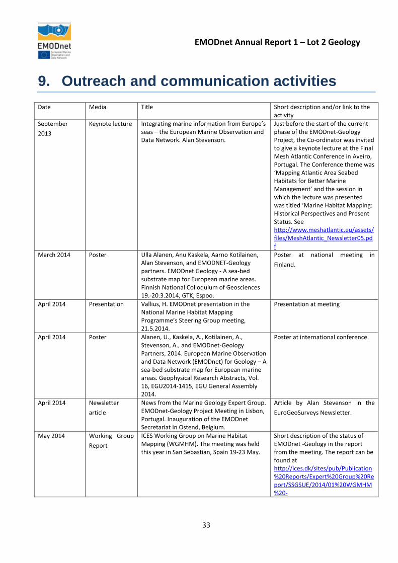
9. Outreach and communication activities Date Media Title Short description and/or link to the
activity September 2013
Keynote lecture Integrating marine information from Europe’s seas – the European Marine Observation and Data Network. Alan Stevenson.
Just before the start of the current phase of the EMODnet-Geology Project, the Co-ordinator was invited to give a keynote lecture at the Final Mesh Atlantic Conference in Aveiro, Portugal. The Conference theme was ‘Mapping Atlantic Area Seabed Habitats for Better Marine Management’ and the session in which the lecture was presented was titled ‘Marine Habitat Mapping: Historical Perspectives and Present Status. See http://www.meshatlantic.eu/assets/files/MeshAtlantic_Newsletter05.pdf
March 2014 Poster Ulla Alanen, Anu Kaskela, Aarno Kotilainen, Alan Stevenson, and EMODNET-Geology partners. EMODnet Geology - A sea-bed substrate map for European marine areas. Finnish National Colloquium of Geosciences 19.-20.3.2014, GTK, Espoo.
Poster at national meeting in Finland.
April 2014 Presentation Vallius, H. EMODnet presentation in the National Marine Habitat Mapping Programme’s Steering Group meeting, 21.5.2014.
Presentation at meeting
April 2014 Poster Alanen, U., Kaskela, A., Kotilainen, A., Stevenson, A., and EMODnet-Geology Partners, 2014. European Marine Observation and Data Network (EMODnet) for Geology – A sea-bed substrate map for European marine areas. Geophysical Research Abstracts, Vol. 16, EGU2014-1415, EGU General Assembly 2014.
Poster at international conference.
April 2014 Newsletter article
News from the Marine Geology Expert Group. EMODnet-Geology Project Meeting in Lisbon, Portugal. Inauguration of the EMODnet Secretariat in Ostend, Belgium.
Article by Alan Stevenson in the EuroGeoSurveys Newsletter.
May 2014 Working Group Report
ICES Working Group on Marine Habitat Mapping (WGMHM). The meeting was held this year in San Sebastian, Spain 19-23 May.
Short description of the status of EMODnet -Geology in the report from the meeting. The report can be found at http://ices.dk/sites/pub/Publication%20Reports/Expert%20Group%20Report/SSGSUE/2014/01%20WGMHM%20-
33

EMODnet Annual Report 1 – Lot 2 Geology
%20Report%20of%20the%20Working%20Group%20on%20Marine%20Habitat%20Mapping.pdf
July 2014 Magazine article An interview with Anu Kaskela (GTK, Finland) about current topics in marine geology by Essi Keskinen for the Series "Veneenalainen maailma" (in English "The World under Boat) in magazine Kippari 7/2014.
September 2014
Keynote lecture Vallius, H. 2014. Sediment and Habitat mapping of the Baltic Sea. The 12th Colloquium on Baltic Sea Marine Geology September 8 – 12, 2014, Warnemünde, Germany.
Keynote lecture at Baltic Sea Conference.
September 2014
Poster Kaskela, A., Alanen, U., Kotilainen, A., and Stevenson, A. 2014. The sea-bed substrate data of the European seas as part of the European marine observation and data network (EMODnet) Geology Project. The 12th Colloquium on Baltic Sea Marine Geology September 8 – 12, 2014, Warnemünde, Germany.
Poster at Baltic Sea Conference.
October 2014 Position paper Land Beneath the Waves. Submerged landscapes and sea level change. A joint geoscience-humanities strategy for European Continental Shelf Prehistoric Research. Fleming, N.C., Cagatay, M.N., Chiocci, F.L., Galanidou, N., Jons, H., Lericolais, G., Missiaen, T., Moore, F., Rosentau, A., Sakellariou, D., Skar, B., Stevenson, A., Weerts, H. 2014. Chu, N.C. and McDonough, N. (Eds) Position Paper 21 of the European Marine Board, Ostend, Belgium. 171 pp. ISBN 978-94-920430-3-0.
European Marine Board Position Paper on submerged landscapes. http://www.marineboard.eu/images/publications/Land%20Beneath%20the%20Waves-244.pdf
2014 Book Workpackage 5 results are presented in a section on coastal erosion, sedimentation and morphology (Sytze van Heteren and John Huthnance) in the North Sea Region Climate Change Assessment,
International initiative to compile a comprehensive interdisciplinary and transdisciplinary assessment of the present scientific knowledge about all aspects of past, ongoing and future climate change in the greater North Sea region. The revised MS has been accepted for publication in a Springer book (2015).
2014 Project brochure
Geological information for Europe :Towards a pan-European Geological Data Infrastructure
Brochure of the European Geological Data Infrastructure Scoping Project (EGDI-Scope). http://www.egdi-scope.eu/wp-content/uploads/2014/05/Brochure-250x180-2014_1.pdf
34

EMODnet Annual Report 1 – Lot 2 Geology
10. Updates on Progress Indicators Indicator 1 - Volume of data made available through the portal
As the information being made available through the EMODnet-Geology Project portal is primarily GIS maps, the volume of information is not the most useful measure. Examples of the current map layers that are available are shown in Figure 14.
Indicator 2 - - Organisations supplying each type of data based on (formal) sharing agreements and broken down into country and organisation type (e.g. government, industry, science).
The information supplied to the EMODnet-Geology Project are almost entirely held by the geological surveys of Europe (government), although interpreted map products can include information derived from broader sources such as industry and the university sector.
Indicator 3 - Organisations that have been approached to supply data with no result, including type of data sought and reason why it has not been supplied.
No organisations have been specifically requested to provide information as the data required to compiled the EMODnet-Geology outputs are compiled at national level then harmonised according to the Guidelines provided by the workpackage leaders
Indicator 4 - Volume of each type of data and of each data product downloaded from the portal
The EMODnet-Geology outputs are not yet available to be downloaded from the project portal. This functionality is being included in the new portal to be launched in November 2014.
Indicator 5 - Organisations that have downloaded each data type Information not available (see Indicator 4).
Indicator 6 - Using user statistics to determine the main pages utilised and to identify preferred user navigations routes
Information not available (see Indicator 4).
Indicator 7 - List of what the downloaded data has been used for (divided into categories e.g. Government planning, pollution assessment and (commercial) environmental assessment, etc.)
35

EMODnet Annual Report 1 – Lot 2 Geology
Information not available (see Indicator 4).
36

EMODnet Annual Report 1 – Lot 2 Geology
Annex 1 Transcript of speech by Maltese Minister for Transport and Infrastructure at the opening of the EMODnet-Geology Project Meeting in Sliema, Malta on 30 September 2014.
https://mti.gov.mt/en/Government/press%20releases/Pages/2014/PR142207.aspx
The Maltese Islands are strategically located in the centre of the Mediterranean. Considering Malta’s traditionally strong maritime connections, it comes as no surprise that Malta has, since time immemorial, been at the centre of maritime activity in the Mediterranean. Historically, Malta was an important military base. Today Malta is the largest ship register in Europe. It has also developed a relatively complete range of maritime activities encompassing a port of call for transhipment facilities, cruise lining and a yachting destination. My Government which was elected in March 2013 is committed to ensure that the maritime sector continues to develop. We recognise the importance and the potential of this sector and we are committed to create a maritime hub of excellence in the Mediterranean. Malta has a very large maritime area compared to its land area however the full potential of the seas that surround us is still to be reaped. The EMODnet project which is an initiative of the European Commission Directorate-General for Maritime Affairs and Fisheries (DG MARE) as part of its Marine Knowledge 2020 strategy is supported by the EU’s Integrated Maritime Policy. Malta supports the EU’s vision and believes that maritime issues require a holistic approach. The EMODnet project aims to assemble marine data from various sources to unlock fragmented and hidden marine data resources and to make this information publicly available. Easily accessible marine data is a requirement for further sustainable economic development in the marine sector or ‘blue growth’. Recognising and exploiting opportunities from this great natural resource around us will stimulate growth and jobs. I am proud that my Ministry, through the Continental Shelf Department, is one of the 36 partners participating in the Geology Lot of the EMODnet Project and that we are contributing towards the provision of marine data for the Central Mediterranean Sea. The Department is also providing input to the Malta Environment and Planning Authority in the implementation of the Marine Strategy Framework Directive and therefore the data assembled through the EMODnet project will also serve in the implementation of this Directive thereby integrating maritime affairs with the environment. As you may be aware, the Continental Shelf Department, which falls under my direct responsibility, is a small Department but with highly sensitive and vast responsibilities. Amongst other matters the Department is responsible for the licensing of oil and gas exploration and exploitation activities, the permitting for the laying of submarine cables and pipelines and the authorisation of marine scientific research on Malta’s continental shelf.
37

EMODnet Annual Report 1 – Lot 2 Geology
We have recently amended the Continental Shelf Act to bring this legislation in line with the 1982 United Nations Convention on the Law of the Sea and soon, subsidiary legislation will also be enacted to regulate various activities on the continental shelf including marine scientific research. We are also currently transposing the Offshore Safety Directive into local legislation. This, as well as other International Conventions, which Malta is a party to, will ensure that offshore operations are carried out to the highest level of safety. Malta depends on the sea to thrive and therefore we are committed to ensure protection of the marine environment which is our common heritage. We are also currently transposing the Offshore Safety Directive into local legislation. This, as well as other International Conventions, which Malta is a party to, will ensure that offshore operations are carried out to the highest level of safety. Malta depends on the sea to thrive and therefore we are committed to ensure protection of the marine environment which is our common heritage. Since my Government took office in March 2013, one of my aims is to increase oil exploration activity offshore Malta. We are confident that several good, drillable prospects analogous with existing producing fields in the Central Mediterranean are located in the sedimentary basins offshore Malta, and that these geological structures very probably contain petroleum in commercial quantities. However, the presence of these petroleum bearing structures can only be proven by drilling exploratory wells. Malta has not yet been successful in striking oil or gas. However oil exploration activity also provides important marine knowledge through seismic and other geophysical surveys, sea-bed surveys, geochemical surveys and exploratory drilling. This data is paramount for understanding the seas around us. I have supported an initiative taken by the Continental Shelf Department to convert past oil exploration data into digital format and to develop a database for maritime data collected from various sources such as oil exploration, marine scientific research and any surveys related to the laying of submarine cables and pipelines. Government has been very careful, through the permitting process, to request the data collected on Malta’s continental shelf and this now provides invaluable information. A Geographic Information System is being developed to enable such data to be readily available to oil companies interested in carrying out oil and gas exploration offshore Malta. Information sharing is important however there is a very delicate balance between the principle of information sharing and the restriction of certain sensitive information due to its commercial nature. Through the EMODnet project certain data on sea-bed substrate, seafloor geology, coastal behaviour, geological events and minerals will be assembled and made publicly available. The information being compiled through EMODnet is also in my opinion an important component to the system being developed locally for management of marine data.
38

EMODnet Annual Report 1 – Lot 2 Geology
We anticipate that the work expected from Malta on the EMODnet project will be accelerated in the coming months also through the Department’s collaboration with the University of Malta and other stakeholders. This will enable us to amply fulfil our project commitments. I believe that there is great value in having European countries work together to provide marine information of value to the business community, scientific researchers, government bodies and other organisations. The EMODnet project will integrate data from various nations to create a harmonised map of the European Regional Seas around the 30 countries participating in this project. My Government is committed to develop and improve our capabilities in the maritime sector and to invest in training and human capital. The issue of training and education is crucial for the long term sustainability of the maritime sector. Higher education institutions are the mechanisms that can build up the necessary skill capacity for both the industry and the public administration. Discussions are currently underway with the University of Malta to set up a degree in Petroleum Studies. Malta already offers an International Masters degree in ocean governance through the University of Malta in collaboration with the International Ocean Institute. This Institute also offers an annual 5 week training course in Malta covering various aspects of ocean governance. The IMO International Maritime Law Institute is also set up in Malta and provides high-level courses in international maritime law. Of course, I cannot forget to mention the Maritime Institute and Global College, both of which offer training in the maritime sector. All these initiatives indicate Malta’s commitment to the maritime sector in all the various dimensions. I do not wish to take more of your time. I would like to take this opportunity to thank project leader Alan Stevenson from the British Geological Survey, lead partner of this consortium, for spearheading this project and for choosing Malta for this second meeting. I would also like to thank all of you for your collaborative efforts on this important initiative and wish you a successful and fruitful meeting. Finally, I also wish you all an enjoyable stay in Malta. Annex 2. References included in the text. Foster-Smith, R., Connor, D. & Davies, J. 2007. What is habitat mapping? In: MESH Guide to Habitat Mapping, MESH Project, 2007, JNCC, Peterborough. Available online at: (http://www.searchmesh.net/default.aspx?page=1900) Kaskela, A., Kotilainen, A. and Ulla, A. 2014a. EMODnet –Geology 2, Work Package 3: Sea-bed substrate Guidance Document I, INDEX map. Internal use only. 8p. Kaskela, A., Kotilainen, A. and Ulla, A. 2014b. EMODnet –Geology 2, Work Package 3: Sea-bed substrate Guidance Document II, Harmonisation and Generalisation. Internal use only. 21 p.
39

EMODnet Annual Report 1 – Lot 2 Geology
Kaskela, A.M., Kotilainen, A.T., Al-Hamdani, Z., Leth, J.O., Reker, J., 2012. Seabed geomorphic features in a glaciated shelf of the Baltic Sea, Estuarine, Coastal and Shelf Science, Volume 100, 20 March 2012, Pages 150-161. Stevenson, A., Kotilainen, A., Kaskela, A., Alanen, U., Asch, K., Schubert, C., van Heteren, S., van de Ven, T., Thorsnes, T., Verbruggen, K., Robinson, A., Guinan, J., Glaves, H., and the Project Team, 2011. EMODnet Geology Project Draft Final Report. Preparatory Actions for a European Marine Observation and Data Network. Lot No 2 – Geological data. 40 pages. Stevenson, A., Kotilainen, A., Kaskela, A., Alanen, U., Asch, K., Schubert, C., van Heteren, S., van de Ven, T., Thorsnes, T., Verbruggen, K., Robinson, A., Guinan, J., Glaves, H., and the Project Team, 2012. EMODnet Geology Project Maintenance Report. Preparatory Actions for a European Marine Observation and Data Network. Lot No 2 – Geological data. 44 pages. Väänänen, T. (ed), Hyvönen, E., Jakonen, M., Kupila, J., Lerrsi, J., Leskinen, J., Liwata, P., Nevalainen, R., Putkinen, S., Virkki, H. 2007. Maaperän yleiskartan tulkinta- ja kartoitusprosessi. Maaperän yleiskartoitus –hankkeen sisäinen raportti. 17 p.
40