emerging practices of wind farm planning in a dense bird
TRANSCRIPT
General rights Copyright and moral rights for the publications made accessible in the public portal are retained by the authors and/or other copyright owners and it is a condition of accessing publications that users recognise and abide by the legal requirements associated with these rights.
• Users may download and print one copy of any publication from the public portal for the purpose of private study or research. • You may not further distribute the material or use it for any profit-making activity or commercial gain • You may freely distribute the URL identifying the publication in the public portal
If you believe that this document breaches copyright please contact us providing details, and we will remove access to the work immediately and investigate your claim.
Downloaded from orbit.dtu.dk on: Dec 20, 2017
Emerging practices of wind farm planning in a dense bird migration area
Clausen, Niels-Erik; Mortensen, Niels Gylling; Hansen, Jens Carsten; Jensen, F.P.; Georgy, L.
Published in:Proceedings CD-ROM. CD 2
Publication date:2003
Document VersionEarly version, also known as pre-print
Link back to DTU Orbit
Citation (APA):Clausen, N-E., Mortensen, N. G., Hansen, J. C., Jensen, F. P., & Georgy, L. (2003). Emerging practices of windfarm planning in a dense bird migration area. In Proceedings CD-ROM. CD 2 Brussels: European Wind EnergyAssociation (EWEA).
brought to you by COREView metadata, citation and similar papers at core.ac.uk
provided by Online Research Database In Technology
European Wind Energy Conference, Madrid, June 16-20, 2003
* Phone +45 46775079; fax +45 46775083; email: [email protected]
EMERGING PRACTICES OF WIND FARM PLANNING IN A DENSE BIRD MIGRATION AREA
Niels-Erik Clausen*, Niels G. Mortensen, Jens Carsten Hansen, Risoe National Laboratory, P.O. Box 49, DK-4000 Roskilde, Denmark.
Flemming Pagh Jensen, Hedeselskabet Environment & Energy A/S,
Ringstedvej 20, DK-4000 Roskilde, Denmark.
Laila Georgy, NREA, P.O.Box 4544 Masakin Dobat-Elsaff, Cairo, Egypt.
SUMMARY: The objective of this paper is to present part of The Wind Atlas for Egypt project aiming at developing a firm basis for planning and utilization of the vast wind energy resources available in Egypt. The project should recommend a common planning framework for wind farm development in Egypt, specifically in the Gulf of Suez, giving an overview of planning and feasibility related activities necessary, as well as of rules, regulations, data and information applicable. The proposed planning method is based on the existing legislation and relevant National Master Plans for Egypt and the suggested approach is utilising a traditional wind atlas as well as a bird migration atlas. The wind atlas is based on more than 10 years of measurements while the bird migration atlas is the result of an in-depth field survey during three bird migration seasons. The wind atlas as well as the bird migration atlas is briefly introduced. As a case study to illustrate the planning process a 60 MW wind farm located at the Gulf of El-Zayt at the Gulf of Suez in Egypt will be analysed. This area is chosen for its very high wind energy potential and the high concentration of migrating birds during spring and autumn. During the site selection and layout of a wind farm the balancing of interests and land use will be described.
Keywords: (max 8): Egypt, Gulf of Suez , wind atlas, bird migration, wind farm planning
Introduction The present work is part of the project Wind Atlas for Egypt, which can be seen as part of a national effort to provide a solid basis for planning of a sustainable development in Egypt as well as to promote utilization of wind energy. The project will recommend a common planning framework for wind farm development in the Gulf of Suez, giving an overview of planning and feasibility studies necessary as well as of rules, regulations, data and information applicable. The Gulf of Suez is selected due to its high potential for utilization of wind energy. The project is particularly aimed at obtaining accurate wind energy production estimations, wind farm siting methods and appropriate environmental impact assessment, essential for future investment decisions and development.
The planning method is based on the existing legislation and relevant National Master Plans for Egypt and proposes an approach using a traditional wind atlas as well as a bird migration atlas. The wind atlas is based on more than 10 years of measurements, while the bird migration atlas is the result of an in-depth field survey during three bird migration seasons. A case study will illustrate the planning process a 60 MW wind farm located at the Gulf of El-Zayt at the Gulf of Suez in Egypt. This area is chosen for its very high wind energy potential and the high concentration of migrating birds during spring and autumn.
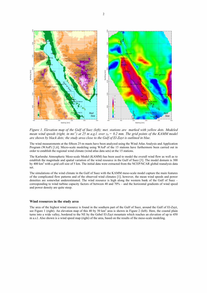
The Wind Atlas for the Gulf of Suez The wind resources in the Gulf of Suez have recently been assessed in the Wind Atlas for the Gulf of Suez [1, 2]. The primary purpose of the Atlas is to provide reliable and accurate wind atlas data sets for evaluating the potential wind power output from large electricity-producing wind-turbine installations [1]. The assessments are based on wind speed and direction data from 15 locations along the Gulf of Suez and the northern Red Sea, as well as meso-scale modeling of the overall regional wind climate. Figure 1 (left) shows an elevation map of the Gulf of Suez in which the met. stations of the Atlas are shown. Also shown is a wind speed map (right) of the region, based on the results of the meso-scale modeling.
2
400 450 500 550 600 650
Easting [km]
3050
3100
3150
3200
3250
3300
3350
Nor
thin
g [
km]
Ras El-Behar
El-Sheikh Fadel
Zafarana
SW
Abu Darag
M7
St. Paul
Ras Ghareb
W
NNW
Gulf of El-Zayt
Hurghada WETC
Ras Sedr
El Tor
El-Suez
Saint Cathrene
Sharm El-Sheikh
Hurghada0
100
200
400
600
800
1000
1200
1400
1600
1800
2000
Gulf of Suez
Red Sea
400 450 500 550 600 650
Easting [km]
3050
3100
3150
3200
3250
3300
3350
Nort
hin
g [
km]
Ras El-Behar
El-Sheikh Fadel
Zafarana
SW
Abu Darag
M7
St. Paul
Ras Ghareb
W
NNW
Gulf of El-Zayt
Hurghada WETC
Ras Sedr
El Tor
El-Suez
Saint Cathrene
Sharm El-Sheikh
Hurghada
Gulf of Suez
Red Sea
5
6
7
8
9
10
11
12
Figure 1. Elevation map of the Gulf of Suez (left); met. stations are marked with yellow dots. Modeled mean wind speeds (right, in ms-1) at 25 m a.g.l. over z0 = 0.2 mm. The grid points of the KAMM model are shown by black dots; the study area close to the Gulf of El-Zayt is outlined in blue.
The wind measurements at the fifteen 25-m masts have been analyzed using the Wind Atlas Analysis and Application Program (WAsP) [1,6]. Micro-scale modeling using WAsP of the 15 stations have furthermore been carried out in order to establish the regional wind climate (wind atlas data sets) at the 15 stations.
The Karlsruhe Atmospheric Meso-scale Model (KAMM) has been used to model the overall wind flow as well as to establish the magnitude and spatial variation of the wind resource in the Gulf of Suez [3]. The model domain is 300 by 400 km2 with a grid cell size of 5 km. The initial data were extracted from the NCEP/NCAR global reanalysis data set.
The simulations of the wind climate in the Gulf of Suez with the KAMM meso-scale model capture the main features of the complicated flow patterns and of the observed wind climates [1]; however, the mean wind speeds and power densities are somewhat underestimated. The wind resource is high along the western bank of the Gulf of Suez – corresponding to wind turbine capacity factors of between 40 and 70% – and the horizontal gradients of wind speed and power density are quite steep.
Wind resources in the study area The area of the highest wind resource is found in the southern part of the Gulf of Suez, around the Gulf of El-Zayt, see Figure 1 (right). An elevation map of this 40 by 50 km2 area is shown in Figure 2 (left). Here, the coastal plain turns into a wide valley, bordered to the NE by the Gebel El-Zayt mountain which reaches an elevation of up to 450 m a.s.l. Also shown is a wind speed map (right) of the area, based on the results of the meso-scale modeling.

3
520 530 540 550 560
Easting [km]
3070
3080
3090
3100
3110
Nort
hin
g [
km]
N
NW
Gulf of El-Zayt
SW Ras El-Behar
Gulf of Suez
0
25
50
75
100
200
300
400
500
520 530 540 550 560
Easting [km]
3070
3080
3090
3100
3110
Nort
hin
g [
km]
N
NW
Gulf of El-Zayt
SW Ras El-Behar
Gulf of Suez
7.0
7.5
8.0
8.5
9.0
9.5
10.0
Figure 2. Elevation map of the Gulf of El-Zayt (left); met. stations are marked with yellow dots and KAMM modelled mean wind speeds (right, ms-1) at 25 m a.g.l. over z0 = 0.2 mm.
The wind climates observed at the four met. stations in the Gulf of El-Zayt area are summarised in Table 1. For comparison the observed wind climate statistics for Ras Ghareb and Hurghada WETC are included as well. Ras Ghareb and Hurghada are located about 50 km to the north and south of Gulf of El-Zayt, respectively.
Table 1. Summary of measured wind data in the Gulf of El-Zayt region: data recovery rate R, Weibull A- and k-parameters, mean wind speed U, mean power density P, and mean direction of the wind vector D.
R A k U P D [%] [ms-1] [ms-1] [Wm-2] [deg]
Ras Ghareb 91.8 11.2 3.54 10.0 819 322 Gulf of El-Zayt N 84.6 11.8 3.67 10.4 952 313 Gulf of El-Zayt NW 83.6 12.1 3.84 10.5 998 313 Gulf of El-Zayt 83.4 11.8 3.52 10.3 947 319 Gulf of El-Zayt SW 83.6 12.4 3.57 10.8 1105 315 Hurghada WETC 84.9 7.6 2.36 6.7 310 320
Table 2 provides a summary of the predicted wind climates and power productions at the four meteorological station sites – if a 600-kW wind turbine with a hub height of 40 m was installed at these sites. With predicted annual average wind speeds above 11 m/s and predicted capacity factors for the wind turbines of more than 65% it is evident that the Gulf of El-Zayt is a place with a world-class wind resource.
4
Table 2. Summary of predicted wind climates and power productions 40 m a.g.l.: Weibull A- and k-parameters, mean wind speed U, mean power density P, mean annual energy production AEP, capacity factor CF and equivalent number of full-load hours FLH.
A k U P AEP CF FLH [ms-1] [ms-1] [Wm-2] [MWh] [%] [h]
Gulf of El-Zayt N 12.6 3.36 11.3 1161 3512 66.8 5863 Gulf of El-Zayt NW 12.8 3.54 11.6 1224 3654 69.5 6090 Gulf of El-Zayt 12.6 3.37 11.3 1159 3516 66.8 5860 Gulf of El-Zayt SW 13.1 3.17 11.7 1346 3622 68.9 6037
The Bird Migration Atlas
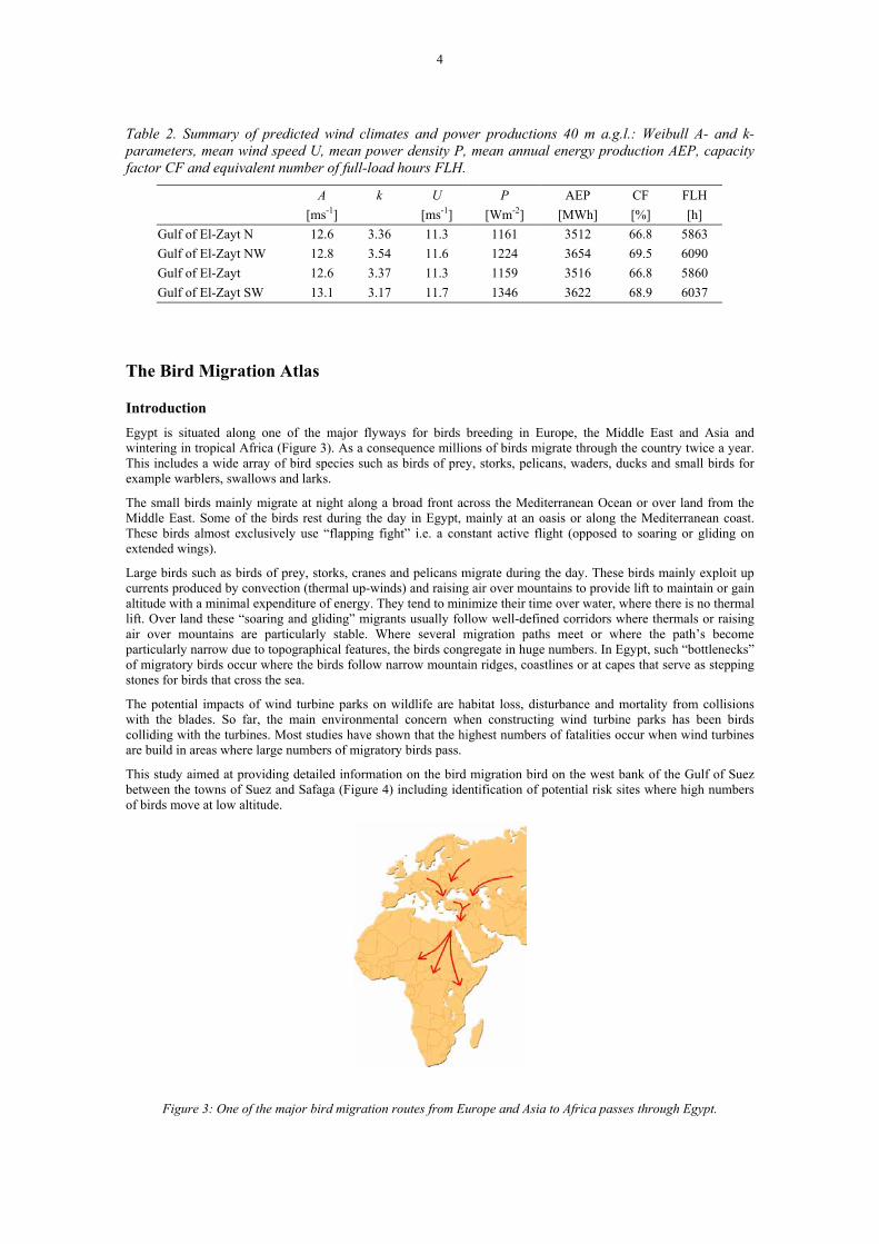
Introduction Egypt is situated along one of the major flyways for birds breeding in Europe, the Middle East and Asia and wintering in tropical Africa (Figure 3). As a consequence millions of birds migrate through the country twice a year. This includes a wide array of bird species such as birds of prey, storks, pelicans, waders, ducks and small birds for example warblers, swallows and larks.
The small birds mainly migrate at night along a broad front across the Mediterranean Ocean or over land from the Middle East. Some of the birds rest during the day in Egypt, mainly at an oasis or along the Mediterranean coast. These birds almost exclusively use “flapping fight” i.e. a constant active flight (opposed to soaring or gliding on extended wings).
Large birds such as birds of prey, storks, cranes and pelicans migrate during the day. These birds mainly exploit up currents produced by convection (thermal up-winds) and raising air over mountains to provide lift to maintain or gain altitude with a minimal expenditure of energy. They tend to minimize their time over water, where there is no thermal lift. Over land these “soaring and gliding” migrants usually follow well-defined corridors where thermals or raising air over mountains are particularly stable. Where several migration paths meet or where the path’s become particularly narrow due to topographical features, the birds congregate in huge numbers. In Egypt, such “bottlenecks” of migratory birds occur where the birds follow narrow mountain ridges, coastlines or at capes that serve as stepping stones for birds that cross the sea.
The potential impacts of wind turbine parks on wildlife are habitat loss, disturbance and mortality from collisions with the blades. So far, the main environmental concern when constructing wind turbine parks has been birds colliding with the turbines. Most studies have shown that the highest numbers of fatalities occur when wind turbines are build in areas where large numbers of migratory birds pass.
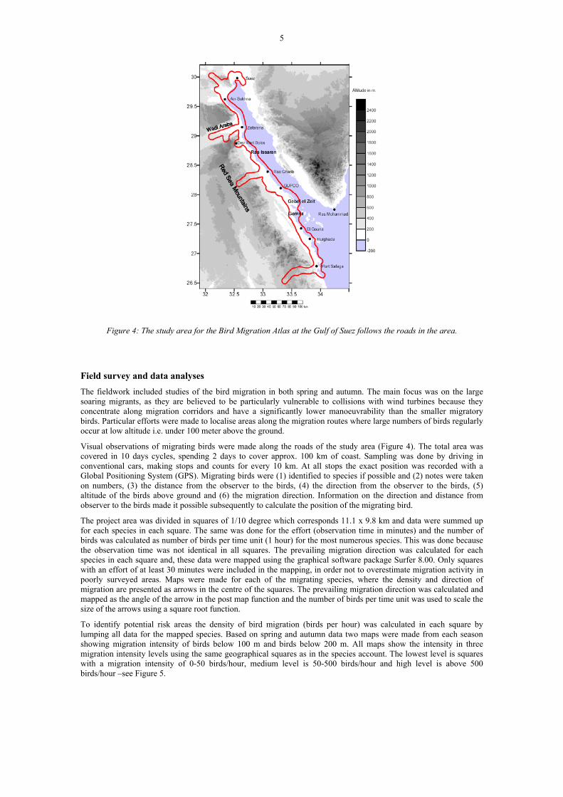
This study aimed at providing detailed information on the bird migration bird on the west bank of the Gulf of Suez between the towns of Suez and Safaga (Figure 4) including identification of potential risk sites where high numbers of birds move at low altitude.
Figure 3: One of the major bird migration routes from Europe and Asia to Africa passes through Egypt.
5
Figure 4: The study area for the Bird Migration Atlas at the Gulf of Suez follows the roads in the area.
Field survey and data analyses The fieldwork included studies of the bird migration in both spring and autumn. The main focus was on the large soaring migrants, as they are believed to be particularly vulnerable to collisions with wind turbines because they concentrate along migration corridors and have a significantly lower manoeuvrability than the smaller migratory birds. Particular efforts were made to localise areas along the migration routes where large numbers of birds regularly occur at low altitude i.e. under 100 meter above the ground.
Visual observations of migrating birds were made along the roads of the study area (Figure 4). The total area was covered in 10 days cycles, spending 2 days to cover approx. 100 km of coast. Sampling was done by driving in conventional cars, making stops and counts for every 10 km. At all stops the exact position was recorded with a Global Positioning System (GPS). Migrating birds were (1) identified to species if possible and (2) notes were taken on numbers, (3) the distance from the observer to the birds, (4) the direction from the observer to the birds, (5) altitude of the birds above ground and (6) the migration direction. Information on the direction and distance from observer to the birds made it possible subsequently to calculate the position of the migrating bird.
The project area was divided in squares of 1/10 degree which corresponds 11.1 x 9.8 km and data were summed up for each species in each square. The same was done for the effort (observation time in minutes) and the number of birds was calculated as number of birds per time unit (1 hour) for the most numerous species. This was done because the observation time was not identical in all squares. The prevailing migration direction was calculated for each species in each square and, these data were mapped using the graphical software package Surfer 8.00. Only squares with an effort of at least 30 minutes were included in the mapping, in order not to overestimate migration activity in poorly surveyed areas. Maps were made for each of the migrating species, where the density and direction of migration are presented as arrows in the centre of the squares. The prevailing migration direction was calculated and mapped as the angle of the arrow in the post map function and the number of birds per time unit was used to scale the size of the arrows using a square root function.
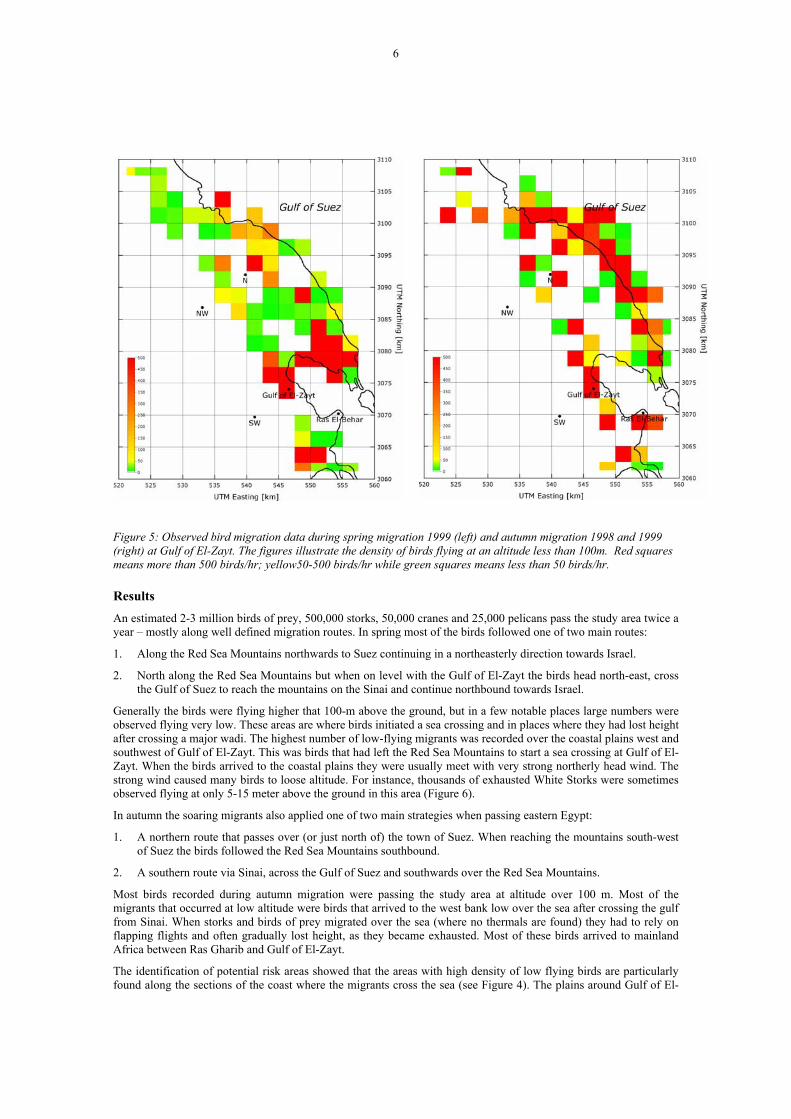
To identify potential risk areas the density of bird migration (birds per hour) was calculated in each square by lumping all data for the mapped species. Based on spring and autumn data two maps were made from each season showing migration intensity of birds below 100 m and birds below 200 m. All maps show the intensity in three migration intensity levels using the same geographical squares as in the species account. The lowest level is squares with a migration intensity of 0-50 birds/hour, medium level is 50-500 birds/hour and high level is above 500 birds/hour –see Figure 5.
6
Figure 5: Observed bird migration data during spring migration 1999 (left) and autumn migration 1998 and 1999 (right) at Gulf of El-Zayt. The figures illustrate the density of birds flying at an altitude less than 100m. Red squares means more than 500 birds/hr; yellow50-500 birds/hr while green squares means less than 50 birds/hr.
Results An estimated 2-3 million birds of prey, 500,000 storks, 50,000 cranes and 25,000 pelicans pass the study area twice a year – mostly along well defined migration routes. In spring most of the birds followed one of two main routes:
1. Along the Red Sea Mountains northwards to Suez continuing in a northeasterly direction towards Israel.
2. North along the Red Sea Mountains but when on level with the Gulf of El-Zayt the birds head north-east, cross the Gulf of Suez to reach the mountains on the Sinai and continue northbound towards Israel.
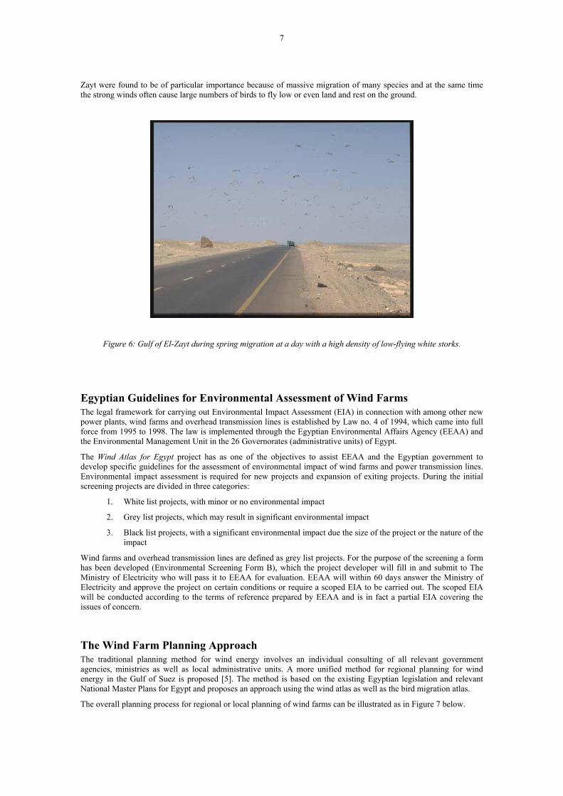
Generally the birds were flying higher that 100-m above the ground, but in a few notable places large numbers were observed flying very low. These areas are where birds initiated a sea crossing and in places where they had lost height after crossing a major wadi. The highest number of low-flying migrants was recorded over the coastal plains west and southwest of Gulf of El-Zayt. This was birds that had left the Red Sea Mountains to start a sea crossing at Gulf of El-Zayt. When the birds arrived to the coastal plains they were usually meet with very strong northerly head wind. The strong wind caused many birds to loose altitude. For instance, thousands of exhausted White Storks were sometimes observed flying at only 5-15 meter above the ground in this area (Figure 6).
In autumn the soaring migrants also applied one of two main strategies when passing eastern Egypt:
1. A northern route that passes over (or just north of) the town of Suez. When reaching the mountains south-west of Suez the birds followed the Red Sea Mountains southbound.
2. A southern route via Sinai, across the Gulf of Suez and southwards over the Red Sea Mountains.
Most birds recorded during autumn migration were passing the study area at altitude over 100 m. Most of the migrants that occurred at low altitude were birds that arrived to the west bank low over the sea after crossing the gulf from Sinai. When storks and birds of prey migrated over the sea (where no thermals are found) they had to rely on flapping flights and often gradually lost height, as they became exhausted. Most of these birds arrived to mainland Africa between Ras Gharib and Gulf of El-Zayt.
The identification of potential risk areas showed that the areas with high density of low flying birds are particularly found along the sections of the coast where the migrants cross the sea (see Figure 4). The plains around Gulf of El-
7
Zayt were found to be of particular importance because of massive migration of many species and at the same time the strong winds often cause large numbers of birds to fly low or even land and rest on the ground.
Figure 6: Gulf of El-Zayt during spring migration at a day with a high density of low-flying white storks.
Egyptian Guidelines for Environmental Assessment of Wind Farms The legal framework for carrying out Environmental Impact Assessment (EIA) in connection with among other new power plants, wind farms and overhead transmission lines is established by Law no. 4 of 1994, which came into full force from 1995 to 1998. The law is implemented through the Egyptian Environmental Affairs Agency (EEAA) and the Environmental Management Unit in the 26 Governorates (administrative units) of Egypt.
The Wind Atlas for Egypt project has as one of the objectives to assist EEAA and the Egyptian government to develop specific guidelines for the assessment of environmental impact of wind farms and power transmission lines. Environmental impact assessment is required for new projects and expansion of exiting projects. During the initial screening projects are divided in three categories:
1. White list projects, with minor or no environmental impact
2. Grey list projects, which may result in significant environmental impact
3. Black list projects, with a significant environmental impact due the size of the project or the nature of the impact
Wind farms and overhead transmission lines are defined as grey list projects. For the purpose of the screening a form has been developed (Environmental Screening Form B), which the project developer will fill in and submit to The Ministry of Electricity who will pass it to EEAA for evaluation. EEAA will within 60 days answer the Ministry of Electricity and approve the project on certain conditions or require a scoped EIA to be carried out. The scoped EIA will be conducted according to the terms of reference prepared by EEAA and is in fact a partial EIA covering the issues of concern.
The Wind Farm Planning Approach The traditional planning method for wind energy involves an individual consulting of all relevant government agencies, ministries as well as local administrative units. A more unified method for regional planning for wind energy in the Gulf of Suez is proposed [5]. The method is based on the existing Egyptian legislation and relevant National Master Plans for Egypt and proposes an approach using the wind atlas as well as the bird migration atlas.
The overall planning process for regional or local planning of wind farms can be illustrated as in Figure 7 below.

8
Wind Farm Planning
Wind AtlasBird MigrationAtlas
Maps &other data
§§Legislation
Masterplans EIA
Power system
dataLand
restrictions
Figure 7: An illustration of the planning approach for wind farm development
The result of the planning process is a regional or local planning document with dedicated areas marked for wind energy development. Having this planning document planning of the individual projects become easier and less cumbersome.
The initial phases of the planning process of a wind farm project involves the determination of the size of the wind farm and the location or siting of the farm. Although the determination of size or capacity of the wind farm and the location in principle are independent activities they are often carried out together through the implementation of a pre-feasibility study. Moreover, the economic and financial optimum size for the society and for the investors at the given conditions may vary for different sites, so in general sizing and siting should be seen as integrated activities. Furthermore, sizing certainly involves aspects that may not easily be quantified in monetary terms.
The determination of the size or capacity of the wind farm is carried out in view of constraints with respect to:
• Planning act and other legislation
• Local and national development plans and policies
• Land availability, access and transport infrastructure
• Power system capability - present situation and in view of expansion plans
• Wind turbine technology
• Financing/funding
• Electricity market and PPA conditions
• Environmental impacts
In addition to the sizing, the planning involves site selection for the wind farm – a procedure that most often is carried out by comparing a number of candidate sites with respect to the following issues:
• Compatibility with project objectives and development plans, which may involve other than economic characteristics
• Potential wind energy production
• Environmental “costs and benefits”
• Sustainability, assumptions, uncertainties and risks o Production estimation
9
o Availability of land, infrastructure, institutional framework, human resources, equipment o Community and power system development as well as authorities’ attention and priority o Investments, investors, economic and financial data and assumptions o Design safety, interference, reliability and lifetime o Wind farm and power system operation and maintenance
• Economic and financial viability and attractiveness
Case Study Through a case study the planning tools are demonstrated at a site with a high potential for wind energy development, which at the same time is known to be close to a location with a high concentration of migrating birds during spring and autumn - Gulf of El-Zayt - see the blue box in Figure 1. This site is particularly interesting as a case study because the environmental impact i.e. the risk for the migrating birds is to some extent linked to the high winds forcing the migrating birds towards the ground. At the same time the wind climate is excellent for wind turbines.
Different locations of a 60 MW wind farm will be analysed and compared with respect to the annual energy production and environmental impact – in this case mainly the expected risk for the migrating birds.
Conclusions Wind turbines possess a potential risk for migratory birds if they collide with the rotor blades or tower of the wind turbine. Millions of migratory birds pass through eastern Egypt twice a year, some of which are of conservation concern, and particularly vulnerable to additional mortality because they have either small populations, declining numbers or slow reproduction (or both).
Most of the potential impacts of wind farms on migrating birds can be reduced to acceptable levels through careful siting, design and mitigation. The most crucial aspect is the siting of the wind park. Identifying areas of possible environmental concern should therefore be done early in the planning of the project, in order to minimise the cost and maximise the effectiveness, of these measures.
An Environmental Impact Assessment (EIA) should be commissioned before the final siting of the wind farm is made. In most cases the information available on breeding and migratory birds (and the biodiversity in general) is insufficient or outdated making it difficult to evaluate the impact of a new wind farm.
In the Gulf of Suez area this is different. Due to the predominantly hyper-arid environment the number of resident birds, mammals and other animal as well as plant species is low. Consequently, nearly all birds that occur in this area are migrants. It is recommended that if wind farms are to be built along the west bank of the Gulf of Suez the scale of the EIA to be carried out is determined on the basis of the information recorded in the Bird Migration Atlas [4]. In areas with a high density of migrating birds a full EIA should be carried out. In areas with medium level a partial EIA should be made, while in areas with low migration a reduced or desk EIA will be sufficient.
The Gulf of El-Zayt is very attractive for development of wind farms due to the excellent wind resource and open and flat landscape with nearly no vegetation and resident animals. Construction of wind farms here is relatively straightforward and requires only a careful mine clearing before construction. At the same time Gulf of El-Zayt is located at a high-density bird migration route and great care should be exercised at an early stage of the planning of a project.
References [1] Niels G. Mortensen, Usama Said Said, Helmut P. Frank, Laila Georgy, Charlotte B. Hasager, Mohamad Akmal,
J. Carsten Hansen and Ashour Abdel Salam (2003). Wind Atlas for the Gulf of Suez. Measurements and Modelling 1991-2001. New and Renewable Energy Authority, Cairo, and Risø National Laboratory, Roskilde. 196 pp.
[2] Niels G. Mortensen, Usama Said Said, Helmut P. Frank, Laila Georgy, Charlotte B. Hasager, Mohamad Akmal, J. Carsten Hansen and Ashour Abdel Salam (2003). Meso- and micro-scale flow modelling in the Gulf of Suez, Arab Republic of Egypt. 2003 European Wind Energy Conference and Exhibition.
[3] Helmut P. Frank (2003). Wind simulations for the Gulf of Suez with KAMM. Risø-I-1970(EN), Risø National Laboratory, Roskilde. 23 pp.
10
[4] Christensen, K.D., Pagh Jensen F.: Atlas of Bird Migration at the Gulf of Suez, Egypt. Hedeselskabet 2003
[5] Clausen, N-E et al: Wind Farm Planning at the Gulf of Suez, NREA/Risoe National Laboratory, R-1387 (EN) to be published
[6] Wind Atlas Analysis and Application Program http://www.wasp.dk/
Acknowledgements The work presented is a result of the joint Egyptian-Danish project Wind Atlas for Egypt. The Danish Ministry of Foreign Affairs (DANIDA) finances the Danish contribution to the project.
Glossary AEP Annual Energy Production EEAA Egyptian Environmental Affairs Agency EIA Environmental Impact Assessment KAMM Karlsruhe Atmospheric Meso-scale Model NCAR National Center for Atmospheric Research NCEP National Center for Environmental Prediction