emerging human settlement patterns … centre lacks a waste collection system and this has ......
TRANSCRIPT
EMERGING HUMAN SETTLEMENT PATTERNS AROUND THE PLANNED
KONZA CITY: A CASE OF MALILI CENTRE
BY
MUTUKU AUGUSTINE MULINGE
B65/3292/2010
A planning Research Project Submitted in Partial Fulfillment of the Requirements for
the Degree of Bachelor of Arts in Urban and Regional Planning.
Department of Urban and Regional Planning
University of Nairobi
June 2014

ii
DECLARATION
This Planning Research Project is my original work and has not been presented for a degree
in any other university.
Signed …………………………………… Date …......................................
MUTUKU AUGUSTINE MULINGE
B65/3292/2010
(Candidate)
This Planning Research Project has been submitted for examination with my approval as the
University Supervisor
Signed …………………………………. Date………………………….
MR. CHARLES DADU KARISA
(Supervisor)
iii
DEDICATION
I dedicate this research project to the Almighty the Only True and Wise God who has given
me the strength to carry out the research work. To my parents and dear friends who have
given me support and encouragement during the whole process, may the Almighty bless you.

iv
ACKNOWLEDGEMENT
My Acknowledgement to the Almighty God the only true and Wise God who gave me good
health the energy to carry out this research from the start to completion.
My sincere gratitude goes to my supervisor, Mr. Charles Dadu Karisa for the valuable
advice, guidance, patience and support he has given me in the writing of this research from
the initial stages to the completion of the research work.
I would also like to appreciate the input of other lecturers, Mr. Z. Maleche and the research
coordinators Dr. Isaack .K. Mwangi and Mr. Opiyo. R, whose insights broadened my
thinking and made this research work possible.
To all my colleagues at the Department of Urban and Regional Planning (DURP) class of
2014, more so Paul Ndeleva, Isdora Awino and Chrispine Kodol who assisted in carrying out
the fieldwork.
Lastly, am grateful to all my wonderful family members and friends for their unfailing
support and encouragement during my entire schooling period. This academic journey has
been an uphill task but your encouragement has seen me this far. I shall forever be indebted
to you all for your kind assistance.

v
ABSTRACT
Malili Centre exhibits all the conditions for the development of an informal settlement. This
research endeavored to examine the extent of the rise of informal activities within the Centre
and came up with recommendations that will guide the development of the Centre
sustainably.
The study involved secondary and primary data. The secondary data was obtained from
literature review while the primary data was collected from the area of study by use of the
following research tools; questionnaires, observation lists and oral interviews. Various
methods of data collected were employed which are administration of questionnaires,
observation taking of photographs conducting interviews and mapping. The data collected
was analyzed and is presented in chapter four, inform of charts, tables, maps and
photographs.
The study established there is increase in activity within Malili Centre since
conceptualization of Konza Technology City. This has led to increase in resident population
within the Centre as some people have moved into the Centre in search of employment while
other have moved in to establish business activities.
The increase in population within the Centre has resulted to various challenges: inadequate
housing, emergence of informal business activities, environmental degradation and straining
of the available infrastructure. The problem of inadequate housing has been addressed by
construction of temporary structures. These structures are walled using iron sheets. Informal
business activities have emerged within the Centre. Most of the businesses do not have
trading licenses. These businesses are established in temporary structures. Some of the
structures area constructed on the road reserves. Majority of the structures within the Centre
lack sanitation facilities like toilets. The Centre lacks a waste collection system and this has
led to piling up of waste within the Centre. All these in combination have given the Centre an
informal character.
Thus, the study recommended for a redevelopment of the Centre by observing measures that
promote sustainability. The new developments will comprise of commercial and residential
use. The redevelopment approach will encompass several aspects which include: provision of
affordable and decent housing typologies, development of a formal market to accommodate

vi
the existing informal commercial activities, improvement of transport infrastructure and
provision of basic amenities.

vii
TABLE OF CONTENTS DECLARATION .............................................................................................................................. ii
DEDICATION ................................................................................................................................. iii
ACKNOWLEDGEMENT .................................................................................................................iv
ABSTRACT ...................................................................................................................................... v
TABLE OF CONTENTS ........................................................................................................................ vii
LIST OF FIGURES ........................................................................................................................... xi
LIST OF PLATES ............................................................................................................................. xi
LIST OF ACRONYMS .................................................................................................................... xii
CHAPTER 1: INTRODUCTION ...................................................................................................... 1
1.1. Statement of Problem ..................................................................................................... 2
1.2. Research Questions ........................................................................................................ 3
1.3. Research objectives ........................................................................................................ 4
1.4. Justification .................................................................................................................... 4
1.5. Research Methodology ................................................................................................... 4
1.5.1. Research stages .......................................................................................................... 4
1.5.2. Methods of data collection .............................................................................................. 5
1.5.3. Secondary data ........................................................................................................... 6
1.5.4. Sampling .................................................................................................................... 6
1.5.6. Data Presentation Methods ......................................................................................... 7
1.5.7. Data need matrix ........................................................................................................ 9
CHAPTER 2: LITERATURE REVIEW .......................................................................................... 11
2.1 Overview ............................................................................................................................... 11
2.2. Definitions of Human settlements ......................................................................................... 11
2.2.1. Urban settlements .............................................................................................................. 11
2.2.2. Rural settlements................................................................................................................ 11
2.3. Components of human settlements ........................................................................................ 11
2.3.1. Shelter............................................................................................................................ 11
2.3.2. Infrastructure.................................................................................................................. 12
2.3.3. Service provision ........................................................................................................... 12
2.5. Function of human settlement ............................................................................................... 13
2.5.1. Service function ............................................................................................................. 13
2.5.2. Economic function ......................................................................................................... 13
2.5.3. Residential function ....................................................................................................... 14

viii
2.7. Evolution of human settlements ............................................................................................ 14
2.7.1. Prehistory settlements .................................................................................................... 14
2.7.2. Settlements in Classical Period ....................................................................................... 16
2.7.3. The origin of human settlements in Kenya ...................................................................... 18
2.7.4. Evolution of human settlements in Kenya ....................................................................... 20
2.8. Sustainable human settlements .............................................................................................. 21
2.8.1. Land tenure.................................................................................................................... 21
2.8.3. Transportation ................................................................................................................ 27
2.8.4. Sustainable Energy ......................................................................................................... 28
2.9. Characteristics of informal settlements .................................................................................. 28
2.9.1. High population densities ............................................................................................... 28
2.9.2. Poor sanitation facilities ................................................................................................. 28
2.10. Measures adopted to solve the inadequacy of shelter. .......................................................... 30
2.10.1. Squatter Upgrading and the Site and Service Schemes .................................................. 30
2.10.2. Accessibility of Formal Housing by Low Income Groups, Case of Nairobi ................... 31
2.11. Impact of large scale infrastructure on human settlements. .................................................. 31
2.12. Policy and Legal framework................................................................................................ 32
2.12.1. National Housing Policy ............................................................................................... 32
2.12.2. Wildlife policy ............................................................................................................. 33
2.12.7. The Constitution of Kenya, 2010 .................................................................................. 35
2.12.8. The Physical Planning Act (cap 286) ............................................................................ 35
2.12.8. The County Government Act, 2012 .............................................................................. 35
2.12.9. The Land Act, 2012 ...................................................................................................... 35
2.12.10. Environmental Management and Coordination Act (EMCA 1999) .............................. 36
2.12.11. Urban Areas and Cities Act, 2012 ............................................................................... 36
2.12.12. Water Act, 2002 ......................................................................................................... 36
2.13. Institutional framework ....................................................................................................... 36
2.13.1 NEMA .......................................................................................................................... 36
2.13.2. Kenya Rural Roads Authority (KERRA) ...................................................................... 37
2.13.3. Kenya National Highways Authority ............................................................................ 37
2.13.4. Tana –Athi River Development Authority (TARDA) .................................................... 37
2.13.5. National Housing Corporation (NHC) .......................................................................... 38
2.13.6. The County Government of Makueni............................................................................ 39
2.14. Conceptual framework .................................................................................................... 39

ix
CHAPTER 3: STUDY AREA ......................................................................................................... 42
3.1. History of Malili Centre ........................................................................................................ 42
3.2. Topography and drainage ...................................................................................................... 44
3.3. Geology and soils ................................................................................................................. 44
3.4. Climate and Vegetation ......................................................................................................... 45
3.4.1. Rainfall .......................................................................................................................... 45
3.4.2. Temperature ................................................................................................................... 45
3.4.3. Vegetation...................................................................................................................... 46
3.5. Population ............................................................................................................................ 47
CHAPTER 4: DATA ANALYSIS AND FINDINGS ...................................................................... 48
4.1. Settlement character before conceptualization of Konza city ......................................... 48
4.2. Settlement characteristics after conceptualization of Konza Techno City ...................... 49
4.2.1. Characteristics of respondents ...................................................................................... 49
4.2.2. Demographic characteristics ......................................................................................... 50
4.2.3. Land tenure and Housing .............................................................................................. 52
4.2.4. Housing........................................................................................................................ 53
4.2.6. Road infrastructure ....................................................................................................... 59
4.2.7. Access to water ............................................................................................................ 61
4.2.8. Access to Education ..................................................................................................... 65
4.2.9. Sanitation ..................................................................................................................... 66
4.2.10. Security ........................................................................................................................ 66
4.2.11. Access to energy .......................................................................................................... 66
4.2.12. Economy and livelihoods ............................................................................................. 67
4.2.13. Environmental concerns ............................................................................................... 69
4.3. Summary of analysis and major findings ...................................................................... 73
4.3.1. Uncontrolled land subdivision and development. .......................................................... 73
4.3.5.3. Inadequate sanitation facilities ...................................................................................... 75
4.3.5.4. Security ........................................................................................................................ 76
4.3.6. Emergence of informal business activities .................................................................... 76
4.3.7. Environmental degradation ........................................................................................... 76
CHAPTER 5: RECCOMENDATIONS ........................................................................................... 77
5.1. Reorganization of land uses within the Centre. ...................................................................... 77
5.2. Provision of better and decent housing .................................................................................. 77
5.3. Provision of transport infrastructure ...................................................................................... 77
5.4. Provide adequate access to basic services. ............................................................................. 78

x
5.5. Provision of water reticulation system ................................................................................... 78
5.6. Introduction of better waste management .............................................................................. 78
5.7. Promotion use of sustainable sources of energy ..................................................................... 78
5.8. Provision of a formal market ................................................................................................. 78
5.9. Conclusion ............................................................................................................................ 79
REFERENCES................................................................................................................................ 80
APPENDIX ........................................................................................................................................ 83
Appendix 1 .................................................................................................................................. 83
Appendix 2 .................................................................................................................................. 87

xi
LIST OF FIGURES Figure 1: Data needs Matrix ............................................................................................................... 9 Figure 2: Conceptual Framework ..................................................................................................... 41 Figure 3: an excavation revealing the black cotton soils found in the area. ....................................... 44 Figure 4: Temperature on Malili Centre ........................................................................................... 46 Figure 5: Population projection for Malili sub location 2009 -2014 .................................................. 47 Figure 6: Distribution of respondents by gender ............................................................................... 49 Figure 7: Distribution of the respondents by age .............................................................................. 49 Figure 8: Percentage of House hold size .......................................................................................... 50 Figure 9: Level of education ............................................................................................................ 51 Figure 10: Level of skills in Malili Centre ........................................................................................ 51 Figure 11: Occupations within Malili Centre.................................................................................... 52 Figure 12: Housing Ownership ........................................................................................................ 54 Figure 13: Room Occupancy within Malili Centre ........................................................................... 55 Figure 14: Range of rent charged per month within the Centre ......................................................... 56 Figure 15: Building material used for wall construction ................................................................... 56 Figure 16: Building material for roofing .......................................................................................... 57 Figure 17: Years businesses have been operational ......................................................................... 68 Figure 18: Summary of resource flow within the Human settlement ................................................ 72
LIST OF PLATES
Plate1: Location of Malili Centre ..................................................................................................... 43 Plate2: Soil and geology Map .......................................................................................................... 45 Plate 3: The Natural vegetation distribution in Malili area. ............................................................... 47 Plate 4: Location of Malili after Subdivision of Malili Ranch. .......................................................... 48 Plate 5: land selling agent office ...................................................................................................... 53 Plate 6: A structure under construction ............................................................................................ 54 Plate 7: Building materials in a construction site in Malili center ...................................................... 57 Plate 8: Row housing in Malili Centre ............................................................................................. 58 Plate 9: A house under construction using permanent material ......................................................... 58 Plate 10: Sections of Malili- Konza road with water accumulated in the middle of the road .............. 59 Plate 11: A pool of water in the middle of the road within the Centre ............................................... 60 Plate 12: Section of Malili Katumani road ....................................................................................... 61 Plate 13: Water tank at the Sub chief office where government trucks supply water ......................... 62 Plate 14: A water cart a common means of transporting water within the Centre ........................... 64 Plate 15: A structure housing Elite Academy ................................................................................... 65 Plate 16: Solid waste dumped at the roadside within Malili Centre .................................................. 69 Plate 17:A section of unpaved circulation road with waste dumped at the roadside ........................ 69 Plate 18: A depression where solid waste is currently being dumped............................................... 70 Plate 19: Land uses within Malili Centre. ......................................................................................... 71
xii
LIST OF ACRONYMS
EMCA: Environmental Management and Coordination Act
GOK: Government of Kenya
HFCK: Housing Finance Company of Kenya
ICT: Information and communication Technology
KENHA: Kenya National Highway Authority
KERRA: Kenya Rural Road Authority
KOTDA: Konza Technology Development Authority
NEMA: National Environmental Management Authority
NHC: National Housing Corporation
TARDA: Tana River Development Authority
TOL: Temporary Occupation License
UNCHS: United Nations Commission of Human Settlement

1
CHAPTER 1: INTRODUCTION
The United Nations Vancouver Declaration on Human settlements in 1976 defined human
settlements as the totality of the human community with all the social, material,
organizational, spiritual and cultural elements that sustain it. Human settlements comprise
both physical components and services that support the physical infrastructure. The physical
components of human settlements are:
Shelter
Shelter mostly perceived as housing is a basic human need and all human beings strive to
access it. The type of shelter differs from one society to another and from one region to
another. Various factors affect the type of shelters. Some of the factors are; culture, available
resources and state of technology.
Infrastructure
Infrastructure has to be provided for human settlements to be effective. The support
infrastructure which need to be provided include; roads, water, power, communication
infrastructure and sanitation facilities.
Services
Services are required by a community for the fulfillment of its functions as a social body and
such services include but not limited to education, health, security, culture, welfare and
recreation.
Settlements have an effect on the economic, social character in any country. It is within the
settlements where majority of the activities are carried out. The provision of housing, one of
the components of any settlement, is entrenched in the constitution. The provision of quality
housing has an impact on the land use and thus is an important concern to physical planners.
Every person has the right to a standard of living adequate for the health and well-being of
himself and of his family, including food, clothing, housing (Universal Declaration on
Human Rights). The constitution of Kenya under article 43 (1) (b) provides that every
Kenyan citizen has a right to accessible and adequate housing and sanitation. The enjoyment
of this right is not limited to those living in urban areas but to all Kenyans irrespective of
where they live. In order for the rights to be enjoyed, the services need to be provided within
or near the human settlement where the citizens live.
Centers in rural areas are transforming into urban settlements and will play crucial role in
housing Kenyan population, which is estimated to rise by 60 percent by 2040.The country is

2
experiencing economic growth and various projects have been proposed to be implemented
under the Economic Recovery Strategy to achieve Vision 2030, which is to make Kenya a
middle-income economy according to Kenya Vision 2030. Among these flagship projects
are, Konza Techno City, Lamu Resort City and Isiolo Resort City. These mega projects have
an impact on the existing rural settlements. The speculation of the implementation of these
mega projects have led to mass movement and high concentration of populations in the
existing rural trading centers. The pattern of human settlement in these centers is thus
transforming. The manifestation of the change in pattern of human settlement is evident in
Malili center. The changes have been spurred by the proposed Konza Technology City.
Malili trading center is about 1 km from the proposed Konza Technology City site. This
center has a linear form and is along the Nairobi-Mombasa highway. In the recent past, the
trading center has experienced increased populations
The Konza Techno City, a project by both the Kenyan government and the private sector, is
planned to accommodate the top technocrats in the country. The speculated city has attracted
people who are searching for employment. Others are positioning themselves to tap in the
increased business that will be generated by the construction of the technology city.
1.1.Statement of Problem
Before the conceptualization of Konza Techno city, Malili Center was a quiet center along
the Nairobi-Mombasa highway providing basic commodities to workers employed in the
former Malili ranch before the conceptualization of Konza Technology and subsequent
subdivision of Malili Ranch. The ranch land has since been subdivided and allocated to its
different shareholders and the rest sold to the government for the construction of the Konza
Technology City. The center has experienced a rapid increase in activities since the
conceptualization of the Konza City. Due to high influx of population in the Centre, the
settlement pattern has changed with emergence of informal houses, poor infrastructure and
inadequate support services. The activities within the center have increased and this center is
undergoing rapid transformation. The growth of Malili in a ribbon manner along both sides of
Mombasa highway is posing challenges in terms of cost of service provision, safety for
motorists and pedestrians, unorganized and incompatible land uses, unattractiveness and
settlement sprawl. (Konza Techno City Buffer Local Physical Development Plan, 2013).
The provision of adequate shelter within the settlement is highly compromised because
demand far outweighs the supply. The provision of quality and affordable shelter to Kenyans
remains a major challenge. The Kenyan constitution also addresses the house issue of access

3
to quality in that it is the right for every Kenyan to have access to quality and affordable
housing. In the case of Malili, trading center there is emergence of poor housing due to high
demand resulting from increase in population. The available stock of housing is not enough
to cater for the demand because more population will move in once the construction of the
Konza Technology City starts. A reconnaissance in the area had showed an emerging trend of
the increase of iron sheet walled houses aimed at increasing supply of housing units.
However, these houses lack many basic requirements. The houses are built without following
any planning standards. The growth of the unplanned Malili center if not controlled will have
impacts on the environment. Human settlements use resources from the environment and
generate waste which is dispose into the environment. The use of resources and disposal of
waste need to be dine in a controlled manner. Unplanned settlements lack the control
channels and this leads to environmental hazards. The center is in a rural setting where
planning regulations are least followed because of the free hold system of land tenure.
Increase in population need to be coupled with increase in the infrastructure. However, this is
not the case in Malili center. The earlier infrastructure, which was not well maintained, is
now supporting the growing settlement.
Other support facilities are coming up. Among these support facilities are schools and clinics
provided by private businesspersons. The provision of these support facilities is also
unplanned and the overall image created by the crowding of these components is that of an
emerging informal settlement. The immediate concerns that face the planners and the county
government jurisdiction in charge of development control in the area are whether the
prevailing conditions in Malili center are the ingredients of the growth of a slum settlement;
and moreover, whether it is allowable for a slum to develop near the proposed Information
Technology City of Africa.
1.2.Research Questions
1. What were the settlement patterns in Malili center before conceptualization of Konza
City?
2. What settlement patterns have emerged in Malili center after conceptualization of
Konza City?
3. What are the implications of emerging settlement patterns on the growth and physical
development of Malili Centre?

4
4. What planning interventions are necessary for guiding sustainable human settlement
patterns in Malili Center?
1.3.Research objectives
1. To establish the settlement patterns in Malili center before conceptualization of Konza
City.
2. Examine settlement patterns in Malili center after conceptualization of Konza City
3. Evaluate the implications of emerging settlement patterns on the growth and physical
development of Malili center and its vicinity
4. Propose appropriate planning interventions for guiding sustainable human settlement
patterns in Malili center.
1.4.Justification
Malili trading center is experiencing rapid transformation in the human settlement patterns,
which is a trend reflected in other centers where other cities or major developments have
been conceptualized in their vicinity. The changes have brought in environmental
degradation, congestion, poor housing, and inadequate infrastructure all of which are
ingredients of the growth of an informal settlements. The aim of this research is to investigate
the nature of transformation Malili center from a human settlement perspective and provide
recommendations on how the growth and development of the center can be sustainable.
1.5.Research Methodology
1.5.1. Research stages
This research was followed the following stages
1. Problem identification. This entailed in identification of the planning problem to
research and identifying the area where the area best manifests itself.
2. Literature review
This involved collecting information from already researched areas related to the
research problem and this aided in formulation of research tools
3. Reconnaissance
During the reconnaissance general attributes of the study area were observed. This stage
made localization of the research tools possible by providing information which was
integrated in the research tools.
5
4. Field study
This was a three day exercise which entailed actual data collection. Various aspects of the
Centre were observed and data of various character of the Centre was recorded
5. Data cleaning. The data collected was cleaned in preparation for data entry.
6. Data entry. The data collected was entered into various softwares in readiness for
analysis
7. Data analysis. Various outputs were generated from the refined data. The data
analysis was guided by the research objectives. The outputs generated helped in the
writing of the study finding.
1.5.2. Methods of data collection
This research employed both primary and secondary methods of data collection.
1.5.2.1.Data Needs and data Sources
To establish the settlement patterns in Malili center before conceptualization of Konza
City.
The data needed to achieve this objective will be to gather data on the housing typologies,
building material, size/extent, plot sizes, building densities, infrastructure economic
livelihoods, environmental concerns, community facilities circulation within the Centre
before the conceptualization of Konza City.
Examine settlement patterns in Malili center after conceptualization of Konza City
The data needs to achieve this objective will be to gather data on the existing housing
typologies, building material, economic livelihoods, environmental concerns, size/extent, plot
sizes, building densities, infrastructure community facilities circulation within the Centre.
This data was collected through use of questionnaires and mapping.
Evaluate the implications of emerging settlement patterns on the growth and physical
development of Malili center and its vicinity
This will collect data detailing on environmental concerns, physical development, housing
typologies, land sizes and population trends.
Propose appropriate planning interventions for guiding sustainable human settlement
patterns in Malili center.

6
This will entail proposing development proposals guided by the analyzed data.
1.5.2.2.Methods of data collection
1.5.2.2.1. Observation
This was necessary to note the change in housing conditions, economic activities, and
community facilities within the area. An observation checklist was developed and this
method of data collection was be supported by photography.
1.5.2.2.2. Administration of questionnaires
Administration of questionnaires was one of the key methods of data collection used. Two
types of questionnaires were used namely household questionnaire and business owners’
questionnaire. This was done by interviewing the residents within Malili center.
1.5.2.2.3. Observation and Photography
This involved the systematic selection, observation and recording of the characteristics and
features (building typologies, land uses,) of the Centre. A checklist used as the tool to
aid in the observation complemented the other aspects by facilitating the observation of key
aspects for later analysis.
1.5.1.2.4 Mapping, and Sketching
Aerial (Google) images were used to aid in mapping of key features of the Centre. The
mapped features were then digitized using a geo-referenced image and a land use map of the
study area was generated.
1.5.3. Secondary data
Data was collected from publications on human settlements and speculative urbanization.
This aided in the understanding of the area of study and establishing what had been
previously studied and gaps by others in the same area of study. This data type was sourced
from journals, internet sources, government publications, articles, maps and other sources.
1.5.4. Sampling
Simple random sampling technique was used in selecting the respondents who gave the
information on the prevailing conditions within Malili settlement.
To determine the sample size for the households, the following formula was applied:

7
N =Z2PQ/D2
Where:
N is the desired sample size
Z is the standard deviation, normal deviate at the required confidence level
P is the proportion in the target population estimated to have the characteristics being
measured
Q is 1-P
D=level of statistical significance.
Assuming that Z is1.96, P is 98% of the target population are affected and a confidence level
of 95%, the sample size was
=1.9622×0.98×0.02/0.0522 = 27.90
An approximate sample size of 30 respondents for households and 30 for the business owners
was used. Those interviewed were those living within the Centre.
1.5.5. Data analysis
Data analysis entails the use of appropriate methods to synthesize data to answer the research
questions. This is therefore the aspect that seeks to make meaning of the data collected. At
the end of the fieldwork all data collected from the structured questionnaires was entered,
coded, cleaned and analyzed using SPSS. The analysis of both the qualitative and quantitative
data collected was presented using simple frequency distribution and analytical tables. The
analysis of the quantitative data collected was also presented by the use of maps and
photographs.
The results of the analysis were used to compile this report.
1.5.6. Data Presentation Methods
All the gathered information were synthesized and presented using simple tables, pie charts,
bar graphs, maps and photographs and were integrated into the research report.
Table 1 below summarizes the research methodology with respect to the study objectives:

8

9
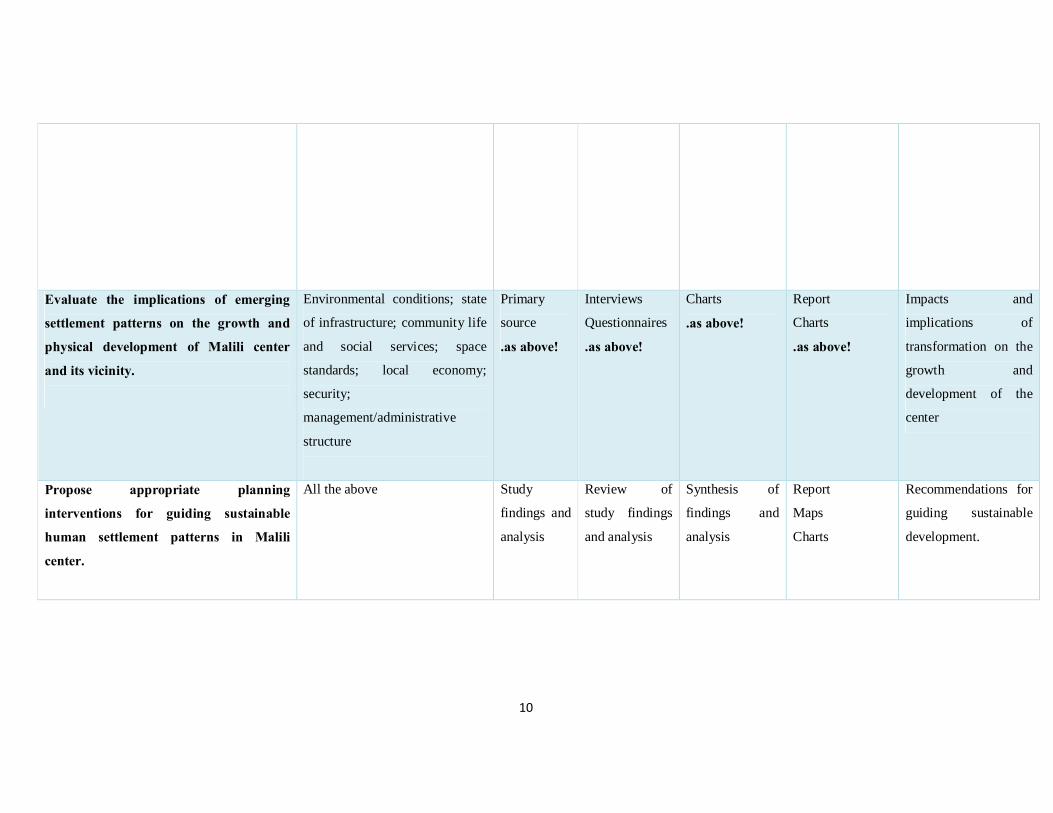
1.5.7. Data need matrix Figure 1: Data needs Matrix
Research Objective Data needs variables to be
observed
Sources of
data
Method of
data collection
Method of Data
analysis
Method of data
presentation
Expected results
To establish the settlement patterns in
Malili center before conceptualization of
Konza City.
Land uses existing before
conceptualization of Konza city
Original settlement structure of
the center;
management/administrative
structure; densities; physical
size/area covered
Secondary
source
Primary
source
Interviews
Questionnaire
Visual survey
Content analysis
Morphological
analysis;
mapping/spatial
analysis
Descriptive
Report;
Settlement
layouts/spatial
layouts
Description of the
original pattern of the
settlement before
conceptualization of
Konza city
Examine settlement patterns in Malili
Center after conceptualization of Konza
City
emerging land uses and patterns
of use; and emerging physical
structure of the center; physical
infrastructure; waste situation;
densities (population and units);
growth; development (real
estate) character;
management/administrative
structure
Primary
source
..As above!
Interviews
Questionnaires
Photography
Observation
Visual survey
Content analysis
Mapping/spatial
analysis
Morphological
analysis
Charts
Photographs
Sketches
Descriptive
report;
Settlement
layouts/structural
drawings
Report on current
situation and emerging
trends of the
settlement
10
Evaluate the implications of emerging
settlement patterns on the growth and
physical development of Malili center
and its vicinity.
Environmental conditions; state
of infrastructure; community life
and social services; space
standards; local economy;
security;
management/administrative
structure
Primary
source
.as above!
Interviews
Questionnaires
.as above!
Charts
.as above!
Report
Charts
.as above!
Impacts and
implications of
transformation on the
growth and
development of the
center
Propose appropriate planning
interventions for guiding sustainable
human settlement patterns in Malili
center.
All the above Study
findings and
analysis
Review of
study findings
and analysis
Synthesis of
findings and
analysis
Report
Maps
Charts
Recommendations for
guiding sustainable
development.

11
CHAPTER 2: LITERATURE REVIEW
2.1 Overview
This chapter summaries what has been documented concerning human settlement dynamics and how the settlements have changed over time, the factors that have necessitated this changes and contributions of recent infrastructural development to settlement pattern changes.
2.2. Definitions of Human settlements
Human settlements are the totality of the human community whether city, town or village -
with all the social, material, organizational, spiritual and cultural elements that sustain it.
(Vancouver Declaration)
A human settlement is defined as a place inhabited more or less permanently. It includes
buildings in which people live or use and the paths and streets over which they travel. It also
includes the temporary camps of the hunters and herders. It may consists of only a few
dwelling units called hamlets or big cluster of buildings called urban cities.
Settlements are classified on the basis of size and function into urban and rural.
2.2.1. Urban settlements
These types of settlement are nodal in character and have secondary and tertiary activities.
The chief occupation of the people of urban areas is non-agricultural i.e. industry, trade and
services. The major function of an urban area are trades and commerce, transport and
communication, mining and manufacturing, defense, administration, cultural and recreational
activities. Population density is high and the settlement size is large.
2.2.2. Rural settlements
These settlements are chiefly concerned with primary activities such as agriculture, mining,
fishing, forestry etc. Most of the people of rural settlement are engaged in agricultural work.
The major function of rural settlement is agriculture and each settlement specializes in
various activities. Population density is small and the settlement size is small.
2.3. Components of human settlements
2.3.1. Shelter
Shelter alongside food and clothing is among the human basic needs. Shelter protects human
beings from extreme weather conditions, attack from wild animals and provides a place of
rest. Shelter currently perceived as housing has evolved over the years. Housing plays an
12
essential role in any strategy for human settlements. The availability of housing can influence
the location of population within and between these settlements. It can therefore be used, to
some extent, as a planning tool to offset urban sprawl and to direct the physical growth of
cities. Furthermore adequate housing, even of a minimum standard contributes directly to
human health and productivity which are important both to the quality of life and to
economic development.
2.3.2. Infrastructure
Infrastructure within a human settlement may be classified as either physical infrastructure or
social infrastructure physical infrastructure include roads power lines, water lines
communication lines among others. Social infrastructure refers to the social institutions
which ensure a human settlement is functioning well.
2.3.3. Service provision
Human settlements provide various services. Among the services provided within a human
settlement may be;
• Water
• Schools
• Health facilities
• Markets
2.4.1 Non-urban centers
Non-urban centres refer to centres within the rural areas where the rural population visit on a
day to day basis to access basic commodities. These centres do not have a resident
population. They are characterized by a few shops and are usually served by the lowest class
of roads.
2.4.1.1. Rural centers
A rural Centre serve an area populated by approximately 40,000 people and may be expected
to have a residential population of 2000-10000 in habitats when fully developed. This center
represent the lower end of the urban hierarchy
2.4.1.2. Market centers
A market center has been designed to an approximately 15000 rural people in the
surrounding hinterland which will enable it to support both primary schools and a junior
secondary school and also a health center. These centers have been designed for the

13
development of a public water supply, sub-post office, telephone facilities, a police post and a
local bus service with an airstrip in remote areas. The center should also have commercial
and administrative services. Market center will have a residential population of less than
2000.
2.4.1.3. Local centers
A local center represents the lowest level of service. It is designed to serve the local needs of
people within walking distances of the center. A local center should eventually contain a full
primary school, several shops, a dispensary, a public water supply and possibly an open air
market.
A local center will be of considerable social economic significance in sparsely populated
areas where they will to serve larger area. The centers themselves will have scarcely any
permanent residential population and will be served by a minor road as a minimum. Malili
Centre can be classified as a local Centre. This Centre is rapidly transforming into market
center. The location of Malili Centre gives it a unique character and is rapidly acquiring
urban character. The Location of Malili Centre o the proximity of the proposed Konza
Techno City provides the opportunity for the Centre to have the necessary infrastructure thus
attracting urban related activities.
2.5. Function of human settlement
2.5.1. Service function
Human settlements facilitate the provision of schools, health services, public utilities,
commercial banks, co-operatives, administration, judicial, recreational and other social
services on an economic basis. These services not only serve the people in the towns but also
those in the surrounding.
2.5.2. Economic function
Human settlements provide employment in, for instance industrial, commercial and the above
service functions. They provide markets for the produce of the surrounding areas which
stimulates the conversion from subsistence to cash economy. On the other hand, the
production of manufactured goods in towns promotes material advancement in both rural
areas and towns.

14
2.5.3. Residential function
Human settlements nearly always have a residential function for people working in non-
agricultural employment.
Human settlements can therefore be considered as focal points of commercial, industrial,
administrative, health, educational and recreational activities required by the population. As
economic development progresses the demand for these activities will increase and in turn
the development of these activities will have a beneficial effect on the country side. With this
comes the enhancement of the role of the towns as the consumer of agricultural production
and in this way the interdependence between the urban and rural areas grows in the process of
development
2.7. Evolution of human settlements
2.7.1. Prehistory settlements
During the eons of the Stone Ages, primitive man, a nomad, a hunter, ever on the search for
meat and edible plants, could seldom stay in one place for long though he might shelter in
cave during spells of severe weather. By very slow degrees he learned those things that
helped to shape his daily life and environment: to control and use fire, to fashion and use
tools, to domesticate animals, to cultivate and store food crops, to build shelter for protection
from the elements of weather. These acquired skills enabled him to remain in one locality for
as long as the land remained productive. When the soil in one place had lost its fertility he
moved, with his flocks, to another. The milder, wetter climate that set in after the last glacial
period around 6000 B.C., including richer vegetation, great soil fertility and an increased
animal population, heralded the Neolithic Age in which mankind grew in numbers and
evinced both the desire and ability to live in sizeable communities,(
http://www.unaab.edu.ng)
At the dawn of the Bronze Age, 3500 B.C., a typical settlement comprised between five and
fifty families sheltering in round hut dwellings on the site provided by earthworks or with a
place of refuge nearby to which women, children and cattle could retire to comparative safety
in the event of attack. Settlements on the scale large enough to be of significance in a study of
urban civilization emerged in the so-called ‘urban revolution’ around 3500 B.C.,
simultaneously in various regions with a broad belt extending roughly from the Sahara in the
west to the Himalayas in the east,( http://www.unaab.edu.ng)

15
Three regions in particular show evidence of advanced and extensive town planning and
development:
1. The land between the Tigris-Euphrates rivers (Sumer, Akkad, Mesopotamia);
2. The Nile Valley
3. The Indus Valley
In each of these regions seasonal flooding of great rivers spread and renewed rich alluvial soil
over wide areas, yielding rewarding harvests led to development of human settlements. Each
area could produce even higher yields if irrigation channels were dug and maintained; and
because such formidable tasks of agricultural engineering demanded organized labour on a
large scale the need arose, and was met, for organized communities in large urban
settlements. The rivers also provided what proved to be indispensable building materials
when reinforced with cut straw, namely mud.
The Sumerian civilization, generally acknowledged as the cradle of urban civilization, began
to develop around 3500 B.C.; and by about 2500 B.C. several of its cities had grown to
considerable size. Ur of the Chaldees was said to have then attained a population of some
34,000, Lagash 20,000 and Erech probably as many as 70,000. The area of Ur within its walls
was some 220 acres (0.89 Square kilometer) and Erech some 2 square miles (5.18sqkm). Ur
is in Mesopotamia in the present-day Iraq. Ur, which means ‘fire’, was the most important
urban settlement for much of the third millennium B.C. Land could be held in large blocks by
tribes or even by the urban god or goddess. Plots could also be rented by the priests acting as
agents of the deity. Urban population comprising craftsmen such as potters, spinners,
weavers, carpenters, metal workers, jewellers, and others supported by farmers and farm
labourers were administered by a profusion of bureaucrats under the direction of priests and
secular rulers.
The scarcity of stone in the region caused Sumerian cities to be constructed mainly of burnt
brick and mud. They were strongly fortified with walls and moat, supplied with water by
canals and dominated visually by the massive Ziggurat (temple) complex standing in its
private enclosure. The buildings do not survive long because they were made of mud bricks.
Surrounding the ziggurat (originally a three storey structure with a base of 64 by 46 metres)
were residential areas containing a dense network of narrow winding streets and courtyards.
The Very little evidence exist about the form and density of the dwellings, their forms or
street pattern, but evidence from excavations is of orderly disposition of compact buildings

16
along straight footways. House were usually two storeys with narrow rooms surrounding an
internal courtyard that gave both privacy and shade.
In the Nile Valley, various tribal groups were united under a long succession of Pharaohs
who ruled Egyptians from 3000 B.C. until the territory was annexed by the Persians in 525
B.C. Here, too, the entire economy depended upon river, which also fed on extensive network
of canals, ditches and dams. Collective effort created artificial environment and enabled
highly organized communities to be housed and protected in large towns. The society evolved
as sharply-defined hierarchy of priests, clerks, soldiers, merchants, craftsmen, labourers, and
slaves, each group living in appointed sectors of the town. Imposing examples of the
monumental architecture produced by this ancient civilization still abound in modern Egypt;
temples, pyramids, obelisks, avenues of sphinxes and statues of colossal size endue because
they were built of stone hewn from neighbouring cliffs.
There are evidences of more planning by the Egyptians than the Sumerians as dwellings were
arranged on a simple geometrical plan of long parallel streets crossed at right angle by short
alleys. Each street had a central drainage channel of stone, and some surfaces were paved.
Workmen’s dwellings were single-storey structures of three or four rooms arranged in long
back to back blocks built of crude brick and roofed with reed or straw bound with mud
plaster. The town may have housed as many as 10,000 people at as high a density as 500
persons per net acre.
The need to secure increased supplies of raw materials and new markets for manufactured
goods spurred rulers and merchants in prosperous Mesopotamia, Akkad, Sumer and Egypt to
extend their sphere of influence far beyond national boundaries. New settlements were thus
founded and Neolithic fishing villages and trading posts around the Mediterranean seaboard
were soon transformed form subsistence economy to an urban economy. Crete was one of the
many places developed in this way by prospectors from Syria and Egypt from 3000 B.C.,
onwards Together with the Aegean islands it formed an important staging point between
those countries in the European mainland and by 2000 B.C. the so-called Minoan civilization
had reached maturity there.
2.7.2. Settlements in Classical Period
Bronze-Age civilization ranking that of the Sumerian or Crete made first brief appearance on
the Greek mainland in the Achaean fortress settlements of Mycenae and Tiryns shortly after

17
the collapse of the ordered existence in Crete. The destruction of this civilization by the
Dorian tribes in 1100 B.C. was the prelude to a long period of strife lasting until the eighth
century B.C., when the various Greek tribes had settled down in small isolated independent
communities which eventually emerged as ‘city states’. Topography imposed isolation and
many sites suitable for settlement were few and scattered and separated by mountains or sea
islets, many of them overgrew the capacity to feed the population from local produce such as
in Athens, Sparta, Corinth , Thebes, Miletus and others. Athens which was the largest city-
state in ancient Greece was probably the first city in the history to attain a population of
100,000.
Under the rule of Pericles in the golden fifth century B.C. (444-429), there emerged a culture
that was to serve as the fount of education for the Western world throughout the centuries
until modern times.The Roman civilization which had been developing slowly while Greece
was at its zenith, gained ascendancy in western Europe first in Italy, subduing Etruscans in
the north of the country by the end of the second century B.C., and then the conquest of
Macedonia by 168 B.C. and Greece and Carthage by 145 B.C.. Thereafter it dominated the
known world for five centuries. In the homeland with topography, unlike that of Greece,
imposed few constraints upon intercommunication, the Roman people acquired
characteristics of nationhood: of conformity rather than individuality, of co-operation rather
than competition, of military genius, administrative ability and respect for law and order
rather than discursive democracy.
They copied and adapted Greek architectural styles but perfected the arch and the vault. Their
techniques of road-making and public health engineering were vastly superior to anything the
Greeks had ever envisaged. Ruthless exploitation of slave labour enabled them to embark
upon massive projects of engineering and construction of the scale undreamt of by their
predecessors: witnessed by their aqueducts, the Pont du Gard in southern France with three
tiers of arches, a height of 158 feet 948.2 meters) and a length of 902 feet (274 metres). All
Roman towns, of whatever size or wherever located, seemed to accord with set specifications,
modified as necessary to suit climatic conditions. At the heart of the built-up area, continuing
the tradition of the Greek agora, was the forum, a formal open space of rectangular shape,
colonnaded , decorated with statues and flanked by public buildings including the basilica
(assembly room or town hall), the curia (law courts), temples, municipal offices, tax collector
and sometimes, shops.

18
The city of Rome grew to at least 250,000 inhabitants, although some claimed that the
population may have reached as high as 1 million. The city’s centrality in the Roman
Empire’s communication network was reflected in the old saying, “All roads lead to Rome.”
The fall of the Roman Empire in the fifth century brought a decline in urban settlements. The
prosperity of the majority of urban settlements had rested on the ability to conduct trade in a
secure environment provided by the empire’s armies. With the empire fragmented into
control of hundreds of rulers, trade decreased, and the need for urban settlement diminished.
Urban life revived in Europe beginning in the eleventh century. Feudal lords established new
urban settlements and gave the residents charter of right to establish the settlements as
independent cities. In exchange for the charter of rights, urban residents agreed to fight for
the lord. Trade boomed in the urban areas as surplus from the countryside were brought to the
city for sale or exchange. The typical medieval European urban settlement was a dense,
compact town, frequently surrounded by a wall. Important public buildings, palaces, and
churches were arranged around a central market square. The tallest and the most elaborate
structure was the church, many of which still dominate the landscape of smaller European
towns.
Until the collapse of the Roman Empire until the diffusion of the industrial revolution across
Europe during the nineteenth century, most of the world’s largest cities were located in Asia
rather than Europe. Around A.D. 900, the five most populous cities are thought to have
included Baghdad (in present–day Iraq), Constantinople (present-day Istanbul in Turkey),
Kyoto (Japan), and Chang’an (modern Xi’an) and Hangzhou (in China). Beijing, China,
competed with Constantinople as the world’s most populous city for several hundreds of
years, until London claimed the distinction during the early 1800s. Agra (India), Cairo
(Egypt), Canton or Guangzhou (China), Isfahan (Iran), and Osaka (Japan) also ranked among
the world’s most populous cities prior to industrial revolution. Majority of the settlement
were triggered by availability of resources and labour to exploit the resources.
2.7.3. The origin of human settlements in Kenya
The scarcity of the towns, their small size and their location has historical origins. Before
colonization, there was no town to speak of in Kenya except for some small urban
agglomeration in the form of trading centers, mostly of Arab origin which were founded
along the coast of Kenya more than 600 years ago. Inside Kenya, tribal life was based self-

19
sufficiency and there was no real need for specialized trade patterns because of the
predominance of subsistence agriculture and stock herding. Traditional markets however
were important nucleation points and in some areas at least appear to have formed a special
system consisting of a hierarchy of markets, dealing with internal trade.
This pattern was altered dramatically with the onset of colonialism which gave rise to the
construction of the Kenya – Uganda rail way and road between 1896 and 1902. The spatial
organization of the colonial development pattern closely followed the railway line. Along the
main railway line important towns of present day Kenya were established: Nairobi Nakuru
and Kisumu. The coastal port of Mombasa grew rapidly in importance as a result of its new
functions, the expansion of branch lines to open up the white highlands led to establishment
of towns such as Thika, Fort hall (Muranga), Nyeri and Thomson falls Nyahururu.
The colonial government introduced an administration based on provinces and districts each
centered on a settlement, the seat of a provincial or district commissioner, which was
generally known as 1boma. In establishing such centers, existing traditional nucleation points
tended to be ignored and were often deliberately avoided. Apart from the residence of the
provincial or district commissioner and his staff, officers, law courts, police headquarters and
perhaps an army detachment and such innovations as a hospital and a post office were also
established. Schools and many hospitals, however tended to be away from the boma but
instead were located at mission stations which also avoided traditional nucleation of the
indigenous population. The administrative centers thus provided a network of settlements in
which commerce could be located and each boma normally included an Asian bazaar area
demarcated separately, but adjacent to it.
The other principal attraction for commercial settlement was the white highlands. These were
areas where a fully developed cash economy was introduced by European settlement,
presenting opportunities for selling a wide range of goods from groceries to agricultural
equipment and for purchasing produce for export or for sale to the incipient towns
characterized by European lifestyles and standard of development. Legal restrictions on land
holding also had an influence on the development of indigenous settlements.
The industrial factor in the establishment of towns in Kenya was negligible, although
manufacturing in now significant in Nairobi. Only three of the forty eight towns in 1969 with
over 2000 population were primarily industrial, namely Thika, Athi River and Magadi and
the industrial growth of the first two took place only after 1945.
1 Boma- Kiswahili word for home and was once used to refer to the provincial administration headquarter.

20
Malili Centre an emerging urban settlement along the Nairobi Mombasa highway is fueled by
speculation of the establishment of an ICT centre. This is a new trend in growth of human
settlements in Kenya with majority of the upcoming settlement within the country being
influenced by major infrastructural projects.
2.7.4. Evolution of human settlements in Kenya
The evolution of human settlements policy for the country can generally be categorized into
two broad phases; pre-post war and the post-independence phases. The major intervention
strategies adopted were the public highly subsidized conventional housing prevalent during
the first phase and the aided self- help and enabling environment strategies of the later years
of independence to the present.
Human settlement problems in the main urban areas in Kenya can be traced as early as the
1920s, when almost all Africans lived in unregulated settlements due to the colonial
segregated policies (NACHU, 1990). The physical development of these urban areas was
based on model of garden city plan. Furthermore, the colonial government had a policy to
control the African urban population, which according to Stern (1978) was mainly driven by:
§ The desire to keep the African wages low.
§ To segregate the African living quarters from the European residential areas.
§ To ensure that a reasonable standard of public health among Africans was realized in
order to prevent the spread of infectious diseases and
§ Discouraged the provision of large-scale public housing so as to curtail the excessive
influx of the Africans into the city.
For instance in Nairobi for, Africans lived in the East lands and the south of the city. To this
date, there exists some level of racial compartmentalization within the city of Nairobi. Since
independence, further segregation has been along socio-economic considerations.
Recently there is speculation of growth of planned towns. These towns are known by the
basic activities that will be carried out in them. For instance Lamu resort city and Isiolo resort
city are towns which are tourism related. The Tatu City is planned city which encompasses
the three concepts of Work, Live and Recreate. The Konza Technology city is an ICT based
city. All the infrastructure within these cities will be planned for and provided in adequate
levels. One thing is common in all these cities is that there will be need to provide for
residential use.

21
2.8. Sustainable human settlements
Sustainable human settlement is a concept derived from sustainable development. The work
of sustainable developed is attributed to Brundtland commission. The concept of sustainable
development advocates for development that meets the needs of the present generation
without compromising the ability of future generations to meet their own needs. Over time
the nature of settlements have transformed to development which care for the environment
and other future generations owning to structures that are conscience to the environment.
Various need to be considered to determine whether a settlement is sustainable. Some of the
aspects that need to be considered are:
i. Land tenure
ii. Population
iii. Transportation
iv. Source and type of energy
v. Building material
vi. Source of raw material
2.8.1. Land tenure
The UN-Habitat report (2008:5) describes it as the way land is held or owned by individuals
and groups, or the set of relationships legally or customarily defined amongst people with
respect to land. In other words, tenure reflects relationships between people and land directly,
and between individuals and groups of people in their dealings in land.
Property rights, which are defined as the recognized interests in land or property vested in
an individual or group and can apply separately to land or development on it (e.g., houses,
apartments or offices). A recognized interest may include customary, statutory or informal
social practices which enjoy social legitimacy at a given time and place
More basically, tenure relates to the means by which land is held and property rights relate to
who can do what on a plot of land.
Land tenure security can be defined in various ways: the degree of confidence that land
users will not be arbitrarily deprived of the rights they enjoy over land and the economic
benefits that flow from it; the certainty that an individual’s rights to land will be recognized
by others and protected in cases of specific challenges; or as more recently agreed upon

22
during the Expert Group Meeting on Urban Indicators in October 2002, “the right of all
individuals and groups to effective protection by the state against forced evictions”.
Insecure tenure covers a wide range of situations, from illegal occupation to various forms of
tolerated occupation, as well as occupation legitimized by customary practices but not
considered as legal by government or local authorities. In extreme cases, it may include land
or property which could be subject to claims for legal recognition, but where such status has
not been officially recorded or where the adjudication of claims has been denied (UN-Habitat
2008:3).
Land is a vital requirement for establishment of any structure. The type of land tenure
determines the type of structures built and ultimately the type of settlement that will evolve.
Insecure land tenure is associated with temporary structures and ultimately informal
settlements that lack basic infrastructure for their sustenance. It is generally agreed that
access to secure land and housing is a precondition for reducing poverty, yet many millions
of people live under the daily threat of eviction, or without sufficient security to invest what
they have in improving their homes (Payne 2012). Assessing the nature and scale of the
problem is fraught with difficulties of definition as well as measurement. While as the
number of urban slum dwellers is estimated with relative accuracy, the number of people who
suffer from insecure land tenure and restricted property rights have proved unsuccessful. This
is because tenure security is partly a matter of perception and experience as much as a legal
issue. Even reaching an agreed definition of terms has proved challenging (UN-Habitat 2011,
State of the World Cities, 2010-2011). Non empirical evidence suggests that between 30 to
50% of urban residents in the developing world lack any form of document to show they have
secure tenure (UN-Habitat 2006)
2.8.1.1. The various types of land tenure
The ways in which a society allocates title and rights to land is an important indicator of that
society, since rights to land can be held to reflect rights in other areas of public life. There are
therefore as many systems of land tenure as there are societies (Payne 2012).
Land tenure ranges from the formal (freehold, leasehold, public, customary, or religious in
origin; they can also include various types of informal tenure. The dominant forms of tenure
from all these are:

23
2.8.1.1.1. Freehold tenure
This is a type of tenure where holders are entitled to full rights and secure tenure to the land.
It is the most expensive to establish as it involves use of professionals in marking out and
registering the land. This type could involve either individuals or groups.
This form of tenure thou offering the highest security have proved not the best option for the
urban poor as it is costly thus not easily accessible to them and that other lesser forms of
tenure offer security too.
2.8.1.1.2. Leasehold tenure
This refers to land tenure based on an agreement where the right to hold and use land for a
specified period from a few months to 99 years as the case is in Kenya- is granted. It is based
on English property law and exists in most countries where this legal system applies.
Registered leases are as secure as freehold, but only for the period specified in the lease.
Rights under leasehold are governed by the conditions of the lease agreement. There are
many types of leases, and a range of costs are associated with their creation, and they can be
upgraded incrementally as and when required.
Leases provide a sufficient sense of security to stimulate investment. In the upgrade of
informal settlements, leases are preferred to freehold tenure as:
• Leases are much cheaper than freehold title/deeds;
• Leases can be delivered faster than freehold title/deeds;
• Leases are more flexible as they do not necessarily fall under the national laws of the
country and can be negotiated by the parties;
• Not only are delivery costs cheaper, but more importantly transfer costs are cheaper.
Government soften subsidize land delivery but seldom subsidize transfers;
• Freehold requires a full adjudication and settlement of rights. Conflicting rights cannot be
held on the registry record. Lease agreements can be made with occupiers of land still under
dispute (UNCHS: 1996 b).
2.8.1.1.3. Group tenure
Group tenure exists for both freehold and leaseholds where the tenure is granted not to
individuals but a group of people. Group tenure is more affordable than individual tenure as it
reduces the number of property parcels to be divided and registered Strong social cohesion is
an important element for the success of group tenure.

24
2.8.1.1.4. Informal/ perceived tenure
In many informal settlements, the majority of inhabitants live with tenure systems that are
informal, which means that their occupation of land and/or housing is either illegal, quasi-
legal, tolerated or legitimized by customary or traditional laws, which can either be
recognized or simply ignored by the authorities. Slums are the invisible zones of silence on
tenure security (UN-Habitat, 2006).
Most of the informal settlements thrive on perceived tenure which involves the general
perception of a secure environment based on prevailing circumstances such as by politicians,
undisturbed occupation and ‘security’ from gangs. This is the baseline from which most
informal settlements find themselves developing.
Insecure land tenure is a great deterrent to development and investment as investors are not
willing to commit their resources in areas of un-assured certainty. The people also cannot use
the land for loans thus limiting their economic development. Insecure tenure also exposes the
urban poor to insufficient access to services and the risk of eviction which disrupts their life.
The road to secure land tenure in informal urban areas is faced by numerous challenges
including: High land prices, inappropriate regulatory frameworks, influential ‘Slumlords’
bureaucratic inertia and political exploitation.
Emerging lessons
International experience has shown that the objectives of improving tenure security,
increasing investment in housing, generating revenues from property taxes and improving the
efficiency and equity of urban land and housing markets can be more effectively achieved
through other methods than the provision of freehold land titles. While as freehold titles
provide the more security of tenure, informal settlements that have had this status have often
attracted the middle income earners to such sites thus the gentrification denies the poor a
better life. Leaseholds and group tenures have been fronted as better methods of providing
secure tenure to the urban poor as they involve fewer costs and provide for more cohesive
society.
Incremental approaches to the provision of secure tenure have proved more successful than
radical changes in the system. Experience shows that progress can often best be achieved in
practice by building on those tenure systems and categories which already exist and which

25
enjoy a degree of social legitimacy, rather than introducing new options which require high
levels of institutional capacity and are not familiar to local people. Such an incremental
approach highlights the importance of, and makes provision for, alternate forms of legal
tenure such as short-term leases, rental and servitudes of use. In certain circumstances, such
as in very poor locations or unusually good locations, these alternative forms of tenure may
be the instruments of choice – even in the long term (Smit and Gemey 2010:10). In doing so,
they provide time for a society to evolve new tenure systems and categories that reflect local
needs and resources.
Gains are being made in the legal arena with the courts asserting the existence of anti-
eviction laws thus protecting the urban poor from unlawful eviction which have been
widespread. Anti-eviction laws have provided millions with some tenure security, but are a
long way from affording complete security. NGOs have played a critical role in fighting
eviction. Adverse possession laws do not deliver to scale on their own, but require legal aid
and actions if they are to be efficient.
Use of innovative ways to provide secure tenure for the urban poor is evolving. These include
use of: Temporary Occupation Licenses in Kenya
Under a TOL, the local authority allocates land for a productive use while retaining long-term
control, since the license is renewable annually and the licensee is allowed to build semi-
permanent structures. The licensee pays an annual land rent, which adds to municipal
revenues. Although intended for commercial and income-generation purposes, TOLs are also
sometimes used for residential purposes and could be replicated elsewhere for this purpose.
Public-private partnerships and innovative use of legal instruments with regard to cloudy
title/deed on private land have been found to be more efficient in a number of countries.
The Kenyan scene
Governments throughout the world have increased efforts to alleviate urban poverty and
improve the quality of housing mostly in informal settlements. This has begun with looking
for convenient secure tenure systems to motivate and encourage the residents and investors to
put up better residential units and also enable authorities to provide servicing. However, such
improvements have not come without challenges with some informal slum dwellers being
forcefully evicted. In Kenya ministers have even been quoted advocating for forceful eviction
as reported by The Daily Nation on 25th September 2011: “Housing Minister Soita Shitanda

26
has said the government could resort to forceful evictions to improve living conditions in
slums”
Human settlements exist due to presence of people. With a secure land tenure and all the
necessary resources for the growth of a human settlement and absence of people all these
resources will be unutilized and thus no emergence of any human settlement. The quality of
life and the activities of all human beings within human settlements are closely interrelated
with population change, demographic patterns, including growth, structure and distribution of
population. The population uses the available natural resources to satisfy their basic wants.

27
2.8.2. Population and sustainable human settlements development
Due to the fact that resources are not constant human populations are never constant at any
given point. There is movement emigration and immigration within the settlement. Human
settlement should provide the basic needs to the present population without affecting its
ability to provide the same basic needs to the future population.
Population movements within and among countries, including the very rapid growth of some
cities and the unbalanced regional distribution of population in some areas need to be
considered to ensure the sustainability of human settlements.
2.8.3. Transportation
Circulation is a major component of Human settlement. Movement corridors always exist in
any settlement. with the rapid urbanization occurring across much of the globe means that not
only that more people than ever before will be living and working in cities but also that more
people and more goods will be making more trips in urban areas, often over longer and
longer distances.
How human settlements and especially, how rapidly growing human settlements in
developing countries meet the increased demand for urban transport has profound
implications for the global environment and the economic productivity of human
settlements. Settlements represent a spatial organization of functions to meet human needs.
The value of this spatial organization depends, to a large extent, on the capacity to facilitate
interactions, by arranging effective patterns of physical development and by providing for the
efficient movement of goods and people. By allowing access to employment opportunities,
housing quarters and services, the transport sector meets basic human needs and, by
affecting the exchange of raw materials and finished products, it supports diversification and
strengthens the economy. However, meeting the demand for transport involves high costs
which bear heavily on public spending, business expenditures and family budgets,
competing for resources needed for the achievement of other developmental objectives.
Expenditures on transport affect, in particular, low-income-family budgets, adding the
poverty burden.

28
2.8.4. Sustainable Energy
Current patterns of energy production, distribution and utilization are unsustainable. Energy
needs challenges in the country require adequate, predictable, new and additional financial
resources. Political will and commitment to innovative ways of applying energy efficient,
environmentally sound and cost effective technologies and systems to all sectors of the
economy are necessary. This calls for considerable efforts and substantial investments,
including from the private sector.
2.9. Characteristics of informal settlements
2.9.1. High population densities
The population per sq. area affects the rate of deterioration. In some cases, there have been 25
rooms in a plot measuring 8 by25 meters where each room has on average 5 people
(UNCHS/GOK 2001). In a few cases, people have been found to double up making the
pressure higher. The units are so tightly packed up that the aged, the disabled and the sick
have problems to move easily. The construction materials are not durable, hence easily worn
out and the people get exposed to cold, wind and rain.
2.9.2. Poor sanitation facilities
Many informal settlements have few pit latrines. The few are used by so many people and yet
they are so close to the habitable rooms. This has made the situation in the informal
settlements so bad that people are helping themselves in any space around the areas. In
General, 94% of population in the informal settlements lacks sanitation facilities resulting
into widespread health hazards.
2.9.3. Water supply
The major problem in the informal settlements is the unavailability, inadequacy, and
unreliable or costly water from the vendors. A study carried out in 1992 revealed that 74.8%
in the popular informal settlements (Kibera, Mathare, Kawangware, and Soweto) purchase
water from the vendors while 20.5% have water through communal piping. Due to lack of
adequate water, there has been outbreak of diseases leading to loses in lives in these
settlements (UNCHS/GOK 2001).

29
2.9.4. Refuse disposal
Refusal disposal in the urban areas, especially in Nairobi continues to be one of the major
failures of the councils. For many years, for example, Nairobi has failed to provide regular
garbage collection to all areas of the city. The same is true and applicable to all other councils
in the country. This has occurred despite the fact that service charges, rates and other levies
are collected in order to enable the councils to undertake such services. In the informal
settlements, there is no space for disposal and the burning of the garbage. These areas are
littered with refuse and contaminated rotting wastes everywhere.
2.9.5. Illegal extensions
The planned estates in Nairobi and in most of the urban areas in the country have deteriorated
due to rampant construction of extensions in the plots and other spaces in the settlements e.g.
play grounds and road reserves (UNCHS/GOK). This is an abuse and violation of the Kenya
Building Code requirements. Most of the illegal extensions are constructed without regard of
the originally approved building plans of the estates or the materials and disregard of
standards of original workmanship of the original units.
The overall impact of these extensions has been, so to state, turn these formally planned
settlements into slums. Some of the extensions are a threat to the residents and the
neighboring structures. The other effect of these extensions is the overburdening of services
and infrastructure, which had been originally, planned for lower population densities per plot.
The extensions put on open spaces have for example interfered with surface water drainage
etc. This practice is widespread in almost all previously planned estates and areas in urban
settings.
Sustainable human settlements and environmental concerns and management and the link
between them are therefore of significance in rapidly growing cities/towns in the country.
The quality of housing in the informal settlements coupled by the high densities result in
rapid deterioration of the housing conditions. Congestion and overcrowding has resulted in
overuse of the few services and facilities available which are rarely maintained or repaired.
The increasing tempo of development seems to make the situation worse.
The Government and Local authorities should explore ways in which to provide services such
as refuse collection even in the informal settlements.
There is need to understand the consequences of environmental impact in the informal
settlements and specifically on the poor. This is what Agenda 21 says, to integrate
environmental concerns into the social and economic development process. Shelter quality in
30
the informal settlements must be integrated with the programs e.g. poverty eradication, public
awareness campaigns on people’s contribution to deplorable shelter conditions and other
environmental matters and concerns.
The failure of the councils2 to discharge their duties in environmental management has
resulted in many private and neighborhood groups coming up, especially for garbage
collection, security issues etc. These private initiatives are playing a crucial role in
undertaking some of these services the councils have so badly failed to provide.
As there are constraints, shortcomings and disadvantages that emanate from the
mismanagement of the environmental services, behavioral change is required among the
public. This can only be possible through environmental awareness campaigns highlighting
health impacts on the people and the need for people’s initiatives to control their own
environment by themselves.
2.10. Measures adopted to solve the inadequacy of shelter.
2.10.1. Squatter Upgrading and the Site and Service Schemes
The squatter upgrading programs and the site and service schemes were encouraged in Kenya
by the international donor agencies, drawing on experiences of other developing countries.
The emphasis into the development of these schemes was to use a considerable amount of
self-help and therefore reduce the financial burden of the GOK. The emphasis here was self-
housing and community development strategies.
The 1984-1988 Development plan stated that 30% of low-income housing was to be provided
through site and service schemes and squatter upgrading projects. These strategies entailed a
stronger focus on the urban poor with a commitment to provide low cost housing.
From the 1980s the role of the government in the provision of housing changed to that of the
enabler, thus in 1987, the declared year of shelter for the homeless, resulted in the GOK role
changing into that of facilitating the development of housing by private entities charging
market prices.
Despite all these attempts in government policy, nothing much has been achieved. There is no
clear government policy on housing. The 2001 policy is still in draft form.
2 Councils – county governments under the new constitution

31
2.10.2. Accessibility of Formal Housing by Low Income Groups, Case of Nairobi
The Nairobi City County (NCC) has been unable to provide the needed housing units. Other
urban authorities too are unable to meet the housing needs of the people, especially the urban
poor. The other low-income developers in the formal sectors have failed to develop houses in
the needed volume and at prices the poor can afford. Moreover, the middle income groups,
not targeted by NCC and government housing programmes have completely infiltrated the
low cost housing.
Informal housing for profits and not as a solution to shelter is increasing in all informal
settlements in the urban areas. Informal rental housing is at large- scale. The majority of the
slum dwellers are tenants as has been revealed by this research in Mathare, Kibera, and
Korogocho.
A study carried out in 1994 in Mathare (Yahya and Nzioki, 1994) revealed that housing
companies in that slum represented the first large-scale intervention of the private sector in
housing.
Over time, the private sector involvement has branched out into individuals who are
interested in the profits rather than shelter provision. Since the demand for housing is
determined by the rents/prices of the houses, and a large proportion of the people being poor
in Nairobi, the houses that they can afford are in the informal settlements.
This means that demand for housing in urban areas for the low- income groups is not met.
The 1992 tribal clashes fuelled the growth of most informal settlements especially in Nairobi
and to certain extend in other places e.g. Mombasa, Kiambu and Thika.
2.11. Impact of large scale infrastructure on human settlements.
Large scale infrastructure development has various impacts. Infrastructure development
impacts on environment and human settlement. Some of the effects of infrastructure
development are:
2.11.1. Increased land prices
Increased land uses. Infrastructure development occur on land and thus when it is established
the land uses in that region increases. Improvement in infrastructure attracts other land uses
to be situated in the same region. With increased land uses there is a possibility of locating

32
incompatible land uses together and thus the need for planning to intervene to guide the
location of this different land uses.
2.11.2. Increased investment
Investors are attracted by efficient infrastructure. Investment in large scale infrastructure will
thus create more investment opportunities in an area.
Increased land values. Once investment on infrastructure has been carried out in an area, a
series of effects are triggered. Among them is improvement of land values. Due to improved
accessibility the land values of the area shoot rapidly.
Increase in population
Large scale infrastructure projects are usually associated with large number of labourers.
During the construction of these projects there is usually massive immigration into the project
area to provide for the labour. Others move into the project area and provide basic services to
the labourers.
2.12. Policy and Legal framework
2.12.1. National Housing Policy
The national housing policy intents to arrest the deteriorating housing conditions country
wide and to bridge the shortfall in housing stock arising from demand that surpasses supply
mostly in urban areas. The policy aims to enable the poor to access housing and basic
services and infrastructure necessary for a healthy living environment mostly in urban areas;
facilitate increased investment by the formal and informal private sector in the production of
low and middle income urban dwellers among others. The policy has broad objectives which
geared towards achieving sustainable human settlement development. Some of the objectives
are:
• To facilitate progressive realization of the right to adequate housing by all
• To promote the development and ownership of housing that is functional, healthy
aesthetically pleasant and environmentally friendly
• To earmark and set aside and for public development in urban areas.
• Access to land and security of tenure for all socio- economic groups.
• To assist the low income earners and economically vulnerable groups in housing
improved production.
• To improve the quality of housing stock.
• To provide and improve infrastructural facilities in both the rural and urban areas so
as to improve human settlements and living environments

33
• To protect the environment of human settlements and ecosystems from pollution,
degradation and destruction in order to attain sustainable development.
2.12.2. Wildlife policy
Wildlife resources in Kenya are valuable natural endowment that must be sustainably
managed for present and future generations. Wildlife resources offer a range of benefits and
opportunities for local and national economic development, improved livelihoods and
provision of environmental goods and services such as watershed protection and
carbon sequestration. In the outskirts of Malili Centre there are various types of wild animals.
These animals are faced with various threats like burgeoning populations, increasing
competition for natural resources and living space, widespread pollution and the
transformation of vast wildlife areas in semi-arid and arid lands. Mainstreaming
wildlife conservation into the national land use systems and optimizing the net benefits to
society for generations to come is a challenge that must be addressed.
This Policy proposes a broad range of measures and actions responding to the wildlife
conservation challenges. It seeks to balance the needs of the people of Kenya with
opportunities for sustainable wildlife conservation and management countrywide.
2.12.4. Kenya Vision 2030
Kenya’s vision is to become a globally competitive and prosperous nation with a high quality
of life by the year 2030. This vision covers the period 2008-2030 and it aims at transforming
Kenya into a newly industrialized middle income country. It is based on three pillars namely,
economic, social and political. The vision identifies key flagship projects throughout the
country which are expected to take the lead in generating rapid and widely shared growth and
create jobs for Kenyans. The establishment of Konza Techno city is one of the flagship
projects under the economic pillar.
2.12.5. Land policy
The Land policy sets out the goals and direction for the management of land and sets out
measures and guidelines to be adopted to achieve optimal utilization and management of
land. The policy recognizes that land use planning is essential to the efficient and sustainable
utilization and management of land and land based resources. However, little effort has been
made to ensure that such plans are effectively prepared and implemented. This has been

34
largely due to the glaring functional disconnect between the plan preparatory authorities and
implementing agencies, lack of appropriate technical and institutional capacity of local
authorities, inadequate human resource establishment in the ministry responsible for physical
planning, absence of broad based consultation and the lack of an effective coordinating
framework for preparation and implementation of the planning proposals and regulations.
Lack of a national land use framework has made the situation worse. These problems
manifest themselves in terms of unmitigated urban sprawl, land use conflicts, environmental
degradation, and spread of slum developments and low levels of land utilization among
others.
The policy under section 103 recognizes these key issues that need to be addressed in land
use planning are:
(a) Preparation of land use plans at national, regional and local levels on the basis of
predetermined goals and integrating rural and urban development;
(b) Review and harmonize existing land use planning laws;
(c) Actualization of spatial frameworks for orderly management of human activities to ensure
that such activities are carried out taking into account considerations such as the economy,
safety, aesthetics, harmony in land use and environmental sustenance;
(d) Strategies for human settlement in relation to service centres, growth centres, transport
and communication network, environmental conservation and rural development;
(e) Efficient and sustainable utilization and management of land and land based resources;
(f) An appropriate framework for public participation in the development of land use and
spatial plans; and
(g) Effective framework for coordination of land use plans to ensure implementation of the
planning proposals and regulations.
2.12.6. The National Wildlife Conservation and Management Policy, 2012
The goal of the wildlife Policy is creating an enabling environment for the conservation of
Kenya’s rich diversity of species, habitats and ecosystems for the wellbeing of its people.
Malili area is such an ecosystem. Some wild animals find a suitable habitat within the
outskirts of Malili Centre. However these animals are threatened by the increased human
activity within the Centre. The policy provides for the following guidelines to ensure
effective management of wildlife resources.
Devolving Wildlife conservation and management to those owners and managers of land
where wildlife occurs.

35
Public participation in conservation and management of wildlife. Recognition of wildlife
conservation and management on public, community and private land as a form of land use
This plan will be guided the wildlife policy when making proposals regarding conservation
and management of flora and fauna.
2.12.7. The Constitution of Kenya, 2010
The constitution of Kenya under article 43 (1) (b) provides that every Kenyan citizen has a
right to accessible and adequate housing and sanitation. The enjoyment of this right is not
limited to only those living in major urban areas but also to those living in rural areas and
those in the developing urban settlements. Thus the state needs to put initiatives to ensure that
Kenyan Citizens enjoy this right. Currently the residents of Malili Centre do not enjoy this
right fully because of lack of basic services within the Centre.
2.12.8. The Physical Planning Act (cap 286)
This is the main statute that provides for planning at national, regional and local levels. The
law mandates the Director of Physical Planning to formulate National, Regional and Local
development policies, guidelines and strategies. The Act also indicates the process to be
followed in plan preparation which includes public participation.
2.12.8. The County Government Act, 2012
The County Government Act, 2012 mandates County Governments to carry out the planning
function at the county level. The Act stipulates that one of the objectives of county planning
is to ensure harmony between national, county and sub-county spatial planning. Konza
Techno city project which has stimulated the growth of Malili Centre is a national project
which also affects Machakos and Kajiado Counties.
2.12.9. The Land Act, 2012
The Land Act provides for sustainable administration and management of land and land
based resources nationally. The land within Malili Centre need to be managed in a
sustainable to ensure the current development will not affect future developments and ensure
the environment is conserved.

36
2.12.10. Environmental Management and Coordination Act (EMCA 1999)
EMCA, 1999 provides for the establishment of an appropriate legal and institutional
framework for the management of the environment. The legislation entitles every Kenyan the
right to a clean environment and tasks the state to protect the environment and ensure
sustainable use of land and other natural resources such as wildlife. With the growth of Malili
Centre the environment of the area is being affected negatively by the various uncontrolled
activities within the Centre. The improper disposal of waste and poor sanitation are major
problems facing the Centre.
2.12.11. Urban Areas and Cities Act, 2012
The Act provides that urban areas and cities shall be managed on behalf of the county
government by boards appointed by the County Executive Committee. The Malili Centre is
within the Konza buffer zone a special planning area within the counties of Machakos
Olkajuado and Makueni. For management of this area a special board need to be formed.
2.12.12. Water Act, 2002
The Act provides for water resources conservation and management. It also provides for
determination of reserves for whole or part of each water resource. It further ensures that
adequate allowance is made for each aspect of the reserve. It also provides for acquisition of
land for water schemes in manner used for acquiring land for public purposes.
2.13. Institutional framework
2.13.1 NEMA
It is an institution established by the Environmental Management and Coordination Act
(EMCA) No. 8 of 1999. It is mandated to implement all policies relating to environment. The
institution has various functions. The activities currently being carried out in Malili Centre
are a threat to the environment and need to be controlled. The National Environmental
Management Authority need to vet all the developments occurring within the center to ensure
they are environmentally friendly. Among the functions are:
• Examine land use patterns to determine their impact on the quality and quantity of
natural resources.
• Undertake and coordinate research, investigation and surveys, collect, collate and
disseminate information on the findings of such research, investigations or surveys
37
• Identify projects and programmes for which environmental audit or environmental
monitoring must be conducted.
• Monitor and assess activities, including activities being carried out by relevant lead
agencies, in order to ensure that the environment is not degraded by such activities.
Management objectives must be adhered to and adequate early warning on impending
environmental emergencies is given.
2.13.2. Kenya Rural Roads Authority (KERRA)
It is a state corporation mandated to construct, maintain and manage the rural road network
for sustainable socio-economic development. KERRA manages roads of class D and E.
Malili Centre is served by Malili Ulu road (E411) which should be maintained by this
authority.
2.13.3. Kenya National Highways Authority
KENHA is a road agency responsible for the management, development, rehabilitation and
maintenance of international trunk roads linking centres of international importance and
crossing international boundaries or terminating at international ports (Class A road), national
trunk roads linking internationally important centres (Class B roads), and primarily roads
linking provincially important centres to each other or two higher-class roads (Class C roads).
2.13.4. Tana –Athi River Development Authority (TARDA)
Broadly, the functions encompass integrated planning and coordination of all development
projects within the Tana and Athi River Basins and specifically to implement any projects for
the purpose of utilization and protection of water and soils of the area.
The Authority is mandated to:
• To advise the Government generally and the Ministries set out in the schedule in
particular on all matters affecting the development of the Area including the
apportionment of resources.
• To draw up and keep up to date, a long-range development plan for the Area.
• To initiate such studies, and to carry out such surveys of the Area as it may consider
necessary, and to assess alternative demands within the Area on the resources thereof,

38
including electricity power generation, irrigation, wildlife, land and other resources
and, to recommend economic priorities.
• To co-ordinate the various studies of, and schemes within the Area, so that human,
water, animal, land and other resources are utilized to the best advantage, and to
monitor the design and execution of planned projects within the Area.
• To effect a programme of monitoring of the performance of projects within the Area
so as to improve that performance and establish responsibility therefore and to
improve future planning.
• To ensure close co-operation between all agencies concerned with the abstraction and
use of water within the Area in the setting up of effective monitoring of that
abstraction and use.
• To collect, assemble and correlate all such data related to the use of water and other
resources within the Area as may be necessary for the efficient forward planning of
the Area.
• To maintain a liaison between the Government, the private sector and foreign
agencies in the matter of the development of the Area with a view to limiting the
duplication of effort and to assuring the best use of technical resources.
• To render assistance to operating agencies in their applications for loan funds if
required and
• To cause the construction of any works necessary for the protection and utilization of
the water and soils of the Area.
TARDA has the mandate to manage water resources within the study area and is
responsible for water distribution within this area. Any development within Malili Centre
that has impact on the water resources should be approved by TARDA.
2.13.5. National Housing Corporation (NHC)
The National Housing Corporation (NHC) is a statutory body established by an Act
of Parliament Cap. 117 as was amended in 1967. The primary mandate of NHC is to play a
principal role in the implementation of the Government’s Housing Policies and Programmes.
The National Housing Corporation (NHC) has its origins in 1953 when the Colonial
Government of Kenya created a Central Housing Board through the Housing Ordinance. The
Board was the principal medium through which the colonial Government could promote the

39
development of houses for Africans. In 1959, the Board's activities were extended beyond the
promotion of African housing in order to cater for Europeans and Asians. In 1965, the Board
decided to undertake direct construction of dwelling in areas where Local Authorities were
unable or unwilling to do so. In the same year through an amendment of Housing Ordinance
of 1953, National Housing Corporation (NHC) was established thereby replacing the Central
Housing Board.
The Corporation was mandated to continue the functions of the Board, with wider powers to
promote low-cost houses, stimulate the building industry and encourage and assist housing
research. The NHC became the Government's main agency through which public funds for
low cost housing would be channeled to Local Authorities (the current county governments),
and for providing the technical assistance needed by those authorities in the design and
implementation of their housing schemes.
This corporation can be engaged to fund the housing projects within the upcoming Malili
Centre. This will ensure that there is decline in the construction of temporal houses, thus
leading to the growth of a formal center.
2.13.6. The County Government of Makueni
Malili Centre is the county of Makueni. The County Government is responsible for ensuring
that the area is served with the necessary infrastructure and ensuring the activities being
carried out within the Centre are sustainable and do not harm the environment.
2.14. Conceptual framework
Speculation of the development of Konza Techno city led to the subdivision of Malili t
provide the required land for the establishment of the ICT city. During the subdivision land
was allocated for a trading centre called malili centre. Since the conceptualization of koza
techno city Malili centre has experienced uncontrolled development fueled by the prospects
of this new city.
People have moved into the area and bought parcels of land where they have already carried
out various developments ranginging from commercial shops to residential houses. These
developments are not guided by ay existing plan because the area did not have any plan. This
has led conflict in land uses and emergence of informal activities within the centre

40

41
Figure 2: Conceptual Framework
Uncontrolled development
Uncontrolled land subdivision
Uncontrolled location of economic activities
Major problem
Speculative development
Poor infrastructure
Increased land prices
High demand for housing
Uneconomical land sizes
Informal economic activities
Inadequate access to basic services
Interventions
Controlled land use through land use planning
Development control
Upgrade the existing transport infrastructure
Redevelopment of the residential zone
Provision of space for location of the
Sustainable human settlement
Lack of land use plan
PHYSICAL LAYOU
FUNCTIONAL FRAME
Improved infrastructure
Adequate housing
Formal economic activities
Adequate access to services
Secure living environment

42
CHAPTER 3: STUDY AREA
3.1. History of Malili Centre
Malili Center is a new urban area forming in the south east of the proposed Konza Techno
city. This Centre has developed after subdivision of Malili ranch in the year 2006.
Shareholders were allocated plots according to the number of shares one owned. During the
subdivision there was allocation of commercial plots to every shareholder. This Centre is
separated into four portions by the Mombasa- Nairobi and Ulu-Malili-Katumani road. The
Mombasa-Nairobi highway runs in a north-south direction and Ulu-Malili-Katumani road
runs diagonally in a north east- south west direction. This urbanization has been fuelled by
expectations arising from the impending construction of a new city on the 5000 acres
acquired by government for that purpose. The expectations have led to acceleration of
subdivision of ranches into small parcels which are sold to speculative developers who are
positioning themselves strategically to benefit from the Konza city project.
The form and character that the Malili urban area has taken is largely informal, devoid of
planning and infrastructure provision. Most of the permanent developments are occurring
along the main road as ribbon development. The center lacks a distinctive form separating
land uses and most of the developments occurring away from the main highway are semi-
permanent structures. The area also lacks provision for public infrastructure to support the
budding urban area.
The Centre has plots ranging from 1/8 acres which are privately owned under leasehold.
Going by the type of development coming up in the area, it is evident that there has been
further uncontrolled subdivision of land. The parcels of land adjacent to and in the vicinity of
Malili center are of 7.8 Acres each and are also under private ownership. The formalization
process for ownership of these parcels is still in progress. Owners of the plots currently have
allotment letters as show of proof of ownership of the plots.

43
Plate1: Location of Malili Centre

44
3.2. Topography and drainage
The land generally slopes gently in a westerly direction. It lies in between a series of hills
thus forming a basin. The North West side slopes steeply from north to the south while the
southern slopes gently to the south.
The area has seasonal rivers which drain into the Athi River. The seasonal rivers present an
opportunity for rain water harvesting through dams. Malili area has a mixture of both well
drained and poorly drained areas. Poorly drained areas with seasonal streams make it suitable
for conservation and recreation but unsuitable for buildings. Gently sloping, well drained area
makes it suitable for buildings and settlements.
3.3. Geology and soils
Malili area is characterized by black cotton soil (approximately 5 meters deep) with patches
of red loams to the west. Developers will require 5 meters of excavation to reach the stable
ground for building, (Konza Techno city Buffer Local Physical Development Plan, 2013).
This implies extra construction costs.
Generally the land has no rocky out crops on the surface apart from small patches on the
south western side along the Malili- Ulu road next to Malili urban center.
Figure 3: an excavation revealing the black cotton soils found in the area.
Source: Field study 2014

45
Plate2: Soil and geology Map
Source: Konza City Buffer Zone Development Plan
3.4. Climate and Vegetation
3.4.1. Rainfall
The area is categorized as an Arid and Semi-Arid Land (ASAL) since it does not receive
sufficient amounts of precipitation. Annual rainfall ranges from 150mm to 650mm. The area
is thus unsuitable for rain-fed agriculture but it is suitable for ranching and irrigation
agriculture. It is also suitable for urban development. Due to the area being Arid and Semi-
Arid Land and long sun shine periods the area has potential for solar energy.
3.4.2. Temperature
The temperature of the area covering Makueni ranges from 150C-290C. This means the
average daily temperature is 220C. The table below shows a summary of monthly
temperatures.
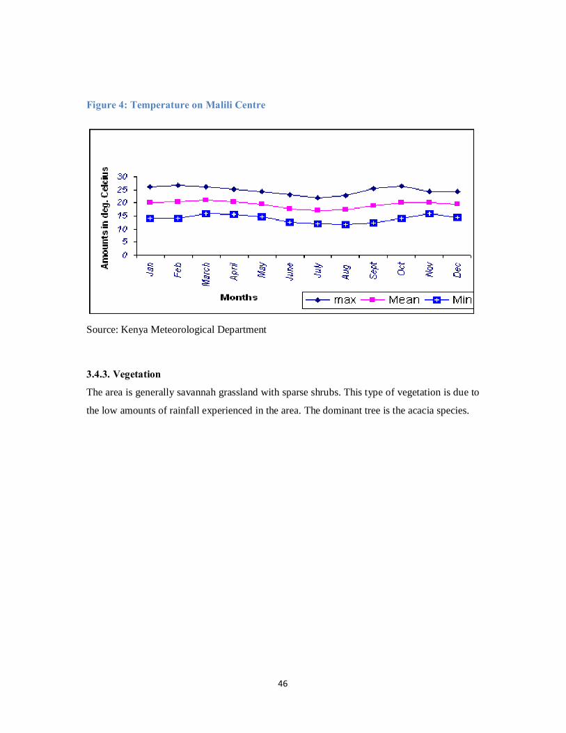
46
Figure 4: Temperature on Malili Centre
Source: Kenya Meteorological Department
3.4.3. Vegetation
The area is generally savannah grassland with sparse shrubs. This type of vegetation is due to
the low amounts of rainfall experienced in the area. The dominant tree is the acacia species.
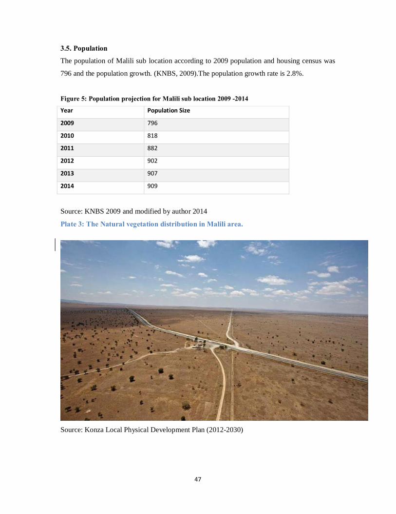
47
3.5. Population
The population of Malili sub location according to 2009 population and housing census was
796 and the population growth. (KNBS, 2009).The population growth rate is 2.8%.
Figure 5: Population projection for Malili sub location 2009 -2014
Year Population Size
2009 796
2010 818
2011 882
2012 902
2013 907
2014 909
Source: KNBS 2009 and modified by author 2014
Plate 3: The Natural vegetation distribution in Malili area.
Source: Konza Local Physical Development Plan (2012-2030)

48
CHAPTER 4: DATA ANALYSIS AND FINDINGS
4.1.Settlement character before conceptualization of Konza city
The land where Malili Centre is located was a ranch and it was not until the year 2006 when
the land was subdivided to provide the required land for the construction of Konza Techno
City. During the subdivision land was allocated to the development of a commercial centre.
This location of the commercial centre is where Malili Centre is now thriving. The
photograph below shows the location of Malili Centre after the subdivision. The land is just
bare ground with little scanty vegetation and no human development.
Plate 4: Location of Malili after Subdivision of Malili Ranch.
Source: Konza Local Physical Development Plan (2012-2030)

49
4.2.Settlement characteristics after conceptualization of Konza Techno City
4.2.1. Characteristics of respondents
Majority of the respondents were male with about 70% of those interviewed being male and
30% being female. This is due to the population dynamics of the center whereby the male
population is the majority.
Figure 6: Distribution of respondents by gender
Source: Field survey 2014
The ages of those interviewed ranged from 20 years to 60 yrs. Majority of those interviewed
were between the age of 26 years to 30 years representing 54% of those interviewed.
Figure 7: Distribution of the respondents by age
Source: Field survey 2014
0.00
10.00
20.00
30.00
40.00
50.00
60.00
0-5 6-10 11-15 16-20 21-25 26-30 31-35 36-40 41-45 46-50 51-55 56-60 Above 60
Age of respondents

50
4.2.2. Demographic characteristics
The mean household size in the Centre is 3 persons. This is because the population is
comprised of young persons who have moved in to the area in search for job opportunities.
Figure 8: Percentage of House hold size
Source: Field survey 2014
It was observed that majority of the residents have at least attended schools with 39% having
completed primary level, 38% having attended secondary school and 26% having completed
tertiary level.
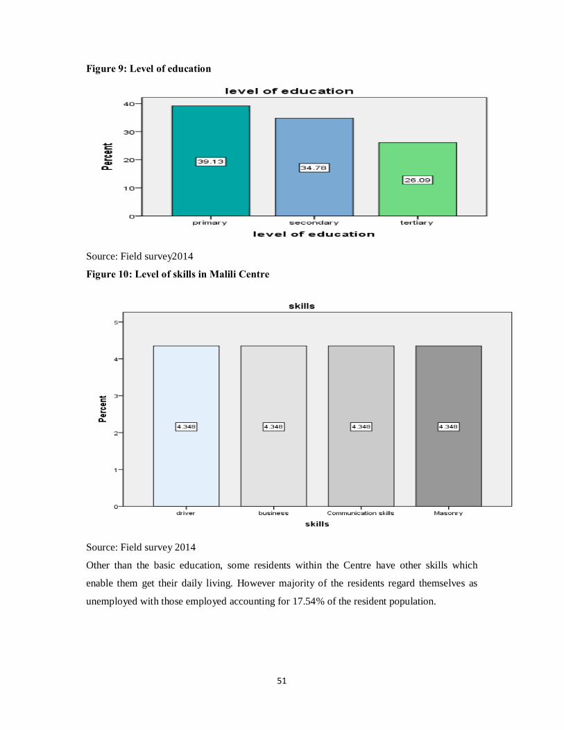
51
Figure 9: Level of education
Source: Field survey2014
Figure 10: Level of skills in Malili Centre
Source: Field survey 2014
Other than the basic education, some residents within the Centre have other skills which
enable them get their daily living. However majority of the residents regard themselves as
unemployed with those employed accounting for 17.54% of the resident population.

52
Figure 11: Occupations within Malili Centre
Source: Field survey 2014
4.2.3. Land tenure and Housing
Land within the center is privately owned. The land which originally was owned by Malili
ranch was subdivided among the shareholders. The plots were allocated according to the
number of shares one owned. As proof of ownership the land owners were issued with
allotment letters. Further informal subdivisions have been carried out and the various parcels
sold to prospective developers.
This is evidenced by the presence of land selling agents and survey firms who have opened
their offices within the Center. The agents act as brokers in the land transactions acting as an
intermediary between the seller and the buyer. There are over three land selling agents and
one survey firm within the Centre.
7.02 7.021.75 1.75
82.46
0.00
10.00
20.00
30.00
40.00
50.00
60.00
70.00
80.00
90.00
Business Person Mason Driver Casual Labourer Unemployed
Occupations

53
Plate 5: land selling agent office
Source: Field survey 2014
4.2.4. Housing
There are various housing typologies within the center. The most common housing typology
is the row housing.
The most common housing typology, that is, the row housing is constructed using temporary
material mostly wood and iron sheets. Several plots have been excavated to establish firm
ground for construction of permanent housing but any further development within the center
has been stopped by KOTDA.

54
Plate 6: A structure under construction
Source: Field Survey 2014
Majority of the tenants have rented houses with in the center with only a small percentage of
the resident population owning the structures. The owners of the structures own other pieces
of land elsewhere in the rural areas. This brings the aspect of absentee structure and land
owners, a phenomenon common in informal settlements.
Figure 12: Housing Ownership
Source: Field Survey 2014
The number of rooms rented per house differs from one household to another with 63.16% of
the households occupying one room.
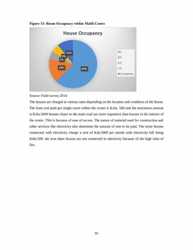
55
Figure 13: Room Occupancy within Malili Centre
Source: Field survey 2014
The houses are charged at various rates depending on the location and condition of the house.
The least rent paid per single room within the center is Kshs. 500 and the maximum amount
is Kshs.5000 houses closer to the main road are more expensive than houses in the interior of
the center. This is because of ease of access. The nature of material used for construction and
other services like electricity also determine the amount of rent to be paid. The stone houses
connected with electricity charge a rent of Ksh.5000 per month with electricity bill being
Kshs.500. the iron sheet houses are not connected to electricity because of the high risks of
fire.
63%16%
5%5%
11%
House Occupancy
1
2
3
4
no response

56
Figure 14: Range of rent charged per month within the Centre
Source: Field survey 2014
4.2.5. Building materials
The main building material for wall within the center is iron sheets. Iron sheets account for
59% of the wall building material use in the center. Building stones are also used mostly for
construction of storey buildings within the center. Building stones accounts for 14% of the
building material used for wall construction. Only a small percentage of 5% of the houses are
constructed using baked brick.
Figure 15: Building material used for wall construction

57
Source: Field survey 2014
Figure 16: Building material for roofing
Source: Field survey 2014
Timber and building poles are also building material used for roof construction and wall
support material in case of iron sheet walled houses. These are locally available in several
timber yard already established within the center. Plate 7: Building materials in a construction site in Malili center
Source: Field survey 2014

58
Plate 8: Row housing in Malili Centre
Plate 9: A house under construction using permanent material

59
Source: Field survey 2014
4.2.6. Road infrastructure
There are two roads within Malili center. The Nairobi Mombasa highway a Class A road that
divides the town into two portions on the east and the other on the west. This road is a single
carriage way and is tarmacked. The road is usually busy and there are infrastructure provision
provided to slow down traffic as it near the center.
The other road a Class D runs across the Centre from South West to North East. This road is
unpaved.
Plate 10: Sections of Malili- Konza road with water accumulated in the middle of the
road
Source: Field survey 2014

60
Plate 11: A pool of water in the middle of the road within the Centre
Source: Field survey 2014
Sections of Malili Konza road have huge pot holes which accumulate rain water making them
impassable.
The Malili Konza road is an earth road which links Malili Centre and Konza Centre. This
road is in poor condition and is impassable during rainy season. Huge potholes are in the
middle of the road which collects water during the rainy season creating a pool of water in
the middle of the road. Currently this road has increased traffic due to increase of traffic in
both centers of Malili and Konza.
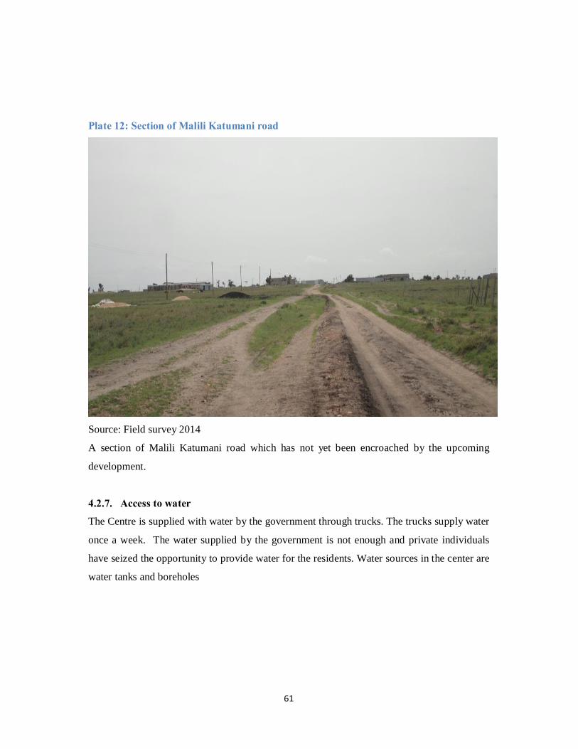
61
Plate 12: Section of Malili Katumani road
Source: Field survey 2014
A section of Malili Katumani road which has not yet been encroached by the upcoming
development.
4.2.7. Access to water
The Centre is supplied with water by the government through trucks. The trucks supply water
once a week. The water supplied by the government is not enough and private individuals
have seized the opportunity to provide water for the residents. Water sources in the center are
water tanks and boreholes

62
Plate 13: Water tank at the Sub chief office where government trucks supply water
Source: Field survey 2014
Source: Field survey 2014

63
The price of water within the Centre varies with the source and quality of the water. Borehole
water is cheaper than the tap water. The prices of water range from Ksh.30 to Ksh.50 per 20
litre jerican. The prices can rise to Ksh. 80 during severe water shortage.
Source: Field survey 2014

64
Source: Field survey 2014
The hand carts are used to distribute water within the Centre. This adds to the cost of access
of the water. Plate 14: A water cart a common means of transporting water within the Centre
Source: Field survey 2014

65
4.2.8. Access to Education
The influx of population in the area, has led to mushrooming of primary schools within the
Centre. These schools do not even meet the minimum requirements for establishment of
primary and they are not registered. Land initially set aside to construction of a public school
within the center has been grabbed by a private developer.
The case of elite academy
This educational institution is located on a 0.125acres piece of land for establishment of a
school. This school has classes 1 to 6 within the plot. This does not meet the minimum
requirement primary school. The classes are also constructed using temporal material.
Plate 15: A structure housing Elite Academy
Source: Field survey 2014
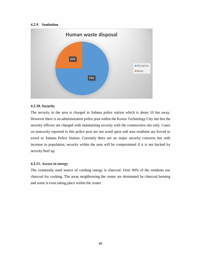
66
4.2.9. Sanitation
4.2.10. Security
The security in the area is charged to Salama police station which is about 10 km away.
However there is an administration police post within the Konza Technology City site but the
security officers are charged with maintaining security with the construction site only. Cases
on insecurity reported to this police post are not acted upon and area residents are forced to
travel to Salama Police Station. Currently there are no major security concerns but with
increase in population, security within the area will be compromised if it is not backed by
security beef up.
4.2.11. Access to energy
The commonly used source of cooking energy is charcoal. Over 90% of the residents use
charcoal for cooking. The areas neighbouring the center are dominated by charcoal burning
and some is even taking place within the center.
75%
25%
Human waste disposal
Pit Latrine
None

67
Source: Field survey 2014
4.2.12. Economy and livelihoods
Malili Centre has various business activities most of which have recently started. Among the
commercial activities in the Centre are; shops, kiosks, hardware, food joints, water selling
points, salons, and road side selling.

68
Figure 17: Years businesses have been operational
Business activities within the Centre are thriving well. Many types of business activities have
been established within the Centre. Most of the business activities are established on
temporary structures while a few have been established on permanent structures.
9%0%
0%
13%
43%
22%
13%6
5
4
3
2
1
less than 1 year
No. of years in Business

69
4.2.13. Environmental concerns
Charcoal burning
Charcoal is the major source of cooking fuel to the residents within the Centre. Charcoal
burning is prevalent event within the Centre. This has led to reduction in the vegetation cover
within the Centre
Waste disposal Plate 16: Solid waste dumped at the roadside within Malili Centre
Source: Field survey 2014 Plate 17:A section of unpaved circulation road with waste dumped at the roadside
Source: Field survey 2014
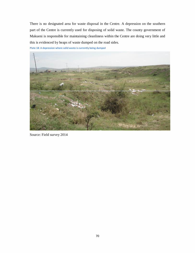
70
There is no designated area for waste disposal in the Centre. A depression on the southern
part of the Centre is currently used for disposing of solid waste. The county government of
Makueni is responsible for maintaining cleanliness within the Centre are doing very little and
this is evidenced by heaps of waste dumped on the road sides. Plate 18: A depression where solid waste is currently being dumped
Source: Field survey 2014

71
Plate 19: Land uses within Malili Centre.
Source: Author, 2014

72
Figure 18: Summary of resource flow within the Human settlement
Livability
Health
Employment
Education
Housing
Community
Resource input
Food
Water
Energy
Land
Processed goods
Building materials
Migrants
Human activities
Output
Waste
Sewage
Air pollutants
Heat
Migrants
Urban sprawl
Settlement dynamics
Resource input
Labour
Land speculation
Output
Increase in economic activities
Increased housing demand

73
4.3.Summary of analysis and major findings
4.3.1. Uncontrolled land subdivision and development.
Malili Centre is a rapidly growing center with uncontrolled and unplanned development with
a rapid rate of land subdivision without any guiding plans. The uncontrolled development has
led to reduction of the aesthetics value of the center.
Most of the development occurs in a scattered manner and this makes provision of necessary
infrastructure services expensive. Construction is still ongoing on the plots which have been
subdivided into smaller portions of 50m by 30m. These constructions do not leave any space
for installation of necessary infrastructure. This in future will force demolition of some
structures to pave way for installation of the necessary infrastructure if the development in
the center is to be sustainable. This is an expensive venture and this can be avoided by
controlling the development before it.
4.3.2. Disorganized land uses
Malili Centre has a variety of land uses. These land uses include residential, commercial,
educational and transportation. These land uses are disorganized and are scattered within the
Centre. This is because there was initial guiding plan. This gives the Centre a disorderly
character. This poses a major challenge in service provision in that it will be an expensive
venture to service the disorganized activities in future.
For instance some structures within the residential area have been converted to schools and
religious facilities. Some of the structures are multipurpose serving both as schools during the
week and religious facilities during the weekend. The disorganization of land uses has made
the Centre to acquire a slum like character and this led to the demolition of the initial
structures in the settlement.
4.3.3. Poor road infrastructure
The Centre is served by one class A road, the Nairobi- Mombasa road and two minor roads
Malili-Konza road and Malili-Katumani road. The Nairobi-Mombasa road lacks traffic
74
calming infrastructure within the Centre. This road, which separates the center into two, is
usually very busy and vehicles usually move at very high speeds. Residents have to wait for
long before they can cross from one side of the center to the other. Others even risk by
crossing the road while running. This poses a great risk to the road users within the center.
The road also lacks pedestrian walk ways.
Both Malili- Konza road and Malili-Katumani road are earth roads. Malili-Konza road is a
major link of Konza center another rapidly growing center, to the main Nairobi-Mombasa
road. Malili-Katumani Road connects Malili center to Katumani Agricultural Research
Institute. These two roads are characterized by huge potholes in the middle of the roads.
These potholes have rendered some sections of the road impassable and road users have
created ways in the adjacent plots. In some sections along the road, the road reserves have
been encroached into by the upcoming developments thus leaving no space for road
expansion and installation of other infrastructure like power and water.
Heavy vehicles usually park within the center creating congestion. The parking currently
used is informal and there is no designated route for entering or leaving the parking. The
location and lack of proper signage to direct the trucks is the major cause of the congestion of
the long vehicles. This causes other vehicles to park beside the main road creating more
congestion.
4.3.4. Poor housing conditions
Majority of the structures within the Centre are built using iron sheets for both wall and
roofing. The use of the temporary material for construction makes it risky to install services
like electricity.
These structures lack basic amenities like toilets and bathrooms this pose a health risk to the
residents who live in this structures.
The initial structures built within the Centre were demolished by the government because
they gave the Centre a slum like character. However the more structures are being built to
accommodate the increasing population. It was observed that there is rapid immigration in
this area with more than 95% of the residents having migrated into the area within the last 4
years. This has led to a significant rise in the temporary structures in an effort to provide
shelter.
This form of housing poses a great risk in case of emergencies like fires and disease
epidemics because of lack of the basic amenities which support quality living.

75
4.3.5. Inadequate basic service provision
Basic services are important in any human settlement. Malili Centre has inadequate provision
of the following basic services:
4.3.5.1.Inadequate Educational facilities
Due to influx of population in the area, there is mushrooming of primary school within the
Centre. There are at least five private owned primary schools within the Centre. Most of the
schools have lack some facilities like playgrounds and classrooms. These schools have been
constructed using temporal material and the land size they are located is less than the required
minimum of 3.9 hectares.
The example of Elite Academy situated on a plot measuring 50m by 30m and has one
structure housing pupils from standard 1 to standard 6. This school is run by three untrained
teachers.
There is no public school within the Centre and this force the residents to fully depend on the
informal primary schools. From the field study it was ascertained that the land set aside for
public primary school has been grabbed by a private developer.
Thus the access to free and quality education within the Centre is greatly constrained.
4.3.5.2. Inadequate access to Water
The Centre is faced with the challenge of access to clean and adequate water for both
domestic and commercial uses. Water vendors supply the residents with much needed
commodity. A 20 litre Jeri can costs an average of Kshs. 30 and even and at times costs
Kshs.80 during serious water shortages. Water vending businesses have taken over the
normal supply of clean water by the government thus compromising on the right of the
residents to access of adequate and clean water at affordable prices.
4.3.5.3.Inadequate sanitation facilities
There are no sanitation facilities provided in the area. The Centre lacks a sewer system and
major sanitation facilities like public toilets. Business operators within the Centre are forced
to use facilities within the residential structures which are also not adequate. Residential
structures use Pit latrines and waste pits to dispose human and domestic waste respectively.

76
4.3.5.4.Security
Security in the area is highly compromised by absence of security personnel. Major security
threats within the Centre are mugging and theft. The residents have to travel more than 15 km
to Salama Police Station to report insecurity instances. The area has increasing population
and insecurity instances are expected to rise.
4.3.6. Emergence of informal business activities
There is emergence of roadside business along the Nairobi-Mombasa highway taking
advantage of the passengers boarding alighting along the road. Other business activities are
established on the road reserves of the Malili-Konza road and Malili-Katumani road. These
business activities are bound to create conflict between road users and the business activities.
4.3.7. Environmental degradation
The Centre lacks a waste collection and waste disposal system and residents are using
alternative ways of disposing the waste generated in their homes and business premises. 75
percent of the residents use pit latrines and waste pits to dispose human and domestic waste
respectively. However waste generated by the commercial activities is disposed besides the
roads. This has led to accumulation of waste on some parts of the roads. These forms of
waste disposal are not sustainable and become exhausted within a short time
An area with a depression south of the Centre is currently used by traders to dispose their
waste. However other traders especially roadside sellers dispose the waste generated in their
businesses beside the road. Most of the households use pit latrines to dispose their human
waste and waste pit to dispose other domestic wastes but these are only found in the few
permanent structures within the Centre. These pose a threat to the fragile ecosystem.

77
CHAPTER 5: RECCOMENDATIONS
5.1. Reorganization of land uses within the Centre.
For there to be harmonious and sustainable development various land uses need to be
assigned different location within the Centre. Separation of non-compatible land uses and
incorporation of compatible land uses has to be carried out. This will be achieved through
assigning the various land uses space within the center.
5.2. Provision of better and decent housing
The demand of housing currently within Malili Centre outweighs the supply of housing
units. Furthermore the housing being provided is temporary in nature. There is need to
provide decent housing with access to basic services. This will entail:
• Replacement of the temporally structures with permanent structures
• Provision of basic amenities like toilets and drainage within the structures
• Alignment of the structures to create better aesthetics and ease access
5.3. Provision of transport infrastructure
The infrastructure development will include:
Tarmacking Malili-Konza road and Malili- Katumani road. This two roads link Malili Centre
to Konza Centre and Katumani Centre respectively. The Malili-Konza road is one of the
major of Konza Centre to the main road, Nairobi Mombasa Highway.
The infrastructure facilities that need include
• Provision of pedestrian facilities on both roads within the Centre to ease movement of
people within the center.
• Provision of better drainage facilities on the road infrastructure in the area.to drain off
the water accumulating in the road making them impassable.
• There is also need to provide parking for long distance within Malili Centre. Currently
the vehicles have created an informal parking within the Centre and the parking is
usually congested because of limited space.

78
5.4. Provide adequate access to basic services.
Provision of education facilities. The area needs public educational facilities to be
established. The area already had enough population to support primary schools and with
expected increase in population there is need to establish a secondary school.
5.5. Provision of water reticulation system
The Centre need to be supplied with adequate and clean water. This water will be able to
power the sewerage facilities proposed for the area.
5.6. Introduction of better waste management
The Centre will have to adopt sustainable method of waste disposal. This include both solid
and liquid waste the current methods of waste disposal lead to environmental degradation and
they also not sustainable.
5.7. Promotion use of sustainable sources of energy
The area lies within the tropics and receives solar insolation throughout the year. There is
thus the potential of harnessing solar power within the centre. This will reduce the cost of
power and overdependence on hydroelectricity thus promoting growth within the centre.
5.8. Provision of a formal market
The major motivation of people moving into the Centre was to search for employment. This
had led to rise in a number of economic activities within the Centre. Among the activities are
the business established along the road reserve. There is thus a need to allocate space where
the where the roadside sellers can be moved into and better structures constructed for their
use.

79
5.9. Conclusion
The country is planning to implement various large scale infrastructural developments. The developments are usually accompanied by changes in settlement patterns like immigration, emergence of informal dwellings characterized by poor infrastructure and inadequate access to basic services. To avoid this proper planning need to be carried out prior to the start of these projects.

80
REFERENCES
1. Agenda 21, Chapter 7 “ Sustainable Human settlements”
2. Amos, Jim (1993) “Planning and managing urban services”
3. Batley, Richard (1996) “Public-private relationship and performance in service
provision”- Urban studies vol.33.
4. Berghal (1995) “Habitat and the urban economy” United Nations University, World
Institute for Development Economics and Research.
5. Buchanan JM (1980) “Rent seeking and profit seeking”: Towards a theory of rent
seeking society, Texas A&M university press
6. Curlee, Randall, T and Das, Sujit, (1996) Back to Basics? The Viability of Plastics
Recycling By Tertiary Processes. Yale Working Papers on Solid Waste Policy,
Program on Solid Waste Policy, Yale School of
7. Derek Osborn and Tom Bigg “Earth Summit II”, Outcomes and analysis (1978):
Financing sustainable development pg. 111
8. Dodds, Felix “Earth Summit 2002 “The New Deal: The urban poor.
9. Environmental Studies Yale Working Papers on Solid Waste Policy, Reid Lifset,
Series Editor. UN General Assembly Resolution 43/181
10. Forestry and Environmental Studies, Reid Lifset, Series Editor.
11. Geoffrey Payne and Michael Majale (2012).The Urban Housing Manual, Cromwell
Press.UK
12. Gitau, Sarah and Chris MacOloo (2000) “Human settlements in Nairobi in the last
100 years”, Nairobi
13. Global Environment Outlook 2000, UNEP, (Earth scan, London, 1999), pg. 1
14. Godbey, Geoffrey (1996) No Time to Waste: Time Use and the Generation of
Residential Solid Waste. Yale
15. Harpham, Trudy and KwasiBoateng 1997 “Urban governance in relation to the
operation of urban services in developing countries”: Habitat International vol.21
No.11
16. http://www.unaab.edu.ng)
17. Ince, Peter, (1995) What Won't Get Harvested, Where and When: The Effects of
Paper Recycling on Timber Harvests. Program on Solid Waste Policy, Yale School of
Forestry and Environmental Studies, Yale Working Papers on Solid Waste Policy,
Reid Lifset, Series Editor.

81
18. International Federation of Red Cross and Red Crescent Societies, World Disasters
Report 1999, pg. 7. GEO 2000, op cit.
19. Kenya National Housing Policy 1997 [Draft]
20. Kenya National Housing Policy 2001 [Draft]
21. Macharia, K (1992) Slum Clearance and the informal economy in Nairobi: Journal
of African modern studies No.30/3
22. Moser, Caroline O.N (1987) “Approaches to community participation in urban
projects in the third world” (progress in planning vol.32 No.2 pp71-133)
23. Moser, Caroline O.N (1996) “Confronting crisis”: A comparative study of household
responses to poverty and vulnerability in four poor urban settlements-
Environmentally sustainable development studies No.8.
24. NACHU (1990): A survey of informal human settlement in Nairobi
25. Obudho, R.A (1975) Urbanization and Development Planning in Kenya
26. Olive M. Mugenda and Abel G. Mugenda (1999) Research Methods: Quantitative and
Qualitative Approaches Nairobi, Kenya, Acts Press
27. Schall, John, (1992): Does the Solid Waste Management Hierarchy Make Sense? A
Technical, Economic & Environmental Justification for the Priority of Source
Reduction and Recycling, Yale Working Papers on Solid
28. Sessional Paper on Housing 1997 (Sessional paper No.5 1965/66)
29. Stren, Richard (1989) The Administration of urban services ( African Cities in crisis)
30. Stren, Richard (2001) The challenges of urban government policies and practices:
WBI Development studies.
31. Syagga and J. Malombe (1994)” Development and management of informal housing
in Kenya”.
32. UN Conference in Human settlements (1996) “an urbanizing world” UN World
Urbanization prospects (1999) UNCHS/GOK (2001) Nairobi Situation Analysis
Report. UNCHS and GOK, Nairobi.
33. UNCHS-Habitat report (2001)
34. United Nations (2011) World Urbanization Prospects
35. United Nations Development Programme (UNDP), Human Development Report.
(Oxford University Press, 1999)
36. Waste Policy, Program on Solid Waste Policy, Yale School of Forestry and
Environmental Studies, Reid Lifset, Series Editor.
82
37. Working Papers on Solid Waste Policy, Program on Solid Waste Policy Yale School
of Forestry and Environmental Studies, Reid Lifset, Series Editor. Habitat Agenda.
Chapter III: Commitments. Section A: Adequate Shelter for All, Para 40 (n)
38. World Bank (1995) “Better Urban services”: Finding the right incentives.
39. World Bank (1997) World Development Report 1997.
40. Yahya S. S. and Nzioki (1994) “Taming the delinquent markets: an analysis of the
unregulated housing sub- markets in Kenya”.
83
APPENDIX
Appendix 1 UNIVERSITY OF NAIROBI
COLLEGE OF ARCHITECTURE AND ENGINEERING
SCHOOL OF BUILT ENVIRONMENT
DEPARTMENT OF URBAN AND REGIONAL PLANNING
TOPIC: EMERGING HUMAN SETTLEMENT DYNAMICS AROUND THE
PLANNED KONZA CITY.A CASE OF MALILI CENTRE. Household questionnaire
Declaration: The Information provided will be used purely for academic purpose and will be
treated with utmost confidentiality.
Name of interviewer …………………………Date…………..Questionnaire No…….
A. Personal Information
1.1 Name of respondent (optional)………………………………………………………….
1.2.Relationship with household head?
1. Household Head 2.Spouse 3.Son 4.Daughter 5.Other (Specify)
1.3.Age ……….
1.4.Gender Male Female
1.5.Ethnicity ………………….
1.6.Hose hold size
Household
member
Gender Age Occupation
84
1.7.Level of education and skills (Tick where appropriate)
Level Tick Skills Tick
Primary
Secondary
Tertiary
B. Demographic characteristics
1.1.Have you lived in Malili since birth? Yes No
1.2.If no when did you relocate to this center?.....................
1.3.What made you relocate from the previous area of residence to this area?
…………………………………………………………………………………………
…………………………………………………………………………………………
C. Land tenure and Housing characteristics
1.1.Do you own any plot in this area? Yes No
1.2.If yes, what size? ..................
1.2.1. How did you acquire the piece of land?
Purchase
Inheritance
Lease
Other (specify)……………….
1.2.2. What use have you put the piece of land in? ......................
1.2.3. What ownership documents do you have?
85
…………………………………………………………………………………………...
2.1.What is the house tenure? Owner Tenant Squatter
2.2.1. If owner how did you acquire it?....................
2.2.2. If, No of rooms……………….
2.2.3. If tenant, how much do you pay per month?...............
2.2.4. Main building materials
D. Access to basic services
1. Water
1.1 Source of water ……………….
1.2 How reliable is the water source?
Very reliableUnreliable Very unreliable
1.3 Cost of access to water ………
2. Education
2.1.What educational facilities are near your home?
2.2.Level of education ……………………
2.3.Distance from the area of residence ……………….
3. Sanitation
3.1.What are the means of disposal of human waste
3.2.Disposal of domestic waste
4. Security
4.1.Are there any security threats in the area Yes No
4.2.If yes how do you deal with them?
………………………………………………………………………………………………
………………………………………………………………………………………………
4.3.Do you have access to police station/post? Yes No
4.4.Distance to the nearest security post ………….
5. Recreational Facilities
Building materials
Walls
floor
Roof

86
5.1.Do you have access to recreational facilities? Yes No
5.2.If yes where?..............................
5.3.Frequency of access Most frequent Less frequent Rarely
6. Energy
Energy used for
6.1.1 Cooking
6.1.2 Lighting
6.2 Source of cooking fuel
6.3 Source of lighting
6.4 Cost of cooking fuel ………………
6.5 Cost of lighting energy ……………
6.6 What renewable energy do you commonly use in your house?……………..
2. Economy and Livelihoods
2.1.What economic activity do you engage in to earn your living?
……………………………..
2.2.Where is the occupation situated?.......................
2.3.How much do you earn? …………………….(please specify whether per annum/per
month/per week/daily)
3. Environment
1.1.Are there persons or organization charged with waste collection Malili Centre?
Yes No
1.2.If yes what is the name of the person(s)/organization/group……………………….
1.3.How efficient are they in discharging their duty?........................................................
1.4.If no, what ways do you dispose other waste (other than domestic and human waste) in
this area?...............................................
2. What do you think can be done to improve waste disposal in Malili Centre
……………………………………………………………………………………………..
3. What environmental challenges do you face in this locality?
………………………..
……………………….
………………………
3.1.When have these challenges started being experienced?.................
3.2.Have they affected your livelihood anyway? Yes No
87
3.3.If yes how?
3.4. What efforts have been put to curb the environmental challenges?
…………………………….
……………………………
THANK YOU
Appendix 2
UNIVERSITY OF NAIROBI
COLLEGE OF ARCHITECTURE AND ENGINEERING
SCHOOL OF BUILT ENVIRONMENT
DEPARTMENT OF URBAN AND REGIONAL PLANNING
TOPIC: EMERGING HUMAN SETTLEMENT DYNAMICS AROUND THE
PLANNED KONZA CITY.A CASE OF MALILI CENTRE.
Declaration: The Information provided will be used purely for academic purpose and will be
treated with utmost confidentiality.
Business Owners Questionnaire
Name of interviewer …………………………Date…………..Questionnaire No…….
A. Personal information
Name of respondent (optional)………………………………………………………….
1. Age ……….
2. Gender Male Female
3. Ethnicity ………………….

88
4. Level of education and skills (tick where appropriate)
Level Tick Skills Tick
Primary
Secondary
Tertiary
5. Nature of business……………………………..Location………………..
6. When did you start your business? ………………….
7. Startup capital. How much did you start your business with? ……………………..
8. Source of capital…………………………
9. What is the origin of your business Malili elsewhere
10. If Malili what motivated you to start business in this center?
…………………………………………………………………………………………
…………………………………………………………………………………………
11. If elsewhere why did you relocate to Malili?............................................
12. Does your business have a trading license? Yes No
13. If yes where did you acquire it?.........................
14. If no who granted you the permission for the operation of your business
………………………………………………………………………………..
15. Do you pay any money to the council? Yes No
a. If yes how much and when?
Amount ………………………….. Day………………..
16. Who are your main customers?
…………………………………………………………………………………………
…………………………………………………………………………………………
………
17. Who owns the piece of land on which the business is established?
…………………………………………………………………………….
18. Did you start the business before conceptualization of Konza city? Yes No

89
a. If yes how was the business doing before the conceptualization of Konza City?
……………………………………………………………………………………
……………………………………………………………………………………
b. What changes has your business experienced after conceptualization of Konza
City?
…………………………………………………………………………………………
…………………………………………………………………………………………
…………………………………………………………………………………………
c. If no, what motivated you to start the business
………………………………………………………………………………………
d. What do you think your business will benefit from the Konza City?
……………………………………………………………………..
19. Where do you dispose waste generated in your business?...............................................
20. What are your future business plans?
…………………………………………………………………………………………
…………………………………………………………………………………………
…………………………………………………………………………………………
21. Is there an organization for business people in Malili Centre? Yes No
If yes what are the interests of the organization
…………………………………………................................................................
THANK YOU