emergency preparedness and response plan …mssi.nrs.gov.bc.ca/hbmine/hbmine_2014_eprp.pdf ·...
TRANSCRIPT

EMERGENCY PREPAREDNESS and RESPONSE PLAN (EPRP)
HB MINE TAILINGS STORAGE FACILITY SALMO, BRITISH COLUMBIA
Prepared by: Regional District of Central Kootenay
Box 590, 202 Lakeside Drive Nelson, British Columbia V1L 5R4

HB Dam Tailings Facility - Document ControlEmergency Preparedness and Response PlanFile No. 6300-HBD-30File Name: HBD-EPRP-V1
MEM MOE ENG2014-11-28 V1 EPRP prepared (downstream contact TBD) Email
Distribution (CD and/or HC)Date V# Version Description

Contents 1.0 INTRODUCTION .......................................................................................................................................... 1
1.1 DOCUMENT ORGANIZATION ........................................................................................................ 1
2.0 FACILITY INFORMATION .......................................................................................................................... 2
2.1 ACCESS TO FACILITY.................................................................................................................... 2
2.2 FACILITY DESCRIPTION ................................................................................................................ 2
2.3 DOWNSTREAM RECEPTORS ....................................................................................................... 3
3.0 EMERGENCY IDENTIFICATION & EVALUATION ................................................................................ 4
3.1 POTENTIAL FAILURE MECHANISMS ........................................................................................... 4
3.2 INUNDATION MAPS ........................................................................................................................ 4
3.3 EMERGENCY MONITORING PACKAGE ....................................................................................... 5
4.0 EMERGENCY RESPONSE ........................................................................................................................ 6
4.1 EMERGENCY RESPONSE PROTOCOL ........................................................................................ 6
4.1.1 Incident for Further Assessment..................................................................................................... 6
4.1.2 Emergency (or potential) Situation ................................................................................................. 7
4.2 EMERGENCY REPAIR ACTIONS .................................................................................................. 7
4.3 SOURCES OF EQUIPMENT AND MATERIALS ............................................................................. 7
5.0 EMERGENCY FOLLOW-UP PROCEDURE ............................................................................................ 9
6.0 EPRP MANAGEMENT .............................................................................................................................. 10
6.1 DOCUMENT CONTROL AND UPDATE ....................................................................................... 10
6.2 TRAINING ...................................................................................................................................... 10
6.3 PROGRAM VALIDATION .............................................................................................................. 10
LIST OF FIGURES (Following Text) FIGURE 2.1 LOCATION MAP FIGURE 2.2 SITE PLAN FIGURE 3.2A INUNDATION MAP – FINAL MUD/TAILINGS DEPOSTION DEPTH FIGURE 3.2B INUNDATION MAP – TIME (hrs) FOR 0.6 M DEPTH FIGURE 4.1 EMERGENCY RESPONSE COMMUNICATION FLOW CHART LIST OF TABLES (Following Text) TABLE 4.2 EMERGENCY REPAIR ACTIONS TABLE 4.3 EMERGENCY SOURCES OF EQUIPMENT AND MATERIALS APPENDIX A – EPRP CONTACT LIST

Page 1
1.0 INTRODUCTION This Emergency Preparedness and Response Plan (EPRP) pertains to the HB Mine Tailings Storage Facility (Facility). An EPRP has been prepared to define the potential for accidents, to describe the actions required in the event of an emergency, and to prevent/mitigate environmental and safety impacts associated with emergency situations. This EPRP has been prepared with reference to the following documents: • Mine Reclamation Permit No. M-218 • Dam Safety Guidelines, Inspection and Maintenance of Dams (BC DSG). British Columbia
Ministry of Environment (MOE) (formerly Ministry of Environment, Lands and Parks) Water Management Branch, March 2011
• Dam Safety Guidelines (DSG). Canadian Dam Association (CDA), 2007 • Mine Emergency Response Plan, Guidelines for the Mining Industry, Ministry of Energy and
Mines and Natural Gas (MEM), February 2013, V1.3 The level of detail within the EPRP is reflective of the classification of the Facility as a Very High Consequence classification rating based on CDA definitions and degree of potential impact, as determined in the 2014 Dam Safety Review (DSR) of the facility.
1.1 DOCUMENT ORGANIZATION This report is organized into the following sections: Section 1.0 Introduction Section 2.0 Facility Information Section 3.0 Emergency Identification & Evaluation Section 4.0 Emergency Response Section 5.0 Emergency Follow-up Procedure Section 6.0 EPRP Management

Page 2
2.0 FACILITY INFORMATION
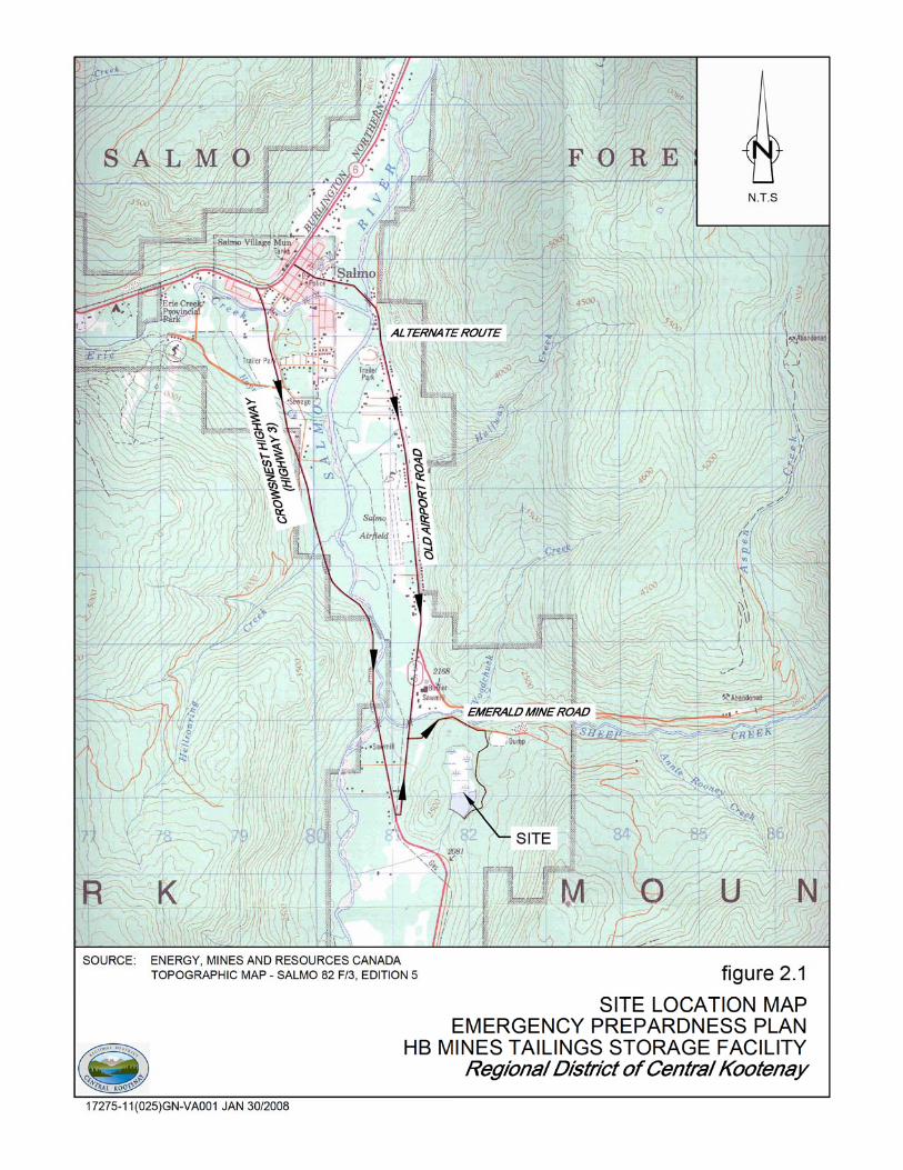
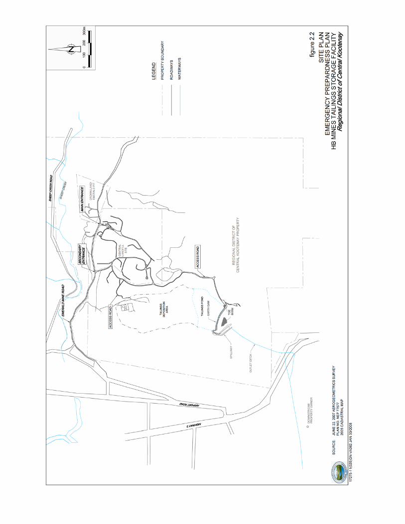
2.1 ACCESS TO FACILITY The Facility is located approximately 6 kilometres (km) south of the village of Salmo, British Columbia (BC) at an approximately latitude of 49°08’ N and longitude of 117°15’ W. Directions to the Facility from Salmo are provided in Figure 2.1. Access to the Facility is off Emerald Mine Road, via unnamed gravel roads through the Central Landfill property as presented in Figure 2.2. The dam is accessed via the gravel road along the outside refuse of limits in a southern direction. The impoundment area is accessed via the gravel road verging to the west along the northern refuse limits of the landfill. The dam access roads are best suited to 4x4 vehicles.
2.2 FACILITY DESCRIPTION The Facility is owned by the RDCK and regulated under Mine Reclamation Permit M-218. The Facility was decommissioned to current day standards during the summer of 2005. The Facility is located at the southern end of a small valley and consists of a tailings deposition area, reservoir, dam, and spillway. The tailings pond is located to the north of the dam with a plan area of approximately six hectares (ha). At the time of fieldwork conducted in the fall of 2000 by BGC, the lowest point in the pond was approximately 5.5 metres (m) lower than the dam crest and the water level was approximately 4.4 m deep. After a slough in July 2012 on the downstream slope, the spillway sill elevation was permanently lowered to reduce hydraulic pressure behind the dam. Approximately 200,000 cubic metres (m3) of water storage is available within the pond up to the dam crest elevation. The total catchment area draining to the pond is approximately 207 ha. The existing dam is approximately 25 m high and 240 m. The existing crest width of the earth dam is approximately 6 to 7 m and the crest elevation is 713.0 m Above Mean Sea Level (AMSL). Rip rap has been constructed along the upstream slope to provide long-term erosion protection. A toe berm was constructed as part of the decommissioning works in 2005 to satisfy dam stability requirements. A permanent open channel spillway was constructed adjacent to the right abutment of the dam to ensure long-term protection of the dam against over-topping. The spillway was originally designed for a 1000-year return period with an outflow capacity of 3.19 cubic metres per second (m3/s). Outflow capacity was based on a spillway width of 3 m and invert elevation 1.7 m below the existing crest elevation. The outlet channel was designed to terminate in a riprap-lined stilling pool prior to discharge into the downstream outlet ditch.
Page 3
The DSR completed in 2014 determined the facility should be upgraded to a Very High consequence classification rating, as per the 2007 Canadian Dam Safety Guidelines, based on economic losses. As such the spillway design flow was increased to accommodate 2/3rd of the way between the 1000-year flood and the Probable Maximum Flood, resulting in a required outflow capacity of 16.6 m3/s. This was reached by the lowering of the spillway sill elevation in 2012 to 709.39 m AMSL.
2.3 DOWNSTREAM RECEPTORS Provincial Highway 3 is located south of the Facility. Across Highway 3, the land is privately owned. Reservoir water discharged into the outlet ditch flows under Highway 3 via a culvert into a man-made ditch and drains into the Salmo River, located approximately 1 km west of the Site. Services such as telecommunications, electricity, and natural are located along the Highway 3 corridor.

Page 4
3.0 EMERGENCY IDENTIFICATION & EVALUATION The Facility has been designed to meet current standards and has been designated a Very High consequence classification rating, as per the 2007 Canadian Dam Safety Guidelines, based on potential economic losses. Emergency situations can develop from a structural failure or failure due to environmental impact (such as extreme weather events or seismic activity). Early detection and evaluation of an emergency situation is important to ensure the appropriate course of action is taken based on the level of urgency.
3.1 POTENTIAL FAILURE MECHANISMS Examples that can lead to potential emergency situations at the Facility include: • Overtopping; • Post seismic upstream and downstream slope instability; • Internal erosion through the embankment; and • Slope instability. A significant failure is considered a breach in the dam leading to release of water and tailings from the reservoir. The occurrence of failure may or may not be associated with an extreme event. Continual surveillance of the Facility and routine maintenance are preventative measures that can mitigate the occurrence of failures. The RDCK conducts routine inspection and instrumentation measurements at a frequency that reflects seasonal conditions. See the Facility’s Operation, Maintenance and Surveillance (OMS) Manual for a detailed description of on-going monitoring and maintenance. In addition to routine inspections, the Facility shall be inspected for any damage after an extreme event. If poor performance is noted, the engineer shall be immediately contacted to discuss the severity of the condition and determine the appropriate measures which should be taken. The emergency response protocol detailed in Section 4.0 shall be followed if an emergency situation is identified.
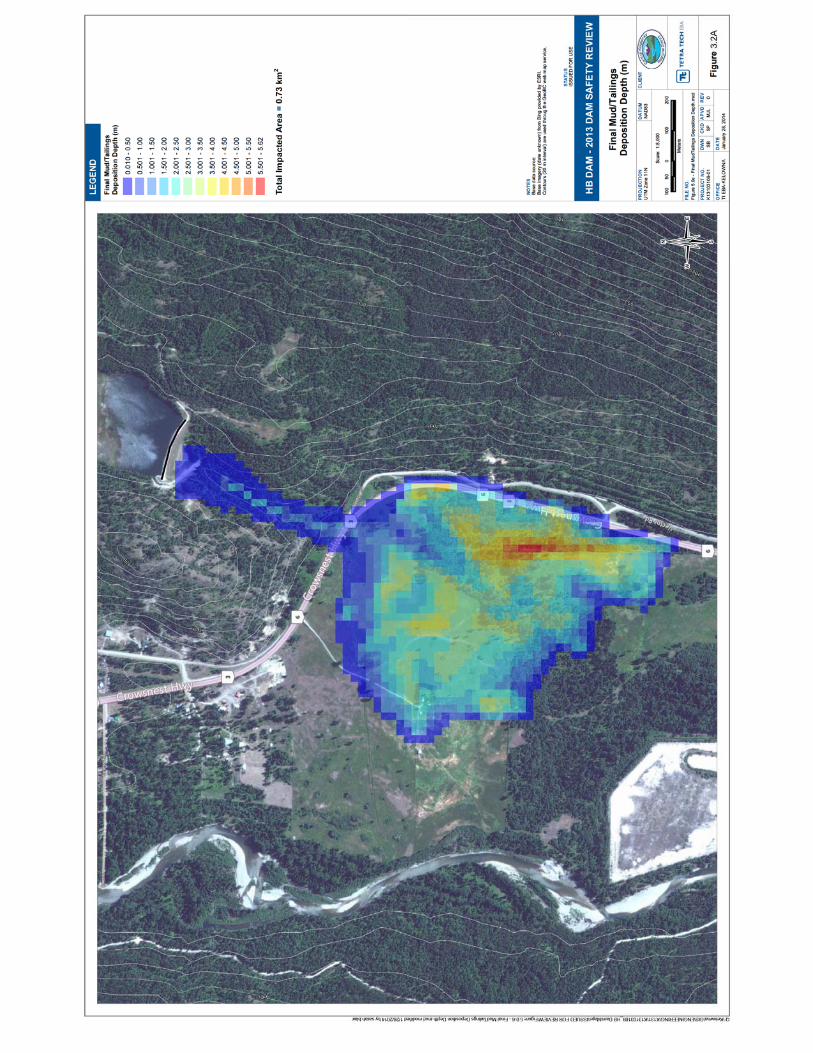
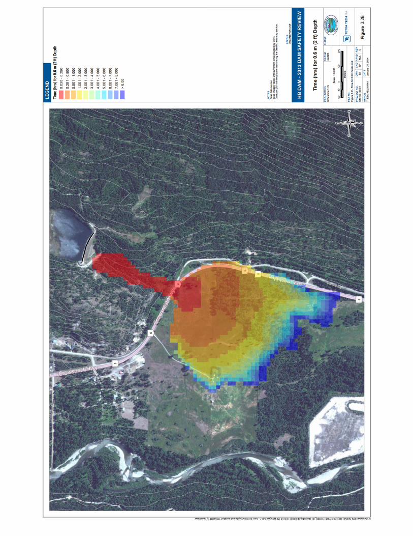
3.2 INUNDATION MAPS The critical mode of failure for earthfill embankments that retain water is considered a breach in the dam leading to release of water and tailings from the reservoir. The 2014 DSR reports the volume of water in the reservoir is 200,000 m3 and the volume of tailings is 514,000 m3. Detailed inundation maps completed as part of the 2014 DSR are included as Figures 3.2 A and 3.2B, which present the Final Mud/Tailings Deposition Depth (m) and the Time (hrs) for 0.6 m Depth, respectively.

Page 5
3.3 EMERGENCY MONITORING PACKAGE An emergency monitoring package shall be readily available in order to evaluate potential environmental concerns associated with discharge from the reservoir arising from abnormal conditions. The package is situated at the Central Landfill scale house. The emergency monitoring package shall include the following: • Clip board • Tape measure • Camera/video • Pencils • Flashlight • Field book • Water level tape • Water sampling specifications consistent with the most recent Environmental Monitoring
Program (EMP) established in the Operation, Monitoring and Surveillance (OMS) manual for the Facility
• Water and Sediment sampling containers The RDCK has qualified staff that is able conduct emergency monitoring at the site. In addition, the RDCK has an on-going contract for environmental monitoring with a technician who is familiar with the Facility and regularly performs environmental monitoring at the site. The contractor maintains an inventory of sampling containers.

Page 6
4.0 EMERGENCY RESPONSE An emergency response must be activated if the performance of the Facility is deemed abnormal and the situation can lead to environmental or safety impacts both on-site and/or off-site.
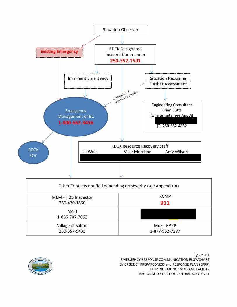
4.1 EMERGENCY RESPONSE PROTOCOL An emergency response protocol is presented in Figure 4.1 outlining the procedure necessary for timely notification of personnel responsible for taking action. Lines of communication and potential actions are specified. Specific names, positions, and telephone numbers are further defined in the EPRP Contact List (see Appendix A). Other potentially affected external stakeholders, relevant off-site contacts, and regulatory contacts are also listed in Appendix A. The initial observer of a potential incident must assess the severity and initiate the appropriate protocol. An incident could range from a suspected concern to a full scale emergency, which would take one of two routes:
• Incident for further assessment, or • Emergency (or potential) situation
If significant failure has begun or is on the verge of developing, the priority is to safely evacuate the Facility and all areas downstream of the facility, and notify all stakeholders. Emergency corrective measures may be undertaken by site personnel to mitigate the problem with input from an engineer provided that the safety of the workers is not compromised.
4.1.1 Incident for Further Assessment As noted in the emergency response protocol presented in Figure 4.1, if an incident requires further assessment the initial observer must contact the designated RDCK incident commander (IC) who, depending on severity, shall immediately attend the site. If required, the RDCK IC shall contact the Engineering Consultant for the Facility, other professional(s), and/or contractors to conduct further assessment or corrective action. The RDCK IC or, if designated, the initial observer, shall contact Emergency Management BC (EMBC) to provide them advance notice that a situation is being investigated which may require assistance. Follow-up actions will depend on the situation.

Page 7
4.1.2 Emergency (or potential) Situation If a situation is observed that appears to have potential to become an emergency, the initial observer must contact the RDCK IC who will assess the situation and determine the next steps. Depending of the situation this would involve contacting EMBC to provide advance notice or immediate response. Further assessment must be completed immediately by the RDCK IC, Engineering Consultant, other professional(s), and/or contractors and corrective action taken. Follow-up actions will depend on the situation. If an emergency situation exists, or is imminent, the initial observer must immediately contact EMBC, followed by the RDCK IC. EMBC will initiate the emergency response by contacting the Provincial Ministries required for the response. EMBC will notify the RDCK Emergency Operation Centre (EOC) director, who in turn will activate an EOC to assist the RDCK IC with site support. The RDCK IC must attend the site as soon as possible. Once on-site the IC shall develop an incident action plan to determine resources required for corrective action and pass such on to the EOC. In either situation, the initial observer must remain on-site, in a safe location, until such time as the designated RDCK IC attends the site and assumes the role of IC or otherwise deems the situation to be non-emergency.
4.2 EMERGENCY REPAIR ACTIONS Emergency repair actions for observations of potential concern are summarized in Table 4.2. Emergency repair actions shall only be undertaken if the situation has been discussed with the engineer responsible for safety surveillance and the safety of the workers is not compromised. Immediate lowering of the water level in the reservoir shall be attempted in most emergency situations that could potentially result in dam failure. A high capacity pump is permanently located at the site on the east abutment. The pump may be used to discharge reservoir water via discharge hoses into the surface water drainage along the east abutment. The discharge point should be the rip rap area located immediately north of the measurement weir. This drainage pathway is routed to the stilling basin located at the end of the spillway.
4.3 SOURCES OF EQUIPMENT AND MATERIALS Resources are available both on-site and off-site to deal with emergency situations. Limited machinery (loader, dump truck, excavator and pumps) may be available from the Central Landfill located immediately to the northeast of the Facility. A high capacity pump is located on-site but a rental may be required depending on the pumping rate required to address the urgency of the emergency situation. There are no personnel working full- time on-site; therefore
Page 8
external help may be required. Other potential sources of equipment suppliers and contractors are listed in Table 4.3. Materials available for emergency repairs shall be chosen based on material strength and low permeability characteristics. Materials to be used for emergency repairs are listed in Table 4.3. A quarry is located on the west side of the spillway and rip-rap may be sourced there. Potential sources of material located within the landfill property include a gravel quarry located to the northeast and low permeability soils (silts/clay) located south of the limits of refuse. Sand bags may also be acquired from the Salmo Public Works yard.

Page 9
5.0 EMERGENCY FOLLOW-UP PROCEDURE Following an emergency event, necessary repairs will need to be completed to ensure safe conditions are restored at the Facility. A monitoring program may need to be conducted to evaluate the extent of environmental impact caused by the emergency situation. The appropriate requirements shall be determined with a detailed review of the design, operation, maintenance, and surveillance of the Facility. The emergency event shall be documented including details pertaining to the activation of the emergency response, emergency decision making used, lessons learned, and follow-up activities undertaken as remedial measures or to investigate potential impacts. The EPRP and OMS for the Facility shall be revised accordingly to avoid similar emergency situations if possible and incorporate areas of improvement for future emergencies.

Page 10
6.0 EPRP MANAGEMENT
6.1 DOCUMENT CONTROL AND UPDATE EPRP details and procedures and requirements shall be reviewed annually and updated as required for continual improvement and to ensure available information is correct (i.e. assigned responsibilities, telephone numbers, materials, equipment, etc.). Revisions shall be clearly documented on the Document Control page preceding the Table of Contents of this report. Once revisions have been made, the updated version or affected pages will be distributed to all involved parties identified in the Distribution List presented on the Document Control page. All material changes will be communicated in a timely fashion. Out-of-date materials shall be removed from active files and archived accordingly.
6.2 TRAINING RDCK personnel shall have an appropriate understanding of the EPRP and their respective roles and responsibilities. All site personnel shall be aware of the visual signs that are indicative of the Facility’s structural integrity and safety. Training of personnel responsible for Facility inspections includes a site walk-thru identifying areas for observation and instruction for instrumentation measurement. Instruction shall be provided by experienced staff and/or the Engineering Consultant. Site inspection forms have been designed for multiple levels of inspection and guide personnel through the requirements of each type of inspection and steps for notification if abnormal conditions exist.
6.3 PROGRAM VALIDATION Orientation meetings with those who have responsibilities under the plan or potentially affected external stakeholders shall be held periodically to review roles, responsibilities, and procedures of those involved, as well as address any concerns regarding coordination of the emergency response.

FIGURES FIGURE 2.1 LOCATION MAP FIGURE 2.2 SITE PLAN FIGURE 3.2A INUNDATION MAP – FINAL MUD/TAILINGS DEPOSTION DEPTH FIGURE 3.2B INUNDATION MAP – TIME (hrs) FOR 0.6 M DEPTH FIGURE 4.1 EMERGENCY RESPONSE COMMUNICATION FLOW CHART
Other Contacts notified depending on severity (see Appendix A)
MEM - H&S Inspector 250-420-1860
RCMP 911
MoTI 1-866-707-7862
Downstream Resident 250-357-2589
Village of Salmo 250-357-9433
MoE - RAPP 1-877-952-7277
Figure 4.1 EMERGENCY RESPONSE COMMUNICATION FLOWCHART
EMERGENCY PREPAREDNESS and RESPONSE PLAN (EPRP) HB MINE TAILINGS STORAGE FACILITY
REGIONAL DISTRICT OF CENTRAL KOOTENAY
RDCK Designated Incident Commander
250-352-1501
Imminent Emergency Situation Requiring Further Assessment
Situation Observer
Emergency Management of BC 1-800-663-3456
Engineering Consultant Brian Cutts
(or alternate, see App A) (C) 250-505-4467 (T) 250-862-4832
RDCK Resource Recovery Staff Uli Wolf Mike Morrison Amy Wilson (C) 250-551-1176 (C) 250-505-3691 (C) 250-505-8146
RDCK EOC
Existing Emergency

TABLES TABLE 4.2: EMERGENCY REPAIR ACTIONS TABLE 4.3: EMERGENCY SOURCES OF EQUIPMENT AND MATERIALS

TABLE 4.2
EMERGENCY REPAIR ACTIONS EMERGENCY PREPAREDNESS AND RESPONSE PLAN
HB MINE TAILINGS STORAGE FACILITY SALMO, BRITISH COLUMBIA
Observation Emergency Action Excessive seepage/signs of piping - Add erosion material or drain material to stabilize slope
- Prepare adequate drainage of area - Lower reservoir level
Clogged spillway leading to high water level with potential overtopping of dam
- Remove blockage from spillway - Lower reservoir level
Sinkhole - Plug sinkhole with rockfill or low permeability material - Investigate downgradient for evidence of seepage - Lower reservoir level
Slope Movement - Add reinforcement material to toe berm - Lower reservoir level
Upstream Erosion - Add or repair erosion protection (i.e., rip rap)
Cracking/Slump/Slide - Add reinforcement material to toe berm - Lower reservoir level

TABLE 4.3
EMERGENCY SOURCES OF EQUIPMENT AND MATERIALS EMERGENCY PREPAREDNESS and RESPONSE PLAN
HB MINE TAILINGS STORAGE FACILITY SALMO, BRITISH COLUMBIA
Source Location Contact Equipment high capacity pump and hoses HB Dam, near crest at East abutment 250-352-1501
HL 757 Loader dump truck fire pump
Central Landfill, adjacent to Landfill entrance (see figure 2.1).
250-352-1501
Kootenay Valley Helicopters 89 Lakeside Dr, Nelson, BC 250-505-2150
Andex Rentals & Sales Ltd. (pumps, light plants, barriers, etc.)
107 Pine St, Nelson, BC 250-352-6291
Canadian Dewatering (high capacity pumps)
130 Crescent Street, Castlegar, BC 250-365-3200
Trowlex Rentals and Sales (pumps, light plants, barriers, etc.)
4450 Columbia Ave, Castlegar, BC 250-365-3315
Impact Equipment Ltd. (heavy equipment/rock trucks, pumps, light plants, barriers, etc.)
306 1 Ave, Trail BC 250-364-9964
Materials Gravel Central Landfill, northeast quadrant
(see figure 2.2) 250-352-1501
Low permeability soils (silt) Central Landfill, southern property (south of Cell 4) (see figure 2.2)
250-352-1501
Rock HB Dam, rock quarry and stockpiles of various dimension rock located on west side of spillway (see figure 2.2)
250-352-1501
Sand Bags (1 pallet = 5000 bags) Salmo Public Works yard (T) 250-357-2641 Jason McNeil (after hours) (C) 250-551-4624
Earthworks Contractors Custom Dozing (Henry Huser)
Salmo, BC (T) 250-357-9686 (C) 250-354-3351 (C) 250-354-9151
Glover Contracting Ltd. Salmo, BC (T) 250-357-2505
Alpine Group (Greg Amantea)
Trail, BC (T) 250-367-0099 (C) 250-231-1006
Maglio Installations Nelson, BC (T) 250-352-7939
McNally Excavating Nelson, BC 250-352-3838
Civil-Tech Services Castlegar, BC 250-365-2005
Cham Rd/Markin Castlegar, BC 250-304-2011
APPENDIX A
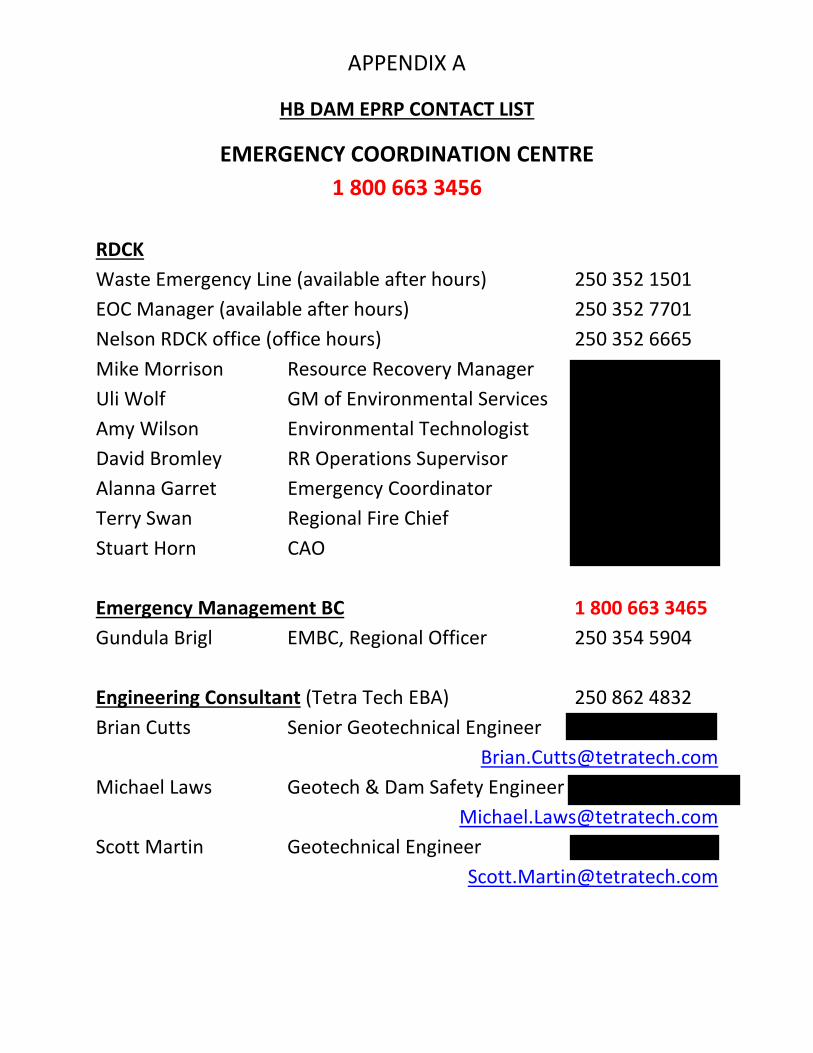
HB DAM EPRP CONTACT LIST
EMERGENCY COORDINATION CENTRE 1 800 663 3456
RDCK Waste Emergency Line (available after hours) 250 352 1501 EOC Manager (available after hours) 250 352 7701 Nelson RDCK office (office hours) 250 352 6665 Mike Morrison Resource Recovery Manager 250 505 3691 c Uli Wolf GM of Environmental Services 250 551 1176 c Amy Wilson Environmental Technologist 250 505 8146 c David Bromley RR Operations Supervisor 250 354 3044 c Alanna Garret Emergency Coordinator 250 254 8255 c Terry Swan Regional Fire Chief 250 551 2641 c Stuart Horn CAO 250 551 5306 c Emergency Management BC 1 800 663 3465 Gundula Brigl EMBC, Regional Officer 250 354 5904 Engineering Consultant (Tetra Tech EBA) 250 862 4832 Brian Cutts Senior Geotechnical Engineer 250 551 4467 c
[email protected] Michael Laws Geotech & Dam Safety Engineer 250 212 1925 c
[email protected] Scott Martin Geotechnical Engineer 250 878 0828 c

w:\departments\engdept\1.0 network structure\12. environmental management\6300 resource recovery - facilities\6300-hbd\30 studies and reports\2014 eprp\2014_hbd_eprp_v1_appa_contacts.docx
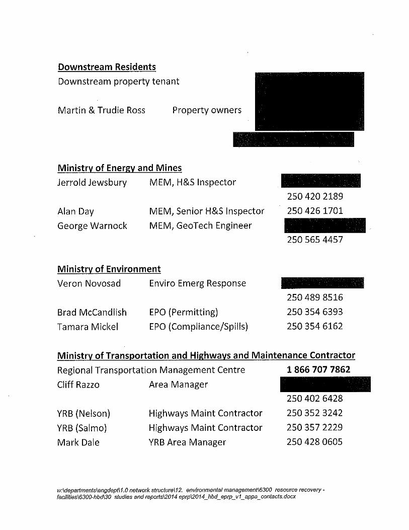
Forest, Lands and Natural Resource Operations Sarah Crookshanks Reg Dam Safety Officer 250 354 6349 Dwain Boyer Water Section Head 250 354 6388 RCMP Salmo 250 357 2212 Trail 250 364 2566 Local Government (Salmo) Village of Salmo Office 250 357 9433 Jason McNeil Operations Manager 250 509 2433 c Jamie Birk Public Works Foreman 250 509 2443 c Salmo Fire Department 250 357 9912 David Hearn Salmo Fire Chief 250 505 7675 c Local Radio Stations The Goat 1-877-560-1010 CBC Radio News 1-866-306-4636 Juice FM 250-352-1902 EZ Rock 250-352-6675 Kootenay Coop Radio 250-352-3706 Equipment Rentals and Sales Canadian Dewatering (pumps) 250-365-3200 Impact Equipment (Trail) 250-364-9964 Andex Equipment Rentals (Nelson) 250-352-6291 Trowlex Rentals & Sales (Castlegar) 250-365-3315

w:\departments\engdept\1.0 network structure\12. environmental management\6300 resource recovery - facilities\6300-hbd\30 studies and reports\2014 eprp\2014_hbd_eprp_v1_appa_contacts.docx
Heavy Equipment Contractors Henry Huser Custom Dozing 250-357-9686
250-354-3351 c 250-354-9151 c Greg Amantea Alpine Group 250-367-0099 250-231-1006 c Maglio Installations 250-352-7939 McNally Excavating 250-352-3838 Civil-Tech Services 250-365-2005 Cham Rd/Markin 250-304-2011 Security and Flagging Mountain Eagle Security 250 777 2253 Safety Zone Traffic Control 250-225-3598 George Scrap King (H’way Flagging) 250 505 7818 Consultants and Other Parties Chris Perdue Perdue Geotechnical 250 354 3524 Dorothy English Enviro tech - water sampling 250 229 5751 250 505 6135 c Peter Ward Ward Engineering (Surveyor) 250 354 1660 250 354 9760 c Bruce Donald Teck 250 426 9845