elwood heritage review - city of port phillip · national trust of australia (victoria), art deco...
TRANSCRIPT

Elwood
Heritage ReviewPrepared for
The City of Port Phillip 30 June 2005
Photo: Aerial photo of Elwood in 1927, looking east across Point Ormond (Picture Collection, State Library of Victoria)
Volume 1: Thematic History
Citations for Heritage Precincts

This Heritage Study has been undertaken in accordance with the principles of the Burra Charter adopted by ICOMOS Australia
This document has been completed bySimon Reeves and David Wixted
© 2004 heritage ALLIANCE
1
heritage ALLIANCE
Job 2004-20 City of Port Phillip: Elwood Heritage Review
Contents: Volume One of Two
1.0 Introduction ...............................................................................................................................................3
1.1 Background and Brief..................................................................................................................................3
1.2 Project Methodology....................................................................................................................................5
1.3 Study Team.................................................................................................................................................7
1.4 Acknowledgements .....................................................................................................................................7
2.0 Thematic History .......................................................................................................................................9
2.1 The Developing Foreshore ..........................................................................................................................9
2.2 Seaside Seats and Marine Mansions: A Prestigious Residential Address ................................................11
2.3 The Mixed Success of Boom Era Subdivision ...........................................................................................14
2.4 Land Reclamation .....................................................................................................................................17
2.5 The Impact of Transport Routes................................................................................................................21
2.6 Closer Settlement: 1900 to 1920 ...............................................................................................................22
2.7 Apartment Living .......................................................................................................................................26
3.0 Statement of Significance ......................................................................................................................29
4.0 New Precincts..........................................................................................................................................31
4.1 Addison Street/Milton Street Residential Precinct .....................................................................................33
4.2 Elwood Canal Precinct ..............................................................................................................................43
4.3 Byron Street/Mason Avenue Residential Precinct .....................................................................................51
4.4 McRae Street Residential Precinct............................................................................................................59
5.0 Extended Precincts .................................................................................................................................63
5.1 Recommended future heritage investigations ...........................................................................................63
6.0 Select Bibliography.................................................................................................................................64

heritage ALLIANCE
2 Job 2004-20 City of Port Phillip: Elwood Heritage Review
Illustrations
Figure 1 Elwood Beach in the 1950s; note sea scout hall and original sailing club and angling clubs ..........10
Figure 2 Elwood Bowling Club; note original 1925 pavilion at left, which still remains ..................................10
Figure 3 Kearney Map of St Kilda, showing the sparse residential development of Elwood by 1855. ..........12
Figure 4 J E S Vardy Map of St Kilda (1872), showing large mansion and villa estates in Elwood...............13
Figure 5 Two Elwood mansions photographed by John Collins in the early 1970s.......................................14
Figure 6 Real estate agent’s flyer for the St Kilda Bluff Estate, auctioned in February 1887 ........................15
Figure 7 MMBW Map No 48 (December 1897) showing extent of Boom-era housing estates in Elwood.....16
Figure 8 Cox’s survey map of St Kilda in 1866, showing extent of the Elwood Swamp at that time .............18
Figure 9 Contemporary engraving showing the Elwood Canal under construction in 1889 ..........................19
Figure 10 The tangle of overhead tramlines at Elwood Junction in the 1920s ................................................22
Figure 11 Two aerial photographs of Elwood in the late 1920s, showing extent of residential development ..23
Figure 12 Shops in Ormond Road, c.1920s; note early chemist shop (No 90) at right ...................................24
Figure 13 Proposed shop and apartment complex at unidentified location in Elwood ....................................24
Figure 14 Former stables at 4 Greig Court, all that remained of once-vast mansion by the early 1970s ........25
Figure 15 A selection of fine architect-designed post-war apartment blocks in Elwood ..................................28

3
heritage ALLIANCE
Job 2004-20 City of Port Phillip: Elwood Heritage Review
1.0 Introduction
1.1 Background and Brief
1.1.1 Project Background
This Heritage Study was commissioned by the City of Port Phillip in November 2004 in order to re-assess the southern extremity of the municipality – the area generally known as Elwood (but also including a small portion of Ripponlea) bounded by Dickens Street, Hotham Street, Glenhuntly Road, St Kilda Street, Head Street and the coastline. Under the local provisions of the planning scheme, this area is currently covered by heritage overlay to the extent of a number of individual sites and three precincts, all identified and documented in the Port Phillip Heritage Review that was completed by Andrew Ward in 2000:
Elwood, St Kilda, Balaclava and Ripponlea (HO7),
Elwood: Glenhuntly and Ormond Roads (HO8)
Brighton Road, Elwood (HO318)
For some time, local residents and councillors had called for a greater extent of heritage control over the area in general, but particularly around Barkly Street, Brighton Road, St Kilda Street and the streets between. The purpose of this study was to prepare a thematic history for the entire Elwood area, and then to re-assess those portions of the study area that currently fall outside of the existing precincts of HO7, HO8 and HO318. This comprised properties in over 60 streets, roads and courts (or parts thereof):
Addison Street (most) Greig Court Ormond Esplanade (most)
Alfriston Street Hartpury Avenue Ormond Road (parts)
Austin Street Head Street (north side) Phyllis Street
Avoca Avenue (part) Hennessy Avenue (part) Pine Avenue
Barkly Street (most) Hood Street Poets Grove
Bell Street Hotham Grove Pozieres Avenue
Brighton Road (parts) Hotham Street (part, west side) Quatt Quatta Avenue (part)
Broadway (part) John Street Robert Street
Browning Street Joyce Street Rothesay Avenue
Burns Street (part) Keats Street Ruskin Street (most)
Byron Street Kendall Street St Kilda Street (part, west side)
Clarke Street Kingsley Street Scott Street
Coleridge Street Knight Street Selwyn Avenue (part)
Cyril Street Lawson Street Shelley Street (part)
Daley Street Lindsay Avenue Southey Court (part)
Dickens Street (part, south side) Lytton Street Southey Street (part)
Docker Street McRae Street Spray Street
Foam Street Mason Avenue Tennyson Street (parts)
Garden Court (part) May Street Thackeray Street
Glenhuntly Road (part) Meredith Street Tide Street
Goldsmith Street (most) Milton Street (part) Tiuna Grove (part)
Gordon Avenue Moore Street Wave Street
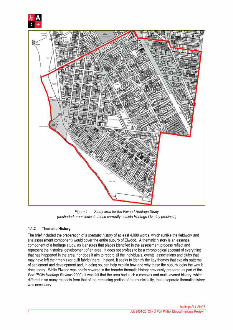
Figure 1 Study area for the Elwood Heritage Study(unshaded areas indicate those currently outside Heritage Overlay precincts)
1.1.2 Thematic History
The brief included the preparation of a thematic history of at least 4,000 words, which (unlike the fieldwork and site assessment component) would cover the entire suburb of Elwood. A thematic history is an essential component of a heritage study, as it ensures that places identified in the assessment process reflect and represent the historical development of an area. It does not profess to be a chronological account of everything that has happened in the area, nor does it aim to record all the individuals, events, associations and clubs that may have left their marks (or built fabric) there. Instead, it seeks to identify the key themes that explain patterns of settlement and development and, in doing so, can help explain how and why these the suburb looks the way it does today. While Elwood was briefly covered in the broader thematic history previously prepared as part of the Port Phillip Heritage Review (2000), it was felt that the area had such a complex and multi-layered history, which differed in so many respects from that of the remaining portion of the municipality, that a separate thematic history was necessary.
heritage ALLIANCE
Job 2004-20 City of Port Phillip: Elwood Heritage Review4

5
heritage ALLIANCE
Job 2004-20 City of Port Phillip: Elwood Heritage Review
1.2 Project Methodology
1.2.1 Stage One: Research and Identification
The first stage, which was carried out between November 2004 and April 2005, involved the preparation of a thematic history (qv) and the identification of places (both individual places and precincts) of potential heritage significance. The latter were identified using a three-tier process:
Desktop research; various published and unpublished sources were consulted, including previous heritage studies undertaken for the City of Port Phillip (and the former City of St Kilda), registers maintained by the National Trust of Australia (Victoria), Art Deco Society and others, standard secondary sources documenting the history of St Kilda, area studies and theses on specific building types (eg churches, apartments, motor garages, neon signs, etc), and various architectural and local history indices.
Public consultation; an evening workshop was held the St Kilda Town Hall on the evening of 22 February 2005. Presentations were made by both the council and the present consultants, during which attendees were made aware of the background, intent and scope of the project. A number of sites that had been identified to date were illustrated and discussed. The workshop concluded with informal group discussions between members of the project team and the attendees, during which the latter were also encouraged to submit any comments, suggestions and recommendations using a printed pro forma.
Physical Survey; on the completion of desktop research and public consultation, a standard ‘windscreen’ survey was carried out. Each of the 45 streets in the designated study area were traversed, mostly by car but occasionally (and especially in the case of the foreshore and canal reserves) on foot.
At the end of the desktop research phase, approximately 170 individual places had been identified across Elwood.This list, however, was subsequently reduced by eliminating those places that were already covered by an existing heritage overlay (either as individual sites or as part of precincts HO7, HO8 or HO318) and those that fell outside the specific study area (that is, north of Dickens Street or south of Head Street). When thus filtered, the list comprised approximately forty places of potential heritage significance. This was increased only nominally during the public consultation phase, when only a few additional places were added to the list.
When these fortysomething places were inspected during the physical survey phase, the shortlist was further reduced by the elimination of those places that were found to be demolished (approximately nine places) and those that could not be located due to lack of information (approximately six places). At the same time, the list was considerably increased by the addition of places that were identified solely through fieldwork. Thus, at the completion of Stage One in April 2005, the study had identified four potential heritage precincts and 41 individual sites of potential significance. For each precinct and site, an outline datasheet was prepared that included a current photograph, a location map and, in some cases, basic historical information where it was already known. These 45 datasheets were then circulated amongst the project’s Reference Group, which comprises three council representatives (two strategic planners and the councillor for the Ormond Ward, which covered the study area) and seven local residents with an interest in the history of the area, including representatives of the Art Deco Society and the St Kilda Historical Society.
The fieldwork component also revealed that a number of places of architectural and aesthetic interest were located just outside the boundaries of the three existing heritage precincts. The recommendation was subsequently made that the borders of these precincts be revised to include these significant, contributory and (occasionally) non-contributory places on their periphery. The revision of precinct boundaries allowed for the existing areas to become less fragmented, by the reinstatement of those portions of streetscapes that had been omitted – sometimes due to the presence of post-war buildings (eg the northern strip of Tennyson Street) and sometimes entirely arbitrarily (eg Garden Court and Southey Court). The inclusion of non-contributory buildings within otherwise significant/contributory streetscapes was recommended on the grounds that it allowed for greater control over appropriate redevelopment of these sites in the future.

heritage ALLIANCE
6 Job 2004-20 City of Port Phillip: Elwood Heritage Review
1.2.2 Stage Two: Assessment and Documentation
On 6 April 2005, the 45 datasheets were reviewed at a meeting between the Reference Group and the consultants. Due to council’s contractual arrangement (that is, the original brief and budget), only a proportion of the 41 places and four precincts were to be assessed and documented as part of Stage Two. The target number, as per the original brief, was for four precincts and 18 individual sites. The decision was made to document the four precincts that had already been identified, and to prioritise the individual sites according to criteria including:
Perceived level of heritage significance
Current risk of demolition/redevelopment
Protection provided by other mechanisms beyond heritage overlay
The Stage One list of 41 individual sites was filtered to a shortlist of 19 places. Amongst those eliminated, by general agreement, were those that were located within the boundaries of proposed heritage overlay areas (and thus having some protection under the planning scheme), those which were on the borders of existing heritage precincts (and thus could be annexed into them) and those located on public land such as the Elwood foreshore, (which are under the management of the council).
An additional datasheet was prepared when one of the sites identified, the Presbyterian Church at 31 Scott Street, was found to comprise two discrete buildings – the original timber church of 1912 and the brick church of 1938.While they had some common history, the two buildings were of individual architectural and aesthetic significance for quite different reasons, and the decision was subsequently made that these sites would be more appropriately assessed and documented as separate citations.
Thus shortlisted, the 19 places and four precincts were researched using standard primary sources such as council rate books, post office and telephone directories and electoral rolls, supplemented by more specialised sources such as contemporary newspapers and journals, architectural and biographical indices and oral history.In the case of precincts, historic maps were also used, particularly the detailed survey plans of St Kilda prepared by Kearney (1855), Cox (1866) and Vardy (1872), plus the MMBW maps produced around the turn of the century.Lodged Plans held by the Lands Department provided useful information in regard to subdivisions and estates. A second phase of fieldwork allowed for place to be subject to a more detailed inspection, and a written description was prepared based on this. Comparative analysis was undertaken with reference to the numerous existing heritage studies, supplemented, where necessary, by additional research and fieldwork. For each place or precinct, a Statement of Significance was prepared in the standard tripartite format used by Heritage Victoria.
As Stage Two was nearing completion in May 2004, additional funding became available for the assessment and documentation of the 22 sites that had previously been omitted at the Reference Group meeting on 6 April. All of these sites were revisited; it was subsequently found, however, that not all were considered to be worthy of inclusion on the heritage overlay as individual places. Some for example, were considered to be of local historical interest only, while others were concluded to be merely representative of their type, style or era, with better examples remaining elsewhere in the municipality.
At the conclusion of Stage Two, the thematic history was reviewed in order to incorporate various corrections, additions and other suggestions that had been made during the course of the study by members of the Reference Group and by attendees at the community consultation workshop. This review included the insertion of references to a number of individual places and precincts that had been documented elsewhere in the report, in order to strengthen the link between the thematic history and the places themselves. In the thematic history, places and precincts are referenced to by their three digit database number in bold text. The first digit refers to the chapter within this report (either precincts, recommended individual sites or other individual sites).

7
heritage ALLIANCE
Job 2004-20 City of Port Phillip: Elwood Heritage Review
1.3 Study Team
The study team that completed this study comprised
David Wixted Principal, Heritage Alliance
Simon Reeves Architectural historian, Heritage Alliance
1.4 Acknowledgements
The consultants would like to thank the members of the Reference Group for their support, enthusiasm and feedback throughout the project: Cr Janet Cribbes (councillor for the Ormond Ward, City of Port Phillip), Nicola Stephens and Sonia Anderson (Strategic Planners, City of Port Phillip), Meyer Eidelson (St Kilda Historical Society), Cliff Skinner and Helen Graham (Art Deco Society), Brett Gamon, Liz Johnstone, Ian McRae and Warren Lee.
In addition, the consultants would like to acknowledge the assistance of Robin Grow (Art Deco Society), Don Taggart, Peter Johnstone, and all those members of the Elwood community who attended the workshop in February 2005.

heritage ALLIANCE
8 Job 2004-20 City of Port Phillip: Elwood Heritage Review
9
heritage ALLIANCE
Job 2004-20 City of Port Phillip: Elwood Heritage Review
2.0 Thematic History
2.1 The Developing Foreshore
2.1.1 Early Occupation of the Elwood Coastline
For thousands of years prior to colonisation, the distinguishing feature on the strip of coastline between St Kilda and Brighton was a steep headland of red sandstone early settler later named Red Bluff. This was a landmark amongst the local Aboriginal community, the Bunurong, who used it for communal and social gatherings. It was evidently still a focus for indigenous people as late as the 1860s, as recalled by one early Elwood resident, Mrs Florence (Dougharty) Huon (1858-1929) who stated that, during her childhood, Aboriginals were still frequent visitors to Red Bluff, as the sand contained large beds of cockles.1 The discovery of a shell midden on the site over a century later, in 1974, not only confirms Mrs Huon’s recollection, but indicates that Red Bluff (subsequently renamed Point Ormond) was an important campsite for the Bunurong for many years.2
In August 1835, Red Bluff first attracted the attention of Melbourne’s early settlers, when John Pascoe Fawker’s schooner, the Enterprize, dropped anchor there en route to the lower Yarra.3 Five years later, it was chosen as a suitably remote site for the colony’s first quarantine station. This was necessitated by the crisis that occurred when the barque Glen Huntly arrived at Williamstown on 17 April 1840 with a number of typhoid-stricken passengers. Superintendent Latrobe ordered that the barque cross the bay and dock at Red Bluff, where two camps were established: one for afflicted passengers, and another for those remaining in good health. Two months passed before the passengers were permitted to leave, whereupon the station was closed. The graves of those who had died were enclosed by a picket fence and remained as a memorial to the tragedy.
Separated from nearby St Kilda by a vast swamp, the foreshore around Port Ormond was clearly considered to be a suitably remote location for some of the more objectionable facilities required by a fledgling settlement. In 1857, the St Kilda Council established a night soil depot at the intersection on Barkly Street and, later that same year, applied to the Department of Land & Survey to occupy an adjacent two acre site, bisected by the Elster Creek, for the purpose of an abattoir.4 In December, the Melbourne Hunt Club was also granted a license to occupy some nearby land, on which they erected kennels for their hounds.5 The adjacent abattoir site, meanwhile, was granted to the council in 1858, and an open slaughter yard was established, for which purpose a small timber bridge was erected over the creek a year later.6 The new abattoir building followed in 1861.
As residential development burgeoned in Elwood in the 1850s and ‘60s, the manure depot and the abattoirs became a much-maligned bone of local contention. In the face of strong opposition from local residents, and repeated complaints to the Central Board of Health, the manure depot was finally closed in 1869.7 The abattoir, however, remained in operation for another three decades before closing in 1898. The changing attitudes towards noxious practices along Elwood’s foreshore also became evident when the council proposed to build its municipal garbage destructor at Point Ormond in 1890, only to be refused by the Department of Land and Survey on the grounds that the land has been ‘permanently reserved for recreational purposes’.8 It was also during the 1890s that erosion around Point Ormond threatened to disturb the sixty-year-old graves of the Glen Huntly typhoidvictims, and the remains were finally exhumed in 1898 and re-interred at the St Kilda Cemetery. By the turn of the century, the last few vestiges of unpleasant mid-nineteenth century history had been exorcised from Elwood’s foreshore, leaving the path open for recreational development.
1 J B Cooper. The History of St Kilda. Vol 1, p 183. 2 ‘Point Ormond’, <<www.portphillip.vic.gov.au/attachments/o12761.pdf>>
3 Meyer Eidelson, Walks in Port Phillip: A Guide to the Cultural Landscapes of a City, p 20. 4 Letter, September 1857. St Kilda Historic Correspondence (Abattoirs; item No 2), City of Port Phillip. 5 Letter, December 1857. St Kilda Historic Correspondence (Reserves - foreshore; item No 120), City of Port Phillip.
6 J B Cooper. The History of St Kilda. Vol 1, pp 191-192. 7 Letters, November 1868 and February 1869. St Kilda Historic Correspondence (Manure depot; item No 1), City of Port Phillip.8 Letter, 2 December 1890. St Kilda Historic Correspondence (Destructor; item No 1), City of Port Phillip.
2.1.2 The Development of Recreation on Elwood Beach
An early parish plan indicates that the site of Elwood Beach, comprising 54 acres of land between Point Ormond and present-day Head Street, extending east to the Esplanade, had been permanently reserved as a Public Garden, with an 11-acre reserve at the southern end for a rifle range. In 1865, the Government proposed to sell off this land for private development, but concerned residents made representations to have the lots withdrawn from sale on the grounds that ‘the land, at present, is being used by the public as a reserve’.9 Some of the land at Point Ormond was subsequently proposed for annexure as part of the coastal recreation reserve, with a survey map, prepared by Clement Hodgkinson in January 1869, annotated thus:
[It is] proposed that the strip of land . . . comprising the tip of Point Ormond, be placed under the control of a Committee of Management to consist of four owners of land in Elwood and the Mayor of St Kilda . .subject tothe condition that this land will be enclosed by private subscription of landholders at Elwood, with a view to it being subsequently converted into an ornamental plantation and recreation ground’.10
The committee was duly formed although, as local historian John Butler Cooper noted, the Mayor of St Kilda was not amongst its members. By this time, the council had already made a number of improvements to the beach reserve, including tree-planting and the construction of a coastal promenade.11
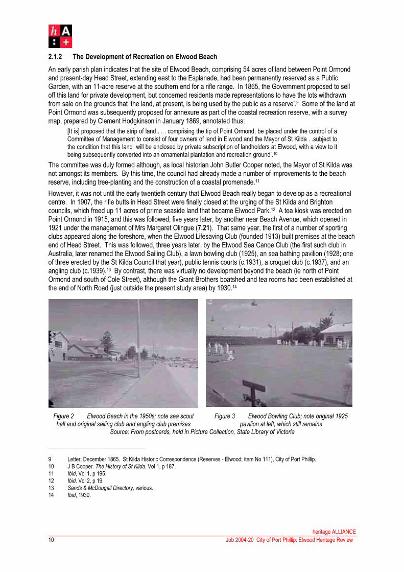
However, it was not until the early twentieth century that Elwood Beach really began to develop as a recreational centre. In 1907, the rifle butts in Head Street were finally closed at the urging of the St Kilda and Brighton councils, which freed up 11 acres of prime seaside land that became Elwood Park.12 A tea kiosk was erected on Point Ormond in 1915, and this was followed, five years later, by another near Beach Avenue, which opened in 1921 under the management of Mrs Margaret Olingue (7.21). That same year, the first of a number of sporting clubs appeared along the foreshore, when the Elwood Lifesaving Club (founded 1913) built premises at the beach end of Head Street. This was followed, three years later, by the Elwood Sea Canoe Club (the first such club in Australia, later renamed the Elwood Sailing Club), a lawn bowling club (1925), an sea bathing pavilion (1928; one of three erected by the St Kilda Council that year), public tennis courts (c.1931), a croquet club (c.1937), and an angling club (c.1939).13 By contrast, there was virtually no development beyond the beach (ie north of Point Ormond and south of Cole Street), although the Grant Brothers boatshed and tea rooms had been established at the end of North Road (just outside the present study area) by 1930.14
Figure 2 Elwood Beach in the 1950s; note sea scout hall and original sailing club and angling club premises
Figure 3 Elwood Bowling Club; note original 1925 pavilion at left, which still remains
Source: From postcards, held in Picture Collection, State Library of Victoria
9 Letter, December 1865. St Kilda Historic Correspondence (Reserves - Elwood; item No 111), City of Port Phillip.
10 J B Cooper. The History of St Kilda. Vol 1, p 187.
11 Ibid, Vol 1, p 195.
12 Ibid. Vol 2, p 19.
13 Sands & McDougall Directory, various.
14 Ibid, 1930.
heritage ALLIANCE
Job 2004-20 City of Port Phillip: Elwood Heritage Review10

11
heritage ALLIANCE
Job 2004-20 City of Port Phillip: Elwood Heritage Review
Unfortunately, the post-war period saw the loss of a number of these early foreshore structures, including the original Point Ormond Kiosk and nearby jetty (both demolished in the 1950s), the angling clubhouse (destroyed by fire c.1957) and the sea bathing pavilion (demolished 1971). All but one of the sporting clubs rebuilt or replaced their respective premises during these years: the angling club (1958), the lifesaving club (1971; 7.23) and the croquet club (1970s). The bowling club pavilion (7.22) now remains as the sole survivor of these early sporting clubs although, ironically, it no longer operates as such – it was converted into a community centre and café complex in the 1990s. Facilities for a number of previously unrepresented sports and recreational groups also established their presence along the foreshore in the post-war period, including a cricket ground (1950s), a sea scout hall (c.1958, 8.08) and a soccer clubroom (1980).
2.2 Seaside Seats and Marine Mansions: A Prestigious Residential Address
2.2.1 The First Land Sales
Elwood’s first land sale was held on 18 September 1851, when six blocks between Ormond Road and the Esplanade were auctioned at an upset of £2/10 per acre. Section 8, of 14 acres, was acquired by W B Wilmot, and the remaining five eight-acre lots by J Payne (Section 10), W W Blow (Section 11), J G Vautier (Sections 12 and 13) and James Murphy (Section 14).15 A month later, three more eight-acre blocks were sold in Melbourne, purchased by Samuel Griffiths (Sections 15 and 16) and J Murphy (Section 17). None of these early investors, however, developed their properties immediately and, even a year later, there was still only one actual resident in Elwood: one John Broadbent, a timber-cutter working at Point Ormond, who lived in a tent at a time when, as he later claimed ‘nobody else had a tent or house in Elwood’.16
One of the first attempts to promote settlement in Elwood took place in 1853, when J G Vautier subdivided his land as the Elwood Hill Estate, comprising 60 residential lots with frontage to ‘Esplanade’ and ‘Government Road’ (Ormond Road), and two new streets, North Elwood Street (Vautier Street) and South Elwood Street (Docker Street). In May 1853, three lots were purchased by the Reverend Joseph Docker, who engaged architects Russell, Watts & Pritchard to design a pair of terrace houses, for which tenders were called in December 1854.While these remains as Elwood’s oldest surviving houses, it must be considered as an anomaly because, as Andrew Ward points out, it represented an unsuccessful attempt to introduce terrace housing (ubiquitous in nearby St Kilda) into Elwood. As it would turn out, it was an entirely different housing typology – the detached mansion on a large allotment – that would strongly characterise Elwood in the second half of the nineteenth century.
2.2.2 Early Mansion Estates, 1850s and 1860s
One of the first of these grand mansions in the area was Thomas Monahan’s Erindale, for which architect Joseph Burns called tenders in October 1854. This two-storey bluestone house, located in what is now part of Ripponlea, stood on over 16 acres on the east side of Brighton Road, just south of present-day Glen Eira Road and appears on Kearney’s map of 1855. This map, which shows Elwood as far south as Glenhuntly Road, gives a clear indication of the emergence of the mansion estates. While residential development in St Kilda was quite dense, it became much sparser south of Carlisle Street (then known as Beach Road), with both sides of Brighton Road characterised by a smattering of substantial houses on large allotments. The east side was dominated by Monahan’s Erindale, and the west by three particularly prominent mansions: one on the corner of Southey and Dryden streets, another on the east corner of Byron and Tennyson streets, and a third on the corner of Milton Street and Brighton Road. Another substantial estate, not shown on Kearney’s map but built c.1855-56, was T J Nankivell’s Chiverton, a mansion attributed to architect Leonard Terry on the west side of Brighton Road, between Burns and Scott streets. 17
15 J B Cooper. The History of St Kilda. Vol 1, pp 183-84.
16 Ibid. Vol 1, p 185.
17 Miles Lewis (ed). Melbourne Mansions Database. <fmweb.arbld.unimelb.edu.au/melbmansions>

Figure 4 Kearney Survey Map of St Kilda, showing the sparse residential development of Elwood by 1855.Source: Map Collection, State Library of Victoria
Although not shown on Kearney’s map, similar development took place further south, with mansions beginning to appear on those seaside blocks along the Esplanade. In December 1855, architect Charles Laing called tenders for two detached houses at ‘North Elwood’, designed for original landholder William Wootton Blow.18 Six months later, the Australian Builder reported that construction of Blow’s ‘marine residences’ was nearing completion, adding that ‘a striking feature is the wide Moorish verandah which surrounds the upper and lower stories’. Blow’s two houses, flanking what is now the intersection of Pine Avenue, became known as Bramshaw and OsborneHouse – the latter a suitably fitting reference to Queen Victoria’s own seaside house on the Isle of Wight. Such evocative nomenclature was clearly significant, also being evident in another early mansion on the Esplanade, built for James Osborn in the 1850s. His house, later known as Wiltonia, was originally Bleak House – an allusion to Charles Dickens’ own holiday house on the Kent coast (and, incidentally, the inspiration for his novel of the same name, serialised in 1852-53). Names such as these were indicative of the emerging trend of the ‘seaside seat’ that would characterise the area over ensuing decades.
The 1860s saw a number of substantial houses springing up in Elwood’s north-eastern fringe. Alfriston, at 131 Brighton Road (near the corner of Mason Avenue) was erected in the early 1860s, possibly for Henry C Wills, but later occupied by the Honorable Caleb Jenner, MLC. Nearby, the prominent intersection of Tennyson and Milton Streets was developed with two mansions built in 1865 for Captain H Selwyn Smith and F G Smith, respectively on the east and north corners. The latter, known as Evora, has since been demolished, although the former, Hartpury, still exists in an altered state at 9 Milton Street. The third corner of this intersection developed in 1870 with the construction of Ravelston, a two-storey mansion for prominent tobacconist Fredrick William Heinecke.Around the same time, merchant Charles Berghoff built a similar mansion for himself, named Critchall, on a large lot between Tennyson Street and Brighton Road, where Wimbledon Avenue now runs. Clearly, some of Melbourne’s most successful businessmen and prominent citizens were choosing Elwood as the location for their town residences. Indeed, the suburb’s reputation as a prestigious address had burgeoned considerably since the early 1860s, when Sir Richard Heales, MLA, then Premier of Victoria, built his house, Tennyson Villa, in Tennyson Street.
18 Argus, 1 December 1855. Cited in Miles Lewis (ed), Australian Architectural Index, s v St Kilda.
heritage ALLIANCE
Job 2004-20 City of Port Phillip: Elwood Heritage Review12

13
The proliferation of mansion estates in Elwood during the 1860s becomes evident when one compares Kearney’s 1855 map with a later map of the area, prepared by J E S Vardy in 1873. This shows that a number of large properties had been established along the west side of Brighton Road, including one large mansion between Scott and Burns street, another on the south corner of Tennyson Street, and several smaller (but still substantial) examples between Milton and Dickens street. Further along Dickens Street, a large house had also been built near the corner of Tennyson Street, overlooking the south boundary of the Botanic Gardens. On the other side of Brighton Road, this type of development was less intensive, with Vardy’s map showing two large properties built east of the railway line (which bisected the area in 1859), respectively with frontage to Hotham Street and Glen Eira Road.
2.2.3 Boom Era Mansions: 1880s to 1890s
By the 1870s, the tendency to erect grand residences in Elwood had abated somewhat, although a few notable examples still appeared, such as Whinbank in Mitford Street (1875; demolished) and Arranmure, on the south corner of Brighton Road and Burns Street (1876; demolished). A rare survivor from this slump period is the former Corra-lynn at 54 Southey Street (7.28), a sprawling single-storey brick villa on a (still) large block, built in 1872 and occupied for many years by prominent estate agent William Thistlethwaite. Otherwise, it was not until the prosperous Land Boom period of the 1880s that the suburb began, once again, to flourish as a prestige residential address. The seaside allotments on the Esplanade were particularly sought-after during that time, with a number of mansions being built such as Tiuna (1884), Thalassa (1889) and Glengarrif (1890).19 East of Brighton Road, Quatt Quatta was built in 1889 for Thomas’ Monahan’s daughter, Betsy Keogh, on the eastern half of her father’s vast estate, which had been bisected by the construction of the railway line thirty years earlier.
Figure 5 Detail of J E S Vardy Map of St Kilda (1872), showing large mansion and villa estates in Elwood.Source: Map Collection, State Library of Victoria
19 Miles Lewis (ed). Melbourne Mansions Database. <fmweb.arbld.unimelb.edu.au/melbmansions>
heritage ALLIANCE
Job 2004-20 City of Port Phillip: Elwood Heritage Review

Figure 6 Two Elwood mansions photographed by John Collins in the 1970s. Alfriston at 131 Brighton Road (left), has since been demolished for flats; the other, Rothermere at 14 Hennessy Street (1891), still exists, albeit in an altered state.
Source: Picture Collection, State Library of Victoria
One of the last of the grand mansions to be built in the Elwood area was Rothermere on Tennyson Street (now 14 Hennessy Avenue), completed in 1891 - barely a year before the collapse of the Land Boom - for Joseph Syme, nephew and former partner of David Syme, proprietor of The Age newspaper. The younger Syme was yet another in the long line of prominent Melbourne citizens who settled in Elwood during the prosperous years of the Land Boom, cementing its reputation as one of the city’s premier residential addresses. Other who lived there during this time included Henry V Duigan, barrister (original owner of Tiuna), Andrew Rowan, a director of Goldsborough & Company (Arranmore), Frank Grey Smith, general manager of the National Bank of Australia (Monkstadt), the Hon Philip Russell, JP, MLC, a prominent pastoralist (occupant of Chiverton in the 1880s) and the Hon Thomas Loader, politician, company director and founder of the City of Melbourne Bank (occupant of Whinbank in the 1880s)
2.3 The Mixed Success of Boom Era Subdivision
2.3.1 Elwood’s Estates of the 1880s
The prosperous Land Boom period saw intense land speculation across Melbourne’s suburbs, and Elwood was no exception. Housing estates, mostly on a relatively modest in scale, began to proliferate along Brighton Road, where they included those subdivisions that created Rainsford Street (16 lots, 1885), Hotham Grove (1887), Victoria Avenue (24 lots, 1888), Moore Street (29 lots, 1888) and Cyril Street (23 lots, 1889). One of the more extensive subdivisions took place when one of Elwood’s oldest estates, Chiverton, was sold in 1885. It vast grounds were carved up into 85 allotments, with the mansion itself retained on a sliver of land between newly-formed Kendall and Coleridge streets. Further west, land between Mitford Street and Southey Road, formerly owned by W J T Clarke, was also subdivided in 1885, which extended Byron Street with 63 new allotments.20 Not surprisingly, such estates also proliferated along the Esplanade, where they included Hood Avenue (17 lots, 1888) and Beach Avenue (34 lots, 1886), the latter being publicised as the Elwood Esplanade Estate.21 Land on the corner of Glen Huntly Road and The Esplanade was subdivided as the St Kilda Bluff Estate, creating twenty ‘marine villa sites’ that were auctioned on 12 February 1887. A flyer for the estate gives an indication of the typical rhetoric used by the estate agents of the day:
20 Lodged Plan No 788, dated 12 June 1885. Land & Survey Information Centre. 21 ‘Elwood Esplanade Estate’, 8 pp booklet. Batten & Percy Collection, Vol 4a, p 228. Map Collection, State Library of Victoria.
heritage ALLIANCE
Job 2004-20 City of Port Phillip: Elwood Heritage Review14

15
The land actually comprises part of the celebrated St Kilda Bluff, and was bought from the Crown in 1853, since which time it has been unfenced and has been used by the public for recreation and picnic purposes.Owing to its splendid position, it has been universally looked upon as a Public Reserve, and sacred from subdivision. It is only five minutes walk from the Omnibus Stands and Tramway Terminus at the Village Belle
Hotel . . and only one minute from the Beach.22
It was duly pointed out that the twenty sites would be suitable for business, mansion or villa sites, and also noted that there was ‘one grand corner suitable for a large Marine Hotel or Coffee Palace’.
It is telling that these estates were relatively modest in scale, most having less than thirty allotments. Amongst the very few large estates were one to the east of Brighton Road, laid out in 1889 on a large triangular site bounded by Grosvenor Street, Hotham Street and the railway line, which comprised 116 allotments in five discrete sections.Closer to the foreshore, two particularly ambitious estates were developed along on the west side of St Kilda Street, overlooking Elsternwick Park. The smaller, with 113 allotments, was laid out in two stages in 1888 and created Joyce, Kingsley, and Phyllis Streets.23 Alongside was the more ambitious Seaside Estate, a huge subdivision of 192 lots that was laid out in 1885 on the large triangular piece of land between Glenhuntly and Ormond roads. With Elwood already well-developed as a prestige residential address by this time, large estates such as these were clearly geared towards Melbourne’s prominent and moneyed gentlemen. Indeed, one of the first residents of the new Seaside Estate was the State Government Geologist, Dr James Stirling, who erected his relatively modest villa at 56 Spray Street in 1887 (7.29)
Figure 7 Detail of real estate agent’s flyer for the St Kilda Bluff Estate, auctioned in February 1887 (source: Map Collection, State Library of Victoria)
22 ‘St Kilda Bluff Estate’, estate agent’s flyer, 12 February 1887. Batten & Percy Collection, Map Collection, State Library of Victoria.23 Lodged Plan Nos 1829 and 1830, dated 16 March 1888. Lands & Survey Information Centre.
heritage ALLIANCE
Job 2004-20 City of Port Phillip: Elwood Heritage Review

Figure 8 MMBW Map No 48, dated December 1897, showing extent of Boom-era housing estates in Elwood (source: Map Collection, Education Resource Centre, University of Melbourne)
2.3.2 Modest Success and Monumental Failures
Notwithstanding the rhetoric of estate agents and the publication of colourful flyers and promotional pamphlets, very few of these subdivisions developed to the extent that had been envisaged. Maps of Elwood prepared by the MMBW in December 1897 show that residential development was still relatively sparse throughout most of the study area. Of the Boom era estates mentioned above, only three had entirely filled out with housing by that time: Moore Street, Rainsford Street and Hotham Grove. Rows of detached villas had also been built on the north side of John Street and both sides of Byron Street and Scott Street, but even these can only be considered as partial successes. The latter, for example, was developed by one William Cowper of Brighton in the early 1890s and, as Andrew Ward notes, Cowper had only completed one house, with another unfinished and two more at the foundation stage, when he ran into financial difficulty (presumably due to the financial crash of 1892) and his houses were subsequently repossessed by the Queen Building Society.
Many of the beachside estates, however, had failed in even more spectacular fashion. The maps show only four houses on the 34-lot Elwood Esplanade Estate (ie Beach Avenue), and only a few more on the adjacent ElwoodHill Estate. The latter included Eri Eriwah, William Heginbottom’s residence in Docker Street (1884) and Everleigh, home of Richard Allen, in Docker Street (1882). Even those two vast and ambitious subdivisions fronting St Kilda Street, with over 200 allotments between them, had less than a dozen houses each. A few of these managed to survive the subsequent overlay of intense inter-war development, including Ivica at 95 Ormond Road (1889), regrettably demolished in relatively recent times, and two much-altered rendered villas at 54 and 56 Spray Street (1887-88), which, although now much altered, remain as the only evidence of this failed estate. The huge subdivision east of the railway line in Elsternwick had fared only slightly better, with intense development along the south side of Grosvenor Street, but only a scattering of villas elsewhere. But even less fortunate were the two estates that remained entirely undeveloped at the turn of the century: Hood Street and Bluff Avenue. In the case of the latter, not only had the proposed ‘marine hotel or coffee palace’ failed to materialise on the prominent corner allotment, but no houses whatsoever had been erected.
heritage ALLIANCE
Job 2004-20 City of Port Phillip: Elwood Heritage Review16

17
heritage ALLIANCE
Job 2004-20 City of Port Phillip: Elwood Heritage Review
Why did these estates fail? The lack of public transport was clearly one factor, in particular the branch railway line that was eagerly promoted for years but which ultimately failed to materialise. And for all the rhetoric about the delights of seaside living, none of the estate agent’s brochures mentioned the nightsoil depot or the abattoirs on Barkly Street, and, moreover, the hovering misconception of Elwood as a polluted swampland must surely have discouraged many potential purchasers.
Little evidence now remains of this phase of Elwood’s development. While only a relatively small number of villas were actually built during the Land Boom period, many of these have since disappeared in the subsequent overlay of intense residential development that tore through Elwood during the first half of the twentieth century. The most extensive evidence of Elwood’s failed Boom-era estates survives in the clusters of 1880s housing in Byron Street (east), Cyril Street, Mason Street and Moore Street (see 2.3), which includes detached villas in both bichromatic brick and timber, double-storeyed rendered terrace houses, and rows of single-fronted cottages. The fine Victorian streetscapes that once characterised John Street, Byron Street (west), Hotham Grove and Rainsford Street have been obliterated to varying degrees: a remarkable row of four timber villas survives at 24-30 John Street (7.15), another detached pair at 7-9 Hotham Grove (7.14), and some notably intact individual examples at 10 John Street, 38 Byron Street (7.08), 2 Hotham Grove (7.13) and 7 Rainsford Street (7.25). A number of other villas remain, albeit much altered (or, sometimes, almost unrecognisable), including a pair of rendered villas at 99-101 Tennyson Street, and another at 54-56 Spray Street (7.29). The latter comprise the only remaining evidence of the vast but spectacularly unsuccessful Seaside Estate of 1885.
2.4 Land Reclamation
2.4.1 The Elwood Swamp
A hurdle in Elwood’s development in the second half of the nineteenth century was the so-called Southern Swamp, comprising two large but shallow lagoons (up to a metre deep) between Dickens Street, Mitford Street, Glenhuntly Road and the beach, plus an expanse of marshland extending south from the Elsternwick golf course (just outside the present study area) to the Gardenvale railway station. An early parish plan notes that this land was ‘withheld from sale, leasing and licensing, and excepted from occupation for mining purposes’. No mining activity, however, is known to have been carried out, and the swamp simply remained as an inconvenience, albeit a picturesque one, to Elwood’s early residents. Florence Huon, who was born in Osborne House in 1858, recalled that, during her childhood, the swamp was home to fenland and seashore bird life – yet she also well remembered when her father drove home during the winter, the water from the swamp would wash over the floor of his buggy.24 As J B Cooper noted, the ‘ooze and sluggish flow’ of the swamp also prevented Elwood’s early residents from reaching the beach, except when the creek itself was dry.25 He further mused:
However welcome to the eye of the fowler a reed-covered swamp may be, it is inevitable that when such a swamp retards the advancement of a municipality, the civic authorities will make efforts to have swamp lands reclaimed, and turned into a harvesting area for the collection of municipal rates.26
The St Kilda Council had already made several attempts to reclaim swampland within the municipality, including a site on the corner of Carlisle Street and Brighton Road (where the town hall now stands), which was drained in 1859 to create a rubbish dump.27 Subsequently, a portion of the Western Swamp, at the southern end of the Albert Park Lake, was reclaimed in 1870. The draining of Elwood’s Southern Swamp had been mooted as early as 1862, when a surveyor’s report recommended that the creek through the slaughter-yards be deepened, and diverted below the cliffs at Point Ormond.28
24 J B Cooper. The History of St Kilda. Vol 1, p 183.
25 Ibid. Vol 1, p 195.
26 Ibid. Vol 1, p 199.
27 Ibid. Vol 1, p 194. 28 Letter, dated May 1862. St Kilda Historic Correspondence (Elwood Swamp; item No 8), City of Port Phillip.

Figure 9 Cox’s survey map of St Kilda in 1866, showing extent of the Elwood Swamp at that time (source: Map Collection, State Library of Victoria)
At a council meeting some seven years later, residents suggested that the land be drained and sold for residential subdivision, but the council were still hampered by the fact that it was Crown Land.29 In late 1883, the council applied to the Department of Land & Survey to take over the site, only to be told that ‘it is not deemed desirable’ to do so.30 The Government Surveyor took levels of the swamp in September 1885 but three more years passed before the contract was signed, on 1 June 1888, for the reclamation of 134 acres, to be undertaken by engineer George Higgins at a cost of £40,000. An additional 26 acres, between Barkly Street and the beach, was in private ownership; its reclamation was negotiated by the Government and the St Kilda Council. But the long-awaited project was fraught with seemingly endless delays. After travelling to the United States to obtain a suction dredging machine, Higgins learnt that the equipment would take almost three months to arrive in Australia, so, instead, had a machine manufactured under license by a local foundry. Work was further delayed by a coal miners’ strike, and then by an ironmoulders strike.
By July 1889, the private land between Barkly Street and the beach had been sufficiently drained for a few houses to be erected. The anticipated completion of the project prompted a number of speculative subdivisions, which were parodied in a cartoon in Punch magazine, showing ‘desirable suburban allotments in Elwood’, with estate agent’s signboard floating on a lake. As already discussed in Theme 2.2, many of these subdivisions met with mixed success. In any case, the reclamation would not be fully completed until 1905. Just as the project had been subject to delays from its inception through to its completion, so, too, was the sale of the reclaimed land. A few years passed before the first auction of took place on 21 January 1908, followed by another sale in November 1913, with the residual land remaining unsold until the early 1920s.
29 J B Cooper. The History of St Kilda. Vol 1, p 193. 30 Letter, Secretary for Lands to St Kilda Town Clerk, 24 April 1884. St Kilda Historic Correspondence (Elwood Swamp; item No 13),
City of Port Phillip. On-line version available at <<www.portphillip.vic.gov.au/heritage_records.html>>
heritage ALLIANCE
Job 2004-20 City of Port Phillip: Elwood Heritage Review18

19
2.4.2 The Elwood Canal
Part of the swamp reclamation involved the construction of a canal that would drain the marshland to the east of St Kilda Street. The canal, to follow the alignment of the existing Elster Creek, would be three quarters of a mile (1.2 kilometres) in length, 54 feet (16.5 metres) in width and eleven feet (3.4 metres) deep. The project, to cost £14,000, commenced in May 1889 and was carried out by contractors Messrs Hendon, Clarke & Anderson, with a team of sixty men. The initial portion of the canal, extending from the beach to Glenhuntly Road, was completed in 1897, and the remaining section, to St Kilda Street, by 1905. The canal walls, of concrete construction, were fitted with mooring rings ‘for the purpose of mooring pleasure boats in the stream’, and five iron girder bridges were provided at Marine Parade, Barkly, Addison and Ruskin Streets, and Broadway.31
It became apparent quite early on, however, that the canal would not be the picturesque Venetian waterway that its developers had initially envisaged. Pollution and flooding were two early concerns that, as it turned out, would plague the canal for decades. The former was evident even in 1880s, when, during a routine inspection of the abattoirs, it was observed that the facility itself was clean and well-maintained, but ‘if there were any smells, they arose from the scum on the half-stagnant waters of the Elwood Canal’.32 Attempts to rectify these problems began in 1899, when the Inspector General of Public Works surveyed the canal and subsequently recommended the construction of a barrel drain. Jointly funded by the municipalities of St Kilda and Caulfield, it was not a success.33 The canal’s salubrious reputation continued into the early twentieth century, the portion closest to the beach being ‘always more or less offensive in the summer months’, as J B Cooper noted, ‘though hundreds of pounds have been spent in attempts to mitigate the recurring conditions of a sea-locked drain’.34
Figure 10 Contemporary engraving showing the Elwood Canal under construction in 1889 (source: Illustrated Australian News, 1 August 1889)
31 Meyer Eidelson, ‘Elwood Canal’, 10pp unpublished typescript. p 4. Copy provided by Meyer Eidelson.
32 J B Cooper. The History of St Kilda. Vol 1, p 197.
33 Ibid. Vol 1, p 203.
34 Ibid. Vol 1, p 207.
heritage ALLIANCE
Job 2004-20 City of Port Phillip: Elwood Heritage Review

heritage ALLIANCE
20
Job 2004-20 City of Port Phillip: Elwood Heritage Review
With the Metropolitan Drains and Rivers Act 1923, the canal came under the jurisdiction of the Melbourne Metropolitan Board of Works (MMBW), and locals assumed that things would improve. Five years later, MMBW engineers made three proposals: the construction of sluice gates (£57,000), the enlargement and regrading of the existing canal (£73,000), or the entire refilling of the canal to create land that could be sold off for subdivision (£200,000).35 The last of these options was preferred by the both the government and the council, although, typically, its implementation was delayed, although J B Cooper emphatically recorded in 1930: ‘that the work will be done some time is a foregone conclusion’.36 That year, the council suggested the work as a possible unemployment relief project, along with the draining of Elster Creek and the reclamation of 45 acres of shallow water on Marine Parade.37 The government, however, refused to subsidise the project, and, even three years later, the council were still unable to gain approval. In any case, the canal’s problems were underscored soon after, when a series of severe storms lashed Melbourne’s bayside suburbs. Gale-force winds drove seawater up the canal in November 1934, and, six months later, the unfortunately named Foam Street was flooded. Then in November 1935, waves broke down the sea-wall at Elwood, flooding many houses and reportedly resulting in newsboys delivering their papers from rowing boats.38
The canal itself had still not shaken off its reputation as a polluted eyesore. As historian Anne Longmire put it:
Households from Brighton to Gardenvale dumped rubbish in Elster Creek or along the embankment, and kerosene tins and garbage littered some of the black marshy canal banks in Elwood, which were also a breeding ground for mosquitoes, and far removed from the glorious Venetian waterway carrying gondolas some had dreamt of in the nineteenth century.39
The troubled waterway became the inevitable scapegoat when a polio epidemic spread through Melbourne’s southern suburbs in 1937, even being referred to as ‘Plague Canal’. 40 As recalled by one Elwood resident, who was a child at the time, these concerns were entirely unfounded:
My mother was worried I would catch polio from the canal, so she asked our family doctor. He said, “Let her play by the canal. If she falls in, all the better - she'll never get polio and the salt water will be good for her lungs”.41
Nevertheless, the stigma of the ‘Plague Canal’ remained; another resident well remembered that ‘my mum wouldn’t let me go anywhere near the canal’, further recalling that his school lessons were completed by correspondence when the local primary school (located beside the canal on Glenhuntly Road) was closed between June and September 1937.42 A month later, the MMBW bowed to collective hysteria and announced that it would clear and widen the upper reaches of the Elster Creek. Otherwise, little was done to improve the canal until the 1950s, when over 3,000 residents signed a petition to have flood protection measures taken. In December 1954, the State Government made an allowance of £150,000 for the underground diversion of floodwaters. The works, which included a diversion canal through Elsternwick Park, were carefully monitored by the newly-formed Elwood Citizens Vigilance Committee, and completed in April 1958.43
Canal pollution, meanwhile, still remained a cause for some concern. After Prince Charles swam at Elwood Beach in April 1970, it was reported that there was rubbish on the banks of the canal, slime on the bottom, and an oil leak that could be traced to the premises of W D & H O Wills. The following year, a number of cases of hepatitis recorded in Elwood prompted one city councillor to place the blame on the canal, evoking memories of the polio epidemic decades earlier. Again, the MMBW came forward and employed a dredge to remove one thousand cubic yards of sludge and decomposed seaweed from the mouth of the canal.
35 J B Cooper. The History of St Kilda. Vol 1, p 208.
36 Ibid, p 209.
37 Anne Longmire. St Kilda: The Show Goes On. pp 33, 43.
38 Ibid. p 67.
39 Ibid. p 54.
40 Ibid, p 72.
41 Recollection of unidentified local resident, quoted in City of Port Phillip, ‘Elwood Stories’, Margins, Memories, and Markers Stories,<<www.portphillip.vic.gov.au/margins_memories_markersstories.html#L2>>
42 Recollection of Max Nicholson, quoted ibid.
43 Anne Longmire. St Kilda: The Show Goes On. p 161.

21
heritage ALLIANCE
Job 2004-20 City of Port Phillip: Elwood Heritage Review
2.5 The Impact of Transport Routes
2.5.1 Railway Lines
When the Melbourne & Hobson’s Bay Railway Company initially planned to erect a railway line to Brighton in the mid-1850s, it was proposed to place a station at the south-west corner of St Kilda junction, with the railway line itself swinging around towards the beach and on to Brighton, via Elwood. Instead, however, the St Kilda station was erected in its present position, in Fitzroy Street. As Elwood burgeoned during the prosperous Land Boom period of the 1880s, the notion of providing a railway connection was revived. The council made a deputation to the Minister of Railways in 1884, urging the extension of the railway line from St Kilda to Elwood via a tunnel under Grey Street.44 Various alternative routes were considered over the next few years, some even appearing on the subdivision plans for the speculative residential estates that began to proliferate in Elwood in the second half of the 1880s. A glossy estate agent’s flyer for the St Kilda Bluff Estate (1887) depicted a branch railway line starting from a point north of St Kilda station, extending along the coastal land between the beach and Acland Street, crossing Barkly Street and then continuing south to Glenhuntly Road before running south-east, between the Esplanade and the beach and then curving back towards the Brighton line, where it joined up just south of Elsternwick station. Another subdivision plan, prepared a year later, shows the new railway line as an extension from the existing terminus in Carlisle Street, which then ran parallel to Brighton Road through Elwood (with a station site indicated somewhere between Milton and Byron Streets), before curving to the south-east, crossing Glenhuntly Road and New Street, and continuing on to Brighton.
In August of that same year, the Premier’s Department announced that, while no decision has yet been made, surveys were being undertaken for two alternative routes: one via a tunnel (beneath Grey Street) and another via the Elwood Swamp.45 Further machinations over the next few years included an investigation by a Parliamentary Standing Committee in 1891, but still nothing had eventuated by 1893, when the Australian Handbook concludedits flowery description of Elwood with a hopeful statement that ‘it is proposed to connect Elwood with St Kilda proper and Melbourne by a railway extending from St Kilda station to Elwood’.
Residents on the eastern side of Brighton Road had slightly more success with their contemporaneous attempt to have a new railway station established between Balaclava and Elsternwick. This had been mooted as early as 1888, when an estate agent’s subdivision plan indicated a ‘railway station site’ on Glen Eira Road. The following year, the Shire of Caulfield invited with City of St Kilda to join its deputation to the Railway Commissioner for the establishment of the station.46 The department deferred the project indefinitely in 1891, stating that it might be reconsidered if land was made available.47 This evidently did not occur for over a decade, and it was not until 1911 that drawings were prepared for the new station, which opened two years later.
2.5.2 Cable and Electric Tramways
Parts of the present study area were served by the St Kilda cable tramway, which opened on 11 October 1888 and ran along St Kilda Road/Brighton Road between Flinders Street and Milton Street, with a depot at the Brunning Street terminus, beside the Grosvenor Hotel.48 A second tramway, travelling via Domain Road to Carlisle Street, opened two weeks later. In 1890, the Brighton Road tram route was extended northwards, along Swanston Street to North Carlton.49 Seven years later, this route was diverted at St Kilda Junction to the beach, and the former Brighton Road route stopped at Queensberry Street until July 1898, when it was decided to run the trams as a shuttle service between Milton Street and St Kilda Junction. After a three-week trial, such was the backlash from local residents that full service to the city was resumed.
44 Letter, October 1884. St Kilda Historic Correspondence (Railways; item No 32), City of Port Phillip. 45 Letter, August 1888. St Kilda Historic Correspondence (Railways; item No 35), City of Port Phillip. 46 Letter, July 1889. St Kilda Historic Correspondence (Railways; item No 37), City of Port Phillip. 47 Letter, March 1891. St Kilda Historic Correspondence (Railways; item No 39), City of Port Phillip.
48 Andrew Ward, City of Port Phillip Heritage Review, Vol 1, p 118.
49 Max Nicholson, ‘St Kilda’s Love for Her Trams’, St Kilda Chronicle, Vol II, No 1 (July 1998), p 8.

Figure 11 The tangle of overhead tramlines at Elwood Junction in the 1920s (source: Picture Collection, State Library of Victoria)
The first few years of the twentieth century saw more community pressure, this time to extend the tram line to Bay Street, Brighton – much of this exerted by the then premier, Thomas Bent, who happened to live there.50 After much debate and dispute, a new tram line opened on 5 May 1906, starting at St Kilda Station and travelling via Grey, Barkly and Mitford Streets, Broadway, Ormond Road and St Kilda Street to a terminus Park Street, Middle Brighton.51 Tram sheds and a power house were built on a piece of land on the corner of St Kilda and Head streets, excised from Elsternwick Park (just outside the study area). Over the next decade, the newly-formed Prahran & Malvern Tramway Trust laid out a number of electric tramlines through St Kilda and environs, the last of which – opened on 4 June 1915 – serviced Elwood, running along Glenhuntly Road from Brighton Road to Point Ormond.52 Seven years later, the new Melbourne & Metropolitan Tramways Board (MMTB) assumed control of all cable tramways and began the gradual process of electrification, with the Brighton Road tram route re-opening on 29 August 1926.
Meanwhile, the St Kilda-to-Brighton tram route remained in operation until it was closed in 1957.53 The tracks were pulled up and the tram shed/power station on the corner of Head Street and St Kilda Street was demolished.Today, virtually no evidence remains of the tramway infrastructure save for an inscribed timber pole near the post office in Ormond Road, and some palm trees on the north side of Glenhuntly Road, which mark the former location of the terminus.54
2.6 Closer Settlement: 1900 to 1920
2.6.1 Elwood’s Development Boom
The first two decades of the twentieth century saw Elwood finally undergo an intense residential boom, on a scale comparable to the one that had reshaped neighbouring suburbs – but largely bypassed Elwood – during the late 1880s. This began with a minor glut of small-scaled housing estates that were laid out in the between Elwood’s still sparsely-located mansions. These subdivisions, which typically comprised between 20 and 40 allotments each, included those that created Foam Street (38 lots, 1902), Pine Avenue (37 lots, 1907), Gordon Avenue (21 lots, 1908) and Daley Street (32 lots, 1908). One of the largest new subdivisions at that time was the development of Bendigo and Selwyn avenues, comprising some 76 allotments, laid out in early 1907.
50 Max Nicholson, ‘The Overhead arrives and St Kilda goes electric’, St Kilda Chronicle, Vol II, No 2 (December 1998), p 13. 51 This tram route corresponded with present-day bus route No 600, from St Kilda Station to Brighton Beach.
52 Max Nicholson, ‘The Overhead arrives and St Kilda goes electric’, St Kilda Chronicle, Vol II, No 2 (December 1998), p 13. 53 ‘Australian Places: Elwood, Victoria’. <www.arts.monash.edu.au/ncas/multimedia/gazetteer/list/elwood.html>
54 Andrew Ward, City of Port Phillip Heritage Review, Vol 1, p 129.
heritage ALLIANCE
Job 2004-20 City of Port Phillip: Elwood Heritage Review22

23
The completion of the swamp reclamation project in 1910, and the first sales of the reclaimed land three years later, spurred even more intense development in that part of the suburb. Over the next few years, streetscapes of new housing spread along newly-formed Addison Street, Ruskin Street, Meredith Street and Broadway.Commercial development soon followed, with ubiquitous corner shops such as 345 Barkly Street (originally George Bearpark’s grocery store, later to become Jerry’s Milk Bar, 7.04) and others flanking the intersection of Meredith and Addison streets. Elsewhere, modestly-scaled housing estates continued to proliferate, including Rothesay Avenue (42 lots, 1911), Austin Avenue (38 lots, 1914), Normanby Road (33 lots, 1915) and Heaton Avenue (49 lots, 1918). These also developed very swiftly. Directory listings show that Austin Avenue, for example, began with ‘two houses being built’ in 1915, jumping to nine listings in 1916, and thence to twenty listings by 1917. The first house to be built, a weatherboard villa at No 6 (7.02), still remains in a streetscape otherwise infiltrated by post-war apartment blocks. Timber houses such as this were, in fact, something of an anomaly in Elwood at that time, when much of this new residential development was of brick –invariably in the form of single-storey semi-detached duplexes. Even rarer, though, was the highly atypical row of three reinforced concrete houses at 2-6 Browning Street (7.06), erected by local builder Verney Wilson in 1912-13.
During the 1910s, intense residential settlement in Elwood prompted the expansion of associated infrastructure - and vice versa. Domestic power supply apparently arrived in the 1910s, after the suburb had being sidestepped when electricity mains were laid out in St Kilda (1900) and Brighton (1910) – phase that is evidenced today by a remaining Edwardian-style red brick substation in Daley Street (7.09). The first purpose-built church in Elwood also appeared around this time – a modest timber structure in Mitford Street for the local Methodist congregation, designed in 1910 by prolific ecclesiastical architect Alec Eggleston. It was followed, two years later, by a similarly understated timber building for the Presbyterians in nearby Scott Street, designed by the same architect (7.27).More conspicuous brick churches followed in the later teens, with St Bede’s Anglican Church in Ormond Road (1916), and a new and larger Methodist church in Mitford Street (1918; demolished). The local Roman Catholic congregation, meanwhile, had acquired a site in the new Normandy Street subdivision in 1914, where they established a denominational school in 1918. A purpose-built church, however, would not be completed for another decade. The Methodists had already operated their own day school in Mitford Street from the early 1910s; however, it was not until 1917 that the first state school opened, on the opposite side of Poet’s Grove.
Retail development also expanded significantly during the 1910s. At the same time that isolated corner shops began to spring up in the suburb’s north-east, a shopping strip began to spread along that portion of Tennyson Street near the new Presbyterian church and the burgeoning subdivisions of Rothesay Avenue (1911) and Austin Avenue (1914). This shopping strip began with S H Dimond’s grocery store, which opened around 1913 at what is now No 164. By 1916, it has been joined by two others – a greengrocer (No 160) and a confectioner (No 162) – and then, by 1920, four more: bootmaker, newsagent, dairy products and butcher.
Figure 12 Two aerial photographs of Elwood in the late 1920s, showing extent of residential development Point Ormond with kiosk in foreground, looking east (left) and looking north across Elsternwick Park towards beach
(Source: Picture Collection, State Library of Victoria)
heritage ALLIANCE
Job 2004-20 City of Port Phillip: Elwood Heritage Review
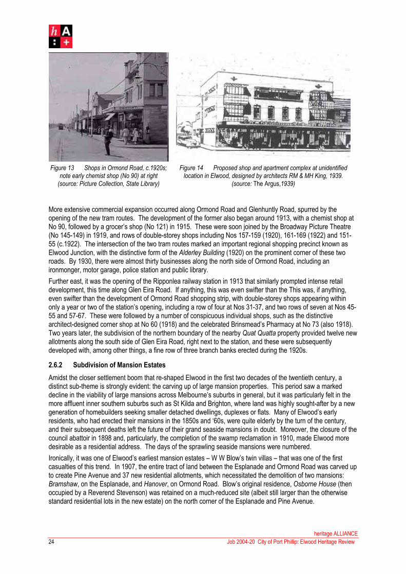
Figure 13 Shops in Ormond Road, c.1920s; note early chemist shop (No 90) at right
(source: Picture Collection, State Library)
Figure 14 Proposed shop and apartment complex at unidentified location in Elwood, designed by architects RM & MH King, 1939.
(source: The Argus,1939)
More extensive commercial expansion occurred along Ormond Road and Glenhuntly Road, spurred by the opening of the new tram routes. The development of the former also began around 1913, with a chemist shop at No 90, followed by a grocer’s shop (No 121) in 1915. These were soon joined by the Broadway Picture Theatre (No 145-149) in 1919, and rows of double-storey shops including Nos 157-159 (1920), 161-169 (1922) and 151-55 (c.1922). The intersection of the two tram routes marked an important regional shopping precinct known as Elwood Junction, with the distinctive form of the Alderley Building (1920) on the prominent corner of these two roads. By 1930, there were almost thirty businesses along the north side of Ormond Road, including an ironmonger, motor garage, police station and public library.
Further east, it was the opening of the Ripponlea railway station in 1913 that similarly prompted intense retail development, this time along Glen Eira Road. If anything, this was even swifter than the This was, if anything, even swifter than the development of Ormond Road shopping strip, with double-storey shops appearing within only a year or two of the station’s opening, including a row of four at Nos 31-37, and two rows of seven at Nos 45-55 and 57-67. These were followed by a number of conspicuous individual shops, such as the distinctive architect-designed corner shop at No 60 (1918) and the celebrated Brinsmead’s Pharmacy at No 73 (also 1918).Two years later, the subdivision of the northern boundary of the nearby Quat Quatta property provided twelve new allotments along the south side of Glen Eira Road, right next to the station, and these were subsequently developed with, among other things, a fine row of three branch banks erected during the 1920s.
2.6.2 Subdivision of Mansion Estates
Amidst the closer settlement boom that re-shaped Elwood in the first two decades of the twentieth century, a distinct sub-theme is strongly evident: the carving up of large mansion properties. This period saw a marked decline in the viability of large mansions across Melbourne’s suburbs in general, but it was particularly felt in the more affluent inner southern suburbs such as St Kilda and Brighton, where land was highly sought-after by a new generation of homebuilders seeking smaller detached dwellings, duplexes or flats. Many of Elwood’s early residents, who had erected their mansions in the 1850s and ‘60s, were quite elderly by the turn of the century, and their subsequent deaths left the future of their grand seaside mansions in doubt. Moreover, the closure of the council abattoir in 1898 and, particularly, the completion of the swamp reclamation in 1910, made Elwood more desirable as a residential address. The days of the sprawling seaside mansions were numbered.
Ironically, it was one of Elwood’s earliest mansion estates – W W Blow’s twin villas – that was one of the first casualties of this trend. In 1907, the entire tract of land between the Esplanade and Ormond Road was carved up to create Pine Avenue and 37 new residential allotments, which necessitated the demolition of two mansions: Bramshaw, on the Esplanade, and Hanover, on Ormond Road. Blow’s original residence, Osborne House (thenoccupied by a Reverend Stevenson) was retained on a much-reduced site (albeit still larger than the otherwise standard residential lots in the new estate) on the north corner of the Esplanade and Pine Avenue.
heritage ALLIANCE
Job 2004-20 City of Port Phillip: Elwood Heritage Review24

25
That year, another large mid-Victorian estate, between Southey and Tennyson streets, was subdivided to create Ascog (now Avoca) Avenue, with the mansion retained on a one-acre lot fronting Southey Street. The next decade saw many other early properties similarly reduced, including Wiltonia on the Esplanade (creating Wilton Grove in 1909), Erindale on Brighton Road (creating Fuller Road and Erindale Avenue in 1911) and OrmondHouse, also on the Esplanade (creating Byrne Avenue in 1914). The trend continued into the 1920s with the subdivision of properties such as Wimbledon (1920), Quat Quatta (1922), Thalassa (1923) and Tiuna (1925).
In all these cases, the mansions themselves were retained on smaller blocks within the new estates, although rarely as single dwellings. The conversion of mansions into multi-unit dwellings was a recurring theme in Melbourne’s more affluent suburbs during the inter-war period, and examples in Elwood included Thalassa on the Esplanade (which became the Greylands Flats in 1925), Wimbledon on Brighton Road (Wimbledon Mansion flatsfrom c.1922), Rothermere on Tennyson Street (a guest house in the 1930s) and Whinbank on Mitford Street (Whinbank Guest House from 1937). Some of these mansions (eg Rothermere) underwent virtually no external alteration, while others (eg Wimbledon) had discreet additions, and still others (eg Himalaya at 6 Tennyson Street, just outside the present study area) were entirely remodelled, now virtually unrecognisable as a Victorian house.But many other mansions were not so lucky. A second wave of subdivision in the 1920s and ‘30s saw the destruction of several mansions that had had already been partly subdivided in the early 1900s. Erindale,probably the oldest surviving house in Elwood at that time, was razed in 1923 for six new lots on the north side of Fuller Road, while the mansion that had been retained off Avoca Avenue in 1907 was finally destroyed almost thirty years later, subdivided in 1936 to create Avoca Court. Other casualties included Arranmore (1918) and Chiverton (c. 1920s), both on Brighton Road, and Monkstadt on Maryville Street (1929).
This tendency to subdivide mansion estates had abated considerably in Elwood by the late 1930s, simply because most of them had already been developed by that time. One of the last casualties was a mansion on Southey Street, which was demolished in 1943 to create Southey Court.55 A rare survivor was a Kenwood on the south-west corner of John and Tennyson streets, which remained virtually intact well into the 1950s. The latter frontage was finally subdivided in 1959-60 (subsequently the site of a fine row of walk-up flats(7.31), of aesthetic interest in their own right) while the remaining portion was carved up six years later to create Elwood’s last cul-de-sac development, Greig Court.56 The original stables were retained on a small block at No 4, and managed to survive a few more years until they, too, were razed for apartment development in the 1970s.
Figure 15 Former stables at 4 Greig Court, all that remained of the vast Caenwood property by the early 1970s(source: Picture Collection, State Library of Victoria)
55 Lodged Plan No 16,187, undated but circa May 1943. Land & Survey Information Centre. 56 Lodged Plan No 73,413, dated 24 April 1966. Land & Survey Information Centre.
heritage ALLIANCE
Job 2004-20 City of Port Phillip: Elwood Heritage Review

heritage ALLIANCE
26
Job 2004-20 City of Port Phillip: Elwood Heritage Review
The phase of mansion estate subdivision, which largely re-shaped Elwood in the early twentieth century, is evidenced today by those few mansions that still survive on relatively tiny allotments, by the street nomenclature that records the names of early settlers and mansions (eg Greig Court, Tiuna Grove, Wilton Grove, et al) and by the patterns of subdivision themselves, including the numerous cul-de-sac developments (Avoca Court, Southey Court, Garden Court, Greig Court) and the few strangely curving thoroughfares, originally laid out around mansions since demolished, such as Hennessy Avenue and Monkstadt Street.
2.7 Apartment Living
2.7.1 The Emergence of a Building Type
Fully self-contained apartments were unknown in Victoria until the erection of Melbourne Mansions, a six-storey block of residential flats in Collins Street, in 1906. Several others were subsequently built in central Melbourne, but it was not until 1911, with the completion of Fawkner Mansions in Commercial Road, South Yarra, that they began to spread into suburbia. As Terry Sawyer has noted, investors looked to certain ‘better suburban locations’ as flats became more popular, principally those that were well served by shops and public transport, and, with a degree of character, atmosphere and, preferably, good views.57 With criteria such as this, flats initially began to proliferate in East Melbourne before spreading south of the river to South Yarra, Prahran and Toorak. But the seaside suburbs of St Kilda, Elwood and Brighton offered something that even these could not, and it was they, in particular, that became Melbourne’s epicentres for flat development. As Sawyer further noted:
Not only did St Kilda enjoy good public transport, but it had a reputation as a pleasant seaside resort. The combination of good transport facilities, good access to parklands and established seaside character made St Kilda an attractive proposition for investors in flat development. 58
Indeed, St Kilda became the site of some of Melbourne’s earliest purpose-built apartment blocks, with two notable examples proposed in Fitzroy Street as early as 1912. One, not actually realised, was designed by architects Tunbridge & Tunbridge (who had pioneered the apartment typology with their Whitehall Flats, completed six years earlier) while the other, Majestic Flats at No 153, was an imposing five-storey block that was, at the time, one of the largest in Melbourne. These were followed by others, including a block in Canterbury Road (1913) and another on the corner of High and Barkly streets (1917), and the trend would continue for another two decades. Apartment blocks of flats, of various eras, subsequently became a dominant characteristic of Elwood and, even today, they still constitute some 65% of Elwood's dwellings.59
2.7.2 Apartment Development in Elwood to 1940
In many respects, Elwood represented an even more desirable locale for apartment development because, unlike St Kilda, it was still underdeveloped at the turn of the century. With the completion of the swamp reclamation in 1905, and the expansion of the tramway networks soon after, land became more available, more desirable and more accessible. One of the first purpose-built blocks of flats in Elwood was built at 73 Mitford Street in 1917, which was designed by architects Schreiber & Jorgensen. This was followed by several blocks along Ormond Road, including Ormond Mansions at Nos 40-42 (1919) and Wandsworth at No 13 (c.1920). Over the next two decades, apartment buildings sprung up across Elwood at an alarming rate to the point that they, as Andrew Ward observed, ‘overwhelm the neighbourhood’.60 Needless to say, the flats themselves display considerable variety in terms of their type and style. By far the most common manifestation was walk-up flats in blocks of two or three storeys, but there were also courtyard developments, sprawling multi-storey blocks, and a few oddities like the rare and unusual bungalow court development, Cromer Court, at 22-24 Kingsley Street, of 1940 (7.16).
57 Terry Sawyer, ‘Residential Flats in Melbourne: The Development of a Building Type to 1950’, 58 Terry Sawyer, ‘Residential Flats in Melbourne: The Development of a Building Type to 1950’, 59 ‘Australian Places: Elwood, Victoria’, <www.arts.monash.edu.au/ncas/multimedia/gazetteer/list/elwood.html#elwdpop>
60 Andrew Ward, City of Port Phillip Heritage Review, Vol 1, pp 115-16.

27
heritage ALLIANCE
Job 2004-20 City of Port Phillip: Elwood Heritage Review
Stylistically, Elwood’s inter-war flats exhibit many of the architectural styles that were fashionable during that time: Tudor Revival, Mediterranean and Spanish Mission (considered highly appropriate for Elwood’s seaside position) and, in particular, the Functionalist idiom, which spread through Elwood (as it did elsewhere) in the late 1930s.Still other examples were built in hybrid and eclectic styles the defied classification – as in the case of the eye-catching Hoods Court at 2 Hood Street, built c.1927 (7.12). Elwood’s inter-war flats also represent the work of some of Melbourne’s finest and most highly-regarded (both then and now) residential architects, including Best Overend, Bernard Evans, Leslie J W Reed, W H Merritt, J H Esmond Dorney and Seabrook & Fildes – the last being responsible for a standout example, Park Court at 473 St Kilda Street, in 1938 (7.30).
J H Esmond Dorney is an important figure in any discussion of flat development in Elwood, as he was not only prolific in the area but was also a long-time local resident. Born in Ascot Vale in 1906, Dorney and his family relocated to Elwood when he was about fourteen years old, occupying a house named Chenier on the corner of Glenhuntly Road and Bluff Avenue. Dorney studied architecture at University of Melbourne in 1925-26 and then worked in the Melbourne office of celebrated American architect Walter Burley Griffin before commencing his own practice in 1930. One of Dorney’s first apartment projects in Elwood was Surrey Court at 71 Ormond Road (1933), and a year later, he converted his family home, Chenier, into a block of flats. His mother, Mrs Marie Louise Dorney, was evidently so happy with the result that she subsequently commissioned him to design several other blocks of flats in Elwood over the next few years, including Antigone at 34 Docker Street (c.1937; 7.10) and the first St Kiernan’s Flats at 51 Ormond Esplanade (1939; 7.19). One of his Dorney’s known projects in Elwood, undertaken before he enlisted with the RAAF to serve in the Second World War, was the much somewhat starker Garden Court at 73 Marine Parade, which he designed for his father-in-law, John R Lambie, around 1940. (7.18)
2.7.3 Apartment Development in Elwood from 1940
Andrew Ward has noted that the inter-war apartment boom marked the final significant phase of development in Elwood.61 This, however, is only partly correct. Certainly, the apartment boom had abated considerably by the early 1940s, when the increasing gravity of the Second World War prompted restrictions in labour and building materials that continued well into that decade. In Elwood, the last gasp of the inter-war apartment boom is evident in the more austere apartment developments such as the aforementioned Garden Court by Esmond Dorney, by the cluster development in Southey Court (1943), and, after the War, in Rajon at 3 Tennyson Street (1946) and Deansgate at 9 Southey Street (1949).62
With restrictions on building activity lifted by the mid-1950s, Elwood experienced a second wave of apartment development that burgeoned over the next two decades. Unlike its inter-war counterpart, which was defined by relatively low-scaled walk-up flats, this phase was marked by the emergence of some new typologies of multi-unit dwelling. Low-scale walk-up flats were still erected, their form and planning now influenced by the growing importance of motor vehicles– such as the sprawling row of cream brick flats at 63-69 Tennyson Street (1959-60, 7.31), with ground-floor carports, single units above, and larger three-storeyed blocks at the rear. The influence of the car is also evident in the atypical motor court development at 2 Southey Grove (1955), comprising a cluster of detached single-storey units around a courtyard. However, the most common manifestation was the more compact blocks of mid-rise flats, of four, five or even more storeys, which became ubiquitous in Elwood (and St Kilda) in the 1960s and 70s. As Ward has noted, this most often occurred near the foreshore (eg Marine Parade, Ormond Esplanade), where pressure for redevelopment was greatest.63 Other epicentres were those streets that provided views across public reserves – notably those overlooking the Botanical Gardens (viz Dickens Street, Tennyson Street and Herbert Street), Elsternwick Park (St Kilda Street), Robertson Gardens (Barkly Street) and Clarke Reserve (Mitford Street, and the south end of Lindsay Avenue).
61 Andrew Ward, City of Port Phillip Heritage Review, Vol 1, p 132.
62 Robin Grow. Elwood Walk: An Art Deco Society Inc Walk, pp 4, 17.
63 Andrew Ward, City of Port Phillip Heritage Review, Vol 1, p 132.

Figure 16 A selection of fine architect-designed post-war apartment blocks in Elwood(source: photographs by Heritage Alliance, 2005)
Unlike the inter-war period, when Elwood’s apartment blocks were characterised by a broad stylistic eclecticism, this new generation of flats were more homogenous in their materials, compositions and detailing. A few examples harked back to the Functionalist style of Elwood’s inter-war heyday, such as the remarkably retardataireflats at 6a Dickens Street (just outside the present study area) or the fine three-storey cream-brick block at 33 Pine Avenue, circa 1960 (7.24). Most of the large apartment blocks erected between 1955 and 1965, however, were realised in a lively contemporary style: stark rectilinear volumes in cream brick or orange brick, typically with flats roofs, bold cantilevered balconies, expressed stairwells and broad windows, sometimes even curtain-walled like contemporaneous office buildings. These were often enlivened by playful Featurist detailing such as decorative concrete block screens, projecting brickwork, mosaic tiled spandrel panels and balcony railings with mild steel grilles or geometric design, sometimes with Colourback or wired glass infill. A number of fine examples still exist in a highly intact condition, retaining these evocative and playful details, such as 7 and 9 Tennyson Street. Andrew Ward has also identified a few ‘particularly exemplary’ examples at 76 Mitford Street, and at 39 and 44 Southey Street.64 Of some concern is the fact that a number of these visually arresting apartment blocks have already been unsympathetically remodelled in very recent times by rendering, by the removal or overpainting of decorative detailing, and the addition of stick-on mouldings and cornices in the currently fashionable Tuscan or Georgian Revival idioms – such as the two glaring examples in Robert Street.
Some of Elwood’s finest examples of post-war apartment blocks represent the work of a generation of European-trained émigré Modernist architects such as Dr Ernest Fooks (born 1906), Kurt Popper (born 1910), Mordachai Benshemesh (born 1911) and Anatol Kagan (born 1914), who all arrived in Australia after the Second World War and settled in Melbourne’s southern suburbs, subsequently playing a significant role in the reshaping of these areas. It is something of an irony that these architects, who designed numerous apartment blocks in Elwood, are otherwise not well represented in regard to individual detached dwellings – a notable exception being the house at 32 Byron Street that Kurt Popper design for prominent Melbourne hotelier Les Erdi in 1962 (7.07). In general, detached individual dwellings were relatively uncommon during Elwood’s post-war apartment boom, simply because of the intense pressure for multi-unit projects that made such valuable land unviable to low-density living.During the 1960s, those who could actually afford to bulldoze an existing Victorian or Edwardian house in Elwood to erect a new residence could also afford to engage an architect to produce a fine contemporary design – clearly evident in the relatively few examples of large houses built in Elwood in the 1960s, such as 14 Burns Street, 9 Byron Street and 19 Lindsay Avenue (7.17)
64 Ibid, Vol 1, p 116.
heritage ALLIANCE
Job 2004-20 City of Port Phillip: Elwood Heritage Review28

29
heritage ALLIANCE
Job 2004-20 City of Port Phillip: Elwood Heritage Review
3.0 Statement of Significance
What is Significant?
The study area, comprising most of Elwood plus the small portion of Ripponlea within the City of Port Phillip, is bounded by Head Street, St Kilda Street, Glenhuntly Road, Hotham Road, Grosvenor Street, Dickens Street and the coastline. The area is traversed by several major thoroughfares including Brighton Road, Tennyson Street and Mitford Street (running north-west/south-east), by Barkly Street and St Kilda Street (running north-south) and by Glenhuntly Road (running east-west), by the railway line in the north-east corner, and by a prominent coastal roadway (Marine Parade/Ormond Esplanade) that separates the zone of residential settlement from the broad foreshore reserve. The coastline itself culminates with the projecting bluff of Point Ormond, in alignment with Glenhuntly Road, with the Elwood Beach extending to the south and, to the north, the entrance to the Elwood Canal – the suburb’s other defining element, which winds through the study area and beyond into the adjacent City of Bayside. Developed from the early 1850s, Elwood was subject to several successive phases of residential settlement, some more successful; than others, which are evidenced today in its layering of nineteenth century mansions, Boom-era subdivisions, Edwardian housing and inter-war and post-war apartment development that now strongly characterise the study area.
How is it significant?
The study area is of historical, aesthetic, architectural significance to the City of Port Phillip.
Why is it significant?
Historically, the area is significant as one of the earliest points of European occupation amongst what is now the metropolitan area, with settlement dating back to a quarantine station that was established on Pont Ormond in 1840. It is significant as one of Melbourne’s most prestigious residential addresses in the nineteenth century, developing from the 1850s with sparsely-located seaside mansions estates, many of which were occupied by leading citizens of the day including politicians and businessmen. It is significant as the site of the Elwood Swamp, a ubiquitous feature in the area in the nineteenth century until its reclamation in the 1890s. The Elwood Canal, which formed part of the reclamation project, is of historical significance in its own right as one of a small number of canals that developed in Victoria in the late nineteenth century, and the only one in metropolitan Melbourne that bisects a residential area. Elwood Beach is of significance as one of Melbourne’s most important locations for foreshore recreation from the 1910s until the present day, the site of countless beachside carnivals, sporting events, and the home to numerous local sporting and recreational groups. Elwood is also of significance as one of the few inner suburbs that did not experience intense residential development during the Land Boom period of the 1880s, which, in turn, gave rise to a subsequent phase of concentrated settlement during the early twentieth century. The latter included a phase of apartment development that is of significance as one of the most dramatic and concentrated in Melbourne’s history.
Aesthetically, the area is significant as for its fine and eclectic mixture of architectural styles that represent the multi-layered history of the suburb’s development. This includes some rare surviving streetscapes of intact Boom-period speculative housing (eg John, Byron and Moore Streets and Hotham Grove) and some particularly fine streetscapes of late Edwardian housing in red brick (eg Addison, Ruskin and Meredith Streets), some enlivened with notable rows of mature street trees. The Elwood Canal, with its bluestone edging, concrete bridges and clusters of mature plantings, remains as a distinctive and visually arresting element in the Elwood landscape. The inter-war apartment and residential boom has also resulted in fine and cohesive streetscapes of 1920s and 30’s housing in various idioms including Spanish Mission, Mediterranean, Tudor Revival, Functionalist and hybrid combinations thereof, quite different in style but otherwise united by their common type and scale (typically two and three storeys) and palette of materials (rendered brick, face brick, terracotta tiled roofs, etc). A number of later apartment blocks – evidence of the development boom spilling into the post-war period – are of aesthetic interest in their own right for their bold, contemporary designs enlivened with Featurist decorative detailing that often remains intact and so evocative of its era.

heritage ALLIANCE
30 Job 2004-20 City of Port Phillip: Elwood Heritage Review
Architecturally, the area is significant as something of a showpiece for the work of some of Melbourne’s most important and highly-regarded twentieth century architects and architectural firms. With particular regard for the intense apartment development that characterised the region from the late 1910s to the 1970s, Elwood includes examples of the residential work of such noted inter-war designers as Bernard Evans, Leslie J W Reed, Arthur Plaisted, Seabrook & Fildes; during the post-war period, this was supplemented by work of important European-trained émigré Modernist architects who had settled in Melbourne’s southern suburbs, such as Kurt Popper, Dr Ernest Fooks and Mordachai Benshemesh. Beyond the residential sphere, Elwood also contains fine examples of ecclesiastical buildings by equally important architects who are strongly associated with various denominations, including inter-war churches by North & Williams (Anglican), Alec Eggleston (Methodist), J F D Scarborough (Presbyterian) and A A Fritsch (Catholic), and a fine post-war synagogue complex by Kurt Popper.

31
heritage ALLIANCE
Job 2004-20 City of Port Phillip: Elwood Heritage Review
4.0 New Precincts

heritage ALLIANCE
32 Job 2004-20 City of Port Phillip: Elwood Heritage Review

33
heritage ALLIANCE
Job 2004-20 City of Port Phillip: Elwood Heritage Review
4.1 Addison Street/Milton Street Residential Precinct
Existing Designations:
Heritage Council Register: nil
National Estate Register: nil
National Trust Register: nil
History: Although reclamation of the Elwood Swamp began in 1889, the area that it occupied – bounded by present-day Marine Parade, Dickens Street, Mitford Street and Shelley Street – still remained largely undeveloped at the turn of the century. The MMBW Map, dated December 1897, shows that the triangular tract of land between Barkly Street, Dickens Street, Mitford Street and the newly-formed canal was entirely vacant at that time.Indeed, the only buildings in the area were two modest timber villas on Marine Parade (one on the south corner of Thackeray Street), and a small cluster of non-residential structures on the southwest corner of Dickens and Barkly streets. Directories reveal that the latter was the property of Matthias Lyons, subsequently listed as a dairy and, from 1909, as a grainstore. That year’s directory also reveals that there were still only two houses on Marine Parade between Dickens Street and the canal: Eileen, occupied by J Jackson, and Vine Cottage, occupied by Henry James.
It appears that closer settlement commenced soon afterwards, as the directory for 1910 recorded five new houses along Marine Parade. Two of these were still listed as ‘vacant’ while another was occupied by George Dean, his wife Ethel, and their young daughter Mary Winifred ‘Molly’ Dean (born 1905) who, two decades later, would become one of the most well-known residents of Elwood through very tragic circumstances. George Dean, one of the earliest residents of Marine Parade, had been joined, by 1911, by Thomas Dow, G Sharp and A M Ross, the last being the occupant of a large red brick villa, Rothes, on the prominent Dickens Street corner.
Development soon spread beyond Marine Parade, down the adjacent portions of Dickens Street and Thackeray Street. A solitary house on the south side of Dickens Street, between Marine Parade and Barkly Street, first appeared in the 1911 directory, identified as Frencha and occupied by Edward Vaughan. A year later, two more houses had been built alongside Vaughan’s Frencha, followed by another by 1913, and then another by 1914.These five early houses, originally Nos 107-115, survive as 77-85 Dickens Street. Nearby Thackeray Street first appeared in the 1912 directory, with a single resident, Benjamin Baker, at what later became No 35 (subsequently changed to 27, and since demolished). The next year, Baker was listed with ‘two vacant houses’ alongside.There were five houses in total by 1915 - a figure that had doubled by 1918, when the directory listed seven residents on the north side (including Nos 2, 6 and 6) and thirteen on the south. The latter, in fact, was then entirely filled out, with no remaining vacant lots and new houses designated as Nos 9-27 and 31-35 (now Nos 1-19 and 23-27).
Further inland, development of the reclaimed swamp was initially concentrated on Ruskin Street, which first appeared in the 1913 directory with six new houses on its east side (three listed as ‘vacant’) and another two vacant houses on the west side. A single house had also been built on the north side of Milton Street that year, between Ruskin and Mitford Street, occupied by Robert Glasscock. A year later, Glasscock had four new neighbours (with another ‘house being built’), plus five new houses on Milton Street’s hitherto undeveloped south side. By that time, all of the new houses in Ruskin Street were occupied, with another two on the east side listed as ‘being built’. It was also in 1914 that Meredith Street and Addison Street appeared in the directory for the first time: the former had five houses on the east side (one listed as ‘being built’) and four on the west side (with two ‘being built’). Development in Meredith Street was then restricted to the portion between Barkly Street and Marine Parade, where there were three new houses on the south side (then numbered as 9, 19 and 21) and a single ‘house being built’ on the north side.

heritage ALLIANCE
34 Job 2004-20 City of Port Phillip: Elwood Heritage Review
This housing boom burgeoned considerably over the next few years. The seven houses listed in Addison Street in 1914 had increased to twenty by 1915, including three vacant houses, another five under construction, and a shop ‘being built’ near the Meredith Street corner. Meredith Street itself had also flourished by that time, with ten occupied houses, four vacant houses, plus six more houses and another shop listed as ‘being built’. The same directory recorded similar expansion elsewhere, with seven houses under construction in Milton Street, and another eight in Ruskin Street. By 1916, a third shop had been erected in the area, being located on the corner of Barkly and Meredith Streets, then occupied by grocer George Bearpark (now Jerry’s Milk Bar). At that time, the total number of houses in Addison Street had jumped from twenty (in 1915) to thirty-two, including five houses recorded as ‘being built’. In Ruskin and Milton streets, most houses previously listed as either vacant or under construction were now completed and occupied. Milton Street, indeed, was fully occupied with 26 residents, while Ruskin Street had tenants in all but five of its 35 dwellings. Amongst Milton Street’s new residents were the Dean family, formerly of Marine Parade. Molly’s father, George Dean, had died in 1913 (two years after the birth of a second child, Ralph) and, four years later, Mrs Ethel Dean moved to a smaller house at 102 (now 86) Milton Street – one of many semi-detached brick dwellings being built in that area at that time.
By the mid-1920s, the former swampland had thus been entirely transformed into a comfortable middle-class residential estate. The end of that decade, however, saw it take on an unexpected notoriety with the brutal murder of Molly Dean. By 1930, she was a 25-year old schoolteacher, aspiring novelist, and sometime artist’s model. She was also engaged to noted artist Colin Colahan, a leading member of Melbourne’s bohemian set, in which Molly herself became an active participant. On the night of 20 November 1930, Molly had attended a film screening in the city with her fiancée and several friends, after which she caught the tram alone to St Kilda Station. Stopping to phone Colahan just after midnight, Molly missed the last tram through Elwood, and had no choice but to walk the three miles to her home in Milton Street. Just before one o’clock, the resident of 5 Addison Street heard moaning, and emerged to find a pool of blood and discarded items of women’s clothing beside the front gate. In a secluded laneway opposite the house, Molly was found in a pool of blood. As the Truth reported on 27 November:
Her head was cruelly battered, her neck swathed in one of her own stockings, and her body so terribly mutilated that only a frenzied ghoul could have been responsible. Mary Dean was not killed in the perpetuation of a criminal offence, she was done to death in a brutal fashion, and so terribly dealt with . . . that the lunacy of jealousy can be the only possible explanation.
Although rushed to the Alfred Hospital, Molly died a few hours later. As her friend Betty Roland later recalled, the murder case subsequently became a cause celebre in Depression-era Melbourne, with a shattering effect on its bohemian community. Molly’s fiancée, the artist Colahan, was the chief suspect until, after a bizarre series of twists, he finally proved that he was at home at the time of her phone to him on that fateful night. Suspicion turned to Adam Graham, a family friend whose appearance and mannerisms matched an eyewitness’ account of a man seen observing Molly at St Kilda station. At the inquest in February 1931, a number of grubby details became known, including the fact that Molly’s mother, who objected to her bohemian friendships, had instructed Graham – with whom she reportedly shared an ‘improper relationship’ - to trail her daughter. The Coroner concluded that Graham was, indeed, the murderer, and he was committed to trail. But a trial never took place. In a final twist, Graham wed the elderly Mrs Dean, ensuring that she could not give evidence against him; a ruling of nolle prosequi was announced, and Graham was set free. The case, which remains unsolved to this day, continues to evoke fascination – it was the basis for George Johnston’s novel, My Brother Jack (1964) and, more recently, inspired a play, Solitude in Blue, produced in Sydney in December 2002.
Physically, the streetscapes of this part of Elwood have changed little since Molly Dean’s time. The intense housing boom of the 1910s left relatively few vacant allotments remaining when Elwood underwent a subsequent boom of residential development during the 1920s and ‘30s. Housing from this era was concentrated in those very few hitherto underdeveloped parts of the precinct, including the portions of Milton and Meredith Street between Addison and Barkly streets, and parts of Addison and Ruskin Street to the south of Meredith Street. The apartment boom of the 1930s, which otherwise characterises so much of Elwood, is barely represented here.Similar, there was very little infiltration in the post-war period, largely restricted to a few multi-storey blocks of flats (mostly in Ruskin Street) and, more recently, some new townhouses, all built on the sites of the precinct’s original Edwardian building stock.

35
heritage ALLIANCE
Job 2004-20 City of Port Phillip: Elwood Heritage Review
Ironically, the house at 5 Addison Street, in front of which Molly Dean was attacked in 1930, was one of the relatively few casualties, and is now occupied by an innocuous block of 1960s flats. The laneway opposite, where her battered body was found, still remains virtually as it was in 1930, its bluestone pitching and ramshackle rear fences still evocative of a brutal event in the history of this leafy and picturesque Edwardian suburb.
Description: The precinct comprises large portions of those principal streets that were laid out following the sale of the reclaimed swampland around 1910: Barkly Street, Addison Street and Ruskin Street (running north-south) and Milton and Meredith streets (running east-west). The precinct also includes some of the smaller streets between Barkly Street and Marine Parade: all of Lawson Street and Lytton Street, most of the Meredith Street extension, and part of Thackeray Street. Finally, the precinct also includes a discrete cluster of buildings on the corner of Dickens Street and Marine Parade, which include some of the earliest houses that were built in the area in the early twentieth century. The streets themselves vary in form; those to the west of Barkly Street (ie Thackeray, Lawson and Meredith Street West) are relatively narrow, having concrete footpaths without nature strips, while those to the east (eg Addison, Milton and Meredith streets) are much wider streets, with nature strips and avenues of mature deciduous trees forming a particularly distinctive element. Most streets retain original bluestone kerbing.
The built fabric within the precinct consists overwhelmingly of late Edwardian housing in the Queen Anne Revival mode (the so-called Federation style), broadly characterised by the use of face red brickwork (often tuckpointed) with roughcast rendered banding and combined hipped and gabled roofs clad in red Marseilles pattern terracotta tiles. Within the precinct, its most common manifestation is in the form of semi-detached pairs. These mostly have symmetrical façades, each half being expressed as a mirror-reversed single-fronted dwelling, often with a curved, canted or rectangular bay window with timber-framed casement sashes and highlights, and a half-timbered and/or roughcast-rendered gable end to the street. Each individual house has an attached verandah along the outer side or, in some cases, a recessed porch to the inner side, flanking a central party wall (eg 81-83 Dickens Street). Both variations use a standard vocabulary of timber posts (typically turned, sometimes plain, tapered or stop-chamfered) with timber slat or fretwork friezes and matching brackets. The most cohesive strips of this type of housing can be seen in the northern and southern extremities of Addison Street, the southern end of Ruskin Street, and along Lytton Street. The last named is particularly notable for recurring details such as timber brackets to roof eaves and window awnings, although the houses themselves have been somewhat compromised by the overpainting of original face brickwork.
Amongst these ubiquitous semi-detached red brick pairs, there are a few anomalous examples that hark back to the Victorian era in their form and detailing. The two pairs at houses at 8-14 Addison Street, for example, have atypical corrugated galvanised steel roofs with matching bullnosed side verandahs, and ripple iron awnings to the bay windows. At 69-71 Milton Street is a pair of single-fronted terraced dwellings, which are unmistakeably Edwardian in their red brickwork, rendered banding and tiled roof, but otherwise recall the previous generation in their use of vermiculated ornament and cast iron verandah friezes. The semi-detached pairs also include a few examples that are expressed (or disguised) as a single double-fronted detached dwelling in the Victorian mode: an asymmetrical street frontage with a projecting bay to one side with a recessed wing alongside, sheltered by a broad verandah. Examples include 77-79 Dickens Street, 31-33 Meredith Street and 65-65a Milton Street. There are also a few detached single dwellings in the precinct that evoke this Victorian Survival mode, such as 29 Meredith Street and 85 Dickens Street – the latter formerly Edward Vaughan’s Frencha, one of the oldest surviving houses in the precinct.
Otherwise, the detached Edwardian houses in the precinct are in the form of red brick Federation-style villas, with materials and detailing comparable to semi-detached houses described above. A fine row at the eastern end of Milton Street includes examples with curved (Nos 68, 55) or canted (Nos 66) bay windows, and some that display somewhat atypical elements such as a slate roof (No 66), canted verandah (No 68) or an attic storey (No 58). Many of the larger and more prominently-sited villas in this area (eg 57, 67 and 70 Ruskin Street) have return verandahs; amongst the more notable is the pair flanking the intersection of Milton and Ruskin Street (ie Nos 71 and 73 Milton), which actually appear be a mirror-reversal of the same design, with distinctive splayed corner bay

heritage ALLIANCE
36 Job 2004-20 City of Port Phillip: Elwood Heritage Review
windows at the verandah return. Similar detailing can be seen in two interesting villas at 29 and 34 Addison Street. Another particularly fine villa (and one of the oldest in the precinct) is the former Rothes at 52 Marine Parade, having a prominent return verandah with tessellated floor, turned posts and oversized curved brackets.
Contemporaneous timber housing is rare within the precinct, and is almost entirely restricted to the older portion, west of Barkly Street. A number of timber villas in Lawson and Meredith streets achieve cohesion through their double-fronted form, weatherboard cladding and hipped corrugated galvanised steel roofs; individually, however, they differ in composition and detailing. Some have asymmetrical frontages in the Victorian Survival mode, with canted bay windows (2 Lawson Street) or rectangular bay windows (29 and 37 Meredith Street). The last example here is particularly fine, with an atypical block-fronted façade, half-timbered gable end with unusual sunburst motif, and finely detailed verandah. The house at 4 Lawson Street is entirely different, having a symmetrical façade with tripartite casement sash windows that flank a central gabled porch with half-timbered gable ends and stop-chamfered posts. The attic-storeyed weatherboard house at No 3 is exceptional, with a steep tiled roof, roughcast rendered upper walls, curved bay windows, recessed porch and shingled spandrels, set amidst a well-established orchard garden.
As already mentioned in the historical overview, there was relatively little residential development in this part of Elwood during the 1920s. This typically consisted of conventional detached dwellings in the ubiquitous bungalow-style of the period, with face red brickwork and terracotta tiled roofs creating cohesion with the earlier dwellings.These can be seen in the southern end of Barkly Street (which largely developed in the later 1920s) and those portions of Milton Street and Meredith Street between Addison and Barkly Streets. In a few instances, the 1920s houses paid greater homage to the earlier building stock by adopting the same symmetrical double-fronted semi-detached composition; this can be seen in a few isolated examples (such as Lytton Street) or, more extensively, along the west side of Ruskin Street, south of Meredith Street
The development boom that had decreased during the 1920s continued to do so into the 1930s. Multi-storey blocks of flats, ubiquitous elsewhere in Elwood, were rare in this part of the suburb. The few examples include a block of Tudor Revival flats at 292 Barkly Street, and some Art Deco and Functionalist counterparts at 24 Meredith Street, 91 and 102 Milton Street, 16 Tennyson Street and 27 Ruskin Street. These last four listed, although built on the reclaimed swampland estate, fall just outside the boundaries of the proposed heritage area.There are even fewer post-war buildings in the precinct: a solitary block of 1960s flats at 46 Ruskin Street. While there are contemporaneous blocks of flats nearby, notably in the portion of Ruskin Street between Milton and Meredith streets, this, too, is actually just outside the proposed precinct boundary. More recent development is limited to a relatively small amount of townhouses, including those at 19 Thackeray Street, 42 Meredith Street, 77 Milton Street, and several down by the canal (which, again, fall just outside the precinct boundary).
References:
Sands & McDougall Directory. Various.
Travis M Sellers, ‘The Artist, the Fiancée and Murder at Elwood’, St Kilda Chronicle, December 2000, pp 27-28.
Betty Roland, The Eye of the Beholder, Melbourne, 1984. pp 68-75. [this memoir includes an account of the Molly Dean case by someone who knew her well]
Thematic Context:
� Land Reclamation
� Closer Settlement, 1900-1920

37
heritage ALLIANCE
Job 2004-20 City of Port Phillip: Elwood Heritage Review
Comparative Analysis: Within the broader City of Port Phillip, there are relatively few comparable examples of the type of residential development seen on the site of the Elwood Swamp. Most parts of St Kilda, South Melbourne and Port Melbourne were characterised by dense development in the nineteenth century, which left little scope for comparable development in the early twentieth century. The most comparable examples can be found in East St Kilda, where they was relatively little development in the late nineteenth century but a minor residential boom in the first two decades of the twentieth.
In Lambeth Place (part of HO6), the west side of the street comprises a long row of paired houses in red brick, albeit articulated as attached single-fronted terraces, and very similar housing can also be seen in Glenmark Street, albeit in less intact condition. This form, representative of a hybrid Victorian/Edwardian style, is atypical in the Elwood precinct (eg a unique pair at 69-71 Milton Street), which is otherwise characterised by the more mature Queen Anne Revival form of semi-detached housing, with individual asymmetry and collective symmetry.This more mature manifestation can otherwise been seen in East St Kilda streetscapes such as Hawsleigh Avenue (part of HO316), Godfrey Avenue and Kalymna Avenue (the last two having been recently recommended as heritage precincts). Hawsleigh Street is the least extensive of the three, with red brick semi-detached houses extending along only one side of the street. Godfrey Avenue and Kalymna Avenue both have their contemporaneous housing along both sides of the streets; the former (developed from 1914) is more consistent in style, consisting almost entirely of semi-detached red brick pairs, with a single example each of a contemporaneous detached red brick villa and a block-fronted timber dwelling. Kalymna Avenue (also developed from 1914) is more diverse, with an even mix of semi-detached and detached houses of both red brick and timber construction.
These precincts are certainly more intact than the Elwood precinct, in terms of their degree of infiltration by non-contributory buildings - Godfrey Avenue, for examples, has no non-contributory buildings at all. The Elwood precinct stands amongst all other examples in the municipality out for its sheer scale, comprising a network of several interconnecting streets rather than, as is the case in the East St Kilda precincts, a single street. Being a larger precinct, it encapsulates a more varied range of buildings (ie detached and semi-detached housing) as well as a number of contemporaneous shops (the latter not represented in any of the examples in East St Kilda).
Statement of Significance:
What is Significant?
The Addison Street/Milton Street Precinct comprises much of the residential estate that was laid out on the site of the Elwood Swamp in the 1910s: most of Addison Street between Dickens Street and the canal, the portion of Milton Street between Barkly Street and Mitford Street, the portion of Meredith Street between Marine Parade and Ruskin Street, the portion of Ruskin Street between Meredith Street and the Canal, the portion of Barkly Street between Pozieres Street and the canal, all of Lawson and Lytton streets, and most of Thackeray Street. The precinct also includes a small sub-precinct straddling the corner of Marine Parade and Dickens Street, containing some of the earliest houses on the estate. Largely developed in the 1910s, the entire precinct consists overwhelmingly of housing in the Queen Anne Revival (the so-called Federation) style, mostly as semi-detached brick pairs as well as some detached villas of both brick and timber construction, and several contemporaneous shops. There are a relatively small number of later (post-1930) buildings.
How is it Significant?
The Addison Street/Milton Street precinct is of historical and aesthetic significance to the City of Port Phillip.
Why is it Significant?
Historically, the precinct is significant as the largest and most swiftly-developed residential estate in Elwood, more substantial and more successful than even the largest speculative subdivisions of the 1880s boom period. Developed from c.1910 and almost entirely filled out by 1920, the estate provides evidence of the intense residential development in this part of Elwood, prompted not only by the reclamation of the Elwood Swamp but also by the expansion of the tramway network in the early twentieth century.

The precinct is also important as a marker for the site of the Elwood Swamp itself, a ubiquitous presence for Elwood’s early residents for fifty years prior to its reclamation at the turn of the century. Certain parts of the precinct are also of historic and social significance for their association with local resident Molly Dean, whosebrutal (and still unsolved) murder in 1930 was a cause celebre in Melbourne at that time and continues to evoke fascination; these sites include her house at 86 Milton Street and the actual murder site in a laneway opposite 5Addison Street.
Aesthetically, the precinct is significant for its fine and cohesive streetscapes of housing in the Queen AnneRevival idiom of the early 1910s, characterised by asymmetrical composition, terracotta tiled roofs, face redbrickwork with rendered banding, bay windows and verandahs or porches with turned timber posts and ornamental timberwork. Within this broad cohesion, the precinct nevertheless exhibits a fine degree of variety in its late Edwardian building form (semi-detached and detached houses) and detailing, which is further enhanced by a lesser number of contemporaneous houses of timber construction, and some brick shops. Later building stock (ie 1920s and ‘30s) is mostly sympathetic in scale and materials, and is largely representative of its era. Thehousing in the streets to the east of Barkly Street are greatly enhanced by their setting: sympathetic (if not original) timber picket fences, particularly wide streets with bluestone kerbing, and broad nature strips with mature deciduous trees creating a leafy and enclosing canopy.
Recommendations: Buildings and street trees recommended for inclusion in the Schedule to the HeritageOverlay Table in the Port Phillip Planning Scheme.
The site of Molly Dean’s murder (that is, the laneway off Addison Street) should be interpreted.
Assessment: Simon Reeves, Heritage Alliance.
Typical row of semi-detached Queen Anne Revival housing in Ruskin Street
Unique Victorian/Edwardian hybrid terrace housing at 69-71 Milton Street
heritage ALLIANCE
Job 2004-20 City of Port Phillip: Elwood Heritage Review38

39
Former grocer’s shop (now Jerry’s milk bar) at 345 Barkly Street, erected c.1915
Substantial Edwardian brick villa at 52 Marine Parade; note intact return verandah
Former residence of Molly Dean and her family at 86 (formerly 102) Milton Street
Site of Molly Dean’s 1930 murder: the narrow laneway opposite 5 Addison Street
Row of 1910s detached weatherboard cottages on north side of Lawson Street
Exceptional block-fronted late Edwardian timber cottage at 37 Meredith Street
heritage ALLIANCE
Job 2004-20 City of Port Phillip: Elwood Heritage Review

heritage ALLIANCE
Job 2004-20 City of Port Phillip: Elwood Heritage Review40

41
heritage ALLIANCE
Job 2004-20 City of Port Phillip: Elwood Heritage Review
Significant
Addison Street: 2, 6, 8, 10, 12, 14, 15, 16, 17, 18, 19, 20, 21, 22, 23, 24, 25, 26, 27, 28, 29, 30, 31, 32, 33, 34, 35, 36, 38, 39, 40, 41, 42, 44, 45, 46, 47, 48, 49, 50, 51, 52, 54, 55, 56, 57, 58, 59, 60, 61, 63, 64, 65, 66, 67, 68, 69, 70, 71, 72, 73, 74, 75;
Barkly Street: 296, 298, 300, 302, 304, 306, 308, 310, 312, 314, 316, 318, 320, 322, 323, 324, 325, 326, 327, 328, 329, 330, 331, 332, 333, 334, 335, 336, 337, 338, 339, 340, 341, 342, 343, 344, 345, 346, 347, 348, 349, 350, 351, 353, 355, 357, 359, 361, 363, 365, 367, 369, 371, 373, 375, 377;
Dickens Street: 77, 79, 81, 83
Lawson Street: 1, 2, 3, 4, 5, 6, 7, 8, 10
Lytton Street: 1, 2, 3, 4, 5, 6, 7, 8, 9, 10, 11, 12;
Marine Parade: 52
Meredith Street: 6, 8, 10, 11, 12, 13, 14, 18, 19, 20, 21, 22, 23, 25, 26, 27, 28, 29, 30, 31, 32, 33, 34, 36, 37, 42, 44, 46, 48, 50, 52, 54, 56;
Milton Street: 53, 55, 57, 59, 63, 65, 66, 67, 68, 69, 70, 71, 72, 73, 74, 75, 76, 78, 79, 80, 81, 82, 83, 84, 86, 88, 90, 92, 94, 96, 98, 100;
Ruskin Street: 6, 8, 10, 12, 14, 16, 18, 20, 22, 24, 29, 50, 52, 54, 56, 58, 60, 62, 64, 66, 68, 70, 72, 74, 76, 78, 80, 82, 84.
Thackeray Street: 1, 2, 3, 4, 5, 6, 7, 8, 9, 11, 13, 15, 17, 23
Contributory
Addison Street: 4, 11, 13, 37, 62;
Dickens Street: 85
Hood Street: 7
Marine Parade: 53, 54
Meredith Street: 15, 16, 17, 24, 35;
Milton Street: 61;
Non-contributory
Addison Street: 53;
Meredith Street: 9, 38, 40;
Milton Street: 77, 77a;
Ruskin Street: 46;
Thackeray Street: 19;

heritage ALLIANCE
42 Job 2004-20 City of Port Phillip: Elwood Heritage Review

43
heritage ALLIANCE
Job 2004-20 City of Port Phillip: Elwood Heritage Review
4.2 Elwood Canal Precinct
Existing Designations:
Heritage Council Register: nil
National Estate Register: nil
National Trust Register: nil
History: The Elwood Canal was built in stages as part of a grandiose scheme by the Public Works Department (PWD) to reclaim the South Swamp, a ubiquitous feature in Elwood in its earliest phases of post-contact settlement (see Thematic History). Following the alignment of Elster Creek, the canal was intended to drain the marshy land east of St Kilda Street (outside the present study area). Originally, the canal proper was designed to carry only flood water, with a large pipeline to each side to carry the stream at all other times.65 The entire scheme was devised by the PWD with the involvement of Carlo Catani, then Assistant Engineer, who later, as Chief Engineer, would be responsible for reclamation of the St Kilda foreshore, and the landscaping of the park that now bears his name. Construction of the £14,000 canal began in May 1889, with the contractors, Messrs Hendon, Clarke & Anderson, engaging sixty workmen. The first stage, from the beach to Glenhuntly Road, was completed in 1897, being ¾ mile (1.2 kilometres) long, 54 feet (16.5 metres) wide and 11 feet (3.4 metres) deep.The MMBW map, dated December 1897, shows the completed canal, with bridges at Marine Parade, Barkly Street and Glenhuntly Road, with another three indicated at the future alignments of Addison Street, Broadway and Shelley Streets. Only five of these were evidently built, described in one source as cast iron trough girder bridges with a non-structural concrete decking. Along the sides of the canal, metal mooring rings were fitted ‘for the purpose of mooring pleasure boats in the stream’. 66
The new canal, however, was not an immediate success. The two pipelines, intended to carry the everyday stream, were not maintained and soon became blocked. All drainage was consequently discharged into the main channel – its capacity (stated as five feet (1.52 metres) at low tide, and eight feet (2.43 metres) at high tide) was soon reduced by silt deposits. Attempts to solve these problems began in 1899, when the Inspector General of Public Works surveyed the canal and recommended that a barrel drain be built – which, in any case, was not a success.67 In January 1901, tenders were called for the cleaning of the canal. Three years later, further works were proposed as part of a grand £30,000 scheme to improve the area’s drainage. The existing canal was paved with brick and concrete, and construction began on the Elsternwick Main Drain, extending the canal from Glenhuntly Road to the new Gardenvale railway station.68 This was 130 feet (39.6 metres) wide and three feet (0.91 metres) deep, with a central bluestone channel to carry the regular stream, and grassed sloping sides to accommodate flood waters. By the start of 1906, the drain had been completed as far as New Street (outside the present study area, in the adjacent City of Bayside), reaching Gardenvale Station at the end of 1907.
In February 1905, Carlo Catani, by then Chief Engineer of the PWD, had been contacted by engineer John Monash, a pioneer of reinforced concrete construction in Australia, who offered to build a reinforced concrete girder bridge for £1,500, which would be more cost-effective than the cast iron girder bridges that had previously been built across the canal.69 Despite some concerns about the veracity of the new technology, Monash’s company won the contract.
65 Meyer Eidelson, ‘Elwood Canal’, 10pp unpublished typescript. p 4.
66 Ibid.
67 J B Cooper. The History of St Kilda. Vol 1, p 203. 68 L Alves, A Holgate & G Taplin. 'Monash Bridges: Typology study of Reinforced Concrete Bridges in Victoria 1897-1917'.
69 Ibid.

heritage ALLIANCE
44 Job 2004-20 City of Port Phillip: Elwood Heritage Review
Construction of the first bridge, at St Kilda Street, commenced in July 1905 and was completed at the end of September. It was tested in the presence of Catani, the St Kilda City Surveyor and municipal representatives from Brighton and Caulfield, and opened to traffic the following week. Monash went on to design another seven concrete bridges across the canal. Two still survive at Brickwood Street (1906; altered) and New Street (1906-07) in what is now the City of Bayside, while later examples at Marine Parade (1907), Cochrane Street (1907), Elsternwick (1907), Port Nepean Road (1907) and Asling Street (1908) have since been demolished or replaced.
These improvements certainly improved the image of the canal, and the reclaimed swampland nearby, which was mostly sold off in two sales in 1905 and 1910, was subject to intense residential development over the next decade or so. The blocks closest to the canal did not develop until the 1920s; this residential expansion necessitated the construction of a small electrical substation on the north side of the canal, at the intersection of Goldsmith and Byron streets, which still remains.
This period also saw the canal effectively change owners after the passing of the Metropolitan Drains and Rivers Act 1923, now falling under the jurisdiction of the Melbourne Metropolitan Board of Works (MMBW). With problems still in evidence five years later, the MMBW engineers put forward three possible solutions: the construction of sluice gates (to cost £57,000), the enlargement and regrading of the existing canal (£73,000), or the entire refilling of the canal to create land that could be sold off for subdivision (£200,000).70 The last of these options – the most expensive and drastic of the three – was preferred by the both the government and the council.Writing in 1930, J B Cooper emphatically stated: ‘that the work will be done some time is a foregone conclusion’.71
The government, however, refused to subsidise the project, and, even three years later, the council were still unable to gain approval. The 1930s saw the canal receive more bad publicity as the scapegoat for a polio epidemic in Melbourne’s southern suburbs; even this prompted little remedial work until October 1937, when the MMBW announced that it would clear and widen the upper reaches of the Elster Creek.
Little else was done to improve the canal until the 1950s, when over 3,000 residents signed a petition to have flood protection measures taken. In December 1954, the State Government made an allowance of £150,000 was made for the underground diversion of floodwaters. The works, which included a diversion canal through Elsternwick Park, were carefully monitored by the newly-formed Elwood Citizens Vigilance Committee, and completed in April 1958.72 Five years later, the channel, west of St Kilda Street, was reconstructed in order to triple its capacity. At that time, one of Monash’s reinforced concrete road bridges was partly demolished to form a footbridge (at Brickwood Street in Brighton, just outside the present study area). This was followed by the replacement of several other bridges over the next decade or so, including one at Elsternwick (demolished 1965), another at Marine Parade (replaced 1967) and a third at Asling Street (demolished 1975).73 During the 1980 and ‘90s, a number of entirely new footbridges were erected by the City of St Kilda, including a fine laminated timber bridge in the Point Ormond Reserve at the Marine Parade end of the canal (1982).
The most recent addition to the canal reserve has been an installation by artist Maggie Fooke entitled ‘Twenty Seven Stories’, which comprises rows of handmade ceramic tiles, set into the edge of the canal, recording canal-related memories and anecdotes from some of Elwood’s long-term residents including Roslyn Blackman, Pauline Thompson, Don Taggart, Jen Ritchie-Jones, Katie Ragheb and Helen Graham.
Description: The Elwood Canal Precinct includes the entire canal reserve, extending from the foreshore to the municipal boundary at St Kilda Street. It comprises three discrete sections: the foreshore outfall (between the beach and Marine Parade), the Elwood Canal proper (extending from Marine Parade to Glenhuntly Road) and the Elsternwick Main Drain (extending from Glenhuntly Road to St Kilda Street and beyond, into the adjacent City of Bayside).
70 J B Cooper. The History of St Kilda. Vol 1, p 208.
71 Ibid, p 209.
72 Anne Longmire. St Kilda: The Show Goes On. p 161.
73 A Holgate et al. Projects Index: Bridges. <http://home.vicnet.net.au/~aholgate/jm/mainpages/list_bridges.html>

45
heritage ALLIANCE
Job 2004-20 City of Port Phillip: Elwood Heritage Review
At the extreme west end, bisecting the foreshore reserve, the waterway has sloping sides lined with uncoursed rock. The main canal, within a reserve about 35 metres wide, is edged with rough concrete walls, approximately 1.2 metres high, but rising even higher (up to 2 metres) at the bridge crossings. The canal walls have a cement render finish, and an edge capping of large bluestone blocks, 530mm by 230mm. Along both sides of the canal are a series of cast iron mooring rings, at approximately 10 metre centres. Some of these have been removed or damaged. The canal walls are otherwise occasionally penetrated by small terracotta outfall pipes, and, near the various bridges, by outfalls with larger wrought iron pipes. There are also two concrete boat ramps: one at Kent Street, and another just south of Shelley Street.
Between Glenhuntly Road and Marine Parade, the canal proper is flanked by broad expanses, variously grassed or gravelled, forming a reserve. The side fences of adjacent properties form the boundary of this reserve, while the bluestone-pitched laneways, which bisect the residential blocks, open directly onto it. Portions of the canal reserve as partly trafficable, with some adjacent properties having garages or vehicle gateways opening off.Numerous houses also have small pedestrian gates, and some of the inter-war houses and flats (eg 90 Ruskin Street, 2 Shelley Street) have discrete side entrances that provide access to (or from) the canal reserve. One c.1940s block of flats, at 21a Broadway, even has its principal frontage to the canal. Asphalt pathways wind along both sides of the canal; relived by metal lampposts and park benches of relatively recent origin. The 27 Stories installation, along the edge of the canal, comprises rows of narrow ceramic tiles inscribed with handwritten anecdotes ascribed to various local residents. This portion of the canal reserve also includes a number of mature specimens of trees including cypress (particularly on the south side of the canal between Ruskin and Barkly streets), peppercorn, a white poplar (south side, near Addison Street), a Monterey pine (south side, near Broadway) and a row of five Canary Island date palms (south side, near Goldsmith Street)
At Glenhuntly Road, the canal merges with the Elsternwick main drain. At the junction, just south of the bridge, the concrete canal walls give way to sloping bluestone walls, then a lower concrete wall, and then a flat concrete slab that connects to the main drain itself. This is a bluestone-edged channel, approximately 2 metres wide and 500mm deep, that runs along the bottom of a grassed verge. At the two roadways (Wave and Foam streets), there are bluestone fords, with precast concrete culverts covering the channel. Beyond Wave Street, the channel becomes increasingly overgrown with aquatic plantings. Other landscaping elements in this part of the precinct include some particularly ancient gum trees (including one, at Wave Street, reputed to be an Aboriginal canoe tree), several Moreton Bay fig trees (on the south side, between St Kilda Street and Wave Street) and various native plantings, many marked by interpretative plaques.
There are twelve bridges across the Elwood Canal within the present study area, comprising four pedestrian bridges and eight road bridges. The most important of these is the reinforced concrete girder bridge across St Kilda Street, designed by John Monash in 1905. This is 40 feet (12.2 metres) wide and 60 feet long, and comprises three 20 foot (6.1 metre) spans supported on columns with spread footings and small corbels. Each span, in turn, consisting of seven reinforced concrete girders at 4’8” (1.42 metre) centres supporting a concrete deck slab 6½“ (165mm) thick. The footpath, on the west side of the bridge, is supported separately. The abutments are in the form of a row of columns against a retaining wall of precast Monier plates.
Of the remaining road bridges, there are two wide bridges that appear to date from the canal’s initial phase of development in the late nineteenth century. These bridges, at Broadway and Glenhuntly Road, have bluestone plinths and rendered brick pier walls that support deep cast iron girders with a concrete deck and asphalt roadway. The bridges at Addison Street, Ruskin Street and Shelley Street also have stone plinths and brick pier walls, but with an entirely reinforced concrete superstructure. The two-lane bridge at Shelley Street has been reconfigured with median strips (of relatively recent origin) to create a single lane bridge, while the two-lane bridge at Ruskin Street has actually been partly demolished to reduce it to a single lane, with only the bluestone plinths, at the base of the canal, remaining of the demolished half. All of these early bridges have broad asphalt footpaths (some on only one side of the road) and painted metal pipe handrails, most being further protected with galvanised steel safety barriers of more recent origin. The Marine Parade Bridge, erected by the County Roads Broad in 1967, consists of a pair of three-lane reinforced concrete bridges with a superstructure of concrete piers and metal railing.
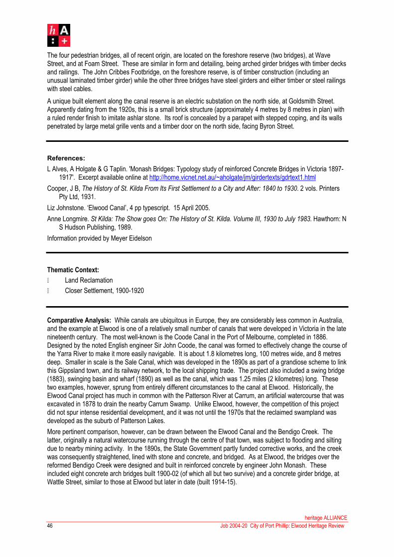
heritage ALLIANCE
46 Job 2004-20 City of Port Phillip: Elwood Heritage Review
The four pedestrian bridges, all of recent origin, are located on the foreshore reserve (two bridges), at Wave Street, and at Foam Street. These are similar in form and detailing, being arched girder bridges with timber decks and railings. The John Cribbes Footbridge, on the foreshore reserve, is of timber construction (including an unusual laminated timber girder) while the other three bridges have steel girders and either timber or steel railings with steel cables.
A unique built element along the canal reserve is an electric substation on the north side, at Goldsmith Street.Apparently dating from the 1920s, this is a small brick structure (approximately 4 metres by 8 metres in plan) with a ruled render finish to imitate ashlar stone. Its roof is concealed by a parapet with stepped coping, and its walls penetrated by large metal grille vents and a timber door on the north side, facing Byron Street.
References:
L Alves, A Holgate & G Taplin. 'Monash Bridges: Typology study of reinforced Concrete Bridges in Victoria 1897-1917'. Excerpt available online at http://home.vicnet.net.au/~aholgate/jm/girdertexts/gdrtext1.html
Cooper, J B, The History of St. Kilda From Its First Settlement to a City and After: 1840 to 1930. 2 vols. Printers Pty Ltd, 1931.
Liz Johnstone. ‘Elwood Canal’, 4 pp typescript. 15 April 2005.
Anne Longmire. St Kilda: The Show goes On: The History of St. Kilda. Volume III, 1930 to July 1983. Hawthorn: N S Hudson Publishing, 1989.
Information provided by Meyer Eidelson
Thematic Context:
� Land Reclamation
� Closer Settlement, 1900-1920
Comparative Analysis: While canals are ubiquitous in Europe, they are considerably less common in Australia, and the example at Elwood is one of a relatively small number of canals that were developed in Victoria in the late nineteenth century. The most well-known is the Coode Canal in the Port of Melbourne, completed in 1886.Designed by the noted English engineer Sir John Coode, the canal was formed to effectively change the course of the Yarra River to make it more easily navigable. It is about 1.8 kilometres long, 100 metres wide, and 8 metres deep. Smaller in scale is the Sale Canal, which was developed in the 1890s as part of a grandiose scheme to link this Gippsland town, and its railway network, to the local shipping trade. The project also included a swing bridge (1883), swinging basin and wharf (1890) as well as the canal, which was 1.25 miles (2 kilometres) long. These two examples, however, sprung from entirely different circumstances to the canal at Elwood. Historically, the Elwood Canal project has much in common with the Patterson River at Carrum, an artificial watercourse that was excavated in 1878 to drain the nearby Carrum Swamp. Unlike Elwood, however, the competition of this project did not spur intense residential development, and it was not until the 1970s that the reclaimed swampland was developed as the suburb of Patterson Lakes.
More pertinent comparison, however, can be drawn between the Elwood Canal and the Bendigo Creek. The latter, originally a natural watercourse running through the centre of that town, was subject to flooding and silting due to nearby mining activity. In the 1890s, the State Government partly funded corrective works, and the creek was consequently straightened, lined with stone and concrete, and bridged. As at Elwood, the bridges over the reformed Bendigo Creek were designed and built in reinforced concrete by engineer John Monash. Theseincluded eight concrete arch bridges built 1900-02 (of which all but two survive) and a concrete girder bridge, at Wattle Street, similar to those at Elwood but later in date (built 1914-15).

47
heritage ALLIANCE
Job 2004-20 City of Port Phillip: Elwood Heritage Review
In its own right, the reinforced concrete bridge over the Elwood Canal at St Kilda Street is a significant element that needs to be seen in the context of other early concrete girder bridges designed by noted engineer John Monash. Two other surviving examples are associated with the Elwood Canal: one at Brickwood Street (1906) and another at new Street (1907), both located outside the present study area in the adjacent City of Bayside. Of these, the former has been partly demolished to create a footbridge while the later has been altered by the replacement of its original railings. The St Kilda Street Bridge is the earliest and most intact of the three. In terms of Monash’s broader oeuvre of reinforced concrete girder bridges, this example is predated only by one erected at Stawell Street, Ballarat, in 1904, which proved unsuccessfully and was subsequently replaced. Other early Monash concrete girder bridges that have been demolished include those examples at Lancefield (1906), Elsternwick (1907), Mount Isaac (1907), Waterfield (1908) and Ararat (1910).
Statement of Significance:
What is Significant?
The Elwood Canal Precinct comprises the watercourse formerly known as Elster Creek, extending from Port Phillip Bay to the municipal boundary at St Kilda Street. It comprises the Elwood Canal proper (1889-97), a stone and concrete-lined waterway between Marine Parade and Glenhuntly Road, and the Elsternwick Main Drain (1904-07), a bluestone channel that extends upstream beyond Glenhuntly Road. The watercourse is spanned by two bluestone fords and twelve bridges, including two remnant nineteenth century bridges (at Glenhuntly Road and Broadway), an early reinforced concrete girder bridge (at St Kilda Street), and a laminated timber footbridge (east of Marine Parade). The canal setting is enhanced by mature landscape elements, namely Moreton Bay fig trees, Canary Island date palms, a white poplar, a Monterey pine and gum trees, and by infrastructure spanning a century, including mooring rings, boat ramps and an electrical substation.
How is it Significant?
The Elwood Canal precinct is of historical, aesthetic, social and scientific (technological) significance to the City of Port Phillip.
Why is it Significant?
Historically, the Elwood Canal is significant as the most accessible and most intact of a relatively small number of canals that were developed in Victoria in the late nineteenth century. It retains important historical associations with the Elwood Swamp, a ubiquitous element in the area in the second half of the nineteenth century, and also with the intense phase of residential development that followed the canal’s completion in 1905. The canal has featured prominently in Elwood’s history for over a century, a fact that is ably demonstrated by surviving elements of infrastructure (eg iron mooring rings, 1920s electrical substation, boat ramps and bridges).
Aesthetically, the Elwood Canal precinct is significant as a prominent element in this suburban landscape. The canal itself, as the only example of its type in the metropolitan area, is a unique element, visible from many parts of Elwood. The aesthetic qualities of the canal reserve are enhanced by its landscaped setting, include numerous mature trees (cypress, Monterey pine, Canary Island date palm, eucalyptus species).
Socially, the Elwood Canal is significant as an important focus for the Elwood community, in both a positive and a negative sense, for over a hundred years. For much of the twentieth century, it was a much-loved venue for swimming, fishing, boating and other recreational activities, while also undergoing phases (such as the recurring threat of flooding, pollution and the polio scare of the late 1930s) when its presence was a source of concern. The precinct remains a strong focus for community interest, including the protection of native flora and fauna. Its social significance is acknowledged by the 27 Stories exhibit, a public art installation that recorded various canal-related memories and musings by a number of local residents.
Technologically, the Elwood Canal precinct is significant for its ability to demonstrate the type and scale of public engineering works in the late nineteenth century. Specifically, the bridge at St Kilda Street is of technological significance in its own right, as Victoria’s earliest surviving example of the type of reinforced concrete girder bridges developed by John Monash, pioneer reinforced concrete engineer, in the early twentieth century.
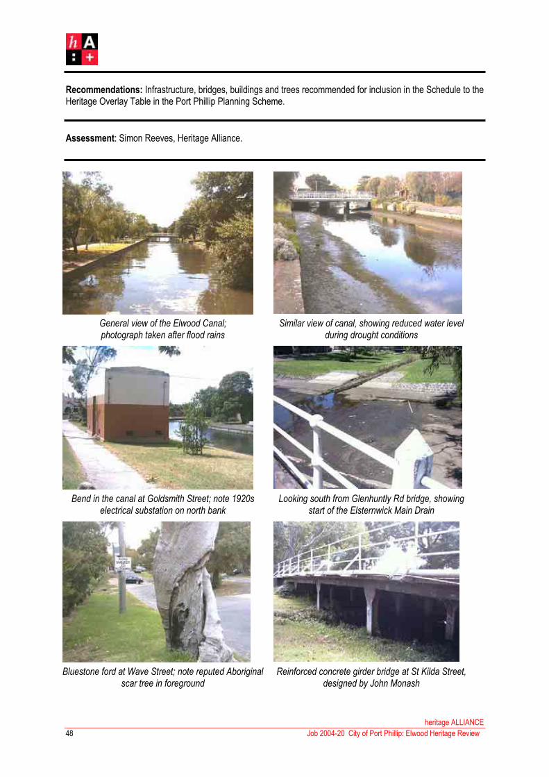
Recommendations: Infrastructure, bridges, buildings and trees recommended for inclusion in the Schedule to the Heritage Overlay Table in the Port Phillip Planning Scheme.
Assessment: Simon Reeves, Heritage Alliance.
General view of the Elwood Canal;photograph taken after flood rains
Similar view of canal, showing reduced water level during drought conditions
Bend in the canal at Goldsmith Street; note 1920s electrical substation on north bank
Looking south from Glenhuntly Rd bridge, showing start of the Elsternwick Main Drain
Bluestone ford at Wave Street; note reputed Aboriginal scar tree in foreground
Reinforced concrete girder bridge at St Kilda Street, designed by John Monash
heritage ALLIANCE
Job 2004-20 City of Port Phillip: Elwood Heritage Review48

49
heritage ALLIANCE
Job 2004-20 City of Port Phillip: Elwood Heritage Review

heritage ALLIANCE
50 Job 2004-20 City of Port Phillip: Elwood Heritage Review

51
heritage ALLIANCE
Job 2004-20 City of Port Phillip: Elwood Heritage Review
4.3 Byron Street/Mason Avenue Residential Precinct
Existing Designations:
Heritage Council Register: nil
National Estate Register: nil
National Trust Register: nil
History: This part of Elwood was still largely undeveloped in the 1870s. The Vardy Survey map of St Kilda, prepared during 1873, shows several large allotments of vacant land flanking the intersection of Byron Street and Brighton Road and, further along, a solitary detached villa on the east corner of Byron and Tennyson. Closer settlement did not occur until the prosperous Boom period of the 1880s with Byron Street, as an existing and principal thoroughfare, being the first to develop. The portion to the west of Tennyson Street was subdivided during 1885, and ten new villas had been built (five on each side of the street) by early 1886. The portion of Byron Street between Brighton Road and Tennyson Street, meanwhile, evidently began to develop a year or two later, as it was not listed in the Sands & McDougall Directory until 1889. This recorded five new houses on the north side of the street, all but one identified as ‘vacant’. The south side of the street, not yet listed in the directory at that time, was subsequently developed from late 1888 with the formation of two small residential estates. The first, gazetted in November 1888, comprised 29 new allotments with frontages to Byron Street, Tennyson Street and newly-formed Moore Street; the second, gazetted in August 1889, consisted of 23 allotments, fronting Brighton Road, Byron Street, and another new street, Cyril Street. A third new street, north of (and parallel to) Byron Street, was also laid out around this time: Moy Street, later renamed Mason Avenue.
Subsequent development of these three new streets was swift; by 1891, Moore Street was completely filled out with thirteen new houses on the east side (of which four were listed as vacant) plus another fourteen houses on the west side (again, with four vacant). Moy Street, meanwhile, had twelve entires along its south side (five being vacant), its north side as yet unlisted. Construction of new houses in Cyril Street was slightly less intense, with four houses on the east side and five on the west. Byron Street, by contrast, had not undergone comparably intense development, notwithstanding its head start. By 1891, only two more houses had been built on the north side of the street, and three on the south side. The latter comprised the pair of double-storey terraces that still stand at Nos 15-17, and a detached villa (since demolished) on the south-west corner of Moore Street.
The MMBW map of the area, dated 1897, shows that development had, in fact stagnated. By that time, there had been no further construction in Byron Street, Moy Street or Cyril Street, and only one more house on each side of Moore Street. The latter included a general store at No 16, operated by one Joseph Shead, which first appeared in the directory in 1896. This development lag would continue for the next decade or so, with only two more houses being built: one at 23 Moy Street (c.1904) and another at 23 Byron Street (c.1907). During this period, the general store at 16 Moore Street remained operated by its original owner, Joseph Shead, until around 1911. It would subsequently be operated by a succession of grocers including John Allen (1913), Percy Dowker (1915), R Glenwright (1920s), and Mrs L Mitchell (1930s).
Residential development in this part of Elwood did not pick up again until the 1910s. Much of this was concentrated in the hitherto under-developed areas such as Cyril Street, which saw new houses erected at Nos 11, 13 and 15 (c.1912) and, on the east side, Nos 2, 4, 6, 8 and 16 (all c.1917). In Byron Street, the Sands & McDougall Directory listed three new houses on the south side (Nos 9, 11 and 13) in 1913, followed by ‘two houses being built’ on the north side (Nos 8 and 8a) in 1917, another three houses (Nos 20, 22 and 24) in 1918, and two more on the south side (Nos 19-21) in 1919. The few remaining vacant lots on the south side of Moy Street (which became Mason Avenue around 1917) were also developed during this time, with new houses at No 25 (1915), No 1 (1916), Nos 43-47 (1916) and Nos 15-17 (1917). With the completion of the last two, listed in the 1918 directory as ‘two vacant houses’, the south side of the street was entirely filled out.

heritage ALLIANCE
52 Job 2004-20 City of Port Phillip: Elwood Heritage Review
The inter-war development that characterises much of Elwood did not leave much of an imprint on this older and more established part of the suburb, simply because most of the allotments had already been developed by that time. The last few remaining vacant allotments were finally developed during the 1920s and early 1930s, comprising a detached weatherboard house at 7 Cyril Street (first listed as ‘vacant’ in 1923), and a semi-detached brick duplex at 17a-19a Byron Street (c.1934). Other residents were merely content to update their existing houses, as was the case with Pekina, the Victorian brick villa at 2 Byron Street, which was externally remodelled with a new timber-framed windows and flat-roofed verandah with ubiquitous tapered pillars.
Still others saw the benefit of demolishing their houses and replacing them with multi-unit dwellings, reflecting a trend that was spreading throughout Elwood at the time. During the 1930s, a semi-detached duplex was erected on the site of two adjacent timber cottages at 17-19 Moore Street and, in Cyril Street, a small double-storey block of flats, Christina Court, built on a site originally occupied by another two cottages. Not surprisingly, this trend of removal and redevelopment was to continue into the post-War period. Casualties during the 1960s and ‘70s included early timber cottages (eg 27-31 Moore Street; 6-8 Cecil Street) and several of the grand brick villas in Byron Street (Nos 6, 16 and 25), which were all razed for new two- and three-storey blocks of flats. Amongst all these new flats, two new detached houses were also built in the post-war period: a faux double-storey terrace house at 35 Mason Avenue, and, at the other end of the architectural spectrum, a particularly fine architect-designed brick townhouse at 9 Byron Street.
Development of this sort within the precinct had abated considerably by the 1980s, and only three new houses have actually been built since then: three double-storey townhouses in Moore Streets (Nos 2a, 18 and 21) and a single-storey house at 25 Mason Avenue.
Description: The precinct comprises the portion of Byron Street between Brighton Road and Tennyson Street, the two narrow dead-end streets (Moore Street and Cyril Street) that extend from its south side, and a parallel but narrower thoroughfare (Mason Street) to the north of Byron Street. The streets themselves are characterised by bluestone kerbing and relatively narrow footpaths, without nature strips. The streets that were laid out in 1888-89 (ie Mason Avenue, Moore Street and Cyril Street) are quite narrow, the last two being dead-ends. Byron Street, the older thoroughfare that pre-dates actual residential development, is considerably wider; a number of bluestone-edged garden beds have been formed in recent years along the edges of the roadway, to enclose angle parking bays.
Predominately developed in the period 1888-93, the precinct exhibits considerable variety, even amongst its late nineteenth century building stock. There are large detached masonry villas, for example, contrasting with rows of humbler working-class timber cottages. The former, restricted to the north side of Byron Street, comprise an intermittent row of five single-storey brick villas (Nos 2, 4, 14, 18, 24). These are (or at least once were) virtually identical, with asymmetrical double-fronted facades, canted bay windows, rendered chimneys with moulded caps, hipped roofs with bracketed eaves, and ornate verandahs. Three are bichromatic brick (eg Nos 14, 18, 24) while two were rendered; one of the latter (No 4) has unfortunately been sandblasted to expose the brick substrate.Roofs are invariably slate (Nos 4, 14, 24), with one in corrugated galvanised steel (No 18) and another (No 2) reclad in terracotta tiles. Verandahs also vary in detailing. Nos 4, 18 and 24 and 18 remain intact, with cast iron columns, lacework friezes and brackets; that at No 4 is particularly fine, having a atypical return verandah with tessellated floor, paired columns, and an ornate frieze enlivened with a dentillated cornice and nailhead mouldings. The verandahs of Nos 2 and 14 were entirely rebuilt during the interwar period, respectively with tapered rendered pillars and squat fluted columns.
There is a cohesive row of double-fronted asymmetrical timber villas at 20-28 Moore Street, somewhat less ostentatious than their masonry counterparts in Byron Street. These are all block-fronted, with hipped roofs variously clad in slate (No 24, 26), corrugated galvinised steel (No 28), Colorbond (No 20) or pressed metal sheet (No 22). Verandahs generally retain plain or stop-chamfered posts, with cast iron lace; one verandah has been altered (No 20) and another entirely removed (No 24). All these houses have original paired windows with timber-framed double-hung sashes and, in the case of Nos 26-28, ripple iron awnings on timber brackets.

53
heritage ALLIANCE
Job 2004-20 City of Port Phillip: Elwood Heritage Review
The more modest single-fronted Victorian cottages, which proliferate in Moore Street and Mason Avenue, are typically of timber construction, either block-fronted or conventional weatherboard. A few (eg 11 and 13 Mason Avenue) have atypical beaded weatherboard, and there is also a unique roe of attached brick cottages at 1-9 Moore Street. Cottages in Moore Street tend to have hipped roofs with bracketed eaves (eg Nos 1-9, 4, 6, 8, 11, 13 and 33 Moore Street), while those in Mason Avenue and Cyril Street invariably have pitched roofs, with a gable front to the street. A number of the gabled houses have a distinctive façade detail, whereby the side eaves partially return across the street frontage to form a bracketed broken stringcourse (eg 13 Mason Avenue, 10 Moore Street, 10 and 15 Cyril Street). There is much variety amongst verandah form: posts may be cast iron (plain or fluted) or timber (plain, turned or stop-chamfered) and roofs may be hipped, skillion, bullnosed or, in the case of the two atypical houses at 11-13 Mason Avenue, with unusual bellcast verandah roofs. Most verandahs are single-fronted; two exceptions with return verandahs exist at 25 Moore Street (a timber house) and 4 Byron Street (in brick). An anomaly amongst the Victorian built fabric in the precinct (and within Elwood in general) is the pair of double-storey rendered brick Boom-style terraced houses on the south side of Byron Street (No 15-17), one of which has been unsympathetically altered by the removal of most of the verandah structure.
Edwardian housing also takes various forms. There are single-fronted timber cottages on the nineteenth century model (eg the identical pair at 2-4 Cyril Street), semi-detached brick pairs (eg 9-11 Cyril Street, 11-13 Byron Street), and fully detached houses in weatherboard (eg 14 Cyril Street) or brick (eg 12 Byron Street). The semi-detached pairs have symmetrical façades about a central party wall flanked by recessed porches, further enlivened by roughcast rendered banding and timber-framed windows with ripple iron awnings. Two similar pairs, albeit altered and far less intact, exist just outside the boundaries of the precinct at Nos 3-5 and 27-29 Byron Street. The Edwardian and early inter-ear houses are otherwise broadly characterised by common detailing including asymmetrical hipped or pitched roofs with red terracotta tiles, gable ends with rough-cast and/or half-timbered infill, porches (often to one side) with turned timber posts and fretwork friezes and brackets, and sometimes bay windows, variously curved (10 Byron Street) or rectangular (12 Byron Street).
The few inter-war houses in the precinct tend to be only representative examples of a type and period that is better represented elsewhere in Elwood. They include a number of semi-detached brick dwellings including two bungalow-style pairs with half-timbered gable ends, roughcast render and canted bay windows (20-22 and 19-21 Byron Street), and two Tudor Revival pairs with rendered walls and clinker brick trim (17a-19a Byron Street and 15-17 Moore Street). The relatively few post-war buildings within the precinct include some three-storey blocks of brick apartments, dating from the 1960s and ‘70s (eg 6, 16 and 25 Byron Street, 6-8 Cyril Street), some contemporaneous double-storey flats (27 and 31 Moore Street), three double-storey townhouses of more recent origin (2a, 18 and 21 Moore Street) and a new single-storey detached house (25 Mason Avenue). None of these are particularly distinguished, although the detached double-storey flat-roofed brick house at 9 Byron Street, with its cantilevered porch roof, vertical fin-like elements and glazed header brick highlights, is a particularly fine piece of contemporary 1960s design, and as such is considered to be a contributory building within the precinct.
References:
Lodged Plans No 2244 (dated 22 November 1888) and 2640 (dated 22 August 1889)
City of St Kilda Rate Books. South Ward.
Sands & McDougall Directory
Thematic Context:
� The Mixed Success of Boom Era Subdivision
� Closer Settlement, 1900-1920

heritage ALLIANCE
54 Job 2004-20 City of Port Phillip: Elwood Heritage Review
Comparative Analysis: The housing within the Byron Street precinct is representative of the type of late Victorian Boom-period development that is ubiquitous across Melbourne’s inner suburbs, including many parts of the City of Port Phillip such as St Kilda, East St Kilda, Balaclava, Port Melbourne and South Melbourne. However, it is much less common in Elwood and present-day Ripponlea. Indeed, the MMBW map of the area (c.1897) indicates that dense residential development at that time to largely restricted to the large area bounded by Brighton Road to the east, Moy Street (now Mason Avenue) and Clarke Street to the north, Mitford Street to the west, and Scott Street to the south. This encapsulated rows of detached masonry villas on both sides of Scott Street, Rainsford Street and the north side of Byron Street (east portion), some scattered brick villas on the south side of Tennyson Street, rows of detached timber villas in John Street and Byron Street (west portion), and rows of more modest single-fronted brick and timber cottages in Moy Street, Cyril Street and Moore Street.
Today, what was once the heart of Elwood’s late nineteenth century residential development has been much compromised by a century of demolition, unsympathetic renovation and redevelopment. In Byron Street (west), seven of the original ten villas have been demolished and another two virtually remodelled beyond recognition, leaving only a single intact surviving example at No 38. In nearby John Street, a cohesive row of four timber villas remains at No 24-30, along with another single villa at No 10, but five others have disappeared. Similarly in both Scott Street and Rainsford Street, many of the brick villas were replaced by new dwellings or multi-storeyed blocks of flats in the post-war period, leaving only one fully intact house in each street (20 Scott Street and 7 Rainsford) plus several others in much-altered states. Within this former centre for Boom-era development, it is Moore Street, Cecil Street, Byron Street (east) and the south side of Mason Avenue that stand out. Some parts, such as Moore Street, remain as extremely cohesive streetscapes of nineteenth century development while other portions, such as Byron Street (east) and Cyril Street, provide intact remnants of that period with an overlay of subsequent twentieth century development.
There are three comparable areas in Elwood that are (or were once) characterised, albeit to lesser extents, by similar Boom-period residential development. The first, much smaller in scale but equally dense, is Hotham Grove, Ripponlea, which once had a row of eight villas on the north side, another seven on the south, plus three small cottages fronting Bell Street. Most of these, however, have either been demolished or unsympathetically altered, leaving only the cottages at 1-5 Bell Street, a pair of villas at 17-19 Hotham Grove, and another larger villa at No 2, as the most intact surviving evidence – which, unfortunately, do not combine to produce the effect of a cohesive precinct (or even a streetscape) in the same way as Byron Street/Moore Street/Cyril Street/Mason Avenue. Two other examples, larger in scale but sparser, were the two ambitious, if ultimately unsuccessful, speculative estates in the southern part of Elwood, between St Kilda Street, Glenhuntly Road and Ormond Road.In contrast to those mentioned above, these estates never actually developed with dense rows of housing, but simply with a few isolated villas. In any case, no evidence of either estate now survives, with the exception of a pair of much-altered brick villas at 54-46 Spray Street.
Statement of Significance:
What is Significant?
The Byron Street Precinct comprises all those properties in Cyril Street, Moore Street, most of the south side of Mason Avenue (Nos 1 to 37) and much of the portion of Byron Street between Brighton Road and Tennyson Street (Nos 9 to 23 on the south side, and Nos 2 to 24 on the north side). Largely developed between 1888 and 1891, the precinct consists overwhelmingly of predominantly single-storeyed late nineteenth century housing of numerous types (grand villas in brick and timber, brick terrace houses, rows of modest timber and brick cottages), supplemented by a small number of Edwardian and inter-war houses (typically duplexes and semi-detached pairs) and post-war buildings (typically multi-storey flats).
How is it Significant?
The precinct is of historical, architectural and aesthetic significance to the City of Port Phillip.

55
heritage ALLIANCE
Job 2004-20 City of Port Phillip: Elwood Heritage Review
Why is it Significant?
Historically, the Byron Street precinct is significant as the most intact, cohesive and varied evidence of Boom-period residential settlement in Elwood. This type of development, ubiquitous in most of Melbourne’s inner suburbs, was underrepresented in Elwood in the late nineteenth century, being largely restricted to a densely settled area bounded by Brighton Road, Mason Avenue, Mitford Street, Scott Street. Other Boom-era subdivisions, such as the Seaside Estate in the south of Elwood, were far more sparsely settled, and ultimately failed. In any case, what little evidence ever existed of this phase of Elwood’s development has subsequently been decimated as a result of subsequent demolition, alteration and redevelopment in the twentieth century, leaving Cyril Street, Moore Street, the south side of Mason Avenue and a portion of Byron Street as the most intact surviving remnant of what, in the late nineteenth century, the heart of residential Elwood. The twentieth century accretions, including Edwardian and inter-war houses and post-war flats, are of interest in their own right, providing important evidence of successive phases in the development of Elwood’s built environment.
Architecturally and aesthetically, the precinct is significant for its ability to demonstrate a number of ubiquitous late nineteenth century housing types, including the grand bichromatic brick villas and terraced dwellings of the middle-class, and the humbler timber and cottages of the lower classes. The nineteenth century buildings within the precinct achieve a broad sense of cohesion through their common scale (predominantly single-storeyed) and materials (predominantly timber) while, at the same time, displaying richness and variety in the form and detailing of individual dwellings. The few early twentieth century buildings, including semi-detached duplexes, are contributory elements, being representative examples of eras and styles that are generally better represented elsewhere in Elwood. The post-war buildings are generally generic in style and thus non-contributory, save for a fine architect-designed 1960s house at 9 Byron Street that is of aesthetic interest in its own right.
Recommendations: Buildings and street trees recommended for inclusion in the Schedule to the Heritage Overlay Table in the Port Phillip Planning Scheme.
Assessment: Simon Reeves, Heritage Alliance.
Significant
Byron Street: 4, 8, 10, 11, 12, 13, 14, 15, 17, 18, 19, 21, 23, 24;
Cyril Street: 2, 4, 9, 10, 11, 12, 13, 14, 16;
Mason Street: 1, 3, 5, 7, 9, 11, 13, 15, 17, 19, 21, 23, 29, 31, 33, 35, 37;
Moore Street: 1, 4, 5, 6, 7, 8, 9, 10, 11, 12, 13, 14, 20, 22, 24, 25, 26, 28, 33;
Contributory
Byron Street: 2, 9, 17a, 19a, 20, 22;
Cyril Street: 1, 3, 5, 15, 17, 18;
Moore Street: 2, 3, 15, 16, 17, 19, 23;
Non-contributory
Byron Street: 6, 16;
Cyril Street: 6-8;
Mason Street: 25, 25a, 27;
Moore Street: 2a, 18, 21, 27, 31;

heritage ALLIANCE
Job 2004-20 City of Port Phillip: Elwood Heritage Review56

57
Attached row of Victorian brick cottages atNo 1-9 Moore Street;
Row of detached single-fronted Victorian timber cottages in Mason Avenue
Two of the remaining grand Victorian detached brick villas, at 2-4 Byron Street
Atypical pair of rendered Victorian double-storey terrace houses at 15-17 Byron Street
Typical double-fronted timber villa,one of several in a row in Moore Street
Interesting architect-designed detached1960s house at 9 Byron Street
heritage ALLIANCE
Job 2004-20 City of Port Phillip: Elwood Heritage Review

heritage ALLIANCE
58 Job 2004-20 City of Port Phillip: Elwood Heritage Review

59
heritage ALLIANCE
Job 2004-20 City of Port Phillip: Elwood Heritage Review
4.4 McRae Street Residential Precinct
Existing Designations:
Heritage Council Register: nil
National Estate Register: nil
National Trust Register: nil
History: The new estate is first recorded in the Sands & McDougall Directory in 1936, which listed newly completed houses at 31 and 33 John Street (respectively occupied at that time by William Bartley and Mrs Fanny Murray), plus another on the east side of McCrae Street (occupied by one Gavin Greenlees), presumably No 1, being the other half of 31 John Street. That year’s directory also had entries for another ‘house being built’ on each side of McCrae Street. A year later, the directory listed six completed houses in McCrae Street, at Nos 1, 2, 3, 4, 5 and 6. By 1938, the estate had entirely filled out, with another four pairs of houses completed at Nos 8-10, 12-14, 7-9 and 11-13.
Electoral rolls record that the original residents of this modest estate included Gavin Greenlees, journalist (No 1), Abraham Frederick Davis, clerk (No 2), Phillip Cohen, musician (No 3), Mark Benjamin, salesman (No 5), Alfred Gardiner, musician (No 7), Henry George, surveyor (No 9), William Cooper, waiter (No 10), Harry Cohen, tailor (No 11), William Newton, manufacturer (No 12), Edwin Smith, manager (No 13) and Thomas O’Dowd, butcher (No 14). Of these original residents, only Davis (No 2), Cohen (No 11), Cooper (relocated from No 10 to No 12), and Smith (No 13) were still living in McCrae Street in the mid-1940s. This remained constant for over a decade; by 1965, however, only Abraham Davis remained.
Description: The subdivision comprises sixteen blocks of land, of which twelve have frontage to McCrae Street, and another four fronting John Street. McRae Street itself, a short but broad cul-de-sac, has bluestone kerbing with concrete driveway crossovers and footpaths, and narrow nature strips planted with small trees including eucalyptus and melaleuca species. The sixteen allotments are occupied by eight pairs of semi-detached duplex dwellings, which have been sited to create a repetitious and regular streetscape. Between each pair of dwellings is a pair of driveways that flanking a central woven-wire fence and leading back to a pair of attached garages at the rear of the block. Streetscape cohesion is also achieved through equal setbacks, and the continuous use of virtually identical front fences, in the form of brick dwarf walls with squat piers. The houses themselves achieve cohesion through their common scale (ie single-storeyed), their composition (ie double-fronted facades with side porches and attached garages to the rear) and their materials (terracotta tiled roofs, tripartite timber-framed windows, and face brick plinths with textured rendered walls above and tapestry brick trim).
Otherwise, there is variety in the detailing and form of individual residences, although some are simply mirror-reversed. This is the case with Nos 7-9 and 12-14, both of which are expressed as a single residence with an asymmetrical double-fronted façade, and side porches with tapestry brick piers. A Moderne influence has been introduced in the rendered finish, which was raked to created the effect of banded rustication, and, unlike most of the other houses, there is no tapestry brick trim. Nos 8-10 and 11-13 also form a mirror-reversed pair; they have a similar asymmetrical double-fronted composition and side porches with brick piers, but the façade detailing is otherwise entirely different, with clinker bricks window sills, lintels and eaves corbels, evoking the Tudor Revival style. The houses at Nos 3-5 are similar, but with fully rendered side porches, soldier course window lintels, and decorative brick diaperwork. By contrast, the houses at Nos 4-6 are entirely anomalous in their form and detailing. This pair has a symmetrical façade with an elongated bay window across both halves, and, above, a jerkinhead roof that is unique in the precinct. Like the other houses, it has side porches, but they are enlivened in this case by round arches with clinker brick voussoirs, a low parapet, and a fully rendered finish.

heritage ALLIANCE
60 Job 2004-20 City of Port Phillip: Elwood Heritage Review
The properties flanking the John Street corner are different again; each pair has an almost symmetrical frontage to John Street, about a central party wall. Each half, however, is articulated as a discrete double-fronted asymmetrical dwelling, having a gabled bay to one side with a raked parapet and a canted bay window. The outermost houses in each pair (31 and 33 John Street) have broad gabled front porches with eaves corbels and a Tudor-style arch, edged in clinker brick. The houses on the actual corners (Nos 1 and 2 McRae Street) have virtually identical double-fronted facades to each street frontage, with the entry porches facing McRae Street.
References:
Sands & McDougall Directory. Various.
Comparative Analysis: While inter-war residential development characterises much of present-day Elwood, much of this took place along existing streets and subdivisions that had been laid out in the nineteenth and early twentieth centuries. Virtually all of the land in Elwood that could be subdivided had been thus developed by the onset of the Depression, and consequently very few entirely new residential estates were laid out there in the 1930s and early ‘40s. During this period, the cul-de-sac residential estate became popular throughout Melbourne’s more affluent suburbs, and Elwood’s few new subdivisions from that period are in that form. In a broad sense, McCrae Street can therefore be compared to the few other cul-de-sac estates in Elwood, namely Garden Court (1936), Avoca Court and, although somewhat later in date, Southey Court (1943). Other examples in the City of Port Phillip include Eildon Court in St Kilda (1940) and Holroyd Court in East St Kilda (1936). The difference, however, is these estates are invariably in the form of short, curving courts rather than, in the case of McCrae Street, a straight dead-end street. Moreover, their building stock typically comprises multi-storey multi-unit developments, such as double-storey duplexes (eg Holroyd Court) or three- or four-storey blocks of flats, rather than the rows of single-storey semi-detached houses seen in McRae Street.
Residential subdivisions like McCrae Street, comprising longer dead-end streets lined with single-storey dwellings in a cohesive architectural style, were actually more common, at least in the City of Port Phillip, in the second half of the 1920s. Perhaps the finest example is Los Angeles Court in Elwood’s northern extremity. Dating from 1927, this relatively long dead-end street was developed with a series of detached dwellings. Mooltan Avenue in East St Kilda, dating from 1925, is a kinked cul-de-sac containing seven detached houses in the Spanish Mission style, creating a cohesive enclave that is quite comparable to McRae Street. The latter, however, is notably larger in scale (having twice as many houses), and displays even greater cohesion in terms of its regular site planning, with semi-detached houses alternating with paired driveways and attached garages.
Statement of Significance:
What is Significant?
The McCrae Street Precinct includes all properties within a cul-de-sac residential subdivision that was laid out in c.1935 and developed within a year or so thence. It consists entirely of pairs of semi-detached single-storey rendered brick dwellings: three pairs along each side of McCrae Street (Nos 3-5, 7-9, 11-13, 4-6, 8-10 and 12-14) plus two other pairs straddling the John Street corners (31 and 33 John Street, forming semi-detached pairs, respectively, with 1 and 2 McCrae Street).
How is it Significant?
The McCrae Street Precinct is of historical and aesthetic significance to the City of Port Phillip.

61
Why is it Significant?
Historically, the McCrae Street Precinct is significant as one of a very small number of entirely new residential estates subdivisions that were developed in Elwood during the 1930s. With a long and straight dead-end street at its centre, it represents a distinct contrast to the more ubiquitous form of contemporaneous estates (eg Garden Court, Avoca Court and Southey Court) that comprise multi-storeyed dwellings around a short court.
Aesthetically, the McCrae Street Precinct is significant as a fine streetscape of late inter-war housing. While individual houses vary in detailing, showing the various influences of the Moderne, Tudor Revival and Bungalow idioms, they otherwise exhibit a remarkable consistency of form (double-fronted facades with hipped roofs and side porches) and materials (terracotta tiles, render, tapestry brick) that combines with the carefully regimented estate layout (alternating semi-detached houses with paired driveways and garages) to create an intact and cohesive enclave, enhanced by common front fences, landscaped nature strips, and bluestone kerbing.
Recommendations: Buildings and street trees recommended for inclusion in the Schedule to the Heritage Overlay Table in the Port Phillip Planning Scheme.
Assessment: Simon Reeves, Heritage Alliance.
General view along west side of McRae Street; note bluestone kerbing and street trees
Unique gambrel-roofed house at 4-6 McCrae Street; note canted bay window across both dwellings
Tudor Revival-influenced house on corner of McCrae and John Street; note front fence
Typical pair at 3-5 McCrae Street; note garage and low woven-wire fence
heritage ALLIANCE
Job 2004-20 City of Port Phillip: Elwood Heritage Review

Significant
John Street: 31, 33
McCrae Street: 1, 2, 3, 4, 5, 6, 7, 8, 9, 10, 11, 12, 13, 14
heritage ALLIANCE
Job 2004-20 City of Port Phillip: Elwood Heritage Review62

63
heritage ALLIANCE
Job 2004-20 City of Port Phillip: Elwood Heritage Review
5.0 Extended Precincts
5.1 Recommended future heritage investigations
A partial review was undertaken of the areas within Elwood not currently contained within the Schedule to the Heritage Overlay.
Some areas, while special to Elwood, do not constitute new heritage areas in their own right but do not contribute to the heritage significance of the development of Elwood and should be included as a part of the existing, larger Heritage Overlay precinct.
Therefore the following recommendations are made:
It is recommended that areas abutting the existing HO7, HO8 and HO318 be reviewed for inclusion into those areas, or into revision of those areas.
It is also recommended that the whole of the HO7 and HO8 areas be reviewed to ensure their relevance and applicability across the entire precinct. Potentially these large HOs may be divided into a number of small areas to more accurately address and reflect the heritage values of more ‘like’ precincts. This will allow for a more detailed analysis of what is significant, how it is significant and why these areas are significant to the City of Port Phillip.

heritage ALLIANCE
64 Job 2004-20 City of Port Phillip: Elwood Heritage Review
6.0 Select Bibliography
Books
Bick, David. Discover St Kilda’s Heritage: Six Walking Tours of St Kilda. St Kilda: City of St Kilda, 1985.
Cooper, J B, The History of St. Kilda From Its First Settlement to a City and After: 1840 to 1930. 2 vols. Printers Pty Ltd, 1931.
Eidelson, Meyer. Walks in Port Phillip: A Guide to the Cultural Landscapes of a City. No place: City of Port Phillip, 2001
Grow, Robin. Elwood Walk: An Art Deco Society Inc. Walk. Camberwell: Art Deco Society Incorporated, 2004.
Longmire, Anne. St Kilda: The Show goes On: The History of St. Kilda. Volume III, 1930 to July 1983. Hawthorn: N S Hudson Publishing, 1989.
Articles
Graham, Helen. ‘Interwar Architecture in Elwood’, Trust News, (April 1996), pp 16-17.
Graham, Helen. ‘J Esmond Dorney, Architect’, Spirit of Progress. Vol I, No 2 (July 2000), pp 14-15.
Graham, Helen. ‘J Esmond Dorney Revisited, Spirit of Progress. Vol II, No 1 (January 2001), p 14.
Lord, Julie. ‘The Apartments of Elwood’, Spirit of Progress, Vol V, No 2 (2004), p 11.
Nicholson, Max. ‘Elwood Village from Another Perspective’, St Kilda Chronicle, Vol II, No 1 (July 1998), pp 11-12.
Patience, Bruce. ‘Elwood Village from YET another perspective’, St Kilda Chronicle, Vol II, No 2 (December 1998), pp 20-21.
Sellers, Travis. ‘The Artist, the Fiancée and Murder at Elwood’, St Kilda Chronicle, Vol IV, No 2 (December 2000), pp 27-28.
Taggart, Don. ‘Alexander George Gurney, 1902-1955 (Elwood Resident)’, St Kilda Chronicle, Vol IV, No 1 (July 2000), pp 25-26.
Thompson, Betty, ‘Elwood Memories’, St Kilda Chronicle, Vol II, No 2 (December 1998), p 19.
Reports and Theses
Robert Peck von Hartel Trethowan. ‘City of St Kilda Twentieth Century Architectural Study’, unpublished report prepared for the City of St Kilda, May 1992.
Sawyer, Terry. ‘Residential Flats in Melbourne: The Development of a Building Type to 1950’, 5th Year Research Report, Department of Architecture, University of Melbourne, 1982.
Ward, Andrew. ‘City of Port Phillip Heritage Review’, 6 vols. Version 2, 2000.
Electronic Resources
Bomford, Janet. ‘The Spirit of St Kilda: Places of Worship in St Kilda’, St Kilda Historical Society, 2003. <<http://www.skhs.org.au/SKHSchurches/churches.htm>>
City of Port Phillip, ‘Margins, Memories and Markers Stories’, <http://www.portphillip.vic.gov.au/margins_memories_markersstories.html>>
Lewis, Miles. ‘Melbourne Mansions Database’, <<http://www.abp.unimelb.edu.au/melbmansions/>>