eis and the neieis and the nei - epa archives · eis and the neieis and the nei • emission...
TRANSCRIPT


EIS and the NEIEIS and the NEI• Emission Inventory System (EIS)
– Data repository for air emissions data used to create the NEIp y– Contains State, Local, Tribal and EPA-submitted data– Can be multiple emissions values for the same unit/process– Annual, monthly, daily data– Data available via a password-protected web site
• EIS Gateway https://eis.epa.gov/eis-system-web/welcome.html• National Emission Inventory (NEI)
Snapshot in time from EIS– Snapshot in time from EIS– Inventory version shared with the public– One emissions value per process selected– Annual emissions values– Annual emissions values
3

S/L/T Reporting RequirementS/L/T Reporting Requirement• Air Emissions Reporting Rule (AERR)
h // / / hi f/ /http://www.epa.gov/ttn/chief/aerr/– Complete criteria pollutant inventory every 3 years
• All point sources (100 tpy potential to emit threshold)• Nonpoint sources• Nonpoint sources• Onroad and Nonroad sources• Events (wildfires and prescribed fires)• 2011 Emissions due 12/31/2012, EIS window opens 6/1/2012, p
– Annual reporting for Type A point source facilities– SO2, NOx, CO with potential to emit > 2,500 tpy– VOC, PM, NH3 with potential to emit > 250 tpy
Pb with potential to emit > 5 tpy (to be amended to agree with Lead– Pb with potential to emit > 5 tpy (to be amended to agree with Lead NAAQS level of > 0.5 tpy)
– HAPs are submitted voluntarily by many S/L/Ts and are encouraged as part of an integrated report
2

Uses of the NEIUses of the NEI
• The NEI is one of the key inputs for :The NEI is one of the key inputs for :– Modeling of national rules – NAAQS reviews,
CSAPR etcCSAPR, etc– Non-attainment Designations– NATA Review – toxics risk modeling– NATA Review – toxics risk modeling– Trends reports and analyses
3

Components of the EISComponents of the EIS
• Six different data categoriesSix different data categories– Facility Inventory– Point EmissionsPoint Emissions– Nonpoint Emissions– Onroad EmissionsOnroad Emissions– Nonroad Emissions– Event Emissions (wildfires and prescribed fires)( p )– No biogenic emissions, although these are part of
EPA’s modeling files
4
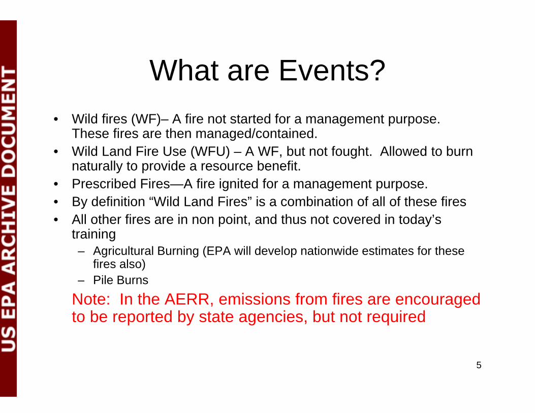
What are Events?What are Events?• Wild fires (WF)– A fire not started for a management purpose.
Th fi h d/ i dThese fires are then managed/contained.• Wild Land Fire Use (WFU) – A WF, but not fought. Allowed to burn
naturally to provide a resource benefit.P ib d Fi A fi i it d f t• Prescribed Fires—A fire ignited for a management purpose.
• By definition “Wild Land Fires” is a combination of all of these fires• All other fires are in non point, and thus not covered in today’s
trainingtraining– Agricultural Burning (EPA will develop nationwide estimates for these
fires also)– Pile Burns
Note: In the AERR, emissions from fires are encouraged to be reported by state agencies, but not required
5

6

Fires most important contributor to 2008 PM2.5 Emissions…p
• Total PM2.5 Emissions in 2008 is ~ 6.1 million tons; Fires ~ 1.8 million tonstons• Fires here include: wild fires, prescribed fires, and agricultural fires• Final NEI represents a blending of S/L and EPA data 7

Agricultural Fires a small component…
8
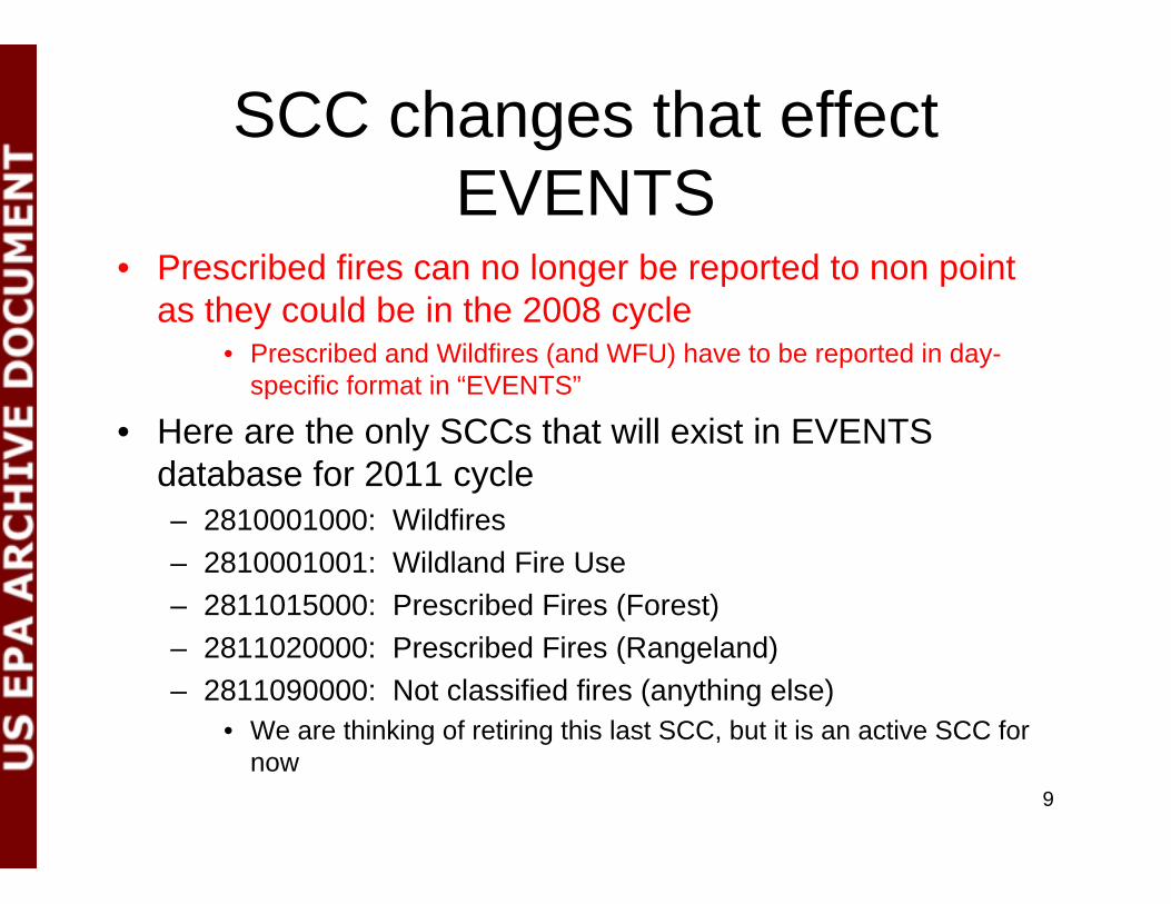
SCC changes that effect EVENTS
• Prescribed fires can no longer be reported to non point g p pas they could be in the 2008 cycle
• Prescribed and Wildfires (and WFU) have to be reported in day-specific format in “EVENTS”p
• Here are the only SCCs that will exist in EVENTS database for 2011 cycle
2810001000 Wildfi– 2810001000: Wildfires– 2810001001: Wildland Fire Use– 2811015000: Prescribed Fires (Forest)– 2811020000: Prescribed Fires (Rangeland)– 2811090000: Not classified fires (anything else)
• We are thinking of retiring this last SCC, but it is an active SCC forWe are thinking of retiring this last SCC, but it is an active SCC for now
9

SCCs continuedSCCs continued….Event 2810001000 Other Combustion Forest Wildfires Wildfires Fires ‐ WildfiresEvent 2810001001 Other Combustion Forest Wildfires Wildland Fire use Fires ‐ WildfiresEvent 2811015000 Other Combustion ‐ as Event Prescribed Forest Burning Unspecified Burn Method Fires ‐ Prescribed FiresEvent 2811020000 Other Combustion ‐ as Event Prescribed Rangeland Burning Unspecified Burn Method Fires ‐ Prescribed FiresEvent 2811090000 Other Combustion ‐ as Event Open Fire Not Classified Miscellaneous Non‐Industrial NEC
EPA Methods will be reporting all Wild Fires to 281001000; all Prescribed Fires to 2811015000; all Wild Land Fire Use to 2810001001 It would be helpful to us if those Agencies wanting2810001001. It would be helpful to us if those Agencies wanting to submit fire emissions (option 3) followed suit.
10
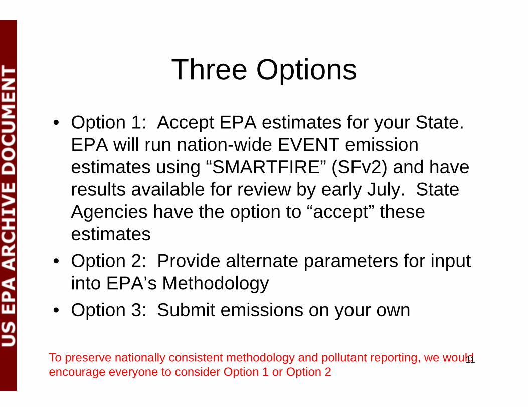
Three OptionsThree Options
• Option 1: Accept EPA estimates for your State.Option 1: Accept EPA estimates for your State. EPA will run nation-wide EVENT emission estimates using “SMARTFIRE” (SFv2) and have results available for review by early July. State Agencies have the option to “accept” these
ti testimates• Option 2: Provide alternate parameters for input
into EPA’s Methodologyinto EPA s Methodology• Option 3: Submit emissions on your own
To preserve nationally consistent methodology and pollutant reporting, we would encourage everyone to consider Option 1 or Option 2
11

Outline of Presentation todayOutline of Presentation today• Option 1 Details
– SMARTFIRE Version 2 (SFv2) methods summary – Some sample results from 2008 cycle– EPA’s development of DRAFT 2011 emissions estimates for SLT review
What sho ld o do if o ant to “accept” these res lts– What should you do if you want to “accept” these results• Option 2 Details
– After reviewing data from Option 1, would any agencies like to supply the “activity” data to EPA so that SFv2 can be re-run using those inputs?y g p
– How will this submission be accomplished and in what format?– What will EPA do with these submissions?
• Option 3 Details– What needs to be done if a state wants to submit their own fire emissions directly
to the EIS– Very few states/agencies submitted data to Events in 2008
12
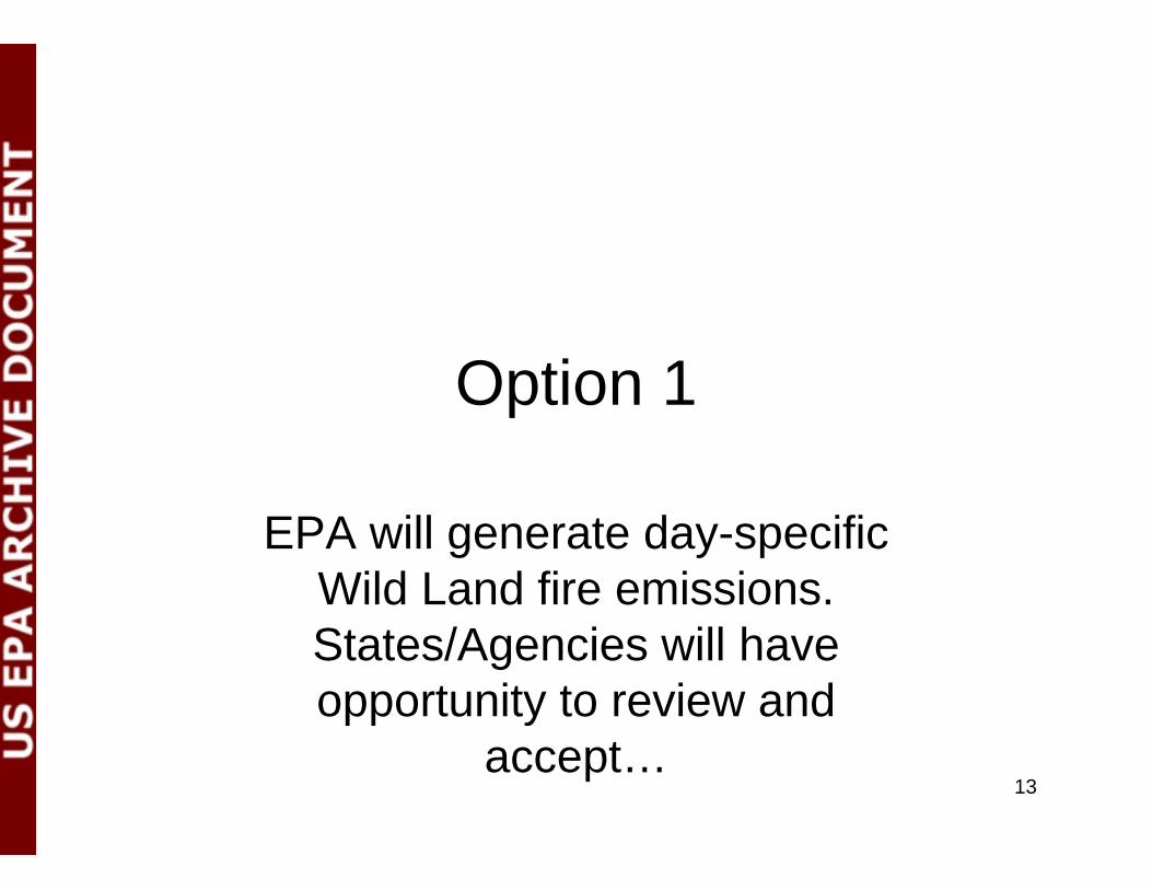
Option 1Option 1
EPA will generate day-specific Wild Land fire emissions. States/Agencies will have opportunity to review and y
accept…13
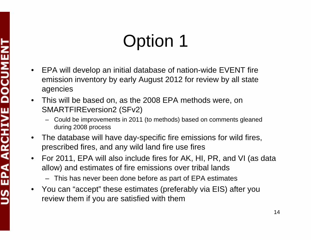
Option 1Option 1• EPA will develop an initial database of nation-wide EVENT fire
emission inventory by early August 2012 for review by all state agencies
• This will be based on, as the 2008 EPA methods were, on SMARTFIREversion2 (SFv2)
– Could be improvements in 2011 (to methods) based on comments gleaned during 2008 process
Th d t b ill h d ifi fi i i f ild fi• The database will have day-specific fire emissions for wild fires, prescribed fires, and any wild land fire use fires
• For 2011, EPA will also include fires for AK, HI, PR, and VI (as data ll ) d ti t f fi i i t ib l l dallow) and estimates of fire emissions over tribal lands– This has never been done before as part of EPA estimates
• You can “accept” these estimates (preferably via EIS) after you i th if ti fi d ith threview them if you are satisfied with them
14

A logical progressionWhere is the fire?
A logical progression
What are the fuels?
How much fuel gotHow much fuel got consumed?
When did they burn?they burn?
What are the emissions?
H hi h did
In the next several slides, we will outline how SFv2 is used in conjunction with the Bl Sk d l t ti t How high did
the smoke go?
What are the smoke impacts?
BlueSky model to estimate each of these “parcels of information”…
smoke impacts?
15
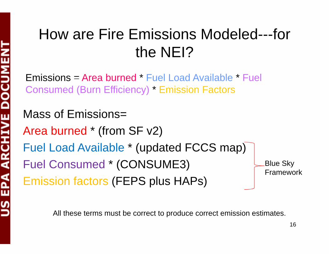
How are Fire Emissions Modeled---for th NEI?the NEI?
Emissions = Area burned * Fuel Load Available * Fuel
M f E i i
Emissions Area burned Fuel Load Available Fuel Consumed (Burn Efficiency) * Emission Factors
Mass of Emissions= Area burned * (from SF v2)
* ( CCS )Fuel Load Available * (updated FCCS map)Fuel Consumed * (CONSUME3) Blue Sky
FrameworkEmission factors (FEPS plus HAPs)
All these terms must be correct to produce correct emission estimates.16

Process Flow
17Fire InformationFuels Information Emissions Estimation

BlueSky and SmartFire 2• The BlueSky Framework was developed to compute smoke emissions (and
impacts) given known fire information
BlueSky and SmartFire 2
• The SmartFire 2 System (Framework) was later developed to help reconcile disparate sources of fire information into a useful data stream
• SF uses NOAA Hazard Mapping System satellite fire detects along withSF uses NOAA Hazard Mapping System satellite fire detects along with ground reports (ICS‐209 reports) and other datasets to create a reconciled fire information data feed.
• SF was developed by the USDA Forest Service AirFire Team and STI under a grant from NASA
• Together, SmartFire 2 ‐> BlueSky can take in multiple heterogeneous fire information datasets and create a unified fire emissions inventory suitable yfor further modeling
• SF interfaces with the Bluesky Framework to estimate daily, location specific fire emissions. Each and every fire can be identified into a fire
( b d )type (WF or Prescribed, etc.)• Developers in the process of putting these methods into the peer reviewed
literature18

The Fire Information ProblemSources of fire information are often:
d ( l )
The Fire Information Problem
• Limited (to particular types, sizes, etc…)• Incomplete (based on clouds, etc…)• Redundant (with other sources)• Better at some aspects (e.g. fire size) than other
(e.g. location)
SmartFire 2 was designed to overcome these issues by leveraging multiple sources
19
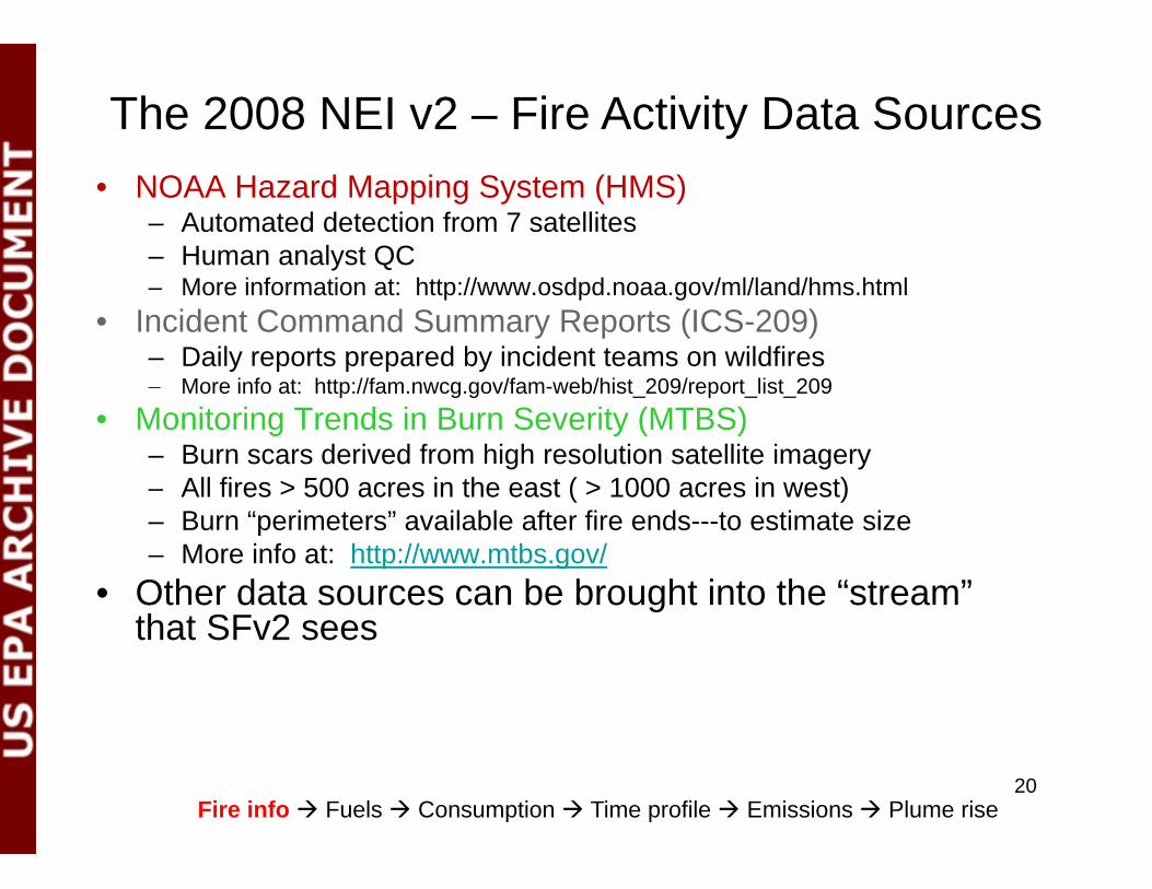
The 2008 NEI v2 – Fire Activity Data Sources• NOAA Hazard Mapping System (HMS)
– Automated detection from 7 satellites – Human analyst QC– More information at: http://www.osdpd.noaa.gov/ml/land/hms.html
• Incident Command Summary Reports (ICS-209)– Daily reports prepared by incident teams on wildfires– More info at: http://fam nwcg gov/fam-web/hist 209/report list 209More info at: http://fam.nwcg.gov/fam-web/hist_209/report_list_209
• Monitoring Trends in Burn Severity (MTBS)– Burn scars derived from high resolution satellite imagery– All fires > 500 acres in the east ( > 1000 acres in west)( )– Burn “perimeters” available after fire ends---to estimate size– More info at: http://www.mtbs.gov/
• Other data sources can be brought into the “stream” that SFv2 sees
Fire info Fuels Consumption Time profile Emissions Plume rise 20
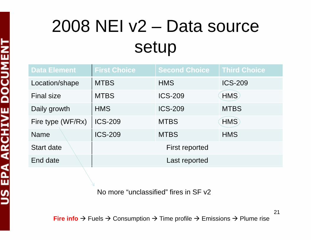
2008 NEI v2 – Data source setupsetup
Data Element First Choice Second Choice Third Choice
Location/shape MTBS HMS ICS-209
Final size MTBS ICS-209 HMS
Daily growth HMS ICS-209 MTBS
Fire type (WF/Rx) ICS-209 MTBS HMS
Name ICS-209 MTBS HMSName ICS-209 MTBS HMS
Start date First reported
End date Last reported
No more “unclassified” fires in SF v2
Fire info Fuels Consumption Time profile Emissions Plume rise 21
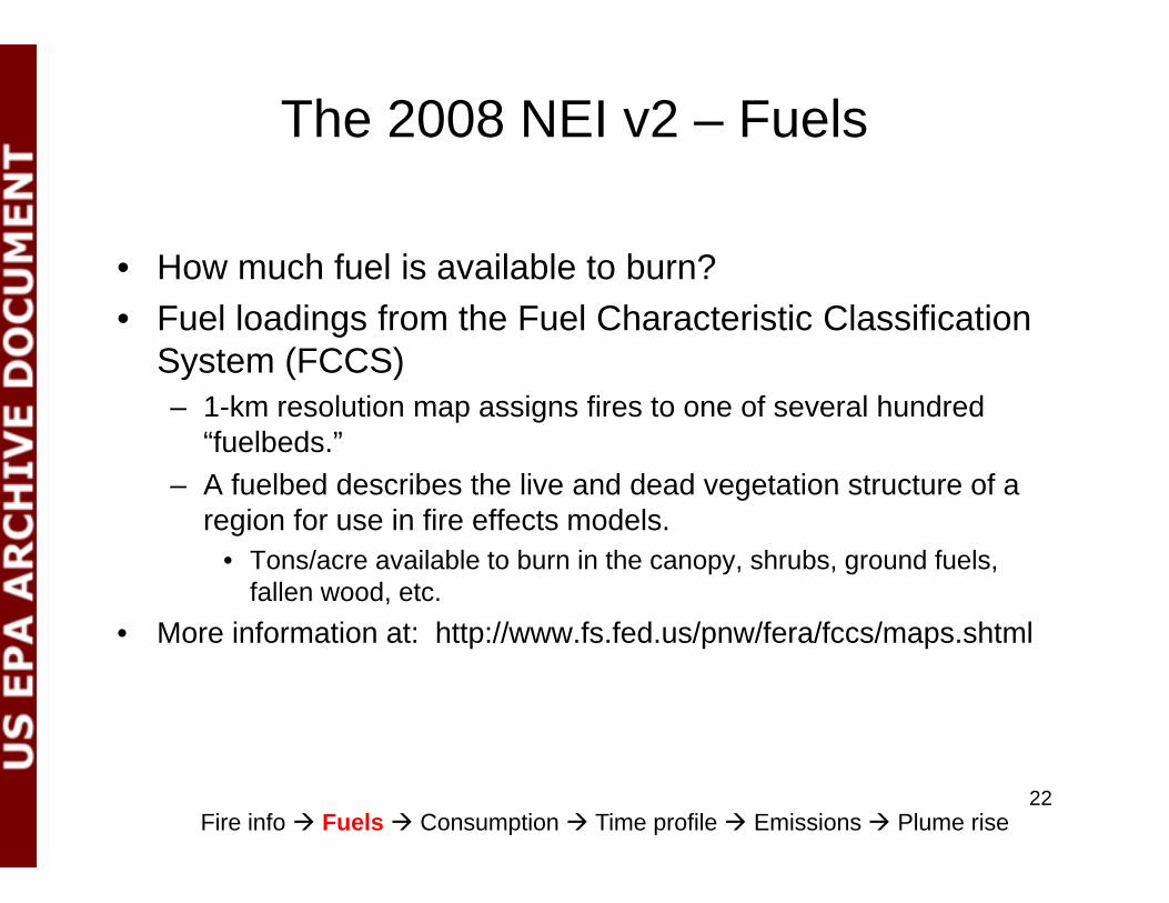
The 2008 NEI v2 – Fuels
• How much fuel is available to burn?• Fuel loadings from the Fuel Characteristic Classification
System (FCCS)– 1-km resolution map assigns fires to one of several hundred
“fuelbeds.”– A fuelbed describes the live and dead vegetation structure of a
f f ffregion for use in fire effects models.• Tons/acre available to burn in the canopy, shrubs, ground fuels,
fallen wood, etc.M i f ti t htt // f f d / /f /f / ht l• More information at: http://www.fs.fed.us/pnw/fera/fccs/maps.shtml
Fire info Fuels Consumption Time profile Emissions Plume rise 22

The 2008 NEI v2 - Consumption• What fraction of the available fuel burns?• Consumption from the Consume 3.0 model
– Designed for use with FCCS fuelbeds– Consumption by phase (flaming and smoldering)
D d t f l i t l– Dependent on fuel moisture values• Daily fuel moistures assigned based on nearest fire
weather station– Capped consumption of ground fuels for
prescribed fires• 5 tons per acre in the east• 5 tons per acre in the east• 20 tons per acre in the west
• More info at: http://www.fs.fed.us/pnw/fera/research/smoke/consume/index.shtml
Fire info Fuels Consumption Time profile Emissions Plume rise 23

The 2008 NEI v2 – Diurnal Time Profile
• When in the day does the consumption occur?occur?
• WildfiresH l fil i t d d d l d– Hourly profile is a standard curve developed by WRAP
P ib d fi• Prescribed fires– Modeled by the Fire Emissions Production
Si l t (FEPS)Simulator (FEPS)
Fire info Fuels Consumption Time profile Emissions Plume rise 24

The 2008 NEI v2 – Emissions
• How much is emitted by the fire?Emissions from the FEPS model• Emissions from the FEPS model– Emission factors from literature for flaming
and smoldering comb stionand smoldering combustion– PM2.5, PM10, total PM, NOx, CO, CO2, CH4,
NH SO VOC NMHCNH3, SO2, VOC, NMHC– Total heat
• More info at: http://www fs fed us/pnw/fera/feps/index shtml• More info at: http://www.fs.fed.us/pnw/fera/feps/index.shtml
Fire info Fuels Consumption Time profile Emissions Plume rise 25

Pollutant HAP Emission factor (lb/ton fuel consumed)
PM2.5 PM10
From SFv2/BS---FEPSN/A
PM10 CO CO2 CH4 NOx NH3 SO2 VOCVOC 1,3‐butadiene 0.405 Acrolein 0.424 Toluene 0.56825 n‐hexane 0.0164025 Anthracene 0.005 Pyrene 0.00929 o,m,p‐xylene 0.242
From EPA supplied “ ” i i
benzo(ghi)perlyene 0.00508 benzo(e)pyrene 0.00266 indeno(1,2,3‐cd)pyrene 0.00341 benzo(c)phenanthrene 0.0039 Perylene 0.000856 benzo(a)fluoranthene 0.0026 Fluoranthene 0.00673
“average” emission factors---have been used since early 2000s
benzo(k)fluoranthene 0.0026 Chrysene 0.0062 methylpyrene,‐fluoranthene 0.00905 methylbenzopyrenes 0.00296 Methylchrysene 0.0079 Methylanthracene 0.00823 Carbonylsulfide 0.000534 Formaldeh de 2 575Formaldehyde 2.575 benzo(a)pyrene 0.00148 benz(a)anthracene 0.0062 Benzofluoranthenes 0.00514 Benzene 1.125 Methylchloride 0.128325 Acetaldehyde 0.40825 Phenanthrene 0 005Phenanthrene 0.005
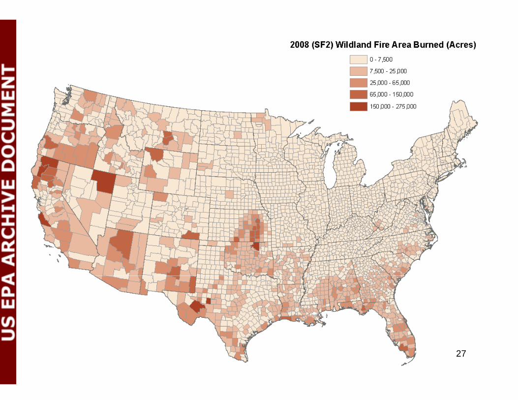
26
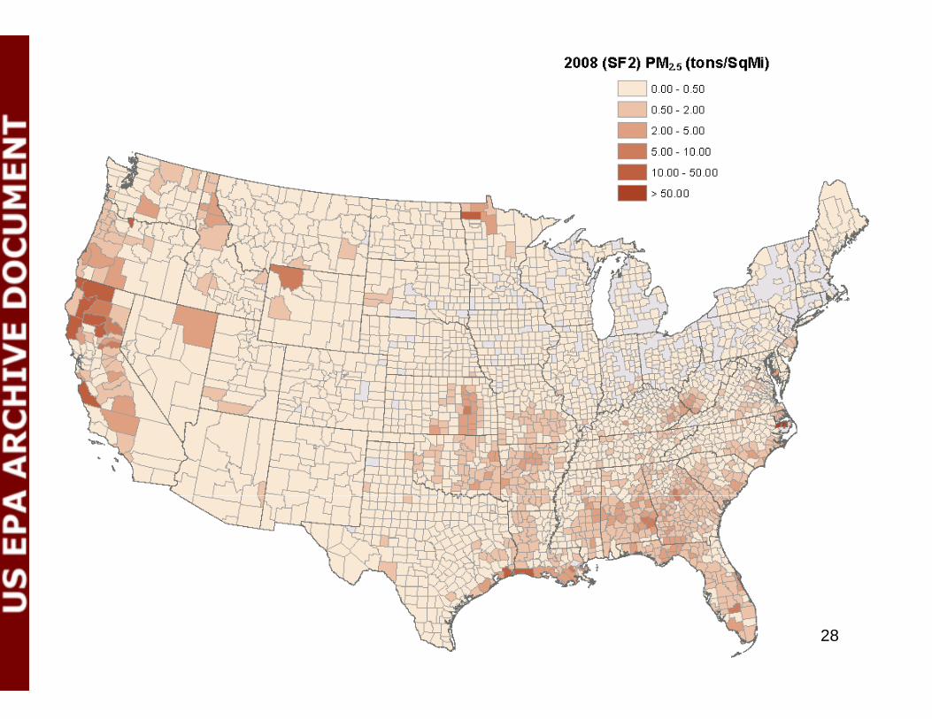
27
28
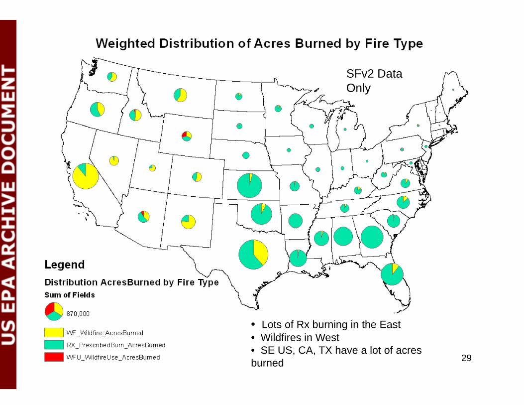
SFv2 DataSFv2 Data Only
• Lots of Rx burning in the East• Wildfires in West• SE US, CA, TX have a lot of acres burned 29

SFv2 DataSFv2 Data Only
• Note NC Due to Evans Road fire in June 2008Note NC. Due to Evans Road fire in June 2008. Smoldering for a month in peat depth of ~ 3 ft.• CA also very high in PM2.5 emissions•Higher PM2.5 emissions associated with WFs than with Prescribed burning (due to conditions of burn)
30
What Data will you get from EPA, and in what format?
• Currently, there isn’t a way to get EVENTS data out of EIS on a day-specific basis
• Thus, our current thinking is that in ~ early August, we will have available at: ftp://ftp.epa.gov/EmisInventory/temp/wildfires all the draft 2011 EVENTS data
– Either parsed state-by-state and by tribes, or – As one data set with proper identifiers to enable you to excise just the data for
your domain.. – Each of you can download the relevant data directly from that site to review.
• I will need a list of contacts in each State A d f l I ill h li f i i ki hi i i d– As default, I will use the list of participants taking this training today
31

What you will see when you get the data from EPA
• You will get these set of data for everyset of data for every identified fire for your agency (state and county)
• Will enable you to review all the specifics, including p , gactivity data, fuel information, and emissions
You will also get i i f
32
emissions for the 29 HAPs listed on slide 28
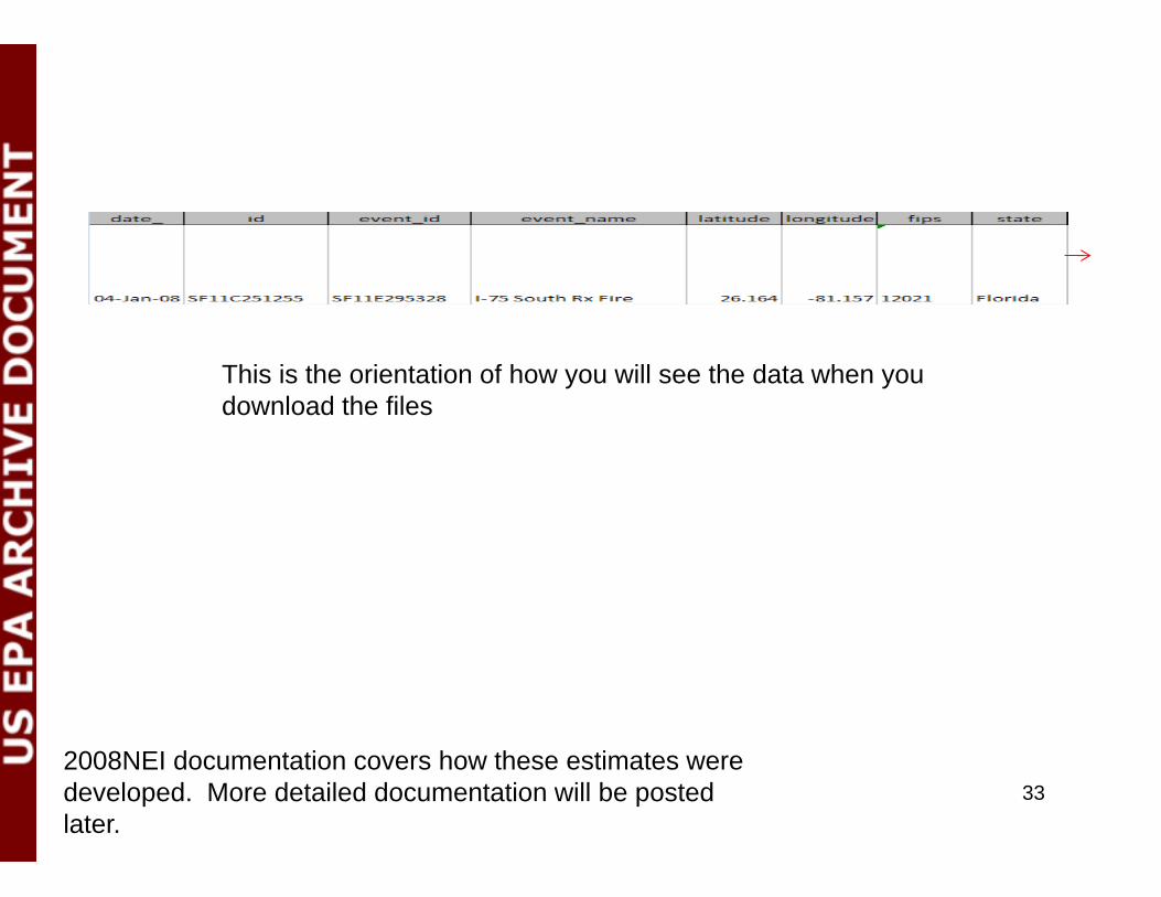
This is the orientation of how you will see the data when you download the files
2008NEI documentation covers how these estimates were developed. More detailed documentation will be posted later.
33

What to do after reviewing 2011 Draft data…
• If you would like to “accept” these emission estimates for y pyour agency, please use the “create support request” option in EIS to indicate your acceptance (see next slide)W ill th i i d f lt f A• We will use these emissions as default for your Agency, if:– 1: We don’t hear from you until 12/31/12 on your acceptance of
these emission estimates (Option 1)– 2: We don’t hear from you until 12/31/12 on Option 2 (coming up
next)– 3: We don’t receive any emissions from you via EIS route
(Option 3)
34

35

Option 2Option 2
After reviewing the initial SFv2 estimates from EPA,
States/Agencies can opt to submit “activity” data so that EPA can re-yrun SFv2 using those submitted
parameters36

Details on Option 2Details on Option 2• After reviewing the fire estimates sent to you via option 1, if you would like
to change or add information on fires for your Agency, you can submit these information via spreadsheet
– We will collect these data until December 2012, and re-run SFv2 early next year with any inputs provided via this processwith any inputs provided via this process
– NOTE: this option will be a re-run of SFv2 using the (revised or new) information you submit
– Note: this option only asks you to submit “activity” or “fuel information” data----NOT i iNOT emissions
– Will preserve methodology and pollutants reported• The next few slides show what information is needed
– Your patience is appreciated as this is an evolving process in our effort to get the– Your patience is appreciated as this is an evolving process in our effort to get the best information we can from you all to improve our fire emission estimates
• You can submit these data outside the EIS, via Excel spreadsheet to [email protected]
37

Basic Fire Information (required information)Basic Fire Information (required information)
• For each fire, for each day of growth– Date– Name (see slide 34, “event_name” in our files)– Is this fire already identified in EPA estimates?
L tit d– Latitude– Longitude– State– County– County– Type (wildfire, prescribed)– Area burned (on this day, not cumulative)
• All elements must be provided for a fire we have already identified orAll elements must be provided for a fire we have already identified or a new fire (if you set area burned = 0 zero, for example, we will omit that fire)
• If these are not provided, daily area burned estimates from SMARTFIRE will be applied
38

REQUIRED FIELDS Field Name Units NotesAll required date format MM/DD/YY
nameText, but not blank---if related to a fire already identified by EPA, use same Name, "Event_Name"
Is this fire already identified in EPA Estimates? Text, either "Yes" or "No"latitude decimal degrees (NAD83)longitude decimal degrees (NAD83)state Name of State in Questionstate Name of State in Questioncounty Name o County in Questiontype WF or RXarea acres area burned on this day only (not cumulative area)
OPTIONAL FIELDSfccs_number A standard FCCS fuelbed number
oroptional: all must be provided fuel_1hr tons/acre 1-hr sound woody fuel loadingif these are provided, fccs_number will be ignored fuel_10hr tons/acre 10-hr sound woody fuel loading
fuel_100hr tons/acre 100-hr sound woody fuel loadingfuel_1khr tons/acre 1000-hr sound woody fuel loadingfuel_10khr tons/acre 10,000-hr sound woody fuel loadingfuel_gt10khr tons/acre > 10,000-hr sound woody fuel loadingshrub tons/acre shrub fuel loadinggrass tons/acre grass fuel loadinggrass tons/acre grass fuel loadingrot tons/acre rotten woody fuel loadingcanopy tons/acre canopy fuel loadingduff inches duff depthlitter tons/acre litter fuel loading
optional: both must be provided fuel_moisture_10hr percentage 10 hr fuel moisture percentagefuel_moisture_1khr percentage 1000 hr fuel moisture percentagefuel_moisture_duff percentage duff fuel moisture percentageg gconsumption_flaming tons/acre flaming consumptionconsumption_smoldering tons/acre smoldering consumptionconsumption_residual tons/acre residual consumptionconsumption_duff tons/acre duff consumption
Single line for each day for each fireIf multiple fuel loadings or fuelbeds for a single fire/day, split into multiple lines
• Parameters in light blue are required for EPA to re-run SFv2 using improved inputs from SLTs. The “Area burned” variable is one where we would encourage state input, as our estimates may not be based on all data available.
• Note that name of fire must match the name provided in EPA database if input corrections made for that fire (which we have already identified) If new fire new name must be supplied and identified
39
we have already identified). If new fire, new name must be supplied and identified.• All other parameters are optional. If SLT Agencies have ways to get these data, they can submit. Note the specifications on requirements. Parameters in same color go together in terms of requirements.•Save file as “YourAgencyName_2011_fireinputparameters”
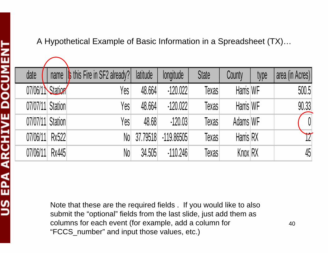
A Hypothetical Example of Basic Information in a Spreadsheet (TX)…
date name Is this Fire in SF2 already? latitude longitude State County type area (in Acres)date name Is this Fire in SF2 already? latitude longitude State County type area (in Acres)07/06/11 Station Yes 48.664 -120.022 Texas Harris WF 500.507/07/11 Station Yes 48.664 -120.022 Texas Harris WF 90.3307/07/11 Station Yes 48.68 -120.03 Texas Adams WF 007/06/11 Rx522 No 37.79518 -119.86505 Texas Harris RX 1207/06/11 Rx445 No 34.505 -110.246 Texas Knox RX 45
Note that these are the required fields If you would like to also
40
Note that these are the required fields . If you would like to also submit the “optional” fields from the last slide, just add them as columns for each event (for example, add a column for “FCCS_number” and input those values, etc.)
Closing remarks on Option 2Closing remarks on Option 2• As mentioned previously, this is an evolving method/option, and we
would like to work with you to get what we need to re-run SFv2 (if you decide to use this option)
• As such, if you can give me an indication early on that you would like to use this option, I can email you a sample spreadsheet and we can work together to generate what it is we need. Please email me if this is the case (once you see our data for 2011 later this
) i th il dd i t th d f thisummer), using the email address given at the end of this presentation (on slide 57).
• This is our early thinking. We will provide updates on items related t ti 1 d 2 d i d t i i i EVENTSto options 1 and 2 during our second training session on EVENTS, to occur on August 1. Training will also be available at our EI Conference (Tampa, FL; Aug 13-16, 2012).
41
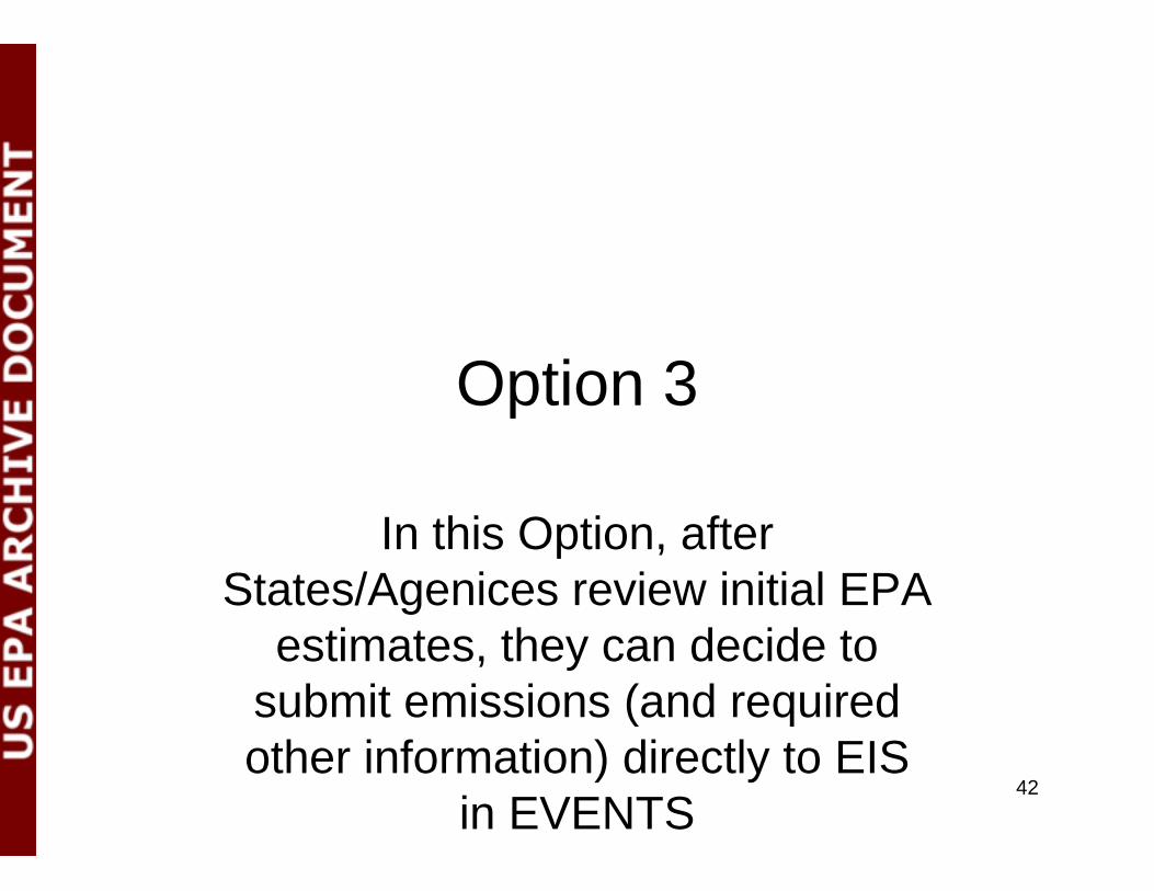
Option 3Option 3
In this Option, after States/Agenices review initial EPA g
estimates, they can decide to submit emissions (and required (other information) directly to EIS
in EVENTS42
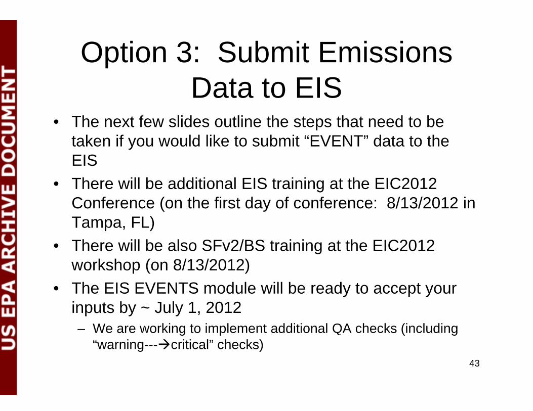
Option 3: Submit Emissions Data to EIS
• The next few slides outline the steps that need to be ptaken if you would like to submit “EVENT” data to the EISTh ill b dditi l EIS t i i t th EIC2012• There will be additional EIS training at the EIC2012 Conference (on the first day of conference: 8/13/2012 in Tampa, FL)
• There will be also SFv2/BS training at the EIC2012 workshop (on 8/13/2012)Th EIS EVENTS d l ill b d t t• The EIS EVENTS module will be ready to accept your inputs by ~ July 1, 2012– We are working to implement additional QA checks (including g p ( g
“warning---critical” checks)43

Event InventoryEvent Inventory• Requirements for submitting an event inventory q g y
(8 Tables Required)– CERS– Exchange HeaderExchange Header– Event– Event Reporting Period
E t L ti– Event Location– Geographic Coordinates or Geospatial Parameters– Event Emissions Process– Emissions
• OptionalEvent Attached File– Event Attached File
– Merged Events44

CERS and Exchange Header Tables are the “Administrative” Tables and the other Tables
t i t l i f ticontain actual information (your data)
45

Required - CERSRequired CERS
• RequiredRequired– User ID (EIS login)– Program System Code (what is your agencyProgram System Code (what is your agency
known by?)– Emissions Year (2011)
• Optional– Model– Model Version– Emissions Creation Date– Submittal Comment
46

Required - Exchange Header
• Required– Author Name (not ID)( )– Organization Name– Document Title (EIS)– Data Flow Name (EIS_v1_0)– Submission Type (QA or Production)
P t D t C t (EVENT)– Property-Data Category (EVENT)• Optional
Ke ords– Keywords– Comments– Property-NCD Data File (Only when submitting NCD)Property NCD Data File (Only when submitting NCD)
47

Required - Event• Required
– Event Identifier– Program System Code– Event Name
• Optional– Event Classification Code– Ground Based Data Source CodeGround Based Data Source Code– Remote Sensing Data Source Code– Land Manager– Location Description
E Si C d– Event Size Code– Containment Date– Recurrence Indicator Code– Recurrence YearRecurrence Year– Fuel Consumption and Emissions Model Code– Fuel type Model Code– Fuel Selection Code
I iti M th d C d I iti L ti C d d I iti O i t ti– Ignition Method Code, Ignition Location Code, and Ignition Orientation Code
– Event Comment 48
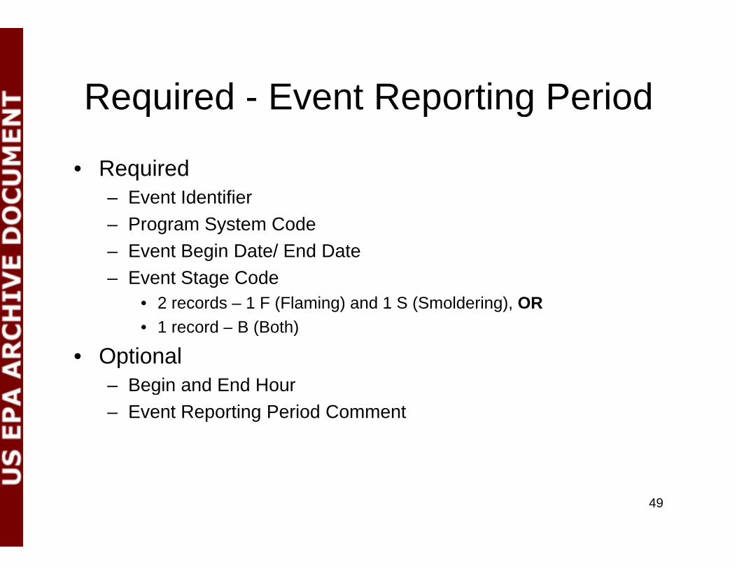
Required - Event Reporting PeriodRequired Event Reporting Period
• Required q– Event Identifier– Program System Code
Event Begin Date/ End Date– Event Begin Date/ End Date– Event Stage Code
• 2 records – 1 F (Flaming) and 1 S (Smoldering), OR( )• 1 record – B (Both)
• Optional– Begin and End Hourg– Event Reporting Period Comment
49
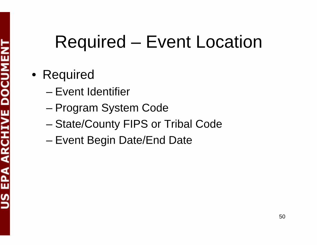
Required – Event LocationRequired Event Location
• RequiredRequired– Event Identifier
Program System Code– Program System Code– State/County FIPS or Tribal Code
Event Begin Date/End Date– Event Begin Date/End Date
50

Required – Geographic Coordinates
• Required if not populating Geospatial Parametersq p p g p– Event Identifier– Program System Code
Event Begin Date/End Date– Event Begin Date/End Date– State and County FIPS or Tribal Code– Latitude and Longitude Measure– Area Within Perimeter (in “acres”)– Area Within Perimeter UOM
• OptionalOptional– Percent of Area Producing Emissions– All other data elements
51
Required – Geospatial ParametersRequired Geospatial Parameters• Required if not populating Geographic Coordinates
– Event Identifier– Program System Code– Event Begin Date/End Date
Shape File Identifier– Shape File Identifier– Area Within Shape and UOM
• Optional– Percent of Area Producing EmissionsPercent of Area Producing Emissions– Geospatial Parameters Comment
• Note: Before submitting, contact EIS Administrators to add the shape files that will be used for our reference listingsshape files that will be used for our reference listings
• If you do supply Geo-spatial parameters, you must also submit a set of zipped Geo-spatial files as the Event Attached File element (next slide)slide)
52
Optional – Event Attached FileOptional Event Attached File• Used to submit shape file
– Requires Geospatial Parameters table not Geographic– Requires Geospatial Parameters table, not Geographic Coordinates
• Required Event Identifier– Event Identifier
– Program System Code– Attachment File Name
Attachment File Content Type Code– Attachment File Content Type Code– Attached File Size– Attached File Content Type Code
N t All G ti l fil t b i d t th d b itt d– Note: All Geospatial files must be zipped together and submitted with the XML. The name of the zip file is what will appear in the “Attachment File Name” shown above
53

Required – Event Emissions Process• Required• Required
– Event Identifier– Program System Code– Event Begin Date/End DateEvent Begin Date/End Date– State and County FIPs or Tribal Code– Source Classification Code (there are only 5)
• 2810001000: Wildfires2810001001: Wildland Fire Use• 2810001001: Wildland Fire Use
• 2811015000: Prescribed Fires (Forest)• 2811020000: Prescribed Fires (Rangeland)• 2811090000: Not classified fires (anything else)
• OptionalOptional– Fuel Configuration Code– Fuel Loading and UOM– Amount of Fuel Consumed and UOM
P t T H F l M i t– Percent Ten Hour Fuel Moisture– Percent One Thousand Hour Fuel Moisture– Percent Live Fuel Moisture– Percent Duff Fuel Moisture– Heat Release and UOM– Emission Reduction Technique Code– Event Emissions Process Comment
54

Required - EmissionsRequired Emissions
• RequiredRequired– Pollutant Code
Total Emissions and UOM– Total Emissions and UOM– Emissions Calculation Method Code
O ti l b t h d i d (i d)• Optional, but very much desired (in red)– Emission Factor and Numerator/Denominator– Emission Factor Text– Emissions Comment
55

Thank You!!Thank You!!
Tesh RaoEPA/OAQPS/Emissions Inventory and Analysis Group
(919)-541-1173rao venkatesh@epa [email protected]
56
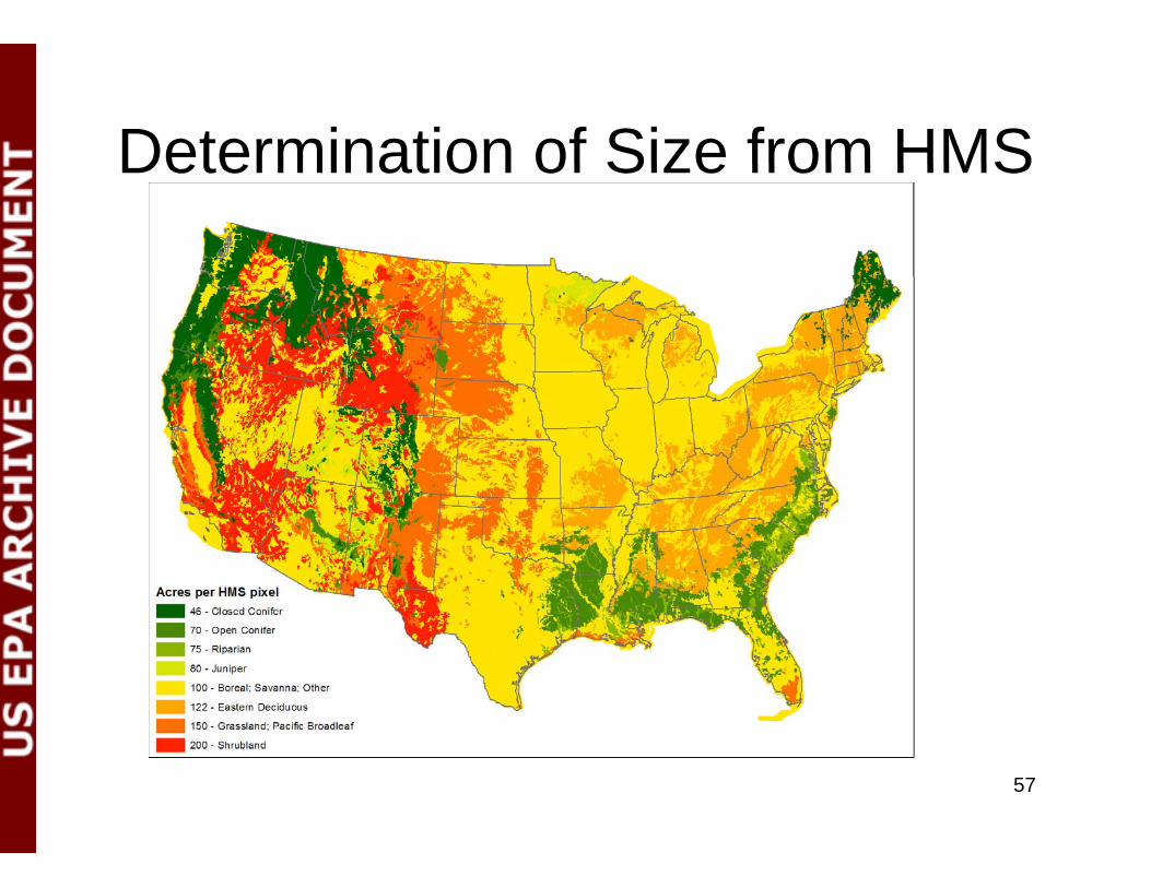
Determination of Size from HMSDetermination of Size from HMS
57