effective during site investigation, and significant ...nguyen.hong.hai.free.fr/ebooks/science and...
TRANSCRIPT

effective during site investigation, and significant faults, forexample, are sometimes not discovered until construction oreven afterwards. Stability of hillsides, cut slopes, quarry facesand so on may often be controlled by the geometric arrange-ment of joints and faults. (For examples see Figure 8.17.) Alsothe groundwater pattern may be controlled by the condition ofthe joints and faults whether they are open or closed or filledwith debris or gouge and the persistence or continuity of suchfractures may be important.
On large works the determination of whether a fault is active,inactive or passive may be important. Active faults are those inwhich movements have occurred during the recorded historyand along which further movements can be expected any time(such as the San Andreas and some other faults in California).Inactive faults have no recorded history of movement and areassumed to be and probably will remain in a static condition.Unfortunately, it is not possible yet to state definitely if anapparently inactive fault will remain so. The fault may reopen,either because of a new stress accumulation in the locality orfrom the effect of earthquake vibrations.
From the alteration products of faulting, gouge is probably ofthe most concern in foundation problems. This is usually arelatively impervious clay-grade material and may hinder orstop the movement of groundwater from one side of the fault tothe other and so create hydrostatic heads, e.g. if encountered ina tunnel. It may also reduce sliding friction along the faultplane. The presence of soft fault breccia or gouge may causesudden squeezes in a tunnel that intersects the fault. Arch actionof rocks in tunnels may be reduced by the presence of joints andfaults. Rock falls on cuts and in tunnels, patterns of rock bolts,grout holes and so on are all controlled to a large extent by thejoint and fault pattern.
In foundations, folds are generally not so critical as faultsthough they may give stability problems if their geometry isunfavourable. Occasionally, folds may influence the selection ofa dam site; e.g. when the reservoir is located over a monoclinecontaining pervious strata, there may be excessive seepage if themonocline dips downstream. If the monocline were to dipupstream, the reservoir might have little seepage providing themonocline contained some impervious layers such as shalewhich were not fractured in the folding. Serious water problemsmay arise in the construction and maintenance of tunnelsintersecting synclines containing water-bearing strata. In deepcuts, analogous water problems arise that may create conti-nuous maintenance problems.
Dipping beds, which must be part of a fold system, may causestability problems if the dip is unfavourable into a cut face(Figure 8. ITb).
8.4 Engineering geology environments
A geological environment is the sum total of the externalconditions which may act upon the situation. For example, a'shallow marine environment' is all the conditions acting off-shore which control the formation of deposits on the sea bed:the water tenjperature, light, current action, biological agen-cies, source of sediment, sea bed chemistry and so on.
The concept of geological environment forms a suitable basisto study systematically the engineering geology of the depositsformed in or influenced by the various environments, as theycondition the in situ engineering behaviour of the variousdeposits. A knowledge of the parameters of the environmentenables predictions and explanations of the engineering be-haviour to be attempted. Geomorphology is the study of thegeology of the Earth's surface (see Fookes and Vaughan8).
8.4.1 Processes acting on the Earth's surface
A landform may be defined as an area of the Earth's surfacediffering by its form and other features from the neighbouringareas. Mountains, valleys, plains and even swamps are land-forms.
The principal processes that are continually acting on theEarth's surface are gradation, diastrophism and vulcanism.
(1) Gradation is the building up or wearing down of existinglandforms (including mountains), formation of soil andvarious deposits. Erosion is a particular case of gradation bythe action of water, wind or ice.
(2) Diastrophism is the process where solid, and usually therelatively large, portions of the Earth move with respect toone another as in faulting or folding.
(3) Vulcanism is the action of magma, both on the Earth'ssurface and within the Earth.
With the exception of vulcanism and sometimes erosion, theseprocesses may take hundreds and even millions of years tochange the face of the Earth significantly. The sudden eruptionof a volcano, for example, with the ensuing flow of lava ordeposition of volcanic ash, can abruptly change land overnight.
Origin of soils. The majority of the soils are formed by thedestruction of rocks. The destructive process may be physical, asthe disintegration of rock by alternate freezing and thawing orday-night temperature changes. It may also be by chemicaldecomposition, resulting in changes in the mineral constituentsof the parent rock and the formation of new ones.
Soils formed by disintegration and chemical decompositionmay be subsequently transported by the water, wind or icebefore deposition. In this case they are classified as alluvial,aeolian, or glacial soils and are generally called transported soils.However, in many parts of the world, the newly formed soilsremain in place. These are called residual soils.
In addition to the two major categories of transported andresidual soils, there exist a number of soils that are not derivedfrom the destruction of rocks. For example, peat is formed bythe decomposition of vegetation in swamps; some marly soilsare the result of precipitation of dissolved calcium carbonate.
Soil-forming processes. There are very many and varied pro-cesses that take place in weathered rock and soils that affect theformation of soil profiles to varying degrees, but the major soil-forming processes are: (1) organic accumulation; (2) eluviation;(3) leaching; (4) illuviation; (5) precipitation; (6) cheluviation;and (7) organic sorting.
The soil-forming processes produce an assemblage of soillayers at horizons, called the soil profile. In its simplest it iscategorized as three layers A, B and C but numerous varieties ofthis and many other soil classifications exist. Probably the mostgenerally accepted one is that based on a geographical ap-proach. This is the zonal scheme thought to reflect zones ofclimate, vegetation and other factors of the local environment.
8.4.2 Engineering significance of selectedgeomorphological environments
Much of what can be called 'classical' geotechnical engineeringhas developed in temperate climate regions of the Earth. As aresult many of the concepts of soil and rock behaviour and theirproperties have been conditioned by the soil and rock foundthere. The climate and local geology play a major role indetermining the local geotechnical characteristics of the soilsand rocks. Figure 8.18 shows the generalized distribution of thefour principal climatic engineering soil zones after Sanders andFookes.9

The following section briefly describes the engineering geo-morphology characteristics of the four principal climatic zones,together with other geological environments of particular inter-est.
8.4.2.1 Rock weathering
A rock can weather by physical breakdown without consider-able change of its constituent minerals by disintegration. Theresidual or transported soil derived from this process consists ofan accumulation of mineral and rock fragments virtuallyunchanged from the original rock. This type of weathering isfound mainly in arid or cold climates. Chemical decompositionleads to the thorough alteration of a large number of mineralsand only a few, among them quartz, may remain unaffected.The greater the percentage of weatherable minerals in theoriginal rock, particularly the ferromagnesian minerals, themore conspicuous is the change from rock to soil. This type ofweathering is generally found in warm and hot, wet climates andcan lead to great thickness of weathered rock and soil. Biologi-cal weathering is generally of less importance than physical orchemical weathering and is a combination of biochemical andbiophysical effects.
The weathering process produces a gradational and oftenquite irregular change in the rock from fresh some distancebelow ground surface to more or less completely weathered atthe surface: Figure 8.19 shows somewhat schematically twoexamples of weathered rock profiles. Corestones need notalways be present and in sedimentary rocks in particular areoften missing.
There are several generalized weathering rock classificationsfor engineering purposes; the one reproduced here, Table 8.8, isfrom Fookes, Dearman and Franklin,10 which discusses weath-ered rock mainly in the UK. For information on the engineeringperformance of weathered rock elsewhere, see also Little,"Deere and Patton12 and Irfan and Dearman.13
8.4.2.2 Humid tropical residual soils
A residual soil is the end product (i.e. grades V and VI) of rockweathering. Different types of residual soils are produced indifferent environments (see Figures 8.20 and 8.21).
In tropical regions of high temperature and abundant surfacewater rock weathering it is at its most intensive. It is character-ized by rapid breakdown of feldspars and ferromagnesianminerals, the removal of silica and bases and the concentrationof iron and aluminium oxides. Kaolinite and related clayminerals form in well-drained areas. Because of the high ironconcentration the resulting soils are usually red in colour. Whendried, such materials may harden as a result of the cementingaction by iron and aluminium oxides and they are commonlyreferred to as laterites. Large, fairly durable concretions may beformed this way to give lateritic gravels which are often import-ant sources of aggregate for road construction and other uses,particularly in East and West Africa.
Tropical weathering of volcanic ash and rock leads to theformation of allophane and halloysite together with concentra-tion of iron and aluminium oxides. Soils of this type, particu-larly common in the Far East, are known as adisols.
Nearer to the edges of the tropics to the north and south there
Figure 8.18 Generalized map showing present-day distributions of the four principal climatic engineering soil zones
Max. limit of present dayperigiaciai zone Temperate zone
after Nixon and Skipp (1957)Dudal (1963)Black (1954)
Arid zone Black soils/ Mumid,_ , .. I tropicalRed so.ls 1 I0^
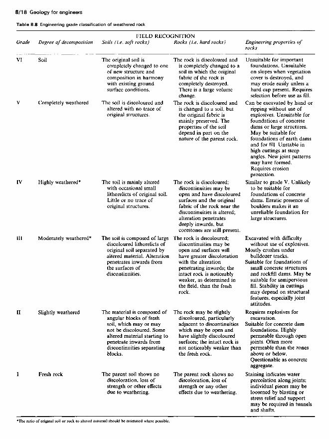
Table 8.8 Engineering grade classification of weathered rock
Grade
VI
V
IV
III
II
I
Degree of decomposition
Soil
Completely weathered
Highly weathered*
Moderately weathered*
Slightly weathered
Fresh rock
FIELD RECOGNITIONSoils (i.e. soft rocks)
The original soil iscompletely changed to oneof new structure andcomposition in harmonywith existing groundsurface conditions.
The soil is discoloured andaltered with no trace oforiginal structures.
The soil is mainly alteredwith occasional smalllithorelicts of original soil.Little or no trace oforiginal structures.
The soil is composed of largediscoloured lithorelicts oforiginal soil separated byaltered material. Alterationpenetrates inwards fromthe surfaces ofdiscontinuities.
The material is composed ofangular blocks of freshsoil, which may or maynot be discoloured. Somealtered material starting topenetrate inwards fromdiscontinuities separatingblocks.
The parent soil shows nodiscoloration, loss ofstrength or other effectsdue to weathering.
Rocks (i.e. hard rocks)
The rock is discoloured andis completely changed to asoil in which the originalfabric of the rock iscompletely destroyed.There is a large volumechange.
The rock is discoloured andis changed to a soil, butthe original fabric ismainly preserved. Theproperties of the soildepend in part on thenature of the parent rock.
The rock is discoloured;discontinuities may beopen and have discolouredsurfaces and the originalfabric of the rock near thediscontinuities is altered;alteration penetratesdeeply inwards, butcorestones are still present.
The rock is discoloured;discontinuities may beopen and surfaces willhave greater discolorationwith the alterationpenetrating inwards; theintact rock is noticeablyweaker, as determined inthe field, than the freshrock.
The rock may be slightlydiscoloured, particularlyadjacent to discontinuitieswhich may be open andhave slightly discolouredsurfaces; the intact rock isnot noticeably weaker thanthe fresh rock.
The parent rock shows nodiscoloration, loss ofstrength or any othereffects due to weathering.
Engineering properties ofrocks
Unsuitable for importantfoundations. Unsuitableon slopes when vegetationcover is destroyed, andmay erode easily unless ahard cap present. Requiresselection before use as fill.
Can be excavated by hand orripping without use ofexplosives. Unsuitable forfoundations of concretedams or large structures.May be suitable forfoundations of earth damsand for fill. Unstable inhigh cuttings at steepangles. New joint patternsmay have formed.Requires erosionprotection.
Similar to grade V. Unlikelyto be suitable forfoundations of concretedams. Erratic presence ofboulders makes it anunreliable foundation forlarge structures.
Excavated with difficultywithout use of explosives.
Mostly crushes underbulldozer tracks.
Suitable for foundations ofsmall concrete structuresand rockfill dams. May besuitable for semiperviousfill. Stability in cuttingsmay depend on structuralfeatures, especially jointattitudes.
Requires explosives forexcavation.
Suitable for concrete damfoundations. Highlypermeable through openjoints. Often morepermeable than the zonesabove or below.Questionable as concreteaggregate.
Staining indicates waterpercolation along joints;individual pieces may beloosened by blasting orstress relief and supportmay be required in tunnelsand shafts.
The ratio of original soil or rock to altered material should be estimated where possible.
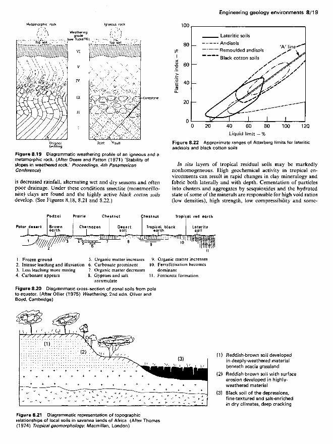
Figure 8.21 Diagrammatic representation of topographicrelationships of local soils in savanna lands of Africa. (After Thomas(1974) Tropical geomorphology. Macmillan, London)
Liquid limit — %Figure 8.22 Approximate ranges of Atterberg limits for lateriticandisols and black cotton soils
In situ layers of tropical residual soils may be markedlynonhomogeneous. High geochemical activity in tropical en-vironments can result in rapid changes in clay mineralogy andfabric both laterally and with depth. Cementation of particlesinto clusters and aggregates by sesquioxides and the hydratedstate of some of the minerals are responsible for high void ratios(low densities), high strength, low compressibility and some-
Reddish-brown soil developedin deeply-weathered materialbeneath acacia grasslandReddish-brown soil with surfaceerosion developed in highly-weathered materialBlack soil of the depressions,fine-textured and salt-enrichedin dry climates, deep cracking
Figure 8.20 Diagrammatic cross-section of zonal soils from poleto equator. (After Oilier (1975) Weathering, 2nd edn. Oliver andBoyd, Cambridge)
Figure 8.19 Diagrammatic weathering profile of an igneous and ametamorphic rock. (After Deere and Patton (1971) 'Stability ofslopes in weathered rock.' Proceedings, 4th PanamericanConference)
is decreased rainfall, alternating wet and dry seasons and oftenpoor drainage. Under these conditions smectite (montmorillo-nite) clays are found and the highly active black cotton soilsdevelop. (See Figures 8.18, 8.21 and 8.22.)
Originalbedding Joint Fault
Corestone
Mfetamorphic rockWeatheringgrade(see Table7-6Top soil
Igneous rock
Lateritic soilsAndisolsRemoulded andisolsBlack cotton soils
'A' line
1 . Frozen ground2. Intense leaching and illuviation3. Less leaching more mixing4. Carbonate appears
5. Organic matter increases6. Carbonate prominent7. Organic matter decreases8. Gypsum and salt
accumulate
9. Organic matter increases10. Ferrallitisation becomes
dominant1 1 . Ferricrete formation
Polar desert
Podzol Prairie
Brownearth Chernozen
Chestnut
Desertsoil
Chestnut
Tropical blackearth
Tropical red earth
Lateritesoil
Plas
ticity
inde
x —
%

times high permeability in relation to high plasticity and smallparticle size. Collapsing soils can occur. (See Table 8.9.)
Many of the red lateritic soils and adisols are susceptible tobreakdown on manipulation which makes index property deter-mination difficult as well as earthwork construction, changing apredominantly granular soil which excavates easily to a plasticmess that cannot be compacted easily. Irreversible changes inproperty of many tropical soils result from drying. (See, forexample, Table 8.10.)
Most of the black cotton soils have high plasticity andmarked swelling and shrinkage characteristics which in areaswith marked dry and wet seasons cause special problems forfoundations of structures and roads. Reference should be madeto the appropriate literature for the particular soil type, thoughthis itself may be difficult since in many of the publishedengineering articles the soil type may not be described suffi-ciently to characterize it. In addition, a great variety of differentresidual soils seem to be dubbed with the title of 'laterite' oftenquite erroneously. See Sanders and Fookes9 for a general studyOf foundation conditions related to four principal climate zones:(1) periglacial; (2) temperate; (3) arid; and (4) humid tropical.See Deere and Patton12 for an extensive treatise on slopestability aspects; Little" for 'laterites' and the Proceedings of theInstitution of Civil Engineers14 for a symposium on road andairfield construction in tropical soils; Chen15 and Gidigasu16 onswelling soils; and Anon17 on engineering and construction.
8.4.2.3 Hot desert soils
Desert soils are formed in dry environments where the evapora-tion exceeds the precipitation and are generally associated withthe world's hot deserts. Rainfall is low (say less than 150 mm per
annum) and often seasonal. Physical weathering is dominantand the disintegration of the rock mainly results from insola-tion, but often other factors such as abrasion by windborneparticles and salt weathering may contribute.
The products of this type of weathering are mainly of coarser-grained materials near hills or mountains. Parent materials of ahigh-silica content produce detrital sands and gravels, which,when sand is transported away from high land by wind, givesand-dune deposits and possibly loess or, when transported bywater, give alluvial sands and gravels. Calcareous parentmaterials result in calcareous sands and gravels and evaporitesalts are often present throughout the soil profile especially ininternally draining areas as playa or salina flats.
Cooke et a/.18 relate potentially suitable sources of aggregatesto some desert landforms as shown in Figure 8.23 and Table8.11.
Fookes and Knill19 (Figure 8.24) divided inter-montane desertbasins into four sediment deposition zones which may be corre-lated with the degree of disintegration of the parent material.
Engineering problems provided by desert conditions areprincipally those related to the grading of the material. Coarse,angular, ill-sorted material generally occurs in zone II (Figure8.24) and intermittent stream flow and occasional flash floodsindicate that carefully designed drainage and runoff measuresare required for engineering works. Better sorted and finermaterial occurs in zone III and the danger of sheet flood heremay be greater. In zone IV, mobile sand dunes may requirestabilization and loess soils can suffer metastable collapse onloading. Evaporite salts in the soil may cause expansive prob-lems under thin pavements and attack concrete.
Desert engineering problems in general are discussed inFookes and Knill19 and Cooke et a/.18, metastable loess soils inHoltz and Gibbs,20 soluble salts in soils in Weinert and Clauss21
and Fookes and French,22 and construction materials by Fookesand Higginbottom23 and Oweis and Bowman.24
8.4.2.4 Glacial soils ('drift' in the UK)
The five major glaciations of the Pleistocene period, begunabout 2 million yr ago, constitute the last major episode in theshaping of much of the world's land surface. During eachglaciation ice advanced over large areas of the northern andsouthern hemispheres. Post-glacial changes which have onlyoccurred within the last 15000 yr or so have been relativelylimited. They are mostly confined to low ground, where alluvialdeposits have tended to accumulate in response to the world-wide rise in sea-level caused by the latest recession of the icesheets and glaciers. The deposits of one or more of the Pleisto-cene ice advances lie at the surface over, very approximately,50% of the land area of the UK, whilst roughly another 10% iscovered with post-glacial alluvium sometimes concealing glacial
Table 8.10 Effect of air-drying on index properties of a hydrated laterite clay from the Hawaiian Islands (In Gidigasu ((1975) Laterite soilengineering. Elsevier.)
Index properties
Sand content (%)
Silt content (%)(0.05-0.005 mm)Clay content (%)(< 0.005 mm)Liquid limit (%)Plastic limit (%)Plasticity index (%)
Wet (at naturalmoisture content)
30
34
36
245135110
Moist (partial airdrying)
42
17
41
21714671
Dry (complete airdrying)
86
11
3
NPNPNP
Remarks
Dispersion prior to hydrometer test withsodium silicate
Soaking in water for 7 days did not causeregain of plasticity lost due to the airdrying
Table 8.9 Physical properties of unremoulded, remoulded andsesquioxide-free lateritic soil (in Anon (1982) 'Engineeringconstruction in tropical and residual soils'. American Society of CivilEngineers, Geotechnical Engineering Division Special Conference,Hawaii)
Property
Liquid limit (%)Plastic limit (%)Plasticity index(%)Specific gravityProctor density(kN/m3)Optimum moisturecontent (%)
Unre-moulded
57.839.5
18.32.80
13.3
35.0
Remoulded
69.040.1
28.02.80
13.0
34.5
Sesquioxide-free
51.332.1
19.22.67
13.8
29.5

Figure 8.23 Some landforms of hot deserts and their potentialsuitability as sources of aggregates. (See Table 8.11 for explanationof terms)
materials at various depths. These deposits are generally knownas 'drift' in the UK.
A large proportion of British site investigations thereforeencounter glacial materials in one or more of their varyingforms, and the property of rapid lateral and vertical changeshown by some types of deposit has become notorious sinceconstruction has often revealed features undisclosed by the siteinvestigation. It is commonly thought of as random and unpre-dictable but this is not always true. An understanding of thedifferent facets of the glacial environment, each with its charac-teristic landforms, erosional processes and assemblages of de-posits, can be of great value in predicting not only the range ofvariation but often also the actual location of anomalousgeotechnical features.
Glacial till and outwash. Moving glaciers excavate soils androcks in their paths which are carried along and released as theice melts away. The material deposited directly by the glacier asit melts is called 'boulder clay' or much better till. If the ice front
remains more-or-less stationary for a long period of time, aconsiderable amount of till moraine may accumulate along theice front. Sub glacial and other tills are also laid down in theform of extensive plains revealed as the glaciers retreat duringperiods of melting and are characterized by lack of stratificationand large range in particle size (Figure 8.25). Many tills depo-sited by continental glaciers contain substantial amounts ofclay-size particles and these are sometimes overconsolidated andform fairly stiff clays. Even though a deposit of till may beextensive in size and uniform in texture, its strength may varyconsiderably from place to place.
Along the front of a glacier, water from the melting of the icegathers to form large torrential streams which are capable oftransporting great quantities of sediments. As the streamsspread out over the plains most of the coarse sediment isdeposited asfluvioglacial alluvium which has the characteristicsof braided-stream deposits. This consists of granular soils withlenses of gravel, sand, or silt, which generally occur in front of atill moraine. In some localities extensive areas are covered by
Table 8.11 Major landforms as aggregate resources in hot deserts
MountainsIncluding peaks, ridges, plateau surfaces, steep (excluding precipitous) slopes,* deep valleys and canyons, wadis, river terraces* and alluvial fans,*bounding scarp slopes.* Forms vary with rock type and the evolutionary history of the areaPediments and alluvial fansRock pediment,f fan* and bajada,t with occasionally inselbergs* or salt domes" forming locally high groundPlainsOccur downslope of pediments or alluvial fans without a distinct boundary and may include a whole variety of features including: alluvialf andcolluvial plains,f wadi channels and flood plains, dune fields," salt domes0 inselbergs,* and extensive stone pavement surfaces"Playa basinsEnclosed depressions receiving surface runoff from internal catchments or within escarpment zones.f They frequently contain lakes (eithertemporary or permanent), lake beaches, evaporite deposits" and may be strongly influenced by aeolian, fluvial and salt processes in their base zonesCoastal zonesThese include beach ridgesf (formed at periods of higher sea-level or during exceptional storms), sabkhas," mud flats,0 beach0 and foreshore,0
estuaries" and deltas"
*Normally a major source of aggregate, conditional on suitable mineralogyfMay be a reasonable source, depending on specific characteristics'Normally should not be used for aggregates(Symbols refer to Figure 8.23)
MountainsPediment andalluvial fans
Piedmont Plain
Mountains:steep slopesriver terraceswadi channelsfans
PlainCoastal Zone
Playa
Escarpment
Playadeflational basin
Sabkha/mudflats
Beachridge Beach
Sea
Salt dome Dunes
Flood plainwadi channel
Bounding scarplnselbergPediment
Fan Salt domeColluvial/alluvial plain
lnselberg
WATER TABLELakes/lake beaches Delta

Figure 8.24 Idealized profile across mountain and plain desertterrain showing engineering zones I—IV and grading envelope,grading curves and Plasticity chart data from zones II, III and IV
fluvioglacial deposits up to 30 m in thickness. In other areas theyexist as thin lenses of limited lateral extent included betweenlayers of till or peat.
Deposits of fluvioglacial soils may also occur in river valleys(valley trains) that once served as drainage outlets for glacialmeltwater or locally in the form of ridges (eskers) and terraces(kames) as a result of various complications in the drainagesystem around glaciers. These fluvioglacial soils are composedprimarily of silt, sand and gravel. Some of them are unstratifiedand others may exhibit irregular stratification. Glacial-lakedeposits are often varved clays which exhibit characteristic thinstratification of silt and clay.
The principal engineering problem produced by the glacialenvironment is generally the difficulty of satisfactorily investi-gating the site. This is variously due to the rapidly changing soiltype and engineering properties, large boulders in the till, lenses
Figure 8.25 Examples of particle-size curves of some glacial soilsand a London Clay for comparison
ZonePrincipalengineeringSOiI typesSlope angle ofdesert surfacePrincipaltransoortinaagent of theenvironmentGeotechnicalfeatures
I IlRock fansBouldergravels
2-12°Gravityand asIII WadisGood for:oundationand fill
IIISilty stony desert and sandy stonydesert, some evapcrites.Could thiniy cover a rock pedimentY, - 2"Intermittent stream flow andsheet floodsShallow anastomosing channelsGenerally very good foundation andfill material. May be salty.May be pervious in foundation.
IVSand dunes, sand sheetsloess and evaporites.O - '/1°WindevaporationErratic behaviour to loadbearing, migrating dunes,metastable loess, saltyabsence of coarse material
Physiographic PedimentPiedmont plain
Alluvial plain Base level
Bedrock
Water table
Fan gravelsZONE III
Liquid limit %
Silty stonydesert
ZONE IV
Sandy stonydesert Liquid limit %
Loess Sanddunes
Desertfill
rStonepavement Liquid limit %
ZONE Il
clQy Fine [Medium]Coarse Fine lMediumlCoarse Fine [MediumJ-QC ion i Slit fraction Sand fraction [Gravel fraction -*•]
Summ
ation
perce
ntage
Summ
ation
perc
entag
eSu
mmati
on p
ercen
tage
Plasti
city i
ndex
Plasti
city
index
Plasti
city
index
Summ
ation
perc
entag
e

of clay, silt, sand or open gravel in other materials, concealedand weathered rockhead topography, structural disturbance ofglacial deposits and complex groundwater conditions. Figure8.26 shows some of the features associated with glaciers. Differ-ential settlement may occur with heavy bearing structures andfor water-retaining structures permeability may be a problem.
Linell and Shea,25 symposium proceedings26 and McGowanand Derbyshire27 discuss geotechnical properties of glacial sedi-ments.
8.4.2.5 Periglacial soils ('drift' and 'head' in the UK)
The term 'periglacial' is used to denote conditions under whichfrost action is the predominant weathering process. Mass trans-portation, wind action, or both, may occur, but only in associa-tion with very cold climatic conditions such as those near themargins of glacial ice. Perennially frozen ground (permafrost) isan important characteristic, but is not essential to the definitionof the periglacial zone. The inner boundary of the zone issharply defined by the current margin of the ice sheet, but theouter edge is gradational and the radial width of the periglacialzone is indefinite.
The distribution of permafrost may be strongly influenced byground conditions and topographic features. The surface stratamust be sufficiently porous or jointed to contain water, and theirthickness must be greater than the potential thickness of theactive layer. Permafrost may be thin or absent under surface
features such as large bodies of water but it is still extensive nearthe northern and southern polar ice caps, in parts of Canada,Siberia and elsewhere.
Most periglacial effects from the Pleistocene glaciations onthe topography and surface deposits are well preserved insouthern England, between the limits of the last (Devensian)glaciation and the loess belts of North and Central Europe.However, they are not restricted to this area but can be foundover the whole of the UK since the periglacial zone movednorthward in the wake of the receding ice sheet. In the ungla-ciated areas, the relationship of frozen-ground features to olderor younger glacial drifts often establishes them as independentof specifically glacial processes.
The phenomena associated with the periglacial environmentalmost defy classification since they are essentially overlappingaspects of a continuously evolving situation. Factors such assurface relief, lithology and geological structure have an import-ant influence on the purely climatic effect. Some of the featureswhich may occur concurrently are shown in an idealized mannerin Figure 8.27.
From the figure it can be seen that the engineering problemscan be classed under three principal headings:(1) Superficial structural disturbance, e.g. frost shattering, gla-
cial shear, hill creep, ice wedges and involutions of chemicalweathering.
(2) Mass movements, e.g. cambering and valley bulging, land-sliding or mudflows.
Figure 8.26 Schematic block diagrams showing three sediment associations and land systems, (a), glaciated valley system.LM-lateral moraine; MM-medial moraine (superglacial); LT-lodgement till; PM-push moraine; KT-kame terrace; (b),subglacial/proglacial system. Simple stratigraphy illustrated consists of outwash deposits on top of till resulting from single glacialadvance followed by retreat; (c), supergiacial system; progressive differential downwasting of ice margin produces ice-cored morainesbetween which meltwater streams flow and ultimately, an inversion of relief occurs as ice cores finally melt out. (After Derbyshire,Gregory and Hails (1979) Geomorphological processes. Butterworth, London, p. 312)deflection indicates vertical strata; b, the outcrop which parallels
MMProglacial outwasr
Flutedlodgementtill
Tillflows
Debrisdykes
Icefoliation
Englacialdebris bands
Failure onflow tillsurface
Bedrock or pre-existingsediment
Ice-coredmoraine
Lodgementtill
Flow till overlyingdead ice Superglacial
outwash ^-<T
Shear plane
Outwash sediments accumulate inhollows on dead ice surface
Kame moraine partiallycovered bv flow till
Kettle;hole
Melt out tillFolded and faulted outwashsediments in core of kame
Fluted lodgementtill surface
Drumlin
Winter pushmoraine ridge(till)
Glaciermargin
Old esker (subglacial orenglacial stream cavern filling)
Subglacial streamtunnel exit
FoliationBasaldebris
Lodgement tillNatural cavity onlee of obstructionDrumlin
Rock coreof drumlin
Proglacial outwashsystem
Kettle holes onabandoned outwashsurfaces
Bedrock orpre-existingsediment

Figure 8.27 Idealized cross-section showing some periglacialfeatures and deposits
(3) Periglacial deposits, e.g. loess, head or solifluxion soils.
A full discussion of these problems in the UK is given inHigginbottom and Fookes.28 Weeks29 discussed periglacial slopeproblems and Fookes and Best30 discuss periglacial metastablesoils.
8.4.2.6 Limestone landforms
Limestones usually develop more distinctive surface features ofengineering relevance than other rock types, primarily as aresult of its jointing, permeability and solubility in water con-taining carbon dioxide or humus acids. The lithology of thelimestone is also significant, as strong, well-jointed limestonespossess different features from those of weak limestones such aschalk.
Landforms on massive limestones. Rocks such as the Car-boniferous Limestone of parts of England, the resistant Meso-zoic Limestones of the Gausses of Central France and similarrocks in the Karst region of Yugoslavia, are said to possesstypical limestone landforms. The main process involved inproducing the limestone features is the widening of fractures,joints and faults by solution, and it is helpful for this action ifthe water table is well below the surface to allow water topercolate continually downwards through the rock.
The surface of the limestone, due to the irregular solventaction of acid waters which pick out more readily attackedzones such as joints and faults, is often conspicuously furrowedand fretted. The vegetation, usually herbaceous plants, grows inthe furrows where there is most likely to be a little soil, so thatthe real depth of the fretting may not be immediately apparent.
Joints are slowly enlarged by solution into holes, the shape ofwhich will depend largely on the control exercised by the minorstructural features of the rock. Two main types of solution holesare distinguished; funnel-shaped depressions with a hole at thecentre (Mine, sink hole, swallow hole, swallet) and shaft-likeholes. With continued solution such holes may enlarge and inplaces several may coalesce to form larger, compound solutionholes (uvala). Certain parts of the Carboniferous Limestone aredotted with grass-grown solution holes; the outcrop of the northof the South Wales coalfield near Penderyn, for example, hassolution holes scattered over the hillside.
The largest depressions of Yugoslavia, the poljes, are proba-bly not solution forms at all but tectonic depressions modifiedby solution of the limestone preserved in them.
If for some reason, such as the erosion of adjacent areas ofimpermeable rocks, the water table in a mass of limestonebecomes lowered, the main underground channels will be dis-placed to successively lower levels. At the same time, generallowering of the limestone surface is thought to thin the rockabove the underground caverns by solution loss so that even-
tually the roofs collapse and the drainage reappears at thesurface in deep narrow gorges. Certain narrow valleys inYugoslavia have been attributed to such cavern collapse and thesame hypothesis has been applied to Cheddar Gorge in Britain.It must not be thought, however, that every narrow limestonevalley is a collapsed cavern. The lowering of the water table in alimestone region is effected largely by the entrenchment of thevalleys. During the process some rivers cut down their valleysmore rapidly than others and, by the underground abstractionof drainage, the majority of the valleys become dry. The riverswhich survive receive no surface tributaries but, instead, asupply of water from springs at river level. Streams havingheadwaters outside the limestone region will be assured of asupply of water, and consequently may survive as the mainsurface streams.
In the Yugoslavian Karst region, which is probably uniqueboth on account of its area and because of the great thickness ofits limestones, it is possible to formulate a Karst cycle oferosion. The cycle includes three important assumptions: (1) athick and extensive mass of limestone; (2) an underlying imper-meable stratum; and (3) a surface layer of impermeable rocksfor the initiation of a stream pattern (see Figure 8.28).
Chalk landforms. Chalk and other weak limestones form reliefwhich differs greatly from that developed on Carboniferous andsimilar massive limestones. Chalk does not often possess such aregular series of joints so there is usually little or no joint controlof the relief comparable with that of Carboniferous Limestonedistricts, nor is the rock hard enough to be fretted at the surfaceby solution, nor usually is it strong enough to allow a develop-ment of large caves. A few caves and gaping fissures can occur,but they are not common, perhaps because the weight offractured chalk above tends to close up any fissures widened bysolution. In the UK, periglacial (freeze-thaw) disturbance of theupper part of the Chalk is very common (see section 8.4.2.5).
The general form of chalk landscapes, dominated by smoothconvexo-concave curves is ascribed to the permeability of therock and its residual soil.
See Dearman31 for engineering data on limestone and Hobbs32
for chalk.
8.4.3 Alluvial soils of rivers
8.4.3.1 Cycle of valley erosion
A river flowing in a valley erodes the material of its bed andlocal surface runoff contributes to the erosion of the walls of thevalley. The eroded materials are transported in the form ofsediment by the river and are eventually deposited.
Considered simply, rivers and the valleys along which theyflow may be youthful, mature or old. At these three stages in thelife of a river or valley its longitudinal profile, cross-section, and
Windblown deposits(brickearth, loess)
Frost splitting
Massiveigneousrock
.Talus
Hillcreep
ValleybulgeStriped
patterns*
Solifluctiondeposits
Infilledgullsv
InvolutionsPolygon patterns
Competent strataIncompetent strata
Cambered blocks ofcompetent strataPossible shearsurface
Last glaciation (Weichselian)buried channel
Modernalluvium
Reverse faultassociated with valleybulging of incompetentstrata
:Pre-loess terracesdeposits with :=old ice wedges -,=?-

Figure 8.28 Simplified stages of the karst cycle of erosion (forexlanation, see text). The depth and size of the solution holes isgreatly exaggerated in relation to the thickness of the limestone.(After Sparks (1972) Geomorphology, 2nd edn. Longman, London)
plan undergo gradual changes. At the youthful stage of a valley,its longitudinal profile is irregular and contains rapids, falls andeven lakes because of local obstructions, such as hard rockstrata, and its cross-section tends to be V-shaped. The plan of ayouthful valley or river is somewhat angular or zigzag.
As erosion progresses, the river reaches maturity, irregulari-ties gradually disappear and the plan acquires the shape of asmooth sinusoidal curve. The longitudinal profile also becomesreduced in gradient, decreasing gradually towards the mouth ofthe river. The valley at its mature stage is wide; its slopes areflatter than in its youth and often covered with talus (hillsiderock debris).
Periodic floods contribute to the gradual widening of thevalley until at its old age it becomes a wide floodplain. Betweenthe floods, the old river meanders, changes its plan, but stayswithin a certain meander belt at the central part of the flood-plain. In shifting from one location to another, a meanderingriver may leave behind oxbow lakes or abandoned oxbow-shaped depressions. Examples of a meandering river are theThames, Rhine and Mississippi (see Figures 8.29 and 8.30).
During any period of geological time when climatic changesremain approximately constant, and in the absence of uplift (e.g.due to formation of folds) or change of base level (e.g. fallingsea-level during a glacial period), downcutting of the river isslow enough for the lateral swinging of the river usually to makethe valley wider than the channel itself. However, when the baselevel is lowered, the old floodplain is dissected and perhaps leftin part at least, as a terrace, i.e. an abandoned floodplain. Risesin base level (e.g. the sea-level rising after a glacial period) causesthe river to fill its channel (i.e. bury it) and to raise its bed levelto keep pace with the rising base level. Figure 8.31 illustrates thisby reference to a glacial cycle in the UK (e.g. the River Thames).More complex sequences can occur by the interacting of fallingand rising base levels.
Figure 8.31 Long profiles of rivers with down-cutting andaggradation phases associated with changing sea-levels. Fine dots,alluvium of temperate stages; large dots, sands and gravels of coldstages: a, preglacial valley, river rejuvenated by low sea-level ofglacial times. Nick-point marks the head of rejuvenation N; b,aggradation as a result of a rising interglacial sea-level; c, a furtherglacial low sea-level results in down-cutting in the lower parts ofthe valley and aggradation of outwash and weathering debris in theupper part; d, further aggradation during a second interglacial stageof higher sea-level
Figure 8.29 Meanders: A, downstream migration of meanders inthe Mississippi; B, the river channel (black) and abandonedmeanders of ihe Rhine
Young
DolineSink hole
Uvala
Figure 8.30 Deposits in the floodplain of a river
BACK SWAMP LEVEE LEVEE BACK SWAMP
RIVER WITHCHANNEL DEPOSITS

Table 8.12 Extended Casagrande classification of some alluvial soils
Material
Coarse-grainedsoils
Majordivisions
Bouldersandcobbles
Gravelsandgravellysoils
Sands andsandysoils
Subgroups
Boulder gravels
Well-gradedgravel andgravel-sandmixtures, littleor no fines
Well-gradedgravel-sandmixtures withexcellent claybinder
Uniform gravelwith little orno fines
Poorly-gradedgravel andgravel-sandmixtures withlittle or nofines
Gravel withfines, siltygravel, clayeygravel,poorly-gradedgravel-sand-clay mixtures
Well-gradedsands andgravellysands, little orno fines
Well-gradedsand withexcellent claybinder
Uniform sandswith little orno fines
Poorly-gradedsands withlittle or nofines
Sands withfines, siltysands, clayeysands,poorly-gradedsand-claymixtures
Casagrandegroup
symbol
~
GW
GC
GU
GP
GF
SW
SC
SU
SP
SF
Drainagecharacteristics
Good
Excellent
Practicallyimpervious
Excellent
Excellent
Fair topracticallyimpervious
Excellent
Practicallyimpervious
Excellent
Excellent
Fair topracticallyimpervious
Potentialfrostaction
None toveryslight
None toveryslight
Medium
None
None toveryslight
Slight tomedium
None toveryslight
Medium
None toveryslight
None toveryslight
Slight tohigh
Shrinkageor swellingproperties
Almostnone
Almostnone
Veryslight
Almostnone
Almostnone
Almostnone toslight
Almostnone
Veryslight
Almostnone
Almostnone
Almostnone tomedium
Value asa road
foundationwhen notsubjectto frostaction
Good toexcellent
Excellent
Excellent
Good
Good toexcellent
Good toexcellent
Excellentto good
Excellentto good
Fair
Fair togood
Fair togood
Bulk unit weightbefore excavation
(kg/m3)
Dry or Saturatedmoist
—
1920-2165
2000-2245
1520-1765
1600-1845
1760-1925
1840-2005
1920-2085
1520-1845
1440-1685
1520-1765
—
2080-2325
2160-2405
1840-2085
1760-2005
1920-2085
2000-2165
1920-2325
1840-2165
1520-1765
1760-2005
Co-efficient
ofbulking
(%)
10-20
5-15

Table 8.12 Continued
Material
Fine-grainedsoils
Majordivisions
Soilshavinglow com-press-ibility
Soilshavingmediumcom-press-ibility
Soilshavinghighcom-press-ibility
Fibrous organic soilswith highcompressibility
Subgroups
Silts(inorganic)and very finesands, rockflour, silty orclayey finesands withslightplasticity
Clayey silts(inorganic)
Organic silts oflow plasticity
Silty and sandyclays(inorganic) ofmediumplasticity
Clays(inorganic) ofmediumplasticity
Organic claysof mediumplasticity
Micaceous ordiatomaceousfine sandyand silty soils,elastic silts
Clays(inorganic) ofhighplasticity, fatclays
Organic claysof highplasticity
Peat and otherhighly organicswamp soils
Casagrandegroup
symbol
ML
CL
OL
MI
CI
OI
MH
CH
OH
Pt
Drainagecharacteristics
Fair to poor
Practicallyimpervious
Poor
Fair to poor
Fair topracticallyimpervious
Fair topracticallyimpervious
Poor
Practicallyimpervious
Practicallyimpervious
Fair to poor
Potentialfrostaction
Mediumto veryhigh
Mediumto high
Mediumto high
Medium
Slight
Slight
Mediumto high
Veryslight
Veryslight
Slight
Shrinkageor swellingproperties
Slight tomedium
Medium
Mediumto high
Mediumto high
High
High
High
High
High
Very high
Value asa road
foundationwhen notsubjectto frostaction
Fair topoor
Fair topoor
Poor
Fair topoor
Fair topoor
Poor
Poor
Poor toverypoor
Very poor
Extremelypoor
Bulk unit weightbefore excavation
(kg/m3)
Dry or Saturatedmoist
1520-1765
1600-1765
1440-1685
1520-1765
1600-1765
1440-1685
<1680
<1925
<1765
<1765
1600-1765
1760-1925
1520-1765
1600-1765
1765-1925
1520-1765
<1925
<1925
<1925
<1765
Co-efficient
ofbulking
(%)
20-40
—

8.4.3.2 Alluvial soils
Eroded soil transported by water and deposited is alluvial(water-laid) soil, or alluvium. Immediately adjacent to the steepportion of the valley, boulders and coarser gravel might beexpected and there will be a minimum of fine sizes. At a distanceof several kilometres from the place of original erosion, finesmay predominate.
Alluvial deposits are in many respects similar to glacial butare generally more stratified and their properties might bedetermined from fewer boreholes than under equal conditions inglacial soils. The alluvial deposits are somewhat heterogeneous.It is not unusual, for example, to find a bed of alluvial clayseveral metres long, although it may be fairly narrow and only afew tens of millimetres thick. Rather uniform sand and gravelbeds of varying dimensions may be found and, although theremay be lens-like inclusions of sand in gravel beds and vice versa,these deposits as a whole are fairly continuous.
Besides forming terraces and benches in the valley itself,deposition of alluvium also may occur on river plains and formrelatively flat deposits. Large plains are not necessarily conti-nuous but may be interrupted by isolated hills and occasionalvalleys. The sediment carried by a flow moving across a plainduring a flood may be spread if the gradient of the streamdecreases gradually and in this case a floodplain is formed.However, if the gradient decreases abruptly, a larger part of thesediment carried by the stream drops in one place and forms analluvial fan, a broad cone with the apex at the point where thegradient breaks.
Particular cases of recent alluvium are organic silt and mud.These are fine outwash from hills and mountain ridges, depo-sited in estuaries and in the rivers flowing into them, especiallyin the lower reaches of these rivers. The greater part of theorganic silt consists of angular fragments of quartz and feldspar,abundant sericite (fine mica), and clayey matter; numerousmicroorganisms are also present. In the natural state, organicsilt is dark and smells unpleasant; after drying it can becomelight grey and lose its characteristic odour. Table 8.12 gives theCasagrande classification of soils deposited from river systems.
For further reading see the bibliography on general andphysical geology, and for engineering behaviour see Chapter 9.
8.5 Geological maps
8.5.1 General geological maps
Maps of the British Geological Survey in the UK are publishedin two principal forms. 'Solid' maps show the rock outcrops asthey would appear with the overburden removed. 'Drift' mapsshow overburden, usually with dotted lines to indicate theprobable extent of the underlying outcrops. All show outcroppatterns, not just the actual exposure of the rock at the surface.As it is only exposures which can be seen, geological maps arenecessarily in part conjectural.
Mapping is based on various techniques and the completedmap is not simply a survey, but the sum of all the informationgathered from various sources. The small-scale map, e.g.1:625 000 or larger, is useful to obtain a general appreciation ofthe country over a relatively wide area, whilst the large-scalemap, 1:50 000 or less, is more for detailed information. Re-gional guides and detailed memoirs are also published by theBritish Geological Survey as well as water and mineral memoirsand so on, to supplement their maps.
One of the first things to be considered on looking at ageological map is to determine whether the rocks shown areigneous, metamorphic or sedimentary, by checking the mainoutcrops shown against the key provided on the map. Assumingthe rocks are sediments, the strike is usually the long axis of the
outcrop if it is a small-scale map. A more accurate picture isobtained by comparing the outcrop with the contours. Bydefinition, in dipping beds the strike is the direction in whichsimilar horizons of the strata are at the same elevation, so itfollows that where the top (or bottom) boundary of a bed twicecrosses the same contour line, the top of the bed will be at thesame altitude at those two points and that a line drawnconnecting them will show the strike direction.
The dip can be identified by noting the direction of dip arrowsif these are shown, otherwise it can be deduced. The key willshow which are the older of two successive beds; a boundary lineon flat ground indicates that the older beds have emerged frombelow the newer beds, or in other words that the older beds aredipping towards the newer beds. If the boundaries followcontour lines, the beds are more-or-less horizontal, and if theboundaries cross contour lines at right angles, the beds arevertical. The relation of the outcrops to the contour lines invalleys is particularly helpful in diagnosing the general dip of thebed. (See examples in Figure 8.32.)
The degree of dip is obtainable by drawing parallel strike
(a) (b)
O I i I ' /M l I o I i Ir iir / /(c) (d)
(e)
Figure 8.32 Outcrop patterns of a geological stratum related totopography: a, the outcrop crossing valley contours withoutdefection indicates vertical strata; b, the outcrop which parallelstopographic contours indicates horizontal strata; c, the outcropwhich forms a blunt V pointing up a valley indicates a stratadipping upstream; d, the outcrop which forms a narrow V pointingup a valley indicates a strata dipping downstream but at an anglesmaller than the valley gradient; e, the outcrop which forms a Vpointing downstream across a valley indicates strata dippingdownstream but at an angle greater than that of the valley gradient

lines, at different contour levels, using the same boundarybetween beds. Thus if a boundary between two beds crosses,say, the 10Om, 20Om and 30Om contours on each side of avalley, and the strike lines are drawn in at these levels, thedistance between each strike line on the map is the distance overwhich the bed has dipped 100 m. The degree of dip may then becalculated or obtained graphically. Examples are given inFigures 8.33 and 8.34.
There are many other problems that can be solved by a study
of geological maps, and textbooks dealing with this are given inthe bibliography.
8.5.2 Special geological maps
8.5.2.1 Engineering geology maps
These are simplified maps in which the details and stratigraphy
Stratum-contours and outcrop
Construction for obtaining the amount of dip
The vertical interval between adjacentstratum-contoursThe horizontal equivalent, the distancemeasured on the map betweenadjacent stratum-contours
Figure 8.33 Stratum contours used to plot the outcrop of a bedand to calculate the dip. The construction is general, not specificallyrelated to the example
INCLINED BED, SLOPING GROUNDVERTICAL BED INCLINED BED, HORIZONTAL GROUND
Figure 8.34 Width outcrop in relation to dip. Thickness f=outcrop width, w/cosec d -s where s is the angle of slope
HorizontalOutcropOutcrop
Thickness
Angle of dip
are omitted as far as possible, and physical characteristics of therocks and soils, and their uses, are given. The legends of suchmaps are generally prepared so as to give facts and inferences ofimportance to the engineer. Small-scale maps may, however, beover-simplified. The particular preparation of maps and plans interms of engineering geology is described in a GeologicalSociety report.33 Such maps can also be produced by an engi-neering geologist from the standard geological maps, andDumbleton and West34 list references which describe the proce-dure. British Standard Code of Practice 593035 gives currentterminology.
8.5.2.2 Hydrogeological maps
The purpose of hydrogeological maps is to enable various areasto be distinguished according to their hydrological character inrelation to the geology. At present, only limited areas in the UKor elsewhere have been mapped, either to show the structure anddistribution of the various water-bearing strata, and/or to showthe depth, and sometimes the seasonal variation, of the watertable. New maps being produced in the UK indicate, on aregional basis, the extent of the principal groundwater bodies,the scarcity of groundwater, the known or possible occurrenceof artesian basins, areas of saline groundwater and the potabi-lity of groundwater. They also show, according to scale, infor-mation of a local character, such as the locations of boreholes,wells and other works, contours of the groundwater table, thedirection of flow and variations in quality of water.
In general, any information leading to a better understandingof occurrence, movement, quantity and quality of groundwaterin the preparation of such maps should be shown with sufficientgeology to lead to a proper understanding of the hydrogeologi-cal conditions.
8.5.2.3 Landform maps
Land use and landform are interrelated. Some maps areavailable in the UK and elsewhere which show present landutilization. Other maps indicate the relative value of land foragricultural use. Where such maps exist, they may serve as apreliminary indication of land values and engineering character-istics (see Dumbleton and West34 for information concerningEngland and Wales). Landform is itself a reflection of the typeof climate and the nature of the geology. Patterns of landformscan be mapped as land systems, subdivided into facets andelements, which broadly relate to the geology of the ground andmore particularly to its agricultural and engineering properties.The advantage of such maps is that they can be prepared easilyfrom air photographs; the disadvantage is their small scale(usually 1:500 000 to 1:50 000).
8.5.2.4 Soil maps
Soil maps exist in many countries including the UK butgenerally are concerned only with the top 1 to 1.5 m of materialat the Earth's surface. They indicate what kinds of soils arepresent, where they are located and to some extent what use theycan best serve. The classification adopted varies with intendeduse. Most soil maps are prepared for agricultural purposes, andalthough there is no agreed worldwide system which will pro-vide for the precise classification of all varieties of physical andchemical composition existing in the soils of the world, discrimi-nation between units is generally on the basis of geographicalassociation, parent material, texture, subsoil characteristics anddrainage class. Some but not all such criteria have engineeringsignificance.
8.5.2.5 Resource maps
These maps indicate the occurrence and distribution of eco-nomic rocks (e.g. gravel, limestone, minerals, coal, oil, etc.)They are often on a small scale and generalized, but may recorduseful, if rapidly outdated, production information. Mapsshowing economic deposits for construction (e.g. sand andgravel, limestone, etc.) are published for parts of the UK.
8.5.2.6 Subsidiary map types
All the above categories of maps are potentially useful to theengineer and are generally published by a national agency.There are also more specialized maps sometimes obtainablethrough various government or commercial sources which maymeet a particular need. Examples of some of these are:
(1) Structural and tectonic maps, which indicate the geologicalstructure of an area but not necessarily the rock types.
(2) Geophysical maps, such as aeromagnetic and gravity ano-maly maps.
(3) Geochemical and mineral maps, which indicate the distribu-tion of specified substances.
(4) Single feature maps, to emphasize the distribution of a singlerock type or rock property.
8.6 Geological information
Although geological information is available in the form ofmaps and in written texts and both published and unpublisheddata may have to be acquired, Military engineering, vol. XV36
suggests the following.
8.6.1 Published data
Most countries now publish geological maps with supportingliterature. This basic literature, which is usually readily availableand understandable to a non-geologist, may take the form of amemoir, dealing with the geology of one map sheet or area (orwith one aspect of the geology of several map sheets); a bookbroadly describing the geology of a country or significantlylarge region; or a brief summary of the geology of an area orinformation printed on the reverse side of a map.
Supplementary literature, more difficult to obtain or assess,but often incorporating maps, generally exists as papers in thebulletins of various institutions and in scientific journals. Wherethe basic literature is inadequate, this supplementary literaturecould be used. However, problems are often caused by themagnitude of published data (some 50 000 geological papers arepublished annually) and sifting and extracting relevant informa-tion may take time and the services of a geologist.
Some principal sources of geological information in Englandare listed in Table 8.13.
8.6.2 Unpublished data
Although a wealth of geological information is available inpublished form, much that is detailed and therefore potentiallyuseful is never published in full, such as, for example, thefollowing.
(1) Borehole logs.(2) Specialist reports.(3) Field notebooks, maps and detailed records from which
publications have been summarized.(4) University theses and dissertations.
Because of its detail such information may be of great practical
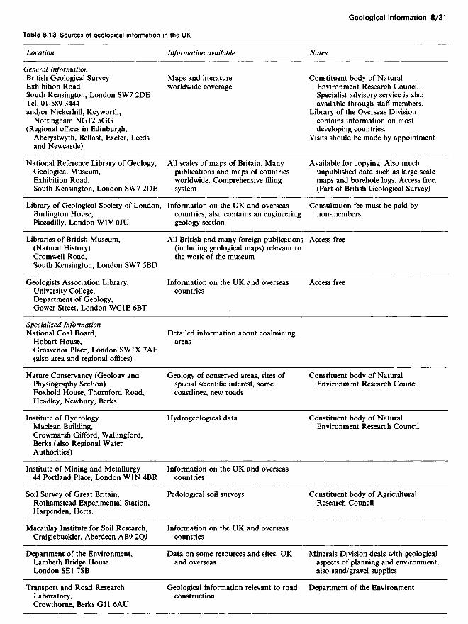
Table 8.13 Sources of geological information in the UK
Location
General InformationBritish Geological SurveyExhibition RoadSouth Kensington, London SW7 2DETel. 01-589 3444and/or Nickerhill, Keyworth,
Nottingham NG 12 5GG(Regional offices in Edinburgh,
Aberystwyth, Belfast, Exeter, Leedsand Newcastle)
National Reference Library of Geology,Geological Museum,Exhibition Road,South Kensington, London SW7 2DE
Library of Geological Society of London,Burlington House,Piccadilly, London WlV OJU
Libraries of British Museum,(Natural History)Cromwell Road,South Kensington, London SW7 5BD
Geologists Association Library,University College,Department of Geology,Gower Street, London WClE 6BT
Specialized InformationNational Coal Board,
Hobart House,Grosvenor Place, London SWlX 7AE(also area and regional offices)
Nature Conservancy (Geology andPhysiography Section)Foxhold House, Thornford Road,Headley, Newbury, Berks
Institute of HydrologyMaclean Building,Crowmarsh Gifford, Wallingford,Berks (also Regional WaterAuthorities)
Institute of Mining and Metallurgy44 Portland Place, London WIN 4BR
Soil Survey of Great Britain,Rothamstead Experimental Station,Harpenden, Herts.
Macaulay Institute for Soil Research,Craigiebuckler, Aberdeen AB9 2QJ
Department of the Environment,Lambeth Bridge HouseLondon SEl 7SB
Transport and Road ResearchLaboratory,Crowthorne, Berks GIl 6AU
Information available
Maps and literatureworldwide coverage
All scales of maps of Britain. Manypublications and maps of countriesworldwide. Comprehensive filingsystem
Information on the UK and overseascountries, also contains an engineeringgeology section
All British and many foreign publications(including geological maps) relevant tothe work of the museum
Information on the UK and overseascountries
Detailed information about coalminingareas
Geology of conserved areas, sites ofspecial scientific interest, somecoastlines, new roads
Hydrogeological data
Information on the UK and overseascountries
Pedological soil surveys
Information on the UK and overseascountries
Data on some resources and sites, UKand overseas
Geological information relevant to roadconstruction
Notes
Constituent body of NaturalEnvironment Research Council.Specialist advisory service is alsoavailable through staff members.
Library of the Overseas Divisioncontains information on mostdeveloping countries.
Visits should be made by appointment
Available for copying. Also muchunpublished data such as large-scalemaps and borehole logs. Access free.(Part of British Geological Survey)
Consultation fee must be paid bynon-members
Access free
Access free
Constituent body of NaturalEnvironment Research Council
Constituent body of NaturalEnvironment Research Council
Constituent body of AgriculturalResearch Council
Minerals Division deals with geologicalaspects of planning and environment,also sand/gravel supplies
Department of the Environment

use for engineering purposes, but problems may be encounteredin locating it and securing permission for its release.
8.6.3 BooksThe bibliographies of the Geological Society of America havebeen issued since 1933 and are available at most university ornational reference libraries. They list all the geological informa-tion published about any country for a given year and in itspresent form have separate location and author indices. Thevalue of the bibliographies lies in the detail of their references,but many of the publications listed may be difficult to obtainother than from the largest national lending libraries, e.g. theBritish Library Lending Division, Boston Spa, Wetherby, WestYorks LS23 7BQ, telephone (0937) 843434.
Many countries have an established Geological Society whichpublishes papers primarily related to the country. Copies ofmany of these papers are kept at the Geological Society ofLondon. Major libraries throughout the world are listed in theWorld of learning, published annually by Europa Publications.
8.6.4 InstitutionsGovernment institutes of geology and allied sciences provide themain reference source for geological information. They publishmaps and literature, store unpublished data, and may provide aspecialist advisory service through their staff members. Mostcountries now possess an equivalent to the British GeologicalSurvey in the UK, although this may be called a GeologicalSurvey Department, Bureau or Department of Mines andMineral Resources. The work produced by such an institutionwill usually be in the language of that country and a technicaltranslation of high quality may be essential.
Many universities have a department of geology or earthsciences and may possess information not available elsewhere,comprising research work in progress and unpublished theses,dissertations and reports. British universities have researchinterests overseas; details of staff and their research interest arepublished annually by the Department of Education and Sci-ence. The address of overseas universities and staff are givenannually in the World of learning.
Local museums frequently serve as depositories for geologicaldata, both published and unpublished. Certain national organi-zations in any country accumulate specialized geological infor-mation.
Similar organizations exist in some developing countries andfor many of these areas particularly useful information may becontained in unpublished reports of oil companies, miningcompanies and civil engineering firms. The oil companies haveproduced geological maps for many otherwise unsurveyed areasand some of these have been published. A request for geologicalinformation, particularly about near-surface formations, may be
received sympathetically depending on company policy andcircumstances.
Besides the methods of obtaining geological informationmentioned above, there are data retrieval organizations andgeological abstracting services which will provide informationfor a fee.
Another source of information is satellite photographs. Acatalogue and price list of satellite photographs can be obtainedfrom Audio-visual Branch, National Aeronautics and SpaceAdministration, Washington DC, US.
References
1. Price, D. G. (1971) 'Engineering geology in the urbanenvironment', Q. J. Engng Geol. 4, 191-208
2. Krynine, D. P. and Judd, W. R. (1957) Principles of engineeringgeology and geotechnics. McGraw-Hill, New York.
3. Lahee, F. H. (1961) Field geology, 6th edn. McGraw-Hill, NewYork.
4. Shergold, F. A. (1960) The classification, production and testingof roadmaking aggregates.' Quarry Managers J., 44, 2, 3-10.
5. Attewell, P. B. and Farmer, I. W. (1975) Principles of engineeringgeology. Chapman and Hall, London.
6. Price, N. J. (1966) Fault and joint development in brittle andsemi-brittle rock. Pergamon Press, Oxford.
7. Phillips, F. C. (1971) The use of stereographic projection instructural geology, 3rd edn. Arnold, London.
8. Fookes, P. G. and Vaughan, P. R. (1986) A handbook ofengineering geomorphology. Surrey University Press, London.
9. Sanders, M. E. and Fookes, P. G. (1970) 'A review of therelationship of rock weathering and climate and its significance tofoundation engineering.' Engng Geol. 4, 289-325.
10. Fookes, P. G., Dearman, W. R. and Franklin, J. A. (1971) 'Someengineering aspects of rock weathering with field examples fromDartmoor and elsewhere.' Q. J. Engrg Geol. 4, 139-186.
11. Little, A. L. (1967) 'Laterites.' Proceedings, 3rd Asian RegionalConference on Soil Mechanics Foundation Engineering. Haifa, 2,61-71.
12. Deere, D. R. and Patton, F. D. (1971) 'Stability of slopes inweathered rock.' Proceedings, 4th Panamanian Conference, pp.87-163.
13. Irfan, T. Y. and Dearman, W. R. (1978) 'Engineeringclassification and index properties of a weathered granite.' Bull.Int. Assoc. Engng Geol. 17, 79-90.
14. Institution of Civil Engineers (1957) Symposium on airfieldconstruction on overseas soils. Proc. Instn. Civ. Engrs, 8, 211-292.
15. Chen, F. H. (1975) 'Foundations on expansive soils. Elsevier,Amsterdam, p. 280.
16. Gidigasu, M. D. (1975) Laterite soil engineering. Elsevier,Amsterdam, p. 570.
17. Anon. (1982) 'Engineering construction in tropical and residualsoils.' Proceedings, American Society of Civil EngineersGeotechnical Engineering Division Special Conference. Hawaii,p. 735.
18. Cooke, R. U., Brunsden, D., Doornkamp, J. C. and Jones,D. K. C. (1982) Urban geomorphology in drylands. Oxford, p. 324.
Table 8.13 Continued
Location
Water Resources Board,Reading Bridge HouseReading RGl 8PS
Building Research Station,Garston, Watford, Herts
Civil Engineering Laboratory,Cardington, Bedfordshire
Information available
Hydrogeological data
Some geotechnical data relevant tobuilding construction
Data relevant to foundations and toslope stability
Notes
Department of the Environment
Department of the Environment
Department of the Environment

19. Fookes, P. G. and Knill, J. L. (1969) 'The application ofengineering geology in the regional development of northern andcentral Iran.' Engng Geol. 3, 81-120.
20. Holtz, W. G. and Gibbs, H. J. (1952) Consolidation and relatedproperties of laersial soils. American Society of Civil EngineersTesting Material Special Technical Publication No. 126, pp. 9-33.
21. Weinert, H. H. and Clauss, M. A. (1967) 'Soluble salts in roadfoundations.' Proceedings, 4th Regional Conference for Africa SoilMechanics and Foundation Engineering, pp. 213-218.
22. Fookes, P. G. and French, W. J. (1977) 'Soluble salt damage tosurfaced roads in the Middle East.' Highway Engineering, XXIV,12, 10-20.
23. Fookes, P. G. and Higginbottom, I. E. (1980) 'Some problems ofconstruction aggregates in desert areas with particular referenceto the Arabian peninsula.' Proc. Instn Civ. Engrs, Part 1, 68,39-90.
24. Oweis, I. and Bowman, J. (1981) 'Geotechnical considerations forconstruction in Saudi Arabia.' Proc. Am. Soc. Civ. Engrs, Paper16092, 319-338.
25. Linell, K. A. and Shea, H. F. (1960) 'Strength and deformationcharacteristics of various glacial tills in New England.'Proceedings, American Society of Civil Engineers RegionalConference on Shear Strength of Cohesive Soils, pp. 275-314.
26. 'The engineering behaviour of glacial materials.' Proceedings,Symposium on Midland Soil Mechanics and FoundationEngineering Society. Birmingham 1975, (reprint by GeoAbstracts, Norwich, p. 275.)
27. McGowan, A. and Derbyshire, E. (1977) 'Genetic influences onthe properties of tills.' Q. J. Engng Geol., 10, 389-410.
28. Higginbottom, I. E. and Fookes, P. G. (1970) 'Engineeringaspects of periglacial features in Britain.' Q. J. Engng Geol., 3,86-117.
29. Weeks, A. G. (1969) The stability of slopes in south-eastEngland as affected by periglacial activity.' Q. J. Engng Geol., 2,49-62.
30. Fookes, P. G. and Best, R. (1968) 'Consolidation characteristicsof some late Pleistocene periglacial metastable soils of east Kent.'Q. J. Engng Geol., 2, 103-128.
31. Dearman, W. R. (1981) 'Engineering properties of carbonaterocks.' Bull. Int. Assoc. Engng Geol., 24, 3-17.
32. Hobbs, N. B. (1975) 'Factors affecting the prediction ofsettlement of structures on rock: with particular reference to theChalk and Triass.' Revised Paper Session IV: rocks, 579-610.British Geotechnical Society, London.
33. Geological Society (1972) Geological Society Working PartyReport on the preparation of maps and plans in terms ofengineering geology.' Q. J. Engng Geol., 5, 4, 293-381.
34. Dumbleton, M. J. and West, G. (1970) 'Preliminary sources ofinformation for site investigation in Britain.' Ministry ofTransport Road Research Laboratory Report LR 403,Crowthorne, Berks, p. 100.
35. British Standards Institution (1981) Site investigation. Code ofPractice 5930. BSI, Milton Keynes.
36. Hughes, N. F. (1977) 'Applied geology for engineers.' In: MilitaryEngineering, vol. XV. HMSO, London.
Bibliography
PeriodicalsEngineering Geology (Published Quarterly by Elsevier).Geotechnique (Published quarterly by Thomas Telford Ltd).International Journal of Rock Mechanics and Mining Sciences(Published bimonthly by Pergamon).Quarterly Journal of Engineering Geology (Published by GeologicalSociety).Rock Mechanics and Engineering Geology (Published quarterly bySpringer-Verlag).
DictionariesChallinor, J. (1978) Dictionary of geology, 5th edn, University of WalesPress.Whitten, D. G. A. and Brooks, J. R. V. (1972) Dictionary of geology.Penguin.
DictionariesChallinor, J. (1978) Dictionary of geology, 5th edn, University of WalesPress.Whitten, D. G. A. and Brooks, J. R. V. (1972) Dictionary of geology.Penguin.
General and physical geologyAger, D. W. (1975) Introducting geology, 2nd edn. Faber and Faber,London.BIy th, F. G. H. and de Freitas, M. H. (1974) A geology for engineers,6th edn. Arnold, London.Bradshaw, J. J., Abbott, A. J. and Gelsthorpe, A. P. (1978) TheEarth's changing surface. Hodder and Stoughton, London.Bridges, E. M. (1970) World soils Cambridge University Press,Cambridge.Dury, G. H. (1966) The face of the Earth (rev. edn). Penguin, London.Fookes, P. G. and Vaughan, P. R. (1986) A handbook of engineeringgeomorphology. Surrey University Press, London.Gass, I. G., Smith, P. J. and Wilson, R. C. L. (1972) Understanding theEarth, 2nd edn. Artemis Press.Holmes, A. (1978) Principles of physical geology, 3rd edn. Nelson,London.Oilier, C. D. (1975) Weathering, 2nd edn. Oliver and Boyd,Cambridge.Read, H. H. and Watson, J. (1971) Beginning geology, 2nd edn.Macmillan/Allen and Unwin, London.Shephard, F. P. (1973) Submarine geology, 3rd edn. Harper and Row,London.Small, R. J. (1978) The study oflandforms, 2nd edn. CambridgeUniversity Press, Cambridge.Sparks, B. W. (1972) Geomorphology, 2nd edn. Longman, London.Thomas, M. F. (1974) Tropical geomorphology. Macmillan, London.West, R. G. (1977) Pleistocene geology and biology, 2nd edn.Longman, London.
Engineering geologyAnon. (1976) Engineering geological maps. UNESCO Press, Paris.Hoek, E. and Bray, J. (1974) Rock slope engineering, 2nd edn. Instituteof Mining and Metallurgy, London.Attewell, P. B. and Farmer, I. W. (1975) Principles of engineeringgeology. Chapman and Hall, London.Brown, E. T. (ed.) (1981) Rock classification, testing and monitoring.ISRM Suggested Methods. Pergamon Press, Oxford.British Standards Institution (1981) Site investigation. Code of Practice5930. HMSO, London.Derbyshire, E., Gregory, F. J. and Hails, J. R. (1979)Geomorphological processes. Butterworth, London, p. 312.Hughes, N. F. (1977) 'Applied geology for engineers.' MilitaryEngineering, Vol. XV. HMSO, London.Stagg, K. G. and Zienkiewicz, O. C. (1968) Rock mechanics inengineering practice. Wiley, Chichester.Legget, R. F. and Karrow, P. G. (1983) Geology in civil engineering.McGraw-Hill, New York.
Fieldwork and mapworkBennison, G. M. (1976) An introduction to geological structures andmaps, 3rd edn. Arnold, London.Blyth, F. G. H. (1976) Geological maps and their interpretation, 2ndedn. Arnold, London.Lahee, F. H. (1961) Field geology, 6th edn. McGraw-Hill, New York.
Structural geologyBillings, M. P. (1972) Structural geology, 3rd edn. Prentice-Hall,Englewood Cliffs, New Jersey.Hills, E. Sherbon (1972) Elements of structural geology, 2nd edn.Chapman and Hall, London.Phillips, F. C. (1971) The use of stereographic projection in structuralgeology, 3rd edn. Arnold, London.Price, N. J. (1966) Fault and joint development in brittle and semi-brittlerock. Pergamon Press, Oxford.Ramsey, J. G. (1967) Folding and fracturing of rocks. McGraw-Hill,New York.
Mineralogy and petrologyGrim, R. E. (1968) Applied clay mineralogy, 2nd edn. McGraw-Hill,New York.

Hatch, F. H., Wells, A. K. and Wells, M. K. (1973) The petrology ofthe igneous rocks, 13th edn. Murby,Hatch, F. H. and Rastall, R. H. (1978) The petrology of thesedimentary rocks, 6th edn. (rev. J. T. Greensmith). Murby,Krumbein, W. C. and Sloss, I. L. (1963) Stratigraphy andsedimentation, 2nd edn. Freeman, New York.Pettijohn, F. J. (1976) Sedimentary rocks, 3rd edn. Harper and Row,London.Read, H. H. (1970) Rutley's elements of mineralogy, 26th edn. Murby
In addition to these general works, the following series are of interest toBritish engineers:British Regional Geology: handbooks published by the Geological
Museum London SW7 , Handbooks published by the BritishBritish Palaeozoic Fossils Museum
British Mesozoic Fossils j R. } L d sw?
Bntish Camozoic Fossils J v J/
Geologists' Association Guides: a series of excursion guides to selectedBritish localities (available from The Scientific Anglican, 30/30A StBenedict's St, Norwich)Publications of the Geological Society of London, Burlington House,Piccadilly, London WlV OJU: various monographs and authoritativeworks