eeriindonesiantsunami.pdf
TRANSCRIPT

8/8/2019 EERIIndonesianTsunami.pdf
http://slidepdf.com/reader/full/eeriindonesiantsunamipdf 1/53
Earthquake EngineeringEarthquake Engineering
Research InstituteResearch Institute
An illustrated description of their causes and effects
The Great Sumatra Earthquake andThe Great Sumatra Earthquake andIndian Ocean TsunamiIndian Ocean Tsunami
of December 26, 2004of December 26, 2004

8/8/2019 EERIIndonesianTsunami.pdf
http://slidepdf.com/reader/full/eeriindonesiantsunamipdf 2/53
This presentation was developed to explain the origins of theThis presentation was developed to explain the origins of theSumatra earthquake of December 26, 2004 and the ensuingSumatra earthquake of December 26, 2004 and the ensuingtsunami, and to document the damages caused by thetsunami, and to document the damages caused by the
earthquake and tsunami in so many countries around theearthquake and tsunami in so many countries around theIndian Ocean.Indian Ocean.
This project was supported by funds from the National Science FoThis project was supported by funds from the National Science Foundation throughundation throughEERI EERI ’ ’ ss Learning From Earthquakes Program under grant # CMSLearning From Earthquakes Program under grant # CMS--0131895 0131895
The presentation was createdThe presentation was createdlargely bylargely by WidiantoWidianto, a doctoral, a doctoral
candidate in civil engineeringcandidate in civil engineeringand president of the EERIand president of the EERIstudent chapter at thestudent chapter at theUniversity of Texas at Austin.University of Texas at Austin.
Other contributors includeOther contributors includeSarah Nathe, Craig Comartin,Sarah Nathe, Craig Comartin,and Heidi Faison.and Heidi Faison.
PrefacePreface

8/8/2019 EERIIndonesianTsunami.pdf
http://slidepdf.com/reader/full/eeriindonesiantsunamipdf 3/53
United States Geological Survey (USGS)
“The tsunami that struck Southeast Asia on
December 26, 2004 has been confirmed as the most
devastating in modern history.”Guinness Book of World Records
“The 26th December 2004 Sumatra-Andaman
earthquake is the fourth largest earthquake in the
world since 1900 and is the largest since the 1964Prince William Sound, Alaska earthquake.”

8/8/2019 EERIIndonesianTsunami.pdf
http://slidepdf.com/reader/full/eeriindonesiantsunamipdf 4/53
Contents Introduction: Plate tectonics, earthquakes
Sumatra Earthquake
- Tectonic activity
- Observations
- Damage
Indian Ocean Tsunami
- Basic mechanism
- Videos: before and after giant wave arrival
- Damage
Tsunamis in the USA
Tsunami Risk Reduction
The Earthquake Engineering Research Institute

8/8/2019 EERIIndonesianTsunami.pdf
http://slidepdf.com/reader/full/eeriindonesiantsunamipdf 5/53
Introduction – Plate Tectonics The Earth is characterized by a small number of lithospheric plates thatfloat on a viscous underlayer called the asthenosphere.
Geological evidence shows that plates undergo constant, gradual
change. Magma is continually upwelling at the mid-oceanic ridges and rises
as the seafloor spreads apart.
In some areas, large sections of plates are forced to move beneath other
plates (surface layers of rocks are absorbed into the earth’s interior). These
areas are called subduction zones.
A plate being subducted beneath another

8/8/2019 EERIIndonesianTsunami.pdf
http://slidepdf.com/reader/full/eeriindonesiantsunamipdf 6/53
Introduction – Plate Tectonics
Source: Earthquakes by Bruce A. Bolt

8/8/2019 EERIIndonesianTsunami.pdf
http://slidepdf.com/reader/full/eeriindonesiantsunamipdf 7/53
Introduction – Plate Tectonics
95% of earthquakes occur along the edges of the interacting plates
Source: Earthquakes by Bruce A. Bolt

8/8/2019 EERIIndonesianTsunami.pdf
http://slidepdf.com/reader/full/eeriindonesiantsunamipdf 8/53
World’s Largest Magnitude Earthquakes
Approx. casualtiesApprox. casualties Year Year MagnitudeMagnitudeEarthquakeEarthquake
>283,100>283,100
(>173,000 in Indonesia)(>173,000 in Indonesia)
200420049.09.05. Sumatra5. Sumatra
Not reportedNot reported195219529.09.04.4. KamchatkaKamchatka
PeninsulaPeninsula
Not reportedNot reported195719579.19.13.3. Andreanof Andreanof
Islands, AlaskaIslands, Alaska
≅≅≅≅≅≅≅≅ 125125196419649.29.22. Prince William2. Prince William
Sound, AlaskaSound, Alaska
>2000>2000196019609.59.51. Chile1. Chile
Source: United States Geological Survey (USGS)

8/8/2019 EERIIndonesianTsunami.pdf
http://slidepdf.com/reader/full/eeriindonesiantsunamipdf 9/53
Earthquake Energy
Source: Earthquakes by Bruce A. Bolt
Sumatra-Andaman (2004)

8/8/2019 EERIIndonesianTsunami.pdf
http://slidepdf.com/reader/full/eeriindonesiantsunamipdf 10/53
Sumatra Earthquake
Magnitude: 9.0
Date-time: Sunday, December 26,
2004 at 7:58:53 AM (local time)
Depth: 30 km (18.6 miles)
Distances:
* 250 km (155 miles) SSE of Aceh,
Sumatra, Indonesia
* 310 km (195 miles) W of Medan,
Sumatra, Indonesia
* 1260 km (780 miles) SSW of
Bangkok, Thailand
* 1605 km (990 miles) NW of
Jakarta, Java, Indonesia
Source: United States Geological Survey (USGS)

8/8/2019 EERIIndonesianTsunami.pdf
http://slidepdf.com/reader/full/eeriindonesiantsunamipdf 11/53
Tectonic Summary It occurred on the interface of
the India and Burma plates: an
interplate earthquake.
India plate subducts beneath
the overriding Burma plate atthe Sunda Trench.
In the region of the earthquake,
the India plate moves toward the
northeast at a rate of about6 cm/year relative to the Burma
plate.
Thrust faulting caused the
earthquake (slip directed
perpendicular to the trench).
Fault rupture propagated to
the northwest from the epicenter
with a width ≅ 100 km and an
average displacement on the faultplane ≅ 20 meters.
6 cm/yr
Source: United States Geological Survey (USGS)

8/8/2019 EERIIndonesianTsunami.pdf
http://slidepdf.com/reader/full/eeriindonesiantsunamipdf 12/53
Felt Shaking ReportsModified Mercalli Intensity Scale:
Banda Aceh, Sumatra: IX
Medan, Sumatra: IV
Port Blair, Andaman Islands: VII
Subsidence and landslides
were observed in Sumatra.
A mud volcano near Baratang,
Andaman Islands began eruptingon December 28, 2004.
Intensity vs. Distance from
Epicenter Plot :
Source: United States Geological Survey (USGS)

8/8/2019 EERIIndonesianTsunami.pdf
http://slidepdf.com/reader/full/eeriindonesiantsunamipdf 13/53
AftershockAftershock
ZoneZone Extends from
Northern Sumatra to
the Andaman Islands,
~ 1300 km to the north.
Largest aftershock
directly following the
main shock was M =
7.1 in the Nicobar
Islands.
On March 28, 2005, a
M = 8.7 earthquake
occurred in a region of
the fault southeast of
the Dec 26th
mainshockand its rupture zone.
Epicenter of mainshock,
28 Mar 2005
8/8/2019 EERIIndonesianTsunami.pdf
http://slidepdf.com/reader/full/eeriindonesiantsunamipdf 14/53
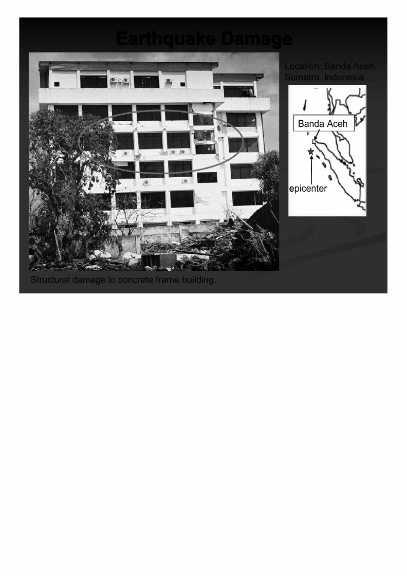
Earthquake DamageEarthquake Damage
Structural damage to concrete frame building.
epicenter
Banda Aceh
epicenter
Banda Aceh
Location: Banda Aceh,
Sumatra, Indonesia
Photo: Jose Borrero

8/8/2019 EERIIndonesianTsunami.pdf
http://slidepdf.com/reader/full/eeriindonesiantsunamipdf 15/53
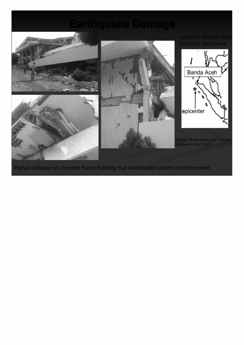
Earthquake DamageEarthquake Damage
Partial collapse of concrete frame building due to column failure.
epicenter
Banda Aceh
epicenter
Banda Aceh
Location: Banda Aceh,
Sumatra, Indonesia
Photo: Murat Saatcioglu, Ahmed
Ghobarah, Ioan Nistor
8/8/2019 EERIIndonesianTsunami.pdf
http://slidepdf.com/reader/full/eeriindonesiantsunamipdf 16/53
Partial collapse of concrete frame building due inadequate column reinforcement.
epicenter
Banda Aceh
epicenter
Banda Aceh
Location: Banda Aceh
Sumatra, Indonesia
Photos: Murat Saatcioglu, Ahmed
Ghobarah, Ioan Nistor
Earthquake DamageEarthquake Damage

8/8/2019 EERIIndonesianTsunami.pdf
http://slidepdf.com/reader/full/eeriindonesiantsunamipdf 17/53
Earthquake DamageEarthquake Damage
Architectural damage to the
Grand Mosque tower.
epicenter
Banda Aceh
epicenter
Banda Aceh
Location: Banda Aceh,
Sumatra, Indonesia
Photo: Jose Borrero

8/8/2019 EERIIndonesianTsunami.pdf
http://slidepdf.com/reader/full/eeriindonesiantsunamipdf 18/53
Earthquake DamageEarthquake Damage
Source: Geological Survey of India
Location: Port Blair,
Andaman Islands
epicenter
Port Blair
epicenter
Port Blair
Column of residential building damaged by ground motion.

8/8/2019 EERIIndonesianTsunami.pdf
http://slidepdf.com/reader/full/eeriindonesiantsunamipdf 19/53
Earthquake DamageEarthquake Damage
Source: Geological Survey of India
Location: Port Blair,
Andaman Islands
epicenter
Port Blair
epicenter
Port Blair
Longitudinal (50 m long)crack on Kamraj Road after
the earthquake
Major crack showing a rupture width of
15 cm on Kamraj Road after the
earthquake

8/8/2019 EERIIndonesianTsunami.pdf
http://slidepdf.com/reader/full/eeriindonesiantsunamipdf 20/53
Earthquake and Tsunami
Not all earthquakes generate tsunamis.
An earthquake must have certain characteristics in order to
generate a tsunami:
Source: Earthquakes by Bruce A. Bolt
1. Epicenter is underneath or near the ocean.
2. Fault causes vertical movement of the sea floor (up to
several meters) over a large area (up to 100,000 km2).
3. Large magnitude ( > 7.5 ) AND shallow focus ( < 70 km).
8/8/2019 EERIIndonesianTsunami.pdf
http://slidepdf.com/reader/full/eeriindonesiantsunamipdf 21/53
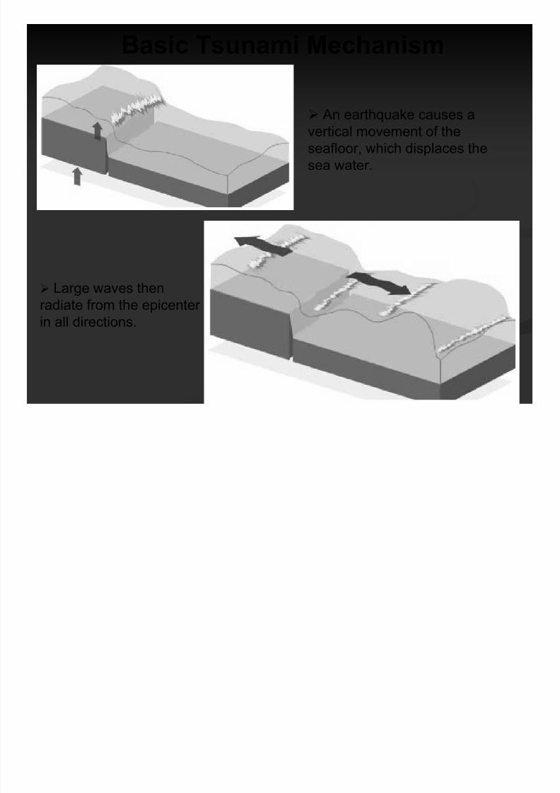
Basic Tsunami Mechanism
An earthquake causes a
vertical movement of the
seafloor, which displaces thesea water.
Large waves then
radiate from the epicenterin all directions.

8/8/2019 EERIIndonesianTsunami.pdf
http://slidepdf.com/reader/full/eeriindonesiantsunamipdf 22/53
Tsunami Explained
A tsunami is series of traveling ocean waves of extremely long lengthgenerated primarily by earthquakes occurring below or near the ocean floor.
Tsunami waves propagate across the deep ocean with a speed exceeding
800 km/h (≅ 500 mph) and a wave height of only a few tens of centimeters or
less.
As they reach the shallow waters of the coast, the waves slow down and
their height increases up to tens of meters (30 ft) or more.
Source: NOAA

8/8/2019 EERIIndonesianTsunami.pdf
http://slidepdf.com/reader/full/eeriindonesiantsunamipdf 23/53
Tsunami Translated
“Tidal wave” is a misnomer because the cause
is unrelated to tides.
“Seismic sea wave” is misleading because a
tsunami can be caused by non-seismic events,
and it is not dangerous in the open ocean.
Japanese word:
“Tsu“ means“harbor”
“Nami“ means
“wave”
English translation:
“Harbor wave”

8/8/2019 EERIIndonesianTsunami.pdf
http://slidepdf.com/reader/full/eeriindonesiantsunamipdf 24/53
Water Recession: A Precursor
F rom: Nature Publishing GroupFrom: Nature Publishing Group
Wave Generation Draw Down Effect
From: Digital Globe
Kalutara Beach, Sri Lanka

8/8/2019 EERIIndonesianTsunami.pdf
http://slidepdf.com/reader/full/eeriindonesiantsunamipdf 25/53
Tsunami Wave AppearanceTsunami Wave Appearance
A tsunami wave crest has A tsunami wave crest hasthree general appearancesthree general appearances
from shore:from shore: FastFast--rising tiderising tide
Cresting waveCresting wave
A step A step--like change in thelike change in thewater level that advanceswater level that advancesrapidly (called arapidly (called a borebore))
Series of wavesSeries of waves Most tsunamis come in a series of waves that may last for severaMost tsunamis come in a series of waves that may last for severall
hourshours The outflow of water back to the sea between waves can causeThe outflow of water back to the sea between waves can cause
more damage than the original incoming wave frontsmore damage than the original incoming wave fronts
The first wave is rarely the largestThe first wave is rarely the largest
A bore on the Qian Tang Jiang River, China
Source: www.waveofdestruction.org

8/8/2019 EERIIndonesianTsunami.pdf
http://slidepdf.com/reader/full/eeriindonesiantsunamipdf 26/53
Tsunami Propagation
National Institute of Advanced Industrial Science and Technology, Japan
8/8/2019 EERIIndonesianTsunami.pdf
http://slidepdf.com/reader/full/eeriindonesiantsunamipdf 27/53
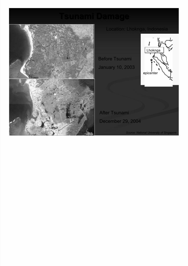
Tsunami DamageTsunami Damage
Before Tsunami
January 10, 2003
After Tsunami
December 29, 2004
Source: National University of Singapore
Location: Lhoknga, Indonesia
epicenter
Lhoknga
epicenter
Lhoknga

8/8/2019 EERIIndonesianTsunami.pdf
http://slidepdf.com/reader/full/eeriindonesiantsunamipdf 28/53
Tsunami DamageTsunami DamageLocation: Lhoknga, Indonesia
epicenter
Lhoknga
epicenter
Lhoknga
Exposed
bridge piers of
road that
washed away.
Damage zone showing anoverturned tanker, trees
snapped in half, and the
high water mark on islands
where vegetation was
stripped away.
Overturned
ship
High Water Mark
Broken Trees
Photo: Jose Borrero
Photo: Jose Borrero

8/8/2019 EERIIndonesianTsunami.pdf
http://slidepdf.com/reader/full/eeriindonesiantsunamipdf 29/53
Tsunami DamageTsunami Damage
Before Tsunami
April 12, 2004
After Tsunami
January 2, 2005
Source: Digital Globe
Location: Gleebruk, Indonesia
epicenter
Gleebruk
epicenter
Gleebruk

8/8/2019 EERIIndonesianTsunami.pdf
http://slidepdf.com/reader/full/eeriindonesiantsunamipdf 30/53
Tsunami DamageTsunami Damage
Before Tsunami
April 12, 2004
After Tsunami
January 2, 2005
Source: Digital Globe
epicenter
Gleebruk
epicenter
Gleebruk

8/8/2019 EERIIndonesianTsunami.pdf
http://slidepdf.com/reader/full/eeriindonesiantsunamipdf 31/53
Tsunami DamageTsunami Damage
Before Tsunami
June 23, 2004
After Tsunami
December 28, 2004
Source: Digital Globe
Location: Banda Aceh, Indonesia
epicenter
Banda Aceh
epicenter
Banda Aceh

8/8/2019 EERIIndonesianTsunami.pdf
http://slidepdf.com/reader/full/eeriindonesiantsunamipdf 32/53
Tsunami DamageTsunami DamageLocation: Banda Aceh, Indonesia
epicenter
Banda Aceh
epicenter
Banda Aceh
Damage was caused by
both water and water-borne
debris.
A boat was
lifted on top
of houses
by the
waves.
Photo: Jose Borrero
Photo: Jose Borrero

8/8/2019 EERIIndonesianTsunami.pdf
http://slidepdf.com/reader/full/eeriindonesiantsunamipdf 33/53
Tsunami DamageTsunami Damage
Location: Banda Aceh & Lhoknga,Indonesia
epicenter
Banda Aceh
epicenter
Banda Aceh
The tsunami waves came
from many directions and
flowed across the tip of
northeastern Sumatra.
Graphic: Jose Borrero

8/8/2019 EERIIndonesianTsunami.pdf
http://slidepdf.com/reader/full/eeriindonesiantsunamipdf 34/53
epicenter
Kerala Coast
epicenter
Kerala Coast
Tsunami DamageTsunami Damage
Location: Thailand
Damage to Kao
Lak Resort from
tsunami waves.
Despite the presence of debris,
this naval base building had
little structural damage due to a
retaining wall at its frontage.
Photo: Curt Edwards
Photo: Chitr Lilavivat
Thailand

8/8/2019 EERIIndonesianTsunami.pdf
http://slidepdf.com/reader/full/eeriindonesiantsunamipdf 35/53
Tsunami DamageTsunami Damage
Location: Sri Lanka
epicenter
Kerala Coast
epicenter
Kerala CoastSri Lanka
Damage to house in Tangala.
Flow depths were
about 4.5 m at Yala
Safari Resort, where
water levels weredetermined by debris
in the trees (see door
impaled on branch).

8/8/2019 EERIIndonesianTsunami.pdf
http://slidepdf.com/reader/full/eeriindonesiantsunamipdf 36/53
Tsunami DamageTsunami Damage
Location: Kerala, India
Source: Geological Survey of India
epicenter
Kerala Coast
epicenter
Kerala Coast
The collapsed front
portion of a concrete
house.
In the village of Alappad, the foundations and
the soil beneath many of the houses were
scoured out.

8/8/2019 EERIIndonesianTsunami.pdf
http://slidepdf.com/reader/full/eeriindonesiantsunamipdf 37/53
Tsunamis in the U.S.A.Tsunamis in the U.S.A. TheThe west coastwest coast, from California to Alaska, is vulnerable to, from California to Alaska, is vulnerable to
tsunamis from nearby or distant earthquakes.tsunamis from nearby or distant earthquakes.
HawaiiHawaii is extremely vulnerable to all tsunamis in the Pacificis extremely vulnerable to all tsunamis in the PacificOcean.Ocean.
California, Oregon, Washington, Alaska and Hawaii all haveCalifornia, Oregon, Washington, Alaska and Hawaii all havetsunami education programstsunami education programs for residents and visitors,for residents and visitors,coastal signagecoastal signage, and, and warning response planswarning response plans..
Photo: Eugene Schader, NISEE Collection
Warped pier in Crescent City, CA caused by1964 Alaska earthquake tsunami
Photo: Kirkpatrick, NISEE Collection
Tsunami induced damage in Seward, Alaskafrom 1964 Alaska earthquake

8/8/2019 EERIIndonesianTsunami.pdf
http://slidepdf.com/reader/full/eeriindonesiantsunamipdf 38/53
Historical Tsunamis in the U.S.A.Historical Tsunamis in the U.S.A.
unknownunknownWest coastWest coast17001700CascadiaCascadia FaultFault
EarthquakeEarthquake
Tsunami CasualtiesTsunami CasualtiesAffected StatesAffected States Year Year Tsunami SourceTsunami Source
120120 (total)(total)AK, HI , WA, CAAK, HI , WA, CA19641964Alaska EarthquakeAlaska Earthquake
(Mw = 9.3)(Mw = 9.3)
6161 (Hilo, Hawaii)(Hilo, Hawaii)CA, HICA, HI19601960Chile EarthquakeChile Earthquake
(Mw = 9.5)(Mw = 9.5)
22AKAK19581958LituyaLituya Bay, AlaskaBay, Alaska
LandslideLandslide
159 (Hilo, Hawaii)159 (Hilo, Hawaii)
165165 (total)(total)
AK, HI , WA, OR, CAAK, HI , WA, OR, CA19461946Aleutian EarthquakeAleutian Earthquake
(Mw = 8.3)(Mw = 8.3)
Sources: NOVA; International Tsunami Information Center (ITIC)

8/8/2019 EERIIndonesianTsunami.pdf
http://slidepdf.com/reader/full/eeriindonesiantsunamipdf 39/53
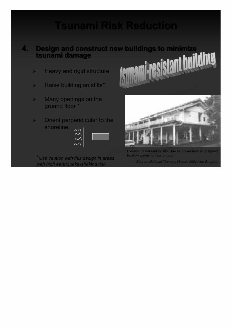
Tsunami Risk ReductionTsunami Risk Reduction
1.1. Determine & understand community tsunami riskDetermine & understand community tsunami risk Hazard:Hazard:
Study the shape of the sea floor and the coastal topography
Run simulations of tsunamis
Vulnerability:Vulnerability:
DevelopDevelop mapsmaps of potential risk areasof potential risk areas
Exposure:Exposure:
Costal communities, especially with tsunami historyCostal communities, especially with tsunami history
2.2. Avoid new development in tsunami runAvoid new development in tsunami run--up areasup areas
1.1. Designate risk areas asDesignate risk areas as openopen--spacespace, i.e., parks and agriculture, i.e., parks and agriculture
2.2. Zone to minimize human riskZone to minimize human risk1.1. Low density residential zoningLow density residential zoning
2.2. Large singleLarge single--residence lotsresidence lots

8/8/2019 EERIIndonesianTsunami.pdf
http://slidepdf.com/reader/full/eeriindonesiantsunamipdf 40/53
Tsunami Risk ReductionTsunami Risk Reduction
3.3. Locate and configure new development in the runLocate and configure new development in the run--upup
areas to minimize future tsunami lossesareas to minimize future tsunami losses
Avoid inundation areas
i.e. build on high ground
Slowing water currentsi.e. Conserve or replant coastal belts
of forest and mangrove swamps
Steering water forces
i.e. angled, by-pass walls
Blocking water forces
i.e. Build sea walls
SLOWING
STEERING
BLOCKINGSource: National Tsunami Hazard Mitigation Program (NTHMP)
8/8/2019 EERIIndonesianTsunami.pdf
http://slidepdf.com/reader/full/eeriindonesiantsunamipdf 41/53
Tsunami Risk ReductionTsunami Risk Reduction
Elevated restaurant in Hilo, Hawaii. Lower level is designed
to allow waves to pass through.
Source: National Tsunami Hazard Mitigation Program
4.4. Design and construct new buildings to minimizeDesign and construct new buildings to minimizetsunami damagetsunami damage
Heavy and rigid structure
Raise building on stilts*
Many openings on theground floor *
Orient perpendicular to the
shoreline:
*Use caution with this design in areaswith high earthquake-shaking risk.

8/8/2019 EERIIndonesianTsunami.pdf
http://slidepdf.com/reader/full/eeriindonesiantsunamipdf 42/53
Tsunami Risk ReductionTsunami Risk Reduction
WAVE
Overturning
SlidingScouring
Buoyancy
Water pressure
& debris impact
WAVE
Overturning
SlidingScouring
Buoyancy
Water pressure
& debris impact
4. Tsunami-resistant buildings (cont.)
Tsunami forces on
structures
Lowest
horizontal
structure
above wave-
crest
Horizontal
member
perpendicular to
the wave
Lateral bracing
Deep protected piles
Rigid connection
Lowest
horizontal
structure
above wave-
crest
Horizontal
member
perpendicular to
the wave
Lateral bracing
Deep protected piles
Rigid connection
Structure designed to resisttsunami forces
Source: National Tsunami Hazard Mitigation Program (NTHMP)

8/8/2019 EERIIndonesianTsunami.pdf
http://slidepdf.com/reader/full/eeriindonesiantsunamipdf 43/53
Caveat: Remember EarthquakeCaveat: Remember Earthquake--
Resistant Design PrinciplesResistant Design Principles
Most communities at risk from tsunamis are also at risk fromMost communities at risk from tsunamis are also at risk from
damaging earthquakesdamaging earthquakes
Buildings designed well for earthquakes typically performBuildings designed well for earthquakes typically perform
well in tsunamiswell in tsunamis
Well-designed building withstood tsunami forceswithout collapse in Banda Aceh, Indonesia
Photo: Jose Borrero
Well-designed building standing amidst therubble in Banda Aceh, Indonesia
Photo: Jose Borrero

8/8/2019 EERIIndonesianTsunami.pdf
http://slidepdf.com/reader/full/eeriindonesiantsunamipdf 44/53
Tsunami Risk ReductionTsunami Risk Reduction
5.5. Protect existing developmentProtect existing development throughthroughredevelopment, retrofit, and land reuse plans andredevelopment, retrofit, and land reuse plans and
projectsprojects
6.6. Take special precautions in locating and designingTake special precautions in locating and designinginfrastructureinfrastructure andand critical facilitiescritical facilities Locate critical infrastructure (water plants, hospitals, etc)
outside the tsunami danger zone
Relocate or protect critical infrastructureRelocate or protect critical infrastructure
Plan for emergency and recoveryPlan for emergency and recovery

8/8/2019 EERIIndonesianTsunami.pdf
http://slidepdf.com/reader/full/eeriindonesiantsunamipdf 45/53
Tsunami Risk ReductionTsunami Risk Reduction
Plan for EvacuationPlan for Evacuation
IdentifyIdentify vertical evacuation buildingsvertical evacuation buildings
Create horizontalCreate horizontal evacuation routesevacuation routes DevelopDevelop early warning systemsearly warning systems
EducateEducate and inform publicand inform public
Tsunami Risk ReductionTsunami Risk Reduction

8/8/2019 EERIIndonesianTsunami.pdf
http://slidepdf.com/reader/full/eeriindonesiantsunamipdf 46/53
Tsunami Risk ReductionTsunami Risk ReductionTsunami early warning system:
Pressure sensors sit on the ocean
bottom and measure the weight of
water column above them.
If a tsunami passes overhead, the
pressure increases and the sensorsends a signal to a buoy sitting on the
sea surface.
The buoy then sends a signal to a
satellite, which in turn alerts a staffed
early warning center.
T i Ri k R d tiT i Ri k R d ti

8/8/2019 EERIIndonesianTsunami.pdf
http://slidepdf.com/reader/full/eeriindonesiantsunamipdf 47/53
Tsunami Risk ReductionTsunami Risk Reduction
The least expensive and the most important mitigation effort is …
"Even without a warning system, even in places where they
didn't feel the earthquake, if people had simplyunderstood that when you see the water go down, when
you hear a rumble from the coast, you don't go down to
investigate, you grab your babies and run for your life,
many lives would have been saved."
Lori Dengler, Humboldt State UniversityNew Scientist MagazineNew Scientist Magazine
January 15, 2005January 15, 2005

8/8/2019 EERIIndonesianTsunami.pdf
http://slidepdf.com/reader/full/eeriindonesiantsunamipdf 48/53
The power of knowledge:The power of knowledge:
Victor Victor DesosaDesosa saved thesaved thevillagevillage of of GalbokkaGalbokka in Sriin SriLanka becauseLanka because he knewhe knewwhat to dowhat to do when the waterwhen the water
receded.receded. Only one inhabitant in hisOnly one inhabitant in his
village was killed.village was killed.
Casualty rates in nearbyCasualty rates in nearby
villages were 70villages were 70 – – 90 %90 %

8/8/2019 EERIIndonesianTsunami.pdf
http://slidepdf.com/reader/full/eeriindonesiantsunamipdf 49/53
“Natural hazards are inevitable.“Natural hazards are inevitable.
Natural disasters are not.”Natural disasters are not.”
JohnJohn FilsonFilson, USGS retired, USGS retired
New York TimesNew York Times
December 27, 2004December 27, 2004
E h k E i iE th k E i i

8/8/2019 EERIIndonesianTsunami.pdf
http://slidepdf.com/reader/full/eeriindonesiantsunamipdf 50/53
Earthquake EngineeringEarthquake Engineering
Research InstituteResearch Institute
EERI is a professional, association dedicated toEERI is a professional, association dedicated toreducing earthquake risk.reducing earthquake risk.
Members of EERI work in the many differentMembers of EERI work in the many differentfields of research and professional practicefields of research and professional practice
dedicated to reducing earthquake losses.dedicated to reducing earthquake losses.

8/8/2019 EERIIndonesianTsunami.pdf
http://slidepdf.com/reader/full/eeriindonesiantsunamipdf 51/53
EERI ProgramsEERI Programs
PublicationsPublications – – Website, Monthly Newsletter andWebsite, Monthly Newsletter andQuarterly Technical JournalQuarterly Technical Journal----Earthquake SpectraEarthquake Spectra
TechnicalTechnical SeminarsSeminars & National& National ConferencesConferences
Web basedWeb based World Housing EncyclopediaWorld Housing Encyclopedia
55 Regional ChaptersRegional Chapters ---- Political AdvocacyPolitical Advocacy
2020 Student ChaptersStudent Chapters
Learning From Earthquakes ProgramLearning From Earthquakes Program
Field reconnaissanceField reconnaissance of earthquake impacts to learnof earthquake impacts to learn
lessons for research and practicelessons for research and practice
To contact us or become a member of EERI, visit our website:To contact us or become a member of EERI, visit our website:
www.eeri.org www.eeri.org
ReferencesReferences

8/8/2019 EERIIndonesianTsunami.pdf
http://slidepdf.com/reader/full/eeriindonesiantsunamipdf 52/53
United States Geological Survey (USGS)
U.S. National Oceanic and Atmospheric Administration (NOAA)
UNESCO / Intergovernmental Oceanographic Commission (IOC)
International Tsunami Information Center (ITIC)
Laboratoire de Geophysique, France (LDG)
Earthquakes: A Primer , Bruce A . Bolt, W.H. Freeman, 1978
Digital Globe
Geological Survey of India
National University of Singapore
New Scientist magazine, Issue #2482, January 15, 2005
BBC News
Nature, Vol. 433, January 27, 2005, Nature Publishing Group
Sri Lanka Reconnaissance Teams:
http://walrus.wr.usgs.gov/tsunami/srilanka05/ &http://www.gtsav.gatech.edu/cee/groups/tsunami/index.html
ReferencesReferences (cont.)(cont.)

8/8/2019 EERIIndonesianTsunami.pdf
http://slidepdf.com/reader/full/eeriindonesiantsunamipdf 53/53
Natural Tsunami Hazard Mitigation Program (NTHMP), Designing for
Tsunamis, March 2001
National Information Service for Earthquake Engineering (NISEE),
Earthquake Image Database, Karl Steinbrugge Collection
www.wavesofdestruction.org
“Field Survey of Northern Sumatra,” Jose Borrero, EERI Newsletter,
March 2005
Pacific Tsunami Museum
NOVA: “The Wave that Shook the World,” PBShttp://www.pbs.org/wgbh/nova/tsunami/
Metro TV, Surabaya Citra Televisi Indonesia (SCTV), Rajawali Citra
Televisi Indonesia (RCTI)
Prof. Wiratman Wangsadinata, Wiratman & Associates Consulting
Company, Indonesia
EERI’s Virtual Clearinghouse:
http://www.eeri.org/lfe/clearinghouse/sumatra_tsunami/overview.html