edmond planning commission
TRANSCRIPT
City of EdmondNOTICE OF PUBLIC MEETING
The City of Edmond encourages participation from all its citizens. To request an accommodation due to a disability,please allow at least 48 hours prior to the scheduled meeting. Contact the ADA Coordinator by phone:405-359-4518, TDD: 405-359-4702, or email: [email protected] .
Notice: Members of the Planning Commission will gather prior to the regular meeting in the Planning and PublicWorks Building, Room #127 beginning at 4:55 p.m. this time for dinner. No Planning Commission business will bediscussed or acted upon at this time. This is an informal gathering and members of the public and press are welcometo attend. Meals will only be provided to members of the Planning Commission and staff.
AGENDA
EDMOND PLANNING COMMISSION20 S. Littler, Edmond, Oklahoma
Tuesday, May 17, 20165:30 p.m.
CITY COUNCIL WORKSHOP
1. Call to Order: 2. Approval of Minutes: May 3, 2016 3. Case #PR16-00015 Public Hearing and Consideration of Preliminary Plat for 2nd and Saints Addition,
located on the north side of East 2nd Street and east of Saints Boulevard. (St. George Holdings, LLC) 4. Case #Z16-00019 Public Hearing and Consideration of Edmond Plan Amendment from General
Agricultural to Commercial Planned Unit Development (“E-1” Level 1 uses) on 3.21 acres and achange from General Agricultural to Multi-family Residential Planned Unit Development on 26.98acres (to include 252 apartments and 70 single family lots) generally located south of Danforth Roadand east I-35, north of Arbor Creek Summit. (Danforth Crossing – Happy Land, LLC) Continued tothe June 7, 2016 Planning Commission meeting.
5. Case #Z16-00020 Public Hearing and Consideration of Rezoning from “G-A” General Agricultural to
Commercial Planned Unit Development (“E-1” Level 1 uses) on 3.21 acres and rezoning from “G-A”General Agricultural to Multi-family Residential Planned Unit Development on 26.98 acres (to include252 apartments and 70 single family lots) generally located south of Danforth Road and east I-35, northof Arbor Creek Summit. (Danforth Crossing – Happy Land, LLC) Continued to the June 7, 2016Planning Commission meeting.
6. Case #Z16-00014 Public Hearing and Consideration of Edmond Plan Amendment for Town Square
Commons, LLC from Single Family to Residential Planned Unit Development, located north ofDanforth Road and one half-mile west of Sooner Road. (Town Square Commons, LLC)
7. Case #Z16-00013 Public Hearing and Consideration of Rezoning from “A” Single Dwelling to
7. Case #Z16-00013 Public Hearing and Consideration of Rezoning from “A” Single Dwelling toResidential Planned Unit Development, located north of Danforth and one half-mile west of SoonerRoad. (Town Square Commons, LLC)
8. Case #ES16-00005 Public Hearing and Consideration of street easement closing on Skyview Drive,
generally located on the west side of the Leawood Addition, one-quarter mile north of Danforth Road,and west of Sooner Road. (Beryl Jones and Timothy McGraw)
9. Case #Z16-00021 Public Hearing and Consideration of Edmond Plan Amendment from Single Family
Planned Unit Development to Commercial PUD located on the northeast corner of Coffee Creek andDouglas Boulevard and the northeast corner of Covell Road and Douglas Boulevard and amending theEdmond Plan from Commercial PUD to Residential PUD, south of Coffee Creek Road, a quarter of amile east of Douglas Boulevard. (Matt Austin, Woodland Park Edmond, LLC)
10. Case #Z16-00022 Public Hearing and Consideration of Rezoning from Single Family Planned Unit
Development to Commercial PUD located on the northeast corner of Coffee Creek and DouglasBoulevard and the northeast corner of Covell Road and Douglas Boulevard and rezoning fromCommercial PUD to Residential PUD, south of Coffee Creek Road, a quarter of a mile east of DouglasBoulevard. (Matt Austin, Woodland Park Edmond, LLC)
11. Case #PR16-00007 Public Hearing and Consideration of Preliminary Plat approval for the Highgarden
Addition Phase 1 with private streets located a one quarter mile south of Sorghum Mill Road and eastof Douglas Boulevard. (Highgarden Development, LLC)
12. Case #PR16-00005 Consideration of Final Plat for The Villas of Edmond located on the east side of
Kelly Avenue, a quarter of a mile north of 15th Street. (Philip Patterson) 13. Case #Z16-00017 Public Hearing and Consideration of Edmond Plan Amendment from Single Family
Dwelling District to Restricted Retail Commercial located on the southwest corner of Covell Road andWestern Avenue. (Andrew and Teaona Njoo)
14. Case #Z16-00018 Public Hearing and Consideration of Rezoning from “A” Single Family Dwelling
District to “D-1” Restricted Retail Commercial generally located on the southwest corner of CovellRoad and Western Avenue. (Andrew and Teaona Njoo)
15. Case #U16-00003 Public Hearing and Consideration of Specific Use Permit and Case #SP16-00011 to
include a Site Plan, for a Victory Car Wash located at 1101 West Danforth Road. (Muhammad N.Siddiqui)
16. New Business - (In accordance with the Open Meeting Act, new business is defined as any matter not
known about or which could not have been reasonably foreseen prior to the time of posting of the agenda.) 17. Adjournment.

Planning Commission 2. Meeting Date: 05/17/2016 From: Bob Schiermeyer Department: Planning/Zoning
InformationRE:Approval of Minutes: May 3, 2016
AttachmentsMinutes 5-3-16
Edmond Planning Commission 75May 3, 2016
EDMOND PLANNING COMMISSION MEETING
Tuesday, May 3, 2016 5:30 P.M.
The Edmond Planning Commission Meeting was called to order by Chairperson Barry K. Moore at 5:30 p.m., Tuesday May 3, 2016, in the City Council Chambers at 20 South Littler. Other members present were Robert Rainey, Bill Moyer, Mark Hoose and Kenneth Wohl. Present for the City were Robert L. Schiermeyer, City Planner; Kristi McCone, City Planner; Steve Manek, City Engineer; and Steve Murdock, City Attorney.
The first item on the agenda was the approval of the April 19, 2016 minutes.
Motion by Moyer, seconded by Hoose, to approve the minutes as written. Motion carried by a vote of 3-0-2 as follows:
AYES: Moyer, Hoose and WohlNAYS: NoneABSTAIN: Rainey and Chairperson Moore
The next item on the agenda was Case #ES16-00005 Public Hearing and Consideration of street easement closing on Skyview Drive, generally located on the west side of the Leawood Addition, one-quarter mile north of Danforth Road, and west of Sooner Road. (Beryl Jones and Timothy McGraw)
The property owners on the north and south sides of Skyview Drive, west of Leawood Drive, in the Leawood Addition, would like to close the street for public access. There may be a benefit to maintaining a utility easement in the 60 feet of right-of-way for electric distribution, and possible waterline distribution in the future. Leawood residents operate with water wells at this point; someday they may request public waterlines. The area to be closed is 60 feet by 325 feet along the side yards of the applicants� properties. A fence may need to be placed on the west end of Skyview Drive, if it is closed, to communicate that the road cannot be used. Edmond Electric does serve this Addition, and there is also phone and gas service.
This type of request is not new to the city; there have been numerous streets that have been closed. Francis Tuttle Vo-Tech has purchased 20 acres of land west of Leawood that extends north to the Skyview Drive area. A rezoning application has been submitted by Caleb McCaleb for a single-family development, incorporating some cottage-type zero lot line lots with alleys generally to the west of this location. Some of the previous streets that have been closed include the following:
∑ Most Additions that have private streets do not connect, such as Olde Edmond, which could have connected to Town Square, but since the streets were private there is no connection.
∑ Walnut Hill Addition, connecting to Iron Horse Ranch, also a private street Addition.

Edmond Planning Commission 76May 3, 2016
∑ Copperfield Addition, south of West Edmond Road, west of Kelly Avenue, connecting with Chisholm Lake, both Public Streets.
∑ Woodhill Addition, with acreage lots connecting to the Oak Tree Park Addition at Coffee Creek and Kelly, as well as the Sorghum Mill Addition, also connecting to Oak Tree Park.
∑ Thornbrooke Addition, connecting to acreage lots in Old Farm Estates at 33rd and Bryant.
∑ Forest Oaks Addition, connecting to Tall Oaks III, east of Bryant.
∑ Bradbury Corner, connecting to Thunderhead Hills.
∑ Ketch Acres, connecting to Pebble Creek.
The street continuation issue is usually discussed based on private streets developing next to public streets, or where the densities are substantially different on the adjoining areas.
Tim McGraw and Beryl Jones were present. Tim McGraw lives at 1609 Leawood Drive and has lived their 6 years. Mr. Beryl Jones has lived in the neighborhood for 15 years. Mr. McGraw spoke indicating that there were several reasons why the street needs to beclosed. The lots planned to the west will produce too many vehicles to share the streets with Leawood Addition, which are bar ditch lesser paved streets. With access to Sooner Road and Danforth Road there will be cut through traffic using the Leawood streets, which is dangerous and lessens the standards of the Leawood lots. Another reason against connecting is that water will specifically drain down Skyview Drive, which cannot handle any more water, even with the natural conditions to the west. People walk in the streets because of the bar ditches.
Caleb McCaleb who owns the property to the west, planned for an addition called Town Square Commons felt like the item needs to be continued so that the closing could be discussed with the details planned for his project. Beryl Jones also spoke in opposition indicating that all of the roads in the area connecting to Covell Road and Danforth Road are backing up to a critical level in the mornings and evenings. People will definitely cut through the Leawood Addition as an alternative to the congestion.
Jay Evans with Francis Tuttle indicated that in working with the public schools there will be students coming from the new high school and since there was a road in place when the 20 acres was purchased they felt that access should remain. He indicated that if there was a need to evacuate the campus the Skyview Drive would be important.
Mitch Harris indicated that this was a compatibility issue. The acreage lots in Leawood Addition would be totally incompatible with the development plan to the west, regarding traffic volume, drainage, cut through traffic to both Sooner Road and Danforth Road.

Edmond Planning Commission 77May 3, 2016
The development of the new homes would be appropriate with no access. The runoff from the newly developed property even with detention could affect water well and septic tanks in Leawood Addition. Lugene Jones with the ENA supported the closing indicating that there had been a clear precedent with many similar streets being closed. Dave Clark supported the closing indicating that he has 4½ inches of water on his property on Leawood Drive during the heavy rains with the existing undeveloped conditions.
Commissioner Hoose asked if the applicant wanted to continue this project until the next Planning Commission meeting on May 17, 2016. Chairman Barry K. Moore felt it was in the best interest to continue to the next Planning Commission meeting.
Motion by Rainey, seconded by Wohl, to continue this item to the May 17, 2016 Planning Commission meeting. Motion carried by a vote of 5-0 as follows:
AYES: Rainey, Wohl, Moyer, Hoose and Chairperson MooreNAYS: None
The next item on the agenda was Case #SP16-00010 Public Hearing and Consideration of Site Plan approval for a new Braum� s restaurant located on the southwest corner of I-35 and Covell Road. (Braum� s Ice Cream & Dairy Store)
Planning Department
1. Existing zoning � � E-1� Planned Unit Development
2. Setbacks � The front setback is 115 feet from the property line, side set back is 37 feet to the east, the west setback is 68 feet, and the south setback is 42 feet. All the land surrounding the property is commercial and no sensitive border.
3. Height of building � One story, 28 feet.
4. Parking � The building is 6,059 square feet, 57 parking spaces. Parking can be based on the maximum setting and or square footage. The restaurant is not over parked. Bicycle parking will be provided and Jan Fees will inspect.
5. Lot size � 53,750 square feet or 1.23 acres
6. Lighting Plan � Light poles will not be any taller than 24 feet tall. Including the base. This area is not a sensitive border.
7. Signage � One ground sign 30 feet tall, 75 square feet per side with a stone pole cover. Located on the southeast corner of Market Street and Covell Road.
8. General architectural appearance � The Braum� s will be combination of brick and stone. Hardie board will be used above the entry and on the tower and will be placed on the canopies. These are masonry panels that are not EIFS. The pole sign will be stone veneer from the ground to the sign. Pole covers exceed

Edmond Planning Commission 78May 3, 2016
code requirement. The Hardie board is less than 15% of the extension wall surface.
9. Sensitive borders � N/A
10. Mechanical equipment � Located on the roof, screened by a parapet wall.
11. Fencing/screening � Not required, except for the dumpster location.
Engineering Department
12. Driveways, access management and paving � All the driveways have been approved. There is a street to the west called Market Street and a street to the east called Exchange Drive. ODOT has delayed the Covell paving bid until April on the Covell improvements.
13. Water and wastewater plans � Sewer and water lines are already installed. The property is platted as the Cross Timbers Park Southwest.
14. Drainage, detention and grading � Drainage is being installed to the north, offsite as originally planned.
Building and Fire Code Services
Project is compliant with all building codes.
Dimensions-Fire apparatus access roads shall have an unobstructed width of not less than 20 feet, the closest edge of which must be at least 10 feet from the building, except for approved security gates in accordance with Section 503.6, and an unobstructed vertical clearance of not less than 14 feet.
Surface-Fire apparatus access roads shall be designed and maintained to support the imposed loads of fire apparatus and shall be surfaced so as to provide hard surface all-weather driving capabilities. Such access roads shall be complete before construction progresses to the first use of combustible materials.
Grade-Fire apparatus access roads shall not exceed eight percent in grade.Exception: Grades steeper than eight percent as approved by the Fire Chief.
Access road width with a hydrant-Where a fire hydrant is located on a fire apparatus access road, the minimum road width shall be 26 feet, exclusive of shoulders.
Plans do not show fire hydrant locations.
The building is to be equipped with an automatic sprinkler system.
Landscaping/Urban Forestry

Edmond Planning Commission 79May 3, 2016
15. Lot area = 52,802 sf% required = 15
Landscape area required: 7,812.3 SP Landscape area: 9,146Frontage area required: 3,906 SP Frontage area: 9,146Total PU required: 1,250 SP Total PU: 2,036PU within frontage required: 625 SP PU within frontage: 2,036Evergreen PU required: 500 SP Evergreen PU: 654
16. Solid Waste Department � Dumpster location is on the southwest corner of the property fully screened.
17. Edmond Electric Department � Edmond Electric will serve.
Mr. Harris Wilson with Braum� s was in attendance. Lugene Jones with the ENA requested additional redbuds on site.
Motion by Hoose, seconded by Rainey, to approve this request as submitted. Motion carried by a vote of 5-0 as follows:
AYES: Hoose, Rainey, Moyer, Wohl and Chairperson MooreNAYS: None
The next item on the agenda was Case # PR16-00006 Consideration of Final Plat for Ferrell-Johnson Wealth Management located on the east side Bryant Avenue, one eight-mile south of 9th Street. (Ferrell-Johnson Properties LLC)
Engineer Keith Beaty is representing the applicant requesting that the 1.08 acre plat located north of the Convention and Visitors Bureau, south of Gourley Masters Medical Office on the east side of Bryant be approved for an office development. The owners are considering if they want to build one building or two buildings but the subdivision improvements including water, sewer, and water detention can be reviewed with the plat. The applicant has already been to the City Council for a driveway variance since the property only contains 110 foot of frontage on Bryant. The right-of-way required by the Master Transportation Plan is being provided and the driveway variance was approved. The owners are considering connecting to the Convention and Visitors Bureau parkinglot Hafer Park is located to the east along a tributary of Spring Creek. Easements are being provided with the plat.
Keith Beatty represented the applicant.
Motion by Moyer, seconded by Wohl, to approve this request. Motion carried by a voteof 5-0 as follows:
AYES: Moyer, Wohl, Hoose, Moyer and Chairperson MooreNAYS: None

Edmond Planning Commission 80May 3, 2016
The next item on the agenda was Case #SP16-00008 Public Hearing and Consideration of Site Plan approval for Market Square II located on the south side of Covell Road and south of Mitch Park. (Covell & Kelly Group, LLC)
Keith Beatty is requesting site plan approval. This project includes two buildings, one 5,460 square foot building The Garage Restaurant located south of the Qdoba Restaurant and west of the Uptown Market. The other building located east of Damon Johnson DDS, south of Covell is a shopping center type building that may include 8 tenants. This building is west of Qdoba Restaurant. Hopefully all the parking lots interconnect along with the driveway along Covell which enhances the circulation for the Planned Unit Development. The strip center contains 16, 381 square feet. This site plan contains both of these buildings.
Planning Department
1. Existing zoning � � E-2� Open Display PUD
2. Setbacks � Front setback on Covell is 82 feet, setback to the west next to Damon Johnson DDS is 53 feet, and setback to the south is 125 feet. This area is not in a sensitive border condition. The Garage is sitting near the drive west of Uptown market and the plan is fully compliant.
3. Height of building � 30 feet, at the highest peak.
4. Parking � 178 spaces are provided, anticipating more restaurants in the strip shopping center in addition to the free standing The Garage Restaurant. The project is not over parked. Bicycle parking has been provided and will be inspected by Jan Fees.
5. Lot size � 112,547 square feet or 2.58 acres
6. Lighting Plan � Same lighting as existing the Covell Village PUD.
7. Signage � The Garage Restaurant will qualify for a sign 6 feet tall and 42 square foot sign. The shopping center will also qualify for a 6 foot tall and 42 square foot sign. Other businesses in the area such as Damon Johnson and Uptown Market have requested variances to install the signs in the right-of-way. A sign variance is not part of this request, at this time, it would be consistent to consider an equivalent variance approved in the past.
8. General architectural appearance � Both buildings will be brick veneer on all four sides. The exterior will be similar to the Covell Village project. EIFS trim materials will be used.
9. Sensitive borders � N/A

Edmond Planning Commission 81May 3, 2016
10. Mechanical equipment � Equipment will be located on the roof and will need to be screened by a parapet wall. The Peperoni Grill provides a good example of the height of the parapet wall for effective screening.
11. Fencing/screening � No screening needed except for the dumpsters
Engineering Department
12. Driveways, access management and paving � A driveway variance has been approved by the City Council for a drive on the west side of the property.
13. Water and wastewater plans � The property is platted as the Market Square II at Covell Village, water and sewer are connected for individual service. Now that buildings are identified some additional utilities may be needed particularly for fire protection.
14. Drainage, detention and grading - This is completed on an area wide basis for the Covell Village PUD
Building and Fire Code Services
Project is compliant
Building will be fire sprinkled.Hydrants adequateFire department access adequate
15. Applicable Building Code, Fire Code
Landscaping/Urban Forestry
16. Lot area = 112,547sf% required = 10
Landscape area required: 11254.7 SP Landscape area: 11,963Frontage area required: 5,627 SP Frontage area: 6,415Total PU required: 900 SP Total PU: 911PU within frontage required: 450 SP PU within frontage: 450Evergreen PU required: 360 SP Evergreen PU: 741
17. Solid Waste Department � The dumpster location for the shopping center is accessed from the west driveway. There will be shared dumpsters for the 8 or more tenants. The Garage Restaurant will have their own dumpster on the south side of the building.

Edmond Planning Commission 82May 3, 2016
Edmond Electric Department � It is critical that there be a utility easement on the west side of this project for Edmond Electric service. An easement was not identified on the plat but it is critical now for the distribution loop for the electric service requirement.
Keith Beatty represented the applicant.
Motion by Hoose, seconded by Rainey, to approve this request. Motion carried by a vote of 5-0 as follows:
AYES: Hoose, Rainey, Moyer, Wohl and Chairperson MooreNAYS: None
The next item on the agenda was Case #PR16-00011 Consideration of Final Plat of Golden Gate Twin Bridges 6th Addition located south of Sorghum Mill Road, west of Bryant Avenue. (Golden Gate Development, LLC)
Doug Klassen is representing Bud Bartley in requesting approval of 40.72 acre final plat containing 83 single family lots. The streets will be public. The lot sizes are generally 10,400 square feet or larger. The access to this phase will be from within the Twin Bridges plat. The addition will be served with full city uti lities. There is no access planned to Bryant Avenue. There is a lake to the west and south. There is one other separate owner to the south with access to Bryant Avenue. The final plat matches the preliminary plat. This will be one of the final phases of Golden Gate at Twin Bridges.
A representative from MKEC Engineering was in attendace.
Motion by Hoose, seconded by Wohl, to approve this request. Motion carried by a vote of 5-0 as follows:
AYES: Hoose, Wohl, Moyer, Rainey and Chairperson MooreNAYS: None
The next item on the agenda was Case #SP12-00009 Public Hearing and Consideration of a Site Plan variance, or modification, to allow a ground sign at The Station/Mill Creek Flooring Center, located on the southeast corner of 12th Street and Broadway. (Ryan Smith)
Item was continued to the May 3, 2016 Planning Commission Meeting. Mr. Ray Toraby was going to consider other alternatives. The reason why this is being reviewed is that the applicant agreed not to have a ground sign because of the limited space on the site. The building that is there was allowed with a number of variances due to the small size of the property. A restaurant use was prohibited for lack of parking. Almost any variance to the sign will require more variances based on the standards of the sign code. The business believes that they need a sign for site identification.
Sign Contractor, Ray Toraby, is representing Ryan Smith and Mill Creek Flooring Center, requesting a ground sign at 1200 South Broadway. Mill Creek Flooring Center is
Edmond Planning Commission 83May 3, 2016
the only business in the building. This site plan was discussed by the Planning Commission on June 19, 2012 and by the City Council on July 9, 2012. Because the site is so small, there were numerous site plan variances. The variances included the number of parking spaces, the amount of landscaping, the sensitive border standard to the east of the building (70 feet required), and even a 50 foot setback on the front of the building along Broadway.
The Broadway Corridor allows a 20 foot tall sign, 75 square feet. The applicant originally requested a monument type signs, but the difficulty is where the sign can be placed. The plan submitted by the applicant shows the sign on the immediate southeast corner of 12th and Broadway. That location is in the sight triangle to view northbound traffic, as drivers turn onto Broadway. That is also the location for the majority of the landscaping that has been installed on the property. Mr. Toraby has turned in three sign options that were discussed at the last Planning Commission meeting
The applicant feels the wall sign that extends on the canopy in front of the building is not enough signage to have customers readily observe the business.
Ray Toraby represented Mill Creek Flooring. Mr. Toraby submitted a new drawing for a 12 foot sign 40 square feet in what he said was an undersized parking space south of the landscaping island. The location was outside the sight triangle and he felt it was critical for the business to have a ground sign because people are not finding the business. He indicated that the blade signs suggested on the building are too far back. The existing wall sign has not been sufficient to find Mill Creek Flooring. Chairman Moore asked how many variances there had been, at least four. Commissioner Hoose indicated that the building was too large for the site and that is why there are numerous problems even with the variances. He felt the blade sign was sufficient.
Motion by Hoose, seconded by Wohl, to approve this request. Motion failed by a vote of 1-4 as follows
AYES: MoyerNAYS: Hoose, Wohl, Rainey and Chairperson Moore
The next item on the agenda was Case #DD16-00005 Consideration of Request for a Deed Certification for David Lambeth located west of Douglas, half of a mile north of Sorghum Mill Road. (David Lambeth)
David Lambeth is requesting a deed approval for three lots just inside the city limits, west of Douglas Boulevard. There is already a house at 6101 N. Douglas and on the larger parcel to the west at 6133 N. Douglas. The property is zoned � R-1� Rural Estate allowing two acre lots. Mr. Lambeth would like to create two additional lots between the two addresses shown as Tract 1 and Tract 2. The new lots are 90,160 square feet. The lots will be developed with private water wells and septic tanks. A private street easement will be required for the 50 foot private street foot easement on the north side of

Edmond Planning Commission 84May 3, 2016
the parcels and that easement will need to be recorded at the County Courthouse once the lot size is modified to meet the zoning lot size.
David Lambeth was present. City Engineer. Steve Manek indicated that the drainage pipe crossing the flood plain for the private street would need to be inspected for compliance with Title 23 drainage. It is understood that there is a house to the west, that uses the street, but for the two new lots the drainage pipe and finished floor elevation will need to be checked.
Motion by Moyer, seconded by Wohl, to approve this request based on the staff� s comments. Commission Mark Hoose was not in the Council Chambers during the discussion of this item. Motion carried by a vote of 4-0 as follows:
AYES: Moyer, Wohl, Rainey and Chairperson MooreNAYS: None
The next item on the agenda was Case # Case #ES16-00007 Public Hearing and Consideration of request by The City of Edmond to close a 24� x 270 � access, fire lane and utility easement north of 15th Street and West of Kelly Avenue. (City of Edmond)
The City of Edmond is requesting that a 24 foot by 270 foot parcel of land shown on the Westbrooks Center 1st Addition, a commercial plat identifying, access, fire lane and utility easement be closed. The City of Edmond owns 2.1 acres at this location, north of 15th Street, west of Pet Medical Center of Edmond. A fire station is planned on this property. When the property to the west was platted, which now includes a vacant convenience store and a strip shopping center, the engineer for the plat identified a series of easements for a future layout of buildings. Improvements have not been constructed in these easements and the second phase of the shopping center was never constructed. The City� s land is unplatted. The easements are not needed. It is common practice for engineers to show a potential easement on the adjoining property even though it is not owned by the sub-divider at the time of the plat. To be sure that no one expects that an access lane, fire lane or utility easement be maintained at the subject location the city is requesting that the easement be closed. The City Clerk will need to fi le the closing Ordinance of Record at the county courthouse after City Council approval. Plans are being developed for the fire station at this time. No private uti lity company objected to the closing, they have no improvements in this easement.
Staff represented the request to remove the easement prior to the fire station being built.
Motion by Rainey, seconded by Hoose, to approve this request. Motion carried by a vote of 5-0 as follows:
AYES: Rainey, Hoose, Wohl, Moyer and Chairperson MooreNAYS: None

Edmond Planning Commission 85May 3, 2016
There was no New Business.
Motion by Hoose, seconded by Wohl, to adjourn. Motion carried by a vote of 5-0 as follows:
AYES: Hoose, Wohl, Moyer, Rainey and Chairperson MooreNAYS: None
Meeting adjourned at 6:21 p.m.
Barry K. Moore, Chairperson Robert Schiermeyer, SecretaryEdmond Planning Commission Edmond Planning Commission

Planning Commission 3. Meeting Date: 05/17/2016 From: Bob Schiermeyer Department: Planning/Zoning
InformationRE:Case #PR16-00015 Public Hearing and Consideration of Preliminary Plat for 2nd and SaintsAddition, located on the north side of East 2nd Street and east of Saints Boulevard. (St. GeorgeHoldings, LLC)
Jason Emmett with Cedar Creek Engineering is requesting preliminary plat approval for a 4.4 acretract on east Second Street, east of the Hargrove Orthopedic Solutions. This property is projectedfor commercial zoning on the Edmond Plan but is not zoned at this time. The owner’s engineershave been working on a drainage solution and would like to proceed with the plat to demonstratethat all the requirements can be met and that the offsite drainage pipe requirement can beaccomplished. The Knights of Columbus own the land to the north and a narrow access east ofthe subject property. The driveway to most of their property contains a low water crossing at thistime. With the detention improvements, on the subject property and the grading and fill neededfor the subject property a new drainage structure will need to be installed on the Knights ofColumbus access drive. They have generally agreed to the improvement and will provide atemporary construction easement to the developer for the offsite improvements. The drainageplans that have been reviewed are more detailed than they would be with a standard preliminaryplat in order to work out this solution with the adjoining neighbor. Access to the property will be from Saints Boulevard. An office building is planned on theproperty which will contain one lot and one block. City sewer and water are available. Therewill be fill dirt placed on the property to prepare the site and that will need to come from anapproved land disturbance permit location, if located in the City of Edmond.
Attachments2nd & Saints


Planning Commission 4. Meeting Date: 05/17/2016 From: Bob Schiermeyer Department: Planning/Zoning
InformationRE:Case #Z16-00019 Public Hearing and Consideration of Edmond Plan Amendment from GeneralAgricultural to Commercial Planned Unit Development (“E-1” Level 1 uses) on 3.21 acres and achange from General Agricultural to Multi-family Residential Planned Unit Development on26.98 acres (to include 252 apartments and 70 single family lots) generally located south ofDanforth Road and east I-35, north of Arbor Creek Summit. (Danforth Crossing – Happy Land,LLC) Continued to the June 7, 2016 Planning Commission meeting.
AttachmentsNo file(s) attached.

Planning Commission 5. Meeting Date: 05/17/2016 From: Bob Schiermeyer Department: Planning/Zoning
InformationRE:Case #Z16-00020 Public Hearing and Consideration of Rezoning from “G-A” GeneralAgricultural to Commercial Planned Unit Development (“E-1” Level 1 uses) on 3.21 acres andrezoning from “G-A” General Agricultural to Multi-family Residential Planned UnitDevelopment on 26.98 acres (to include 252 apartments and 70 single family lots) generallylocated south of Danforth Road and east I-35, north of Arbor Creek Summit. (Danforth Crossing– Happy Land, LLC) Continued to the June 7, 2016 Planning Commission meeting.
AttachmentsNo file(s) attached.

Planning Commission 6. Meeting Date: 05/17/2016 From: Bob Schiermeyer Department: Planning/Zoning
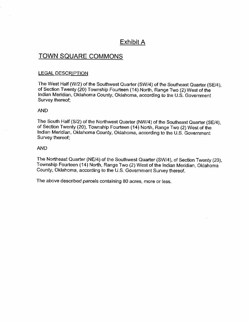
InformationRE:Case #Z16-00014 Public Hearing and Consideration of Edmond Plan Amendment for TownSquare Commons, LLC from Single Family to Residential Planned Unit Development, locatednorth of Danforth Road and one half-mile west of Sooner Road. (Town Square Commons, LLC)
The following general planning considerations represent some of the factors evaluated inreviewing justifications for Plan Map Amendments.
1. Infrastructure: Water and sewer are available along Danforth Road and within the existingTown Square Addition to serve 309 more lots. Traffic studies are required when the developmentwould add 100 vehicles more during the peak traffic times. Mr. McCaleb has provided threeoutlets to Danforth Road from Town Square to provide for traffic alternatives and distribution.Town Square I, 40 lots, Town Square II, 53 lots, Town Square III, 24 lots. There will be a total of426 lots in this total development. 2. Traffic: Danforth Road is planned to be a major arterial street based on the MasterTransportation Plan. Right-of-way requirements will apply on Danforth Road and bicyclefacilities as shown on the Bike Master Plan would be constructed with the paving improvements. With Covell improvements starting this summer west of I-35 and west of Sooner Road, additionaltraffic would be expected along Danforth Road until Covell Road is completed.
3. Existing zoning pattern:North – “A” Single FamilySouth – “A” Single Family and Urban EstateEast – Urban Estate, one acre lotsWest – Single Family
4. Land Use:North – UndevelopedSouth – Developed with acreage lotsEast – Developed with acreage lotsWest – Urban Lot sizes
5. Density: 3.86 units per acre, considering the entire 80 acre ownership
6. Land ownership pattern:North – Larger tract ownershipsSouth – Acreage lotsEast – Acreage lotsWest – Urban lots
7. Physical features: Rolling terrain, native trees.

7. Physical features: Rolling terrain, native trees.
8. Special conditions: There is a 20 acre tract adjacent that will be developed by Francis TuttleVo-tech. Skyview Drive may not connect to the east. There is another 20 acre tract to thenortheast that is a different owner at this time and may develop with different lot sizes dependingon the utility availability.
9. Location of Schools and School Land: Not directly a factor, the nearest elementary school isCentennial on Coltrane Road, north of Coffee Creek Road. Francis Tuttle has indicated that therewill be a connection to the high school for classes that will be offered in the future.
10. Compatibility to Edmond Plan: The reason this application is a PUD is because the ownerwishes to get variances in the setbacks for the alley type lots. The density planned is not affectedby the property being zoned as a PUD
11. Site Plan Review: No site plan but there will be a preliminary and final plat.
AttachmentsTown Square PlAm


Planning Commission 7. Meeting Date: 05/17/2016 From: Bob Schiermeyer Department: Planning/Zoning
InformationRE:Case #Z16-00013 Public Hearing and Consideration of Rezoning from “A” Single Dwelling toResidential Planned Unit Development, located north of Danforth and one half-mile west ofSooner Road. (Town Square Commons, LLC)
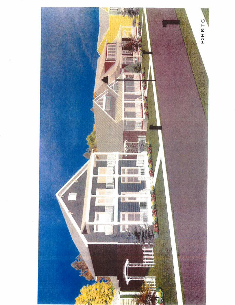
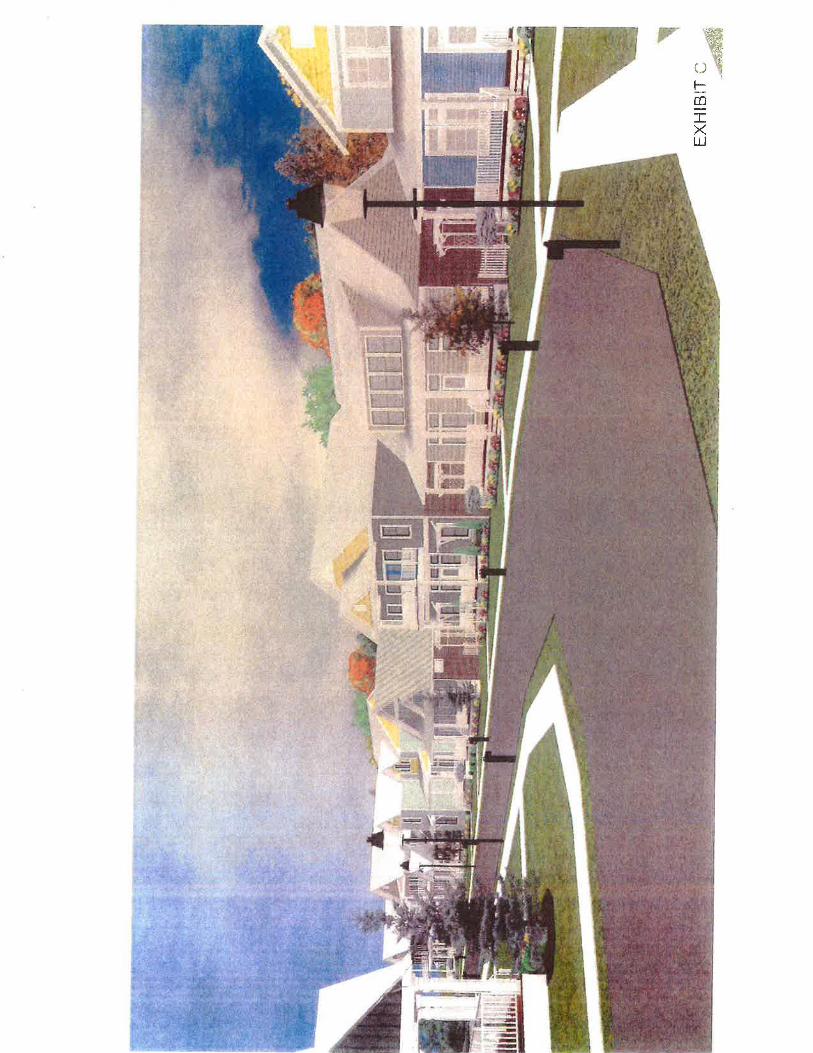
Caleb McCaleb is requesting 80 acres of single family PUD zoning allowing variations insetbacks for 146 of the 309 lots proposed. With the existing three phases of Town Square therewill be 426 lots. This addition is north of the existing Town Square Addition, east of OldeEdmond Addition, west of the Leawood Addition and south of a project planned as the Lakes atCross Timbers. Francis Tuttle Vo-tech owns 20 acres of undeveloped property west of LeawoodAddition and north of Danforth Road. With this development there would be three access pointsinto Town Square from Danforth Road. A stub out street has been shown to the north to connectwith the future Lakes at Cross Timbers. Streets in the Olde Edmond Addition will not connectbecause they are private and Olde Edmond is a gated addition. Francis Tuttle will be able to usethe collector type street planned along the west side of their property. The current PUD planidentifies a connection to Skyview Drive in Leawood. A hundred and forty six of the lots in the northwest portion of the property will have alleys. Thiswill allow garages in the rear yard and there will not be a 20 foot setback from the property line,accounting for one of the variances in the PUD. There will be 20 foot setback/buffer adjacent tothe Old Towne Addition on the west, next to Old Edmond Addition. Garbage trucks will not usethe alleys they are not large enough, residential pick up will be from the street following thetypical service. Most of the utilities are in the street. Some of the alleys dead-end, which worksfor homeowners access but not solid waste access. None of the lots are less than 6, 000 squarefeet the minimum in “A” Single Family zoning. The developer describes the density as 3.86units per acre. Some of the homes will have a zero rear yard setback, 10 foot front yard setbackand a zero side yard setback. There will be a 10 foot setback on the corner lots. The non-alleylots will have a 20 foot front setback and a modified rear yard setback of 10 feet. A traffic studyshould be required at least with the final plat. A traffic signal may be justified on DanforthRoad.
AttachmentsTown Square Rez


Planning Commission 8. Meeting Date: 05/17/2016 From: Bob Schiermeyer Department: Planning/Zoning
InformationRE:Case #ES16-00005 Public Hearing and Consideration of street easement closing on SkyviewDrive, generally located on the west side of the Leawood Addition, one-quarter mile north ofDanforth Road, and west of Sooner Road. (Beryl Jones and Timothy McGraw)
The property owners on the north and south sides of Skyview Drive, west of Leawood Drive, inthe Leawood Addition, would like to close the street for public access. There may be a benefit tomaintaining a utility easement in the 60 feet of right-of-way for electric distribution, and possiblewaterline distribution in the future. Leawood residents operate with water wells at this point;someday they may request public waterlines. The area to be closed is 60 feet by 325 feet alongthe side yards of the applicants’ properties. A fence may need to be placed on the west end ofSkyview Drive, if it is closed, to communicate that the road cannot be used. Edmond Electricdoes serve this Addition, and there is also phone and gas service.
This type of request is not new to the city; there have been numerous streets that have beenclosed. Francis Tuttle Vo-Tech has purchased 20 acres of land west of Leawood that extendsnorth to the Skyview Drive area. A rezoning application has been submitted by Caleb McCalebfor a single-family development, incorporating some cottage-type zero lot line lots with alleysgenerally to the west of this location. Some of the previous streets that have been closed includethe following:
• Most Additions that have private streets do not connect, such as Olde Edmond, which couldhave connected to Town Square, but since the streets were private there is no connection.
• Walnut Hill Addition, connecting to Iron Horse Ranch, also a private street Addition.
• Copperfield Addition, south of West Edmond Road, west of Kelly Avenue, connecting withChisholm Lake, both Public Streets.
• Woodhill Addition, with acreage lots connecting to the Oak Tree Park Addition at Coffee Creekand Kelly, as well as the Sorghum Mill Addition, also connecting to Oak Tree Park.
• Thornbrooke Addition, connecting to acreage lots in Old Farm Estates at 33rd and Bryant.
• Forest Oaks Addition, connecting to Tall Oaks III, east of Bryant.
• Bradbury Corner, connecting to Thunderhead Hills.
• Ketch Acres, connecting to Pebble Creek.

The street continuation issue is usually discussed based on private streets developing next topublic streets, or where the densities are substantially different on the adjoining areas.
AttachmentsJones - McGraw EC


Planning Commission 9. Meeting Date: 05/17/2016 From: Bob Schiermeyer Department: Planning/Zoning
InformationRE:Case #Z16-00021 Public Hearing and Consideration of Edmond Plan Amendment from SingleFamily Planned Unit Development to Commercial PUD located on the northeast corner of CoffeeCreek and Douglas Boulevard and the northeast corner of Covell Road and Douglas Boulevardand amending the Edmond Plan from Commercial PUD to Residential PUD, south of CoffeeCreek Road, a quarter of a mile east of Douglas Boulevard. (Matt Austin, Woodland ParkEdmond, LLC)
The following general planning considerations represent some of the factors evaluated inreviewing justifications for Plan Map Amendments.
1. Infrastructure: The original Woodland Park developer extended public water along CovellRoad, along Air Depot Boulevard and west to the water supply towers on I-35. Sanitary sewerlines were also extended offsite from Woodland Park through the Thunder Canyon Addition tothe Coffee Creek Wastewater Treatment Plant. Those utilities have been connected by severaldevelopers along those streets. Water and sewer are generally available to the 1,240 acreWoodland Park project, except the southeast portion of the property which will not be a gravityflow sewer. This condition has been understood from the original approval. 2. Traffic: Covell Road, Douglas Boulevard and Post Road are arterial streets that do need tomeet the Master Transportation Plan for right-of-way.
3. Existing zoning pattern: The zoning requests are adjoining the land uses planned in the WoodLand Park PUD. North – PUDSouth – “G-A” and “R-1”East – “G-A” Stonegate AdditionWest – Acreage lots, “R-1” and “G-A” District
4. Land Use:North – UndevelopedSouth – Acreage lotsEast – Acreage lotsWest – Acreage lots
5. Density: Single family, 6 units per acre for the residential. For the two commercials sitesdensity is not applicable.
6. Land ownership pattern: Other than the changes for the school property and the sale 19.2 acres,west of Post Road at Coffee Creek to Mr. Matherly the ownership parcels have stayed the same.North – Woodland Park
South – Individual acreage ownershipsEast – Individual acreage ownershipsWest – Individual acreage ownerships
7. Physical features: Rolling wooded terrain
8. Special conditions: No sewer on the southeastern part of the properly without a lift station. Septic tanks preferred. Wastewater solution/aerobic systems for 30,000 square foot net residentiallots.
9. Location of Schools and School Land: 50 acre undeveloped tract, southeast corner of CoffeeCreek Road and Douglas Boulevard.
10. Compatibility to Edmond Plan: Represents a new policy direction for the Edmond Plan.
11. Site Plan Review: Plats would be required for residential and site plans for commercial.
AttachmentsWoodland PlAm


Planning Commission 10. Meeting Date: 05/17/2016 From: Bob Schiermeyer Department: Planning/Zoning
InformationRE:Case #Z16-00022 Public Hearing and Consideration of Rezoning from Single Family PlannedUnit Development to Commercial PUD located on the northeast corner of Coffee Creek andDouglas Boulevard and the northeast corner of Covell Road and Douglas Boulevard and rezoningfrom Commercial PUD to Residential PUD, south of Coffee Creek Road, a quarter of a mile eastof Douglas Boulevard. (Matt Austin, Woodland Park Edmond, LLC)
Several months ago Matt Austin the current developer of Woodland Park wanted to change toadd two commercial corners and to exclude some of the retail in favor of residential east of thenew school site at Douglas Boulevard and Coffee Creek Road. The original request involved amile long area of commercial zoning from Douglas Boulevard to Post Road on the north side ofCovell Road. That request has been amended to exclude all the land except 11.42 acres on thenortheast corner of Covell Road and Douglas Boulevard and 8.26 acres on the northeast corner ofCoffee Creek Road and Douglas Boulevard. The original theory of the Woodland Park PUD isthat the commercial would be located in the center of the 1,240 acre project. In 1950 homes wereplanned in 2007 it is likely that there will be less homes developed in this project. Land has beensold to the school district at Coffee Creek Road and Douglas Boulevard since 2007 and anotherowner has bought 20 acres at Post Road and Coffee Creek Road and there is a substantial area ofaerobic type lots not available to city sewer in the southeast portion of the property. The ownercould build 1,950 homes in that part of the PUD not being changed but those homes will be builton less acreage than was available in 2007. The developer is now saying at the interiorcommercial parcel planned at the beginning of the project is not feasible and he would rathermove the sites to the section line corner locations. The developer would like “E-1” GeneralCommercial usage on the subject property. The second commercial tract at Covell Road andDouglas Road contains 11.42 acres. This parcel is adjacent to water but is not available to citysewer. Septic tanks could be used for commercial uses. In addition to the two commercial changes, Matt Austin wants to change from commercial toresidential on 40.9 acres, south of Coffee Creek Road, east of the 50 acre school site. Therewould still be some retail along Coffee Creek Road but a majority of the commercial plannedwould now be built as single family homes. City utilities could be available to this site. Mr.Austin that the retail is not feasible in the center of this project. The major change that hasoccurred since the Planning Commission last saw this item is that the majority of the land on thenorth side of Covell Road, originally requested for commercial has been withdrawn.
AttachmentsWoodland Park Rez


Planning Commission 11. Meeting Date: 05/17/2016 From: Bob Schiermeyer Department: Planning/Zoning
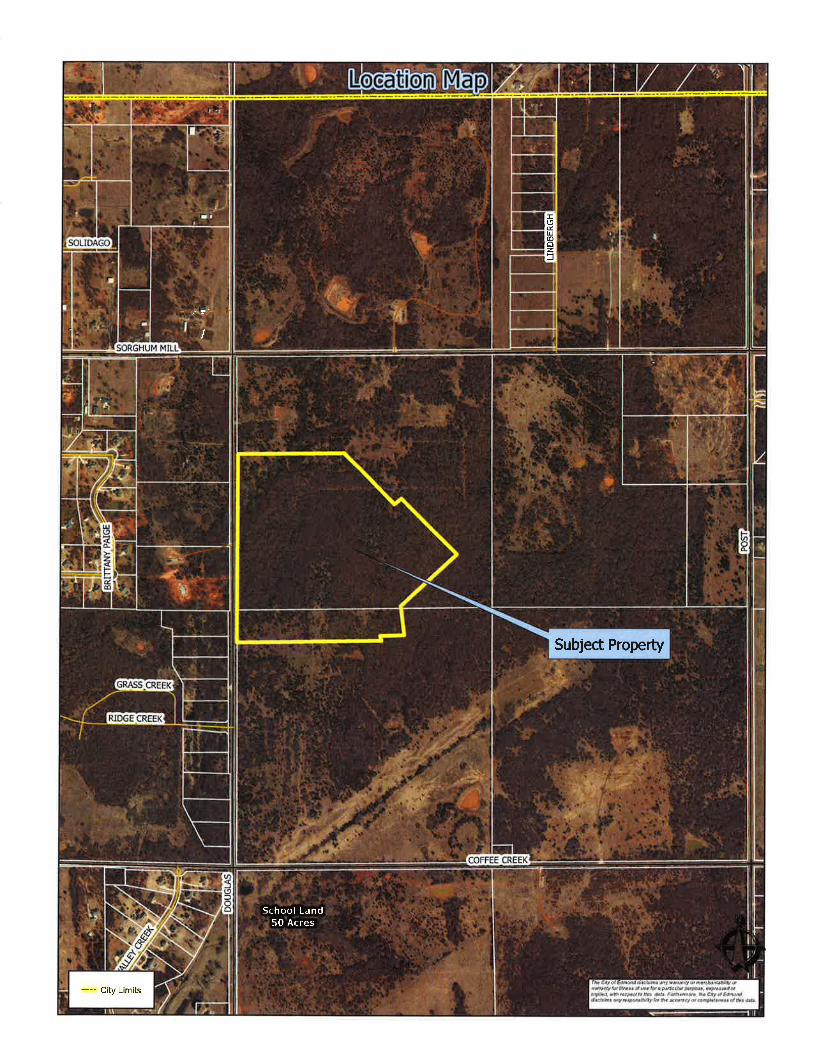
InformationRE:Case #PR16-00007 Public Hearing and Consideration of Preliminary Plat approval for the Highgarden AdditionPhase 1 with private streets located a one quarter mile south of Sorghum Mill Road and east of Douglas Boulevard.(Highgarden Development, LLC)
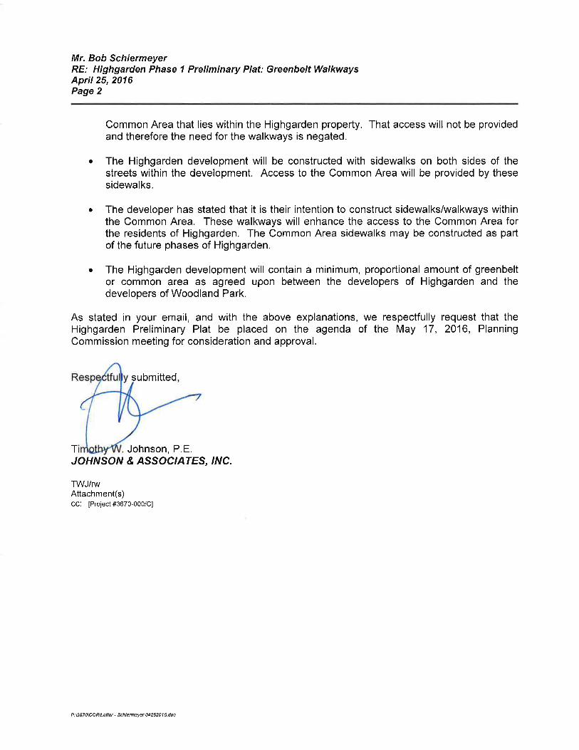
Highgarden development is planning 65 single family homes on 31 acres in the Woodland ParkPlanned Unit Development. These lots will connect to city water and sewer. The streets will beprivate. The notices have been given to the Planning Commission for the preliminary plat/privatestreet discussion. Bob Birchell was hired by the owner as a consulting forester to perform aSensitive Areas Conservation Assessment, which in part includes evaluation of the proposed treepreservation areas for Woodland Park. That requirement is in the PUD and needs to be completedprior to City Council review. The lot size is generally 75’ x 145’ for a total of 10,730 squarefoot lots. The developer has completed a drainage study and plans for a detention pond adjacentto the creek. There are several common areas and the project will be gated. The gate locationneeds to meet the Gate Standards with a queuing lane allowing four cars to back up outside of theDouglas traffic lanes. Ninety foot of right-of-way is provided along Douglas Boulevard to meetthe Master Transportation Plan. The preliminary plat indicates that there will be several othersections to Highgarden Addition. The Woodland Park PUD identifies a series of greenbelts, one of which that does extend throughthis addition in the center of the blocks. In the letter from April 25, 2016 the developers engineerindicates that he does not wish to have the greenbelt set aside in the plat. Even with privatestreets sidewalks are expected and are valuable to disabled residents. The developer is leavingthe creek area with the largest common area being Area C. In this particular PUD there is nodensity credit needed to offset a high density area with the lesser density from another area. Theopen space is additional land that may be flood plain, detention or common area that is part of anamenity for the addition including the entry area, which takes up more space due to the gate. Itwould be a policy judgment, but it may be more significant to leave groups of tree preservationareas rather than to leave the greenbelts that would likely be graded for the lot, street and utilityinstallation. The exception would be if the trees exist on the greenbelt shown on the originalPUD Master Plan.
AttachmentsHighgarden PH I PP


Planning Commission 12. Meeting Date: 05/17/2016 From: Bob Schiermeyer Department: Planning/Zoning
InformationRE:Case #PR16-00005 Consideration of Final Plat for The Villas of Edmond located on the east sideof Kelly Avenue, a quarter of a mile north of 15 th Street. (Philip Patterson)
Phil Patterson is working with the buyer for The Villas of Edmond Senior Housing planned at thislocation. The immediate developer is Rich Smith. The overall land area is 5.97 acres for theVillas Senior Housing. The Patterson property would be 2.65 acres consisting of Lot 1 and Lot3. The remainder of the property along the front of Kelly Avenue is common area due to anextensive flood plain. The access drive and cross access is shown as Lot 1 but may need to beidentified as Common Area A to emphasize the cross access to Lots 1 and Lot 3. The Villasproperty is zoned multi-family allowing for 52 units. The Villas Apartment building is threestories in height. The Patterson property is zoned Restricted Light Industrial. The offsitedetention area is on the Phil Patterson property south of the drive and is critical for The Villasproject, otherwise there is no detention for the apartments. As discussed with the preliminaryplat, The Villas have made an arrangement with the mobile home park to the east for a secondaccess. This primarily is an emergency access and maybe gated in accordance to fire departmentrequirements and standards. The plat provides for the necessary utility easements. The AppleVillage Mobile Home Park is located to the east. There are commercial buildings to the south,except for an undeveloped commercial parcel south of The Villas main lot. There is alsocommercial to the north accessible by Evergreen Street. The conditions for approval include thefollowing:
1. The access easement from Kelly Avenue shall allow for the Patterson ownership to crossaccess.
2. The public water line shall also be accessible to the Patterson property.
3. The sanitary sewer access shall also be accessible to the Patterson property.
4. All public or private utility easements, particularly for the private detention area shall beprovided or labeled as needed, including the access to the mobile home park.
AttachmentsVillas of Ed FP


Planning Commission 13. Meeting Date: 05/17/2016 From: Bob Schiermeyer Department: Planning/Zoning
InformationRE:Case #Z16-00017 Public Hearing and Consideration of Edmond Plan Amendment from SingleFamily Dwelling District to Restricted Retail Commercial located on the southwest corner ofCovell Road and Western Avenue. (Andrew and Teaona Njoo)
The following general planning considerations represent some of the factors evaluated inreviewing justifications for Plan Map Amendments.
1. Infrastructure: City water is located along Covell Road. A new line was extended even furtherwest to serve the two schools on Pennsylvania Avenue. There is a sewer line in the creek west ofthe site. A septic tank may be the best solution for wastewater. The Oklahoma City sewer linewill be very difficult to access. Mr. Njoo is generally familiar drainage detention requirements. 2. Traffic: Covell Road has been discussed as a major east west. The right-of-way is beingprovided for that major improvement either with the site plan or the plat. Western Avenueright-of-way would be provided with the right-of-way standard required.
3. Existing zoning pattern:North – “A” Single Family, Covell right-of-waySouth – “A” Single Family, is also in a flood plain.East – “A” Single Family, Western Avenue right-of-wayWest – “A” Single Family. but is unbuildable due to the flood plain
4. Land Use:North – UndevelopedSouth – Immediately South UndevelopedEast – UndevelopedWest – Undeveloped
5. Density: N/A
6. Land ownership pattern:North – Single 12+ acre parcelSouth – Large ownershipsEast – Large ownershipsWest – Large ownerships
7. Physical features: Only the corner is buildable, the remainder of the land is flood plain.
8. Special conditions: Flood plain, right-of-way requirements for Covell Road improvements later.

9. Location of Schools and School Land: nearest school is on Pennsylvania Avenue, south ofCovell Road.
10. Compatibility to Edmond Plan: Not projected in 2006. This site is limited for many uses, notthe best location for a home.
11. Site Plan Review: Would be required if zoned commercial.
AttachmentsNjoo PlAm


Planning Commission 14. Meeting Date: 05/17/2016 From: Bob Schiermeyer Department: Planning/Zoning
InformationRE:Case #Z16-00018 Public Hearing and Consideration of Rezoning from “A” Single FamilyDwelling District to “D-1” Restricted Retail Commercial generally located on the southwestcorner of Covell Road and Western Avenue. (Andrew and Teaona Njoo)
Andrew and Teaona Njoo is requesting 2.018 acres to be rezoned from “A” Single Family toRestricted Retail Commercial at Covell Road and Western. This land is vacant. The uses in thegeneral area St. Monica Catholic Church at 2001 North Western. The Kingsbury Additionlocated west of the bridge, west of this property, several 100 feet to the west and the Fall BrookAddition several 100 feet to the northeast. The land to the northwest is undeveloped and isadjacent to a major creek. City water is adjacent to this property. Sewer is located to the west. The site is large enough for a septic tank for limited commercial usage. Mr. Njoo is aware of theright-of-way needed on Covell Road and Western Avenue based on the Master TransportationPlan. The owner has worked with an engineer and studied the flood plan, which has a majorimpact to the property. The “D-1” usage will allow for office and light retail uses.
AttachmentsNjoo Rez


Planning Commission 15. Meeting Date: 05/17/2016 From: Bob Schiermeyer Department: Planning/Zoning
InformationRE:Case #U16-00003 Public Hearing and Consideration of Specific Use Permit and Case#SP16-00011 to include a Site Plan, for a Victory Car Wash located at 1101 West DanforthRoad. (Muhammad N. Siddiqui)
Planning Department
1. Existing zoning – Commercial Planned Unit Development to allow a car wash and otherlimited commercial uses.
2. Setbacks – From the property line to the vacuum area would be 60 feet. The building itself setsback 140 feet from the property area. The side yard setback to the east is 80 feet, side yardsetback to the west 132 feet, and setback to the north 97 feet.
3. Height of building – 28 feet
4. Parking – The parking spaces are oriented to the car wash process. There is a flow of trafficaround the building on the north with 29 spaces for vacuum and other finishing of the car after thewash. There is a queuing lane to stack a considerable number of cars around the building. Thebuilding is on 3,840 square feet. Bicycle parking will be required and Jan Fees will inspect.
5. Lot size – Is 334 feet by 342 feet before the right-of-way is only provided along DanforthRoad. This site is approximately 96,860 square feet.
6. Lighting Plan – This area is not a sensitive border. The School District owns property to theeast. There is a strip shopping center to the west and Hibdon Tire Center to the south. TheSchool District also owns property to the north, as well as, the original property owner Mr.Novotny.
7. Signage – One ground sign is planned out of the 70 foot right-of-way required. The sign willbe six foot tall and 42 square feet. Wall signs may also be used, meeting the code.
8. General architectural appearance – The building is a combination of light brown brick veneerand a dark blue EIFS. The front of the building will have a number of windows, common to carwashes.
9. Sensitive borders – N/A
10. Mechanical equipment – Will be located on the roof.
11. Fencing/screening – Not required except for the dumpster enclosure.

Engineering Department
12. Driveways, access management and paving – There is one driveway into the property locatedon the west side of the property. That driveway meets the Access Management Standard betweenthe shopping center and School District driveway on either side of the property. Mr. Novotny willalso use the driveway to care for his horse pasture to the north.
13. Water and wastewater plans – Are available for service and will be connected.
14. Drainage, detention and grading – Engineering has completed their drainage review.
Building and Fire Code Services
15. Applicable Building Code, Fire Code
a. A fire hydrant will need to be added on site along a fire department access road.b. fire department access is adequate
Landscaping/Urban Forestry
16. Lot area = 96,860 sf% required = 10
Landscape area required: 9,686 SP Landscape area: 28,000Frontage area required: 4,843 SP Frontage area: 6,800Total PU required: 775 SP Total PU: 775PU within frontage required: 387 SP PU within frontage: 412Evergreen PU required: 310 SP Evergreen PU: 340 17. Solid Waste Department – There is a dumpster adjacent to the front parking area, nearest tothe building.
18. Edmond Electric Department – Will serve.
AttachmentsVictory Car Wash SUP SP
