edinburgh research explorer file346 the kostoperska karpa regional archaeologi-cal (kkra) project...
TRANSCRIPT
Edinburgh Research Explorer
Kostoperska Karpa
Citation for published version:Donev, D, Gorgievski, D, Jacobs, I, Mladenovic, D, Russell, B & Strutt, K 2017, 'Kostoperska Karpa: Newresults from an integrated intensive field and remote sensing survey', Patrimonium.Mk: Periodical forCultural Heritage , vol. 10, no. 15, pp. 73-90.
Link:Link to publication record in Edinburgh Research Explorer
Document Version:Publisher's PDF, also known as Version of record
Published In:Patrimonium.Mk: Periodical for Cultural Heritage
General rightsCopyright for the publications made accessible via the Edinburgh Research Explorer is retained by the author(s)and / or other copyright owners and it is a condition of accessing these publications that users recognise andabide by the legal requirements associated with these rights.
Take down policyThe University of Edinburgh has made every reasonable effort to ensure that Edinburgh Research Explorercontent complies with UK legislation. If you believe that the public display of this file breaches copyright pleasecontact [email protected] providing details, and we will remove access to the work immediately andinvestigate your claim.
Download date: 26. Dec. 2019

345
Damjan DONEV, Dejan GORGIEVSKI, Ine JACOBS, Dragana MLADENOVIĆ, Ben RUSSELL and Kristian STRUTT
Kostoperska Karpa: New Results from an Integrated Intensive Field and Remote Sensing Survey
ПАТРИМОНИУМ.МК, година 10, бroj 15 / 2017УДК:
Abstract: This article summarizes the prelimi-nary results of the 2015 and 2016 field campaigns of the Kostoperska Karpa Regional Archaeology Project. Work was conducted on three sites within the survey area, at Kostoperska Karpa, Klečovce-Crkvište, and near the village of Biljanovce, and in-volved field walking, ceramic survey, and geophysi-cal prospection. The results presented will form the basis of future work of the project and demonstrate the potential of integrated field and remote sensing survey methods in this region.
Introduction: the survey region and a brief his-tory of the project
North-eastern Macedonia is an important cross-road in the southern Balkans. It has always been both a link – used by Iron Age tribes and advancing Ro-man forces – between Central Europe and the Aege-an, as well as a border region: between the Roman
provinces of Moesia, Thrace and Macedonia, the lat-er dioceses of Dacia and Macedonia, and eventually the Byzantine and Slavic kingdoms. Despite this, the region’s archaeological remains have received little attention. Only the fortified hilltop sites have been surveyed systematically and although numerous oth-er sites have been identified, few have been excavat-ed. Indeed the only site in the region to have ever been excavated by using modern scientific methods is Golemo Gradište at Konjuh.1 Our understanding of the wider settlement patterns also remains limit-ed. Field survey has been only limitedly employed in the Central Balkans, while geophysics has been employed patchily (and only at Golemo Gradište, Is-ar-Marvinci and Scupi in this region).2
1 Snively 2017 for an overview of recent work at the site.
2 Темов 1998, Thorpe 2008, ibid. 2012.
Keywords: field walking, ceramic survey, geophysical prospection, long-term settlement development, Kumanovo
Fig. 1. The focus area of the Kostoperska Karpa Regional Archaeological Project

346
The Kostoperska Karpa Regional Archaeologi-cal (KKRA) Project aims to change this.3 Combin-ing archival research, field walking, satellite anal-ysis, geophysics, and excavation, it will contribute substantially to our understanding of changes in the religious and civic landscape of this region, and the southern Balkans more generally, between the Ro-man and Byzantine periods. The project concentrates on the region surrounding the volcanic outcrop of Kostoperska Karpa at Mlado Nagoričane, north-east of Kumanovo (42.170851, 21.810327) (Fig. 1).4 This squat, steep-sided hill, 4 km west of the Pčinja riv-er, dominates a landscape of rolling fields and the Roman roads running north-south between Naissus and Scupi and east-west between Scupi and Pautalia. In fact a junction of the Scupi-Pautalia and the Sto-bi-Pautalia road was most likely within or very near the survey area itself.
In 2015, a museum and archive study was con-ducted at the Museum of Kumanovo. This was fol-lowed up in 2016 by a field survey campaign, which focused on the area of Kostoperska Karpa itself and Klečovce-Crkvište,5 to the south-east. This paper will present some initial results from the KKRA Project in order to demonstrate the potential of integrated field and remote sensing survey methods in this region.
Previous work on Kostoperska Karpa and its surroundings
After early antiquarian interest in Kostoperska Karpa,6 the first modern research at the site was con-ducted by the Museum of Kumanovo in the 1980s and 2000s, concentrating on the acropolis, the south-ern hillside and the western necropolis. Excavations in the centre of the acropolis revealed remains of a basilica-type structure, surrounded by graves be-longing to several phases, the precise chronology of which remains uncertain.7 The designation of the central structure as a church was confirmed by exca-vations carried out in 2015, which also allowed for the earliest phase of its construction to be dated to the
3 The 2016 season of the KKRA Project was funded by a Dumbarton Oaks Project Grant, for which we are very grateful. Further support for the project was provided by the Kiril Trajkovski Foundation and the universities of Southampton, Oxford, and Edinburgh.
4 Koцo & Грoздaнoв 1994, 213-215, Mladenović 2012, no. 995.
5 Koцo & Грoздaнoв 1994, 210, Mladenović 2012, no. 675.
6 Hadži-Vasiljević 1909, 435. 7 Вељановска 1989, Ѓеорѓиевски 1989a, 1989b,
1993, Колиштркова – Настева 1993, Џидрова 2003.
second half of the 6th century.8 At the southern edge of the plateau, rectangular rock-cut features lined with hydraulic mortar have been uncovered and interpreted as cisterns.9 The southern hillside produced evidence of habitation in the 5th to 3rd centuries BC, but the limited extent of research in this area, together with later interventions at the site, including the construc-tion of the modern road, made it impossible to further characterise these remains.10 Research on the western lower slopes of the outcrop resulted in the excavation of a Late Antique necropolis (the western necropolis of the site, dating to the 4th–5th centuries), consisting of 14 cyst-type graves.11 Finally, excavations in the late 1980s uncovered a structure consisting of sever-al rooms cut into the south-west side of the outcrop. The function of this feature remains unclear, and it has been variably interpreted as a cistern, a hypoge-um, a tomb or church, depending on the proposed dating of the remains.12 Only preliminary reports of these excavations have been published, but it is clear they just scratched the surface: traces of terracing and structures to the west of the hilltop, as well as finds of a fragment of marble architectural decoration bearing a cross and a cross-inscribed stele in the fields to the west, suggest the settlement extended well beyond the hill itself.
Kostoperska Karpa must always have been a prominent landmark (Fig. 2), but the finds outline above show that in both the Iron Age and Late An-tiquity it also developed into an important settlement and local hub. The site, moreover, sat at the heart of a densely-populated landscape. In the surrounding ter-ritory at least two more settlements have been identi-fied: a Hellenistic hilltop foundation (Gradište – Mla-do Nagoričane)13 and the larger Roman/Late Antique site of Crkvište, situated on the banks of the Pčinja. Crkvište, near the village of Klečovce, is the only other site in the survey area that has been investigated on more than one occasion.14 It consists of a low-ly-ing settlement and an associated necropolis dated be-tween the 3rd and the 5th centuries. The life of the settlement was outlasted by a church which shows evidence of use up to the end of the 11th century. A find of an altar in the vicinity, the reading of which includes a reconstructed toponym of VIZIANUM,15
8 Ѓорѓиевски 2015.9 Станковски 2006.10 Митревски 1987.11 Јованова 1987.12 Ѓеоргиевски 1989b, 1996.13 Георгиев 1990-1991, Лилчиќ 2013.14 Николовски 2002, 2002-2004.15 Dragojević-Josifovska 1982, no. 212.

347
has led to the site being identified with the road sta-tion of the same name.
Apart from these two sites at which excavation has taken place, our knowledge of the archaeological remains of the region comes from either chance finds or limited rescue excavations.16 Little is known about most the sites identified in this way and the dates for most of them are highly tentative, based upon coin or imported fine ware finds, supplemented by epigraph-ic evidence where available. The dating of coarse wares is seldom even attempted. The current state of research has thus made it difficult to view and use this evidence holistically. A major objective of this project, as a result, is to establish a secure ceramic chronology for the region.
In addition to the settlement sites noted above, a multitude of churches, ranging in date from the ear-ly Christian to the Turkish period, are known from anecdotal archaeological research and chance finds. The most famous of these is the Church of St George at Staro Nagoričane, renowned for its fourteenth-cen-tury frescoes. Of the character, scale and chronology of the settlements we know almost nothing, while the
16 E.g. Na breg – Mlado Nagoričane (Late Neolithic settlement, Koцo & Грoздaнoв 1994, 215-216.44), Gro-blje - Vojnik (Early Iron Age necropolis under tumuli, Koцo & Грoздaнoв 1994, 206.14), Mlaka – Šuplji Kamen (Late Neolithic Settlement, unpublished).
location of only six of the attested churches has been pinpointed, and of these only two have been partial-ly uncovered. The importance of these churches is paramount, given that from the 4th century onwards Christianity was the only stable factor in this highly volatile region. The investigation of churches and the associated settlements provides an opportunity to ex-amine the functioning of the local communities and the nature and intensity of Roman and Byzantine rule in this inland area of the Dacian diocese.
Field survey methodology
In order to understand the relationship between the known settlements in the vicinity of Kostoperska Karpa, to locate the other attested sites in the region, and to place all of these sites back into their wider framework, the KKRA Project is consciously broad in scope. It focuses on an area of roughly 30 sq. km centred on Kostoperska Karpa and encompassing various terrains (Fig. 3): the Pčinja valley, the rolling hills to its west, and the foothills of Mt. Ruen to the northwest. A systematic ceramic survey will play an important role in the study of this area. Before the preliminary survey results are discussed, we would like to provide the reader with a brief introduction to the relevance of ceramic surveys and the techniques of field survey adopted by this project.
Fig. 2. Kostoperska Karpa, view from the west

348
The potential of systematic field surveys for the study of population distribution, agrarian economies and long-term developments hardly requires addi-tional appraisal.17 Few would today doubt the useful-ness of this technique. Its application is fully justified, both from a methodological and theoretical point of view, but as with all methods, one has to be acutely aware of the limitations inherent to survey data.
To make this more tangible, one can highlight the contribution of a recent series of small-scale surveys in the region of the Middle Vardar valley, carried out over the past decade.18 The effectiveness of modern systematic survey is here demonstrated by the num-ber of sites identified in the region before and after surveying, as summarised in Table 1.
17 Keller & Rupp 1983, Bintliff & Snodgrass 1985, 123-161, Cherry et al. 1991, Barker 1995, Crouwel, Cat-ling, Shipley et al. 2002.
18 Donev 2013, 2015, forthcoming.
This simple comparison is a useful way of illus-trating the scale of the advances made in field survey methodology. Prior to the application of modern in-tensive surveys, the countryside of the Middle Vardar was practically empty. In such conditions it is im-possible to even begin thinking about the local and regional demographic and economic realities. The landscape and settlement history of the Middle Pčin-ja valley – the principle aim of this project - is yet to be written.
The KKRA Project employs two survey method-ologies: a ‘siteless’ survey across selected areas of the territory within the survey boundaries, and a site-based grid survey on locations where high artefact concentrations are identified by the siteless survey. These are basically two phases of the same research program. The difference is in the degree of survey in-
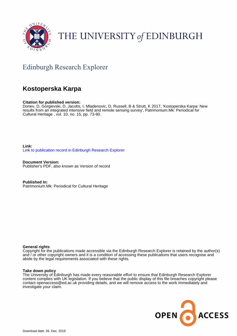
tensity. Siteless or off-site surveys are less in-tensive, being carried out by field units meas-uring between 0.25 and 0.5 ha. In this first phase, the aim is a complete coverage of the survey area. Each field unit is traversed along the longitudinal axis by surveyors spaced 10-15 m apart (Fig. 4). They count all surface finds visible within their trajectory and 1.5 m
either side of it. They also grade the ground visibility on a scale from 1 to 5, with 1 standing for optimal vis-ibility. In this phase only a sample of material is col-lected. If these sample collections are large enough, it is possible to make a projection of the composition
Fig. 3. The KKRA project survey-area
Sopot Skopian Montenegro Staro SvećaniBefore After Before After Before After2 >9 0 >12 1 5
Table 1. Number of sites recorded in the Archaeological Atlas of Macedonia before and after the Vardar valley surveys
349
of the overall surface record on the basis of the com-position of the sample collections.
The raw counts from the siteless surveys are cor-rected for the variable ground visibility and the var-iable degree of survey coverage – the spacing of the field walkers cannot be kept even on every field unit. After implementing these corrections, density figures are derived, usually expressed in 1000 sq. m. For example, on a field unit measuring 2000 sq. m. where the coverage was estimated at 30%, ground visibility was graded 2 (20%) and the number of recorded finds was 50, the artefact density is derived using the fol-lowing formula:
[(50 + (50 x 20%) / (2000/3)] x 1000 = ca. 90/1000 sq. m
The number of counted fragments is increased by 20% (50 + 10 = 60) and then divided by the surface area actually covered – 2000/3 = 666.6 sq. m - equal-ling slightly over 0.09 shards per sq. m.
The chief end-product of the siteless survey is therefore a map of artifact densities for the survey area obtained in the way described above. Not all practitioners of this method agree with these proce-dures.19 It is, therefore, advisable to publish raw and corrected figures side-by-side.
19 Given 2004.
Locations that feature high artifact densities are then selected for the more intensive, second phase of the survey. This is a grid-based survey, usually involving total artifact collections from the gridded areas. In the case of the Kostoperska Karpa project, we used grid units measuring 20 x 20 m and collected only pottery fragments, while building material (such as brick and tile fragments) was counted and returned to the grid unit. The collections from the individual grid units were carried out by all participants in the survey in order to average out the variable perfor-mances of individual field walkers.
Most modern surveys are carried out in multiple stages. The two phases of the research design are obviously complementary, but they can also be used independently. The field block or siteless survey is most useful for revealing wider, regional patterns, while the site-centred grid surveys are indispensable for the study of the size, micro-location, chronology, and inner structure of the settlements. We follow the example set by earlier regional projects, in trying to strike a balance between a full coverage of the survey area and detailed studies of individual sites.20
20 Schiffer, Sullivan, Klinger 1978, Bintliff & Snod-grass 1985, Davis et al. 1997; for a more exhaustive bibli-ography see Donev 2015.
Fig. 4. The team conducting field survey west of the Kostoperska Karpa mound
350
The ceramic surveys
A site-based survey was carried out at Klečovce-Crkvište, the data of which are still being analysed (cf. infra).21 At Kostoperska Karpa itself, however, the extreme topography of the site made a grid survey impossible. Instead, 46 blocks of transects were laid out across the site, the size of each was primarily de-termined by existing field boundaries. Small samples of surface material, preferably comprising chrono-logically sensitive shards and different fabrics, were collected from each individual transect. The size of the samples was purposefully kept small, as we an-ticipated carrying out a grid survey on at least cer-tain segments of this site in the future. The collected
21 The ceramic surveys were carried out in March and April 2016. The team comprised the authors of this article, Miroslav Petkovski and Boban Antevski from the Museum of Kumanovo, and the following students: Jelena Jarić and Kristina Terpoy (graduates, University of Oxford), Fraser Reed (graduate, University of Edinburg), Bojan Ivano-vski, Aleksandar Zdravevski, Naum Nalbatinovski, Stefan Velkov, Darko Angjelkovski, Kristijan Toshevski and Su-zana Stefanovska, all undergraduates at the Ss. Cyril and Methodius University of Skopje.
finds were studied in the spring of 2017.22 The small size of the samples had an unfavourable impact in at least two aspects. It not only proved impossible to estimate the possible composition of the overall sur-face record on the basis of collections consisting of a few fragments, it was also very challenging to detect individual fabric groups in conditions where no two fragments were alike. Only a few local fabrics were identified and even these might need to be revised in the future. It was nonetheless possible to recog-nize a number of wider categories, fabric groups or functional classes, which opened an important first insight into the micro-topography of this settlement.
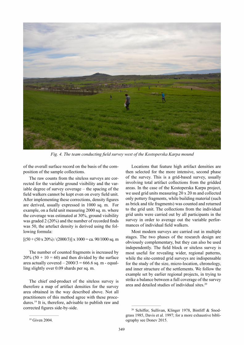
Based on the preliminary study of the ceramics and the overall distribution of the collected finds, it became clear that the core of the settlement was lo-cated at the western foot of Kostoperska Karpa (Fig. 5). Most of the fabric categories that could be identi-fied were discovered in this area of the site, although there were exceptions. For instance medieval glazed pottery was present at the top of the hill as well as in KK4 and KK25, but absent from the higher slopes.
22 The study was undertaken by Damjan Donev, the sur-vey director, Miroslav Petkovski (Museum of Kumanovo), Jelena Jarić (graduate, University of Oxford) and Darko Angelkovski (undergraduate, University of Skopje).
Fig. 5. The Kostoperska Karpa survey: overall artefact densities

351
Late Antique pottery, in contrast, appears every-where. Either this was the period during which the settlement reached its greatest extent or this was the last period of intensive occupation on Kostoperska, overwhelming the scattered surface remains coming from the lower cultural strata. Equally notable was the presence of finds dating to the Classical and Hel-lenistic periods, readily recognized by the fragments of fine, grey-fired pottery.
These finds form a relatively dense carpet along the western flank of Kostoperska Karpa and they are the only ceramic category that appears at the eastern foot of the volcanic cone in larger quantities (Fig. 6). Prehistoric periods were also represented among the collected finds (Fig. 7).
At least one fragment was collected from nearly half of the field units in the Kostoperska Karpa sector. Unfortunately this material does not comprise a co-herent group in terms of fabric properties. Individual shards are small and worn and the label prehistoric is by no means always certain. Yet the presence of pre-historic phases on Kostoperska Karpa is undeniable. If our preliminary analysis is only half correct, the core of the prehistoric settlement was at the western foot of the hill, as in later periods of occupation. Fur-ther transects walked in the valley as well as on top of the largest plateau to the south of Kostoperska Karpa
(PK1-26) produced almost no finds at all, suggesting that in all periods, settlement concentrated around the outcrop (cf. Fig. 5).
It is important to stress that these observations are based on a preliminary analysis of a small sample of surface material. Because of the small sample size, the density figures presented in the maps are of lim-ited value. At this stage they should be read as crude indicators of the micro-location and extent of the set-tlement in different phases of occupation. A larger, systematically collected sample will certainly result in a more finely grained map of the ceramic site. It is also very likely that a more thorough collection of surface material will bring to light new, hitherto unknown phases on Kostoperska Karpa, though we would argue that the main periods of occupation have been identified. If we are to gain a deeper understand-ing of the changing micro-topography of this settle-ment, it will be necessary to intensify the surface col-lections and perhaps open a few stratigraphic test-pits at the western foot of the hill.
Klečovce-Crkvište is located on the western banks of the Pčinja river, 5.6 km south-east of Ko-stoperska Karpa, on one of the flattest stretches of land in the region (cf. Fig. 3). As mentioned earli-er, excavations at the site have uncovered a basilica and it has been assumed that the main portion of the
Fig. 6. The Kostoperska Karpa Survey: distribution of grey-fired and ochre-fine fabrics

352
settlement stretched between this structure and the western edge of the Pčinja flood plain. Indeed, the probable remains of an ancient road on the edge of the plain could represent the edge of the settlement as well. A high density of surface artefacts was noted during initial prospection. Consequently, we decided to apply a site-based survey at this location, combin-ing transects and grid survey. Transects were used to provide overall counts but 20 x 20 m grid squares were laid out for collection.
Both the transects and grid surveys highlight-ed some interesting things about the settlement at Klečovce-Crkvište (Fig. 8). First, this is not a single nucleated settlement laid out on any form of regu-lar plan. Three or four nuclei can be noted. Close to the edge of Pčinja flood plain, where the settlement seems to abut the Roman road, a very high density of ceramics and ceramic building material was identi-fied. Ceramic wasters found in these areas may indi-cate industrial activity. A series of further nuclei can be noted to the west, along a line running roughly north-south. Some of the grid squares produced very low totals though, suggesting a gap between these nuclei. At the west edge of the grid survey a sharp density of finds was identified in two contingent grids squares, which perhaps relates to a single large prop-erty of some description. Much lower densities were found to the north-east, south, and west of the survey area, suggesting that the grids that we laid out cover the core of the site. However, a slight increase in ar-
tefact density can be noted in the territory east of the basilica and in future seasons we will need to extend our grid around this structure.
Finally, a small team did field walking in the re-gion of the village of Biljanovce.23 The goal was to assess the potential of known sites and to clear up a confusion regarding their location and number. Ref-erence publications on the area, TIR K-34 (1976) and Archaeological Map of Macedonia (1994) disagree on both the number and location of the sites.24 The preliminary survey allowed us to establish the ap-proximate location of the sites of Krasta (a mithrae-um) and Derven/Stambolski pat (a Roman and Late Antique settlement), as well as sections of the Scu-pi-Pautalia road. Derven/Stambolski pat shows par-ticular promise: a scatter of building material, pot-tery, and pithoi was discovered over an area of 400 x 500m, the nature of which indicates good preser-vation of subsurface remains. The site therefore is a prime candidate for field survey and geophysical research in the future. We also intend to make further explorations into the immediate surroundings of the major nucleated settlements of the region, where we
23 Koцo & Грoздaнoв 1994, 205, Mladenović 2012, nos. 132-133.
24 Cf. TIR K-34 (1976), 26-7 and Koцo & Грoздaнoв 1994, 205 and 208, resulting in duplication of sites. Cf. Mladenović 2012, nos. 132, 133, 328, 329.
Fig. 7. The Kostoperska Karpa Survey: distribution of prehistoric finds

353
hope to observe the changing patterns of agricultural exploitation.
Geophysical survey
As a part of our integrated multidisciplinary ap-proach, and in addition to the field survey discussed above, two trial geophysical surveys were carried out in 2015 and 2016. The surveys focused on the sites of Klečovce-Crkvište and Kostoperska Karpa and were aimed predominantly as a trial of efficiency of different geophysical techniques in the area.25 These comprised survey using magnetometry, earth resist-ance and ground penetrating radar (GPR) techniques.
2015 Survey
In the March 2015 season the geophysical survey was conducted with the aim of testing the applica-tion of magnetometer survey and thus focused on two sites of different geological nature and diverse archaeological material: Klečovce-Crkvište, located on an alluvial floodplain, with an archaeological site
25 The geophysical recording and interpretation was undertaken by Kristian Strutt in 2015 and Kristian Strutt and Dominic Barker in 2016, both from the Archaeologi-cal Prospection Services of the University of Southampton, with help of Dragana Mladenović (University of Southamp-ton) and colleagues from the Museum of Kumanovo, Dejan Gorgievski, Miroslav Petkovski and Boban Antevski.
comprising stone-built structures, and Kostoperska Karpa, situated on the hillslopes of a volcanic for-mation.
The magnetometer survey was conducted using a Bartington Instruments Grad601-2 dual sensor fluxgate gradiometer.26 Data were collected along traverses spaced 0.5m apart at 0.25m intervals. The magnetometer survey data were imported into and processed using Geoplot 3.0 software.
The results of the magnetometer survey at Klečovce-Crkvište (Fig. 9) are dominated by modern features, in particular the plough furrows from inten-sive farming. Some of the potential features are also aligned with the plough marks, which also makes it difficult to discern other archaeological features. In contrast, the issues with the survey at Kostoperska Karpa were of a different nature (Fig. 10). While some potential archaeological features were identi-fied, the volcanic nature of the surrounding geology and the nature of features and deposits in the survey results suggest that some of the features relate to dis-persal of volcanic rocks in the area by natural causes. Other anomalies indicate the creation of cairns and boundaries for field systems in the area.
On the basis of the trial survey it was concluded that while magnetometry would be useful to expand
26 For details on the technique, see Gaffney et al. 1991, Clark 1996, Aspinall et al. 2011.

354
survey coverage in certain areas, and to cover a larger area at both sites, the use of techniques such as GPR and earth resistance survey would prove more appro-priate to the location of archaeological remains. The survey season in March 2016 thus aimed at applying these techniques to the same sites, to assess the most appropriate techniques to use in coming seasons.
2016 survey
Survey in the 2016 season focused on a 60m by 30m area to the east of the archaeological excava-tions at Klečovce-Crkvište and on the summit of Ko-stoperska Karpa, close to the archaeological excava-tions of the church. For the earth resistance survey27 a Geoscan Research RM15 resistance meter was used, with a twin probe array configured with probe separation of 0.5m. Readings were collected at 1m intervals along traverses spaced 1m apart. The GPR survey28 was conducted using a Sensors and Soft-ware Noggin Plus cart and 500MHz antenna. Profiles
27 For details of the technique, see Clark 1996; Schmidt 2013; Scollar et al. 1990.
28 For details of the technique, see Conyers 2013; Co-nyers and Goodman 1997.
Fig. 9. Greyscale image and interpretation plot of the results of the magnetometer survey from Klečovce- Crkvište
of data were collected along traverses spaced 0.5m apart, with traces of data collected every 0.05m. Data were processed in Geoplot 3 and GPR Slice software.
The survey results from Klečovce-Crkvište (Fig. 11) indicate the continuation of the settlement sur-rounding the church excavations. The earth resist-ance survey shows the presence of linear anomalies extending in the area to the east of the excavation. Some appear to be low resistance but on the line of the structures in the excavation. The GPR results also indicate the presence of archaeological remains, however, these anomalies are affected by plough damage to the archaeology at the site. Results of the geophysics at Kostoperska Karpa (Figs 12 and 13) show the presence of walls and structures on the highest point of the site. A continuation of the walls of the church are visible in the earth resistance results (Fig 12), while the GPR results are less clear (Fig 13) but indicate walls between two of the excavation trenches at the site.
It is apparent from the results that earth resist-ance provides the clearest set of data for location of sub-surface archaeological features. The results of the GPR, as with the magnetometry, are less edify-ing. The resolution of the earth resistance survey is a potential issue, however, and higher resolution of

355
0.5m by 0.5m readings would improve detection of structural remains. It is also clear that an integrated approach using different techniques may provide the most comprehensive results for each survey area. These results will help in directing future field sea-sons at the sites.
Conclusion
This article summarizes the preliminary results of the 2015 and 2016 campaigns of the KKRA Pro-ject in the region surrounding the volcanic outcrop of Kostoperska Karpa. Work was conducted on three sites within the area, at Kostoperska Karpa itself, Klečovce-Crkvište, and near the village of Biljano-vce. At the last site, field walking identified locations of particular interest, whereas the first two were ex-plored by means of systematic ceramic surveys. In addition, their potential for various forms of geo-physical research was tested.
The first results clarify the location of the core of the settlement at Kostoperska Karpa at the western foot of the hill. Even though further survey and ce-ramic research is required to group pottery into co-herent groups in term of fabric properties, we were able to determine the main phases of occupation. At
Klečovce-Crkvište, the existence of three or four sep-arate nuclei was attested, one of which was probably an industrial quarter. Geophysical prospection con-firmed the existence of a larger settlement surround-ing the excavated remains of a church at this site.
In the next two seasons we hope to build on the results presented here. First, we aim to gain a finer understanding of what are currently perceived as the major sites in the survey-area. Larger, systematical-ly collected ceramic samples will elucidate the sites’ occupation history in more detail and possible bring to light currently still unknown phases of occupation. The lay-out of these sites will be examined through further geophysical research. Secondly, through a combination of surveys and stratigraphic test-pits at well-chosen locations, we endeavor to establish a se-cure ceramic chronology for these sites and the wider region. Thirdly, on-site grid surveys and geophysical prospections will be combined with a field block sur-vey of the countryside with the aim of understanding the land use patterns in the region.
Fig. 10. Greyscale image and interpretation plot of the results of the magnetometer survey from Kostoperska Karpa

356
Fig. 11 Greyscale image and interpretation plot of the earth resistance survey results from Klečovce- Crkvište

357
Fig. 12 Greyscale image and interpretation plot of the earth resistance survey results from Kostoperska Karpa Acropolis

358
Fig. 13 Greyscale image and interpretation plot of the GPR survey results from Kostoperska Karpa Acropolis

359
Bibliography
A. Aspinall, C. Gaffney, and A. Schmidt, Mag-netometry for Archaeologists, London 2011.
G. Barker, ed. A Mediterranean Valley: Land-scape archaeology and Annales History in the Bifer-no Valley, Leicester 1995.
J. Bintliff, and A, Snodgrass, The Cambridge/Bradford Boeotian Expedition: The first four years, Journal of Field Archaeology 12, 1985, 123-161.
J. F. Cherry, et al. Landscape archaeology as long-term history: northern Keos in the Cycladic Islands from earliest settlement until modern times, Los Angeles 1991.
A. Clark, Seeing Beneath the Soil: Prospecting Methods in Archaeology. London 1996.
L.B. Conyers, Ground-Penetrating Radar for Ar-chaeology, 3rd Edition. London 2013.
L.B. Conyers, and D. Goodman, Ground Pene-trating Radar: An Introduction for Archaeologists. London 1997.
J.H. Crouwel, W.G. Cavanagh, R.V. Catling, D.G.J. Shipley, et al. The Laconia Survey: Continui-ty and Change in a Greek Rural Landscape, Volume I, British School of Athens, supplementary volumes, London 2002.
Ф. Вељановска, Акропола – Жеглиговски Ка-мен: антрополошка анализа, МАА 10, 1989, 259-276.
J. L. Davis, S. E. Alcock, J. Bennet, Y. Lolos, and C. W. Shelmerdine, The Pylos Regional Archaeolog-ical Project, Part I: Overview and Archaeological Survey, Hesperia 66, 1997, 391-494.
D. Donev, Campus Argestaeus: The Chronology, Extent and Organization of Settlement in the Survey Area. Haemus 2, 2013, 89-111.
D. Donev, Rural landscapes along the Vardar val-ley: two siteless survey near Veles and Skopje, Re-public of Macedonia, Oxford 2015.
D. Donev, Argos on the Vardar. The first contribu-tion of a total ceramic survey, (forthcoming).
B. Dragojević-Josifovska, Inscriptions de la Mé-sie supérieure. Vol. VI, Scupi et la région de Kumano-vo, Belgrade 1982.
C. Gaffney, J. Gater, and S. Ovendon, S. The Use of Geophysical Survey Techniques in Archaeological Evaluations. Institute of Field Archaeologists Techni-cal Paper No. 9, London 1991.
З. Георгиев, Три предримски населби крај Пчиња, Годишен зборник на Филозофскиот факул-тет во Скопје, бр. 17-18, Скопје 1990-1991, 94-97.
Б. Ѓеорѓиевски, Жеглиговски Камен/Костопер-ска Карпа, AΠ 28, 1989a, 56-8.
Ibid. Подземниот објект кај Куманово, Лихнид 7, 1989b, 95-100.
Ibid. Праисториски градишта од Куманово, MAA 13, 1993, 51-68.
Ibid. Ранновизантийски скални обекти от райо-на на Крива река, Република Македония, Архео-логия, 37, 2-3, 1996, 73-79.
M. Given, Mapping and manuring: Can we com-pare shards density figures? In eds. S.E. Alcock, J.F. Cherry, Side-by-side survey: comparative regional studies in the Mediterranean World, Oxford, 2004, 13-21.
Д. Ѓорѓиевски, Извештај од археолошкото ис-тражување на лок. Костоперска Карпа/Жеглигов-ски Камен, НУ Музеј Куманово 2015.
J. Hadži-Vasiljević, Južna Stara Srbija, Beograd 1909.
Л. Јованова, Извештај од археолошкото ис-тражување на лок. Костоперска Карпа/Жеглигов-ски Камен, Музеј на Македонија 1987.
D. R. Keller, D.W. Rupp eds. Archaeological Sur-vey in the Meiterranean Area, Oxford 1983.
Д. Koцo, Ц. Грoздaнoв (eds.), Aрхeoлoшкa Kaртa нa Рeпубликa Maкeдoниja, Скопје 1994.
И. Колиштркова – Настева, Енеолитско наоѓа-лиште на Костоперска Карпа, МАА 13, 1993, 43-50.
В. Лилчиќ, Еден агријанско-пајонски град на Пчиња, Кумановско, 2013 (http://reper.net.mk/eden-agrijansko-pajonski-grad-na-pcinja-kumanovsko)
Д. Митревски, Извештај од археолошкото ис-тражување на лок. Костоперска Карпа/Жеглигов-ски Камен, Музеј на Македонија 1987.
D. Mladenović, Urbanism and settlement in the Roman province of Moesia Superior, Oxford 2012.
З. Николовски, Прилог за убикацијата на ста-ницата Vizianus кај с. Клечовце, Музејски Гласник (7-9), Куманово 2002, 69-84.
idem, Црквиште – Рамниште, с. Клечовце, Ку-мановско – истражувања 2001-2004 година, MAA 18, Skopje 2002-2004, 323 – 333.
M.B. Schiffer, A.P. Sullivan, and T.C. Klinger, The design of archaeological surveys. World Archae-ology, 10-1, 1978, 1-28.
A. Schmidt, Earth Resistance for Archaeologists. London 2013.

360
I. Scollar, A. Tabbagh, A. Hesse, and I. Herzog. Archaeological Prospecting and Remote Sensing. Cambridge 1990.
C.S. Snively, Golemo Gradište at Konjuh: A New City or a Relocated One? in New Cities in Late An-tiquity: Documents and Archaeology, E. Rizos, ed., Brepols 2017, 205-219.
Ј. Станковски Извештај од археолошкото ис-тражување на лок. Костоперска Карпа/Жеглигов-ски Камен, НУ Музеј Куманово 2006.
С. Темов, Геофизички мерења на Исар Мар-винци, Maкeдoнскo нaслeдствo, 3,6, 1998, 81-82.
R. Thorpe, Golemo Gradište, Konjuh, Republic of Macedonia, Report on Archaeological Geophysical Survey, 2008. (https://www.academia.edu/233572/GOLEMO_GRADISTE_KONJUH_REPUBLIC_OF_MACEDONIA_REPORT_ON_ARCHAEO-LOGICAL_GEOPHYSICAL_SURVEY).
Ibid. Looking and Digging: Non-Intrusive Survey, Relations of Knowledge and Hierarchies of Informa-tion in Cultural Resource Management, Haemus 1, 2012, 29-56.
Љ. Џидрова, Обичајот на погребување во црк-вите, Старохристијанската археологија во Маке-донија, МАНУ, 2003, 255-272.

361
Во презентираниот труд се сумирани резулта-тите од археолошките истражувања во рамките на проектот „Костоперска Карпа и регионот“ кои се одвиваа во 2015 и 2016 г. Истражувањата беа ком-бинација од рекогносцирања, обработка на про-најдената керамика и геофизички истражувања, а беа концентрирани на три локации – Костоперска Карпа во Мл. Нагоричане, Црквиште во Клечовце и Дервен – Стамболски Пат кај Биљановце.
Иако се наоѓа на фреквентна локација и отсе-когаш бил инволвиран во историските случувања, кумановскиот регион, а веројатно и цела северо-источна Македонија се прилично непознати во археолошка смисла. Иако се изведувани поголем број истражувања (археолошки ископувања), само Големо Градиште кај Коњух е истражува-но според модерните научни методи, кои секако, како основен дел ја вклучуваат геофизиката.
Нашиот проект претставува комбинација од архивски истражувања, рекогносцирања, геофи-зика и сателитски снимки, кои се концентрирани на и во околината на арх. локалитет Костоперска Карпа (Жеглиговски Камен) во Мл. Нагоричане. Локалитетот претставува доминантен вулкански рид со плато на врвот, познат меѓу населението и истражувачите како стара населба уште во запи-сите од 19 век. Истражувањата кои што Музеј Ку-маново ги има изведено во осумдесетите и деве-десетите години резултираа со точно лоцирање на неколку ситуации – на врвот од ридот е откриена енеолитска и средновековна населба, две ранох-ристијански цркви сочувани во основа, повеќес-лојна некропола од средниот век, како и цистерни и други градби од тој период. На јужните падини постои подземен објект со нејасна функција, како и слоеви од хеленистичкиот период, додека во по-лињата северозападно од карпата, помеѓу новиот
и стариот пат Куманово – Крива Паланка, се наоѓа доцноримска некропола. Карпата останала свето место и во подоцнежните периоди – покрај егз-истирањето на неколку поствизантиски цркви, дури и денес месното население ги користи пади-ните од локалитетот за погребување.
Локалитетот Црквиште, во близина на Клечо-вце, исто така е ископуван. До него, на потегот Рамниште, е ископувана римска некропола, доде-ка на Црквиште е бронајдена базиликална градба (веројанто црква), римска бања и повеќе неиден-тификувани градби. За жал, поради долгата обра-ботка на земјиштето, скоро сите градби се сочува-ни само во основа.
За изведување на рекогносцирањата за потре-бите на проектот, употребени се два метода. Пр-виот, наречен „siteless“ рекогносцирање (рекогно-сцирање на поширок регион, без фокусирање на специјално определен локалитет), претставува ре-когносцирање од помал интензитет, на површина од 0,25-0,5 ha. Во оваа фаза, намерата е целосно да се покрие областа која е од интерес. Секој блок од полето е поминат од екипата што рекогносцира, при што, луѓето се поставени на меѓусебно рас-тојание од 10-15 метри. Се бројат површинските наоди во радиус од 1,5 м од оној кој рекогносцира, а во исто време се бележи и видливоста на тере-нот на скала од 1 до 5. Во оваа фаза, се собираат само поедини индикативни наоди. Преку бројот на наодите, комбиниран со видливоста и покри-еноста на површината која се рекогносцира, се добива прилично оптимална слика за густината на наодите, што е и индикатор за постоење или непостоење на локалитети. За крајниот резултат од овој метод во рекогносцирањето, се користи и посебна формула која подлежи на модификации и корекции на реалната состојба, па затоа, при
Дамјан Донев, Дејан Георгиевски, Ine Jacobs, Драгана Младеновић, Ben Russell и Kristian Strutt
КОСТОПЕРСКА КАРПА: НОВИ РЕЗУЛТАТИ ОД КОМБИНИРАНИ РЕКОГНОСЦИРАЊА И ГЕОФИЗИЧКИ ИСТРАЖУВАЊА
Рeзимe

362
репродуцирањето на истражувањето, пожелно е, еден до друг, да се прикажат и необработениот и обработениот резултат од истражувањето.
Освен овој метод, на локалитетите кои се од посебен интерес за проектот, односно на Кос-топерска Карпа и Црквиште, употребен е и метод на рекогносцирање на претходно поставена мре-жа. Во оваа фаза, секој од квадратите од мрежата, со големина 20х20м е рекогносциран посебно, при што се собираат сите движни наоди, додека елементите од архитектурата или градежниот ма-теријал само се бројат. Точно ваков метод е упо-требен на Црквиште, додека поради специфич-ниот релјеф, на Костоперска Карпа мораше овој метод да биде прилагоден на ситуацијата. Таму, беа сигнирани 46 трансекти, чија што големина беше диктирана од веќе постоечките граници на полињата кои се обработуваат.
Преку изведеното рекогносцирање и обра-ботката на керамика, јасно е дека најразвиен е западниот дел од локалитетот, односно неговата западна падина. Најзастапена е доцноантичка-та керамика, но, присутни се и праисториската, класичната, хеленистичката и средновековната керамика, и тоа понекогаш на различни локации од локалитетот.
Што се однесува до Црквиште, рамниот терен овозможи, покрај употребата на трансекти, реког-носцирањето да биде интензивирано и со квадра-тна мрежа 20х20м. на овој начин, увидовме дека населбата има три или четири точки во кои се јавува поголема густина на наодите. Во овој по-глед, најголема густина се јавува во североисточ-ниот дел, на самиот раб на локалитетот. Поголема густина има и кон запад, како и во делот источно од базиликата.
Дел од екипата изврши и помало рекогносци-рање во с. Биљановце, каде што беа лоцирани траги од патот Скупи – Пауталија, населбата која
била во близина и локацијата на митреумот. За следните истражувања, неопходно е да се посвети поголемо внимание на населбата.
На двата локалитета беа вршени помали гео-физички истражувања во 2015 и 2016, со цел да се утврди најдобриот метод кој би се користел за понатамошните истражувања. Беа употребени магнетометар, метод на отпорливост и GPR.
Магнетометарот се покажа корисен во опре-делен степен, и тоа само на Црквиште, додека на Костоперска Карпа, поради вулканското потекло и магнетизираноста на каменот, овој метод беше неупотерблив. Во 2016 г., истражувањата се фоку-сираа на методот на отпорливост и GPR.
На Црквиште, иако се видливи уништувањата на локалитетот од орање, забележливи се и струк-тури источно од црквата. На Костоперска Карпа пак, евидентно е постоењето на ѕидови северно од црквата, од кои некои, можеби и комуницираат со неа.
Со геофизичките истражувања, утврдивме дека методот на отпорливост, и тоа со поголема резолуција (0,5х0,5 м) е најдобар за геофизичките истражувања на двата локалитети, а резултатите секако дека би биле поцелосни ако се комбинира-ат до GPR и магнетометријата.
Преку овој проект, односно преку резултати-те добиени со рекогносцирањето, обработката на керамика и сознанијата од геофизичката проспек-ција, дојдовме до резултати кои ни покажуваат неколку интересни работи. Кај Костоперска Кар-па, успеавме да заклучиме дека центарот на на-селбата бил на западните падини од ридот. Преку деталната обработка на керамика, можеме да дој-деме до заклучок дека во тој дел, доцноантичкиот период е најзастапен, додека пак на самиот врв, најбројни се трагите на живеење од средновеков-ниот период.