edgs working paper akr corporindo, pt adaro, pt bank central asia, pt djarum, the ford foundation,...
TRANSCRIPT

EDGS WORKING PAPER
Number 32
“Spatial Segregation and Ethno-Religious Violence: A Lesson from Ambon, Indonesia”
Wara Urwasi 2014 Arryman Fellow
May 16, 2015
Abstract: This paper examines when and how space influences the occurrence of communal violence, particularly among ethno-religious groups. The study of ethno-religious violence in Indonesia has led to a rich understanding of its root and proximate causes. Missing from this study, however, is the analysis of a spatial dimension. I explore the importance of space through a study of Ambon in Maluku Province, a provincial city with large Christian and Muslim populations. I argue that space should be seen as a major contributing factor that can ameliorate or exacerbate conflicts between groups. I extend a theoretical framework of space and collective violence that looks at space as both a motivation-driven mechanism and an opportunity-driven mechanism. In this study, I use scholarly works, archival data, and census data to provide information about the historical conditions of Ambon, the spatial arrangement of religious groups, and the pattern of violence. The preliminary findings confirm the hypothesis that space acted as a motivation-driven mechanism in the Ambon conflict in which spatial segregation created a desire for a certain territory because of its objective and subjective values. Space also played a role as an opportunity-driven mechanism in which spatial segregation in Ambon increased the interaction within groups, mobilized groups to participate in communal violence, and facilitated the targeting of other groups during a state of conflict. Keywords: spatial segregation, ethno-religious violence, motivation-driven mechanism, opportunity-driven mechanism Presented at the 2014 Arryman Fellows’ Symposium, on May 16, 2015 as part of the Equality Development and Globalization Studies (EDGS) program at Northwestern University, with generous support from the Rajawali Foundation.
Spatial Segregation and Ethno-Religious Violence: A Lesson from Ambon, Indonesia*
Wara Urwasi
Department of Sociology, Northwestern University [email protected]
Abstract: This paper examines when and how space influences the occurrence of communal violence, particularly among ethno-religious groups. The study of ethno-religious violence in Indonesia has led to a rich understanding of its root and proximate causes. Missing from this study, however, is the analysis of a spatial dimension. I explore the importance of space through a study of Ambon in Maluku Province, a provincial city with large Christian and Muslim populations. I argue that space should be seen as a major contributing factor that can ameliorate or exacerbate conflicts between groups. I extend a theoretical framework of space and collective violence that looks at space as both a motivation-driven mechanism and an opportunity-driven mechanism. In this study, I use scholarly works, archival data, and census data to provide information about the historical conditions of Ambon, the spatial arrangement of religious groups, and the pattern of violence. The preliminary findings confirm the hypothesis that space acted as a motivation-driven mechanism in the Ambon conflict in which spatial segregation created a desire for a certain territory because of its objective and subjective values. Space also played a role as an opportunity-driven mechanism in which spatial segregation in Ambon increased the interaction within groups, mobilized groups to participate in communal violence, and facilitated the targeting of other groups during a state of conflict. Keywords: spatial segregation, ethno-religious violence, motivation-driven mechanism, opportunity-driven mechanism
* This paper is an Arryman Fellowship—EDGS working paper. The author would like to thank Mary Pattillo, Jeffrey Winters, Carol Yoken, Lisa-Jo van den Scott, Rita Padawangi, Rahardhika Arista Utama, Muhammad Fajar, Gde Metera, and Y Thien Nguyen for very helpful feedback and suggestions. This research is made possible due to generous funding from the Indonesian Scholarship and Research Support Foundation (ISRSF) and its benefactors: PT AKR Corporindo, PT Adaro, PT Bank Central Asia, PT Djarum, the Ford Foundation, the Rajawali Foundation, and the William Soeryadjaya Foundation.

1
1. Introduction
Spatiality has gained increasing attention among scholars, especially from the perspective
of space not merely as a static product but rather as an active agent that informs and affects
intergroup relations. The primary objective of this research is to explore the relationship between
spatiality and communal violence, particularly between ethno-religious groups. This paper is part
of a larger project that aims to compare dimensions of the issue among various Asian countries.
Indonesia provides a setting for study on the intersectionality of ascribed identity such as
ethnicity and religion and achieved status such as socio-economic class.
This issue is explored through a study of Ambon in Maluku Province, a provincial town
in the eastern part of Indonesia. The period of 1999 signifies a critical phase in changing ethnic
and religious patterns in Indonesia, with several occurrences of communal violence in many
regions. The violence that occurred in Ambon erupted from prolonged tensions between
Christians and Muslims in the region. The conflicts in Maluku Islands from 1999 to 2002
resulted in approximately 5,000 people dying, and more than 500,000 people being displaced
(ICG 2002; UNDP 2005). According to Mearns (1999), this conflict revealed the sharp
geographic divisions between the Christian and Muslim groups prior to the conflict. Christians
and Muslims lived in mostly separate sub-districts and villages, and even when they lived in one
village, the groups had distinct neighborhoods (HRW 1999). The visual overview of the city
reflected “a religious mosaic” (Colombijn and Erdentug 2002:11) that divided the community
into a number of Christian and Muslim sections. More recent communal conflict in Ambon
occurred in 2011, revealing the lasting impact of the previous events.
The repeated ethno-religious violence in Ambon, however, did not occur in every
neighborhood. Wayame Village, for example, with its balanced demographic composition

2
between Christians and Muslims, was not involved in the conflicts. As Moore noted, “Riots that
occurred in other towns and villages on (sic) Ambon did not take place in Wayame” (2001 in
Barnes 2007:114-115). Instead, the local leaders and the residents formed “Team 20” consisting
of Christians and Muslims to prevent inter-faith tension (Pamuji et al. 2008). The community’s
mechanisms, such as regulating religious symbols and controlling issues and misinformation,
successfully prevented both segregation and violence along religious lines. The pattern shows
that certain neighborhoods were able to prevent conflict in their areas, while some particular
neighborhoods were unable to do so.
Studies on ethnic conflict in Indonesia have provided rich analysis of its root and
proximate causes, examining multiple-level causation that includes local, national, and
international contexts. Numerous literatures suggest that discrimination since the colonial time,
chronic rivalry, and prejudice are frequently at the core of the tension between ethno-religious
groups. Furthermore, a number of studies provide evidence that particular events, such as
economic shocks and a consequent struggle for control over resources, decentralization that leads
to a challenge of the power structure, and diminished state capacity to control violence can help
to elucidate the outbreak of historical tensions into communal violence (e.g. Bertrand 2002,
2004; Goss 2000; van Klinken 2007; Sidel 2006, 2008). Moreover, Aspinall (2008), Barron et al.
(2009) and Varshney (2010) suggest that the study of conflict should put more emphasis on the
micro or local factors for understanding violence.
What is missing from existing studies of Indonesia’s intergroup conflict is the analysis of
a spatial dimension. Most research about communal violence in Ambon mentions the importance
of residential segregation between groups, but none of this research provides a clear answer to
when and how this spatial condition influences the risk of a group’s being involved in violence.
3
This paper attempts to address this issue along with other important questions: Why are some
areas in Ambon prone to conflict while others are not? What exactly are the causal links between
spatial pattern and intergroup tension and violence?
These questions are part of a larger debate on the causal relationships between space and
conflict. Space can affect power relations between groups from different ethnicities, religions,
and class statuses. Some scholars argue that using space as an independent variable in framing its
relation to conflict can lead to “simultaneity bias” (e.g. Kanbur, Rajaram, and Varshney 2011).
However, neglecting the analysis of spatial configurations, principally settlement patterns,
prevents us from understanding the group interactions and actors that lead to conflict (Weidmann
2009a). In this paper, I contend that space should be seen as a major contributing factor that can
either ameliorate or exacerbate conflicts because of its value and its potential role as a facilitating
condition for the group interactions. Moreover, the debate over segregation as a means for
prevention or mitigation of conflict has been challenged. Within that debate, one argument posits
that segregation can help to diminish conflict (e.g. Kauffman 1996; Weidmann and Sahleyan
2013), while another perspective contends that separation provides opportunity for the explosion
of communal violence (e.g. Field, et al. 2008; Kasara 2014). This study aims to revisit the debate
on the causal relationship between segregation and violence.
To examine the case of Ambon, I draw on the literatures on ethnicity, spatial segregation,
as well as geography and communal violence. In doing so, I extend an argument by Weidmann
(2009b) who suggests in his study of intrastate conflict that space plays a role as a motivation-
driven mechanism and an opportunity-driven mechanism. I argue that these same mechanisms
facilitate the occurrence of communal violence in Ambon, and I insert several additional
contributing factors. In this study, I use scholarly works, archival data, and census data to

4
provide information about the historical conditions of Ambon. I create several mappings of the
spatial arrangement of religious groups and the pattern of violence based mainly on the 1999
Human Rights Watch Report and Ecip’s work (1999). Because of minimal availability of micro-
level data at the sub-district and neighborhood levels, in this stage of research, I put more
emphasis on early episodes of the Ambon conflict that occurred in 1999.
The preliminary findings support the hypothesis of the roles of space in the occurrence of
ethno-religious violence in Ambon. This paper suggests, first, that spatial segregation created a
desire of particular group of a certain territory because of its functions in two domains: economic
resources and identity formation. From this perspective, a higher degree of spatial segregation
between ethno-religious groups was the objective of the conflict. Second, the findings suggest
that violence occurred in sub-districts and neighborhoods where a certain degree of segregation
existed between different groups. In this way, space played a role as an opportunity-driven
mechanism in which spatial segregation increased interaction within groups, mobilized groups to
participate in communal violence, and facilitated the targeting of other groups during a state of
conflict.
This paper is organized as follows: after situating my study in the relevant literature on
geography and ethnic violence, I develop a theoretical framework suggesting the mechanisms of
how spatial segregation influences the occurrence of ethno-religious violence. I then move on to
present a case study, including a brief history of the formation of the ethnic setting and spatiality
of Ambon, before discussing the pattern of violence that occurred in Ambon with more emphasis
on the 1999 conflict. Next, I analyze the data and offer some preliminary conclusions as well as
further research possibilities.

5
2. Defining the Terms and Theoretical Framework
This section introduces the theoretical foundations for the approach to ethnicity and the
relationship between spatiality and communal violence. I start with defining the terms ethno-
religious groups and communal violence used in this paper. Next, I look at the existing theories
of the causal mechanism of ethnic conflict. I then turn to the literature on social space and the
processes and consequences of spatial segregation in search of additional contributing factors
that may assist in analyzing the case study. Then, I explore several approaches that address how
space plays a role in the occurrence of conflict, including 1) ethnic competition theory and ethnic
segregation theory and 2) space as a motivation-driven mechanism and an opportunity-driven
mechanism.
2.1 Ethno-religious Groups and Communal Violence
In this paper, I use the term ethno-religious for the restrictive identity it connotes, as
opposed to the concept of ethnic group. Ethno-religious group refers to ethnic groups with
religion as a potent marker of their ethnic identification. According to Kaufmann (1996), ethnic
conflicts refer to disputes concerning the power relationship “between communities that see
themselves as having distinct heritages” (p.138). Therefore, conflict may also occur because a
particular ethnic group considers itself as indigenous or “sons-of-the-soil,” and migrants enter
the region (Fearon and Laitin 2011:199). The conflict between indigenous and immigrant groups
involves competition over resources including land, jobs, services, and/or natural resources (ibid.
p.200). The conflict also results when unifying values are disturbed, with the members of
particular group reacting to a perceived attack on their values (Lambert 2013:3). The conflict

6
between groups may or may not be manifested in group riots, communal violence, and/or civil
war.
Ethno-religious violence in this paper refers to an event in which groups are involved in
acts of aggression against each other, and in which individuals participate in the violence as a
group and upon the basis of ethnic and religious identification. Adopting the definition by
Lambert (2013), ethno-religious violence must include physical dimension, and individuals
participate as members of a community, instead of through direct self-interest in the dispute.
Therefore, ethno-religious violence is synonymous with what Horowitz calls as a deadly ethnic
riot, which is “an intense, sudden, though not necessarily unplanned, lethal attack by civilian
members of one ethnic group on civilian members of another ethnic group, the victims chosen
because of their group membership” (2001:1).
Barron, Kaiser, and Pradhan (2004) have generated a list of hypothesis on why ethnic
groups fight, based on economic, social, and political dimensions (see Table 1). From the
economic perspective, the points of contention between two groups include economic rivalries
and supply of public goods, poverty, inequality, property rights, and the process of economic
development and structure change (Barron, Kaiser, and Pradhan 2004:2). In the political
dimension, particular consideration is given to the role of the state and civil institutions as the
mediator between ethnic groups and violence (Kanbur, Rajaram, and Varshney 2009). Most of
the arguments state that institutional design and unequal state policy favoring one ethnic
community often produces violence (e.g. Horowitz 1985; Jalali and Lipset 1992). The
competition over political representations also gives a reason for conflict, in which some of the
conflicts occur during election campaigns (e.g. Wilkinson 2004; Toha 2015). Competition over
political representation may use both ethnic divisions to mobilize support, and intra-elite
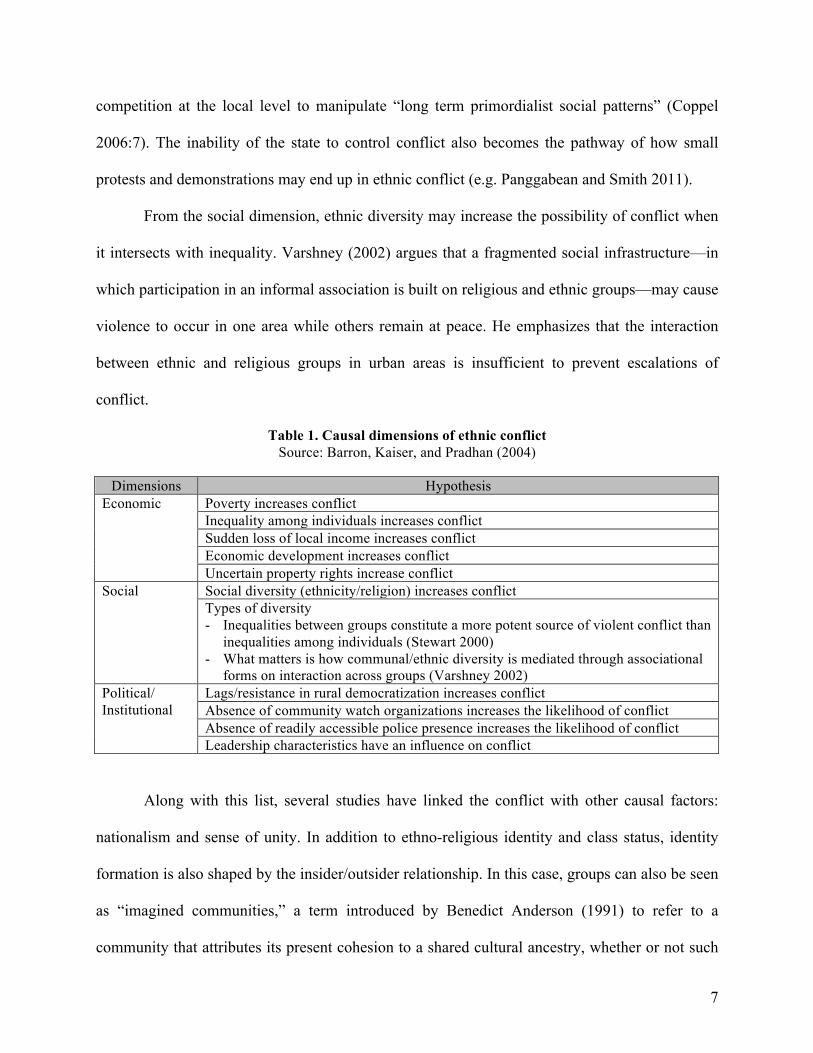
7
competition at the local level to manipulate “long term primordialist social patterns” (Coppel
2006:7). The inability of the state to control conflict also becomes the pathway of how small
protests and demonstrations may end up in ethnic conflict (e.g. Panggabean and Smith 2011).
From the social dimension, ethnic diversity may increase the possibility of conflict when
it intersects with inequality. Varshney (2002) argues that a fragmented social infrastructure—in
which participation in an informal association is built on religious and ethnic groups—may cause
violence to occur in one area while others remain at peace. He emphasizes that the interaction
between ethnic and religious groups in urban areas is insufficient to prevent escalations of
conflict.
Table 1. Causal dimensions of ethnic conflict Source: Barron, Kaiser, and Pradhan (2004)
Along with this list, several studies have linked the conflict with other causal factors:
nationalism and sense of unity. In addition to ethno-religious identity and class status, identity
formation is also shaped by the insider/outsider relationship. In this case, groups can also be seen
as “imagined communities,” a term introduced by Benedict Anderson (1991) to refer to a
community that attributes its present cohesion to a shared cultural ancestry, whether or not such
Dimensions Hypothesis Economic Poverty increases conflict
Inequality among individuals increases conflict Sudden loss of local income increases conflict Economic development increases conflict Uncertain property rights increase conflict
Social Social diversity (ethnicity/religion) increases conflict Types of diversity - Inequalities between groups constitute a more potent source of violent conflict than
inequalities among individuals (Stewart 2000) - What matters is how communal/ethnic diversity is mediated through associational
forms on interaction across groups (Varshney 2002) Political/ Institutional
Lags/resistance in rural democratization increases conflict Absence of community watch organizations increases the likelihood of conflict Absence of readily accessible police presence increases the likelihood of conflict Leadership characteristics have an influence on conflict

8
ancestry corresponds with the actual historical record. The causal mechanism stemming from
this dimension relates to the “maintenance or perpetuation of group boundaries, the competing
imaginations of these” (Kanbur, Rajaram, and Varshney 2009:20). Imagined geographies also
relate to ideological and religious forces that offer different conceptions of group boundaries that
make conflicts “established structures of meaning making” (ibid).
2.2 Approaches on Spatial Segregation and Ethnic Conflict
It is commonly realized that the study of social interaction should take spatial
components into account. The relation of space and social constructs links to the concept of the
“duality of space” proposed by Löw (2008), in which individuals are seen as social agents
involved in the spatial production process. Spatial dimensions, in turn, influence the individual’s
actions. As argued by Henri Lefebvre, “(social) space is a (social) product” (1991:26). The
production of social space encompasses spatial practice, representation of space, and
representational spaces. Spatial practice refers to the physical and material activities
encompassing “the circulation of goods, people, money, labor power, information… within a
hierarchy of administrative and organizational divisions of space” (Lefebvre 1991 in Zieleniec
2007:73). The representation of space is the process of abstraction and conceptualization of
space created by the powerful. Another aspect is representational spaces, which are the “spaces
of imagination, of resistance, of carnival, of subversion and appropriation” experienced by the
people (Dennis 2008:2). Similarly, Colombijn and Erdentug (2002) contend that the connection
between ethnicity and urban space is a two-way process. Space and its ownership, ordering, and
manipulation become “a means for efficient expansion of power” (Dreyfus and Rabinow

9
1982:190). This power usually takes the form of territory or “physical properties” that also
structures the “interaction opportunities” of individuals (Weidmann 2009a: 24).
Spatial patterning of ethnic groups in conjunction with their host societies takes two
forms: assimilation and segregation. Assimilation denotes the integration of minority groups into
dominant groups culturally and spatially (Peach 2005), while segregation involves a process of
maintaining cultural identity and socio-spatial separateness. Wolff (2007:4157) defines
segregation as “formal and informal separation of one group from another…based on markers of
difference, where race, ethnicity, gender, class, sexual orientation, or religion is used as the
foundation for justifying a split between groups and populations.” Residential segregation, in
particular, occurs because of either discriminatory or voluntary tendencies of individuals to
concentrate or cluster within their groups.
Several works have highlighted the positive and negative consequences of spatial
segregation. The concentration of a homogeneous group through residential segregation may
allow that group to preserve its social cohesion, cultural identity, and networks. It also provides a
greater sense of security and personal safety (Farley 2010). In contrast, segregation can lead to
negative consequences such as discrimination and intergroup tensions. Segregation can further
impact the quality of relationships among groups by reducing contact and inclusion, exposing
polarization among groups (Iceland 2007), and strengthening intergroup boundaries.
Similarly, Boal (1981) provides four basic functions of ethnic segregation. By joining an
ethnic cluster, members of a particular group decrease their sense of isolation, and their presence
in an area establishes an organized protection system for the entire group. Second, residential
segregation functions for a minority community as an avoidance of an unfamiliar world. As
Kramer (1970) notes, an ethnic cluster provides a “haven of refuge in unfriendly surroundings”

10
(p.67). A third function of ethnic segregation is related to the preservation and promotion of an
ethnic group’s cultural heritage. This preservation function is enhanced by the development of
ethnic institutions such as schools and religious establishments. Finally, Boal also notes that
spatial concentration provides an ethnic group with a defense system in the struggle of its
members within a larger society; that struggle may take the form of peaceful action or may
evolve into communal conflict.
Because of the different consequences of spatial segregation, an intriguing puzzle has
emerged in the research, with two competing approaches to analyzing the structural cause of
ethnic conflict and spatiality: “ethnic competition theory” and the “ethnic segregation model”
(Medrano 1994). These two approaches are opposed in looking at the effects of economic
inequality and segregation on intolerance and conflict. Ethnic competition theory suggests that
the mobilization of ethnic groups is caused by competition over scarce resources and economic
activities (Barth 1969; Olzak 1992). The competition among ethnic groups results from the
declining ethnic segmentation and ethnic hierarchy (Medrano 1994). In other words, this theory
suggests that the decreasing segregation between ethnic groups increases ethnic competition and
conflict.
In contrast, the ethnic segregation model proposes that ethnic intolerance and conflict
result from uneven development, increased hierarchy, and inequality rather than from
competition (Medrano 1994). The ethnic segregation model assumes that place becomes one
mechanism that transmits inequality (e.g. Massey and Denton 1993; Sharkey 2013; Wilson
1987). According to Blau (1977), the spatial organization of a society influences the group’s
mobility and opportunities. Spaces in this respect can be seen as “the geography of opportunity”
(Rosenbaum 1995) that relates to access to better schools and jobs, neighborhood satisfaction,

11
and safety (Briggs, Darden and Aidala 1999). The uneven development can be observed at
several levels: core and peripheral regions, city and rural, and between neighborhoods within a
city. This theory, therefore, argues that segregation-induced inequality in economic and social
dimensions increases ethnic intolerance and conflict.
These two approaches—although helpful in analyzing the conditions of ethnic tensions
and conflict—seem to compete with each other if both are applied at one spatial level (regional,
state, or city level). I argue that both theories may apply simultaneously at different levels. The
competition between groups and the changing spatial settings at the city level, for example, may
be followed by segregation at the sub-district or neighborhood level. This paper uses both
theories to examine the case of Ambon at different spatial levels.
2.3 Spatial Segregation as a Motivation-driven Mechanism and an Opportunity-driven
Mechanism
Another approach that is suitable for addressing the interrelationship between space and
conflict is to see space in the sense of territory as a source of conflict, as well as space as a
contingent factor that facilitates conditions of conflict (Diehl 1991). In other words, space can be
seen as both “a motivation-driven mechanism” and “an opportunity-driven mechanism”
(Weidmann 2009b). A motivation-driven mechanism occurs when a desire for a certain territory
motivates conflict; whereas an opportunity-driven mechanism describes the fact that shared
territorial residence provides the opportunity for coordination.
Weidmann suggests that a motivation-driven mechanism works when a particular
geographic area becomes the reason for disputes between groups, where one group fights for
power and control over a region it perceives as its own. Territory can be the source of conflict

12
because of its real or perceived value. Such values relate to economic, political, and cultural
dimensions, including the objective value that refers to the resources located in the territory;
strategic value for control and military advantage; and subjective value because land or territory
is part of group’s culture and identity (Toft 2003). To achieve the ownership of a territory and its
objective and subjective values, displacement of certain groups becomes one possible strategy
that will allow the opposition group to gain control over land and consolidate larger areas of
ethnic homogeneity. Clashes between ethnic and religious groups are often accompanied by
displacements of particular groups that lead to changes in political power and socio-spatial
structure in the conflicted areas.
From this perspective, a higher degree of spatial segregation is the goal of conflict
because it allows for the hardening of a boundary, not only the physical dimension but also the
mental boundary between different identity groups. Several studies claim that segregation is
indeed an effective strategy to avoid conflict, as it reduces the interaction between hostile groups.
For example, Weidmann and Sahleyan (2013) argue that ethnic “unmixing” and the creation of
homogenous enclaves were causes of diminishing conflict in Baghdad. Their conclusions
corroborate the argument that partition or physical separation between ethnic groups is the best
approach for peacemaking in the midst of conflict (Kaufmann 1996).
In contrast, an opportunity-driven mechanism, according to Weidmann (2009b), relates to
the interaction opportunity within and between group members. He views group concentration as
facilitating intra-group coordination and mobilization for communal action. While some type of
gain is the primary factor driving conflict, spatial proximity among members affects group
communication. As Laitin (2004) suggests, “territory sets the stage for violence to become a
feasible strategy if spatial group distribution facilitates collective organization for conflict” (in

13
Weidmann 2009:527). Interaction within a group is conducive to conflict with other groups
because it enhances the establishment of collective grievances, facilitates the flow of
information, and increases social pressure on individuals to participate, making recruitment more
likely.
Spatial segregation between groups affects other mechanisms, which can alleviate the
level of conflict. The more legible the physical boundaries between groups during a conflict, the
more quickly one group can identify the opposite group. A study conducted by Fjelde and
Hultman (2014) in sub-Saharan Africa can shed light on this matter. According to them, ethnic
groups in sub-Saharan Africa tend to cluster geographically. Their findings show that this
settlement pattern facilitates collective targeting along rival ethnic lines because spatiality
provides group-level identification. Therefore, spatial segregation enhances the establishment of
systematic collective targeting of particular members of a group.
While looking at space as a motivation-driven mechanism and an opportunity-driven
mechanism approach is helpful in establishing a framework for the issue addressed in this paper,
its implementation has focused mainly on the conflict between government and rebel groups and
has not yet been tested at the city level. Moreover, Weidmann’s study focuses solely on
geographic concentration of particular group that settles in one contiguous area of a country. In
this paper, I apply the theory to the city-level area with a different type of settlement pattern, in
which the distribution of ethno-religious groups creates not only city-level fragmentation but also
neighborhood-level segregation.

14
2.4 Framework of the Analysis
Based on the literature review, I develop a framework to analyze the case of Ambon that
includes a general approaches and contributing factors.
3. The Case of Ambon City, Maluku
The Muslim majority made up 87.2% of the total Indonesian population in 2011. The
distribution of religious groups at the national level shows the regional division between west
and east Indonesia (see Appendix 1). Muslims are predominant in Java, Sumatera, Kalimantan,
and Sulawesi while Christians are the majority in Southern Maluku, East Nusa Tenggara, and
Papua. Spatial distribution at the national level, therefore, repeats the imbalance of distribution of
religious groups. Maluku Islands formed one province before they finally split into two in 1999:
North Maluku and Maluku.
3.1 The Spatial Distribution of Ethno-religious Groups in Ambon
Following the factors that influence the formation of ethnic settings suggested by Brown
(1997:512), in this section I explain a brief history of Ambon related to the demographic patterns
Figure 1. Framework of conditional relationship between spatiality and ethno-religious violence
Communal violence
Motivation-driven mechanism • Objective value • Subjective value
Opportunity-driven mechanism • Interaction within groups
(mobilization) • Interaction between groups
(collective targeting)
Spatial segregation

15
and ethno-religious geography, colonial legacies, economic factors and trends, and regional
influences. Ambon is the name of the capital of Maluku Province as well as the island in which
the city located. Ambonese is a term that describes ethnic groups that populate not only Ambon
Island but also the district of Central Maluku. The population of the city, according to the
Population and Civil Registration Agency (2012), numbers 390,825 people. The administrative
development in Ambon Island is divided into two: the Ambon municipal area and a part of
Central Maluku district (see Map 1).
Before the first city agglomeration in 1979, the old town part of Ambon City was only a
single sub-district of Sirimau and was densely populated. The majority of the Muslim population
resided in the neighborhoods of Batu Merah, Waihaong, and partly in Tanah Lapang Kecil,
Diponegoro, and Jalan Baru, while other areas were predominantly Christians. The old town of
Ambon functioned as a port, with commercial and government districts, markets, and residential
settlements. The area surrounding the old core of the city was inhabited by the Christian majority
especially in the southern peninsula.
In addition to the Ambonese, which encompassed Muslims and Christians, many ethnic
migrants arrived in Ambon Island, such as Butonese from Southeast Sulawesi and Bugis and
Makassarese from South Sulawesi. These migrants settled in their own clusters of the same
ethnic and/or religious groups. They were predominantly Muslims, and they dominated small-
scale retail trading and transportation networks (Ecip 1999).
Ambon City area then agglomerated into three sub-districts in 1979: Sirimau, Nusaniwe,
and Teluk Ambon Baguala. The Muslims spread their settlements mostly to the northern and
western parts of the city, while the Christians spread to the southern and eastern parts. In 2006,
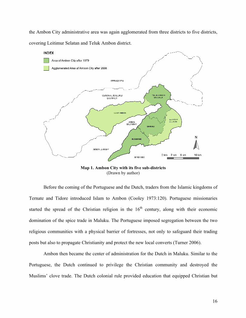
16
the Ambon City administrative area was again agglomerated from three districts to five districts,
covering Leitimur Selatan and Teluk Ambon district.
Before the coming of the Portuguese and the Dutch, traders from the Islamic kingdoms of
Ternate and Tidore introduced Islam to Ambon (Cooley 1973:120). Portuguese missionaries
started the spread of the Christian religion in the 16th century, along with their economic
domination of the spice trade in Maluku. The Portuguese imposed segregation between the two
religious communities with a physical barrier of fortresses, not only to safeguard their trading
posts but also to propagate Christianity and protect the new local converts (Turner 2006).
Ambon then became the center of administration for the Dutch in Maluku. Similar to the
Portuguese, the Dutch continued to privilege the Christian community and destroyed the
Muslims’ clove trade. The Dutch colonial rule provided education that equipped Christian but
Map 1. Ambon City with its five sub-districts (Drawn by author)

17
not Muslim Ambonese, leading to a higher literacy rate among the Christians (Chauvel 1990:36).
This advantage affected not only areas within the city but also spread literacy skills to Christian
villages in rural areas. The population of indigenous Ambonese, therefore, was divided between
the two religions from this early time. Religious communities clustered in different villages
(Mearns 1999) which later became known as either Ambon Sarani (Christians) or Ambon Salam
(Muslims). The formation of such villages showed the strength of the groups’ internal solidarity,
yet the segregation later made them vulnerable to the possibility of conflict between groups.
However, the peace was maintained through the traditional system called pela and gandong
among the negeri (village). Pela and gandong are “inter-village alliances” between villages with
the same or different religious groups (Cooley 1961:263). It is a traditional (adat) institution
based on socio-economic interest that also involves “reciprocal relationships” in public works,
including building and maintaining places of worship (Ratnawati 2006).
The downfall of the spice trade changed the pattern of job opportunities such that
government services—for example, the army and civil services (ambtenaar)—became the most
important sources of income. Among the Ambonese Christians, the more educated received more
access to work in the Dutch colonial bureaucracy in clerical jobs, and even the less educated
were able to join the Dutch colonial army/KNIL (Chauvel 1990:32). Meanwhile, Dutch colonial
policy discriminated against the Muslims who were afforded fewer chances in the colonial army
and civil service (Braithwaite 2013:38), while the Protestants gained higher material wealth
compared to the Muslim residents (Chauvel 1990). The Dutch administrative policy strengthened
both clan-based and religious community-based territorial entities (Tanamal and Trijono
2004:234). The Dutch tactic of discrimination against the Muslims slowly and eventually formed
chronic social segregation based on religion, even down to the village level. This situation started

18
to alter at the beginning of the 20th century after the inception of Indonesian nationalism under
the leadership of Sarekat Ambon (Ambon Association). During the Japanese occupation of the
archipelago, Christians and traditional local leaders (raja) were viewed as Dutch loyalists and
removed from the bureaucracy. After this period, the role of Ambonese Muslims in politics
increased (Ratnawati 2006).
The early independence period in Indonesia brought anxiety to the region and the rise of
a movement to form a country separate from Indonesia. In Maluku, the movement called
Republik Maluku Selatan (RMS), led mainly by the Ambonese Protestants, demanded an
independent state. Faced with this situation, the people of Maluku divided into groups that sided
with the Indonesian government and groups that wanted to be independent. With this split, the
relations between the two communities became tenser, because most of the leaders of the RMS
came from the Christian community. The movement led to a fight for independence, in which the
victims of the upheaval were mostly from the Islamic community. The movement was defeated
by the central government, resulting in decreased benefits for Ambonese Protestants in the
bureaucracy and armed forces (Kiem 1993 in Sidel 2008:39). In contrast, the Muslims gained
upward mobility along with growing access to education and employment opportunities, thus
increasing competition over the distribution of socio-economic benefits.
During the Suharto period (1967-1998), the landscape was changing as the extensive
transplantation of different ethnic groups created cultural friction and economic competition. A
flood of immigrants from Bugis, Buton, Makassar (BBM) and Sumatra, Kalimantan, Java (SKJ),
added to the size of the Muslim population in the entire Maluku Province (see Graph 1). As
explained by Sidel (2008:41), patterns of migration to and within Maluku heightened
“ethnicizing tensions” between Christian and Muslim communities as well as between

19
immigrants and the native population. The changing demographic composition in Ambon
because of migration led to the tension, which started as an “antimigrant prism” (Davidson
2008:185; van Klinken 2001).
To understand the local representation and interaction among groups, I take an example
of Silale neighborhood in Nusaniwe sub-district. Silale was a mixed locality with a vast majority
of Muslim migrants who had arrived from the mid-1950s onwards. The migrants settled in the
area alongside the river and on the foreshore. The haphazard process of settlement resulted in
“the tightly packed, irregularly located, typical squatter/shanty area” compared to the more
widely spaced houses of Christians (Mearns 1999:25). Ambon experienced urban sprawl, and
the scarcity of residential land resulted in the rise of land price. The more recent arrivals of
migrants increased the competition to find affordable sites for housing and resulted in illegal
0
10
20
30
40
50
60
70
1971 1980 1990 1995
Muslim
Protestant
Catholic
Graph 1. Demographic changes in Maluku according to religion prior to the 1999 conflict Source: Central Bureau of Statistics of Ambon City

20
settlements. The government then started the process of “rehabilitation” that required a more
ordered space, organized planning, and a hygienic settlement pattern (Mearns 1999).
The relationship between Christian and Muslim households—who knew each other
before—became weakened. According to Mearns (1999), “there was little knowledge and almost
no interaction between the Christians and the Muslims and many of the newcomers were
perceived as troublesome and potentially violent” (p.27). The Christians were then inclined to
support local authorities in applying social control over the migrants, leading to an increased in
social distance between groups.
Middle class Christians viewed the migrants as “coarse and unrefined” compared to their
experience with European Protestants who valued “appropriate public behavior” (Mearns
1996:102). Ambonese Christians characterized the migrants from Sulawesi as more likely to take
on hard manual labor and to be entrepreneurial. The Christians clashed with the migrant
population because of the latter’s drunkenness and violence. Social stratification also formed
among the migrants from Sulawesi. Bugis people perceived themselves as having a higher status
and complained that Butonese, who were considered harsh and a lower status, often assaulted
them (Mearns 1996).
In 1974, the new law on local government transformed the local leadership system in
Ambon, which had been based on the clan. This new system provided political representation
from various ethno-religious groups. However, it reduced the authority of the traditional leader
(raja) who previously had the ability to stop conflict between groups from breaking out (HRW
1999). Moreover, the politics in Maluku under the New Order tended to be drawn along religious
lines as Suharto cultivated new bases for political support from Islamic groups (Bertrand 2004;
Davidson 2008).

21
The dominant role of the Christian community in Ambon before the conflict slowly
shifted into the hands of the Muslim community. The issue of land was an important factor
related to the tension between ethno-religious and migrant groups. The establishment of Law
No.5/1979 changed the traditional control of land, forest, and coastal areas from adat society
where indigenous forests were protected by customary rights to governance by formal law. The
loss of traditional control over these functions gave everyone the opportunity for ownership over
the land (Ecip 1999:139). With their economic capabilities, the Muslim migrants bought land
based on purely economic considerations. According to Ratnawati (2006), the lack of cultural
considerations in the changing of land ownership gave rise to the crisis in the community of
Ambon. For the people of Ambon, land had not merely economic value but also cultural value
that was significant for their ancestry. Pariela (1996) suggests that there are three functions of
land for the people in Ambon:
“First, some people have lost a symbol of unity to maintain their lineage identity through collective landownership. Secondly, the household is no longer the unit of production because it has lost sufficient labor force to work its own land. Thirdly, their traditional ceremonies which are related to kinship and land tenure have become merely a symbol of the past” (in Ratnawati 2006) According to Benda-Beckman and Taale (1996), housing and land connections became
increasingly problematic in village areas, especially related to the changing of land use and the
expansion of residential areas. Their study in Hila in Central Maluku District, for example,
shows that the changing land use triggered new conflict. The changes were related to the
economic exploitation of property resources, a more permanent and less flexible occupation of
land, and the used of a much larger part of available land because of the presence of more labor
power from Buton (Benda-Beckman and Taale 1996:55).

22
Moreover, the in-migration to the area was not only from other regions but also from
rural to urban. Despite the agglomeration of the city area, rural economic activity in Maluku
Islands remained less well developed. Ethnic Bugis, for example, who used to live along the
coast, began to move to the city of Ambon. The urbanization process, in the view of some
Ambonese, displaced the previous traders and took over some economic sectors (HRW 1999). In
this regard, the dynamics of social relationships often led to tensions based mainly on
competition between groups of migrants and the indigenous communities of Ambon.
3.2 The Pattern of Communal Violence in Ambon
The recurrence of conflict in Ambon during this period is commonly divided into three
phases: the first, from January to April 1999; the second, from July to December 1999, and the
third, from 2000 to 2004 (Tanamal and Trijono 2004). In this paper, I focus on the 1999
Map 2. Preliminary mapping of religious-based population distribution before 1999 Source: Compilation of data, mainly from Ecip (1999) and HRW (1999); Drawn by author

23
episodes. Several sources detail the pattern of violence, including those created by religious
organizations. In this paper, I use data based on the report made by Human Rights Watch (HRW)
in 1999 and Ecip’s work (1999). Their documents are based on secondary sources such as
newspapers and direct interviews in the communities in Ambon during the post-conflict period.
Descriptions that they provide in these documents allow me to draw a map showing the location
of the incidence of violence and the origin of the actors involved in the conflict.
The tension in Ambon had started a couple of months before the first spark of conflict by
an ongoing rumor that the residents from Bugis, Buton, and Makassar would be displaced, along
with other non-Maluku Muslims (Ecip 1999). The first phase of conflict started on January 19,
1999 and continued to the end of April 1999, triggered by a gang fight in Batu Merah terminal,
between two youth groups from the Christian neighborhood of a majority Muslims area of Batu
Merah and the majority Muslim village of Mardika in Rijali neighborhood. On the same day, 600
Muslims converged on the Christian settlement area in Batu Merah Dalam and set fire to the
houses as well as the business district in Mardika Market (HRW 1999). Furthermore, Christian
settlements in Waihaong and Silale were targeted by the Muslims; the Silo Church was
destroyed. Christian residents in Kudamati neighborhood took revenge on Muslims in Mardika
but then were confronted by Muslims from Waringin. In the evening, a number of Christian
citizens destroyed Muslim housing in Kampung Paradeys. This evening attack targeted migrants
from Buton, Bugis, and Java (HRW 1999).
The conflict in downtown Ambon spread to Central Maluku district, showing how ethno-
religious violence was connected between the city and the peripheral area. The rumor of the
burning of Al-Fatah Mosque in the downtown area aroused the anger of Muslims from Wakal,
Hitu, and Mamala, which are located in the northeast of Ambon Island. The Muslims headed to

24
Ambon city for revenge and destroyed several Christian villages in the district of Teluk Ambon
Baguala.
As they moved from the hinterland, the Muslims were confronted by the Christian
community at Passo who had mobilized after hearing about the destruction of Benteng Karang
(HRW 1999). Moreover, the area of Hila in the northern part of Central Maluku District became
a site of violence, where the Muslims of Wakal attacked the participants of Hila Bible Camp. On
January 23, Muslim residents from Tulehu attacked the Christian village of Waai in the name of
jihad because of the displacement of Butonese to Tulehu. Subsequently, on March 1, several
Christians attacked the majority Bugis and Butonese settlement in Rinjani area.
To sum up, the first phase of conflict spread to surrounding neighborhoods and to other
sub-districts of Ambon City and Central Maluku District with the burning of homes and houses
of worship (see the detail in Table 2 and Map 3). The burnings of mosques and churches were
predominant events that sparked the spread of the conflict to other areas. The nature of the
conflict also shifted, as what first tended to be a fight of Christian Ambonese against the Muslim
migrants transformed into a struggle between Christians and Muslims.
In contrast to the first phase of ethno-religious violence, the second significant conflict
broke out after a clash of drunken youths on July 24, 1999 in the middle-class area of Poka in
Teluk Ambon Baguala sub-district, that was inhabited by a multi-ethnic and religious population
(Braithwaite 2010:154). This phase of the conflict was followed by the devastation of the
Chinese-owned business district along A.J. Patty Street in Ambon City. The Muslims then also
targeted Catholics, a group that was not involved in the previous conflict. Several fights
occurred in houses of worship, including a large massacre of civilians in Galala Church and
fighting in the area around Al-Fatah. At the end of 1999, a major confrontation occurred in

25
Mardika. Subsequently, on December 26, another large fight broke out in the city of Ambon,
triggered by an accident involving a Christian pedestrian who was hit by a Muslim driver. This
fight led to another attack on and destruction of Silo Church.
Table 2. Matrix of the ethno-religious violence in Ambon in 1999 Source: Compilation of data, mainly from HRW (1999) and Ecip (1999)
Date Location Majority Minority Actors First Phase of Conflict (1999)
1/19 Batu Merah Muslims (with Butonese,
Bugis, and Makassarese)
Christians Christians and Muslims
1/19 Mardika Christians Muslims Muslims from Batu Merah 1/19 Silale Muslims Christians Muslims from outside Silale 1/19 Kudamati Christians Muslims Christians and Muslims 1/19 Waringin Muslims Christians Christians from Kudamati
and Muslims from Waringin 1/19 Silo Church Christians Muslims Muslims 1/19 Anthony Rebok
Avenue N/A N/A Christians burn kiosk
belonging to Butonese and Bugis
1/19 Kampung Paradeys N/A N/A Christians target Buton, Bugis, Minang, and Javanese
1/19-20 Batu Gantung, Waringin
Muslims
Christians (Northern part
of neighborhood)
Christians from Batu Gantung Kudamati, Mardika, and Nusaniwe sub-district
1/20 Major markets in city
N/A N/A Christians
1/20 Pelita Shopping Area, the Gambus market, the Mardika market, the Mardika fruit market, and the Cakar Bongkar food market
N/A Some settlements of
Muslims Butonese around
the Gambus market was
burned
Christians
1/20 Pohon Pule N/A Muslims (Bugis housing
complex)
Christians
1/20 Gunung Nona Christians Muslims (Butonese)
Christians
1/20 Benteng Karang N/A Muslims Southeastern
Moluccas
Muslims from Hitu and Mamala, Morela, Hulana, Hitu-Missin, and Wakal; Christians
1/20-21 Passo, Nania, Negeri Lama
Christians Muslims Muslims from Hitu

26
1/20 Hila and Bible Camp
Muslims Christians Muslims from Wakal
1/20-21 Wailette and Kamiri, Hative Besar
Christians Muslims (Butonese,
Bugis, Makassarese)
Christians & Muslims
1/22 Mangga Dua Christians Muslims Christians 2/23 Waihaong Christians Muslims Muslims
Batu Merah Muslims Christians 2/23 Waai Christians Muslims Christians & Muslims 2/23 Liang and Tulehu Muslims Christians Christians & Muslims 3/1-2 Rinjani (Batu
Merah) Muslims
(mainly Bugis and Butonese)
Christians Christians
3/5-6 Around Silo Church N/A N/A Christians & Muslims Second Phase of Conflict (1999)
7/24 Poka Christians Muslims Christians & Muslims A.J. Patty Street N/A N/A Christians & Muslims
8/12 Galala Church, Galala
Christians Muslims Muslims
Al-Fatah Mosque, Waihaong
Christians Muslims Christians & Muslims
11/26 Mardika Christians Muslims Christians & Muslims 12/26 Around Silo Church Christians Muslims Christians & Muslims
Map 3. Preliminary mapping of the locations of violence and origin of actors in 1999 conflict
Source: Compilation of data, mainly from HRW (1999) and Ecip (1999); Drawn by author

27
The ethno-religious violence in 1999 resulted in the displacement of more than 90,000 people.
The highest number of refugees went to Buton in Southeast Sulawesi. Thus is appears that one of
the consequences of the violence was the reduction in the number of Muslim migrants in Ambon.
Table 3. Data of Internally Displaced Person after the Ambon violence in 1999
Source: Ratnawati (2006)
3.3 Space as a Motivation-driven Mechanism
Tracing the dynamics of ethno-religious settings in Ambon with the pattern of communal
violence, we can infer that several factors support ethnic competition theory as an explanation of
the structural cause of Ambon violence. The historical background of Ambon prior to the 1999
conflict reveals declining social fragmentation and hierarchy between Ambonese Christians and
Muslims, as well as between the indigenous and migrant groups. The Muslims gained upward
mobility along with growing access to education and employment opportunities, thus increasing
competition over the distribution of socio-economic benefits. The process of transplantation of
Muslim migrants to Ambon then changed the demographic and geographical patterns on the
island. Along with increased mobility of the Muslims on the economic, social, and political
ladders, competition over land and territory became one prominent condition that exacerbated
the conflict between groups. The spatial mobility from rural to urban Ambon also eliminated the
barriers for different ethno-religious groups to compete for land and occupation.
Date (1999) Place of Conflict IDP Location Number of IDPs January-August 10 Ambon Buton, Southeast Sulawesi 60,000 February 26 Ambon Al-Fatah Mosque, Ambon 3,500 August 2 Ambon Military institution, place of
worship, government office in Ambon
30,000
August 2 Ambon Ujung Pandang, South Sulawesi 1,040 August 23 Ambon Outside Ambon 1,200
28
Although decreasing social segregation between groups was evident, the preliminary
mapping of population distribution based on religious groups prior to the 1999 communal
violence shows apparent spatial segregation at different levels: macro-level (island), city-level,
and neighborhood level. The majority of the Muslim population resided in the Central Maluku
District, and the Christian population settled mostly inside the boundary of Ambon City.
Meanwhile, the archival review shows that residential segregation was manifested at the city
level and neighborhood level, although these were not areas of total segregation. Both religious
groups, with different majority/minority compositions, inhabited most of the areas. Moreover,
the pattern of violence shows that the conflict occurred mostly in sub-districts and
neighborhoods that were occupied by both religious groups. The conflict in Ambon city core
happened predominantly in areas with majority Muslims and considerable numbers of the
migrant population. The conflict was followed by massive displacement that increased the
separation between the Christian and Muslim communities (Sidel 2008). The case of Ambon
reveals that the patterns and dynamics of displacement intertwine with the competition over
territory and resources, and the new formation of ethno-religious spatial setting.
Space then became a motivation-driven mechanism because the conflict was grounded in
anxieties that increased over periods of time, especially regarding the changing demographic
compositions. The sequence of violence left Ambon City more segregated than before, wherein
the “once fluid, multiple, and disunited spatial and ethnic boundaries have become fixed, one
dimensional, and totally coextensive” (Colombijn and Erdentug 2003). The displaced people
moved to other areas inhabited by communities of their co-religionists. Displacement, as a
consequence, enlarged the separation between Christian and Muslim communities and mediated
the creation of “purified land” which increases the legibility of a group’s identity. Thus, the

29
conflict proved substantial in sharpening spatial segregation and simplifying the boundaries of
religious identity and authority between the Christian and Muslim communities, redrawing a
“religiously coded topography” (Sidel 2008:58). From this perspective, a higher degree of spatial
segregation becomes the goal or result of the conflict.
The displacement occurred based on the increasing competition among groups over land.
The conflict in Maluku escalated because the Muslim population increased its economic and
territorial mobility vis-à-vis the other groups. From the historical description, space in urban
Ambon encompasses an economic value or space as commodity. Government regulation,
particularly in urban area, increased awareness of the residents over the economic value of land.
We can infer that Ambon has experienced a long struggle over land relates to access of people to
a place of living. The increased gap and segregation among ethno-religious groups, therefore,
allowed greater control and autonomy of urban space in each sub-districts.
The communal violence in the core of Ambon City cannot be isolated from the areas in
the neighboring Central Maluku District. The value of land as resource also differs between
urban Ambon and the hinterland. In the case of hinterland villages, land titles became “one
source of conflict” (van Klinken 2006) because the village-based system could not readily handle
non-local landowners. According to Adam (2010), the violence that occurred mostly in rural
areas was based on long-standing disputes related to land and border. Such disputes explain why
“ordinary folk” decided to participate in conflict. According to him, the violence that occurred in
the hinterland was “a deliberate attempt to clear a certain space with the aim of assuming
control” (Adam 2010:35). These villages also have histories of conflict with neighboring
villages. Therefore, the analysis of why particular areas experienced conflict should consider the
spatial (territorial dimension) and the long history of the local fight.

30
Moreover, the motivation to displace particular groups was related to the inward
migration created during colonial rule and the New Order period. The Dutch colonial projects
drew boundaries along ethnic and religious lines, privileged one group over another, and started
early resentment among ethnic groups. This legacy of disadvantages further fostered the
establishment of insider and outsider feelings and justified a need to displace particular groups.
The segregation that existed prior to the 1999 conflict signified the subjective value of territory
where certain areas “belonged” to certain groups. Mosques and churches were markers of
particular communities belonging to particular places. The burning of places of worship in some
areas escalated the conflict because it symbolized an act of removing particular groups. The
rumors and news about burning churches or fights in the inner city of Ambon spread to the
hinterland and sparked the “ties of obligation to co-religionist villages” (van Klinken 2006:137).
The 1999 conflict resulted in an intensifying segregation between groups, and an
increasing territoriality based on religious identity. Artworks such as murals, signboards, and
sculptures depicting Jesus and other Christian saviors have since become territorial emblems to
mark the Christian identity and to “ward off Muslims” (Spyer 2008:11). In this sense, space in
urban and hinterland Ambon has significant value related to personal and collective historical
relationships.
3.4 Space as an Opportunity-driven Mechanism
Although this discussion suggests that ethno-religious tension in Ambon was caused by
the increased competition among groups, support for ethnic segregation theory is also quite
evident in the spatial dimension. As this approach suggests, residential segregation increases in-
group solidarity and interaction within groups. The concentration of Muslims and Christians in

31
particular areas of Ambon made them more susceptible to being mobilized to join the conflict.
Segregation between religious groups, on the other hand, reduces the interaction between groups
and discourages an existence of associational life between groups. To further examine this
interaction factor, I take Batu Merah and Wayame sub-districts as examples. As shown in Table
2, violence frequently occurred in Batu Merah that comprised a Muslim majority and a Christian
minority, the latter dwelling in the Batu Merah Dalam neighborhood. In the case of Wayame
Village, spatial integration increased social relations between Muslims and Christians. In this
area, social and cultural segregation was low and reduced the probability for provocation.
Furthermore, the mapping and matrix of ethno-religious violence reveals that residential
segregation between ethno-religious groups led to a magnified level of conflict, as one group
could quickly identify the targeted groups. As mentioned, although the city of Ambon was
predominantly Christians, Muslims dominated the outer part of the municipality, especially in
the north and west part of the Island of Ambon. Some villages outside of Ambon City, such as
Hila and Waai that have large Christian community, were subjected to the anger of the Muslims
from surrounding areas. According to Davidson, the selective targeting of native Christian
Ambonese in these areas was along ethnic lines, done particularly by migrants of Butonese,
Makassarese, and Bugis, who are mostly Muslims (2008:177).
Similarly, collective targeting happened during the conflict in the city core area. As
explained by Ecip (1999:176):
“…the Christians in nearby Kudamati heard that Muslim residents of Batu Merah had attacked Christian residents of Mardika and that homes and religious buildings had been burned. They gathered themselves together to mount a counteroffensive and defend their co-religionists. A Muslim crowd at Waringin blocked them, and the two parties attacked each other” (translated by author).

32
In other words, the clustering of ethno-religious groups provided means for collective
targeting during the conflict. The identification of particular neighborhoods based on the religion
of majority group became a tool that “fed the fighting.” As van Klinken mentioned in his
writings:
“… a young Muslim outraged by the bloodshed, showed me a map he had drawn. On it were marked the red and white militia posts (posko) situated near the front line as it snaked through Ambon city… This map of a city at war showed that different localities in it had robust identities as being either Protestant or Muslim” (2006:137).
Spatial segregation, therefore, became the mechanism that facilitated mobilization within
a co-religionist group and also provided a strategic instrument for particular groups in collective
targeting of opponent groups. The map that was made and circulated by Laskar Jihad, for
example, showed locations of the allied and opponent groups. Therefore, the affiliation of an
individual with a neighborhood became the signifier of ethno-religious identity.
4. Concluding Remarks and Further Research
In this paper, I have attempted to seek a framework to examine how and when spatial
patterns influence the occurrence of communal violence. The preliminary findings of the case
show that space should be put into the equation in examining the causal mechanisms of
communal violence. In the context of Ambon, space played a role as a factor that ameliorated the
occurrence of conflict both as a motivation-driven mechanism and an opportunity-driven
mechanism. Space acted as a motivation-driven mechanism in the Ambon conflicts because the
existed spatial segregation created a desire of the Christian and Muslim groups to gain a larger
control of certain territory along with its value as an economic resource and for collective
identity formation. Therefore, a higher degree of spatial segregation between religious groups
was the objective of the conflict. Space played a role as an opportunity-driven mechanism in

33
which the existed spatial segregation in Ambon prior to 1999 conflict increase the interaction and
solidarity within groups that accelerate mobilization of a particular group. It also facilitated the
collective targeting of other groups during a state of conflict. Related to the debate on ethnic
competition theory and ethnic segregation theory, my findings suggest that the approaches
should not be seen as competing perspectives, but rather as two different mechanisms to read the
causal links of ethnic tensions when they are applied to different spatial levels.
The argument that I made in this paper does not suggest that spatial segregation is the
leading cause of violence. Nevertheless, this study expands the knowledge of the causal
conditions that affect ethno-religious groups’ relations, in which the presence of segregation can
activate and magnify the occurrence of ethnic conflict. In other words, without spatial
segregation, the other intervening phenomena such as an economic downturn and political
juncture would operate more weakly.
This paper has several limitations, including the use of a single case study and incomplete
data collection. The lack of availability of relevant micro-level data prior to the conflict limits the
analysis to explaining only partly how changes in spatial pattern related to motivation to sharpen
boundaries between groups. Several pieces of contrasting information related to the location of
violence and actors involved shows a possibility of bias reporting that would reduce the accuracy
of data used in the analysis. Further research on the relationship between space and ethnicity,
with more case material and data, is needed to corroborate the argument and to arrive at a robust
conclusion. The next stage of this research involves field study and on-site data collection to
support an in-depth analysis. Similarly, this paper has not detailed the aspect of social
organization within the boundaries of the neighborhood that influences the trajectories of
neighborhood residents. Therefore, group actors involved in mobilization and targeting during

34
conflict as well as the pattern of interaction need to be explored further. Regarding methodology,
there is the possibility of using various mechanisms in measuring segregation developed by
scholars in the US. Massey and Denton (1988), for example, provide spatial understanding of
segregation by proposing five categories, including evenness, exposure, concentration,
centralization, and clustering.
Nonetheless, the current framework may be applied in future research to compare Ambon
to other areas with similar or contrasting conditions. Furthermore, we can start to investigate how
residential choice operates in such a tense environment and why segregation is maintained.
Therefore, this paper opens the possibility for future research that would also fill gaps in the
literature. These gaps are related to the need for comparative studies, particularly in developing
and poor countries; variations in methodology and analysis; the use of spatial data; studies on
other social categories, such as gender and age (e.g., young people); intergenerational effect of
ethno-religious violence; and examination of policy making.
Bibliography
Adam, Jeroen. 2010. "How Ordinary Folk Became Involved in the Ambonese Conflict: Understanding Private Opportunities during Communal Violence." Bijdragen tot de Taal-, Land- en Volkenkunde 166 (1): 25-48.
Anderson, Benedict. 2006 Imagined Communities: Reflections on the Origin and Spread of Nationalism. London: Verso.
Aspinall, Edward. 2008. "Ethnic and Religious Violence in Indonesia: A Review Essay." Australian Journal of International Affairs 62(4): 558-572.
Barnes, Bruce E. 2007. Culture, Conflict, and Mediation in the Asian Pacific. Maryland: University Press of America.
Barron, Patrick, Kai Kaiser, and Menno Pradhan. 2004. "Local Conflict in Indonesia: Measuring Incidence and Identifying Patterns." World Bank Policy Research Working Paper.
Barron, Patrick, Sana Jaffrey, Blair Palmer, and Ashutosh Varshney. 2009. Understanding Violent Conflict in Indonesia: A Mixed Methods Approach. Jakarta: Social Development, the World Bank.
Barth, Frederick. 1969. Ethnic Groups and Boundaries. Boston: Little, Brown.

35
Benda-Beckman, Franz von, and Taale, Tanja. 1996. "Land, Trees and Houses: Changing (Un)certainties in Property Relationships on Ambon." In Remaking Maluku: Social Transformation in Eastern Indonesia, eds. David Mearns and Chris Healey. Northern Territory University: Centre for Southeast Asian Studies. 39-63.
Bertrand, Jacques. 2002. "Legacies of the Authoritarian Past: Religious Violence in Indonesia's Moluccan Islands ." Pacific Affairs (University of British Columbia) 72(1): 57-85.
—. 2004. Nationalism and Ethnic Conflict in Indonesia. Cambridge: Cambridge University Press.
Blau, Peter. 1977. Inequality and Heterogeneity: A Primitive Theory of Social Structure. New York: Free Press.
Boal, F.W. 1981. "Ethnic Residential Segregation, Ethnic Mixing and Resource Conflict: A Study in belfast, Northern Ireland." In Ethnic Segregation in Cities, ed. Ceri Peach, Vaughan Robinson and Susan Smith, London: Croom Helm. 235-251.
Braithwaite, John, and Dunn, Leah. 2010. "Maluku and North Maluku." In Anomie and Violence: Non-truth and Reconciliation in Indonesian Peacebuilding, Eds. John Braithwaite, Valerie Braithwaite, Michael Cookson, and Leah Dunn. Canberra: Australian National University E Press .147-242
Braithwaite, John. 2013. "Maluku: Anomie to Reconciliation." In Diminishing Conflicts in Asia and the Pacific: Why Some Subside and Other's Don't, eds. Edward Aspinall, Robin Jeffrewy and Anthony J. Regan. New York: Routledge. 37-48.
Briggs, Xavier De Souza, Joe T Darden, and Angela Aidala. 1999. "In the Wake of Desegregation: Early Impacts of Scattered-site Public Housing on Neighborhoods in Yonkers, New York." Journal of the American Planning Association 65(1): 27-49.
Brown, David. 1994. The State and Ethnic Politics in Southeast Asia. London and New York: Routledge.
Chauvel, Richard. 1990. Nationalists, Soldiers, and Separatists: the AMbonese Islands from Colonialism to Revolt 1880-1950. Leiden: KITLV Press.
Colombijn, Freek, and Aygen Erdentug. 2002. "Introduction: Urban Space and Ethnicity." In Urban Ethnic Encounters: The Spatial Consequences, eds. Aygen Erdentug and Freek Colombijn, London and New York: Routledge. 1-23.
Cooley, F.L. 1973. "Persentuhan Kebudayaan di Maluku Tengah 1475-1675 (A Clash of Cultures in the Central Moluccas 1475-1675)." In Bunga Rampai Sejarah Maluku (I) (A Compilation of the History of the Moluccas (I), by Paramita R. Abdurrachman, R.Z. Leirissa and C.P.F. Luhulima. Jakarta: Lembaga Penelitian Sejarah Maluku.
Coppell, Charles A. 2006. "Violence: Analysis, Representation and Resolution." In Violent Conflicts in Indonesia: Analysis, Representation, Resolution, ed. Charles A. Coppel, London and New York: Routledge. 3-18.
Davidson, Jamie S. 2008. From Rebellion to Riots: Collective Violence on Indonesian Borneo. Madison, Wisconsin: The University of Wisconsin Press.
Dennis, Richard. 2008. Cities in Modernity: Representations and Productions of Metropolitan Space, 1840-1930. Cambridge: Cambridge University Press.
Diehl, Paul. 1991. "Geography and War: A Review and Assessment of the Empirical Literature." International Interactions 17(1): 11-27.
Dreyfus, Hubert L., and Paul Rabinow. 1982. Michel Foucault: Beyond Structuralism and Hermeneutics. Chicago: University of Chicago Press.

36
Ecip, S. Sinansari. 1999. Menyulut Ambon: Kronologi Merambatnya Kerusuhan Lintas Wilayah di Indonesia. Bandung: Penerbit Mizan.
Farley, Katherine Laura. 2010. Patterns and Trends in EthnicResidential Segregation in England, 1991-2001: a Quantitative and Qualitative Investigation. PhD Thesis, Department of Sociology, School of Applied Social Sciences, Durham University, Durham: Durham University.
Fearon, James D., and David D. Laitin. 2011. "Son of the Soils, Migrants, and Civil War." World Development 39(2): 199-211.
Field, Erica, Matthew Levinson, Rohini Pande, and Sujata Visaria. 2008. "Segregation, Rent Control, and Riots: The Economics of Religious Conflict in an Indian City." The American Economic Review 98 (2): 505-510.
Fjelde, Hanne, and Lisa Hultman. 2014. "Weakening the Enemy: A Disaggregated Study of Violence against Civilians in Africa." Journal of Conflict Resolution 58(7): 1230-1257.
Goss, Jon. 2000. "Understanding the "Maluku Wars": Overview of Sources of Communal Conflict and Prospects for Peace." Cakalele 11: 7-39.
Horowitz, Donald L. 1985. Ethnic Groups in Conflict. Berkeley: University of California Press. —. 2001. The Deadly Ethnic Riot. Berkeley: University of California Press. Human Rights Watch (HRW). 1999. Indonesia: The Violence in Ambon.
http://www.hrw.org/legacy/reports/1999/ambon/. Iceland, John. 2007. "Residential Segregation." In The Blackwell Encyclopedia of Sociology, ed.
George Ritzer, Malden, Mass.: Blackwell Publishing. 3896-3899 International Crisis Group (ICG). 2002. "Indonesia: The Search for Peace in Maluku." Asia
Report, February 8. Jalali, Rita, and Seymour Martin Lipset. 1992. "Racial and Ethnic Conflicts: A Global
Perspective." Political Science Quarterly 107(4): 585-606. Kanbur, Ravi, Prem Kumar Rajaram, and Ashutosh Varshney. 2011. "Ethnic Diversity and
Ethnic Strife: An Interdisciplinary Perspective." World Development 39 (2): 147-158. Kasara, Kimuli. 2014. "Does Local Ethnic Segregation Lead to Violence?: Evidence from
Kenya." February 25. http://ssrn.com/abstract=2401738 (accessed December 2, 2014). Kaufmann, Chaim. 1996. "Possible and Impossible Solutions to Ethnic Civil Wars."
International Security 20(4): 136-175. Kiem, Christine. 1993. "Re-Islamization among Muslim Youth in Ternate Town, Eastern
Indonesia." Sojourn 8(1): 92-127. Klinken, Gerry van. 2001. "The Maluku Wars: Bringing Society Back In." Indonesia 71: 1-26. Klinken, Gerry van. 2006. "The Maluku Wars: 'Communal Contenders' in a Failing State." In
Violent Conflicts in Indonesia: Analysis, Representation, Resolution, ed. Charles A. Coppel. London and New York: Routledge.129-143.
Klinken, Gerry van. 2007. Communal Violence and Democratization in Indonesia: Small Town Wars. London: Routledge.
Kramer, Judith Rita. 1970. The American Minority Community. New York: Thomas Y. Crowell. Laitin, David D. 2004. "Ethnic Unmixing and Civil War." Security Studies 13(4): 350-365. Lambert, Richard D. 2013. Hindu-Muslim Riots. Oxford: Oxford University Press. Lefebvre, Henri. 1991. The Production of Space. Oxford: Blackwell. Löw, Martina. 2008. "The Constitution of Space: The Structuration of Spaces Through the
Simultaneity of Effect and Perception." European Journal of Social Theory (Sage Publications) 11(1): 25-49.
37
Massey, Douglas S., and Nancy A. Denton. 1993. American apartheid: Segregation and the making of the underclass. Cambridge, Mass.: Harvard University Press.
Mearns, David. 1996. "Class, Status and Habitus in Ambon." In Remaking Maluku: Social Transformation in Eastern Indonesia, eds. David Mearns and Chris Healey. Northern Territory University: Centre for Southeast Asian Studies. 95-105.
—. 1999. "Urban Kampongs in Ambon: Whose Domain? Whose Desa?" The Australian Journal of Anthropology 10(1): 15-33.
Medrano, Juan Díez. 1994. "The Effects of Ethnic Segregation and Ethnic Competition on Political Mobilization in the Basque Country, 1988 ." American Sociological Review 59(6): 873-889.
Moore, C. W. 2001. "Developing a Village-Level System for Resolving Religious Conflicts: the Wayame Experience in Ambon, Indonesia." Unpublished Paper.
Olzak, Susan. 1992. The Dynamics of Ethnic Competition and Conflict. Stanford: Stanford University Press.
Pamuji, Nanang, Akiko Horiba, Mohamad Miqdad, Nerlian Gogali, and Loury Sipasulta. 2008. "Success Story Mekanisme Komunitas dalam Penanganan dan Pencegahan Konflik: Studi Kasus di Desa Wayame (Ambon) dan Desa Tangkura (Poso)." http://fes.or.id/fes/download/Laporan%20Penelitian%20Ambon%20Poso%20ITP-FES.pdf.
Panggabean, Samsu Rizal, and Benjamin Smith. 2011. "Explaining Anti-Chinese Riots in Late 20th Century Indonesia." World Development 39(2): 231-242.
Pariela, Tony D. 1996. "Social Transformation in Soya Atas Village." In Remaking Maluku: Social Transformaton in Indonesia, eds. David Mearns and Chris Healey. Darwin, Australia: Northern Territory University.
Peach, Ceri. 1996. "Good Segregation, Bad Segregation." Planning Perspectives 11(4): 379-398. Ratnawati, Tri. 2006. Maluku: Dalam Catatan Seorang Peneliti (Maluku: A Researcher's Note).
Yogyakarta: Pustaka Pelajar. Rosenbaum, James E. 1995. "Changing the Geography of Opportunity by Expanding Residential
Choice: Lessons from the Gautreaux Program." Housing Policy Debate 6(1): 231-269. Sharkey, Patrick. 2013. Stuck in Place: Urban Neighborhoods and the End of Progress toward
Racial Equality. Chicago: The University of Chicago Press. Sidel, John T. 2006. Riots, Pogroms, Jihad: Religious Violence in Indonesia. Ithica, New York:
Cornell University Press. Sidel, John T. 2008. "The Manifold Meanings of Displacement: Explaining Inter-Religious
Violence, 1999-2001." In Conflict, Violence, and Displacement in Indonesia, ed. Eva-Lotta E. Hedman. Ithaca, New York: Cornell Southeast Asia Program. 29-59.
Spyer, Patricia. 2008. "Blind Faith: Painting Christianity in Postconflict Ambon." Social Text 96 (Duke University Press) 26(3): 11-37.
Stewart, Frances. 2008. Horizontal Inequalities and Conflict: Understanding Group Violence in Multiethnic Societies. Hampshire and New York: Palgrave Macmillan
Tanamal, Pieter, and Lambang Trijono. 2004. "Religious Conflict in Maluku: In Search of Religious Community Peace." In The Making of Ethnic and Religious Conflicts in Southeast Asia: Cases and Resolutions, eds. Frans de Djalong and Lambang Trijono, Yogyakarta: Center for Security and Peace Studies, University of Gadjah Mada. 231-256.
Toft, Monica Duffy. 2003. The Geography of Ethnic Violence: Identity, Interests, and the Indivisibility of Territory. Princeton, NJ: Princeton University Press.
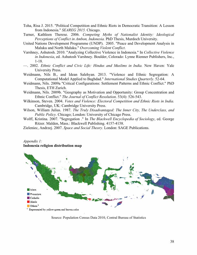
38
Toha, Risa J. 2015. "Political Competition and Ethnic Riots in Democratic Transition: A Lesson from Indonesia." SEAREG 2015. Chicago.
Turner, Kathleen Therese. 2006. Competing Myths of Nationalist Identity: Ideological Perceptions of Conflict in Ambon, Indonesia. PhD Thesis, Murdoch University.
United Nations Development Programme (UNDP). 2005. "Peace and Development Analysis in Maluku and North Maluku." Overcoming Violent Conflict.
Varshney, Ashutosh. 2010. "Analyzing Collective Violence in Indonesia." In Collective Violence in Indonesia, ed. Ashutosh Varshney. Boulder, Colorado: Lynne Rienner Publishers, Inc., 1-18.
—. 2002. Ethnic Conflict and Civic Life: Hindus and Muslims in India. New Haven: Yale University Press.
Weidmann, Nils B., and Idean Salehyan. 2013. "Violence and Ethnic Segregation: A Computational Model Applied to Baghdad." International Studies Quarterly. 52-64.
Weidmann, Nils. 2009a "Critical Configurations: Settlement Patterns and Ethnic Conflict." PhD Thesis, ETH Zurich.
Weidmann, Nils. 2009b. "Geography as Motivation and Opportunity: Group Concentration and Ethnic Conflict." The Journal of Conflict Resolution. 53(4): 526-543.
Wilkinson, Steven. 2004. Votes and Violence: Electoral Competition and Ethnic Riots in India. Cambridge, UK: Cambridge University Press.
Wilson, William Julius. 1987. The Truly Disadvantaged: The Inner City, The Underclass, and Public Policy. Chicago; London: University of Chicago Press.
Wolff, Kristina. 2007. "Segregation ." In The Blackwell Encyclopedia of Sociology, ed. George Ritzer. Malden, Mass.: Blackwell Publishing. 4157-4158.
Zieleniec, Andrzej. 2007. Space and Social Theory. London: SAGE Publications.
Appendix 1: Indonesia religion distribution map
Source: Population Census Data 2010, Central Bureau of Statistics