economic development opportunities - stratford, wisconsin18855c34-66c7-4aec-8532... · the village...
TRANSCRIPT
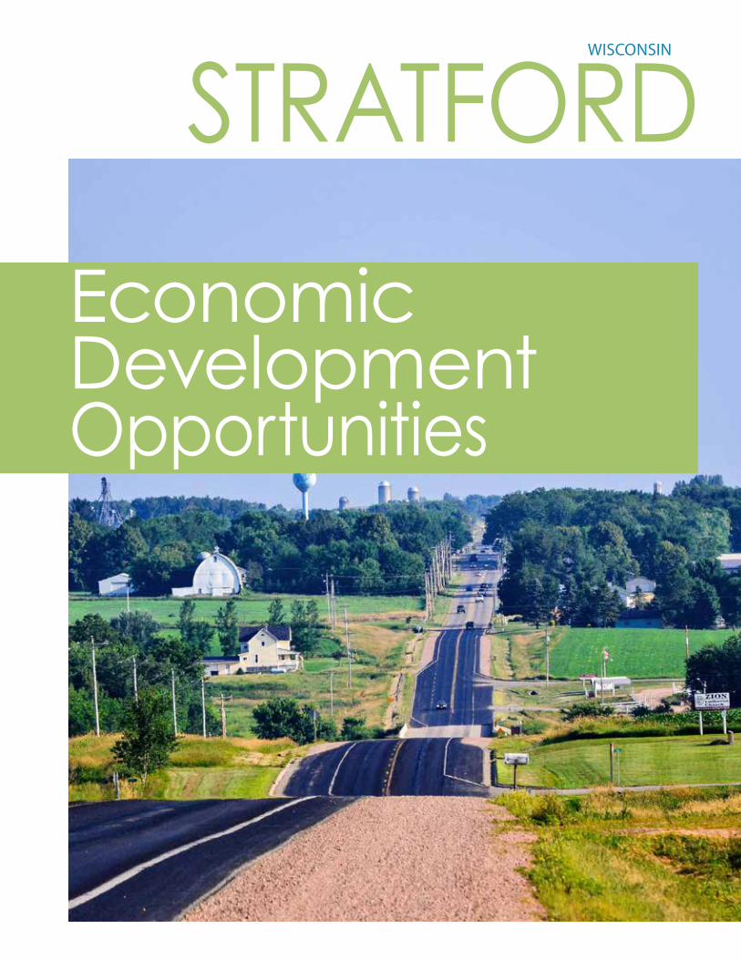
STRATFORDWISCONSIN
Economic DevelopmentOpportunities
2
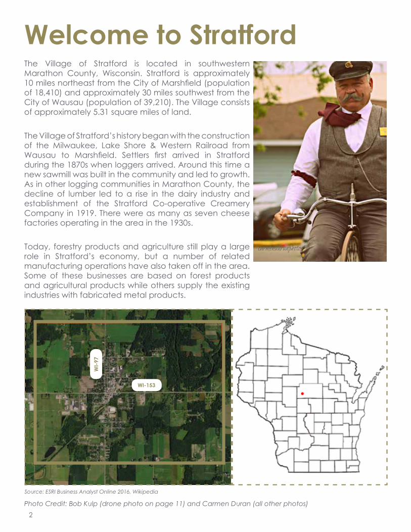
Welcome to StratfordThe Village of Stratford is located in southwestern Marathon County, Wisconsin. Stratford is approximately 10 miles northeast from the City of Marshfield (population of 18,410) and approximately 30 miles southwest from the City of Wausau (population of 39,210). The Village consists of approximately 5.31 square miles of land.
The Village of Stratford’s history began with the construction of the Milwaukee, Lake Shore & Western Railroad from Wausau to Marshfield. Settlers first arrived in Stratford during the 1870s when loggers arrived. Around this time a new sawmill was built in the community and led to growth. As in other logging communities in Marathon County, the decline of lumber led to a rise in the dairy industry and establishment of the Stratford Co-operative Creamery Company in 1919. There were as many as seven cheese factories operating in the area in the 1930s.
Today, forestry products and agriculture still play a large role in Stratford’s economy, but a number of related manufacturing operations have also taken off in the area. Some of these businesses are based on forest products and agricultural products while others supply the existing industries with fabricated metal products.
Photo Credit: Bob Kulp (drone photo on page 11) and Carmen Duran (all other photos)
Source: ESRI Business Analyst Online 2016, Wikipedia
Village of Stratford
Source: ©2015 Esri.
February 23, 2017
©2016 Esri Page 1 of 1
WI-153
WI-9
7
3
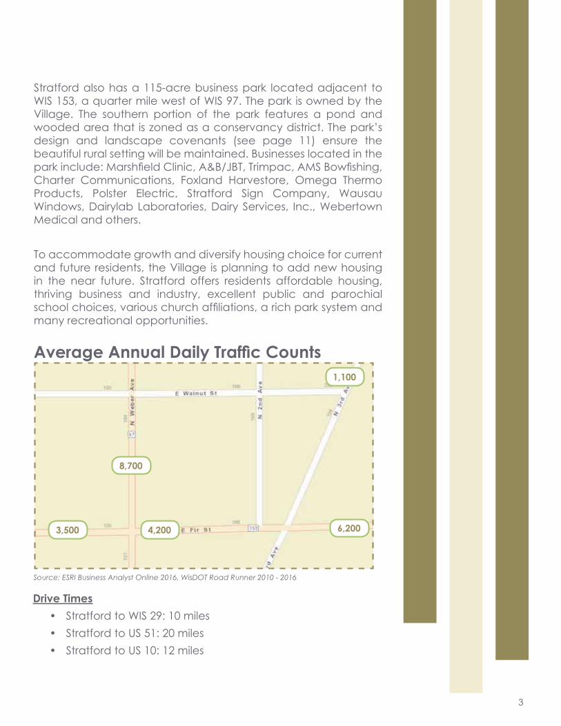
Average Annual Daily Traffic Counts
Stratford also has a 115-acre business park located adjacent to WIS 153, a quarter mile west of WIS 97. The park is owned by the Village. The southern portion of the park features a pond and wooded area that is zoned as a conservancy district. The park’s design and landscape covenants (see page 11) ensure the beautiful rural setting will be maintained. Businesses located in the park include: Marshfield Clinic, A&B/JBT, Trimpac, AMS Bowfishing, Charter Communications, Foxland Harvestore, Omega Thermo Products, Polster Electric, Stratford Sign Company, Wausau Windows, Dairylab Laboratories, Dairy Services, Inc., Webertown Medical and others.
To accommodate growth and diversify housing choice for current and future residents, the Village is planning to add new housing in the near future. Stratford offers residents affordable housing, thriving business and industry, excellent public and parochial school choices, various church affiliations, a rich park system and many recreational opportunities.
Source: ESRI Business Analyst Online 2016, WisDOT Road Runner 2010 - 2016
Custom Map
Source: ©2015 Esri.
April 04, 2017
©2016 Esri Page 1 of 1
3,500 4,200 6,200
1,100
8,700
Drive Times• Stratford to WIS 29: 10 miles• Stratford to US 51: 20 miles• Stratford to US 10: 12 miles
4
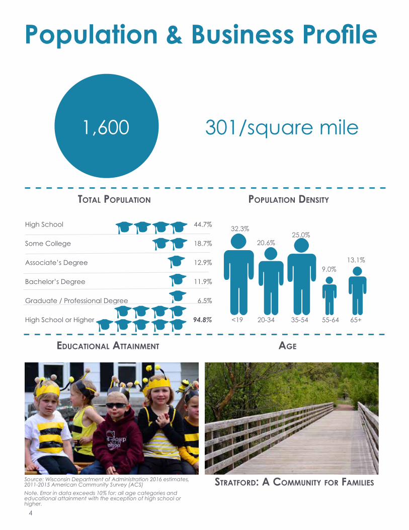
Population & Business Profile
Age
Source: Wisconsin Department of Administration 2016 estimates, 2011-2015 American Community Survey (ACS)Note. Error in data exceeds 10% for: all age categories and educational attainment with the exception of high school or higher.
ToTAl PoPulATion
1,600
32.3%
<19 20-34 35-54 55-64 65+
20.6%25.0%
9.0%13.1%
PoPulATion DensiTy
301/square mile
eDucATionAl ATTAinmenT
sTrATforD: A communiTy for fAmilies
High School 44.7%
Some College 18.7%
Associate’s Degree 12.9%
Bachelor’s Degree 11.9%
Graduate / Professional Degree 6.5%
High School or Higher 94.8%
5
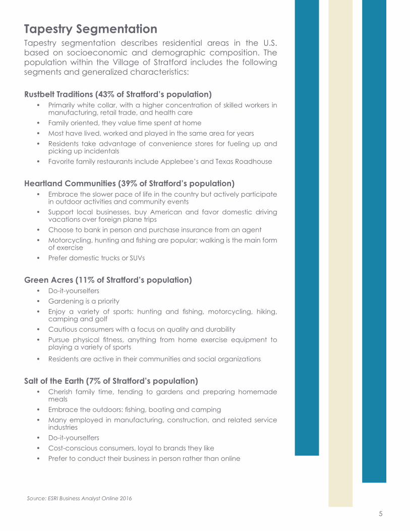
Tapestry SegmentationTapestry segmentation describes residential areas in the U.S. based on socioeconomic and demographic composition. The population within the Village of Stratford includes the following segments and generalized characteristics:
Rustbelt Traditions (43% of Stratford’s population)• Primarily white collar, with a higher concentration of skilled workers in
manufacturing, retail trade, and health care• Family oriented, they value time spent at home• Most have lived, worked and played in the same area for years• Residents take advantage of convenience stores for fueling up and
picking up incidentals• Favorite family restaurants include Applebee’s and Texas Roadhouse
Heartland Communities (39% of Stratford’s population)• Embrace the slower pace of life in the country but actively participate
in outdoor activities and community events• Support local businesses, buy American and favor domestic driving
vacations over foreign plane trips• Choose to bank in person and purchase insurance from an agent• Motorcycling, hunting and fishing are popular; walking is the main form
of exercise• Prefer domestic trucks or SUVs
Green Acres (11% of Stratford’s population)• Do-it-yourselfers • Gardening is a priority• Enjoy a variety of sports: hunting and fishing, motorcycling, hiking,
camping and golf• Cautious consumers with a focus on quality and durability• Pursue physical fitness, anything from home exercise equipment to
playing a variety of sports
• Residents are active in their communities and social organizations
Salt of the Earth (7% of Stratford’s population)• Cherish family time, tending to gardens and preparing homemade
meals• Embrace the outdoors: fishing, boating and camping• Many employed in manufacturing, construction, and related service
industries• Do-it-yourselfers• Cost-conscious consumers, loyal to brands they like• Prefer to conduct their business in person rather than online
Source: ESRI Business Analyst Online 2016

6
Business TypeNumber ofBusinesses
Service - Construction 8
Food & Beverage 7
Service - Health 7
Service - Other 7
Public Service 6
Beauty & Grooming 5
Manufacturing 5
Service - Financial 5
Church 4
Education 4
Service - Communication 4
Civic/Social Organization 3
Retail - Auto 3
Retail - Gas/Convenience 3
Retail - Other 3
Service - Auto 3
Recreation 2
Retail - Agriculture 2
Retail - Outdoor Recreation 2
Service - Business 2
Service - Insurance 2
Service - Legal 2
Service - Storage 2
Service - Vet 2
Assisted Living 1
Cooperative 1
Lab - Agriculture 1
Businesses in Stratford
Note. Services with one business are included in “other services” and retail stores with one business are included in “other retail”.
There are
96 businesses in Stratford

7
Housing Summary & Retail Market Analysis
meDiAn closing Price meDiAn Home VAlue
$126,900
69% Owner Occupied
4% Vacant
27% Renter Occupied
occuPAncy
Source: 2011-2015 ACS, Realtor.com
Note. Error in data exceeds 10% for: renter and vacant occupancies, average household income, and median rent. Median closing price is based on all properties listed for sale, including land and multi-family units.
Housing DensiTy
134/square mile
meDiAn renT
$545
$123,000
Total = 680Avg. Size = 2.54
HouseHolDs
8
STRATFORD
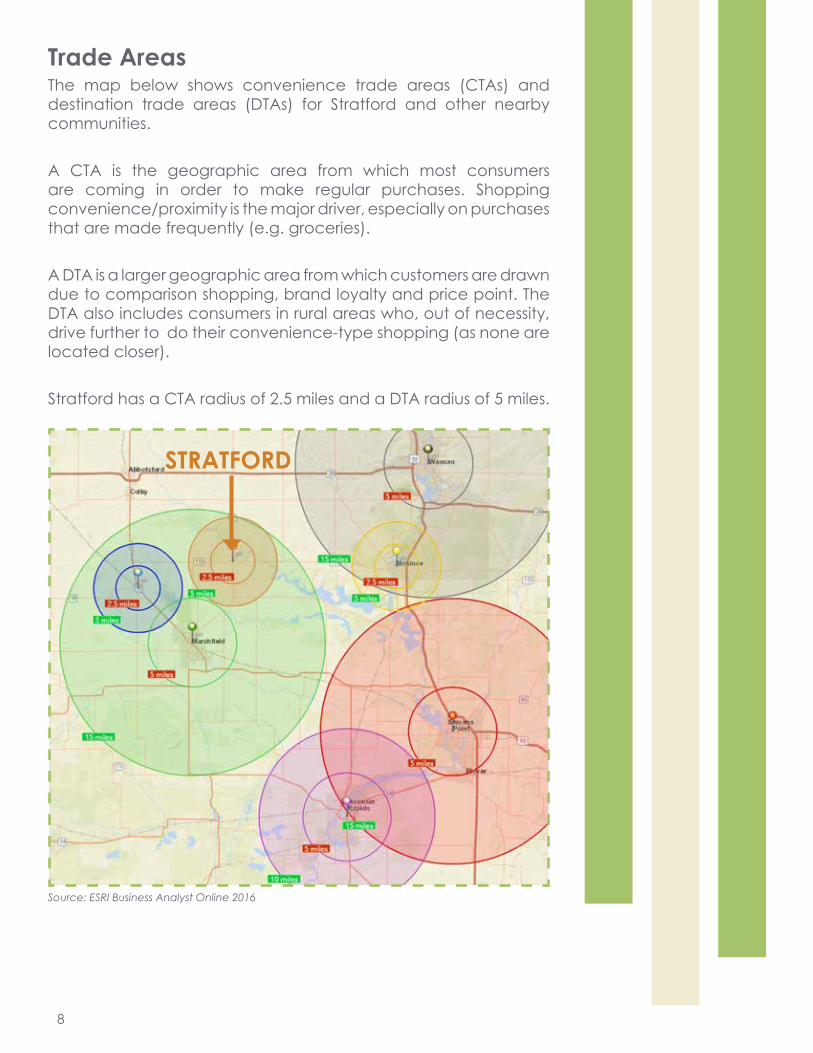
Trade AreasThe map below shows convenience trade areas (CTAs) and destination trade areas (DTAs) for Stratford and other nearby communities.
A CTA is the geographic area from which most consumers are coming in order to make regular purchases. Shopping convenience/proximity is the major driver, especially on purchases that are made frequently (e.g. groceries).
A DTA is a larger geographic area from which customers are drawn due to comparison shopping, brand loyalty and price point. The DTA also includes consumers in rural areas who, out of necessity, drive further to do their convenience-type shopping (as none are located closer).
Stratford has a CTA radius of 2.5 miles and a DTA radius of 5 miles.
Source: ESRI Business Analyst Online 2016
9
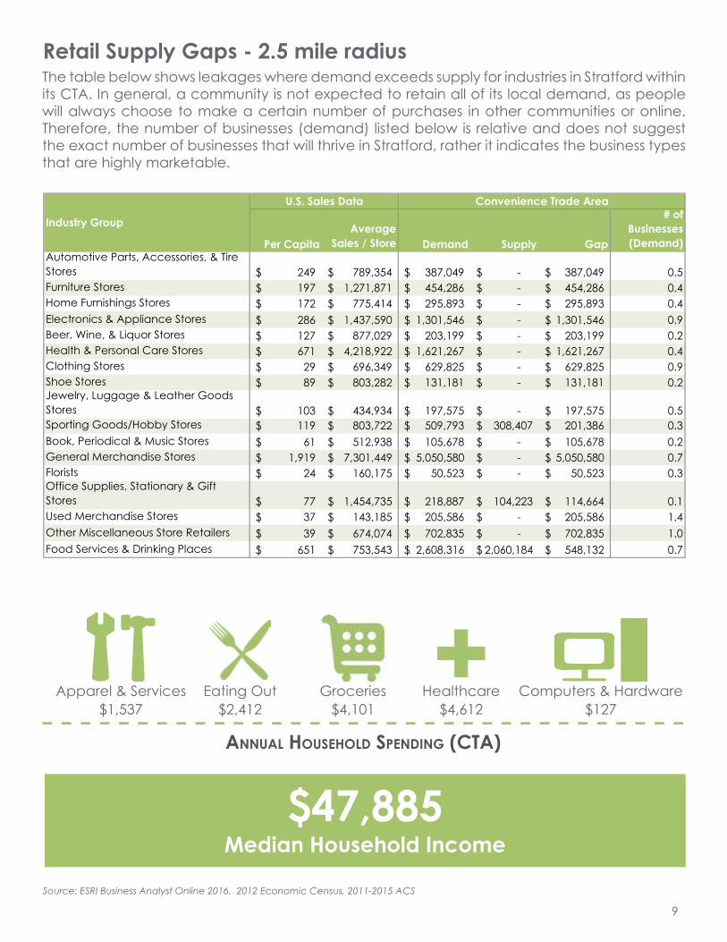
$47,885 Median Household Income
Retail Supply Gaps - 2.5 mile radius
Per CapitaAverage
Sales / Store Demand Supply Gap
# ofBusinesses(Demand)
Automotive Parts, Accessories, & Tire Stores 249$ 789,354$ 387,049$ -$ 387,049$ 0.5Furniture Stores 197$ 1,271,871$ 454,286$ -$ 454,286$ 0.4Home Furnishings Stores 172$ 775,414$ 295,893$ -$ 295,893$ 0.4Electronics & Appliance Stores 286$ 1,437,590$ 1,301,546$ -$ 1,301,546$ 0.9Beer, Wine, & Liquor Stores 127$ 877,029$ 203,199$ -$ 203,199$ 0.2Health & Personal Care Stores 671$ 4,218,922$ 1,621,267$ -$ 1,621,267$ 0.4Clothing Stores 29$ 696,349$ 629,825$ -$ 629,825$ 0.9Shoe Stores 89$ 803,282$ 131,181$ -$ 131,181$ 0.2Jewelry, Luggage & Leather Goods Stores 103$ 434,934$ 197,575$ -$ 197,575$ 0.5Sporting Goods/Hobby Stores 119$ 803,722$ 509,793$ 308,407$ 201,386$ 0.3Book, Periodical & Music Stores 61$ 512,938$ 105,678$ -$ 105,678$ 0.2General Merchandise Stores 1,919$ 7,301,449$ 5,050,580$ -$ 5,050,580$ 0.7Florists 24$ 160,175$ 50,523$ -$ 50,523$ 0.3Office Supplies, Stationary & Gift Stores 77$ 1,454,735$ 218,887$ 104,223$ 114,664$ 0.1Used Merchandise Stores 37$ 143,185$ 205,586$ -$ 205,586$ 1.4Other Miscellaneous Store Retailers 39$ 674,074$ 702,835$ -$ 702,835$ 1.0Food Services & Drinking Places 651$ 753,543$ 2,608,316$ 2,060,184$ 548,132$ 0.7
U.S. Sales Data
Industry Group
Convenience Trade Area
AnnuAl HouseHolD sPenDing (cTA)
Computers & Hardware$127
Healthcare$4,612
Eating Out$2,412
Groceries$4,101
Apparel & Services$1,537
Source: ESRI Business Analyst Online 2016, 2012 Economic Census, 2011-2015 ACS
+
The table below shows leakages where demand exceeds supply for industries in Stratford within its CTA. In general, a community is not expected to retain all of its local demand, as people will always choose to make a certain number of purchases in other communities or online. Therefore, the number of businesses (demand) listed below is relative and does not suggest the exact number of businesses that will thrive in Stratford, rather it indicates the business types that are highly marketable.
10
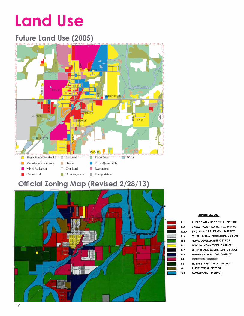
Land UseFuture Land Use (2005)
Official Zoning Map (Revised 2/28/13)
PINE LN FUR FOOD RD
BASTMAN RD
BALSAM RD
153
DRAK
E AV
KARE
N LN
RD
N WEB
ER AV
S WEB
ER AV
EAST
AV
E NORTH ST
WEBE
RTOW
N AV
PARKVIEW DR
W ELM ST
E LARCH ST
CARDINAL LN
STUR
M RD
INDY LNLE
ISURE
LN
N 3RD
AV
E HEMLOCK ST
SOUTH ST
STEV
EN ST
FIELDCREST DR
E STATE HIGHWAY 153
S WISC
ONSIN
AV
S
STRATFORD
Figure 3-1Future Land Use
STRATFORDMap Developed by Marathon County CPZ & GIS 2005Indicates other Municipality
Single Family Residential
Multi-Family Residential
Mixed Residential
Commercial
Industrial
Barren
Crop Land
Other Agriculture
Forest Land
Public/Quasi-Public
Recreational
Transportation
Water
PINE LN FUR FOOD RD
BASTMAN RD
BALSAM RD
153
DRAK
E AV
KARE
N LN
RD
N WEB
ER AV
S WEB
ER AV
EAST
AV
E NORTH ST
WEBE
RTOW
N AV
PARKVIEW DR
W ELM ST
E LARCH ST
CARDINAL LN
STUR
M RD
INDY LN
LEISU
RE LN
N 3RD
AV
E HEMLOCK ST
SOUTH ST
STEV
EN ST
FIELDCREST DR
E STATE HIGHWAY 153
S WISC
ONSIN
AV
S
STRATFORD
Figure 3-1Future Land Use
STRATFORDMap Developed by Marathon County CPZ & GIS 2005Indicates other Municipality
Single Family Residential
Multi-Family Residential
Mixed Residential
Commercial
Industrial
Barren
Crop Land
Other Agriculture
Forest Land
Public/Quasi-Public
Recreational
Transportation
Water
11
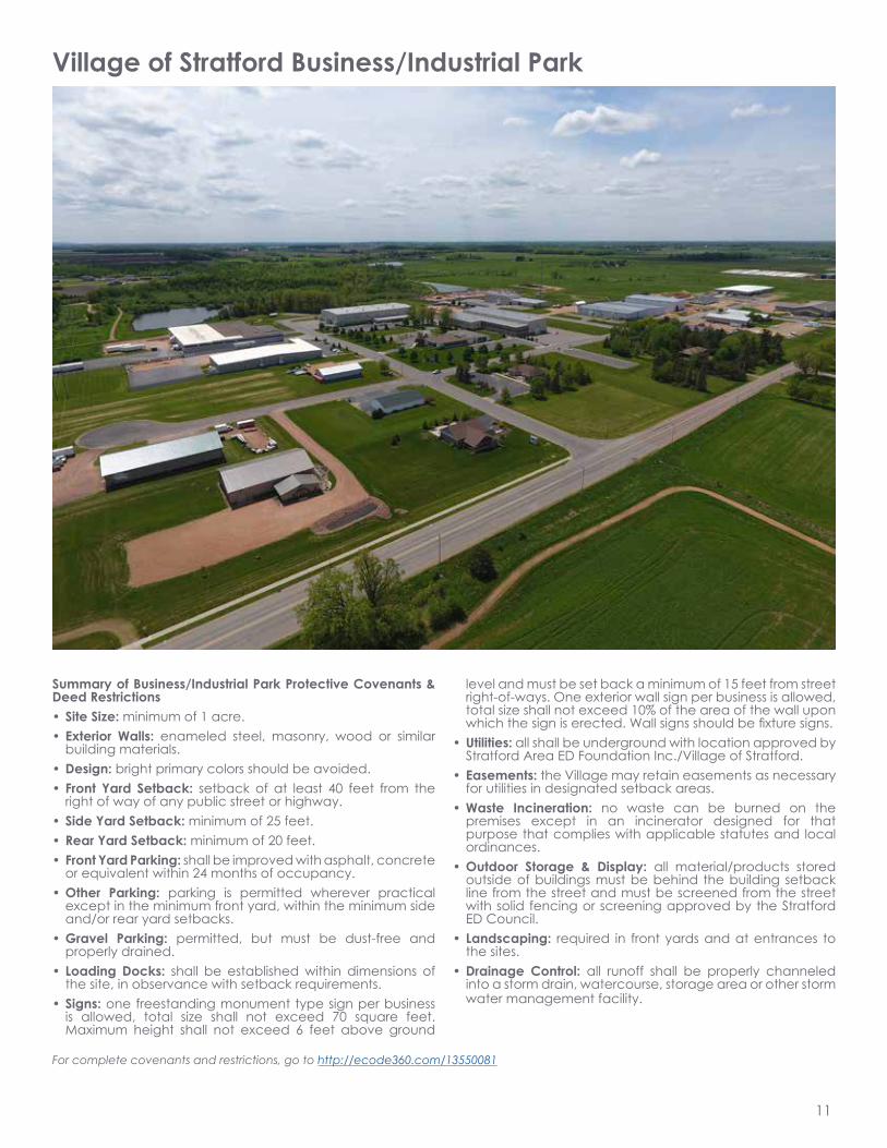
Village of Stratford Business/Industrial Park
Summary of Business/Industrial Park Protective Covenants & Deed Restrictions• Site Size: minimum of 1 acre.• Exterior Walls: enameled steel, masonry, wood or similar
building materials. • Design: bright primary colors should be avoided.• Front Yard Setback: setback of at least 40 feet from the
right of way of any public street or highway.• Side Yard Setback: minimum of 25 feet.• Rear Yard Setback: minimum of 20 feet.• Front Yard Parking: shall be improved with asphalt, concrete
or equivalent within 24 months of occupancy.• Other Parking: parking is permitted wherever practical
except in the minimum front yard, within the minimum side and/or rear yard setbacks.
• Gravel Parking: permitted, but must be dust-free and properly drained.
• Loading Docks: shall be established within dimensions of the site, in observance with setback requirements.
• Signs: one freestanding monument type sign per business is allowed, total size shall not exceed 70 square feet. Maximum height shall not exceed 6 feet above ground
level and must be set back a minimum of 15 feet from street right-of-ways. One exterior wall sign per business is allowed, total size shall not exceed 10% of the area of the wall upon which the sign is erected. Wall signs should be fixture signs.
• Utilities: all shall be underground with location approved by Stratford Area ED Foundation Inc./Village of Stratford.
• Easements: the Village may retain easements as necessary for utilities in designated setback areas.
• Waste Incineration: no waste can be burned on the premises except in an incinerator designed for that purpose that complies with applicable statutes and local ordinances.
• Outdoor Storage & Display: all material/products stored outside of buildings must be behind the building setback line from the street and must be screened from the street with solid fencing or screening approved by the Stratford ED Council.
• Landscaping: required in front yards and at entrances to the sites.
• Drainage Control: all runoff shall be properly channeled into a storm drain, watercourse, storage area or other storm water management facility.
For complete covenants and restrictions, go to http://ecode360.com/13550081
12
State Highway 153
Sta
te H
ighw
ay 9
7
Web
erto
wn
Ave
E North St
Sta
inle
ss A
venu
e
E Larch St
Source: Esri, DigitalGlobe, GeoEye, EarthstarGeographics, CNES/Airbus DS, USDA, USGS, AEX,Getmapping, Aerogrid, IGN, IGP, swisstopo, and theGIS User Community
Legend
Commercial/Industrial Parcel, Vacant
Parcel
0 0.25 0.50.125 Miles
¯P:\18400s\18440s\18440\18440000\GIS\18440000_ComInd_Vacant.mxd
2
3
8
5
10
14
4
1
6 12
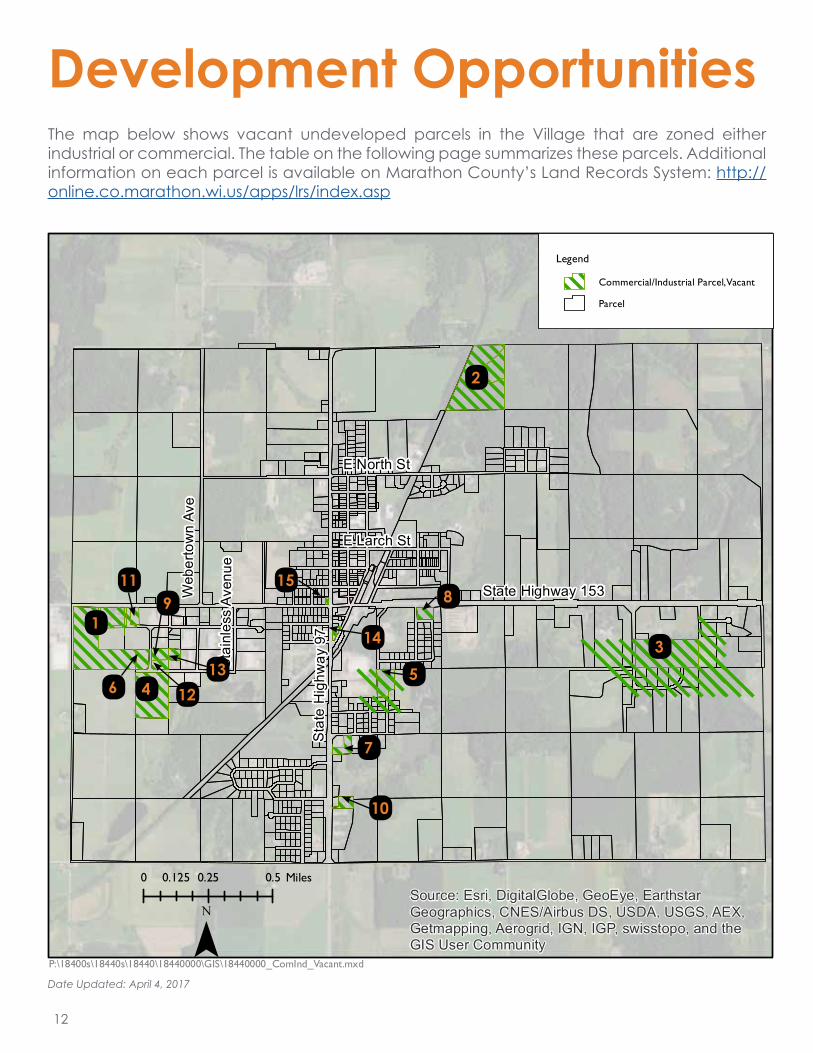
Development OpportunitiesThe map below shows vacant undeveloped parcels in the Village that are zoned either industrial or commercial. The table on the following page summarizes these parcels. Additional information on each parcel is available on Marathon County’s Land Records System: http://online.co.marathon.wi.us/apps/lrs/index.asp
15
Date Updated: April 4, 2017
11
7
13
9
13
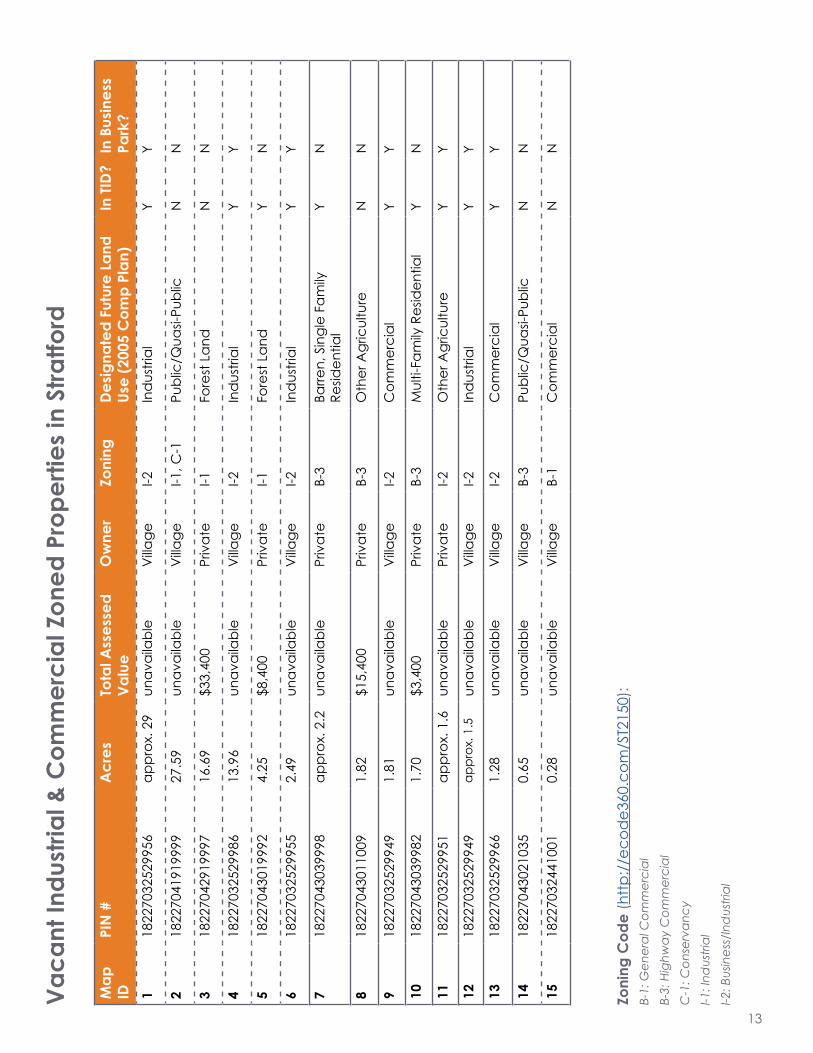
Map
ID
PIN
#A
cres
Tota
l Ass
esse
d Va
lue
Ow
ner
Zoni
ngDe
signa
ted
Futu
re L
and
Use
(200
5 C
omp
Plan
)In
TID?
In B
usin
ess
Park
?1
1822
7032
5299
56ap
prox
. 29
unav
aila
ble
Villa
geI-2
Ind
ustri
alY
Y
218
2270
4191
9999
27.5
9un
avai
labl
eV
illage
I-1, C
-1Pu
blic
/Qua
si-Pu
blic
NN
318
2270
4291
9997
16.6
9$3
3,40
0Pr
ivat
eI-1
Fore
st L
and
NN
418
2270
3252
9986
13.9
6un
avai
labl
eV
illage
I-2In
dus
trial
YY
518
2270
4301
9992
4.25
$8,4
00Pr
ivat
eI-1
Fore
st L
and
YN
618
2270
3252
9955
2.49
unav
aila
ble
Villa
geI-2
Ind
ustri
alY
Y
718
2270
4303
9998
appr
ox. 2
.2un
avai
labl
ePr
ivat
eB-
3Ba
rren,
Sin
gle
Fam
ily
Resid
entia
lY
N
818
2270
4301
1009
1.82
$15,
400
Priv
ate
B-3
Oth
er A
gric
ultu
reN
N
918
2270
3252
9949
1.81
unav
aila
ble
Villa
geI-2
Com
mer
cial
YY
1018
2270
4303
9982
1.70
$3,4
00Pr
ivat
eB-
3M
ulti-
Fam
ily R
esid
entia
lY
N
1118
2270
3252
9951
appr
ox. 1
.6un
avai
labl
ePr
ivat
eI-2
Oth
er A
gric
ultu
reY
Y
1218
2270
3252
9949
appr
ox. 1
.5un
avai
labl
eV
illage
I-2In
dus
trial
YY
1318
2270
3252
9966
1.28
unav
aila
ble
Villa
geI-2
Com
mer
cial
YY
1418
2270
4302
1035
0.65
unav
aila
ble
Villa
geB-
3Pu
blic
/Qua
si-Pu
blic
NN
1518
2270
3244
1001
0.28
unav
aila
ble
Villa
geB-
1C
omm
erci
alN
N
Zoni
ng C
ode
(http
://e
cod
e360
.com
/ST2
150)
:B-
1: G
ener
al C
omm
erci
alB-
3: H
ighw
ay C
omm
erci
alC
-1: C
onse
rvan
cyI-1
: Ind
ustri
alI-2
: Bus
ines
s/In
dus
trial
Vaca
nt In
dust
rial &
Com
mer
cial
Zon
ed P
rope
rties
in S
tratfo
rd

14
Tax Increment Financing (TIF)/Tax Increment District (TID)*
TIF is a tool that builds the local tax base. It allows the Village to borrow money to build infrastructure or assist development projects, and then pay off those loans with the new tax revenue.
The Village currently has two active TIDs. Stratford’s TIDs have created nearly $10 million in value increment since they were created. The TIDs include a sizable portion of the Business/Industrial Park, along with areas open for residential development to accommodate a growing workforce.
!(83
!(79
!(94
!(33 !(34
!(4
!(2
!(78
!(31
!(108
!(32
!(7
!(11
!(1
!(96
!(17
!(3
!(80
!(16!(92
!(90!(89
!(91
!(105
!(106
!(28
!(20
!(13
!(5
!(69
!(95
!(84
!(74
!(104
!(27
!(30
!(93
!(71
!(21
!(107
!(6
!(18!(14
!(22
!(86!(85 !(87
!(10
!(15
!(81
!(9
!(23
!(101
!(75!(73
!(82
!(24
!(29!(19
!(102
!(12
!(76!(77
!(100
!(103
!(99
!(8
!(35
!(88
!(26
!(97
!(98
!(25
DR
AKE
AV
S W
EBER
AV
N W
EBE
R A
V
N 3
RD
AV
W BALSAM ST
N 2
ND
AV
E NORTH ST
PINE LN
WE
BER
TOW
N A
V
W FIR ST E FIR ST E STATE HIGHWAY 153
E BALSAM RD
W NORTH ST
E LARCH ST
SOUTH ST
BALSAM RD
STU
RM
RD
FUR FOOD RD
S4TH
AV
EAS
T AV
INDY LN
S 5T
H A
VW MEADOW ST
E ELM ST
N 5
TH A
V
STEV
EN S
T
W STATE HIGHWAY 153
KANN ST
E HEMLOCK ST
E OAK ST
S3RD
AV
E WALNUT ST
CARDINAL LN
SUN
SET
AV
FIELD CREST DR
NORTH LIMIT RD
E MYRTLE ST
W ELM ST
W WALNUT ST
JONATHAN DR
MAP
LE R
IDG
E D
RN
6TH
AV
BAS
TMA
N R
D
E ELM ST
BALSAM RD E BALSAM RD
W MEADOW ST
I
Village of Stratford, WI
TID #4
0 700 1,400 2,100350Feet
TID #4 Boundary BufferProject # 589027SRK December 7th, 2015G:\projects\580s\589\589027\GIS
Half MileBuffer Map
LegendTID #4 Boundary
Half Mile Buffer
Street ROW
Water
TID #4 Parcels
TID #3 Overlap
Stratford Village Boundary
Parcel Boundaries
M a p N u m b e r P a rc e l N u m b e r1 182270324299962 182270324299993 182270324399934 182270324399995 182270324499586 182270324499597 182270324499618 182270324499619 18227032449990
10 1822703250999811 1822703251994312 1822703251994713 1822703251994814 1822703251994915 1822703251995116 1822703251995617 1822703251997818 1822703251998819 1822703252996220 1822703252996321 1822703252996422 1822703252996623 1822703252996824 1822703252996925 1822703252997126 1822703252997227 1822703252998528 1822703252998629 1822703252999030 1822703252999231 1822703252999532 1822703252999633 1822703253999834 1822703253999935 1822703253999936 1822703254105637 1822703254105738 1822703254105839 1822703254105940 1822703254106041 1822703254106142 1822703254106243 1822703254106344 1822703254106445 1822703254107046 1822703254107247 1822703254107348 1822703254107449 1822703254108550 1822703254108651 1822703254108752 1822703254108853 1822703254108954 1822703254109055 1822703254109156 1822703254109257 1822703254109358 1822703254109459 1822703254109560 1822703254109761 1822703254109862 1822703254109963 1822703254110064 1822703254110165 1822703254110266 1822703254110467 1822703254110968 1822703254111069 1822703254996970 1822703254997771 1822703254998772 1822703254999573 1822704191104174 1822704191104275 1822704191998476 1822704191998577 1822704191998678 1822704191998879 1822704191999880 1822704192999981 1822704193998382 1822704193999283 1822704194997484 1822704194998985 1822704202996186 1822704202996287 1822704202996988 1822704202997289 1822704203998990 1822704203999091 1822704203999192 1822704301999193 1822704301999294 1822704301999595 1822704301999896 1822704301999997 1822704302104098 1822704302104399 18227043021051
100 18227043029972101 18227043029976102 18227043029978103 18227043029993104 18227043039981105 18227043039983106 18227043039996107 18227043039998108 18227043049992109 18227032549972
!(72
!(46
!(70!(45
!(47
!(68 !(67
!(63
!(109
!(51
!(64
!(44
!(50!(49
!(48
!(43 !(42
!(52
!(62
!(65!(53
!(41
!(56
!(57
!(37!(38!(39!(40
!(61!(60
!(58
!(36
!(55!(54
!(59!(66 S W
EBER
AV
FIELDCREST DR
Development Incentives
*Note: The development incentive the Village currently offers is TIF. However the Village is open to exploring other incentives with potential businesses.
15
Marathon County Economic Development Corporation (MCDEVCO) Revolving Loan FundThe County provides low cost financial assistance for new and established businesses in Marathon County (http://mcdevco.org/business-resources).
Central Wisconsin Economic Development Fund (CWED)This loan fund is intended to fill financing gaps in local markets and stimulate private sector development. The CWED Loan Fund provides direct loans to businesses and works in partnership with other lending institutions (http://cwedfund.com/).
Regional Revolving Loan Fund (RRLF) and Community Development Loan Fund These funds provide gap financing to area businesses. Typically, RRLF money is long-term, has low down payments, and carries lower interest rates than traditional private financing (http://www.ncwrpc.org/ncwdc/index.html).
Wisconsin Economic Development Corporation (WEDC)WEDC offers loans, grants and tax credits for companies in Wisconsin (http://inwisconsin.com/select-wisconsin/incentives/).
• WEDC provides tax credits and exemptions on sales and property tax for qualifying manufacturing and agricultural businesses.• WEDC offers Business Development Tax Credits for businesses planning to move to and hire workers in Wisconsin based on the creation or retention of full-time jobs, depending upon the wage range and number of jobs created.
16
For Inquiries, please contact:
Allie Knoll, PresidentStratford Area Economic Development FoundationP.O. Box 12Stratford, WI 54484715-571-4781
For more information, please visit the Village’s website at
www.stratfordwi.com