ecology – survey methodology · this method statement presents the methodology of the...
TRANSCRIPT

Annex 9B
Ecology – Survey Methodology

Hong Kong Offshore LNG Terminal
Ecology Survey Method Statement
Rev 2
30 September 2016 Environmental Resources Management 16/F, Berkshire House 25 Westlands Road Quarry Bay, Hong Kong Telephone 2271 3000 Facsimile 2723 5660 www.erm.com

The business of sustainability
Hong Kong Offshore LNG Terminal Ecology Survey Method Statement
ERM Document Code: 0359722_Ecology Method Statement_Rev 2
Environmental Resources Management 16/F, Berkshire House 25 Westlands Road Quarry Bay Hong Kong Telephone: (852) 2271 3000 Facsimile: (852) 2723 5660 E-mail: [email protected] http://www.erm.com
Client: CLP Power Hong Kong Limited
Project No: 0359722
Summary: Date: 30 September 2016
This document presents the method statement for the ecological survey for the Hong Kong Offshore LNG Terminal Project
Approved by:
Dr Robin Kennish Project Director
2 Method Statement Var JN RK 30/09/16
1 Method Statement Var JN RK 09/09/16
0 Method Statement Var JN RK 22/07/16
Revision Description By Checked Approved Date
This report has been prepared by Environmental Resources Management the trading name of ‘ERM Hong-Kong, Limited’, with all reasonable skill, care and diligence within the terms of the Contract with the client, incorporating our General Terms and Conditions of Business and taking account of the resources devoted to it by agreement with the client. We disclaim any responsibility to the client and others in respect of any matters outside the scope of the above. This report is confidential to the client and we accept no responsibility of whatsoever nature to third parties to whom this report, or any part thereof, is made known. Any such party relies on the report at their own risk.
Distribution
Government
Public
Confidential

ENVIRONMENTAL RESOURCES MANAGEMENT CLP POWER HONG KONG LIMITED 0359722_ECOLOGY METHOD STATEMENT_REV 2.DOCX 30 SEPTEMBER 2016
1
1 INTRODUCTION
1.1 BACKGROUND
To support the increased use of natural gas in Hong Kong from 2020 onwards, CLP Power Hong Kong Limited (CLP) has identified that the development of an offshore liquefied natural gas (LNG) import facility in Hong Kong using Floating Storage and Regasification Unit (FSRU) technology (the ‘Hong Kong Offshore LNG Terminal Project’ or ‘the Project’) presents a viable additional gas supply option that can access competitive gas supplies from world markets. The Project will involve the construction and operation of an offshore FSRU LNG import facility to be located in the southern waters of Hong Kong, a double berth jetty, and subsea pipelines that connect to the gas receiving stations (GRS) at the Black Point Power Station (BPPS) and Lamma Island Power Station (LPS; owned and operated by Hong Kong Electric, HKE).
The Project requires an Environmental Permit from the Hong Kong SAR Government. In relation to this, CLP has prepared a Project Profile for application for an Environmental Impact Assessment (EIA) Study Brief, which was submitted to Environmental Protection Department (EPD) on 6 May 2016. The EIA Study Brief (No. ESB-292/2016) (hereafter referred to as “the Study Brief”) was issued by EPD on 15 June 2016.
Environmental Resources Management (ERM) was commissioned by CLP for the EIA Study for the proposed Project. In accordance with Clause 3.4.9 of the Study Brief, an ecological impact assessment shall be conducted to evaluate and assess potential impacts on terrestrial and marine ecology.
1.2 OBJECTIVE & SCOPE OF THIS METHOD STATEMENT
Ecological baseline information for the terrestrial and marine habitats within the Assessment Areas for ecological impact assessment, i.e. areas within 500 m distance from the boundary of the Project for terrestrial ecology, and areas with reference to the locations of the two proposed subsea pipelines and the offshore LNG terminal site within the Deep Bay Water Control Zone (WCZ), Southern WCZ, Second Southern Supplementary WCZ, North Western WCZ and North Western Supplementary WCZ for marine ecology in accordance with Clause 3.4.9.2 of the EIA Study Brief (Figure 1.1), is available from the following key sources:
ERM (2006) Liquefied Natural Gas (LNG) Receiving Terminal and Associated Facilities: EIA Study (EIA Report Registered No. AEIAR-106/2007);
ERM (2010) Black Point Gas Supply Project: EIA Study (EIA Report Registered No. AEIAR-150/2010);

ENVIRONMENTAL RESOURCES MANAGEMENT CLP POWER HONG KONG LIMITED 0359722_ECOLOGY METHOD STATEMENT_REV 2.DOCX 30 SEPTEMBER 2016
2
ERM (2010) Development of a 100MW Offshore Wind Farm in Hong Kong: EIA Study (EIA Report Registered No. AEIAR-152/2010);
AECOM (2011) Development of the Integrated Waste Management Facilities Phase 1: EIA Study (EIA Report Registered No. AEIAR- 163/2012);
Mott MacDonald (2014) Expansion of Hong Kong International Airport into a Three-Runway System: EIA Study (EIA Report Registered No. AEIAR-185/2014); and
ERM (2016) Additional Gas-fired Generation Units Project: EIA Study (EIA Report Registered No. AEIAR-197/2016).
Whilst some of the published baseline information was collated in 2009 and before, the following information on the terrestrial and marine habitats at the BPPS was collected in 2015 ( 1 ) and is considered to be up-to-date and representative of the existing conditions of the Assessment Areas around the proposed GRS (2) and submarine pipeline landfall at the BPPS:
Terrestrial habitat, vegetation and wildlife (i.e. terrestrial mammals, avifauna, herpetofauna, odonate and butterfly, and aquatic fauna) data; and
Marine intertidal, subtidal benthos and subtidal coral data.
Baseline survey is thus not considered necessary at the Assessment Areas at the BPPS.
In addition, the Assessment Area around the LPS GRS (3) for terrestrial ecology overlaps with the LPS site only which is industrial in nature and does not cover any natural terrestrial habitats. Baseline survey on terrestrial ecology is not considered necessary at this Assessment Area at the LPS.
The above data sources also provide up-to-date baseline information on important ecological habitats or habitats with conservation interest such as horseshoe crab breeding and nursery grounds, mangroves, etc. of the Assessment Area. Baseline survey of these habitats is not considered necessary.
Therefore, verification surveys at selected habitats within the Assessment Areas where potential impact could occur and up-to-date baseline information is not present are proposed to be conducted to update the latest ecological conditions in these areas.
(1) ERM (2016) Additional Gas-fired Generation Units Project: EIA Study (EIA Report Registered No. AEIAR-
197/2016)
(2) The proposed GRS will be located within the existing boundaries of the BPPS.
(3) The proposed GRS will be located on the extension site within the existing boundaries of the LPS.

ENVIRONMENTAL RESOURCES MANAGEMENT CLP POWER HONG KONG LIMITED 0359722_ECOLOGY METHOD STATEMENT_REV 2.DOCX 30 SEPTEMBER 2016
3
In accordance with the requirements in Appendix F of the Study Brief, ecological surveys shall be conducted to fill the identified data gaps as well as verify and update the desktop information on existing conditions of the Assessment Areas. Subsequently, the information collected from desktop review and ecological surveys will be used to establish the general ecological profile and characterize the identified habitats within the Assessment Areas. The proposed ecological surveys comprise:
Marine ecological surveys: intertidal survey, subtidal benthos survey, subtidal coral survey and marine mammal survey; and
Terrestrial avifauna surveys.
This Method Statement presents the methodology of the aforementioned marine and terrestrial ecological surveys. Reference has been made to the guidelines of ecological assessment in Annex 16 of EIAO-TM, the relevant Guidance Notes (GN 7/2010, GN 10/2010 and GN 11/2010), and approved EIA reports on the EIA Register.
It should be noted that the presence of species of conservation importance such as Green Turtles and Whale Sharks in the Assessment Area, if any, is likely to be opportunistic and hence is difficult to be studied by systematic dedicated field surveys. The existing uses of the Assessment Area by these species will be studied by a desktop review.
1.3 STRUCTURE OF THIS METHOD STATEMENT
Following this introductory section, the remainder of this Method Statement is presented as follows:
Section 2 presents the methodologies for the marine ecological surveys, including intertidal survey, subtidal benthos survey, subtidal coral survey and marine mammal survey; and
Section 3 presents the methodologies for the terrestrial avifauna surveys.

ENVIRONMENTAL RESOURCES MANAGEMENT CLP POWER HONG KONG LIMITED 0359722_ECOLOGY METHOD STATEMENT_REV 2.DOCX 30 SEPTEMBER 2016
4
2 MARINE ECOLOGICAL SURVEY
2.1 INTERTIDAL SURVEY
Intertidal surveys will be conducted as described below to characterize the existing ecological conditions of the intertidal assemblages within the Assessment Area at the artificial sloping seawall of the LPS, in particular the proposed location of the submarine pipeline landfall, and at the natural coastal areas of Yi O in West Lantau, Pak Chau at Northeast Lantau and Tau Lo Chau at Southeast Lantau, which represents the ecological sensitive sites and natural shores the closet to the pipeline alignments. The surveys are designed to provide an update of information collected from the Assessment Area in 2008/ 2009 (1) as well as to cover data gaps in the literature.
The intertidal surveys will consist of quantitative transect surveys and qualitative walk-through surveys at the accessible artificial seawall of the LPS and along the accessible shorelines of Yi O, Pak Chau and Tau Lo Chau. It should be noted that the LPS is an active facility with operating intakes and outfalls and survey at these areas will be avoided for safety reasons, and Pak Chau and Tau Lo Chau are offshore islands where site access may be limited by rough sea conditions and local topography. Access to the seawall under the direct footprint of potential marine works may also be limited, e.g. fenced off by barbed wire, and so accessible sloping seawalls of the LPS that share similar intertidal assemblages and profile have been selected for quantitative survey.
For quantitative transect survey, survey locations have been identified along the shoreline of LPS, Yi O, Pak Chau and Tau Lo Chau (Figures 2.1 to 2.4). At each survey location, one 50 – 100 m horizontal (belt) transects (actual length subject to the site conditions) will be surveyed at each of the three shore heights: 2 m, 1.5 m and 1 m above Chart Datum. These transects are located to cover the artificial intertidal habitats along the LPS seawall, intertidal rocky shores of Pak Chau and Tau Lo Chau, and intertidal soft-shores of Yi O. On each transect, five quadrats (50 cm x 50 cm) will be placed randomly in each transect to assess the abundance and distribution of flora and fauna. For transects located on soft shores of Yi O, all organisms found in the top 10 cm of the substrate within the quadrats will identified and recorded. All organisms found in each quadrat will be identified and recorded to species level so that density per quadrat could be determined. Sessile animals such as barnacles and oysters in each quadrat will not be counted but estimated as percentage cover on the rock surface. All species of algae (encrusting, foliose and filamentous) will also be identified and recorded by estimating the percentage cover on the rock surface. All organisms will be identified to the lowest possible taxonomic level (at least Genus level). Species encountered outside the quadrat but in the vicinity of survey transect will also be recorded.
(1) ERM (2010) Development of a 100MW Offshore Wind Farm in Hong Kong: EIA Study (EIA Report Registered No.
AEIAR-152/2010)

ENVIRONMENTAL RESOURCES MANAGEMENT CLP POWER HONG KONG LIMITED 0359722_ECOLOGY METHOD STATEMENT_REV 2.DOCX 30 SEPTEMBER 2016
5
For qualitative walk-through surveys, the accessible shoreline of LPS and along the accessible shorelines of Yi O, Pak Chau and Tau Lo Chau will be surveyed, and organisms encountered will be recorded and their relative abundance noted. In particular, active search of horseshoe crabs will be conducted at Yi O to confirm whether horseshoe crabs are present along at this site.
Intertidal surveys will be conducted once in the dry season and once in the wet season. Local tide tables will be used to determine tidal height at the site and times of surveys.
2.2 SUBTIDAL BENTHOS SURVEY
2.2.1 Survey Methodology
Subtidal soft bottom surveys will be conducted as described below to characterize the existing ecological conditions of the seabed where marine dredging works for the proposed double berth jetty and associated berthing pocket, manoeuvring area and marine access area, and the subsea pipelines are anticipated to be required. Sampling locations, equipment involved, sampling procedure, laboratory analytical procedures, and QA/QC requirements for the proposed surveys are detailed below.
Benthic sediment samples will be collected within and around the footprints for the proposed double berth jetty and associated berthing pocket, manoeuvring area and marine access area, and the subsea pipelines where practical for biological analyses (i.e. taxonomic identification and abundance of subtidal benthos). It should be noted that the BPPS and LPS are active facilities with operating intakes and outfalls and survey at these areas will be avoided for safety reasons. Access to the very nearshore areas of the BPPS and LPS is also constrained by water depth and other existing operations and so sampling locations representative of the broader area have been selected.
Seabed sediment samples will be collected from sixteen (16) sampling locations representative of the subtidal soft-bottom habitats. At each sampling location, two grab samples will be collected from each station (∑ = 16 stations x 2 grabs = 32). The number of sampling locations is considered sufficient given the scale of Project and the relatively homogeneous nature of sediments at the sites. The sampling locations are shown in Figure 2.5.
A modified Van Veen grab sampler (960 cm2 sampling area; 11,000 cm3 capacity) with a supporting frame attached to a swiveling hydraulic winch cable. Sediments for biological analysis will be sieved on board the survey vessel. The sediments will be washed into a sieve stack (comprising 1 mm2 and 500 µm2 meshes) and gently rinsed with seawater to remove all fine material. Following rinsing, any material remaining on the two screens will be combined and carefully rinsed using a minimal volume of seawater into pre-labelled thick triple-bagged ziplock plastic bags. A 5% solution of borax-buffered formalin containing Rose Bengal in seawater will then be added to

ENVIRONMENTAL RESOURCES MANAGEMENT CLP POWER HONG KONG LIMITED 0359722_ECOLOGY METHOD STATEMENT_REV 2.DOCX 30 SEPTEMBER 2016
6
the bag to ensure tissue preservation. Samples will be sealed in plastic containers for transfer to the taxonomy laboratory for sorting and identification.
Subtidal benthos surveys will be conducted once in the dry season and once in the wet season.
2.2.2 Parameters Measured
The parameters to be measured for subtidal benthos analysis are:
Total number of species (diversity)
Abundance of each species recorded (biomass)
In addition to the above parameters, other relevant data will also be measured and recorded, including time, weather conditions, sea conditions, special phenomena (if any), and other activities undertaken around the sampling area that may influence the sampling results.
2.2.3 Laboratory Analyses
The benthic laboratory will perform sample re-screening after the samples have been held in formalin for a minimum 24 hours to ensure adequate fixation of the organisms. Individual samples from the 500 µm2 and 1 mm2
mesh sieves will be gently rinsed with fresh water into a 250 µm2 sieve to remove the formalin from the sediments. Sieves will be partially filled while rinsing a specific sample to maximize washing efficiency and prevent loss of material. All material retained on the sieve will be placed in a labeled plastic jar, covered with 70% ethanol, and lightly agitated to ensure complete mixing of the alcohol with sediments. Original labels will be retained with the re-screened sample material.
Standard and accepted techniques will be used for sorting organisms from the sediments. Small fractions of a sample will be placed in a petri dish under a 10-power magnification dissecting microscope and scanned systematically with all animals and fragments removed using forceps. Each petri dish will be sorted at least twice to ensure removal of all animals. Organisms representing major taxonomic groups, such as Polychaeta, Arthropoda, Mollusca and miscellaneous taxa will be sorted into separate, labeled vials containing 70% ethanol.
Taxonomic identifications will be performed by qualified and experienced specialist using stereo dissecting and high-power compound microscopes. These are generally to the species level except for unidentified taxa, which will be identified to genera as far as practical. The careful sampling procedure employed minimizes fragmentation of organisms. If breakage of soft-bodied organisms occurred, only anterior portions of fragments will be counted, although all fragments will be retained and weighed for biomass determinations (wet weight).

ENVIRONMENTAL RESOURCES MANAGEMENT CLP POWER HONG KONG LIMITED 0359722_ECOLOGY METHOD STATEMENT_REV 2.DOCX 30 SEPTEMBER 2016
7
2.2.4 Quality Assurance & Control (QA/QC) Procedures
The sediment samples will be evaluated for acceptance based upon the degree of disturbance, penetration depth, and amount of leakage from the grab. In the following cases, a sediment sample would be rejected and another sample collected:
The sediment sampler doors open in recovery, causing possible surface washout.
Half sample obtained where the sediment sampler had not struck a flat area of seabed, or improper deployment of benthic grab, or half sample of sediment.
Disruption of the sample by heavy shaking or contamination (these can occur when a sample is badly handled or if the sediment sampler strikes the side of the vessel during operations).
The sample represents less than 30% of the sediment sampler’s total capacity (i.e. less than 15 cm penetration).
Grab deployment location deviates from the designated position (1).
Before sieving each sample on site, the grab, frame and sample containers will be washed with seawater to avoid cross contamination of samples.
Sample integrity for subtidal benthos analyses should be maintained for the duration of the survey, demobilization through to delivery to the appropriate laboratory. All samples should be accompanied with a Chain of Custody form to document sample management and delivery.
2.3 SUBTIDAL CORAL SURVEY
Subtidal coral surveys will be conducted as described below to characterize the existing ecological conditions of the subtidal hard bottom habitats of the LPS seawall where marine works are proposed, the marine dredging works where hard substrates (i.e. potential habitats for corals) are recorded, as well as at the subtidal hard bottom habitats of Yi O in West Lantau, Pak Chau at Northeast Lantau and Tau Lo Chau at Southeast Lantau, which represents the ecological sensitive sites and natural shores the closet to the pipeline alignments. The subtidal coral surveys, which will be conducted once in the dry season, comprise the following two components:
Qualitative spot dive reconnaissance check; and
Semi-quantitative Rapid Ecological Assessment (REA) survey.
(1) Concerns about positional errors must be weighed against the aims of the survey. Horizontal accuracies to
within a few metres are acceptable distance

ENVIRONMENTAL RESOURCES MANAGEMENT CLP POWER HONG KONG LIMITED 0359722_ECOLOGY METHOD STATEMENT_REV 2.DOCX 30 SEPTEMBER 2016
8
2.3.1 Qualitative Spot Dive Reconnaissance Check
The spot dive reconnaissance check will investigate if coral communities (hard and soft corals) are present at the areas of hard substrate, which include the artificial sloping seawall and seabed in close proximity of the proposed submarine pipeline landfall at the LPS, potentially isolated patches of hard substrate within the proposed marine dredging areas, and the subtidal habitats of Yi O, Pak Chau and Tau Lo Chau. At this stage survey locations have been identified along the seawall of the LPS and along the subtidal habitats of Yi O, Pak Chau and Tau Lo Chau to conduct the spot dive reconnaissance check (Figure 2.6 to 2.9). It should be noted that the LPS is an active facility with operating intakes and outfalls and survey at these areas will be avoided for safety reasons. The exact location(s) within the proposed marine dredging areas for coral survey will be confirmed when the subsea pipelines and double berth jetty construction methodology has been confirmed.
At each survey location, a spot dive reconnaissance check will be conducted along a 100 m transect by coral specialists (or commercial divers supervised by coral specialists) to confirm the substrate type and associated sessile benthos, particularly the presence of hard and soft coral communities. The characteristics of seabed and associated fauna along the survey transect will be recorded by photographs and videos to characterise the biological nature of the subtidal area along the survey transect. All organisms encountered will be identified to the lowest possible taxonomic level.
2.3.2 Semi-quantitative Rapid Ecological Assessment (REA) Survey
When corals are recorded during spot dive reconnaissance check, semi-quantitative survey, Rapid Ecological Assessment (REA), will then be undertaken with reference to the Guidance Notes (GN 11/2010) to provide information on the relative coverage of coral and other benthic groups as well as an inventory of sessile benthic taxa used to define the community types. This technique is now one of the standard practices for EIA marine baseline surveys in Hong Kong and has been modified from the standardised REA survey technique established for the assessment of coral communities on the Great Barrier Reef (1) for marine environment of Hong Kong (2).
REA survey will be performed along a 100 m transect based on the preliminary observations from spot dive reconnaissance check (i.e. area where corals appeared to be the most abundant, or in the close proximity of the proposed dredging area). As the survey locations may have varying water depths and the visibility in deeper water (> - 3 mPD) could be fairly low for survey, only one depth zone will be assessed at each of the REA survey
(1) DeVantier, L.M., G. De’Ath, T.J. Done and E. Turak 1998. Ecological assessment of a complex natural system: A case
study from the Great Barrier Reef. Ecological Applications 8: 480-496.
(2) Fabricius, K.E. and D. McCorry. 2006. Changes in octcoral communities and benthic cover along a water quality gradient
in reefs of Hong Kong. Marine Pollution Bulletin 52: 22-33.

ENVIRONMENTAL RESOURCES MANAGEMENT CLP POWER HONG KONG LIMITED 0359722_ECOLOGY METHOD STATEMENT_REV 2.DOCX 30 SEPTEMBER 2016
9
locations. The depth of transect will be adjusted based on the site condition and substrates.
After laying of the transect line, video footage will be taken for the benthos along the transect and the assessment of the benthic cover (Tier I) and taxon abundance (Tier II) will be conducted in a swathe ~ 2 m wide, 1 m either side of each transect. The belt transect width is dependent on underwater visibility experienced and for Hong Kong generally consists of a swathe ~2 m wide, 1 m either side of the each transect. An explanation of the two assessment categories (Tiers) used in the survey is presented below.
Tier I - Categorisation of Benthic Cover
Upon the completion of each survey transect, ecological and substratum attributes (Table 2.1) will be assigned to standard ranked (ordinal) categories (Table 2.2).
Table 2.1 Tier I Benthic Attribute Categories
Ecological Attributes Substratum Attributes
Hard coral Bedrock
Dead coral Continuous pavement
Octocoral (Soft corals and Gorgonians) Rocks (<26 cm)
Black coral Large boulders (>50 cm)
Dead standing coral Small boulders (<50 cm)
Macroalgae Rubble
Other Benthos (including sponges, zoanthids, ascidians and bryozoans)
Sand
Mud/ Silt
Other
Table 2.2 Tier I Ordinal Ranks of Percentage Cover of Benthic Attributes
Rank Percentage Cover (%)
0 None recorded
1 1-5
2 6-10
3 11-30
4 31-50
5 51-75
6 76-100
Tier II - Taxonomic Inventories to Define Types of Benthic Communities
An inventory of benthic taxa will be compiled for each transect. Taxa will be identified in situ to the following levels:
Scleractinian (hard) corals to species, where possible;

ENVIRONMENTAL RESOURCES MANAGEMENT CLP POWER HONG KONG LIMITED 0359722_ECOLOGY METHOD STATEMENT_REV 2.DOCX 30 SEPTEMBER 2016
10
Soft corals, anemones and conspicuous macroalgae to genus level where possible;
Other benthos (including sponges, zoanthids, ascidians and bryozoans) recorded to genus level, where possible, or phylum plus growth form.
Following the completion of the survey of each transect, each taxon in the inventory will be ranked in terms of abundance in the community (Table 2.3). These broad categories rank taxa in terms of relative abundance of individuals, rather than the contribution to benthic cover along each transect. The ranks are visual assessments of abundance, rather than quantitative counts of each taxon. Representative photos of organisms will be taken.
Table 2.3 Ordinal Ranks of Taxon Abundance
Rank Abundance
0 Absent
1 Sparse
2 Uncommon
3 Common
4 Abundant
5 Dominant
Photographs and videos for each REA transect will be reviewed to compile the REA data. Species lists, species richness and coverage for ecological and substratum attributes will be presented.
2.4 MARINE MAMMAL SURVEY
To better understand the occurrence, distribution and abundance of marine mammals especially Finless Porpoises (Neophocaena phocaenoides) and Chinese White Dolphins (Sousa chinensis) in the Assessment Area, in accordance with the requirements in Appendix F of the Study Brief, two types of marine mammal surveys are proposed:
Shipboard survey of 12 months to investigate their usage, especially in the area for the proposed offshore LNG terminal and along the subsea gas pipelines; and
Underwater passive acoustic monitoring (PAM) survey covering both day-time and night-time period and different seasons to collect data on the occurrence of marine mammals and their diel patterns.
2.4.1 Shipboard Survey
Vessel-based marine mammal survey by means of systematic line-transect boat survey will be undertaken to examine the distribution, abundance, encounter rate and density of Finless Porpoise and Chinese White Dolphin within the Assessment Area. The methodology of the proposed survey is

ENVIRONMENTAL RESOURCES MANAGEMENT CLP POWER HONG KONG LIMITED 0359722_ECOLOGY METHOD STATEMENT_REV 2.DOCX 30 SEPTEMBER 2016
11
consistent and compatible with that adopted in the long-term marine mammal monitoring programme conducted by AFCD since 1995 to allow potential comparisons and pooling data for analysis.
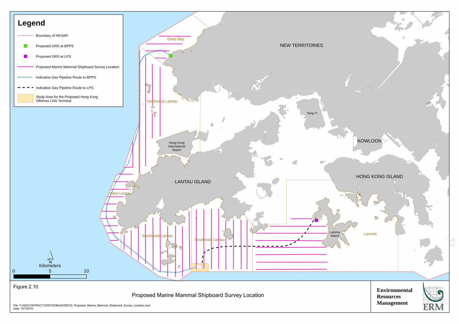
Line-transect boat survey technique for marine mammals has been standardised in Hong Kong waters so that data from all surveys are directly comparable. The survey areas will focus on the alignments of the two subsea pipelines and the offshore LNG terminal site, and the transect lines for the survey areas will cover those are used in the AFCD long term monitoring programme. The proposed survey transects in the six survey areas for line-transect boat surveys, namely Deep Bay, Northwest Lantau, West Lantau, Southwest Lantau, Southeast Lantau and Lamma, are presented in Figure 2.10.
The transect boat survey will be conducted from a 15 m inboard vessels (with an open upper deck above the pilothouse, providing a mostly unobstructed 180° view of the area ahead of the vessel), weather permitting (Beaufort 0-5, no heavy rain, and visibility > 1,200 m). The marine mammal observer (MMO) team will conduct searches and observations from the flying bridge area, 4-5 m eye height above the water surface. In order to ensure the quality of the data and allow consistency with the long-term AFCD database, and take consideration of the sea conditions of the monitoring site, a team of three qualified and trained MMOs will make up the survey team.
As the vessel transits the transect lines at a relatively constant speed of 13-15 km/hr, the primary MMO searches for marine mammals continuously through 7 X 50 marine binoculars. A second MMO searches with unaided eye and fills out data sheets. Both MMOs search ahead of the vessel, between 270° and 90° (in relation to the bow, which is defined as 0°). MMOs rotate positions approximately every 30 minutes. There will be an additional MMO on the boat, who rotate into position to give observers a rest after each hour of search effort, thereby minimizing fatigue.
Effort data collected during on-effort monitoring periods includes time and position for the start and end of search effort, vessel speed, sea state (Beaufort scale), visibility, and distance travelled in each series (a continuous period of search effort). When marine mammals are sighted, the MMO fills out a sighting sheet (Annex A), and generally the team is taken off-effort and the vessel is diverted from its course to approach the marine mammal group for group size estimation, behavioural observations, and collection of identification photos. The sighting sheet includes information on initial sighting angle and distance, position of initial sighting, sea state, group size and composition, and behaviour, such as response to the survey vessel and associations with vessels. Position, distance travelled, and vessel speed are obtained from a hand-held Global Positioning System (GPS) unit.
All records of marine mammal sightings will be collated, compiled and integrated with Geographic Information System (GIS). Positions of sightings together with group sizes, activities and calf occurrence will be plotted on figures for illustration of spatial and temporal patterns of dolphin and

ENVIRONMENTAL RESOURCES MANAGEMENT CLP POWER HONG KONG LIMITED 0359722_ECOLOGY METHOD STATEMENT_REV 2.DOCX 30 SEPTEMBER 2016
12
porpoise distribution, if any. For the analysis of Chinese White Dolphin data, information will be entered into established computer programmes (e.g. all recent versions of DISTANCE programme including version 5.0, ArcView© GIS programme), which provides distribution plots and estimates of density and abundance of dolphins in each of the survey areas. The method for line transect analysis of dolphin density, abundance and encounter rate will follow the established approach for AFCD long-term marine mammal monitoring (1). It should be noted that as Finless Porpoises are cryptic and difficult to identify as unique individuals with no useful natural markings, the potential of double counting cannot be eliminated and hence rendering any abundance or density estimation confounded with serious violation of assumption under the line-transect survey method; therefore such analysis is not proposed to be completed for Finless Porpoise, which is the same approach for the AFCD long-term marine mammal monitoring.
Shipboard marine mammal surveys are proposed to be conducted every month for 12 months, commencing in June 2016. Each transect line is proposed to be surveyed twice per month (i.e. about ten (10) survey days per month will be conducted).
2.4.2 Underwater PAM Survey
Underwater PAM survey is a tool for detecting the high frequency clicks of marine mammals as these are easily-distinguished from sounds of other marine animals. Recent developments include specific C-POD (Cetacean Porpoise Detector) devices that more accurately records vocalizations of porpoises plus all other echolocating toothed whales and dolphins. The deployment of such devices would allow the activity of Finless Porpoises and Chinese White Dolphins to be monitored both day and night over 24 hours in all weather conditions, and will provide information on the marine mammal baseline for the EIA study, especially considering the gap in the knowledge of night-time behaviour of Finless Porpoises and Chinese White Dolphins in the offshore LNG terminal study area.
The purpose of the underwater PAM survey is to supplement desktop and shipboard survey data and investigate and compare the relative importance of the offshore LNG terminal site to marine mammals with other areas with known marine mammal occurrences (2). Five C-PODs are proposed to be deployed on the seabed within and in the vicinity of the offshore LNG
(1) Samuel K.Y. Hung (2015) Monitoring of Marine Mammals in Hong Kong Waters (2014-15): Final Report (1 April 2014 to
31 March 2015). Submitted to the Agriculture, Fisheries and Conservation Department of the Hong Kong SAR Government Tender Re.: AFCD/SQ/177/13
(2) The PAM survey can benchmark the marine mammal acoustic data from the offshore LNG terminal site with those from a few other “control sites” of known marine mammal occurrence based on visual surveys during
daylight hours in the past. In the event that the offshore LNG terminal site is shown to be an important night-time habitat from the PAM survey, results at other control sites would provide critical information on the
uniqueness and relative importance of the offshore LNG terminal site as marine mammal habitat. For example,
if other control sites also show frequent marine mammal occurrence at night, the offshore LNG terminal site would not be viewed as unique night-time habitat, and it would not be more important than other marine
mammal habitats on a relative scale.

ENVIRONMENTAL RESOURCES MANAGEMENT CLP POWER HONG KONG LIMITED 0359722_ECOLOGY METHOD STATEMENT_REV 2.DOCX 30 SEPTEMBER 2016
13
terminal site. The proposed locations for C-POD deployment are presented in Figure 2.11. The number and position of deployment have been developed in consultation with a marine mammal expert with experience in PAM / C-POD application and is considered to be sufficient taking into account the potential coverage of the device as well as the purpose for the PAM survey.
The downloaded record from the C-POD shall be examined to identify vocalisation of Finless Porpoises and Chinese White Dolphins. Analysis shall be undertaken to obtain information on marine mammal such as:
Number of clicks: calculated per hour to detect diel patterns, and per day to determine activity level at a site;
Detection positive minutes (DPM): indicates the total amount of minutes where at least one click train was detected within a one minute time period, to measure the duration the marine mammals spent in an area;
Duration of click trains: provides an indication of the average density of marine mammal at a site; and
Encounter rates: represents the number of dolphin echolocation click train (>5 clicks) encounters per hour of acoustic measurement with the C-POD.
Any spatial or temporal trends (especially the 24-hour activity patterns of dolphins and porpoises) in changes of the above parameter shall be determined.
Underwater PAM surveys are proposed to be conducted over different seasons commencing September 2016. The study duration would be subject to review of initial findings and agreement with AFCD. The C-PODs will be deployed and retrieved by a team of commercial divers. The C-PODs deployed will be retrieved from the seabed for servicing and downloading of data by a marine mammal expert every two months.
2.5 PROPOSED SURVEY SCHEDULE
Table 2.4 presents the tentative survey schedule for the proposed marine ecological surveys.
Table 2.4 Tentative Survey Schedule for Marine Ecological Surveys
Survey Method Location Survey Frequency Intertidal Survey
Quantitative Transect Survey & Qualitative Walk-through Survey
Artificial sloping seawall at LPS Natural shores of Yi O in West Lantau, Pak Chau at Northeast Lantau and Tau Lo Chau at Southeast Lantau
Dry season: once in March 2017 Wet season: once in August to September 2016

ENVIRONMENTAL RESOURCES MANAGEMENT CLP POWER HONG KONG LIMITED 0359722_ECOLOGY METHOD STATEMENT_REV 2.DOCX 30 SEPTEMBER 2016
14
Survey Method Location Survey Frequency Subtidal Benthos Survey
Quantitative Grab Sampling
Seabed within and around the marine dredging areas
Dry season: once in January 2017 Wet season: once in April 2017
Subtidal Coral Survey
Spot Dive Reconnaissance Check & REA Survey
Artificial sloping seawall at LPS Seabed within and around the marine dredging areas where hard substrates are found Natural shores of Yi O in West Lantau, Pak Chau at Northeast Lantau and Tau Lo Chau at Southeast Lantau
Once in February 2017
Marine Mammal Survey
Shipboard Survey Marine waters within the alignments of the two subsea pipelines and the offshore LNG terminal site, covering six survey areas
10 days per month for 12 months between June 2016 and May 2017 (inclusive)
Underwater PAM Survey Five locations around the offshore LNG terminal site, South Soko Island (Tai A Chau) and Shek Kwu Chau
Continuous (24-hour) deployment over different seasons

ENVIRONMENTAL RESOURCES MANAGEMENT CLP POWER HONG KONG LIMITED 0359722_ECOLOGY METHOD STATEMENT_REV 2.DOCX 30 SEPTEMBER 2016
15
3 TERRESTRIAL AVIFAUNA SURVEY
3.1 BOAT-BASED AVIFAUNA SURVEY
The methodology of the avifauna surveys has made reference to the technical guidelines of ecological assessment in Annex 16 of EIAO-TM and the relevant Guidance Notes (GN 7/2010 and GN 10/2010).
The proposed offshore LNG terminal site is located approximately 1.6 km away from the nearest shoreline at southwestern Hong Kong waters. In order to assess the potential impacts of the proposed offshore LNG terminal on the avifauna in particular White-bellied Sea Eagle, migratory birds and seabirds, the survey area will include not only a 500 m Assessment Area from the offshore site but also the waters in South Lantau (Figure 3.1) (1).
Avifauna survey by means of systematic line-transect boat survey will be undertaken (2). The transect lines overlap with some of the transect lines for the shipboard marine mammal survey (Section 2.4.1). The survey period extends over 12 months which over the migratory and breeding seasons of birds.
During each survey, as the vessel transits the transect lines at a relatively constant speed of 13-15 km/hr, observations will be made by a team of two observers using 8x binoculars and all birds seen within 1 km on both sides along the transect lines will be counted and identified to species where possible. Detailed information on bird species, sex and age where feasible, abundance, observed coordinates, bird activities/behaviour, flying height and path will be recorded (Annex A). Breeding colony of terns or nest of White-bellied Sea Eagle, if encountered during the survey, will be recorded. Activities/behaviour of the birds will be categorized into five classes:
Flying - Birds moving in the air following a particular direction without conducting any of the other activities as below.
Soaring - Birds moving in the air usually making a form of circular movement.
Roosting – Birds do not move, remain in the same location in certain period of time (eg Birds of Prey perching on trees, Egrets standing on rock, Tern standing on floating objects).
Foraging/Feeding - Birds seen attacking, collecting, pecking or carrying food with their bill or feet could be defined as foraging or feeding.
(1) The avifauna baseline conditions of areas potentially affected by pipeline construction works will be reviewed
through a desktop review.
(2) Given the large distance of the offshore LNG terminal site from any coastline, it is considered difficult and not
practical to conduct land-based survey and hence this is not proposed.

ENVIRONMENTAL RESOURCES MANAGEMENT CLP POWER HONG KONG LIMITED 0359722_ECOLOGY METHOD STATEMENT_REV 2.DOCX 30 SEPTEMBER 2016
16
Swimming – Birds making movements on a water surface or floating on the sea.
Surveys will be conducted during daylight hours only and night survey will not be undertaken. Although night surveys may be useful to track nocturnal migrants, in an open sea environment, surveys can only be done by radar tracking system as seabirds seldom make calls (as in owls). However, such a system cannot collect detailed information on birds such as species identity and abundance. Night survey is therefore not to be carried out and the proposed daytime survey is sufficient to determine the ecological significance of the offshore LNG terminal site to avifauna.
3.2 PROPOSED SURVEY SCHEDULE
In accordance with the requirements in Appendix F of the Study Brief, avifauna survey is proposed to be conducted for a period of 12 months including both the wet and dry seasons.
The survey will be conducted at a frequency of two days per month, commencing in July 2016. The proposed survey effort is considered sufficient taking into account the scale of this Project and potential impact on avifauna, and has made reference to the survey effort in other approved EIA reports for projects with similar nature (1).
(1) Mott MacDonald (2014) Expansion of Hong Kong International Airport into a Three-Runway System: EIA Study
(EIA Report Registered No. AEIAR-185/2014)

")
")
BC
EnvironmentalResourcesManagement
Relevant Water Control Zones for the Hong Kong Offshore LNG Terminal
File: T:\GIS\CONTRACT\0359722\Mxd\0359722_WCZ_for_HK_LNG_Terminal.mxdDate: 14/7/2016
LANTAU ISLANDHONG KONG ISLAND
KOWLOON
NEW TERRITORIES
LammaIsland
Hong KongInternational
Airport
Tsing Yi
0 105Kilometers´
Figure 1.1
LegendBoundary of HKSAR
") Proposed GRS at BPPS
") Proposed GRS at LPS
Indicative Gas Pipeline Route to BPPS
Indicative Gas Pipeline Route to LPS
Study Area for the Proposed Hong Kong Offshore LNG Terminal
Water Control Zone
North Western WCZ
North Western Supplementary WCZ
Southern WCZ
Second Southern Supplementary WCZ

T1
T3
T2
EnvironmentalResourcesManagement
Proposed Intertidal Survey Location at Lamma Power Station (LPS)
File: T:\GIS\CONTRACT\0359722\Mxd\0359722_Proposed_Intertidal_Survey_Location_at_LPS.mxdDate: 8/9/2016
0 500250Meters´
Figure 2.1
LegendIntertidal Survey Location
DEM
INE
RAL
ISAT
ION
PLA
NT
RO
AD
LAMMA POWER STATION
Lantau IslandHong Kong
Island
LammaIsland
TsingYi
New Territories
Kowloon

T10
T11
EnvironmentalResourcesManagement
Proposed Intertidal Survey Location at Pak Chau
File: T:\GIS\CONTRACT\0359722\Mxd\0359722_Proposed_Intertidal_Survey_Location_at_PC.mxdDate: 8/9/2016
0 6030Meters´
Figure 2.2
LegendIntertidal Survey Location
Lantau IslandHong Kong
Island
LammaIsland
TsingYi
New Territories
Kowloon
Pak Chau

T5
T4
EnvironmentalResourcesManagement
Proposed Intertidal Survey Location at Tau Lo Chau
File: T:\GIS\CONTRACT\0359722\Mxd\0359722_Proposed_Intertidal_Survey_Location_at_TLC.mxdDate: 8/9/2016
0 200100Meters´
Figure 2.3
LegendIntertidal Survey Location
Tau Lo Chau
Lantau IslandHong Kong
Island
LammaIsland
TsingYi
New Territories
Kowloon

T6 T9
T8
T7
EnvironmentalResourcesManagement
Proposed Intertidal Survey Location at Yi O
File: T:\GIS\CONTRACT\0359722\Mxd\0359722_Proposed_Intertidal_Survey_Location_at_YO.mxdDate: 8/9/2016
0 200100Meters´
Figure 2.4
LegendIntertidal Survey Location
Lantau IslandHong Kong
Island
LammaIsland
TsingYi
New Territories
Kowloon
Yi O Hau

")
")
BC
!(
!(
!(
!(
!(
!(
!(
!(
!(
!(!(
!(!(
!(
!(
!(
EnvironmentalResourcesManagement
Proposed Subtidal Benthos Survey Location
File: T:\GIS\CONTRACT\0359722\Mxd\0359722_Proposed_Subtidal_Benthos_Survey.mxdDate: 17/8/2016
LANTAU ISLANDHONG KONG ISLAND
KOWLOON
NEW TERRITORIES
LammaIsland
Hong KongInternational
Airport
Tsing Yi
0 105Kilometers´
Figure 2.5
LegendBoundary of HKSAR
!( Subtidal Benthos Survey Location
") Proposed GRS at BPPS
") Proposed GRS at LPS
Indicative Gas Pipeline Route to BPPS
Indicative Gas Pipeline Route to LPS
Study Area for the Proposed Hong Kong Offshore LNG Terminal
X: 806814.734Y: 831415.374
X: 805344.352Y: 830884.403
X: 804731.692Y: 826840.851
X: 804813.380Y: 822552.236
X: 802362.743Y: 814996.104
X: 799912.106Y: 809931.453
X: 801341.644Y: 805683.682
X: 806202.075Y: 802260.958
X: 810449.846Y: 801076.483
X: 813070.327Y: 801712.973
X: 812611.895Y: 801705.730
X: 815922.937Y: 804466.532
X: 821191.807Y: 804670.752
X: 825888.862Y: 805038.347
X: 827604.308Y: 806590.417
X: 812850.285Y: 801946.865

MAIN ROAD
PRECIPITATOR ROAD
JETTY APPROACH RD
EA
ST
WH
AR
F R
OA
D
AMENITY ROAD
ADMINISTRATION ROADWE
ST
WH
AR
F R
OA
D
WATERFRONT ROAD
BRIDGE RD
ST
ATI
ON
RO
AD
NORTH SEAFRONT RD
CH
IMN
EY
RD
OU
TFA
LL R
OA
D
INTA
KE
RO
AD
SOUTH SEAFRONT ROAD
Po Lo Tsui
HA MEI WAN
Power Station
Dra
in P
it
Ash
Set
tlem
ent B
asin
s
GasReceivingStation
T1
T4T3
T2
EnvironmentalResourcesManagement
Proposed Subtidal Coral Survey Location at Lamma Power Station (LPS)
File: T:\GIS\CONTRACT\0359722\Mxd\0359722_Proposed_Subtidal_Survey_Location_at_LPS.mxdDate: 8/9/2016
0 500250Meters´
Figure 2.6
LegendSubtidal Coral Survey Location
DEM
INE
RAL
ISAT
ION
PLA
NT
RO
AD
LAMMA POWER STATION
Lantau IslandHong Kong
Island
LammaIsland
TsingYi
New Territories
Kowloon

T10
T11
EnvironmentalResourcesManagement
Proposed Subtidal Coral Survey Location at Pak Chau
File: T:\GIS\CONTRACT\0359722\Mxd\0359722_Proposed_Subtidal_Survey_Location_at_PC.mxdDate: 8/9/2016
0 6030Meters´
Figure 2.7
LegendSubtidal Coral Survey Location
Lantau IslandHong Kong
Island
LammaIsland
TsingYi
New Territories
Kowloon
Pak Chau

T5
T6
EnvironmentalResourcesManagement
Proposed Subtidal Coral Survey Location at Tau Lo Chau
File: T:\GIS\CONTRACT\0359722\Mxd\0359722_Proposed_Subtidal_Survey_Location_at_TLC.mxdDate: 8/9/2016
0 200100Meters´
Figure 2.8
LegendSubtidal Coral Survey Location
Tau Lo Chau
Lantau IslandHong Kong
Island
LammaIsland
TsingYi
New Territories
Kowloon

T7
T9
T8EnvironmentalResourcesManagement
Proposed Subtidal Coral Survey Location at Yi O
File: T:\GIS\CONTRACT\0359722\Mxd\0359722_Proposed_Subtidal_Survey_Location_at_YO.mxdDate: 8/9/2016
0 300150Meters´
Figure 2.9
LegendSubtidal Coral Survey Location
Lantau IslandHong Kong
Island
LammaIsland
TsingYi
New Territories
Kowloon
Tsin Lam Kok
")
")
BC
Lamma
Northwest Lantau
Southeast LantauSouthwest Lantau
Deep Bay
West Lantau
EnvironmentalResourcesManagement
Proposed Marine Mammal Shipboard Survey Location
File: T:\GIS\CONTRACT\0359722\Mxd\0359722_Proposed_Marine_Mammal_Shipboard_Survey_Location.mxdDate: 14/7/2016
LANTAU ISLANDHONG KONG ISLAND
KOWLOON
NEW TERRITORIES
LammaIsland
Hong KongInternational
Airport
Tsing Yi
0 105Kilometers´
Figure 2.10
LegendBoundary of HKSAR
") Proposed GRS at BPPS
") Proposed GRS at LPS
Proposed Marine Mammal Shipboard Survey Location
Indicative Gas Pipeline Route to BPPS
Indicative Gas Pipeline Route to LPS
Study Area for the Proposed Hong Kong Offshore LNG Terminal

!(
!( !(
!(
!(5
4
321
EnvironmentalResourcesManagement
Proposed Underwater PAM Survey Location
Figure 2.11
File: T:\GIS\CONTRACT\0359722\Mxd\0359722_Proposed_Underwater_PAM_Survey_Location.mxdDate: 14/7/2016
0 21Kilometers´
LegendBoundary of HKSAR
!(Proposed C-POD DeploymentLocation
Study Area for the Proposed Hong Kong Offshore LNG Terminal
LANTAU ISLAND
Shek Kwu Chau
Siu A Chau
Tai A Chau
ID Longitude Latitude Water Depth (m)1 113o 54' 31.267" E 22o 9' 16.503" N 14.62 113o 56' 44.310" E 22o 9' 10.185" N 14.53 113o 57' 11.918" E 22o 9' 11.249" N 15.54 113o 57' 8.900" E 22o 9' 51.039" N 14.65 113o 59' 50.741" E 22o 11' 26.794" N 13.5
Proposed C-POD Deployment Location

BC
EnvironmentalResourcesManagement
Proposed Boat-based Avifauna Survey Location
File: T:\GIS\CONTRACT\0359722\Mxd\0359722_Proposed_Avifauna_Survey_Location.mxdDate: 14/7/2016
LANTAU ISLAND
0 42Kilometers´
Figure 3.1
LegendBoundary of HKSAR
Proposed Transect for Boat-based Avifauna Survey
Indicative Gas Pipeline Route to BPPS
Indicative Gas Pipeline Route to LPS
Study Area for the Proposed Hong Kong Offshore LNG Terminal
Shek KwuChau
Siu A Chau
Tai A Chau
CheungChau

Annex A
Survey Sighting Record

ENVIRONMENTAL RESOURCES MANAGEMENT
A1
DOLPHIN / PORPOISE SIGHTING SHEET
HIGH PRIORITY DATA (Record at Initial Sighting)
Date Time Sighting No.
Sighting Distance (metres) Sighting Angle (O)
Sighting Angle – Dolphins Sighting Angle – Bow of Boat
Sighting Position (Initial)
Sighting Position (dolphin) (Trip: km)
LOW PRIORITY DATA (Record During or After Sighting)
Species � Humpback Dolphin
� Finless Porpoise
� Other
Effort � On
� Off
Seen By
Group Size Best High Low
CWD* Group
Composition†
UC UJ SJ
SS SA UA
FP‡ Group Composition Claves Adults
Beaufort � 0 � 1 � 2 � 3 � 4 � 5 � 6 � 7+
Boat Assoc. � None � Pair � Shrimp � Hang
� Other
Photos � Yes � No
Survey Area
Survey Type
BEHAVIOUR / COMMENTS
� Feeding � Socializing � Travelling � Milling/Resulting
� Breaching � Spy-hopping � Porpoishing
Other Behaviour
Identified Individual(s)
Other Comments
* CWD = Chinese White Dolphin † UC = Unspotted Calf, UJ = Unspotted Juvenile, SJ = Spotted Juvenile, SS = Spotted Sub-Adult, SA = Spotted Adult, UA =
Unspotted Adult ‡ Finless Porpoise

VESSEL SURVEY DATA SHEET (AVIFAUNA)
P. of
Date Survey Area Survey Direction
Weather condition & Visib. Observers
Time Stg.# Position of the
boat (o ‘ “) Direction from the
boat (R/L/C)
Species Sighting distance
(m)
Height Level (m)
Flying path (o)
Group size
Group Composition (Adult/
Juvenile)
Behaviour (Flying/Foraging
/Roosting/
Soaring/ Swimming)
Beau Remarks
--
--
--
--
--
--
--
--
--
--