ecological technical report
TRANSCRIPT

saunders havill group page 0
environmental management
ecological assessment report
1261 Gladstone Mount Larcom
Road – Livestock Holding &
Processing Facility
Ecological Technical Report
8616
Asia Pacific Agri-Corp (Projects) Pty. Ltd.
28 February 2017
environmental management

saunders havill group page 1
environmental management
ecological assessment report
Document Control
Title Ecological Field Survey Report
Address 1261 Gladstone – Mount Larcom Rd Aldoga
Job Number 8616
Client Asia Pacific Agri-Corp (Projects) Pty. Ltd.
Document Issue
Issue Date Prepared By Checked By
Draft 08.02.2017 Adam Hutchinson Sam Maynard
Final 28.02.2017 Adam Hutchinson Sam Maynard
Disclaimer
This report has been prepared for Asia Pacific Agri-Corp (Projects) Pty. Ltd. Saunders Havill Group cannot accept
responsibility for any use of or reliance upon the contents of this report by any third party.
Reports and/or Plans by Others
Reports and/or plans by others may be included within this report to support the document.

saunders havill group page 2
environmental management
ecological assessment report
Table of Contents
1. Introduction 4
1.1. Key Site Details 4
2. Ecological Assessment Methodology and Process 7
2.1. Desktop Analysis 7
2.2. Botanical Survey 7
2.3 Fauna Survey 7
3. Ecological Assessment Results 9
3.1. Botanical Survey Results 9
3.1.1 Protected Plants and Threatened Ecological Communities. 10
3.1.2 Southern Mapped Waterway (Boundary) 10
3.1.3 Site Botanical Species 14
3.2. Fauna Observations 19
3.2.1 Habitat features 20
3.2.2 EPBC Fauna Species 22
4 Recommendations 26
4.1 Vegetation Management Plan 26
4.2 Fauna Management Plan 26
4.3 Stormwater Management Plan 26
4.4 Erosion and Sediment Control Plan 26
4.5 Rehabilitation Plan 27
5 Appendices 28

saunders havill group page 3
environmental management
ecological assessment report
Figures
Figure 1: Site Context
Figure 2: Site Aerial
Plans Plan 1: Development Proposal / Development Assessment
Plan 2 Vegetation Communities
Plan 3 Habitat assessment of Geophaps scripta scritpa (Squatter Pigeon)
Tables
Table 1: Native Botanical Species Observed
Table 2: Introduced Botantical Species Observed
Table 3: Fauna Species Observed
Table 4: EPBC Protected Matters Fauna Search Summary

saunders havill group page 4
environmental management
ecological assessment report
1. Introduction
The Environmental Management Division of Saunders Havill Group was engaged by Asia Pacific Agri-Corp
(Prjoects) Pty. Ltd. to prepare an Ecological Field Assessment Report (EFAR) for 1261 Gladstone – Mt Larcom Road,
Aldoga. This EFAR is intended to support an EPBC Referral to the Department of Environment and Energy (DOEE)
and provides a review of the site’s ecological values in accordance with Commonwealth Government legislation.
1.1. Key Site Details
Address 1261 Gladstone – Mt Larcom Road, Aldoga
Application 1 RPD Lot 23 on SP278358 (Freehold)
Lot 200 on SP239672 (Freehold)
Local Government Area Gladstone Regional Council
Application Area Approx. 333 hectares
Planning Scheme Queensland Government’s Gladstone State Development Area
Zoning High Impact Usage
VMA Category X (non-remnant) (Exempt)
NCA No Trigger
Proposed Land Use High Impact
Existing Land Use Agricultural
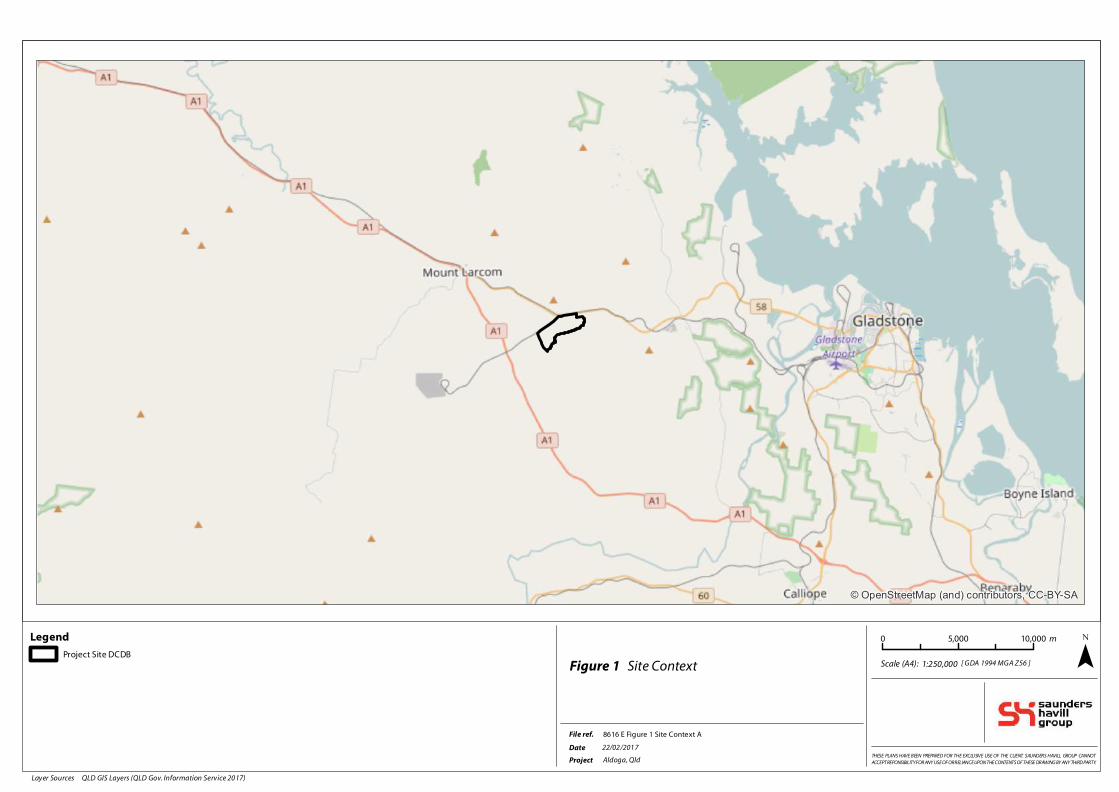
The site is situated on Gladstone – Mount Larcom Road, Aldoga, is straddled by the main North Coast rail line and
East End spur line, and is within 10 km of the new Fishermans Landing port facility. The site is predominantly open
paddock and contains no remnant vegetation mapped by the Queensland Government. The proposed
development is to be located on the land sloping to the west of the existing Homestead. There is approximately 15
metre fall north to south over a 650 metre separation from the northern property boundary to the easement for the
high-voltage electricity corridor which is the southern boundary of the development area. Refer to Figure 1 for site
context and Plan 1 for site aerial and proposed layout. The total footprint of the proposed development is 140 hectares.
Legend
Project Site DCDB
File ref.
Project Aldoga, Qld
Date
[ GDA 1994 MGA Z56 ]
22/02/2017
Scale (A4): Figure 1 Site Context
THESE PLANS HAVE BEEN PREPARED FOR THE EXCLUSIVE USE OF THE CLIENT. SAUNDERS HAVILL GROUP CANNOT
ACCEPT REPONSIBILITY FOR ANY USE OF OR RELIANCE UPON THE CONTENTS OF THESE DRAWING BY ANY THIRD PARTY.
8616 E Figure 1 Site Context A
© OpenStreetMap (and) contributors, CC-BY-SA
1:250,000 ¯0 5,000 10,000 m
Layer Sources QLD GIS Layers (QLD Gov. Information Service 2017)

As ia Pac i f i c Agr i -Co rp (P ro j e c t s ) P ty L td
Address 1261 Gladstone Mount Larcom Road
@ A3GDA 1994 MGA Zone 56Universal Transverse Mercator
ALDOGA , QLD
LEGEND
Project Site DCDB
Qld DCDB
Development footprint (approx. 84ha)
Q100 flood line
21/02/2017
PLAN ISSUE:Issue Date Description Drawn Checked
A Prelim Draft TC AH21/02/2017
8616 E 02 Development Assessment A
Future development area -
distribution centre (30ha)
Gate house (0.01ha)
Holding yards and Anaerobic
lagoons (33.3ha)
Solar farm (50ha)
Executive offices & caretakers
residence (0.1ha)
Processing Facility (18.6ha)
Hardstand Road/
Driveway (7.7ha)
1:11,000
°
0 100 200 300 400 50050 m
NOTES
This plan was prepared as a desktop assessment tool.
The information on this plan is not suitable for any other purpose.
Property dimensions, areas, numbers of lots and contours and other physical
features shown have been compiled from existing information and may not
have been verified by field survey. These may need verification if the
development application is approved and development proceeds, and may
change when a full survey is undertaken or in order to comply with
development approval conditions. No reliance should be placed on the
information on this plan for detailed design or for any financial dealings
involving the land. Saunders Havill Group therefore disclaims any liability for
any loss or damage whatsoever or howsoever incurred, arising from any party
using or relying upon this plan for any purpose other than as a document
prepared for the sole purpose of accompanying a development application
and which may be subject to alteration beyond the control of the Saunders
Havill Group. Unless a development approval states otherwise, this is not
an approved plan.
Layer Sources: QLD GIS Layers (QLD Gov. Information Service 2016),
Aerial (Qld Globe 2016), Development footprint (OPUS Architecture 2014)
Q100 line (OPUS Architecture 2014)
* This note is an integral part of this plan/data. Reproduction of this plan or any
part of it without this note being included in full will render the information
shown on such reproduction invalid and not suitable for use.
1. Deve lopment Footpr int Assessment

page 7
environmental management
ecological assessment report
2. Ecological Assessment Methodology and
Process
The following steps were undertaken in the preparation of this assessment:
1. Desktop Analysis
2. Legislation and Policy Review
3. Field Survey
4. Analysis and Recommendation
2.1. Desktop Analysis
Prior to the commencement of field surveys, a desktop analysis was conducted to identify relevant information for
the site. The following information was reviewed:
� Search of the Commonwealth’s EPBC Protected Matters Search Tool
� Search of EHP’s Wildlife Online Database for the study area and surrounds
� Federal and State Government Environmental Databases
� State Government Environmental Overlay Mapping i.e. SPP, SARA
� Planning Scheme Documents and Maps
2.2. Botanical Survey
A survey of woody vegetation, habitat features and overall health was carried out during the assessment with all
species including ground-covers and shrubs recorded. The site was extensively traversed with all flora species
encountered recorded and a master flora catalogue compiled to provide a comprehensive list of all botanical
species located on the site.
Analysis of an aerial photography of the site provided preliminary stratification of vegetation types (analogous to
vegetation communities) based on diagnostic features such as colour, texture, crown architecture and topographic
position. Regional Ecosystem (RE) mapping –indicated the site contains a mix of Category X non remnant vegetation
and open paddocks. Ground-truthing exercises were conducted across the site to assess the accuracy of the aerial
imagery and to provide definitive results relating the mapped vegetation (or lack thereof) communities found on
site. GPS track logs were kept to assess the efficiency and coverage of the on-site botanical survey.
2.3 Fauna Survey
Fauna searches were conducted on the site on 6 and 7 February 2017. Fauna surveys were undertaken across the
site, with a particular focus on any unique and niche environments that may provide potential habitat for
threatened species (State and Commonwealth).
Bird Surveys were undertaken as well as incidental observations over the two-day period. Methods included
sedentary listening and observational surveys in potnetial habitat areas.
Herptofauna surveys were conducted in the early mornings. Active searches were carried out looking under leaf
litter, rocks, logs, fallen branches and other anthropogenic debris. The surveys were carried out around a centre

page 8
environmental management
ecological assessment report
point which contained suitable and a high likelihood of potential reptile habitat resources such as fallen timber
and/or logs.
Opportunistic searches and general species identification searches were also employed onsite. The site was swept
/ traversed to increase site coverage and survey timed effort. These surveys targeted general species identification
through sight and sound. Particular attention was paid to any threatened species that were listed as possibly
occurring on or within the vicinity of the application site and specific micro assemblages which may support these
threatened species.

page 9
environmental management
ecological assessment report
3. Ecological Assessment Results
Two (2) Senior Ecologists from Saunders Havill Group assessed the application area on 6 and 7 February 2017 with
conditions fine and sunny. Assessment methods are described in Section 2 and included general flora species
identification and searches, bird surveys, herptofauna surveys, observational fauna survey and opportunistic
searches, and identification of habitat values.
Native vegetation has largely been cleared from the immediate surrounds of the application site and continue to
be maintained for rural grazing activities. Currently the site and its surrounds are all in keeping with agricultural
grazing. On the northern boundary the site is straddled by the North Coast Railway, the East-End Mine Branch
Railway and Gladstone Mount Larcom Road.
Regional Ecosystem (RE) vegetation polygons indicate the area to the west of the development site includes 11.3.26
(60%) - Eucalyptus moluccana or E. microcarpa woodland to open forest on margins of alluvial plains (No concern at
present) and 11.3.4 (40%) - Eucalyptus tereticornis and/or Eucalyptus spp. woodland on alluvial plains (Of Concern).
Also indicated in the vicinity of the site to the south of the development site includes 11.3.26 (90%) Eucalyptus
moluccana or E. microcarpa woodland to open forest on margins of alluvial plains (No concern at present) and 11.3.4
(10%) Eucalyptus tereticornis and/or Eucalyptus spp. woodland on alluvial plains (Of Concern). To the south-east of
the development site RE mapping indicates 11.3.26 (40%) - Eucalyptus moluccana or E. microcarpa woodland to
open forest on margins of alluvial plains (No concern at present), 11.11.4 (40%) - Eucalyptus crebra woodland on old
sedimentary rocks with varying degrees of metamorphism and folding. Coastal ranges (No concern at present) and
11.3.4 (20%) Eucalyptus tereticornis and/or Eucalyptus spp. woodland on alluvial plains (Of Concern). Site survey did
not venture to areas outside of the site proposed for development due to the large buffer area between the
proposed development and the surrounding RE Mapping. Refer to Page 4 of Appendix C for RE mapping.
3.1. Botanical Survey Results
The following general observations have been made for flora at the site:
� The investigation area consists of two (2) allotments. All of the individual allotments have undergone
similar management regimes including mass scale historical clearing of vegetation for agricultural grazing.
Scattered established native trees remain on the allotments with little to no mid storey or clumped
groundcovers (i.e. sedges) present which is typical of an agricultural grazing function.
� What vegetation remains on site is present in small scattered clustered arrangements and are dominated
by individual specimens including Eucalyptus moluccana (Gum Topped Box), Eucalyptus siderophloia (Grey
Ironbark), Corymbia tessellaris (Moreton bay Ash), and Corymbia erythrophloia (Variable barked Bloodwood)
with some Acacia spp. regrowth.
� Larcom Creek and the associated floodplain contained large scattered individual specimens dominated by
Eucalyptus tereticornis (Forest Red Gum). A large number of these specimens contained habitat features
including both small and large hollows and at the time of the assessment these specimens were utilised by
highly mobile species including birds such as cockatoos, wedge tail eagle and other raptors.
� Topography within the vicinity of the site is best described as undulating with an overall slope towards the
south of the property towards Mt. Larcom Creek. The highest point of the property contains the existing
homestead and associated infrastructure including sheds and stables.
� Two waterways are mapped within the investigation area, including Larcom Creek which borders the
southern property boundary. Larcom Creek contains lineal vegetation with large scattered Eucalyptus

page 10
environmental management
ecological assessment report
tereticornis (Forest Red Gum) specimens dominating the T1 layer, Melaleuca viminalis (Weeping
Bottlebrush) the T2 layer and introduced species dominant within the shrub and ground layers. Larcom
Creek contained a series of large pools and runs providing habitat for fish and other aquatic species.
Vegetation had largely been cleared outside the top bank area. The second mapped waterway is a stream
order 2 waterway and is located towards the site’s western property boundary and heads under the railway
line along the northern boundary. This waterway is highly disturbed due to cattle access and weed
invasion. The majority of the T1 layer is absent however patchy Casuarina cunninghamiana (River Sheoak)
is observed along the mapped waterway. It should be noted that the actual channel is absent in some areas
with the waterway contained a series of small pools and overland flow paths. The further downstream this
stream order 2 waterway is towards Larcom Creek, the features of the waterway are more defined, including
a greater diversity of species including Melaleuca viminalis (Weeping Bottlebrush).
� No remnant vegetation communities are located within the investigation area however the remaining
vegetation contained small patches of specimens that are a height and density typical of the regional
ecosystem communities that would have once dominated the landscape.
� For a full site vegetation context refer to Plan 2.
3.1.1 Protected Plants and Threatened Ecological Communities
The Environment Protection and Biodiversity Conservation Act 1999 (EPBC) online Protected Matters Search Tool listed
three Threatened Ecological Communities (TEC’s) that may occur within the local area:
� Coolilbah – Black box Woodlands of Darling Riverine Plains and Brigalow Belt South Bioregions
(Endangered)- community may to occur within the area;
� Semi-evergreen vine thickets of the Brigalow Belt (Endangered) - community likely to occur within the
area; and
� Weeping Myall Woodlands (Endangered) – community may occur within the area.
Botanical surveys confirmed that no TEC’s are present on the site and therefore will not be affected by the proposed
action. The EPBC search listed nine (9) threatened botanical species. Of the nine (9) threatened species none were
found on the site.
3.1.2 Southern Mapped Waterway (Boundary)
The mapped waterway along the sites southern boundary is referred to as Larcom Creek. This waterway is a stream
order 3 waterway and contains vegetation best described as lineal. No remnant vegetation is mapped along this
portion of Larcom Creek however flora species identified are typical of the preclear vegetation mapping including
Of Concern Regional Ecosystem 11.3.4, described as Eucalyptus tereticornis (Forest Red Gum) and/or Eucalyptus sp
woodland on alluvial plains. The vegetation observed along the creek is generally between the embankments of
the creek with trailing vegetation largely cleared for agricultural purposes. The sub canopy is dominated by
Melaleuca viminalis (Weeping Bottlebrush) however included other species such as Casuarina cunninghamiana
(River Oak) and Lophostemon suaveolens (Swamp Box). It is noted that infestations of Cryptostegia grandiflora
(Rubber Vine) was recorded along Larcom Creek amongst other weed species.

page 11
environmental management
ecological assessment report
Photo: Larcom Creek located along the site’s southern boundary
In-stream habitat types observed at the time of the assessment included pools and runs however these were
separated by deposited material with no flow of water for fish movement. These pools and runs would likely
become connected after a relatively minor rain event. Overhanging vegetation and logs were observed along the
majority of the embankments and is dominated by Melaleuca viminalis (Weeping Bottlebrush). Turtles, water
dragons and a relatively high number, when compared to the balance of the site, of bird species were observed
utilising this vegetation throughout the survey period.

page 12
environmental management
ecological assessment report
Photo: Lineal vegetation remaining along Larcom Creek

As ia Pac i f i c Agr i -Co rp (P ro j e c t s ) P ty L td
Address 1261 Gladstone Mount Larcom Road
@ A3GDA 1994 MGA Zone 56Universal Transverse Mercator
ALDOGA , QLD
LEGEND
Project Site DCDB
Qld DCDB
Vegetation Communities
Non-remnant open woodland
Open grassland/Agricultural
land with scattered stand-
alone vegetation
Project site -
Typical Vegetated waterway
(stream order 3)
Larcom Creek USL/Watercourse -
Typical vegetated waterway
(stream order 3)
Drainage lines and
constructed dams
15/02/2017
PLAN ISSUE:Issue Date Description Drawn Checked
A Prelim Draft TC AH15/02/2017
8616 E 01 Veg Communities A
1:11,000
°
0 100 200 300 400 50050 m
NOTES
This plan was prepared as a desktop assessment tool.
The information on this plan is not suitable for any other purpose.
Property dimensions, areas, numbers of lots and contours and other physical
features shown have been compiled from existing information and may not
have been verified by field survey. These may need verification if the
development application is approved and development proceeds, and may
change when a full survey is undertaken or in order to comply with
development approval conditions. No reliance should be placed on the
information on this plan for detailed design or for any financial dealings
involving the land. Saunders Havill Group therefore disclaims any liability for
any loss or damage whatsoever or howsoever incurred, arising from any party
using or relying upon this plan for any purpose other than as a document
prepared for the sole purpose of accompanying a development application
and which may be subject to alteration beyond the control of the Saunders
Havill Group. Unless a development approval states otherwise, this is not
an approved plan.
Layer Sources: QLD GIS Layers (QLD Gov. Information Service 2016),
Aerial (Nearmap 2016)
* This note is an integral part of this plan/data. Reproduction of this plan or any
part of it without this note being included in full will render the information
shown on such reproduction invalid and not suitable for use.
2 . Vegetat ion Communit ies & Ecologl ica l Features

page 14
environmental management
ecological assessment report
3.1.3 Site Botanical Species
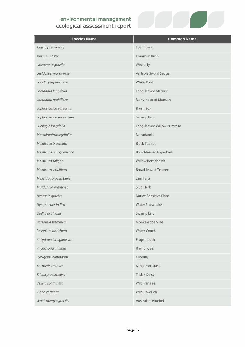
One hundred and forty-eight (148) species were identified throughout the investigation area at the time of the
assessment. Of these, seventy-nine (79) are native species with the remaining sixty-nine (69) being introduced
species, common with cleared / agricultural land use. Ten (10) of the introduced species are classified as restricted
under the Biosecurity Act 2014.
The Biosecurity Act 2014 replaced the multiple pieces of separate legislation that were previously used to manage
biosecurity. The Act is now the primary piece of legislation in Queensland for managing pests, diseases and
contaminants and requires landowners to take all reasonable and practical steps to minimise the risks associated
with invasive plants and animals under their control. Management of restricted invasive plants declared under the
Act are to be managed at the Local Government level though a biosecurity plan that covers invasive plants and
animals in its area.
Native botanical species observed on site are listed in Table 1 with introduced species provided in Table 2.
Table 1: Native Botanical Species Observed
Species Name Common Name
Acacia concurrens Black Wattle
Acacia disparimma Hickory Wattle
Acacia fimbriata Fringed Wattle
Acacia leiocalyx Early-flowering Black Wattle
Acacia podalyriifolia Queensland Silver Wattle
Allocasuarina cunninghamia River Sheoak
Allocasuarina littoralis Black Sheoak
Alloteropsis semialata Cockatoo Grass
Alphitonia excelsa Red Ash
Alstonia constrica Bitter Bark
Angophora leiocarpa Smooth-barked Apple
Araucaria heterophylla Norfolk Pine
Archidendropsos basaltica Dead Finish
Aristida latifolia Feathertop Wiregrass
Carissa ovata Current Bush
Cheilanthes distans Bristle Cloak Fern
Chrysocephalum apiculatum Yellow Buttons
Chrysopogon fallax Golden Beard Grass
Corymbia citriodora Spotted Gum

page 15
environmental management
ecological assessment report
Species Name Common Name
Corymbia erythrophloia Variable-barked Bloodwood
Corymbia intermedia Pink Bloodwood
Corymbia tesselaris Moreton Bay Ash
Cymbidium canaliculatum Black Orchid
Cymbopogon refractus Barbwire Grass
Cyperus exaltatus Giant Sedge
Cyperus polystachyos Bunchy Sedge
Daviesia ulcifolia Native Gorse
Dianella caerulea Blueberry Lilly
Elaeocharis dulcis Water Chestnut
Entolasia stricta Wiry Panic
Eragrostis brownii Browns Lovegrass
Eragrostis sp. Love Grass
Eucalyptus crebra Narrow-leaved Ironbark
Eucalyptus exserta Queensland Peppermint
Eucalyptus melanophloia Silver-leaf Ironbark
Eucalyptus moluccanna Gum-topped Box
Eucalyptus siderophloia Northern Grey Ironbark
Eucalyptus tereticornis Forest Red Gum
Eustrephus latifolius Wombat Berry
Ficus obovata Sandpaper Fig
Ficus rubiginosa Rusty Fig
Fimbristylis dichotoma Common Fringe Rush
Goodenia rotundifolia Star Goodenia
Grevillea striata Beefwood
Grewia retusifolia Dog's Balls
Hardenbergia violacea Native Sarsaparilla
Heteropogon contortus Black Spear Grass
Imperata cylindrica Blady Grass
Jacksonia scoparia Dogwood
page 16
environmental management
ecological assessment report
Species Name Common Name
Jagera pseudorhus Foam Bark
Juncus usitatus Common Rush
Laxmannia gracilis Wire Lilly
Lepidosperma laterale Variable Sword Sedge
Lobelia purpurascens White Root
Lomandra longifolia Long-leaved Matrush
Lomandra multiflora Many-headed Matrush
Lophostemon confertus Brush Box
Lophostemon sauveolens Swamp Box
Ludwigia longifolia Long-leaved Willow Primrose
Macadamia integrifolia Macadamia
Melaleuca bracteata Black Teatree
Melaleuca quinquenervia Broad-leaved Paperbark
Melaleuca saligna Willow Bottlebrush
Melaleuca viridiflora Broad-leaved Teatree
Melichrus procumbens Jam Tarts
Murdannia graminea Slug Herb
Neptunia gracilis Native Sensitive Plant
Nymphoides indica Water Snowflake
Otellia ovalifolia Swamp Lilly
Parsonsia staminea Monkeyrope Vine
Paspalum distichum Water Couch
Philydrum lanuginosum Frogsmouth
Rhynchosia minima Rhynchosia
Syzygium leuhmannii Lillypilly
Themeda triandra Kangaroo Grass
Tridax procumbens Tridax Daisy
Velleia spathulata Wild Pansies
Vigna vexillata Wild Cow Pea
Wahlenbergia gracilis Australian Bluebell

page 17
environmental management
ecological assessment report
Table 2: Introduced Botanical Species Observed
Species Name Common Name Biosecurity Act 2014
Aeschynomene indica Budda Pea
Ageratum houstonianum Blue Billygoat Weed
Asclepias curassavica Red-headed Cotton Bush
Asparagus aethiopicus Asparagus Fern Restricted
Baccharis halimifolia Groundsel Bush Restricted
Bidens pillosa Cobblers Peg
Bothrichloa decipiens Pitted Bluegrass
Brachiaria decumbens Signal Grass
Brachiaria mutica Para Grass
Calliandra sp. Pom Pom Bush
Capillipdeum spicigerum Scented Top
Centella asiatica Centella
Chamaecrista mimosoides Mimosa Cassia
Chloris gayana Rhodes Grass
Cinnamomum camphora Camphor Laurel Restricted
Cirsium vulgare Scotch Thistle
Conyza sp. Fleabane
Corymbia torelliana Cadaghi
Crptostegia grandiflora Rubber Vine Restricted
Cynodon dactylon Couch
Delonix reggia Poincianna
Desmodiumrhytidophyllum Hairy Trefoil
Eclipta prostata White Eclipta
Eichhornia crassipes Water Hyacinth
Glycine tabacina Glycine Pea
Gomphocarpus physocarpus Balloon Cotton Bush
Gomphrena celosioides Gomphrena Weed
Heliotropium aamplexicaule Blue Heliotrope
Hibiscus sp. Hibiscus

page 18
environmental management
ecological assessment report
Species Name Common Name Biosecurity Act 2014
Hypochaeris radiata Flatweed
Indigofera linifolia Narrow-leaved Indigo
Lantana camara Lantana Restricted
Lepidium bonariense Peppercress
Leuacaena leucocephala Leucaena
Macroptilium atropupureum Siratro
Mangifera indica Mango
Megathyrus maximus Guinea Grass
Melinis minutifolia Molasses Grass
Melinis repens Red Natal Grass
Neonotonia wightii Glycine
Nymphaea caerulea Puple Waterlilly
Onopordum acanthium Scotch Thistle
Opuntia tomentosa Prickly Pear Prohibited
Paspaplum dilatum Paspalum
Passiflora suberosa Corky Passionflower
Persicaria decipiens Knotweed
Persicaria decipiens Slender Knotweed
Phyllanthus virgatus Phyllanthus
Pultenaea villosa Hairy Bush Pea
Schinus terebinthifolius Broad Leaf Pepper Tree Restricted
Schleffera actinophylla Umbrella Tree
Schoenoplectus mucronatus Triangular Clubrush
Senecio lautus Fireweed Restricted
Senna pendula Easter Cassia
Sesbania cannabina Sesbania Pea
Setaria sphacelata Setaria
Sida cordifolia Flannel Weed
Solanum chrysostichum Giant Devils Fig
Solanum nigrum Blackberry Nightshade

page 19
environmental management
ecological assessment report
Species Name Common Name Biosecurity Act 2014
Solanum torvum Devil's Fig
Sorghum halepense Johnsons Grass
Sphagneticola trilobata Singapore Daisy Restricted
Sporobolus pyramidalis Giant Rats Tail Grass Restricted
Stylosanthes scabra Shrubby Stylo
Syragrus romanzoffiana Cocus Palm
Themeda quadrivalvis Grader Grass
Tipuana tipu Tipuana
Tradescantia sp Wandering Jew
Typha orientalis Bulrush
3.2. Fauna Observations
Targeted and opportunistic fauna surveys were conducted on the site over the two-day period. Searches were
concentrated around potential habitat for listed Threatened species (EPBC and NCA). The site was swept / traversed
to increase site coverage and survey timed effort. These surveys targeted general species identification through
sight and sound. For more detail on fauna surveys that were undertaken please refer to section 2.3. Table 3 lists
fauna species identified to utilise the site in some capacity.
Table 3: Fauna Species Observed
Species Common Name
Canis lupus familiaris Domestic Dog
Corvus orru Torresian Crow
Cryptoblepharus virgatus Wall Skink
Dacelo novaeguineae Laughing Kookaburra
Grallina cyanoleuca Magpie-lark
Gymnorhina tibicen Australian Magpie
Hemidactylus frenatus Asian House Gecko
Hirundo neoxena Welcome Swallow
Manorina melanocephala Noisy Minor
Ocyphaps lophotes Crested Pigeon
Platycercus adscitus Pale-headed Rosella
Rhinella marina Cane Toad
Taeniopygia bichenovii Double Barred Finch
Rhipidura leucophrys Willie Wagtail