ecological character description of toolibin lake… · ecological character description of...
TRANSCRIPT

ECOLOGICAL CHARACTER DESCRIPTION OF TOOLIBIN LAKE, WESTERN AUSTRALIA
January 2006 Prepared for Department of Conservation and Land Management Prepared by Gary McMahon
Ecosystem Solutions Pty Ltd PO Box 685 Dunsborough WA 6281 Ph: 08 9759 1960 Fax: 08 9759 1920

Ecological Character Description of Toolibin Lake Ramsar Wetland Page 2 of 49.
Limitations Statement This report has been exclusively drafted for the DEPARTMENT OF CONSERVATION & LAND MANAGEMENT. No express or implied warranties are made by Ecosystem Solutions Pty Ltd regarding the findings and data contained in this report. No new research or field studies were conducted. All of the information details included in this report are based upon the research provided and obtained at the time Ecosystem Solutions Pty Ltd conducted its analysis. In undertaking this work the authors have made every effort to ensure the accuracy of the information used. Any conclusions drawn or recommendations made in the report are done in good faith and the consultants take no responsibility for how this information and the report are used subsequently by others. Please note that the contents in this report may not be directly applicable towards another organisation‟s needs or any other specific land area requiring management strategies. Ecosystem Solutions Pty Ltd accepts no liability whatsoever for a third party‟s use of, or reliance upon, this specific report.
The views and opinions expressed in this publication do not necessarily reflect those of the Australian Government or the Minister for Sustainability, Environment, Water, Population and Communities or the Administrative Authority for Ramsar in Australia. While reasonable efforts have been made to ensure the contents of this publication are factually correct, the Commonwealth does not accept responsibility for the accuracy or completeness of the contents, and shall not be liable for any loss or damage that may be occasioned directly or indirectly through the use of, or reliance on, the contents of this publication. Guidance on the development of Ecological Character Descriptions, including Limits of Acceptable change, are areas of active policy development. Accordingly there may be differences in the type of information contained in this Ecological Character Description, to those of other Ramsar wetlands. This information does not create a policy position to be applied in statutory decision making. Further it does not provide assessment of any particular action within the meaning of the Environment Protection and Biodiversity Conservation Act 1999, nor replace the role of the Minister or his delegate in making an informed decision on any action. This report is not a substitute for professional advice rather it is intended to inform professional opinion by providing the authors' assessment of available evidence on change in ecological character. This information is provided without prejudice to any final decision by the Administrative Authority for Ramsar in Australia on change in ecological character in accordance with the requirements of Article 3.2 of the Ramsar Convention. Users should obtain any appropriate professional advice relevant to their particular circumstances.

Ecological Character Description of Toolibin Lake Ramsar Wetland Page 3 of 49.
Table of Contents Table of Contents .......................................................................................................................................... 3 1) Introduction .......................................................................................................................................... 4
a) Ramsar Convention ........................................................................................................................... 4 b) Australian Policy ............................................................................................................................... 4 c) Ecological Character .......................................................................................................................... 5
2) Approach .............................................................................................................................................. 6 3) Description of ecological character .......................................................................................................... 8
a) Overview of Toolibin Lake (Step 1) ..................................................................................................... 8 b) Significant Biological Assets (Step 2) ................................................................................................. 12
i) Waterbirds ................................................................................................................................. 14 ii) Native vegetation ....................................................................................................................... 14 iii) Threatened Ecological Community ........................................................................................... 17 iv) Primary producers and aquatic invertebrates ............................................................................ 17
c) Ecosystem Drivers and Features (Step 3) .......................................................................................... 17 i) Geomorphology .......................................................................................................................... 18 ii) Climate ...................................................................................................................................... 20 iii) Primary Production ................................................................................................................. 21
4) Significant biological assets and their related ecological-hydrological processes ......................................... 23 a) Significant Biological Asset 1: Waterbirds .......................................................................................... 23
i) Key ecological and hydrological processes for sustaining waterbirds at Toolibin Lake ........................... ................................................................................................................................................ 24
b) Significant Biological Asset 2: Native Vegetation ................................................................................ 30 i) Key ecological and hydrological processes for sustaining native vegetation at Toolibin Lake .............. 32
c) Significant Biological Asset 3: Threatened Ecological Community ......................................................... 35 i) Key ecological and hydrological processes for sustaining the threatened ecological community at Toolibin Lake ...................................................................................................................................... 36
d) Significant Biological Asset 4: Algae, Phytoplankton and Aquatic Macroinvertebrates ................................ ..................................................................................................................................................... 36
i) Key ecological and hydrological processes for sustaining algae, phytoplankton and aquatic macroinvertebrates at Toolibin Lake ...................................................................................................... 37
5) Ecosystem Services (Step 4) ................................................................................................................ 39 6) Knowledge Gaps (Step 5) ..................................................................................................................... 40
7) References ......................................................................................................................................... 41 Appendices .................................................................................................................................................. 48
List of Figures and Tables Figures Page
1. Toolibin Lake in relation to major towns 9
2. Toolibin Lake 10
3. Vegetation Map of Toolbin Lake 16
4. Universal Drivers of Wetland ecological character 18
5. Simplified Conceptual Model of Toolibin Lake 22
6. Water Ponding on the lake floor 29
7. Algal Mats on the lake floor 39
Tables
1. Significant Biological Assets of Toolibin Lake 13
2. Waterbirds recorded at Toolibin Lake (1981-1985) 27
3. Nesting Guilds of Waterbirds at Toolibin Lake 28
4. Feeding Guilds of Waterbirds at Toolibin Lake 28
5. Parameters influencing seed germination and seedling establishment 34
6. Ecosystem Services at Toolibin Lake. 40

Ecological Character Description of Toolibin Lake Ramsar Wetland Page 4 of 49.
1) Introduction
a) Ramsar Convention
In 1971, at a meeting in the town of Ramsar in Iran, the Convention on Wetlands was signed. The broad aims of the convention are to halt and, where possible, reverse the worldwide loss of wetlands and to conserve those that remain through wise use (defined by the convention as "...sustainable utilisation for the benefit of humankind in a way compatible with the maintenance of natural properties of the ecosystem” Ramsar COP 3, 1987) and management. The Convention is commonly known as the Ramsar Convention.
The Ramsar Convention Bureau, based in Switzerland, administers and supports the implementation of the Convention. The Contracting Parties meet every three years in order to review implementation of the Convention and to agree upon new policies and initiatives. The Parties present a report of their activities over the previous three years that may include the records of additional sites that have been listed as Wetlands of International Importance.
Under the Ramsar Convention, Contracting Parties are expected to designate sites for the List of Wetlands of International Importance. These sites are nominated “on account of their international significance in terms of ecology, botany, zoology, limnology or hydrology” (Article 2.2) AND contracting parties are to “formulate and implement their planning so as to promote the conservation of the wetlands included in the List” (Article 3.1) (Ramsar Convention Bureau, 2000)
b) Australian Policy
Australia is a Contracting Party to the Convention and has presently designated 64 Ramsar sites (Australian Government, 2004). Australia addresses its Ramsar site obligations, primarily, though the Commonwealth Environmental Protection and Biodiversity Conservation Act, 1999 (EPBC Act) (Australian Government, 1999), and the Environmental Protection and Biodiversity Conservation Regulations, 2000 (Australian Government, 2000). The EPBC Act establishes a framework for managing Ramsar wetlands, which is in accordance with the Ramsar Convention, through the Australian Ramsar Management Principles (which are set out in the EPBC Regulations). They cover matters relevant to the preparation of management plans, environmental assessment of actions that may affect the site, and the community consultation process. The EPBC Act identifies Ramsar sits as “matters of national environmental significance” and provides for the assessment of proposed actions that are likely to have a significant impact on the ecological character of Ramsar sites.

Ecological Character Description of Toolibin Lake Ramsar Wetland Page 5 of 49.
c) Ecological Character
Ramsar Convention signatories are expected to have mechanisms in place to help them detect threats that are likely to, or have altered the „ecological character‟ of their sites. The Ramsar Convention defines „ecological character‟ and its associated terms as follows:
Ecological character is the sum of the biological, physical and chemical components of the wetland ecosystem, and their interactions, which maintain the wetland and its products, functions and attributes.
Products generated by wetlands include: wildlife resources; fisheries; forest resources; forage resources; agricultural resources; and water supply. These products are generated by the interactions between the biological, chemical and physical components of a wetland.
Functions are activities or actions that occur naturally in wetlands as a product of the interactions between the ecosystem structure and processes. Functions include flood water control; nutrient, sediment and containment retention; food web support; shoreline stabilisation and erosion controls; storm protection; and stabilisation of local climatic conditions, particularly rainfall and temperature.
Attributes of a wetland include biological diversity and unique cultural and heritage features. These attributes may lead to certain uses of the derivation of particular products, but they may also have intrinsic, unquantifiable importance.
Change in ecological character is the impairment or imbalance in any biological, physical or chemical component of the wetland ecosystem, or in their interactions, which maintain the wetland and its products, functions and attributes.
A description of „ecological character‟ should be prepared as part of the management plan for the Ramsar site. The description of „ecological character‟ forms the basis for the design of a monitoring programme that should be included in the management plan. Documenting the „ecological character‟ of a Ramsar listed wetland is therefore a fundamental tool for its management.
A description of „ecological character‟ is required as the baseline for assessing any adverse „change in the ecological character‟ of Ramsar sites. It forms the reference for three main activities:
1. the assessment of the likely impact on „ecological character‟ of proposed actions, as required under the EPBC Act;
2. the design of a monitoring programme to detect ecological change; and 3. the regular evaluation of the results of the monitoring programme as the
basis for reporting to the Ramsar Convention and for review of the site‟s management plan.

Ecological Character Description of Toolibin Lake Ramsar Wetland Page 6 of 49.
A Ramsar Information Sheet (RIS) must be prepared for each Ramsar site at the time of listing and that a description of the „ecological character‟ of the site should be provided as part of the RIS. The Ramsar Convention Bureau (2000) has indicated that the current RIS does not provide a sufficiently detailed and rigorous description of „ecological character‟ to provide a useful baseline reference. Presently, there is no Ramsar recommended method for describing „ecological character‟.
2) Approach
The Ramsar Convention refers to „changes in ecological character‟, which is defined as an “impairment or imbalance in any biological, physical or chemical component of the wetland ecosystem, or in their interactions, which maintain the wetland and its products, functions and attributes”. Contracting parties are expected to manage their Ramsar sites so as to maintain the ecological character of each site and, in doing so, retain those essential ecological and hydrological functions that ultimately provide the wetland‟s products, functions and attributes. Therefore to describe the ecological character of a wetland it is important to document the natural ranges of variation of the internal components that will be monitored. This will enable managers to determine whether changes to the ecological character are outside those identified natural variations. Such a change may signal that uses of the site, or externally derived impacts on the site, are unsustainable and may lead to the degradation of natural processes and thus the ultimate breakdown of the ecological, biological and hydrological functioning of the wetland (Ramsar Convention Bureau, 2000).
Phillips et al, (in preparation) use the term “limits of acceptable change” to indicate the variation that is considered acceptable in a particular measure or feature of the ecological character of a wetland (e.g. population changes, water quality etc.), that is the natural variation of that feature or measure. Should values for that specific feature or measure vary outside those „acceptable changes‟ then this would trigger careful examination to determine the cause, and to respond to variation though monitoring and adaptive management.
In order to set these limits of acceptable change, there needs to be an understanding of the existing system attributes, which often requires long term data sets that accurately reflect the natural variability of the system. Where such data do not exist, expert opinion can be used as an interim measure (in combination with sound monitoring and adaptive management techniques) until sound data becomes available (Phillips et al., in preparation).
Toolibin Lake has been extensively monitored since the late 1970s and there are significant amounts of data on specific elements of the wetland. It should be noted, however, that given the varying scopes, methodologies and outcomes from the various monitoring programmes and changes in management regimes and techniques at Toolibin, expert opinion is required to refine and clarify the limits of acceptable change for Toolibin Lake. Toolibin Lake is designated as a Natural Diversity Recovery Catchments under the Western Australian Salinity Strategy (State Salinity Council, 2000). This provides for a coordinated programme of actions to ensure the long term maintenance and recovery of Toolibin‟s natural assets, where they are threatened by salinity and hydrological change. As part of this process a recovery plan is prepared for a period of 10 years. The plan for Toolibin Lake outlines a number of criteria

Ecological Character Description of Toolibin Lake Ramsar Wetland Page 7 of 49.
against which success of recovery will be evaluated. Within this report these success criteria have been used as a basis from which the limits of variation of the system are determined. While some criteria are quantitative, a number of them are defined in qualitative terms. Within this report quantitative range of variation limits are suggested for those criteria to make them more specific and measurable. While these recommendations have been determined from the available literature, it is important to note that they should be seen as preliminary until more quantitative data are available and evaluated.
Ecosystems are complex and dynamic, and changes in composition and structure can be expected over time. This can include both gradual change, as succession proceeds, and more rapid change, as a result of disturbance, episodic events, or changed management. (Wallington et al, 2005). Ecosystems are open, heterogeneous systems that are not only internally variable across space and time, but also interact with other ecosystems at the landscape level. The structure, composition and dynamics of an ecosystem in any particular place are thus contingent on its spatial context (in terms of its position in relation to other systems, the extent to which surrounding systems interact, and the degree of human modification of the landscape) (Wallington et al, 2005). Given the variability of ecosystems, there is a need to describe the ecological character of a system at a specific point in time. Ideally, this would be conducted at the initial time of listing a specific site. Toolibin Lake was listed as a lake of International Importance under the Ramsar Convention on the 7th June, 1990. The RIS does not have sufficient data to enable an ecological character description to be determined. There have been significant changes to the wetland since its listing, from both a physio/chemical and a biological perspective. This report describes the ecological character of Toolibin Lake as at 2005, however where there are major changes in the data from the listing date, these are highlighted. The approach taken with the categorisation of the ecological character of Toolibin Lake broadly follows the approach taken by Phillips et al (in preparation) in defining the ecological character of Lake MacLeod. Given the complexity of the ecosystem, the ambiguity with the limits of natural variability and, at a minimum, the critical thresholds for a number of the biological/ecological elements and/or processes, ecological character management benchmarks have not been determined. For this report, the approach follows five steps:
Step 1: provide an overview of the site; its location, climate, hydrology, special biological, ecological and other values. The Ramsar Information Sheet provides much of the information for this step. Step 2: Document the significant biological assets of the site. This includes its‟ plant and animal species, unique ecological communities and other values that provide the biological justification for Ramsar listing. These are linked to the specific Ramsar criteria for the listing of the site. This component of the ecological character description focuses on the structural and compositional aspects of the site in response to the spatial context of the ecosystem.

Ecological Character Description of Toolibin Lake Ramsar Wetland Page 8 of 49.
Step 3: Using the data described in step 2, identify the underlying system drivers that initiate and maintain the ecological and hydrological features and processes that define the wetland type and in turn support the significant species and ecological communities and their habitats. The processes, both hydrological and ecological, are then linked back to the significant biological assets, associated habitats and wetland types that justify the Lake‟s international significance. Step 4: Describe the ecosystem services provided by the wetland. Step 5: Summarise the gaps in knowledge, where further research and/or analysis would assist in gaining a better understanding of the ecological character of the Toolibin Lake site.
3) Description of ecological character
a) Overview of Toolibin Lake (Step 1)
Toolibin Lake is situated in the Shire of Wickepin, approximately 200 kms south east of Perth in the State of Western Australia. It is 40 kilometres east of the town of Narrogin (population ca. 4,700 in 2003) and covers an area of 493 ha (Figure 1). It is situated within the Avon Wheat bioregion described by the Interim Biogeographic Regionalisation for Australia (IBRA) (Cummings & Hardy, 2000).

Ecological Character Description of Toolibin Lake Ramsar Wetland Page 9 of 49.
Figure 1: Toolibin Lake in relation to major towns (the arrow highlights the wetland)
Toolibin Lake has a catchment of approximately 483 square kilometres and occurs in a low rainfall zone. The median and mean annual rainfall at Wickepin (17 kms northwest of the site) is 401mm and 415mm respectively, mostly falling in May-August. The annual evaporation rate is 1900 mm (George, 1998). During dry years or a series of them the lake may not fill, but during wet years the lake may be inundated continuously for several years.
Toolibin Lake is a fresh-brackish Playa after the geomorphological classification system of Semeniuk and Semeniuk (1995), however it would have been called a sumpland prior to this. The wetland is perched above the water table and fills from surface run-off. The groundwater is near the surface but is lowered by groundwater pumping. It is intermittently inundated and generally fills in years when above average rainfall is received. It may receive no inflow for several years and it has not filled since 1996 (as at October, 2005), a period of very low rainfall. The maximum depth of water in the lake, when full, is about 2 metres, after which the lake overflows into other wetlands, downstream. Figure 2 shows a map of Toolibin Lake and its surrounds.

Ecological Character Description of Toolibin Lake Ramsar Wetland Page 10 of 49.
Figure 2: Toolibin Lake.
Toolibin Lake it is situated at the head of the Northern Arthur River drainage system of the Upper Blackwood River catchment. It is the only natural wetland in the bioregion that has not become saline due to a rising saline groundwater table. Many of the downstream wetlands contained similar vegetation and supported similar broad ecological communities to those now largely restricted to Toolibin Lake. The latter is the only major wetland in the chain that has not become saline. The lake‟s resilience is likely to be a consequence of local sub-surface geological features that have compartmentalised groundwater under the lake.
Toolibin Lake is the last, large, Casuarina obesa dominated wetland, with mostly living trees, in the inland agricultural area of South-Western Australia. Wetlands of this type were formerly widespread, however most have become severely degraded by secondary salinisation. Toolibin Lake is listed as a threatened ecological community under the Commonwealth Environmental Protections and Biodiversity Conservation Act, 1999. The listing is recorded as “Perched wetlands of the Wheatbelt region with extensive stands of living sheoak and paperbark across the lake floor – Toolibin Lake”

Ecological Character Description of Toolibin Lake Ramsar Wetland Page 11 of 49.
and its current status is “Endangered”. In a Western Australian context it is included in the List of Threatened Ecological Communities (TEC) on the Department of Conservation and Land Management‟s TEC Database endorsed by the Minister for the Environment (http://www.naturebase.net/plants_animals/watscu/tec.html) and classified as “Critically Endangered”. Toolibin Lake provides an important habitat for native fauna, particularly waterbirds. It is a vital breeding area for a wide range of waterbirds and supports more breeding species than any other wetland in SW Western Australia (Jaensch, et al, 1988). There have been more than 60 waterbird surveys between 1965 and 1996. A total of 50 waterbird species was recorded, 25 of which were observed breeding (Froend, et al, 1997). Recent records would suggest the number of breeding species has substantially reduced (S. Halse, pers. com). Given the lack of inflow since 1996, it is difficult to suggest what the current numbers would be.
The dominant land use in the Toolibin catchment is dry-land agriculture to produce wool and cereal grain. By 1972, 91% of the total area of the catchment was cleared. Reserves managed for conservation purposes occupy only 3% of the catchment.
Toolibin Lake was originally a perched freshwater wetland with the water table 15 m below the bed of the lake (Bowman, et al, 1992). The salinity of the water in the lake has increased over the past three decades (Bowman, Bishaw, Gorham et al, 1992). These effects have resulted from the clearing of the catchment, in two associated ways. First, there has been more runoff from the catchment and the water table has risen, bringing salt previously stored in the soil with it. Thus, seasonal runoff from the catchment carried saline water into the lake. Secondly, rising regional groundwater levels have caused the saline groundwater under Toolibin Lake to rise virtually to the floor of the lake.
Originally most of the lake was covered in thickets or woodlands of water-tolerant tree species, although there is a large, naturally open area on the eastern side. The higher ground around the lake supports open eucalypt woodland, sheoak, banksia and heathlands. Pronounced undulations or „gilgai mounds‟ occupy the lake‟s floor and with many of the older tree species growing on these mounds (Ogden & Froend, 1998). Toolibin Lake is one of a chain of wetlands occupying a palaeodrainage valley that forms part of the Northern Arthur River System. The Lake is situated in the Yilgarn Craton, in alluvial and lacustrine valley-fill deposits, surrounded by broadly undulating sandplain. The fluvial plain at Toolibin Lake is about three kilometres wide and is bounded to the east by aeolian dune deposits and to the west by weathered basement overlain by thin colluvium. Toolibin Lake is located at the boundary between these two systems, with its eastern flanks overlying lacustrine sediments, and to the west, alluvial sequences. There is a palaeochannel system 300m wide and 40m deep beneath the lake, extending approximately five kilometres in a north-westerly direction (Dogramaci et al, 2002). The catchment‟s hydrology is affected by several large dolerite dykes which may be responsible, in part, for reducing the effects of secondary salinisation on the Lake (Smith & Wallace, 1998).
Ecological Character Description of Toolibin Lake Ramsar Wetland Page 12 of 49.
The launch of the State Salinity Action Plan (SAP) in November 1996 provided significant funds for a range of recovery catchments including Recovery Catchments for Natural Diversity. Toolibin Lake is one of six such recovery catchments. The objective of the Natural Diversity Recovery Program as stated in the Salinity Action Plan is:
The government will develop and implement a coordinated Wetlands and Natural Diversity Recovery Programme targeting at least six key catchments over the next ten years to ensure that critical and regionally significant areas, particularly wetlands are protected in perpetuity (Government of Western Australia, 1996).
The natural diversity recovery catchment programme gained continuing support through the revised State Salinity Strategy (Salinity Council, 2000).
b) Significant Biological Assets (Step 2)
Under the Ramsar Convention, Toolibin Lake is classified as an inland wetland type of Xf, which is described as “Freshwater, tree-dominated wetlands; includes freshwater swamp forests, seasonally flooded forests, wooded swamps on inorganic soils” under the Classification System for Wetland Type outlined by the Convention. The RIS for Toolibin Lake accounts for the changed character of the wetland system following the impacts of secondary salinisation with the following statement:
Due to secondary salinisation, which began several decades ago, the water is no longer fresh. The wetland type that would more accurately reflect the present water salinity is R – Seasonal/intermittent saline/brackish/alkaline lakes and flats, but this does not reflect the wooded character of the wetland which is the dominant feature of the site.
The RIS for Toolibin Lake (Appendix A) indicates that the site meets four of the eight criteria that are used to determine a lake‟s suitability as a Wetland of International Importance. These are:
Criterion 1. It contains a representative, rare or unique example of a natural or near-natural wetland type found within the appropriate biogeographic region.
Criterion 2. It supports vulnerable, endangered or critically endangered species or threatened ecological communities
Criterion 3. It supports populations of a plant and/or animal species important for maintaining the biological diversity of a particular biogeographic region.
Criterion 4. It supports plant and/or animal species at critical stages in their life cycles, or provides refuge during adverse conditions.
Table 1, summarises the justification for each of the Ramsar criteria and lists the significant biological assets.

Ecological Character Description of Toolibin Lake Ramsar Wetland Page 13 of 49.
Table 1: Significant Biological Assets of Toolibin Lake
Ramsar Criteria
Justification for Toolibin Lake Significant Biological Assets
1,3 Toolibin Lake is the last, large Casuarina obesa – dominated wetland, with mostly living trees, in the
inland agricultural area of south Western Australia.
Whereas wetlands of this type were formally widespread, the woodland in most of these wetlands
has been degraded or lost due to secondary salinisation associated with agricultural development
of catchments
A representative and bioregionally significant
wetland ecosystem as it:
1. supports more
waterbird species than any other wetland in
the inland south-west.
2. is the last, large
Casuarina obesa – dominated wetland,
with mostly living trees, in the inland
agricultural area of
south Western Australia
3. supports a State and
Nationally listed
„Threatened Ecological Community‟ and
supports extensive stands of Melaleuca strobophylla, which has restricted geographic
range
2, 3 The ecological community of the site (“Perched
wetlands of the Wheatbelt region with extensive stands of living sheoak and paperbark across the lake
floor – Toolibin Lake”) is included in the national list
of threatened ecological communities.
3 As the last substantial remnant of a formerly common
wetland type, Toolibin Lake is vital to maintaining the genetic and ecological diversity of the inland
agricultural area of South- Western Australia.
2, 3, 4 When full or near-full, Toolibin Lake supports more
breeding waterbird species than most, if not all, other inland wetlands in south-western Australia. These
include the Freckled Duck, Stictonetta naevosa, which has a very small breeding population in south
Western Australia. The lake also supports small
breeding colonies of cormorants, egrets, night herons and spoonbills.
Source: Ramsar Information Sheet, 2003.
Although it is not highlighted in the description above, the wetland supports a suite of primary producers (e.g. algae & phytoplankton) and aquatic invertebrates. These operate as drivers in the system and are also significant biological assets. Without their presence and maintenance it is highly unlikely that the other biota (particularly waterbirds) would be able to persist, especially at the diversity and abundance they have in the past. Toolibin Lake is a representative and bioregionally significant wetland ecosystem due to four primary significant biological assets:
1. Waterbirds 2. Native vegetation 3. Threatened ecological community. 4. Primary producers.

Ecological Character Description of Toolibin Lake Ramsar Wetland Page 14 of 49.
i) Waterbirds
Toolibin Lake supports 25 species of breeding waterbird, the greatest number for any wetland in south-western Australia. Altogether 50 species of waterbirds have been recorded, which is the highest species richness among inland wetlands in the south west. In particular, Toolibin Lake is important as a breeding area for Freckled Ducks Stictonetta naevosa, and for large wading birds – Pacific Herons Ardea pacifica, White-faced Herons A. novaehollandiae, Great Egrets Egretta alba, Rufous Night Herons Nycticorax caledonicus and Yellow-billed Spoonbills Platalea flavipes. In addition, Toolibin Lake is an important breeding area in south-western Australian for Great Cormorants Phalacrocorax carbo, Little Black Cormorants P. sulcirostris, Little Pied Cormorant P. melanoleucos and Blue-billed Ducks Oxyura australis. The highest number of waterbirds counted at the lake is 1858 in December 1996 (the previous record was 1646 in January 1982). The most abundant species is Grey Teal Anas gracilis with numbers up to 1160 being recorded (RIS).
ii) Native vegetation
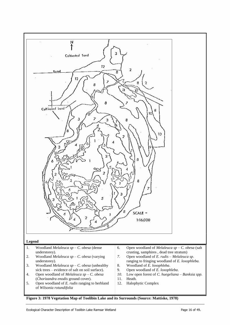
Toolibin Lake is the last, large, Casuarina obesa – dominated wetland, with mostly living trees, in the inland agricultural area of southwest Australia. Wetlands of this type would formally have been widespread, the woodland in most of the other wetlands are degraded or lost due to secondary salinisation associated with the agricultural development of catchments. With the loss of Eucalyptus trees, due to increasing salinity and waterlogging, only two tree species remain on the lake bed; C. obesa and Melaleuca strobophylla (Froend et al. 1996). These species occur in woodlands across the lake bed, often occurring on the raised gilgai mounds. The understorey consists of halophytic species with some annual weeds occurring towards the perimeter of the lake bed. The upland vegetation is highly modified on the western and southern sides due to the construction of a major drain and revegetation of cleared areas with native species. The eastern and northern sides are dominated by woodlands of Eucalyptus loxophleba-Acacia acuminata (Franke et al. 2001) and also include Allocasuarina huegeliana and Banksia prionotes, with some heathland. The fringing woodland around the waterbody consists of Allocasuarina huegeliana, M. uncinata, E. rudis, and Acacia acuminata. E. loxophleba forms an open woodland on higher ground (Mattiske 1978, 1982, Froend 1983, 1996, Franke et al 2001). Some species are no longer present on the lake floor and a current vegetation map is required. A vegetation map was prepared in 1978 (Mattiske, 1978) and although some of the descriptions are obsolete, it provides a useful baseline from which to gain an understanding of the vegetation matrix (Figure 3). In the early 1970‟s, stressed and dead trees were reported in parts of Toolibin Lake when surface salt crusting first became evident (Froend, et al. 1987). Following these observations, vegetation studies were initiated in 1977 with the aim of establishing base-line data for the long term monitoring of the structure and health of the vegetation (Mattiske, 1978). A total of 26 families and 97 species have been recorded on the vegetation monitoring plots on Toolibin Lake and its‟ surrounding reserves (Mattiske, 1993). Even though the vegetation condition has declined (Froend et al. 1997; Ecoscape Australia, 2004), the lake still contains extensive areas of dense vegetation. When the lake is flooded, the healthy thickets and woodlands provide

Ecological Character Description of Toolibin Lake Ramsar Wetland Page 15 of 49.
nesting sites for many waterbirds, protection for young birds from predators and roosting sites and foraging areas for some species with specific habitat requirements. (Halse, 1987). The presence and maintenance of the native vegetation of the lake is paramount for maintaining the abundance and diversity of waterbirds that use the lake.
Ecological Character Description of Toolibin Lake Ramsar Wetland Page 16 of 49.
Legend
1. Woodland Melaleuca sp – C. obesa (dense
understorey).
2. Woodland Melaleuca sp – C. obesa (varying
understorey).
3. Woodland Melaleuca sp – C. obesa (unhealthy
sick trees – evidence of salt on soil surface).
4. Open woodland of Melaleuca sp – C. obesa
(Chorizandra enodis ground cover).
5. Open woodland of E. rudis ranging to herbland
of Wilsonia rotundifolia
6. Open woodland of Melaleuca sp – C. obesa (salt
crusting, samphires , dead tree stratum)
7. Open woodland of E. rudis – Melaleuca sp.
ranging to fringing woodland of E. loxophleba.
8. Woodland of E. loxophleba.
9. Open woodland of E. loxophleba.
10. Low open forest of C. huegeliana – Banksia spp.
11. Heath.
12. Halophytic Complex
Figure 3: 1978 Vegetation Map of Toolibin Lake and its Surrounds (Source: Mattiske, 1978)

Ecological Character Description of Toolibin Lake Ramsar Wetland Page 17 of 49.
iii) Threatened Ecological Community
Toolibin Lake is also listed as a TEC under the Commonwealth‟s Environmental Protections and Biodiversity Conservation Act 1999. Its current threatened status is “Endangered” and the listing is recorded as “Perched wetlands of the Wheatbelt region with extensive stands of living sheoak and paperbark across the lake floor – Toolibin Lake”. The community fits criteria 2 (a), (d) and (e) of Section 6 of the EPBC Act for the following reasons (Endangered Species Scientific Subcommittee, 2000):
1. The community has been reduced in area and number of occurrences by at least 90%;
2. Toolibin Lake is the only remaining large occurrence of the once widespread community, and is threatened by salinisation and waterlogging, due to clearing of the catchment, with the final salinisation inevitable if the water table raised though the lake floor. Without ongoing recovery actions, this would be likely to occur in the near future; and
3. The community is subject to other threats including weed invasion and grazing by native herbivores.
iv) Primary producers and aquatic invertebrates
Aquatic invertebrates provide a major food source for a large number of resident and occasional waterbirds. A total of 52 invertebrate species have been recorded in Toolibin Lake (Halse, et al, 2000). Insects comprised the largest proportion of the invertebrate fauna (65% of species, of which beetles comprised 28% and chironomids 19%), with crustaceans accounting for another 28% (of which 43% were ostracods), annelids 5%, and molluscs 2%. Rotifers were also present. While the species list at Toolibin is larger that at may south-western wetlands, Toolibin has only intermediate value for invertebrate conservation. The most species-rich wetlands in the Wheatbelt region yield about 100 species and 30% of wetlands sampled in a Wheatbelt-wide survey in the late 1990s had more species than recorded at Toolibin Lake. There is little information on the types, distribution and abundance of autotrophs and other primary producers, although algae are readily observed in small ponds on the lake‟s surface after rainfall. This is a knowledge gap and should be a focus of future investigation. Section Five provides further information on the significant biological assets, their key elements and the ecological and hydrological processes that sustain them.
c) Ecosystem Drivers and Features (Step 3)
Biological and ecological components exist because there are processes that enable them to exist. These processes develop and maintain the physical and chemical parameters that in turn allow the biota to survive. In an ecosystem management approach, it is important to identify the underlying system drivers that initiate and maintain the ecological and hydrological processes that support the significant species
Ecological Character Description of Toolibin Lake Ramsar Wetland Page 18 of 49.
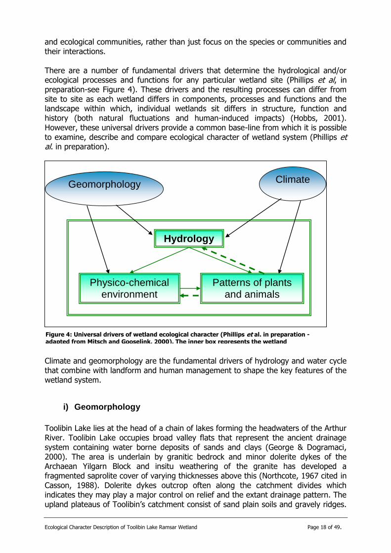
and ecological communities, rather than just focus on the species or communities and their interactions. There are a number of fundamental drivers that determine the hydrological and/or ecological processes and functions for any particular wetland site (Phillips et al, in preparation-see Figure 4). These drivers and the resulting processes can differ from site to site as each wetland differs in components, processes and functions and the landscape within which, individual wetlands sit differs in structure, function and history (both natural fluctuations and human-induced impacts) (Hobbs, 2001). However, these universal drivers provide a common base-line from which it is possible to examine, describe and compare ecological character of wetland system (Phillips et al. in preparation).
Climate and geomorphology are the fundamental drivers of hydrology and water cycle that combine with landform and human management to shape the key features of the wetland system.
i) Geomorphology
Toolibin Lake lies at the head of a chain of lakes forming the headwaters of the Arthur River. Toolibin Lake occupies broad valley flats that represent the ancient drainage system containing water borne deposits of sands and clays (George & Dogramaci, 2000). The area is underlain by granitic bedrock and minor dolerite dykes of the Archaean Yilgarn Block and insitu weathering of the granite has developed a fragmented saprolite cover of varying thicknesses above this (Northcote, 1967 cited in Casson, 1988). Dolerite dykes outcrop often along the catchment divides which indicates they may play a major control on relief and the extant drainage pattern. The upland plateaus of Toolibin‟s catchment consist of sand plain soils and gravely ridges.
Climate
Hydrology
Patterns of plants and animals
Physico-chemical environment
Geomorphology
Figure 4: Universal drivers of wetland ecological character (Phillips et al. in preparation - adapted from Mitsch and Gooselink, 2000). The inner box represents the wetland ecosystem
Ecological Character Description of Toolibin Lake Ramsar Wetland Page 19 of 49.
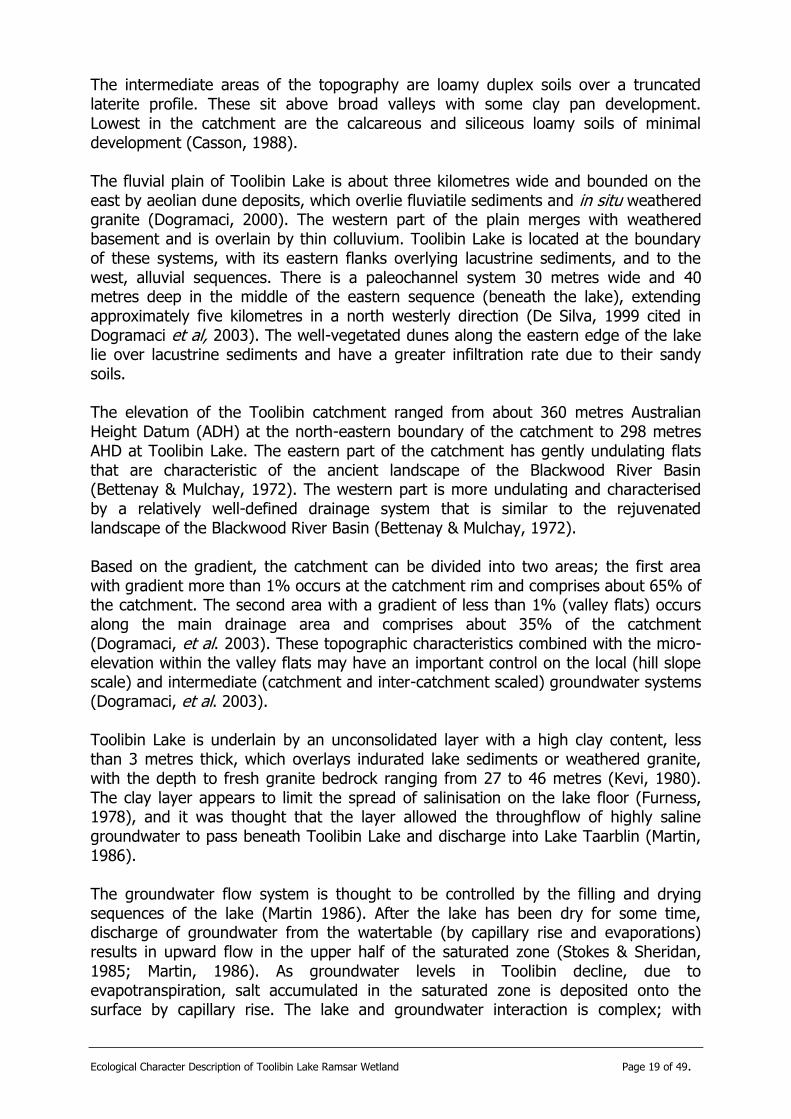
The intermediate areas of the topography are loamy duplex soils over a truncated laterite profile. These sit above broad valleys with some clay pan development. Lowest in the catchment are the calcareous and siliceous loamy soils of minimal development (Casson, 1988). The fluvial plain of Toolibin Lake is about three kilometres wide and bounded on the east by aeolian dune deposits, which overlie fluviatile sediments and in situ weathered granite (Dogramaci, 2000). The western part of the plain merges with weathered basement and is overlain by thin colluvium. Toolibin Lake is located at the boundary of these systems, with its eastern flanks overlying lacustrine sediments, and to the west, alluvial sequences. There is a paleochannel system 30 metres wide and 40 metres deep in the middle of the eastern sequence (beneath the lake), extending approximately five kilometres in a north westerly direction (De Silva, 1999 cited in Dogramaci et al, 2003). The well-vegetated dunes along the eastern edge of the lake lie over lacustrine sediments and have a greater infiltration rate due to their sandy soils. The elevation of the Toolibin catchment ranged from about 360 metres Australian Height Datum (ADH) at the north-eastern boundary of the catchment to 298 metres AHD at Toolibin Lake. The eastern part of the catchment has gently undulating flats that are characteristic of the ancient landscape of the Blackwood River Basin (Bettenay & Mulchay, 1972). The western part is more undulating and characterised by a relatively well-defined drainage system that is similar to the rejuvenated landscape of the Blackwood River Basin (Bettenay & Mulchay, 1972). Based on the gradient, the catchment can be divided into two areas; the first area with gradient more than 1% occurs at the catchment rim and comprises about 65% of the catchment. The second area with a gradient of less than 1% (valley flats) occurs along the main drainage area and comprises about 35% of the catchment (Dogramaci, et al. 2003). These topographic characteristics combined with the micro-elevation within the valley flats may have an important control on the local (hill slope scale) and intermediate (catchment and inter-catchment scaled) groundwater systems (Dogramaci, et al. 2003). Toolibin Lake is underlain by an unconsolidated layer with a high clay content, less than 3 metres thick, which overlays indurated lake sediments or weathered granite, with the depth to fresh granite bedrock ranging from 27 to 46 metres (Kevi, 1980). The clay layer appears to limit the spread of salinisation on the lake floor (Furness, 1978), and it was thought that the layer allowed the throughflow of highly saline groundwater to pass beneath Toolibin Lake and discharge into Lake Taarblin (Martin, 1986). The groundwater flow system is thought to be controlled by the filling and drying sequences of the lake (Martin 1986). After the lake has been dry for some time, discharge of groundwater from the watertable (by capillary rise and evaporations) results in upward flow in the upper half of the saturated zone (Stokes & Sheridan, 1985; Martin, 1986). As groundwater levels in Toolibin decline, due to evapotranspiration, salt accumulated in the saturated zone is deposited onto the surface by capillary rise. The lake and groundwater interaction is complex; with

Ecological Character Description of Toolibin Lake Ramsar Wetland Page 20 of 49.
recharge occurring when the lake fills and discharge occurring when it is dry (Froend & Storey, 1996).
The lake floor is characterised by the presence of gilgai mounds. These are a series of subtle undulations, up to 1.5 metres above the surrounding lake bed, formed by the shrinking and swelling of clay horizons, with alternate wetting and drying cycles. This forces „blocks” of subsoil material gradually upwards to from mounds (Department of Primary Industries, 2005). These mounds provide an increased distance between the soil surface and the saline groundwater, reducing capillary rise and resultant salinisation of surface soil. The microrelief provided by the Gilgai mounds also provides favourable conditions for seedling regeneration in years when the lake floods as they reduce waterlogging (Bowman, et al, 1992).
ii) Climate
Toolibin Lake is a perched wetland relying on surface runoff for filling and as a result its ecology is largely driven by climate (Mitsch, 1996). The wetland occurs in a low rainfall zone, with the average annual rainfall over its catchment (which is approximately 483km2 in area) ranging from 370mm at the lake, to approximately 420mm along the western boundary (Bowman, et al, 1992). The average at the lake is based on records dating back only to the 1970s, whereas other sites have longer periods of recording (P. Lacey, pers com).
Toolibin Lake is ephemeral, only filling in years of above average rainfall. It has been estimated that 6mm of runoff from the catchment is required to fill Toolibin Lake to the point of overflow, which represents a runoff of 1.5% of average rainfall (Stokes and Sheridan, 1985). When full, the lake is about 3 km2 in area and 2 m deep. The lake is relatively flat with several shallow (<1m) depressions or lagoons and gilgai mounds in the centre of the lake. The mounds control circulations at low water levels. Surface water inflow to the lake is from the catchment of the Northern Arthur River (435 km2) to the north and from the smaller catchment (41km2) for the North West Creek in the north west corner of the lake. A diversion channel was constructed along the western boundary of Toolibin Lake in 1994/95 and later a separator to direct saline flows away from Toolibin Lake and back into the river channel further downstream (Froend & Storey 1996).1 Lake outflow, as surface water loss, occurs via an overflow channel to the south of the lake and drains via a series of smaller lakes to Lake Taarblin. It is assumed that both groundwater inflow and outflow may occur to and from the lake. Toolibin Lake also has a drainage pipe which allows some of the saline watr at the end of the season to be drained from the lake floor (P. Lacey, pers. com). Streamflow for the North Arthur River occurs for relatively short periods, with little sustained baseflows. Runoff is generally of short duration, associated with the more intense rainfalls (Stokes & Sheridan, 1985).
Annual rainfall at Wickepin (17 kms to the North West of the lake) during the past 40 years has been gradually decreasing over 4-5 year cycles (Froend & Storey, 1996), a trend that appears likely to continue (IOCI, 2005). This is likely to have significant
1. The 5.5 km channel takes water from the Northern Arthur River, upstream of Toolibin, and diverts it around the lake (also
intercepting the NW Creek flows), to rejoin the rivers downstream of the outflow from Walbyring Lake, therefore protecting both Toolibin and Walybring lakes from saline surface flows.

Ecological Character Description of Toolibin Lake Ramsar Wetland Page 21 of 49.
consequences for the future ecological and hydrological characteristics of Toolibin Lake.
Temperature and evaporation also contribute to driving the system, especially in the modified environment of the Toolibin catchment, as there is a sound relationship between the salinity levels of the lake and evaporation. The average annual evaporation level of the Toolibin catchment is 1900mm (George, 1998). Light and temperature also play an important part in setting the conditions for algae and phytoplankton development (or re-invasion) and maintenance.
iii) Primary Production
Along with the physical drivers of climate and geomorphology, ecological drivers need to be considered. The primary trophic levels of the system are fundamental drivers of the ecological character of Toolibin Lake. The type and abundance of waterbirds and key vegetation species and associations are shaped and maintained by ecological and hydrological processes that are initiated by the key drivers of rainfall (Climate) and soil type and location (Geomorphology). Energy and material flows that occur as part of the primarily production system also need to be included as drivers. Consequently, sunlight provided the energy for phytoplankton/periphyton which have a major influence on the presence of aquatic invertebrates and macrophytes which, inturn, provide energy and material flow to higher trophic levels and provide carbon and organic nutrients back into the system.
A conceptual model (Fig. 5) has been developed after Phillips et al (in preparation) to outline the underlying system drivers, the ecological and hydrological process they initiate and the special flora, fauna and ecological communities they, in turn, maintain.

Ecological Character Description of Toolibin Lake Ramsar Wetland Page 22 of 49.
Figure 5: Simplified conceptual model of Toolibin Lake.
Lak
e/G
roundw
ater
inte
ract
ions
Species Interactions
Trophic Interactions Herbivory
Predator/Prey Competition
Primary Production (Trophic)
Energy flows
Material flows
SYSTEM
DRIVERS
ECOLOGICAL and
HYDROLOGICAL
FEATURES and PROCESSES
SIGNIFICANT
BIOLOGICAL
ASSETS
Hydrological
Surface water inflows/ outflows
Water quality (salinity/
nutrients Rainwater ponding
Lake morphology Depth/ Volume
Hydroperiod Rain ponding on lake
floor
Surface Hydrology
Hydrogeology
Groundwater Flow
Levels quality
Geology Gilgai mounds
Clay layers Soil salinity
Ecological
Biota Maintenance
Diversity of habitats
Reproduction Seed store
Hydro-period Nesting sites
Immigration
Adjacent fw lakes Dispersal
Surface water flows/ ponds
Migration Migration routes
Adjacent fw lakes
Energy/Nutrient Dynamics
Primary production
Nutrient cycling Decomposition
Carbon cycling
Waterbirds
Native Vegetation
Threatened Ecological Community
Phytoplankton/ periphyton, Algal mats, Invertebrates.
Geomorphology
Landforms
Gilgai mounds
Climate
Rainfall
Temperature/ Evaporation
Insolation
Ecological Character Description of Toolibin Lake Ramsar Wetland Page 23 of 49.
4) Significant biological assets and their related ecological-hydrological processes
Section 3.b outlined the significant biological assets (SBAs) of the Toolibin Lake site. The following tables provide further details on the SBA and more specific details on the ecological and hydrological processes that sustain them. As the Ramsar definition of ecological character refers to the physical, chemical and biological elements of a wetland, details on the processes are split into these categories. The relevant ecological and/or hydrological process from Table 2, are stated after each element.
a) Significant Biological Asset 1: Waterbirds
Significant biological asset 1: Waterbirds
Description: More species were recorded breeding in Toolibin Lake than in any other of the 251 wetlands examined by RAOU (now Birds Australia) (Jaensch et al. 1988). More than 60 surveys of its waterbirds were conducted between 1965-1996, during which a total of 50 waterbird species were recorded, 25 of which were observed breeding (Froend & Storey, 1996; Froend et al, 1997; Halse et al. 2000). In particular, Toolibin Lake is important as a breeding area for Freckled Ducks Stictonetta naevosa and for large wading birds such as herons, egrets and spoonbills. Table 2, below, outlines the species occurrence, status, and numbers for the species recorded at Toolibin in the RAOU surveys. Trend: A general trend of increasing salinity and decreasing number of species of waterbirds utilising Toolibin Lake, with reductions in numbers of certain species since pre-1980 is reported (Froend & Storey 1996). The quality of breeding data prevents conclusive support for the suggested reduction in breeding activity
Recovery Plan Success Criterion The Toolibin Lake Recovery Plan ((Bowman, Bishaw, Gorham et al, 1992) outlines biological criteria on which to base a measure of success of their intended recovery actions. One such criterion refers to waterbirds:
RP 4. The numbers and species of waterbird visitation (41 species) and breeding success (24 species) that currently occurs is maintained or improved.
Evaluation of Criteria The recovery plan was reviewed in 2004 (Wyland & Lacey, 2004). The extended dry period, with only a partial filling in 1994 and 1996 of the lake makes the assessment of waterbird numbers and species difficult to evaluate. There is a strong relationship between waterbird usage and lake filling, consequently it is difficult to determine the numbers and species of visiting birds until a flooding event occurs again. Given an anticipated reduction in species due to the changing landscape, it is suggested that this criterion be reviewed to as part of the new recovery planning process. Range of variability The numbers and species of waterbirds using a wetland fluctuate seasonally and annually according to wetland conditions (Halse et al, 2000). Monitoring of waterbird usage needs to be undertaken using a standardised survey method that associates

Ecological Character Description of Toolibin Lake Ramsar Wetland Page 24 of 49.
information on water levels, salinity and vegetation condition (Froend & Storey, 1996). The recovery plan criterion is quantitative and can be measured against a known parameter (visitation numbers and breeding number), however this would only be valid for years when water is present. It can be assumed that there would be no waterbird breeding activity at Toolibin Lake when water is absent, the range for breeding numbers would therefore vary between 0 and 25 (the highest number observed – Froend & Storey, 1996). To determine the range of variability, detailed analysis of breeding lists of past surveys needs be conducted and criteria set for numbers that should be recorded in any one year. This could be expresses as the expected average over a period of years (S. Halse pers. com). A 1996 survey in December 1996 found 20 species of waterbirds and concluded that this figure reflected the high waterbird conservation value of Toolibin Lake (Halse, et al, 2000). Note that water was present in the wetland in 1996. The average richness in September/October in the early 1980s was just under 20 species. Therefore, if the average number of birds recorded in spring surveys over a period of years remains at this level, it could be said that the waterbird conservation value has remained stable (assuming no gross change in species composition) (S. Halse pers. com). Interim limits of acceptable change Breeding numbers – (only when water present) – 18-25. Visitation numbers – (only when water present) 20. Note that this needs to be considered in association with water depth and quality and seasonality. NOTE: There should be consideration to monitor the waterbird numbers and breeding activity of Lake Walbyring as well as Toolibin. Although it is not part of the Ramsar site, the monitoring of waterbirds in the lake may provide useful data on waterbird activity in the surrounding landscape, for those years when Toolibin is dry.
i) Key ecological and hydrological processes for sustaining waterbirds at Toolibin Lake
Biological: (Biota Maintenance; Energy/Nutrient Dynamics)
Diversity of habitats – extensive dense thickets of vegetation Adequacy of breeding sites – nesting guilds Presence of food sources – feeding guilds
Chemical (Surface Hydrology; Hydrogeology)
Water quality - salinity Water quality – nutrients
Physical (Surface Hydrology; Biota Maintenance)
Hydro-period – occasional drying facilitates the persistence of vegetation and probably increases the wetland‟s productivity.
Proximity of adjacent freshwater/brackish lakes – esp Lake Walbyring

Ecological Character Description of Toolibin Lake Ramsar Wetland Page 25 of 49.
Element Description
Biological:
Diversity of Habitats The diversity and quality of habitats for waterbirds affects the number of
waterbirds and breeding activities (Goodsell, et al, 1978; Casson, 1988; Halse, 1987). Live vegetation in the lake is required for suitable nesting
sites. Extensive dense thickets of Casuarina obesa and Melaleuca spp through much of the inundated area provide important shelter for breeding,
roosting sites, protection from predators and habitat for aquatic
invertebrates and other food sources. The health and vigour of the lake‟s vegetation is required for the maintenance of waterbirds, as is the
maintenance of the suitable water quality (for instance, fresh to brackish salinity) in the lake.
Adequacy of breeding sites
Four nesting guilds exist, based on the usual location of their nests (Table 3
after Halse 1987). Nine species nest in trees over water, several using only live trees (see vegetation section below). Two species build nests of sticks
under the cover of trees. Two species nest in dense rushed or grass. Four species nest in tree hollows, often some distance from water and five
species build open nest that are either floating or made of sticks built up
from the bottom of the lake. Live vegetation in the lake is of paramount importance in providing suitable nesting sites for most of the species
breeding there.
Presence of food sources
Eight feeding guilds have been identified (Table 4 after Halse, 1987). Almost 50 percent of the species and over 90% of the individuals are
„swimming‟ birds that obtain food principally by dabbling or diving. The dabbling species generally have a mixed diet of plants and animals,
although Black swans are almost completely vegetarian and Pink-eared
Ducks and Australasian Shovelers feed mostly on invertebrates (Frith 1977; Briggs et al 1985). In shallow water, dabbling birds feed by submerging
their bill, or head and neck, or by upending. In deeper water, they feed only on the surface, either by filtering or by pecking at floating plant material
and animals (Frith 1977). The diving species probably prefer water at least 1 m deep, although little
information is available on this aspect of their biology. The data from
Toolibin show that water depth has little effect on numbers of diving birds when the lake contains 1 m or more water, but that numbers decline
rapidly, and most species are absent, when it contains less. Waterbirds feed throughout the lake and around its margin, eating
principally invertebrates, small vertebrates (fish and frogs), algae, aquatic
macrophytes, and vegetation on the mudflats surrounding the lake. Individual species eat a comparatively narrow range of food items (Halse,
1987). The maintenance of phytoplankton/periphyton, aquatic macroinvertebrates and macrophytes are important elements that endure
waterbird abundance and breeding are sustained, hence their identification as significant biological assets (see below).
Chemical:
Water quality - salinity
For the first week or so after hatching, young birds must have freshwater to drink. This is because their salt glands are not developed and the birds will
be unable to regulate salt intake (Halse, 1987). Toolibin lake is the only natural wetland of its size in the Avon-Wheatbelt bioregion that has not
become saline due to rising saline groundwater tables, consequently it is an
important habitat for waterbird breeding within the Wheatbelt region (Ramsar Information Sheet, 2003). A thin (~3m) clay layer acts as a
barrier, possibly preventing the deep, highly saline groundwater from leaking into the lake (Furness, 1978). Minor discharge does occur (primarily
by capillary rise and evaporation) (Martin, 1986). Water salinity within the
lake is caused by the input of salt from the salinised agricultural catchment (Stokes & Sheridan, 1985; Dogramaci et al, 2003). Watertable rise within

Ecological Character Description of Toolibin Lake Ramsar Wetland Page 26 of 49.
the lake is, at least, as important as the influx of saline surface water in degrading the lake environment (Martin, 1990). With the establishment of
the diversion channel and separator, saline surface flows are diverted away from Toolibin Lake. The current level is set at 1000mg/L after which a
value judgement is made depending on water quality, time of the year and
the quality of the water upstream (P. Lacey, pers. comm.). As such, only „fresh‟ water is allowed to flow into the lake (Bowra & Wallace, 1996).
Groundwater salinities within the catchment are high, reaching values of 60,000 mg/L TDS at the bores in Toolibin Lake (Martin, 1986). After
clearing of the catchment, elevation of watertables and prolonged dry
periods, the discharge of saline groundwater to the lake when the lake is dry, has become more frequent (Froend & Storey, 1996). A dewatering
programme to lower groundwater levels under the lake was suggested as early as 1987 (NARWRC, 1987). After a number of investigations (Martin,
1986, 1990; GHD, 1992; George & Bennett, 1995), a groundwater pumping programme began operation in March 1997, with the instillation of 6 pumps
on the western side of the lake, in addition to two existing trial pumps
(Smith & Wallace, 1998). Another was commissioned in 2000 and since then one of the original pumps has been decommissioned (Wyland & Lacey,
2004). The pump field produces an average of 230 kilolitres (KL) of groundwater per day, which is disposed of in Taarblin Lake. Three
additional pumps that were commissioned in July 2001 are situated in the
proximity of the paleochannel on the eastern side of the lake. This raised the total groundwater production from the lake to approximately 700 KL per
day (Wyland & Lacey, 2004). Low rainfall in recent years has made the evaluation of pumping more complex. However, engineering reports
indicate that the pumping is reducing the groundwater levels, particularly in the western area. The eastern area drawdown is observed, but at a much
slower rate (Dogramaci et al, 2003). Both the diversion and pumping are
major management interventions designed to sustain the salinity of the water within the lake to less than 1000 mg/L TDS when it is full (Bowman
Bishaw Gorham et al, 1994). There is concern, however, that due to the lack of above average rainfall for many years, that the lakes surface salinity
is high, as it has not been flushed since the last overflow event (1992).
Ideally a filling event is needed to carry this salt down the system.
Water quality – nutrients
Most nutrients (N & P) will enter the lake in particulate form, associated
with suspended sediment, however as the gradient and rainfall in the upper catchment of Toolibin Lake are relatively low, the potential for erosion and
flushing of nutrients into the wetland is low (Froend & Storey, 1996). The Toolibin Lake recovery plan has a success criterion aiming to ensure that
the total phosphorus levels not to exceed 100mg/L (Physical Criterion 5 – Bowman Bishaw Gorham et al, 1994). (Note that this figure is probably
incorrect and should be in µg/L thatn mg/L) Monitoring between 1991 and
1996 showed that all water samples recorded less than 0.3 mg/L (µg/L??). This level need to be reassessed as the default trigger valued for stressors
causing algal problems in slightly disturbed ecosystems in freshwater lakes and reservoirs is 10 µg/L (ANZECC/ARMCANZ, 2000)
However, algal blooms and bird deaths due to botulism have been observed
suggesting elevated nutrient conditions in the water column possibly as a result of reduced P sorption capacity (P saturation of surface soil) and re-
release into the water column. One botulism outbreak at Toolibin Lake, in March 1993, caused the death of 450 birds. Extensive crusting of algae has
also smothered Casuarina obesa seedlings between 1986 and 1992, contributing to the death of these seedlings (Wyland & Lacey, 2004).
Physical:
Flooding/drying regime Hydroperiod
Since 1978, there has been little substantial flow to Toolibin Lake. In only
five of the past twenty seven years (1981, 1983, 1990 and 1992, 1996) has the lake received substantial inflow and only three (1983, 1990 and 1992)
of which resulted in outflow events (Froend & Storey, 1996; Wyland &
Ecological Character Description of Toolibin Lake Ramsar Wetland Page 27 of 49.
Lacey, 2004) For the period 1978 to 1996, the lake bed dried out nine times, or
approximately once in every two years. Since implementation of the Recovery Plan began in 1992 the lake bed dried out in 1994, 1995, 1997
and 1998, or four out of seven years (Wyland & Lacey, 2004). Significant
changes in the composition of numbers or species of waterbirds have not been reported (Halse, 2000).
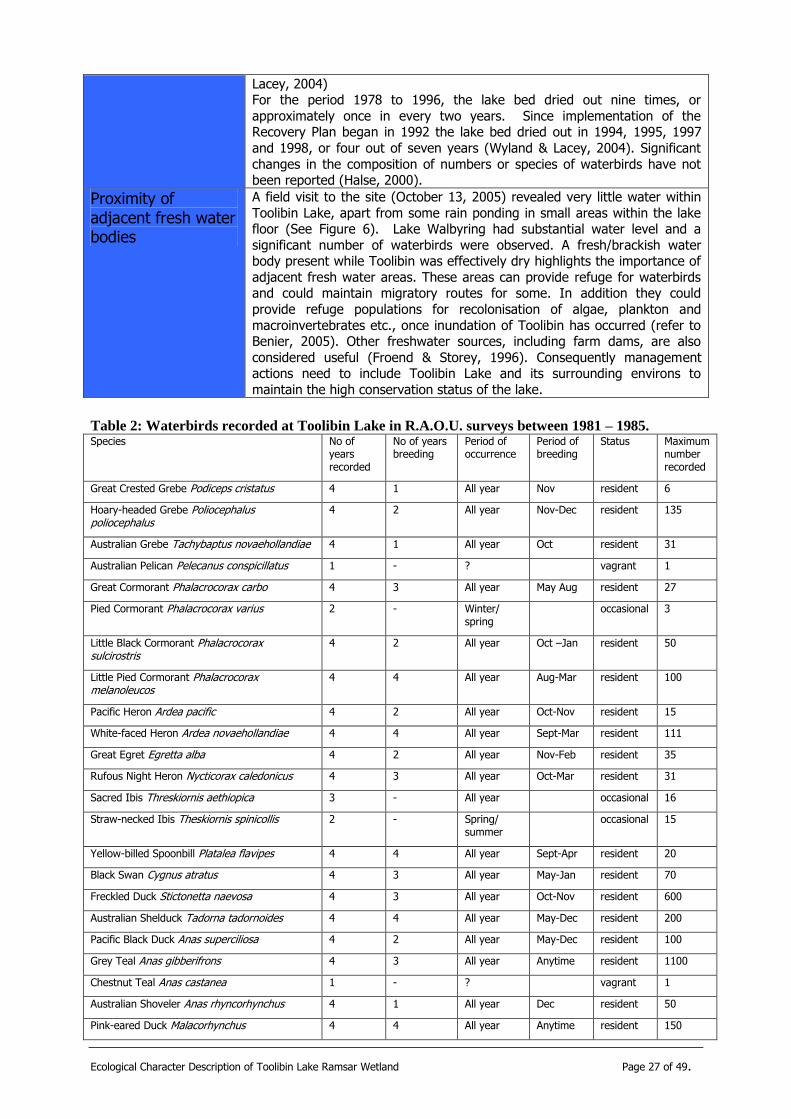
Proximity of adjacent fresh water bodies
A field visit to the site (October 13, 2005) revealed very little water within
Toolibin Lake, apart from some rain ponding in small areas within the lake floor (See Figure 6). Lake Walbyring had substantial water level and a
significant number of waterbirds were observed. A fresh/brackish water body present while Toolibin was effectively dry highlights the importance of
adjacent fresh water areas. These areas can provide refuge for waterbirds and could maintain migratory routes for some. In addition they could
provide refuge populations for recolonisation of algae, plankton and
macroinvertebrates etc., once inundation of Toolibin has occurred (refer to Benier, 2005). Other freshwater sources, including farm dams, are also
considered useful (Froend & Storey, 1996). Consequently management actions need to include Toolibin Lake and its surrounding environs to
maintain the high conservation status of the lake.
Table 2: Waterbirds recorded at Toolibin Lake in R.A.O.U. surveys between 1981 – 1985. Species No of
years recorded
No of years breeding
Period of occurrence
Period of breeding
Status Maximum number recorded
Great Crested Grebe Podiceps cristatus 4 1 All year Nov resident 6
Hoary-headed Grebe Poliocephalus poliocephalus
4 2 All year Nov-Dec resident 135
Australian Grebe Tachybaptus novaehollandiae 4 1 All year Oct resident 31
Australian Pelican Pelecanus conspicillatus 1 - ? vagrant 1
Great Cormorant Phalacrocorax carbo 4 3 All year May Aug resident 27
Pied Cormorant Phalacrocorax varius 2 - Winter/ spring
occasional 3
Little Black Cormorant Phalacrocorax sulcirostris
4 2 All year Oct –Jan resident 50
Little Pied Cormorant Phalacrocorax melanoleucos
4 4 All year Aug-Mar resident 100
Pacific Heron Ardea pacific 4 2 All year Oct-Nov resident 15
White-faced Heron Ardea novaehollandiae 4 4 All year Sept-Mar resident 111
Great Egret Egretta alba 4 2 All year Nov-Feb resident 35
Rufous Night Heron Nycticorax caledonicus 4 3 All year Oct-Mar resident 31
Sacred Ibis Threskiornis aethiopica 3 - All year occasional 16
Straw-necked Ibis Theskiornis spinicollis 2 - Spring/ summer
occasional 15
Yellow-billed Spoonbill Platalea flavipes 4 4 All year Sept-Apr resident 20
Black Swan Cygnus atratus 4 3 All year May-Jan resident 70
Freckled Duck Stictonetta naevosa 4 3 All year Oct-Nov resident 600
Australian Shelduck Tadorna tadornoides 4 4 All year May-Dec resident 200
Pacific Black Duck Anas superciliosa 4 2 All year May-Dec resident 100
Grey Teal Anas gibberifrons 4 3 All year Anytime resident 1100
Chestnut Teal Anas castanea 1 - ? vagrant 1
Australian Shoveler Anas rhyncorhynchus 4 1 All year Dec resident 50
Pink-eared Duck Malacorhynchus 4 4 All year Anytime resident 150

Ecological Character Description of Toolibin Lake Ramsar Wetland Page 28 of 49.
membranaceus
Hardhead Aythya australis 4 - All year resident 275
Maned Duck Chenonetta jubata 4 1 All year Dec resident 91
Blue-billed Duck Oxyura australis 4 2 All year Mar-July resident 15
Musk Duck Biziura lobata 4 3 All year Apr-Dec resident 10
Marsh Harrier Circus aeruginosus 3 - All year resident 2
Black-tailed Native-hen Gallinula ventralis 1 - ? vagrant 1
Purple Swamphen Porphyrio porphyrio 1 - ? vagrant 1
Eurasian Coot Fulica atra 4 4 All year Sept-Jan resident 370
Red-kneed Dotterel Erythrogonys cinctus 1 - ? vagrant 1
Oriental Plover Charadrius veredus 1 - Summer vagrant 1
Red-capped Plover Charandrius ruficapillus 1 - Summer vagrant 19
Black-fronted Plover Charandrius melanops 2 - ? vagrant 3
Black-winged Stilt Himantopus himantopus 1 - ? vagrant 41
Banded Stilt Cladorhynchus leucocephalus 1 - ? vagrant 3
Greenshank Tringa nebularia 1 - Summer vagrant 1
Sharp-tailed Sandpiper Calidris acuminata 1 - Summer vagrant 2
Silver Gull Larus navaehollandiae 1 - ? vagrant 1
Whiskered Tern Chlidonias hybrida 1 - ? vagrant 1
TABLE 3: Nesting Guilds of Waterbirds at Toolibin Lake (data from Readers’ Digest 1976;
Seventy & Whittell 1976; Frith 1977; NPIAW 1985; RP Jaensch pers omm.. (from RAOU)
cited in Halse, 1987)
Guild Species
Floating or anchored nest of rushes, aquatic
macrophytes or sticks on water
Great Crested Grebe, Hoary-headed Grebe,
Australasian Grebe, Black Swan, Eurasian Coot.
Nest of sticks in, or under cover of, tree over
water.
Great Cormorant, Little Black Cormorant, Little
Pied Cormorant, Pacific Heron, White-faced Heron,
Great Egret, Rufous Night Heron, Yellow-billed Spoonbill, Freckled Duck, Blue-billed Duck, Musk
Duck.
Nest in tree hollow Australian Shelduck, Grey Teal, Pink-eared Duck, Maned Duck.
Nest on ground in grass or rushes Pacific Black Duck, Australasian Shoveler.
Table 4: Feeding Guilds of Waterbirds at Toolibin Lake (data from Readers Digest 1976;
Severnty & Whittell 1976, NPIAW, 1985; cited in Halse, 1987) Guild Species
Dabblers – mixed diet Black Swan, Freckled Duck, Australian Shelduck,
Pacific Black Duck, Grey Teal, Chestnut Teal, Australasian Shoveler, Pink-eared Duck, Hardhead
Divers – animals Great Crested Grebe, Hoary-headed Grebe, Australasian Grebe, Australian Pelican2, Great
Cormorant, Pied Cormorant, Little Black
2 Does not dive for food but shares many habitats with other birds in this guild.

Ecological Character Description of Toolibin Lake Ramsar Wetland Page 29 of 49.
Cormorant, Little Pied Cormorant.
Divers – vegetation Blue-billed Duck3, Musk Duck3, Eurasian Coot.
Large waders – animals Pacific Heron, White-faced Heron, Great Egret,
Rufous Night Heron, Yellow-Billed Spoonbill.
Small waders – invertebrates Red-kneed Dotterel, Oriental Plover, Red-capped
Plover, Black-fronted Plover, Black-winged Stilt, Banded Stilt, Greenshank, Shark-tailed Sandpiper.
Shore feeders – animals Sacred Ibis, Straw-necked Ibis, Silver Gull.
Shore feeders – vegetation Maned Duck, Black-tailed Native Hen, Purple
Swamphen
Aerial feeders – animals Marsh Harrier, Whiskered Tern.
Figure 6: Water ponding on the lake floor.
3
Diet contains significant proportion of animals.
Ecological Character Description of Toolibin Lake Ramsar Wetland Page 30 of 49.
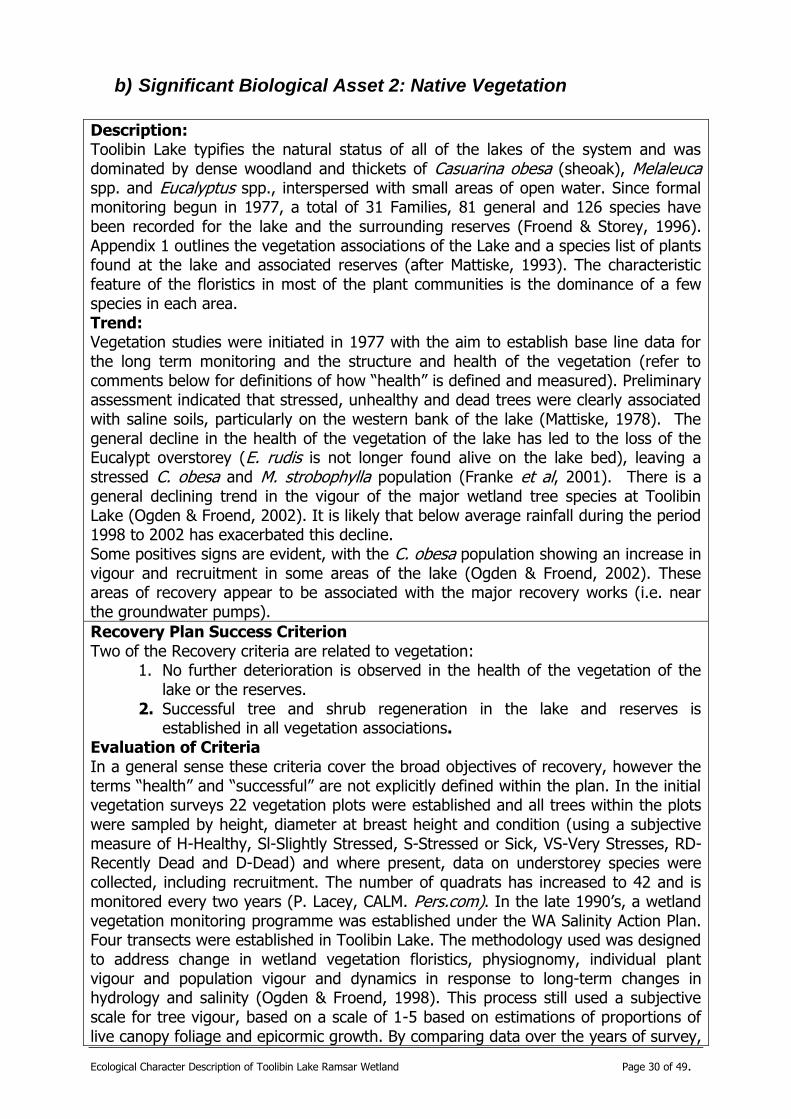
b) Significant Biological Asset 2: Native Vegetation
Description: Toolibin Lake typifies the natural status of all of the lakes of the system and was dominated by dense woodland and thickets of Casuarina obesa (sheoak), Melaleuca spp. and Eucalyptus spp., interspersed with small areas of open water. Since formal monitoring begun in 1977, a total of 31 Families, 81 general and 126 species have been recorded for the lake and the surrounding reserves (Froend & Storey, 1996). Appendix 1 outlines the vegetation associations of the Lake and a species list of plants found at the lake and associated reserves (after Mattiske, 1993). The characteristic feature of the floristics in most of the plant communities is the dominance of a few species in each area. Trend: Vegetation studies were initiated in 1977 with the aim to establish base line data for the long term monitoring and the structure and health of the vegetation (refer to comments below for definitions of how “health” is defined and measured). Preliminary assessment indicated that stressed, unhealthy and dead trees were clearly associated with saline soils, particularly on the western bank of the lake (Mattiske, 1978). The general decline in the health of the vegetation of the lake has led to the loss of the Eucalypt overstorey (E. rudis is not longer found alive on the lake bed), leaving a stressed C. obesa and M. strobophylla population (Franke et al, 2001). There is a general declining trend in the vigour of the major wetland tree species at Toolibin Lake (Ogden & Froend, 2002). It is likely that below average rainfall during the period 1998 to 2002 has exacerbated this decline. Some positives signs are evident, with the C. obesa population showing an increase in vigour and recruitment in some areas of the lake (Ogden & Froend, 2002). These areas of recovery appear to be associated with the major recovery works (i.e. near the groundwater pumps).
Recovery Plan Success Criterion Two of the Recovery criteria are related to vegetation:
1. No further deterioration is observed in the health of the vegetation of the lake or the reserves.
2. Successful tree and shrub regeneration in the lake and reserves is established in all vegetation associations.
Evaluation of Criteria In a general sense these criteria cover the broad objectives of recovery, however the terms “health” and “successful” are not explicitly defined within the plan. In the initial vegetation surveys 22 vegetation plots were established and all trees within the plots were sampled by height, diameter at breast height and condition (using a subjective measure of H-Healthy, Sl-Slightly Stressed, S-Stressed or Sick, VS-Very Stresses, RD-Recently Dead and D-Dead) and where present, data on understorey species were collected, including recruitment. The number of quadrats has increased to 42 and is monitored every two years (P. Lacey, CALM. Pers.com). In the late 1990‟s, a wetland vegetation monitoring programme was established under the WA Salinity Action Plan. Four transects were established in Toolibin Lake. The methodology used was designed to address change in wetland vegetation floristics, physiognomy, individual plant vigour and population vigour and dynamics in response to long-term changes in hydrology and salinity (Ogden & Froend, 1998). This process still used a subjective scale for tree vigour, based on a scale of 1-5 based on estimations of proportions of live canopy foliage and epicormic growth. By comparing data over the years of survey,

Ecological Character Description of Toolibin Lake Ramsar Wetland Page 31 of 49.
trends of vegetation “health” are determined. Both these methodologies can be replicated. While individual plots or transects can be compared, it is unclear how changes within them, at their discrete spatial scale, can be combined into an individual assessment of the complete wetland system. Time series analysis of vegetation composition would highlight important trends and the use of techniques such as arithmetic averaging and ordination could highlight changes in the plot and transect data. With the current data and analysis, there is general decline in the “health” of the major wetland tree species at Toolibin Lake (Ogden & Froend 2002). This is particularly the case with M. strobophylla, whose population has declined continuously since 1977. Of the original 111 live trees assessed in 1977, only 29 remained in 2002and only 18 survived in 2004. Of these 18, only two were assessed as “healthy” (Ecoscape, 2005). Range of variability There are significant levels of natural variability of vegetation within the Toolibin Lake area making the determination of baselines or levels/limits of acceptable change particularly difficult. The dynamics of the wetland and its surrounding landscape have been altered significantly with rising groundwater, increasing salinisation and significant management interventions. The changing climate and in particular rainfall events makes predictions difficult. While the range of variability may not be determined, it is important to establish threshold limits or parameters that, once reached, will trigger specific conservation actions to maintain the vegetation values. Given the lack of analysis, prescribing those threshold limits, within this report, was not considered. There are, however, substantial data available for analysis from which thresholds or limits could be extrapolated. The following suggested factors would provide useful initial indicators of vegetation condition until more rigorous parameters are determined. These include: Extent, density and foliage cover of M. strobophylla – the maintenance of the mixed C. obesa / M. strobophylla woodland is a high priority because of its uniqueness (hence TEC status- refer 4 c), below). If the current trend of mortality of M. strobophylla continues, the community will gradually change to degraded C. obesa woodland. The extent and spread of samphire communities – these are indicators of higher soil salinities, a growing spread of this community type suggests a worsening of the situation.
“Successful” recruitment also needs to be defined for those species on the lake bed. This should include recruitment that occurs naturally and that assisted by management actions. “Successful” recruitment could also be quantified as occurring in two phases a) survival beyond 5 years since establishment, and b) recruits reaching reproductive maturity (Froend & Storey, 1996). The vegetation monitoring report for 2004 (Ecoscape, 2005) has used the data since 1977 to establish and graph species trends for “health”, abundance and distribution. Detailed analysis of this, waterlevel and salinity data could be used to determine suitable ranges of the natural variability of the native vegetation of the Toolibin Lake system. However there is a lack of understanding of the interaction between vegetation and groundwater and further research into this is required.

Ecological Character Description of Toolibin Lake Ramsar Wetland Page 32 of 49.
i) Key ecological and hydrological processes for sustaining native vegetation at Toolibin Lake
Biological: (Biota Maintenance; Species Interactions)
Recruitment o Flowering o Pollinators o Seed set
Predation/Herbivory
Chemical (Surface Hydrology; Hydrogeology)
Fresh/brackish water Soil salinity
Physical (Surface Hydrology; Hydrogeology)
Flooding regime/hydro-period Gilgai mounds
Element Description
Biological:
Recruitment Recruitment of Casuarina obesa seedlings on the floor of Toolibin Lake is dependent on specific conditions being met (Froend & Storey, 1996). Key
parameters considered to influence the potential for seedling recruitment and successful seedling establishment are summarised in Table 5 (from
Mattiske and Froend 1993). The frequency of successful recruitment may
also change with alteration of the set of conditions required for seedling establishment. The diversion of high salt flows, the groundwater pumping
and the level of salts on the lake floor from the lack of flushing are likely to alter the frequency of recruitment opportunities. There is substantial
recruitment and seedling establishment of C. obesa at Toolibin Lake around
Pump 9 on the western section of the lake bed. Seed germination and seedling establishment is continuing at this site (Ogden & Froend 2002).
Groundwater pumping at this site commenced (as a trial) in 1989 and the site has comparatively low soil salinities. Successful recruitment and
seedling establishment around pump 9 is an encouraging sign for the longer
term persistence of the C. obesa population as the groundwater pumps take effect (Ogden & Froend 2002).
There is also substantial recruitment and seedling establishment of Melaleuca strobophylla in the north east corner of Toolibin Lake and
elsewhwere on the lake floor. The recovery of many mature trees of c. obesa around Pump 9 is encouraging, although the continued decline in
may other areas is an area of concern.
Herbivory A potential cause of seedling death is grazing by rabbits and kangaroos
(Mattiske 1993). Grazing has stunted seedling growth, reducing their vigour and survival ability. Three fences have been constructed around areas of C. obesa recruitment on the floor of Toolibin Lake. These fences have been designed to provide temporary protection (1-5 years) from grazing. Four
additional fences have been erected to protect planted seedlings. Recruitment and growth of seedlings around Pump 9 (P9) has continued
without fencing. The density of seedlings around P9 appears to offer some
protection from grazing.
Monitoring the kangaroo population within the Nature Reserve is an
ongoing project. In previous years, some neighbouring landholders have

Ecological Character Description of Toolibin Lake Ramsar Wetland Page 33 of 49.
applied for damage licences to reduce crop damage from Kangaroo grazing.
Rabbit control is an annual activity. The Reserve is baited with one shot
1080 oats between the months of February and April.
Chemical:
fresh/brackish water Since 1978, there has been little substantial flow to Toolibin Lake. In only five of the past twenty seven years (1981, 1983, 1990 and 1992, 1996) has
the lake received substantial inflow and only three (1983, 1990 and 1992) of which resulted in outflow events (Froend & Storey, 1996; Wyland &
Lacey, 2004). The flushing of lake stored salt has become an issue with
increasingly saline inflows and rising saline groundwater. This has implications for vegetation health, as there has been a lack of
flushing of accumulated salts on the lake floor. Surveys in 2004 confirmed that soil salinities remain high across most of the lake‟s floor (Geoforce,
2004).
Soil salinity The main factor causing tree death is topsoil salting due to groundwater capillary rise during dry periods which exposes shallow roots to high soil
osmotic potentials, particularly when leaching and diluting of surface salts during winter inflow does not occur, i.e. when the lake does not overflow
(Froend et al, 1987). The interaction of waterlogging and salinity is
responsible for some vegetation loss. The continued accumulation of salt in the surface soils of the lake bed will lead to further tree mortality (Froend &
Storey, 1996). Samphires on the lake bed are indicators of higher soil salinities. Further spread of this community type suggests a worsening of
this situation.
Soil salinities have slightly decreased along fixed transects, since 1997 (2001 salinities ranged from 18-744 mS/cm, which is a small decline from
the 1997 figures of 28 -794 mS/cm in similar locations) (Franke et al, 2001). Soil salinities remain high across the majority of the floor of the lake,
despite a lowering of the saline groundwater table (Geoforce, 2004). These salts are likely to have a deleterious affect on vegetation health until they
are leached down through the soil profile. Significant leaching of salts is
expected when Toolibin Lake next fills.
Physical:
Flooding regime/ hydro-period
As with 5a, above.
Significant flooding events stimulate mass germination and establishment of seedlings. Large flooding events do not occur frequently in consecutive
years, therefore the following winters usually brings low water levels that do
not totally submerge the young seedlings. Prolonged deep flooding soon after the seedlings have established has led to complete mortality (Froend &
Storey, 1996). The flooding regime at the time of seed dispersal, germination and seedling establishment are important, however the degree
of water available to the parent trees prior to and/or during flowering may
determine the amount and viability of seed produced (Froend & Storey, 1996).
Gilgai mounds
Much of the healthy vegetation in the lake is located on raised gilgai mounds (Casson, 1988). Gilgai mounds allow phreatophytic trees (those
that are adapted to extracting water from the water table) to root above
the saline water and protect other vegetation from inundation. Soil salinity is also reduced on the gilgai mounds (Franke, et al, 2001). Significant
flooding events stimulate mass germination and establishment of seedlings which have kept the gilgai mounds moist into autumn, giving the seedlings
sufficient moisture during periods of higher temperatures.
The sedge, Chorizandra enodis was noted in the 1990s on some of the gilgai mounds (Mattiske, 1993). Its presence varied considerably in density
and appeared to be dependant on the mounds for protection from prolonged inundation and higher soil salinities. This sedge has not been
recorded in the past 8 years and may no longer exist on the lake floor (P. Lacey, pers. com).
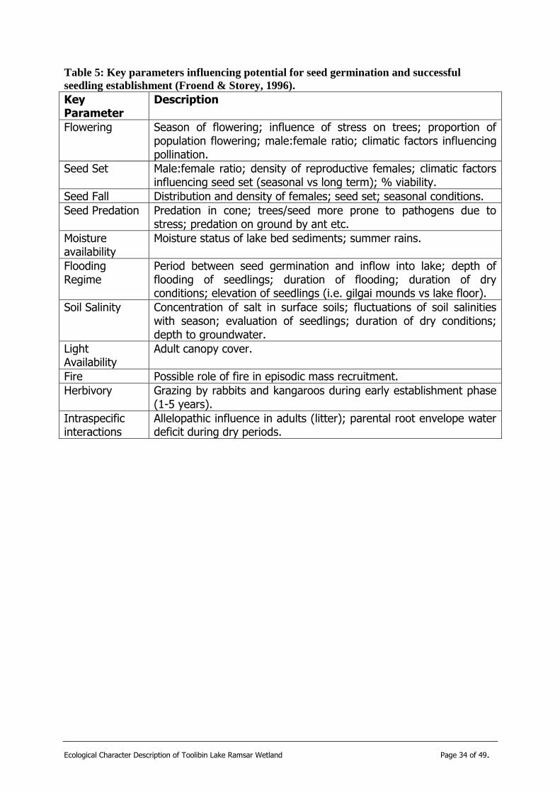
Ecological Character Description of Toolibin Lake Ramsar Wetland Page 34 of 49.
Table 5: Key parameters influencing potential for seed germination and successful
seedling establishment (Froend & Storey, 1996).
Key Parameter
Description
Flowering Season of flowering; influence of stress on trees; proportion of population flowering; male:female ratio; climatic factors influencing pollination.
Seed Set Male:female ratio; density of reproductive females; climatic factors influencing seed set (seasonal vs long term); % viability.
Seed Fall Distribution and density of females; seed set; seasonal conditions.
Seed Predation Predation in cone; trees/seed more prone to pathogens due to stress; predation on ground by ant etc.
Moisture availability
Moisture status of lake bed sediments; summer rains.
Flooding Regime
Period between seed germination and inflow into lake; depth of flooding of seedlings; duration of flooding; duration of dry conditions; elevation of seedlings (i.e. gilgai mounds vs lake floor).
Soil Salinity Concentration of salt in surface soils; fluctuations of soil salinities with season; evaluation of seedlings; duration of dry conditions; depth to groundwater.
Light Availability
Adult canopy cover.
Fire Possible role of fire in episodic mass recruitment.
Herbivory Grazing by rabbits and kangaroos during early establishment phase (1-5 years).
Intraspecific interactions
Allelopathic influence in adults (litter); parental root envelope water deficit during dry periods.

Ecological Character Description of Toolibin Lake Ramsar Wetland Page 35 of 49.
c) Significant Biological Asset 3: Threatened Ecological Community
Significant biological asset 3: Threatened Ecological Community
Description: Toolibin Lake is also listed as a threatened ecological community (TEC) under the Commonwealth‟s Environmental Protections and Biodiversity Conservation Act 1999. Its current threatened status is “Endangered” and the listing is recorded as “Perched wetlands of the Wheatbelt region with extensive stands of living sheoak and paperbark across the lake floor – Lake Toolibin”. The community fits criteria 2 (a), (d) and (e) of Section 6 of the EPBC Act for the following reasons (Endangered Species Scientific Subcommittee, 2000):
1. The community has been reduced in area and number of occurrences by at least 90%;
2. Toolibin Lake is the only remaining large occurrence of the once widespread community, and is threatened by salinisation and waterlogging, due to clearing of the catchment, with the final salinisation inevitable if the water table raised though the lake floor. Without ongoing recovery actions, this would be likely to occur in the near future; and
3. The community is subject to other threats including weed invasion and grazing.
Trend: The TEC can be considered as a subset of the vegetation significant biological asset. The trends are the same as for significant biological asset 2: Native Vegetation above, however the importance of maintaining a C obesa & M strobophylla community is vital for the maintenance of the TEC. The declining trend in “health” and numbers of mature M. strobophylla and the lack of recruitment of the species are a major concern.
Recovery Plan Success Criterion Refer to significant biological asset 2: Native Vegetation Evaluation of Criteria Refer to significant biological asset 2: Native Vegetation Range of variability As mentioned above, there are only 18 of the original 111 live trees of M strobophylla. It is also important to note that only two of the remaining 18 are “healthy”. Some of the plots, however, are showing signs of recruitment (P. Lacey, pers. com). The conservation of this species in the community is vitally important. It could be argued that the species has presently reached a critical threshold and conservation actions to maintain and/or augment the current population are a very high priority. Specific details on any recruitment need to be noted and analysed.
Ecological Character Description of Toolibin Lake Ramsar Wetland Page 36 of 49.
i) Key ecological and hydrological processes for sustaining the threatened ecological community at Toolibin Lake
These are the same as for Significant Biological Asset 2: Native Vegetation: see above. Discussion with the threatened community‟s project officer with the Department of Conservation and Land Management reveals that no specific recovery plan for the Toolibin TEC. The recovery actions outlined in the Toolibin Lake Recovery Plan (Bowman Bishaw Gorham et al. 1994) are considered appropriate and specific enough to address the conservation and management of the TEC (R. Rees: CALM, pers. com). It may become pertinent to focus on the abundance and vitality of the M strobophylla community as part of the TEC recovery process as a subset of the broader goals for native vegetation management of the lake.
d) Significant Biological Asset 4: Algae, Phytoplankton and Aquatic Macroinvertebrates
Significant biological asset 4: Algae, phytoplankton and macroinvertebrates
Description: A total of 52 invertebrate species have been recorded in Toolibin Lake (Halse, et al, 2000). Insects comprised the largest proportion of the invertebrate fauna (65% of species, of which beetles comprised 28% and chironomids 19%), with crustaceans accounting for another 28% (of which 43% were ostracods), annelids 5%, and molluscs 2%. There appears to be no data on phytoplankton/periphyton within the Toolibin, although there has been evidence of extensive crusting of algae smothering Casuarina obesa seedlings between 1986 and 1992, contributing to the death of these seedlings (Mattiske, 1993; Wyland & Lacey, 2004).
Trend: Only small changes in the Toolibin aquatic invertebrate fauna have been observed, however the occurrence of halophilous invertebrate species on the western side of the lake may indicate that the lake may be approaching a salinity threshold, above which dramatic changes will occur (Halse et al, 2000). This warning may be of increased importance considering the lack of flushing of salts of the lake‟s surface over the past 10 years.
Recovery Plan Success Criterion One of the Recovery Plan‟s criterion relates to invertebrates
Biological Criterion 3. Based upon available data, the lake supports sufficient species richness and number of invertebrates to assure water bird resources.
Evaluation of Criteria Monitoring of invertebrates has been sporadic and confounded with the use of a variety sampling methodologies (Smith & Wallace, 1998). The invertebrate monitoring program has now been standardised to improve future evaluation.
Ecological Character Description of Toolibin Lake Ramsar Wetland Page 37 of 49.
The limited available data suggests that the increase in salinity at Toolibin Lake has caused only small changes in invertebrate fauna to date (Halse, et al 2000). Substantial changes in the invertebrate population are likely only when salinities exceed 4 000mg/l and management priority should be given to maintaining salinity at Toolibin Lake below this threshold level. (Halse et al 2000; Pinder et al, 2005; S Halse, pers com). The data and literature are insufficient to define the term “sufficient species richness and number of invertebrates to assure water bird resources”. Range of variability There is insufficient data to confidently predict the range of natural variation within the Toolibin system. While some data exists on aquatic invertebrates, there is a dearth of information on algal mats and benthic microbial communities and the abundance and species of phytoplankton. While this is difficult to determine without water inflow into the wetland, composition and abundance data are needed before any indicators or limits of variability can be determine. The presence of Chironomus tepperi is possibly pivotal to the lake‟s importance to waterbirds (S. Halse pers.com, cited in Casson, 1988), as it was found to be linked to intensive breeding by ducks in New South Wales (Crome, 1988). Hence it may be a suitable indicator, however the biomass of this species that are required to maintain populations of waterbirds are unknown. This species was, however, absent from the last invertebrate survey undertaken by Halse et al (2000). In summary, the range of variability is unknown and more data are required to determine the composition and patterns for the following elements:
Composition, distribution and depth of benthic microbial communities and algal mats;
Phytoplankton composition and biomass.
Egg bank and macrophyte seed composition, abundance and structure within the wetland‟s surface sediments.
Note other baseline data on the community metabolism (i.e. the measure of the production and respiration of the system), may be a useful parameter to measure the gross primary production of the system. However the frequency and seasonality of obtaining this data needs to be developed
i) Key ecological and hydrological processes for sustaining algae, phytoplankton and aquatic macroinvertebrates at Toolibin Lake
Biological: (Biota Maintenance; Surface Hydrology)
Mobility of taxa Desiccation Resistance
o Propagule resistance o Diapause o Cysts o Burrowing
Chemical (Surface Hydrology; Hydrogeology; Energy/Nutrient Dynamics)
fresh/brackish water

Ecological Character Description of Toolibin Lake Ramsar Wetland Page 38 of 49.
Water quality – nutrients
Physical (Surface Hydrology; Hydrogeology; Energy/Nutrient Dynamics)
Flooding regime/ Hydro-period – occasional drying facilities the persistence of vegetation and probably increases the wetland‟s productivity
Rain ponding on lake floor Adjacent freshwater lakes – to allow reinvasion from refuge populations
Element Description
Biological:
Mobility of taxa Dispersal of invertebrates and their propagules, via episodic flood events, wind dispersal from dry sediments, phoresy on birds and colonisation by
flying insects can play an important role in invertebrate community structure (Pinder et al. 2004).
Desiccation Resistance
Given the extended period of minimal water in the lake, a taxa‟s strategy to
resist desiccation is an important process that will also determine the ultimate aquatic invertebrate community structure, as well as the
phytoplankton/periphyton community. These strategies can include
propagule diapause, cysts, aestivation and burrowing behaviours (Panov et al, 2004; Froend & Storey, 1996),
Chemical:
fresh/brackish water
As per significant biological asset 1: waterbirds
Water quality – nutrients
As per significant biological asset 1: waterbirds
Physical:
Flooding regime/ Hydro-period
As per significant biological asset 1: waterbirds
Rain ponding on lake floor
A field visit to the site (October 13, 2005) revealed very little water within
Toolibin Lake, apart from some rain ponding in small areas within the lake
floor. Most of these small ponds had significant numbers of insect larvae within them and algal mats (Figure 7). These ponds retain water for 2-3
month a year (P Lacey, Dept of CALM. Pers. Com). The role of these small ponds in allowing the survival of algae and invertebrate species through
periods of no inundation of the lake is unknown, however anecdotally the role should not be underestimated.
Adjacent freshwater lakes – to allow reinvasion from refuge populations
The majority of species will reinvade from refuge populations. Closeness of
refuge populations, mobility of adults and duration of inundation will influence the community structure that establishes (Froend & Storey, 1996).
The field visit to the site (October 13, 2005) revealed very little water within
Toolibin Lake, apart from some rain ponding in small areas within the lake floor – see point above. Lake Walbyring had substantial water levels.
Doupe and Horwitz (1995) argue for greater emphasis on enduring the recovery of Lake Walbyring as important refugia for macroinvertebrates.

Ecological Character Description of Toolibin Lake Ramsar Wetland Page 39 of 49.
Figure 7: Algal mats on the lake floor after rainfall
5) Ecosystem Services (Step 4) It is important to also consider the broader values of Toolibin Lake. These can be seen through the “products‟ and “attribute” definitions above. These elements can be referred to as “Ecosystem Services”. Ecosystem Service can be defined as the benefits people obtain from ecosystems, including: provisioning services (products obtained from ecosystem, e.g. food or water);
regulating services (benefits obtained for the regulation of the ecosystem process (e.g. regulating flood waters);
cultural services (e.g. recreational and spiritual benefits); and supporting service (those necessary for the production of the other services such as
nutrient cycling and soil formation) (Millennium Ecosystem Assessment, 2003). Toolibin Lake ecosystem services are outlined in Table 6. The main purpose of this is to understand the many values that are attributed to Toolibin Lake. With a greater understanding of all the values of the lake, managers are able to determine effective and appropriate management actions that take these into account.

Ecological Character Description of Toolibin Lake Ramsar Wetland Page 40 of 49.
Table 6: Ecosystem Services of Toolibin Lake.
Ecosystem Service
Provisioning services
Tourism values
Opportunity value
Potential salt production
Regulating services
Flood mitigation
Silt and nutrient trap
Water table control
Cultural services
Heritage values (Aboriginal and European)
Nature observations values
Aesthetic values
Supporting services
Nutrient cycling
Primary production (considered a process in this report)
Biodiversity conservation:
Waterbirds Vegetation Floristics
Landscape ecosystem Invertebrates
Source: (Bowman, Bishaw, Gorham et al, 1992).
6) Knowledge Gaps (Step 5) The preceding sections have identified a number of areas where additional research or analysis is required to gain a better understanding of the ecological character of the Toolibin Lake Ramsar site. These knowledge gaps are listed below.
Role of adjoining fresh/brackish waterbodies in biota maintenance;
Nutrient dynamics within the lake (soil/water interactions)
Time series analysis of species abundance and condition based on vegetation plots;
Methodology to quantitatively measure vegetation health;
Processes to appropriately analyse vegetation plot and transect data and the development of clear objectives and thresholds to enable the monitoring of vegetation.
Natural range of variability for waterbird visitation and breeding during inundation;
Natural range of variability for native vegetation, both species and communities.
Composition, distribution and depth of benthic microbial communities and algal mats;
Phytoplankton composition and biomass.
Egg bank and macrophyte seed composition, abundance and structure within
Ecological Character Description of Toolibin Lake Ramsar Wetland Page 41 of 49.
the wetland‟s surface sediments.
Baseline measures of ecosystem‟s metabolism (i.e. the measure of the production and respiration of the system.
Understanding of the interactions between lake floor vegetation and ground and surface water.
7) References
ANZECC/ARMCANZ, (2000). National Water Quality Management Strategy; An Introduction to the Australian and New Zealand Guidelines for Fresh and Marine Water Quality. Australian and New Zealand Environmental and Conservation Council and Agricultural and Resource Management Council of Australia and New Zealand.
Australian Government. (1999). Environmental Protection and Biodiversity Conservation Act 1999. http://scaleplus.law.gov.au/html/pasteact/3/3295/top.htm :Accessed 11 October, 2005.
Australian Government. (2000). Schedule 6 of the Environment Protection and Biodiversity Conservation Regulations 2000. http://scaleplus.law.gov.au/html/pastereg/3/1619/0/PR003100.htm :Accessed 11 October, 2005.
Benier, J.-M. (2005) The role of farm dams as refugia for aquatic invertebrates in a salinised landscape, south western Australia. Unpublished M.Sc. thesis, Edith Cowan University, Centre for Ecosystem Management
Bettenay, E. and Mulcahy, M.J., (1972). Soil and Landscape studies in Western Australia (2) Valley form and surface features of the south-west drainage division. Journal of Geological Society of Australia. 18. 359-369.
Bowman Bishaw Gorham, Jim Davies & Associates, and Rural Planning (1992). Recovery Plan for Toolibin Lake and Surrounding Reserves. Unpublished report prepared for the Department of Conservation and Land Management, Western Australia, under the Australian National Parks and Wildlife Service Endangered Species Program, 1991/92. Department of Conservation and Land Management, Western Australia.
Bowra, T. and Wallace, K.J. (1996). Toolibin Lake Recovery Team Annual Report. Unpublished report prepared by Department of Conservation and Land Management for the Toolibin Lake Recovery Team.

Ecological Character Description of Toolibin Lake Ramsar Wetland Page 42 of 49.
Briggs, S.V. and Maher, M.T. (1985). Limnological studies of waterfowl habitat in south-western New South Wales. II: Aquatic macrophyte productivity. Australian Journal of Marine and Freshwater Research. 36: 707-715.
Casson, N.E. (1988). Toolibin Lake and Reserves – Interim management guidelines. Unpublished report prepared for the Department of Conservation and Land Management, Perth, Western Australia.
Cummings, B. and Hardy, A. (2000). Revision of the Interim Biogeographic Regionalisation for Australia (IBRA) and Development of Version 5.1 – Summary Report. Environment Australia, Canberra.
Crome, F.H.J, (1988). To drain or not to drain? – Intermittent swamp drainage and waterbird breeding. Emu. 88. 243-248.
Davis, J.A., Rosich, R.S., Bradley, J.S., Growns, J.E., Schimdt, J.G. and Cheal, F. (1993). Wetland Classification on the Basis of Water Quality and Invertebrate Community Data: Volume 6, Wetlands of the Swan Coastal Plain. Water Authority of Western Australia, Perth.
De Silva, J. (1999). Toolibin Catchment Airborne Geophysics Bore Completion Report. Hydrological Report No. 126. Water and Rivers Commission, Perth, Western Australia.
Department of Primary Industries. (2005) Soil Glossary. Victorian Resources Online. Updated 18/10/2005, Accessed 23 October, 2005. http://www.dpi.vic.gov.au/dpi/vro/vrosite.nsf/pages/gloss_DG
Dogramaci, S. (2000). Toolibin Lake Bore Completion Report – Hydrogeological Report No. 159. Water and Rivers Commission, Perth, Western Australia.
Dogramaci, S., George, R., Mauger, G. and Ruprecht, J. (2003). Water Balance and Salinity Trend, Toolibin Catchment, Western Australia. Report prepared for the Department of Conservation and Land Management, Perth, Western Australia.
Doupe, R.G. and Horwitz, P. (1995). The value of macroinvertebrates assemblages for determining priorities in wetland rehabilitation: A case study from Lake Toolibin, Western Australia. Journal of the Royal Society of Western Australia. 78. 33-38.
Ecoscape (Australia) Pty Ltd (2005). Vegetation Monitoring of Toolibin Lake and Reserves. Unpublished report prepared for the Department of Conservation and Land Management. Perth. Western Australia.

Ecological Character Description of Toolibin Lake Ramsar Wetland Page 43 of 49.
Edwards, D.H.D., Gazey, P., and Davis, P.M. (1994). Invertebrate community structure related to physio-chemical parameters of permanent lakes of the south coast of Western Australia. Journal of the Royal Society of Western Australia. 77: 51-63.
Endangered Species Scientific Subcommittee (2000). Commonwealth Listing Advice on Perched Wetlands of the Wheatbelt region with extensive stands of living sheoak and paperbark across the lake floor (Lake Toolibin). Department of the Environment and Heritage, Canberra. http://www.deh.gov.au/cgi-bin/sprat/public/publicshowcommunity.pl?id=15&status=Endangered :Accessed 20 October 2005.
Franke, B., Gurner, R. and Froend, R. (2001). Wetland Vegetation Monitoring 2000/2001 (Salinity Action Plan). Report No 2001-07. Unpublished report prepared for the Department of Conservation and Land Management. Centre for Ecosystem Management, Edith Cowen University, Perth, Western Australia.
Frith, H.J. (1977). Waterfowl in Australia. Reed Publishing, Sydney, NSW.
Froend, R.H. (1983). Impact of Increased Flooding and Salinity on the Tree Vegetation of Lake Toolibin. Unpublished Honours Dissertation. University of Western Australia.
Froend, R.H., Heddle, E.M., Bell, D.T., and McComb, A.J. (1987). Effects of salinity and waterlogging on the vegetation of Lake Toolibin, Western Australia. Australian Journal of Ecology, 12, 281-298.
Froend, R.H. & Storey, A.W. (1996). Monitoring Design and Data Analysis: Toolibin Lake and Catchment. Unpublished report prepared for the Department of Conservation and Land Management.
Froend, R.H., Halse, S.A., and Storey, A.W. (1997). Planning for the recovery of Lake Toolibin, Western Australia. Wetlands Ecology and Management. 5: 73-85.
Geoforce. (2003). Electromagnetic Ground Survey of Toolibin Lake. Unpublished report prepared for the Department of Conservation and Land Management
George, R. (1998). Toolibin Western Australia, Evaluation of Airborne Geophysics for Catchment Management. The National Airborne Geophysics Project, www.nrsc.com.au/nagp/toolibin
Ecological Character Description of Toolibin Lake Ramsar Wetland Page 44 of 49.
George, R.J. and Dogramaci, S. (2000). Toolibin – A life and death struggle for the last freshwater Wheatbelt lake. Hydro 2000, 3rd international Hydrological and Water Resources Symposium of The Institution of Engineers, Australia, Vol 2. 733-738.
George, R.J. and Bennett, D. (1995). Toolibin groundwater management program; drilling results. Unpublished report prepared for the Department of Conservation and Land Management.
Goodsell, J., Garstone, R. and Lambert, P. (1978). Guidelines to the management of the fauna of Toolibin Lake Nature Reserve and other nearby nature reserves. In Northern Arthur River Wetlands Rehabilitation Committee: Progress Report. August 1978.
Government of Western Australia. (1996). WA Salinity Action Plan. Government of Western Australia, Perth, Western Australia.
Gutteridge Haskin and Davey Pty Ltd (GHD). (1992). Toolibin Lake Hydrological Studies. Unpublished report for the Department of Conservation and Land Management.
Halse, S.A. (1987). Probable Effects of Increased Salinity on the Waterbirds of Lake Toolibin. Technical Report No. 15, March 1987. Department of Conservation and Land Management, Perth, Western Australia.
Halse, S.A., Pearson, G.B., McRae, J.M. and Shiel, R.J. (2000). Monitoring aquatic invertebrates and waterbirds at Toolibin and Walbyring Lakes in the Western Australian Wheatbelt. Journal of the Royal Society of Western Australia. 83. 17-28.
Hobbs, R.J. (2001). The Ecological Context: A landscape perspective, in Handbook of Ecological Restoration. Eds. Perrow, M. & Davy, A.J. Cambridge University Press. Cambridge.
Indian Ocean Climate Initiative (2005). How our rainfall has changed – The southwest. Climate Note 5/05. August. IOCI. Accessed on-line 21 October, 2005. www.ioci.org.au
Jaensch, R.P., Vervest, R.M. and Hewish, M.J. (1988). Waterbird surveys of wetland nature reserves in southwest Western Australia: 1981-85. Report 30. Royal Australasian Orthithologists Union, Melbourne, Australia.
Kevi, L. (1980). Toolibin Lake Seismic Refraction Survey. 198: West Australian Geological Survey, Geophysics File Note 4/80.

Ecological Character Description of Toolibin Lake Ramsar Wetland Page 45 of 49.
Martin, M.W. (1986). Hydrogeology of Toolibin Lake. Geological Survey of Western Australia. Record 1986/13. Department of Mines, Western Australia.
Martin, M.W. (1990). Salinity control by groundwater pumping at Toolibin Lake, Western Australia. Geological Survey of Western Australia. Record 1990/30. Department of Mines, Western Australia.
Mattiske, E.M., (1978). Vegetation studies of Lake Toolibin and surrounds. Unpublished report prepared for the Northern Arthur River Wetlands Rehabilitation Committee Progress Report, 1978.
Mattiske, E.M. (1982). Northern Arthur River Wetlands Rehabilitation Committee Progress Report: Lake Toolibin Vegetation Study. Unpublished report prepared for the Department of Fisheries and Wildlife, Western Australian.
Mattiske, E.M. (1986). Progress Report – Lake Toolibin Vegetation Study. Unpublished report prepared for the Department of Conservation and Land Management, Perth, Western Australia.
Mattiske, E.M. (1993). Monitoring of Flora and Vegetation: Lake Toolibin. Unpublished report prepared for the Department of Conservation and Land Management. Perth, Western Australia.
Millennium Ecosystem Assessment (2003). Ecosystems and Human Well-Being: A Framework for Assessment. Accessed on-line 5 October, 2005. http://www.millenniumassessment.org/en/products.aspx?
Mitsch, W.J. (1996). Managing the world‟s wetlands – Preserving and enhancing their ecological functions. Ver. Inernat. Verein. Limnol. 26. 139-147.
Munro, D.R. (1975). Lake Toolibin Report. Waterfowl Research Section, Department of Fisheries and Wildlife, Perth, Western Australia.
Northern Arthur River Wetland Rehabilitation Committee (NARWRC). (1987). The status and future of Lake Toolibin as a Nature Reserve. Water Authority of Western Australia. Report No. WA2.
Ogden, G. and Froend, R.H. (1998). Salinity Action Plan – Wetland Vegetation Monitoring: 1997/1998. Centre for Ecosystem Management, Edith Cowan University Report No 2002 – 15.
Ecological Character Description of Toolibin Lake Ramsar Wetland Page 46 of 49.
Ogden, G. and Froend, R.H. (2002). Vegetation Monitoring of Toolibin Lake and Surrounding Reserves, 2002. Centre for Ecosystem Management, Edith Cowan University Report No 2002 – 15.
Panov, V.E., Krylov, O.I., and Riccardi, N. (2004). Role of diapause in dispersal and invasion success by aquatic invertebrates. Journal of Limnology. 63 (Suppl. 1): 56-69.
Phillips, B., Butcher, R., Hale, J., Coote, M. (in preparation). Ecological Character of the Lake McCloud Wetland of International Importance. Unpublished report prepared for the Department of Conservation and Land Management, Perth, Western Australia.
Pinder, A.M., Halse, S.A., McRae, J.M. and Shiel, R.J. (2004). Aquatic invertebrate assemblages of wetlands and rivers in the Wheatbelt region of Western Australia. Records of the Western Australian Museum. Supplement No. 67: 7-37.
Pinder AM, Halse SA, McRae JM, Shiel RJ (2005) Occurrence of aquatic invertebrates of the wheatbelt region of Western Australia in relation to salinity. Hydrobiologia 543, 1-24.
Ramsar Convention Bureau. (2000). Frameworks for managing Wetlands of International Importance and other wetlands: Handbook 8. Ramsar handbooks for the wise use of wetlands. Ramsar Convention Bureau, Gland, Switzerland.
Semeniuk, C A & Semeniuk, V. (1995), „A geomorphic approach to global classification for inland wetlands‟, Vegetatio 118: 103-124.
Smith, A. and Wallace, K.J. (1998). Toolibin Lake Recovery Plan: Major Project Review. Project Number 350. Prepared on behalf of the Toolibin Lake Recovery Team.
State Salinity Council. (2000). The Salinity Strategy. Government of Western Australia.
Stokes, R.A., and Sheridan, R.J. (1985) Hydrology of Toolibin Lake. Water Authority of Western Australia, Report WH 2.
Storey, A.W., Halse, S.A., and Shiel, R.J. (1993). Aquatic invertebrate fauna of the Two Peoples Bay area, south-western Australia. Journal of the Royal Society of Western Australia. 76:25-32.
Wallington, T. J., R. J. Hobbs, and S. A. Moore. (2005). Implications of current ecological thinking for biodiversity conservation: a review of the salient issues.

Ecological Character Description of Toolibin Lake Ramsar Wetland Page 47 of 49.
Ecology and Society. 10 (1): 15. [online] URL: http://www.ecologyandsociety.org/vol10/iss1/art15/ : Accessed 18 October, 2005.
Water Authority of Western Australia (1987). The Status and Future of Lake Toolibin as a Wildlife Reserve. Report No. WS 2. Unpublished report prepared for the Northern Arthur River Wetlands Committee.
Watson, A.N. (1978). The clearing history of the Toolibin area and some of its effects. In. The Northern Arthur River Wetlands Rehabilitation Committee Progress Report. Unpublished report to the State Minister of Fisheries and Wildlife, Perth, Western Australia.
Wyland, J. and Lacey, P. (2004). Toolibin Recovery Review. Unpublished report prepared for the Department of Conservation and Land Management.
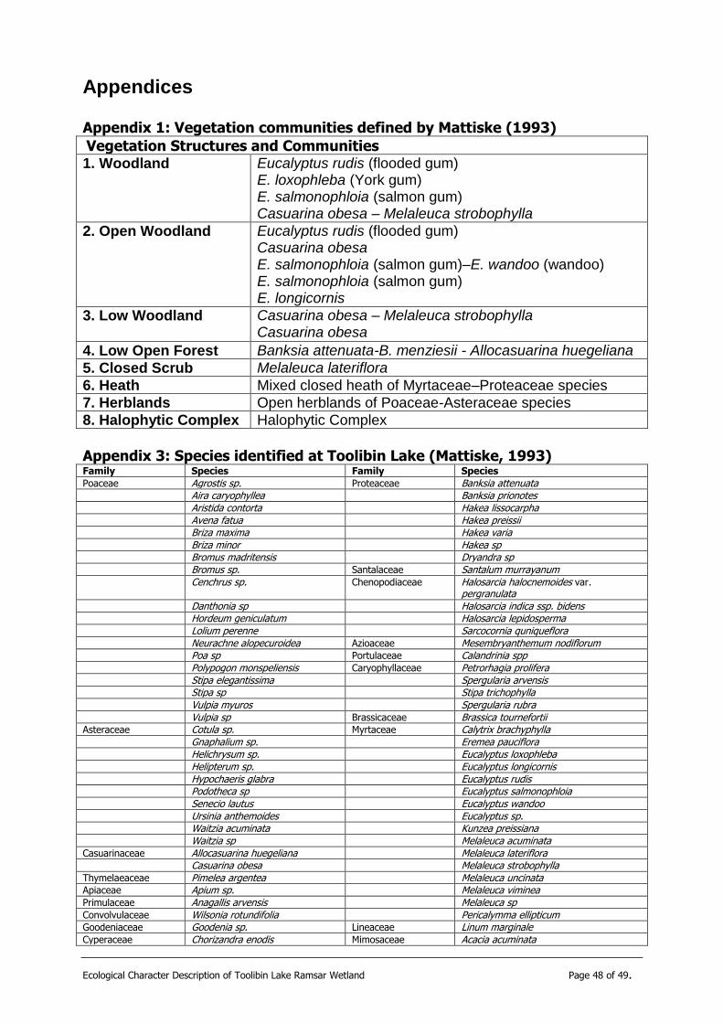
Ecological Character Description of Toolibin Lake Ramsar Wetland Page 48 of 49.
Appendices
Appendix 1: Vegetation communities defined by Mattiske (1993)
Vegetation Structures and Communities 1. Woodland
Eucalyptus rudis (flooded gum) E. loxophleba (York gum) E. salmonophloia (salmon gum) Casuarina obesa – Melaleuca strobophylla
2. Open Woodland
Eucalyptus rudis (flooded gum) Casuarina obesa E. salmonophloia (salmon gum)–E. wandoo (wandoo) E. salmonophloia (salmon gum) E. longicornis
3. Low Woodland
Casuarina obesa – Melaleuca strobophylla Casuarina obesa
4. Low Open Forest Banksia attenuata-B. menziesii - Allocasuarina huegeliana
5. Closed Scrub Melaleuca lateriflora
6. Heath Mixed closed heath of Myrtaceae–Proteaceae species
7. Herblands Open herblands of Poaceae-Asteraceae species
8. Halophytic Complex Halophytic Complex
Appendix 3: Species identified at Toolibin Lake (Mattiske, 1993) Family Species Family Species
Poaceae Agrostis sp. Proteaceae Banksia attenuata Aira caryophyllea Banksia prionotes Aristida contorta Hakea lissocarpha Avena fatua Hakea preissii Briza maxima Hakea varia Briza minor Hakea sp Bromus madritensis Dryandra sp Bromus sp. Santalaceae Santalum murrayanum Cenchrus sp. Chenopodiaceae Halosarcia halocnemoides var.
pergranulata Danthonia sp Halosarcia indica ssp. bidens Hordeum geniculatum Halosarcia lepidosperma Lolium perenne Sarcocornia quniqueflora Neurachne alopecuroidea Azioaceae Mesembryanthemum nodiflorum Poa sp Portulaceae Calandrinia spp Polypogon monspeliensis Caryophyllaceae Petrorhagia prolifera Stipa elegantissima Spergularia arvensis Stipa sp Stipa trichophylla Vulpia myuros Spergularia rubra Vulpia sp Brassicaceae Brassica tournefortii Asteraceae Cotula sp. Myrtaceae Calytrix brachyphylla Gnaphalium sp. Eremea pauciflora Helichrysum sp. Eucalyptus loxophleba Helipterum sp. Eucalyptus longicornis Hypochaeris glabra Eucalyptus rudis Podotheca sp Eucalyptus salmonophloia Senecio lautus Eucalyptus wandoo Ursinia anthemoides Eucalyptus sp. Waitzia acuminata Kunzea preissiana Waitzia sp Melaleuca acuminata Casuarinaceae Allocasuarina huegeliana Melaleuca lateriflora Casuarina obesa Melaleuca strobophylla Thymelaeaceae Pimelea argentea Melaleuca uncinata Apiaceae Apium sp. Melaleuca viminea Primulaceae Anagallis arvensis Melaleuca sp Convolvulaceae Wilsonia rotundifolia Pericalymma ellipticum Goodeniaceae Goodenia sp. Lineaceae Linum marginale Cyperaceae Chorizandra enodis Mimosaceae Acacia acuminata

Ecological Character Description of Toolibin Lake Ramsar Wetland Page 49 of 49.
Gahnia ancistrophylla Acacia erinacea Gahnia trifida Acacia leptopetala Lepidosperma angustatum Acacia microbotrya Lepidosperma
pubisquameum Acacia pulchella
Lepidosperma tenue Papilionaceae Daviesia horrida Restionaceae Lepidobolus preissianus Gompholobium tomentosum Leptocarpus sp Jacksonia furcellata Lyginia barbata Templetonia sulcata Dasypogonaceae Lomandra effusa Trifolium angustifolium Lomadra rupestris Trofolium spp. Phormiaceae Dianella revoluta Geraniaceae Pelargonium havlasae Sapindaceae Dodonaea viscosa Rhamnaceae Cryptandra pungens