east of the roundabout: activating space in the town of santa fe
TRANSCRIPT

East of the RoundaboutActivating Space in the Town of Santa Fe, Mexico City
Samuel Tellechea Pratt Institute Summer 2010

East of the Roundabout: Activating Space in the Town of Santa Fe, Mexico CityCapstone Project
Samuel TellecheaPratt InstituteGraduate Center for Planning and the EnvironmentMaster of Science in Urban Environmental Systems ManagementSummer 2010
Advisors:
Jaime SteinKate ZidarEnrique Martin-MorenoPerry WinstonKees van Rooij

Mexico city: Background inforMation
Mexico City is a place filled with contrasts. It is a fascinating metropolitan area located
in a valley at an altitude of 2,200 meters (7,200 feet) above sea level that over 20 million
people call home. It has been under constant change since the 14th century when it was
originally founded by the Aztecs. The location was not picked randomly, as one of their
gods had stated that the site for the new capital would be the place where they found an
eagle perched on a prickly pear eating a snake. The Aztecs named their city Tenochtitlán.
The setting back then barely resembles what Mexico City is today. The Aztecs settled on an
island in Lake Texcoco, one of the original five lakes that characterized the ‘Valley of Mexico.’
They built their lives around the lakes and created a series of canals and waterways that
were used for transportation and agriculture (remnants of these activities still exist in parts of
south Mexico City). Gradually, the city became one of the most important in Mesoamerica
as the Aztec empire became more powerful. Not surprisingly, when the Spanish arrived in
Mexico in the early 16th century, Tenochtitlán was targeted as one of the main city-states in
the region to conquer.
On August 13, 1521, Hernán Cortés conquered Tenochtitlán. The existing built and
natural environments would be forever changed: the city’s monuments were replaced or
built upon with buildings of colonial and European character, churches were constructed in
many parts of the city, and the lakes were gradually drained, rendering the entire system of

dikes, dams, levies and canals obsolete.1 It was a violent cultural and urban transition that
set the path for a series of problems the city faces to this day.
Although Mexico City has been the center of the country, it was not until the 20th
century that the city grew exponentially. It grew slowly and steadily between the 16th and
19th centuries, though by the end of the 19th century, the city became more industrialized,
as it possessed some of the best infrastructure in the country and a large consumer market.
Population estimates vary, and also depend on which entities in the metropolitan area are
accounted for, yet the overall growth of the city during the 20th century was staggering due
to increased migration.2
1940 1.6 million 1950 3.1 million 1960 5.4 million
1970 9.1 million 1980 13.1 million 1995 15.6 million
Generally, the capital city itself is considered
to have 8 million inhabitants, while the
metropolitan area is considered to have
over 20 million, making it one of the largest
metropolitan regions in the world.
Keeping up with the growth of the city
was not inconsequential. A megalopolis of this magnitude is always hungry for resources.
Ironically, a place that had abundant water sources is now suffering from thirst, perhaps
even dehydration. Over-extraction of water from the aquifer is taking place at a rate faster
than it can be replenished. Parts of Mexico City sink up to 12 inches each year due to the
unstable soil conditions and the receding aquifer3; many areas of the city, and particularly in
east Mexico City become flooded during the rainy season. Not surprisingly, most of these
areas are slums or low-income neighborhoods that were built on lake beds and, as the soil
is very salty, some of these slums present desert-like conditions.1 Malkin, E. (2006, Mar. 16) “ Once built on a lake, Mexico City now runs dry.” The New York Times. Http://www.nytimes.com/2006/03/16/world/americas/16iht-mexico.html?_r=2 [Accessed: June 12, 2010]
2 U.N. City Profiles. “Mexico City, Mexico.” United Nations Cyberschoolbus. Http://www.un.org/cyberschoolbus/habitat/profiles/mexico.asp [Accessed: June 25, 2010]
3 Gaynor, T. (2004, Apr. 30) “Water Crisis as Mexico City Sinks Faster Than Venice.” The Independent. Http://www.mindfully.org/Water/2004/Mexico-City-Sinks30apr04.htm [Accessed: June 25, 2010]
Mexico City Metropolitan Area New York City

Yet the grass is greener on the other
side: Mexico City is, in fact, a very green city
with abundant vegetation, except in parts
of the east side. It is also very flat, except
on the west and south where many hills
start making their way to the mountainous
topography. The west side, in particular,
is characterized by having some of the
wealthiest neighborhoods in the city, with
the occasional low-income neighborhoods
that have settled in the periphery as the
city has grown in most directions, while the
central areas are socially and economically
stable. This unregulated growth has also had
consequences, as forests, lakes, rivers and
ravines have been invaded with disregard
to the ecosystem. However, this invasion
has not only been carried out by informal
settlers and new migrants, it has been a
consequence of poor planning practices
under the continuous stress of a city growing
at a high rate in a short period of time.
Ironically, all these issues have come together in Mexico City’s new central business
district: Santa Fe. Not only does it reflect the reality behind Mexico’s society, it is an
example that questions the ability of the local government, real-estate developers, investors
and planners to successfully bring Mexico City into the 21st century. Mistakes from the
past have been repeated, a whole new set of problems were created, and sustainability
of the environment and of local communities has been compromised, all for the sake of
development.
“Attention! Ecologic reserve zone prone to flooding”Image near a slum in east Mexico City
Income distribution in Mexico City: red being the lowest-income areas, cyan middle-income, and green the highest-income areasSource: BIMSA
Santa fe
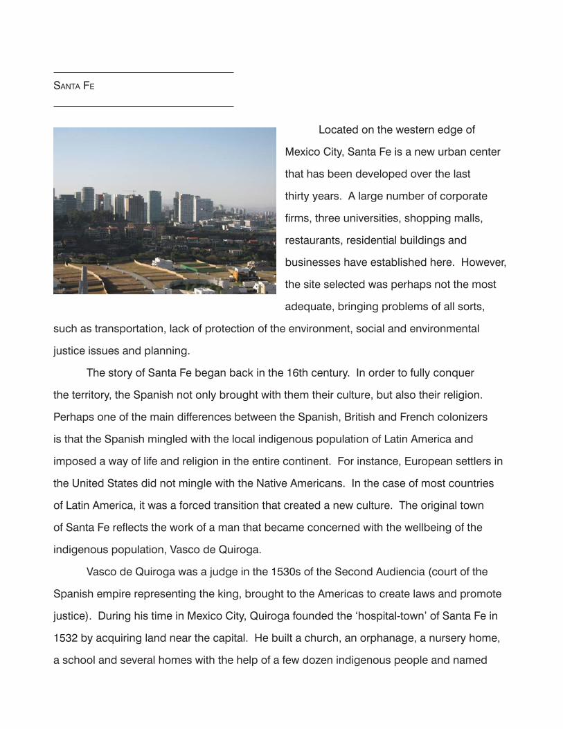
Located on the western edge of
Mexico City, Santa Fe is a new urban center
that has been developed over the last
thirty years. A large number of corporate
firms, three universities, shopping malls,
restaurants, residential buildings and
businesses have established here. However,
the site selected was perhaps not the most
adequate, bringing problems of all sorts,
such as transportation, lack of protection of the environment, social and environmental
justice issues and planning.
The story of Santa Fe began back in the 16th century. In order to fully conquer
the territory, the Spanish not only brought with them their culture, but also their religion.
Perhaps one of the main differences between the Spanish, British and French colonizers
is that the Spanish mingled with the local indigenous population of Latin America and
imposed a way of life and religion in the entire continent. For instance, European settlers in
the United States did not mingle with the Native Americans. In the case of most countries
of Latin America, it was a forced transition that created a new culture. The original town
of Santa Fe reflects the work of a man that became concerned with the wellbeing of the
indigenous population, Vasco de Quiroga.
Vasco de Quiroga was a judge in the 1530s of the Second Audiencia (court of the
Spanish empire representing the king, brought to the Americas to create laws and promote
justice). During his time in Mexico City, Quiroga founded the ‘hospital-town’ of Santa Fe in
1532 by acquiring land near the capital. He built a church, an orphanage, a nursery home,
a school and several homes with the help of a few dozen indigenous people and named

the town Santa Fe. Quiroga was deeply opposed to the exploitation and slavery of the
indigenous people, seeing them as ‘clean and pure’ individuals with potential to create a
‘new man.’ Contrary to other religious leaders of the time, Quiroga concentrated on the
spiritual, technical and the economic development of the people. Some of the activities
that took place in the town were caring for the ill, schooling, apprenticeships in matters of
the Church, handicrafts, agriculture and lodging for travelers.4 The town eventually had
30,000 inhabitants, and many of the indigenous people were baptized, married and taught
the principles of Catholicism. Residents of the town had to dedicate time to work for the
community, often on activities such as farming, although everyone had to learn a trade as
well. Ownership of the land was not allowed, and luxuries were forbidden. Quiroga later
went on to found other such towns in the
state of Michoacán in western Mexico.5
The town of Santa Fe did not
become part of Mexico City until the 19th
century and today is more of a low-income
neighborhood filled with problems than the
‘hospital-town’ that served the poor, needy or
those persecuted it once was. It is located
between several ravines and also surrounded
by other low-income neighborhoods. More interestingly, it is next to the high-income
development also called Santa Fe, Mexico City’s newest central business and residential
district: an architectural playground of modern high-rises, institutions and transportation
infrastructure, cleverly built on a place far from central Mexico City, complicated to reach
from most parts of the city, and specifically designed for automobiles. Access routes are
limited, and congestion is one of the main problems. In fact, “[…] getting between the old
and the new CBD is a challenge. Compared to the world’s other highly populated cities, the
4 Biografias. “Don Vasco de Quiroga.” Monografias.com. Http://www.monografias.com/trabajos58/don-vasco-de-quiroga/don-vasco-de-quiroga2.shtml [Accessed: June 3, 2010]5 Zarandona, J.M. ““The Biography of Vasco de Quiroga (1470-1565), Bishop of Utopia, byBenjamín Jarnés (1888-1949)”, Spaces of Utopia: An Electronic Journal, nr. 3, Autumn/Winter 2006, pp. 69-83. Http://ler.letras.up.pt/uploads/ficheiros/3063.pdf
The town of Santa Fe

distance from old to new in Mexico City is the greatest. The topography doesn’t help either.
The steep rambling terrain compounds the difficulty of commuting the 15 or so kilometers.
When distance and topography are factored together, it is the world’s most circuitous and
tilted urban corridor” (Inaba, P. 57)
Many people from different walks of life come to Santa Fe to work, most from different
parts of the city, and public transportation is limited and inefficient. The majority of the
existing businesses cater to middle and upper class residents, therefore creating a food
desert for most employees in the area. Although informal commerce was abundant even
a few years ago, most have been asked to relocate or leave. It was not uncommon to see
people selling food from the trunks of cars or stands, yet, for aesthetic and legal issues,
these have been cleared .
Overall, the contrast between socioeconomic classes is significant, both in new
Santa Fe and around it. Although there is no explicit discrimination from the government
or developers on the town of Santa Fe, actions do speak louder than words. It is, however,
a reality for many cities around the world, and probably the norm in Latin American cities:
“Urban segregation is not a frozen status quo, but a ceaseless social warfare in which the
state intervenes regularly in the name of “progress,” “beautification,” and even “social justice
for the poor” to redraw spatial boundaries to the advantage of landowners, foreign investors,
elite homeowners, and middle-class commuters.” (Davis, P. 98)
Main road infrastructure in the city
Santa Fe Santa Fe
Downtown Downtown
Subway infrastructure

WeSt of the roundaBout: Santa fe cBd
In order to regulate the urbanization process and planning for Santa Fe, Mexico
City’s government designated the area a ZEDEC (Special Zone of Controlled Development).
Despite being regulated, the neighborhood developed gradually with severe infrastructure
problems, mostly in terms of sewage, water supply, road access and transportation.
Although the majority of problems regarding water and drainage have been solved (to a
certain extent), transportation continues to be the main issue affecting visitors and residents
alike. There are five main access points that are continuously saturated with traffic,
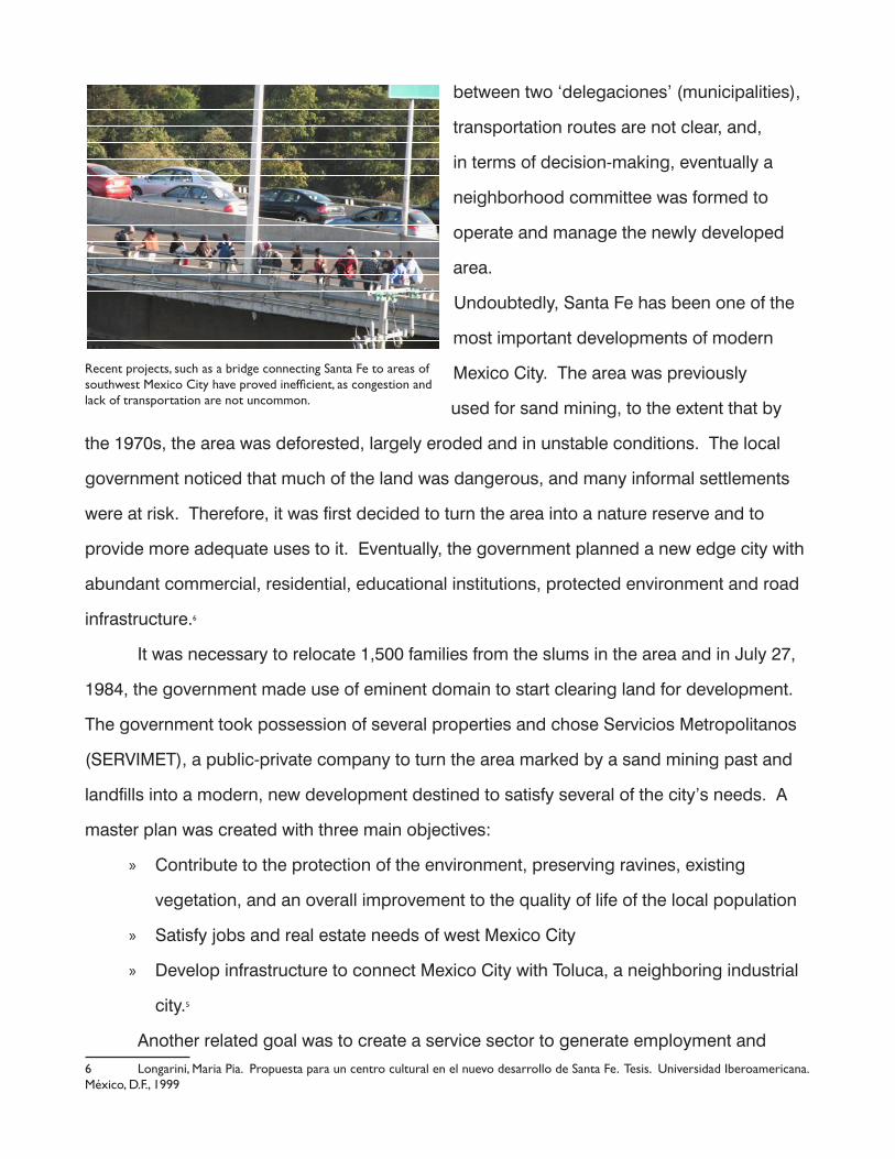
especially during rush hours. Even new projects, such as three bridges built across ravines
and connecting the development to other main roads in southwest Mexico City proved to
be quite inefficient, creating problems where there were none. Arbitrary and unplanned
decisions like these have spurred widespread chaos. Further, being that Santa Fe sits
Roads, ravines and socioeconomic divisions in Santa Fe
Town of Santa Fe
Santa FE CBD
Roundabout
between two ‘delegaciones’ (municipalities),
transportation routes are not clear, and,
in terms of decision-making, eventually a
neighborhood committee was formed to
operate and manage the newly developed
area.
Undoubtedly, Santa Fe has been one of the
most important developments of modern
Mexico City. The area was previously
used for sand mining, to the extent that by
the 1970s, the area was deforested, largely eroded and in unstable conditions. The local
government noticed that much of the land was dangerous, and many informal settlements
were at risk. Therefore, it was first decided to turn the area into a nature reserve and to
provide more adequate uses to it. Eventually, the government planned a new edge city with
abundant commercial, residential, educational institutions, protected environment and road
infrastructure.6
It was necessary to relocate 1,500 families from the slums in the area and in July 27,
1984, the government made use of eminent domain to start clearing land for development.
The government took possession of several properties and chose Servicios Metropolitanos
(SERVIMET), a public-private company to turn the area marked by a sand mining past and
landfills into a modern, new development destined to satisfy several of the city’s needs. A
master plan was created with three main objectives:
Contribute to the protection of the environment, preserving ravines, existing »
vegetation, and an overall improvement to the quality of life of the local population
Satisfy jobs and real estate needs of west Mexico City »
Develop infrastructure to connect Mexico City with Toluca, a neighboring industrial »
city.5
Another related goal was to create a service sector to generate employment and
6 Longarini, Maria Pia. Propuesta para un centro cultural en el nuevo desarrollo de Santa Fe. Tesis. Universidad Iberoamericana. México, D.F., 1999
Recent projects, such as a bridge connecting Santa Fe to areas of southwest Mexico City have proved inefficient, as congestion and lack of transportation are not uncommon.

economic advantages. Two areas were designated for corporate buildings, two areas for
shopping centers, while other areas were zoned for scientific institutions, and recreation.
The ZEDEC master plan was put into effect, and out of the 800 hectares for ZEDEC, 30%
were designated for environmental preservation and 15% were designated for housing.7
One problem that arose due to the quick development of Santa Fe was that the
government took possession of the land through SERVIMET (mostly through eminent
domain) and sold it to the private sector. However, it was the government’s responsibility to
provide infrastructure and services, while the new owners were responsible for remediating
the land.6 This did not go as planned, and problems with water supply, sewage and paving
were an issue until recently. It was not uncommon to see trucks supplying water to Class A
office buildings. SERVIMET faces several lawsuits for over $70 USD million by companies
that took part in the development of Santa Fe due to the fact that infrastructure and services
were incomplete.8 Further, a neighborhood association called Asociación de Colonos de
Santa Fe was established to take issues into the hands of residents and as an intermediary
between residents and the local municipalities.
Little relationship exists between the settlements surrounding Santa Fe with the Santa
Fe CBD. Some of the previously existing informal settlers around the area had located their
7 Cano, D. (1999, Nov. 1) “Santa Fe, bujia de desarrollo.” El Universal. Http://www2.eluniversal.com.mx/pls/impreso/noticia.html?id_nota=3498&tabla=ciudad [Accessed: June 5, 2010]8 Llanos Samaniego, R. (2002, Oct. 1) “SERVIMET, paraestatal poco rentable.” La Jornada. Http://www.jornada.unam.mx/2002/10/01/037n1cap.php?origen=capital.html [Accessed: June 5, 2010]
Informal commerce is still present in many parts of Santa Fe. Meanwhile, the Santa Fe Shopping Mall is one of the biggest in Latin America, with a wide variety of department stores and luxury boutiques.

homes in the area of and around Santa Fe to benefit from the mining and landfill activities.
While some of these were cleared for the development of the new CBD, most have been
incorporated into the city. However, one of the outcomes of building a new, contemporary
city next to low-income neighborhoods was the contrast generated between them and the
growth of informal settlements to take advantage of the new services offered in Santa Fe.
Although there have been considerable investments in real-estate and infrastructure, there
have been no meaningful interventions for improving the living conditions of the surrounding
neighborhoods nor investments in affordable or middle-class housing within easy reach
from Santa Fe. In fact, there has been a 350% increase since 1982 in informal settlements
around Santa Fe, most having taken place on land designated for conservation/preservation,
particularly on the slopes of hills and ravines.9
ravineS: exiSting conditionS
Most of Mexico City is located in a
valley surrounded by mountains. On the
west side of the city, a series of hills rise from
the plateau towards the mountains, forming
many ravines that characterize this part of
town. These ravines are composed mostly
of volcanic rock, ash, pumice and caliche
(calcium carbonate deposits), and were
formed millions of years ago. Though the
exact way in which the ravines were formed is not
known, there are two possibilities: they were a product of shifts in tectonic plates, or, created
by pluvial and fluvial waters going northeast and downhill.10
9 Sistema de informacion del desarrollo social. “Programa Delegacional de Desarrollo Urbano Alvaro Obregon.” Http://www.sideso.df.gob.mx/documentos/progdelegacionales/alvaro%5B1%5D.pdf [Accessed: July 8, 2010]
10 Canedo Castro, M. “Conservacion y recuperacion de barrancas del poniente de la Ciudad de Mexico.” Instituto Nacional de Ecologia. Http://www.ine.gob.mx/descargas/dgipea/pon_barranca_poniente_cd_mex.pdf [Accessed June 26, 2010]
Ravines and forests are under pressure due to encroachment from residential developments.

Mexico City’s setting was once very different:
it was a plateau with five lakes and an
extensive system of canals and agriculture
during the time of the Aztec empire. After
the arrival of the Spanish, and as Mexico City
grew into a megalopolis, extraction of surface
water, and later groundwater took place at
a rate that led to the disappearance of the
lakes, as well as extinction of many endemic
species. Nowadays, one lake (Lake Texcoco in
the northeast) and the canals of Xochimilco and Tláhuac in southeast Mexico City are all that
remain.
The ravines found on the west side of Mexico City are an important source of water
filtration and rainwater catchment. Naturally, the water accumulating in these ravines would
flow downhill. And it still does. However, as is the case in many cities, informal settlements
have taken place in these nature reserves, and many ravines have become polluted.
Oftentimes, where rivers flow, sewage and garbage contribute to the degradation of the
ecosystems. The ravines around Santa Fe are not the exception, as they have become
polluted and because some of the recently constructed buildings still discharge sewage
directly to the rivers flowing through ravines until they reach the appropriate infrastructure.
Out of the 74 ravines found in west Mexico City, all present problems such as informal
settlements, erosion, pollution and deforestation. This impairs ravines from functioning as
part of a lager system of rivers, streams and rainwater catchment, although not all ravines
contribute to recharging the aquifer.10 These problems need to be addressed at the local
government level, yet, as of 2009, no projects from different municipalities proved promising,
and the situation persists.11
Though most of the sewage coming from Santa Fe is now connected to the
infrastructure of the city, most goes untreated. Three water plants in different ravines in the
11 Martínez, Edith (2009, Jul. 20) “Barrancas de Santa Fe, “cloacas” de corporativos.” El Universal.Http://www.eluniversal.com.mx/ciudad/96517.html [Accessed: Jun. 15, 2010]
Ravines south of Santa Fe, with informal settlements present in many areas.

area exist, but none is operational. One of
these is in an area called Jalalpa, close to
Santa Fe and built to treat water from the
newly developed area, yet it lies dormant
because of lack of funds. There are mainly
three rivers that flow in the area east of Santa
Fe: Tacubaya, Tlapizahuaya and Becerra. As
they flow downstream, they carry sewage
and garbage with them. Most of the Becerra
River flows along the town of Santa Fe until it
joins the Tlapizahuaya River. They both converge at a dam that protects the neighborhoods
downhill. However, the dam is old and run-down, and brings a risk of infectious diseases to
the surrounding neighborhoods as trash and
waste accumulate, and is at risk of breaking,
threatening the population downhill. There
are no wells for water absorption for treated
water or rainwater.10
The ravines around Santa Fe are
designated as protected areas (AVA
– Áreas de Valor Ambiental, literally
Areas of Environmental Value) under the
municipality’s zoning plan: areas that, due
to their characteristics, constitute elements
of value for the environment that must be
rescued or preserved, such as ravines, rivers,
streams, canals and forested areas.12
Although different government
agencies interact to address the
12 Secretaria de desarrollo urbano y vialidad. “Programa delegacional de desarrollo urbano, Alvaro Obregon 1997.” Http://www.seduvi.df.gob.mx/seduvi/cartografia/programasdelegacionales/aobregon.pdf
La Loma Santa Fe, where a few buildings continue to discharge sewage into the Becerra river.
Streetscape near the Becerra river.

safeguarding and management of land designated AVA, the Direction of Urban
Reforestation, Parks and Bicycle Circuits (Dirección de Reforestación Urbana, Parques y
Ciclovías), which is part of the Ministry for the Environment (Secretaría del Medio Ambiente)
is the main entity. The purpose of this agency is to implement policies and programs
to protect the environment, improve living conditions and promote cycling as a means
of transportation. Some of the main objectives are the following: prioritize use of native
species, create policies to improve, create and rehabilitate protected areas, provide training,
promote involvement of citizens to enforce environmental protection, and improve and
create infrastructure for cyclists.13 They are also concerned with issues such as recharge
of the aquifer, pollution reduction, heat-island effect, noise, erosion, recreation and wildlife
protection and ecosystem services within Mexico City, and provide several programs to
address them, such as:14
Plant production in nurseries to satisfy demand for municipal projects (limited to »
native species grown in two nurseries in the city)
Plant donations for projects or open spaces that would benefit from more »
vegetation (residential compounds, medians, community gardens, parks)
Garden maintenance through sponsorships from the private sector (medians, »
community gardens, AVA designated land)
Tax incentives for plots with over 30% vegetation »
Infrastructure, initiatives and policies to improve conditions for cyclists »
Designation of AVA land use »
The Direction of Urban Reforestation, Parks and Bicycle Circuits also manages the
Ravine Information System (Sistema de Información de Barrancas) web site, providing
materials in order to discuss existing conditions and to address problems, proposals
and offenses related to ravines. Ravines are defined as geographic depressions with
topographic and geologic characteristics that allow them to be wildlife refuges, rainwater
catchment systems, source of rivers and storm water management, and significant
13 Secretaria del Medio Ambiente. “Mision, Vision y Objetivos.” Direccion de reforestacion urbana, parques y ciclovias. Http://www.sma.df.gob.mx/drupc/index.php?opcion=2 [Accessed: July 17, 2010]14 Secretaria del Medio Ambiente. “Que son las areas verdes urbanas” Direccion de reforestacion urbana, parques y ciclovias. Http://www.sma.df.gob.mx/drupc/index.php?opcion=22 [Accessed: July 17, 2010]

contributors to ecosystem services and hydrological cycle of the region.15
The main problems identified by the information system in most of the ravines in Mexico City
are:
Change of land use »
Pollution »
Development pressure for real-estate development »
Lack of available information for the population in general »
Solid waste and wastewater issues »
Loss of biodiversity »
Unbalance of ecological and hydrological functions »
Risk-prone areas for inhabitants (landslides, floods and fires) »
Demolition and industrial waste »
Lack of coordination between different government agencies »
This information system also indicates that a large number of government agencies
are involved in the safekeeping of ravines (for example, the Ministry for the Environment,
National Water Commission, Urban Development and Roads Ministry, the municipalities,
Ministry for the Environment, and Office of the Attorney General, among others).
Five directives exist to address protection, conservation, restoration, environmental and
15 Secretaria del Medio Ambiente. “Contexto Basico.” Sistema de informacion de barrancas. Http://www.sma.df.gob.mx/barrancas/index.php?op=06_definiciones [Accessed: July 19, 2010]
Existing conditions in the ravine and river. Large areas have been deforested and the river is severely polluted with trash and sewage

urban rescue plans regarding ravines. These provide sets of guidelines and manuals to deal
with issues such as reforestation, identification of problems, informal settlements, use of
native species, wildlife preservation, flash floods, solid waste and wastewater management,
among others. It also discusses risk and disaster management, climate change, and
provides recommendations in case of emergencies (particularly intense rain and sewage
overflow affecting informal settlements).
Overall, there is a clear recognition of the importance of ravines and the ecosystem
services they provide. Fines for offenses affecting ravines are severe, although it is likely
that laws are rarely enforces, perhaps because of the large number of entities involved,
bureaucracy, political and development interests and lack of funds.
eaSt MeetS WeSt
Santa Fe was planned almost like a
tailored suit with very well delineated roads
and specific zoning regulations. It could very
well be the pride of city planners and real-
estate developers (ironically, although it was
planned specifically for automobiles, there is
not enough parking and valet parking mafias
rule the streets). The wide gap between rich
and poor that characterizes Mexico and many
other Latin American countries becomes
evident: regardless of all the investment and presence of international corporations, luxury
condominiums, embassies, private schools and high-end shopping, the contrast between
neighborhoods is an issue. There is no connection between the neighborhoods (except
at a roundabout in Vasco de Quiroga Ave.). There are no buffer zones. It is almost a slap
in the face for both sides, and most are unhappy with the situation. For the new CBD, the
Many streets in the town have views of the Santa Fe CBD, intensifying contrast between neighborhoods.

low-income communities are an unpleasant sight and even a threat. For the low-income
residents, the existence of such a place is also threatening and has significantly changed
their way of life.
Local government entities have also failed to satisfy needs and find solutions, in
addition to the corrupt and futile actions of SERVIMET. Nowadays, the governance of Santa
Fe CBD lies in the hands of an entity created by the community, collecting funds, distributing
taxes for improvements and addressing problems. In the case of the surrounding towns,
they depend mostly on the municipality. There is no apparent relationship between the
Neighbors Association of Santa Fe with the rest of the communities around.
In an interview with one of the leaders of the community, Mr. Juan Cisneros, the
importance for a better relationship between both sides was stressed. The town of Santa Fe
has consistently suffered the chaos brought by a poorly planned city. Some of the findings
and comments are the following.
The water in the river used to be clean 35 years ago. However, the increase in »
population and sprawl has led to pollution of the ravines and rivers with sewage
and waste. Collection trucks rarely make it downhill because of the complicated
topography. Further, there have been cancer cases related to the unhealthy state of
the river (unconfirmed).
Santa Fe was a site characterized by sand mines and four landfills (Prados de la »
Montaña, Alameda Poniente, the roundabout at Vasco de Quiroga, and the current
location of Santander Serfin bank). The first actions the government took to spur
development was the use of eminent domain and removal of slums.
The geography of Santa Fe was completely devastated by the mining activity, »
including deforestation and pollution.
A supermarket and housing development were built in the town of Santa Fe on a »
site where there used to be single-family residences and a soccer field used by the
locals. In exchange for this, SERVIMET promised to hand in the Alameda Poniente
once it was remediated. Around 1998, SERVIMET began using the Alameda
Poniente as a parking lot and soccer field for its employees, and the people of the

town have been told that the land will not be granted to them (unconfirmed)
Jalalpa water treatment plant is not operating due to the high cost required. It was »
built around 1997 on a hill next to the Becerra river ravine, and SERVIMET agreed
that the water plant would be used to treat water from new Santa Fe, and that part
of the water would be used for irrigation in the town of Santa Fe (unconfirmed).
Some of the outcomes of having Santa Fe as a neighbor have been increased rent, »
encroachment of medium-income developments, a serious traffic problem, social
issues within the town, increased interest in selling land due to higher property
values, increased taxes, and more crime (murder, drugs, gangs, auto theft, petty
crimes)
At one point, the government offered relocating the citizens of towns around Santa »
Fe to different cities around Mexico City (unconfirmed).
SERVIMET sold a large number of plots at a cheap price because many were »
perceived to be polluted (though in reality, only 4 sites were used as landfills).
Further, the company had offered to provide jobs for locals, yet it did not happen
(unconfirmed)
A large number of businesses in the town are informal. Although the government »
has suggested improvements to storefronts and buildings along Vasco de Quiroga
Avenue, most people are afraid to pay more taxes or lose their property.
Most people in the town own the land they live in, although informal settlements »
exist as well. At one point, the people of the town tried to take possession of a
hilltop (now La Loma residential complex), yet they were not allowed to because
the area was designated for preservation. However, a few years later, and after
reforesting the hilltop, a series of upscale buildings were built, and the trees were
cut down and thrown down the ravine (unconfirmed).
A vision for the town of Santa Fe should include an overall improvement in the »
quality of life, better streets and transportation, more support from Santa Fe, better
public and recreational areas, and cleaning of the river. Santa Fe was once a place
where persecuted and needy people were assisted from being overexploited by the

Spanish, yet now they feel persecuted by the wealthy and the government.
Investors, corporations and the government need to treat the people of the town »
with respect. Without old Santa Fe’s support, new Santa Fe has no hope for a
successful future.
Written communications with members of the Neighbors’ Association of Santa Fe
were also attempted. Although they responded to the first requests offering answers for the
purpose of this research, they eventually did not answer any questions.
MiSSion StateMent
Considering the existing conditions of the town of Santa Fe and the situation the
community is living in, there is a need for solutions that will improve the quality of life
through proposals that address environmental and social justice issues, as well as restoring
the environmental damages that threaten the sustainability of the site. Most of the local
government’s efforts have been geared towards the Santa Fe CBD, casting a great shadow
on the surrounding communities
Three goals will be addressed for the purpose of this proposal regarding the town of
Santa Fe:
Activate space »
Spur economic development »
Promote environmental sustainability »
The site has the potential to become a place where recreation and economic
development are combined. Currently, the ravine south of the town of Santa Fe presents
several environmental problems, such as pollution of the river, deforestation and erosion.
There is an urgent need to clean the river and promote community involvement in keeping it
safe and clean. Sewage should be kept from reaching the river from the town and the CBD
by adequately connecting it to the main sewage system or creating a more efficient one,
while also contemplating the possibilities of recharging the aquifer with clean water.

There are many areas that can be used for recreation along the river, including the
improvement of existing soccer fields and the creation of gathering spaces, and a greenway/
bike path communicating the different neighborhoods. Eroded slopes of the ravines and
parts of the riverbank could be used for production of edibles and non-edibles, creating
a new business activity that could bolster the community’s economic development while
restoring habitat and the ecosystem services provided by ravines.
In order to achieve such a proposal, several steps would need to be taken. For
instance, although Mexico City’s temperature is fairly temperate throughout the year, an
average 26 inches of rain fall each year, but mostly from late spring to early fall. For this
reason, rainwater harvesting from the swelling of rivers and on the upper parts of the ravines
would be necessary to store water for the dry season. Additionally, if the Jalalpa water plant
was made operational, treated water could be used for irrigation purposes, both in the town
and in the CBD
Historically, some of the activities that were done by the original settlers when Santa
Fe was a ‘hospital-town’ were related to making handicrafts and working on agriculture, and
every citizen of the town was required to work. Reestablishing these activities could very
well increase the chances for economic success and diversify jobs, increase recreational
activities and provide a sense of community. There are wide swathes of open, unused and
degraded space along the river, and few steps have been taken to activate space and make
use of it for improving the environment and the quality of life.

ProPoSal
Gabion Walls and Magueys on the Slopes of the Ravine
Several parts of the ravine are deforested and eroded. Although a way to address
this in the past has been to cover slopes with concrete (often using the surface to paint
murals), this does not address restoration of the natural habitat or soils. Gabion walls are an
alternative that has been used in parts of Mexico and South America to prevent erosion and
for terraced agriculture.
Gabion walls are cost-effective wall
systems that are composed of galvanized
steel baskets filled with rocks. They provide
slope stabilization, while allowing for water to
dissipate through the rocks. They are also
flexible, and adjust to withstand pressure
without deforming.16
Terraces could be created and
maguey plants could be used to create a new landscape for the site. The maguey plant has
been used in Mexico for at least eight centuries. Its properties allow it to be employed as
medicine, fiber, building material, fuel and fertilizer (from its ashes). It was used on terraced
agriculture for inter-planting with grain crops on the hillsides of villages and is characteristic
of the central highlands of Mexico. It can thrive at high altitudes and sustain periods of
drought, yet they can also withstand frost, which is not uncommon during the winter,
especially in areas such as ravines.17
The combination of gabion walls and magueys would have two main objectives.
Create a scenery on the landscape to enhance the quality of the open space while
addressing the problems of erosion in the area. Aside from being culturally appropriate and
16 Modular Gabion Systems. “Gabion Walls Design.” Http://www.gabions.net/downloads/Documents/MGS_Design_Guide.pdf [Accessed: June 28, 2010]17 Evans, S. “The Productivity of Maguey Terrace Agriculture in Central Mexico During the Aztec Period.” Latin American Antiquity. Vol.1, No.2, 1990. Http://www.anthro.psu.edu/faculty_staff/docs/Evans_Maguey_1990.pdf

native to the region, magueys enrich and strengthen the soil, preventing further erosion and
providing slope stabilization along with the gabion wall system. Further, magueys can be
exploited for certain derived products and add to the economic development of the place.
Magueys are perennial succulents belonging to the Agavaceae family. They have been used
in Mesoamerica for many centuries. Before the arrival of the Spaniards, agaves were widely
used for obtaining sap and fibers. After sugarcane was introduced in Mexico, the use of agaves
declined rapidly.
Agaves are native to North America, with the majority of species existing in Mexico. Its
fibers can be used for cloths, ropes and baskets, among other products. Its leaves are useful for
cooking ‘barbacoa,’ as, traditionally, a sheep is placed in a hole in the ground and covered with
maguey leaves. A more popular product is pulque, a milk-colored alcoholic beverage obtained
from the sap of magueys. Recently, there has been increased interest in using agave nectar as a
substitute for sugar or corn syrup. This nectar can be obtained from a related species also native
to the highlands of Mexico, Agave salmiana.
Source: El Agave. Http://www. elagave.org. Image source: Http://commons.wikmedia.org

Restoration of Habitat
It is urgent to clean the rivers around the town of Santa Fe, as well as an active
preservation strategy that involves the communities living in or near ravines in west Mexico
City. There are considerable amounts of garbage present in the river, particularly east
of the Santa Fe CBD. Sewage is also an issue that needs to be solved, as most of the
sewage from the town is discharged into the river, as well as sewage from some of the
high-end buildings in the CBD. This is a situation that needs to be addressed by the local
government, the National Water Commission and the community.
Some of the rivers in the area eventually converge at dams located downhill. Due
to the lack of appropriate infrastructure, sewage is present in most of them. Garbage is
an issue, and it is also not uncommon to find demolition waste being placed at the dams.
The water in theses places is polluted and could eventually cause health problems to the
communities. These fabricated wetlands could provide more ecosystem services and
interventions could be made to recharge the aquifer.
Reforestation is also a need that is very present in several ravines. Unfortunately,
there are many species that have been planted that do not belong in these places, such as
eucalyptus. The government supports reforestation with native species, and more use of
ash, oak and pine trees should be planted to enhance the environment and preserve the
forest-like conditions of many of the ravines.
Areas for rainwater catchment could be built to address irrigation during the dry
season. The water could be used for open spaces, nurseries, recreation and recharge of the
aquifer.
Areas for Recreation / Connecting Spaces
A few areas for recreation exist in the neighborhoods along the Becerra river, such as
playgrounds, small parks and a couple of soccer fields. The soccer fields, in particular, are
in poor conditions. Although there are roads that run parallel to the river, they are not always
continuous.
A new path would be proposed to connect the different neighborhoods. A bike lane

could easily be placed along the river, especially considering that Mexico City’s government
is trying to promote the use of bicycles as a means of transportation. Having a better way
of travelling in the lower parts of the ravine could present itself as a convenient alternative
to using Vasco de Quiroga Ave. and would also increase recreational spaces for the
community.
The soccer fields could be restored and even used for distribution of plants collected
from the proposed nurseries. These spaces would be ideal for multiple functions.
San Borja Ravine Case Study
A ravine five kilometers away from Santa Fe went through a transformation process to
become a community garden for a low-income neighborhood. With the assistance of the
local government and from different universities in Mexico, the community turned a place
characterized by garbage into productive land. It was started in 2009, and is now run by a 30-
person cooperative providing food for over 70 families in the neighborhood. Lettuce, tomatoes,
squash, cucumbers, radish and beans are now
being harvested.
Over 1,200 tons of garbage were
collected from the ravine and the San Borja
river, and a new irrigation system was put
in place for the project. Members of the
community have received training on how to
manage the site, and they take turns with the labor required to achieve production.
Most of the funding for this project came from fines charged to construction companies in
the area, and were provided by the municipality. This project was a finalist in the Deutsche Bank
Urban Age Awards on July 22, 2010, and was part of an initiative from the municipality and the
National University of Mexico (UNAM) to create a model for rescuing ravines.
Sources:Alvarez Laris. C (2009, Jul. 14) “Rinde frutos el rescate de un espacio muerto en la barranca de San Borja.” La Jornada. Http://www.jornada.unam.mx/2009/07/14/index.php?section=capital&article=033n1capDeutsche Bank Urban Age Award, Mexico City 2010. LSE Cities. Http://www.urban-age.net//news/updates/2010/07/dbua-award-winner/

Economic Development
The economic development proposal for the underused spaces is an opportunity that
could only take place with a committed involvement of members the community and support
from the local government, NGOs, private investors and micro-credits. Nurseries with plants
that are often used in landscape architecture projects in the Santa Fe CBD could be installed
along in open and underused spaces along the river. Considering that many buildings are
under construction in the CBD, the location of these nurseries could reduce transportation
costs and provide a higher profit for producers selling plants to developers and contractors
working in projects in the CBD. This activity could also diversify jobs and skills in the
community, particularly for elders, children, women and the unemployed.
Further, magueys could also provide to the economic development of the community.
One product derived from maguey is fresh sap (aguamiel) which is a watery substance
that can ferment and be used to produce pulque, an alcoholic beverage that, although it
was very popular in Mexico many years ago, still retains some popularity, particularly for
low-income communities and even tourists. Other products obtained from magueys are
fibers that can be used for making thread, ropes, baskets, brooms; leaves of the maguey
are also used for cooking.17 Perhaps even workshops for handicrafts as those previously
used during Vasco de Quiroga’s time could be installed, allowing for marketing of products
(ideally in the shopping malls in Santa Fe CBD or markets for artisan products).
Urban agriculture is also an option for the area, taking advantage of underused
open space in the ravine as well as backyards in private homes. Water would be an issue,
especially considering that sewage is present in the river, therefore, water harvesting
techniques would be necessary through rainwater catchment on the upper parts of the
ravine or, in the future, from the river itself. Magueys also support other crops, such as
beans and corn, that can be inter-planted in the same place, all depending on the distance
between maguey plants. This system with terraced agriculture could optimize water usage
for irrigation.17
Successfully obtaining products from maguey plants can take years, and requires
knowledge of the techniques to make the most of each plant. Once the plant is over eight

years old, sap can be extracted on a regular basis by up to ten liters per day. After that
process, the sap can be placed in 50-liter barrels and fermented for approximately two
weeks. The final product is pulque, a popular alcoholic beverage in many parts of Mexico,
and particularly in low-income communities that could also be marketed.
Making it Happen
Urban agriculture has been recognized as a means to improve the environment and
allows for more democratic and sustainable cities.18 Currently, Mexico City’s government is
seeking to invest up to $10 million USD for sustainable agricultural practices.19 The Ministry
18 Blumenthal, U.J. D.D. Mara. “Reducing the Risks of Using Wastewater in Agriculture.” Urban Agriculture Magazine Vol. 3, RUAF Foundation. June, 2005. Http://www.ruaf.org/node/14719 Balboa, B. (2010, Apr. 8) “Impulsa GDF agricultura urbana.” El Universal. Http://www.eluniversal.com.mx/notas/671573.html [Accessed: July 24, 2010])
Yield from vegetable gardensYield in pounds
per foot*
Yield in pounds
per meter
Yield in kilogram
per meter
Price per kilogram
**
Total MXN per
meter
Total USD
per meter
Cucumber 1 3.28 1.49 6.00$ 8.92$ 0.70$ Lettuce 0.5 1.64 0.74 10.00$ 7.43$ 0.58$ Potato 2 6.56 2.97 10.00$ 29.72$ 2.34$ Squash 2 6.56 2.97 8.00$ 23.77$ 1.87$ Tomato 2.5 8.2 3.71 9.00$ 33.43$ 2.63$ Spinach 0.8 2.624 1.19 10.00$ 11.89$ 0.93$ Onion 1.5 4.92 2.23 5.50$ 12.26$ 0.96$
Yield from nurseries
Yield per square
meter (items)
Average price in
markets USD
USD per square
meterFern 9 2.00$ 18.00$ Elephant's Ear 5 5.00$ 25.00$ Lavender 40 1.00$ 40.00$ African Iris 20 2.00$ 40.00$ Phormium 12 3.00$ 36.00$ Azalea 4 10.00$ 40.00$ Salvia 30 1.00$ 30.00$ Silverthorn 4 2.00$ 8.00$ Kangaroo Vine 50 1.50$ 75.00$ Juniper 4 20.00$ 80.00$
* Community Garden Guide Vegetable Garden Planning and Development. USDA Natural Resources Conservation Service. http://plant-
materials.nrcs.usda.gov/technical/publications/newpublications/PMC_final_Garden%20guide%20Nov%2009.pdf [Accessed: July 25, 2010]
**ASERCA. Reporte de Precios Diarios de Hortalizas observados en diversas Centrales de Abasto. http://www.aserca.gob.mx/sicsa/hortalizasnacional/hna_ca1.asp [Accessed: July 25,
2010]
Sources
Sample yields from nurseries in Mexico City and average community vegetable gardens

for Rural Development and Community Equity (SEDEREC – Secretaría de Desarrollo
Rural y Equidad para las Comunidades), a branch of the local government, promotes
commercialization and distribution of sustainable practices through activities such as
agriculture and handicraft production to address social welfare of communities in the city.
The Program for Small Scale Sustainable Agriculture (Programa de Agricultura
Sustentable a Pequeña Escala) arose as a way to tackle climate change, food security and
nutrition by supporting sustainable projects, while increasing profitability from agricultural
practices. The aim of the project is to increase production of organics, protect biodiversity
and invest on technologies and research. Urban agriculture is supported to increase
community involvement, maximize resources, optimize labor, diversify crops and to get
citizens involved in food production of organics, herbs and healthy foods in the city and
peripheral areas. Low-income communities, and mostly women and elders can take
advantage of these programs, and local participation is encouraged.20
This program was put into effect in 2007 to address urban and suburban communities
that have no access to federally funded projects. Many areas within Mexico City are
available for agricultural activities and can be exploited for production, particularly favoring
self-consumption for families and communities. Almost 1,300 projects have been approved
in different municipalities of the city since 2007, investing over $1.3 million USD, mostly
in animal production, but also on agricultural activities and infrastructure for irrigation and
greenhouses. In terms of organics, strawberries, tomatoes, lettuce, spinach, broccoli and
mushrooms were supported with over $250,000USD.20
When private capital is not available to fund projects, other ways to fund the
production of edibles and non-edibles include micro-credits (oftentimes supported by
international donors, national governments, banks or NGOs), subsidies, and savings.
Combining these financing alternatives with the support provided from the local government
could increase the possibility of success: “savings could, for example, work as collateral
for receiving credit. Tax incentives or other subsidies could motivate people to become
20 Secretaria de desarrollo social y equidad para las comunidades.”Programa de agricultura sustentable a pequeña escala en la Ciudad de Mexico.” Proyectos especiales y vinculacion comercial. Http://www.sederec.df.gob.mx/proyectos_agricultura_sustentable.html [Accessed: July 25, 2010]

involved, and complement credit systems with training and assistance, and in this way better
guarantee success and sustainability of the (integrated) support programs.”21
Community Supported Agriculture could present itself as a potential option to get
members of the community involved, perhaps even some in the CBD. CSA programs work
by seeking potential investors who will receive produce in exchange for their support of the
program.22
The Ministry for the Environment could also support projects to produce more native
plants in nurseries that provide production of plants for city projects (such as medians and
parks), but can also donate plants to areas that are in need of more vegetated spaces. The
greenway/bike path proposal could also be supported by this agency. There has been
increased interest from the government to provide more infrastructure for bike use, as well
as recent bike-sharing/rental programs that have worked successfully in central parts of the
city.
Overall, the aim is that the community retains a sense of ownership over land that
is currently underused and at risk. There are plenty of government programs that could
support projects in the neighborhood, but perhaps adequately implementing these and
involving the community is what has prevented any actions from taking place.
21 Dubbeling, M. “Financing Urban Agriculture.” Urban Agriculture Magazine Vol. 9. RUAF Foundation. April 2003. Http://www.ruaf.org/node/29122 Local Harvest. “Community Supported Agriculture.” Http://www.localharvest.org/csa/ [Accessed: Jul. 28, 2010]

Town of Santa Fe
Roundabout
Town of Santa Fe
Santa FE CBD
Santa FE CBD
Supply of produceCSA
Supply of nursery plants Supply
of magu
ey pro
ducts
Supply of produce
Santa Fe CBD has very defined zoning regulations in contrast with the surrounding neighborhoods. The layout of the development has allowed for further segregation due to its scale and because it was planned specifically for automobile use. Little flexibility exists to integrate the other communities. There are, however, a few open public spaces that could be used for activities involving the inhabitants of other neighborhoods.
If the space along the Becerra river is used for production of edibles and non-edibles, nursery plants could be supplied for new and existing developments in the CBD; produce could be integrated through Community Support Agriculture - involving those in the community who are interested. Products from maguey, such as pulque, fibers and agave nectar could be supplied to potential consumer markets in the city.
ProPoSal: viSualS

Restoration of habitat
Restoration of habitat
Restoration of habitat
Restoration of habitatBike path
Bike path
Rainwatercatchment
Rainwatercatchment
Gabion wallsMagueys
Gabion wallsMagueys
Recreation
Edibles andnon-edibles
Edibles andnon-edibles
Edibles andnon-edibles
The ravine along the Becerra river, south of the town of Santa Fe has the potential to be regenerated into open space that is environmentally stable as well as productive.
Activating space would bring an improvement to the quality of life and involvement of the community.
Cleaning the river is indispensable, and, as seen in the San Borja river ravine, it is possible with the involvement of the government and the community.
Deforestation
Pollution
Erosion
Rainwater catchment would be necessary for irrigation of the productive land.
Gabion walls and maguey would provide a new scenery protecting the ravines from further erosion and spurring economic development.

next StePS
Despite the great number of challenges to succeed, the power of the community will
be stronger than that of the government. The most important step to follow is to involve the
community in a visioning process that could jump-start a bottom-up planning approach.
The existence of Santa Fe CBD has greatly compromised the environment and the well-
being of many neighborhoods, but many solutions are possible once the community sets its
goals and realizes what they will be fighting for.
The intention of this proposal is to seek some solutions that could tackle the existing
issues in order to promote sustainability by focusing on the safekeeping of the environment
and the economic development of the people of Santa Fe, while enhancing a sense of
community through increased responsibility.
A great deal of indifference exists on all sides: the Santa Fe CBD, people from the
town, and the government. Yet it is possible to create more involvement by hearing opinions
from all sides and creating grounds for discussion: the quality of life can be improved,
land can be remediated, and new jobs could be created. The only ingredient necessary to
achieve these goals is will power.
magueys and gabion walls non-edibles clean river bike path recreation
Sample Cross SectionActivating space, remediating land, improving quality of life

referenceS
Alvarez Laris. C (2009, Jul. 14) “Rinde frutos el rescate de un espacio muerto en la barranca de San Borja.” La Jornada. Http://www.jornada.unam.mx/2009/07/14/index.php?section=capital&article=033n1cap
ASERCA. Reporte de Precios Diarios de Hortalizas observados en diversas Centrales de Abasto. Http://www.aserca.gob.mx/sicsa/hortalizasnacional/hna_ca1.asp [Accessed: July 25,2010]
Balboa, B. (2010, Apr. 8) “Impulsa GDF agricultura urbana.” El Universal. Http://www.eluniversal.com.mx/notas/671573.html [Accessed: July 24, 2010])
Biografias. “Don Vasco de Quiroga.” Monografias.com.Http://www.monografias.com/trabajos58/don-vasco-de-quiroga/don-vasco-de-quiroga2.shtml [Accessed: June 3, 2010]
Blumenthal, U.J. D.D. Mara. “Reducing the Risks of Using Wastewater in Agriculture.” Urban Agriculture Magazine Vol. 3, RUAF Foundation. March 2001. Http://www.ruaf.org/node/147
Cano, D. (1999, Nov. 1) “Santa Fe, bujia de desarrollo.” El Universal.Http://www2.eluniversal.com.mx/pls/impreso/noticia.html?id_nota=3498&tabla=ciudad [Accessed: June 5, 2010]
Canedo Castro, M. “Conservacion y recuperacion de barrancas del poniente de la Ciudad de Mexico.” Instituto Nacional de Ecologia. Http://www.ine.gob.mx/descargas/dgipea/pon_barranca_poniente_cd_mex.pdf
Community Garden Guide Vegetable Garden Planning and Development. USDA Natural Resources Conservation Service. Http://plantmaterials.nrcs.usda.gov/technical/publications/newpublications/PMC_final_Garden%20guide%20Nov%2009.pdf
Davis, M. Planet of Slums. Verso New York, 2006.
Deutsche Bank Urban Age Award, Mexico City 2010. LSE Cities. Http://www.urban-age.net//news/updates/2010/07/dbua-awardwinner/
Dubbeling, M. “Financing Urban Agriculture.” Urban Agriculture Magazine Vol. 9. RUAF Foundation. April 2003. Http://www.ruaf.org/node/291
Evans, S. “The Productivity of Maguey Terrace Agriculture in Central Mexico During the Aztec Period.” Latin AmericanAntiquity. Vol.1, No.2, 1990. Http://www.anthro.psu.edu/faculty_staff/docs/Evans_Maguey_1990.pdf
Gaynor, T. (2004, Apr. 30) “Water Crisis as Mexico City Sinks Faster Than Venice.” The Independent. Http://www.mindfully.org/Water/2004/Mexico-City-Sinks30apr04.htm [Accessed: June 25, 2010]
Inaba, J. “Santa Fe: planning disaster or model of the future?” Archis. Vol. 4, 2004.
Llanos Samaniego, R. (2002, Oct. 1) “SERVIMET, paraestatal poco rentable.” La Jornada.Http://www.jornada.unam.mx/2002/10/01/037n1cap.php?origen=capital.html [Accessed: June 5, 2010]

Local Harvest. “Community Supported Agriculture.”Http://www.localharvest.org/csa/ [Accessed: Jul. 28, 2010]
Longarini, Maria Pia. Propuesta para un centro cultural en el nuevo desarrollo de Santa Fe. Tesis. Universidad Iberoamericana. México, D.F., 1999
Malkin, E. (2006, Mar. 16) “ Once built on a lake, Mexico City now runs dry.” The New York Times. Http://www.nytimes.com/2006/03/16/world/americas/16iht-mexico.html?_r=2
Martínez, Edith (2009, Jul. 20) “Barrancas de Santa Fe, “cloacas” de corporativos.” El Universal.Http://www.eluniversal.com.mx/ciudad/96517.html [Accessed: Jun. 15, 2010]
Modular Gabion Systems. “Gabion Walls Design.”Http://www.gabions.net/downloads/Documents/MGS_Design_Guide.pdf [Accessed: June 28, 2010]
Secretaria de desarrollo social y equidad para las comunidades.”Programa de agriculutra sustentable a pequena escala en la Ciudad de Mexico.” Proyectos especiales y vinculacion comercial.Http://www.sederec.df.gob.mx/proyectos_agricultura_sustentable.html [Accessed: July 25, 2010]
Secretaria de desarrollo urbano y vialidad. “Programa delegacional de desarrollo urbano, Alvaro Obregon 1997.”Http://www.seduvi.df.gob.mx/seduvi/cartografia/programasdelegacionales/aobregon.pdf
Secretaria del Medio Ambiente. “Mision, Vision y Objetivos.” Direccion de reforestacion urbana, parques y ciclovias. Http://www.sma.df.gob.mx/drupc/index.php?opcion=2 [Accessed: July 17, 2010]
Secretaria del Medio Ambiente. “Que son las areas verdes urbanas” Direccion de reforestacion urbana, parques y ciclovias. Http://www.sma.df.gob.mx/drupc/index.php?opcion=22 [Accessed: July 17, 2010]
Secretaria del Medio Ambiente. “Contexto Basico.” Sistema de informacion de barrancas.Http://www.sma.df.gob.mx/barrancas/index.php?op=06_definiciones [Accessed: July 19, 2010]
Sistema de informacion del desarrollo social. “Programa Delegacional de Desarrollo Urbano Alvaro Obregon.” Http://www.sideso.df.gob.mx/documentos/progdelegacionales/alvaro%5B1%5D.pdf [Accessed: July 8, 2010]
U.N. City Profiles. “Mexico City, Mexico.” United Nations Cyberschoolbus.Http://www.un.org/cyberschoolbus/habitat/profiles/mexico.asp [Accessed: June 25, 2010]
Zarandona, J.M. ““The Biography of Vasco de Quiroga (1470-1565), Bishop of Utopia, byBenjamín Jarnés (1888-1949)”, Spaces of Utopia: An Electronic Journal, nr. 3, Autumn/Winter 2006, pp. 69-83. Http://ler.letras.up.pt/uploads/ficheiros/3063.pdf