earthquake hazard for the czech republic corrected …€¦ · earthquake activity in central...
TRANSCRIPT

Acta Research Reports, No.17, 37–43, 2008
EARTHQUAKE HAZARD FOR THE CZECH REPUBLIC CORRECTED ON LOCAL GEOLOGY EFFECTS
Grant project of the Czech Science Foundation No. 205/05/2287
Main investigator: Vladimír Schenk
Scientific collaborators: Zdeňka Schenková, Richard Pichl and Zuzana Jechumtálová
Institute of Rock Structure and Mechanics, Academy of Sciences of the Czech Republic, v.v.i., V Holešovičkách 41, 182 09 Praha 8, [email protected] ABSTRACT Standard seismostatistic approach of the earthquake hazard assessment is extended for corrections on local geology effectsthat often significantly change amplitude and frequency contents of seismic waves and in this way their impacts to building structures. Relations among characteristics of the seismic waves and physical parameters of rocks, especially of sedimentarycovers are evaluated and their common relationships are statistically determined. The relationships are applied to earthquakehazard calculations for the Czech Republic to correct local geological effects and output hazard values are presented in theelectronic form of maps on the scale 1 : 50000 corresponding to the geological map for the Czech Republic compiled by theCzech Geological Survey. KEYWORDS: earthquake hazard, local geological effects, the Czech Republic
seismoresistance of the designed building will not be kept and its safety against earthquake effects could drop sharply. The main goal of the project was to remove this imperfection in engineering tasks for the Czech Republic.
2. INTENSITY DATA AND LOCAL EARTHQUAKE
EFFECTS Earthquake activity in Central Europe is
determined by its geologic history and tectonics. The earthquakes in the Bohemian Massif have taken in its peripheral areas. The macroseismic intensities of the strongest events were 7.5˚ MSK (1872, near Gera in Saxony) and 7˚ MSK (1901, in the vicinity of Trutnov town, jointed with the Hronov-Poříčí fault). The intensities of the strongest shocks having occurred in earthquake swarms in the western part of the Bohemian Massif not exceed 7˚ MSK. The epicentres between towns Těšín and Cracow (7˚-8˚ MSK) belong to the active belt stretching along the Peripienian lineament. Macroseismic intensity effects that have been observed in the Czech Republic however are not confined only to the Bohemian Massif. Epicentres in the Pre-Alps, the East and South Alps, the Franconian and the Swabian Jura, the Brabant Massif, Saxony, south Poland, Central and West Slovakia and even in Slovenia and Vrancea affect the territory of the Czech Republic.
Responsible researches of the project used the Greek intensity macroseismic database to find
1. INTRODUCTION In the last decades the earthquake hazard
assessment aims at a regional hazard mapping which is directed to a mitigation or prevention of earthquake disaster effects. Such hazard maps become parts of national building codes. For this purposes the standard probabilistic approach of the earthquake hazard assessment (Cornell, 1968) is usually applied. Based on knowledge of source zone regimes (earthquake recurrence graphs, maximum possible earthquakes) and of seismic wave attenuations the conditional probability of non-exceedance of cumulative earthquake dynamic effects at a given site are calculated. However, these effects include no influences of local geologic structures that often significantly affect coming seismic vibrations. Although this fact is generally known, a smaller attention has been devoted to acquisition of empirical correlations of these changes and their applications in final steps of the earthquake hazard assessment have not so frequent.
Many national building codes require for applications in earthquake engineering practice knowledge of expected earthquake effects at a given site in the intensity or in the peak ground acceleration (PGA). As far as hazard maps give only general values of the expected effects and as far as designers do not take into account hazard changes that could occur at a given site and origin local geological effects, then it can easily happen that requested
V. Schenk et al.
38
other rock types involved in the Czech Geological Survey database and valid building codes (EUROCODE-8, ENV 1988-1-1, UBCode US, etc.)
3. PROBABILISTIC EARTHQUAKE HAZARD
ASSESSMENT In the first stage of the probability earthquake
hazard calculations for the territory of the Czech Republic responsible researchers applied the same input data used in the international Global Seismic Hazard Assessment Project (GSHAP) (Grünthal et al.,1999; Schenk et al., 2000, 2001), which were extended for earthquakes occurred up to the distance of 200 km from the Czech Republic during the last decade. This earthquake database can be considered as homogeneous for the five hundreds years.
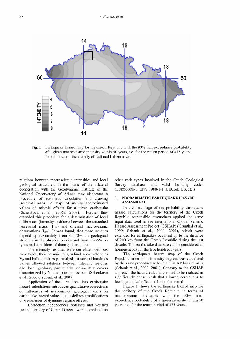
The earthquake hazard map of the Czech Republic in terms of intensity degrees was calculated by the same procedure as for the GSHAP hazard maps (Schenk et al., 2000, 2001). Contrary to the GSHAP approach the hazard calculations had to be realized in significantly dense mesh that allowed corrections to local geological effects to be implemented.
Figure 1 shows the earthquake hazard map for the territory of the Czech Republic in terms of macroseismic intensities with the 90% non-exceedance probability of a given intensity within 50 years, i.e. for the return period of 475 years.
relations between macroseismic intensities and local geological structures. In the frame of the bilateral cooperation with the Geodynamic Institute of the National Observatory of Athens they elaborated a procedure of automatic calculation and drawing isoseimal maps, i.e. maps of average approximated values of seismic effects for a given earthquake (Schenková et al., 2006a, 2007). Further they extended this procedure for a determination of local differences (intensity residues) between the smoothed isoseismal maps (IAPR) and original macroseismic observations (IOBS). It was found, that these residues depend approximately from 65-70% on geological structure in the observation site and from 30-35% on types and conditions of damaged structures.
The intensity residues were correlated with six rock types, their seismic longitudinal wave velocities VP and bulk densities ρ. Analysis of several hundreds values allowed relations between intensity residues and local geology, particularly sedimentary covers characterized by VP and ρ to be assessed (Schenková et al., 2006a; Schenk et al., 2007).
Application of these relations into earthquake hazard calculations introduces quantitative corrections of influences of near-surface geological units on earthquake hazard values, i.e. it defines amplifications or weaknesses of dynamic seismic effects.
Correction dependences obtained and verified for the territory of Central Greece were completed on
Fig. 1 Earthquake hazard map for the Czech Republic with the 90% non-exceedance probability of a given macroseismic intensity within 50 years, i.e. for the return period of 475 years; frame – area of the vicinity of Ústí nad Labem town.

EARTHQUAKE HAZARD FOR THE CZECH REPUBLIC …
39
Grünthal, G., Bosse, Ch., Camelbeeck, T., de Crook, T., Gariel, J.C., Gregersen, S., Guterch, B., Halldorsson, P., Labák, P., Lindholm, C., Lenhardt, W., Mäntyniemi, P., Mayer-Rosa, D., Musson, R.M.W., Schenk, V., Schenková, Z., Slejko, D., Verbeiren, R., Wahlström, R., Zabukovac, B. and Zsiros, T.: 1999, Seismic hazard assessment for Central, North and Northwest Europe : GSHAP region 3. Annali di Geofisica 42, No. 6, 999–1011.
Schenk, V. and Schenková, Z.: 1998, ČSN 73 0036, Amendment 2 “Seismic loads of building”, Czech technical standard, ICS 91.080.00, 91.040.00. May 1998, Czech Standards Institute, Prague, 5 pp. and 1 map (in Czech).
Schenk, V., Schenková, Z., Kottnauer, P., Guterch, B. and Labák, P.: 2000, Earthquake hazard for the Czech Republic, Poland and Slovakia – Contribution to the ILC/IASPEI Global Seismic Hazard Assessment Program. Natural Hazards 21, Nos. 2–3, 331–345.
Schenk, V., Schenková, Z., Kottnauer, P., Guterch, B. and Labák, P.: 2001, Earthquake hazard for the Czech Republic, Poland and Slovakia. Acta Geophysica Polonica 49, 287–302.
Schenk, V. and Schenková, Z.: 2007, Earthquake hazard assessment for Central Greece considering local geological media. EGU 2nd Alexander von Humboldt Int. Conf. „The Role of Geophysics in Natural Disaster Prevention“, EGU, Lima (Peru), March 2007, 55–56.
Schenková, Z., Schenk, V., Kalogeras, I., Pichl, R., Kottnauer, P., Papatsimba, C. and Panopoulou, G.: 2007, Isoseismal maps drawing by Kriging method. Journal of Seismology 11 (3), 345–353.
Schenková, Z., Kalogeras, I., Schenk, V., Pichl, R., Kourouzidis, M. and Stavrakakis, G.: 2006a, Atlas of isoseismal maps of selected Greek earthquakes (1956-2003). Publ. Evonymos Ecological Library, Athens, 99 pp.
Schenková, Z., Kalogeras, I., Schenk, V., Pichl, R.,Kourouzidis, M. and Stavrakakis, G.: 2006b, Atlas of isoseismal maps of selected Greek earthquakes (1956-2003). Abstract Book, 1st European Conf. on Earthq. Engng and Seismology (ECEES), Geneva, 3 – 8 September, 2006, Geneva, SGEB, ETH Zürich, Swiss Seismological Service, 275.
UBCode: 1997, ICBO – Uniform Building Code–1–1997, U.S. Codes, 1st Edition.
4. EARTHQUAKE HAZARD CALCULATION CORRECTED ON LOCAL GEOLOGY EFFECTSTo introduce near-surface geology corrections to
earthquake hazard calculation, the geological map for the Czech Republic has to be vectorized. For this purpose new geological map of the Czech Republic compiled by the Czech Geological Survey on the scale 1: 50 000 (Geological map for the CR, sheet 02-41) had been integrated to ArcIMS and ArcGIS server technologies.
Earthquake hazard map in the terms of the macroseismic intensities corrected on local geology effects for the vicinity of Ústí nad Labem town and the return period of 475 years is given in Figure 2. The geological map for this area with indicated rock types is presented in Figure 3.
The comparison of corrected earthquake hazard values (Fig. 2) with rock types (Fig. 3) demonstrates the great influence of individual rock types on the earthquake hazard values. Differences of 10 MSK or more can be found between the hazard values of volcanites (violet items, Fig. 3) and of alluvial or loess deposits (beige items, Fig. 3). For instance if the standard probability earthquake hazard attains 50 MSK for the locality with less consolidated geological environment, it is possible in this locality to expect the amplification of earthquake effects as much as on 60 MSK and then according to valid building codes the objects in such locality have to have seismoresistant design.
ACKNOWLEDGEMENT
This paper was prepared under financial support of the Czech Science Foundation, project 205/05/2287 and the Ministry of Education, Youth and Sport, project 1P05ME781.
REFERENCES Cornell, C.A.: 1968, Engineering seismic risk analysis. Bull.
Seism. Soc. Am. 58, 1583–1606. ENV 1988-1-1: 1994, Design provision for earthquake
resistance of structures – Part 1-1: General rules –Seismic actions and general requirement for structure. In: European Prestandard, European Committee for Standardization, Brussels, 25 pp.
Geological map for the Czech Republic – Ústí nad Labem, scale 1:50 000, sheet 02-41, Czech Geological Survey, Praha.

V. Schenk et al.
40
ZEMĚTŘESNÉ OHROŽENÍ ČESKÉ REPUBLIKY KORIGOVANÉ O VLIV MÍSTNÍ GEOLOGIE
Vladimír Schenk, Zdeňka Schenková, Richard Pichl a Zuzana Jechumtálová
ABSTRAKT: Standardní seismostatistický přístup ocenění zemětřesného ohrožení je rozšířen o korekci na lokální geologii, která často významně mění amplitudový a frekvenční obsah seismických vln a tím i jejich účinky na stavební konstrukce. Jsou vyhodnoceny vztahy mezi charakteristikami seismických vln a fyzikálními parametry hornin, speciálně sedimentárními pokryvy, a jsou statisticky určeny jejich závislosti. Tyto závislosti jsou zavedeny do výpočtu zemětřesného ohrožení České republiky. Výsledné, o vliv místní geologie korigované, hodnoty ohrožení jsou prezentovány v elektronické formě map v měřítku 1:50000 odpovídající geologické mapě České republiky sestavené pracovníky České geologické služby.

V. Schenk et al.: EARTHQUAKE HAZARD FOR THE CZECH REPUBLIC …
Fig. 2 Example of earthquake hazard map for vicinity of Ústí nad Labem town corrected on effects of localgeology. The hazard values are in the terms of macroseismic intensities calculated for return period of 475 years.

V. Schenk et al.: EARTHQUAKE HAZARD FOR THE CZECH REPUBLIC …
Fig. 3 Geological map of the vicinity of Ústí na Labem town, the scale 1:50 000 (Geological map for the CR,
sheet 02-41).