earthquake - azgs document...
TRANSCRIPT
Arizona is
Country
Down-to-Earth21
EarthquakeCountry
Arizona is

Any use of trade, product, or firm names in this publication is for descriptive purposes only and does not imply endorsement by the State of Arizona.
Printed by the Arizona Geological Survey 2012Manuscript approved for publication in September 2012.
For an electronic copy of this publication: www.azgs.az.gov
M. Lee Allison, Ph.D, PG, State Geologist and DirectorArizona Geological Survey
Arizona Is Earthquake Country, 2012, Arizona Geological Survey staff.Down-to-Earth #21, 44 pages.
Contributors: Arizona Geological Survey – Michael Conway, Jeri Young, Phil Pearthree, and Lisa Linville.
Production, design, and illustration by: Arnie Bermudez and Michael Conway. Other illustrators as noted in the text.
AcknowledgmentsWe drew heavily from California, Utah and Nevada earthquake preparedness publications, e.g., “Putting Down Roots in Earthquake Country” and “Living on Shaky Ground”, for the structure and content of this booklet.
We thank Lori Dengler of Humboldt State University for graciously providing illustrations. Thanks, too, to the Utah Geological Survey and Utah Seismic Safety Commission for graciously allowing us to use the Seven Steps to Earthquake Safety portion of their “Putting Down Roots in Earthquake Country: Your Handbook for Earthquake Hazards in Utah”. Pioneers in earthquake preparedness literature, including Lucy Jones (U.S. Geological Survey) and Mark Benthien (Southern California Earthquake Center), among others, blazed the trail that we followed. Our thanks to all of them.
Thanks, too, to Darlene Trammell, Gregory Roybal and Judy Kioski of the Arizona Division of Emergency Management for their comments and constructive criticism. Financial Support provided by the Federal Emergency Management Agency (FEMA) through the National Earthquake Hazard Reduction Program (NEHRP).
Disclaimer: The suggestions and illustrations included in this document are intended to improve earthquake awareness and preparedness; however, they do not guarantee the safety of an individual or a structure. The Arizona Geological Survey and its staff do not assume liability for any injury, death, property damage, or other effect of an earthquake. Prepared by staff of the Arizona Geological Survey.

ContentsArizona has earthquakesWhat can I do? Arizona is earthquake countryEarthquake faultsEarthquakes Aftershocks ForeshocksWhat we don’t know about earthquakes What is your risk from a damaging earthquake? Measuring earthquake size
The seven steps to earthquake safetyActive faults in ArizonaSome prominent Arizona faults Hurricane fault Algodones fault Santa Rita fault Big Chino fault Lake Mary fault Safford faultThree earthquakes & one quake swarm Sonoran Earthquake - 1887 Imperial Valley, California – 1940 Flagstaff, Arizona – ca. 1910 Sunset Crater, Arizona – Halloween 2009Earthquake hazards Ground shaking and cascading events Earthquake-related cascading events Disrupted infrastructure Damaging fires Landslides Rock fall Seiche Hazardous materials Liquefaction Dam failureMonitoring earthquake in Arizona U.S. Geological Survey shake map A role for citizen scientists in seismologyEarthquake resources Sources of earthquake information Modified Mercalli scale Intensity Scale Glossary
020304060608080808091128
44
3030303030313131313233333333353636363636363737373838393942
1

Arizona has earthquakes? Each time an earthquake occurs in Arizona, the news media and public asks, “Does Arizona have earthquakes?”. Short answer: yes! In comparison with California, Nevada, and Utah, major earthquakes in Arizona are infrequent. But each year, Arizona Broadband Seismic Network (ABSN) seismometers record hundreds of earthquakes in Arizona. And Arizona is not immune to the effects of earthquakes that originate in California, Utah, and Mexico, too. Yuma, in Arizona’s far southwest corner, is prone to earthquakes originating in southern California and Baja California, Mexico. But earthquakes occur throughout Arizona and communities in central and northern Arizona have recorded damaging earthquakes. Taking steps now to prepare your family and home will help mitigate the effects of moderate to severe earth shaking.
San Andreas Fault San Andreas Fault
Figure 1- Tectonic map of western North America showing major seismic zones in the western U.S.
2

What can I do? This handbook will help you prepare for earthquakes and their aftermath. While damaging earthquakes are unusual in Arizona, they do have the potential for causing damage wherever you live. It is important that you be aware of how to prepare for an earthquake; it costs little and requires only several hours to “earthquake proof ” your home. Getting ready in advance can save you and your family from injury, minimize damage to your home or business, and allow you to recover quickly. The “Seven steps to earthquake safety” section on page 11 provides detailed information on what you can do to prepare for earthquakes.
San Andreas Fault San Andreas Fault
3

Civil authorities, government agencies, and emergency organizations cannot protect you from the next earthquake. It could be hours or days before help arrives. In the meantime, we each bear responsibility for taking care of the needs of our families and neighbors. The steps you take now to prepare will stand you in good stead in the event of a damaging earthquake or other natural hazard -- fire or flood. Being informed and taking modest action protects you and your family, reduces loss, and assures a rapid recovery. Arizona is earthquake country Earthquakes in Arizona are not as common as in California where the San Andreas fault forms the boundary between the North American and Pacific tectonic plates (Fig. 1). From fault locations and earthquake records, we know some areas of Arizona are more susceptible to earthquakes than others. The northwestern part of the state has the highest concentration of active faults and seismicity, while Yuma on the California-Arizona-Mexico border has repeatedly experienced ground-shaking and damage from quakes originating in California and Baja California, Mexico (Fig. 2). Although these areas are more likely to suffer from earthquake activity, no Arizona community is wholly immune to earthquakes.
Northern Arizona is part of a seismically active region in the Western U.S. referred to as the Intermountain Seismic Belt (ISB), which includes Utah, Nevada, New Mexico, and eastern California. There are numerous active faults in the ISB capable of producing moderate and, less frequently, large magnitude earthquakes. The Northern Arizona Seismic Belt, which extents from the Arizona-Utah border south-southeast of Flagstaff, is a particularly seismically active region (Fig. 1).
To the south and west, Arizona’s Transition Zone -the backbone of Arizona - forms a formidable boundary of rugged terrain between the Colorado Plateau to the north and the Basin and Range Province further south and west (Fig. 2, inset). Faults in the Transition Zone are capable of causing moderate earthquakes ranging from magnitude (M) 3 to as much as M7. Further south, faults of the Basin and Range Province of southern and western Arizona and northern Sonora, Mexico, are capable of moderate to large magnitude earthquakes as well. Forces at work in the Earth’s crust of Arizona’s Basin and Range Province require tens of thousands of years to accumulate sufficient stress to generate large earthquakes, accounting for the infrequency of damaging temblors here.
Yuma, Wellton, Somerton and other communities in southwestern Arizona are likely to be impacted by earthquakes from faults comprising or related
to the North American – Pacific plate boundary. This includes the San Andreas fault system, a complex network of faults that
4

extends for more than 810 miles (1,300 km) from north of San Francisco southeast-ward to the Salton Trough (Fig. 1). South of the Trough, the Imperial fault, a splay of the San Andreas fault, crops out just 45 miles west of Yuma. Like other fault segments along the plate boundary, the Imperial fault is capable of producing a M7 earthquakes or greater. The Elsinore fault zone, the westward arm of the San Andreas fault, extends south into Baja California, Mexico, becoming the Laguna Salada fault. In April 2010, a M7.2 temblor from near the Laguna Salada fault was felt widely in southern California and southwestern and central Arizona.
Figure 2- Quaternary faults (blue) and historic earthquake epicenters (green circles, larger circles represent larger earthquakes) of Arizona and environs. Only earthquakes of magnitude 3 or greater are displayed. Inset: physiographic provinces of Arizona.
5

Earthquake faultsEarthquakes occur when rocks making up the Earth’s crust strain and rupture. The rupture occurs on planes of weakness comprising crushed and broken rock that geologists refer to as faults (Fig. 3). Arizona possesses dozens of young, active faults; mostly normal faults that accommodate extensional forces that slowly stretch and crack the Earth’s upper crust (Fig. 4). When an earthquake occurs on a fault, rocks on one side of the fault slip with respect to rocks on the other side. Faults range widely in length from inches to 100s of miles; the lives of longer faults can be measured in millions or 10s of millions of years.
Our knowledge of fault locations is supported by several lines of evidence. First, we find rocks juxtaposed that used to be further apart. Second, faults are accompanied by a surface rupture or fault scarp (Fig. 5). Third, while modern seismic networks often do not pin an earthquake directly on a fault, they do provide information on fault motion, from which we infer approximate fault location. Undoubtedly, there exist a number of potentially active faults that go overlooked because the rocks along the fault are poorly exposed, or because the fault lacks either historic activity or any telltale surface expression from prehistoric activity.
Figure 3. Fault types: reverse (left), normal (center), strike-slip (right). (Figure courtesy of the USGS.)
Figure 4. Geometry and features of a normal fault. See the glossary for precise definitions.
6

EarthquakesThere is much that we know about earthquakes. For instance, we know that most earthquakes, but certainly not all, occur along the boundaries of tectonic plates, such as the tectonic boundary of the North American and Pacific tectonic plates (Fig. 1). We know that tectonic forces stress and strain (deform or bend) the rocks of the Earth’s crust, breaking and displacing those rocks. At the instant when the rock breaks, energy is released and radiates outward. The geometry of the fault, the nature of the rupture, and the properties of the surrounding rock and soil greatly influences the propagating energy wave and the amount of ground-shaking an area will experience. As seismic waves race through the Earth’s interior, they are refracted and reflected upon encountering rocks of different physical properties. We can model the velocity and direction of the propagating waves and trace their paths through the Earth’s interior.
We know large earthquakes release far more energy and are felt over correspondingly larger areas than small earthquakes. Earthquake waves diminish in intensity the further they travel, so the further you are from the epicenter (the point on the Earth’s surface where the earthquake wave first strikes) the less intense is the shaking from the earthquake. Most of the damage from earthquakes is associated with the side-to-side shaking that accompanies surface waves.
Figure 5. Fifteen foot fault scarp that formed on the Piticaychi fault as a result of the 1887 Sonoran earthquake (image courtesy of the National Information Service of Earthquake Engineering, University of California, Berkeley).
7

Aftershocks. The main shock or earthquake is always accompanied by aftershocks. Sometimes by thousands of aftershocks! And an earthquake that is sufficiently large to cause moderate to substantial damage is likely to be followed within minutes or hours by felt aftershocks. The January 17, 1994, M6.7 Northridge, California, earthquake was accompanied by more than 13,700 aftershocks, including two M6.0 events that followed within minutes to hours of the main event.
Following a large magnitude earthquake, be prepared for aftershocks and avoid damaged structures as they may be prone to collapse. And remember, aftershocks can occur for weeks, months, even years after a large earthquake as the Earth’s crust slowly returns to a state of rest.
Foreshocks. Sometimes the main earthquake event is preceded by one or more smaller earthquakes. Geologists refer to these as foreshocks. If all large earthquakes were preceded by signature foreshocks, then we could use the smaller events to forecast large events. Unfortunately, this is rarely the case.
What we don’t know about earthquakes There is much we don’t know about earthquakes. The intricacies of precisely when, where, and how large the next earthquake will be escapes us. Nonetheless, it is possible to approximate the likelihood and magnitude of earthquakes for portions of the southwestern U.S., including Arizona. These approximations take the form of probabilities of an event; earthquake probability models are mathematical approximations derived from our understanding of the historic and prehistoric activity along well-studied faults. Of course, faults for which there is no historic record and no surface expression do not figure into our probability models. They are wild cards.
What is your risk from a damaging earthquake? The western United States is particularly prone to earthquake hazards (Fig. 6). The U.S. Geological Survey’s (USGS) online tool, “2009 Earthquake Probability Mapping”, can help you determine the likelihood of a damaging earthquake near where you live.
To get started, go the “2009 Earthquake Probability Mapping” (https://geohazards.usgs.gov/eqprob/2009/) and simply enter your zip code, a time span in years (25 years might be a good starting point), and a magnitude. A M6.0 earthquake is likely to cause damage, so you might start there. Smaller magnitude events are more likely to occur, but they are less likely to cause
extensive damage.
8
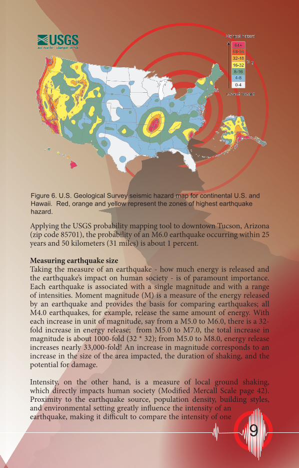
Applying the USGS probability mapping tool to downtown Tucson, Arizona (zip code 85701), the probability of an M6.0 earthquake occurring within 25 years and 50 kilometers (31 miles) is about 1 percent.
Measuring earthquake sizeTaking the measure of an earthquake - how much energy is released and the earthquake’s impact on human society - is of paramount importance. Each earthquake is associated with a single magnitude and with a range of intensities. Moment magnitude (M) is a measure of the energy released by an earthquake and provides the basis for comparing earthquakes; all M4.0 earthquakes, for example, release the same amount of energy. With each increase in unit of magnitude, say from a M5.0 to M6.0, there is a 32-fold increase in energy release; from M5.0 to M7.0, the total increase in magnitude is about 1000-fold (32 * 32); from M5.0 to M8.0, energy release increases nearly 33,000-fold! An increase in magnitude corresponds to an increase in the size of the area impacted, the duration of shaking, and the potential for damage.
Intensity, on the other hand, is a measure of local ground shaking, which directly impacts human society (Modified Mercall Scale page 42). Proximity to the earthquake source, population density, building styles, and environmental setting greatly influence the intensity of an earthquake, making it difficult to compare the intensity of one
Figure 6. U.S. Geological Survey seismic hazard map for continental U.S. and Hawaii. Red, orange and yellow represent the zones of highest earthquake hazard.
9

event, say in an area where building standards are lax, with an area that requires strict adherence to safe building codes. The Modified Mercalli Intensity Scale (MMI), p. 42, enumerates in Roman numerals the 12 intensity steps. For instance, an MMI value of 3 is felt locally and may cause hanging objects to swing to and fro; an MMI value of IX, on the other hand, is accompanied by violent shaking, general panic, and damage to masonry buildings and underground pipes.
The photograph below shows damage to a building in Calexico, California, resulting from earth shaking during the 4 April 2010, M7.2 El Mayor-Cucapah earthquake. (Image courtesy of Adam Dubrowa FEMA.)
10

The Seven Steps to Earthquake Safety
Earthquakes in Arizona are inevitable, but damage from them can be reduced. Steps you can take before, during, and after earthquakes will help make you and your family safer and reduce your injuries, damage, and losses.
• First and foremost, plan for the
personal safety of you and your family.
• Look into the safety of your home, workplace, and child’s school. Don’t forget to think about likely economic impacts to you and your family from a major quake.
Follow these seven steps to prepare for earthquakes:
BEFORE A QUAKE:
STEP 1. Identify potential hazards in your home and fix them
(p. 12-13).STEP 2. Create a disaster-preparedness
plan (p. 14-15).STEP 3. Prepare disaster supply kits (p. 16-17).STEP 4. Identify your building’s
potential weaknesses and begin to fix them (p. 18-19).
DURING A QUAKE:
AFTER A QUAKE:
STEP 5. Protect yourself during earthquake shaking (p. 20-21).STEP 6. After the earthquake, check for
injuries and damage (p. 22-23).STEP 7. When safe, continue to follow
your disaster-preparedness plan (p. 24-25).
30 Suggestions to make your house earthquake safe (p. 26.)
11

STEP
1 Collectibles and other loose objects can become dangerous projectiles. Secure them with removable putty or other adhesives.
Tall, top-heavy furniture, such as bookcases and entertainment centers, may fall and injure you.
o Store heavy items and breakables on lower shelves.
o Secure both top corners of tall furniture into a wall stud, not just to the drywall.
o Flexible-mount fasteners, such as nylon straps, allow furniture independent movement from the wall, reducing strain on studs.
Identify Potential Hazards in Your Home and Begin to Fix ThemHanging objects
Objects on open shelves and tabletops
Furniture
Art and other heavy objects hung on walls may fall, and glass in pictures and mirrors may shatter.
o Place only soft art, such as unframed posters or rugs and tapestries, above beds or sofas.
o Hang mirrors, pictures, and other hanging objects on closed hooks.
o Check the bubbles!
Follow the seven steps to Earthquake safety
BEFORE A QUAKE12

What should I do?
Unsecured water heaters may fall over, rupturing rigid water and gas connections.
o Water heaters should be anchored to wall studs or masonry with metal straps and lag screws. Kits are available at hardware stores and home centers.
o If not already done, have a plumber install flexible (corrugated) copper water connectors.
Flexible gas connector
Flexible water
connectors
Glassware and china may crash to the floor if cabinet doors are unsecured. Gas appliances can shift, rupturing their gas connections.
o Secure all cabinet doors, especially those overhead, to help prevent contents from falling out during quakes. Use latches designed for child-proofing or earthquake or boat safety.
o Secure refrigerators and other major appliances to walls using earthquake appliance straps.
Water and gas pipes
Water heaters
In the kitchen
Garage or utility room
Home electronics
Water or gas pipes anywhere in your home can break. Water leaks can cause extensive damage, and gas leaks are a major fire hazard.
o Have a plumber evaluate, replace, and properly secure rusted or worn water and gas pipes.
o If not already done, have a plumber replace rigid gas connections to water heaters, stoves, dryers, and other gas appliances with flexible (corrugated) stainless-steel gas connectors (see below).
o Excess-flow gas-shutoff valves for individual appliances, which stop gas flow in case of a catastrophic leak, are also now available for use with flexible connectors.
Items stored in garages and utility rooms can fall, causing injuries, damage, and hazardous spills or leaks.
o Move flammable or hazardous materials to low areas that are secure.
o Ensure that items stored above or beside vehicles cannot fall, damaging or blocking them.
Large electronic devices may fall, causing injuries and damage. They are also costly to replace.
o Secure TVs, stereos, computers, and microwave ovens with flexible nylon straps and buckles for easy removal and relocation.
STEP 1
For more information on making your home safer in earthquakes go to: http://www.ready.gov/
BEFORE A QUAKE
o Check the bubbles!
13

STEP
2
Plan NOW to be safe during an earthquake
Follow the seven steps to earthquake safety
BEFORE A QUAKE
Identify Potential Hazards in Your Home and Begin to Fix ThemPrepare now for an earthquake by constructing a disaster-preparedness plan. Make everyone in your family aware of it and how to behave in the event of an earthquake.
In a strong earthquake, individual survival skills will be crucial: o Practice “DROP, COVER, AND HOLD ON.” (See STEP 5, page 20) o Identify safe spots in every room, such as under sturdy desks and
tables. o Learn how to protect yourself no matter where you are
Plan NOW to respond after an earthquakeDoing the following will enable you to help your family and others after a strong quake:
o Keep shoes and a working flashlight next to each bed. o Teach everyone in your household to use emergency whistles and
(or) to knock three times repeatedly if trapped. Rescuers searching collapsed buildings will be listening for sounds.
o Identify the needs of household members and neighbors with special requirements or situations, such as use of a wheelchair, walking aids, special diets, or medication.
o Take a Red Cross first aid and CPR (cardiopulmonary resuscitation) training course. Learn who in your neighborhood is trained in first aid and CPR.
o Know the locations of utility shutoffs and keep needed tools nearby. Know how to turn off the gas, water, and electricity to your home. Only turn off the gas if you smell or hear leaking gas. (See STEP 6, page 22)
o Get training from your local fire department in how to properly use a fire extinguisher.
o Install smoke alarms and test them monthly. Change the battery once a year, or sooner if the alarm emits a “chirping” sound (low-battery signal).
o Check with your fire department to see if there is a Community Emergency Response Team (CERT) in your area. If not, ask how to start one.
o Check the bubbles!
14

STEP 2
BEFORE A QUAKE
Follow the seven steps to earthquake safety
o Check the bubbles!Plan NOW to communicate and recover
after an earthquake
Don’t wait until the next earthquake to do the following:
o Locate a safe place outside of your home for your family to meet after the shaking stops.
o Establish an out-of-area contact person who can be called by everyone in the household to relay information.
o Provide all family members with a list of important contact phone numbers.
o Determine where you might live if your home cannot be occupied after an earthquake or other disaster (ask friends or relatives).
o Learn about the earthquake plan developed by your children’s school or day care, and keep your children’s school emergency release cards current.
o Keep copies of insurance policies, financial records, and other essential documents in a secure location, such as with your household disaster kit. Include a household inventory (a list and photos or video of your belongings).
Your family may be sleeping when the next strong quake hits Arizona. After the shaking stops, the lights may be out and broken glass and other dangerous debris may litter the floor, making it unsafe to walk barefoot. Keep a flashlight and a pair of sturdy shoes secured to or within reach of everyone’s bed. A good way to do this is to use a drawstring bag tied to a bedpost at the head of the bed for each occupant.(Photo courtesy USGS)
15

STEP
3What should I do?
BEFORE A QUAKE
Personal disaster kitsEveryone in your family should have their own personal disaster kits. These kits are collections of supplies they may need when a quake strikes.
Personalize these kits and keep them where they can easily be reached—at home, in the car, at work or school. A backpack or other small bag is best for these kits so that they can be easily carried in an evacuation. Include the following items:
o Medications, a list of prescriptions, copies of medical insurance cards, doctors’ names and contact information.
o Medical consent forms for dependents. o First aid kit and handbook. o Spare eyeglasses, personal hygiene supplies, and
sturdy shoes. o Bottled water. o Whistle (to alert rescuers to your location). o Emergency cash. o Personal identification. o List of emergency contact phone numbers. o Snack foods high in calories. o Emergency lighting—light sticks and (or) a working flashlight with extra
batteries and light bulbs (hand-powered flashlights are also available). o Comfort items, such as games, crayons, writing materials, and teddy
bears.
Prepare Disaster Supply Kits
A Special Note About ChildrenBefore the next earthquake, spend time with your kids to discuss what might occur. Involve them in developing your disaster plan, preparing disaster kits (ask them what game or toy they want to include), and practicing “DROP, COVER, AND HOLD ON.”
In the days after a quake, kids need extra contact and support. They may be frightened and under great stress, and aftershocks won’t let them forget the experience. Parents may have to leave children with others in order to deal with the emergency, and this can be scary. Whenever possible, include your children in the earthquake recovery process.
Resources for kids to learn about disaster preparedness:http://www.fema.gov/kids/http://earthquake.usgs.gov/4kids/
o Check the bubbles!
16
(Photo courtesy of American Red Cross)
STEP 3
BEFORE A QUAKE
Household disaster kit
What should I do?
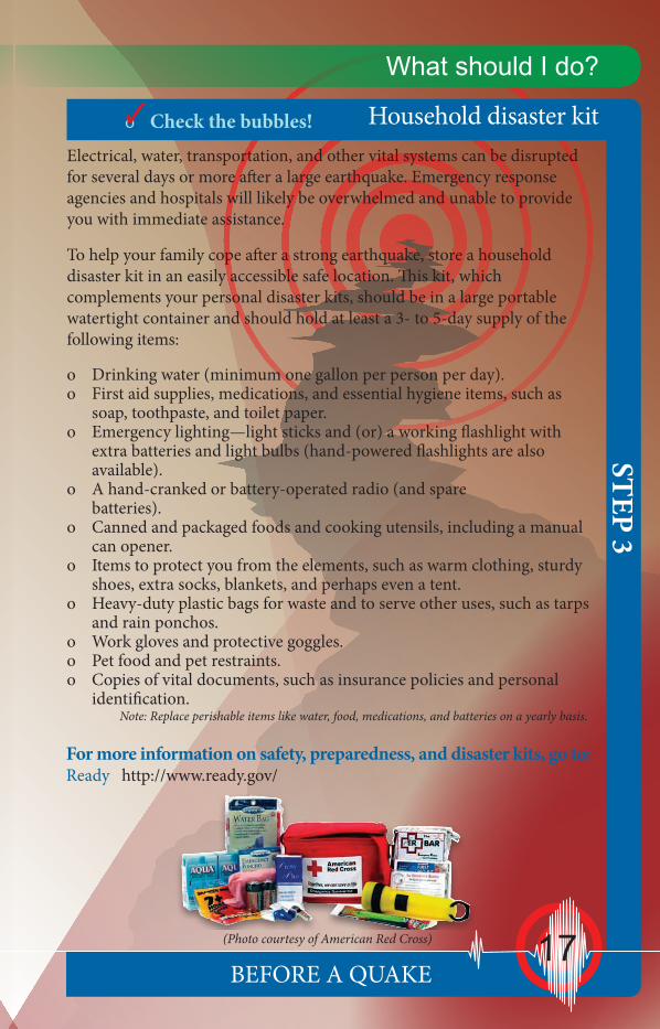
Electrical, water, transportation, and other vital systems can be disrupted for several days or more after a large earthquake. Emergency response agencies and hospitals will likely be overwhelmed and unable to provide you with immediate assistance.
To help your family cope after a strong earthquake, store a household disaster kit in an easily accessible safe location. This kit, which complements your personal disaster kits, should be in a large portable watertight container and should hold at least a 3- to 5-day supply of the following items:
o Drinking water (minimum one gallon per person per day). o First aid supplies, medications, and essential hygiene items, such as
soap, toothpaste, and toilet paper. o Emergency lighting—light sticks and (or) a working flashlight with
extra batteries and light bulbs (hand-powered flashlights are also available).
o A hand-cranked or battery-operated radio (and spare batteries).
o Canned and packaged foods and cooking utensils, including a manual can opener.
o Items to protect you from the elements, such as warm clothing, sturdy shoes, extra socks, blankets, and perhaps even a tent.
o Heavy-duty plastic bags for waste and to serve other uses, such as tarps and rain ponchos.
o Work gloves and protective goggles. o Pet food and pet restraints. o Copies of vital documents, such as insurance policies and personal
identification. Note: Replace perishable items like water, food, medications, and batteries on a yearly basis.
For more information on safety, preparedness, and disaster kits, go to:Ready http://www.ready.gov/
o Check the bubbles!
17

STEP
4Follow the seven steps to earthquake safety
BEFORE A QUAKE
Is your house, condo, or apartment strong enough to withstand an earthquake?
Identify your building’s potential weaknesses and begin to fix them
Use the following quiz to see if your home is likely to be so badly damaged in a future earthquake that people might be injured or that it would be unsafe to occupy. If your home scores above 17 on the quiz, you probably should have a structural engineer evaluate it unless it has been strengthened in the last few years. The engineer will check to see if your home is strong enough to keep you and your family reasonably safe in an earthquake by looking for the following:
• Is your house properly connected to the foundation?
• Is there plywood on the exterior walls of your house?
• Are there anchors attaching the roof and floor systems to the walls?
• Is your house constructed out of unreinforced masonry?
• Do you have large openings like a garage door that may require better bracing?
The following quiz will help you to determine the adequacy of your house in resisting a seismic event. Once you have identified the areas requiring retrofitting, prioritize how and when to fix them, and get started. Local building departments are excellent resources.
18

1. When was your home built? o Before 1970 = 6 points o 1970 – 1980 = 3 points o After 1980 = 1 point
2. How many stories and what style is your home? o 2 or more stories above grade with stepped floors, split levels, or large
openings in floors = 5 points o 2 or more stories above grade with flat floors, no steps in the floor,
and no large openings in floors = 3 points o 1 story rambler above grade = 1 point
3. What is the construction material of the exterior walls? o Unreinforced masonry bearing walls = 7 points o Wood or reinforced masonry with full height brick veneer = 3 points o Wood or reinforced masonry = 1 point
4. What are the foundation walls constructed from? o Stacked rock or brick, with basement = 5 points o Stacked rock or brick, no basement = 3 point o Concrete, with or without basement = 1 point o Slab on grade, no basement = 0 points
5. Where is your house located? (see map, page 8)
If your home scores 17 or more points on the quiz, you probably should have an engineer, architect, or contractor evaluate it.
EXAMPLES:
1. 1949, 1 story, unreinforced masonry, concrete foundation, Flagstaff: 6+1+7+1+8 = 23
2. 1995, 2 story (flat), wood (brick veneer), concrete foundation, Yuma: 1+3+3+1+8 = 16
3. 2006, 2 story (large openings), wood, slab on grade, Tucson: 1+5+1+0+3 = 10
STEP 4
BEFORE A QUAKE
Structural-safety quiz for homes and other buildings
Follow the seven steps to earthquake safety
Total points =
o Check the bubbles!
19

STEP
5What should I do?
DURING A QUAKE
If you are indoors...
Protect yourself during earthquake shakingThe previous pages have concentrated on getting you ready for future earthquakes in Arizona, but what should you do when the shaking starts?
• DROP, COVER, AND HOLD ON. If you are not near a desk or table, drop to the floor against an interior wall and protect your head and neck with your arms.
• Avoid exterior walls, windows, hanging objects, mirrors, tall furniture, large appliances, and cabinets filled with heavy objects.
• Do not go outside until well after the shaking stops!
In bedHold on and stay there, protecting your head with a pillow. You are less likely to be injured staying where you are. Broken glass on the floor can cause injuries; be sure to put shoes on before stepping on the floor.
In a high-rise buildingDROP, COVER, AND HOLD ON. Avoid windows. Do not use elevators. Do not be surprised if sprinkler systems or fire alarms activate.
At workDROP, COVER, AND HOLD ON. Know your workplace’s earthquake safety plan and put it into action. When safe, move to a specified meeting location.
In a public building or theaterDROP, COVER, AND HOLD ON if possible. If in a theater seat, duck down and protect your head and neck with your arms. Don’t try to leave until the shaking is over. Then walk out slowly, watching for fallen debris or anything that could fall on you in aftershocks.
20
STEP 5
DURING A QUAKE
If you are outdoors...
What should I do?
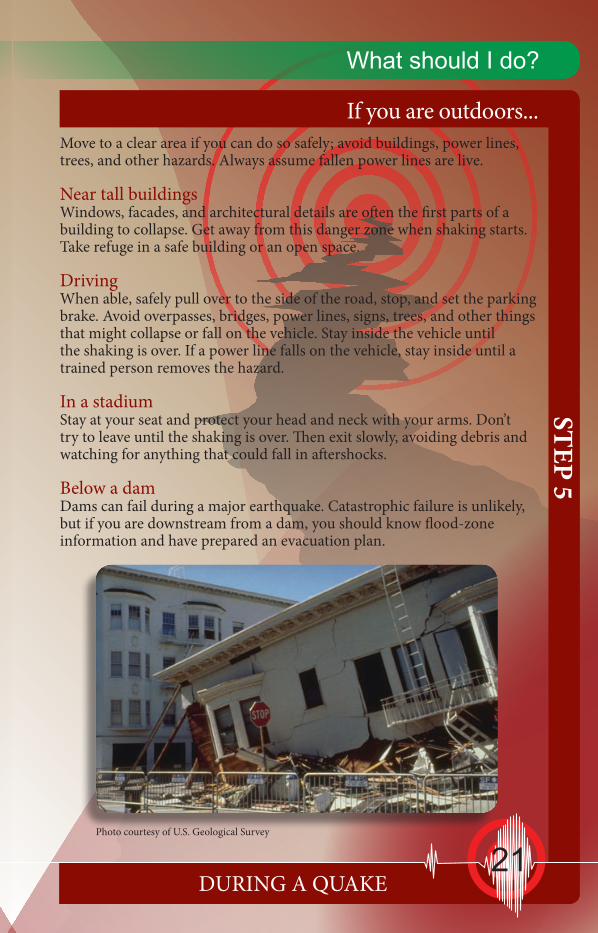
Move to a clear area if you can do so safely; avoid buildings, power lines, trees, and other hazards. Always assume fallen power lines are live.
Near tall buildingsWindows, facades, and architectural details are often the first parts of a building to collapse. Get away from this danger zone when shaking starts. Take refuge in a safe building or an open space.
DrivingWhen able, safely pull over to the side of the road, stop, and set the parking brake. Avoid overpasses, bridges, power lines, signs, trees, and other things that might collapse or fall on the vehicle. Stay inside the vehicle until the shaking is over. If a power line falls on the vehicle, stay inside until a trained person removes the hazard.
In a stadiumStay at your seat and protect your head and neck with your arms. Don’t try to leave until the shaking is over. Then exit slowly, avoiding debris and watching for anything that could fall in aftershocks.
Below a damDams can fail during a major earthquake. Catastrophic failure is unlikely, but if you are downstream from a dam, you should know flood-zone information and have prepared an evacuation plan.
Photo courtesy of U.S. Geological Survey
21

STEP
6Follow the seven steps to earthquake safety
AFTER A QUAKE
Check for injuries
After the earthquake, check for injuries and damageOnce earthquake shaking has stopped, follow your disaster preparedness plans (see Step 2, page 24). Most importantly:
NOTE: The manual in your first aid kit and the front pages of your telephone book have instructions on first aid measures.• Check yourself for serious injuries before helping others. Protect your
mouth, nose, and eyes from dust.• If a person is bleeding, put direct pressure on the wound. Use clean gauze
or cloth, if available.• If a person is not breathing, administer rescue breathing.• If a person has no pulse, begin CPR (cardiopulmonary resuscitation).• Do not move seriously injured persons, unless they are in immediate
danger of further harm.• Cover injured persons with blankets or additional clothing to keep them
warm.
Check for damage causing hazardous conditions• Fire—If possible, put out small fires in your home or neighborhood
immediately. Call for help, but don’t wait for the fire department.
• Gas leaks—Turn off the gas only if you suspect a leak because of broken pipes or detect the odor or sound of leaking natural gas. Use a manual gas shut-off wrench to close your main gas valve by turning it counterclockwise. Don’t turn gas back on by yourself—wait for the gas company! (Your telephone book has information on this topic.)
• Damaged electrical wiring—Shut off power at the main breaker switch if there is any damage to your home wiring. Leave the power off until the damage is repaired! (Your telephone book also has information on this topic.)
• Downed utility lines—If you see downed power lines, consider them energized and keep yourself and others well away from them. Never touch downed power lines or any objects in contact with them!
• Falling items—Beware of heavy items tumbling off shelves when you open closet and cupboard doors.
•Spills—Use extreme caution; when in doubt, leave your
22

STEP 6
AFTER A QUAKE
If your home is seriously damaged
What should I do?home. Spilled medicines, drugs, or other relatively non-toxic substances can be cleaned up. Potentially harmful materials, such as bleach, lye, garden chemicals, paint, and gasoline or other flammable liquids should be isolated or covered with an absorbent material, such as dirt or cat litter.
• Damaged masonry—Stay away from brick chimneys and walls. They may be weakened and could topple during aftershocks. Don’t use a fireplace with a damaged chimney, as this could start a fire or trap toxic gases in your home.
If your home is structurally unsafe or threatened by a fire or other secondary disaster, you need to evacuate. However, shelters may be overcrowded and initially lack basic services, so do not leave home just because utilities are out of service or your home and its contents have suffered moderate damage. If you evacuate, and be sure to make plans for evacuating pets, tell a neighbor and your family point-of-contact where you are going. Take the following, if possible, when you evacuate:
Bring to a shelter: o Personal disaster supply kits (see STEP 3, page 25). o Supply of water, food, and snacks. o Blanket, pillow, and air mattress or sleeping pad. o Change of clothing and a jacket. o Towel and washcloth. o Diapers, formula, food, and other supplies for infants. o A few family pictures or other small comfort items, such as dolls or
teddy bears for children. o Personal identification and copies of household and health insurance
information. o Books and games (especially for children). o Your pets, pet food and any essential medicine(s).
However, do not bring• Large quantities of unnecessary clothing or other
personal items.• Valuables that might be lost, stolen, or take up
needed space.If you suspect a gas leak, use a
manual gas shut-off wrench.
o Check the bubbles!
23

STEP
7What should I do?
AFTER A QUAKE
The first day after the quake
When safe, continue to follow your disaster-preparedness planOnce you have met your and your family’s immediate needs after the next strong Arizona earthquake, continue to follow your disaster-preparedness plan (see Step 2, page 24).
In the days following a damaging quake, pay special attention to the following:
Safety first• Do not re-enter your home until you know it is safe.• Be sure there are no gas leaks at your home before using open flames
(lighters, matches, candles, or grills) or operating any electrical or mechanical device that could create a spark (light switches, generators, chain saws, or motor vehicles).
• Check for chemical spills, faulty electrical wiring, and broken water lines. Water in contact with faulty wiring is a shock hazard.
• Unplug broken or toppled light fixtures or appliances. These could start fires when electricity is restored.
• Never use the following indoors: camp stoves, kerosene or gas lanterns or heaters, gas or charcoal grills, or gas generators, as these can release deadly carbon monoxide gas or be a fire hazard in aftershocks.
Be in communication• Turn on your portable or car radio and listen for information and safety
advisories.• Place all phones back on their cradles.• Call your out-of-area contact, tell them your status, and then stay off
the phone—emergency responders need the phone lines for life-saving communications.
• Check on your neighbors.Check your food and water supplies• If power is off, plan meals so as to use up refrigerated and frozen foods
first. If you keep the door closed, food in your freezer may be good for a couple of days.
• If your water is off, you can drink from water heaters, melted ice cubes, or canned vegetables. Avoid drinking the water from swimming pools or hot tubs; use it to fight fires.
24
STEP 7
AFTER A QUAKE
The first weeks after the earthquake
What should I do?
• This is a time of transition. Although aftershocks may continue, you will now work toward getting your life, your home and family, and your routines back in order. Emotional care and recovery are just as important as healing physical injuries and rebuilding a home. Make sure your home is safe to occupy and not in danger of collapse in aftershocks. If you were able to remain in your home or return to it after a few days, you will have a variety of tasks to accomplish while re-establishing routines:
Tasks• If your gas was turned off, you will need to arrange for the gas company
to turn it back on.• If the electricity went off and then came back on, check your appliances
and electronic equipment for damage.• If water lines broke, look for water damage.• Locate or replace critical documents that may have been misplaced,
damaged, or destroyed.• Contact your insurance agent or company to begin your claims process. • Contact the Federal Emergency Management Agency (FEMA) to find
out about financial assistance. For FEMA teleregistration, call 1-800-621-FEMA (3362).
• If you cannot live at your home, set up an alternative mailing address with the post office.
If you can’t stay in your homeThe American Red Cross offers immediate emergency assistance with housing needs. The Red Cross also supports shelter operations prior to a presidential declaration of a federal disaster.
In the unlikely event of a presidential declaration being issued, FEMA may activate the Assistance for Individuals and Households Program. This program includes: • Home-repair cash grants; the maximum federal grant available is
$28,800 for all individual and family assistance.• Housing assistance in the form of reimbursement for short-term lodging
expenses at a hotel or motel.• Rental assistance for as long as 18 months in the form of cash payment
for a temporary rental unit or a manufactured home. • If no other housing is available, FEMA may provide mobile
homes or other temporary housing.
25

1. Be familiar with hazards around your home.2. Hang plants in lightweight pots with closed hooks.3. Store fire extinguisher in easily accessible location.4. Install latches on kitchen cabinets.5. Use flexible connections where gas lines meet appliance.6. Remove or lock refrigerator wheels, secure to studs.7. Keep several flashlights in set locations around the house.8. Secure valuable electronics – computers and televisions.9. Keep breakables in low or secure cabinets with latches.10. Move heavy plants and other large items to floor or low shelves.11. Hang mirrors and pictures on closed hooks.12. Secure free-standing woodstove or fireplace insert.13. Keep heavy unstable objects away from doors and exit routes.14. Place bed away from windows or large items.15. Secure knick knacks.16. Brace overhead light fixtures.
Thirty suggestions to make
Figure 7. Thirty suggestions to make your home earthquake safe (image courtesy of Lori Dengler, Humboldt State University).
11
12
13
24
9
8 8
10
6
7
5 4
3
2
1
26

17. Place only light weight objects over bed.18. Secure top-heavy furniture to studs.19. Keep wrench or turn-off tool handy or near gas meter.20. Know the location of your main electrical switch – fuse box.21. Secure water heater with metal straps to studs22. Trim hazardous tree limbs.23. Have your emergency plan accessible – discuss it with family.24. Obtain a NOAA Weather Radio with the Public Alert feature.25. Keep an emergency backpack with copies of important documents ready to grab and go.26. Keep flashlight, slippers and gloves next to beds.27. Keep gas tank at least half full.28. Store emergency food and water supplies in a dry accessible area. Include a first-aid kit, too.29. Use anchor bolts every 4 to 6 feet to secure home to foundation. 30. Reinforce brick chimneys.
your home earthquake safe
30
1125
12
13
26 14
15
1617 18
2319
27
2820
21
22
29
27

Active faults in ArizonaFaults are to earthquakes what storm clouds are to rain. You can’t have one without the other. The western United States is riddled with faults and Arizona is no exception. Dozens of young faults have been identified by geologists in Arizona, with the largest concentration north of Flagstaff in the Northern Arizona Seismic Belt (Fig 8). But faults occur in central, southern and eastern Arizona, too.
Faults are by nature episodically active and operate over tens of thousands to millions of years. A key element of any fault is its recurrence rate – the average period of time between successive major earthquake events. Faults in Arizona tend to have long recurrence rates. For example, the Big Chino fault north of Prescott ruptures between every 10,000 to 30,000 years – the last major event probably occurred about 10,000 to 15,000 years ago. Areas at moderate to higher risk from earthquakes include Yuma, Prescott, and the Flagstaff-Grand Canyon area. Yuma’s proximity to the active San Andreas fault system places it at greatest risk. The Northern Arizona Seismic Belt, which includes northern Coconino County, home to Flagstaff and Williams, Arizona, has not suffered a large earthquake in about 100 years. Flagstaff suffered damage from earthquakes in 1906, 1910, and 1912 from events that occurred 10s of miles away. The Cataract Creek earthquakes of 1993, magnitude 4.9 and 5.3, shook the area without causing damage.
Figure 8. Quaternary faults of Arizona. The six faults described in the next section include: (A) Algodones, (B) Hurricane, (C) Big Chino, (D) Lake Mary, (E) Safford, and (F) Santa Rita faults.
28

Near Prescott in central Arizona, the largest historical earthquake was an M5.1 event on 4 February 1976. While there were no injuries and damage was minor, the earthquake was felt over nearly 50,000 square miles in central and northern Arizona. Twenty-five miles east-northeast of Prescott, Clarkdale, Arizona, felt two nearby earthquakes in January and March 2011; the first a M3.6 event, the second an M3.7 earthquake.
In their book, “A Home Buyer's Guide to Geologic Hazards in Arizona”, Ray Harris and Phil Pearthree noted that the risk from earthquakes in the Sonoran Desert of southern Arizona, where few historical earthquakes have occurred, is low (Fig. 9). In southeastern and central Arizona, including much of the Phoenix and Tucson metropolitan areas, the earthquake hazard is low to moderate. Nonetheless, potentially active faults scattered across this region are fairly long and could generate M6.0 to M7.2 earthquakes. These faults, however, display low slip rates and very long intervals between ruptures. With the exception of the major 1887 Sonoran Earthquake, historical earthquake activity has been low. But the 1887 event – an estimated whopping M7.4 earthquake - shows that large magnitude earthquakes can and do occur.
Figure 9. Arizona Earthquake Hazard Zones (Earthquake Hazards Map, 1999, by Pearthree and Bausch)
29

Some Prominent Arizona FaultsThere are active faults in Arizona capable of generating moderate to large earthquakes. And over the past 100,000 years, at least 20 of these faults have generated at least one earthquake on the order of M6 to M7+ and several faults have generated more than one large earthquake in that time window. Discussed below are some of the more potentially destructive faults in Arizona (Fig. 8).
Hurricane Fault, northern Arizona. A north-south trending, down-to-the-west, normal fault with well-developed and pronounced fault scarp. One of the longer and more active faults in Arizona with strong evidence of rupture in the past 10,000 years. The recurrence interval – period of time between successive large earthquakes - is estimated at 5,000 to 50,000 years. Rocks along the fault have been displaced as much as 1300 feet. Slip-rate ranges between 0.01 and 0.04 inches/year. The fault zone has generated large earthquakes between M6.5 and M7.5. The nearest communities likely to be impacted by rupture are St. George and Cedar City, Utah.
Algodones Fault, southwestern Arizona. An northwest-trending normal fault stretching for 20 miles south of Yuma. A well-defined 5 - to 50-foot-high fault scarp is evident. Displacement per event is estimated at about 5 feet. The most recent large event occurred between 11,000 and 15,000 years ago. Characteristic maximum magnitude approaches M6.6. The slip-rate is about 0.01 inches/year. In the event of an earthquake, nearby Yuma, Somerton and Wellton, Arizona, and San Luis Rio Colorado, Mexico, are likely to be impacted.
Santa Rita Fault, southern Arizona. North to northeast-trending fault about 35 miles long cutting across the western alluvial fans of the Santa Rita Mountains, southeast of Tucson. Displacement per event is on the order of seven feet. Most recent rupture event occurred between 60,000 and 100,000 years ago. Slip-rate is less than 0.01 inches per year. Repose is long approaching 100,000 years between major events, with a maximum magnitude earthquake of about M7.0. Communities likely to be impacted include Green Valley and Tucson.
Big Chino Fault, central Arizona. A northwest-trending fault located along the northeastern margin of Big Chino Valley. Displacement during individual events is on the order of seven to 12 feet. The most recent event occurred about 10,000 to 15,000 years ago. Recurrence rate is somewhere between 10,000 and 30,000
years. Well-developed faults scarp(s) are observed for most of its 35 miles. The slip rate is about 0.01 inches per year.
30

Maximum magnitude event is on the order of M7.0. Communities likely to be impacted: Paulden, Chino Valley and Prescott.
Lake Mary Fault, north-central Arizona. A northwest-trending fault stretching for about 30 miles from near Mormon Lake to Flagstaff. Most recent activity occurred sometime after 130,000 years ago. Slip rate is less than 0.01 inches per year. Recurrence rate is poorly known but certainly on the order of tens of thousands to the 100,000 year range. Maximum magnitude is probably about M7.0. The nearest large community is Flagstaff.
Safford Fault, eastern Arizona.A north to northwest trending, discontinuous fault zone along the east front of the Pinaleño Mountains. Total fault length is about 20 miles long. Most recent rupture probably occurred between 10,000 and 15,000 years ago. Recurrence rate is unknown. Slip-rate is less than 0.01 inches per year. Maximum magnitude is probably about M6.5. In the event of an earthquake, the nearby communities of Safford and Thatcher are most likely to be impacted.
Three earthquakes & one quake swarmOver the past 125 years, three earthquakes stand out in their impact on Arizona. Two occurred before statehood, and of the three only one occurred in what is now the state of Arizona. Nonetheless, these three events show that large magnitude and destructive earthquakes are indigenous to Arizona. Similar-sized events will occur in the future. Preparing for earthquake activity now will prevent injuries and minimize damage in the future.
Sonoran Earthquake 1887. On 3 May 1887, a major earthquake rocked nearly 775,000 square miles of the southwestern United States and Mexico. The epicenter of the estimated M7.4 event was about 40 miles southeast of Douglas, Arizona, on the Pitaycachi Fault. The resulting fault scarp broke the Earth’s surface for about 60 miles, with the northern tip exposed just 5 miles south of Douglas (Fig. 10). The average vertical offset on the fault was a whopping 9 feet; maximum displacement was about 16 feet!
Tepic, Sonora, situated about 130 miles south of Tombstone, Arizona, was flattened by the event; most homes were destroyed, irrigation ditches broken, and the town plaza and environs “ripped up” by ground fissures. Across northern Sonora, 51 lives were lost. Ground shaking in southeastern Arizona lasted 1-to 3-minutes. Rock falls occurred in
31

nearby mountain ranges, including the Santa Catalina Mountains, north of Tucson.
In 1887, fewer than 90,000 people lived in the Arizona Territory. Now more than four million people inhabit the metropolitan areas of Phoenix and Tucson combined. While earthquakes M7 or more are rare in the southwestern U.S., excluding California, they do occur. Civil authorities, geologists, and the broader public must ask, “are we ready?”
Imperial Valley Earthquake 1940. In southeastern California, the San Andreas fault splays into the Imperial fault. On 19 May 1940, a M6.9 earthquake caused nine deaths and $6 million in damages. Eighty percent of the buildings in Imperial, California, suffered damage. A major aftershock, M5.5, followed closely on the heels of the main event, causing substantial additional damage to buildings in Brawley, California.
The ground unsutured along the right-lateral Imperial fault producing a surface fracture that stretched from 12.5 to 15.5 miles long, extending from the epicenter of the main shock southeastward towards Cocopar, Mexico. Nearly 15 feet of offset occurred near the All-American Canal east of Calexico, California.
Shaking was felt over more than 60,000 square miles of southwestern Arizona and southern California. In Yuma, Arizona, liquefaction, a
condition induced by shaking water-saturated sediments, damaged roads and farm fields. Several homes were shaken
Figure 10. Trace of the Piticaychi fault scarp from the May 1887 M7.4 earthquake (from The 1887 Earthquake in San Bernardino Valley, Sonora: Historic Accounts and Intensity Patterns in Arizona by S.M. DuBois and A.W. Smith, 1980).
32

loose of their foundations, too. South of Yuma, near Gadsden and Somerton, roads buckled, bridges were dislodged, and canals, drainage channels, and flumes, were damaged. The tremor was felt in Phoenix and Tucson, too.
Flagstaff, Arizona 1906. From January 1906 to August 1912, Coconino County experienced three magnitude (M) 6.0 to 6.2 earthquakes, all of which occurred within 24 miles of Flagstaff. •1906,January25, M6.2 •1910,September24,M6.0 •1912,August18, M6.2
Ground shaking from the 1906 earthquake lasted more than 30 seconds, caused general panic in the community, and collapsed chimneys, cracked walls, broke glassware, and shook plaster from ceilings. The shock was felt over 86,000 square miles of northern and central Arizona with reports of shaking from Angell, Bellemont, Phoenix, Seligman, Williams, Winslow, and towns in New Mexico and Utah. Flagstaff residents felt a “great rocking motion”.
Sunset Crater, Arizona, Halloween 2009 Swarm. While lacking the punch of the earlier events - almost no one felt these earthquakes - the earthquake swarm of 31 October 2009, near the 990 year old Sunset Crater, 15 miles northeast of Flagstaff, deserves attention. About 120 small magnitude earthquakes, most were M2.0 or smaller, occurred over a six-hour period in the early morning hours. The largest tremor, a M2.9 tremor, marked the end of the swarm. Earthquake locations clustered along a northeast trending zone that became shallower toward the southwest, in a trend at right angles to faults near the crater.
The earthquakes originated in the mid-crust at depths ranging from 10 to 16 miles. Only the M2.9 event was likely to be felt. The swarm occurred in what the U.S. Geological Survey recognizes as an active volcanic field, the San Francisco volcanic field, raising questions about the role of magma – molten rock – movement as a cause of the events.
Earthquake hazards Each year seismic networks across the U.S. record more than 87,000 earthquakes. Most of those events are too weak to be felt by people, but a handful cause damage and even fatalities. Earthquake damage
33

usually results from ground shaking associated with surface seismic waves. There are two types of surface waves. The first, Rayleigh waves, roll across the Earth’s surface much like a wave moves across the ocean surface. As the wave rolls through, the ground rises and then falls; buildings respond much like a cork bobbing and swaying up and down on ocean swells. The second surface wave, Love waves, induces ground shaking from side to side. Unreinforced masonry buildings – buildings of brick, cinder block, stone or adobe, - are particularly susceptible to damage from Love waves.
Ground Shaking. Seismologists have a favorite saying, “Earthquakes don’t kill people, buildings kill people.” And that is about right (Fig. 11), while not entirely correct; cascading or associated events, such as landslides, collapsing bridges, roads, and dams, falling objects, tsunami, and fire, kill people, too. But the chief earthquake hazard for people living in Arizona, is likely to be building collapse or falling objects: indoor hazards include heavy bookcases, pictures, appliances, and large screen TVs; while outdoors parapet, masonry, adornments, cornice, rain gutters, lights, and gargoyles constitute a hazard.
Buildings accommodate vertical ground acceleration (up and down motion) reasonably well, it is the side-to-side shaking characteristic of surface waves that are particularly damaging. Wood frame buildings, which include many homes in the United States, behave well because wood is naturally resilient and flexes with the wave; foundations may crack, wallboard split, and unattached objects may fall, but rarely will the building collapse outright. (Fire, of course, is another concern.) Unreinforced masonry buildings (referred to as URMs), such as adobe, cinder block, brick, tile or other masonry material that lack reinforcing supports, e.g., rebar, may wholly collapse killing or injuring people within.
A number of factors come into play regarding whether a building will sustain damage or collapse as the result of an earthquake.
Figure 11. Building in Calexico, Mexico, damaged during 4 April 2010 El Mayor earthquake (image by Adam Dubrowa, Federal Emergency Management Agency).
34
Chief factors include:• Magnitude of the earthquake.
Small magnitude quakes, M3 to M5, may result in nuisance level damage – cracked chimneys, falling pictures, chipped dishes and glasses – but little more. Magnitude 6 to M7 events can produce considerably more damage including collapse of unreinforced masonry buildings leading to serious injury or death. Events larger than M7 can cause catastrophic damage to infrastructure – buildings, roads, bridges, canals, dams - leading to numerous injuries and deaths.
• Distance from the earthquake – all other things being equal, the further from the main event the less the damage.
• Local soil conditions -- seismic waves propagate through solid bedrock rapidly, thereby minimizing the duration and amplitude of shaking. Soft sediments, like ancient lake deposits and
the unconsolidated valley fill in valleys of Arizona’s Basin and Range Province, tend to slow and amplify the energy from seismic waves, resulting in longer more powerful shaking that can lead to more building and infrastructure damage.
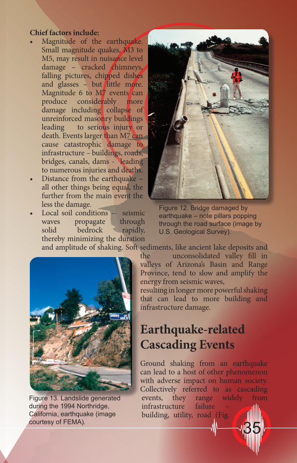
Earthquake-related Cascading Events Ground shaking from an earthquake can lead to a host of other phenomenon with adverse impact on human society. Collectively referred to as cascading events, they range widely from infrastructure failure – building, utility, road (Fig.
Figure 12. Bridge damaged by earthquake – note pillars popping through the road surface (image by U.S. Geological Survey).
Figure 13. Landslide generated during the 1994 Northridge, California, earthquake (image courtesy of FEMA). 35

12) or dam collapse, to landslides, rock fall, liquefaction, and more.
Disrupted Infrastructure. Earthquakes are capable of damaging roads, crippling or collapsing buildings, and disrupting pipelines and utilities resulting in injury or even death. Oil pipelines can be severed leading to damaging oil spills.
Damaging Fires. Earthquakes can disrupt electrical lines, gas lines, and water lines. Add to this damage to water tanks, roads and bridges and you have a powerful recipe for hard-to-control fires.
Landslides. Shaking from earthquakes can cause sloping ground to collapse and form landslides capable of damaging buildings, roads, bridges, pipelines
and other infrastructure (Fig. 13). Landslides can dam rivers causing flooding upstream while endangering communities downstream in the event of sudden dam collapse.
Rock Fall. The 1887 Sonoran earthquake set in northern Sonora, Mexico, caused rock falls in the mountains throughout southeastern Arizona. According to one observer, “Rocks crashed down the mountainsides, and large clouds of dust rose
several thousand feet above the peaks.” Rock falls can damage roads and collapse homes and other infrastructure.
Seiche. Landlocked Arizona has little to fear from tsunamis, but seiches, which form as water in enclosed basins sloshes back and forth, are a potential hazard. Swimming pools, reservoirs, lakes and ponds are potentially prone to seiche formation. Besides inboard damage from flood waters, seiches can sweep shoreline observers lakeward. Some Phoenix residents reported observing a seiche in their backyard pools during the 4 April 2010, El Mayor-Cucupah earthquake.
Hazardous Materials. Hazardous materials – pesticides, petroleum products, and chemicals - can be released from industrial plants and holding containers
during earthquakes. The resulting damage to the environment can verge on the catastrophic.
Figure 14. Building in San Francisco’s Marina section that foundered as shaking from the 1989 Loma Prieta earthquake caused liquefaction (image by U.S. Geological Survey).
36

95
Gila River
Area of LiquefactionDamage May 18, 1940
California
Mexico
Arizona
San Luis
Colorado RiverAlgodones Fault
YumaMesa
Ave
B
16th St
22nd St
I-8
SouthGila
Valley
NorthGila
Valley
Yuma
Gadsden
10th St
Som
erto
n Av
e
Ave
I
Liquefaction Hazard
Figure 15. Liquefaction hazard zone in and around Yuma, Arizona (courtesy of the U.S. Geological Survey).
Liquefaction. Water saturated soils can lose their stiffness during the ground shaking that accompanies earthquakes and behave like a liquid. As a result the ground can flow, fracture or slump disrupting roads and bridges and causing buildings to founder (Fig. 14). Yuma and Gila Valleys, with their high ground water tables and loose sandy soils, are particularly prone to liquefaction. (Fig. 15)
Dam Failure. Severe shaking and earthquake rupture can cause dams to fail, leading to sudden and catastrophic downstream flooding. Following dam failure, water resources may be greatly reduced and water contamination a serious concern.
Monitoring earthquakes in ArizonaUntil recently, U.S. Geological Survey monitoring of earthquake activity in Arizona was only capable of detecting earthquakes of M3.5 or greater. Northern Arizona fared somewhat better; since the mid-1980s the Arizona Earthquake Information Center (AEIC) network of six analogue stations was capable of detecting smaller events.
In 2007, earthquake monitoring in Arizona improved markedly when Earthscope’s US Array deployed nearly 60 temporary seismic stations throughout the state. For the first time, there was a statewide network capable of detecting small magnitude earthquakes. In 2008, the transportable array rolled eastward, but the Arizona Geological Survey purchased eight stations for building a permanent broadband seismic network, the Arizona Broadband Seismic Network (ABSN) (Fig. 16a & b).
Figure 16a. Map of the Arizona Broadband Seismic Network hosted at azgs.az.gov.
37

The broad geographic spread of ABSN seismometers assures that small magnitude earthquakes will no longer go undetected. Earthquake data captured by ABSN provides researchers with data for better understanding the distribution and behavior of Arizona’s active fault systems. In time, this should lead to better, more efficacious earthquake hazard modeling, which should make Arizona safer.
To follow global and regional seismic activity in near real-time, tune in to the U.S. Geological Survey’s “Latest Earthquakes in the World” web page (http://earthquake.usgs.gov/earthquakes/recenteqsww/Quakes/quakes_all.html).
U.S. Geological Survey shake mapWithin minutes of a magnitude 3.0+ earthquake, the U.S. Geological Survey Shake Map program releases a map displaying the extent and intensity of ground shaking (Fig. 17). Ground shaking is strongly influenced by the magnitude of the earthquake, local rock and soil properties, and attenuation of seismic energy due to complexities in the Earth’s crust. Shake Map provides a picture of where shaking was greatest, providing an important aid to emergency managers in structuring their response to earthquake-related hazards.
A Role for Citizen Scientists in Seismology. Since 1999, the U.S. Geological Survey’s Did you feel it? earthquake reporting program has solicited the input of 100,000s of citizen scientists – more than 500,000 reports were logged between 1999 and 2004 - on their experiences during more than 13,000 felt earthquakes. Did you feel it? may be the single-most successful citizen science program in the world.
The Did you feel it? survey begins with precisely that question, did you feel it. It goes on to pinpoint your location and ask other foundational questions: did others nearby feel it; how did you react, was there
Figure 16b. Broadband seismic station of the ABSN near Yuma, Arizona.
38

any damage; did hanging objects swing or shelved objects fall; how long did the shaking last, and more. The USGS uses responses from Did you feel it? to inform their evaluation of the intensity of an earthquake.
For more information on USGS’s Did you feel it? program: http://pubs.usgs.gov/fs/2005/3016/pdf/FS-2005-3016.pdf .
Sources of earthquake information
In June 2012, a Google search of the term “earthquake” yielded 155,000,000 results – and that in 0.16 seconds! Fortunately, in the southwestern United States, a half-dozen earthquake sites do a magnificent job addressing the essential information of the where, why, and when of earthquakes, as well as how to prepare for tremors, big and small.
Important sources of earthquake information are science agencies (e.g., U.S. Geological Survey, Arizona Geological Survey, Nevada Bureau of Mines and Geology, and Utah Geological Survey) and academic institutions and consortiums that coordinate or participate in seismic networks (e.g., Incorporated Research Institutions for Seismology (IRIS), Southern California Earthquake Center (SCEC), and the Arizona Earthquake Information Center (AEIC)). All of these groups monitor and report on seismicity via excellent and informative websites.
For educators working with middle school or high school students, a primary resource of earthquake and other Earth science lesson plans and activities is the Digital Library for Earth Science Education (DLESE - http://www.dlese.org ). The PBS special presentation, Savage Earth, provides an excellent overview of the origin of earthquake well-illustrated by animations showing how seismic waves propagate through the Earth’s interior (http://www.pbs.org/wnet/savageearth/).
Figure 17. USGS shake map for the M7.2, 4 April 2010, Sierra El Mayor, Baja California, Mexico, earthquake.
39

What follows is a list of excellent earthquake web sites of regional, national, or international significance, recommended readings, and videos.
Arizona Earthquake Information Center (AEIC) http://www.cefns.nau.edu/Orgs/aeic/ A primer on historical and current seismicity in Arizona from the School of Earth Sciences and Environmental Sustainability at Northern Arizona University.
Arizona Geological Survey (AZGS) http://azgs.az.gov Interactive broadband seismic network map service and a brief history of seismic activity in Arizona (FIG AZGS Seismic Stations – small for filler).
Did you feel it? – Report it! http://earthquake.usgs.gov/dyfi/ U.S. Geological Survey’s online earthquake reporting instrument.
Incorporated Research Institutions for Seismology (IRIS) http://www.iris.edu/hq/ Includes a global monitor of earthquake activity and extensive outreach materials – animations, teachable moments and the innovative Active Earth Monitor. Nevada Bureau of Mines and Geology http://www.nbmg.unr.edu/Geohazards/Earthquakes/Earthquakes. html Provides a number of publications and photo galleries on faults, earthquake activity, earthquake hazards, and historical earthquakes in Nevada.
Ready – Prepare. Plan. Stay Informed. http://www.ready.gov/ The Federal Emergency Management Agency’s excellent webpage on preparing for emergencies, including earthquakes. Lots of useful guidance for anyone preparing for natural disasters, fire or flood.
Southern California Earthquake Center (SCEC) http://www.scec.org/ Rich in information, maps and catalogs earthquake-prone Southern California. SCEC hosts great education and outreach resources including the classic “Putting down roots in Earthquake country”.
University of Utah Seismograph Stations http://www.seis.utah.edu/ Includes an interactive seismic station
map, outreach education materials and Utah’s “Putting down roots in earthquake country”, plus lots more.
40

Utah Geological Survey http://geology.utah.gov/ Contains an excellent page on earthquakes and faults in Arizona.
U.S. Geological Survey Earthquake Hazard Program http://earthquake.usgs.gov/ Near-real-time earthquake map, seismic hazard maps for U.S. states, regional activity, and news articles (e.g., Bringing earthquake science into your home).
Some recommended readings
A Home Buyer’s Guide to Geologic Hazards in Arizona, by R.C. Harris and P.A. Pearthree, 2002, 36 p., Down-to-Earth # 13.
The 1887 Earthquake in San Bernardino Valley, Sonora: Historic Accounts and Intensity Patterns in Arizona, by S.M. DuBois and A.W. Smith, 1980, 112 p., Special Paper # 3.
Arizona Earthquakes, 1776-1980, by S.M. DuBois, A.W. Smith, N.K. Nye, and T.A. Nowak, Jr., 1982, 456 p., scale 1:1,000,000 [includes Map 16], Bulletin 193.
Earthquake Hazards Map, by P.A. Pearthree and D.B. Bausch, 1999, scale 1:1,000,000. Map-34.
Arizona Geological Survey Youtube earthquake videos
Big Chino Fault narrated by Dr. Phil Pearthree. http://tinyurl.com/bp6sg6l
Earthquakes in Arizona 1852-2011. http://tinyurl.com/cqr5sjs
Earthquake monitoring in Arizona: the role of the Arizona Integrated Seismic Network narrated by Lisa Linville and Dr. David Brumbaugh. http://tinyurl.com/dxcvwm3
Lake Mary Fault narrated by Dr. David Brumbaugh. http://tinyurl.com/c2bbvkq
Little Chino Fault narrated by Brian Gootee. http://tinyurl.com/cepzqku
1887 Sonora Earthquake narrated by Dr. Phil Pearthree http://tinyurl.com/qko63m
41

Modified Mercalli Intensity ScaleI. Not felt except by a very few under especially favorable conditions. II. Felt only by a few persons at rest, especially on upper floors of buildings. III. Felt quite noticeably by persons indoors, especially on upper floors of buildings. Many people do not recognize it as an earthquake. Standing motor cars may rock slightly. Vibrations similar to the passing of a truck. IV. Felt indoors by many, outdoors by few during the day. At night, some awakened. Dishes, windows, doors disturbed; walls make cracking sound. Sensation like heavy truck striking building. Standing motor cars rocked noticeably. V. Felt by nearly everyone; many awakened. Some dishes, windows broken. Unstable objects overturned. Pendulum clocks may stop. VI. Felt by all, many frightened. Some heavy furniture moved; a few instances of fallen plaster. Damage slight. VII. Damage negligible in buildings of good design and construction; slight to moderate in well-built ordinary structures; considerable damage in poorly built or badly designed structures; some chimneys broken. VIII. Damage slight in specially designed structures; considerable damage in ordinary substantial buildings with partial collapse. Damage great in poorly built structures. Fall of chimneys, factory stacks, columns, monuments, walls. Heavy furniture overturned. IX. Damage considerable in specially designed structures; well- designed frame structures thrown out of plumb. Damage great in substantial buildings, with partial collapse. Buildings shifted off foundations. X. Some well-built wooden structures destroyed; most masonry and frame structures destroyed with foundations. Rails bent. XI. Few, if any (masonry) structures remain standing. Bridges destroyed. Rails bent greatly. XII. Damage total. Lines of sight and level are distorted. Objects thrown into the air.
42

Aftershock – an earthquake that follows in the wake of a larger event. Large magnitude earthquakes are followed by hundreds even thousands of smaller aftershock earthquakes in the weeks, months, and even years.
Epicenter – the point on the Earth’s surface directly above the focus.
Fault – a plane of weakness in the Earth’s crust along which rock is displaced. There are three types of faults, normal faults, reverse faults and strike-slip faults. (In Arizona, most recent faults are of the normal fault type.)
Fault rupture -The area of Earth through which fault movement occurs during an earthquake. For large quakes, the section of the fault that ruptures may be several hundred miles in length. Ruptures may or may not extend to the ground surface.
Fault scarp - A steep, linear break or slope formed where a fault ruptures the ground surface.
Foreshock – an earthquake that precedes a larger magnitude “mainshock” quake. Foreshocks may occur seconds to weeks before the mainshock. Not all mainshocks are preceded by foreshocks.
Focus – the point on a fault where rock initially ruptures – where the earthquake originates.
Intensity - A measure of ground shaking describing the local severity of an earthquake in terms of its effects on Earth’s surface and on humans and their structures. The Modified Mercalli Intensity scale, which uses Roman numerals, is one way scientist’s measure intensity.
Liquefaction - The process that occurs when an earthquake shakes wet sandy soil until it behaves like a liquid, allowing sand to “boil up” to the surface, buildings to sink, or sloping ground to move.
Modified Mercalli Intensity Scale (MMI) – a measure of the relative impact of an earthquake on society. For example, an MMI value of IV (MMI values are expressed in Roman numerals from I to XII) involves a sensation like the passing of a large truck
GlossaryThe science of seismology – the study of earthquakes – has fostered a number of conceptual terms to describe the physical processes that accompany earthquakes. Some of the more common terms are included here.
43

– light shaking - with concomitant rattling of glass, doors and swaying of hanging objects. A MMI value of IX involves violent shaking and extensive damage including potential collapse of unreinforced masonry structures.
Magnitude – a measure of the amount of energy released during an earthquake. An increase of one on the magnitude scale represents a 30-fold increase in energy released. So to go from a magnitude 5 to a magnitude 6 event releases 30-times more energy, from a magnitude 5 to 7 releases 900 times more energy.
Normal fault - An inclined fault along which the upper side moves downward relative to the lower side. Arizona’s Hurricane fault is a good example.
Seismic hazard - The potential for damaging effects caused by earthquakes. The level of hazard depends on the magnitude and frequency of likely quakes, the distance from the fault that could cause quakes, and geologic conditions at a site.
Seismic risk - The chance of injury, damage, or loss resulting from seismic hazards. There is no risk, even in a region of high seismic hazard, if there are no people or property that could be injured or damaged by a quake.
Seismic waves – energy waves that travel through the Earth’s interior (body waves) or across the Earth’s surface (surface waves). Body waves travel at velocities of roughly 4- to 6-km per second; that’s the equivalent of 8,947 to 13,421 miles per hour! Surface waves travel more slowly, at approximately 2- to 3- km per second.
Seismogram – a graphic representation of ground motion over time.
Seismologist – a geologist who studies earthquakes.
Seismometer – an instrument that monitors ground motion such as seismic waves produced by earthquakes.
Slip-rate – refers to the average annual rate of slip on a fault; the rate at which rocks on one side of a fault move with respect to rocks on the other side. A slip-rate of 1 to 2 mm per year is typical. Surface faulting (surface fault rupture) - Propagation of an earthquake-generating fault rupture to the surface, displacing the surface and forming a fault scarp.
Tectonic plate - Earth’s outer shell is composed of large, relatively strong “plates” that move relative to one another. Movements on the faults that define plate boundaries produce most earthquakes.
44

Earthquake shaking intensity map for Arizona from seismic events occurring between 1857 and 2000. The “violent shaking” and “very strong shaking” displayed in southeastern Arizona stems from the Sonoran earthquake
of May 3rd 1887.

YumaYuma
HolbrookHolbrook
KingmanKingman
Map of Arizona showing young faults (red lines) and the locations of historic (1852 to 2011) moderate to large magnitude earthquake epicenters in Arizona. In order of increasing magnitude, green dots represent M3.0-M3.9, yellow dots M4.0-M4.9, orange dots M5.0-M5.9, and red dots M6.0-M6.2. Not shown is the M7.4 earthquake that occurred in Sonora, Mexico, about 40 miles south of Douglas on May 3rd 1887.