earth science mid-term practice regents questions
TRANSCRIPT

Earth Science Mid-term Practice Regents Questions
Density Example(s)
1.) The graph below shows the density for five different samples of the mineral pyrite.
According the graph above, the density of pyrite is about
(1) 0.5 g/cm3 (2) 7.5 g/cm3
(3) 2.5 g/cm3 (4) 5.0 g/cm3
2.) The diagram below represents a rectangular object with a mass of 450 grams. According to the Earth Science Reference Tables, what is the density of the object?
(1) 2 g/cm3 (2) 1 g/cm3
(3) 4 g/cm3 (4) 3 g/cm3
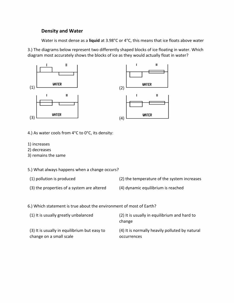
Density and Water
Water is most dense as a liquid at 3.98°C or 4°C, this means that ice floats above water
3.) The diagrams below represent two differently shaped blocks of ice floating in water. Which diagram most accurately shows the blocks of ice as they would actually float in water?
(1) (2)
(3) (4)
4.) As water cools from 4°C to 0°C, its density: 1) increases 2) decreases 3) remains the same
5.) What always happens when a change occurs?
(1) pollution is produced (2) the temperature of the system increases
(3) the properties of a system are altered (4) dynamic equilibrium is reached
6.) Which statement is true about the environment of most of Earth?
(1) It is usually greatly unbalanced (2) It is usually in equilibrium and hard to
change
(3) It is usually in equilibrium but easy to
change on a small scale
(4) It is normally heavily polluted by natural
occurrences

7.) Humans can cause rapid changes in the environment that may result in catastrophic events.
Which statement below is the best example of this?
(1) concrete and brick buildings cause a city
to absorb more heat than surrounding areas
do
(2) A project to straighten out a river causes
flooding at a city downstream
(3) A new housing development uses well
water, causing the water table level to drop
(4) Streetlights make it more difficult to
observe stars and planets at night near a city
8.) Object A expands when it is heated. Which graph best represents the relationship between
the temperature and the density of object A?

9.) The following diagrams show physical changes in four materials over time. The chemical
composition of each material remains the same. Which material most likely changed in
density?
10.) The rising and setting of the sun are examples of
(1) noncyclic events (2) predictable changes
(3) unrelated events (4) random motion
11.) A predication of next winter’s weather is an example of
(1) a measurement (2) a classification
(3) an observation (4) an inference

12.) The diagram below represents the mass and volume of a mineral sample being measured.
These measurements were used to determine the density of the mineral sample.
What is the density of this sample?
(1) 6 g/mL (2) 24 g/mL
(3) 34 g/mL (4) 60 g/mL

13.) On the grid below, draw a profile of the landscape along the bicycle trail from point P to
point Q by following the directions below.
(a) Plot the elevation along line PQ by marking with a dot each point where a contour line is
crossed by line PQ. Point P and point Q have been plotted for you.
(b) Connect the dots to complete the profile

Points A, B, C, D, and X represent points on a map below. Elevations are measured in feet.
14.) What is the average gradient of the slope along straight line CD in the map?
500 ft/mi 250 ft/mi 100 ft/mi 1,000 ft/mi
15.) What is the highest possible elevation of point X on Rock Mountain in the map?
1,601 ft 1,699 ft 1,600 ft 1,599 ft
16.) Which cross section best represents the profile along straight line AB in the map?

17. The ozone layer protects life on Earth by absorbing harmful ultraviolet radiation. The ozone
layer is located between 17 kilometers and 35 kilometers above Earth’s surface in which
atmospheric temperature zone?
(1) troposphere (2) stratosphere
(3) mesosphere (4) thermosphere
18. Which line best identifies the interface of the lithosphere and the troposphere?
(1) A (2) B (3) C (4) D
19. The following data table shows the altitude of Polaris as recorded by four observers at
different locations on Earth.
Which statement is best supported by the information in the table?
(1) Observer A was at the equator (2) Observers A and B measured the altitude
during daytime hours
(3) Observers B and C measured the altitude
at the same latitude (4) Observers B, C, and D were in the
Southern Hemisphere

20. Which statement is true about an isoline on an air temperature field map?
(1) It represents an interface of high and low
barometric pressures
(2) It indicates the direction of maximum
insolation
(3) It increases in magnitude as it bends
southward (4) It connects points of equal air
temperature
21. Calculate gradient between points X and Y?
(1) 50 m/km (2) 100 m/km (3) 150 m/km (4) 200 m/km
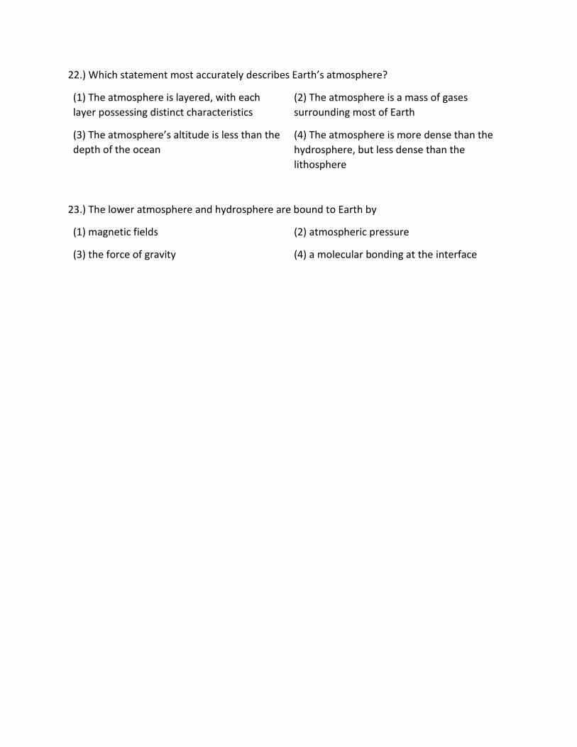
22.) Which statement most accurately describes Earth’s atmosphere?
(1) The atmosphere is layered, with each
layer possessing distinct characteristics
(2) The atmosphere is a mass of gases
surrounding most of Earth
(3) The atmosphere’s altitude is less than the
depth of the ocean (4) The atmosphere is more dense than the
hydrosphere, but less dense than the
lithosphere
23.) The lower atmosphere and hydrosphere are bound to Earth by
(1) magnetic fields (2) atmospheric pressure
(3) the force of gravity (4) a molecular bonding at the interface

24.) The topographic map below shows a depression contour line on Earth’s surface.
Points A, B, C, and D represents surface locations. Contour line elevations are in feet.
Which profile best shows the topography along line AD?
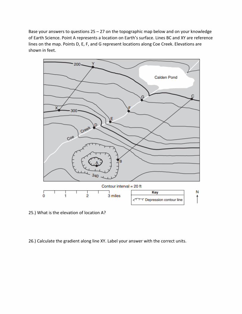
Base your answers to questions 25 – 27 on the topographic map below and on your knowledge
of Earth Science. Point A represents a location on Earth’s surface. Lines BC and XY are reference
lines on the map. Points D, E, F, and G represent locations along Coe Creek. Elevations are
shown in feet.
25.) What is the elevation of location A?
26.) Calculate the gradient along line XY. Label your answer with the correct units.

27.) Construct a topographic profile along line BC, from point B to point C. Plot the elevation of
each contour line that crosses line BC. Connect all nine plots with a line to complete the profile.

For question 28, use the table from the Earth Science Reference Tables.
28.) The pie graph below represents the composition, in percent by mass, of the chemical
elements found in an Earth layer.
The composition of which Earth layer is represented by the pie graph?
(1) crust (2) outer core
(3) troposphere (4) hydrosphere

29.) The map below shows a portion of Earth’s system of latitude and longitude and five
locations labeled A, B, C, D, & X.
It is solar noon at location X. At which location will solar noon next occur?
(1) A (2) B
(3) C (4) D

Factors Affecting Infiltration
Slope of the Land – steeper the slope (gradient), less infiltration & more runoff
Degree of saturation – more water in the ground, the less it can absorb,
increasing water table
Porosity – percentage of open space in Earth’s surface, greater porosity greater
infiltration
o (A) Shape: well – rounded particle have
greater porosity
o (B) Packing: more closely packed particles
has lower porosity
o (C) Sorting: particle size does not affect
porosity
Sorted: greater porosity
Unsorted: lower porosity
Permeability
o Permeable: speed of water through material
o Impermeable: object may be porous & not
allow water to pass through it
Capillarity – how high water moves against gravity, extremely important to
plants
o Cohesion: water molecules attracted to each
other
o Adhesion: water molecules attracted to unlike
materials
Vegetation – absorbs water, low runoff & higher
infiltration
Land Use – roads, parking lots, buildings, gazing pastures decrease permeability
& increase runoff

The Water Cycle: using the word bank, match the number to the correct water cycle process
below.
Infiltration ______
Transpiration ________
Precipitation ______
Runoff ____________
Evaporation _______ Condensation ________
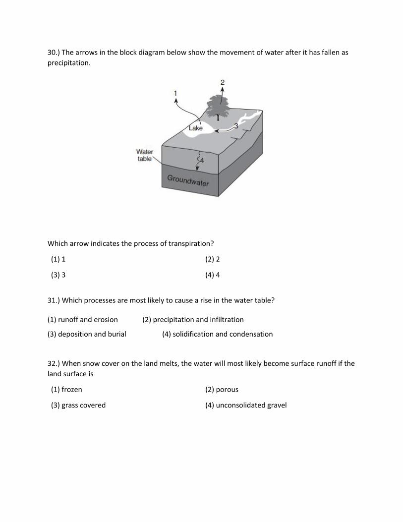
30.) The arrows in the block diagram below show the movement of water after it has fallen as
precipitation.
Which arrow indicates the process of transpiration?
(1) 1 (2) 2
(3) 3 (4) 4
31.) Which processes are most likely to cause a rise in the water table? (1) runoff and erosion (2) precipitation and infiltration
(3) deposition and burial (4) solidification and condensation
32.) When snow cover on the land melts, the water will most likely become surface runoff if the
land surface is
(1) frozen (2) porous
(3) grass covered (4) unconsolidated gravel

33.) In which environment is the amount of transpiration usually the greatest?
34.) Water will infiltrate surface material that is
(1) impermeable & unsaturated (2) impermeable & saturated
(3) permeable & unsaturated (4) permeable & saturated

Weathering
Chemical & physical breakdown of rocks at or near Earth’s surface
Chemical Weathering: change in mineral or chemical composition ie. Rust
Physical Weathering: Frost Action (Freezing & Thawing), Plant Action, Wind (Abrasion)
Erosion
Weathering of rock into sediments that are transported
Transportation Systems of Erosion
Stream, glacier, wave, wind, or human activity
Gravity Erosion
Mass Movement: pulling massive amounts of rocks & sediments downhill
Running Water Erosion & Streams
Streams
Running water erosion in a channel
Tributary
Smaller stream flows into a larger stream
35.) What is the main difference between chemical and physical weathering?
(1) Chemical weathering alters the composition of minerals, and physical weathering does not.
(2) Chemical weathering increases the surface area of minerals, and physical weathering does not.
(3) Physical weathering alters the composition of minerals, and chemical weathering does not.
(4) Physical weathering increases the surface area of minerals, and chemical weathering does not.
36.) Which is the best example of physical weathering?
(1) The cracking of rock caused by the freezing and thawing of water.
(2) The transportation of sediment in a stream.
(3) The reaction of limestone with acid rainwater.
(4) The formation of a sandbar along the side of a stream.
37.) Water is a major agent of chemical weathering because water
(1) Cools the surroundings when it evaporates.
(2) Dissolves many of the minerals that make up rocks.
(3) Has a density of about one gram per cubic centimeter.
(4) has the highest specific heat of all common earth materials.
38.) In which climate would the chemical weathering of limestone occur most rapidly?
(1) cold and dry (2) cold and humid (3) warm and dry
(4) warm and humid
39.) A variety of soil types are found in New York State primarily because areas of the
state differ in their
(1) amounts of insolation (2) distances from the ocean
(3) underlying bedrock and sediments
(4) amounts of human activities
40.) The chemical composition of a soil formed in a certain area from the bedrock
beneath it is determined by the
(1) method by which the soil was transported to the area
(2) slope of the land and the particle size of the soil
(3) length of time since the last crustal movement in the area occurred
(4) minerals in the bedrock beneath the soil and the climate of the area

41.) Which type of climate has the greatest amount of rock weathering caused by frost
action?
(1) a wet climate in which temperatures remain below freezing
(2) a wet climate in which temperatures alternate between below freezing and above freezing
(3) a dry climate in which temperatures remain below freezing
(4) a dry climate in which temperatures alternate between below freezing and above freezing
42.) Use the table from the Earth Science Reference Tables to answer question 8.
Which sediment is most easily picked up and transported by the wind?
(1) cobbles
(2) pebbles
(3) sand (4) silt

43.) Lichens are usually the first organisms that first appear in barren, rocky areas. They
use root-like structures to split bedrock into small fragments. Lichens also secrete acidic
solutions that help break down rock. The cross sections below represent an area when
lichens first appeared (time 1) and that same area hundreds of years later, after it was
changed by lichens and exposed to air and water (time 2).
The soil shown in time 2 was formed mainly by
(1) compaction and cementing
(2) weathering and biological activity
(3) faulting and tilting of rock strata (4) mass movement and deposition of particles

44.) Photographs A and B below show two different valleys.
Which list best identifies the agent of erosion that primarily determined the shape of each valley? (1) photograph A—glacier; photograph B—river
(2) photograph A—river; photograph B—glacier
(3) both photographs—river
(4) both photographs—glacier
45.) The photograph below shows both erosional and depositional features formed by an agent of erosion.
(1) running water
(2) glacial ice
(3) ocean waves
(4) prevailing wind

46.) What is the minimum water velocity necessary to maintain movement of 0.1-
centimeter-diameter particles in a stream?
(1) 0.02 cm/s (2) 0.5 cm/s conduction
(3) 5.0 cm/s (4) 20.0 cm/s
47) Sediment is deposited as a river enters a lake because the
(1) velocity of the river decreases (2) force of gravity decreases
(3) volume of water increases (4) slope of the river increases

48.) The map below shows coastal features of a portion of Long Island, New York. Point
A represents a location on a landscape feature that resulted from wave action and
longshore currents.
On which landscape feature is point A located?
(1) moraine
(2) delta
(3) barrier island (4) floodplain
49.) Which cross section best represents the pattern of sediments deposited on the
bottom of a lake as the velocity of the stream entering the lake steadily decreased?

50.) Use the table from the Earth Science Reference Tables to answer the following
questions.
Which mineral will scratch fluorite, galena, and pyroxene?
(1) graphite (2) olivine (3) calcite (4) dolomite

51.) Use the table from the Earth Science Reference Tables to answer the following
question.
Which two elements make up the greatest percentages by mass in Earth’s crust?
(1) oxygen and potassium (2) oxygen and silicon
(3) aluminum and potassium (4) aluminum and silicon
52.) Which rock is composed of the mineral halite that formed when seawater
evaporated?
(1) limestone (2) dolostone
(3) rock gypsum (4) rock salt
53.) Which mineral precipitates from oceans and forms rock salt?
(1) quartz (2) fluorite
(3) halite (4) olivine

54.) Use the table from the Earth Science Reference Tables for question 54 - 56.
Which mineral is most frequently found in both granitic continental crust and basaltic
oceanic crust?
(1) olivine (2) potassium feldspar
(3) plagioclase feldspar (4) quartz
55.) The igneous rock gabbro most likely formed from molten material that cooled
(1) rapidly at Earth’s surface (2) slowly at Earth’s surface
(3) rapidly below Earth’s surface (4) slowly below Earth’s surface

56.) Which graph best shows the relationship between the composition of different
igneous rocks and their densities?
57.) The graph below shows the hardness of four minerals.
Which mineral is hard enough to scratch calcite but is not hard enough to scratch
amphibole?
(1) muscovite mica
(2) fluorite
(3) olivine
(4) graphite

58. Basaltic bedrock of the oceanic crust is classified as?
(1) felsic, with a density of 2.7 g/cm3 (2) felsic, with a density of 3.0 g/cm3
(3) mafic, with a density of 2.7 g/cm3 (4) mafic, with a density of 3.0 g/cm3
59.) Compared to the oceanic crust, the continental crust is usually: (1) thicker, with a less dense granitic composition
(2) thicker, with a more dense basaltic composition
(3) thinner, with a less dense granitic composition
(4) thinner, with a more dense basaltic composition
Landscape Regions
Characteristics – elevation, bedrock, structure, stream drainage pattern, soil
characteristics, and amount of slope that form identifiable areas
60. Which New York State landscape region has the lowest elevation, the most level
land surface, and is composed primarily of Cretaceous through Pleistocene
unconsolidated sediments? Pages 8-9, 2-3
(1) the Hudson-Mohawk Lowlands (2) the Atlantic Coastal plain
(3) the Champlain Lowlands (4) the Erie-Ontario Lowlands

Factors of Landscape Development
Uplifting forces – displace and form new rock to raise the land, mountain building
Examples – volcanic action, earthquakes, and plate interactions
Leveling forces – lower or level out the Earth by breaking down the rocks, energy
source is the Sun
Examples - weathering, erosion, deposition, and sinking
Climate on Landscape Development – climate & bedrock determine landscape
Humidity increases chemical weathering on landscapes
Vegetation decreases erosion on landscape
Arid landscapes are wind-blown
61. Landscape regions in which leveling forces are dominant over uplifting forces are
often characterized by
(1) volcanoes (2) mountain building
(3) low elevations and gentle slopes (4) high elevations and steep slopes

62. The three diagrams below represent the same location at different times. What is
the best explanation for the difference in appearance of this location?
(1) This region was exposed to leveling
forces for different lengths of time
(2) This region has different underlying
bedrock structures
(3) This region developed in different
climate regions
(4) This region has the same type of
underlying rock layers
63. Which factor(s) is most important in determining the evolution of a landscape?
(1) surface landscape (2) development of drainage
(3) plant cover (4) climate & rock structure

Bedrock
Characteristics of bedrock determine characteristics of landscape
Escarpment – more resistant rock layer, or cliff, along the edge of rock layers
Drainage Patterns
Dendritic drainage – horizontal sedimentary rocks and lava flows with little difference
in rock resistance

Trellis (block) drainage – observed in folded rocks with much difference in
resistance, with faulted and jointed rock

Radial drainage – occurs in areas of domed structure (volcanoes)

Annular drainage – pattern of concentric circles in areas of domed structure
64. Which cross-sectional diagram below best represents a landscape region that
resulted from faulting?

65. Which of the following stream patterns is most characteristic of horizontal rock
structure?

66. The graph below shows the heating effect that different land uses have on surface
air temperatures on a summer afternoon.
Which land use results in the least heating effect in urban areas?
(1) commercial (2) downtown
(3) residential (4) parks

67.) The diagram shows a New York State highway road cut. The water well has
probably gone dry because
(1) crustal uplift has altered the landscape (2) human activities have altered the
landscape
(3) the climate has become more humid (4) the bedrock porosity has changed
68.) Stream drainage patterns that develop in a landscape region are controlled mostly
by
(1) bedrock structure (2) precipitation amounts
(3) nearness to a large body of water (4) air temperature variations
69.) Which cross section best represents a plateau landscape region?

70.) The map below shows a picture of California and a section of the San Andreas
Fault?
What is the primary process occurring
along the San Andreas Fault?
(1) Spreading movement
(2) Transform movement
(3) Subduction
(4) Convergence

Use the following table from the Earth Science Reference Tables to answer questions
71 & 72.
71.) Which mantle hotspot is located directly below a mid-ocean ridge plate boundary?
(1) Yellowstone (2) Iceland
(3) Canary Islands (4) Hawaii
72.) The formation of the Canary Islands was primarily caused by their location near a
(1) subduction (2) mantle hot spot
(3) divergent boundary (4) transform fault
73.) Which two features are commonly found at divergent plate boundaries?
(1) mid-ocean ridges & rift valleys (2) wide valleys & deltas
(3) ocean trenches & subduction zones (4) hot spots and island arcs

74.) Earth’s magnetic field has reversed itself several times during the past. This pattern
of magnetic reversal is best preserved in
(1) metamorphic bedrock in mountain ranges
(2) bedrock with fossils containing radioactive carbon-14
(3) ocean trenches and subduction zones
(4) hot spots and island arcs
75.) Compared to the oceanic crust, the continental crust is usually: (1) thicker, with a less dense granitic composition
(2) thicker, with a more dense basaltic composition
(3) thinner, with a less dense granitic composition
(4) thinner, with a more dense basaltic composition
76.) Earth’s internal heat is the primary source of energy that?
(1) Warms the lower troposphere
(2) Melts glacial ice at lower altitudes
(3) Moves lithospheric plates
(4) Pollutes deep groundwater with radioactivity

77.) The cross section below represents a pattern of magnetic field reversals preserved in the igneous bedrock of the oceanic crust east of the Mid-Atlantic ridge.
Which cross section best represents the magnetic field pattern west of the Mid-Atlantic
ridge?
(1)
(2)
(3)
(4)