eame o aioa eeome. ueau o miea esouces geoogy a … · eig ougy easwes oms e soue imi o e s. emo...
TRANSCRIPT

COMMONWEALTH OF AUSTRALIA.
DEPARTMENT OF NATIONAL DEVELOPMENT.
BUREAU OF MINERAL RESOURCESGEOLOGY AND GEOPHYSICS.
RECORDS.
1962/8 1
EXPLANATORY NOTES, JULIA CREEK SHEET,QUEENSLAND.
by
R. R. Vine and'. i. Jauncey.
The information contained in this reportDepartment of National Development, as part of tiwealth Government, to assist in the exploration arresources. It may not be published in any fonprospectus without the permission in writing ofMineral Resources, Geology and Geophysics.

EXPILUATORY NOTES — JULIA CREEK SHEET
by
R.R. Vine and W. Jauncey
with Palynolorical Notes
by
P.R. Evans
RECORDS 1962
CONTENTS^ PageSUMMARY^ 1
INTRODUCTION
PREVIOUS INVESTIGATIONS^ 2
PHYSIOGRAPHY^ 3
STRATIGflAPHY^ 4
STRUCTURE^ 4
GEOLOGICAL HISTORY^ 7
ECONOMIC GEOLOGY^ 8Underground Water^ 8Road Metal^ 8Building materials^ 9Petroleum^ 9
RECOMMENDATIONS^ 9
REFERENCES^ 13
The information contained in this report has been obtainedby the Department of National Development, as part of the policyof the Commonwealth Government, to assist in the exploration anddevelopment of mineral resources.^It may not be published inany form or used in a company prospectus without the permissionin writing of the Director, Bureau of Mineral Resources,Geology and Geophysics.

4
APPENDIXES
A^Notes On a Palynological Examination of St. Andrew'sBore, Julia Creek, Queensland.^ t6
B^Lithological examination of samples fromSt. Andrew Bore, Registered Number 14338^21
C^Bore data, Julia Creek^ Boundseparately
TABLES
1 Topography of the Julia Creek area 3
2 Stratigraphy of Julia Creek Sheet (followingpage) 5
3 Driller's records of petroleum 10
4 Stratigraphic concepts of marine Cretaceous 11Sequence, Great Artesian Basin.
ILLUSTRATIONS
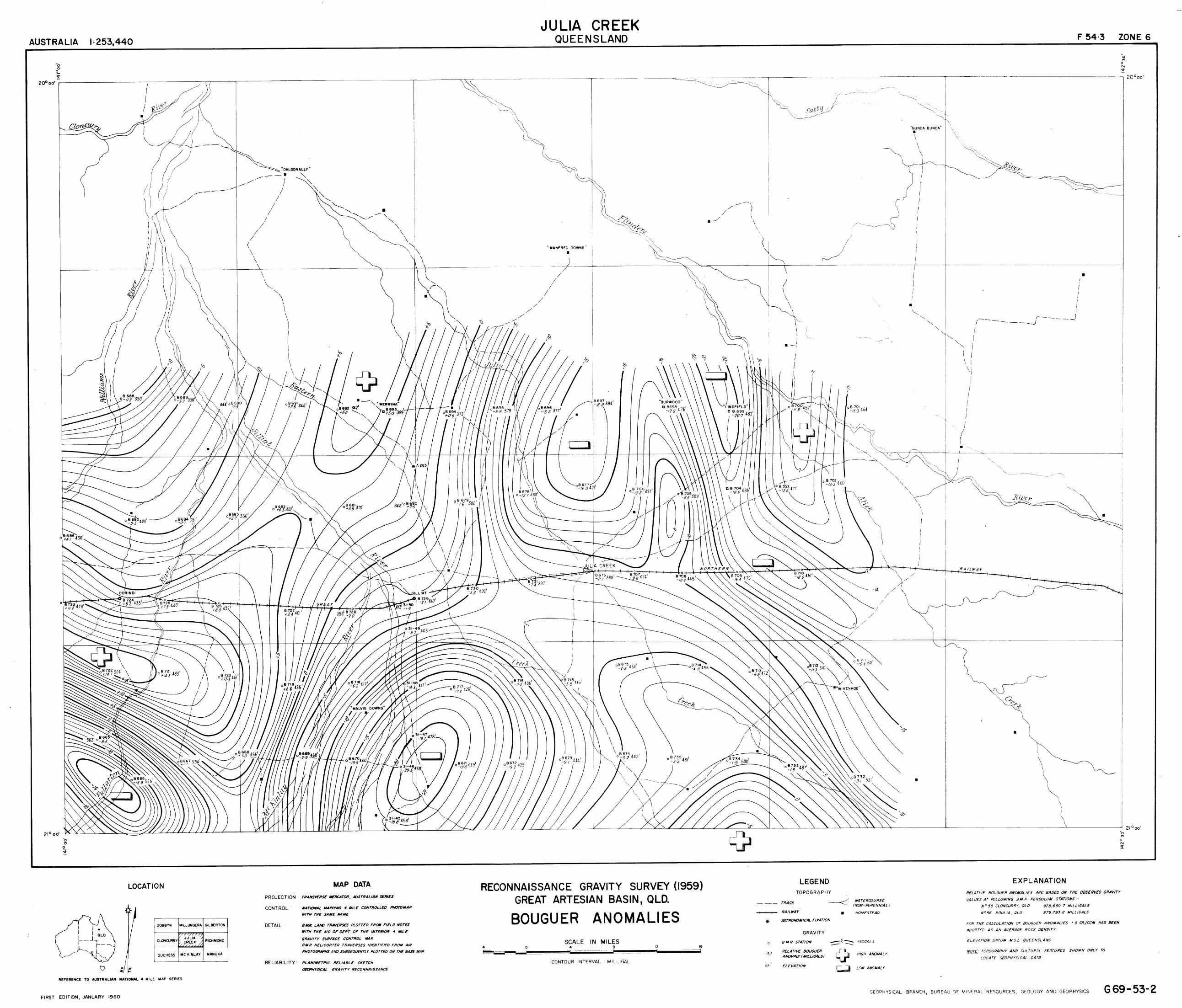
Figure 1.^Geophysical surveys, Julia Creek^ 6
Plate I^Contours on the base of the Longsight Sandstone.)
Plate II^Longsight Sandstone Isopachs.
Plate III^Contours on the top of the Longsight Sandstone. ) at'rear
Plate IV^Bouguer Anomalies.^ ))
Plate V^Graphic representation of some driller's logs. ))
Plate VI^Geological Map.^ )

ST7 IIMA RY
The Julia Creek area forms the western and northern
margins of the Eromarga Sub-Basin, where it is mainly composed
of Cretaeous rocks overlying a shallow, crystalline basement.
Small outcrops of Precambrian granite and metamorphics occurin the south-west.^Thin veneers of Cainozoic sand and gravel,and Recent alluvium mask large areas of the Cretaceous rocks.
Interpretation of drillers' logs was used to draw
structure contours and isopachs of the Longsight Sandstone.
These indicate the whole sequence is faulted in the south-westand strong basement relief is reflected by folding in theoverlying Cretaceous rocks.
Recommendations are made for a core-hole to resolve the
problem of faunal and possible time oreaks below the Toolebuc
Member, for completion of the helicopter gravity survey of thearea and extension northwards to basement outcrops, and for a
well to test possible petroleum accumulation on the St. ElmoStructure.
INTRODUCTION
The Great Artesian Basin Party of the Bureau of MineralResources, consisting of Rolle Vine and W. Jauncey, with I.
Chertok as draftsman, mapped the Julia Creek Sheet in 1961 as
part of a programme of regional mapping covering the margins of
the Eromanga Sub-Bsin in Western Queensland. Four military
1:250,000 sheets were mapped during the field season, and explan-atory notes to accompany each sheet have been produced.^Inaddition to Julia Creek, the sheets mapped were McKinlay (Vine &
Jauncey, 1962), Mackunda (Vine, 196g and Brighton Downs (Jauncey,1962).^The results were plotted/air photos (average scale1:46,500) taken by the Royal Australian Air Force in 1951 and theinformation was later reduced to the final 1:250,000 scale.
Access to and within the area is excellent, with many
station tracks and main roads. The only obstacles to cross-countrytravel are numerous fences and the channels of larger creeks andrivers.^Four planes a week fly into Julia Creek from each ofTownsville and Mt. Isa, the Great Northern Railway (Townsville toCloncurry and Mt. Isa) runs east-west through the area, and there
are highways or main roads to Cloncurry, Normanton, Townsville,
Winton (via Kynuna) and McKinlay. Most are earth roads and im-
passable for two or three days after rain, but a new highway beingbuilt to Normanton will be sealed.
2.
Potable water from bores is available throughout the
area; most are flowing bores.^Waterholes are mainly small
and temporary, although some of the larger ones on the Flinders
River may be permanent.
The eastern third of the area (east of 142 °E longitude)is held under Petroleum Authority to Prospect 76P by Exoil N.L.
The rest of the area is held by Australian Oil Corporation.
PR7VIOUS INVESTIGATIONS
Before the present survey only very broad, regional geo-
logical work had been carried out in the general area. Early
workers recognised an old metamorphs• .- belt of rocks forming the
Cloncurry Mineral Field on the west, and Cretaceous sediments,
with an arenitic aquifer at the base, forming the rolling downson the east.^(Daintree, 1872; Jack, 1885, 1895; Jack andEtheridge, 1892; Cameron, 1901; Dunstan, 1920, Jensen, 1925;Reid, 1929).
More detailed, though still broad reconnaissance, work
was carried out on the Great Artesian Basin as a whole. by White-
house (1930, 1945, 1953) which culminated in a comprehensive
account of the stratigraphy, structure and geological history ofthe basin (Whitehouse, 1954).^He also discussed the late geo-logical history and physiography of western Queensland (Whitehouse,
1940, 1941) and recognised the extent of the Pliocene Glendower
Formation in the Flinders River area (Whitehouse, 1954).
More systematic work on the western margins of the GreatArtesian Bathin began in 1957 with mapping of the Boulia Sheet
(Casey et al,. 1960) and continued with the Springvale Sheet
(Reynolds, 1960a) Gilberton and Georgetown Sheets (Reynolds,
1960b) and south-western Queensland (Reynolds, Olgers and Jauncey,1961).^Casey (1959) established the nomenclature for the westernmargin of the basin; the Mesozoic sequence, with a probablecorrelation with Whitehouse's is:
Casey, 1959^ Whitehouse, 1954Winton Formation^ Winton Formation
upperWilgunya^Tambo Formation
Toolebuc Memberlower^5,Formation
Roma Formation
Blythesdale Group
(Upper part)
Lpngsight Sandstone
Laing and Power (1959a,b) published new stratigraphic
names as a result of mapping in the adjacent Carpentaria Sub-Basin.

3 .
A photo-interpretation of the sheet was made by the
Institut Francais du Petrole (de Lassus St. Genie, Perry andScanvic, 1962).^The geological map (Plate VI) was compiled
mainly from this photo-interpretation; few changes had to bemade.
Geophysical work is limited to a single gravity traverse
by Sydney University (Marshall and Narain, 1954), a helicopter
gravity survey of part of the area by the Bureau of Mineral
Resources (Map only, Plate IV, this report) and an aeromagnetictraverse (Jewell, 1960).,
PHYSIOGRAPHYThe whole of the Julia Creek^is nearly flat.
Elevations range from 300 to 600 feet above mean sea level,with a gentle slope from the eastern and southern marginsto the north-west.^What little relief there is, is controlledby -blab geology (Plate VI) and is summarised in Table I:
Table I
Topography of the Julia Creek area.
Rock Unit^
Topography
Qa (Alluvium)
Czg (High levelalluvium)
Black soil plains, sandy flats;
linear shallow, silty valleys of
Julia, Eastern and Sadowa Creeks
Low, gravelly rises.
Czs
K1 w2 ))Wilgunya FormationK lw
l )Klw(t) Toolebuc Member
Pg )%) PrecambrianPI )
Sand and gravel flats, relict sand
ridges in Saxby Downs area.
Rolling downs
Low Ridge along St. Elmo Structure,
low rocky knolls west of Gilliat
River and south of the railway,
rocky outcrops in rolling downs north
of Flinders River ending in a low
scarp against the alluvial belt of
the Saxby River, and Express and YardCreeks.
Rocky outcrops in alluvial plains.

4 .
STRAri:IGRAPHY
Table 2 summarises the stratigraphy of the Julia CreekSheet.^The Cretaceous unitc are continuations of those recog-nised and named from earlier surveys in nearby areas.^Severalfossil collections were made in the upper and Toolebuc Members
of the Wilgunya Formation, but these have not yet been determined.
A very thin cover of the Cainozoic unit marked Czs
overlies Mesozoic rocks in the north and north-east, thickens
eastwards and has given rise to some low, linear, sand ridges,now completely covered in scrub.^This unit is possibly part ofthe Glendower Formation, which Whitehouse (1954 pp 12-13) des-
cribes, in part, as loosely compacted sediments which form abelt of sandy soils from Normanton to 1 -)pyond Hughenden.^Fromthe limited outcrops in the Julia Creek area it is inadvisableto claim that this is part of the Glendower Formation, but
further mapping to the east during 1962 (including the type area
near Glendower Homestead) may resolve the problem.
Some of the local inhabitants report "petrified wood" inthe Julia Creek area.^All the occurrences seen were cone-in-cone limestone.
STRUCTURE
Structural information in the Julia Creek area was ob-tained from three sources, each of which is partly interpretative.SurfacelEppinfv (Plate VI):
(a) Crystalline basement crops out in the south-westof the sheet area.
(b) In the north-east the beds dip regionally in the
south-west but rocks older than the Toolebuc Member of the
Wilgunya Formation are concealed by veneers of Cainozoicdeposits.
(c) A structurally controlled limestone ridge extends•^from near Lara Downs to east of Julia Creek Town.^The lime-
stone is the Toolebuc Member, which is topographically higher
than the surrounding younger lutites of the upper member of theWilgunya Formation,^The Structure, here named the St. ElmoStructure, is a very gentle fold. It is probably related to
the Manfred Fault (Whitehouse, 1954); this is discussed belowin relation to sub-surface information.
Drillers' Luis: ,Approximately 200 bores have been drilled withinthe Sheet area.^Where drillers' logs are available it is clearthat practically all bores reach the Longsight Sandstone and

5 .
approximately 50 penetrate it.^These logs have been used to
plot contours on the top and bottom of the Longsight Sandstone,
to make an isopach map of the unit, and to show the lithologies
of the pre-Cretaceous rocks (Plates I to III).^The main
features evident from these maps are:
(a) The St. Elmo Structure is the surface expression of
a basement ridge with the Longsight Sandstone draped and thinningover it.^Although the contours on the west side of the struc-
ture are close and nearly parallel, the isopachs do not suggestfaulting.
Whitehouse (1954, Figure 34) shows the Manfred Fault in the
approximate position of the St. Elmo Structure.^He quotes (p.16),
without any reference, Ogilvie as the originator of the name.
Ogilvie (1954, Figure 95) gives a phc^f steeply dipping lime-
stone which he refers to as the surface expression of the ManfredFault.^Such dips are common in the Toolebuc Member, but they are
of random direction and amount and normally represent collapsestructures.
In this area, therefore, there is little evidence for theexistence of the "Manfred Fault".^The concept of a fold due to
dr'Aping over a basement ridge is fundamentally different; to
avoid confusion the name "St. Elmo Structure" is proposed forthis feature to replace "Manfred Fault".
Further north Whitehouse (1954) shows the Manfred Fault on
the east side of the Precambrian inliers of Mt. Brown and Mt.Fort Bowen.^These were not examined, but it is quite possiblethat the inliers are part of the basement ridge of the St. ElmoStructure where it reaches the Surface.
(b) Another basement ridge, shown by basement contours, ex-
tending roughly east-west forms the southern limit of the St.Elmo Structure.^This ridge also caused draping and thinningof the Longsight Sandstone.^It approximates the positions ofthe marked westerly swings of Julia and Eastern Creeks.
(c)• In the south-west there is a crowding of the contours forthe top and bottom of the Longsight Sandstone.^There is no sim-ilar effect in the isopachs; a fault is therefore inferred witha downthrow of approximately 800 feet to the east.^It is a con-tinuation of the fault inferred from similar evidence in the
north-west of the McKinlay area (Vine and Jauncey, 1962).(d) East of the St. Elmo Structure bore information in the
Julia Creek area is sparse, and no bore penetrates the wholeof the Longsight Sandstone.^The top of the unit dips off theeastern flank of the structure but rises again in the north-east.
At Bore .4368 the top of the sandstone is 25 feet above sea level
and the driller records 411 feet of "sandrock" and "pipe clay"which are interpreted as part of the Longsight Sandstone.

111/1117711/717771711 1111111111 11111
JULIA CPF..thmu^I
It
6 .
This rise in the ,;op of the unit is not, therefore, primarily
duo to basement relief but is a reflection of a thickening of
the Mesozoic sequence.
Whitehouse (1954) noted that large water flows are common
east of the "Manfred Fault" and postulated the existence of sand-
stone of the Bundamba Group at depth to account for them.^This
remains to be proved, but it appears certain that the Mesozoic
sequence is thickening eastwards.
Ogilvie (1954) noted a sharp drop in the temperature
gradient east of the "Manfred Fault".^This he correlated with
deepening basement.
Geophysical surveys:^Geophysical surveys are listed' on page 4;their locations are shown on Figure •
141 0^
1 42 0 .5 0'20'
II
1111111110111111111111111^111A ,,^'Jae o'
^Figure 1^Geophysical Surveys, Julia Creek. 142° 30'
20 °
REFERENCE
UU^Bureau of /Win era/ RerourcAeroinayrelic fraver,re
profile.
rad guitvu^Afinera/ Rerourees.
liefico,o/er s'egytty setrvey
—•-- Sycioey versil_y piawtytraverse
Occomp.my Records /9620/
Jewell, (1960), describing the aeromagnetic profile,
noted that no trace of the Manfred Fault could be seen, but
his map shows the fault about 18 miles east of the St: Elmo .
Structure.^It is probably incorrectly plotted from Whitehouse's
map (1954, Figure 34).^The magnetic profile shown on Figure 1,
with values below arbitrary datum, is dominated by basement
characteristics, but two crests can possibly be related to the St.
Elmo Structure and the probable fault in the south—west, both of
which bring basement close to the surface.
A broad relation can be seen between the contours of the
Bouguer anomalies (Plate IV) and the contours of the base of
the Longsight Sandstone (Plate I).^It is evident that in this
area depth to basement is largely the determining factor in the
location of gravity anomalies and trends.

7.
GEOLOGICV,..,., HISTORY
Basement in the Julia Creek area is crystalline.^The outcrops
in the south-west are lithologically similar to some of the
Precambrian rocks of the mineralised belt of north-west Queensland
(Carter pers. comm.) and are probably a continuation of it.
Basement is recorded by drillers as mainly granite or metamorphics,
plus the ubiquitous "rock".^In the McKinlay area rocks des-
cribed by the drillers as "red rock" and "red marl" were mainly
in basement hollows and they were regarded as possible pre-
Cretaceous sediments.^However in the Julia Creek area "red rock"
is almost entirely restricted to basement highs, and as sediments
are unlikely to be preserved in this position, the identity of the
red rock in the Julia Creek area must remain speculative.
Sedimentation on an irregular surface of the basement rocks
began late in the Jurassic - earlier if rocks of the Bundamba
Group are present east of the St. Elmo Structure.^The earliestsediments were mainly sandy.^In this area it is not known if
there was an initial fresh or brackish water phase, but the laterarenites were marine.^Over basement ridges the deposits are thin,
and locally absent, and they thicken into basement hollows.
The main effect of this period of sedimentation was to subdue
earlier relief, but the Longsight Sandstone is not thick enough toobliterate all relief (Plates I to III).
The succeeding Wilgunya Formation was the deposit of a
very muddy sea, with one break of clear water deposition when theToolebuc Member was formed.^These sediments were gently foldedby draping and compaction over the now subdued relief of the mainly
buried basement ridge to form the St. Elmo Structure.
There is no definite evidence that later Cretaceous sed-iments once covered the Julia Creek area.^No shore-line con-ditions have been recognised in the Wilgunya Formation, and it is
likely that it once extended continuously farther north, and can be
correlated with the similar sequence in the Carpentaria Sub-Basin
of Blackdown Formation, Kamileroi Limestone and Normanton Formation.
Faulting in the south-west took place subsequent to the
deposition of the Wilgunya Formation, but presumably prior to the
development of the present river system as the fault is completelyconcealed by the alluvium.
At what stage the drainage of the area was developed isimpossible to decide.^Vine and Jauncey, (1962) suggested thatthe watercourses of the Gulf drainage system reached the McKinlayarea by headward erosion and river capture.^Such headward erosion .must have started on the flanks of the highest land.^It is

8.
reasonable to suppose that such land would have been at a
structurally. controlled location such as the Euroka Shelf, whichWhitehouse (1954 p5) refers to as "a shelf of shallow bedrock,deepening northwards, with a buried scarped southern edge about
19 degrees 30 minutes south latitude."
Both the sand and conglomerate in the north and the high
level alluvium in the west represent the deposits of a period
of more active erosion, when large quantities of material werebrought down by the river systems.^The sand ridges in thenorth—east are possibly due to a subsequent more arid period.
ECONOMIC GEOL.Underground Water
Abundant supplies of potable water are available throughoutthe region.^The only area where it is difficult to obtain good
supplies is close to, and west of, the inliers of Precambrianrocks in the south—west.^Except in the south—west most boresare flowing.^Analyses of water quality are available from theIrrigation and Water Supply Commission, Brisbane.
The main aquifers are in the Longsight Sandstone, althoughsmall supplies are recorded from the Wilgunya Formation.
Whitehouse (1954) suggested that the "Manfred Fault" separates
very large supplies in the east from smaller supplies in the west,
because sandstone of the Bundamba Group is preserved in theeastern area.^There is no lithological evidence for this inthe driller's logs.^An alternative explanation is that theLongsight Sandstone thins, over basement ridges which restrict theflow from the intake areas in the east to the western aquifers.Road Metal
Builders of the new highway from Julia Creek to Normanton
have had a major problem in obtaining road metal for the projectwithin reasonable distances.^In 1961 it was being obtained fromtwo sources.;
(a) Very thin—bedded limestone of the Toolebuc Member
near the Landsborough Highway, east of Julia Creek;(b) Gravel from the high level alluvium near ScrubbyBore in the north—west.^This is only about 5 feetthick, and an alternative site being considered near
Dalgonally Homestead cotains a gravel bed only 2 feetthick.

9.
The most suitable sources of road metal, espeCially for
surfacing bitumen, are the gravels of the high level alluvialterraces, but these are all very thin.^The surrounding alluviumhas a large proportion of silt derived from the Cretaceous rocks.
Gravel from the conglomerate, and sand of the possible Glendower
sediments would also be suitable as Toad making materials.^Thereis no laterite in the area to provide road metal.Buil.ling Materials
No good building stones were seen.^The granite in thesouth-west is badly weathered in outcrop, and the depth to freshrock is unknown.
Some of the limestone of the Toolebuc Member is well
bedded and flaggy and could be used in buildings for special
effects. Some of it would also be sult;able for lime making.Reynolds (1960b) records an analysis of 90% CaCO 3 of a samplefrom the unit from the Gilberton area, north-east of this sheet.Petroleum
Drillers have reported kerosene or oil shale from severalborer) in the Julia Creek area, and traces of gas in others.The occurrences are listed in Table 3 and plotted on Plate III.
Possibly some of the reports are based on the presenceof carbonaceous material, Reynolds (1960b) records one suchoccurrence.^It is unlikely, however, that this is the soleexplanation, as Vine (1962) records an analysis of oily materialfrom a drillers' sample.^The marine Cretaceous cannot be dis-regarded in searching for oil.
There are no suitable reservoirs stratigraphically above
the Wilgunya Formation in the Julia Creek area, but the Longsight
Sandstone should be considered in topographically high areas.
The large supplies of water show that it is very porous, and the
differences in supplies east and west of the St. Elmo Structure
suggest that there is not free connection, and therefore some areashave not been flushed by meteoric water.^The St. Elmo Structureprovides a good stratigraphic trap in the Longsight Sandstone on astructural culmination, and with the target at shallow depths.
RECOMMENDATIONS
Three main problems have arisen as a result of the mappingof the Julia Creek Sheet, and further work is required on each.(a)^StratiEmphy near the Toolebuc Member
Surface Mapping in western Queensland is based mainlyon the lithological change within the Wilgunya Formation from

10.
TABLE 3 - DRILLERS' RECORDS OF PET.INTD7Y1
RegisteredNumber &Name
Lithology(Drillers t.:rms)
Depth(feet)
Height aboveLonEsight Sand-
(feet)^stone
48Dalgenally Trust
Shale, Beams of scInd,much of shale oilylooking
0 -370 484-854
374Julia CrJek Town
4336
Kerosene shale
Hard oil shale
Small quantity ofodourless gas from flow
Slight odour of gas
Gas in flow
Kerosene shale
Black oil shale
Blackish keroseneshale
Kerosene shale2
Kerosene shale3
Black keroseneshale
Oily black shale
A little gas inwater
Some gas
505- 538
460-490
? From LongsightSandstone
? From LongsightSandstone
464-564
287-410
117-517
460-480
180-229
270-410
525-530
?From LongsightSanotone
'?
389Nelia Town
.1747Glade vale
.2070Eurabba
2315Holy Joe
2323Maiden Camp
2458Malvie Downs
2460Armadale
2478Leilavale No.
2479Leilfwale No.
2761Ccrindi ParkNo. 4
3713
4023
423-456
500-530
250-350
427-550
573-973
160-180
191-240
210-350
120-125
claystone-siltstone of the lowe. member, to limestone-coquinite-
calcareous shale of the Toolebuc Member, and back to claystone-
siltstone of the upper member.^It is not certain if this
coincides with Whitehouse's (1954) postulated time break between
the Roma and Tambo Formations, which are based on faunal and not
litological differences.^Whitehouse (1954 p.10) does, however,
mnt -Lon a coquina at or near the base of the Tambo Formation.
Dibkins (1960) noted a very marked faunal difference
between fossils collected from the lower member (with Roma-type
fauna) and those collected from the Toolebuc Member and upper
member (with Tambo-like fauna) and confirmed Whitehouse's
suggestion of at least a faunal break.^But it is not clear
whether any fossils were collected frciii Immediately below the
Toolebuc Member.^This is important as Evans (Appendix A)
records a distinct palynological change 100 feet or more below
the Toolebuc Member but no significant change at it.^The possible
relation between these concepts is illustrated in Table 4:
TABLE 4
Stratigraphic Cons of Yarine Cretaceous Stquence,Great Artesian Basin_
Lithological^Whitehousedivisions^(1954)used thisreport
^
Dickins^Evans
^
(1960)^Appendix Athis
report
uppermember Tambo
Formation
/0
Tamijo-typefossils
OdontochitinaToolebucMember airculata
unitTime BreakErgarofossil
Breaklower Roma Roma-typemember Formation fossils
100'+
MONO 4,•^•
71.17ET1UEicalChange angodiniumcerviculum
unit

12,
It is important that this confusion of names and faunal
changes be resolved, and it io recommended that a core hole be
drilled through the zone of interest.^Cring is necessary
to obtain samples of sufficient size for detailed macrofossil
with a direct relation to microfossil determinations.
it would be essential that the samples are not split until(.;ter examination.
In order that an unweathered micro-fauna is obtained
te bore must be sited to intersect the Toolebuc Member at
a depth of about 100 feet.^The most suitable location wouldOe four miles north of bore registered number 2071, which is-,wo miles east of Eurabba Homestead, near the eastern marginof the sheet.^This bore penetrate - ravel-like limestone"
(driller's term) between 200 and 230 feet depth.^The areais beyond the region of thinning and possible non-sequence
over the basement ridge of the St Elmo Structure.
(b) Relation of gravity to basement relief
Results from the Bureau of Mineral Resources helicoptergravity survey in the south-western half of the sheet (Plate IV)
give a reasonable relation to basement relief.^It is recommendedthat the survey of the remainder of the sheet should be completed.
If this indicates the extent of the St Elmo Structure the survey
should be extended northwards to include the area of Mt. Brown
and Mt. Fort Bowen to show their relation to the structure.
(c) Petroleum accumulation on the St Elmo Structure
It is noted above (page 9 ) that there is a possiblestratigraphical trap associated with a structural culminationon the St Elmo Structure.^The most suitable location for awell to test this would be near bore registered number 5010,13 miles north-east of Julia Creek.^A site can be selectedon the west, or least flushed side of the structure, and
near a possible pinch-out of the Longsight Sandstone.

13.
REFERENCES
W.E., 1901 - GeolOgical observations in north-western Queensland.^Ann. prop. Rep. geol. Surv.Qid for 1900, 186-191.
C.A3 71Y, J.N., 1959 - New names in Queensland stratigraphy,north-west Queensland. Oil Gas J. Aust. 5 (12) 31-36.
C.LY, J.N., REYNOLDS, LA., DOW, D.B., PRITCHARD, P.W.,VINE, R.R., and PATEN, R.J., 1960 - The geoluzy of theBoulia area, western Queensland.^Bur. Min, Resour.Aust. Rec., 1960/12 (unpubl.).
DII.INTREE, R., 1872 - Notes on the gee' '.- of the colony ofQueensland.^Quart. J. geol. Soc. Land., 28, 271-317.
De LASSUS ST. GENIES, PERRY, W.J. and SCANVIC, J.Y., 1962 -
Report on photo-interpretation of the north-westernArtesian Basin.^Inst. Fr. Pet., AUS/38 (unpubl.).
DIOXINS,^1960 - Cretaceous marine macrofossils from theGreat Artesian Basin in Queensland.^Bur. Min. Resour. Aust.Rec. 1960/69 (unpubl.).
DUNSTAN, B., 1920 - Geological notes on the Cloncurry-Camooweal-Burketown-Boulia area.^Publ. geol. Surv. Qici, 265.
JACK, R.L., 1885 - Geological features of part of the districtto be traversed by the proposed transcontinental railway,1881-2, Brisbane, by Authority.
^, 1895 - Artesian water in the western interior ofQueensland.^Bull. geol. Surv. Q1d, 1.
JACK, R.L. and ETHERIDGE, R., 1892 - The geology and palaeontologyof Queensland and New Guinea.^Publ. geol. Surv. Q1d, 92.
JAUNCEY, W., 1962 - Explanatory notes, Brighton Downs Sheet,Queensland. Bur. Min. Resour. Aust. Rec. 1962/79 (unpubl.).
JENSEN,^1925 - Palaeogeography of Queensland.Qld Govt Min. J., 26, 379-382, 422-424, 459-464.
JEWELL, F., 1960 - Great Artesian Basin, neromagnetic reconnaissancesurvey 1958.^Bur. Min. Re sour. Aust Rec. 1960/14 (unpubl.).
LING, A.C.M., and POWER, P.E., 1959a - New names in QueenslandStratigraphy (Part 1) Carpentaria Basin. Aust. Oil Gas J.5 (8) 35-36.
1 4.
LAING, A.C.M., and POWER, P.:& ? 19591) - Idem. (Par 2)
Carpentaria Basin. Ibid 5 (9) 28.
MARSHALL, C.E., and NARAIN, Hoy 1954 - Regional gravity
investigations in the eastern and central Commonwealth.
Univ. Sydney Dept Geol. Geophys. Mom. 1954/2.
OGILVIE, C., 1954 - The hydrology of the Queensland portion of
the Great Australian Artesian Basin. Appendix H to:
Artesian water supplies in Queensland.^BriLl.)ano,12iAuthority.
REID, J.H., 1929 - The marginal formations of the Great Artesian
Basin in Queensland. in Report^the Fifth Interstate
Conference on Artesian Water.^Sydney, by Authority.
REYNOLDS, M.A., 1960a - Geology of the Springvale 4-mile sheet
area, Queensland. Bur. Min. Resour. Aust, Rec. 1960/92
(unpubl.).
^ 1960b - Mesozoic and younger sediments of the
Gilberton and Georgetown 4-mile Sheet area, Queensland.
Bur. Min. Resour. Aust. Rec. 1960/68 (unpubl.).
REYNOLDS, M.A., OLGERS, F. and JAUNCEY, W., 1961 - Geology of the
Bedourie, Machattie, Birdsville, Betoota 4-mile Sheet areas
in western Queensland.^Bur. Min. Resour. Aust. Rec.
1961/54 (unpubl.).
VINE, R.R., 1962 - Explanatory notes, Mackunda Sheet, Queensland.
Bur. Min. Resour. Aust. Rec. 1962/70 (unpubl.).
VINE, R.R. and JAUNCEY, W., 1962 - Explanatory notes ? McKinlay
Sheet, Queensland.^Bur. Min. Resour. Aust. Rec. 1962/80
(unpubl.).
WHITEHOUSE, F.W., 1930 - The geology of Queensland. Handb.
Aust. Ass, Adv. Sol., 23-29.
^ , 1940 - Studies in the late geological history
of Queensland.^Pap. Univ. Qld Dept Geol. 2 (1).
1941 — The surface of western Queensland.
Proc. Roy. Soc, Q1d, 53, 1-22.
^ 9 1945 - Geological work upon the Great Artesian
Basin. and Additional notes on the geology of the basin.
Appendices C and D to: Artesian water supplies inQueensland.^First interim report.^Brisbane_by Authoritz.

1 5.
WHITEHOUSE, F.W., 1953 - The Mesozoic environments of Queensland.Rep. Aust. N.Z. Ass. Adv. Sci. 29, 83-106.
^9 1954 - The geology of the Queensland portionof the Great Artesian Basin.^Appendix G to: Artesian
water supplies in Queensland.^Brisbane by Authority.

16.
APPENDIX A
NOTES ON A PALYNOLOGICAL EXAMINATION OF ST. ANDREW'S BORE,
JULIA CREEK, QUEENSLAND
by
P.R. Evans
INTRODUCTION
Determinations of the distribution of microplankton in
core samples from Conorada Ooroonoo No 1 Well suggested a
two-fold division of the marine Cretaceous beds either side of
an horizon below the Toolebuc Member of the Wilgunya Formation
in the Great Artesian Basin (Evans, 1961).^Examination of cores
and cuttings from Innamincka No. 1, Betoota No. 1, W.O.L. No. 3
(Warbreccan), Cabawin No. 1 and Mornington Island No. 1 Wells
(Evans, 1961, 1961-1962) has shown that the same basic distribution
is widespread over the basin.^Study of Mornington Island No. 1
Well indicated that an intermediate "impoverished" section below
the "fish-scale zone", the lithological and probable time
equivalent of the Toolebuc Member, was also present.^However,
the types of samples available in each case restricted further
observations on the nature of these divisions; cores were few
and cuttings were readily contaminated by aavings from
incompetent sediments.
However, the St. Andrew's Bore, Julia Creek sheet area,
has provided another opportunity to examine these phenomena in
the lower Wilgunya Formation and the Toolebuc Member.^The
top of the bore was sited only 340 ft. above the Toolebuc Member
and casing, driven in behind the percussion bit, reduced
contamination by caving to a minimum.
During the examination particular no has been taken of
the distribution of previously chosen key species, of the
relative abundance of microplankton throughout the section and of
the nature of the apparently low fossil content below the
Toolebuc Member.
A graphic log of the St. Andrew's Bore (compiled from
the description in Appendix 13, p. ) and the depths of the
eighteen samples analyzed is presented in Plate I.

17.
OBSERVATIONS
A. KEY SPECIES
Dingodinium cerviculum Cookson & Eisenack 1958 always
appears in the lower part of the marine Cretaceous of theGreat Artesian Basin.^It was uncertain previously how closelythe range of this species approached to the Toolebuc Member,
but at St. Andrew's it died out before the Toolebuc was deposited.
Its associate Micrhystridium sp. 1 is also widespread and seems
to disappear at about the same time
Odentochitina operculata (O. Wetzel) Cookson & Eisenack 1958was chosen at Ooroonoo No. 1 (Evans, — 11-2) as a possible markerof the remainder of the marine Cretaceous.^However, rare
specimens associated with D. cerviculum in the St. Andrew's Bore
extend the lower limit of its range.
Pseudoceratium tetracanthum Cookson & Eisenack 1958 and
P. turneri Cookson & Eisenack 1958 appeared in Ooroonoo No. 1
just above the D. cerviculum range and appeared in both
Mornington Island No. 1 and Cabawin No. 1 Wells in the samerelative position.^They may provide better key fossils thatO. operculata for an intermediate zone in the marine beds.
Certain microspores were observed to have restrictedranges in Ooroonoo No. 1 Well.^The tops of the ranges arLycopodiumsporites circolumenus Cookson & Dettmann 1958,
Dictyotosperites speciosus C. & D. 1958 were found, as in
the St. Andrew's Bore, within the range of D. cerviculum.
Trilobosporites trioreticulatus C. & D. 1958 was thought to
typify the higher parts of the upper Wilgunya Formation:
its presence as low as the Toolebuc Member at St. Andrew's
extends this range, but retains the species as a useful markerof the upper Wilgunya Formation.
B. MICROPLANKTON SWARMS
Relative changes in abundance of Gonyaulacidae were
particularly noticeable throughout Mornington Island No. 1
while the persistence of Diconodinium spp. was obvious inOoroonoo No. 1.^It is noticed from the St. Andrew's Bore,
that above the D. cerviculum range, one species of microplankton
dominated a particular horizon to be replaced rapidly as the
dominant form by another species at the next level.
18.
Small leiospheres were the first to appear.^A brief swarmof Deflandrea sp. nov. occurred at 503 ft., replaced above by theleiospheres once again.^At 360 and 380 ft., within and justbelow the Toolebuc Member, a psilate Diconodinium is very prominent,
while at 220 ft the spinose D. cf. multispina (Cookson & Eisenack1958) was dominant.^At 100 ft Gonyaulax edwardsi C. & E. 1958 wasthe most noticeable species.^The changes in ornament that
affected Diconodinium also affected Canningia spp. which at
640 ft were granulate, as in C. colliveri C. & E. 1960, but which
were psilate at higher levels.
C. ABUNDANCE OF ORGANISMS
Produced from a standard extraction technique which normally
removes bituminous matter satisfactorily, slides of samples from
340 to 420 ft contained abundant amorphous organic debris whichtended to hide most microfossils from view.^The yield oforganisms between 460 and 600 ft was relatively low and at aminimum at 580 and 600 ft.^These two factors combined to marka poorly fossiliferous zone below and including the ToolebucMember and above the D. cerviculum beds.^However, the sample at360 ft was reprocessed to remove all bituminous material and wasfound to contain many fossils.^Two distinctive zones thereforeseem to be present; the lower, with few fossils and the upper,bituminous but fossiliferous.
2.^No quantitative measure of organism abundance per gm. of
sample can be made by the current method of analysis, but the
percentage of microplankton among all the types of micro-organisms
present (spores, pollens and microplankton) has been measured asan indication of the suitability of the marine environment tomicro-organic growth.^The resultant graph (Pl.I) shows distinctlya progressive, but somewhat erratic increase in this figure to apeak at 380 ft, just below the Toolebuc Member, followed by a
sudden reduction in abundance characterizing the upper WilgunyaFormation.^The peak might occur at 360 ft, depending on thenature of abundant thin walled inaperturate psilate spheres.
They differ in wall thickness and chemical character (ability totake stain) from those referred to as leiospheres and have
previously been classed as pollens under the name Inaperturopollenitessp.^If tLese are another type of biosphere the count of aquaticorganisms at 360 ft would be above 95 per cent.
1 9.
1. While only certain species of microplankton have been chosen
for study, a clearer understanding of the ranges of a few forms,
which are widespread in occurrence and easily recognizable,
will lead to the establishment of a zonal classificatory scheme.
The recognition of the top of the range of Dingodinium cerviculum some way below the Toolebuc Member is a means of distinguishing
a lower part of the lower Wilgunya Formation.^TLis should berecognizable from cuttings in future test wells.^Micrhystridium sp. 1 L. circolumenus, D. speciosus will also characterize thezone.
2. The extension of the known ran6^mong others of
Odontochitina aprculata, Pseudoceratium turneri and P. tetracanthum
resolves the apparent dissimilarity of the two microfaunas at
Ooroonoo No. 1 to a progressively changing phase.^Considerableassemblage variations above the D. cervicuIum range due tochanging plankton swarms take place, but there is no clear
evidence to suggest that a microfaunal break takes place in thesequence.^The changing swarms could be attributed to variations
in environment in the basin during this part of Lower Cretaceous
times and could reflect the same causes of the general variations
in microfossil content and the distribution of bituminous matter.
They may also be responsible for the alterations in the
ornamentation of groups such as Diconodinium and Canningia.
The Toolebuc Member would mark the end of these fluctuationsand the onset of more stable conditions.
REFERENCES
COOKSON, I.C.,^DETTMANN, M.E., 1958 - Some Trilete spores fromUpper Mesozoic deposits in the easternAustralian region.^Proc. Roy. Soc. Vic. 70(2),95-128.
COOKSON, I.C., & EISENACK, A., 1958 - Microplankton fromAustralian and New Guinea Upper Mesozoicsediments.^Proc. Roy. Soc. Vic. 70(1),19-78.
^ , 1960 - Upper Mesozoic microplankton
. from Australia and New Guinea.^Palaeontology 2(2), 243-261.
20.
EVANS, P.R., 1961^- A palynological report , on Conorada
Ooroonoo No. 1 well, Queensland. Bur. Min. Resour.
Aust. Rec. 1961/22 (unpubl.).
^ 1961-1962 - Appendices in completion reports on
the subsidized wells: Conorada Ooroonoo No. 1
(unpubl.). Union-Kern-A.O.G. Cabawin No. 1
(unpubl.) Delhi-Santos Mornington Island
No. 1 (unpubl.).
WHITEHOUSE, F.W., 1954 - The geology of the Queensland portion
of the Great Australian Artesian Basin.
Appendix G in ArtesiaT- v'T -,ter Supplies in Queensland.
Dep. Co-ord. Gen. Public Works, Qd. Pan. Pap.A v. 56-1955.
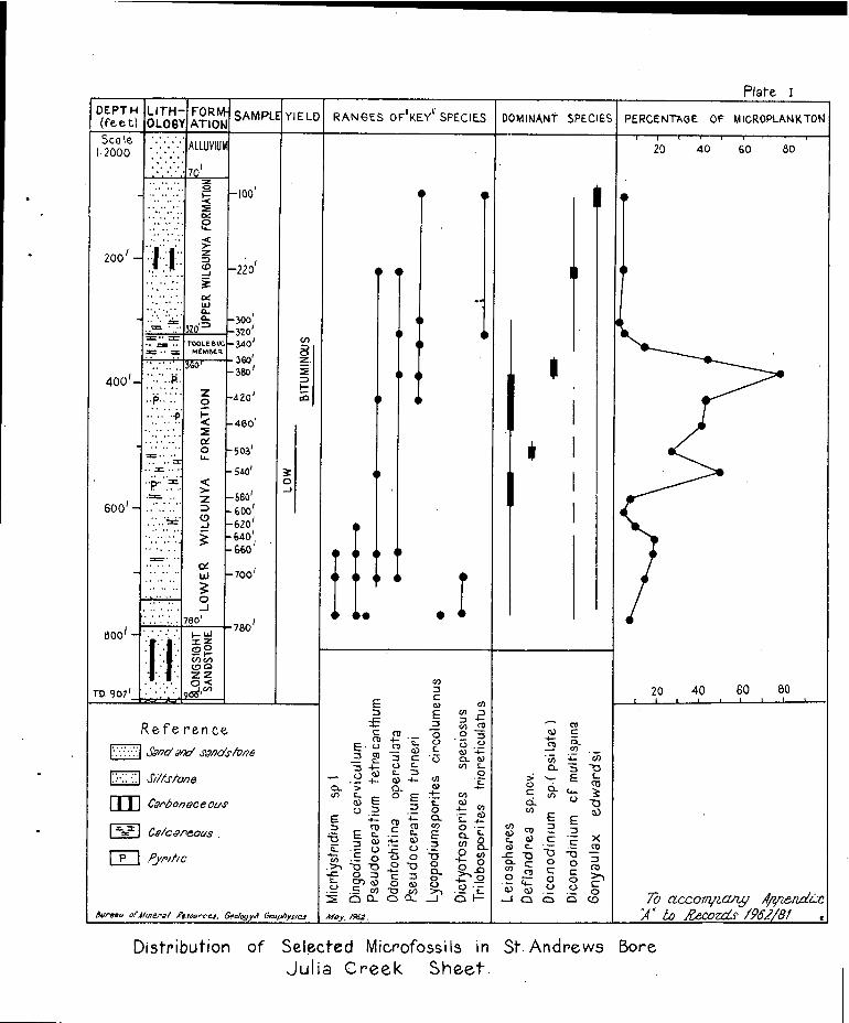
Plate I
DEPTH(fe e t)
LIT. H -
OLOGY,FORM-...ATION
SAMPLE YIELD RANGES OF I KEY II SPECIES DOMINANT SPECIES PERCENTAGE^OF M ICROPLANK TON
Sca le1.2000
-
/200 -
-
400 1 -
600'-
800 / _
ra 907 1
ALLUVIUM
70 1
-100'
• r-220
-300 1
,-320'-3401
360
cn8
•
•
•
i 1.
•
•
•
•
•• •
•
• •
•
• 1
1
i^,,,^,^'i^20^40^60^80
•
••
20^40^801^I^i^■^
60
• •..
•..•'^•^•..^..
•
-^•^•^•^• -
••^-•...^' ..-
.:.••••2OG0L.-
.<›..Z
cc'
a., =
320TOOLE 0 Q0
MEMBER= - =....= • • =..^..
-
•-^• ••'..^..^..
• ... ..A•....^......0....
^• ••^•^•^••
..^••^••
."=-^..
............•.............
..^..^..
..^..^..
360
0
<7
z
9
0-A
^ 380'
-420'
- 460'
-50'
-580 I
-600'-620'-640 i-660
,^•
-700 f
780 r
30-J
1-WI
•"^".......•
..
•*.
•:
.x zonc7 t.--)o nZ zo <
96g'v)comc
G^CD^coz^E^''^.,
o^coC^CO^<>^0 -5CD^4- -E^0^• :-.:^0E . (-)^CO^03^L
Z 2 -5^c . 3^cL w75 4_^0^L^V) I-,..,^co^Q-^Z^o
--^.- 4-^a) -4-^a)^. --c_
Ci.^3^Ca-^0)^4--c/I^C-^0^e^7t.-_^C4
ea^e^r...^0.)c...)^z^=^0^-^01
4_.-^0 '^4
E^47^cL^•c-_- 4,1).c^co^a^2^co^o -E.
1 6^E t.- -^„0^E^cL 0,._^.=^(!)^._^c...,^• c^co^eL
+--.-
•
E^-c^0^ii^2^cn(,)^._^o^0^no^-r -^0
-^s3
'^° M^C^0^-4-' 0
^.> -, -C. MI 24.'1' 1:3^Ea.^0
6 I-c-^cn c.)^0^a)^0^0 • -c-)^C^CO -CI^v)^>")^Les Q..^(-2.. 0_^_I
Noy, 4962.
---^coOA^C4-^=co^,,;--,• .-^:i.--tr,CI- 3^-C3
5^•-^e^1--
^
0^•^COC
0ci.^c.)^--aco^a.)E E
c,C3^co^z^L 0 ^E ..6^x
co^c_^• -^. _^co-c 13 -10 no -2z
^0- z ^0^0c.0^ CO
^
co^C^C
•0,— 0^0 ›.)c
^
' Z6 —^0^0^a) ^.^o^- 1 GI^cll.-^a.^ca
Reference
To accoiwzctrzy ,ImenctiLe34' 10 Record c /962/81
I:.' .•.* 1 Sc7/70'^ 0' 88/20:S/7248
Si//stone
III Capbonoce ous
Ce/cz'.^oPeous .
P^pyril/ c
Bureau ofAnera &row-cc', eedogr■ Geophysics
Distribution of Selected Microfossils in St. Andrews BoreJulia Creek Sheet.

21.
APPENDIX B
LITHOLOGICAL EXAMINATION OF SAMPLES FROM ST. ANDREW BORE
REGISTERED NUMBER 14338
Location: 20 °43'S, 141 °20'E
Depth^Description^ Geological -Interpretation
^10'^Fine grained quartz sand grains,sub-angular to sub-rounded; siltymatrix; small percentage^icminerals.
^
20'^As for 10'
^
30'^Same as 10' but decrease inpercentage of quartz and increasein mafic mineral percentage.
^
40'^Similar to 30'; some white micapresent.^ Alluvium
^
50'^Similar to 40'. Some congregationof red ferruginous matrix.
^
60'^Sub-angular quartz grains; siltymatrix; small percentage of maficminerals, mica and carbonate.
^
70'^Same as 60'; unidentified greenmineral.
^
80'^Grey siltstone, very slightlycalcareous; scattered larger quartzgrains, some iron staining.
^
90'^Grey siltstone, non-calcareous withless ircn staining than at 80 1 .
^
100'^Grey non-calcareous siltstone.
^
110'^Grey Siltstone, slightlycalcareous.
upper Wilgunya
^
120°^Grey non-calcareous siltstone.^Formation
^
130'^Grey, non-calcareous siltstonewith scattered fine-grinedquartz grains.
^140'^Grey, non-calcareous siltstone
^
150'^As for 140'
^160'^As for 140'
^
170'^As for 140'

22.
222,21^Description^ GeologicalInterpretation
180'
^
^Grey, non-calcareous siltstone with?carbonaceous material .
190'^Grey, non-calcareous siltstone with?carbonaceous material.
198'^Grey, quartz siltstone with somemica; non-calcareous ?carbonaceousmaterial.
220'^Grey siltstone; non-calcareous,numerous mica grains, ?carbonaceousmaterial. upper Wilgunya
Formation240'^Grey, non-calcareous si1A—,he.
260'^As for 240'.
280'^Grey, calcareous siltstone with micaand scattered larger quartz grains.
300'^Grey, calcareous, silty clay withwhite calcareous fragments and somepyrites.
320'^Dark grey-blue, silty claystone withmoderately strong reaction to diluteHC1; some very small specks ofpyrites.
340'^Very calcareous, grey siltstone withpyrites, calcite crystals and?Inoceramus fragments.^ Toolebuc Member
360'^Dark grey, highly calcareousclaystone with pyrites.
^
380'^Dark grey, non-calcareous siltstone.
^
?400 1^Dark grey, calcareous siltstone(Marked^with small amounts of pyrite.
420')
^
420'^Dark grey, non calcareous siltstone.
^
440'^As for 420'.
^
460'^As for 420'.
^
480'^Dark grey, non-calcareous siltstonewith some mica grains.
^
503'^Dark grey, non-calcareous siltstone.
^
518'^Dark grey, calcareous siltstone withsome quartz and a green mineral -?glauconite.
^
540'^Dark grey, slightly calcareoussiltstone; appreciable amounts ofpyrites present.
lower WilgunyaFormation

2 3.
e cription
Dark grey, calcareous siltstonewith pyrites and shell fragments.
^
580'^Slightly calcareouq grey-siltstonewith some "pellets" of buff-white clay.
^
600'^Very slightly calcareous, greysiltstone with traces of mica andlarger quartz grains.
^
620'^Very slightl calcareous, greysilts tone.
_eologicalInterpretation
'Depth
560'
^640'^As for 620'.
^
660'^As for 620'.
^
680'^As for 620'.
^
700'^As for 620'
^
720'^As for 620'
lower WilgunyaFormation
740'^Very slightly calcareous, dark grey
siltstone with some mica.
760'^Slightly calcareous, dark grey silt-stone with some larger quartz grains.
780°^As for 760'
800'^Very fine grained, non-calcareous sand,clayey matrix; moderately numerousmica flakes and a green, amorphous,dull earthy mineral - ?glauconite.
820'^Medium to coarse quartz grains, with anon-calcareous silty-clayey matrix;some mica and dark mafic minerals.^Longsight
Sandstone840'^Very fine quartz grains, sub-rounded
to sub-angular, sub-spherical; verylittle matrix; approximately 1% heavyminerals; and some ?carbonaceousmaterial.
860'^As for 840'
880'^As for 840' with a large piece ofcarbonaceous material.
900'^As for 840' but with 1-2% mica flakes
907 1^Angular quartz grains, many withconchoidal fracture; small fragments ?Lower Proterozoicof mica schist; some tourmaline.^metamorphicsVery little weathering of .grains,weathered material has probablyfallen from above.


COMMONWEALTH OF AUSTRALIA
DEPARTMENT OF NATIONAL DEVELOPMENT
BUREAU OF MINERAL RESOURCESGEOLOGY AND GEOPHYSICS
RECORDS
APPENDIX C to RECORDS 1962/81
BORE DATA — JULIA CREEK

APPENDIX C to RECORDS 1962/.81.
BORE DATA - JULIA CREEK.
Information on all bores in the Julia Creek Sheetarea, collected from the Irrigation and Water SupplyCommission, Brisbane, and from property owners andmanagers, is listed in this Appendix.
The order of listing is numerical by the registerednumbers allocated to water bores by the Irrigation andWater Supply Commission.
Abbreviations used in this Appendix are as follows:
Position Mi^Miles
^
' N^North
^
S^South^from Middleton Township.
^
E^East
^
W^West
Elevation^3681 Elevation of ground surface at bore.Barometric measurement, or method ofsurvey not known.
L368' Elevation of ground surface at bore,instrument levelled height.
Standing Water Level
^S.A.^Present water level unknown, pumping frombelow surface.
Water quality - P PotableF FreshB BrackishS Salty or saline.
Drillers Log
Bd^band^P.c1Bk^black^PkBl^blue^QtzBld^boulder^QtziteBr^brown^l'iCl^clay^RkCong conglomerate^SCs^coarse^ShDk^dark^ShyF^fine^Sst.Fm^formation^StGn^green^StkGvl^gravel^StkyGy^grey^SyHd^hard^T.D.Lst^limestone^v.Lt^light^w.N.O.I. No other informatien.Wh
Y.
p.
pipe claypinkquartzQuartziteredrocksandshaleshalysandstonestonestreakstickysandytotal depthverywithWhiteyellow.
p.
APPENDIX C TO RECORDS 1962/81BORE DATA - JULIA CR2EK
Reg.No. Position Elev-^Driller Standing^WATERName^from^ation^Year^water^Struck Rose^Supply Quality TempProperty^Julia^(feet) Completed^level^(feet;^to^(g.p.d.)^oFGreek^ Pump
depth^(feet)
(feet)
Drillers Log
Colmn^Column^Column Column^Column^Column Column^Column Column Column^ColumnA
Thioughout this appendix the columns are indicated by the
letters A to K. The full headings are given above.
33

DRILLERS' LOG
K .
3Allara^15 El. L369 1922 Flow.Trust NW.^ing 1032Alva^ 1130
tobottom
) 1,097,000 159 -i 0— 80 Y sh.—.232 Br.sh.— 414 V Hd.B1.Sh.— 719 Sy.sh.— 801 Bl.sh.— 824 Sy.sh.— 832 Gn.sst.
— 910 Gy.sh.— 936 Gn.sst.— 952 Gy.s.rk.— 960 Gn.s.rk.— 1089 Water S.— 1200 Hd.S.rk.
12Trust 41 MiCabanda NW
L338^1915 Flow-ing
316^80889^21932 Surface30,000986 Surface 442,3301002 Surface 698,3001020 Surface 761,109
0- 3 Subsoil— 12 Y.sy.sh.— 118 Y.cl.— 128 R.cl.— 184 Y.cl.— 202 Bl.sh.— 241 Gy.sy.sh.— 306 Bl.sh.— 316 Sst.W.stks.
of gypsum— 366 Bk.sh._ 557 Bl.sh.— 625 Bl.sh.slightly
sy.— 798 Bl.sh.
889 Gy.sy.sh.1012 S.rk.1014 Hd.gy.rk.1020 P.cl.1025 Pink sst.1026 Coal1033 Pink s.1052 V.sticky sst.1073 P.cl.1079 Hd:.p.cl.1100 Hd.gy.sh.1152 Gy.sh.— 1180 Sl.rk.
48Trust 27 El L390 1920 S.A.
Dalgonally NW114 ,95 0
0— 854.Sh.seams of s. 370 muchof sh.oily—looking.
— 951 S.rk. & p.cl.
A a.

la. DRILLERS' LOG
A
72^9 Mi. L447 1916 Flow— 610-40)^SmallTrust^NE^ing 710^Sur— 40,000 approx.St.EImo^ • 772-76 face Small increase
1002^95,000285,900(1916)
^
251,270^116(1917)
0 —^19 Y.cl.w.smallstks hd.sst.
- 26 Y.c1.& br.rotten sh.
- 33 Br.rotten rk.- 44 Br.st.,v.hd.
Yr.C1'1.."- 85 Lt.bk.sh.- 124 Sty.bl.sh.- 161 Bl.sh.- 123 Soft bl.sh.
196 Bl.sh.- 223 Rotten bl.sh.- 282 Bl.st.
314 Soft bl.sh.- 420 Bl.sh.- 445 Soft bl.sh.- 463 Bl.sh.- 480 Soft bk.sh.,gn.s.
5
-
6'11-g Kghh.sh.- 640 Bk.sh.w.s.- 666 Gy.sh.& s.- 700 F.sst.
— 715 Soft s.— 735 Hd.s.rk.— 750 S.& gy.sh.— 756 Choc.sh.— 760 Sh. & s.— 776 Rough pebbly s.— 822 Gn.s.rk.— 881 Hd.gn.rk.— 887 Bk.s.— 934 Hd.gn.s.rk.— 945 Gn.s.— 951 Hd.gy.rk.— 958 Bk.s.— 967 Bk.s.& pk .sh.— 1015 Pk.&Bk.s.— 1033 choc.sh.w.a little
bk.s.— 1042 Pk.sh.- 1052 Hd.dk.gy.rk.- 1067 choe.sh:w.a little
dark s.— 1076 Fine bk.& wh.s.— 1080 Dk.gy.crystalline
rk.
108^25 Ni. 540^1899 Flow-Wivethce ESE^ing N.O.I.
4

A
2. DRILLERS LOGTr1-\
130^23 Miicorale^S.S.ETrustHudderfield.
L.507 1917 Flowing 118912071222124612791324
100)^4000)^89000)„„^,129000°I' lac.- 213453
420424
0-3 Dk.sh^-1189 S.rk-70 y.cl.^-1200 Gy.sst-285 Bl.sh.^-1279 S.rk-376 Gy.rk^-1294 P.cl.-498 Dk.sh^-1324 S.rk.
1387 540136 -514 No info -^-1329 Hd.bd.1406 571642
(Approx-imately
-10t-^Bl.Sh.w.small-1406 S.sstseam at 590^-1409 Hd.pk.sst.
-1074 Hd.gy.rk^-1424 V.hd.br.sst.250000in
-1100 Dk.gy.sn.-1183 Gy.sy.sh
1961
166^46Mifanborra E.N.E.
1916 Flowing 902)975
1005
104203151718
Surface 339506
0-5 Surface c .^-350 Bl.sh.-28^Gy.rk.^-454 Dk.sh.
-100 Bl.sh^-761 Bl.sh.1025 -105 Hd.rk.^-780 Bl.sh.W.S1103) 473784 -135 Lt.bl.sh.^-892 Bl.sh.
-154 Gy.sh.^-1040 S.rk-179 Bk.sh.^-1065 P.cl.-239 Bl.sh.^-1104 S.rk.-261 Hd.dk.sh.
300^48MiNondaRailway.
L.520 1907 Ilowing 17091010801093
70445
)^407632584 100
0-35 Sy.cl.w.c1 & pebbles.-130 y.cl.-910 Dk.bl.sh.-930 Dk.bl.sst.
1132 Surface...100968 100 -1080 Lt.bl.sh.1175 236710 110 -1295 cs.sst.1280 )^392078 112
-714:W^JuliaJulia Ck^CreekRailways
410 1907 Flowing ?130?260380546
9513012095
0-546 Shaft shy.cl.-561^sst.-690 Shoft shy cl.- 705 Sst.
690 85 -966^Soft Ohy.cl.966 Surface^4 112? Surface 185' of
head

A
3. DRILLERS LOG
302orindi
RailwayStationRailways.
44 MiW.
433 1)07
---sooft•
S.A. 25582602632
15Surface
itit
32584169372)213450
102103106
0-35 y.cl.w.qtz. -570 Lt.gy.sh.shy el-70 y.cl.^-582 Gy.Sh
-130 Gy.^sh.c1^-632 Sst.-140 Cl.sst^-679 Sst.w.p.cl.-150 Lst.
374Town
JuliaCreek
JuliaCreek
1928 Flowing 150622970 )
1022 )1060 )1070)1090 )1093 )1098 )
Surface
70001000020800320005700085000
229000
0-8 Surface soil^-961 Dk.sh-95 y.sh.^-993 Sst.-341^Gy.sh^-1055 Sy p.cl.-405 Dk.3h.^-1200 Sst.-423 Coal and sh.- bottom sst,-456 Kerosene sh. particles of Qtzite-501,Bk.sh^apparently finiEh--885 Gy.sh^ing in dk.sh.
1122 3730001200 566000
389 30 Ili 127 Flowing 1116) 73000^) F 0-10 Subsoil^-1122 Hd.fine sst.No haTown
1122)1257)1270)
Surface
^
83000^)8c
^
110000^)\^soft
^
190000 )
-100 Y.sh.^-1145 Rd qt7ite-150 Dk.sh.^-1150 v.m.rk.-320 Gy.sh^cement fmn.
Increased ) -323 Sedimentary -1157 R.marl.to rk^-1162 Sst.
563170 -500 It gy sh.^-1170 Fine hd.sst.-530^Hd.oil-sh^-1185 Soft sst.-650 V.Bk.Oily sh-1190 Fine hd.sst.-850 Gy sh^-1261 Gy.marl.-860 Sy.gy.br.sh -1267 P.cl.
-990 Dk.sh.cement -1300 S.r1r.-fmn
-1113 V.hd.Sst-1116 Soft s t
1729 54 Mi L535 1900 680 Surface 433000 97 T.D.^883 N.O.I.Kungaburgh NE
1730 56 Mi L536 1293 Flowing 613 Surface 340000 106 T.D.613Eahalla NE

A
4. DRILLERS LOG.
1900 Plowing 729. Surface 431,500^98 T.D.^1004^N.O.I.i731
LycliaDowns
48 MiNE
L535
17d32BundaBunda
52 Mi.NNE
L539 1905 Plowing 653 Surface 897,000^98 T.D. 9600-?640 Bk.sh-649^Sst.^IP
1733Bade:Bunda
49 MiNNE
L532 1905 Plowing T.D.^1104 N.O.I.
1735^51 MiKUlagaburgh^NE
L566 1 9 01 Flowing T.D.952 N.O.I.
1747^54 MiGladevale^NE
640 1902 flowing 825,000 Smallquantityodourlessgas
T.D.^1100S. rk near bottom, water-bearing.
N.O.I.
1 V. -9Rockvale
36 MiENE
473 1903 Flowing T.D.^700^N.O.I.
1750• Kilterry
46 MiNE
1922 Flowing 275^Soak^Slight695^Surface). .825^Surface )1001570825-901 Surface )Static head142'^7"
0-5 Surface soil -69 /77.717.---41 Y.sh.^-757 P.c1.& s.rk-57 Lst.^-760 Blown cl.-63 Bk.cl.^-791 P.c1
-110 Hd.rk.^?880 P.c1.& s.-239 Bk.sh^-901 Cs.s.rk.
2068Nonda West
38 MiE
504 1901 Flowing T.D.1300 N.O.I.
2069Furabba
42 MiENE
495 Flowing T.D.1300 N.O.I.
2920' Eurabba
45 MiENE
491 1901 Flowing S & sh, slight odour of gas.T.D.^1300^N.O.I.

A
5. 'DRILLERS LOG
2071.
FrancharDowns
48 MiENE
1922 Flowing 250)850)870)Static68'6"
Surface 309,577^S^104
head
0-9 Surface soil 4.850 Bl.shY.sh^-.880 Water-bearing S.rk
4200 Gy.sh.^-.900 P.c1 & S..230 Gvl-like 1st -904 Hd. lime s.rk-.330 Br.sh^4-930 Br.sh & S.
2310.algonally
305 1890 220 Surface 32,700^- 87 0-100 ?S.rkT.D.^108
23".Ca than
41 Mi^308 1891 Flowing 336 9,700 0-33C ?Sh.
2312Conientes
32 Mi^355NNW
1891 292 Surface 3,900 88 T.D.^4 O.^N.O.I.
21 1 3CoL-entes
22 Mi L337NNW
1891 300 Surface 20,550 122 T.D.300 N.O.I.
2314Larias End
339 1901 T.D.917.^N.O.I.
2.'5Ho y JoeCaiwarra
30 Mi^352WNW
Flowing Gas inflow.
Excellentwater.
T.D.^981.^N.O.I.
•.^2316Williams.Dalgonally
46 Mi^358NNW
1902 Flowing T.D.1024 N.O.I.
2317Dalgonally
42 Mi^L3I2NW
1902 Flowing T.D.970 N.O.I.
2318Homelands
328 1904 N.O.I.
2319Dargonally
312 1904 Abandoned bore.
2331^
15 Mi 375 1912Sunny Plains^N
Flowing 850 Surface) 4,60 0001020 Surface)^' 0-850 Sh
-1020 S.rk.-1026 P.cl.
A
6.^ DRILLERS LOG
320^36 Miealieewa^NW
320 1911 Flowing Excellentdrinkingwater
0-706 Sh-887 S.rk.
2321^37 MiOpossum Ck. WNWCammeray
2322^54 NiTona^NW..1gonally
,mlowalinow••••■• ^
^360^1911^Flowing 709^Surface
^
L383^
S.A.^900^800
^
932^300942 Surface 75,000952 Surface
^4.1malii•■■■••••■■•••■■
0-704 Cl Sh.-709 Sst.
0-78 y.cl.^-1134 Hd.rk.-932 Bi.sh.^-1150 R.cl.-952 Sst^-1152 hd.rk.
-1132 R.cl.^Bottomed in granite.
^4■■••••••••••••..60^
2323^53 Mi L302Maiden^.NWCampDalgonally
1913^Flowing 814 Surface)913 Surface)1,500,0001006 Surface)
0-90 y.cl.^-814 Sh-250 Sh.^-1006 Sst.-350 Kerosene sh.
2325^50 MiDgigonally NW
2326^30 MiBox Creek^WCarjoan
2329LTrne NW
1919
1919
1926
38 Mi^349^1926
Flowing 210^
Small694 Surface700 Surface
S.A.^550 Surface730 Surface^43,000^F
Flowing 892 )942 )Surface997 )
0-70 Cl^-684 Bl.sh-380 Bk.sh -700 Hd.r.burnt sst.-390 ah.rk -701 Granite
0-?5 Surface soil -780 S.rk.-90 Y.cl.^-822 Hd.bk.fmn.
-730 Bl.sh.
N.O.I.
C,100 Y.sh.^.- 947 S.rk.-150 Gy.sh.^-997 Picl.-892 Bl.sh.^1017 Sirk-902 S.rk.^1035 P.cl.-932 P.cl.^1055 Qt&ite
-1106 Ria.k.
2128Dalgonally
.11
DRILLERS' LOG6a.
A^
E^F^
K.
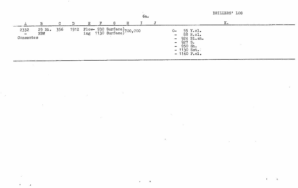
2332^29 Ni. 356^1912 Flow— 930 Surface)\NNW^ing 1130 Surface)700 000 9
Consentes
55 Y.cl.— 88 R.cl.— 924 Bl.sh.— 927 S._ 950 Sh.— 1130 Sst.— 1140 P.cl.

23349-mileAlva Downs
22 Mi Flowing370 580^Surface786^Surfacl855^Surface 20,000916^Surface)
Small
A7. DRILLERS LOG
It
2333DrnwallDowns
35 MiNW
—^Ve
L362
'^A
1927 Flowing 632904964
Surface
I t
8000
138,500
0- 10^Sub soil- 20^Y.sh-25^S.rk- 45^Y.sh- 48^Rk-68^Y.sh- 70^Rk-100 Y.sh-104 Rk-109 Y.sh-149 Gy.sh-152 Rk-157 Gy.sh.-159^Rk-179 Gy.sh-182 Rk-201 Gy.sh
-204 Rk-261 Gy.sh-500 fy.Gy.sh.-660 Gy.sh-700 Dk.sh-800 V.dk.sh.-803 Marl-830 Sy-872 Sst.-874 Like gn.bld.-964 Sst.-1009 Hd.rk.like qtz.-1066 Hd.rk.-1074 Bod.rk.
-768 S.rk-775 Wh.rk-798 Sy.p.cl.-814 S.rk.-825 Hd.rk.-832 Br.p.cl.-841 Hd.S.rk.-860 Hd.rk.-880 S.rk.-900 Br.cl.-993 S.p.cl.-1200 Dk.Shy.cl.
.hith bar^sia-696 Bks.:avi:
20sh:-705 Bks.w^b^ofqy
Granite.-7.14 Ish-760 Sst.-779 Dk.sh-789 Sy.sh
-818 Hd.r.sst.with soft sms-915 Interbedded_sgt r intHlor
apper4 red.rk with soft spots."'
2335Canewa
31 Mi^1924 Flowing 695-698 SmallNW^ soak
760^Surface)800^Surface) 110,000
0-8 Bk.sh.-100 Y.c1-275 Sh-300 Sy.sh-330 Dk.Sh.-421 Lt.Sh-498 Gy.sh-523 Sy.sh-598 Gy.sh-693_Hd.bk.
0-4 Surface sh*50 Lst .3r34
-113 Bl.sh-181 Gy.sh-246 Hd.gy.sh-580 Bl.sh.-599 S.rk.-621 Sy.p.cl.-735 Bl.sh-745 S.rk-759 Hd.rk

0-298 Sh.with 2' rk bands.Flowing1929-1040 Rd.rk-1049 Rd.rk.carrying
schist & mica.-1064 Gy.rk.-Pk.tinge-1098 Granite.
304 ) SA660 )^•850 Surface873895^11
2337^31 MiHomaands NW -329 Br.rk.
-823 Bl.Sh.-828 Sst.-846 P.c1.& sst.-350 SSt-857 P.cl. & sst.-873 Hd.W.sst.—380 Cs. sst.-895 Sst & P.cl.-900 Cs..sst.-928 Hd.gy.sst.-948 Gy.rk.-952 Pk.rk.-V.hd.-958 Rd.rk.-984 Gy.rk.
DRILLERS LOG
A
R336usTOrtDowns
12 Mi^408^1926 Ilowing 800 Surface, Small985^Surface ; 105,000
0-367 Gy sh.^—919-400 Sst.^—939- Oa ci^—943-500 Y.sh.^—945-651 Bl.sh.^—952-708 Br.rh.^—965-79 Br.sh.^—970-836 Gy.sh^—980-851 P.cl.^—982-856 S & cl^—990-881 Wh.qtz.^—991-906 Hd.s.rk —996-909 S.rk.bars —998
Wh.qtz. -1002-913 Wk.qtz-915 2Ft.pk.qtz.-917 Pk.qtz.-918 Sst
Pk.qtz.S.rk.Wh.qtz.Pk.qtzHd.S.rk.S & cl.Wh.qtz.Hd.s.rk.Wh.qtz.S.rk.W.qtzS.rk.Pk.qtzRI qtz.

A
9
IC
DRILLERS LOG
2338ina
24 MiNW
1933 Flowing 366498756859876
))
Small 0-6 Soil & cl-126 Y.sh.-160 Bk.sh-162 Rk-212 Gy.sh
-639 Rk-692 Gy.sh-713 Hd.gy.sh-746 Gy.sh-751 Br.sh
908921
)) Surface
-214 Rk-254 Bl.sh
-759 Lst.-815 Br.sh
932942
))
-257 Rk-297 Bl.sh
-835 S & sh-841^Sst.
951 ) -299 Rk-349 Gy.sh
-855 S^sh-859 S
-352 Rk -864 Qtz-364 Gy.sh -371 S & Cl.-366 Rk -873 Qtz-418 Gy.sh -876 S-498 Gy.rk -881 Qtz-533 Gy.sh -895 S-541 Rk -903 Granite-561 Gy.sh -956 Qtz & granite-563 Rk-593 Gy.sh-596 Rk-636 Gy.sh
2443^5 Mi^
400'^1891^Flowing^300 Surface 152^
80^T.D. 300 N.0. I.
Ga7i.omna ESE
2444^
5 Mi^400'^1891^ T.D.30^N.O.I. (Adjacent 2443)
Garomna^ESE
-745 S.rk -880 S.rk.-759 Hd.rk -900 Br.cl.-768. S.rk^-993 Sy.-F.01.-775 Wh.rk -1200 Dk.Shy.-793 Sy.P.c1^cl.-814 S.rk-325 Hd.rk.-832 Br.p.01.-341 Hd.s.rk-060 Hd.rk
2447^17 Mi 370Eddington WSW
Flowing^580 Surface736 Surface855 Surface916 Surface
Small
20000
0-4 Surf sh.-34 Y.sh-50 1st-113 Bl.sh-181 Gy.sh-246 Hd.gy.sh-530 Bl.sh-599 S.rk-621 Sy.P.C1-735 Bl.Sh.

A -LJ
1 0. DRILLERS LOG.
2448^8 MiL-,:amerookaLongfordPlains
469 1393 Flowing 8891045
) Surface)
0-889^No info.-1045 S.rk.at 1279 bedrock.
2449^7 IVIiArgyle^NNE
420 1898 Flowing Determined in granite at 1066'.
24, 0^35 MiKevin. Downs^SW
498 SA o50950) Surface 0-850t Sh^little gas
-1000S.rk9
-1106 reported bedrock reached.
2451^32. MiBox Ck.^-WSWSt. Andrew
449 • • SA TD.115^N.^.-.
2452^23 MiEddington (7) WSW.Bindoora
402 1899 Flowing 379501 Surface T.D.^964^N.O.I.
13 MiInnisfail ESEDowns
475 1899 Flowing T.D.1020 Determined in granite
2454^7inEddington(9) SWEddington
419 1900 Flowing 10411170 Surface Determined in bedrock.
2455^17 MiEddington(10)^WGilliat Town
413 1901 SA T.D.^986.^N.O.I.
2456^32 MiEddington(11)^SWIvellen
490 1904 SA 889
945
Surface
Surface
_
416'050D'1936-
21 -63*DO1914
0-100 Y.sh-465 Bl.sh-565 Bk.Sh-845 Bl.Sh-870 3 & sh-1000 s.rk.-1054 p.c1.& cong.
2457^12MiEddington(12) WNW
Edding ton
407 1901 Flowing 978 Surface 92,05041909i84,920-0914
0-973 sh-1081^Sst & p.cl.-1097 Rotten granite.

2458 2811iEddingtor (13)li-avie WSWDowns
- 837 Patches of S.- 900 Sst.-1055 Bk.s.
0-^92 Y.cl.- 427 Bl.sh.- 550 Bk.oil sh.- 600 Bk.sh.- 800 Hd.Lt.sh.w.s.
446 1913^Flow- 335ing
837
880
Sur-faceSurface 256,300 Slightly
(1913) BSurface
0-^6 Surface- 7601- 154 Bl.sh.- 156 Hd.gn.st.- 167 Bl.sh.- 177 Hd.St.
2459^11111 401Eddington(14)Eddington WEW
- 217 Bl.sh.- 267 Hd.bl.sh.- 984 Bl.sh.-1084 Hd.St.& P.cl.-1134 Sst.w.bands
of coal.
1915 Flow- 200 Surfaceing 247 Surface
987 Surface 299,300(Est)
sh.
2460^13 .7:J 451Arrqdale S
0- 160 Y.sh.320 Br.sh.
- 323 Hd.st.573 Bl.sh.
-973 Bkish, kerosene
-1090 Bl.sh.-1190 Sst.-1196 R.granite- basement
1915^S.A. 1902 Surface 85,000
DRILLERS' LOG
217,300(1914)
11.
- 558 Bk.sh.^-1083 Bk.sh.- 605 Choc.sh.^-1107 Bl.sy.sh.- .-607 Hd.stk.^-1117 Bk.sh.
^
cap rock^-1162 Bl.sy.sh.
^
of oil bed^-1171 P.c1.& sh.- 666 Petrified -1189 S.& p.cl.
& Hd.tar sh.-1216 Sy.sh.- 672 Chro.shale -1305 S.& p.cl.- 770 BlIsh.^-1318 Hd.p.c1.&- 825 Bk.sh.^qtz.- 938 Bl.sh.^-1326 Qtzite &
sst.-1355 Hd.sst.-1367 Hd.sst. &
pk.qtz.-1380 Congl.-1394.Hd.s 7 rk&qtz
2461^15 Mi 451Carrum ro.2 SArm,-,dale
1924^S.A. 11841256127812861355
1144Surface) 30,000Surface) 70,000Surface)140,000Surface)200,000
5 Surface84 Y.sh.112 Pk.sh.132 Purple sh.181 S.rk.with hd.stks252 S.& sh.255 Hd.bd.285 Sh.& S.288 Hd.rk.400 Bk.sh.w.hd
& sy stks.431 Sy.sh.447 Bk.sh.484 Choc.sh.w.
stks.lst.
- 959 Br.sh.- 983 Bl.sh.- 1031 Bk.sh.- 1061 Br.sh.
-1400 Pk.qtz.
11a.^ DRILLERS' LOG
A
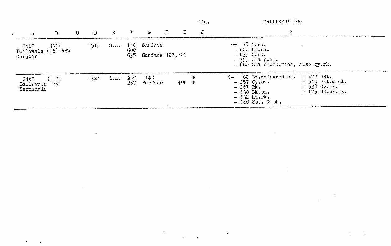
2462^34Mi^1915^S.A. 13C Surface^ 0- 78 Y.sh.Leilavale (16) WSW^ 600 .^ - 600 Bl.sh.Carjoan^ 635 Surface 123,700^- 635 S.rk.
- 755 S & p.cl.- 860 S & bl.rk.mica, also gy.rk.
2463^38 Mi.Leilavale SWBarn sdale
1924^S.A. 200^140^F^0-^62 Lt.coloured el. - 472 SSt,257 Surface^400 F^- 257 Gy.sh.^- 510 Sst.& cl.
- 267 Rk.^- 538 Gy.rk.- 430 Bk.sh.^- 679 Hd.bk.rk.- 432 Hd.rk.- 460 Sst. & sh.

A
12, DRILLERS LOG.
2464Lddington 10Clifton Park
19 MiWNW
1S27 Flowing T.D.^362.^N.O.I.
2465Eddington
15 MiSW
1927 Flowing 10601000
0-505 Sh.y.bl.gy.w.hd^stks.-540 Br.sh.& fossils-1052 Br.bk.bl.sh.-1089 s & p.cl.-1091^Qtz.
2466Car roan
35 MiWSW
472 1926 SA 144206.209335490
-Soak^Small
Surface 20,000"^60,000 F
0-20 Surface sh. -266. Bk.sh_50 y.cl.^-272 Bench of bk.rli-90 7311..sh.^-326 Gy.sh.-92 Bench of r4^-336 Bk.sh
-144 Bk.sh^-465 Bk.sh-204 Gy.sh^-485 Wh.bd.rk-206 Bench of rt^-506 Wh.p.cl.
2460Stratbyrne
26 MiSW
1097 SA T.D.^1)00'^N.O.I.
2469Maori
Downs
34 MiSW
437 1910 flowing T.D.1050^N.O.I.
2473ianrie-Lowns
25 MiSW 1925 SA
976979
urface 27,000 0-4^Soil.^*, 925 - Dksh.-16^S^a. 965^Gy.sh.-84^Dk.Sh^975 Sy.gy.sh-184^Gy.sh^--978^Hd.rk.-244, Sy.mixture4985^Sharp sst.-240 - Gy..1.1:^—1010 Water-bearing-404 Gy.sh^sst.-464 Dk.Sh^*1020 Hd.r. cong:-564 Gy.sh^1031 V.hd.cong:;.
2474No.l.
Kamerooka
19 MiSSW
462 1900 Flowing T.D.^1383 N.O.I.

13,^ DRILLERS LOG
A^ X
T.D. 1330 N.O.I.
1921^Flowing
2475110.2.Xamorooka
2476^31 MiRunhillo^SW
0 4 Su4ace sn,
- (i
-140 Lt.gY.sh.*- 1096 s.rk...
rNn.=i84 0:41:-931 (4.sh.-1069 S.rk.-1006 Dk.sh.-1076 p.c1.*
26 Mi^
492^1934^SASSW
'77^37HumesteadLeilavale
446^
1911^Flowing^542 Surface 160,000
^,..1.1.....••••••••■■■■■•■••■•■■■•e . ^
0-400 Deepening existirie bore-532 Bk.sh.-645. S.rk.
2470No.2.
Leilavale
42 Mi^442^1914^SA 100 Soak640 Surface 15 000790 Surfacd '
0-100 y.sh.-160 Bk.sh.-180 Kerosene-400 Bk.sh-560 Gy.sh-505 Bk.sh- Gy.sh
--640^sh.
-641 Bk.rk4 650 Gy . s.sh*690▪ 750 Wh. p. cl.4.790 S.rk.& y.cl.10 796 Bk.rk.
2479^
37 Mi^465No.3^WSW
Leilavale
1914^416^S.AFlowing^530 Surface ' "
400,000
0-9 y.sh-15 4C 4 0.-60 y.sh.-105 Bk.sh
-191 Cong.-240 Kerosene-370 Bk.sDi , .
-423 Gy.-425 Bk.T.D.591.4' intoN.O.I.
sh
sh.cong.8" caseingwh cong.
2401BodellBodell^12 Mi SSE
1920 Flowing ? 960 Surface 119,400^G^129^0-5 Bk. soil-75 y.cl.-77 Rk-133 Lt.sh.-135 Sy.sh-187 Rk-270 Bk.sh.
-277 Hd.gn.sstSy.bk.sh
--546 Rk
-796 Bk.sh- 856 Gn.sst.w.water-977 Sst.w.water.• 997 V.hd.p] , .sst.-1005 Bk.

2483^10 MiGaromna^ES:
0-3 Bk.soil-9 Cl-48 y.sh-68 3/.sh-72 itk-165 Bk.sh-175 Gy.rk177 Water S205 Gy.r.k
T.D. 59 N.O.I.2580^42 MiKevin^swDowns
0-75 Y.cl.-100 Bl.sh.-360 Bk.sh-400 Drift & wh.s.
SoakSurface
2589^47 MiBarnsdale 5N
1946 175705
Flowing 782815820840
470 1890 Well
573 1896 115SA 380
-318 Br.sh-690 Gy.sh-715 Water s773 Cl.w.hd.rk862 Water s870 Qtz876 Qtzite900 Qtzite w water.
-475 Rotten granite-530 Hd granite.
.43Surface
.^"Small80,000
11
11
11
14.^ DRILLERS LOG
A
2482^8 Mi L461±Jelgravia SSW
1925 Flowing Flow gradually increasedup to 1207'
0-130 y.sh.w.rk.at 526-605 Soft br.rk30-33;43-45;^-610 Hd.gy.rk50-54;70-75;^-760 Gy.sh.90-91;9t-100;^-768 Hd.s & rk.120-122i^-880 Gy sh
130-250 ?Bk,i. _.Acrk at-990 Hd.gy.sh145-150;1(0-172° -1085 Elst176-180;2 0-213y; -1209 Sst w seams230-231 - ;45-248;^of qtz.
250-258 S &^-1229 Qtzite.270 Sst.w.rk 'at
260-263;.270-380 S & cl.with rk at
271-280;320-320;340-342;355-358.
380-526 Gy.sh.w.rk at380-382;400-404;417-419.

A
15. DRILLERS LOG
2590^44 MiHoly Joe^SWBarnsdale
L534 1896 S.A. 240 Surface 62,580 92^0-75 y.cl.-200 Bl.sh-240 Drift-275 Hd.rk-300 Qtz & mica
2591^47 MiBerwick^SWLongford
,37 1396 S.A. 25520
SoakSurface 6,200
0-5 Sy.loam^-552 Qtz-30 Drift S.^-690 Hd.wh.s.rk-444 Sh^-692 Granite.-534 Water rk
2592^44 MiLower Fullaton WSWOorindiPark
504 1896 S.A. 480 Surface 0-18 Sy.loam,s.-40 y.clo^-540 Water rk-400 Bk.sh.^-562 Hd.sst.-402 Hd.stk-480 Bk.Sh
2593^40 MiStony Creek 2^SWKevin Downs
501 1897 S.A. 800840
Surfacen
)Originally) 85,000)Trickle in
1937
0-70 Cl-800 ri^info.-890 Water rk-916 Sst.
2597^38 MiBirdcage^SWBeenfields
.■•■••■••••••■•••••■■•■■
'71907 S.A. 836860
SurfaceSurface
0-30 Br cl.^--135 y.soap.st. -889 S.^rk-500 Bk & gy sh -910 Bl.primary-750 Bk.sh.^rk.
-830^& drift
2598^42 MiCopi^SWLongford
498 1907 S.A. 401 Surface^0-401^.-Ii.4hfo.
^
-544^Sst.Bottomed in granite.
42 MiLower WSWFullarton 18Oorindi Park
4761908 S.A.
406 Surface 2,700(1000 in
1937)
0-39 Caving strata-41 Drift s-174 Bk.cl.w.pieces of flint.-484 Bk.sh-619 Sst,c1.^& s.
to Gn.st.at bottom.

A
16. DRILLERS LOG.
2619ivniern
36 misvi
1925 S.A. 850858
SurfaceSurface ) 7000) cold
0-5 Br.soil^436 Bl.sh.& S.-13 Gul & r. soi14850-60 y.sh^-858 V.hd.sy.sh.w.-63 ist.bld.^water.-118 y.sh.^4886 Gy.sst.-120 rk^-1098 Sh.w.falcose
- 142 Sh^minerals.0379 Bl.sh
2733 503 1911 T.D.533.^N.O.I.DrillingBoreArolla2737
Spanish476 1910 C10 Soil^•^- 580 El.sh.
-^90 Y.sh.^- 600 Sst.ValeArolla
- 150 Bk.sh.^- 608 Bed rk.probablyreached.
2738 48 Mi 473 1910 S.A. 630 Surface 0-10 soil^-600 Bl.sh.Spanish WSW -20 1st^-630 Set & s.Vale 2 -90 y.sh.^Bedrock probably reached.Arolla -150 Bk.sh^T.D.672.
-500 Bl.sh.some gas.good water.-550 Bk.sh
2756 48 Mi 440 1908 300 0-10 Soil^-530 Bl.shGreenwood W 380 Surface -86 Y.c1.& sh. -680 Sst
Flowing 530 -380 ri.sh.^Bottomed in qt4_te &-389 Set.^diorite.
2758 49 Mi 1917 S.A. 444 S.A. 0-10^loamNo.1 -75 Y.cl.
'Doyal -425 Bk.sh.444 Thin seam s. rk.
-495 Bk. sh.Bore abandoned.
2759 50 Mi 1922 S.A. T.D.^603.^N.O.I.No.1.Ccoyal
A
1 7. DRILLERS LOG
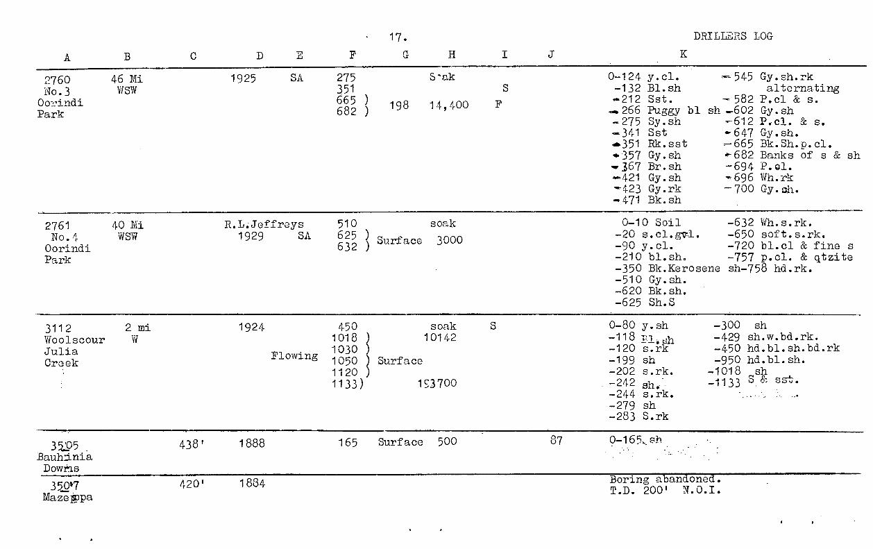
2760 46 Mi 1925^SA 275 S-ak 0-124 y.cl.^- 545 Gy.sh.rkNo.3 WSW 351 -132 Bl.sh^alternatingOurindiPark
665682
))
198^14,400 Sst.^-582 P.c1 & S.-.266 Puggy bl sh .602 Gy.sh-275 Sy.sh^- 612 P,c1. & s..341 Sst^- 647 Gy.sh.4.351 Rk.sst^-665 Bk.Sh.p.cl..357 Gy.sh^*-682 Banks of s & sh367 Br.sh^- 694 P.ol.
4.-421^Gy.sh^-, 696 Wh.rk•-423 Gy.rk^-700 Gy.oh.-471 Bk.sh
2761 40 Mi R.L.Jeffreys 510 soak 0-10 Soil^-632 Wh.s.rk.No.4Oorindi
WSW 1929^SA 625632 J
Surface^3000 -20 s.cl.g71.^-650 soft.s.rk.-90 y.cl.^-720 bl.c1 & fine s
Park -210 bl.sh.^-757 p.cl. & qtzite-350 Bk.Kerosene sh-758 hd.rk.-510 Gy.sh.-620 Bk.sh.-625 Sh.S
3112 2 mi 1924 450 soak S 0-80 y.sh^-300^shWoolscour W 1018 10142 -118^•i, dh^-429 sh.w.bd.rk.JuliaCroak
Flowing 10301050 Surface
-120 s.rk^-450 hd.bl.sh.bd.rk-199 sh^-950 hd.bl.sh.
1120 ) -202 s.rk.^-1018 ,sh1133) 193700 -242 ah.^-1133 o & sat.
-244 s.rk.-279 sh-283 S.rk
35:05 438' 1888 165 Surface^500 87Bauh:iniaDowns
350 117 420' 1884 Boring abandoned.T.D.^200'^N.O.I.
Maze*pa

A
18 DRILLERS LOGK
3508_auhiniaDowns
L398 1889 T.D.^130'^N.O.I.
3513BauhiniaDowns
L438 1890 203 Surface 94 Abandoned T;D.203' N.O.I.
3517BauhniaDowns
34 MiNNW
L365 1889 Flowing 678 Surface^34,370 105 -60^Alluvium-638 sh.7678 sst.
3518Maze ppa
21 MiNNE
L421 '1889 Flowingia'Alreei -
760SurfaceSurface 180,300 109
•-665 sst
-675 bd.of sh.-760 sst.
MazePpa25 DiliNNE
1924 Flowing T.D.725°^N.O.I.
3520Maze ppa
22 MiNNE
1928Flowing
2010071084
Surface)72 9 000Surface)
01-42 y.cl.-44 rk
-124 cl.—808 sh.w.2' bds
of rk.-809^sst.-1003 bl.bk.br.sh,1015 c'.4.3& fine
49 p.c1.8c,^sst.-1050 rubble w water-1091 Fine hd.sst.-1109 Mica sst.-1121 Mica a.-1123 hd.rk.-1139 hd.Ei.
sst.
3521Burwood
"16 MiNN. E
446 1889SA
390707
Surfac1 80,830 100 0-60 Alluvium-390 Sh.-394 bk.sst.-602 sh.-707 sst.
T.D.^760'
3522Linafield
14 MiNE
L441 - 1890 Flowing 733 Surface 113,600 115 0-60 Alluvium-70^sh
-110 rotten sst.
- 655 sh— 733 sst.
3524BainiaDowns
29 Mi L339 1891 680 Surface^26,600 112 0-72 Alluvium-624 sh-670 sst.-690 hd.rk.
A
19
H
DRILLERS LOG
I
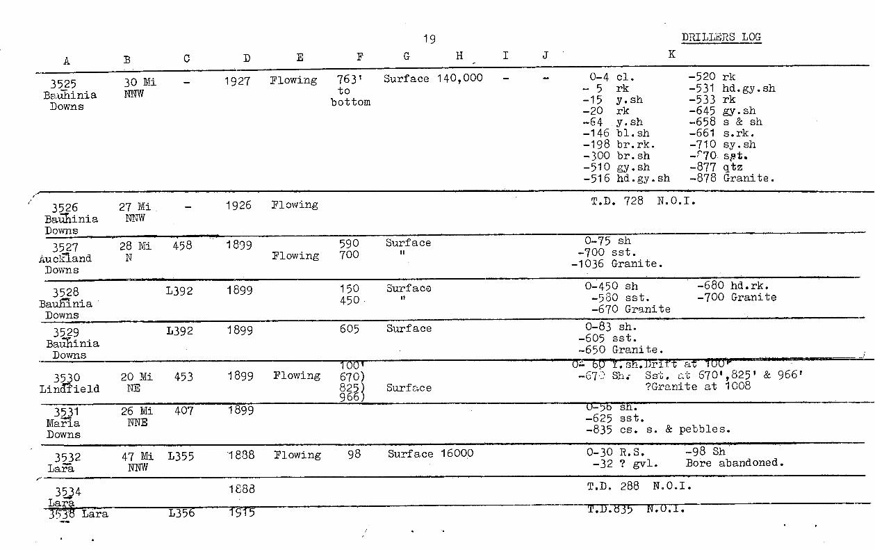
3525BalihiniaDowns
30 MiNNW
1927 Flowing 763'to
bottom
Surface 140,000 -^0-4 cl.^-520 rk- 5^rk^-531 hd.gy.sh-15^y.sh^-533 rk-20^rk^—645 gy.sh-64^y.sh^-658 s & sh-146 bl.sh^-661^s.rk.-198 br.rk.^-710 sy.sh-300 br.sh^-r70 s9t.-510 gy.sh^-877 q 'tz-516 hd.gy.sh^-878 Granite.
3526BaMiniaDowns
27 Mi.NNW
1926 Flowing T.D.^728^N.O.I.
3527AueinandDowns
28 Mi 458 1899Flowing
590700
Surface 0-75 sh-700 sst.-1036 Granite.
3528BauaniaDowns
L392 1899 150450
Surface 0-450 sh^-680 hd.rk.-580 sst.^-700 Granite-670 Granite
3529BaAiniaDowns
L392 1899 605 Surface 0-83 sh.-605 sst.-650 Granite.
3530Lindlield
20 MiNE
453 1899 FlowingTOO'670)825)966)
Surface
'—'77717175777777-7171rt 1 "'""ah,^sst. at 6701,8251 & 966'
?Granite at 1008
3531MariaDowns
26 MiNNE
407 1899 o-56 sh.-625 sst.-835 cs.^s. & pebbles.
3532LaFa
47 MiNNW
L355 1838 Flowing 98 Surface 1600.0 0-30 R.S.^-98 Sh-32 ? gvl.^Bore abandoned.
34
Lara7r5S^Lara L356
1888
19 f5
T.D.^288^N.O.I.
T.D.d35^N.O.L.
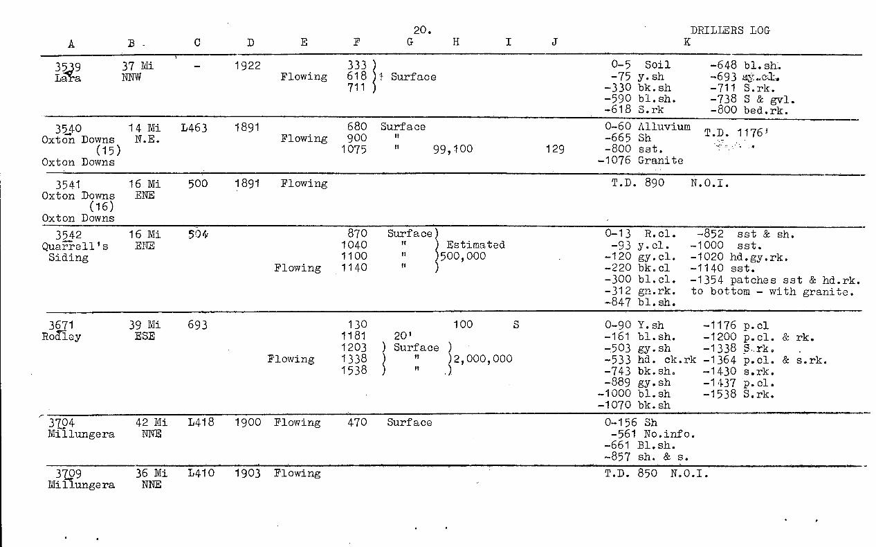
A B^-20. DRILLERS LOG
35,9Ldl.a
37 MiNNW
1922Flowing
333618711
)Surface
)
0-5^Soil^-648 bl.sh.-75 y.sh^-693-330 bk.sh^-711^S.rk.-590 bl.sh.^-738 S & gvl.-618 S.rk^-800 bed.rk.
350Oxton Downs
14 MiN.E.
L463 1891Flowing
680900
Surface 0-60 Alluvium-665 Sh^T.D.^1176 3
(15) 1075 "^99,100 129 -800 sst.Oxton Downs -1076 Granite
3541 16 Mi 500 1891 Flowing T.D.^890^N.O.I.Oxton Downs ENE
(16)Oxton Downs
3542 16 Mi 5Qty 870 Surface) 0-13^R.cl.^-852^sst & sh.QuaTi-ell's ENE 1040 "^) Estimated -93 y.cl.^-1000^sst.Siding 1100 )500,000 -120 gy.cl.^-1020 hd.gy.rk.
Flowing 1140 ) -220 bk.c1^-1140 sst.-300 bi.cl.^-1354 patches sst & hd.rk.-312 gn.rk.^to bottom - with granite.-847 bl.sh.
3671 39 Mi 693 130 100 0-90 Y.sh^- 1176 p.c1Roliey ESE 1181 20' -161 bl.sh.^-1200 p.cl. & rk.
1203 ) Surface^) -503 gy.sh^-1338Flowing 1338 )^"^)2,000,000 -533 hd.^ck.rk -1364 p.cl. & s.rk.
1538 )^" -743 bk.sh.^-1430 s.rk.-889 gy.sh^-1437 p.cl.
-1000 bl.sh^-1538 S.rk.-1070 bk.sh
3704 42 Mi L418 1900 Flowing 470 Surface 0-156 ShMillungera NNE -561 No.info.
-661 Bl.sh.-857 sh. & s.
3709 36 Mi L410 1903 Flowing T.D.^850^N.O.I.Mifiungera NNE

21.
Ilowing
150^?60^'^S760 )920 ) Surface 1,846,6001095 )
Flowing
Flowing 192750 Surface 80,000900^n^1,169,000950^"^)
C.
Flowing
Flowing
Flowing
Flowing^525^Surface 436,000
A D
3713^39 Mijingera^NNE
1,446 1912
3716WiQera^NNE
1929
3768^28 MiFairlea^NE
1926
403^21 MiNelia Ponds^ESE
485 1899
4025^31 Mi^558Pa^SE
100.1■••••••••■■••••■•■1010•1116
1900
4026^34 Mi^471Nefla Ponds^ENE
1901
4027^3,-MiNefla Pond^ENE 1902
4330^62 MiGlerigalla^NE
1393
DRILLERS LOG.
IC
0- 14 y.cl.^-800 p.cl.-20 s^-840 Br.sh.
106.5^-86 y.cl.^-890 P.cl. & s.-120 Bl sh.^-920 sst.-125 Oily bk.sh-...950 p.cl.-155 Silt^-.1035 sst.-650 Bl.sh.^T.D. 1095-760 Sst.^N.O.I.T.D.822 N.O.I.
0=z it-y- 31.^-375 Rk-40 y.sst.^-510 Gy.sh-42 P-.rk.^- 520 Rk-66 _1.sh^-560 Gy.sh.-80 Br.sh^-680 Bk.sh.-84 Bl.sh.^-750 Sy. sh.-100 Sst.^4,784 Sst-190 Gy.sh.^-.900 p.cl.-220 Br.rk^4.970 s.rk.4-370 Bk.sh.
Bottomed in bed rk.T.D. 1154.^N.O.I.
T.D.1318 N.O.I.
T.D.1300 N.O.I.
T.D.1078 N.O.I.
- 99^0-10 Alluvium-525 Sh-543 Sst.
a littlegas inwater

A22. DRILLERS LOG
41,36^64Mir'iaxby^NEDowns
L.629 1908
Flowing
400850
Surface^Some^At 400 Marl
^
gas^-850 Hd.sst.At 850 Inz,^spring.T.D.1335^N.O.I.
4366 L.575 1912 T.D.847 N.O.I.Watgam
4367^54 Ml L627 1911 Flowing T.D.T0-8-8Sutlirprland^NE
4368^58 Mi 1923 326 Surface 0-4 S^95^1.sh.Dovn.^NE 595 1,100,000 -66^y.s.^-715 S.rkDowns 947 -93 y.cl.^-750 P.cl.
Flowing -198 Bk.sh.^-875 Fine s.rk.-326 Bl.sh.^-900 P.cl. & s.-342 Bk.s.rk.^1006 Cs.s.rk.
4459^37 Mi 515 1910 Flowing T.D.1700^N.O.I.Minamere^SE
472^38 mi 535 1907 1116 0-117 Hd.surface-1042 Bk.shEDar3sborough SSE. 1190 -226 Bk.sh^#1145 Bk.gy.sh.& p.cl.Yorkshire Flowing 1291 -449 Bl.gy.sh^t-1379 S.rk. & p.cl.
Downs 1379 -621 Gy.sh^#1433 S.rk.1405
.0"
4973^19 Mi 498 I.B.C. 863 Surface Slight 0- 9 y.sh.^.sNo.2.shed^ESE 1911 877 10,000 -- 323 Gy.sh^- 892 s.rk.WeJeley 975 * 340 S . rk.^-908 S.rk. 8c p.cl.
Flowing 1042 11 225,000 350 Bk.sh^-1012 p. cl.1063 11 597 Br.sh.^1063 S.rk.
I" 619 Gy, sh^4.1164 Dk. gn. rk.-687 Hd. gy sh •1201 Qtz.739 Gy sh
4974^24 Mi,3ngley^SE
504 1911 AM 161200 0-88 y.cl.^-910 Gy.sy.sh.
-181 Sy.gy.sh^Boring abandoned,-263 Gy.sh.w.hd. stkp^cable and*413 Hd.br.ah.^hook in bore.#530 Gy.sh.w.hd. stks.

A
23. DRILLERS LOG.
4975-j-nsfey
24 MiSE
504 1911 Flowing 140913
SoakSurface
0-25 Surface cl. 693 Gy.sh.-181^cl. 4917 Gy.sh.-417 Gy.sh. Granite at 917.-460 Bk.sh
5010Lindlield
13 MiNNE
1938 160 40 0-13 Bk.soil & y.c1 -480 Gy.sh-27 Y.sst. & y. sy.c1.-481 Br.rk.-31 rotten sst. -556 Gy.sh-40 y.cl.^-562 Sst-60 Bk.sh^4.575 S.rk.
Gy.sh^576 Sst..105 Gy.sy.sh^-.608 Lt.gy.sht-125 Bk.sh.^4.783 Hd.r.rk.-.178 Bk.gy.sh
5016LarT
40 MiNNW
1935 Flowing 80124
RSASurface Small 0-3 Surface^-426^Sy.sh.
^
429^Rk342365485
It 5,00038,000
-44 Rk. !:12 01^0.449 Bl.sh.4.120 Br.sh.^-451 Rk200 Lt gy.sh^0465 sy.sh.
Rk^'467 Rk.- 2'74 Lt.gy.sh.^--473 Gy.sh— 277 Rk^""'475 Qtz4.337 Lt.gy.sh.^0.478 Sh
339 Rk.^,-537 Qtz45* 396 Bl.sh.^Mica-40398 Rk.^-.545 Qtz46' 416 Bl.sh.^4,4548 Mica
5028GlIdevale
51 Mi ,NE
•■••• 1936 424815826
175Surface
II10,00024,000
0-57 Lst & y.c1.-72480^'-.^00766 S.rk
^*-423 By. sh•428 Gn.s.rk.^-769 P.cl. & S.830 30,000 -455 Sh & bds.rk-774 S.rk.
Flowing 838 50,000 -458 Gn.s.rk.^*800 Sh.871 85,700 4'607 Sh & bds. rk807 P.cl.rk887 120,000 *618 Sh^:^.9.845 s.rk.898 It 146,000 .4 622^GL.o.rk.^P.cl.^& s.906 410,000 -698 Sh.w.bds rk--906 S.rk.
-702 Qtzite*710 Gy.s.rk.

A
24. DRILLERS LOG.K
515,4^10 MiLoryfordPlains
1938^SA^1063 Surface )1117^"^)134,8231175^)
0-65 y. cl.-380 Bl. sh.-530 Gy. sh-960 Bk. sh.
- 1020 Gy. . sh.40:1213 Interbedded bid.
s.rk.p. cl.-1058 Bk. sh.- 1061 p. cl.
• 5355^42 MiOorindi^SWSimplex
Beaufields
SA^878^29^12,672 0-2 Soil-20 R. gvl .
76 y. sh.- 77 Rk100 y. sh.
*120 Bk. sh-'-160 Gy. sh.
165 Rk.207 Gy. sh-217 Rk.6262 Gy .sh--265 Rk*315 Gy. sh-.316 Rk
373 Gy. sh.
- 403- 435 Gy. sh.- 488 Bk. sh.-•• 491 Rk-.571 Gy. sh- 573 Rk'.663 Gy. sh
-- 759 Br. sh-'763 Rk0* 861 Br. sh- 870 Sy . sh- 880 Sst.- 890 Ci.• 960 Mica 8c rk.
53j7Kevin
Downs
40 MiSW
1926 SA T.D.920 N.O.I.
A°756 Sh (mud spring)-761 Sy sh-770 S. rk.4.-790 Sy. p. cl..-802 Sh-305 Qtz rubble*842 S. rk-844 R. qtzite
6013^26 MiWNW
Caiwarra
1537 289761
Flowing^802830
220^.Surface
81,042
0-405 .g . lrifo..* 410 Sh.w.bd.rk- 508 ShI"- 519 sh.rk- 545 sh
552 Sh & bds rk560 sh
-d■' 570 sh & bds rk- 685 Sh
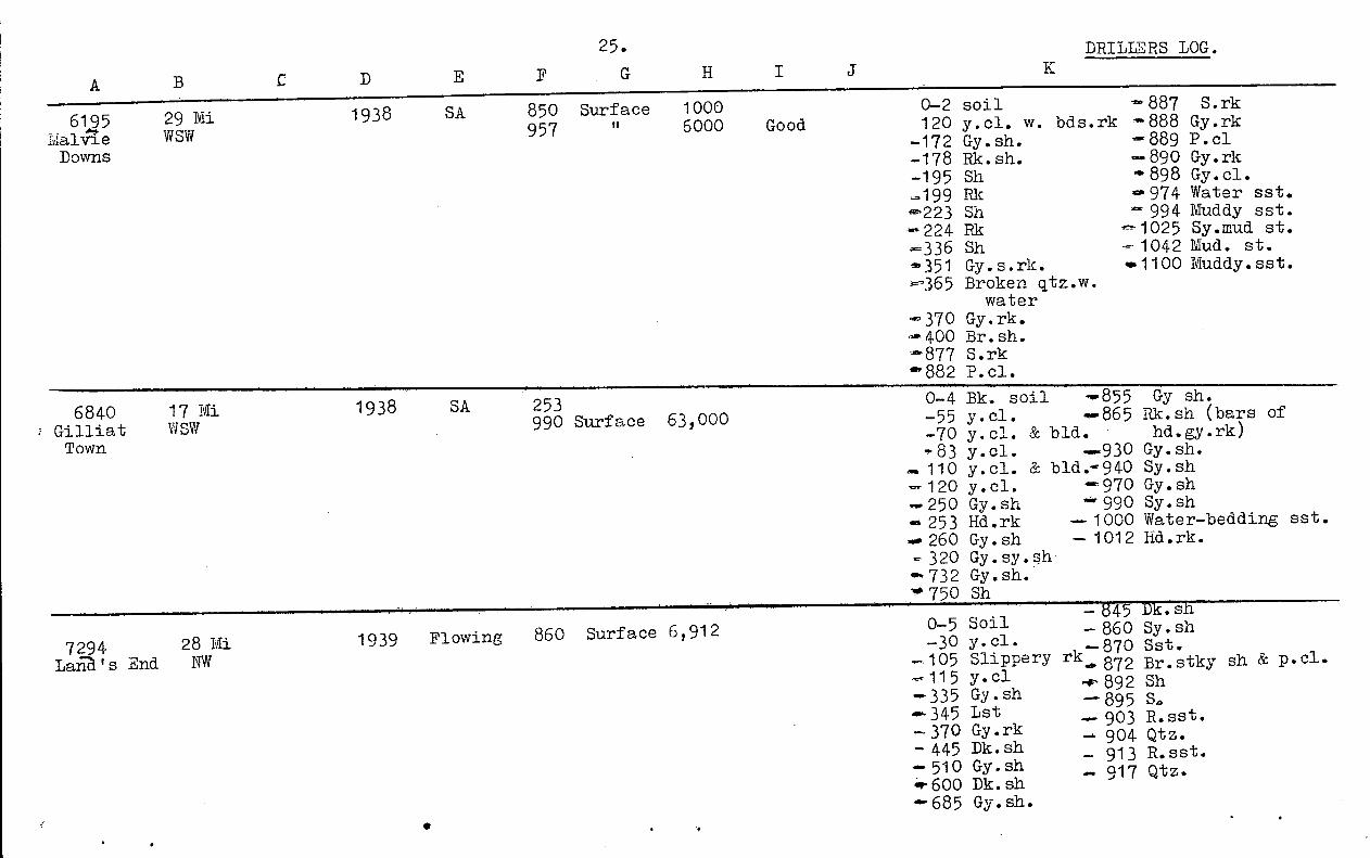
25.^ DRILLMS LOG.
A
0-2 soil120 y.cl. w. bds.rk
-172 Gy. sh.-178 Rk. sh.- 195 Sh-199 Rk
Sh- 224 Rk-336 Shdi 351 Gy. s.rk.ii-365 Broken qtz .w .
water-370 Gy.rk.
400 Br. sh.i-877 S. rk
882 P cl.
- 887 S. rk- 888 Gy.rk'889 P. cl-890 Gy.rk
• 898 Gy. cl.• 974 Water sst.."` 994 Muddy sst.1025 Sy .mud st.
- 1042 Mud. st.1100 Muddy. sst.
6145^29 DaW SW
Downs
1938^SA^850 Surface^1000957^6000^Good
6840^17 MiGilliat^WSW
Town
1938^SA^253990 Surface 63,000
0-4 Bk. soil-55 y. cl.-70 y. cl. & bid83 y. cl .
- 110 y. cl. & bid- 120 y. cl.- 250 Gy. sh▪ 253 Hd.rk
260 Gy . sh- 320 Gy . sy . she. 732 Gy. sh.• 750 Sh
-.855 Gy sh...865 Rk. sh (bars of• hd.gy.rk).930 Gy. sh.."940 Sy. sh
99 9700 Gsyy :sshh
1000 Water-bedding sst.1012 Hd.rk.
- 345 Dk. sh- 860 Sy. sh
870 Sst.rk
•
872 Br. stky.4-892 Sh
895 S.▪ 903 R. sst.- 904 Qtz.- 913 R. sst.- 917 Qtz.
7294^28 Mi.Laria. ' s End^NW
1939^Flowing^860 Surface 6, 912 0-5 Soil-30 y. cl.
- 105 Slippery--115 y. cl-335 Gy . sh• 345 Lst-370 Gy .rk-445 Dk. sh- 510 Gy. shar 600 Dk. sh
685 Gy. sh.
sh & p. cl.

A
26.
3.
DRILLERS LOG
7577Cooyal(2)Cooyal
46 MiWNW
1939 SA 730735
Surfacl 21,000 • 0-80 y.cl.^-735 Sy.sh-141 Bl.sh.^-745 S.w.stk.p.cl.-146 Rk^-793 Hd.s.rk.-455 Gy.sh^-868 Hd.br.rk.-465 Gvl^-840 Bk.rk.-605 Br.sh-700 Dk.gy.sh
8396MalhamWestMalham
16 MiSSE
_^1941
Flowing
9981011109811571169
Surface111111II
10,00012,0005,0007,00046,000
))))
80,000
0- 8-62.654. 80•*118
soil^4b. 997 stks,gn.rk.y.sh.^- 1000 Hd.s.rk.y.rk^. 1004 P.cl.Sh^1008 Gn.s.rk.Gy.sh.^.1010 P.cl.s.
-*120 Gy.rk.^-.1013 S.rk.Gy.sh.^.0 1018 P.cl.
.-135 Gy.rk.^Fine hd.s.rk.--157 Gy.sh.^.1066 P.cl.^s.rk..0-158 Gy.rk.^-1076 S.rk.-280 Gy.sh^-1086 Lst.
283 Gy.rk^40098 S.rk.-315 Gy.sh^.1099 Qtz pebbles.4317 Gy.rk^Qtz sst.—475 Gy.sh^.1151^Cs.s.rk.-485 Qtz.rk^0401154 Lst.
Bk.sh.^-.1157 Qtz.s.-667 Gy.sh.^-.1160 Qtz-727 Bk.sh.^41163 Lst..811 Gy.sh.^-1169 Qtz sst.
830 Bk.sh.^-4.1173 Lst.+840 Gy.sh.^-.1176 Hd.rk.w.specks-894 Bk.sh.^of. mica..912 Bi.sh..928 Bk.sh.-- 951 Gy.sh.-960 Bk.sh.--966 Dk.gn.rk.
Bk.sh.

5166 32 fli E.EnblemN^1943 Floving
BuuhiniaDowns
490^120576)584) Surface6947b71 -
0- 34 Rd & wh.cl. - 575- - 538- 346 Gy.sh.^- 679- 474 Alternating
rk.w.sh.^- 686
sh.^- 690 Hd.rk.s.^- 707 s.rk.w.qtzCl.w.s.bds.- 720 No.info.graniteCong.
27.^ DRILLERS' LOG
A^B^C.^D
9083^33E1 428 1942
Flowing
460^
60560 Surface
0- 3 Surface- 90 Y.sh.- 260 Dk.sh.- 263 Rk.;4 288 Sh- 294 Rk.- 322 Sh.- 325 Rk.- 362 Sh- 364 Rk.- 378 Sh.- 381 Rk.
- 417 Sh.- 421 Rk.- 466 Sh- 478 Rk.- 500 Sh.- 555 Hd.sh.- 576 Sst.- 580 Qtz.
586 Cl. & qtz.- 609 Rk.
653 Granite
10785-45E1.Elrose .
1946 S.A. 201^140)60) 24,000
0-^5 Dk.soil
- 197Dk.sh.201 Rk.
- 206 Dk.sh.- 290 Rk.- 316 Dk.sh.- 336 Sst.- 366 S.rk.- 374 Qtz.- 380 Hd.sst.& qtz.

33 Mi11047No.2^NW
Caleewa
210^S.A.615 )
Flowing^788 ) Surface820 )860 )876 )
0-125 y.cl.-185 Gy.sh-215 Br.rk.-615 Dk.sh.
-890 Sst.-950 Qtz.
28.^ DRILLERS LOG.A
10849151..oa
0-2 Surface soil-65 y.cl.
-276 Gy.sh.w.rk at100,106,146,178,187, 216.
-330 Br.rk.-424 Dk.sh.-489 Gy.sh. & rk at
454,488.-577 Sh.w.r1. at-51,566,574.
-871, Hd sh.w.rk at55,632,705,718,720,756,788,817,855, stks s
• at 722 & 774.-901 S & qtz.-939 Cl & qt2.-986 Granite & qtz.Samples examined byGovernment Geologist.
Gy.sh.w.sypatches.
-.876 Gy wh.sst.
D
31 MiSE
1947 310876
Flowing 948968977980
576SurfaceSurface
It
Soak
25,000
-879 Sst & Sh.-0.910 Gy.sh.
Sh & smallproportion ofsst.
- 941 Pk qtzite &frequent sst.
-950 Moderately• cs.wh.sst.
-982 Mainly hdqt z.
--986 Granite

29^ DRILLERS LOGA^B
11110^3 Mi^1948^ 75,000 -^ 0-?14 SurfaceHi non^SE^ (controlled^-66 y. cl.FlowingPark^ to 36,000)^-74 Rk
Gy sh.-110 Rk-0124 Sh.125 Rk.."135 Sh.0.139 Rk-158 Sh+159 Rk-210 Sh-213 Rh-- 238 Sh
242 Rk258 Sh260 Rk
- 283 Rk431 Sh
-486 Rk-632 Sh-'634 Rk-E:9 Sh4.- G2.3
26 2E. "1..-14.55
.
-882 Hd. sh.-925 Rd.
-1004 Hd. sh.- 1030 Hd.br. sh.- 1123 Qtz.- 1167 Hd. s.rk.
10'279 Sh
11.04 44 Mi 1949 666 Surface 20, 000 0-5 cl- 479 Gy . sh
Lydia NNE 694 TI 42, 000 -38 rk -481 RkDowns 797 It 97,000 -44 y. cl. -511 Gy.sh
Flowing 806 163,000 - 60 Dk. sh 4-529 Hd sh819 II 218,000 - 63 Rk - 531 Rk
146 Dk sh -591 Hd. sh.-191 Gy sh-192 Rk :659184 HRkd. sh.-193 Sh -620 Rk-219 Gy. sh -645 Hd. sh-222 Rk - 647 Rk.313 Gy . sh - 664 Hd. rk-315 Rk Qtz-0-350 Gy sh 46-699^S-353 Rk .-702 Hd. sst.-365 Gy . sh S & qtz.366 Rk -749 Cl.-388 Gy.sh -751 S- 390 Rk -763 Qtz-460 Gy.sh —819 S-463 Rk .

A30. DRILLERS LO.G.
11400No.3.
Proa
30 MiSE
E. Emblem1950^Flowing
1001:104111051130
)^8,000Surface50 9 000
1009000160,000
0-2 Surface Roil-93 y.sh.-10^gn. sh-177 Gy. sh
- 631 Gy sh'10•636 Rk- 944 Gy. sh
949 hd. s.rk(Controlledat 52 9 208)
•-180 Rk-214 Gy . sh
955 S. rk-.41002 Br. cl.
- 250 Gy. sh.w.bars of rk
-1004 Rk-1005 Br. cl
-0280 Gy. sh. -1013 S.rk318 RIK -1016 Qtz.
- 446 Dk. sh -1039 S.rk448 Rk -1040 Iron pyrites
'479 Gy. sh481 Rk
1041 Qtzto 1129 S.rk
'4- 542 Gy. sh S4- 544 Rk .-1144 S.rk..580 Gy . sh.-- 583 RIK..0, 610 Gy.shAP 6 1 4 RIK
11173^60 MiDalgonally NW
1954 S.A.^1057^40 0-5 Bk. soil-145 y . sh.-855 Bl. sh.-925 Gy. sh
990 Bl. sh.?1005 Sst-1057 Hd. gy sh-1096 Gvl.' 1190 Hd.r. sst.
—1250 Hd. creamyqt z . like rk.
1355 Gy. slatey sh.- 1630 Hd.r. sl. like sh.

A31. DRILL2RS Laa
X
11§32Lara
38 MiNNW
1951 Flowing 679^Surface ) 38 , 426850^controlledat 18,000)
0-2 Hd.cl.^-512 Gy. rk-8 cl.^-.554 Gy. sh.-25S^- 556 Rk-32 Cl^- 586 Gy . sh.-70 Y. cl,^-662 Sh.
-106 Gy. sh.^-706 Rk140 Bk rk^-720 S.rk
-476 Dk. gy. sh^740 QtzHd.rk^-772 S.rk
--475 Gy. sh^-823 RkRk^-850 Hd.rk
-505 Gy. sh--510 Hd . gy . sh
11706Balanally
47 MiNW
1951
lowing
182^6472 Surface690^"
9,250
0-4 Surface soil.-690 Bl. sh.w sst.-64 y . cl.^-- 700^Sst-122 Bl. sh.^- 710 Sst .w . hd .226 Bk. sh^seams
-- 478 Bl. sh^742 Bk. st.'480 Gn. sh^760 Bk.rk.
- 652 Bl. sh.
11747Ernestina
44 MiWNW
19 51 SA 661 Surface731^"
40,000 0-3 Sizrf ace soil - 565 B1 . sh.-26 Br. sst .^590 Bk. sh.
Erne stina -35 Woody y cl^630 B1 . sh & wh. s.Plains - 54 y. sh.w. mica^- 691 Wh. sst .
seams.^740 Sst.195 Bl. sh^744 Pyrites of
. 208 Bk. sh.^sh.520 Bl. sh.
aft 560 Bl.sh.w.s.seams.

11227Lara
42 Mi^
1952^SA^155NNW^ 202
50
A
32. DRILLERS LOG.
11783 36 Mi 1951 470 Surface ) 0-4 Surface soil 561 Dk.br.st.ammeray WNW 480 "^) 34,000 94 Y.cl.^690 Bk.woody sh.Cammeray Flowing 616 ) 100 Bk.sh^615 Gy.sh. & wh.S.
120 Br.lst.^616 Qt z.137 Bk.sh^636 Wh.sst.472 Bl.sh^666 Wh.sst.w.hd.seams480;Gy.sh.^672 Hd.S.505 Bl.sh.^722 Qtzite.559 Bl.woody ski.
•
11800ITellen No.2ite lien
34 MiSW.
1951 Flowing 405853870
305^SmallSurface 7500
110-5 Br. soil^-738^Sh-18 Sy.r.cl.^-743 Sh & rk-42 y.sh.^-750 Sh
8,000 -77 y.sh.w.bld.^-841^Gy.sh.Sept -100 y.sh.^-853 Sy.sh.1961. -115 y. & gy.sh^-873 Sst.
-380 Gy.sh.^-878 Hd.cl.sst.-420 Br.sh.w.wh .rk-697 Gy.sh-700 Gy.rk-703 Gy.sh.-723 Sh.w.saams
of rk.
0-5 Surface soil-55 y.cl.-75 R.cl.-107 Y.c1-160 Gy.sh.-178 Br.sh-207 Br.rk-274 Br.sh.-352 Rk-490 Gy.sh-492 Rk-524 Gy.sh.
Rk
-613 Gy.sh-662 Hd.br.sh.-708 Gy.sh.-722 S.-737 Qtz-777 S-785 Cl-787 Qtz-791 S-797 Qtz.rk.-831 S.-874 Rk

33.^ DRILLERS LOGA^ P
125477., e"wantha
37Mi^Flowing^777 SurfaceNE^ 1012^"^729,530
0-8' Soil-31 y.c1-33 Rk-84 y.c1-131 Gy.sh-132 Rk-141 Gy.sh-172 Hd.Rk-197 Gy.sh-290 Dk.Sh-369 Gy.Sh-371 Rk-397 Gy.sh-399 Rk-403 Hd.Sh-404 Hd.rk.-408 Gy.Sh-409 Hd.rk-414 Sh-495 Gy.sh.-498 Rk-529 Gy.Sh-530 Rk-535 Sh
-566 Gy.Sh.-568 Rk-574 Sh-575 Rk-585 Sh-637 Gy.Sh-651 Hd.br.sh.-652 Rk-671 Hd.br.sh-673 Rk-679 Hd.br.sh-694 Rk-777 Hd.br.sh-783 S.rk.-812 S-815 Qtz
- 819 S & cl.-822 Qtz-854 Qtz & cl.-870 Qtz-971 Qtz cl.-972 Qtz.-1032 S
12605^32 MiIuellen No.3 SWIuellen
1954^840 Surface^6,000844^11^11,000
Flowing 869^50,000
Good 0-5 Br. soil-20 Y.cl.-40 y.sh.-60 y.sh.w.rks-80 y.sh.-126 Gy.sh.-132 Gy.rk-150 Gy.sh^.
-350 Sh.W.rk. seams.-405 Br.sh.w.rk.seams-461 Sticky sh.-510 Ceing Sh-820 Sh.w.rk.seams.-840 Sy.sh.-841 Drift s.-855 St. : .-869 Sst. & pecl.-909 wh.sst.-910 Hd.gy.s.rk.
12642^58 MiScrubby^NWDalgonally
1954 Flowing 1044^60^21,600Flowing
1961
0-4 Soil-98 Cl-1000 Sh-1088 tst.-1098 Rk.
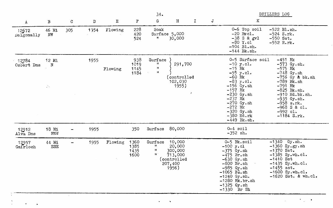
A
34. DRILLERS LOG
12672 46 Mi 305 1954 Flowing 228 Soak 0-6 Top soil -522 Bl.sh.Dalgonally NW 420 Surface 5,000 -20 -524 S.rk.
524 "^30,000 -38 S & gvl -550 Sst.-80 Y.c1 -552 R.rk.
-104 Bl.sh.-144 Bk.sh.
12784 12 Mi 1955 938 Surface 0-5 Surface soil -451 RkOsbert Dns N 1019 "^291,700 -10 y.cl. -573 Gy.sh.
Flowing 1145 It -15 Rk -575 Rk1184 11^) -55 y.cl. -748 Gy.sh
(controlled -60 Rk -756 Gy & bk.sh102,030 -83 y.cl. -789 Bk.sh
1955) -156 Gy.sh -791 Rk-157 Rk -825 Bk.sh.- 230 Gy.sh -910 Hd.bk.sh.-237 Rk -935 Gy.sh.-270 Gy.sh -958 s.rk.-272 Rk -968 S & cl.-320 Gy.sh -992 cl.-380 Hd.rk^-1184 S.rk.-449 Bk.sh.
1212^18 Mi^
1955^350^Surface 80,000^
0-4 soilAlva Dns^NNW^ -352 sh.
12957^44 MiGairloch^ESE
-^ 1955 Flowing 1360 Surface 10,000it^20,000
1435^"^300,0001600^"^713,000
(controlled207,400
1956)
0-5 Bk.soil-100 y.c1-375 Gy.sh-475 Br.sh-630 Gy.sh-800 Br.sh-985 Gy.sh
-1065 Bl.sh-1240 Gy.sh.-1280 Rk.br.sh-1325 Gy.sh-1330 Br Sh
-1340 Gy.sh.-1360 Sy.gy.sh-1370 Sst.-1385 Sy.wh.cl.-1410 Sst-1435 Sy.wh.cl.-1455 sst.-1600 Sy.wh.cl.-1620 Sst. & wh.cl.
138 5

35.^ DRILLERS' LOG
13188 25 Ml.Lana End NWLand's End
1957^368^Soak
^
Flowing 983^-5(00- 1O C1.- 22S- 80 Y.cl.— 94 Y.cl.w.bars
of rk.- 118 Y.cl.- 345 Gy.sh.- 397 Rk.- 414 Gy.sh.- 471 Dk.sh.- 531 Gy.sh.- 535 Rk.
- 747 Gy.sh.
: 7812 GY:sh.- 848 Br.sh.- 849 Rk.- 880 Br.sh.
:-
--9853. .-1030 Hd.rk.
13387 37 Mi..^NEBeverley
- 1957^216^30 Small B861 Surface10,000 G
Flowing^996^280,000 .,(3-
4 Soil- 18 Br.cl.- 20 Br.sst.- 110 Y.sh.- 204 Bl.sh.
- 240 B1.1st.- 356 Bk.sh.At least 644' Bl.sh.T.D. 996' N.O.I.
13556^9 MiGaromma ESEGaromna
E.Emblem1958 Flow-
ing
1046)^Small1110 Surface l'Icrease1131^ 50,0001153^80,0001220)
0— 3 Soil- 80 Y.cl.- 347 Gy.sh.- 401 Br.rk.- 550 Dk.sh.- 678 Gy.sh.- 680 Rk.- 696 Gy.sh.- 721 Rk.- 780 Hdogy.sh.- 850 Dk.sh., rk.• seams
- 856 C1.& s.- 903 Gy.sh.- 923 Rk.— 936 Gy.sh.— 994 Rk.•_1043 Cl.—1080 S.rk.-1083 Hd.rk.-1110 S.rk.-1112 Qtz.:-1220 S.rk.

0- 28 Rd.c1.& gvl.- 268 Br.sh.- 80 Y.cl.^- 380 Gy.sh.- 115 Dk.gy.sh.^- 383 Rk.- 145 Gy.sh.^- 480 Gy.sh.
- 575 Br.sh.- 725 p.c1.8c s.- 744 Lst.
14142^
45 MiOorindi WRly Stn.Railway
W.Week -^575 Sur- 31681960^46'^face
35a.
A^B
13339^39NNW
Lara
F
1960 Flow- 210ing 946
98310001083
Sur-face
0--
-
IN•••
-94 Soil, s.r^y cl.203 Gy.sh.255 Rk433 Sh465 Sh466 Rk.569 Sh571 Rk.719 Sh.
-- 727 Rk.- 900 Sh.w.rk.seams- 931 S.rk.-1013 Rk-1022 S.rk.-1069 Hd.rk.-1090 S.rk.-1112 Bk.rk.
14076 19 MiNNW
Barroona
1960 Flow- 89Q Sur-ing 1005 face
1058106410711084
0-^99 Cls.,br.y.gy.- 890 Shs, gy.br.,b1.- 1070 Sst.gy.wh.- 1110 Wh.rk.
14)85^26M1^
1960^Flow-^ T.D. 1265 N.O.I.KaL3rooka 3 SW^
ing:lamerooka
14279^46 hi.hillungera N
R.Beauchamp 476 150 snail^?1960 Flow-820) Surface 120,000 P
ing 860)^500,000 P
0-^5- 7- 25- 104- 470- 476
Surface s.S.rk.Cs.s.ec gvl.y.sh.Bl.sh.Bk.sst.
- 492 Bk.shacs.- 526 Gy.sh.- 736 Bl.sh.-
745 Gn.s.- 764 Bl.sh.- 788 31.sh.& sst.
- 820 31.sh.& s.- 832 Wh.sst.- 842- 854 Wh.cl.- 860 Wh.s.

36.
IL
14338^27E1.St. Anfrew WSWSt. i.a .Z.rew
1960 Flow—^825 Surface)77,000 Ging^879 Surface)^0- ^5 Bk. soil^—^328
7 Y.cl.^—^331
^
—^8S^—^343
Gy.mudst.Rk.Dr.mudst.-
—^653 Rk.—^794 Gy.mudst.—^796 Rk.
—^18 Y.sy.cl.^—^367 Br.sy.mudst. —^825 Gn.sst.-^53 Y.cl.^—^498 Gy.mudst. —^835 Water sst.—^58 Rk.^—^500 Rk. —^836 Rk.—^80 Y.cl.^—^564 Gy.Mudst. —^871 Sst.—^112 Gy.mudst.^—^566 Rk. -^879 Br.sst.—^136 Gy.sy.mudst.—^646 Gy.mudst. —^901 Water sst.—^139 Rk.^—^648 Rk. —^907 Slate.—^200 Gy.sy.mudst.—^652 Gy.mudst.
14339^25 MI 1960 Flow— 1030) Surface91,995 0—^96 Y.cl.^—1030 Gy.sh.Bullock^SW ing^1058) 165 Gy.sh.^— 1032 Sst.HolesMbYinlay
—^196 Gy.sh.bars^— 1058of rk.^— 1061
P.c1.& S.Sst.
Shire -^545 Gy.sh.^— 1072 P.c1.& s.—^690 Dr.sh.
14611^33 Mi 1961 ? SACarjoan 4^W 1961 T.D. 733 N.O.I.Carjoan