e ja - southwestern prospectors & miners has claims you ... map showing location of the jacumba...
TRANSCRIPT

Minera Wild rn Imper al
ou u y
,
e Ja (
nla
u.s. GEOLOGICAL SURVEY BULLETIN 1711-D
CALIFORNIA

Chapter D
Mineral Resources of the Jacumba (In-ko-pah) Wilderness Study Area, Imperial County, California
By VICTORIA R. TODD, JAMES E. KILBURN, DAVID E. DETRA, ANDREW GRISCOM, and FRED A. KRUSE U.S. Geological Survey
EDWARD L. McHUGH U.S. Bureau of Mines
u.s. GEOLOGICAL SURVEY BULLETIN 1711
MINERAL RESOURCES OF WILDERNESS STUDY AREAS: SOUTHERN CALIFORNIA AND CALIFORNIA DESERT CONSERVATION AREA

DEPARTMENT OF THE INTERIOR
DONALD PAUL HODEL, Secretary
u.S. GEOLOGICAL SURVEY
Dallas L. Peck, Director
UNITED STATES GOVERNMENT PRINTING OFFICE, WASHINGTON: 1987
For sale by the Books and Open-File Reports Section U.S. Geological Survey Federal Center, Box 25425 Denver, CO 80225
library of Congress Cataloging-in-Publication Data
Mineral resources of the Jacumba (In-ko-pah) Wilderness Study Area, Imperial County, California.
u.s. Geological Survey Bulletin 1711-0 Bibliography: Supt. of Docs. No.: J 19.3:1711-0 1. Mines and mineral resources-California-Jacumba (Inko-pah) Wilderness. 2. Jacumba (In-ko-pah) Wilderness (Calif.) I. Todd, Victoria R. (Victoria Roy) II. U.S. Geological Survey. III. Series. QE75.B9 No. 1711-0 557.3 s 87-600129 [TN24. C2] [553' .09794'99]
STUDlml Rm.ATED TO WILDERNESS
Bureau of Land Management Wilderness Study Areas
The Federal Land Policy and Management Act (Public Law 94-579, October 21, 1976) requires the U.S. Geological Survey and the U.S. Bureau of Mines to conduct mineral surveys on certain areas to determine the mineral values, if any, that may be present. Results must be made available to the public and be submitted to the President and the Congress. This report presents the results of a mineral survey of part of the Jacumba (In-ko-pah) (CDCA-368) Wilderness Study Area, Imperial County, California.


CONTENTS
Summary Dl Abstract 1 Character and setting 1 Identified mineral resources and resource potential 1
Introduction 3 Area description 3 Previous and present investigations 3 Acknowledgments 3
Appraisal of identified resources 5 History and production 5 Mineral deposits 5 Appraisal of mineral deposi ts 6
Assessment of mineral resource potential 7 Geology 7 Geochemical studies 8 Geophysical studies 8 Conclusions 9
References cited 9 Appendixes
Definition of levels of mineral resource potential and certainty of assessment 13
Geologic time chart 14
FIGURES
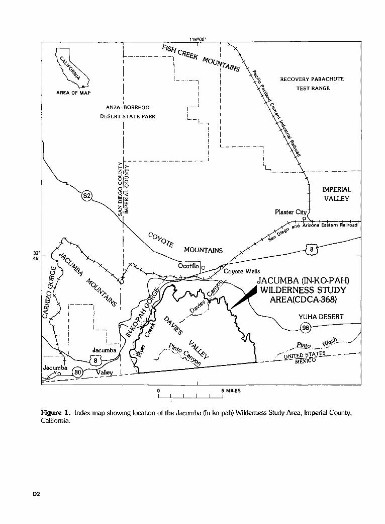
1. Index map showing location of the Jacumba (In-ko-pah) Wilderness Study Area, Imperial County, California D2
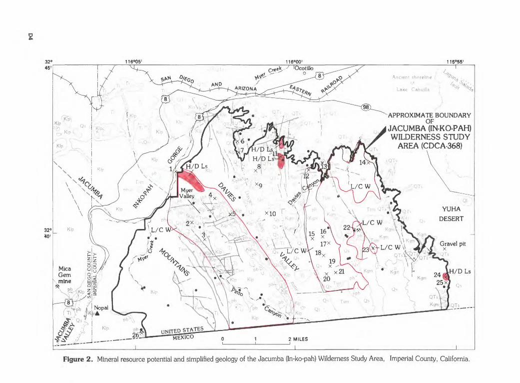
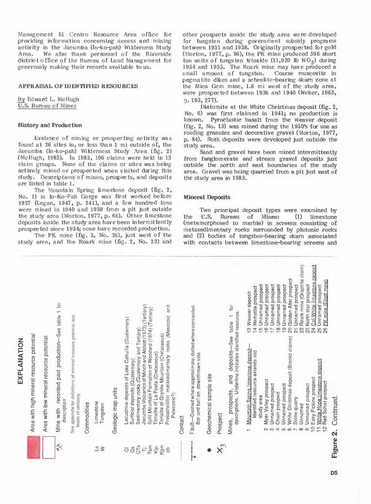
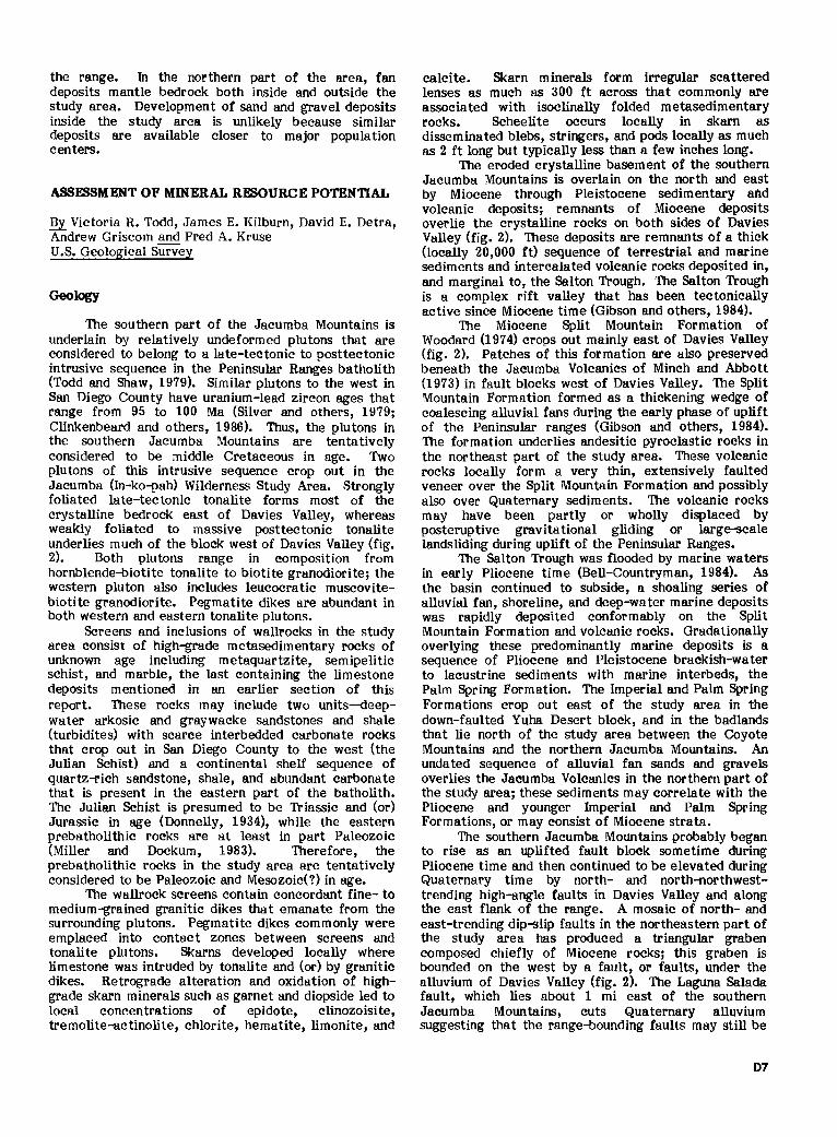
2. Map showing mineral resource potential and simplified geology of the Jacumba (In-ko-pah) Wilderness Study Area 4
TABLE
1. Prospects in and adjacent to the Jacumba (In-ko-pah) Wilderness Study Area D15
v

MINERAL RESOURCES OF WILDERNESS STUDY AREAS: SOUTHERN CALIFORNIA AND CALIFORNIA DESERT CONSERVATION AREA
Mineral Resources of the Jacumba (In-ko-pah) Wilderness Study Area, Imperial County, California
By Victoria R. Todd, James E. Kilburn, David E. Detra, Andrew Griscom, and Fred A. Kruse U.S. Geological Survey
Edward L. McHugh U.S. Bureau of Mines
SUMMARY
Abstract This report presents the results of a mineral
survey of part of the Jacumba (In-ko-pah) Wilderness Study Area (CDCA-368) that was designated by the Bureau of Land Management as suitable for mineral surveys. In this report, the area studied is referred to as the "wilderness study area", or simply "the study area." The study area encompasses approximately 28,443 acres in southwestern Imperial County, Calif. Field work for this report was carried out between 1983 and 1985. Numerous mines, prospects, and claims are present in the study area, but none are being actively mined or prospected. Three sites inside the study area have identified limestone resources that total about 1.8 million tons. Four areas in the northwestern, northern, and eastern parts of the study area have high potential for undiscovered limestone resources. Two north-trending belts in the western and eastern parts of the study area have low resource potential for tungsten.
Character and Setting
The Jacumba (In-ko-pah) Wilderness Study Area is located between the Peninsular Ranges province on the west and the Yuha Desert on the east (fig. 1). The United States-Mexico border forms the south boundary of the study area. Much of the area is characterized by rugged topography. Maximum relief in the study area is about 3,400 ft. A semiarid climate and chapparal vegetation are found at the higher elevations, whereas an arid climate and desert plant communities are characteristic of lower areas.
The study area is underlain by ere taceous (66 to 138 million years before present (Ma); see appendix for geologic time chart) plutonic rocks of the Peninsular Ranges batholith (informal name). The batholith is composed of a variety of plutons that intruded metamorphosed Paleozoic and Mesozoic sedimentary and volcanic rocks. Neogene (24 to 1.7 Ma) marine and alluvial deposits unconformably overlie the uplifted and deeply eroded batholithic rocks in the study area, and faults of the Elsinore fault zone cut both the batholithic rocks and the sedimentary deposits. Evidence of mining or prospecting activity was found at 26 sites in, or just outside of, the Jacumba (In-kopah) Wilderness Study Area. In 1983, 106 claims were held in 13 claim groups. At that time, none of the claims or sites was being actively mined or prospected.
Identified Mineral Resources and Resource Potential
Geologic and geochemical studies, and an evaluation of known mineral occurrences indicate locally high potential for undiscovered limestone re::ources in three areas in the northern part of the study area and in one area in the eastern part. In addition, a northwest-trending belt in the western part of the study area and four irregular areas that define a north-trending belt in the eastern part have low potential for tungsten resources (fig. 2).
Metasedimentary stm ta of Paleozoic and Mesozoic(?) age that are present as steeply dipping tabular bodies, or screens, within granitic plutons in the study area locally contain abundant limestone (metamorphosed to marble). Known deposits in the study area contain identified resources of about 1.8
01
02
AREA OF MAP
L ______ ~I~;Cll~ I .
I I I l_._._.~
I i i
I I
ANZA-BORREGO
DESERT STATE PARK
I
I·_· j
i -·-L.:
i 1-._._._._._.- .-.-.-. _._._._.j
~I>-zll-::>,5 00 Uu o Ol~ UJ
1
--0:: OUJ zQ. ~I~
I
i i L.. ._._._.-._ . ...,
i
RECOVERY PARACHUTE
TEST RANGE
IMPERIAL VALLEY
MOUNTAINS
o I
Coyote Wells
JACUMBA (IN-KO-PAH)
5 MILES
WILDERNESS STUDY AREA(CDCA-36B)
Figure 1. Index map showing location of the Jacumba Un-ko-pah) Wilderness Study Area, Imperial County, California.

million to ns of limestone, although economic conditions are un favorable for the development of these small deposits a t t he present t ime. Abundant deposits o f high~ua lity limes tone are presen t in the Coyote Mou ntains to the north.
Tungsten-bear ing skarn deposi t s are prese nt between marble-bear ing me tasedi menta ry screens a nd surrouoo ing plutons. These small, ir regular, aoo spo radically mine ra lized skarn deposit s are probably t he source of widespread anomalous concentra t ions o f t ungsten, molybdenum, a nd tin, a nd localized gold, silver, bismut h, and zinc anomalies in st rea m sediments in the study area. Rock sam ples from several skarn deposits contain significant amounts of t ungsten. Alt hough known tungsten occurrences inside t he study area are too small or low grade to be considered resources, undiscovered resources may e xist. Thus, areas of skarn deposi ts and metasediment ary screens in the st udy area have low resource potent ial for tungst en. No potential for geothermal energy , uranium , or oil a nd gas resources was identifi ed in the study area.
INTRODUCTIO N
Area Description
The Jacumba (In-ko-pah) Wilderness Study Area (C DCA- 368) occupies 28,443 acres in the southwest corner o f Im perial County, Calif. (fig. 1). The study a rea is located in the southeastern part of the Jac umba Mountains, which forms the easte rn faulted escarpment o f the Peninsular Ra nges immediate ly north of the inte rna tional border with Mexico. The Jacumba Mountains r ise above the Yuha Desert, which is the weste rn part o f the [mper ial Va lley, a broad alluvial valley that lies partly below sea level. The s tudy area is roughly bisec ted by north-northwesttre nding Davies Va lley (fig . 1), which wa s e roded along a ma jor fault zone that separa tes high- standing batholithic rocks on the west fro m low hills that expose me tasedi menta ry rocks and Neogene volcanic and sedimenta ry rocks on the east. Other northtrending faults c ross the ea stern a nd western part s of the study area, and part of the Elsinore fault zone bounds the study area on the east (fig. 2). These fault s have produced a rough stair-step topography in which fault -bounded blocks are progressive ly lower to the east. Elevations range from about 4,000 ft in the wes tern part 0 f the area to about 600 ft near the easte rn front of the range. The climate of the region is arid, with rainfa ll ranging be tween 3 and 4 in. per yea r (Morton, 1977) and summer te mpera tures 0 ften exceeding 100 to 110 OF a t lower elevations.
Access to the area is chiefly from California Highway 98, which extends south from In tersta te 8 to Calexico. Several dirt roads maintained by the Bureau of Land Management lead southwest from California Highway 98 into the eastern part of the area. On the west side of the study area, a jeep trail leads from Jacumba Valley to the PK mine (fig . 2, No. 26).
Previous and Present Investigations
This mine ra l re source s tudy is a joint effort by t he U.S. Geological Survey and the U.S. Bureau of Mines. The history a nd philosophy of such joint mi neral surv eys of U.S. Bureau of Land Ma nageme nt Wilderness Study Areas we re discussed by Beikman and o thers (19 B3). Minera l a sse ssment methodology and ter minology we re discussed by Goudarzi (1984). See appendix for the definition of levels of mineral re source potential a nd certainty of assessment. Studies by the U.S. Geological Survey are desig ned to provide a reasonable scienti fic basis for assessing the potential for undiscovered mineral re s:>urces by de ter mining geologic units a nd s tructures, possible environ ments of mineral deposition, presence of geoche mic.3.1 and geophysical a no malies, and applicable ore-deposit mod els . The U.S. Bureau of Mines evalua tes identified resources at individual mines and known minera lized areas by collecting data on current and pa st mining activities and through field examina tion of mines, prospec ts , claims , and mine ralized areas. Identi fied resources are classi fied accord ing to the syste m described by U.S. Bureau of Mines and U.S. Geological Survey (1980).
The Jacumba (In-ko-pah) Wilderness Study Area includes parts of the In-ko-pah Gorge and Coyote Wells 7. 5-minu te quadrangles. Published geologic maps by Brooks and Robert s (1954) and Morton (1977) describe the geolog'y of the region. Unpublished mapping by T.W. Dibblee, Jr. (written commun., 1943) covers part of the Jacumba Mountains. The U.S. Geological Survey ca.'ried out field investigations in the study area between 1984 and 1985. The work included geologic mapping and whole-rock and s tream-sediment sampling for geochemical analyses and radiometric dating. A total of 52 panned heavy-mineral conc entrates fro m stream sediment samples were a nalyzed; the a nalytical data are given in Detra and Kilburn (1985).
The U.S. Bureau of Mines conducted a library search for information on mines and prospects in and adjacent to the study area. Mines and prospec ts in and near the s tudy area were described by Sampson and Tucker (1942) and Morton (1977). These data were suppleme nted by information from U.S. Bureau of Land Ma nagement mining claim and land sta tus records. Claim owners were contacted when possible. Field studies by U.S. Bureau of Mines personnel were carried out in the fall of 1983. Rock samples collected from outcrops, prospects, and mines were analyzed for a variety 0 f ele ments by fire-assay, atomic abIDrption, colorimetr"c, X"'1'ay fluorescence, plasma spectrographic, and semiquantitative spectrographic methods. Detailed sample data are presented in McHugh (1985).
Acknowle~~ments
The authors gra te fully acknowledge Sean Hagerty and Steve Nels:>n of the Bureau of Land
03
C 0l:Io
32° 116°05' 116°00' 115°55' 45 11 / " I J I...... ::;::;:> 7 I
/~
r
r-' N-
"KT~" i f K p Kip ' I ,
X" Q I KI~, \ Kip . ] , ~
I.
Kip L- . I --. i , " j • 1<.
lr· " ' 1.'1 ' " I ""II=' ,
'" t p~ plf ~ I .' "' -~ , '- . ". • , I I ..... v~ I " j -,f.- . l{IP~~· -
\ C : <:> ' Xg \ I II \ "~4,<s» 9.~ " ) Myer ', _ "1&. ..... \ , \ l' ~ 0 \ ' " ~4? \~I ~ \ I ~ P TI ( '\ '\ -~. "~ X~ ~ >< 10
,.. .J ~ ... "... ~J11 - .. ~ .. --- .. - ., . 2X - t" ~ ~ \ _ 1 _ l\ n' ?-.....
,1
'Slq;, . 'If'} S ",
~I.;// r}~J%' A"lclenl .:;t--0fl?ltn€
La k€ l ah ullla
APPROXIMATE BOUNDARY OF
JACUMBA (IN-KO-PAH) WILDERNESS STUDY
AREA (CDCA-368)
QT~
':JI
YUHA
DESERT
320 1 Kip
~O '
>-I>-) ~i!< +0 " Mica 8i§ ~ t/~ \' ( ' K'I Gem g'..> '. ~ - . ~'- . ~I \ I
pb /. 01'" ' . I' -'" • • ~~t!p ~ ,~ .~ - ~""" <~Ir 1<' ....
() r oS Q~
Gravel pit x
Qs
~mlne !::l~ \. ~q,.U' '\ 1- "'S
~. (})1 KI)1 I· "-. ii' PII';-' '"
(T pb k Nopal I ~ - to ', . J : ..tKIJ A • ........ -:~ \ - ,,~ ...... . ,.... • ..
!t"-"Q 'J ' ~~IT' ''''' ~ " ) :f..~ ", i pO'\\ • " ,",pb C", ,' • a;:'~ t" I Kip ,c KI" ""J.b;;- ,lt KI' Q ' _ .il ' C .. ' • ' • ' ',"" • ~ ~. ~' ." 26'" UNITED STATES '. , ' . , ~.!;---_. __ -------.-l _---------- MEXICO o
I ___ ---1 ___ - ~ MILES
Figure 2. Mineral resource potential and Simplified geology of the Jacumba (In-ko-pah) Wilderness Study Area, Imperial County, California.
Management El Centro Rerource Area office for providing information concerning access and mining activity in the Jacumba (In-ko-pah) Wilderness Study Area. We also thank personnel of the Riverside district 0 ffice of the Bureau of Land Management for generously making their records available to us.
APPRAISAL OF IDENllFIED RESOURCES
~ Edward L. McHugh U.S. Bureau of Mines
History and Production
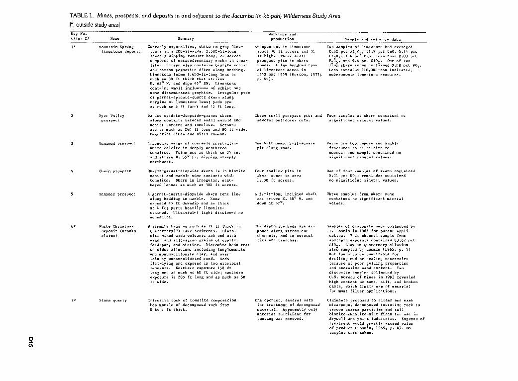
Evidence of mining or prospecting activity was found at 26 sites in, or less than 1 mi outside of, the Jacumba (In-ko-pah) Wilderness Study Area (fig. 2) (McHugh, 1985). [n 1983, 106 claims were held in 13 claim groups. None of the claims or sites was being actively mined or prospected when visited during this study. Descriptions of mines, prospects, and deposits a re listed in table 1.
The Mountain Spring limestone deposit (fig. 2, No.1) in In-Ko-Pah Gorge was first worked before 1927 (Logan, 1947, p. 241), and a few hundred tons were mined in 1940 and 1959 from a pit just outside the study area (Morton, 1977, p. 66). Other li mestone deposits inside the study area have been intermittently prospec ted since 1954; none have recorded production.
The PK mine (fig. 2, No. 26), just west of the study area, a nd the Roark mine (fig. 2, No. 22) and
z o i= oCt z oCt ..J c.. >< w
CJ> :0 ~ CJ> CJ>
I c o U ::J
"'0 e a.
CJ> C C o CJ> (;iw CJ>0l E C
0 - :::)
....JI-
other prospects inside the study area were developed for tungsten during government subsidy programs between 1951 and 1958. Originally prospected for gold (Morton, 1977, p. 96), the PK mine produced 596 short ton units of tungsten trioxide (11,920 lb W03) during 1954 and 1955. The Roark mine may have produced a small amount of tungsten. Coarse muscovite in pegmatite dikes and a scheelite-bearing skarn zone at the Mica Gem mine, 1.6 mi west of the study area, were prospected between 1936 and 1940 (Weber, 1963, ;? 193, 277).
Diatomite at the White Christmas deposit (fig. 2, No.6) was first claimed in 1941; no production is known. Pyroclastic basalt from the Weaver deposit (fig. 2, No. 13) was mined during the 1950's for use as roofing granules and decorative gravel (Morton, 1977, p. 84). Both deposits were developed just outside the study area.
Sand and gravel have been mined intermittently from fanglomerate and stream gravel deposits just outside the north and east boundaries of the study area. Gravel was being quarried from a pit just east of the study area in 1983.
Mineral Deposits
Two principal deposit types were examined by the U.S. Bureau of Mines: (1) limestone (meta morphosed to marble) in screens consisting of metasedimentary rocks surrounded by plutonic rocks and (2) bodies of tungsten-bearing skarn associated with contacts between limestone-bearing screens and
i I
~
t) Q) a. IJ)
e (l.
• x(V)
(i) E
0(ij
U o
.:Jt:. C o el
05

plutonic rocks. Resources were identified on the basis of geologic evidence and sample data.
Limestone resources were identified at three sites in the study area. The Mountain Spring and White Hope limestone deposits are in the northern part of the study area (fig. 2, Nos. 1 and 11), and the Cal-White deposit is in the southeastern part (fig. 2, No. 24). The limestone is present as irregular lenses that dip moderately to steeply. The thickness of the lenses probably varies where concealed, and overburden increases rapidly with depth as a result of the steep dips. Resource projections are limited because of these factors. Geochemical analyses of samples from the deposits (table 1) suggest that the limestone is generally suitable for portland cement and agricultural uses.
Limestone was opencut mined at the Mountain Spring deposit just outside the study area. The main lens contains about 210,000 tons of limestone and extends inside the study area. At the White Hope deposit, two lenses of limestone are aligned parallel to foliation in enclosing gneissic tonalite. One lens contains approximately 175,000 tons of limestone. The second lens is not well exposed, but is estimated to contain 170,000 tons of limestone. At the Cal-White limestone deposit, lenses of limestone are intercalated with metasedimentary rocks and gneissic tonalite. This deposit contains an estimated 1.4 million tons of limestone resources.
Two prospects and an inactive mine in the east half of the study area (fig. 2, Nos. 18, 22, and 23) may have tungsten resources associated with skarn deposi ts. The diopside-tremoli te-garnet skarn is in thinly lamina ted limestone and biotite schist along contacts with tonalite. Irregular quartz-tourmaline pegmatite dikes transect both the host rocks and the skarn. The calcium tungstate mineral scheelite (Ca W 0 4) is disse mina ted in the skarn zones as blebs and in stringers. Although the scheeli te-bearing zones are too sparsely mineralized or too small to constitute resources, additional sampling in unexposed parts of the zones might reveal tungsten resources.
Two scheeli te-bearing skarn zones are exposed at the unnamed prospect 1 mi east of Davies Valley (fig. 2, No. 18). A limestone lens at the Roark mine (Graphite claim, fig. 2, No. 22) is poorly exposed but is at least 25 ft thick; a weakly silica ted zone in the bed contains disseminated scheelite (Morton, 1977, p. 96). Segments of six skarn zones are exposed in workings and outcrops at the North Star prospect (fig. 2, No. 23). One chip sample from a 3.2-ft-thick skarn zone contained 0.02 oz/ton gold and 1.66 percent tungsten trioxide (W03); an 8-ft-thick shear zone in schist is enriched in manganese oxides. Samples from other workings and outcrops suggested only minor mineralization.
The PK mine (Elliott mine), located immediately outside the study area about 1,000 ft north of the international border (fig. 2, No. 26), is in a small roof pendant in tonalite that contains an irregular tungstenbearing skarn body. Resource estimates based upon sampling of mineralized skarn at the 3,990, 4,000, and 4,040 ft levels of the mine and upon an assumed downdip width of the skarn body of 60 ft indicate 30,000 tons of low-grade ore with an average grade of 0.19 percent W03. One 9,000-ton segment of the
06
deposit also contains 0.06 oz/ton gold. At the estimated average 1985 price of $68/t W03 (metric ton unit of W03, which contains 7.93 kg W) or $3.89/lb W (U.S. Bureau of Mines, 1986, p. 168), the value of tungsten ore in the deposit is $11. 71/ton. The average grade of the deposit is low, and the roof pendant that contains the deposit is small. Underlying tonalite is exposed in the lower workings, ruling out downward extension of the mineralized zone. No associated tungsten occurrences are exposed in the study area.
The White Christmas diatomite deposit (Bronko claims) is located about 3 mi southwest of Ocotillo, just outside the study area (fig. 2, No.6). Diatomite beds as much as 12 ft thick are present in Quaternary lake sediments in two erosional remnants. Two diatomite samples collected by the Bureau of Mines contained abundant sand, silt, and broken diatom tests, which limits use of the material for most filter applications. Loomis (1965, p. 4) estimated 3,000 to 5,000 tons of material averaging 79 to 80 percent Si02 in the diatomite deposits, and possibly 30,000 to 50,000 tons of similar material covered by unconsolidated sand near the deposit. No identified diatomite resources are inside the study area.
Appraisal of Mineral Deposits
The Cal-White, Mountain Spring, and White Hope limestone deposits contain indicated limestone resources of about 1.4 million, 210,000, and 175,000 tons, respectively. The White Hope and Cal-White deposits are at the range front along the edge of the study area, making access relatively simple. The 'VIountain Spring deposit is in In-Ko-Pah Gorge along Interstate 8, where access might require construction of an interchange. Large, partially developed deposits of high-quality limestone are present 6 mi north of Ocotillo in the Coyote Mountains, where Bowen and others (1973) describe three deposits, each with more than 20 million tons of limestone resources. These deposits would probably be developed before the smaller deposits in the study area.
Known tungsten occurrences inside the study area are too small or low grade to be considered resources. The character of the known mineralized skarn bodies suggests that other such occurrences, if present, would be small, irregular, and only sporadically mineralized. Low prices have resulted in periodic, temporary closing of domestic tungsten mines in recent years. Tungsten is a strategic and critical commodity, and net reliance on imports in 1985 was about 68 percent. Although U.S. demand for tungsten is expected to increase at an average annual rate of 16 percent through 1990 (U.S. Bureau of Mines, 1986), development of such small deposits as might be expected to occur in the study area is not probable in the foreseeable future.
Diatomite deposits do not extend into the study area, and no large-scale development of the White Christmas deposit is expected. Very large deposits of relatively pure diatomite in other parts of California and in Nevada dominate domestic markets and provide exports to foreign markets.
Sand and gravel in alluvial fan deposits are mainly outside the study area along the east side of
the range. In the northern part of the area, fan deposits mantle bedrock both inside and outside the study area. Development of sand and gravel deposits inside the study area is unlikely because similar deposits are available closer to major population centers.
ASSESSMENT OF MINERAL RF1l0URCE POTENTIAL
~ Victoria R. Todd, James E. Kilburn, David E. Detra, Andrew Griscom and Fred A. Kruse U.S. Geological Survey
Geology
The southern part of the Jacumba Mountains is underlain by relatively undeformed plutons that are considered to belong to a late-tectonic to posttectonic intrusive sequence in the Peninsular Ranges batholith (Todd and Shaw, 1979). Similar plutons to the west in San Diego County have uranium-lead zircon ages that range from 95 to 100 Ma (Silver and others, 1979; Clinkenbeard and others, 1986). Thus, the plutons in the southern Jacumba Mountains are tentatively considered to be middle Cretaceous in age. Two plutons of this intrusive sequence crop out in the Jacumba (In-ko-pah) Wilderness Study Area. Strongly foliated late-tectonic tonalite forms most of the crystalline bedrock east of Davies Valley, whereas weakly foliated to massive posttectonic tonalite underlies much of the block west of Davies Valley (fig. 2). Both plutons range in composition from hornblende4liotite tonalite to biotite granodiorite; the western pluton also includes leucocratic muscovitebiotite granodiorite. Pegmatite dikes are abundant in both western and eastern tonalite plutons.
Screens and inclusions of wallrocks in the study area consist of high-grade metasedimentary rocks of unknown age including metaquartzite, semipelitic schist, and marble, the last containing the limestone deposits mentioned in an earlier section of this report. These rocks may include two units-deepwa ter arkosic and graywacke sandstones and shale (turbidites) with scarce interbedded carbonate rocks that crop out in San Diego County to the west (the Julian Schist) and a continental shelf sequence of quartz-rich sandstone, shale, and abundant carbonate that is present in the eastern part of the batholith. The Julian Schist is presumed to be Triassic and (or) Jurassic in age (Donnelly, 1934), while the eastern prebatholithic rocks are at least in part Paleozoic (Miller and Dockum, 1983). Therefore, the prebatholithic rocks in the study area are tentatively considered to be Paleozoic and Mesozoic(?) in age.
The wallrock screens contain concordant fine- to medium-grained granitic dikes that emanate from the surrounding plutons. Pegmatite dikes commonly were emplaced into contact zones between screens and tonalite plutons. Skarns developed locally where limestone was intruded by tonalite and (or) by granitic dikes. Retrograde alteration and oxidation of highgrade skarn minerals such as garnet and diopside led to local concentrations of epidote, clinozoisite, tremolite-actinolite, chlorite, hematite, limonite, and
calcite. Skarn minerals form irregular scattered lenses as much as 300 ft across that commonly are associated with isoclinally folded metasedimentary rocks. Scheeli te occurs locally in skarn as disseminated blebs, stringers, and pods locally as much as 2 ft long but typically less than a few inches long.
The eroded crystalline basement of the southern Jacumba Mountains is overlain on the north and east by Miocene through Pleistocene sedimentary and volcanic deposits; remnants of Miocene deposits overlie the crystalline rocks on both sides of Davies Valley (fig. 2). These deposits are remnants of a thick (locally 20,000 ft) sequence of terrestrial and marine sediments and intercalated volcanic rocks deposited in, and marginal to, the Salton Trough. The Salton Trough is a complex rift valley that has been tectonically active since Miocene time (Gibson and others, 1984).
The Miocene Split Mountain Formation of Woodard (1974) crops out mainly east of Davies Valley (fig. 2). Patches of this formation are also preserved beneath the Jacumba Volcanics of Minch and Abbott (1973) in fault blocks west of Davies Valley. The Split Mountain Formation formed as a thickening wedge of coalescing alluvial fans during the early phase of uplift of the Peninsular ranges (Gibson and others, 1984). The formation underlies andesitic pyroclastic rocks in the northeast part of the study area. These volcanic rocks locally form a very thin, extensively faulted veneer over the Split Mountain Formation and possibly also over Quaternary sediments. The volcanic rocks may have been partly or wholly displaced by posteruptive gravitational gliding or large-scale landsliding during uplift of the Peninsular Ranges.
The Salton Trough was flooded by marine waters in early Pliocene time (Bell-Countryman, 1984). As the basin continued to subside, a shoaling series of alluvial fan, shoreline, and deep-water marine deposits was rapidly deposited conformably on the Split Mountain Formation and volcanic rocks. Gradationally overlying these predominantly marine deposits is a sequence of Pliocene and Pleistocene brackish-water to lacustrine sediments with marine interbeds, the Palm Spring Formation. The Imperial and Palm Spring Formations crop out east of the study area in the down-faulted Yuha Desert block, and in the badlands that lie north of the study area between the Coyote Mountains and the northern Jacumba Mountains. An undated sequence of alluvial fan sands and gravels overlies the Jacumba Volcanics in the northern part of the study area; these sediments may correlate with the Pliocene and younger Imperial and Palm Spring Formations, or may consist of Miocene strata.
The southern Jacumba Mountains probably began to rise as an uplifted fault block sometime during Pliocene time and then continued to be elevated during Quaternary time by north- and north-northwesttrending high-angle faults in Davies Valley and along the east flank of the range. A mosaic of north- and east-trending dip-slip faults in the northeastern part of the study area has produced a triangular graben composed chiefly of Miocene rocks; this graben is bounded on the west by a fault, or faults, under the alluvium of Davies Valley (fig. 2). The Laguna Salada fault, which lies about 1 mi east of the southern Jacumba Mountains, cuts Quaternary alluvium suggesting that the range4lounding faults may still be
07

active. All of the above faults are part of the active Elsinore fault zone, which has undergone chiefly dipslip motion south of 330 N. lat (Todd and Hoggatt, 1979).
The most recent geologic feature adjacent to the southern Jacumba Mountains is the high shoreline of ancient Lake Cahuilla, which lies less than 1 mi east of the range. The lake originated by periodic flooding and overflow of the ancestral Colorado River into the Salton Trough (Morton, 1977). Although it probably existed as recently as several hundred years ago, the lake has probably formed and dried up repeatedly since at least late Pleistocene time. Fine-grained lake sediments in the northern part of the study area (the White Christmas diatomite deposit) (fig. 2, No.6) and patchy lacustrine sediments east of the study area suggest that the earliest lakes may have extended westward into the valleys of the southern Jacumba Mountains (Morton, 1977).
Geochemical Studies
A reconnaissance geochemical survey of stream sediments was conducted in the study area in 1984 by the U.S. Geological Survey. Heavy-mineral concentrates were derived from fifty-two samples collected from streams that drain areas ranging from a fraction to several square miles within the study area. Each sample was sieved through a minus-80-mesh screen to remove the coarsest material and divided into light and heavy fractions using a bromoform mineral separation technique. The heavy fraction was further separated using a magnetic separator. All samples were analyzed for 30 elements by a six-step semiquantitative emission spectrographic method (Grimes and Marranzino, 1968). A complete listing of the analytical results can be found in Detra and Kilburn (1985). In addition, concentrates were examined optically for mineral identification.
Spectrographic analysis of the concentrates revealed widespread anomalous concentrations of tungsten and tin as well as numerous anomalous concentrations of barium, lead, and molybdenum. In addition, isola ted local anomalous concentrations of gold, silver, bismuth, zinc, and strontium were noted. Mineralogically, the concentrates are characterized by abundant barite and scheelite coupled with an apparent absence of ore-forming sulfide and oxide minerals. Optical studies also identified gold at one sample site. Contaminating lead shot observed in the samples coincides with five of the nine anomalous lead concen tra tions.
The ubiquitous scheelite and accompanying tungsten anomalies are undoubtedly mineralogical and chemical manifestations of the numerous skarn deposits that are present in the study area. Anomalous concentrations of one or more of the elements molybdenum, tin, gold, silver, bismuth, and zinc, often constituents of tungsten-bearing skarns, are associated with the tungsten anomalies throughout the eastern part of the study area and in the western part near the PK (Elliott) mine. A skarn-related multiple-element anomaly is found in a minor drainage below the PK mine (Elliott mine) in the southwest corner of the study area. The anomalous trace-element suite here
08
included tungsten, tin, molybdenum, bismuth, gold, and silver. The sample contained a substantial amount of scheelite (50 percent) and several gold flakes. The PK mine, initially a gold prospect but later mined for tungsten, is situated within an irregular skarn body near the contact between a metasedimentary roof pendant and enclosing tonalite (Morton, 1977).
The tin anomalies appear to be a regional geochemical signature of the late-tectonic to posttectonic intrusive sequence. Although no mineralogic or lithologic host was determined, it is possible that much of the tin may be derived from an accessory mineral or minerals disseminated throughout these granitic rocks. Additionally, skarns may have contributed in some measure to the tin anomalies.
The source of the barium and barite anomalies is uncertain. Although barite was identified as a minor component in most of the concentrates, the majority of barium anomalies are restricted to the region east of Davies Valley. This may represent structural control by the numerous faults that bound the valley and the eastern range front and (or) lithological control by the Miocene sedimentary rocks that occur mainly east of Davies Valley. Anomalous concentrations of strontium and barium are present jointly near the northeast boundary of the study area; the strontium may be a constituent of barite, having replaced barium in a solid solution series.
Most, and perhaps all, of the anomalous lead concentrations can be attributed to contamination ra ther than natural sources. Evidence includes lead shot fragments found in over half the anomalous samples and the failure to identify a lead-related mineral in any of the concentrates.
Geophysical Studies
Three aeromagnetic and gamma-ray spectrometer profiles (High Life Helicopters, Inc., and QEB, Inc., 1980) cross the study area. The data were collected along east-west and north-south traverses by helicopter at a height of 400 ft above ground. The magnetic data are nearly featureless because none of the rocks within the study area are particularly magnetic, except for some weakly magnetic volcanic rocks. The radioactivity data for these profiles show no anomalous amounts of uranium or thorium within, the study area.
Gravity data available for the study area (Oliver and others, 1980; Roberts and others, 1981) consist only of about 15 stations and do not contribute significantly to the mineral resource appraisal of the area.
The limonite mineral group has unique spectral reflectance characteristics that can be detected on Landsat images using a color-ratio compositing technique described by Rowan and others (1974). This technique was used to map areas of limonite in the Jacumba (In-ko-pah) Wilderness Study Area. Limonite occurrences in exposed bedrock are considered anomalous and may indicate the presence of hydrothermal alteration. The largest limonite occurrence is in the south~ast corner of the study area and covers roughly 1 mi. This and several other limonite anomalies in the area seem to be associated
with faulted parts of the tonalite of Granite Mountain (fig. 2). These areas are favorable for the occurrence of hydrothermally altered rocks. Scattered limonite occurrences within the study area coincide closely with the eastern of two zones of low tungsten resource potential (fig. 2) and, to a lesser extent, with the western zone. However, these occurrences are small and their areal extent does not indicate a large hydrothermal system if indeed they are associated with hydrothermally altered rocks. Other limonite occurrences are associated with volcanic rocks that also may be hydrothermally altered.
Conclusions
Geologic studies, geochemical sampling, examination of prospects and mines, and a review of the history of mine production in and near the Jacumba (In-ko-pah) Wilderness Study Area indicate that the study area contains two main types of mineral occurrences, both associated with pre-Cenozoic crystalline rocks. Metasedimen tary stra ta of Paleozoic(?) age that are present as screens within tonalite plutons locally contain abundant limestone. Limestone resources were identified at three sites within the study area. The study area has a high potential, certainty level D, in four areas for additional low- to moderate-tonnage limestone resources in and near these deposits (fig. 2). See appendix for definition of levels of mineral resource potential and certainty of assessment.
The second type of mineral occurrence in the study area consists of relatively abundant skarn deposits. Rock samples from four localities in the study area contain significant amounts of tungsten and minor amounts of gold. Samples from the PK mine (Elliott mine) outside the study area contain tungsten, gold, and silver. Widespread occurrences of the tungsten mineral scheelite in stream-sediment concentrates in the study area probably originated in skarn deposits. Local anomalous concentrations of molybdenum, tin, gold, silver, bismuth, and zinc also probably are derived from tungsten-bearing skarns. No deposits of ore minerals containing these elements were found in the study area.
The parts of the study area that are underlain by known skarn deposits and (or) metasedimentary screens have low resource potential, certainty level C, for tungsten in skarns of metasomatic origin (fig. 2). Known tungsten occurrences inside the study area are too small or low-grade to be considered resources, but the widespread development of skarns in the study area indicates that other skarn bodies may be present at depth. Geologic evidence suggests that such occurrences will be small, irregular, and only sporadically mineralized. No potential for other mineral resources or for geothermal energy, uranium, or oil and gas resources was determined in the study area.
REFERENCES CITED
Beikman, H.M., Hinkle, M.E., Frieders, Twila, Marcus, S. M., and. Ed. ward, J. R., 1983, Mineral surveys by the Geological Survey and the Bureau of Mines of
Bureau of land Management Wilderness Study Areas: U. S. Geological Survey Circular 901, 28 p.
Bell-Countryman, Pat, 1984, Environments of deposition of the Pliocene Imperial Formation, Coyote Mountains, southwest Salton trough, in Rigsby, C. A., ed., The Imperial Basin--tec tonics, sedimenta tion, and thermal asp ec ts: Pac ific Section, Society of &onomic Paleontologists and Mineralogists, v. 40, p. 45-70.
Bowen, O.E., Gray, C.H., Jr., and Evans, J.R., 1973, The mineral economics of the carbonate rocks, in Bowen, O. E., ed., Limes tone and dolomite resources of California: California Division of Mines and Geology Bulletin 194, p. 13-60.
Brooks, Baylor, and Roberts, Ellis, 1954, Geology of the Jacumba area, San Diego and Imperial Counties, in Jahns, R. H., ed., Geology of southern California: California Division of Mines and Geology Bulletin 170, map sheet 23, scale 1:62,500.
Clinkenbeard, J. P., Walawender, M.J., Parrish, K.E., Wardlaw, M.S., and Smith, B., 1986, The geochemical and isotopic composition of the La Posta granodiorite, San Diego County, California [abs.]: Geological Society of America Abstracts with Programs, v. 18, no. 2, p. 95.
Detra, D.E., and Kilburn, J.E., 1985, Analytical results and sample locality maps of heavy-mineral concentra te samples from the Jacumba (In-kopah.) (CDCA-368) Wilderness Study Area, Imperial County, California: U.s. Geological Survey Open-File Report 85-272.
Donnelly, Maurice, 1934, Geology and mineral deposits of the Julian district, San Diego County, California: California Journal of Mines and Geology, v. 30, no. 4, p. 331-370.
Gibson, 1.. M., Malinc onic 0, 1..1.., Downs, T., and Johnson, N.M., 1984, Structural implications of gravity data from the Vallecito-Fish Creek Basin, western Imperial County, California, in Rigsby, C.A., ed., The Imperial Basin-tectonics, sedimentation, and thermal aspects: Pacific Section, Society of Economic Paleontologists and Mineralogists, v. 40, p. 15-29.
Goudarzi, G.H., 1984, Guide to preparation of mineral survey reports on public lands: U.S. Geological Survey Open-File Report 84-787, 51 p.
Grimes, D.J., and Marranzino, A.P., 1968, Directcurrent arc and alternating-current spark emISSIon spectrographic field methods for the semiquantitative analysis of geologic materials: U.S. Geological Survey Circular 591, 6 p.
High Life Helicopters, Inc., and QEB, Inc., 1980, Airborne gamma-ray spectrometer and magnetometer surv~, San Diego quadrangle~.~ California [ 10 by 2 ] sheet; National Uranium' Resource Evaluation program, GJBX-214 (80) ; Grand Junction, Colo., U.S. Department of Energy, variously paged.
Logan, C.A., 1947, Limestone in California: California Journal of Mines and Geology, v. 43, p. 175-357.
Loomis, T.H. W., 1965, Mineral patent application of Andrada Desert Enterprises, Inc., for the White Christmas, White Christmas No. 2., and Le Plateau placer mining claims: U.S. Bureau of
D9

Land Management Mineral Report Sere No. R 02425, 5 p.
McHugh, E.L., 1985, Mineral resources of the Jacumba Wilderness Study Area, Imperial County, California: U.S. Bureau of Mines Open-File Report MLA 55-85, 27 p.
Miller, R.H., and Dockum, M.S., 1983, Ordovician conodonts from metamorphosed carbonates of the Salton Trough, California: Geology, v. 11, p. 410-412.
Minch, J.A., and Abbott, P.L., 1973, Post batholithic geology of the Jacumba area, southeastern San Diego County, California: San Diego Society of Natural History, Transactions, V. 17, no. 11, p. 129-135.
Morton, P.K., 1977, Geology and mineral resources of Imperial County, California: California Division of Mines and Geology County Report 7, 104 p.
Oliver, H.W., Chapman, R.H., Biehler, S., Robbins, S.L., Hanna, W.F., Griscom, A., Beyer, L.A., and Silver, E.A., 1980, Gravity map of California and its continental margin: California Division of Mines and Geology, scale 1:750,000, 2 sheets.
Roberts, C. W., Jachens, R.C., and Oliver, H. W., 1981, Preliminary isostatic residual gravity map of California: U.S. Geological Survey Open-File Report 81-573, scale 1:750,000, 5 sheets.
Rowan, L.C., Wetlaufer, P.H., Goetz, A.F.H., Billingsley, F.C., and Stewart, J.H., 1974, Discrimination of rock types and detection of hydrothermally altered areas in south-central Nevada by the use of computer-enhanced ERTS images: U.S. Geological Survey Professional Paper 883, 35 p.
Sampson, R.J., and Tucker, W.B., 1942, Mineral
010
resources of Imperial County; California Journal of Mines and Geology, v. 38, p. 105-145.
Silver, L.T., Taylor, H.P., Jr., and Chappell, B., 1979, Some petrological, geochemical and geochronological observations of the Peninsular Ranges batholith near the international border of the U.S.A. and Mexico, in Abbott, P.L., and Todd, V.R., eds., Mesozoic Crystalline Rocks: Geological Society of America Annual Meeting, San Diego, Calif., 1979, Guidebook, p. 83-110.
Todd, V.R., and Hoggatt, W.C., 1979, Vertical tectonics in the Elsinore fault zone south of 33 0 7'30" [abs.]: Geological Society of America Abstracts with Programs, v. 11, p. 528.
Todd, V.R., and Shaw, S.E., 1979, Structural, metamorphic, and intrusive framework of the Peninsular Ranges batholith in southern San Diego County, California, in Abbott, P.L., and Todd, V.R., eds., Mesozoic Crystalline Rocks: Geological Society of America Annual Meeting, San Diego, Calif., 1979, Guidebook, p. 177-231.
U.S. Bureau of Mines, 1986, Mineral Commodity Summaries 1986: U.S. Bureau of Mines, 185 p.
U.S. Bureau of Mines and U.S. Geological Survey, 1980, Principles of a resource/reserve classification for minerals: U.S. Geological Survey Circular 831, 5 p.
Weber, F.H., Jr., 1963, Geology and mineral resources of San Diego County: California Division of Mines and Geology County Report 3, 309 p.
Woodard, G.D., 1974, Redefinition of Cenozoic stratigraphic column in Split Mountain Gorge, Imperial Valley, California: American Association of Petroleum Geologists Bulletin, v. 58, no. 3, p. 521-526.
APPENDIXES

Definition of levels of mineral resource potential and certainty of assessment
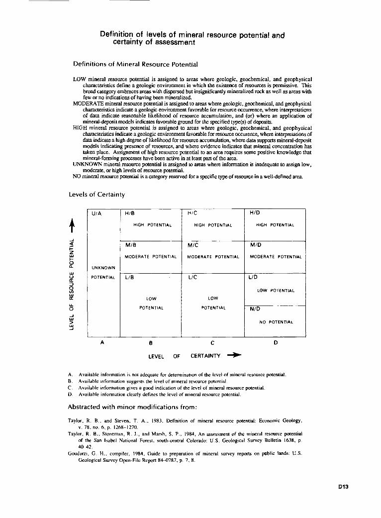
Definitions of Mineral Resource Potential
LOW mineral resource potential is assigned to areas where geologic, geochemical, and geophysical characteristics define a geologic environment in which the existence of resources is pennissive. This broad category embraces areas with dispersed but insignificantly mineralized rock as well as areas with few or no indications of having been mineralized.
MODERATE mineral resource potential is assigned to areas where geologic, geochemical, and geophysical characteristics indicate a geologic environment favorable for resource occurrence, where interpretations of data indicate reasonable likelihood of resource accumulation, and (or) where an application of mineral-deposit models indicates favorable ground for the specified type(s) of deposits.
HIGH mineral resource potential is assigned to areas where geologic, geochemical, and geophysical characteristics indicate a geologic environment favorable for resource occurence. where interpretations of data indicate a high degree of likelihood for resource accumulation, where data supports mineral-deposit models indicating presence of resources, and where evidence indicates that mineral concentration has taken place. Assignment of high resource potential to an area requires some positive knowledge that mineral-forming processes have been active in at least part of the area.
UNKNOWN mineral resource potential is assigned to areas where information is inadequate to assign low, moderate, or high levels of resource potential.
NO mineral resource potential is a category reserved for a specific type of resource in a well-defined area.
levels of Certainty
t --J 4: t= z w Io (l.
w u a:: ::> o tf) w a:: u.. o ...J W :> w ...J
U/A
UNKNOWN
POTENTIAL
A
H/B
HIGH POTENTIAL
M/B
MODERATE POTENTIAL
LIB
LOW
POTENTIAL
B
LEVEL OF
H/C
HIGH POTENHAL
M/C
MODERATE POTENTIAL
LlC
LOW
POTENTIAL
C
CERTAINTY ~
HID
HIGH POTENTIAL
MID
MODERATE POTENTIAL
LID
LOW POTENTIAL
N/D
NO POTENTIAL
D
A. Available information is not adequate for determination of the level of mineral resource potential. B. Available information suggests the level of mineral resource potential. C. Available information gives a good indication of the level of mineral resource potential. D. Available information clearly defines the level of mineral resource potential.
Abstracted with minor modifications from =
Taylor, R. B., and Steven, T. A., 1983, Definition of mineral resource potential: Economic Geology, v. 78, no. 6, p. 1268-1270.
Taylor, R. B., Stoneman, R. J., and Marsh, S. P., 1984, An assessment of the mineral resource potential of the San Isabel National Forest, south-central Colorado: U.S. Geological Survey Bulletin 1638. p. 40--42.
Goudani, G. H., compiler. 1984, Guide to preparation of mineral survey reports on poblic lands: U.S. Geological Survey Open-File Report 84--0787, p. 7,8.
I
D13
014
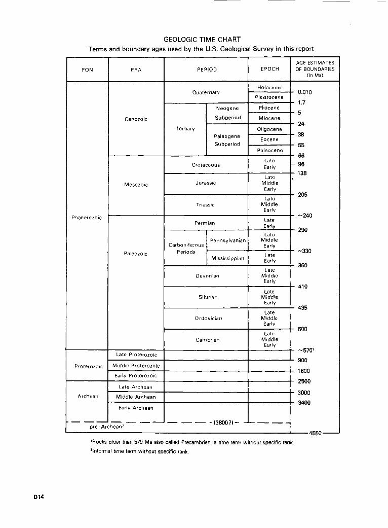
GEOLOGIC TIME CHART
Terms and boundary ages used by the U.S. Geological Survey in this report
AGE ESTIMATES EON ERA PERIOD EPOCH OF BOUNDARIES
(in Ma)
Holocene Quaternary 0.010
Pleistocene 1.7
Neogene Pliocene 5
Cenozoic Subperiod Miocene 24
Tertiary Oligocene Paleogene 38
Eocene Subperiod 55
Paleocene 66
Late - 96 Cretaceous Early
Late ~
Mesozoic Jurassic Middle Early
Late Triassic Middle
Early
Phanerozoic Permian
Late Early
Late Pennsylvanian Middle
Carboniferous Early
Paleozoic Periods Late
Mississippian Early
Late Devonian Middle
Early
Late Silurian Middle
Early
Late Ordovician Middle
Early
Late Cambrian Middle
Early
Late Proterozoic
Proterozoic Middle Proterozoic
Early Proterozoic
Late Archean
Archean Middle Archean
Early Archean
~- --- -- - -- - - - - (38001)- ---- ---pre - Archean2
'Rocks older than 570 Ma also called Precambrian, a time term without specific rank.
21nformal time term without specific rank.
138
205
.v 240
290
"'330
360
410
435
500
""'570'
900
1600
2500
3000
3400
4 55 0-
c .... en
TABLE 1. Mines, prospects, and deposits In and adjacent to the Jacumba (In-kb-pah) Wilderness Study Area
[*, outside study areal Map No. (fig. 2)
1*
4
Ii*
7*
Name
Mountain Spring limestone deposit
Myer Valley prospect
Unnamed prospec t
Chain prospect
Unnamed prospec t
White Christmas deposit (Bronko cIa ims)
Stone quarry
Summary
Coarsely crystalline, white to gray limestone in a 200-ft-wide, 2,500-ft-Iong steeply dipping tabular body, or screen composed of metasedimentary rocks in tonalite. Screen also contains biotite schist and narrow pegmatite dikes along bedding. Limestone forms l,600-ft-long lens as much as 30 ft thick that strikes N. 65 0 W. and dips 45 0 SW. Limestone contains small inclusions of schist and some disseminated graphi teo Irregu lar pods of garnet-epidote-quartz skarn along margins of limestone lens; pods are as much as 5 ft thick and 15 ft long.
Banded epidote-diopside-garnet skarn along contacts between small marble and sch ist screens and tona li te. Screens are as much as 240 ft long and 80 ft wide. Pegmatite dikes and sills common.
Irregular veins of coarsely crystalline white calcite in deeply weathered tonalite. Veins are as thick as 25 in. and strike N. 55 0 E., dipping steeply northwest.
Quartz-garnet-diopside skarn is in bioti te schist and marble near contacts with tonalite. Skarn in irregular, scattered lenses as much as 300 ft across.
A garnet-quartz-diopside skarn zone lies along bedding in marble. Zone exposed 40 ft downdip and as thick as 4 ft; parts heavily limonite-stained. Ultraviolet light disclosed no scheelite.
Diatomite beds as much as 12 ft thick in Quaternary( 7) lake sediments. Diato-mite mixed with volcanic ash and with sand- and si It-sized grains of quartz, feldspar, and biotite. Diatomite beds rest on older alluvium, including fanglomerate and montmori lloni te clay, and over-lain by unconsolidated sand. Beds flat-lying and exposed in two erosional remnants. Northern exposure 150 ft long and as much as 60 ft wide; southern exposure is 200 ft long and as much as 50 ft wide.
Intrusive rock of tonalite composition has mant Ie of decomposed rock from o to 5 ft thick.
Workings and production
An open cut in limestone about 70 ft across and 35 ft high. Three small prospect pits in skarn zones. A few hundred tons of 1 imes tone mined in 1940 and 1959 (Morton, 1977; p. lili).
Samp Ie and resource da ta
Two samp les of limes tone bed averaged 0.1i0 pct A1203 , 51.8 pct CaO, 0.14 pct Fe203' 1.6 pct Mgo, less than 0.03 pct P20 5 , and 9.1i pct Si02 • One of two from skarn zones contained 0.08 pct WOr Lens contains 210,OOO-ton indicated, subeconomic limes tone resource.
Three small prospect pits and Four samples of skarn contained no several bulldozer cuts. significant mineral values.
One 4-ft-deep, 5-ft-square Veins are too impure and highly pit along road. fractured to be calcite re
source; one sample contained no significant mineral values.
Four shallow pits in skarn zones in area 1,000 ft across.
A 37-ft-long inclined shaft was driven S. 56 0 W. and down at 37 0
•
The diatomite beds are exposed along stream-cut channels, and in several pi ts and trenches.
One opencut, several vats for treatment of decomposed material. Apparently only material sufficient for tes t ing was removed.
One of four samples of skarn contained 0.01 pct W03 ; remainder contained no significant mineral values.
Three samp les from skarn zone contained no significant mineral values.
Samples of diatomite were collected by T. Loomis in 1965 for patent application: 7 ft channel sample from sou t hern exposure con ta ined 83.62 pc t Si02 • Clay in Quaternary alluvium a Iso samp led by Loomis (1965, p. 5) but found to be unsui tab Ie for dri lling mud or sea ling reservoirs because of poor gelling properties and excessive sand content. Two diatomite samples collected by U.S. Bureau of Mines in 1983 revealed high content of sand, si It, and broken tests, which limits use of material for most filter applications.
C laiman ts proposed to sc reen and wash micaceous, decomposed intrusive rock to remove coarse particles and sell biot ite-ch lori te-si It fines for use in drywall and paint industries. Expense of treatment would great ly exceed value of product (Loomis, 1965, p. 4). No samples were taken.

c .... en TABLE 1. Mines, prospects, and deposits in and adjacent to the Jacumba (In-ko-pah) Wilderness Study Area- Continued
Map No. (fig. 2)
10
11
12
13*
14
15
Name
Unnamed
Unnamed prospec t
Easy Pickins prospec t
White Hope limestone deposit
Red Schist prospect
Weaver deposit
Hematite prospect
Unnamed prospec t
Summary
Frac ture zone in vo lcanic mudf low debris strikes N. 150 E. and dips 60 0 NW.
Fragments of chalcedony and common opal in andesite tuff breccia.
Area of unconsolidated Quaternary alluvium, mainly sandy gravel, listed as gold prospect by Morton 0977, p. 51).
Two para lle 1 beds of coarse-gra ined whi te gray limestone strike N. 100- 35 0 W. and dip 35 0-55 0 SW. along foliation in gneissic tonalite. One bed 8 to 21 ft thick, averaging about 14 ft, and exposed along strike for about 1,500 ft. Second bed 300 to 400 ft to the east, about 20 ft thick, and exposed for 1,000 ft along strike. Limestone contains sparsely disseminated graphite. Granitic sills intrude limestone in places and follow segments of beds.
Intensely sheared and folded biotite schist pervasively hematite-stained. Sch is t bounded on south and wes t by tonalite and overlain by andesitic volcanic rocks and alluvium on north and east. Schist contains bands of marb le and veins of quartz. Pegmat i te dikes to 10 in. thick contain coarse garnet, apatite, and sphene crystals.
Vesicular, deeply weathered, dark-gray basalt expo!;ed at the mouth of a dry wash.
A 2-ft-thick, hematitic quartz vein extends for 22 ft along shear zone in chloritic schist; it strikes N. 580 W. and dips 140 SW. Isolated quartz lenses contain blebs of chalcopyrite. An 8-ftthick bed of montmorillonite-rich clay underlies fanglomerate in area.
Quartz-garnet-actinolite skarn zones follow bedding in interlayered quartzite and biotite schist. Strike about N. 150 W., dip 300-600 NE (Morton, 1977, p. 97).
Workings and production
None (prospect shown on In-ko-pah Gorge 1 :24 ,000 sheet not found. Fracture zone at location was sampled).
One pit and one 3-ft-wide, 10-ft-long, 1.5-ft-deep trench.
One 15-ft-deep shaft, caved
One sma 11 openc ut
None found
A sma 11 product ion of roofing granules during the 1950's (Morton, 1977, p 84). Several bulldozer cuts, and opencut about 130 ft square and 12 ft deep
Two prospect pits: one on quartz vein, one on weathered pegmatite dike.
Two sma 11 prospec t pits
Samp le and resource data
One chip sample contained no significant mineral values.
One chip sample contained no significant mineral values.
No minera Is of economic value were found; no samples were collected.
Four samples collected from western exposure averaged 0.30 pct A12 03 , 54.5 pct CaO, 0.10 pct Fe203' 0.76 pct MgO, less than 0.02 pct P2 05 , and 2.8 pct Si02 • Wes tern bed contains 175,000-ton indicated limestone resource; eastern bed inferred to conta in 170,000-ton inferred limes tone resource.
Seven chip samples of schist, pegmat i te dikes, and quartz veins contained no minerals of economic significance. One stream sediment sample contained 0.00046 oz /yd3 go ld in minus-20-mesh flakes.
Although possible source of decora-tive gravel, degree of weathering and proximity of more suitable material 8 mi north in the Coyote Mountains (Morton, 1977, p. 83) make development of deposit unlikely.
Two chip samples of quartz and one of weathered pegmatite contained no significant mineral values. A sample of clay bed had 13.3 pct Al2 03 , 4.8 pct CaO, 4.3 pct Fe2 03 , 2.4 pct K20, 3.4 pct MgO, 1.1 pct Na40, 0.038 pct P205 , and 60.5 pct S1.02 •
One grab sample of actinolite-rich skarn contained 0.19 pct WOr A chip sample of one skarn zone (2.6 ft thick) contained 0.01 pct WOr

o .-....
TABLE 1. Mines, prospects, and deposits in and adjacent to the Jacumba (In-ko-pah) Wilderness Study Area- Continued
Map No. (fig. 2)
16
17
IS
19
20
21
22
Name
Unnamed prospect
Unnamed prospec t
Unnamed prospec t
Unnamed prospec t
Golden Alter prospect
Unnamed prospec t
Roark mine (Graphite claim)
Summary
An lS-in.-thick marble bed in biotite schist contains weakly developed quartz-diopside-garnet skarn zone. Ultraviolet light disclosed no scheelite.
ft southwest of incline (Morton, 1977, p. 96) has apparent ly been fi !led.
A limonitic pegmatite dike in biotitemuscovite schist strikes N. 20 0 W. and dips 35 0 SW.
Fine- to medium-grained diopside-tremolitegarnet skarn in zones along contacts where tonalite intrudes thinly laminated limestone and biotite schist. Irregular quartz-tourmaline pegmatite dikes transect schist and skarn. Scheelite disseminated in skarn zones and in blebs as much as 0.5 in. across and in stringers as much as 0.25 in. thick and 3 in. long. Schee li te-bearing ska rn zone at southern working exposed for about 65 ft in northerly direction and averages about 4 ft wide. Schee lite found in one apparently isolated, 2-ft-long pod at northern working.
Hematitic biotite schist has narrow dikes of biotite tonalite along foliation.
Two quartz veins strike N. 30 0 to 65 0 W. in gneissic tonalite and biotite schist; dip 65 0 NE to vertical. One vein exposed intermittently for 1,SOO ft and averages 3.4 ft thick; other 50 ft long and 1.4 ft thick. Both stained in p laces by iron and manganese oxides.
Narrow stringers of siliceous hematite along biotite schist-pegmatite contact. Strike is N. SOO E., dip is 45 0 NW.
A limestone lens at main shaft poorly exposed but at least 25 ft thick; it strikes N. 60 0 W. and dips 55 0 SW; a weakly silicated zone in lens contains disseminated scheelite (Morton, 1977, p. 96). A 5- to 10-ft-thick felsic dike forms footwall of bed and schist forms hanging wall. Tonalite crops out nearby, and biotite-tourmaline pegmatite dikes transect both metasedimentary and intrusive rocks. Scheelite sparsely disseminated in quartz-garnet skarn zone in inter layered limestone and biotite schist 600 ft southeast of shaft.
Workings and product ion
A 44-ft-Iong incline (25 0)
(20 ft underground) was driven S. 61 0 W. A lOft-deep vertical shaft SOO
One caved adit about 15 ft long.
Southern working consists of 61-ft-Iong, curved trench as much as S ft deep, at crest of isolated knob. Northern working, about 1,100 ft N. ISO W. from trench is 25-ft-long incline driven S. SOo W.
One 5- ft-diameter, 2- ft-deep pit.
Eight pits and two shafts, 14 and 15 ft deep, on quartz veins. One pit in tonalite. Jeep trails and bulldozer cuts lead to most workings.
One 6-ft-deep, 3-ft-square pit.
A 30-ft-deep vertical shaft has SO ft of horizontal workings at 30-ft level (Morton, 1977, p. 96). Two prospect pits southeast of shaft.
Samp le and resource data
Two ch ip samp les 0 f skarn from inc line and grab sample of limonitic schist from site of vertical shaft contained no significant mineral values.
One sample of pegmatite contained no significant mineral values.
Four chip samples of skarn and quartz-rich pegmatite contained less than 0.01 pct W03 • Schee li te-bearing skarn in samp les from north and south workings, selected by use of ultraviolet light, contained 0.43 and 1.46 pct W03 , respectively. No samples contained detectable gold or silver.
One chip sample from zone contained no significant mineral values.
Five chip samples from quartz veins contained no significnt mineral values. A se lee t samp Ie from manganese-rich pod had 11 pct manganese and 0.051 pct zinc
One chip sample from hematitic contact zone contained 0.026 ppm gold.
A chip sample of quartz-garnet skarn in prospect pit contained 0.07 pct W03 • Chip sample of pegmatite from other pit contained no significant mineral values. A grab sample from near shaft, of gray, medium-grained limestone with some diopside-quartz skarn contained 0.29 pct WOr
c .... Q)
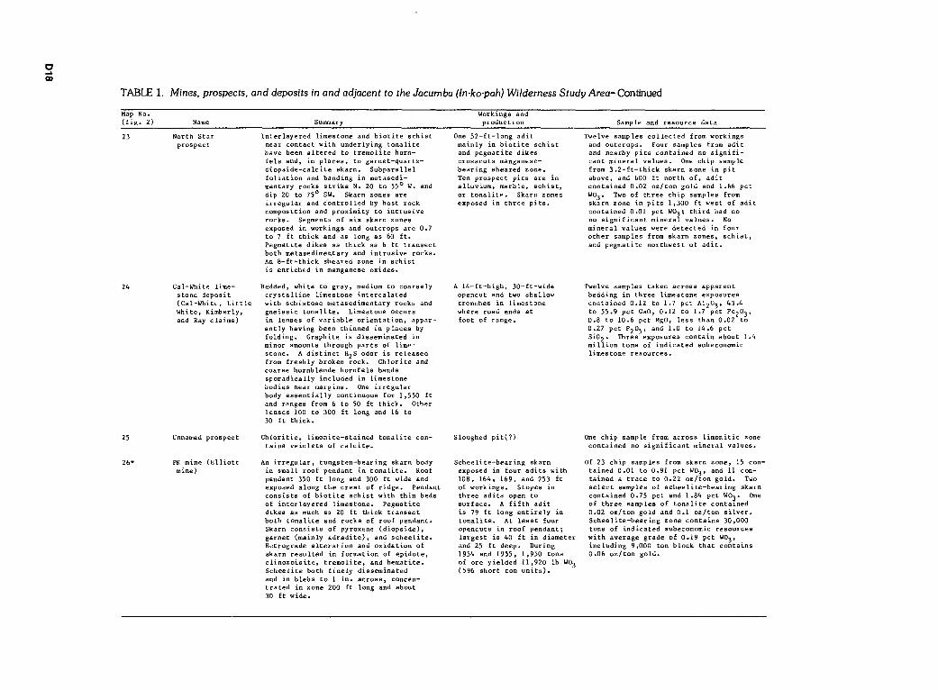
TABLE 1. Mines, prospects, and deposits in and adjacent to the Jacumba (In-ko-pah) Wilderness Study Area- Continued
Map No. (fig. 2)
23
24
25
26*
Name
North Star prospec t
Cal-White limestone deposit (Cal-White, Little White, Kimberly, and Ray cIa ims)
Unnamed prospec t
PK mine (Elliott mine)
Sununary
Interlayered limestone and biotite schist near contact with underlying tonalite have been altered to tremolite horn-fels and, in places, to garnet-quartzdiopside-calcite skarn. Subparallel foliation and banding in metasedimentary rocks strike N. 20 to 55 0 W. and dip 20 to 75 0 SW. Skarn zones are irregu lar and contro lled by host rock composition and proximity to intrusive rocks. Segments of six skarn zones exposed in workings and outcrops are 0.7 to 7 ft thick and as long as 60 ft. Pegmatite dikes as thick as 6 ft transect both metasedimentary and intrusive rocks. An 8-ft-thick sheared zone in schist is enriched in manganese oxides.
Bedded, white to gray, medium to coarsely crystalline limestone intercalated with schistose metasedimentary rocks and gneissic tonalite. Limestone occurs in lenses of variable orientation, apparent ly having been th inned in p laces by folding. Graphite is disseminated in minor amoun ts th rough par ts of limestone. A distinct H2 S odor is released from freshly broken rock. Chlorite and coarse hornb lende hornfe Is bands sporadica lly inc luded in limes tone bodies near margins. One irregular body essentially continuous for 1,550 ft and ranges from 6 to 50 ft thick. Other lenses 100 to 300 ft long and 16 to 30 ft thick.
Chloritic, limonite-stained tonalite contains veinlets of calcite.
An irregular, tungsten-bearing skarn body in small roof pendant in tonalite. Roof pendant 350 ft long and 300 ft wide and exposed along the crest of ridge. Pendant consists of biotite schist with thin beds of interlayered limestone. Pegmatite dikes as much as 20 ft thick transect both tonalite and rocks of roof pendant. Skarn consists of pyroxene (diopside), garnet (mainly adradite), and scheelite. Retrograde alteration and oxidation of skarn resulted in formation of epidote, clinozoisite, tremolite, and hematite. Scheelite both finely disseminated and in blebs to 1 in. across, concen-t ra ted in zone 200 ft long and about 30 ft wide.
Workings and production
One 52-ft-long adit mainly in biotite schist and pegma t i te d ik es crosscuts manganesebearing sheared zone. Ten prospec t pi ts are in alluvium, marble, schist, or tonalite. Skarn zones exposed in three pits.
A 14-ft-high, 30-ft-wide openc ut and two sha 110101 trenches in limestone where road ends at foot of range.
Sloughed pit(?}
Schee 1 i te-bear ing skarn exposed in four adi ts wi th 108, 164, 169, and 253 ft of work ings. Stopes in three adits open to surface. A fifth adit is 79 ft long entire ly in tonalite. At least four opencuts in roof pendant; largest is 40 ft in diameter and 25 ft deep. During 1954 and 1955, 1,950 tons of ore yielded 11,920 lb W03 (596 short ton units).
Samp Ie and resource da ta
Twelve samples collected from workings and outcrops. Four samples from adit and nearby pits contained no significant mineral values. One chip sample from 3.2-ft-thick skarn zone in pit above, and 600 ft north of, adit contained 0.02 oz/ton gold and 1.66 pct W03 • Two of three chip samples from skarn zone in pits 1,300 ft west of adit contained 0.01 pct W03 j third had no no significant mineral values. No mineral values were detected in four other samples from skarn zones, schist, and pegmatite northwest of adit.
Twelve samples taken across apparent bedding in three limestone exposures contained 0.12 to 1.7 pct A1 203 , 43.4 to 55.9 pct CaO, 0.12 to 1.7 pct Fe203 , 0.8 to 10.6 pct MgO, less than 0.02 to 0.27 pct P2 05 , and 1.0 to 14.6 pct Si0 2 • Three exposures contain about 1.4 mi 11 ion tons of ind icated subeconomic limestone resources.
One chip sample from across limonitic zone contained no significant mineral values.
Of 23 chip samples from skarn zone, 15 contained 0.01 to 0.91 pct W03 , and 11 contained a trace to 0.22 oz/ton gold. Two select samples of scheelite-bearing skarn contained 0.75 pct and 1.84 pct WO:r One of three samples of tonalite contal.ned 0.02 oz/ton gold and 0.1 oz/ton silver. Schee lite-bear ing zone contains 30,000 tons of indicated subeconomic resources wi th average grade of 0.19 pct W03 , inc luding 9,000 ton b lock that contains 0.06 oz/ton gold.