e-geos contribution to dwh phase 2 - esa conference …old.esaconferencebureau.com/custom/15m34/ppt...
TRANSCRIPT

YOUR HUBFOR GEOSPATIALAPPLICATIONS
e-GEOS contribution to DWH Phase 2Copernicus Space Component Data Access Workshop, ESA/ESRIN 21 April 2015
Andrea [email protected]

Overview
• The COSMO‐SkyMed Constellation• Contributions to DWH Phase 2 DAPs• Service enhancements for DWH Phase 2
Thank you for your attention !The COSMO-SkyMed Constellation

The COSMO‐SkyMed Constellation in brief
• Owned by the Italian Space Agency (ASI) and IT‐MOD – operated by Telespazio and e‐GEOS
• Constellation of 4 identical SAR satellites– Highest revisit– Best response time– High imaging capacity all over the world– 4 interferometric acquisitions every 16 days

Unmatched Revisit
• At least 4 acquisitions / day (@ equator):
– 1 left looking and 1 right looking early morning (ASCENDING, approx. 6 AM local time)
– 1 left looking and 1 right looking late afternoon (DESCENDING , approx. 6 PM local time)
>12
4
6
>12
6
>12
4
6
>12
6
Acquisitions per day (4 satellites)

COSMO‐SkyMed Current Configuration
Day 1 2 3 4 5 6 7 8 9 10 11 12 13 14 15 16 17
CSK1 CSK1CSK3CSK2 CSK4
• In a 16‐days cycle there are 4 interferometric acquisitions– Same orbit direction, same look side, same incidence angle
CSK1
CSK2
CSK3
CSK4
67.5°
90°

Large Area Coverage
StripMap HIMAGE (3 m resolution) Descending and Ascending Right monitoring every 16 days (MapItaly project)

Imaging Modes
HUGEREGION WIDEREGION HIMAGE PINGPONG
SPOTLIGHTSCANSAR STRIPMAP
MODE-2
10 x 10 km40 km 30 km100 km200 kmSwath
Swath
Flight Direction
30 m100 m 5 m 20 m 1 mResolution (multi-look)
HHVV
HH+VVHH+HVVV+VH
HHHVVHVV
PolarizationHHHVVHVV
HHHVVHVV
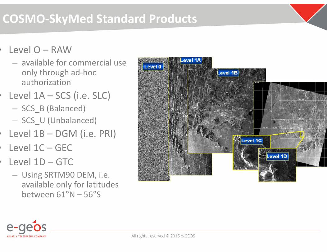
COSMO‐SkyMed Standard Products
• Level O – RAW – available for commercial use
only through ad‐hoc authorization
• Level 1A – SCS (i.e. SLC)– SCS_B (Balanced)– SCS_U (Unbalanced)
• Level 1B – DGM (i.e. PRI)• Level 1C – GEC • Level 1D – GTC
– Using SRTM90 DEM, i.e. available only for latitudes between 61°N – 56°S
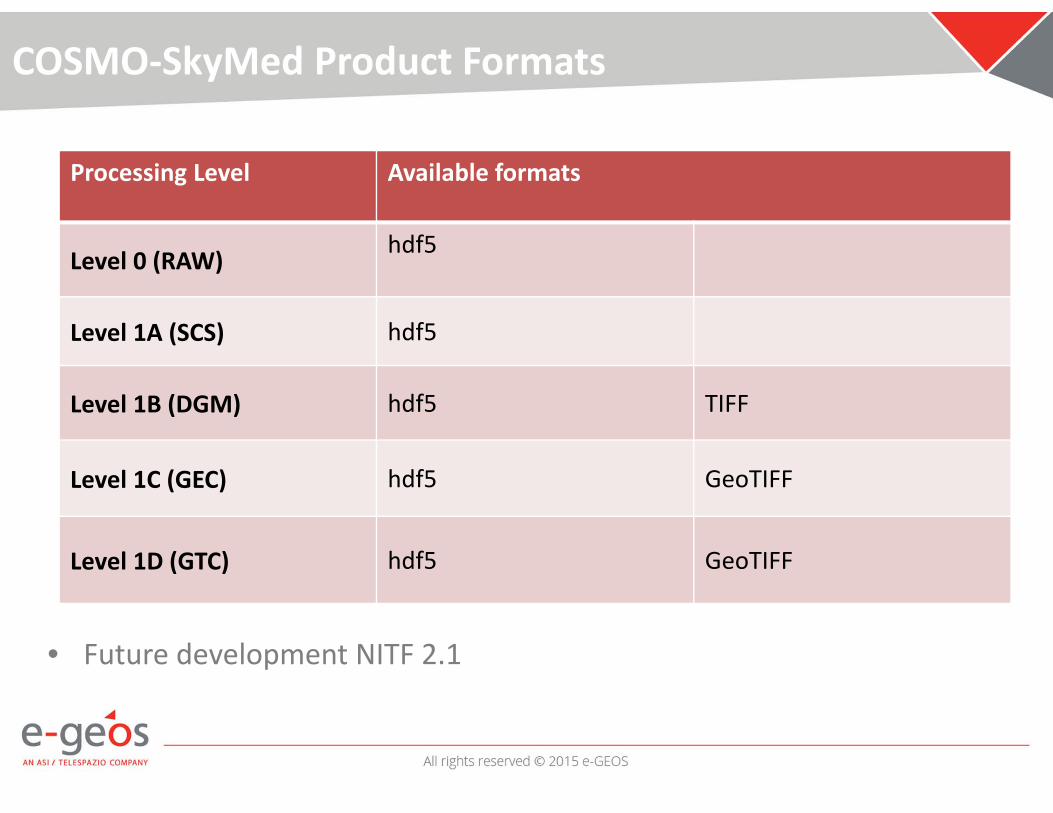
COSMO‐SkyMed Product Formats
• Future development NITF 2.1
Processing Level Available formats
Level 0 (RAW) hdf5
Level 1A (SCS) hdf5
Level 1B (DGM) hdf5 TIFF
Level 1C (GEC) hdf5 GeoTIFF
Level 1D (GTC) hdf5 GeoTIFF
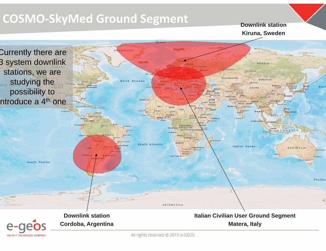
COSMO‐SkyMed Ground Segment
Italian Civilian User Ground SegmentMatera, Italy
Downlink stationCordoba, Argentina
Downlink stationKiruna, Sweden
Currently there are 3 system downlink
stations, we are studying the possibility to
ntroduce a 4th one
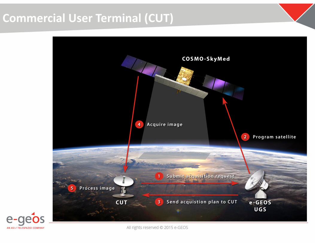
Commercial User Terminal (CUT)
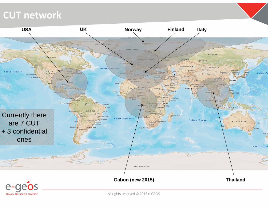
CUT networkUSA UK Italy
ThailandGabon (new 2015)
Norway Finland
Currently there are 7 CUT
+ 3 confidential ones

IC‐UGS (Matera)
• The Matera Space Center is the core center of the Civilian COSMO‐SkyMed system
• Complete archive of all COSMO civilian acquisitions
• Full production facility, 24x7 operations• CUT Technical Support
Total area: 55.000 m2 Buildings: 2.500 m2Antennas: 7Workers: 100
Programming Orders
• Possible orders– Single acquisitions
• e.g. 1 acquisition tomorrow– Interferometric series
• e.g. 1 interferometric acquisition every 8 days– Monitoring activities
• e.g. 1 image every day
• Possibility to define– Acquisition window– Orbit direction, Look side– Incidence angle range
• COSMO‐SkyMed constellation loves to work with multiple DTOs (Data Take Opportunities)– The more flexibility, the more success

12‐hrs Routine Mode ordering timelines
Day 0 Day 1 Day 2
Data collection horizon
6:21 UTC
Start collection window
7:30 UTC
EMERGENCY ORDER
18:21 UTC
Data collection horizon
6:21 UTC 18:21 UTC
EMERGENCY ORDER
17:30 UTC
Start collection window

Thank you for your attention !Contributions to DWH2 DAPs

CORE Datasets
SEA ICE Monitoring HR2/MR1 SAR CORE Dataset• Continuation of the service started in DWH Phase 1• Promising results obtained with the first exercise in terms of:
– quality of data– coverage – performances
• Delivered during DWH Phase 1– More than 97,000,000 km2 – More than 3,000 products
ScanSAR acquired during year 2014-2015 around the North Pole

CORE Datasets
• Improved offer for DWH Phase 2• Several Modes available:
– StripMap HIMAGE– ScanSAR Wide – ScanSAR Huge
• Several AOI covered:– Baltic and Eurarctic area offered in NRT3h– Other areas offered not in NRT3h as default
• Possibility to tune the acquisitions/delivery timeliness according to User needs thanks to the CUT network
• Expected volume:– Around 1,000 product/year for a total of – more than 188,000,000 Km2

CORE Datasets
SAR HR2/MR1 Worldwide Coverage• Taking advantage of the COSMO‐SkyMed Revisit time and its interferometric acquisition capacity
• Supporting to Regional Monitoring• Several Modes available:
– ScanSAR Wide – ScanSAR Huge
• AOI covered:– Potentially any place in the world
• Possibility to integrate and/or supportSentinel‐1 coverage

Generic Additional Datasets
• Continuation of the service started in DWH Phase 1– Supported many GMES Service Projects in different application domains– About 4,000,000 Km2 delivered during DWH Phase 1– More than 1,000 products

Generic Additional Datasets
• COSMO‐SkyMed contributes to several datasets
• Tasking Lead Time– Long Lead Time (LLT)– Normal– Short Lead Time (SLT)– Short Lead Time Plus (SLT+)– Rush
• Delivery Timeliness– NRT3h / ArcRush (New/Arch)– Fast24h (New)– Normal (New/Arch)
Add Dataset Code
Archive_rush_SAR_HR1 ADD_005aArchive_rush_SAR_HR2 ADD_005bArchive_rush_SAR_VHR1 ADD_007aArchive_rush_SAR_VHR2 ADD_007bArchive_rush_SAR_MR1 ADD_023aNew acquisition_rush_SAR_HR1 ADD_006aNew acquisition_rush_SAR_HR2 ADD_006bNew acquisition_rush_SAR_VHR1 ADD_008aNew acquisition_rush_SAR_VHR2 ADD_008bNew acquisition_rush_SAR_MR1 ADD_024aArchive_standard_SAR_HR1 ADD_013aArchive_standard_SAR_HR2 ADD_013bArchive_standard_SAR_VHR1 ADD_015aArchive_standard_SAR_VHR2 ADD_015bNew acquisition_standard_SAR_HR1 ADD_014aNew acquisition_standard_SAR_HR2 ADD_014bNew acquisition_standard_SAR_VHR1 ADD_016aNew acquisition_standard_SAR_VHR2 ADD_016bNew acquisition_standard_SAR_MR1 ADD_017aArchive_standard_SAR_MR1 ADD_019a

Thank you for your attention !Service enhancements for DWH2
COSMO-SkyMed 2nd Generation

Mission Statement
COSMO‐SkyMed Second Generation (CSG) is the follow‐on mission to COSMO‐SkyMed
(CSK) assuring continuity and improvement of the supply of SAR services through data and products, to preserve and enhance the ability of Customers and operational Users to fulfill
their mandates.
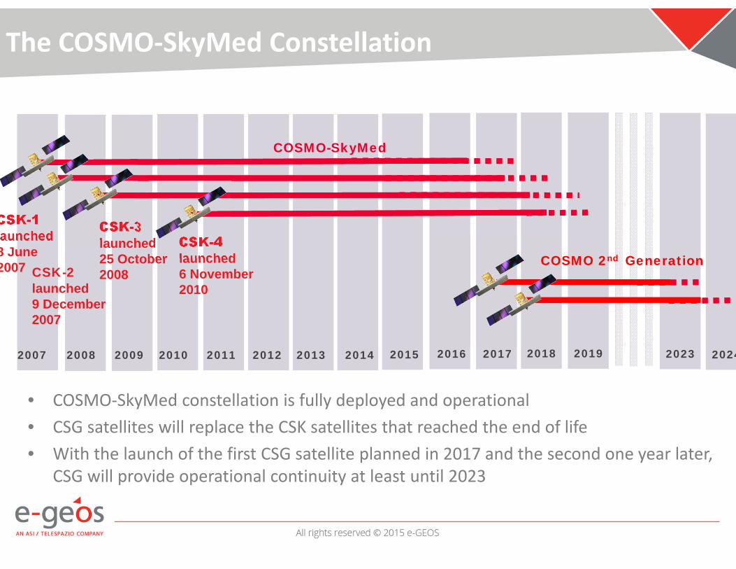
• COSMO‐SkyMed constellation is fully deployed and operational • CSG satellites will replace the CSK satellites that reached the end of life• With the launch of the first CSG satellite planned in 2017 and the second one year later,
CSG will provide operational continuity at least until 2023
2007 2008 2009 2010 2011 2012 2013 2014
CSK-1aunched
8 June 2007
COSMO-SkyMed
CSK-3launched 25 October2008CSK-2
launched9 December 2007
CSK-4launched6 November 2010
2015 2016 2017 2018 2019 2023 2024
COSMO 2nd Generation
The COSMO‐SkyMed Constellation

Primary Objectives
• To provide data and service operational continuity to CSK mission with seamless transition
• To supply Earth Observation services through space‐borne X‐band SAR data and products that will meet the future operational needs of institutional (civilian/defense) users and commercial market
• To support ASI and AD engagements in international cooperation, either civilian or defense (MUSIS), leveraging and improving the existing Interoperability, Expandability and MultiMission/Multisensor capabilities
• To capitalize the heritage of CSK (knowledge, experience, “lessons learned”, assets) and other relevant developments/investments

Main system improvements
CSK CSG
Number of satellites 4 2
Max SAR bandwidth 400 Mhz 800 or 1200 Mhz(depends on ITU)
Routine operations 24 hrsimproved to 12 hrs 12 hrs
Satellite manoeuvres Reaction wheels Control Moment Gyro
Time to rotate from Right to Left looking 6 min 3 min
Downlink capacity 2 channels of 155 Mbps 2 channels of 260 Mbps
On‐board memory 1200 Gb 1530 Gb

Imaging improvements
Resolution CSK (Range x Az.)[m x m](polarization)
Resolution CSG(Range x Az.)[m x m](polarization)
Scene size(Range x Az.)[Km x Km]
Spotlight‐2 sub‐metricOnly for specific customers
Yes (single)
Spotlight‐2 metric 1x1 (single) 1x1 (single/dual) 10x10
StripMap 3x3 (single) 3x3 (single/dual) 40x40
StripMap Quad Pol 3x3 (quad) 15x40
ScanSAR Wide 13,5x23 (single) 4x20 (single/dual) 100x100
ScanSAR Huge 13,5x38 (single) 6x40 (single/dual) 200x200

Imaging capacity (per day, per satellite)
CSK CSG
Wide field37,5 min(@ 3 m, 40 Km, single pol)
450 scenes
46 min(@ 3 m, 40 Km, dual pol)
> 1000 CSK equivalent scenes
Narrow field Spotlight
75 scenes (single pol)
67 scenes (dual/single pol)

Thank you for your attention !