dwh-ar0240752 - united states fish and wildlife service · andy nyman ducks unlimited dale humburg...
TRANSCRIPT

W O R K P L A N FOR ESTIM ATING W IN T E R IN G
W A T E R F O W L OILING A N D MORTALITY
BIRD S T U D Y PLAN # 1 0
P r e p a r e d b y t h e W a t e r f o w l T e c h n ic a l W o r k i n g G r o u p
For t h e Mississippi Canyon 252 Oil Spill
January 29, 2011
U.S. Fish a n d W i ld l i f e S e r v i c e
M a r e l l a B u n c ick , N orth Carolina
T o m E d w a r d s , Arkansas
R o b e r t F o r d , Tennessee
P a m G a r r e t t s o n , M a r y l a n d
S a m a n t h a G ib b s , Virginia
C h u c k H u n t e r , G eorgia
J o h n I s a n h a r t , Utah
T im J o n e s , M a ry la n d
C in d y K a n e , Virginia
J a m e s Kel ley, M in neso ta
M a r k K o n e f f , M a ry la n d
K e n t LIvezey, W ashington
K irs te n Luke , Florida
Bill Pyle, A laska
F r e d R o e t k e r , Louisiana
A n n e S e c o r d , N e w York
E m ily S i l v e r m a n , M a ry la n d
K a r e n S u g h r u e , Georgia
S a r a W a r d , North Carolina
K hris ti A W i lk in s , M a ry la n d
B a r r y W i l s o n , Louisiana
R a n d y W i l s o n , Mississippi
W o o d y W o o d r o w , Texas
J im W o r t h a m , M a ry la n d
LSU A g r i c u l t u r e
School o f R enew able N a tu ra l Resources
F r a n k R o h w e r
A n d y N y m a n
D u c k s U n l i m i t e d
D a le H u m b u r g
M i k e B r a s h e r
A l a b a m a
D ep artm e n t o f Conservation a n d N a tu ra l Resources
R o g e r Cla y
D a v id H a y d e n
C h u c k S h a r p
F lo r id a
Fish and W iid iife Conservation Commission
J o e B e n e d i c t
M is s i s s i p p i
D ep artm e n t o f W iidiife, Fisheries and Parks
H o u s t o n H a v e n s
L o u i s i a n a
D ep artm e n t o f W iid iife a n d Fisheries
T o d d B a k e r
R o b e r t B o u r g e o i s
L a u r a A n n C a r v e r
M a r t y F loyd
P au l Link
L a r ry R e y n o l d s
M i c h a e l S e y m o u r
J im L a c o u r
Louisiana Oil Spill Coordinator's Office
G in a S a lz a n
P au l L a n g
T e x a s
Parks and W iidiife
K evin Kraa l
U.S. G e o lo g i c a l S u r v e y
Biological Resources Division
A! A f to n
C l in t J e s k e
T o m m y M i c h o t
UC D avis , CA
School o f Veterinary M edicine
M i c h a e l H. Z i c c a rd i
G l e n n F o r d (R.G. F o r d C o n s u l t i n g Co.) U.S. F o r e s t S e r v i c e
S t e f a n i M e lv i n
Page 1 of 71
DWH-AR0240752

INTRODUCTION
The Deepwater Horizon (MG 252) oil spill began on April 20, 2010 in the Gulf of Mexico off the Louisiana coastline. Oil spill related injury to wildlife is of major concern to t h e Natural
Resource Trustees, public, and BP. At least 30 sta te wildlife m anagem en t areas, national wildlife refuges and national parks occur in the area potentially th re a tened by the oil. Seabirds,
colonial waterbirds, shorebirds, and waterfowl are particularly susceptible to impacts from the oil at sea and on land.
Study plans are assessing potential impacts to marsh birds (NRDA Bird Study #3), colonial
waterbi rds (NRDA Bird Study #4), pelagic seabirds (NRDA Bird Study #6), the endangered Piping P\o\/er (Charadrius melodius) (NRDA Bird Study#?) and non-breeding and breeding shorebirds (NRDA Bird Study #5 and #8). This plan, the ten th in a series of avian injury ephemeral data collection studies, seeks to specifically address potential impacts to waterfowl. The objectives of this study are to:
1) docum en t dead and live oiled and unoiled waterfowl in representat ive habitats,
2) est imate the temporal and spatial abund ance and distribution of waterfowl within the study area,
3) examine oiled and not visibly oiled birds collected from representa tive habitats.
Every year, millions of waterfowl travel from breeding grounds in Canada and the northern
United States to the marshes, bays, and es tuar ies of the Gulf coastal s tates through the North American migration flyways. These birds winter or stage in Gulf areas before continuing a southward migration or redistributing to o ther southern U. S. habi tats (i.e., Mississippi Flyway,
Figure 1).
Page 2 of 71
DWH-AR0240753

M ajor F iyw ay P rin c ip a l R o u te s M erg ing R o u te s (with o th er routes)
M ississippi Fiyway (with Principal Routes)
Figure 1. Map of Mississippi Flyway.
STUDY AREA
The study area is broadly described as bays, estuaries, salt marshes, and tidal marshes, including SAV beds and mudflats th a t serve as waterfowl habi tats not currently evaluated as
par t of any o ther Natural Resource Damage Assessment (NRDA) studies. In the event of an oil spill, oiled birds may also seek refuge on berms or beach loafing areas, or move into the dense marsh grasses. Coastal Louisiana const i tutes impor tant wintering waterfowl areas, whe re this project is primarily focused (USDOl 1981). Flowever, if ongoing data collection reveals oiling of
waterfowl or o ther waterbi rds is a concern in adjacent areas, the geographic scope of the study
area may be broadened by mutual ag reem en t be tween the Trus tees and BP. Likewise, if data
indicate few oiled waterfowl are present within surveyed areas, the study area may be contracted.
STUDY DESIGN
Data-collection protocols for making boat - based live and dead bird observat ions as well as foot-based live and dead bird observat ions are a t tached (Appendix A).
Objective 1: Document dead and live oiled and unoiled waterfowl in representat ive habitats.
Page 3 of 71
DWH-AR0240754
Two carcass-detection methods , Objectives lA (boat-based marsh edge beached bird survey) and IB (walking beach-based bird survey) will be employed to es t imate numbers of oiled waterfowl. In addition, live and dead oiled waterfowl will be observed during open wa te r bird surveys (Objective 1C). Survey crews will perform Open Water Bird Surveys (Objective 1C) and
Boat-based Beached Bird Surveys (ObjectivelA) relying on t ransect initiation points in close proximity to the extent possible to economize effort. Walking Beached Bird Surveys (Objective
IB) will also be conducted on existing beached bird segment s (from NRDA Bird Study #1) be tw een Atchafalaya Delta, LA and Apalachicola, FL.
The program will be reviewed 30 ca lendar days after implementat ion for all compo nen ts of
Objective 1 (which may, at the ag reem en t of BP and the Trustees, be counted from the initiation of USFWS searches in early January). Given th at implementat ion of some transects was initiated earlier than others, it is the intent of BP and the t rus tees th a t all t ransects will be surveyed for no shor ter than a 30 day t ime period. At th a t t ime, if BP and the Trus tees agree it is warranted, the duration of the s tudy may be extended and the Trus tees and BP may agree to
expand, contract or maintain the scope based on survey results. If BP does not agree to
cont inue the efforts described in the work plan past the first 30 days, the Trus tees reserve the right to continue work under this Work Plan depending on thei r as sessmen t of w he th e r
additional data are needed to de te rm ine oiling rates or carcass deposit ion, and BP will not initiate surveys that duplicate or overlap Trustee waterfowl survey efforts.
lA. Boat-based Beached Bird Survey
A pilot s tudy (Bird Study #11) was conducted to evaluate using ai rboat and skiff surveys along t h e edge of waterfowl marsh habi tats to search for carcasses in these habitats. Information
gathered as part of Bird Study #11 informed Trustee opinions as to Objective lA implementat ion.
Sam pling Area:
Habitats to be sampled include vege ta ted (robust em ergen t vegetat ion) edges of bays, estuaries, and marshes accessible by motorized boat and airboat. Maps showing
concentra t ions of recovered oiled birds, historical waterfowl and waterbi rd concentrat ion areas, and SCAT maps, as well as o ther sources of information regarding oiling, will be considered when selecting sampling areas.
Areas of known concentrat ion for waterfowl range from central Texas to the panhandle of
Florida. This plan focuses in th ree areas where shoreline oiling impacts have been greatest :
Mississippi River delta, Ter rebonne Bay, and Barataria Bay. If field crews in o th e r areas
Page 4 of 71
DWH-AR0240755

en coun te r significant numbers of waterfowl or o the r waterbi rd carcasses, survey areas could be expanded. Likewise, if systematic surveys at any of the th ree initial focal areas detec t substantial mortalities, t hen that may be a trigger for addit ional surveys in o the r areas.
Two reference sites will be established on Atchafalaya Delta WMA and Marsh Island/Vermilion Bay whe re no oil has been observed (as confirmed by current SCAT data). Reference area
surveys will be conducted at the same t imes as impact area surveys to the extent possible. The Trus tees and BP will cooperatively review data collected from oil-impacted sites and reference areas to determine if and when the survey effort should be compressed (after the initial 30-day period).
Target species: This study targets dabbling ducks, diving ducks and geese. To the extent possible, o the r avian species, both live and dead, will also be recorded and evaluated for oiling. Carcasses encoun tered during field efforts will be processed according to the Deepwater Horizon (MC 252) Oil Spill Carcass Collection Protocol. The SOP for Carcass handling will be
modified appropriately as warranted, e.g., due to a change in Office of Law Enforcement
requirements . Any carcasses left in place will be clearly marked following the Carcass Handling SOP.
Sam ple units: Sample units are t ransects along s t re tches of selected marsh (at the ou te r
interface of robust emer gent vegeta t ion with open water) within the oil-impact zone that can be searched by a boat -based survey crew. Transect distance will be measured using track file f rom a field GPS unit. Transects will be approximately 5 km in length. Visibility along some marsh habi tat edges will be limited by dense vegeta tion. Evaluation of this sample unit will be m ade soon after onset of the study, and m et hod s can be revised to adjust to observed field
conditions as agreed by the Trus tees and BP in writing. Calculations of sampling area coverage will be adjusted for variable-width sample units and will be clearly do cu m en te d in SOPs
submitted to BP for review in a t imely fashion.
Transect locations on areas administered by th e National Park Service (NPS), areas within military bases, and those in national wildlife refuges or s ta te wildlife m an ag em en t areas will
require consultation with those agencies to identify sensitive areas tha t should not be surveyed, to acquire appropr ia te permits, and to de termine if crews need to be accompanied by agency personnel during surveys. Standard Operat ing Procedures for coordinat ing activities with land managers will be followed to ensure th a t project implementat ion is consistent with m an a g e m en t goals for the protec ted area (Appendix B). In addition, t ransect locations will be
coordinated with o ther TWG activities to ensure tha t surveys for this s tudy do not overlap with
areas set aside for ongoing response or NRDAR activities (e.g., shoreline TWG assessment) .
Page 5 of 71
DWH-AR0240756

Stratification: Transects will be located in representat ive marsh habi tats support ing "high" or "medium" densit ies of waterfowl (>1.5 ducks/acre and 0.5-1.5 ducks/acre for marsh habitats, respectively, based on Gulf Coast Joint Venture data sets). Three marshes are in "heavy" and
"mod era te" oil impact areas based on SCAT maps (Pass a Loutre WMA, Barataria Bay, and Terrebonne Bay) and two are in unimpacted areas (Atchafalaya Delta and Marsh
Island/Vermilion Bay).
Sam ple Selection: Transects are developed f rom randomly gene ra t ed points along the marsh/shore line in each of five major concentra t ion areas (three oil impacted areas and two
reference areas). The marsh edge was manually digitized (1:63424 scale) along the shoreline using a satellite coverage obtained f rom ESRI's World Imagery (available from ESRI online). A shore l ine/marsh polygon was created buffering the line shapefile by 0.5 meters. The "Generate Random Points" function of Hawths tools was used to genera te the random points along this polygon in ARC/GIS. Points are restricted to > 500m apart to ensure dispersion within each
s t ratum. If the resultant t ransect associated with a selected s tart point offers an edge of marsh
less than 5 km, then additional random start points will be used and t ransects assigned such th a t a minimum of 50 km of shoreline is surveyed in each of the th ree oil-impacted marshes (a
minimum of 25 kilometers of shoreline will be surveyed in each of two reference areas as well). For each pre-assigned start point, the direction in which the t ransect runs along the marsh edge
will be pre-determined and randomly selected.
Survey duration: Sampling will be initiated in January and extend for 30 ca lendar days at which t ime BP and the Trus tees will evaluate the data collected up to th a t t ime and determine the need for additional work under this Plan. If BP and the Trus tees agree it is warranted,
cooperat ive sampling will cont inue in a phased manner . Results from NRDA Bird Study #11 (carcass detect ion) may also be considered in the decision of when to t erminate sampling
efforts.
Sam ple size: A minimum of 10 transects will be sampled in each of the focus areas (Pass a Loutre WMA, Terrebonne and Barataria bays) corresponding to a minimum of 50km of
shoreline coverage. In each of two reference areas (Atchafalaya Delta and Marsh Island/Vermilion Bay) a minimum of 5 t ransects will be sampled corresponding to a minimum of 25 km of shoreline coverage. The total num ber and location of t ransects may be modified as agreed by th e Trustees and BP in writing based on experience from initial phase of the study and from results of NRDA Bird Study #11.
Page 6 of 71
DWH-AR0240757

Data collection: Boat crews will survey pre-assigned t ransects based on nearshore normalization via GIS protocols (refer to site selection for additional details). Three observers (one federal and one s ta te Trustee representat ive and one BP representative) will be on each survey including the boat operator . If boat space does not allow, a good faith effort will be
made to obtain a larger boat prior to t h e next outing, unless a larger boat would prevent effective implementat ion of the survey due to difficulties approaching the shoreline in shallow
w a te r or o the r reasons. Under ci rcumstances where larger boats cannot be utilized, additional shallow draft boats may be obtained; however, every effort will be made to accommod ate integrated t eam s (of Trustee and BP representat ive observers) in the same boat.
Integrated t eam s of observers will search transects for dead waterfowl carcasses along a maximum of 5 km of shoreline for each t ransect beginning near a pre-assigned random point. Search platforms will be e i ther a small shallow draft vessel or airboat moving at 10 km per hour or the minimum safe speed to maintain s teerage (whichever is greater). Airboat use will be
restricted to areas where d is turbance to recreational hunting is negligible. Crews will conduct s imultaneous surveys for live and dead birds. A good faith effort will be made to conduct all
s tudy e lemen ts th a t fall within the BP safety policy with cooperative, integrated t eams of observers and field technicians.
Survey frequency: Selected t ransects will be sampled every 3 days, consis tent with methods in NRDA Bird Study 1 (estimating mortali ty of birds using beached bird surveys).
Data Analysis: Data will be collected in a man ner th a t will support the beached bird model used in NRDA Bird Study #1.
IB. Walking Beached Bird Survey
Sam pling Area: Beaches and barrier islands will comprise the sampling area from the Atchafalaya Delta in Louisiana eas tward to Apalachicola, FL. Upon mutual ag r eem en t of the Trus tees and BP, the sampling area could expand within the first 30-day period if oiled
waterfowl are found outside this s tudy area.
Target species: This study targets dabbling ducks, diving ducks and geese. To the extent
possible, o the r avian species will be recorded and evaluated for oiling. Carcasses encounte red during field efforts will be processed according to the Deepwater Horizon (MG 252) Oil Spill Carcass Collection Protocol. The SOP for Carcass handling will be modified appropriately as warranted, e.g., due to a change in Office of Law Enforcement requirements . Any carcasses left in place will be clearly marked following the Carcass Handling SOP.
Page 7 of 71
DWH-AR0240758

Sam ple units: Sample units are approximately 1000-m long s tretches of beach corresponding to named segment s del ineated by the oil spill response Incident Command. Sample unit width will be variable, extending from the wa te r line to the high-high tide line, which is identified by the wrack line. If this is not apparent , the inland edge is defined as 50-m inland from the wate r or
vegeta t ion line, whichever comes first. Whenever practicable, oiled or dead individual birds observed outside of sample segment s will be recorded as "off t ransect ."
Standard Operat ing Procedures (Appendix B) for coordinating activities with national wildlife refuges and s ta te wildlife m an ag em en t area land managers will be followed to ensure tha t project implementa tion is consis tent with m an ag em en t goals for the protec ted area. All
required permits will be obtained.
Stratification: Post stratification may be considered after evaluating di fference am ong types of beaches and geographic locations.
Sam ple selections: Beaches have been selected with a systematic random approach and
implemented by randomly selecting a start point within the sampling area and selecting every o the r walkable beach segment in both directions to the edges of the sampling area (refer to
NRDA Bird Study #1).
Sam ple size: Sample size will be approximately 25% of the available segmen ts (those areas wi thout restricted access or o ther logistical constraints).
Data collection: Data will be collected consistent with protocols outl ined in NRDA Bird Study #1. Crews will conduct s imul taneous surveys for live oiled and dead birds.
Survey freq u en cy and duration: All pre-existing beached bird t ransects in LA will be surveyed
every three days consistent with protocols for Bird Study #1. A subset of existing beached bird t ransects in MS, AL, and FL (to Apalachicola) will also be surveyed at a reduced f requency (e.g.,
every 14 days). Sampling will be initiated in late January and cont inue 30 ca lendar days at which t ime cumulative data will be reviewed by BP and the Trus tees to inform decisions on
fur ther sampling and determine the need for additional work un d e r th i s Plan. If BP and the Trus tees agree it is warranted, sampling will cont inue as agreed in a phased manner . If oil- related impacts are evident to BP and the t rus t ees at sentinel survey sites in MS, AL and panhandle Florida, the survey effort may be expanded based on ag reem en t be tween the Trus tees and BP to full scale effort consis tent with Bird Study #1 (e.g., sample f requency of
every three days and expansion to all pre-existing t ransects) as needed.
Page 8 of 71
DWH-AR0240759
Data analysis: Data th a t m ee t the protocol for Bird Study #1 (e.g., collected every 3 days) will be collected in a man ner th a t will support the Beached Bird Model (NRDA Bird Study #1). Other data will be used to docum en t the num ber and locations of beached birds.
1C. Open Water Bird Surveys
Sam pling Area: The sampling area encompasses bays and open w a te r es tuar ies tha t are known to have high/medium concentrat ions of waterfowl and heavy/mod erate oiling as described in
Objective lA.
Target species: This study targets dabbling ducks, diving ducks and geese. To the extent
possible, o the r avian species (especially those th at are targeted by o the r NRDA studies) found dea d or oiled will be recorded and reported to Wildlife Operat ions Dispatch. Dead birds will be processed in accordance with the Carcass Collection Protocol (revised January 2011) (Appendix A).
Sam ple units: Sample units are GPS tracks, or t ransects, across the bays and open wa ter
estuaries.
Sam ple selection: An a t t em p t will be made to site the t ransect start point in close proximity (e.g., approximately 300 meters offshore of the marsh edge) to t h e start of each Objective lA s tudy site. Transects will run due south a maximum of 5 km in length or to t h e initial ent rance
to em bayment , whichever comes first.
Sam ple duration: The first phase of survey t ransects will be conducted concurrent with Objective lA). Sampling will be initiated in January and extend for 30 ca lendar days at which
t ime BP and the Trus tees will review the cumulative data and determine the need for additional
work u n d e r th i s Plan. If BP and the Trus tees agree it is warranted cooperat ive sampling will cont inue in a phased manner .
Stratification: Transects will be in representat ive bay habi tats th a t historically support "high"
or "medium" (>0.5 ducks/acre and 0.1-0.5 ducks/acre for bays, respectively, based on Gulf
Coast Joint Venture data sets) duck concentra t ions and coincide with areas identified with "heavy /m od era te" oil impacts as described in Objective lA. Transects will be stratified by site as described in Objective lA.
Data collection: Boat crews will survey pre-assigned t ransect tracklines downloaded on GPS
units. Tracklines will be tracked using a GPS recording position. Surveys will be run when the
Page 9 of 71
DWH-AR0240760

boat is underway on a straight course a t a constant speed. A minimum of th ree observers (one federal and one s ta te Trustee representat ive and one BP representative) will be on each survey including the boat ope ra to r when boat space allows. If boat space does not allow, a good faith effort will be made to obtain a larger boat prior to the next outing.
The observers will work as a te am and be seated near the bow of the boat with an
unobst ructed 180 degree field of view, the centerl ine (90 degrees) being the bow of the boat. The observer 's arc will reach 300m away f rom the boat for the purpose of carcass observation. The perpendicular distance f rom the centerl ine will be recorded for each observat ion. Distance
sampling method s will be used to adjust for visibility. Narrow strip t ransects (e.g. less than 50m) will be used for the purposes of live bird species identification, oiling s ta tus observation, and density es timates .
Observers will use binoculars with lOX magnification to identify live and dead waterfowl,
identify waterfowl to species, and to dete rmine waterfowl oiling status. All observat ions will be recorded. Dead birds will be processed in accordance with the current protocols.
Observers will use a range finder provided to familiarize themselves with t h e t ransect radius prior to beginning and periodically during the t ransect . One observer should focus on simple
populat ion counts within the strip-t ransect while the o the r focuses on confirmed observat ions of oiling status. Data collected during the surveys will be recorded on the a t tached data sheets (Appendix A). For each bird, critical information includes: species (or closest taxon), wh e the r t h e bird was confidently assessed for oiling, and w h e th e r the bird was oiled or not. For birds for which oiling s ta tus could not be confidently assessed, these observat ions will be noted for purposes of est imat ing population sizes, but they will not contribute to the determinat ion of
oiling rate. An oiling s tatus is "confidently assessed" when the observer has undoubtedly observed oil on the bird or has undoubtedly observed the bird to be free of oil. Any birds for
which oiling s ta tus could not be confidently determined due to distance from observer, wa ter
conditions, wea the r or o ther factors limiting visibility should be noted as "undetermined."
Survey frequency. Transects will be sampled every 3 days.
Survey duration: The survey will continue depending on results from phased 30 day sampling periods if BP and the Trus tees agree it is warranted.
The Beached Bird Model requires es t imates of:1) Searcher efficiency,2) Sinking,
Page 10 of 71
DWH-AR0240761

3) Removal by scavenging, and4) Background carcass collection rates.
Depending in part on results of the initial 30 days of lA- l C effort, carcass persis tence and drift
and searcher efficiency studies may be cooperatively developed and implemented in separa te , supplementa l work plans.
GENERAL OPERATING PROCEDURES
Chain-of-custody procedures will be observed at all t imes. All samples and data shee ts will be t ransferred with appropr ia te chain of cus tody forms.
Laboratory Data
All field and laboratory data will be collected, managed and stored in accordance with US ERA Good Laboratory Practice regulations (GLPs) to the extent practicable. In accordance with GLPs, all field and laboratory work, and the calibration and use of field and laboratory
eq u ipm en t (e.g. scales, hand held GPS devices, etc.) shall be conducted using wri tten Standard Operat ing Procedures (SOPs). The appropriate training on particular equ ipmen t or in the conduct of specific field studies for all personnel involved with the project shall be documented and those records kept on file by the implement ing enti ty for the duration of this project. All da ta (including electronically archived data), and original da ta sheets or elect ronic files, must be
promptly t ransferred to USFWS, BP or thei r representative, LOSCO and o the r Trustees. All samples will be sent to NRDA approved laboratories.
In the event th a t samples for laboratory analysis are collected, each laboratory shall simultaneously deliver raw data, including all necessary metadata , genera ted as part of this
work plan as a Laboratory Analytical Data Package (LADP) to the t rus tee Data Managem en t
Team (DMT), the Louisiana Oil Spill Coordinator 's Office (LOSCO) on behalf of the State of Louisiana and to BP (or CardnoENTRIX on behalf of BP). The electronic data deliverable (EDD)
sp re adsheet with pre-validated analytical results, which is a com pon en t of t h e complete LADP, will also be delivered to the secure FTP drop box maintained by the t rus tees ' Data Managem en t Team (DMT). Any preliminary data distributed to the DMT shall also be distributed to LOSCO and to BP (or CardnoENTRIX on behalf of BP). Thereafter, the DMT will validate and perform quality assurance/qual i ty control (QA/QC) procedures on the LADP consis tent with the authorized Analytical Quality Assurance Plan, after which t ime the validated/QA/QC'd data shall be made available s imultaneously to all t rus tees and BP (or CardnoENTRIX on behalf of BP).Any ques tions raised on the val idated/QA/QC results shall be handled per the procedures in the
Analytical Quality Assurance Plan and the issue and results shall be distributed to all parties. In
Page 11 of 71
DWH-AR0240762

t h e interest of maintaining one consis tent data set for use by all parties, only the validated/QA/QCd data se t released by the DMT shall be considered the consensus data set. In order to ensure reliability of the consensus data and full review by the parties, no party shall publish consensus data until 7 days af ter such data have been made available to the parties.
Also, the LADP shall not be released by the DMT, LOSCO, BP or CardnoENTRIX prior to validation/QA/QC absent a showing of critical operat ional need. Should any party show a
critical operat ional need for data prior to validation/QA/QC, any released data will be clearly marked "preliminary/unvalidated" and will be made available equally to all t ru s t ees and to BP (or CardnoENTRIX on behalf of BP).
Scheduling Field Efforts
A good faith effort will be made to conduct all cooperat ive study e lemen ts th a t fall within the BP safety policy^ with integrated t eam s of observers and field technicians. Where study e lements fall outside of BP safety policy, t e a m s will be integrated to the extent possible. A
weekly schedule describing the num ber of t eam s and thei r general area of opera tion will be prepared by the Trus tee 's project coordinator and provided to BP or its des ignated contrac tor a
we ek in advance. BP or its des ignated representat ive will provide the Trus tee ' s project coordinator and othe r responsible Trus tee agencies a list of the field efforts in which it will participate at least 3 days prior to the beginning of the des ignated week, and BP or its
des ignated representa tive will be notified as soon as possible of specific t ime and place of depa r tu re for cooperat ive field efforts. If thes e agreed-upon notification and communicat ion procedures are followed, yet ci rcumstances prevent BP or its des ignated representat ive from
participating in a field effort, the field effort may be carried out wi thout BP or its designated representa tive ' s participation.
Field da ta transfer: Prior to concluding each field day, integrated t e a m s will share (1) all data shee ts (2) all official photographs , and (3) the official GPS track log using m e thods developed as
par t of the Beached Bird Survey (Study #1) effort. In the event th a t the data is collected wi thout a BP representa tive present , those data (data sheets, t rack logs, photos, any and all da ta collected as part of the field effort) will be e-mailed to a des ignated BP representa tive within 3 days of its being collected. In the event th a t t ransfer of such data is delayed due to eq u ipm en t malfunction or o the r reasons, it will be emailed to des ignated BP and Louisiana Oil Spill Coordinator 's Office representa t ives as soon as practicable.
Durable Equipment - All durable equ ipmen t (such as cameras , GPS, etc.) purchased by BP for
this study will be re turned to BP or thei r des ignated representa tives at the conclusion of their use for this study.
' Low level overflights and night operations generally fall ontside the BP safety policy.
Page 12 of 71
DWH-AR0240763

Carcass M anagem ent - Carcasses encou nte red during field efforts will be processed according to the Deepwater Horizon (MC 252) Oil Spill Carcass Collection Protocol as it may be am ended .
Safety - Field te am s will comply with existing training and safety protocols as applicable to operat ions. Prior to c o m m en cem en t of field activities, BP and the Trustees will agree upon a person or persons to whom s tudy participants may repor t any safety concerns. Such person(s)
will take action to address and resolve reported concerns.
Adaptive M anagem ent of Field Efforts - BPs cont inued participation in, and funding of the cooperat ive waterfowl plan, or any of its specific tasks, is cont ingent upon t he results of the
meeting which will occur within 30 days beyond implementa t ion of surveys on the last t ransect
initiated. During this meeting, adh e renc e to SOPs will be reviewed and discussed. The t rus tees and BP will also review the information collected to da te and will de t ermine if there is joint ag r eem en t tha t cont inued data collection is warranted.
Page 13 of 71
DWH-AR0240764

References
Afton, A. D. 2009. Chronology and Rates of Migratory M ovem ents , Migration Corridors, and Habitats
Used th ro u g h o u t t h e Annual Cycle by Female Lesser Scaup Radio-marked on Pool 19 of t h e Mississippi
River. Annual Progress Report to All Coopera tors , 30 N ovem ber 2009. 30pp.
American Ornithologists ' Union. 1998. Check-lis tof North American Birds, 7'^ Edition. Am. Ornith.
Union., Wash, DC.
Austin, J.E., C.M. Custer and A.D. Afton. 1998. Lesser Scaup {Aythya a jfin is). /n T h e Birds of North
America. No. 338 (A. Poole and F. Gill, eds.) The Birds of North America, Inc., Philadelphia, PA.
Castellanos, D.L. 1997. Com parison of hab i ta t utilization by nekton species in a Louisiana tidal
f re sh w a te r ecosystem . M.S. Thesis, University of S ou thw este rn Louisiana, Lafayette, Louisiana.
Castellanos, D.L. and L.P. Rozas. 2001. Nekton use of su b m erged aquatic vege ta tion , m arsh and shallow
u n v e g e ta ted b o t tom in th e Atchafalaya Delta, a Louisiana Tidal F reshw ate r Ecosystem. Estuaries
24:184-197.
Chabreck, R.H. and C.M. Hoffpauir. 1962. The use of weirs in coastal m arsh m a n a g e m e n t in coastal
Louisiana. Proceedings of th e Annual Conference of th e S ou theas te rn Association of G am e and Fish
Com missioners 16:103-112.
Fritcher, D. L., J. A. K. Mazet, M. H. Ziccardi, and I. A. Gardner. 2002. Evaluation of tw o direct
im m unoassays for rapid de tec tion of pe t ro leum products on m arine birds. Marine Pollution Bulletin
44:388-395.
Hohm an, W.L. and R.T. Eberhardt. 1998. Ring-necked Duck (Aythya collaris). In The Birds of North
America. No. 329 (A. Poole and F. Gill, eds.) The Birds of North America, Inc., Philadelphia, PA.
Kessel, B., D.A. Rocque and J.S. Barclay. 2002. G rea ter Scaup (Aythya m arila). In The Birds of North
America. No. 650 (A. Poole and F. Gill, eds.) The Birds of North America, Inc., Philadelphia, PA.
LaPeyre, M.K.G., C.S. Bush Thom, C. Winslow, A. Caldwell and J.A. Nyman. 2005. Com parison of seed
bank size and com position in fringing, res to red and im pounded m arsh in so u th w e s t Louisiana.
S o u theas te rn Naturalist 4(2):273-286.
Merino, J.H., J.A. Nyman and T. Michot. 2005. Effects of season and m arsh m a n a g e m e n t on subm erged
aqua tic vege ta tion in coastal Louisiana brackish m arsh ponds. Ecological Restoration 23(4):235-243.
Michot, T.C., T.W. Custer, A.J. Nault, and C.M. Mitchell. 1994. Environmental co n tam in an ts in redheads w intering in coastal Louisiana and Texas. Archiv. Environ. Contam. Toxicol. 26(4):425-434.
Page 14 of 71
DWH-AR0240765

M owbray, T. B. 2002. Canvasback {Aythya valisneria). In The Birds of North America. No. 659 (A. Poole
and F. Gill, eds.) The Birds of North America, Inc., Philadelphia, PA.
M oorm an, T.E. and P.N. Gray. 1994. M ott led Duck (Anas fu lv igu la ). In The Birds of North America. No. 81
(A. Poole and F. Gill, eds.) The Birds of North America, Inc., Philadelphia, PA.
Nyman, J.A. and R.FI. Chabreck. 1996. Some effects of 30 years of w e ir -m an a g em en t on coastal m arsh
aqua tic vege ta tion and implications of w aterfow l m a n ag e m en t . Gulf of Mexico Science pp l6 -25 .
Nyman, J.A. 2004. Estimation of waterfow l food-p lan t availability in f re sh w a te r m arshes of t h e Gulf
Coast Imitative Regions: A ddendum to Main Report 12pp.
Szaro, R.C., M.P. Dieter, G.FI. Fleinz, and J.F. Ferrell. 1978. Effects of chronic ingestion of South Louisiana
crude oil on mallard ducklings. Environ. Res. 17:426-436.
U.S. D epar tm en t of Interior. 1981. Mississippi Deltaic Plain Region Ecological Atlas. FWS/OBS-81/16.
W ard, L.G., W.M. Kemp, and W.R. Boynton. 1984. The influence of waves and seagrass com m unities on
su sp e n d ed particles in an es tua r ine e m b ay m e n t . Marine Geology 59:85-103.
W oodin, M .C and T.C. Michot. 2002. Redhead [Aythya IS m erlcana). In The Birds of North America. No.
695 (A. Poole and F. Gill, eds.) The Birds of North America, Inc., Philadelphia, PA.
51""' S upp lem ent to t h e AOU Check-list of North American Birds. Auk 2010, vol. 127:726-744
Page 15 of 71
DWH-AR0240766

APPENDIX A: STANDARD OPERATING PROCEDURES
MORTALITY AND OILING EXTENT OF WINTERING
WATERFOWLDEEP WATER HORIZON (MC
252)
NATURAL RESOUCE DAMAGE ASSESSMENT AND
RESTORATION (NRDAR)
Bird Study No. 10 Sections l a ic
DR. COURTNEY AMUNDSON AND DR. FRANK ROHWER Principal Investigators
Eouisiana State University Agricultural Center 341 RNR Building, ESU Ag Center, Baton Rouge, LA70803
5 lanuary, 2010
Page 16 of 71
DWH-AR0240767

INTRODUCTION
The Deepwater Horizon (MC 252) oil spill began on April 20, 2010 in the Gulf of Mexico off the Louisiana coastline. Oil spill related injurj - to wildlife is of major concem to the Natural Resource Trustees, public, and BP. At least 30 state wildlife management areas, national wildlife refuges and national parks occur in the area potentially threatened by the oil. Seabirds, colonial waterbirds, shorebirds, and waterfowl are particularly susceptible to impacts from the oil at sea and on land.
Study plans are assessing potential impacts to marsh birds (NRDA Bird Study #3), colonial waterbirds (NRDA Bird Study #4), pelagic seabirds (NRDA Bird Study #6), the endangered Piping Plover (Charadriusmelodius) (NRDA Bird Study #7) and non-hreeding and breeding shorebirds (NRDA Bird Study #5 and #8). This plan, the tenth in a series of avian injury ephemeral data collection studies, seeks to specifically address potential impacts to waterfowl. The objectives of this study are to:
1) document dead and live oiled and unoiled waterfowl in representative habitats,2) estimate the temporal and spatial abundance and distribution of waterfowl within the study area,3) examine oiled and not visibly oiled birds collected from representative habitats.
This manual provides the protocols, methods, resource materials, and some overall context for Natural Resource Damage Assessment and Restoration Bird Study #10 Section la-lc. In contrast to many offshore surveys of marine birds, most of which seek to obtain an accurate index of abundance or density, this study places its greatest priority on enumerating relative carcass abundance in affected and unaffected areas, and the percentage of visibly oiled waterfowl in impacted zones and unimpacted areas.
ACKNOWLEDGMENTS
The Trustee Waterfowl Technical Working Group drafted the work plan upon which this manual is based. Additional protocols were also obtained from the Pelagic Seabird SOP (NRDA Bird Study #6), Non-Breeding Shorebird Study (Bird Study #5 - Objectives #2 and #3b), and Beached Bird Study (Bird Study #1). This SOP was reviewed by NRDAR Fairhope office personnel, LDWF, USFWS, DOI NRDA Data Manager, and a DOI Contractor.
Page 17 of 71
DWH-AR0240768

SAMPLING DESIGN FOR ESTIMATING OILING RATES AND COUNTING CARCASSES OF WATERFOWL USING WALKING AND BOAT-BASED SURVEYS IN THE VICINITY OF THE DEEPWATER HORIZON (MC 252) OIL SPILL (BIRD STUDY #10 Objectives la - Ic)
SAMPLING DESIGN
A total o f 100 coastal transects (5 - 20 per site) were selected for ground-based nonbreeding waterfowl surveys in a five-state area within the G ulf o f M exico (Table 1, Map 1). Predetermined surv'ey areas were established in sites where waterfowl aggregations are likely to be encountered. Field surveys will consist of two parts: 1) live waterfowl oiling level assessment, and 2) waterfowl carcass enumeration. Both parts are done as the observers move along their assigned survey route either from a boat (marsh edge and open water; Louisiana only) or on foot (Louisiana to Apalachicola, Florida).
Table 1. List o f study sites, the number o f transects per study site for the deepwater horizon MC-252 oil spill as part o f NRDA Bird Study #10 Objectives la - lc .Site Impact Number of Transects^
M arsh Open W ater BeachAtchafalaya Delta WMA Reference 5 5Vermilion Bay Reference 5 5Barataria Bay Impacted 10 10T errebonne Bay Impacted 10 10Mississippi River Delta Impacted 10 10
Louisiana Barrier Islands Impacted 5Mississippi Impacted 5Alabama Impacted 5Florida Impacted 5^Marsh and o p en w a te r t r an se c ts a re 5 km in length, beach t ran se c ts are
approxim ately 2km long
Page 18 of 71
DWH-AR0240769

Figure 1. Map of all study transects for NRDA Bird Study #10 Objectives la -lc .
U S . F b I i A V n U f f e S s v w e
Waterfowl Marah Edga Tr« i»»cts. O pert Waiter T ransects, and B eech tra n se c ts
u t s i i i s t p p
P a ss A L o u tre W U A ttMsstsstBpiDeltal
VValefTOMS Marvi Edge T ranseds
Waicrfowi Opcrt Vfalef Transects
Wtaterftwl Beadi TraisectB
Permits, Access, and Safety
Each field team should verily' that the necessary permits have heen acquired to access the necessaiy' State Wildlife Management Areas, State Parks, National Parks, and National Wildlife Refuges. To the extent possible the Natural Resource Damage Assessment and Restoration (NRDAR) bird coordinator will work with you to obtain the necessary permits.
Surveys will be conducted in a variety o f environments and proper safety precautions must be taken to ensure the health o f each crew member. Consult the M C 252 Site Safety Plan for training and personal protective equipment that may be required while conducting surveys (Waterfowl Survey W orkbook). All crew members m ust wear protective booties in areas affected by oil and carry proof o f trainings (photocopies of FIAZWOPER and BP 4-Hour Training certificates) during all surveys. Specific safety protocols such as daily check in and scheduling are provided in the Field Team Tracking Protocol in the Workbook.
Page 19 of 71
DWH-AR0240770

Sampling Schedule
Each boat-based transect (marsh and open water) within each study area will be sampled every three days for 30 days starting early-January. All pre-existing beached bird transects in LA will be surveyed on foot every three days consistent with protocols for Bird Study #1. A subset o f existing beached bird transects in MS, AL, and FL (to Apalachicola) will also be surveyed at a reduced frequency (e.g., every 14 days).Surveys will be extended another 30 days if reasonable numbers o f oiled live birds and carcasses are detected, but no difference among impacted and control sites is found (for boat-based surveys). Surveys could be contracted if very few carcasses are found. The W eekly summaries o f results will be provided to the Trustees who will ultimately determine whether modifications to the duration o f field sampling are warranted. If unsuitable weather or tidal conditions prevent the completion o f a scheduled survey, it may be rescheduled and completed over the next two days. If a weather forecast predicts that conditions will prevent a survey from being completed on the scheduled day, the survey may be done up to two days prior to the original date. Crews are encouraged to track future weather to plan accordingly.
FIELD METHODS
Data SheetsSurvey data (e.g., date, start/end time, coordinates, weather) will be recorded on the Bird Search Effort - Wintering Waterfowl (BSE - WW) data sheets. Bird observational data will be recorded on Live Animal Assessment - Wintering Waterfowl (LAA - WW) data sheets. If dead birds are encountered, data will be recorded on Carcass Collection - Wintering Waterfowl (CC - WW) data sheets.
Estimating Oiling Rates in Marsh and Open Water Habitats (Objectives la and Ic)Marsh and open water surveys are perfonned by boat, following an established, 5 km course at approximately 10 km per hour (or the slowest possible safe operating speed). Routes were established by ground-truthing transects in the two weeks prior to commencing surveys. Best route tracks were recorded and will be followed using a GPS. Beach surveys are established, 2 km transects that will be conducted in one pass. Observations will be made on all birds or groups of birds encountered. Oiling status will only be assessed for live birds within 100 m of the boat or observer (beach surveys).Care will be taken to avoid double-counting flying birds. Before each survey, surveyors will calibrate their visual, un-aided ability to estimate distance using a range finder on objects (e.g., buoys) at least five locations from 5-100 m distant. A minimum of three observers, including tlie boat operator, (one federal and one state Trustee representative and one BP representative) will be on each sur\^ey including the boat operator when boat space allows. If boat space does not allow, a good faith effort will be made to obtain a larger boat prior to the next outing. For boat-based surveys, two observers will observe birds and record while the other observer drives the boat and also assists in detecting birds or identifying oiling extent of identified birds. For beach surveys, observers will walk the beach (with at least one observer below and one above the wrack line) and will alternate who is the recorder for each transect and will generally follow protocol for NRDA Bird Study # 1: Beach Bird Surveys (Appendix A-2).
Observers will use image-stabilizing binoculars with at least lOX magnification to locate live waterfowl, identify them to species (or nearest taxon), and to determine the bird’s oiling status.
Page 20 of 71
DWH-AR0240771

Oiling status will be documented using oiling categories developed for the Beached Bird Survey Live Animal Assessment.
For each detection of a bird or group of birds, time, number, species, and oiling status will be recorded along the length of each transect for all waterfowl species. At one point along each transect, observers will conduct a live bird assessment on non-waterfowl species following protocol described in Appendix B (Beached Bird Surveys). The live assessment will start when the first group of non-waterfowl birds are seen along each transect. Only birds that are in clear view of the observer will be assessed for oil. Oiling level will be assessed according to the following amount of oil coverage for each bird: (1) not visibly oiled, (2) trace (< 5%), (3) light (5-20%), (3) moderate (21-40%), (4) heavy (> 40%). An oiling status is “confidently assessed” when the observer has undoubtedly observed oil on the bird or has undoubtedly observed the bird to be free of oil. GPS waypoints (boat position) and distance from the survey transect, i.e., the boat, will be taken for each confidently assessed sighting of an oiled or nnoiled bird. Waterfowl that cannot be confidently assessed will be recorded, but they will not contribute to the determination of oiling rate. Any waterfowl for which oiling status could not be confidently determined due to issues with distance from observer, sea state, or weather limiting visibility will be noted as “undetermined”.
Enumerating Waterfowl Carcasses in Marsh, Beach, and Open Water Habitats (Objectives la - Ic)
Observations will be made during surveys for live waterfowl. For marsh surveys (Objective la) observers will look for carcasses along the vegetated edge nearest to the transect. For beach surveys (Objective lb), observers will look for carcasses from the w ater’s edge up to 5 m above the wrack line (the collection o f organic debris collected from the previous high tide). If this is not apparent, the inland edge is defined as 50-m inland from the water or vegetation line, whichever comes first. W henever practicable, oiled or dead individual birds observed outside o f sample segments will be recorded as “off transect.”
For open water surveys (Objective Ic), observers will look in a 180 degree arc from the bow of the boat Observers will use image-stabilizing binoculars with at least 1 OX magnification to locate carcasses. When a carcass is detected, observers will calculate the distance of the carcass from the survey transect, i.e., the boat, using a rangefmder.
Observers will then record location variables on the Carcass Collection - Wintering Waterfowl (CC-WW’) data sheets (Appendix A-1) and collect or mark carcasses consistently using established Carcass Collection Protocols (Appendix A-2 and Appendix A-3). For each bird, critical information includes: species (or closest taxon), location, and a description of oil visible on the bird. A minimum of three observers, including the boat operator, (one federal and one state Tmstee representative and one BP representative) will be on each survey including the boat operator when boat space allows. If boat space does not allow, a good faith effort will be made to obtain a larger boat prior to the next outing. One observer will look for carcasses and one observer will record while the third observer drives the boat and also assists in carcass detection.
The area suiveyed for marsh transects (Objective la) is variable based on the distance of the transect line to the nearest vegetated edge. To estimate the area surveyed, we will lay GPS tracks along each transect, and digitize the shoreline at each transect using GIS software (ArcGlS 9.2, ESRI Inc.). We will then use ArcGIS to create a polygon using the transect line and shoreline as boundaries connected by two straight lines. We can then determine how much marsh habitat
Page 21 of 71
DWH-AR0240772

within a site was sun^eyed and extrapolate carcass abundance based on area surveyed to the entire marsh area as determined by GIS. We will ground tmth our digitized estimates of shoreline by- laying GPS tracks along the vegetated shore edge by walking the shoreline along three transects per site. If ground-tmthed shorelines do not approximate those digitized using GIS, we will walk the vegetated edge of each marsh transect within the study.
Page 22 of 71
DWH-AR0240773

COMPLETING DATA SHEETS
NOTE: Obsen^ers are nrt to fill out lines on the forms’ footer sections that are indicated with thefollowing designations: “Database Form ID :___________ ”, “Data Entered into Database by(print and sign):___________ ”, and “Date Entered:___________ ”
1. BIRD SEARCH EFFORT - WINTER WATERFOWL DATA SHEET
• Page o f : Indicate the first page o f all forms used, even if only one pageused, and number the second, third, etc., pages for that particular transect if applicable.
• Investigators: print and sign full name of every observer.
• Date: Expressed as 3-letter calendar month between calendar date and year. E.g., 07Jul2010.
• Start/End Time: Time of the start and end o f one transect survey in 24-hour military format (e.g., 3:30PM = 1530)
• Camera: Camera ID number
• SD Card Number: Number of SD card in camera
• GPS Unit#: Number on outside o f GPS unit
• Survey Tools: Circle binoculars, scope, or both
• State: State where transect survey was conducted (e.g., LA, MS, AL)
• Transect ID: For marsh and open water surveys; one letter transect type code (M = marsh transect, O = open water transect, followed by a 2-digit transect number, e.g., M03. For beached bird surveys, two letter state code, followed by 2 or 3 digit segment ID number followed by 2 digit transect number, e.g., LA-644-01
Format for Beached Bird Surveys
Louisiana Beach survey LA-XXX-XXMississippi Beach Survey MS-XXX-XXAlabama Beach Survey AL-XXX-XXFlorida Beach Survey FL-XXX-XX
Survey Area: Name of island (e.g., Chandeleur islands) or 4-digit study site code.
Site codes for study sites
Page 23 of 71
DWH-AR0240774

Atchafalaya Delta ATCHVermilion Bay VERMT erreb o n n e Bay TERRBarataria Bay BARAMississippi River Delta MSRD
Transect Type: Circle marsh, open water, or beach survey
Start Terminus: Either TO or T1 read from the GPS or map. Start at terminus that allows observers to best see the water in relation to the sun.
Start/End Lat/Long: Latitude and longitude o f the boat in decimal degrees and WGS 84 projection (e.g., 90.339480) at the starting point and ending point of the transect survey. Do not round decimal degrees.
Track ID: At the end o f each day, save your daily tracks with the following naming protocol. Four digit site code, date, and team letter. The primary team will be team ‘A ’, those filling in or helping out at a site will be subsequent letters to be decided on the day o f survey. Do not delete or rename any tracks once they are saved.
Tracks for the primary team on the Atchafalaya delta on January 5* would be called
ATCH _1_5_A
A second team helps on 4 on January 18 at MSRD and their tracks would be called...
MSRD_1_18_B
Site and Transect Letters;
Mississippi River Delta = MSRD Atchafalaya = ATCH Vermilion Bay = VERM Barataria Bay = BARA Terrebonne Bay = TERJl
Oil Presence: circle one o f the options listed: oil smell, oil in water, oil on vegetation, oil on exposed land, none
Weather: Use a single numerical code, ranging from “0” to “5”, as listed and described on form.
Wind: Recorded wind speed, expressed in miles per hour.Page 24 of 71
DWH-AR0240775
• Wind Direction; True wind direction (not relative to the ship), expressed in cardinal directions.
• Visibility: Use a single numerical code, ranging from “0” to “9”, as listed and described on form.
• Tide: Position (low or high) and direction (rising or falling). M ay be fdled out after transect is run after looking at a tide chart.
• Notes: Notes any elaboration on behavior, inter-specific associations, oceanographic features, etc., observed during the transect.
• After completing the survey, before leaving the survey area, check each datasheet to confinu that ALL data fields are complete and filled out correctly, completely, and legibly. Empty field should be “X” out. If you fill in a field on the data sheet incorrectly, cross out the incorrect entry with a single thin line and record your initials next to the crossed out entry.
Page 25 of 71
DWH-AR0240776

Bird Search Effort - Wintering Waterfowl Data SheetDeepwater Horizon (MC-252] NRDA Bird Study #10 lA-lC
Please: Only one transect per form. Fill out form completely; indicate ‘Unknown’ or 'Not Evaluated’ if applicable
Investigators (print and sign names] _____________________________________________________________
Date Start time End Time
State
Start Lati
Transect ID
Camera SD Card #
Start Long
Survey Area
Page_ of
GPS Unit #
Survey Tools (circle one]: Binoculars Scope Both
Transect Type (circle one]: Marsh Open-Water Beach
End Lat
Oil Presence (circle all that apply]:
End Long Track ID
Oil smell Oil in water Oil on vegetation Oil on exposed land None
Weather2
Notes :
Wind (mph] Wind Directions Visibility^ Tides
iLat/Long in decimal degrees WGS 84; Lat = Northing, Long = W esting^Weather: 0 = clear to partly cloudy [<50%]; 1 = cloudy to overcast [>50%]; 2 = Fog, Patchy; 3 = Fog, solid; 4 = rain, light, 5 = rain, hear'yswind Direction: SW, W, NW, N, NE, E, SE, S'‘Visibility: 0 = < 50m; 1 = 50 - 200m; 2 = more than 200 m^Tide: position [low or high] and direction (rising or falling]
Database Form 1D_ Database Entry by (print and sign] Date Entered REV12JAN11
Page 26 of 71
DWH-AR0240777

2. LIVE A NIM A L A SSESSM EN T - W IN T ER IN G W A TER FO W L DATA SHEET
of : Indicate the first page o f all forms used, even if only one pagePageused, and number the second, third, etc., pages for that particular transect if applicable.
Investigators: print and sign full name of each observer (if 2).
Date: Expressed as 3-letter calendar month between calendar date and year. E.g., 07Jul2010.
Transect ID: For marsh and open water surveys; one letter code for survey type (M = marsh, O = open water), followed by a 2 digit transect number, e.g., M03. For beached bird surveys, two letter state code, followed by 2 or 3 digit segment ID number followed by 2 digit transect number, e.g., LA-644-01
Site codes for beach tran se c ts a re as follows
Louisiana Beach survey LA-XXX-XXMississippi Beach Survey MS-XXX-XXAlabama Beach Survey AL-XXX-XXFlorida Beach Survey FL-XXX-XX
Survey Area: Name of island (e.g., Chandeleur islands) or 4-digit study site code.
Site codes for study sites
Atchafalaya Delta ATCHVermilion Bay VERMT erreb o n n e Bay TERRBarataria Bay BARAMississippi River Delta MSRD
• Start/End Time: Time of the start and end o f one transect survey in 24-hour military format (e.g., 3:30PM = 1530)
• Group Number: Each bird or group of birds independently encountered will be assigned a group number that is the time followed by group ID, e.g., the second group of birds observ'ed on a transect at 923 AM would be given the group number 0923-2 and the group number would apply to numerous rows if multiple species were observed within the group (one row for each species)
• Species: Species recorded. Observers may use a four-letter abbreviation, termed an alpha code, using the conventions provided by the Institute for Bird Population Studies (see: http://www.birdpop.org/alphacodes.htm) Below is a list o f many of the
Page 27 of 71
DWH-AR0240778

species that have been recorded in Gulf o f Mexico waters (coastal, inshore, offshore, and pelagic) and their corresponding codes.
ENGLISH NAME 4-LETTER CODE SCTENTTETC NAME
Mallard MALLLesser Scaup LESCRedhead REDHCanvasback CANVNorthern Pintail NOPINorthern Shoveler NSHOGadwall GADWBlue-winged Teal BWTEAmerican Greenwinged Teal AGWTAmerican W igeon AMWIAmerican Coot AMCOM ottled Duck MODU
Anas platyrhynchos Aythya affinis Aythya americana Aythya valistneria Anas acuta Anas clypeata Anas strepera Anas discors
Anas c. carolinensis Anas amertcana Fulica americana Anas fulvigula
• Degree of oiling: Record the number of birds per species seen in each of the described oiling degree category in columns 3 to 7 (“No Visible Oil” through “Heavy (>40%). ‘TMo Visible Oil” means that a bird was thoroughly visually evaluated and it did not have oil on it. “No Visible Oil” does not mean that oil could not be adequately evaluated; do not record inadequately evaluated birds on the form.
• Debilitated: Record the number of debilitated birds per species in the “debilitated” column. This includes any birds seen exhibiting lethargic or abnormal behavior, misaligned featliers, or injuries.
• Photo (ID no.): if a photograph (or photographs) are taken to elaborate or confirm any data on the transect, including photos o f oiled birds, then a numerical identifier, including one from the camera, should he recorded here (see attached instructions for Disposition o f Electronic Data for FWS Employees or FWS C ontractors).
• Distance (m): distance o f bird in meters from observer using rangefinder or educated guess.
• GPS Waypoint: waypoint name given to location where bird(s) were located. Using the following naming protocol
o SITETR A N SEC TM O N TH D A Y LN U M B ER
The first GROUP of birds you record in marsh transect 9 in the Atchafalaya delta on January 5* would be called
A_M09_1_5_L1
Page 28 of 71
DWH-AR0240779

The 4‘ group of birds in open water surv ey transect 4 on January 18 at MSRD would be called...
M_O04_l_18_L4
Site and Transect Letters:
MSRD = M Atchafalaya = A Vermilion Bay = V Barataria Bay = B Terrebonne Bay = T
Marsh transects = M Open water transects = 0 Beach transects = B
• Notes: Note any elaboration on behavior, inter-specific associations, oceanographic features, etc., observed during the transect survey.
• After completing the survey, before leaving the survey area, check each datasheet to confirm that ALL data fields are complete and filled out correctly, completely, and legibly. Empty field should be “X" out. If you fill in a field on the data sheet incorrectly, cross out the incorrect entry with a single thin line and record your initials next to the crossed out entry.
Page 29 of 71
DWH-AR0240780

Deepwater Horizon (MC-252] Live Animal Assessment Form - Wintering Waterfowl Oiling Observations^ Page o f___
Please: Only one transect p e r form. Fill out form completely: indicate ‘Unknown’ or 'Not Evaluated’ if applicable. If no birds w ere seen on transect, fill ou t the top section and w rite "No birds seen” in large letters across data boxes below.
C alib ration D one T oday? [circle o ne] Yes No
In v es tig a to rs [p r in t an d sign n am es]_________ __
Date:
Survey Type [Circle one]: Marsh Open W ater Beach
State: T ransect ID#: Survey Area:
D egree o f o iling [re c o rd # o f b ird s in each ca tego ry ]
GroupNum ber Species
NoVisibleOil
Trace f< 5%]
Lightf6-20%]
M oderate(21-40% !
Heavy(>40%! Debilitated Photo IDs
Distance[m] GPS W aypoint
^Observations within 100m of the transect NOTES:
D atab ase F o rm ID: D atab ase e n try b y [p r in t a n d sign] D ate E n te red : R ev S JA N ll
Page 30 of 71
DWH-AR0240781

3. CARCASS COLLEC TIO N - W IN T E R W A TER EO W L D A TA SHEET
• Page o f : Indicate the first page o f all forms used, even if only one pageused, and number the second, third, etc., pages for that particular transect if applicable.
• Date: Expressed as 3-letter calendar month between calendar date and year. E.g., 07Jul2010.
• Investigators: print and sign full name of every observer.
• Transect ID: For marsh and open water surveys; one letter code for site (M = marsh, O = open water, followed by a 2-digit transect number, e.g., M03. For beached bird surveys, two letter state code, followed by 2 or 3 digit segment ID number followed by 2 digit transeet number, e.g., LA-644-01
Site codes for beach tran se c ts a re as followsLouisiana Beach survey LA-XXX-XXMississippi Beach Survey MS-XXX-XXAlabama Beach Survey AL-XXX-XXFlorida Beach Survey FL-XXX-XX
Survey Area: Name of island (e.g., Chandeleur islands) or 4-digit study site code.
Site codes for study sites
Atchafalaya Delta ATCHVermilion Bay VERMT erreb o n n e Bay TERRBarataria Bay BARAMississippi River Delta MSRD
Survey Type: circle beach, marsh or open water
Evidence Seizure Tag (EST) Number: Form 3-487, W HITE tag assigned for one or more birds AT A SINGLE LOCATION. See Carcass Collection Protocol (Appendix A-3) for instructions on filling out Evidence Seizure Tag.
Was carcass collected: Circle Yes or No
Disposition: If earcass was collected, note disposition.
Time: Time in 24-hour military format at detection
Page 31 of 71
DWH-AR0240782

• Carcass ID#: Unique ID tag # affixed to each carcass. The tag ID # is the location_transect type and #_order of birds collected under that evidence seizure tag. For example, the second carcass collected on open water transect 4 at Vermilion Bay have the tag #
o VERM _004_002 (to put on evidence ID tag) o ONLY the last 3 digits need to be on the data form (ex: 003)
• Species: Species recorded. Observers may use a four-letter abbreviation, termed an alpha code, using the conventions provided by the Institute for Bird Population Studies (see: http://www.birdpop.org/alphacodes.htm) Below is a list o f many of the species that have been recorded in Gulf o f Mexico waters (coastal, inshore, offshore, and pelagic) and their corresponding codes.
ENGLISH NAME
Mallard Lesser Scaup Redhead Canvasback Northern Pintail Northern Shoveler GadwallBlue-winged Teal American Green- winged Teal American W igeon American Coot Mottled Duck
4-LETTER CODE
MALLLESCREDHCANVNOPINSHOGADWBWTE
AGWTAMWIAMCOMODU
SCIENTIFIC NAME
Anas platyrhynchos Aythya affinis Aythya americana Aythya valisineria Anas acuta Anas clypeata Anas strepera Anas discors
Anas c. carolinensis Anas americana Fulica americana Anas fidvigula
• Sex: M = male, F = female, U = unknown
• Carcass Position: W hether carcass is belly up (BU) or belly down (BD).
• Beach Position: for beach surveys only - position relative to high tide line: U = Upper (above wrack line W = Wrack, L = Low (wash zone), otherwise N/A
• Photo (ID no.): if a photograph (or photographs) are taken to elaborate or confirm any data on the transect, including photos o f oiled birds, then a numerical identifier, including one from the camera, should be recorded here (see attached instructions for Disposition o f Electronic Data for FWS Employees or FWS Contractors)
• Oiling: the degree to which the carcass is covered in oil. NONE = not visibly oiled. Trace = <5% of body. Eight = 6-20% of body. Moderate = 21-40% o f body. Heavy = >40% of body
Page 32 of 71
DWH-AR0240783

Scav: the degree and type o f scavenging visible on the carcass. F = freshly dead whole carcass with little or no scavenging, L = lightly scavenged, H = heavily scavenged, M = mummified or skeletal, X = not evaluated
GPS Waypoint: waypoint name given to location where a carcass was located. Using the following naming protocol
o SITE TRANSECT MONTH DAY C CARCASS ID
The first carcass you record in marsh transect 9 in the Atchafalaya delta on January 5* would be called
A_M09_1_5_C1
The 4* carcass in open water survey transect 4 on January 18 at MSRD would be called...
M_O04_l_18_C4
Site and Transect Letters:
MSRD = MAtchafalaya = A Vermilion Bay = V Barataria Bay = B Terrebonne Bay = T
Marsh transects = M Open water transects = 0 Beach transects = B
Notes: Note any elaboration on behavior, inter-specific associations, oceanographic features, etc., observed during the transect survey.
After completing the snrvey, before leaving the survey area, check each datasheet to confinn that ALL data fields are complete and filled out correctly, completely, and legibly. Empty field should be “X” out. If you fill in a field on the data sheet incorrectly, cross out the incorrect entry with a single thin line and record your initials next to the crossed out entry.
Page 33 of 71
DWH-AR0240784

Date:
D e e p w a t e r H o r i z o n (M C 2S2)
________________ State:
Investigators (Print AND sign n a m e s ) : .
Carcass Collection Form NRDA Bird Study#10 lA - 1C P a g e _
_______________ Transect ID#:___________________ Survey A re a :______
o f
_Survey Type (Circle one): Marsh Open W ate r Beach
W ere carcasses collected? (Circle one) Yes No
EVIDENCE SEIZURE TAG NUMBER:____________
If yes, carcass disposition (w here they w ere taken):
Time Carcass ID # Species SexCarcass
Position^Beach
Position^ Photo IDs Oiling ^ Scav"‘ W aypoint ID
Notes:
‘Carcass position: belly up (BU); belly down(BD)For beach surveys only: position relative to high tide line: U = Upper (above wrack line W = Wrack, L = Low (wash zone), otherwise N/A Oiling: NONE = notvisibly oiled; TRACE = < 5% ofbody; LIGHT = 6-20% ofbody; MODERATE = 21-40% of Body; HEAVY = > 40% ofbody Scav (Scavenging): F = Freshly dead whole carcass with little or no scavenging; L = Lightly scavenged; H = Heavily scavenged; M = Mummified or skeletal; X = not evaluated
Lat/long are included in the waypoint file within the GPS.
Database Form ID D atabase en try by (print and sign) Date en te red REV5JAN11
Page 34 of 71
DWH-AR0240785

DATA DISPOSITION
Data Sheets: At th e end of each day, check each d a ta s h e e t to confirm th a t d a ta fields are com plete .
• DO NOT LEAVE DATA FIEEDS BLANK; W RITE N/A for “Not Applicable” W HEN APPROPRIATE.
• Make sure you sign and date all data sheets as the investigator (not data entry).
At th e end of each day, scan all signed d a ta sh e e ts and save as: NRDA_mmddyyyy_TRANSECTNUMBER_LSUteammemberlastname.pdf.
Example: “NRDA_08232010_ GOGU.23Aug2010.17:45_MATZ.pdf"
At th e end of each day, or as o f ten as possible based on In ternet connectivity, email th e s e files to: FW 4N RDADataM anagement@ fws.gov.
W ithin 7 days of th e end of each survey, t h e observer(s) m us t m ake available all original signed data sh ee ts , th e cam era , cam era m em ory card, scanner, laptop and any o th e r Issued e q u ip m e n t to th e Project Coordinator (Courtney A m undson, LSU Ag Center). If th e project coo rd ina to r canno t m ake It to a field site, all m ateria ls listed above m ust be provided using ap p ro p r ia te Receipt and Transfer of Property fo rm s (DI-104 and DI-105) In person or via FedEx. The mailing address and con tac t Information Is as follows:
PROJECT COORDINATORCourtney Amundson, PhDProgram Coordinator, NRDA Bird Study #10 la-lcSchool of Renewable Natural Resources341ARNR BuildingLSU Ag CenterBaton Rouge, LA 70803(225) 578-7854 (office)(612) 655-0218 (cell)
Within 7 days of receipt of the original signed data sheets, electronic data, and equipment, the Project Coordinator will provide a weekly summary of study findings, and copy the photo and data sheet files from the laptop onto a CD and transmit the original data sheets, CD, and equipment to the Federal Trustees with the original, completed Receipt and Transfer of Property forms (DI-104 and DI-105) in person or via Federal Express to the following address:
U.S. Fish and Wildlife Service NRDAR Planning Section - Birds ATTN: Data Manager 29474 N. Main Street Daphne, AL 36526 (251) 509-3565
All original data sheets and SD cards must be archived at the USFWS NRDAR office in Fairhope, AL, after LSU investigators have completed all tasks, including data entry. Data packages must be transmitted
Page 35 of 71
DWH-AR0240786

with the original, completed Receipt and Transfer of Property forms (DI-104 and DI-105) in person or via Federal Express to the following address:
USFWS/NRDA ATTN: Data M anager
24190 US HWY98, Suite E Fairhope, AL 36532
251-517-5008
Page 36 of 71
DWH-AR0240787
Appendix A-1: DISPOSITION OF ELECTRONIC DATA FOR FWS EMPLOYEES or FWS CONTRACTORS
PHOTOS
Legally Defensible PhotosThere are two concepts that apply to creating a legally defensible photo record. First, maintain a complete photo record. Do not delete photos from the camera or from vour computer before the official archive is created. Second, keep one set of photos that are never opened. In practice this means transferring one copy of the photos from the camera memory card to a computer, to other storage media such as a non- editable DVD-R or CD-R, and to the secure server without ever opening them. The resulting continnous set of photo fdes that have not been opened will demonstrate that that you have a full, un-edited, photo record for the court.
• Set camera to keep incrementing file names across multiple downloads. This avoids duplicate filenames.
• Do not delete photos in the field. Maintain a full photo record from the lowest to highest photo number.
• Return from field - download camera• Place one copy in the ''W orking' directory and one copy in the "'Archive’" directory -
hefore reviewing on the PC (review = open)
You will upload your photos to the secure server, following the instruction in “Data Entry Instructions: Uploading Digital Photographs” (Appendix A-4)
Before entry into the online server:
• Archive• Photos should be sortable by date, and you will not rename them. Label the archive
directory using the following convention: “ArchivePhotos_DHMC252_NRDA_ Transect Numher_FW Steammemberlastname.”
• Example: “ArchivePhotos_DHMC252_]S[RDA_ GOGU.23Aug2010.17:45_Matz”
• Never open the files stored in the "Archive” directory• Additional back-up copies can be made to portable hard drives
Returning from Field/Completion of Daily Surveys Archive photosUse the steps above to create an unopened, un-editable copy of all photos in the Archive Directory. Process: Logging photosLocating photos in space and time is a good first step to ensure that your photos become data and not useless files. The next step is to enter your photos in a log. Photo logs can take several forms. A log can
Page 37 of 71
DWH-AR0240788

be a simple spreadsheet that captures basic information about each photo. It can also be a photo database that stores more information and provides additional functionality. A photo log should include: Photographer: e.g., Angela Matz Date: 05/24/2010Incident Name: Deepwater Horizon (MC252) SpillNote/Caption: e.g., Photo from NRDA Segment ALBAl-1, May 24 2010, Carcasses
Camera Memory Cards, Laptop, and CameraSave all full SD cards for archiving - do not reuse them. When a card is full, remove it from the camera, tape it to a 3x5 card with your name, date, “NRDA Beached Bird Survey Photos” or other descriptor written on it, and save for transfer to the PI along with your original Data Sheets, Laptop Computer, and Camera immediately upon completion of the cmise.
Page 38 of 71
DWH-AR0240789

Appendix A-2. SOP for Beached Bird Surveys (NRDA Bird Study #1)
Page 39 of 71
DWH-AR0240790

D e e p w a t e r Horizon {MC 2 5 2 ) Oi! Spill Beach Bird S u rvey - Field P r o c e d u r e s
Background
The coastline of the Gulf Coast has been subdivided into county/division sections from Corpus Christi, Texas to Merritt Island, Florida. Field team s will be assigned one or tw o county/division search sections as their sampling area. Within each sampling area, foo t surveys will be conducted on 2 kilometer (km) segments. Segment surveys will consist of a Live Bird Assessment to estim ate the proportion of birds tha t are oiled and a Bird Carcass Survey to docum en t changes in bird mortality o v e r time.
Beach S eg m en ts / Sampling Schedule
Survey segm ents are 2 km in length, spaced every 8 km (Table 1). W hen you com plete the segm ent, you will move down th e beach approximately 6 km and survey ano ther 2 km segment.
Table 1. Illustration of sampling pattern of 2 km survey segm ents2 km beach segm ents
SurveySegment
Skip Skip Skip SurveySegment
In general, surveys should be conducted from east to w est with th e first survey segm ent beginning a t th e easte rn edge of th e most eastern county in your assigned sampling area. In peninsular Florida, begin with the more southern segments. On the Texas coast, th e more northern segm ents should be sampled first.
Note: Segments may be run in reverse direction w here efficiency or safety is substantially increased com pared to th e standard, eas t to w est direction of surveys.
Each search area should be surveyed once every th ree days. Unsuitable w ea ther and sea conditions will occasionally prevent completion of one or more surveys. If a survey is missed, make it up immediately and continue on a regular basis through the rest of the segm ents. Example: If a survey cannot be conducted on day 3, it should be conducted on day 4, or if necessary day 5. If a missed survey(s)
Last y o c a i e d jtiiy 5„ 2C10
Page 40 of 71
DWH-AR0240791

cannot be com pleted within th a t extra two-day allowance, do no t re-survey it, and resum e the scheduled segm ent survey sequence.
GPS coordinates for th e segm ents will generally be provided by your coordinator. However, if GPS coord ina tes are not available, simply record th e coord ina tes of
yO'Ur beginning and ending points of each 2 km segm ent. The first time a segm ent is surveyed, use th e "Track" function on th e GPS for upload to th e GIS da tabase (this only has to be done once for each segm entl.
If you have any questions regarding this protocol, please call the NRDA field coord ina tor at 850-316-0941.
Perm its and Access
The NRDA program will provide field team s with any special permits n eed ed to conduct th e study. However, the f ie ld team s will need to coordinate local access with State and National parks, National Wildlife Refuges, and DOD lands. In Alabama, field te am s will need a SONS permit/ID for accessing beaches closed to the public.
Beginning th e Survey
If a group of live birds is p resent at th e starting point of your survey, begin with th e Live Bird Assessment (see instructions below). After com:pleting th e Live Bird Assessment, som e crews may be instructed to conduct a Shoreline Assessment (see Shoreline Assessment guidance). After completing the Shoreline Assessm,ent, begin your Bird Carcass Survey.
Live Bird A ssessm ent
You will only evaluate birds that are close enough for you to confidently de tec t th e presence of visible oil. This d istance will vary, based on a variety of factors Including the size of th e bird, coloration of plumage, bird behavior (standing, sitting, flying), and degree of oiling. You are asked to evaluate birds fo r degree of oiling by species or class (gull, terns, sandpipers, plovers, etc.,) if Identification to species is no t possible.
You will perform one Live Bird Assessment per segm en t per day. If a group of birds is p resen t a t th e beginning of your segm ent, proceed with a Live Bird Assessment; o therw ise, perform th e assessm ent on th e f i rs t group of birds you
.. 2 .
L ci i t L i s d j t e d J : j i y S, 2313
DWH-AR0240792
encounte r . W hen stopped for a Liye Bird Assessment, you may need to aliow several minutes for birds to adjust to your presence. While Vi/aiting, fill o u t the to p portion of the Live A nim ai A ssessm en t Form.
• Record the nam es of th e survey team , da te (d d /m m /2 0 10}, d iv ision/segm ent nam e (e.g. Bay County, Division 2|, type of optics used |e.g. Nikon Monarch 10X42), w e a th e r (e.g. overcast, windy), wind direction ( toward or away from shore) and Visibility.
• Record your coofd ina tes and create a waypoint in the GPS.
• W hen you are ready to begin th e assessm ent, record the s tart time.
• Spend up to 15 minutes evaluating birds for degree of oiling, if all birds canno t be classified in 15 m inutes, evaluate as many as practical. R em em b er to only ewalyate birds th a t are close enough for you to
confidently d e te c t th e p resence of visible oil.
• For each species (or cfass), record each different behavior observed on a
s ep a ra te line (eg. "gull, standing", "gull, flying", "gull, on water").
• Assess th e birds in each behavior category for degree of oiling: no visible oil, trace oil (<5%), light oil (6-20%), m o d era te oil (21-40%), or heavy oil (>40%) (See photos for examples of each oiling category). Also e n te r the
n u m ber of birds observed th a t are debilitated.
• One person should observe the birds and call ou t th e degree of oiling while th e o th e r tallies the observations on a n o te pad. W hen you are finished, add up th e tallies fo r each species (or class) by behavior category and record the num ber in th e appropria te percent oiling category. In the
example below, the observer w as able to confidently assess visible oiling on 5 sitting Brown pelicans, 6 s tanding Brown pelicans, and 3 flying Brown pelicans.
DWH-AR0240793

o f O iling (reco rd l u i i T i b e r o f b ird^ in calegory)^
SpQciQE./Cl B e h a v io r
r io
y j tib ii?Oil
Trace Liehl f& -2 0 ?4 i
Mnderate(21-iO''4)
H e s w('•■40^^ OcbiiitatQcj
Brown peLxcan 3 I 1 & 0 0
Brc^wr) Lie an s t a n d i n g 9 2 3 1 9 9
Src-wn p e l i c a n f i y i n s I 2 & & & &
• If addit ional pages are needed^ make sure you note these addit ions in the upper right hand corner o f the f irst page and on all subsequent pages (eg "page 1 of 3"),
• When your observations are finished, record the stop time. Both members of the field team should review the data sheet and sign beside the ir printed names.
• If no bird activity was observed anywhere on the segment, conduct an assessment at the segment end point- even if no birds are present. W rite "no live birds observed" across the lines on the data sheet and cross-out this section w ith a large (X).
• Make sure all of the fields are fi lled in correctly, completely, and legibly. Cross- ou t all em pty fields w ith an X,
• If you fill in a field on the data sheet incorrectly, cross out the incorrect entry w ith a SINGLE thin line and record your initials next to the crossed out entry.
Bird Carcass Surveys
Survey teams walk the 2 km beach segment recording and collecting bird carcasses. The search area is defined as the beach from the water line up to 5 meters above the wrack line (the collection of organic debris deposited by the previous high t ide} or, for very narrow beaches, the transition from beach to o the r habitat (eg. saltmarsh, mangrove, etc.). One person should cover the upper beach while the other covers the lower beach. It may be necessary to cover wide beaches in a zig-zag pattern to adequately cover the entire search area.
W ith in the search area, all bird carcasses are collected using the Carcass Collection Protocol. A bird carcass is defined as any dead bird, regardless of its
Last u p d a ted July 5, 2010
Page 43 of 71
DWH-AR0240794

con'dition. As little as a few fea th ers a t tach ed to skin fragm ents constl ty tes a bird carcass.
Begin the Beach Carcass Survey by filling in the top portion of the Bird Search Effort and Birds Collected Data Form, making sure all fields are filled in correctly and legibly.
• Record the starting coordinates (Lat/Long) in decimal degrees {dd.mmmmmms, WGS 84) and the starting time. Note: Leave the INV field blank- this will be filled in by law enforcement.
• Circle the appropriate field unit (e.g. NRDA for beach survey crews).
• For each carcass found, fill in a SINGLE line on the data sheet. Identify to species/dass, record the Lat/Long and create a GPS waypoint. The ID numbering convention is 001 for first bird found on survey, 002 for second, etc,
• Fill in remaining fields related to the carcass including: time of collection (24-hour), carcass location on beach (lower beach, wrack line, or upper beach), degree of oiling, degree of scavenging and age. If these fields are not assessed, complete the field with N/A.
• Photo-document the bird by writing th e date, segm ent name (e.g., IVlS-02- 01), s ta te abbreviation, evidence seizure tag number, and bird ID (e.g. OOl) on the whiteboard. Place the whiteboard next to the carcass or live bird and photograph.
• Collect the carcasses, using the Carcass Collection Protocol.
• Finish filling out the rem ainder of th e data sheet. Record any com m ents in th e Field Comments column, or in a yellow field notebook, The last two columns are for use by the Evidence Custodian. DO NOT USE THESE COLUMNS FOR COMMENTS.
• Record the ending coordinates and time (for a one-way search), or tu rn around point for a round-trip search. If any new birds are found on the return trip, note 'R' within the comnnents section for th a t bird.
- 5 -
L3=t rpddErc! juiv 5, 2010
Page 44 of 71
DWH-AR0240795

• If no carcasses are observed, w rite "no carcasses observed" across theindividual lines on the data sheet and cross-out this section with a targe (X). Write N/A in the Evidence Seizure Tag field.
• If you see work crews cleaning your survey segm ent or find evidence that the beach has been, cleaned or groomed, fill out an Information Needs Related to Beach Surveys and Grooming form (see instructions below}.
• When the survey is complete, both m em bers of the survey team should review the data sheet and sign beside their printed names at the top of the form. DO NOT SIGN AT THE BOTTOM.
NOTE;0D not erase any incorrect entries on the data sh e e t If you m ake an incorrect entry, cross it ou t with a single fine and write your initials next to the crossed-out entry.
Beach Surveys and Documentation of Beach Cleanyp/Groomlng Activity
This assessment is completed on a segm ent O'NLY when observers witness signs of, preparations for, or ongoing beach cle.anup/grooming activity. The purpose of this assessm ent is to docum ent actions that affect search conditions. Beach grooming is a common practice on beaches frequented by public. Other actions may be taken to remove oil or limit its spread. Such actions could potentially (1) interfere with operation of segm ent surveys; {2} alter distribution and detectabiiity of dead birds; and (3) influence distribution of live birds during and after a beach manipulation event.
File ou t the top o f the fo rm with the segment name, date, survey crew members, and contact in formation . Record the lat/ long coordinates o f the tw o ends of the beach area subject to manipulation. This may be the entire 2 km survey segm ent for large-scale operations. Fill o u t the rest of the form to the best o f your abilities. If beach manipulation is ongoing and the situation allows, you can a t tem p t to m eet and identify a crew foreman who might describe the operation Of provide contact information (phone n o . and/or email address) of som eone who could. SAFETY NOTE: Do no t jeopardize safety of your crew by approaching any moving heavy eq u ip m en t or by flagging down op era to rs of moving equipm ent.
- 6 -
L.jb! updrteiJ ii.iy 5,
Page 45 of 71
DWH-AR0240796

Data Form and Carcass Procedyres
1. At the end of every day, check each data sheet to confirm tha t ALL data fieids are complete.
• DO NOT LEAVE DATA FIELDS BLANK; WRITE 'W A" WHEN APPROPRIATE. REMEMBER THE INV FIELD WILL REMAIN EMPTY.
• Make sure you sign and date all data sheets.
2. If you collected any bird carcasses, they are evidence and must be handled accordingly. Deliver the carcass and the original Beach Search Effort and Birds Collected Data form to the Evidence Custodian a t the appropriate Intake Center. At the Intake Center, make a copy of th e Beach Search Effort and Birds Collected Data form to keep with the o ther forms for th a t survey segment.The Evidence Custodian will keep the originaf form, you m ust keep a copy.
For logistical reasons, some field crews may be instructed to transfer carcasses to a designated Evidence Custodian at a National Wildlife Refuge. As described above, the original Beach Search Effort and Birds Collected Data form must stay with the carcass. Make a copy and keep it with the rest of the survey segm ent data forms.
If there are no Intake Centers within a reasonable driving distance, you may send carcasses by FedEx {see FedEx Protocol). Make a copy of the Beach Search Effort and Birds Collected Data fo rm to keep w ith the o ther forms fo r th a t survey segment. Place the original Beach Search Effort and Birds CoWecfed Data form inside a gallon'Sized Ziploc bag and place in the shipping cooler with the carcass. Make sure you complete the white Evidence Seizure Tag and include it with th e carcass. Remember, y o u m ust k e e p a c o p y of the Beach Search Effort and Birds Collected Data form.
3. Scan all signed data sheets from one segm ent and save as a .pdf file to your com puter hard drive. Use the following naming convention:
NRDA_mmddyyyy_segmentlD_USFWSteammemberlastname.pdf
Example: "NRDA^05252010^MSHRl-lNRDA^rriati,pdf"
Page 46 of 71
DWH-AR0240797

4, Email a copy o f each segm ent .pd f file to:
5. Approx im a te ly every th ree days, FedEx all o f your data fo rm s to the NRDA Bird Group at:
H om ew ood Suites Inn 29474 N orth M ain Street Daphne, AL 36526 Blakely Conference Room 2
ATTN: USFWS-NRDA BIRD
Reporting Injured or Oiled W ild life or D eepw ater Horizon Debris
* If you find a live in jured or o iled bird, you m ust call the W ild l i fe Incident Hotline, 866-557-1401, A W ild l i fe Response - OPS team will be assigned to collect the bird. You'l l need a precise GPS location to give the hotline,
* If you find dead or in jured w i ld l i fe o the r than birds, inc luding turt les, dolphins, o r fish kills, call the W ild l i fe Inc ident Hotline, S66-557-1401.
* If you find debris from the D eepwater Horizon, call 202-309-9559,
3 -
Last updated July 5, 2010
DWH-AR0240798

Appendix A-3. Carcass Collection Protocol
AVIAN CARCASS COLLECTION PROTOCOL Standard Operating Procedures for NRDA Bird Plan Study Field Crews
January 13, 2011
The purpose o f this protocol is to describe when and how to collect bird carcasses, as part of US Fish and W ildlife Service NRDA field studies being conducted to assess potential injury to birds during the MS Canyon 252 Deepwater Horizon Oil Spill. This protocol is periodically updated, according to current NRDA needs and injury conditions.
BEACHED BIRD SEARCH TEAMS (or members of NRDA Bird Study Surveys assignedthis task):
• Teams will consist of at least two members. At least one member o f the team should have previous carcass search and collection experience or have completed standardized training based on this protocol.
• Each collection team will be issued a carcass collection kit. Each kit should contain a carcass collection form.
• Begin each collection by fdling out the top portion o f the form for each location; carcass specific information is entered in the lower portion under the “DEAD BIRDS COEEECTED” heading.
W HEN TO COLLECT CARCASSES
The attached “Carcass Collection at a Glance” table illustrates final disposition of the carcass, based on characteristics o f the carcass. The table also defines when a carcass should be collected or left in place.
If the carcass is bauded, tagged or trausmittered it could be a NRDA study bird. These carcasses will be collected regardless o f their status. Record how bird is marked (band, tag or transmitter) and all associated numbers on its unique blue Evidence Identification Tag (see below).
If the carcass is of a species listed ou the federal Eudaugered Species List, treat the carcass as if it were banded, tagged, or transmittered.
Carcass Collection Protocol
• W ear nitrile gloves when handling bird carcasses. A new pair o f gloves should be donned prior to handling each bird.
Page 48 of 71
DWH-AR0240799

• If one or more bird carcasses are found and collected at any one location, assign a white Evidence Seizure Tag (Form 3-487) for that location. Each_Seizure Tag is imprinted with a unique number. Fill out the entire datasheet except for the INV number block (the Evidence Custodian will fill this in at the Intake Center). Do not leave anything blank other than the INV.
• Complete a blue Evidence Identification Tag (Form 3-2052)for each carcass that is collected. One blue Identification Tag is used to identify each individual carcass and should be filled in to include: the white Seizure Tag Num ber - collection number; date; and initials o f the collector. Collectors should uot fill in the file no. on the Identification tag (the Evidence Custodian will fill this at Intake Center).
N O TE: If more than one carcass is collected from a single location, then multiple blueIdentification Tags will be recorded on the single white Seizure Tag assigned to that location.However, do not te-exceed 10 carcasses per seizure tag; use additional tags i f necessary. If only asingle carcass is collected, its blue Evidence Tag will be the only one recorded on the whiteSeizure Tag for that location.
• Photograph the carcass with the completed blue Identification Tag visible next to the carcass.
• Fill in the carcass information on the carcass collection form jncluding: species identification (if known), lat/long of carcass collection location (decimal degrees, WGS 84), ID# (blue Evidence Identification Tag item number (assigned sequential number, i.e., 001, 002...010); field photograph number; and amount/description o f oiling. Determinations on carcass condition, scavenging, and emaciation should be made by experienced personnel as time allows.
• Carcass handling procedure -It is important tbat oiled carcasses do not toucb plastic bagsFor simplicity, follow this same handling process with fresh. Not Visibly Oiled (NVO) carcasses, as well:
1. First place the carcass in a paper bag, then place the paper-bagged-carcass in a plastic bag.
2. Do NOT place used gloves in the bag with the carcass.3. Securely attach the completed blue Evidence Identification Tag to the outside o f the
plastic bag.
• Record the GPS location for each carcass on the “Bird Search Effort and Birds Collected Form.”
• Complete the white Seizure Tag with information from all o f the blue Identification Tags associated with this location. One member o f the collection team should become responsible for this and their name should appear on the Seizure Tag.
• After the carcass(es) has been appropriately bagged and tagged, the accompanying white Seizure Tag should he filled in to include: the date and time; number of carcasses collected;
Page 49 of 71
DWH-AR0240800

all blue Identification Tag numbers associated this same location; and the name of the person collecting the carcasses.
ADDITIONAL NOTES:
o If you collect multiple carcasses from one location which have different dispositions (some to LE and some to NRDA), fill out a separate datasheet and white Seizure Tag to represent all carcasses for each different disposition. In other words, all oiled carcasses should be recorded on one data sheet and Seizure tag which goes to LE, and all NVO on another data sheet and Seizure tag which goes to Fairhope NRDA. Remember not to exceed 10 carcasses per Seizure Tag.
o For all oiled carcasses collected, make a copy of the completed datasheets. Eeave the ORIGINAL with the carcass at the Intake Center. Provide the copy to the Fairhope NRDA field office and LOSCO.
MS Canyon 252 Deepwater Horizon Oil Spill USFWS OFFICE OF LAW ENFORCEMENT
D es ig n a ted OILED CARCASS In tak e C e n te rsFresh (intestines intact) oiled carcasses only
are to be sent to Law Enforcement at the locations below (Wildlife rehab center contact info is listed for your information).
FWS LE Liaison Officer Wesley Verrill Jr. (573) 999-1694 [email protected]
Wildlife Rehab Center Resee Collins (404) 314-6526 [email protected]
Coordinators Carmen Simonton (404) 576-3874 [email protected]
A labam aEnvironmental Studies Center6101Girby Road Mobile, Alabama
Susan Clemens (251) 221-5000 LIVE OILED BIRDS ONLY No Carcasses
AlabamaOffice of Law Enforcement
Special Agent Donnie Grace
(251)202-1556 [email protected]
FloridaW ildlife Sanctuary of NW Florida 105 North "S" Street Pensacola, Florida
Dorothy Kaufmann (850) 433- 9453
LIVE OILED BIRDS ONLY No Carcasses
FloridaOffice of Law Enforcement
Special Agent Downie Wolfe
(904) 545- 2612
Louisiana
Page 50 of 71
DWH-AR0240801

W ildlife Rehab Center 200 Lear Drive Hammond, Louisiana
Erica Miller Heather Neville
(985) 345- 8261
LIVE OILED BIRDS ONLY No Carcasses
LouisianaOffice of Law Enforcement
Special Agent Phillip Siragusa
(337) 288- 2810
MississippiHu mane Society of South MS 2615 25*'' Avenue Gulfport, Mississippi
Casey Sartin .8-5133 LIVE OILED BIRDS ONLY No Carcasses
MississippiOffice of Law Enforcement
Special Agent Ben Bryant .4-7115 /a [email protected]
NOT VISIBLY OILED CarcassesFWS NRDA Field Bird Lead (251) 442- FW4 NRDA [email protected] 7416 And/or Bird Planner emailContact Bird Planneror Bird Lead toarrange for dispositionin New Orleans
Page 51 of 71
DWH-AR0240802
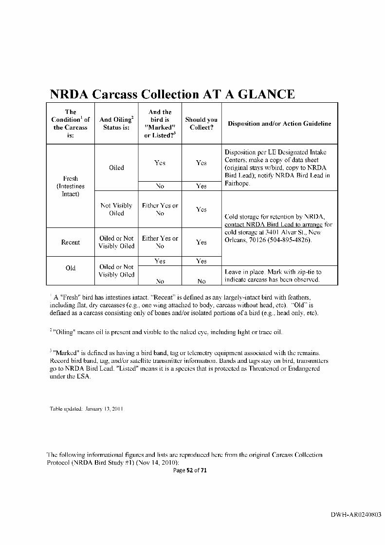
NRDA Carcass Collection AT A GLANCEThe
Condition^ of the Carcass
is:
And Oiling Status is:
And the bird is
"Marked" or Listed?^
Should you Collect? Disposition and/or Action Guideline
Fresh(Intestines
Intact)
OiledYes Yes
Disposition per EE Designated Intake Centers; malce a copy of data sheet (original stays w/bird, copy to NRDA Bird Lead); notify NRDA Bird Lead in Fairhope.No Yes
Not Visibly Oiled
Either Yes or No Yes
Cold storage for retention by NRDA, contact NRDA Bird Lead to arrange for
Recent Oiled or Not Visibly Oiled
Either Yes or No Yes
cold storage at 3401 Alvar St., New Orleans, 70126 (504-895-4826).
Old Oiled or Not Visibly Oiled
Yes Yes
No NoLeave in place. Mark with zip-tie to indicate carcass has been observed.
' A "Fresh" bird has intestines intact. “Recent” is defined as any largely-intact bird with feathers, including flat, dry carcasses (e.g., one wing attached to body, carcass without head, etc). “Old” is defined as a carcass consisting only of bones and/or isolated portions of a bird (e.g., head only, etc).
‘ "Oiling" means oil is present and visible to the naked eye, including light or trace oil.
"Marked" is defined as having a bird band, tag or telemetiy^ equipment associated with the remains. Record bird band, tag, and/or satellite transmitter information. Bands and tags stay on bird; transmitters go to NRDA Bird Lead. "Listed" means it is a species that is protected as Threatened or Endangered under the ESA.
Table updated: January 13,2011
The following informational figures and lists are reproduced here from the original Carcass Collection Protocol (NRDA Bird Study #1) (Nov 14, 2010):
Page 52 of 71
DWH-AR0240803

Evidence Seizure Tag:
©D ais ar>d military
E V ID E N C E S E rZ U R EUMTEOSWetDBMnUEMrOFTIE.IMrE»QH UJ). M l
dtUUHt rMjNU.
C heck appropriate box. If received from non-FW S, check th a t box & input p e rso n 's n am e
List city, s ta te , & coliection site (Lat/Long in decim al d e g re e s] , and Datum
List bird sp e c ie s or c la ss (gull, tern, sarKjplper, etc.) an d indication o f oiling
Coiiector"s nam e (d o es not have to be Law E nforcem ent)
ruTE. TILE n r r e e i i h
5.i'29j'2010 1300
899766
□ -piKEMHrOf* (PenSOUiCLMDiUie LOCATION)□ F“C«:Ef^WDAf; G u lfport, MS
30.235343 86 .432243 W GS 34
DIrSCiUrn-IOM CtFFVtHCWCFi
001) N o r th e r n G a n n e t- O iled002) U n k n o w n bird ' '003) L a u g h i n g gull
>
SPeCUtAQENT'iNSfeCTOR MDCCWX
^ C o lle c to r 's n a m e N
3ecor>d person in the chain of custody or Evidence C ustodian
Leave tfie iNV block blank; Evidence C u sto d ian s will fill in th e IhJV num ber
No m ore than 10 EvidenceIdentification T a g s on 1 E v idence S eizu re Tag
FCFHMSTIHhiiTiBI]
SEIZED PnOPEFiTVRECEtPrCWnUTlMe4F»EiZlME: SBDUAfimW.
899766BSCfrintPNj
Leave blank andattached
arccMLAaEr'in'iiroF'Ecron: BADQEM.
L eave blank u n less LE
oCH M ii o r CLiaTODYi L la ta d llam (B ) i r a n a te re d fr iM n c u a la d ^ e f oFEIcor i ic t» d o-n rw B ra e e td o a r th is tBig to :
DATE:5,'29,'ICi
DaiiuTEn uiimC*Second person 5P
5/31flQ Third person TP
nETURN ACKNaWLroGENEHr: I Pwraby K k n m ie d g s [tul Ri*articles) Fitted eti iheratfeneHileoTlhlt tsg iiim rkow i retiiirrid lo n ie b i a a o o o d » cendiUonA* w tientiisy n o w w te ed hry ihw IrxBcnlBfl p4Wcw.
RECC1PT eiGNATURE: PKTE;
W AhNiNS: Iht? m»icrini l9*ilifEli th is i t g i s iffflwd I t In t t f eu sw itiF N i t a Unilbd SldtaB-G^iviimiMnt and muAt 4aaLbk lAntfNred w lJi u iitlw pH ttH v al r w i 1filiSCZ2)2|.
oEPA nnneN r o f t h e irfnERfoi»U.S. ANb WlLDUF^ SkRVlCe
Version 7 17-2010 Page 6
Page 53 of 71
DWH-AR0240804

BLUE EVIDENCE TAG;
Seizure Tag No. TTiisnum ber can be reused formultiple Evidence ID# of Individual bind fromIdenOticatlon Tags ttie Bird Searcti Effort andcollected a t ttie sam e site. Birds Collected D ata Form
EVIDENCE FICATION TAG
Leave blank
;ullETAa lo. y rrcuNo. 902641-001
DATF;5/29/2010 —
FILE NO. TAGGED BY (INITIALS)MKH N.
•Nr OF THE INTERIOR I AND WILIHIMi SERVICE
U.S. Qpoaa 10-400 S4i rORM 3-2€52
D ate e d i t e d
C ollectors initials
Version 7-17-2010 Page 7
Page 54 of 71
DWH-AR0240805

Carcass collection kit (U SFW St;
Incident-specific maps or shoreline segment maps, if available Evidence Seizure Tags, Fomi 3-487 (white)Evidence Identification Tags, Form 3-2052 [blue)BIRD SEARCH EFFORT and BEIDS COLLECTED DATA FOR.\IsChain-of-Custody FormsCarcass collection protocolLarge paper bags (for otter carcasses)Paper bagsSmall plastic bagsLarge plastic bagsRubber bands or Evist tiesPencil and / or peiiiianent pen (shaipie)Evidence tape Nitiile glovesFlagging (for marking large marine mammal carcasses)
Carcass collection kit (non-USFW S1:
Incident-specific carcass collection instmctionsPaper bagsSmall plastic bagsLarge plastic bagsRubber bands or hvist ticsPencil and ; or peinianent pen (shaipie)BIRD SEARCH EFFORT and BIRDS COLLECTED DATA FORMsChain-of-Custody FormsTapeNitiile glovesFlagging (for marking marine mammal carcass locations)
Version 7-17-2010 Page t
Page 55 of 71
DWH-AR0240806

Appendix A-4. Uploading Photographs to the DOUERDC Database
P a g e 5 6 o f 7 1
DWH-AR0240807

ERDCDeepwater Horizon (MC 252)
USFWS/ERDC NRDA Bird Database
Data Entry Instructions: Uploading Digital Photographs
Remember: Never rename, delete, or open a photo file!1. To access the USFWS/ERDC NRDA Bird Database please connect to:
h t t p s : / / 1 3 4 . 1 6 4 . 4 8 . 1 7 7 / m s c 2 5 2 i / m s c 2 5 2 i . a s p x
Individual settings on FWS computers may result in sub-optimum performance using Internet Explorer, so Mozilla Firefox may be needed. Accept unknowrn certificates and allow flash
viewers to operate. Use the "x” in the corner of each pop-up to close windows; the browser
back button will cause ejection from the database.
2. First-time users will be prompted to download Microsoft Silverlight if not already installed.
Answer "yes” to all security download questions.
3. First-time users need to register. Hit "Click Here to Register” and enter your information on the
resulting screen. You will create your own username.
r narieoft
E R flC °
4. A password will be generated and emailed to you.
5. Login using your user name and password.
Last updated: 14M10 3
P a g e 5 7 o f 7 1
DWH-AR0240808

0 ■ cf . ■prr
6. Click the Upload Photo tab. A series o f selections will appear. Click on “NRDA" if the carcass
was collected on a Beach Bird Survey segment or “Ops” if it was collected off-segment.
> « U t l l B l I b M . r a l t a r d
Upload Photes
7. Enter the Date that photos were taken
8. On the next screen, click on “Survey Crew Members,” select yourself, then click on “Add to
Survey Crew.” If you aren’t on the list, click on “Add New Surveyor” and add yourself to the
Survey Crew Members list, followed by "Add to Survey Crew.”
Last updated: 14JullO 3
P a g e 5 8 o f 7 1
DWH-AR0240809

u p lo ad Photos
S o L rc s:
[^vr£nforrarn«nt^^^^^J
D a te P ic tu re s W ere T a k e n S j r v e y C rew M e m b ers;
a I -1I n ta k e C e n te r
Afla to Suivev C i ^ |WM new sjr~biever|
F irs t N am e MI L as t M arne P h o n e N u m b e r E -m ail
9. If NRDA, select the state, ACP, and/or Segment Name. If Ops, select or enter the Evidence
Seizure Tag number.
10, Click “Upload Photos.” A browser screen will open and allow you to select photos for upload.
Select only the photos associated with the specified segment name or seizure tag!
Remember: Never rename, delete, or open a photo file!
U p l o a d P h o t o s
S a u rce ;
kRDA
D ale P ic tu res W ere T aken S u rv e y C rew M e m b ers :
I iM arz, A ngela_______
^ Adc CO c rw »iJd NBA Sur«i^r|
\ b L - M
S e g m e n t N a-ne:
I’A L -24-02___________ J
ici SsiacC ni69 or Hold Shift and SaiectTc U|d«d lO Bulk
U pltw d P h o to s
Fiteiwre: |"vBwit«ii liMce ttf'’TcatcAe.cs" ^ j Qc ~|Files al i>te |Airies ^
:.ast Updated: 14JullO
P a g e 5 9 o f 7 1
DWH-AR0240810

Appendix A-5. Workbook Contents
1. Field Team Tracking Protocol
2. MC 252 Site Safety Plan
3. Dead bird Flow Chart
4. Transfer of Property Form
5. Receipt of Property Form
6 Chain of Custody Report Form
Page 60 of 71
DWH-AR0240811

APPENDIX BPROTOCOL FOR REQUESTING ACCESS
to US EISH AND WILDLIEE SERVICE NATIONAL WILDLIFE REFUGES
For Natural Resource Damage Assessment Activities
MSC252 - Deep W ater Horizon
To be used with respect to Natural Resource Damage Assessment (NRDA) activities related specifically to the BP M ississippi Canyon 252 Oil Spill in the G ulf of Mexico
National W ildlife Refuge (NWR) lands are some of the most sensitive areas in the oil spill area. National W ildlife Refuge managers have been overwhelmed with requests for data collection on N W R lands. Collection of data from NW Rs is vitally important and coordination with NW R staff on all activities on NW R lands is needed. The refuge staff are experts on their NW Rs and integration into appropriate ongoing refuge activities, as applicable, is important. The purpose of this protocol is to facilitate assessment by providing central points of contact for NW R managers and Technical W orking Group (TWG) members. The refuge staff are experts on their NWRs and integration into appropriate ongoing refuge activities, as applicable, is important. To assist w ith NRDA data collection, please use the Access Request Form to facilitate your preassessment and assessment needs.
The form is located on the ftp site: www.researchnlanning.com/downloads/ uadtx F ield Operations in the Scientific Research and Collecting Permits file. Please submit access request and associated assessment work plan(s) to fw4nrdanwr@ fws.gov. After the request is received by an NW R liaison you will be contacted to arrange access to the requested site.
NRDA NW R Liaison: (251) 725-2439 N W R Liaison: (504) 303-2859
Page 61 of 71
DWH-AR0240812

Access Request Form U.S. Fish and Wildlife Service
National Wildlife Refugesfor
Natural Resource Damage Assessment Activities
Send completed request to: [email protected]
National Wildlife Refuge:________________________________________
Technical Working Group: __________________________________
Title of Assessment Plan(s): __________________________________
Contact:Name email
Phone #(s)
Goal of Plan/Study:
DatetsT
Type of Assessment (ie.; aerial surveys, biotic/abiotic sampling, visual surveys):
Resource support needs (boat etc):
Inforaiation Needs from NWR:
Page 62 of 71
DWH-AR0240813

Incident-Specific Guidance for Scientific Research and Collecting Permit applicantsMay 14, 2010
To Be Used Only With Respect To Scientific Activities Related Specifically To The BP Mississippi Canyon 252 Oil Spill In The Gulf Of Mexico
The purpose of this information is to provide guidance to those who wish to conduct scientific activitiesin parks impacted by the oil spill.
• Activities related to response/clean-up up do not require a Scientific Research and Collecting Permit. Contact the park directly to determine how to proceed.
• Proposed activities that trigger the requirement to apply for a Scientific Research and Collecting Permit include Natural Resource Damage Assessment (NRDA) activities, scientific specimen collection, data collection, inventory, monitoring, and research.
If you need a permit this is what you do:• Access the Research Permit and Reporting System (RPRS) web site:
httn s: //science. nature. np s. gov/re search• Choose “Submit applications for research permits” and follow the instmctions• Please identify the funder of your activity in the “Purpose of Study” field.• Be sure to complete the process. You will know you are done when the system provides you the
option to print a copy of your application. This page also provides an “Apply for another Research Permit” option by which you may submit the same application to additional parks. This option saves time by porting the data you entered in your original application into the new application, and you will be able to edit the data in the new application.
• Park contact information is provided at the beginning and end of the application process. It is a good idea to follow up your application hy checking in with the Park Research Coordinator.
• If you are unable to submit your application on-line, you may contact the park directly. The parkhas the option of processing permit applications via paper forms.
Additional Points• Park contact information is available from the RPRS weh site; choose the “Park Info” menu item.• A National Park Service resource advisor/observer may be assigned to accompany you in tlie
field.• Review of applications related to the oil spill will be expedited.• Review of applications not related to the oil spill may be delayed.• For questions related to the process of submitting an application you may contact Bill Commins
at 202-513-7166, bill commins@nps gov• For questions related to the status of your application, contact the Park Research Coordinator.• Additional appendices will be included to cover assessment methods, SOPs and protocols
associated with the activities within the spill area.
Page 63 of 71
DWH-AR0240814

W aterfowl Bird Study #10 budget
An es t im a te of t h e required budge t for th is project Is a t tached . In addition, d a ta sharing ag re em e n ts b e tw e e n natura l resources t ru s te es , Louisiana S ta te University, BP, and Its au thorized consu ltan ts will be deve loped and Im plem ented . The parties acknow ledge th a t this budge t Is an e s t im a te , and th a t actual cos ts may prove to be higher. BP's co m m itm e n t to fund th e costs of this work Includes any additional rea so n ab le costs within th e scope of this w ork plan th a t m ay arise. The t ru s te e s will m ake a good faith effort to notify BP In advance of any such Increased costs. It Is acknow ledged th a t this ag re em e n t au thorizes only th o s e activities and expenses associa ted with Phase 1 of t h e proposal. Any activities or ex p enses ou ts ide phase 1 would require a supp lem enta l ag re em e n t .
Objective 1
PI Salaries
Principal Investigator (Rohwer) Fringe benefits
co/PI (Amundson)Fringe benefits
Flouslng& Food (co/PI) Subtotal
Field W orkersResearch Associates (2)
Fringe benefits Survey technicians (14)
Fringe benefits Flousing & Food (16 people) Subtotal
Cost per unit
36%$ 8 0 /d a y /p e rso n
7.65%$ 8 0 /d a y /p e rso n
N um ber of units
2 m o n th s
5 m o n th s
45 days
1.5 m o n th s
1.5 m on th
45 days
Total
$14,331$5,159
$25,000$9,000$3,600
$57,090
$9,000$3,240
$50,400$3,856
$57,600$124,096
Objective l A - Boat-based Beach Surveys
Mileage for vehicles $0 .48/m lle7 rental boats (boat, m o to r & trailer) $50 0 /d a y /u n l tFuel for 7 rental surface drive boats $ 4 5 /b o a t /d a yField supplies Subtotal
17,000 miles 45 days 7 X 45 days
$8,160$157,500
$14,175$17,400
$197,235
Objective IB - Walking Beach Bird Surveys
Mileage for vehicles $0 .48/m lle1 rental bay b oa t (boat, m o to r & trailer) $60 0 /d a y /u n l tFuel for rental boa t $ 8 5 /b o a t /d a yField supplies Subtotal
6,000 miles 45 days 45 days
$2,880$27,000
$3,825$6,500
$40,205
Objective 1C - Open W ate r Bird Surveys
Mileage for vehicles $0 .48/m lle3 rental bay boats (boat, m o to r & trailer) $60 0 /d a y /u n l t Fuel for 3 rental boa ts $ 8 5 /b o a t /d a y
14,100 m iles
45 days
3 X 45 days
$6,768$81,000$11,475
Page 64 of 71
DWH-AR0240815

Field supplies $15,200Subtotal $114,443
Total d irect costs $533,069LSU Agricultural Center O verhead 26% $138,598
Total for Objective lA; IB; & 1C $671,667
ID Budget for Examination of carcasses (will be pursued in supp lem enta l work plan if w arran ted )
IE Budget for Search Efficiency (will be pu rsued in supp lem enta l w ork plan if w arran ted )
O bjective 2: (23 transect lines; 3 m o n th s @ 18 days apart = 6 runs)
Budget fo r Aerial Surveys______________ Cost per unit N um ber of units Total
Salary T hree (3) surveyors $ 3 0 0 /d a y /p e rso n 12 days $10,800
O ne (1) pilot {included in equ ipm ent costs)
Travel/Com m odities $ 2 0 0 /d a y /p e rso n 12 days $ 9,600
O ther Costs $ 2,500
Facilities/Administration (20%) $4,580
TOTAL PERSONNEL COST $27,480
• Airplane with pilot $2400 /day 12 days $28,800
• Supplies (paper, pencils, clipboards, $ 1,500
guides, etc.)
TOTAL EQUIPMENT COST $30,300
Total for Objective 2 $57,780
Page 65 of 71
DWH-AR0240816

SUMMARY O bjective 1:Objective lA $197,235
Objective IB $40,205
Objective 1C $114,443
Total for Objective 1 $671,667
O bjective 2:Total for Objective 2 $57,780
OVERALL TOTAL $729,447
Page 66 of 71
DWH-AR0240817

WORK PLAN FOR ESTIMATING WINTERING WATERFOWL
OILING AND MORTALITY
DEEPWATER HORIZON {MISSISSIPPI CANYON 252) OIL SPILL
b ir d STUDY #10
fegSSfflgafe party signing below reservea fr^ righ t to produce its own iM d .MSiiVsis o f any data collected pursuant to this work ofan^
APPROVAL
Trustee NRDA Bird Group Lead Date
-Stale oTtgSfsiana Trustee Representative Date
BP Representative
dll.Date
Page 67 of 71
DWH-AR0240818

Objective 2: Estimate the temporal and spatial abund ance and distribution of waterfowl within t h e s tudy area
Aerial surveys will be conducted to es t imate abundance and distribution of waterfowl using
near-shore and offshore habi tats within the study area.
Surveillance flights will be conducted along existing systematically placed t ransects used by LDWF (spaced 15 miles apart) following protocols currently utilized by federal and s ta te agencies to allow compar isons with historical data (Figure 2, white t ransect lines). Additional t ransects (shown in yellow in Figure 2) will be added between existing/historical t ransect lines
to cover areas known to have been impacted by oil in each of four focal areas (Terrebonne Bay, Barataria Bay, the Mississippi River delta, and the Biloxi Marsh area). Systematic randomly placed t ransects will be established in each focal area on 5-mile intervals be tw een the tradit ional LDWF t ransects. In order to moni tor diving ducks, current t ransects will also be extended to cover areas wh ere historical concentra t ions of diving ducks have been identified,
including bays extending to both the Timbalier Islands and Isle Dernieres. The USFWS annual
flights over the Chandeleur Islands will be used to es t imate Redheads (Aythya americana) th a t utilize local seagrass beds. Figure 2 depicts the proposed 23 t ransects for this survey. With
extens ions of existing t ransects and 13 additional t ransects, the distance is approximately double the LDWF traditional aerial waterfowl survey in Southeas t LA.
P a g e 68 o f 71
DWH-AR0240819

Figure 2. Aerial Louisiana waterfowl survey t ransects (Atchafalaya Basin to the Mississippi line) for dabbling and diving ducks.
Page 69 of 71
DWH-AR0240820
Locations of waterfowl will be recorded using laptops with GPS-equipped voice recording software. A continuous track file will be determined. This will enable geographically explicit counts. Because this e l em en t of the s tudy falls outside of BP safety policy, Objective 2 will be accompl ished independently by the trustees .
Survey flights will be at or below 200' above sea level moving at 90-100 knots with observers
s tat ioned on ei ther side of the aircraft scanning a 200-m fixed-width t ransect . A third person sea ted in the copilot 's position will assist with navigation and back-up data logging.
Sam ple frequency: Surveys will be conducted approximately every 18 days so long as BP and
t h e Trustees agree they are providing data th a t will reduce NRDA uncertainty.This f requency may be modified as needed . The Trus tees will make a good faith effort to notify BP in writing prior to modifying the sampling frequency.
Sam ple duration: November through February but may be adjus ted by mutual wri tten consent
of the Trus tees and BP.
Specific sample sites on areas adminis tered by the NPS, areas within military bases, and those
in national wildlife refuges or s tate wildlife m anage m en t areas will require consul tat ion with t hose agencies to identify sensitive areas th a t should not be surveyed, to acquire appropriate
permits, and to det ermine if crews need to be accompanied by agency personnel during surveys. Standard Operat ing Procedures for coordinating activities with land managers will be followed to ensure th a t project implementa t ion is consistent with m an ag e m en t goals of the protec ted area (Appendix B). Research permits to o pe ra t e within s ta te or federa l-owned lands will be reques ted as needed. Landowner permission will be secured for access to privately held
properties.
Two primary observers will fly all the aerial surveys for this evaluation. Individuals will be selec ted based on prior experience as well as ability to commit to working for the entire study
period. LDWF will train observers in accordance with established protocols.
LDWF traditionally conducts aerial waterfowl surveys once per month in November , December , and January in coastal Louisiana. The southeas t portion of t h e survey takes approximately 1.5 days to fly and process data. Three additional surveys, t ransect extensions, thi r teen additional t ransects, and spatial referencing necessary for this study will add 2 days to normal surveys and 2 days of additional surveys.
Page 70 of 71
DWH-AR0240821

Objective 3: Examine oiled and not visibly oiled birds collected from representa tive habitats.
Visual inspection and sample analysis of collected waterfowl
Information will be collected from carcasses harves ted legally for o the r LDWF work to evaluate "birds in hand" for signs of oil exposure. This e l em ent of the study will be accomplished
independent ly by the t rus tees under a workplan previously signed by the Trustees.
P a g e 7 1 o f 7 1
DWH-AR0240822