dunning - the scottish government - gov.scot · chapter 3 townscape analysis character and...
TRANSCRIPT

Dunning Conservation
Area Appraisal
The Environment Service
July 2010

CONTENTS
Chapter 1 INTRODUCTION, PURPOSE and JUSTIFICATION 1
Conservation Areas 1 Reason for Conservation Area designation 1 Purpose of the Conservation Area Appraisal 2 Chapter 2 CONTEXT and SURVEY 2
Location, history and development 2 Chapter 3 TOWNSCAPE ANALYSIS 6 Character and appearance 6
Street pattern and topography 6 Activity and movement 6 Buildings and townscape 6 Area west of Dunning Burn 7 Area east of Dunning Burn 12 Building materials and finishes 13 Spaces 13 Trees and landscaping 15 Character areas 18 Negative factors 19 Building by building analysis 19 Buildings at risk 19 Shopfronts and signage 20 Spaces 20 Area south of Thorntree Square, Muckhart Road 20 Public realm audit 21 Street furniture and surfacing 21 Surveys of specific issues 22 Windows and doors 23 Roofscapes 24 Materials, decoration and detail 25 Boundary treatments 27 Shopfronts and signage 28 Sensitivity analysis 29 Setting of the conservation area 29 Historic Gardens and Designed Landscapes 29 Archaeology 29 Assessment of significance 29 Chapter 4 CONSERVATION STRATEGY 31
Using the Conservation Area Appraisal 31 Monitoring and Review 32

Chapter 5 PROPOSALS 33
Opportunities for development 33 Local path networks 33 Opportunities for planning action 33 Conservation area boundary 33 Effects of permitted development 33 Advertisements 34 Trees 34 Opportunities for enhancement 35 Buildings 36 Spaces 36 Shopfronts and signage 37 APPENDICES 39
1) Article 4 Direction 39 2) Classes of advertisements proposed for advertisement control under Regulation 11 41 MAPS Map 1 Location of Dunning within the Perth & Kinross Council boundary 2 Map 2 OS Map c.1862 5 Map 3 OS Map c.1901 5 Map 4 OS Map c.1959 5 Map 5 Six historic routes meet in the heart of Dunning 6 Map 6 Townscape analysis 10 Map 7 Green areas 17 Map 9 Character areas 18 Map 9 Conservation area boundary 30 Map 10 Possible enhancement site 38

Chapter 1 INTRODUCTION, PURPOSE and JUSTIFICATION Conservation areas 1.1 Conservation areas are crucial to the conservation of our built environment. There are over 600 conservation areas in Scotland. They contain groups of buildings extending over areas of a village or town and can also include public parks, woods and historic land. To safeguard them for the enjoyment and benefit of future generations any new development should preserve or enhance their varied character. The local planning authority is required to determine which parts of its area are of special architectural and/or historic interest. It may propose and designate these as conservation areas. The public will be consulted on any proposal to designate conservation areas or change their boundaries. 1.2 Conservation areas must be safeguarded and enhanced. This is defined through:
Defining the character that merits protection, including the space between buildings;
Use of appropriate controls over development, demolition and advertising; Financial assistance, where appropriate, for works of repair and restoration; Protection of trees; Interpretation schemes, through leaflets or exhibitions; The implementation of enhancement schemes based upon a conservation
area appraisal. 1.3 Designation as a conservation area does not place a ban upon all new development within its boundaries. However new development will normally only be granted planning permission if it can be demonstrated that it will not harm the character or visual quality of the area. New development should also positively enhance the area through good design rather than just create a neutral effect. Reason for conservation area designation 2.1 The village of Dunning retains a strong architectural and historic character which demonstrates its evolution and creates a unique, high quality environment. This character is important for the quality of life and economic health of the village, in the present and the future. 2.2 A conservation area was first designated in Dunning in August 1970. The Council is required to review its conservation areas from time to time and update the conservation area appraisal and management proposals on a regular basis. The Council has determined that the criteria for reviewing Conservation Areas should be: (i) a Placecheck has been undertaken or is imminent (ii) the local community has requested a review (iii) there is potential for physical regeneration and linkages with broader schemes (iv) development pressure is creating a need for more detailed guidance and (v) considerable time has elapsed since the original appraisal was undertaken. The review of the Dunning Conservation Area reflects some of the proposals put forward by the community during the recent Placecheck process and integrates them within a revised appraisal. Purpose of the Conservation Area Appraisal 2.3 A Conservation Area Appraisal is a management tool which helps to identify the special interest and changing needs of an area. It serves as supplementary planning
1

guidance to the Local Plan. The appraisal provides the basis for the development of a programme of action that is compatible with the sensitivities of the historic area and can enable the local authority to fulfil its statutory duties to protect and enhance that particular area. 2.4 Appraisals also assist development control and management. They provide the opportunity to inform residents about the special needs and characteristics of the area and help developers identify and formulate development proposals. If a conservation area’s special interest has been clearly defined and published in an appraisal then this definition will help those thinking to invest in the area and can be used to guide the form and content of new development. Local Plan policy indicates that within the conservation area, infill and other development will only be acceptable where it would not adversely affect the character and amenity of the area. Chapter 2 CONTEXT and SURVEY Map 1: Location of Dunning within the Perth & Kinross Council boundary
Location, history and development 3.1 Dunning is located in Strathearn, around 8 miles from Perth and on the former main route between Perth and Stirling. There is evidence of human settlement in Strathearn from the Neolithic period (c.4000-2000BC) onwards. Several peaks around Dunning were used as hill-forts during the Iron Age (c.700BC-80AD), including Dun Knock immediately to the south-east of the village. The name Dunning
© Crown copyright and database right (2010). All rights reserved. Ordnance Survey Licence number 100016971.
2

itself relates to the term ‘Dun’, meaning a fortress or hill. Strathearn was then utilised as an invasion route for the Roman army after 80AD, evidenced by the temporary marching camps at Dunning, Forteviot and Carey, near Abernethy. The massive Dunning camp, just to the east of the village, is thought to have accommodated around 40,000 soldiers. 3.2 Later, St Serf is associated with missionary activity, bringing Christianity to the area in the 7th century. A church was founded, possibly during the 8th or 9th centuries, which now bears his name. He is associated with the miraculous destruction of a dragon at Dunning and the Dun Knock/Newton of Pitcairns area is still referred to as the Dragon (pronounced ‘draygon’). The lower Strathearn area became a centre of Pictish culture with a royal palace established at nearby Forteviot where Kenneth MacAlpine died in 860AD. The Dupplin Cross, a spectacular decorated sandstone cross associated with the Pictish royal centre, now stands within St Serf’s church.
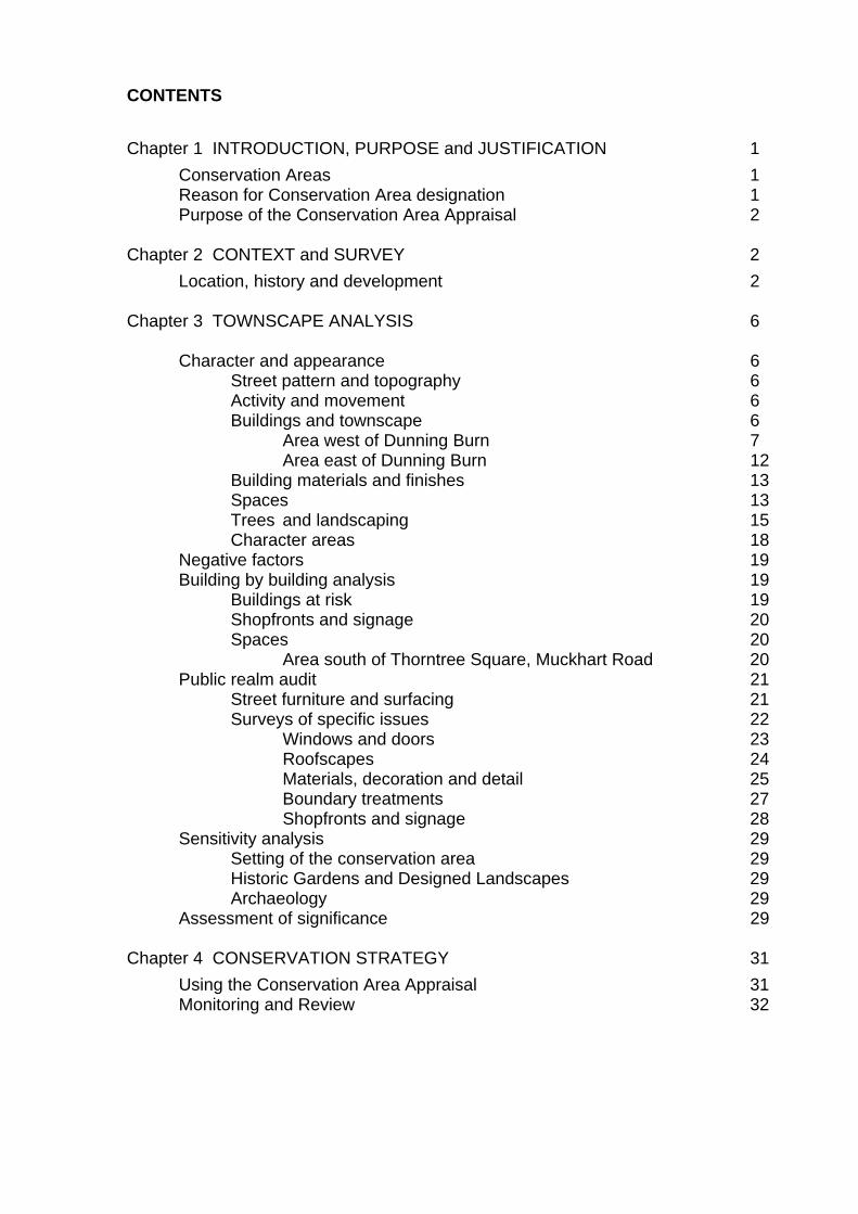
Dupplin cross now located in St.Serf’s St Serf’s c.1890 3.3 The medieval parish church of St Serf stands at the hub of six routes connecting Dunning with Forteviot, Invermay, Path of Condie, Yetts o’ Muckhart, Auchterarder and Dalreoch. The land was associated with Inchaffray Abbey and later formed part of the extensive Duncrub estate. In 1511 Dunning was granted status as a Burgh of Barony. Its principal industry was handloom weaving of linen and later, wool and cotton although the industry declined once weaving became the preserve of large, city-based mills during the later 19th century. The flat, open areas in front of St Serf’s church and along the banks of the Dunning Burn were used as bleaching greens. The central area came to be known as Tron Square, relating to its use as a market and location of a weighbridge for the assessment of goods for sale. 3.4 In 1716 many of the villages of Strathearn including Dunning were burned by the Jacobite forces retreating towards Perth after the battle of Sheriffmuir, in an attempt to slow the progress of the government troops. The Straw House in Kirk Wynd is the only existing building to survive from before the fire. A thorn tree was planted as a memorial to the event in the square which now bears its name.
Pho
togr
aph
cour
tesy
of
Dun
ning
Par
ish
His
toric
al S
ocie
ty
3
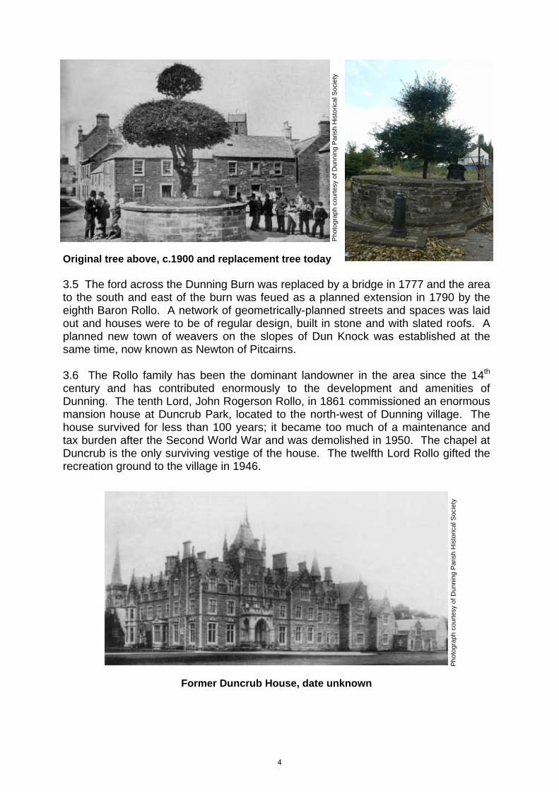
Original tree above, c.1900 and replacement tree today 3.5 The ford across the Dunning Burn was replaced by a bridge in 1777 and the area to the south and east of the burn was feued as a planned extension in 1790 by the eighth Baron Rollo. A network of geometrically-planned streets and spaces was laid out and houses were to be of regular design, built in stone and with slated roofs. A planned new town of weavers on the slopes of Dun Knock was established at the same time, now known as Newton of Pitcairns. 3.6 The Rollo family has been the dominant landowner in the area since the 14th century and has contributed enormously to the development and amenities of Dunning. The tenth Lord, John Rogerson Rollo, in 1861 commissioned an enormous mansion house at Duncrub Park, located to the north-west of Dunning village. The house survived for less than 100 years; it became too much of a maintenance and tax burden after the Second World War and was demolished in 1950. The chapel at Duncrub is the only surviving vestige of the house. The twelfth Lord Rollo gifted the recreation ground to the village in 1946.
Former Duncrub House, date unknown
Pho
togr
aph
cour
tesy
of
Dun
ning
Par
ish
His
toric
al S
ocie
ty
Pho
togr
aph
cour
tesy
of
Dun
ning
Par
ish
His
toric
al S
ocie
ty
4

Settlement development
© C
row
n co
pyr
ight
, dat
abas
e rig
ht a
nd L
andm
ark
Inf
orm
atio
n G
rou
p (2
010
). A
ll rig
hts
rese
rved
. Ord
nanc
e S
urve
y Li
cenc
e nu
mbe
r 1
000
1697
1.
Map 2: c.1862
Map 3: c.1901
Map 4: c.1959
5

Chapter 3 TOWNSCAPE ANALYSIS Character and appearance Map 5: Six historic routes meet in the heart of Dunning Street pattern and topography 4.1 The heart of the old village is at Tron Square and St Serf’s church, where the six historic routes converge. Branching off and around the square is a series of narrow streets and wynds of medieval origin. East of the village burn the street layout is more formal, this area being the planned ‘new town’ of the late 18th /early 19th century created after the Dunning Burn Bridge was built. The nature of the topography adds significant interest to the townscape, the land rising steeply within the village to the north-east along Perth Road, to the east up the Bridge of Earn and Newton of Pitcairn roads and up the Muckhart Road to the south. Activity and movement 4.2 Although the majority of vehicular traffic now by-passes Dunning via the A9 trunk route, the centre of the village is relatively busy with local agricultural and industrial traffic. The village retains three public houses, two shops and is the base for a number of local businesses. The village also acts as a commuter base for surrounding urban centres.
DUNNING
Auchterarder Road
Perth
Roa
d
Muckhart R
oad
Station R
oad
Bridge of Earn Road
Newton of Pitcairn Road
Thorntree Inn, Thorntree Square
6

Buildings and townscape 4.3 In the village core the narrow streets are informal and organic in layout, inviting further exploration. The scale of buildings is generally low, predominantly two-storey and interspersed with some grander three-storey buildings. East of the burn, in the later planned extension, the scale of the buildings is also low but the houses are more regimented in attractive, harmonious terraces. Buildings generally form hard edges to the street, without front gardens. 4.4 The Dunning Burn is the natural boundary between the original medieval street pattern of the old village to the west of the burn and the more formal, planned street layout to the east.
Above: Linear layout of Upper Granco St Left: Curvilinear layout of Kirk Wynd
Area west of Dunning Burn 4.5 St Serf’s church is the key landmark building in the village. The impressive Romanesque steeple, c.25m in height, can be seen in long views from all directions, in vistas and in glimpse views between the densely packed buildings of the village core. Tron Square and Kirkstyle Square offer superb close-up views of the church. The churchyard is bordered by a high stone boundary wall, providing a distinctive and attractive edge to the street scene.
St Serf’s church steeple visible Over rooftops from Townhead
7

4.6 A key feature in Tron Square is the gothic-style Alexander Martin Fountain. Tron Square is framed on its south edge by the three-storey Pan Haggerty building with its distinctive canted form, decorative cast iron balcony and original, tall shop front. Both this building and Crossways on the opposite corner with Muckhart Road are fine examples of square and snecked stonework with ashlar margins. At the gate house entrance to St Serf’s the street narrows considerably between Tron Square and Kirkstyle Square, providing a distinctive contrast between these two informal open spaces. 4.7 Approaching Kirkstyle Square from the Dunning Burn Bridge the street narrows and is framed by buildings set at an angle to the street, the Kirkstyle Inn on one side and Burnbank House on the other, then further on at Sunnydale. These deflected angles and the narrowing of the street lead the eye into the village centre, inviting exploration into Kirkstyle and Tron Squares. The Kirkstyle Inn has a double stairway up to its attractive corniced doorpiece. 4.8 Kirk Wynd curves north from Tron Square and downhill around the churchyard. On the north side of the wynd is the rubble-built ‘Straw House’, which survived the destruction of 1716 when the village was torched. This house is random-rubble built rather than coursed or squared and snecked rubble which are the predominant masonry designs in the village. Kirk Wynd meanders northwards and follows the curved line of the burn. The burn and the woodland backdrop provide an attractive edge to the wynd. Interesting features are the two cast iron footbridges and the ford. At the end of Kirk Wynd there is fine terrace of houses at The Granco with a variety of roof styles.
Straw House, Kirk Wynd The ford and footbridge at Granco 4.9 The initially narrow Muckhart Road leads off to the south of Tron Square. The road widens at Thorntree Square, another square of medieval origin of an informal layout. The thorn tree is the central feature of the square and has a small information plaque. The surfacing and landscaping of the pedestrian area of this square needs some improvement. There are also two electricity poles with overhead wiring which spoils the setting of the square and the houses framing the northern edge of the square, although the poles themselves are of an unusually decorative design with metal finials. The open space area immediately to the south of the square is in an untidy condition and surrounded by security fencing. This area has planning permission for twelve residential units. The road rises steeply from here and there
8
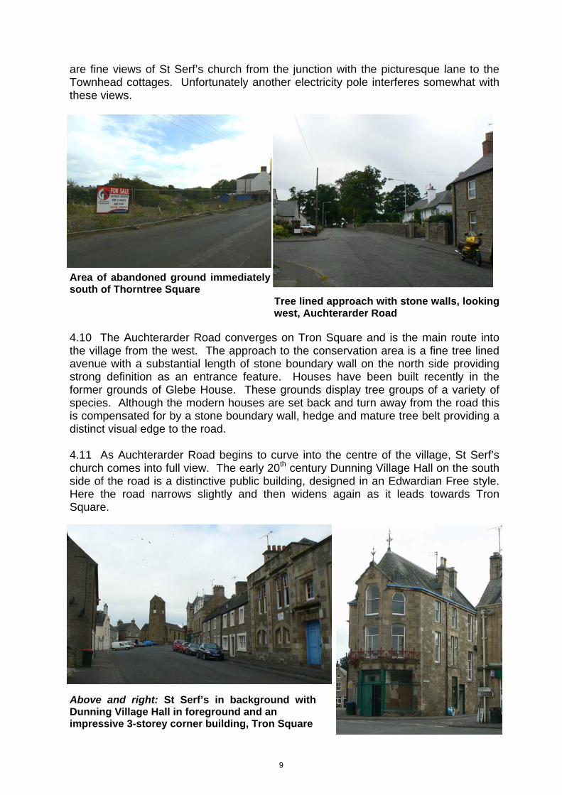
are fine views of St Serf’s church from the junction with the picturesque lane to the Townhead cottages. Unfortunately another electricity pole interferes somewhat with these views.
Area of abandoned ground immediately south of Thorntree Square Tree lined approach with stone walls, looking west, Auchterarder Road 4.10 The Auchterarder Road converges on Tron Square and is the main route into the village from the west. The approach to the conservation area is a fine tree lined avenue with a substantial length of stone boundary wall on the north side providing strong definition as an entrance feature. Houses have been built recently in the former grounds of Glebe House. These grounds display tree groups of a variety of species. Although the modern houses are set back and turn away from the road this is compensated for by a stone boundary wall, hedge and mature tree belt providing a distinct visual edge to the road. 4.11 As Auchterarder Road begins to curve into the centre of the village, St Serf’s church comes into full view. The early 20th century Dunning Village Hall on the south side of the road is a distinctive public building, designed in an Edwardian Free style. Here the road narrows slightly and then widens again as it leads towards Tron Square.
Above and right: St Serf’s in background with Dunning Village Hall in foreground and an impressive 3-storey corner building, Tron Square
9

Map 6: Townscape analysis
10

4.12 Station Road is the main road from the north which meets up with Tron Square. Approaching Tron Square from Station Road the road becomes narrower and the buildings taller, leading the eye towards the heart of the village. The two-storey building at the corner of Circus Street (altered to an extent recently) and the three-storey buildings on the west edge at the end of the road provide a strong visual frame to the townscape and sense of enclosure. Crossways, the two-storey building with large canted dormers on the south side of the junction with Auchterarder Road, acts as a fine visual stop or frame to the vista. 4.13 The approach to the conservation area from further north in Station Road is flanked on both sides by mature trees, creating a tree lined avenue effect and creating a sense of enclosure before opening out into views of the Rollo Park and the Ochil hills in the distance. Here at the entrance to the conservation area the school is a prominent feature. The original mid-19th century building is designed in a restrained gothic style with gablets, tall decorative chimney stacks and a ventilator spire (fleche) on the roof ridge. A substantial extension in a contemporary style has been added recently. The extension design is good quality and links well with the original stone building. Unfortunately the tarmac-surfaced access/egress area in front of the main gates, painted in hatched yellow lines, has a negative impact on the setting of the school.
Strong boundary walls and mature Dunning Primary School with recent extension trees north out of village 4.14 There are a series of glimpse views of St Serf’s church between houses before the junction with Circus Street. The oriel window on Oswald Villa is an interesting feature.
Oriel window, Oswald House, Station Road
11

Area east of Dunning Burn 4.15 The street layout of the late 18th century planned extension covers Granco Street, Chalmers Street, part of Perth Road and Bridge of Earn Road and Bridgend. A central feature of the planned town is the triangular shaped public green, flanked by Granco Street, Perth Road and Chalmers Street. The triangle flanked by terraced two-storey houses forms a sense of enclosure and leads the eye further into the centre of the village as it narrows. A key feature at the southern end of the green is the Celtic cross war memorial. 4.16 Granco Street, running straight and at a gradient, is predominantly terraced housing of one or two storey fronting the street. The street is divided into Upper and Lower sections. There are some larger houses set in mature front garden grounds, such as Willowbank House (former Union Bank) and the Knowes. At the top of Upper Granco Street the early 19th century water pump is an interesting feature. Unfortunately the backdrop to this vista is dominated by rather incongruous looking blocks of two-storey housing, erected recently, on a high elevation above the conservation area. The house known as Weavers Beam at the top of Lower Granco Street has an interesting gently bowed corner gable. At the end of Lower Granco Street is the ford across the burn.
19th century water pump with modern An attractive row of cottages in Thimblerow housing behind it 4.17 From the top of Bridgend and the road uphill to Newton of Pitcairns there are good views of the village and the landmark St Serf’s church. Bridgend gradually narrows, with a fine terrace of two-storey houses on the north side of the street stepping down the steep gradient. Thimblerow is an attractive lane of cottages to the south, linking with a path to the wooded banks of the burn. Continuing down Bridgend, after the junction with Perth Road, there are the open spaces of communal gardens and trees on the north side and the wooded burn on the south side before the bridge and then the enclosure of the village core. 4.18 The main entrance route to the east side of the village is the Perth road, approaching from the north-east. There are fine views of the village setting and the Ochil hills beyond. The block of two-storey houses erected recently at a high elevation above the Bridge of Earn Road are out of scale and have considerable visual impact from this viewpoint. After passing recent housing areas on either side of the road the gothic style St Paul’s church and its landscaped grounds is a key building and entrance feature at the edge of the conservation area.
12

St Paul’s church, c.1915 and present day Building materials and finishes 4.19 Traditional roof materials throughout the village are Scottish or Welsh slate. Some roofs have stone skews or decorative timber bargeboarding. Chimney heads are either stone or brick. Traditional rainwater goods are cast iron. There are some fine examples of decorative rainwater heads (hoppers) and brackets to downpipes. 4.20 Wall materials and finishes are coursed or squared and snecked rubble, wet harling, and some later examples of cement ‘ashlar’ render. Squared and snecked stonework or coursed rubble marked with squared and snecked lining is a predominant feature in Dunning, often with dressed window and door margins. Many of these margins are painted. There are a variety of colours used, mostly of light tones. Some front door surrounds are classical in design, with entablatures over the doorway or in some cases, pediments. Many houses have attractive name signs, often hand painted on door surrounds or in some cases in decorative metal lettering. Windows are predominantly timber sash and case, many with astragal patterns of twelve or four pane design.
Examples of the various stone treatments found in the village Spaces 4.21 All spaces, regardless of ownership and accessibility (ie. public and private spaces) contribute to the amenity and character of an area, as indicated in Planning Advice Note 65, ‘Planning and Open Space’. The term ‘open space’ covers green space consisting of any vegetated land or geological feature in a village and civic space including squares, market places and other paved or hard landscaped areas. 4.22 The informal squares within the village centre are traditional public open spaces dating back to the Middle Ages. Tron Square is the focal public open space of the old village. As it is a through route in various directions for vehicular traffic the majority of it is not a pedestrian-oriented environment apart from a small area of granite setts around the Alexander Martin Fountain. However the landscaping around the fountain
Pho
togr
aph
cour
tesy
of
Dun
ning
P
aris
h H
isto
rical
Soc
iety
13

and provision of footways have been enhanced recently through the Placecheck process. The smaller Kirkstyle Square is tarmac surfaced and used to an extent as a parking area. The kirkyard of St Serf’s Church is also regarded as open space, being accessible to the public.
4.23 Thorntree Square, between Muckhart Road and the Thorn Tree Inn, is predominantly a tarmac surfaced parking area. A small area in front of the inn is laid out with picnic benches and bollards but there is no change in the surface material. The thorn tree itself is outlined and protected by a round stone wall. The edges of the square have been defined by granite setts in recent times, including around the thorn tree. In overall terms the square is a vehicle-dominated environment. 4.24 The one formal public garden in Dunning is the attractive war memorial green, which is landscape designed with grass, trees and flower beds. Other important green spaces are along the banks of Dunning Burn. A secluded path leads off the top of Lower Granco Street and down into small attractive woodlands, following the east bank of the burn and linking up with Kirk Wynd across two footbridges. Another path leads down from the end of Thimblerow and links with Muckhart Road.
War memorial green, Perth Road Green bank along Dunning Burn 4.25 Part of the recreation park to the west of Station Road is within the conservation area. This area is used for walking and playing sports including golf on the connected course.
Fountain in Tron Square, now lit up at night, following Placecheck
View across the kirkyard
14

4.26 The rural and agricultural spaces forming the immediate setting of Dunning are also important in defining its character. The paddock to the south of Thimblerow and west of Bridgend/Newton of Pitcairns road is important in visually separating the historically separate districts of Dunning and Newton of Pitcairns. This area is excluded from the Dunning settlement boundary and any proposed development here would have to take into account the setting of the conservation area.
4.27 Private gardens, although physically inaccessible, can contribute significantly to the visual amenity of the townscape. Within the conservation area most buildings form a hard edge to the street, although there are pockets of mature front gardens and soft landscaped grounds such as St Paul’s church. There are several glimpse views of mature rear gardens and these views contribute to the richness and diversity of the townscape. 4.28 Key spaces within the conservation area are indicated on map 6 and 7. Trees and landscaping 4.29 Trees and landscaping are important features of the townscape and make a positive contribution to the character and appearance of the conservation area and its wider setting. 4.30 The banks of Dunning Burn are framed with mature tree belts and small woodland areas and this green artery and wildlife corridor is a key element of Dunning’s character. There are also mature tree belts enclosing and forming view corridors entering the village from the west and north-west. Smaller groups and individual specimens are scattered generously throughout the village, mainly in private gardens. There are also substantial hedges in the village, several of which form distinct edges to the street. 4.31 Significant tree species within and around the edge of the village are oak, beech, copper beech, willow, ash, rowan, cherry and cedar.
Left and above: Private garden by Dunning Burn, visible from road bridge and the paddock south of Thimblerow, a valuable green space
15

Green space, St Serf’s Terrace Well maintained grounds, St Paul’s church
Mature tree, Willowbank House
Trees and visually strong hedging, Townhead
Mature trees to the rear of the former manse now Glebe house
Visually strong hedge-line marking the path around St Paul’s church
Mature trees line the main drive of Glebe House
16

Map 7: Green areas
17

4.32 There are no existing Tree Preservation Orders (TPOs) within the conservation area. Key trees, tree groups and woodland areas within the conservation area are indicated on map 7. Any proposals to fell, top or lop trees within the conservation area are subject to controls under the Town and Country Planning Act (explained further at para.14.10). 4.33 Kincladie Wood, located to the east of Dunning just off the Perth road, is a wooded area occupying part of the site of the Roman temporary camp, and is important in the wider setting of the village. The Roman camp is a scheduled ancient monument (see para. 9.4). The wood is a recreational and environmental asset to the area, and was acquired as a Community Woodland in 2005. Enhanced interpretation of the landscape and history of the wood and the camp are currently in development. 4.34 Boundary treatments such as walls and railings are important elements of the townscape. There are several examples of traditional rubble walls, stone gate piers, decorative cast iron railings and gates throughout the village (for details see page 27). Where there are remnants or evidence of original railings previously removed it would be desirable to restore these decorative features wherever possible. Character areas 4.35 There are two areas of distinct character within Dunning, the original, medieval core of the village concentrated around St Serf’s church, and the planned extension east of the Dunning burn.
© C
row
n co
pyr
ight
and
dat
abas
e rig
ht (
2010
). A
ll rig
hts
rese
rved
. O
rdn
ance
Sur
vey
Lice
nce
num
ber
1000
169
71.
18

Map 8: Character areas Negative factors 5.1 There are a few negative buildings, façades or ill-defined spaces which detract from the quality of the townscape. These areas of poor visual quality have been identified in the townscape survey, shown on map 6. There may be the potential to enhance these areas and opportunities for enhancement are discussed further in paragraphs 15.1 - 15.9. Building by building analysis Buildings at risk 6.1 There are two buildings in Dunning currently included in the Scottish Civic Trust’s Buildings at Risk (BaR) Register: the warehouse/store at Kirk Wynd, and the roofless cottage and store at Thimble Row. Store building and yard adjacent, Kirk Wynd 6.2 The store building is a Building at Risk. The yard area at its north end is visually harsh and ill-defined.
Store building, Kirk Wynd 6.3 There are also several other buildings whose condition is of concern. These include: Former scout hut in Kirk Wynd 6.4 This relatively large, modern timber shed just to the north of St Serf’s church is dis-used, with windows boarded up. A planning application was submitted for its replacement with a dwelling house but is believed to have been held up awaiting the resolution of flood risk issues. Store building, Station Road 6.5 Situated on the south edge of the public car parking area for the recreation park, this building appears dis-used and is in poor condition.
Store building, public car park, off Station Road
19

6.6 There are also a number of spaces, buildings, signs or features which detract from the character of the village through inappropriate design or materials, which would benefit from replacement or enhancement: Shopfronts and signage 6.7 Post Office and Spar, Bridgend: both fascia signs are internally illuminated and the shop window of the post office consists of an illuminated poster advertisement. The degree and nature of illumination is excessive and has considerable visual impact on the street scene (by contrast the external illumination on the nearby Kirkstyle Inn is suitably discrete). Spaces 6.8 The emergency vehicles pull-in area in front of Dunning School is currently a harsh expanse of black tarmac with yellow box hatching. The design and landscaping of this area could be designed more sympathetically for this important approach into Dunning and the foreground setting of the attractive school buildings.
6.9 The site of the demolished toilet block in Station Road has recently been redeveloped and landscaped with waiting and bus stop facilities. Area south of Thorntree Square, Muckhart Road 6.10 This area is fenced off and is awaiting development. The site has an untidy appearance and the path behind the site to the burn requires some improvement and landscaping. 6.11 Scattered through the village in general, there are examples of non-traditional replacement windows, standard design rooflights and prominent satellite dishes which have a negative impact on the townscape.
Spar Shop, Bridgend
Black tarmac and yellow lines outside Dunning Primary School
Former toilet block site, redeveloped following Placecheck
20

Public realm audit Street furniture and surfacing 7.1 Street furniture in most areas of the village is generally of a standard ‘off-the-shelf’ design, such as lamp standards and litter bins. Most of these lamp standards emit a large degree of light spillage into the night sky. Some neo-Victorian designed lamp columns have been erected recently at Tron Square on either side of the Fountain. Lamp columns have also been erected recently at the War Memorial garden, these being a simpler vernacular design to those at Tron Square.
Variety of lamp standards; War memorial green, Tron Square and Kirkstyle Square 7.2 The surfacing material for lanes and squares is generally tarmac, although some limited use of granite or whin setts for edging and feature areas has been used in current and recent enhancement works. Some surfaces of lanes are in poor condition, such as Kirk Wynd. Street footpaths are either tarmac or in some cases concrete, although limited areas of stone flagged footways survive, such as in Chalmers Street.
Satellite dishes clutter walls and inappropriate style and size of roof windows affect the character of buildings
Alterations to window fenestration and inappropriate window replacement
21

7.3 There are few traffic bollards within the village and road signs are mostly unobtrusive. However, the centre of the village suffers visually from rather outdated looking electricity poles and overhead wires, which adversely affect the setting of St Serf’s church and Thorntree Square.
7.4 An original ‘K6’ red telephone box exists at the corner of Bridgend and Perth Road. It is important that traditional features such as this are retained. Surveys of specific issues 8.1 All conservation areas contain streetscapes, building types, architectural details, materials or other features which are unique to that area and a result of their historical development. These features contribute to an area’s local distinctiveness, the characteristics that lend it a unique sense of place. Some of these characteristics are general or intangible, but others can be quite closely defined. 8.2 The following is not an exhaustive list and will be augmented in the future. It identifies the most important types of features and elements of the townscape which help to shape its identity, but which may be most at risk of incremental erosion. A full survey of each category will be undertaken as part of the building analysis survey. This will provide example images which may be referred to when new development, alterations and extensions are proposed in the area.
Original ‘K6’ telephone kiosk, corner site
Road surface at Kirk Wynd, before and after, following Placecheck
Before After
22

Surveys of specific issues: Windows and doors
23

Roofscapes
24

Materials, decoration and detail
25

Materials, decoration and detail
26

Boundary treatments
27
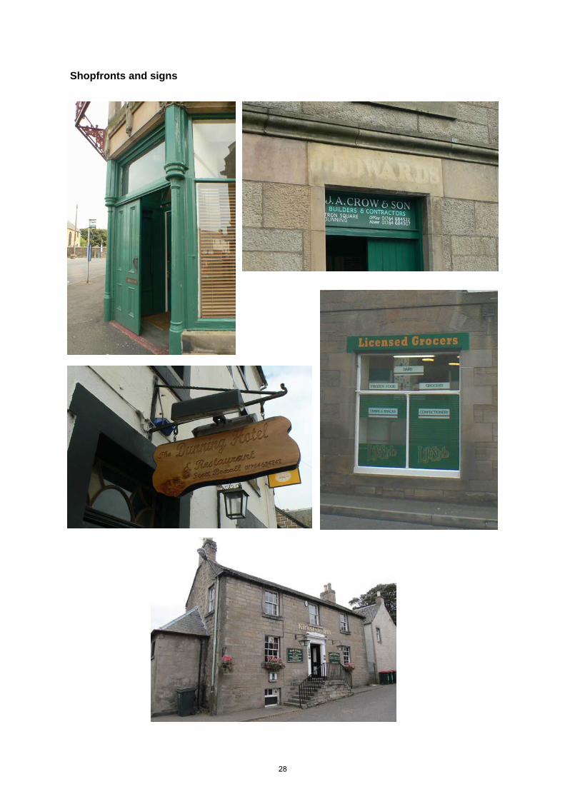
Shopfronts and signs
28

Sensitivity analysis Setting of the conservation area 9.1 The edges of the conservation area can be sensitive to potential development. It is important to preserve and enhance the setting of the conservation area and the design, scale and landscaping of any development must not adversely affect this setting. Existing tree belts should not be adversely affected. Historic Gardens and Designed Landscapes 9.2 The Invermay designated Historic Garden and Designed Landscape lies approximately 1.5 miles to the east of Dunning. The Invermay landscape is considered important as an example of the picturesque landscape movement, comprising elements of formal design from the pre-18th to 19th centuries, and has connections to Sir Walter Scott and the well-known Scottish designer Walter Nicol. 9.3 Development affecting the settings of both the designed landscape and the conservation area are material considerations for any planning applications in the area. Historic Scotland must be consulted on any proposal potentially affecting the setting of Invermay designed landscape. Archaeology 9.4 The Dunning area is archaeologically significant with a high concentration of designated and undesignated sites. There are Scheduled Ancient Monuments at St Serf’s church; the standing stone 300m south-east of Leadketty Holdings; the Roman camp to the east of the village; and at Dun Knock. There are further scheduled areas of pit circles and alignments, enclosures and burial mounds at Leadketty Farm to the north and Millhaugh to the west of Dunning. 9.5 Historic Scotland must be consulted on any proposal potentially affecting scheduled ancient monuments or their setting. Outwith the scheduled areas, following national planning policy, a programme of archaeological works including an initial evaluation to assess the significance of any deposits will be required to protect and record any archaeological remains impacted upon by any proposed development. Depending on the results of the initial evaluation, this programme of archaeological works is likely to include measures for preservation in situ and preservation by record, through excavation, analysis or publication. Assessment of significance 10.1 Dunning is a good example of a small but important church- and market centre serving an agricultural hinterland, with links to the Romans, early Christianity and Pictish culture in the area. Its townscape demonstrates its medieval evolution, its connections with weaving and the influence of major local estates.
29

Map 9: Conservation area boundary
30
Chapter 4 CONSERVATION STRATEGY Using the Conservation Area Appraisal 11.1 The Conservation Area Appraisal (CAA) provides a sound basis for development management and for initiatives to promote environmental and economic improvements. Key issues and features that contribute to the character of Dunning are addressed and proposals will be put forward for enhancing the character of the area. 11.2 This will be done through local consultation with amenity groups, businesses and other community organisations. Public meetings and exhibitions will also be arranged. 11.3 The CAA provides a framework for on-going management of the conservation area in the medium term as well as the near future. The key objectives are:
To ensure maintenance of the integrity of the conservation area; To prevent erosion of character through small-scale change; To enable future evolution and change as long as it is appropriately
controlled. 11.4 Implementing these objectives will depend on a number of factors:
Development proposals must be in accordance with current development plan policies relating to conservation area status and special character of the historic buildings, open spaces and tree groups. Design, materials and detailing will require to be in accordance with design guidelines prepared by the local planning authority;
Development proposals should demonstrate a sustainable approach,
including use of materials and sustainability of use; Adaptive re-use of buildings and mixed use projects to ensure a reverse in
physical, visual or economic decline will be positively considered subject to compatibility with neighbouring property and uses;
The potential for economic regeneration will be considered as a positive
factor, subject to compatibility with neighbours. 11.5 Whilst current planning policies provide a framework for protection of the conservation area, it is important to ensure implementation and enforcement where necessary. A combination of guidance, information and planning tools will be used in this management role, as indicated below:
Conservation area guidance: design advice covering conservation areas in general will be provided for owners and occupiers of residential and commercial property with regard to building alterations and improvements, and there will also be advice for any new build site infill in conservation areas;
Grant aid: the local planning authority will provide information regarding what
31

grant schemes may be available from partnership agencies and other organisations for certain types of repair or enhancement works;
Enforcement action: the planning authority will assess any unauthorised
works within and adjacent to conservation areas with a view to taking enforcement action where feasible;
Article 4 Directions: the planning authority is committed to establishing this
additional planning tool within the conservation area in order to bring certain classes of permitted development under planning control (as described in paragraph 14.6).
Repairs Notices: the planning authority will seek to work with owners of listed
buildings but will take action in terms of undertaking urgent works or requiring repairs where owners allow buildings to fall into disrepair;
Compulsory Purchase orders: the planning authority will exercise its rights to
acquire buildings in disrepair to assist their repair and conversion in partnership with other agencies;
Education and training: the planning authority is in the process of
establishing links with Historic Scotland, business and enterprise bodies and construction skills providers to facilitate conservation training programmes for building contractors and other interested parties or private individuals. Perth and Kinross Heritage Trust has an ongoing interpretative and outreach education programme in conjunction with other agencies which includes events linked with conservation areas.
11.6 There is a firm commitment from the planning authority to ensure the protection and enhancement of Dunning Conservation Area and to use statutory planning powers when these are required. The importance of public consultation with local civic amenity and community groups and local businesses is fully understood and this will continue after the conservation area has been designated and established. Monitoring and Review The conservation area will be monitored through: 12.1 Photographic surveys: a detailed survey of all buildings and open spaces within the conservation area has been undertaken as part of the appraisal and will form a basis for monitoring further change; 12.2 Observation: officers from the planning authority will visit the conservation area at regular intervals and check on the progress of any restoration and enhancement schemes and also observe any other works occurring which may be unauthorised; 12.3 Liaison: officers will liaise with local amenity groups, the public and other interested parties as necessary; 12.4 Review: the Conservation Area Appraisal will be monitored and reviewed from time to time depending upon budget constraints and other priorities.
32

Chapter 5 PROPOSALS Opportunities for development 13.1 The 1995 Perth Area Local Plan identified areas for residential development within Dunning at Gallows Knowe, Newton of Pitcairns, Perth Road and Tron Square, all of which have now been developed. Local Plan policy indicates that, taking account of the landscape setting and adjoining areas of archaeological interest, future development opportunities are likely to lie with small infill developments. Within the conservation area, infill and other development will only be acceptable where it would not adversely affect the character and amenity of the area. Local path networks 13.2 The management of the conservation area provides an opportunity for the development and enhancement of path networks passing through and around the area. The draft Core Path Plan identifies key routes around the village linking to wider networks allowing access throughout the area. Many paths within the built up area of the village are established, historic rights of way which contribute significantly to its character and amenity. There is scope for enhancement of some of these routes, discussed further in paragraphs 15.2 and 15.5. Opportunities for planning action Conservation area boundary 14.1 The conservation area was first designated in 1970. During the current re-appraisal other areas have been considered for inclusion in the boundary. Two small additional areas are considered to meet the criteria for special architectural or historic interest and are proposed for inclusion: the area known as the Granco, on the north side of the Dunning burn, and the whole primary school site as far as the footpath adjacent to the bowling club. The appraisal and boundary will be kept under review in future re-appraisal cycles. 14.2 The 1995 Perth Area Local Plan includes the proposal to designate a conservation area at Newton of Pitcairns. The area has been assessed in the current review but is not considered to be of sufficiently high or consistent architectural quality to merit designation. The area however will be kept under review and the potential for designation may be re-considered in future. Effects of permitted development 14.3 There are examples in the village of development which would not have required planning permission (under the General Permitted Development Order 1992), called `permitted’ development’, but which in some cases, are not appropriate to the traditional character of the townscape. Alterations to listed buildings are covered by listed building legislation and the need to obtain listed building consent, but unlisted buildings are not covered by this legislation. 14.4 Small scale developments or alterations to unlisted buildings or open spaces may not be significant individually but cumulatively can erode the visual fabric of the townscape and there is the potential, without development management, for more of such developments to appear.
33

14.5 Classes of development which are usually `permitted’ include alteration or removal of stone walls or railings; small extensions or some types of alterations to the exterior of houses, including replacement windows; small buildings or alterations within the curtilage of houses; some satellite dishes; repairs to private streets; caravan sites; some forms of telecommunications development; some types of development by statutory undertakers (water, gas, electricity, road transport, post office and sewerage) and certain types of development by local authorities, including lamp standards and street furniture. In Dunning the townscape is particularly vulnerable to some if not all of these classes of permitted development, for example, window and door replacements; developments within the curtilage of gardens and possible loss of trees; the alteration of stone boundary walls or decorative iron railings; visual clutter of telecommunications and electricity apparatus on or near buildings, and alterations to roads or parking areas. 14.6 Under Article 4 of the Town & Country Planning (General Permitted Development) (Scotland) Order 1992, the local planning authority can seek the approval of the Scottish Ministers for Directions that restrict permitted development rights. Development is not precluded, but such alterations will require planning permission and special attention will be paid to the potential effect of proposals. In order to maximise the benefit of a conservation area designation it is considered that an `Article 4 Direction’ should be drafted for Scottish Ministers approval (Draft Article 4 Direction shown in Appendix 1). Advertisements 14.7 There are certain types of advertisements which do not require advertisement consent under the Town & Country Planning (Control of Advertisements) (Scotland) Regulations 1984. It is possible for a local planning authority to propose additional advertisement controls through regulation 11 of the 1984 Regulations and seek the approval of the Scottish Ministers. A Regulation 11 direction controls normally permitted forms of ‘minor’ advertisement which can have an impact in areas of environmental quality. Certain types of advertisements, such as shop or business signage, can have a significant impact on historic building frontages and on the overall quality of the townscape, as discussed in para 6.7. 14.8 Additional advertisement controls would be a useful development management tool and should therefore be drafted for consultation and Scottish Ministers’ approval. Classes of permitted advertisement proposed for removal under Regulation 11 of the Control of Advertisements Regulations 1984 are shown at Appendix 2. Usually Regulation 11 advert controls are only approved in conservation areas. Trees 14.9 There is a case for Tree Preservation Orders (TPOs) to be formulated within the setting of Dunning if there are trees which are important to the setting of the conservation area. The Council will consider serving TPOs if there is evidence that any tree belts in these areas are under actual or potential threat.
Signage clutter
34
14.10 Any proposals to fell, top or lop trees within the conservation area will be subject to certain planning controls under the Town & Country Planning Act. Under this Act the local planning authority must be given six weeks notice of the intention to uproot, fell or lop trees. The planning authority then has the opportunity to discuss suitable management of the tree(s) with the owners, such as thinning rather than lopping. The planning authority would also have the option to propose protection by Tree Preservation Order (TPO). Failure to give notice will render the person liable to the same penalties as for contravention of a TPO, which could involve a fine not exceeding £20,000 per tree. Opportunities for enhancement 15.1 Enhancement of the conservation area will be achieved through a variety of agencies and routes: through schemes promoted by the local authority (Perth and Kinross Council) in partnership with local or national agencies; through private business enterprise and development or via conditions or agreements attached to planning consents. Funding may be available from a variety of sources including Perth and Kinross Council; Perth and Kinross Heritage Trust; Historic Scotland or the Heritage Lottery Fund, depending on these organisations’ priorities and resources at the time. 15.2 A number of enhancements were proposed as part of the 2008-10 Dunning Placecheck initiative and some have been carried out to date. These included: Improvements to pedestrian routes and traffic management in Tron Square, and enhancement of the Fountain area Enhanced landscaping and play equipment in the Rollo Park play area Enhanced public car parking facilities at the entrance to Rollo Park Removing the redundant public toilet block in Station Road and providing an enhanced landscaped entrance to the park with a bus waiting area Enhancement of the War Memorial area at Perth Road/Chalmers Street Resurfacing of Kirk Wynd Rationalisation of roads signage, traffic management and bus stop provision Improvements to footpaths, removal of overgrown vegetation etc. Survey and recommendations for all footpaths and footbridges around Dunning Burn 15.3 Many other suggestions were made by the community for potential improvements which could not be progressed through the Placecheck initiative, but which are included below for future attention. Factors identified in the Negative Factors and Buildings at Risk sections and the Townscape Analysis map are also included below. Please note that these represent initial ideas for potential solutions. There will be early consultation with the local community, including the Community
35
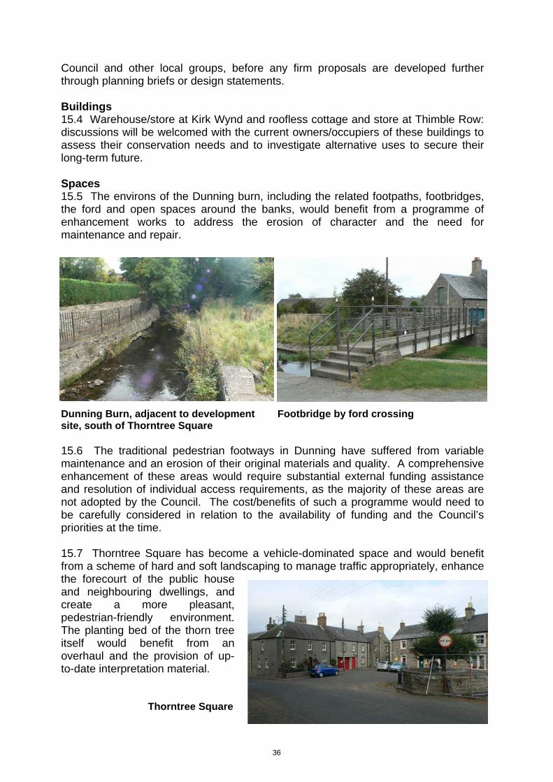
Council and other local groups, before any firm proposals are developed further through planning briefs or design statements. Buildings 15.4 Warehouse/store at Kirk Wynd and roofless cottage and store at Thimble Row: discussions will be welcomed with the current owners/occupiers of these buildings to assess their conservation needs and to investigate alternative uses to secure their long-term future. Spaces 15.5 The environs of the Dunning burn, including the related footpaths, footbridges, the ford and open spaces around the banks, would benefit from a programme of enhancement works to address the erosion of character and the need for maintenance and repair.
Dunning Burn, adjacent to development Footbridge by ford crossing site, south of Thorntree Square 15.6 The traditional pedestrian footways in Dunning have suffered from variable maintenance and an erosion of their original materials and quality. A comprehensive enhancement of these areas would require substantial external funding assistance and resolution of individual access requirements, as the majority of these areas are not adopted by the Council. The cost/benefits of such a programme would need to be carefully considered in relation to the availability of funding and the Council’s priorities at the time. 15.7 Thorntree Square has become a vehicle-dominated space and would benefit from a scheme of hard and soft landscaping to manage traffic appropriately, enhance the forecourt of the public house and neighbouring dwellings, and create a more pleasant, pedestrian-friendly environment. The planting bed of the thorn tree itself would benefit from an overhaul and the provision of up-to-date interpretation material. Thorntree Square
36

15.8 Area south of Thorntree Square, Muckhart Road: discussions will be welcomed with the current or future owners to assist with the enhancement of the site in conjunction with the implementation of redevelopment proposals. 15.9 The paddock to the south of Thimblerow and west of Bridgend/Newton of Pitcairns road is important in visually separating the historically separate districts of Dunning and Newton of Pitcairns. This area is excluded from the Dunning settlement boundary and any proposed development here would have to take into account the setting of the conservation area. It is recommended that this area remain as open space in order to protect the setting of the village. Shopfronts and signage 15.10 Post Office and Spar, Bridgend: guidance and assistance in rationalising and redesigning some of this signage would greatly benefit the character and quality of this part of the conservation area.
37

Map 10: Potential enhancement sites
38

APPENDICES 1) Article 4 Direction
Town & Country Planning (Scotland) Act 1997 Form of Direction by Planning Authority under Article 4(8)
Town and Country Planning (General Permitted Development) (Scotland) Order 1992
Dunning Conservation Area
The Perth & Kinross Council (Restriction of Permitted Development)
(Dunning) Direction 2010
Perth & Kinross Council in terms of article 4(1) of the Town and Country Planning (General Permitted Development) (Scotland) Order 1992 (SI 1992/223) being satisfied that it is expedient that all or any development comprising:- Class 1 - the enlargement, improvement or other alteration of a dwellinghouse; Class 3 - the provision within the curtilage of a dwellinghouse of any building or Enclosure, swimming or other pool required for a purpose incidental to the enjoyment of the dwellinghouse, or the maintenance, improvement or other alteration of such a building or enclosure; Class 6 - the installation, alteration or replacement of a microwave antenna on a dwellinghouse or within the curtilage of a dwellinghouse; Class 7 - the erection, construction, maintenance, improvement or alteration of a gate, fence, wall or other means of enclosure; Class 16 - the use of land, other than a building, as a caravan site; Class 27 - the carrying out on land within the boundaries of a private road or private way of works required for the maintenance or improvement of the road or way; Class 30 - the erection or construction and the maintenance, improvement or other alteration by a local authority; Class 38 - water undertakings; Class 39 - public gas transporters; Class 40 - electricity undertakings; Class 41 - tramway or road transport undertakings: Class 43 - universal service providers; and, Class 43A - sewerage undertakings; should not be carried out within the Conservation Area of Dunning (area of land as described in the Schedule hereto) unless permission is granted on an application in that behalf, hereby directs that the permission granted by article 3 in respect of:-
39

Classes 1, 3, 6, 7, 16, 27, 30, 38, 39, 40, 41, 43 and 43A, as described above, shall not apply This direction may be cited as the Perth & Kinross Council (Restriction of Permitted Development) (Dunning) Direction 2010. Signature ………………………….. Designation ……………………….. Corporate Services - Legal Perth and Kinross Council 2 High Street Perth PH1 5PH SCHEDULE The area of land outlined in black on the plan annexed and executed as relative hereto, in the district of Perth & Kinross Council. Note: The plan annexed to the Direction should be executed in the same way as the Direction and duly docquetted with reference thereto.
40

2) Classes of advertisements proposed for advertisement control under Regulation 11
Description of Advertisement
Class II (3): Advertisements relating to any institution of a religious, educational, cultural, recreational or medical or similar character to any hotel, inn or public house or hostel, situated on the land on which any such advertisement is displayed. Class III (3): Advertisements relating to the carrying out of building or similar work on the land on which they are displayed, not being land which is normally used, whether at regular intervals or otherwise for the purpose of carrying out such work. Class IV (1) Advertisements displayed on business premises wholly with reference to all of the following matters; the business or other activity carried on, the goods sold or services provided, and the name and qualification of the person carrying on such business or activity or manufacturing or supplying such goods or services on those premises.
Class IV (2) Advertisement displayed on any forecourt of business premises wholly with reference to all or any of the matters specified in Class IV (1).
41

Sources Gifford, John, The Buildings of Scotland, Perth and Kinross, Yale UP, 2007 Haynes, Nick, Perth & Kinross, An Illustrated Architectural Guide, Rutland Press, 2000 Perth and Kinross Heritage Trust/Dunning Parish Historical Society booklet, Historic Dunning, A Perthshire Village, 2005 Dunning Parish Historical Society website, www.dunning.uk.net
42

43