duluth superior harbor - national oceanic and atmospheric
TRANSCRIPT

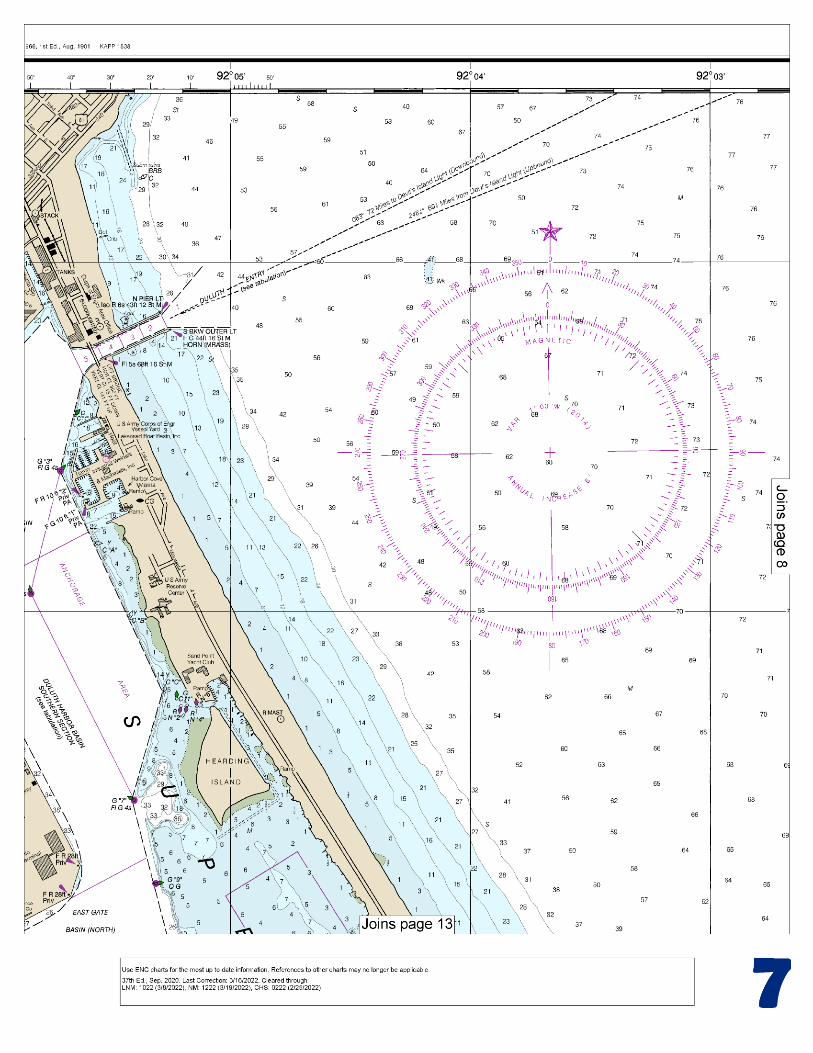
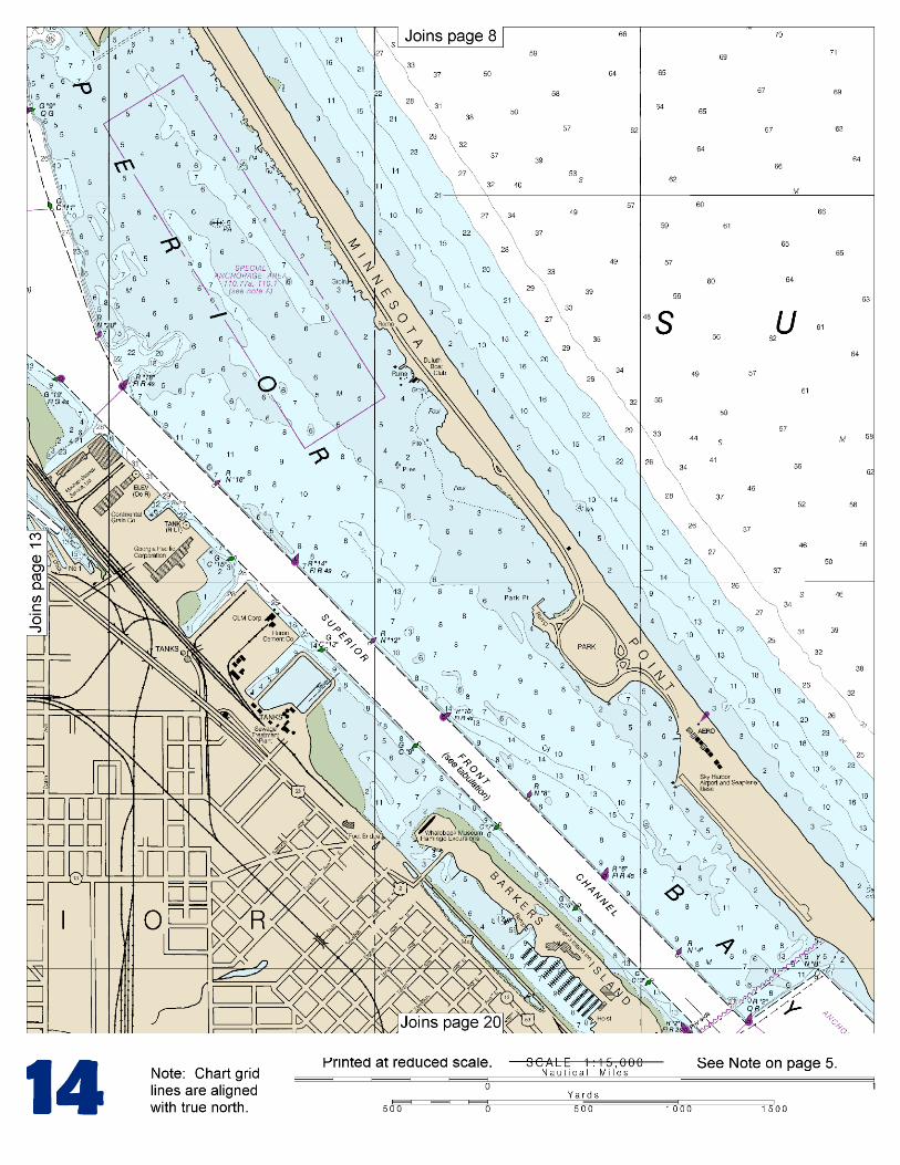
BookletChart™ Duluth – Superior Harbor NOAA Chart 14975
A reduced-scale NOAA nautical chart for small boaters When possible, use the full-size NOAA chart for navigation.
Included Area

2
Published by the National Oceanic and Atmospheric Administration
National Ocean Service Office of Coast Survey
www.NauticalCharts.NOAA.gov 888-990-NOAA
What are Nautical Charts?
Nautical charts are a fundamental tool of marine navigation. They show water depths, obstructions, buoys, other aids to navigation, and much more. The information is shown in a way that promotes safe and efficient navigation. Chart carriage is mandatory on the commercial ships that carry America’s commerce. They are also used on every Navy and Coast Guard ship, fishing and passenger vessels, and are widely carried by recreational boaters.
What is a BookletChart?
This BookletChart is made to help recreational boaters locate themselves on the water. It has been reduced in scale for convenience, but otherwise contains all the information of the full-scale nautical chart. The bar scales have also been reduced, and are accurate when used to measure distances in this BookletChart. See the Note at the bottom of page 5 for the reduction in scale applied to this chart.
Whenever possible, use the official, full scale NOAA nautical chart for navigation. Nautical chart sales agents are listed on the Internet at http://www.NauticalCharts.NOAA.gov.
This BookletChart does NOT fulfill chart carriage requirements for regulated commercial vessels under Titles 33 and 44 of the Code of Federal Regulations.
Notice to Mariners Correction Status
This BookletChart has been updated for chart corrections published in the U.S. Coast Guard Local Notice to Mariners, the National Geospatial Intelligence Agency Weekly Notice to Mariners, and, where applicable, the Canadian Coast Guard Notice to Mariners. Additional chart corrections have been made by NOAA in advance of their publication in a Notice to Mariners. The last Notices to Mariners applied to this chart are listed in the Note at the bottom of page 7. Coast Pilot excerpts are not being corrected.
For latest Coast Pilot excerpt visit the Office of Coast Survey website at http://www.nauticalcharts.noaa.gov/nsd/searchbychart.php?chart=14975
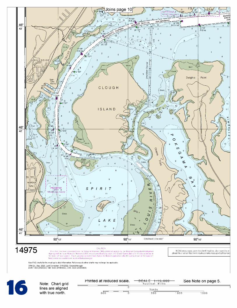
(Selected Excerpts from Coast Pilot). Duluth-Superior Harbor is at the W end of Lake Superior. The harbor has been developed along Superior Bay and the lower part of the St. Louis River, which forms part of the State boundary between Wisconsin and Minnesota. It is one of the most important harbors on the Great Lakes because of its range of facilities and the magnitude of its commerce. The cities Superior, Wis., and, Minn., front the S and N sides of the harbor, respectively.
Superior Entry South Breakwater Light (46°42.6'N., 92°00.4'W.), 70 feet above the water, is shown from a white cylindrical tower on a white
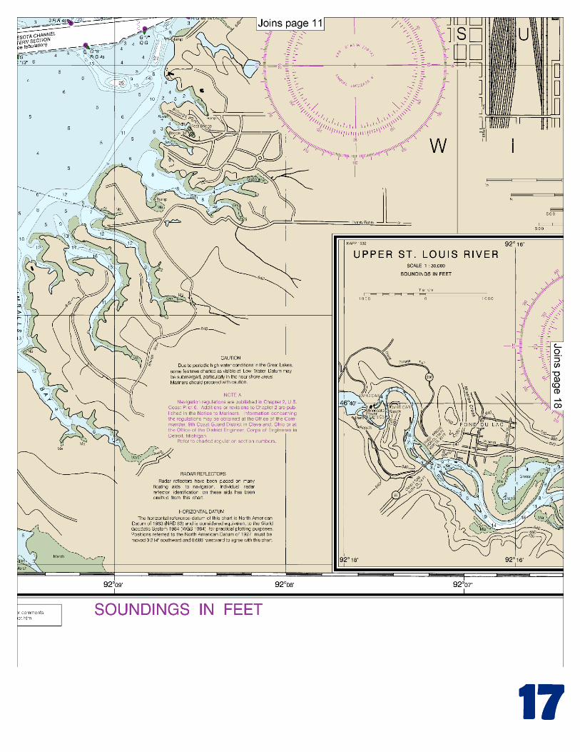
building on the outer end of the breakwater on the S side of the S harbor entrance. A fog signal is at the light. Duluth Harbor South Breakwater Inner Light (46°46.7'N., 92°05.5'W.), 68 feet above the water, is shown from a black cylindrical tower with a white lantern room on the S side of the N harbor entrance. Superior Bay, about 6.5 miles long and 0.5 to 1 mile wide, is a natural shallow basin separated from Lake Superior by Minnesota Point, a low, narrow strip of sand and gravel. The bay is entered from Lake Superior through Duluth Entry at the N end of Minnesota Point and through Superior Entry at the S end of the point. Between the entrances, the lakeside of Minnesota Point has deep water within 0.4 mile. A submerged breakwater extends 1,000 feet S from shore in the small bight on the N side of Duluth Entry. A buoy marks the outer end of the ruins. Several cribs are on the W side of the bight. Allouez Bay is a very shallow bay that extends SE from Superior Bay S of Superior Entry and is enclosed on the E by Wisconsin Point. Nemadji River flows from Moosecamp Lake, about 40 miles above Superior, and empties into the W side of Superior Bay opposite Superior Entry. In 1982, a depth of 4½ feet was available for 5 miles above the mouth, thence in 1976, 2 feet above that point. St. Louis River flows into the W side of Superior Bay near its N end through a narrow gap between Rices Point on the N and Connors Point on the S St. Louis Bay is a widening in the river that extends from these points to Grassy Point, 3 miles SW. Howards Bay is a narrow inlet that leads SE from St. Louis Bay for 1 mile on the W side of Connors Point. Above Grassy Point, the river again widens, covers a large shallow area, and is divided by points and islands into a number of irregularly shaped bays and inlets. Clough Island, the largest in this area, encloses the N side of Spirit Spirit Lake, a section of the river mostly isolated by islands. Minnesota Channel, the dredged channel through this area, follows the Minnesota shore for 2 miles W from Grassy Point, thence turns S between Clough Island and the mainland, and thence turns E on the S side of Clough Island to the head of the dredged channel. Above Clough Island, the natural channel of the St. Louis River is navigable for varying drafts to just above du Lac, about 8 miles above Clough Island. The river is practically a level pool at ordinary stages to the foot of the rapids just above Fond du Lac. The channel in this reach is well marked by buoys, and vessels of suitable draft should have no difficulty navigating it. A wreck, covered about 2½ feet, is on the E side of the river at Oliver, about 3.8 miles above Clough Island. Coast Guard Duluth Coast Guard Station is on the W side of Minnesota Point, 0.5 mile S of Duluth Ship Canal. A Coast Guard Marine Safety Office is in Duluth. (See appendix for address.) Harbor regulations Two companies in the harbor have docking facilities for making repairs to deep-draft vessels, and three other companies have shops and make repairs to vessels at their berths. Fraser Shipyard, Inc., at the head of Caution.–A sunken wreck is 0.9 mile ENE of the entrance to Duluth Ship Canal. The area immediately ESE of Duluth Harbor Basin Traffic Lighted Buoy is subject to shoaling. Local magnetic disturbance.–Differences from normal variation of 001°E to 005°E have been observed in the lake about 10 miles from Duluth. Harbor regulations.–A speed limit of 8 mph (7 knots) is enforced in Duluth-Superior Harbor.
U.S. Coast Guard Rescue Coordination Center 24 hour Regional Contact for Emergencies
RCC Cleveland Commander
9th CG District (216) 902-6117 Cleveland, OH
G
Lateral System As Seen Entering From Seaward on navigable waters except Western Rivers
PORT SIDE ODD NUMBERED AIDS
GREEN LIGHT ONLY FLASHING (2)
PREFERRED CHANNEL NO NUMBERS – MAY BE LETTERED
PREFERRED CHANNEL TO STARBOARD
TOPMOST BAND GREEN
PREFERRED CHANNEL NO NUMBERS – MAY BE LETTERED
PREFERRED CHANNEL TO PORT
TOPMOST BAND RED
STARBOARD SIDE EVEN NUMBERED AIDS
RED LIGHT ONLY FLASHING (2)
FLASHING FLASHING OCCULTING GREEN LIGHT ONLY RED LIGHT ONLY OCCULTING QUICK FLASHING QUICK FLASHING ISO COMPOSITE GROUP FLASHING (2+1) COMPOSITE GROUP FLASHING (2+1) ISO
"1"
Fl G 6s
G "9"
Fl G 4s
GR "A"
Fl (2+1) G 6s
RG "B"
Fl (2+1) R 6s
"2"
Fl R 6s
8
R "8" Fl R 4s
LIGHT
G
C "1"
LIGHTED BUOY
G "5"
GR "U"
GR
C "S"
RG
N "C"
RG "G"
LIGHT
6
R
N "6"
LIGHTED BUOY
R
"2"
CAN DAYBEACON
CAN NUN NUN
DAYBEACON
For more information on aids to navigation, including those on Western Rivers, please consult the latest USCG Light List for your area. These volumes are available online at http://www.navcen.uscg.gov
2
2
C U 5
1


VHF Marine Radio channels for use on the waterways:Channel 6 – Inter-ship safety communications.Channel 9 – Communications between boats and ship-to-coast.Channel 13 – Navigation purposes at bridges, locks, and harbors.Channel 16 – Emergency, distress and safety calls to Coast Guard and others, and to initiate calls to other
vessels. Contact the other vessel, agree to another channel, and then switch.Channel 22A – Calls between the Coast Guard and the public. Severe weather warnings, hazards to navigation and safety warnings are broadcast here.Channels 68, 69, 71, 72 and 78A – Recreational boat channels.
Getting and Giving Help — Signal other boaters using visual distress signals (flares, orange flag, lights, arm signals); whistles; horns; and on your VHF radio. You are required by law to help boaters in trouble. Respond to distress signals, but do not endanger yourself.
EMERGENCY INFORMATION
Distress Call Procedures
• Make sure radio is on.• Select Channel 16.• Press/Hold the transmit button.• Clearly say: “MAYDAY, MAYDAY, MAYDAY.”• Also give: Vessel Name and/or Description;Position and/or Location; Nature of Emergency; Number of People on Board.• Release transmit button.• Wait for 10 seconds — If no responseRepeat MAYDAY call.
HAVE ALL PERSONS PUT ON LIFE JACKETS!
This Booklet chart has been designed for duplex printing (printed on front and back of one sheet). If a duplex option is not available on your printer, you may print each sheet and arrange them back-to-back to allow for the proper layout when viewing.
QR
Quick ReferencesNautical chart related products and information - http://www.nauticalcharts.noaa.gov
Interactive chart catalog - http://www.charts.noaa.gov/InteractiveCatalog/nrnc.shtmlReport a chart discrepancy - http://ocsdata.ncd.noaa.gov/idrs/discrepancy.aspx
Chart and chart related inquiries and comments - http://ocsdata.ncd.noaa.gov/idrs/inquiry.aspx?frompage=ContactUs
Chart updates (LNM and NM corrections) - http://www.nauticalcharts.noaa.gov/mcd/updates/LNM_NM.html
Coast Pilot online - http://www.nauticalcharts.noaa.gov/nsd/cpdownload.htm
Tides and Currents - http://tidesandcurrents.noaa.gov
Marine Forecasts - http://www.nws.noaa.gov/om/marine/home.htm
National Data Buoy Center - http://www.ndbc.noaa.gov/
NowCoast web portal for coastal conditions - http://www.nowcoast.noaa.gov/
National Weather Service - http://www.weather.gov/
National Hurrican Center - http://www.nhc.noaa.gov/
Pacific Tsunami Warning Center - http://ptwc.weather.gov/
Contact Us - http://www.nauticalcharts.noaa.gov/staff/contact.htm
NOAA’s Office of Coast Survey The Nation’s Chartmaker
For the latest news from Coast Survey, follow @NOAAcharts
NOAA Weather Radio All Hazards (NWR) is a nationwide network of radio stations broadcasting continuous weather information directly from the nearest National Weather Service office. NWR broadcasts official Weather Service warnings, watches, forecasts and other hazard information 24 hours a day, 7 days a week. http://www.nws.noaa.gov/nwr/