drake passage and bransfield strait – new geophysical data ... · bransfield strait – new...
TRANSCRIPT
U.S. Geological Survey and The National Academies; USGS OF-2007-1047, Extended Abstract 028
Drake Passage and Bransfield Strait – new geophysical data and modelling of the crustal structure S.P. Levashov.1 N.A. Yakymchuk,1 I.N. Korchagin,2 V.G. Bachmutov,2 V.D. Solovyov,2 and D.N. Bozhezha3
1Institute of the applied problems of Ecology, Geophysics and Geochemistry, Kyiv, Ukraine ([email protected]) 2Institute of Geophysics of National Academy of Science of Ukraine, Kyiv( [email protected]) 3Management and Marketing Center of Institute of Geological Science of NAS Ukraine, Kyiv, ([email protected])
Summary The 2004 (9th) and 2006 (11th) Ukrainian Antarctic expeditions acquired new geoelectrical data (‘short-impulse electromagnetic field formation’ – FSPEF, and ‘vertical electric-resonance sounding’ – VERS) along profiles across Drake Passage and along Bransfield Strait, Antarctic Peninsula, with the aim of studying the crustal structure of these features down to depths of >30 km. Beneath the Drake Passage, Moho is interpreted at extremely shallow depths of 8–12 km; the origin of a deeper anomalous layer at 14–20 km is unknown at this stage. Both Moho and the deeper layer show strong relief in the vicinity of the Shackleton Fracture Zone. Moho in the Bransfield Strait profile is interpreted at depths of 12–28 km, while the lower crustal layers and crust–mantle transition zone show radical variations in depth and thickness. These variations likely reflect the complex geological history and the current tectonic setting as an incipient oceanic back-arc basin.
Citation: Levashov, S.P., Yakymchuk, N.A., Korchagin, I.N., Bachmutov, V.G., Solovyov, V.D., and Bozhezha, D.N. (2007), Drake Passage and Bransfield Strait – new geophysical data and modelling of the crustal structure, in Antarctica: A Keystone in a Changing World – Online Proceedings of the 10th ISAES X, edited by A. K. Cooper and C. R. Raymond et al., USGS Open-File Report 2007-1047, Extended Abstract 028, 4 p.
Introduction Crustal heterogeneities and fracture zones can sometimes be clearly seen in geoelectrical images. The field methods
employed in this study were based: (i) on the use of applied electromagnetic fields which were pulsed, (i.e. non-stationary); and (ii) on measurements of naturally-occuring "quasi-stationary" Earth electric fields; and the spectral characteristics of the latter in the vicinity of investigated objects. More specifically, the field procedures of this study combined the methods of "short-impulse electromagnetic field formation" (FSPEF) and "vertical electric-resonance sounding" (VERS).
The FSPEF method is based on the use of small ferrite dipole antennas to transmit and receive short-impulse electromagnetic fields. This method uses short but high-power electric pulses. Compared with earlier techniques, this method has the benefits of increased field efficiency and productivity. The VERS method is based on processes which polarize naturally-occuring electric fields at the surface of Earth. The polarised fields are analysed for their spectral characteristics. The method makes possible the efficient and accurate determination of a stratigraphic model beneath a sounding site.
These techniques were applied during the 2004 (9th) and 2006 (11th) Ukrainian Antarctic expeditions. Marine observations were carried out from the vessels Ushuaya (2004) and Humboldt (2006) using compact, computerized equipment. The portable measuring equipment “GEMA” (Geo-Electromagnetic Application) was an important element of this technology. GEMA was connected with a GPS-receiver and a laptop computer using special program interfaces. This equipment allows investigations to be carried out over large areas in short time-frames and at minimal expense (Levashov et al., 2003; Levashov et al., 2006).
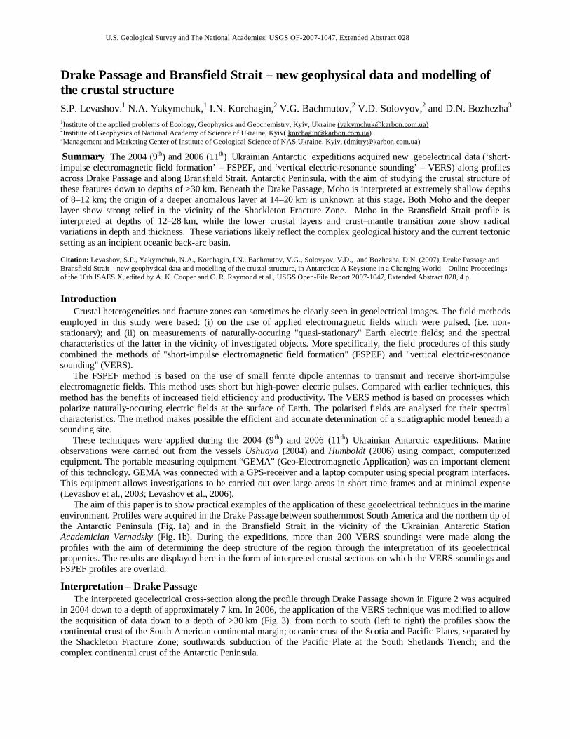
The aim of this paper is to show practical examples of the application of these geoelectrical techniques in the marine environment. Profiles were acquired in the Drake Passage between southernmost South America and the northern tip of the Antarctic Peninsula (Fig. 1a) and in the Bransfield Strait in the vicinity of the Ukrainian Antarctic Station Academician Vernadsky (Fig. 1b). During the expeditions, more than 200 VERS soundings were made along the profiles with the aim of determining the deep structure of the region through the interpretation of its geoelectrical properties. The results are displayed here in the form of interpreted crustal sections on which the VERS soundings and FSPEF profiles are overlaid.
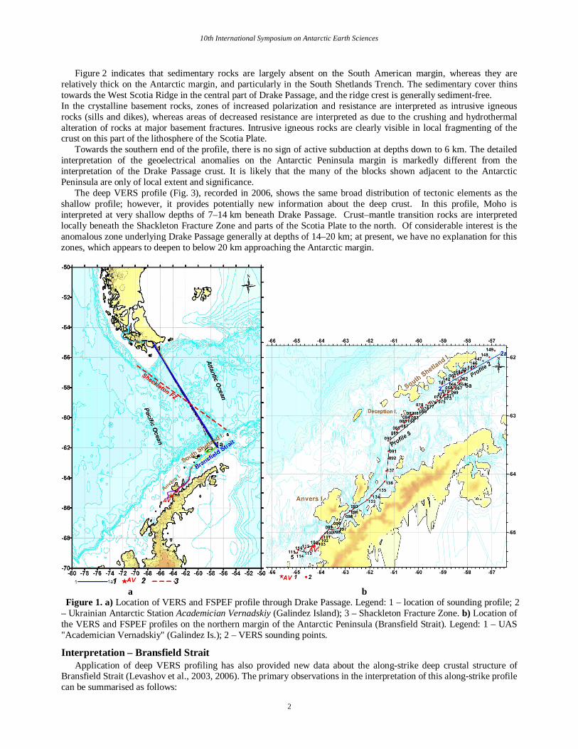
Interpretation – Drake Passage The interpreted geoelectrical cross-section along the profile through Drake Passage shown in Figure 2 was acquired
in 2004 down to a depth of approximately 7 km. In 2006, the application of the VERS technique was modified to allow the acquisition of data down to a depth of >30 km (Fig. 3). from north to south (left to right) the profiles show the continental crust of the South American continental margin; oceanic crust of the Scotia and Pacific Plates, separated by the Shackleton Fracture Zone; southwards subduction of the Pacific Plate at the South Shetlands Trench; and the complex continental crust of the Antarctic Peninsula.
10th International Symposium on Antarctic Earth Sciences
2
Figure 2 indicates that sedimentary rocks are largely absent on the South American margin, whereas they are relatively thick on the Antarctic margin, and particularly in the South Shetlands Trench. The sedimentary cover thins towards the West Scotia Ridge in the central part of Drake Passage, and the ridge crest is generally sediment-free. In the crystalline basement rocks, zones of increased polarization and resistance are interpreted as intrusive igneous rocks (sills and dikes), whereas areas of decreased resistance are interpreted as due to the crushing and hydrothermal alteration of rocks at major basement fractures. Intrusive igneous rocks are clearly visible in local fragmenting of the crust on this part of the lithosphere of the Scotia Plate.
Towards the southern end of the profile, there is no sign of active subduction at depths down to 6 km. The detailed interpretation of the geoelectrical anomalies on the Antarctic Peninsula margin is markedly different from the interpretation of the Drake Passage crust. It is likely that the many of the blocks shown adjacent to the Antarctic Peninsula are only of local extent and significance.
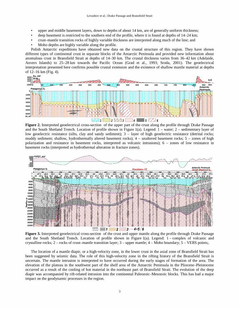
The deep VERS profile (Fig. 3), recorded in 2006, shows the same broad distribution of tectonic elements as the shallow profile; however, it provides potentially new information about the deep crust. In this profile, Moho is interpreted at very shallow depths of 7–14 km beneath Drake Passage. Crust–mantle transition rocks are interpreted locally beneath the Shackleton Fracture Zone and parts of the Scotia Plate to the north. Of considerable interest is the anomalous zone underlying Drake Passage generally at depths of 14–20 km; at present, we have no explanation for this zones, which appears to deepen to below 20 km approaching the Antarctic margin.
a b Figure 1. a) Location of VERS and FSPEF profile through Drake Passage. Legend: 1 – location of sounding profile; 2 – Ukrainian Antarctic Station Academician Vernadskiy (Galindez Island); 3 – Shackleton Fracture Zone. b) Location of the VERS and FSPEF profiles on the northern margin of the Antarctic Peninsula (Bransfield Strait). Legend: 1 – UAS "Academician Vernadskiy" (Galindez Is.); 2 – VERS sounding points.
Interpretation – Bransfield Strait Application of deep VERS profiling has also provided new data about the along-strike deep crustal structure of
Bransfield Strait (Levashov et al., 2003, 2006). The primary observations in the interpretation of this along-strike profile can be summarised as follows:
Levashov et al.: Drake Passage and Bransfield Strait
3
• upper and middle basement layers, down to depths of about 14 km, are of generally uniform thickness; • deep basement is restricted to the southern end of the profile, where it is found at depths of 14–24 km; • crust–mantle transition rocks of highly variable thickness are interpreted along much of the line; and • Moho depths are highly variable along the profile. Polish Antarctic expeditions have obtained new data on the crustal structure of this region. They have shown
different types of continental crust in separate blocks of the Antarctic Peninsula and provided new information about anomalous crust in Bransfield Strait at depths of 14–30 km. The crustal thickness varies from 36–42 km (Adelaide, Anvers Islands) to 25–28 km towards the Pacific Ocean (Grad et al., 1993; Sroda, 2001). The geoelectrical interpretation presented here confirms possible crustal extension and the existence of shallow mantle material at depths of 12–16 km (Fig. 4).
0 50 100 150 200 250 300 350 400 450 500 550 600 650 700 750 800 850 900-20000
200040006000
6000
5000
4000
3000
2000
1000
0
N-W S-E
Patagonya Is.AntarcticPeninsula
Ez, mV
H, m
km
1 2 3 4 5 6 Figure 2. Interpreted geoelectrical cross-section of the upper part of the crust along the profile through Drake Passage and the South Shetland Trench. Location of profile shown in Figure 1(a). Legend: 1 – water; 2 – sedimentary layer of low geoelectric resistance (silts, clay and sandy sediment); 3 – layer of high geoelectric resistance (detrital rocks; muddy sediment; shallow, hydrothermally altered basement rocks); 4 – unaltered basement rocks; 5 – zones of high polarization and resistance in basement rocks, interpreted as volcanic intrusions); 6 – zones of low resistance in basement rocks (interpreted as hydrothermal alteration in fracture zones).
Figure 3. Interpreted geoelectrical cross-section of the crust and upper mantle along the profile through Drake Passage and the South Shetland Trench. Location of profile shown in Figure 1(a). Legend: 1 – complex of volcanic and crystalline rocks; 2 – rocks of crust–mantle transition layer; 3 – upper mantle; 4 – Moho boundary; 5 – VERS points;.
The location of a mantle diapir, or a high-velocity zone, in the lower crust in the axial zone of Bransfield Strait has
been suggested by seismic data. The role of this high-velocity zone in the rifting history of the Bransfield Strait is uncertain. The mantle intrusion is interpreted to have occurred during the early stages of formation of the area. The elevation of the plateau in the southwest part of the shelf area of the Antarctic Peninsula in the Pliocene–Pleistocene occurred as a result of the cooling of hot material in the northeast part of Bransfield Strait. The evolution of the deep diapir was accompanied by rift-related intrusion into the continental Paleozoic–Mesozoic blocks. This has had a major impact on the geodynamic processes in the region.

10th International Symposium on Antarctic Earth Sciences
4
The active rift in the Bransfield Strait is a component of the regional rift zone that extends from Deception Island in the west to the South Sandwich Island arc to the east. At the present time, the further rifting of Bransfield Strait is developing to the southwest.
Figure 4. Schematic model of the deep crustal structure along profile 4 in Bransfield Strait. Location of the profile shown in Figure 1(b). 1 – complex of volcanic and crystalline rocks; 2 – rocks of crust–mantle transition; 3 – rocks of the upper mantle; 4 – Moho boundary; 5 – VERS points; 6 – tectonic fractures. Summary
The electromagnetic experiments conducted by the Ukrainian Antarctic expeditions in 2004 and 2006 yielded a new dataset containing potentially valuable information about the internal crustal structure of Drake Passage and Bransfield Strait. New estimates of the depth of the Moho discontinuity in these areas were obtained.
The new geophysical data allow investigation of the deep crustal structure in a region where possible mantle diapirs have been emplaced into the pre-rift continental complexes of Bransfield Strait. The central part of Bransfield Strait, in its current state of geodynamic evolution, is very similar to other extensional areas in terms of its tectonic displacements and faulting. Therefore this region is interesting not only from the viewpoint of studying processes of multiphase expansion in Mesozoic, but also as an area of young (2.5–4.0 Ma) tectono-geodynamic processes accompanied by the formation of multiple volcanic uplifts and ridges composed of different igneous and volcanic rocks. We also observe that the location of submarine volcanic structures in Bransfield Strait appears to be given by high gradient zones in the FSPEF data where its sign changes. Geoelectrical data reflect complicated structural and tectonic geology, resulting from marked changes in the physical properties of the Earth’s. Newly interpreted values of the depth to Moho confirm the tectonic view of Bransfield Strait as a modern rift basin with a distinctive sediment fill and anomalous underlying crust. Acknowledgments. The authors are grateful to Howard Stagg for his co-editing of our extended abstract and helping us to improve English in this text.
References Grad, M., A. Guterch and T. Janik (1993), Seismic structure of the lithosphere across the zone of subducted Drake Plate under the Antarctic Plate,
West Antarctic, Geophys. J. Int.l, 11(5), 568–600. Levashov, S. P., M. A. Yakymchuk, I. N. Korchagin, Ju. M. Pyschaniy and Ju. M. Yakymchuk (2003), Electric-resonance sounding method and its
application for the ecological, geological-geophysical and engineering-geological investigations, in Abstracts, 66th EAGE Conference and Technical Exhibition, Paris, France, 7–10 June 2003.
Levashov, S. P., Ju. V. Kozlenko, I. N. Korchagin, V. D. Solovyov., N. A. Yakymchuk and Ju. N. Yakymchuk (2006), Crustal inhomogeneities of Drake Passage lithosphere structures, in Abstracts, Geosciences – To Discover and Develop, International Conference and Exhibition, 15-18 October 2006, Saint Petersburg, Russia.
Sroda P. (2001), Polish Polar Research,.22 (2), 129–146.