draft—archaeological inventory for the quinault national
TRANSCRIPT

DRAFT—Archaeological Inventory for the
Quinault National Fish Hatchery Exclusion Barrier,
Grays Harbor County, Washington
Submitted to: McMillen Jacobs Associates
Submitted by: Historical Research Associates, Inc.
Jordan Pickrell, PhD, RPA James Grant, MA Sylvia Tarman, BA Adam Fruge, BA
Seattle, Washington December 2015

DRAFT—Archaeological Inventory for the Quinault National Fish Hatchery Exclusion Barrier, Grays Harbor County, Washington
This report was prepared by HRA Research Archaeologist Jordan Pickrell, PhD, RPA, who meets the Secretary of
the Interior’s professional qualifications standards for archaeology. Information concerning Tribal Trust Assets was
prepared by James Grant, MA, who meets the Secretary of the Interior’s professional qualifications standards for
history and regularly works on projects concerning tribal trust issues. This report is intended for the exclusive use of the
Client and its representatives. It contains professional conclusions and recommendations concerning the potential for
project-related impacts to archaeological resources based on the results of HRA’s investigation. It should not be
considered to constitute project clearance with regard to the treatment of cultural resources or permission to proceed with
the project described in lieu of review by the appropriate reviewing or permitting agency. This report should be submitted
to the appropriate state and local review agencies for their comments prior to the commencement of the project.

DRAFT—Archaeological Inventory for the Quinault National Fish Hatchery Exclusion Barrier, Grays Harbor County, Washington
i
Executive Summary
The U.S. Fish and Wildlife Service (USFWS) is overseeing the construction of a new fish exclusion
barrier at Quinault National Fish Hatchery (Project) in Grays Harbor County, Washington. The
Project will “maintain the functionality of the Quinault National Fish Hatchery” (QNFH) by
replacing the existing weir with a velocity barrier (consisting of an Obermeyer Weir gate system),
replacing the existing electric weir control building, , modifying riprap and an access road, and
adding a fish bypass ladder. Additionally, the Project includes routine maintenance activities
consisting of cleaning water intakes, and removing woody debris and gravel buildup around the weir,
and use of a construction staging area (Raymond 2015:1). The Project is located in Township 22
North, Range 10 West, Section 31, Willamette Meridian, USGS Stevens Creek quadrangle.
The QNFH is owned and managed by the USFWS, which determined that the Project is a federal
undertaking. Therefore, the Project must comply with the requirements of Section 106 of the
National Historic Preservation Act. The USFWS notified the Quinault Indian Nation (QIN) of the
Project and consulted with the Tribe while defining the Area of Potential Effects (APE). The APE
consists of the footprint of all ground disturbing activities, areas of new inundation along Cook
Creek, and a temporary staging area. In total, the APE covers 6.9 acres.
In October 2015, McMillen Jacobs Associates contracted with Historical Research Associates, Inc.
(HRA), to conduct an archaeological inventory to determine the presence of cultural resources
within the APE. A review of available historic and archaeological literature indicated a very high risk
of cultural resources occurring within the APE. HRA archaeologists conducted an archaeological
inventory, consisting of surface and subsurface survey, from November 4–6, 2015. No precontact or
historic-period cultural resources were identified during the inventory.
Based on the results of the archaeological inventory, HRA recommends that no further
archaeological studies are necessary for the Project. However, if the Project undergoes substantial
design changes, additional archaeological work may be necessary.

ii DRAFT—Archaeological Inventory for the Quinault National Fish Hatchery Exclusion Barrier, Grays Harbor County, Washington
Table of Contents
EXECUTIVE SUMMARY I
1. INTRODUCTION AND PROJECT DESCRIPTION 1
1.1 PROJECT DESCRIPTION 1
1.2 AREA OF POTENTIAL EFFECTS 3
1.3 REGULATORY CONTEXT 3
2. INDIAN TRUST ASSETS 5
3. ARCHIVAL RESEARCH 7
3.1 PREVIOUS CULTURAL RESOURCE INVESTIGATIONS 7
3.2 PREVIOUSLY RECORDED ARCHAEOLOGICAL SITES 8
3.3 CEMETERIES 8
3.4 HISTORIC MAP RESEARCH 9
3.5 ETHNOGRAPHIC PLACE NAMES 9
3.6 DAHP PREDICTIVE MODEL 9
4. ENVIRONMENTAL CONTEXT 10
4.1 TOPOGRAPHY AND GEOLOGY 10
4.2 CLIMATE AND VEGETATION 10
4.3 FAUNA 11
5. CULTURAL CONTEXT 13
5.1 PREHISTORIC BACKGROUND 13
5.2 ETHNOGRAPHIC BACKGROUND 13
5.3 HISTORIC BACKGROUND 15
6. EXPECTATIONS FOR PRECONTACT OR HISTORIC CULTURAL RESOURCES 17
7. FIELD STRATEGY AND METHODS 18
7.1 ARCHAEOLOGICAL INVENTORY 18
7.1.1 PEDESTRIAN SURVEY 18 7.1.2 UTILITY LOCATES 18 7.1.3 SUBSURFACE SURVEY 18
8. ARCHAEOLOGICAL INVENTORY RESULTS 20
8.1 PEDESTRIAN SURVEY 20

DRAFT—Archaeological Inventory for the Quinault National Fish Hatchery Exclusion Barrier, Grays Harbor County, Washington
iii
8.2 SUBSURFACE SURVEY 20
9. SUMMARY AND RECOMMENDATIONS 28
9.1 INADVERTENT DISCOVERY OF CULTURAL RESOURCES 28
9.2 INADVERTENT DISCOVERY OF HUMAN REMAINS 28
10. REFERENCES CITED 30
APPENDIX A. SHOVEL PROBE TABLE 35
APPENDIX B. INADVERTENT DISCOVERY PLAN 43
APPENDIX C. INADVERTENT DISCOVERY CONTACT INFORMATION 53
APPENDIX D. TRIBAL CONSULTATION 55
List of Figures Figure 1-1. Location of the APE and vicinity. 2 Figure 1-2. Aerial photograph of the APE. 4 Figure 8-1. Pedestrian survey map. 21 Figure 8-2. Vegetation along south bank of Cook Creek (view southeast). 22 Figure 8-3. Chain link safety fence on south bank of Cook River. Note disturbed, mounded area inside the
fence (view northwest). 22 Figure 8-4. Temporary staging area (view southwest). 23 Figure 8-5. Subsurface survey results map. 24 Figure 8-6. Erosion control on north bank of Cook Creek (view north). 25 Figure 8-7. Electric weir control building. Note impervious surface in foreground and infrastructure around
the building (view west). 25 Figure 8-8. SP 14 extent of excavation. 26 Figure 8-9. SP 9 extent of excavation. Note water table at 50 cmbgs. 27 Figure B-1. Shell midden. 46 Figure B-2. Example of stone tools. 47 Figure B-3. Example of stone flake and tools. 48 Figure B-4. Example of historic artifacts from debris scatter. 49 Figure B-5. Example of bottles from historic debris dump. 50
List of Tables Table 3-1. Previous Cultural Resource Studies Located Within 0.5 mi of the APE. 8 Table 3-2. Previously Recorded Cultural Resources Located Within 3 mi of the APE. 8 Table A-1. Results of Shovel Test Probes in the APE. 35


DRAFT—Archaeological Inventory for the Quinault National Fish Hatchery Exclusion Barrier, Grays Harbor County, Washington
1
1. Introduction and Project Description
The U.S. Fish and Wildlife Service (USFWS) is overseeing the construction of a new fish exclusion
barrier at Quinault National Fish Hatchery (Project) in Grays Harbor County, Washington. The
Quinault National Fish Hatchery (QNFH) is owned and managed by the USFWS and is located
within the boundaries of the the Quinault Reservation. In September 2015, McMillen Jacobs
Associates contracted with Historical Research Associates, Inc. (HRA), to conduct an archaeological
inventory for the Project, located in Township 22 North, Range 10 West, Section 31, Willamette
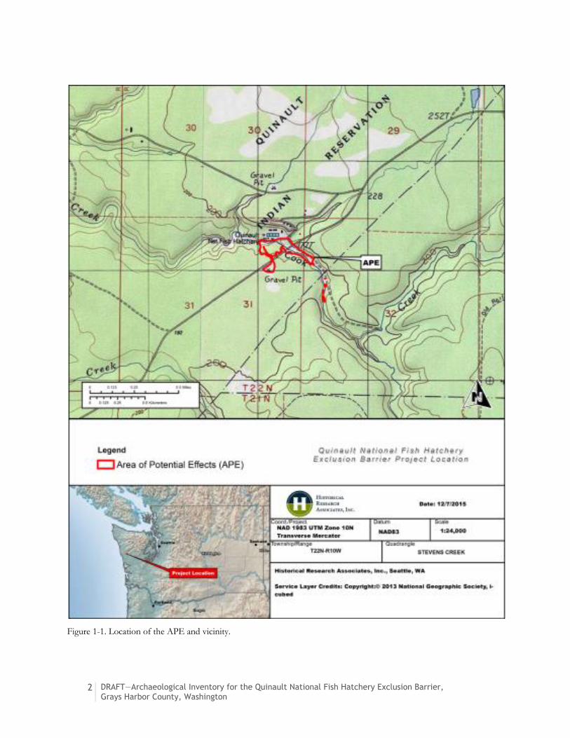
Meridian, USGS Stevens Creek quadrangle (Figure 1-1).
1.1 Project Description
“The [P]roject will maintain the functionality of the Quinault National Fish Hatchery (QNFH) by
replacing the existing weir, modifying riprap and an access road, and adding a fish bypass ladder.
Additionally, the Project includes routine maintenance activities which include cleaning of water
intakes and removal of large woody debris and gravel buildup near or on the weir” (Raymond
2015:1).
The Project “will replace the existing electric weir with a velocity barrier consisting of a concrete slab
(apron) with two 40-foot-wide Obermeyer weir panels separated by a central concrete pier. A new
fishway (fish ladder) will be constructed on the north abutment of the weir to allow fish passage”
(Raymond 2015:1). The existing control building will be replaced with a new building for the new
Obermeyer Weir’s control equiptment (Raymond 2015:Attachment A).
An existing access road between Moclips Highway and the fish exclusion barrier will be widened by
2–4 ft and two access ramps will be added to provide maintenance access to the weir. Clearing and
grubbing will occur along the Access Road and where the concrete curb will be added to the top of
the berm on the right bank. A temporary staging area that was once a gravel pit will be used during
the Project (Raymond 2015:1).
2 DRAFT—Archaeological Inventory for the Quinault National Fish Hatchery Exclusion Barrier, Grays Harbor County, Washington
Figure 1-1. Location of the APE and vicinity.

DRAFT—Archaeological Inventory for the Quinault National Fish Hatchery Exclusion Barrier, Grays Harbor County, Washington
3
1.2 Area of Potential Effects
USFWS consulted with the Quinault Indian Nation (QIN) while defining the APE (Raymond 2015;
Parks, personal communicationAppendix D). The previous project limits were the initial extent of
the APE. However, after revisions to the project the APE includes the limits of ground disturbance
as well as the limits of flooding during a typical flood event (Figure 1-2). USFWS notified the
Quinault of the project revisions and expansion of the APE on December 1, 2015 (Parks, personal
communication 2015). Only the areas of withint the previous project limits were subject to surface
and subsurface survey.
The QIN had no comment on the APE defined by the USFWS. The APE “includes the footprint of
all ground disturbing activities and areas of new inundation, specifically activity areas associated with
the weir, fishway, control building, , access road, and staging areas” (Raymond 2015; Raymond
personal communication 2015; Appendix D.
No buildings, structures, or objects (BSOs) were considered during definition of the APE because
indirect effects (e.g., visual effects) are not anticipated. The Project includes the replacement of the
existing electric weir and an associated control building. It is HRA’s understanding that the electric
weir and the control building are less than 50 years old; therefore, they do not need to be treated as
historic-period resources.
1.3 Regulatory Context
The QNFH is owned and managed by the USFWS. The USFWS determined that the Project is a
federal undertaking. As such, it requires compliance with Section 106 of the National Historic
Preservation Act (NHPA). The USFWS consulted with the QIN in defining the APE (see Section
1.2). This cultural resources inventory partially satisfies requirements of Section 106 of NHPA and
its implementing regulations (36 CFR 800). The USFWS has responsibility to consult with the
Washington State Department of Archaeology and Historic Preservation (DAHP), affected Native
American tribes, and other interested parties.

4 DRAFT—Archaeological Inventory for the Quinault National Fish Hatchery Exclusion Barrier, Grays Harbor County, Washington
Figure 1-2. Aerial photograph of the APE.

DRAFT—Archaeological Inventory for the Quinault National Fish Hatchery Exclusion Barrier, Grays Harbor County, Washington
5
2. Indian Trust Assets
Indian Trust Assets (ITAs) are the legal interests in property held in trust by the United States
government for the benefit of federally recognized Indian tribes or individual Indians. ITAs often
include real property and its associated natural resources, but can also be federally reserved hunting
and fishing rights, federally reserved water rights, in stream flows associated with trust land, water
quality, fisheries, native plants, and more (U.S. Bureau of Reclamation 1994).
In upholding its fiduciary duties, the United States, as trustee, is responsible for protecting and
maintaining rights reserved by, or granted to, Indian tribes or individual Indians by treaties, statutes,
and executive orders. It also must ensure that trust assets not be sold, leased, or otherwise
encumbered without the approval of the Secretary of the Interior (U.S. Bureau of Reclamation
1994). On August 20, 2014, Secretary of the Interior Sally Jewell issued an order upholding the
federal government’s trust responsibility to federally recognized Indian tribes and individual Indian
beneficiaries, which stated, among other things, “The trust responsibility consists of the highest
moral obligations that the United States must meet to ensure the protection of tribal and individual
Indian lands, assets, resources, and treaty and similarly recognized rights” (Jewell 2014).
The APE is located on a tributary to the Quinault River and is surrounded by the 208,000-acre
Quinault Reservation, which is home to the QIN. The reservation is bordered on the west by
24 miles of rugged Pacific coastline. The reservation extends inland to the foothills of the Olympic
Mountains and Lake Quinault, from which the Quinault River drains southwest through the
reservation to the sea. The lower Queets River runs through the northern corner of the reservation
(Tiller 1996:596–597).
QIN’s traditional territory extends far beyond the borders of today’s reservation (Hajda 1990:503–
507). In 1855, however, the Quinault and neighboring tribes agreed to the Quinault River Treaty—
also known as the Olympia Treaty (ratified in 1856 and proclaimed in 1859)—with the United States
that established the current reservation, while guaranteeing the Indians’ right to fish “at all usual and
accustomed grounds and stations” and the “privilege of hunting, gathering roots and berries, and
pasturing their horses on all open and unclaimed lands” (Kappler 1904:719–721). In 1873, President
Ulysses S. Grant expanded the Quinault Reservation by executive order to approximately
190,000 acres for the benefit of the “Quinaielt, Quillehuete, Hoh, Quite, and other fish-eating tribes
on the Pacific Coast”1 (Grant 1873; Tiller 1996:597).
1 Note inconsistencies with current spelling of tribe names.

6 DRAFT—Archaeological Inventory for the Quinault National Fish Hatchery Exclusion Barrier, Grays Harbor County, Washington
The Quinault Reservation supports viable steelhead and salmon fisheries in both the Pacific Ocean
and in area rivers. The fisheries provide a major source of employment and tribal revenue.
Associated industry, such as the tribally-owned Quinault Pride Seafood, is important to the
reservation economy (Tiller 1996:597). The QIN’s Department of Fisheries oversees certain harvest
management and other technical activities related to the QIN’s fisheries resources, and operates two
tribally-owned fish hatcheries that are located at Lake Quinault and the along the Cook Creek
(Quinault Indian Nation 2015). The QIN continues to utilize its ocean fishery in accordance with
tribal fishing rights guaranteed by the 1855 Treaty and upheld in 2015 in U.S. District Court
(Peninsula Daily News 2015).

DRAFT—Archaeological Inventory for the Quinault National Fish Hatchery Exclusion Barrier, Grays Harbor County, Washington
7
3. Archival Research
Prior to fieldwork, HRA staff reviewed DAHP’s online database, the Washington Information
System for Architectural and Archaeological Records Data (WISAARD), for cultural resource survey
reports, archaeological site records, cemetery records, and National Register of Historic Places
(NRHP)- and Washington Heritage Register (WHR)-listed resources. DAHP’s statewide predictive
model layer was also reviewed for probability estimates of precontact cultural resources, and to aid
in developing the field strategy. Background research for archaeological sites and cultural resources
studies was conducted using an approximate 1-mile (mi) research radius from the APE. There are, at
this time, no anticipated aboveground impacts associated with the Project; therefore, the search
radius for aboveground BSOs was limited to the APE and adjacent parcels for the purposes of
identifying past construction on and/or use of the landform.
HRA’s in-house library was used to obtain information on the environmental, archaeological, and
historical context of the project vicinity. HRA research staff also examined General Land Office
(GLO) plats, available online through the Bureau of Land Management (BLM) website, to locate
potential historical features. These nineteenth-century maps, arranged by township and range,
indicate locations of then extant historical structures, trails, and features. Although most of these
structures are no longer extant, the maps indicate where historic period cultural resources could be
encountered. Researchers reviewed additional historic maps (e.g., U.S. Geological Survey [USGS]
maps, Sanborn Fire Insurance maps, and County atlases) available through online resources. Based
on environmental characteristics, ethnographic data, and the distribution of previously recorded
cultural resources, HRA formulated initial expectations about the sensitivity of the APE for
containing archaeological remains.
3.1 Previous Cultural Resource Investigations
An online records search of WISAARD revealed that one cultural resources study has been
conducted within the APE. Within an approximate 1 mi radius, the review documented two
additional cultural resource studies (Table 3-1).
Archaeological research in the vicinity of the APE has fallen exclusively under the domain of
cultural resources management (CRM) work. CRM, by its nature, focuses on development-oriented
projects, and can be somewhat limited in its research scope. The studies conducted in this area are
related to roadway improvement and transmission line projects and did not result in the
identification of any cultural resources. Bourdeau (2002) conducted an assessment for a road
improvement project that lies within part of the APE. This study included background research and

8 DRAFT—Archaeological Inventory for the Quinault National Fish Hatchery Exclusion Barrier, Grays Harbor County, Washington
pedestrian survey adjacent to the road, which runs parallel to Cook Creek. No cultural resources
were identified.
Table 3-1. Previous Cultural Resource Studies Located Within 0.5 mi of the APE.
Author(s) Date Title Project Description Cultural Resources Identified
Bourdeau* 2002 Quinault Intake Road - Quinault NFH, Grays Harbor County, Washington
Background research, pedestrian survey
None
Chambers 2006 Cultural Resources Assessment for Rayonier’s Cook Creek Road Construction Project, Grays Harbor County, Washington.
Background research, pedestrian survey, shovel probes
None
Flenniken and Trautman
2011 Phase I, Moclips Highway Transmission Line Reliability Project, Grays Harbor PUD No. 1, Grays Harbor County, Washington
Background research, pedestrian survey, shovel probe
None
*survey conducted within the APE
3.2 Previously Recorded Archaeological Sites
Research revealed that no archaeological sites have been recorded within 1 mi of the APE. The
nearest recorded archaeological site, Puncheon Road (45OL93), is located approximately 3 mi east
of the APE (Table 3-2). The site consists of a few extant sections of a cedar plank puncheon road
that was constructed over a trail built in 1890 to carry mail from Quinault to Humptulips. The road
was mostly destroyed when the county road was built on the alignment, but the marshy conditions
in the Cook Creek Hill area preserved some of the puncheon road (Righter 1978).
Table 3-2. Previously Recorded Cultural Resources Located Within 3 mi of the APE.
Resource Location Site Type Landform Cultural Materials and Features
NRHP Status
Puncheon Road (45OL93)
3 mi east of APE
Historic Trails Hill Sections of cedar plank and stringer puncheon road
Not Evaluated
3.3 Cemeteries
No cemeteries have been recorded within 1 mi of the APE.

DRAFT—Archaeological Inventory for the Quinault National Fish Hatchery Exclusion Barrier, Grays Harbor County, Washington
9
3.4 Historic Map Research
The 1904 GLO survey plat for the “Quinauielt2 Indian Reservation” in Township 22 North, Range
10 West, Willamette Meridian (United States Surveyor General [USSG] 1904) notes the Cook River
but no BSOs in the vicinity of the APE. The 1921 USGS topographic map shows Cook Creek and
the Quinault Indian Reservation, as well as a beaver dam and the Chow Chow Prairie north of the
APE (USGS 1921). The 1990 USGS topographic map shows the Quinault National Fish Hatchery,
the Moclips Highway (unlabeled), the access road on the eastern edge of the APE, and the gravel pit
in the Project staging area (USGS 1990).
3.5 Ethnographic Place Names
The APE is located within the traditional territory of the QIN. Quinault villages were established
and maintained throughout the Quinault River Watershed, including locations around Lake Quinault
and along smaller streams and tributaries (such as Cook Creek) to the Quinault River. Taholah, the
principal village, is located on the coast, approximately 14 mi west of the APE (Ruby and Brown
1992). Negwe’lan (Salmon River) is the Quinault name for Cook Creek. It is also the name of a village
located at the confluence of Cook Creek and the Quinault River, approximately 3 mi west of the
APE (Flenniken and Trautman 2011).
3.6 DAHP Predictive Model
DAHP’s predictive model is based on statewide information, using large-scale factors. Information
on geology, soils, site types, and landforms, and GLO maps were used to establish or predict
probabilities for precontact cultural resources throughout the state. DAHP’s model uses five
categories for the predictions: Low Risk, Moderately Low Risk, Moderate Risk, High Risk, and Very
High Risk. According to the DAHP, the APE is located within an area with Very High Risk for
containing precontact cultural resources.
2 Note inconsistencies with current spelling of tribe name.

10 DRAFT—Archaeological Inventory for the Quinault National Fish Hatchery Exclusion Barrier, Grays Harbor County, Washington
4. Environmental Context
This chapter provides a brief overview of the local environment, including historic modification to
this landscape and natural resources. Understanding the local environment, including geology,
climate, flora, and fauna, is important for understanding how people used the landscape in the past.
Like archival research, this environmental context is necessary for developing expectations regarding
the potential for cultural resources to be encountered during the Project (see Section 6).
4.1 Topography and Geology
The APE is within the Coast Range Province of Washington, approximately 15 mi from the
Washington coast (McKee 1972:154; Roll 1974:4–5). The APE is located along Cook Creek, in the
Quinault River Watershed, southwest of the Olympic Mountain Range.
The western foothills and plains of the Coast Range include varying sedimentary contexts. The basic
geology of the region consists largely of sedimentary layers of sandstones, siltstone, and
conglomerates, formed in shallow marine and non-marine conditions prior to approximately
15 million years ago (mya). During the later Micocene (from 15 to 2 mya) and Pleistocene epoch
(after 2 mya), these layers were gradually uplifted to form the Coastal Range (Alt and Hyndman
1995:xi; McKee 1972:172). The Fraser glaciation during the Pleistocene covered the vicinity of the
APE in glacial drift, which has been cut through by creeks and rivers in the area (Alt and Hyndman
1995:277). Soils in the vicinity of the APE consist of glacial and alluvial deposits including stratified
sand, gravel, silt, and clay deposits (McKee 1972:168; Tabor and Cady 1978).
4.2 Climate and Vegetation
The climate in the region has changed dramatically in the 13,500 years since the Vashon Stade.
Immediately after glacial retreat and the uplifting of landforms around northwestern Washington,
the newly exposed glacial sediments were barren. However, between approximately 13,000 and
12,000 years ago, a much cooler and drier climate than that of the modern period supported an
ecosystem characterized by lodgepole pine (Pinus contorta), sedges (Cyperaceae sp.), sage (Artemisia sp.),
and a variety of grasses and herbs (Barnosky 1984; Barnosky et al. 1987; Brubaker 1991; Whitlock
1992). After 12,000 years ago, the climate warmed while continuing to dry, and Douglas fir
(Pseudotsuga menziesii), western hemlock (Tsuga heterophylla), and red alder (Alnus rubra) joined the
developing parkland forest on inland areas. This warm, dry period lasted from 12,000 to
approximately 7,000 years ago, with relatively high summer temperatures and more frequent summer
droughts than currently. The Douglas fir and western hemlock altered the amount of light that
breached the forest canopy, reducing foliage in the understory and opening up the forest in general.

DRAFT—Archaeological Inventory for the Quinault National Fish Hatchery Exclusion Barrier, Grays Harbor County, Washington
11
Prairies were also more common on inland terraces, largely due to drier climatic conditions
(Barnosky et al. 1987; Brubaker 1991; Whitlock 1992).
By around 6,000 years ago, the climate of the region had cooled and moistened to levels comparable
to today’s maritime regime, producing the current Picea sitchensis (sitka spruce) vegetation zone.
Studies of pollen extracted from coastal sediment samples have shown little to no climatic change
over the past 5,000 years (Hansen 1941, 1947; Heusser 1960, 1965). The Picea sitchensis zone on
upland areas is characterized by a dominant climax overstory of sitka spruce, western hemlock,
Douglas fir, western red cedar (Thuja plicata), and fir (Abies sp.). Deciduous components including
red alder (Alnus rubra) and big-leaf maple (Acer macrophyllum) represent secondary species in forested
habitats and are dominant in disturbed areas or, in the case of alder, within riparian and wetland
zones (Franklin and Dyrness 1973).
Understory vegetation on uplands typically consists of a variety of ferns including sword fern, deer
fern, and bracken fern (respectively Polystichum munitum, Blechnum spicant, and Pteridium aquilinum);
berries including red huckleberry (Vaccinium parvifolium), salmonberry (Rubus spectabilis), trailing
blackberry (Rubus ursinus), and snowberry (Symphoricarpos albus); salal; Oregon grape (Berberis nervosa);
and rose (Rosa gymnocarpa) (Franklin and Dyrness 1973:59–61). Camas (Camassia quamash) and a host
of edible tubers, berries, fruits, and nuts would have been available closer to the shoreline of the bay
and within inland prairies (Franklin and Dyrness 1973).
4.3 Fauna
Changing vegetation presented opportunities for multiple species of animals in the region
surrounding the APE. In the Late Pleistocene, as the glaciers were retreating from the area,
terrestrial fauna including mastodon (Mammut americanum), black-tailed deer (Odocoileus hemionus), and
elk (or wapati, Cervus elephus) would have browsed on grasses, shrubs, and herbs in the newly
emerging forest parkland. With fluctuating temperatures and levels of precipitation affecting the
number and types of trees providing canopy cover, and therefore the amount and kinds of
understory vegetation, the location and abundance of terrestrial animals varied over the millennia.
Before extensive Euroamerican influence in the area, larger terrestrial mammals would have included
elk, deer, black bear (Ursus americanus), coyote (Canis latrans), bobcat (Lynx rufus) and mountain lion
(cougar, Felis concolor). Smaller mammals would have included plentiful snowshoe hare (Lepus
americanus) along with raccoon (Procyon lotor), red fox (Vulpes vulpes), and porcupine (Erethizon
dorsatum) (Larrison 1967).
Estuary and river resources included waterfowl (Aix and Anas sp.), beaver (Castor canadensis), otter
(Lutra candensis), and mink or weasel (Mustela spp.). Freshwater fish would include rainbow or
steelhead trout (Oncorhynchus mykiss), cutthroat trout (Salmo clarkii), and eels (Anguillidae). Those fish
moving from fresh to saltwater and back included the euchalon (candlefish, Thaleichthys pacificus) and
perhaps most significantly, the salmon species that seasonally migrate up the local drainages, notably

12 DRAFT—Archaeological Inventory for the Quinault National Fish Hatchery Exclusion Barrier, Grays Harbor County, Washington
chum (Oncorhynchus keta) and coho (Oncorhynchus kisutch) salmon in the Grays Harbor vicinity
(Atkinson et al. 1967; Larrison 1967).
Marine resources were readily available on the nearby coast. Whales and dolphins (particularly gray
whales [Eschrichtius glaucus], killer whales [Orcinus orca], and the Pacific Harbor porpoise [Phocoena
phocoena]), northern fur seals (Callorhinus ursinus), harbor seals (Phoca vitulina), sea lions (order
Pinnipedia), and sea otter (Enhydra lutris) were available in the nearby coastal waters for meat, bones,
and skins (Roll 1974:236). Saltwater fish including herring (Clupea pallasii), halibut (Hippoglossus
stenolepis), and dogfish (Squalus acanthias) were available, in addition to the anadromous fish
mentioned above. Shellfish were important to the local diet, being as they were extremely abundant.
These included Bent-nose clam (Macoma nasuta), razor clam (Siliqua patula), horse clam (Schizothaerus
nutallii), butter clam (Saxidomus giganteus), littleneck clam (Protothaca staminea), bay mussel (Mytilus
edulis), and basket cockle (Clinocardium nuttallii) (Roll 1974).

DRAFT—Archaeological Inventory for the Quinault National Fish Hatchery Exclusion Barrier, Grays Harbor County, Washington
13
5. Cultural Context
5.1 Prehistoric Background
There is evidence that humans have been present in Washington State for at least the past
14,000 years (Jenkins et al. 2012; Waters et al. 2011). However, coastal sites dating to this period will
only be found offshore, due to the rising sea level that accompanied the end of the last ice age. For
example, off Haida Gwaii Island in British Columbia, sites have been recorded in settings similar to
the Washington coast that date to 10,700 calibrated (cal.) years before present (B.P.) (Mackie et al.
2014). Earlier sites situated alongside rivers have also likely fallen victim to erosional forces as the
river course meandered through the centuries (Storm and Capoeman 1990:46). As such, the
archaeological record of the Washington coast is limited to a large extent by conditions of
preservation and erosion. For this reason, the best known time period in the archaeological record is
the last 2,500 years (Wessen 1990). A great deal of the available information comes from the Ozette
and Minard sites, located on the coast north and south of the APE, respectively (Roll 1975; Wessen
1990). Archaeological remains recovered from Washington coastal sites indicate a broad economy
centered along the saltwater bays in the area (for instance, Grays Harbor) and featuring inland
resources. This economic pattern appears to differ from the marine focus of peoples farther to the
north. Inland archaeological sites in the vicinity of the APE are generally not well documented, but
those that have been reported generally consist of lithic scatters including cryptocrystalline silicate
(CCS) projectile points have also been recorded (Wessen 1990). Based on these observations, the
economy of the southern Washington coast may be more comparable to that of Puget Sound.
5.2 Ethnographic Background
The Native American groups that would have been present in the general vicinity of the APE prior
to European contact were ancestors of the Quinault Nation, and the Humptulips and Copalis
peoples. These groups spoke mutually-intelligible dialects of the Southern Coast Salish language
group (Hajda 1990:503). The Washington coast displays remarkable linguistic diversity (Wessen
1990:420–421).
The Quinault peoples, who seasonally used portions of the north shore of Grays Harbor,
traditionally inhabited the coast from Joe Creek to Raft River, along with the Quinault River valley.
The Copalis bands claimed territory “from Joe Creek to the mouth of Grays Harbor and a portion
of North Bay,” the largest settlement in which was “Oyehut.” The Humptulips lived along the
northern shore of Grays Harbor, east to Elliott Slough, and had several villages on the mouth and
along the course of the Humptulips River (Hajda 1990:503; Van Syckle 1982:55–57).
14 DRAFT—Archaeological Inventory for the Quinault National Fish Hatchery Exclusion Barrier, Grays Harbor County, Washington
The culture of the Northwest Coast was built around canoe transport and travel. The canoe was a
daily-used item, conveying wealth and status within the community. Different models were utilized
for ocean and river travel, and a canoe was eventually used for aboveground internment during
death rituals. Canoes were generally constructed from cedar, while the paddles were carved from
Oregon ash. Canoes opened the door to warfare, a practice common on the coast (Singh 1966;
Storm and Capoeman 1990:45, 77).
The groups along the southern Washington coast relied more heavily on anadromous fish, shellfish,
and land mammals than some of their neighbors to the north, who were renowned for their use of
sea mammals and deep-sea fish (Singh 1966:48). Sea-based resources were caught using a hook and
line for the smaller fish or composite toggling harpoons for larger mammals. Within the bay and
riverine systems, smaller fish and mammals were caught using any number of devices, including dip
and drift nets (the latter operated from canoes), weirs, harpoons, spears, clubs, and rakes (specifically
herring rakes). Arguably the most important fish was the salmon, whose plentiful runs in April
provided surplus for winter stores and for trade to groups further inland. Shellfish were dug utilizing
the ubiquitous digging stick, and those not eaten fresh were dried over a fire for storage and winter
consumption. Hunting parties traveled inland, to higher-elevation forest or prairies. Large and small
mammals and birds were taken with bow and arrow, noose, net, or pit. Any meat not eaten fresh
was processed for storage and the skins and bones and feathers were processed for tools and
personal ornamentation (Hajda 1990:505–507; Storm and Capoeman 1990:68).
There was a division of labor between men and women among the Salishan speakers. Generally
women gathered and dug plant and shellfish resources, while men hunted, fished, and peeled cedar
bark. Women typically processed (i.e., cooked, pounded) and stored plant and faunal resources,
while men twisted cedar bark into rope (Storm and Capoeman 1990:66).
The Euroamerican influence, in down-the-line trade items and disease, was felt long before most
Native groups met incoming settlers to the Pacific Northwest. By 1792, smallpox was reported on
the southern shore of the Strait of Juan de Fuca (Taylor 1963:161). In 1830, the botanist David
Douglas reported an “intermittent fever… which has depopulated the country [of the lower
Columbia River]”; this plague lasted two more years (Davies 1981:159). Populations in southwestern
Washington were severely depleted well before the formal arrival of Euroamerican settlers (Swan
1972).
In 1855, after negotiations between Washington Governor Isaac Stevens and local tribes (including
the Quinault, Chinook, Lower Chehalis, Queets, Satsop, Upper Chehalis, and Cowlitz), the Quinault
and some neighboring tribes signed the Quinault River Treaty, by which they were consigned to a
reservation on the mouth of the Quinault River. The treaty guaranteed fishing rights “at all usual and
accustomed grounds and stations” and hunting, and gathering rights on “all open and unclaimed
lands” (Kappler 1904:719–721). Native groups continued to hunt, fish, and gather, but they also
participated in the local logging, small-scale farming, and railroading economies during the historic
period (Hajda 1990:514–515).

DRAFT—Archaeological Inventory for the Quinault National Fish Hatchery Exclusion Barrier, Grays Harbor County, Washington
15
5.3 Historic Background
Euroamerican exploration of the area occurred when fur traders and explorers traveled around the
Olympic Peninsula. Spanish explorers were in the area by 1775 and the English by 1787 (Wilma
2006). On May 7, 1792, Robert Gray and his crew were the first non-indigenous group to enter
Grays Harbor. Gray’s party was met by local people in dugout canoes, thought to be Chinook, who
frequented Grays Harbor in the nineteenth century (Gunther 1972). Although Gray only spent three
days in the harbor, his crew named it after their captain. The name continued when Lt. Joseph
Whidbey, part of Captain George Vancouver’s expedition, surveyed the harbor and labeled it Gray’s
Harbor, and a Spanish crew called it Puerto de Gray during their expedition (Oldham 2003).
Vancouver’s party indicated a native village with approximately 100 inhabitants was on Grays
Harbor, near Point Hanson (Gunther 1972). With the arrival of Euroamericans, disease was spread
and epidemics, including smallpox in the 1770s, malaria in 1829, and cholera in 1836, and in 1853
smallpox again, decimated the native Chinook population, so much so that by the 1850s Chehalis
groups migrated to that territory (Wilma 2006).
The Quinault River Treaty was signed in 1855 between the Quinault, Hoh, Queets, and Quileute
tribes and the Washington Territorial Governor Isaac Stevens. The treaty ceded 1.2 million acres on
the Olympic Peninsula to the U.S. in exchange for fishing rights and a reservation. In 1873,
President Ulysses S. Grant expanded reservation lands to the present boundaries, however individual
allotments were granted to tribal members and the result was that a majority of the land passed to
non-Indians via alienation. Non-treaty tribal members of the Chinook, Chehalis, and Cowlitz groups
were also allowed to apply for allotments, and many times sold the land to timber companies (Grant
1873; Tiller 1996:597; Wilma 2006).
Euroamerican settlement began in the 1850s, with the encouragement of the Donation Land Act.
The first Euroamerican settlers in present-day Grays Harbor County were William O’Leary, and
Isaiah Scammon and his wife Lorinda. Scammon became a postmaster, judge, school administrator,
and church leader. In 1859, the first cannery was established on Grays Harbor. Fishing and canning
of such resources as salmon, razor clam, and whale meat was prevalent into the 1900s. Clam and fish
canneries were “all along the beach” (Berg 1952:80–82; Van Syckle 1982:315–318; Wilma 2006).
Flenniken and Trautman (2011) note that Euroamericans began to move north in the 1880s, settling
in areas around Cook Creek and Lake Quinault.
Between 1870 and 1900, the towns of Montesano, Aberdeen, and Hoquiam were established and
flourished with the rise of the timber industry. Additionally, railroad lines were also important to the
growth of Grays Harbor County. A line from Aberdeen to Montesano was built by local labor under
the leadership of Samuel Benn, Aberdeen’s founder, and was later incorporated as part of the
Northern Pacific line. By the turn of the century, transcontinental rail lines connected Grays Harbor
and Aberdeen to the rest of the nation. A lighthouse was built at the harbor entrance in 1898. This
would have helped improve maritime safety and continue the growth of the shipping industry in the
area. Rivalries between the communities and leadership led to a campaign to split the county, which

16 DRAFT—Archaeological Inventory for the Quinault National Fish Hatchery Exclusion Barrier, Grays Harbor County, Washington
occurred by March 1907 (Wilma 2006). The county, formerly called Chehalis, was renamed Grays
Harbor in 1915. The spelling without the apostrophe remained after this time (Oldham 2003).
A decline in the timber industry began in the 1920s, with much of the old growth trees having been
logged on private lands. Economic impacts from the Great Depression affected housing,
construction, and eventually the local sawmills. In an effort to spur the economy and to manage
forests, Weyerhaeuser opened a tree farm in Montesano in 1941, and Congress passed the Forest
Practices Act in 1946. An economic boom in Asia starting in the 1960s–1970s reinvigorated the
demand for timber in Washington. However, the recession in the early 1980s and in the 1990s the
environmental concerns about endangered species, such as the Northwest Spotted Owl, again
affected the timber industry. Limitations on logging public and private lands prompted a decline for
local timber. The decrease in the economy spurred unemployment and eventually a population
decline (Wilma 2006).
The QNFH was established in 1968 as a joint venture between the USFWS and the Quinault and
Hoh Indian Nations. It seeks to rebuild salmon and steelhead runs along the Washington coast. The
QNFH releases coho, chum, and steelhead into Cook Creek (USFWS 2008, 2014).

DRAFT—Archaeological Inventory for the Quinault National Fish Hatchery Exclusion Barrier, Grays Harbor County, Washington
17
6. Expectations for Precontact or Historic
Cultural Resources
Environmental factors (e.g., proximity to water and available food and material resources), the
DAHP predictive model, and ethnographic and historic records suggest a very high probability of
intact archaeological remains in the APE vicinity. The area was likely used as a travel corridor during
precontact and ethnographic times, with groups traveling along Cook Creek for hunting and fishing
purposes.
Many types of archaeological materials may be encountered during construction activities. These
may include, but are not limited to:
1. Precontact or ethnohistoric-period archaeological materials and features (ethnohistoric-
period materials would include artifacts or features the same as those for precontact
timeframes with the inclusion of some historic-period items).
Stone tools and flaking debris.
Organic-rich, midden sediments (may contain shell).
Antler or non-sawed bone fragments.
Charcoal concentrations, darkened earth, and fire modified rock (FMR).
2. Ethnohistoric-period or historic-period archaeological materials.
Low-fired and bisque ceramics with subdued colors, or blue/pink willow-like design;
thick-bodied pieces indicating crockery.
Non-tempered glass; violet-colored glass; stopper-topped glass jars or bottles; press-
capped (cork gasket liner) heavy-walled soda or liquor bottles (not twist-top, thin-
walled); zinc and vitreous glass-lidded glass canning jars with colored body.
Miscellaneous fragments of metal (or plated) clothing closures (hooks and eyes, and
suspender fittings, but not zippers), shell buttons, fragments of bakelite houseware,
celluloid.
Sawed animal bone and fruit pits; punch-opened and solder-sealed beverage cans;
solder-sealed food tins (not thin-walled aluminum and welded-steel cans); enameled
ironware.

18 DRAFT—Archaeological Inventory for the Quinault National Fish Hatchery Exclusion Barrier, Grays Harbor County, Washington
7. Field Strategy and Methods
7.1 Archaeological Inventory
Surface and subsurface surveys were performed across the APE in order to identify archaeological
materials and to assess the potential of the project area to contain archaeological materials.
7.1.1 Pedestrian Survey
HRA archaeologists walked parallel pedestrian transects within the APE, examining the ground for
cultural materials. Transects were spaced a maximum of 20 m apart. During the survey, the
archaeologists sought out ground exposures (e.g., ditches and cutbanks). Representative
photographs were taken during the course of the survey in order to document the landscape.
7.1.2 Utility Locates
Prior to archaeological fieldwork, HRA arranged for utility locates to meet the requirements of
Washington’s Underground Utilities regulations (RCW 19.122). These regulations require obtaining
a locate survey for any kind of excavation on public and private property that will exceed 12 inches
in depth. A locate service was contacted by HRA at least two (2) business days before fieldwork
began. HRA provided the locate service with adequate documentation in the form of maps and text
descriptions to complete the locate survey.
7.1.3 Subsurface Survey
HRA archaeologists excavated shovel probes (SPs) within the APE along both sides of Cook Creek
and the access road to the fish weir in order to assess the probability for and identify buried cultural
materials. SPs were placed at approximately 25- to 30-meter (m) intervals in areas of planned ground
disturbance. SP placement was determined by the field supervisor, based on the Project’s design
plan, topographic circumstances and other field observations.
SPs measured 35–40 centimeters (cm) in diameter. Excavated sediments were screened through
¼-inch hardware mesh. Sediments observed in each shovel probe were documented on standard
HRA shovel probe forms. Observations regarding SP soils were documented on standardized forms
and included sediment grain size, color, presence and characteristics of gravels, presence of roots,
signs of soil development, origin of soil, and evidence of disturbance. Cultural materials recovered
during SP excavation were noted and photographed using a digital camera. Excavations were
terminated upon glacial material, or upon encountering a buried obstruction (such as a large cobble
or other impediment), or when a maximum depth of 1 m below ground surface (bgs) was reached.
DRAFT—Archaeological Inventory for the Quinault National Fish Hatchery Exclusion Barrier, Grays Harbor County, Washington
19
Each SP was filled upon the completion of documentation and its location was noted using a Global
Position System (GPS) instrument.
The temporary staging area south of Moclips Highway was once used as a gravel pit and has already
been greatly disturbed. No SPs were placed within the temporary staging area.
Field work was performed prior to revisions in the project. As such, only areas of previous ground
disturbance were subject to subsurface survey. USFWS indicated that because of the limited
anticipated effects elsewhere in the APE that additional subsurface survey was not needed.

20 DRAFT—Archaeological Inventory for the Quinault National Fish Hatchery Exclusion Barrier, Grays Harbor County, Washington
8. Archaeological Inventory Results
HRA archaeologists Jordan Pickrell, Dan Focke, Ali Gulduren, and David Treichel conducted the
archaeological inventory between November 4 and 6, 2015. The inventory included surface and
subsurface survey methods across the APE.
8.1 Pedestrian Survey
HRA archaeologists walked parallel transects, spaced approximately 10 m apart, across the 6.9 acre
APE (Figure 8-1). The APE encompasses the shoreline along Cook Creek, which is “comprised of a
riparian habitat consisting of mature deciduous riparian vegetation near the creek, mature coniferous
trees in the upland area, and sedges and rushes in the wetland areas” (Raymond 2015:2). Dense
vegetation limited ground surface visibility in most areas within the APE (Figure 8-2). For safety
reasons, HRA employees did not cross the exclusion fences on either side of the electric fish weir.
The fenced-off area south of the creek appeared to be previously disturbed, perhaps during
construction of the current weir (Figure 8-3).
Neither precontact nor historic-period cultural resources were observed during the pedestrian survey
within the APE around Cook Creek and along the access road to the fish weir. Temporally non-
diagnostic materials (a group of three wooden poles with protruding metal spikes lying perpendicular
to the creek’s south bank) (see Figure 8-1), and a few pieces of modern trash (beer cans, other
debris) were noted by not recorded during the pedestrian survey.
The crew also conducted a pedestrian survey of the temporary staging area south of Moclips
Highway (Figure 8-4). Neither precontact nor historic-period cultural resources were observed in
this portion of the APE. The crew noted, but did not record, three concentrations of temporally
non-diagnostic construction materials, including lumber, rebar, and slabs of concrete, in the
southwestern portion of the staging area (see Figure 8-1). Based on the amount of modern debris
(energy drink cans, beer cans, nylon rope, fish carcasses, PVC pipe, etc.), the temporary staging area
appears to have been used recently.
8.2 Subsurface Survey
As stated in Section 7.1.2, utility companies were contacted in order to mark out infrastructure prior
to fieldwork. Two utility companies responded to HRA’s request, reporting that they had no
infrastructure within the APE. During the pedestrian survey along the northeastern edge of the
APE, in the vicinity of present QNFH buildings, HRA archaeologists noted utility boxes and other
indications of possible underground disturbance associated with the QNFH.

DRAFT—Archaeological Inventory for the Quinault National Fish Hatchery Exclusion Barrier, Grays Harbor County, Washington
21
Figure 8-1. Pedestrian survey map.

22 DRAFT—Archaeological Inventory for the Quinault National Fish Hatchery Exclusion Barrier, Grays Harbor County, Washington
Figure 8-2. Vegetation along south bank of Cook Creek (view southeast).
Figure 8-3. Chain link safety fence on south bank of Cook River. Note disturbed, mounded area inside the fence (view northwest).

DRAFT—Archaeological Inventory for the Quinault National Fish Hatchery Exclusion Barrier, Grays Harbor County, Washington
23
Figure 8-4. Temporary staging area (view southwest).
HRA archaeologists excavated a total of 34 SPs across the APE (Table B-1 in Appendix B;
Figure 8-5). SPs were spaced approximately 20 to 30 m apart, depending upon field conditions. No
SPs were excavated along the north bank west of SP 24 because the steep bank in this area had been
stabilized with large angular rocks (Figure 8-6). One of these rocks was encountered 24 cmbgs
(centimeters below ground surface) in SP 24, indicating the ledge between the QNFH buildings and
the creek was a part of the previous bank stabilization. Similar bank stabilization methods were
present on a steep slope in the western section of the APE, between an access road and the creek
below. Probes were not placed in the temporary staging area due to the high level of disturbance at
that location. No probes were placed in the vicinity of the control building. It was evident that the
area was previously disturbed by construction of the QNFH (Figure 8-7).
Neither precontact nor historic-period cultural resources were identified during the subsurface
survey. Two modern, colorless glass fragments were recovered from shallow sediments in SP1; all
other shovel probes were sterile of any cultural materials.

24 DRAFT—Archaeological Inventory for the Quinault National Fish Hatchery Exclusion Barrier, Grays Harbor County, Washington
Figure 8-5. Subsurface survey results map.
DRAFT—Archaeological Inventory for the Quinault National Fish Hatchery Exclusion Barrier, Grays Harbor County, Washington
25
Figure 8-6. Erosion control on north bank of Cook Creek (view north).
Figure 8-7. Electric weir control building. Note impervious surface in foreground and infrastructure around the building (view west).

26 DRAFT—Archaeological Inventory for the Quinault National Fish Hatchery Exclusion Barrier, Grays Harbor County, Washington
Stratigraphy within the APE is consistent with the APE’s location in a flood plain (Figures 8-8 and
8-9). In general, observed sediments include dark brown silty sand with many roots extending
approximately 25 to 30 cmbgs. Sediments below this stratum transition to brown or gray sands with
many gravels (ranging in size from pea gravels to medium-sized cobbles). At a typical depth between
60 and 80 cmbgs, soils become sandier and are colored dark to grayish brown, commonly with an
increase in gravel content and grain size with depth. Sediments across the APE remained relatively
loose to depths of 100 cm. Moisture content typically increased with depth, and the water table was
reached at depths between 50 and 100 cmbgs in some SPs.
Figure 8-8. SP 14 extent of excavation.
DRAFT—Archaeological Inventory for the Quinault National Fish Hatchery Exclusion Barrier, Grays Harbor County, Washington
27
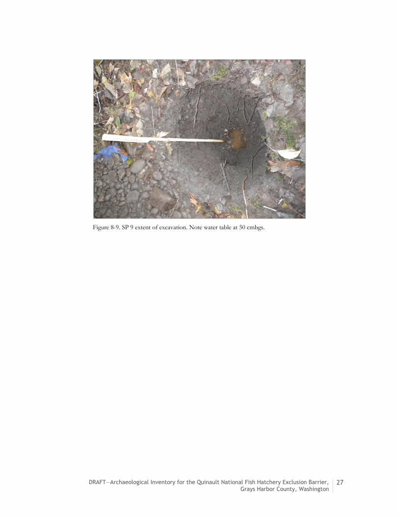
Figure 8-9. SP 9 extent of excavation. Note water table at 50 cmbgs.

28 DRAFT—Archaeological Inventory for the Quinault National Fish Hatchery Exclusion Barrier, Grays Harbor County, Washington
9. Summary and Recommendations
USFWS will oversee the construction of a new fish exclusion barrier at the QNFH in Grays Harbor
County, Washington. The Project is defined as a federal undertaking. Therefore, compliance with
Section 106 of the NHPA is required. In September 2015, McMillan Jacobs Associates contracted
with HRA to conduct an archaeological inventory to partially satisfy requirements of Section 106 of
the NHPA and its implementing regulations (36 CFR 800).
HRA’s review of available historic and archaeological literature indicated a very high risk of cultural
resources occurring within the APE. HRA archaeologists conducted the archaeological inventory,
consisting of surface and subsurface survey across the APE, from November 4–6, 2015.
The archaeological inventory identified neither precontact nor historic-period cultural resources.
HRA recommends no further cultural resources work within the APE, unless the Project undergoes
substantial design changes.
9.1 Inadvertent Discovery of Cultural Resources
In the event that archaeological deposits are inadvertently discovered during the Project in any
portion of the APE, ground-disturbing activities in the vicinity of the find should be halted
immediately, USFWS should be notified, and the Project’s Inadvertent Discovery Plan (Appendix B)
should be followed. Work in the immediate area of the find will not resume until treatment of the
discovery has been completed or the discovery has been adequately protected.
9.2 Inadvertent Discovery of Human Remains
Any human remains that are discovered during project-related activities will be treated with dignity
and respect. In the event that human remains are discovered, the following procedures are to be
followed to ensure compliance with RCW 68.50 Human Remains, RCW 68.60: Abandoned and Historic
Cemeteries and Historic Graves, and RCW 27.44: Indian Graves and Records.
If ground disturbing activities encounter human or potentially human skeletal remains during
activities associated with the Project, then all activity must cease that may cause further disturbance
to those remains and the area of the find must be secured and protected from further disturbance.
1. To establish if a bone is human, Dr. Guy Tasa is available to review pictures of a bone. His
information is in the contact list in Appendix C of this report. USFWS will contact
Dr. Guy Tasa.

DRAFT—Archaeological Inventory for the Quinault National Fish Hatchery Exclusion Barrier, Grays Harbor County, Washington
29
2. If Dr. Tasa establishes that the bone is not human, then there is no need to contact the
coroner and procedures outlined in Appendix B-1 for the discovery of archaeological
materials should be followed.
3. If Dr. Tasa establishes that the bone is human, USFWS will contact the coroner and local
law enforcement to inform them of the discovery.
If the discovery is human remains, USFWS will completely secure the work area by moving the land-
altering equipment to a reasonable distance, and will immediately contact the Grays Harbor County
Coroner (to determine if the remains are forensic in nature), DAHP, and may consult a professional
archaeologist (see Appendix C for contact information). If the remains are not forensic in nature,
USFWS will determine an appropriate method of treatment for the remains and will consult with the
affected tribes.
The legal requirements are as follows:
1. Per RCW 68.50.645, 27.44.055, and 68.60.055 (1) Any person who discovers skeletal human
remains must notify the county coroner and local law enforcement in the most expeditious
manner possible. Any person knowing of the existence of human remains and not having
good reason to believe that the coroner and local law enforcement has notice thereof and
who fails to give notice thereof is guilty of a misdemeanor.
2. If the bone is human, the remains should not be touched, moved, or further disturbed. The
coroner will assume jurisdiction and determine if the remains are forensic or not.
3. If the bones are not forensic, the coroner will report that to USFWS, who will then take
jurisdiction over the human remains and report the remains to any appropriate cemeteries
and to affected tribes.
4. The state physical anthropologist will make a determination of whether the remains are
Native American or not and will report that finding to any appropriate cemeteries, to
affected tribes, and to other appropriate parties.
5. USFWS will then conduct all consultation with the affected parties as to the future
preservation, excavation, and disposition of the remains.

30 DRAFT—Archaeological Inventory for the Quinault National Fish Hatchery Exclusion Barrier, Grays Harbor County, Washington
10. References Cited
Alt, David and Donald W. Hyndman 1995 Northwest Exposures: A Geologic Story of the Northwest. Mountain Press Publishing Company,
Missoula, Montana.
Atkinson, C. E., J. H. Rose, and T. O. Duncan 1967 Salmon of the North Pacific Ocean, Part IV, Spawning Populations of North Pacific
Salmon, 4. Pacific Salmon in the United States. International North Pacific Fisheries Commission Bulletin 23:43–223.
Barnosky, C.W. 1984 Late Pleistocene and Early Holocene Environmental History of Southwestern
Washington, U.S.A. Canadian Journal of Earth Sciences 21:619–629.
Barnosky, Cathy W., Patricia M. Anderson, and Patrick J. Bartlein 1987 The Northwestern U.S. During Deglaciation: Vegetation History and Paleoclimatic
Implication. In North America and Adjacent Oceans During the Last Deglaciation, Vol. K-3, edited by W. F. Ruddiman and H. E. Wright, Jr., pp. 289–321. Geological Society of America, Boulder, Colorado.
Berg, Norah (with Charles Samuels) 1952 Lady on the Beach. Prentice-Hall, New York.
Bourdeau, Alex 2011 Quinault Intake Road - Quinault NFH, Grays Harbor County, Washington. United States Fish
and Wildlife Service.
Brubaker, Linda B. 1991 Climate Change and the Origin of Old-Growth Douglas-Fir Forests in the Puget Sound
Lowland. In Wildlife and Vegetation of Unmanaged Douglas-Fir Forests, edited by Leonard F. Ruggiero, Keith B. Aubry, Andrew B. Carey, and Mark F. Huff, pp. 17–24. U. S. Department of Agriculture, Forest Service, Pacific Northwest Research Station, General Technical Report PNW- GTR-286. Portland, Oregon.
Daugherty, R. D. 1947 Minard Site (45GH15) Site Survey Form. University of Washington, Archaeological Field
Form, Seattle. On file at the Department of Archaeology and Historic Preservation, Olympia, Washington.
Davies, John (editor) 1981 David Douglas to William Hooker, Entrance to the River Columbia, October 11, 1830.
In Douglas of the Forests: The North American Journals of David Douglas, edited by John Davies. University of Washington Press, Seattle.
Franklin, Jerry F., and C. T. Dyrness 1973 Natural Vegetation of Oregon and Washington. USDA Forest Service, General Technical
Report PNW-8.

DRAFT—Archaeological Inventory for the Quinault National Fish Hatchery Exclusion Barrier, Grays Harbor County, Washington
31
Flenniken, J.J. and P. Trautman 2011 Phase I, Moclips Highway Transmission Line Reliability Project, Grays Harbor PUD No. 1, Grays
Harbor County, Washington. On file at the Department of Archaeology and Historic Preservation, Olympia, Washington.
Galster, R. W., and W. T. LaPrade 1991 Geology of Seattle, Washington, United States of America. Bulletin of the Association of
Engineering Geologists 28(3):235–302.
Gibbs, George 1855 Report of Mr. George Gibbs to Captain McClellan on the Indian Tribes of the Territory
of Washington. Reports of Explorations and Survey, to Ascertain the Most Practicable and Economical Route for a Railroad from the Mississippi River to the Pacific Ocean 1:402–434. Executive document No. 78, 2nd Session, 33rd Congress, Washington.
Grant, U. S. 1873 President of the United States, Order of November 4, 1873. Washington, D.C.
Gunther, Erna 1945 Ethnobotany of Western Washington. University of Washington Publications in Anthropology
10(1):1–62. Seattle.
1972 Indian Life of the Northwest Coat of North America. University of Chicago Press, Chicago, Illinois.
Hajda, Yvonne 1990 Southwestern Coast Salish. In The Northwest Coast, edited by Wayne Suttles, pp. 503–517.
Handbook of North American Indians, Vol. 7, William C. Sturtevant, general editor, Smithsonian Institution, Washington, D.C.
Hansen, H. P. 1941 Paleoecology of Two Peat Deposits on the Oregon Coast. Oregon State Monographs; Studies
in Botany 3:1–31.
1947 Postglacial Forest Succession, Climate and Chronology in the Pacific Northwest. American Philosophical Society Transactions, New Series 37(1):1–130.
Heusser, Calvin J. 1960 Late-Pleistocene Environments of North Pacific North America. American Geographical
Society Special Publications 35.
1965 A Pleistocene Phytogeographical Sketch of the Pacific Northwest and Alaska. In The Quaternary of the United States, edited by H. E. Wright and David G. Frey, pp. 469–483. Princeton University Press, Princeton, New Jersey.
James, Justine E., and Leilani A. Chubby 2002 Quinault. In Native Peoples of the Olympic Peninsula: Who We Are, edited by Jacilee Wray.
University of Oklahoma Press, Norman.

32 DRAFT—Archaeological Inventory for the Quinault National Fish Hatchery Exclusion Barrier, Grays Harbor County, Washington
Jenkins, Dennis L., Loren G. Davis, Thomas W. Stafford Jr., Paula F. Campos, Bryan Hockett, George T. Jones, Linda Scott Cummings, Chad Yost, Thomas J. Connolly, Robert M. Yohe II, Summer C. Gibbons, Maanasa Raghavan, Morten Rasmussen, Johanna L. A. Paijmans, Michael Hofreiter, Brian M. Kemp, Jodi Lynn Barta, Cara Monroe, M. Thomas P. Gilbert, and Eske Willerslev
2012 Clovis Age Western Stemmed Projectile Points and Human Coprolites at the Paisley Caves. Science 337(6091):223–228.
Jewell, Sally 2014 Secretary of the Interior, Order No. 3335. Washington, D.C.
Kappler, Charles J., editor. 1904 Indian Affairs, laws and Treaties, Vol. II. U.S. Government Printing Office, Washington,
D.C.
Kirk, Ruth, and Richard D. Daugherty 1974 Hunters of the Whale: An Adventure in Northwest Coast Archaeology. William Morrow and
Company, New York.
Larrison, Earl J. 1967 Mammals of the Northwest: Washington, Oregon, Idaho, and British Columbia. Seattle Audubon
Society, Seattle, Washington.
Mackie, Quentin, Loren Davis, Daryle Fedje, Duncan McLaren, and Amy Gusick 2014 Locating Pleistocene-age Submerged Archaeological Sites on the Northwest Coast:
Current Status of Research and Future Directions. In PaleoAmerican Odyssey, edited by Kelly E. Graf, Caroline V. Ketron, and Michael R. Waters, pp. 133–148. Texas A&M, College Station.
Marino, Cesare 1990 History of Western Washington Since 1846. In The Northwest Coast, edited by Wayne
Suttles, pp. 169–179. Handbook of North American Indians, Vol. 7, William C. Sturtevant, general editor, Smithsonian Institution, Washington, D.C.
Matson, R. G., and G. Coupland 1995 The Prehistory of the Northwest Coast. Academic Press, Orlando, Florida.
McKee, Bates 1972 Cascadia: The Geologic Evolution of the Pacific Northwest. McGraw Hill Book Company, New
York.
Oldham, Kit 2003 Captain Robert Gray Enters Grays Harbor on May 7, 1792. HistoryLink Essay No.
5050. Electronic document, http://www.historylink.org, accessed October 2, 2015.
Peninsula Daily News 2015 Secretary of the Interior, Order No. 3335. Washington, D.C.
Quinault Indian Nation 2015 Quinault Division of Natural Resources. Electronic document,
http://www.qlandandwater.org/, accessed November 11, 2015.
Raymond, Anan 2015 Letter to Justine James, Subject: Section 106 of the National Historic Preservation Act
(NHPA) for Quinault NFH Fish Exclusion Barrier, Grays Harbor County, Washington. United States Department of the Interior, Fish and Wildlife Service, Sherwood, Oregon.

DRAFT—Archaeological Inventory for the Quinault National Fish Hatchery Exclusion Barrier, Grays Harbor County, Washington
33
Righter, Elizabeth 1978 Puncheon Road (45OL93). Washington Archaeological Site Inventory Form. On file at the
Washington State Department of Archaeology and Historic Preservation, Olympia, Washington.
Roll, Tom E. 1974 The Archaeology of Minard: A Case Study of a Late Prehistoric Northwest Coast
Procurement System. PhD dissertation, Washington State University, Department of Anthropology, Pullman.
Ruby, Robert H., and John A. Brown 1992 A Guide to the Indian Tribes of the Pacific Northwest. Revised Edition. University of
Oklahoma Press, Norman.
Singh, Ram Raj Prasad 1966 Aboriginal Economic System of the Olympic Peninsula Indians, Western Washington.
Anthropological Society Papers 4.
Smith, Allan H. 1964 Ethnographic Guide to the Archaeology of Mt. Rainier National Park. Washington State
University, Pullman. Prepared for the National Park Service.
Stewart, Hillary 1984 Cedar: Tree of Life to the Northwest Coast Indians. University of Washington Press, Seattle.
Storm, Jacqueline M., and Pauline K. Capoeman 1990 Land of the Quinault. Quinault Indian Nation, Taholah, Washington.
Sturhan, Douglas 1992 Lab Project Area and Section 2 Project Area, Cook Integrated Resource Analysis Area Cultural
Resource Report. Olympia National Forest, Quinault Range District. Quinault.
Suttles, Wayne 1968 Coping with Abundance: Subsistence on the Northwest Coast. In Man the Hunter, edited
by Richard B. Lee and Irven DeVore, pp. 56–68. Aldine, Chicago, Illinois.
Swan, James G. 1972 The Northwest Coast: or, Three Years’ Residence in Washington Territory, by James G. Swan,
Introduction by Norman H. Clark. University of Washington Press, Seattle.
Tabor, R. W., and Cady, W. M. 1978 Geologic Map of the Olympic Peninsula, Washington [map]. Department of the Interior, United
States Geological Survey. Electronic document, http://ngmdb.usgs.gov/Prodesc/proddesc_9852.htm, accessed November 17, 2015.
Taylor, Herbert C., Jr. 1963 Aboriginal Populations of the Lower Northwest Coast. Pacific Northwest Quarterly
54(4):158–166.
Tiller, Veronica E. Valverde 1996 American Indian Reservations and Trust Areas. U.S. Department of Commerce, Washington,
D.C.
U.S. Bureau of Reclamation. 1994 U.S. Bureau of Reclamation Indian Trust Asset Policy and NEPA Implementing Procedures. U.S.
Bureau of Reclamation, Washington, D.C.

34 DRAFT—Archaeological Inventory for the Quinault National Fish Hatchery Exclusion Barrier, Grays Harbor County, Washington
U. S. Fish and Wildlife Service (USFWS) 2008 Quinault National Fish Hatchery, Humptulips, Washington. Electronic document,
http://www.fws.gov/wafwo/fisheries/Publications/QN2008.pdf, accessed November 17, 2015.
2014 Quinault National Fish Hatchery, Washington: Our Work. Electronic document, http://www.fws.gov/Quinaultnfh/Work.cfm, accessed November 17, 2015.
United States Geological Survey (USGS) 1921 Quinault Lake Quadrangle, 1:62,500 (Topographic). Electronic document,
http://historicalmaps.arcgis.com/usgs/, accessed September 29, 2015.
1990 Stevens Creek Quadrangle, 1:24,000 (Topographic). Electronic document, http://historicalmaps.arcgis.com/usgs/, accessed September 29, 2015.
United States Surveyor General 1904 General Land Office Survey Map, Township 22 North, Range 10 West, Williamette
Meridian. United States Department of the Interior Bureau of Land Management. Electronic document, http://www.glorecords.blm.gov/, accessed September 29, 2015.
Van Syckle, Edwin 1982 The River Pioneers: Early Days on Grays Harbor. University of Washington Press, Seattle.
Waters, Michael R., Thomas W. Stafford, Jr., H. Gregory McDonald, Carl Gustafson, Morten Rasmussen, Enrico Cappellini, Jesper V. Olsen, Damian Szklarczyk, Lars Juhl Jensen, M. Thomas P. Gilbert, and Eske Willerslev
2011 Pre-Clovis Mastodon Hunting 13,800 Years Ago at the Manis Site, Washington. Science 334(October 2011):351–353.
Wessen, Gary 1990 Prehistory of the Ocean Coast of Washington. In The Northwest Coast, edited by Wayne
Suttles, pp. 412–421. Handbook of North American Indians, Vol. 7, William C. Sturtevant, general editor, Smithsonian Institution, Washington, D.C.
Whitlock, Cathy 1992 Vegetational and Climatic History of the Pacific Northwest during the last 20,000 Years:
Implications for Understanding Present-Day Biodiversity. The Northwest Environmental Journal 8:5–28.
Wilma, David 2006 Grays Harbor County-Thumbnail History. HistoryLink Essay No. 7766. Electronic
document, http://www.historylink.org, accessed October 2, 2015.

DRAFT—Archaeological Inventory for the Quinault National Fish Hatchery Exclusion Barrier, Grays Harbor County, Washington
35
Appendix A. Shovel Probe Table
Table A-1. Results of Shovel Test Probes in the APE.
Shovel Probe
UTM:
East/North
Maximum Depth Below Surface (cmbs)
Description Cultural Materials Identified
1 424964E/ 5245434N
90 0-16 cmbs: dark brown, silty sand, high organic content
16-30 cmbs: reddish brown, silty loam, few round to subangular gravels, many roots
30-90 cmbs: pale grayish brown, loamy clay, some subround gravels (pebble to small cobble-sized), soil becomes paler and clay content increases with depth
Terminated on rock obstruction
0-16 cmbs: 2 colorless glass fragments – modern
2 424982E/ 5245428N
100 0-9 cmbs: dark brown, organic rich silty sand, some roots, duff layer
9-60 cmbs: brown fine sandy loam
60-100 cmbs: yellowish brown, fine sandy loam, many poorly sorted round to subround gravels (small pebble to large cobble-sized)
Terminated at maximum depth
none
3 425004E/ 5245426N
98 0-12 cmbs: dark brown, organic rich silty sand, many roots, duff layer
12-75 cmbs: brown, silty loam, fewer roots with depth, few subround gravels
75-98 cmbs: grayish tan, medium-grained sand, increase in gravel content (small pebble to small cobble-sized) with depth, decrease in root content with depth
Terminated at maximum depth
none

36 DRAFT—Archaeological Inventory for the Quinault National Fish Hatchery Exclusion Barrier, Grays Harbor County, Washington
Table A-1. Results of Shovel Test Probes in the APE.
Shovel Probe
UTM:
East/North
Maximum Depth Below Surface (cmbs)
Description Cultural Materials Identified
4 425030E/ 5245435N
100 0-3 cmbs: dark brown, organic, silty sand, some roots, duff layer
3-48 cmbs: brown, sandy loam, very loose, many small, round to subround gravels
48-85 cmbs: pale brown, sandy loam, some subround gravels
85-100 cmbs: pale brown, sandy loam, many round-subround gravels (small pebble to medium cobble-sized)
Terminated at maximum depth
none
5 425051E/ 5245433N
68 0-20 cmbs: dark brown, organic rich silty sand, duff layer
20-68 cmbs: dark brown, coarse-grained sand, many subround to rounded gravels (small pebble to large cobble-sized)
Terminated after reaching water table
none
6 425075E/ 5245435N
72 0-16 cmbs: pale gray, medium-grained sand, few rounded gravels
16-55 cmbs: grayish brown sand, some roots, some moderately sorted subround gravels
55-72 cmbs: gray sand, gravel and moisture content increasing with depth, many subround gravels (pebble to lage cobble-sized), few roots
Terminated after reaching water table at 72 cm
none
7 425099E/ 5245442N
80 0-15 cmbs: gray sandy loam
15-80 cmbs: dark brown sandy loam, many rounded gravels (pebbles and large cobbles)
Terminated on rock obstruction
none

DRAFT—Archaeological Inventory for the Quinault National Fish Hatchery Exclusion Barrier, Grays Harbor County, Washington
37
Table A-1. Results of Shovel Test Probes in the APE.
Shovel Probe
UTM:
East/North
Maximum Depth Below Surface (cmbs)
Description Cultural Materials Identified
8 425151E/ 5245397N
60 0-12 cmbs: dark grayish brown, fine grained sand, some roots, some subround gravels (pebble to small cobble-sized)
12-60 cmbs: dark grayish brown, fine-grained sand, many subround gravels (small pebble to large cobble-sized)
Terminated on rock obstruction
none
9 425127E/ 5245416N
50 0-14 cmbs: pale gray, silty sand, some roots, some subround gravels
14-50 cmbs: grayish brown, silty sand, no roots, many subround gravels (medium pebble to small cobble-sized), increase in gravel size with depth
Terminated after reaching water table at 50 cmbs
none
10 425151E/ 5245397N
100 0-9 cmbs: gray sandy loam
9-34 cmbs: brown sandy loam, many rounded gravels
34-80 cmbs: dark brown sandy loam
80-100 cmbs: brown sandy loam, compact, some round to subround gravels
Terminated at maximum depth
none
11 425177E/ 5245366N
78 0-30 cmbs: dark brown, organic rich silty sand, many roots
30-78 cmbs: dark brown, coarse-grained sand, many subrounded gravels (pebble to small cobble-sized), gravel sphericity decreasing with depth
Terminated after reaching water table
none

38 DRAFT—Archaeological Inventory for the Quinault National Fish Hatchery Exclusion Barrier, Grays Harbor County, Washington
Table A-1. Results of Shovel Test Probes in the APE.
Shovel Probe
UTM:
East/North
Maximum Depth Below Surface (cmbs)
Description Cultural Materials Identified
12 425204E/ 5245357N
100 0-66 cmbs: brown, loose sandy silt, many roots, very few gravels
66-100 cmbs: grayish brown, coarse-grained sand, loose, some subround gravels (pebble to cobble-sized), few roots
Terminated at maximum depth
none
13 425233E/ 5245353N
60 0-40 cmbs: grayish brown sandy loam, many rounded gravels (pebble to cobble-sized)
40-60 cmbs: dark brown sandy loam, many rounded gravels (pebble to cobble-sized)
Terminated on rock obstruction
none
14 425260E/ 5245347N
95 0-18 cmbs: dark brown to grayish brown fine grained sand with organic content
18-48 cmbs: grayish brown, fine-grained sand
48-95 cmbs: yellowish brown, coarse-grained sand, many subrounded gravels (small pebble to large cobble-sized), gravel content increasing with depth
Terminated on gravel obstruction
none
15 425273E/ 5245372N
100 0-20 cmbs: brown sandy loam, some roots, few rounded gravels (pebble-sized)
20-90 cmbs: brown sandy loam, some roots, no gravels
90-100 cmbs: gray sandy loam with yellowish mottling
Terminated at maximum depth
none
16 425241E/ 5245383N
61 0-42 cmbs: dark brown, organic rich silty sand near surface, organic content decreasing with depth
42-61 cmbs: dark brown coarse-grained sand, many round to subround gravels (pebble to cobble-sized)
Terminated on rock obstruction
none

DRAFT—Archaeological Inventory for the Quinault National Fish Hatchery Exclusion Barrier, Grays Harbor County, Washington
39
Table A-1. Results of Shovel Test Probes in the APE.
Shovel Probe
UTM:
East/North
Maximum Depth Below Surface (cmbs)
Description Cultural Materials Identified
17 425231E/ 5245387N
80 0-2 cmbs: gray, organic rich silty sand, duff layer
2-50 cmbs: grayish brown fine-grained sand, moist, many roots
50-80 cmbs: dark grayish brown medium-grained silty sand, many rounded to subrounded gravels (small pebble to medium cobble-sized)
Terminated on rock obstruction
none
18 425289E/ 5245368N
49 0-49 cmbs: brown, fine sandy loam, many roots, few subrounded gravels (small to medium pebble-sized)
Terminated on subsurface obstruction
none
19 425375E/ 5245309N
100 0-8 cmbs: gray sandy loam
8-36 cmbs: grayish brown sandy loam
36-85 cmbs: brown sandy loam, many rounded gravels (pebble to cobble-sized)
85-100 cmbs: blackish brown, coarse-grained sand, many rounded gravels (pebble to cobble-sized)
Terminated at maximum depth
none
20 425390E/ 5245284N
73 0-22 cmbs: gray fine-grained sand
22-30 cmbs: brown silty sand, moist, many roots
30-73 cmbs: grayish brown, medium-grained silty sand, many subround gravels (pebble to medium cobble-sized)
No recovery on cobbles
none

40 DRAFT—Archaeological Inventory for the Quinault National Fish Hatchery Exclusion Barrier, Grays Harbor County, Washington
Table A-1. Results of Shovel Test Probes in the APE.
Shovel Probe
UTM:
East/North
Maximum Depth Below Surface (cmbs)
Description Cultural Materials Identified
21 425287E/ 5245344N
100 0-25 cmbs: dark brown, organic rich sandy loam, few rounded to subangular gravels (pebble-sized)
25-81 cmbs: dark brown sandy loam, some subangular to rounded gravels (pebble-sized)
81-100 cmbs: Dark brown to grayish brown, coarse-grained sand, many gravels (pebble to cobble-sized)
Terminated at maximum depth
none
22 425312E/ 5245331N
100 0-28 cmbs: grayish brown sandy loam
28-65 cmbs: blackish brown, very coarse-grained sand, few small rounded gravels
65-85 cmbs: brown sandy loam, some small rounded gravels
85-100 cmbs: brown, sandy loam, many rounded gravels (pebble to cobble-sized)
Terminated at maximum depth
none
23 425333E/ 5245305N
100 0-10 cmbs: dark brown, organic rich silty sand, some roots, duff layer
10-34 cmbs: brown silty sand, many roots
34-74 cmbs: grayish brown sandy loam, some roots
74-100 cmbs: pockets of dark gray sandy loam in bluish gray sandy clay, some subround gravels (small to large pebble-sized)
Terminated at maximum depth
none
24 425086E/ 5245468N
24 0-8 cmbs: gray sandy loam, no gravels
8-24 cmbs: brown, fine-grained sandy loam, some roots, abrupt boundary with upper sediments
Terminated upon rock retaining wall/landscaping
none

DRAFT—Archaeological Inventory for the Quinault National Fish Hatchery Exclusion Barrier, Grays Harbor County, Washington
41
Table A-1. Results of Shovel Test Probes in the APE.
Shovel Probe
UTM:
East/North
Maximum Depth Below Surface (cmbs)
Description Cultural Materials Identified
25 425104E/ 5245467N
62 0-21 cmbs: dark brown, organic rich sandy loam, duff layer
21-62 cmbs: dark brown, coarse-grained sand, some gravels (pebble to medium cobble-sized)
Terminated after reaching water table
none
26 425129E/ 5245459N
100 0-27 cmbs: grayish brown, sandy loam
27-100 cmbs: dark brown, coarse-grained sand, many subround to rounded gravels (pebble to cobble-sized)
Terminated at maximum depth
none
27 425139E/ 5245477N
64 0-64 cmbs: dark brown, coarse-grained sand, very many gravels (pebble to cobble-sized)
Terminated due to compaction
none
28 425168E/ 5245475N
100 0-11 cmbs: dark brown, organic rich silty sand, some roots, duff layer
11-40 cmbs: brown sandy loam, many roots, many rounded gravels
40-95 cmbs: dark brown sandy loam, many rounded gravels (pebble to cobble-sized)
95-100 cmbs: gray, fine sandy loam, very moist
Terminated at maximum depth
none
29 425155E/ 5245457N
100 0-12 cmbs: dark brown, organic rich silty sand, some roots, duff layer
12-34 cmbs: reddish brown, sandy loam
34-55 cmbs: brown, compact sandy loam, very few gravels (small pebble-sized)
55-90 cmbs: grayish brown, fine-grained sandy loam
90-100 cmbs: bioturbation
Terminated at maximum depth
none
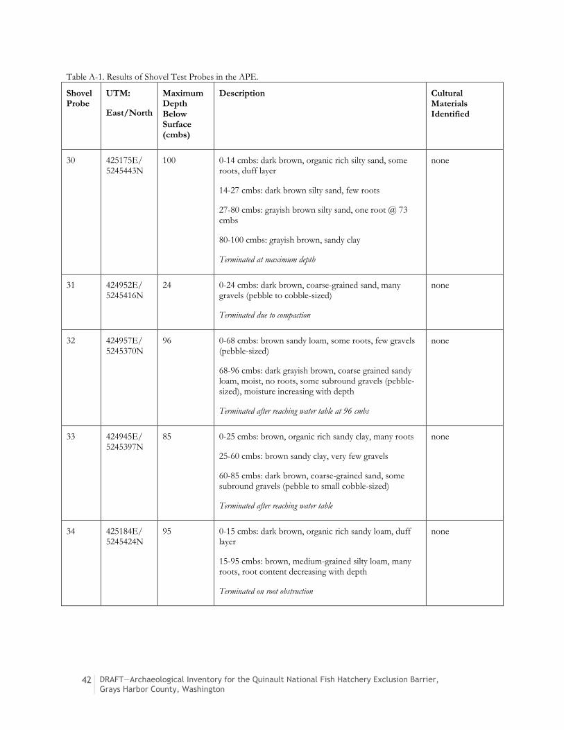
42 DRAFT—Archaeological Inventory for the Quinault National Fish Hatchery Exclusion Barrier, Grays Harbor County, Washington
Table A-1. Results of Shovel Test Probes in the APE.
Shovel Probe
UTM:
East/North
Maximum Depth Below Surface (cmbs)
Description Cultural Materials Identified
30 425175E/ 5245443N
100 0-14 cmbs: dark brown, organic rich silty sand, some roots, duff layer
14-27 cmbs: dark brown silty sand, few roots
27-80 cmbs: grayish brown silty sand, one root @ 73 cmbs
80-100 cmbs: grayish brown, sandy clay
Terminated at maximum depth
none
31 424952E/ 5245416N
24 0-24 cmbs: dark brown, coarse-grained sand, many gravels (pebble to cobble-sized)
Terminated due to compaction
none
32 424957E/ 5245370N
96 0-68 cmbs: brown sandy loam, some roots, few gravels (pebble-sized)
68-96 cmbs: dark grayish brown, coarse grained sandy loam, moist, no roots, some subround gravels (pebble-sized), moisture increasing with depth
Terminated after reaching water table at 96 cmbs
none
33 424945E/ 5245397N
85 0-25 cmbs: brown, organic rich sandy clay, many roots
25-60 cmbs: brown sandy clay, very few gravels
60-85 cmbs: dark brown, coarse-grained sand, some subround gravels (pebble to small cobble-sized)
Terminated after reaching water table
none
34 425184E/ 5245424N
95 0-15 cmbs: dark brown, organic rich sandy loam, duff layer
15-95 cmbs: brown, medium-grained silty loam, many roots, root content decreasing with depth
Terminated on root obstruction
none

DRAFT—Archaeological Inventory for the Quinault National Fish Hatchery Exclusion Barrier, Grays Harbor County, Washington
43
Appendix B. Inadvertent Discovery Plan
Compliance with all applicable laws pertaining to archaeological resources (RCW 27.53, 27.44 and
WAC 25-48) and to human remains (RCW 68.50) is required. Failure to comply with these
requirements could result in a misdemeanor and possible civil penalties and/or may constitute a
Class C felony.
B.1 Inadvertent Discovery of Cultural Resources
1. If any member of the construction crew believes that they have encountered precontact or
historic-period archaeological materials during the Project, the crew member will direct the
contractor to stop work at that location to protect potential additional resources. The
contractor will establish a buffer zone of 50 ft around the find to protect the location. This
will also ensure the Secretary of the Interior (SOI) Qualified Archaeologist’s safety while
inspecting the possible find.
a. Precontact cultural materials include, but are not limited to:
i. Buried layers of black soil with layers of shell, charcoal, and fish and mammal
bones (Figure B-1).
ii. Non-natural sediment or stone deposits that may be related to activity areas
of people;
iii. Stone, bone, shell, horn, or antler tools that may include projectile points
(arrowheads), scrapers, cutting tools, wood working wedges or axes, and
grinding stones (Figures B-2 and B-3);
iv. Stone flakes created during the manufacture of stone tools (Figures B-2 and
B-3);
v. Fragments of basketry, weaving, wood tools, or carved pieces
b. Historic-period cultural materials include, but are not limited to:
i. Remnants of logging machinery or implements;
ii. Low-fired and bisque ceramics with subdued colors, or blue/pink willow-like
design; thick-bodied pieces indicating crockery (Figure B-4);
iii. Non-tempered glass; violet-colored glass; stopper-topped glass jars or
bottles; press-capped (cork gasket liner) heavy-walled soda or liquor bottles

44 DRAFT—Archaeological Inventory for the Quinault National Fish Hatchery Exclusion Barrier, Grays Harbor County, Washington
(not twist-top, thin-walled); zinc and vitreous glass-lidded glass canning jars
with colored body (Figure B-5);
iv. Miscellaneous fragments of metal (or plated) clothing closures (hooks and
eyes, and suspender fittings, but not zippers), shell buttons, fragments of
bakelite houseware;
v. Sawed animal bone and fruit pits;
vi. Enameled ironware;
vii. Punch-opened and solder-sealed beverage cans; solder-sealed food tins; (not
thin-walled aluminum and welded steel cans);
viii. Older automotive parts; and
ix. Knob-and-tube electrical insulators; and
2. The contractor will temporarily halt the work in the location of the find and immediately
contact USFWS. USFWS will then contact the SOI Qualified Archaeologist (see Appendix C
for contact information), and describe the find to ascertain the necessary next steps.
3. If archaeological materials (excluding human remains) are found, USFWS and the contractor
will take appropriate steps to protect the discovery site by maintaining the 50 ft buffer
around the find, installing a physical barrier (i.e., exclusionary fencing), and prohibiting all
machinery, other vehicles, and unauthorized individuals from crossing the barrier until the
SOI Qualified Archaeologist examines and verifies the find.
4. If there is suspicion that the artifact(s) may be disturbed or an isolate, the archaeologist may
request that excavation continue in order to assess the extent of the deposit and the nature
of the soils/ sediments below the observed materials. The archaeologist will coordinate with
the Contractor to direct the crew in such circumstances. If excavation is allowed to continue,
the archaeologist will take notes on the find along with overview photographs to form a
basic description of the characteristics and location of the cultural materials, to allow for
minimal delays.
5. For safety reasons, no archaeologist will enter any excavations deeper than 4 ft to inspect a
possible find until the excavation has been shored by the contractor, per OSHA standards at
29 CFR 1926.652 (www.osha-slc.gov/).
6. Halting of construction excavation for inspection of a possible find will allow the
archaeologist to identify whether the find is an isolate, an intact archaeological deposit,
disturbed artifact deposits, or other materials.
Isolate: One distinct artifact or a few fragments of the same artifact that are too far away
(typically more than 30 meters) from other cultural materials (over 50 years old) to be

DRAFT—Archaeological Inventory for the Quinault National Fish Hatchery Exclusion Barrier, Grays Harbor County, Washington
45
considered part of a site. Generally, an isolate will not take long to document. If diagnostic,
the find should be recorded on an Isolate Form and photographs taken.
Intact Artifact Deposit or Feature: Two or more distinct artifacts or one feature
(immovable object such as a concrete foundation) within a 50-m area. Intact deposits would
be considered an archaeological site and be recorded on an Archaeological Site Inventory
Form.
Disturbed Artifact Deposits: Artifacts identified in disturbed soils (such as historic fill)
should be documented in monitoring notes and photographed. Depending on the volume of
artifacts and the level of disturbance, the deposit may or may not need to be recorded on a
Site Form. Limited investigation around the artifacts may be necessary to determine if
additional materials are present and the site boundaries extend, following the protocol steps
below as necessary.
Other: Abandoned/remnant utilities and materials less than 50 years old are not considered
significant. No further action is necessary.
7. If the archaeologist believes the find represents an intact archaeological site, excavation will
halt completely at that location. The archaeologist will then inform USFWS of that
determination.
8. Depending on the nature and size of the archaeological resource, it is feasible that
construction may continue elsewhere in the APE, provided that a safe buffer zone is
maintained between the archaeological resource and construction area. This will be decided
between the archaeologist and USFWS, in consultation with DAHP.
9. Under RCW 27.53, all precontact archaeological sites are protected regardless of significance
or eligibility for national, state, and/or local historic registers. A determination of eligibility
for listing on the state or national register by DAHP must be obtained for archaeological
resources. It is presumed that historic-period resources are eligible for listing in the NRHP
until and unless DAHP makes a determination that they are not.
10. USFWS, in coordination DAHP and the affected Tribes, will determine an appropriate form
of treatment for the archaeological site. Treatment measures may include mapping,
photography, limited probing, and sample collection, or other activities.
11. If treatment measures determined by the consulting parties include sample collection, the
archaeological resources will be examined by the archaeologist and possibly analyzed by
specialists, as needed and appropriate.
12. All precontact and historic artifacts collected within the APE will be analyzed, catalogued,
and temporarily curated by HRA. Ultimate disposition of cultural materials will be
determined by USFWS.

46 DRAFT—Archaeological Inventory for the Quinault National Fish Hatchery Exclusion Barrier, Grays Harbor County, Washington
13. When all archaeological investigation work has been completed, the Professional
Archaeologist will prepare a report discussing the methods and results of the work.
14. If any ground disturbing activities associated with the Project reveal human remains, the
procedures listed in Section B.2 will be followed.
Figure B-1. Shell midden.

DRAFT—Archaeological Inventory for the Quinault National Fish Hatchery Exclusion Barrier, Grays Harbor County, Washington
47
Figure B-2. Example of stone tools.

48 DRAFT—Archaeological Inventory for the Quinault National Fish Hatchery Exclusion Barrier, Grays Harbor County, Washington
Figure B-3. Example of stone flake and tools.

DRAFT—Archaeological Inventory for the Quinault National Fish Hatchery Exclusion Barrier, Grays Harbor County, Washington
49
Figure B-4. Example of historic artifacts from debris scatter.

50 DRAFT—Archaeological Inventory for the Quinault National Fish Hatchery Exclusion Barrier, Grays Harbor County, Washington
Figure B-5. Example of bottles from historic debris dump.
B.2 Inadvertent Discovery of Human Remains
Any human remains that are discovered during project-related activities will be treated with dignity
and respect. In the event that human remains are discovered, the following procedures are to be
followed to ensure compliance with RCW 68.50 Human Remains, RCW 68.60: Abandoned and Historic
Cemeteries and Historic Graves, and RCW 27.44: Indian Graves and Records.
If ground disturbing activities encounter human or potentially human skeletal remains during
activities associated with the Project, then all activity must cease that may cause further disturbance
to those remains and the area of the find must be secured and protected from further disturbance.
1. To establish if a bone is human, Dr. Guy Tasa is available to review pictures of a bone. His
information is in the contact list in Appendix C of this report. USFWS will contact
Dr. Guy Tasa.

DRAFT—Archaeological Inventory for the Quinault National Fish Hatchery Exclusion Barrier, Grays Harbor County, Washington
51
2. If Dr. Tasa establishes that the bone is not human, then there is no need to contact the
coroner and procedures outlined in Appendix B-1 for the discovery of archaeological
materials should be followed.
3. If Dr. Tasa establishes that the bone is human, USFWS will contact the coroner and local
law enforcement to inform them of the discovery.
If the discovery is human remains, USFWS will completely secure the work area by moving the land-
altering equipment to a reasonable distance, and will immediately contact the Grays Harbor County
Coroner (to determine if the remains are forensic in nature), DAHP, and may consult a professional
archaeologist (see Appendix C for contact information). If the remains are not forensic in nature,
USFWS will determine an appropriate method of treatment for the remains and will consult with the
affected tribes.
The legal requirements are as follows:
1. Per RCW 68.50.645, 27.44.055, and 68.60.055 (1) Any person who discovers skeletal human
remains must notify the county coroner and local law enforcement in the most expeditious
manner possible. Any person knowing of the existence of human remains and not having
good reason to believe that the coroner and local law enforcement has notice thereof and
who fails to give notice thereof is guilty of a misdemeanor.
2. If the bone is human, the remains should not be touched, moved, or further disturbed. The
coroner will assume jurisdiction and determine if the remains are forensic or not.
3. If the bones are not forensic, the coroner will report that to USFWS, who will then take
jurisdiction over the human remains and report the remains to any appropriate cemeteries
and to affected tribes.
4. The state physical anthropologist will make a determination of whether the remains are
Native American or not and will report that finding to any appropriate cemeteries, to
affected tribes, and to other appropriate parties.
5. USFWS will then conduct all consultation with the affected parties as to the future
preservation, excavation, and disposition of the remains.


DRAFT—Archaeological Inventory for the Quinault National Fish Hatchery Exclusion Barrier, Grays Harbor County, Washington
53
Appendix C. Inadvertent Discovery Contact
Information
United States Fish and Wildlife Service Anan Raymond, Regional Archaeologist 20555 Gerda Lane Sherwood, OR 97140 Telephone: (503) 625-8215 ext. 520 Email: [email protected]
Grays Harbor County Coroner Lane Youmans, Coroner 1006 North H St. Aberdeen, WA 98520 Telephone: (360) 537-6139 Telephone 24 hr: (360) 532-2322
Grays Harbor County Sheriff’s Department Rick Scott, Sheriff 100 W. Broadway, Suite 3 Montesano, WA 98563 Telephone: (360) 249-3711 Telephone: (360) 532-3284 Telephone: 1-800-562-8714
Archaeological Consultant Historical Research Associates, Inc. (HRA) Alex Stevenson 1904 Third Ave, Suite 240 Seattle, WA 98101 Telephone: (206) 343-0226
Tribes Justine James, Cultural Resource Specialist Quinault Indian Nation P.O. Box 189 Taholah, WA. 98587 Telephone: (360) 276-8211 ext: 520 Email: [email protected]
Washington State Department of Archaeology and Historic Preservation (DAHP) State Archaeologist Dr. Rob Whitlam PO Box 48343 Olympia, WA 98501 Telephone: (360) 586-3080 (office) Email: [email protected] State Physical Anthropologist Dr. Guy Tasa PO Box 48343 Olympia, WA 98501 Telephone: 360-586-3534 (office) Email: [email protected]


DRAFT—Archaeological Inventory for the Quinault National Fish Hatchery Exclusion Barrier, Grays Harbor County, Washington
55
Appendix D. Tribal Consultation


27 October 2015
To: Justine James, Cultural Resources PO Box 189 Taholah, WA 98587-0189 P/ 360-276-8215 ext. 520
[email protected] From: Anan Raymond, Regional Historic Preservation Officer (RHPO) Subject: Section 106 of the National Historic Preservation Act (NHPA) for Quinault NFH Fish Exclusion
Barrier, Grays Harbor County, Washington The U.S. Fish and Wildlife Service (FWS) is proposing a fish passage project at Quinault National Fish Hatchery (NFH) in Grays Harbor County, Washington (T22N, R10W, S31, Stevens Creek 7.5’ USGS quad) (Figures 1). Pursuant to its responsibilities under Section 106 of the National Historic Preservation Act (NHPA) and 36 CFR 800, the FWS has determined that the proposed action is a federal undertaking. Through this letter, the FWS is initiating consultation with your tribe pursuant to 36 CFR 800.2(c), 800.4(a)(3) and 800.4(a)(4). Undertaking and Area of Potential Effects (APE): The project will maintain the functionality of the Quinault NFH by replacing the existing weir, modifying riprap and an access road, and adding a fish bypass ladder. Additionally, the proposed project includes routine maintenance activities which include cleaning of water intakes and removal of large woody debris and gravel buildup near or on the weir. These repairs and maintenance activities are needed to allow the weir and fish ladder to function properly, allow fish passage, and improve human safety. The proposed project will replace the existing electric weir with a velocity barrier consisting of a concrete slab (apron) with two 40-foot-wide Obermeyer weir panels separated by a central concrete pier. A new fishway (fish ladder) will be constructed on the north abutment of the weir to allow fish passage. The total width of the new weir and fishway, including abutments and piers, will be approximately 89 feet. The new weir will be oriented perpendicular to the flow of the creek. A flood wall will be added to the south bank of Cook Creek for a distance of about 1,275 feet upstream of the weir. The flood wall will contain the backwater from the weir and prevent permanent inundation of wetlands “D” and “E” and the surrounding riparian and forest areas. With the exception of the staging area, all work activities occur within the 100-year floodplain (Figure 2). A more detailed description of the project elements is attached as Attachment A. The Area of Potential Effects (APE) includes the footprint of all ground disturbing activities and areas of new inundation, specifically activity areas associated with the weir, fishway, control building, flood walls, access road, and staging areas, a total of 6.9 acres.
United States Department of the Interior FISH AND WILDLIFE SERVICE Anan Raymond, Regional Archaeologist
Region 1+ Region 8 Cultural Resource Team 20555 Gerda Lane, Sherwood, OR 97140
phone:503-625-4377, fax:503-625-4887, cell:503-803-7913 email: [email protected]

Background Information: The project occurs at Quinault National Fish Hatchery located on Cook Creek. The surrounding properties adjacent to the project area are managed by the USFWS, the Quinault Nation, and the United States Forest Service. The adjacent land consists of native riparian areas and mixed upland deciduous and coniferous forest. Both the US Forest Service and Quinault Tribe use their property for timber production and harvesting, recreation, and/or forest preservation. The Quinault National Fish Hatchery (NFH) was authorized on July 7, 1964, by the Appropriation Act (78 stat. 283) and the Fish and Wildlife Act of 1956 (70 Stat. 1119) and began operations in 1968 “...to restore and enhance depleted runs of salmon and steelhead on the Quinault Indian Reservation and adjacent federal lands...” The hatchery is operated by U.S. Fish and Wildlife Service and is located on Quinault Indian Reservation land. The project area is located within the Olympic Mountains on the Olympic Peninsula. The Holocene post glacier or the outwash from the Quinault River ice advance likely formed the contemporary topography of the area. The shoreline along Cook Creek is comprised of a riparian habitat consisting of mature deciduous riparian vegetation near the creek, mature coniferous trees in the upland area, and sedges and rushes in the wetland areas. The portion of the property south of Cook Creek is moderately undisturbed from development activities, and the noxious weed presence is low. The portion of the property north of Cook Creek has been developed into the hatchery. The areas surrounding the project have been previously logged, some possibly twice. Logging continues along the Moclips Highway. Proposed Identification Effort: A professional archaeologist (Alexander Stevenson, HRA, [email protected]) has been contracted to conduct research, fieldwork, and documentation for this project. Requested Action: We look forward to receiving comments and information from your office as we determine the appropriate action for protection of historic properties within the APE. This may include tribal input regarding sites of religious or cultural significance. We recognize that cultural resource information is sensitive and must be treated confidentially. We will be happy to talk or meet with you or your staff regarding this project. An individual meeting the Secretary of the Interior’s standards for professional in archaeology (36 CFR 61) will ensure proper implementation of all identification, evaluation, and mitigation activities, as appropriate. If you believe this undertaking requires direct consultation with tribal government, please let us know. To ensure your comments are given adequate consideration and the determination and identification process can proceed in a timely manner, we request that you respond within 30 days. If you have questions or concerns, please contact me at 503-625-4377 or [email protected]. Sincerely,
Anan Raymond, Regional Historic Preservation Officer
Attachment A: Description of Project Activities

Figure 1. Project location on Stevens Creek 7.5’ USGS quad.

Figure 2. Close up of project area on Stevens Creek 7.5’ USGS showing area of potential effects (APE).

Figure 3. Aerial photograph showing area of potential effects (APE).
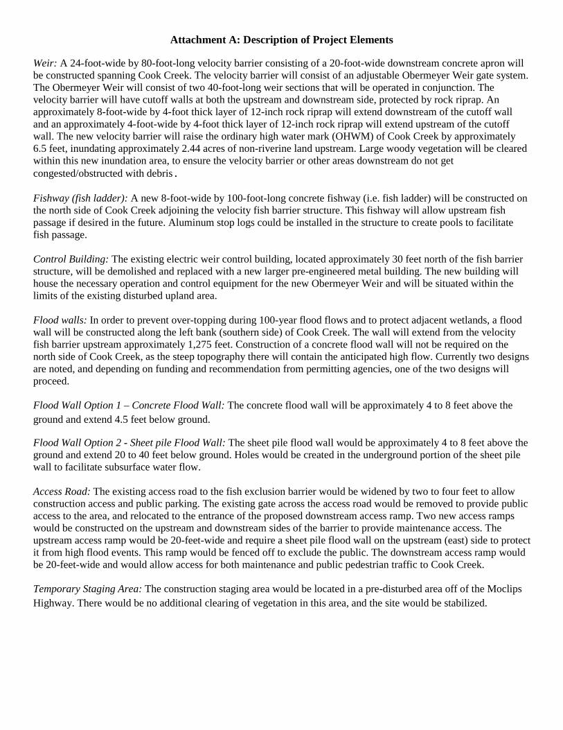
Attachment A: Description of Project Elements
Weir: A 24-foot-wide by 80-foot-long velocity barrier consisting of a 20-foot-wide downstream concrete apron will be constructed spanning Cook Creek. The velocity barrier will consist of an adjustable Obermeyer Weir gate system. The Obermeyer Weir will consist of two 40-foot-long weir sections that will be operated in conjunction. The velocity barrier will have cutoff walls at both the upstream and downstream side, protected by rock riprap. An approximately 8-foot-wide by 4-foot thick layer of 12-inch rock riprap will extend downstream of the cutoff wall and an approximately 4-foot-wide by 4-foot thick layer of 12-inch rock riprap will extend upstream of the cutoff wall. The new velocity barrier will raise the ordinary high water mark (OHWM) of Cook Creek by approximately 6.5 feet, inundating approximately 2.44 acres of non-riverine land upstream. Large woody vegetation will be cleared within this new inundation area, to ensure the velocity barrier or other areas downstream do not get congested/obstructed with debris. Fishway (fish ladder): A new 8-foot-wide by 100-foot-long concrete fishway (i.e. fish ladder) will be constructed on the north side of Cook Creek adjoining the velocity fish barrier structure. This fishway will allow upstream fish passage if desired in the future. Aluminum stop logs could be installed in the structure to create pools to facilitate fish passage. Control Building: The existing electric weir control building, located approximately 30 feet north of the fish barrier structure, will be demolished and replaced with a new larger pre-engineered metal building. The new building will house the necessary operation and control equipment for the new Obermeyer Weir and will be situated within the limits of the existing disturbed upland area. Flood walls: In order to prevent over-topping during 100-year flood flows and to protect adjacent wetlands, a flood wall will be constructed along the left bank (southern side) of Cook Creek. The wall will extend from the velocity fish barrier upstream approximately 1,275 feet. Construction of a concrete flood wall will not be required on the north side of Cook Creek, as the steep topography there will contain the anticipated high flow. Currently two designs are noted, and depending on funding and recommendation from permitting agencies, one of the two designs will proceed. Flood Wall Option 1 – Concrete Flood Wall: The concrete flood wall will be approximately 4 to 8 feet above the ground and extend 4.5 feet below ground.
Flood Wall Option 2 - Sheet pile Flood Wall: The sheet pile flood wall would be approximately 4 to 8 feet above the ground and extend 20 to 40 feet below ground. Holes would be created in the underground portion of the sheet pile wall to facilitate subsurface water flow. Access Road: The existing access road to the fish exclusion barrier would be widened by two to four feet to allow construction access and public parking. The existing gate across the access road would be removed to provide public access to the area, and relocated to the entrance of the proposed downstream access ramp. Two new access ramps would be constructed on the upstream and downstream sides of the barrier to provide maintenance access. The upstream access ramp would be 20-feet-wide and require a sheet pile flood wall on the upstream (east) side to protect it from high flood events. This ramp would be fenced off to exclude the public. The downstream access ramp would be 20-feet-wide and would allow access for both maintenance and public pedestrian traffic to Cook Creek. Temporary Staging Area: The construction staging area would be located in a pre-disturbed area off of the Moclips Highway. There would be no additional clearing of vegetation in this area, and the site would be stabilized.

1
Alexander Stevenson
From: Parks, Virginia <[email protected]>Sent: Thursday, December 03, 2015 10:05 AMTo: James, JustineCc: Alexander Stevenson; Anan Raymond; Yvonne Dettlaff; Roberts, WendySubject: Re: Quinault NFH Fish Exclusion Barrier - An FWS Undertaking in Grays Harbor CountyAttachments: Quinault_NewFloodMap_20151124.pdf
Good morning, Justine:
We’ve been informed by the consultant for the project at Quinault NFH that the APE for the project has changed slightly. The change involves a larger area of inundation than was previously planned, but does not involve any additional ground disturbing activities. An aerial photograph showing the new APE is attached to this email.
While this larger area was not included in the area surveyed by Alex Stevenson, based on the negative findings of the archaeological survey and shovel probe tests (shown on the attached aerial and for which a report is forthcoming) and the fact that this new area will only be subject to inundation and not otherwise disturbed, the FWS is inclined to recommend that no additional fieldwork is necessary in this area, if such a recommendation raises no issues for you. Please let us know if you have concerns or believe the revised APE warrants additional investigation.
Thanks very much, Virginia
On Fri, Oct 30, 2015 at 8:27 AM, Parks, Virginia <[email protected]> wrote: Thank you very much, Justine, and I'll forward your caution regarding the presence of fishers to everyone involved. Virginia On Wed, Oct 28, 2015 at 3:55 PM, James, Justine <[email protected]> wrote:
Greetings,
Regarding the Quinault – Cook Creek facility
Thank you for the opportunity to review the Quinault NFH Fish Exclusion Barrier

2
The QIN does not have issue with the project as proposed.
I visited the site on October 27 and discussed the project with a couple of staff members at the Cook Creek facility. In addition, Alex and I have discussed the project on 2 occasions.
I will be out of town when the Alex and the crew will be visiting the site. I understand the timeliness of the schedule and informed Alex that I do not need to be on site to monitor the initial fieldwork. I would, however, appreciate an update/progress report of the activities.
During yesterday’s visit, I noticed there were Quinault guides and fisherman just below the weir. So, schedules may need to be double‐checked to ensure that the fishers will not be in construction zone. I understand that the initial activities should not disturb fishing activities – arch fieldwork. The project is ready to roll.
Sincerely,
Justine James
Cultural Resource Specialist
Quinault Indian Nation
From: Parks, Virginia [mailto:[email protected]] Sent: Tuesday, October 27, 2015 8:40 AM To: James, Justine Cc: Alexander Stevenson; Yvonne Dettlaff; Roberts, Wendy; Anan Raymond Subject: Quinault NFH Fish Exclusion Barrier - An FWS Undertaking in Grays Harbor County
Good morning, Justine: Attached is a tribal review and consultation memo for a fish barrier removal project that the FWS is implementing at Quinault NFH in Grays Harbor County, Washington.
It's our understanding that you have already been in communication with the project partners regarding this project. We want to make sure we address any issues or concerns you might have before Alex Stevenson heads out to the hatchery to begin the fieldwork for the project.
Alex may be contacting you directly to follow up, if that's OK.
3
Thanks very much! Virginia
--
Virginia Parks
Cultural Resources Team, Region 1
U.S. Fish and Wildlife Service
20555 SW Gerda Lane
Sherwood, OR 97140
503-625-4377
503-625-4887 fax
Check out the new Region 1 Experience Nature website at:
http://www.fws.gov/pacific/experience_nature/
See (and like!) how Region 1 is Connecting People with Nature:
https://www.facebook.com/USFWSPacificCPWN
**** E-MAIL PRIVILEGED INFORMATION **** This Email message is for the sole use of the intended recipient(s) and may contain confidential and privileged information. Any unauthorized review, use, disclosure or distribution is prohibited. If you are not the intended recipient, please be advised that the content of this message is subject to access, review and disclosure by the sender's Email System Administrator. -- Virginia Parks Cultural Resources Team, Region 1 U.S. Fish and Wildlife Service 20555 SW Gerda Lane

4
Sherwood, OR 97140 [email protected] 503-625-4377 503-625-4887 fax Check out the new Region 1 Experience Nature website at: http://www.fws.gov/pacific/experience_nature/ See (and like!) how Region 1 is Connecting People with Nature: https://www.facebook.com/USFWSPacificCPWN -- Virginia Parks Cultural Resources Team, Region 1 U.S. Fish and Wildlife Service 20555 SW Gerda Lane Sherwood, OR 97140 [email protected] 503-625-4377 503-625-4887 fax Check out the new Region 1 Experience Nature website at: http://www.fws.gov/pacific/experience_nature/ See (and like!) how Region 1 is Connecting People with Nature: https://www.facebook.com/USFWSPacificCPWN