draft purpose and need statement -...
TRANSCRIPT

MD 175 (Annapolis Road) From MD 295 (Baltimore/Washington Parkway) to MD 170 (Telegraph Road)
Anne Arundel County, Maryland
DRAFT Purpose and Need Statement
Maryland State Highway Administration Office of Planning and Preliminary Engineering
707 North Calvert Street Baltimore, Maryland 21202
July 2006
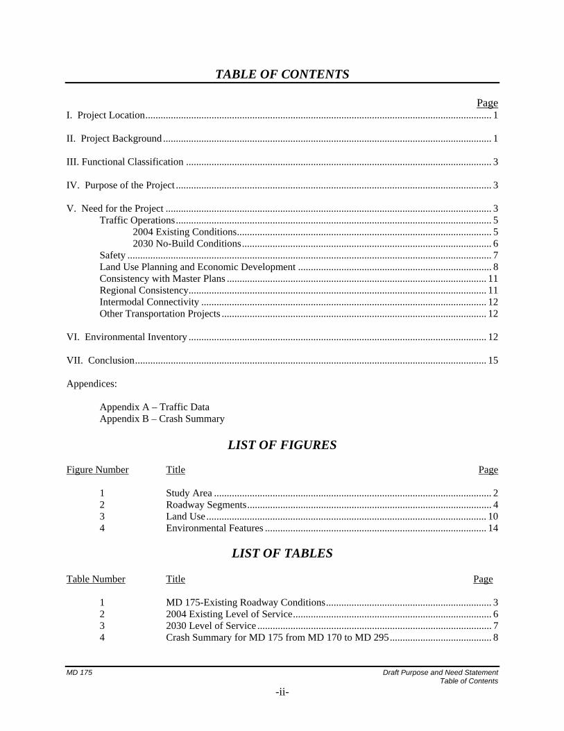
TABLE OF CONTENTS
Page I. Project Location........................................................................................................................................ 1 II. Project Background ................................................................................................................................. 1 III. Functional Classification ........................................................................................................................ 3 IV. Purpose of the Project ............................................................................................................................ 3 V. Need for the Project ................................................................................................................................ 3 Traffic Operations............................................................................................................................ 5 2004 Existing Conditions.................................................................................................... 5 2030 No-Build Conditions.................................................................................................. 6 Safety ............................................................................................................................................... 7 Land Use Planning and Economic Development ............................................................................ 8 Consistency with Master Plans ...................................................................................................... 11 Regional Consistency..................................................................................................................... 11 Intermodal Connectivity ................................................................................................................ 12 Other Transportation Projects ........................................................................................................ 12 VI. Environmental Inventory ..................................................................................................................... 12 VII. Conclusion.......................................................................................................................................... 15 Appendices: Appendix A – Traffic Data Appendix B – Crash Summary
LIST OF FIGURES Figure Number Title Page 1 Study Area ............................................................................................................. 2 2 Roadway Segments................................................................................................ 4 3 Land Use.............................................................................................................. 10 4 Environmental Features ....................................................................................... 14
LIST OF TABLES Table Number Title Page 1 MD 175-Existing Roadway Conditions................................................................. 3 2 2004 Existing Level of Service.............................................................................. 6 3 2030 Level of Service ............................................................................................ 7 4 Crash Summary for MD 175 from MD 170 to MD 295........................................ 8 MD 175 Draft Purpose and Need Statement Table of Contents
-ii-

I. PROJECT LOCATION The limits of the MD 175 (Annapolis Road) Project Planning Study extend from MD 295 (Baltimore-Washington Parkway) to MD 170 (Telegraph Road) in Anne Arundel County, Maryland as shown on the Project Location Map (Figure 1). The project study area is located south of the City of Baltimore in northwestern Anne Arundel County. MD 175 is located just south of Baltimore-Washington International Thurgood Marshall Airport (BWI), about 20 miles from Baltimore and 30 miles from Washington, DC. Within the study limits, MD 175 has grade separated interchanges with MD 295 and MD 32, and at-grade intersection with MD 170 and MD 713. MD 175 is a major east-west corridor serving the Fort George G. Meade Military Reservation (Ft. Meade) and Odenton Town Center. This roadway serves several different types of travelers including commuters, military personnel, commercial, and residential traffic. II. PROJECT BACKGROUND MD 175 can be seen on Maryland State maps from as early as 1860. Odenton was founded in 1868 with the arrival of the Baltimore & Potomac (B & P) Railroad. The B & P Railroad crossed the already existing Annapolis and Elkridge (A & E) Railroad where Odenton was founded. Very little development occurred in the study area until the early part of the 20th Century with the arrival of Ft. Meade in 1917 when the United States War Department acquired 19,000 acres of land west of Odenton. The focus of Ft. Meade expanded in the 1950s with the establishment of the National Security Agency (NSA). Originally a training and deployment center, Ft. Meade is currently transitioning to an information and administrative center, and experienced recent employment growth as a result of the new Environmental Protection Agency (EPA) and Library of Congress buildings located on base. The area is expecting a large increase in employment and development as a result of the 2005 Base Realignment and Closure (BRAC) process. Currently, there are several mixed-use (residential/commercial) developments planned for the area, including two large developments at the intersection of MD 175 and MD 295. There are also plans to expand the parking capacity and services provided for the MARC train station at Odenton. A mixed use Town Center and a large parking garage are planned around the MARC station. The 2005 BRAC decisions will have significant impacts on the MD 175 Corridor. According to published reports, the U.S. Department of Defense’s plan to consolidate the nation’s military bases will have a major influence on the region’s traffic. Ft. Meade would gain 5,300 jobs according to current estimates, including both military and Department of Defense civilians thus resulting in additional contract workers and indirect increases in employment numbers. Many current positions at Ft. Meade will be replaced by civilian contractors who live off-post, thus increasing the travel demand (off-post) relative to the number of employed persons on-post In addition, the NSA is hiring 7,500 additional workers through 2009. The additional traffic that will be generated will be concentrated at specific locations including MD 175 leading to Ft. Meade. These figures do not include the additional private sector jobs that will be created in this corridor to support the government expansion.
MD 175 Draft Purpose and Need Statement
-1-

Insert Figure 1 (Study Area)
MD 175 Draft Purpose and Need Statement
-2-
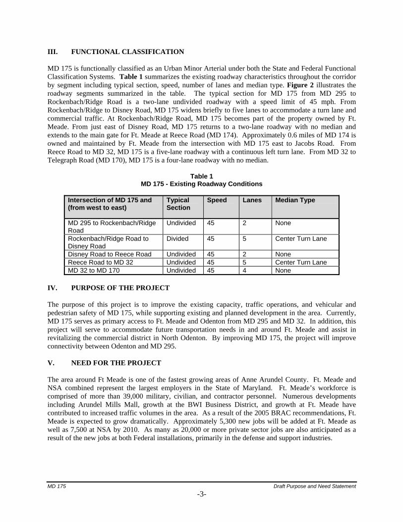
III. FUNCTIONAL CLASSIFICATION MD 175 is functionally classified as an Urban Minor Arterial under both the State and Federal Functional Classification Systems. Table 1 summarizes the existing roadway characteristics throughout the corridor by segment including typical section, speed, number of lanes and median type. Figure 2 illustrates the roadway segments summarized in the table. The typical section for MD 175 from MD 295 to Rockenbach/Ridge Road is a two-lane undivided roadway with a speed limit of 45 mph. From Rockenbach/Ridge to Disney Road, MD 175 widens briefly to five lanes to accommodate a turn lane and commercial traffic. At Rockenbach/Ridge Road, MD 175 becomes part of the property owned by Ft. Meade. From just east of Disney Road, MD 175 returns to a two-lane roadway with no median and extends to the main gate for Ft. Meade at Reece Road (MD 174). Approximately 0.6 miles of MD 174 is owned and maintained by Ft. Meade from the intersection with MD 175 east to Jacobs Road. From Reece Road to MD 32, MD 175 is a five-lane roadway with a continuous left turn lane. From MD 32 to Telegraph Road (MD 170), MD 175 is a four-lane roadway with no median.
Table 1 MD 175 - Existing Roadway Conditions
Intersection of MD 175 and (from west to east)
Typical Section
Speed Lanes Median Type
MD 295 to Rockenbach/Ridge Road
Undivided 45 2 None
Rockenbach/Ridge Road to Disney Road
Divided 45 5 Center Turn Lane
Disney Road to Reece Road Undivided 45 2 None Reece Road to MD 32 Undivided 45 5 Center Turn Lane MD 32 to MD 170 Undivided 45 4 None
IV. PURPOSE OF THE PROJECT The purpose of this project is to improve the existing capacity, traffic operations, and vehicular and pedestrian safety of MD 175, while supporting existing and planned development in the area. Currently, MD 175 serves as primary access to Ft. Meade and Odenton from MD 295 and MD 32. In addition, this project will serve to accommodate future transportation needs in and around Ft. Meade and assist in revitalizing the commercial district in North Odenton. By improving MD 175, the project will improve connectivity between Odenton and MD 295. V. NEED FOR THE PROJECT The area around Ft Meade is one of the fastest growing areas of Anne Arundel County. Ft. Meade and NSA combined represent the largest employers in the State of Maryland. Ft. Meade’s workforce is comprised of more than 39,000 military, civilian, and contractor personnel. Numerous developments including Arundel Mills Mall, growth at the BWI Business District, and growth at Ft. Meade have contributed to increased traffic volumes in the area. As a result of the 2005 BRAC recommendations, Ft. Meade is expected to grow dramatically. Approximately 5,300 new jobs will be added at Ft. Meade as well as 7,500 at NSA by 2010. As many as 20,000 or more private sector jobs are also anticipated as a result of the new jobs at both Federal installations, primarily in the defense and support industries.
MD 175 Draft Purpose and Need Statement
-3-

Insert Figure 2 (Roadway Segments)
MD 175 Draft Purpose and Need Statement
-4-
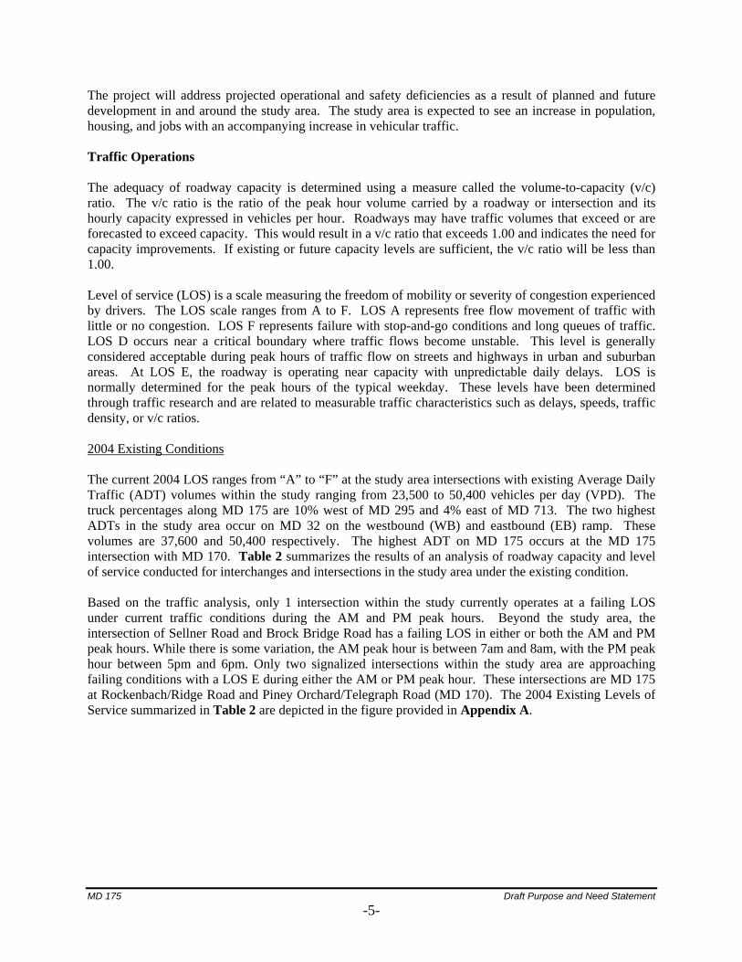
The project will address projected operational and safety deficiencies as a result of planned and future development in and around the study area. The study area is expected to see an increase in population, housing, and jobs with an accompanying increase in vehicular traffic. Traffic Operations
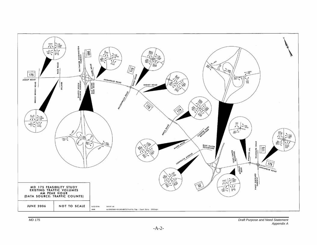
The adequacy of roadway capacity is determined using a measure called the volume-to-capacity (v/c) ratio. The v/c ratio is the ratio of the peak hour volume carried by a roadway or intersection and its hourly capacity expressed in vehicles per hour. Roadways may have traffic volumes that exceed or are forecasted to exceed capacity. This would result in a v/c ratio that exceeds 1.00 and indicates the need for capacity improvements. If existing or future capacity levels are sufficient, the v/c ratio will be less than 1.00. Level of service (LOS) is a scale measuring the freedom of mobility or severity of congestion experienced by drivers. The LOS scale ranges from A to F. LOS A represents free flow movement of traffic with little or no congestion. LOS F represents failure with stop-and-go conditions and long queues of traffic. LOS D occurs near a critical boundary where traffic flows become unstable. This level is generally considered acceptable during peak hours of traffic flow on streets and highways in urban and suburban areas. At LOS E, the roadway is operating near capacity with unpredictable daily delays. LOS is normally determined for the peak hours of the typical weekday. These levels have been determined through traffic research and are related to measurable traffic characteristics such as delays, speeds, traffic density, or v/c ratios. 2004 Existing Conditions The current 2004 LOS ranges from “A” to “F” at the study area intersections with existing Average Daily Traffic (ADT) volumes within the study ranging from 23,500 to 50,400 vehicles per day (VPD). The truck percentages along MD 175 are 10% west of MD 295 and 4% east of MD 713. The two highest ADTs in the study area occur on MD 32 on the westbound (WB) and eastbound (EB) ramp. These volumes are 37,600 and 50,400 respectively. The highest ADT on MD 175 occurs at the MD 175 intersection with MD 170. Table 2 summarizes the results of an analysis of roadway capacity and level of service conducted for interchanges and intersections in the study area under the existing condition.
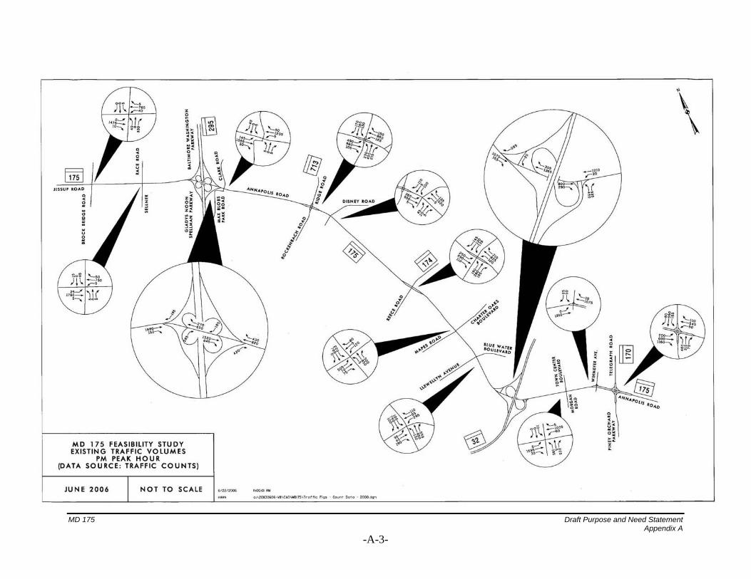
Based on the traffic analysis, only 1 intersection within the study currently operates at a failing LOS under current traffic conditions during the AM and PM peak hours. Beyond the study area, the intersection of Sellner Road and Brock Bridge Road has a failing LOS in either or both the AM and PM peak hours. While there is some variation, the AM peak hour is between 7am and 8am, with the PM peak hour between 5pm and 6pm. Only two signalized intersections within the study area are approaching failing conditions with a LOS E during either the AM or PM peak hour. These intersections are MD 175 at Rockenbach/Ridge Road and Piney Orchard/Telegraph Road (MD 170). The 2004 Existing Levels of Service summarized in Table 2 are depicted in the figure provided in Appendix A.
MD 175 Draft Purpose and Need Statement
-5-
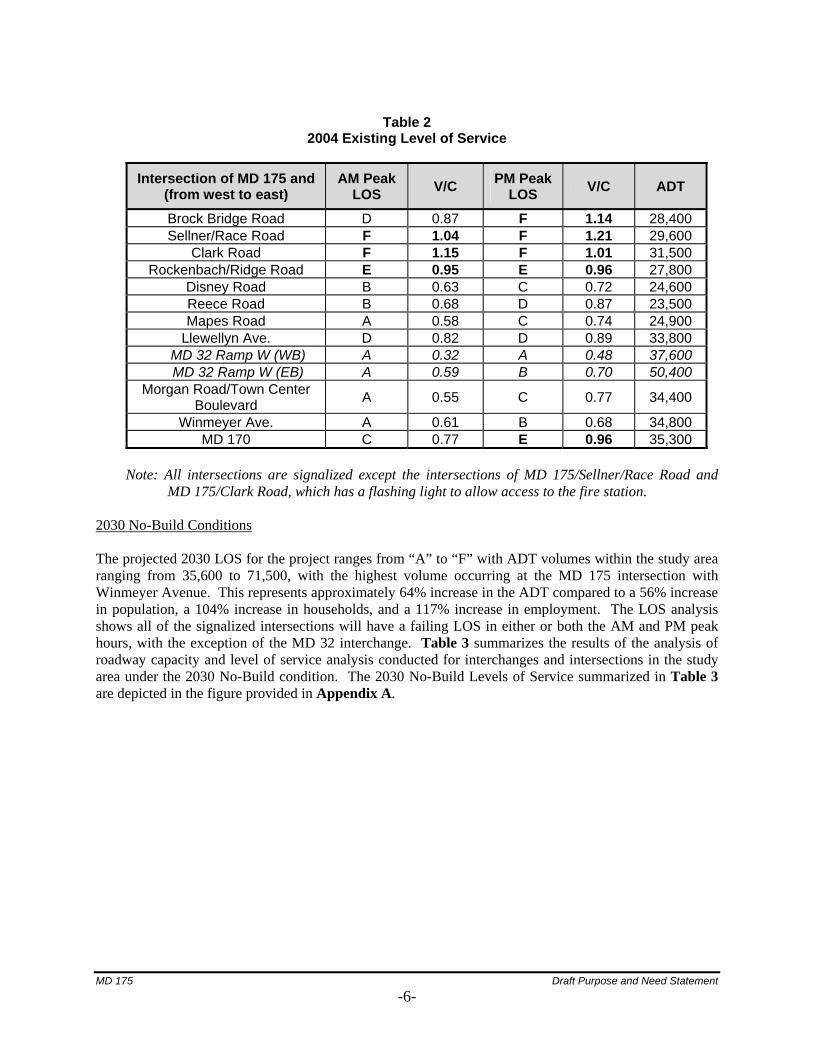
Table 2
2004 Existing Level of Service
Intersection of MD 175 and AM Peak (from west to east) LOS V/C PM Peak
LOS V/C ADT
Brock Bridge Road D 0.87 F 1.14 28,400 Sellner/Race Road F 1.04 F 1.21 29,600
Clark Road F 1.15 F 1.01 31,500 Rockenbach/Ridge Road E 0.95 E 0.96 27,800
Disney Road B 0.63 C 0.72 24,600 Reece Road B 0.68 D 0.87 23,500 Mapes Road A 0.58 C 0.74 24,900
Llewellyn Ave. D 0.82 D 0.89 33,800 MD 32 Ramp W (WB) A 0.32 A 0.48 37,600 MD 32 Ramp W (EB) A 0.59 B 0.70 50,400
Morgan Road/Town Center Boulevard A 0.55 C 0.77 34,400
Winmeyer Ave. A 0.61 B 0.68 34,800 MD 170 C 0.77 E 0.96 35,300
Note: All intersections are signalized except the intersections of MD 175/Sellner/Race Road and
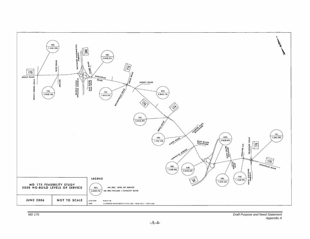
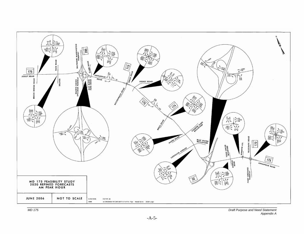
MD 175/Clark Road, which has a flashing light to allow access to the fire station. 2030 No-Build Conditions The projected 2030 LOS for the project ranges from “A” to “F” with ADT volumes within the study area ranging from 35,600 to 71,500, with the highest volume occurring at the MD 175 intersection with Winmeyer Avenue. This represents approximately 64% increase in the ADT compared to a 56% increase in population, a 104% increase in households, and a 117% increase in employment. The LOS analysis shows all of the signalized intersections will have a failing LOS in either or both the AM and PM peak hours, with the exception of the MD 32 interchange. Table 3 summarizes the results of the analysis of roadway capacity and level of service analysis conducted for interchanges and intersections in the study area under the 2030 No-Build condition. The 2030 No-Build Levels of Service summarized in Table 3 are depicted in the figure provided in Appendix A.
MD 175 Draft Purpose and Need Statement
-6-
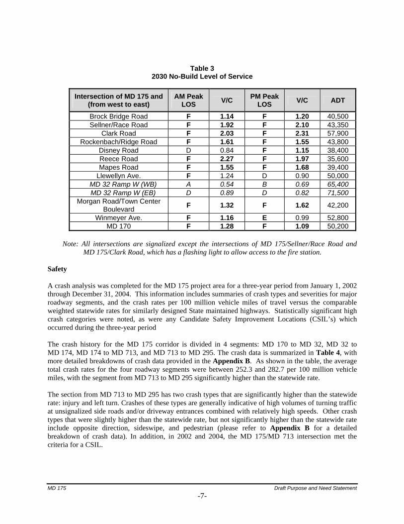
Table 3 2030 No-Build Level of Service
Intersection of MD 175 and (from west to east)
AM Peak LOS V/C PM Peak
LOS V/C ADT
Brock Bridge Road F 1.14 F 1.20 40,500 Sellner/Race Road F 1.92 F 2.10 43,350
Clark Road F 2.03 F 2.31 57,900 Rockenbach/Ridge Road F 1.61 F 1.55 43,800
Disney Road D 0.84 F 1.15 38,400 Reece Road F 2.27 F 1.97 35,600 Mapes Road F 1.55 F 1.68 39,400
Llewellyn Ave. F 1.24 D 0.90 50,000 MD 32 Ramp W (WB) A 0.54 B 0.69 65,400 MD 32 Ramp W (EB) D 0.89 D 0.82 71,500
Morgan Road/Town Center Boulevard F 1.32 F 1.62 42,200
Winmeyer Ave. F 1.16 E 0.99 52,800 MD 170 F 1.28 F 1.09 50,200
Note: All intersections are signalized except the intersections of MD 175/Sellner/Race Road and
MD 175/Clark Road, which has a flashing light to allow access to the fire station. Safety A crash analysis was completed for the MD 175 project area for a three-year period from January 1, 2002 through December 31, 2004. This information includes summaries of crash types and severities for major roadway segments, and the crash rates per 100 million vehicle miles of travel versus the comparable weighted statewide rates for similarly designed State maintained highways. Statistically significant high crash categories were noted, as were any Candidate Safety Improvement Locations (CSIL’s) which occurred during the three-year period The crash history for the MD 175 corridor is divided in 4 segments: MD 170 to MD 32, MD 32 to MD 174, MD 174 to MD 713, and MD 713 to MD 295. The crash data is summarized in Table 4, with more detailed breakdowns of crash data provided in the Appendix B. As shown in the table, the average total crash rates for the four roadway segments were between 252.3 and 282.7 per 100 million vehicle miles, with the segment from MD 713 to MD 295 significantly higher than the statewide rate. The section from MD 713 to MD 295 has two crash types that are significantly higher than the statewide rate: injury and left turn. Crashes of these types are generally indicative of high volumes of turning traffic at unsignalized side roads and/or driveway entrances combined with relatively high speeds. Other crash types that were slightly higher than the statewide rate, but not significantly higher than the statewide rate include opposite direction, sideswipe, and pedestrian (please refer to Appendix B for a detailed breakdown of crash data). In addition, in 2002 and 2004, the MD 175/MD 713 intersection met the criteria for a CSIL.
MD 175 Draft Purpose and Need Statement
-7-
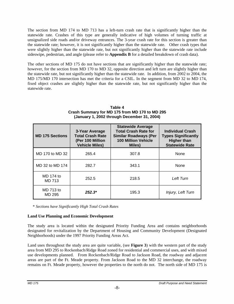
The section from MD 174 to MD 713 has a left-turn crash rate that is significantly higher than the statewide rate. Crashes of this type are generally indicative of high volumes of turning traffic at unsignalized side roads and/or driveway entrances. The 3-year crash rate for this section is greater than the statewide rate; however, it is not significantly higher than the statewide rate. Other crash types that were slightly higher than the statewide rate, but not significantly higher than the statewide rate include sideswipe, pedestrian, and angle (please refer to Appendix B for a detailed breakdown of crash data). The other sections of MD 175 do not have sections that are significantly higher than the statewide rate; however, for the section from MD 170 to MD 32, opposite direction and left turn are slightly higher than the statewide rate, but not significantly higher than the statewide rate. In addition, from 2002 to 2004, the MD 175/MD 170 intersection has met the criteria for a CSIL. In the segment from MD 32 to MD 174, fixed object crashes are slightly higher than the statewide rate, but not significantly higher than the statewide rate.
Table 4
Crash Summary for MD 175 from MD 170 to MD 295 (January 1, 2002 through December 31, 2004)
MD 175 Sections 3-Year Average
Total Crash Rate (Per 100 Million Vehicle Miles)
Statewide Average Total Crash Rate for
Similar Roadways (Per 100 Million Vehicle
Miles)
Individual Crash Types Significantly
Higher than Statewide Rate
MD 170 to MD 32 265.4 307.8 None
MD 32 to MD 174 282.7 343.1 None
MD 174 to MD 713 252.5 218.5 Left Turn
MD 713 to MD 295 252.3* 195.3 Injury, Left Turn
* Sections have Significantly High Total Crash Rates
Land Use Planning and Economic Development The study area is located within the designated Priority Funding Area and contains neighborhoods designated for revitalization by the Department of Housing and Community Development (Designated Neighborhoods) under the 1997 Priority Funding Areas Act. Land uses throughout the study area are quite variable, (see Figure 3) with the western part of the study area from MD 295 to Rockenbach/Ridge Road zoned for residential and commercial uses, and with mixed use developments planned. From Rockenbach/Ridge Road to Jackson Road, the roadway and adjacent areas are part of the Ft. Meade property. From Jackson Road to the MD 32 interchange, the roadway remains on Ft. Meade property, however the properties to the north do not. The north side of MD 175 is
MD 175 Draft Purpose and Need Statement
-8-

zoned commercial, and there are several commercial establishments including the North Odenton Plaza, Dunkin Donuts, Baskin Robbins, Odenton Self Storage, and a Hess gas station.
From the MD 32 interchange extending to the eastern end of the study area (MD 170), land uses and zoning are mixed. Ft. Meade owns the property south of MD 175 from the MD 32 interchange to an area slightly west of Baldwin Road. The north side of the road through this stretch is zoned Town Center, and is currently wooded. From Baldwin Road east to the MARC Penn line, the area north of the roadway is zoned Town Center, while the area to the south is primarily zoned commercial. On the north side, there are several residences and commercial properties. The South side has several commercial properties, along with the Odenton MARC station, and a large MARC parking lot. From the rail line to MD 170, the area north of the roadway is mainly zoned for industrial use and includes several commercial properties while the area to the south is both commercial and residential. The new West County library has recently opened in the area to the west of the southwest quadrant of the MD 175/MD 170 intersection.
The study area has experienced high population growth over the past several years. Between 1990 and 2000, the area’s population has increased by 21.5% to 58,014 and the overall Anne Arundel County population increased by only 14.6%. Between 1970 and 2000, the County’s population has increased by 64.3%, growing from 298,042 to 489,656. The County’s population is expected to continue to increase by 15.4% between 2000 and 2030. The area has also seen high household growth over the past several years. Between 1990 and 2000, the number of households in the study area has increased by 16.1% to 14,909. Over the same time period, the number of households in the County has increased by 19.8%. Between 1970 and 2000 the number of households in the County have more than doubled from 81,100 to 178,670. The County’s households are expected to increase by 26.5% between 2000 and 2030. Odenton is one of the three Town centers in Anne Arundel County, along with Glen Burnie and Parole. The Odenton Town Center is in the center of existing and future population and economic growth in the County. There are two large Planned Unit Developments (PUDs) within the Odenton Small Area Plan that have large amounts of housing.
MD 175 Draft Purpose and Need Statement
-9-
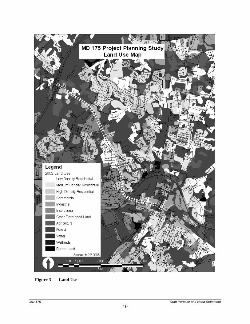
Figure 3 Land Use
MD 175 Draft Purpose and Need Statement
-10-
Consistency with Master Plans
The study area encompasses areas within both Odenton Town Center and Ft. Meade, all within Anne Arundel County. There are six master plans that govern land use in parts of the study area including: the 1997 Anne Arundel County General Development Plan (The County Plan), the 2003 Odenton Small Area Plan, the 2003 Odenton Town Center Master Plan, the 1999 MD 175 Roadway and Streetscape and Odenton Town Center Master Plan (The Roadway Plan), the Jessup-Maryland City Small Area Plan (February 2004) and the Severn Small Area Plan (July 2002). The MD 175 project is consistent with the goals and objectives of both local and regional master planning efforts.
The Odenton Small Area plan identifies the study area as one of the prime areas for economic growth within Anne Arundel County. In compliance with the County Plan, the Small Area Plan seeks to preserve the County’s rural areas by “promoting development in all the right places.” The Plan seeks to improve commercial districts outside of the Town Center. Specifically, it calls for the construction of a parking structure at the Odenton MARC Station, roadway improvements to MD 175 near the station, acquisition of right-of-way or easements from Ft. Meade for MD 175 improvements, and streetscape and sidewalk improvements along MD 175 throughout the study area. The Plan specifically seeks economic development along the MD 175 corridor, in the form of a “gateway entrance” to Odenton Town Center with MD 175 serving as the “Community Main Street”.
The Odenton Town Center Master Plan recommends how to focus future growth in Odenton through the proposed Odenton Town Center (OTC). The OTC will be a destination for shopping, employment, education and other services for the town center, Ft. Meade, and the western part of Anne Arundel County. The OTC seeks to create an urban core along with the adjacent residential areas of Odenton. MD 175 will connect the OTC with the surrounding area.
The Roadway Plan spells out specific recommendations for improvements to MD 175 to support and encourage development of the OTC. The Roadway Plan seeks to improve the functionality and appearance of the commercial strip, and to improve pedestrian/bicycle safety and access along the western section of MD 175 (Reece Road to MD 32). In Central Odenton (MD 32 to MD 170), the Roadway Plan seeks to use MD 175 to integrate town center development. Anne Arundel County intends to improve both the traffic and pedestrian cross movements across MD 175. Regional Consistency The Odenton Growth Management Area (OGMA) was established in 1990 and, in conjunction with the MD 175 commercial revitalization district, will be one of Anne Arundel County’s primary growth areas. The OGMA is a 1,600-acre area encompassing major commercial and industrial zoned portions of Odenton. It contains four sub-areas that include the Odenton Industrial sub-areas along MD 170 north of MD 175, the East Odenton Commercial area along MD 175 between Sappington Station Road and MD 170, the Odenton Town Center sub-areas between MD 170 and MD 32, and the Odenton North sub-areas along MD 175 north of MD 32 to Reece Road. MD 175 is included in the 2004 Highway Needs Inventory and has been identified by Anne Arundel County as its top priority transportation project. The project is integral to the commercial revitalization of the MD 175 corridor, the development of the OGMA, and to support the employment growth at and around Ft. Meade.
MD 175 Draft Purpose and Need Statement
-11-
Intermodal Connectivity One of the most important parts of the study area is the MARC Odenton Station; the main entrance to this facility is on MD 175. The Odenton Station is the third most utilized station within the MARC system, with Penn Station in Baltimore and Union Station in Washington, DC experiencing the highest ridership. In response to large numbers of commuters, the Maryland Department of Transportation (MDOT) constructed an 800-space parking lot in 1995. Currently MDOT and the Maryland Transit Administration (MTA) is constructing expanded parking north of MD 175 including a connection of the new platform to the existing platform at the Odenton MARC Station. MDOT and MTA are also studying the feasibility for a parking structure that could accommodate an additional 2,500 to 3,500 spaces. The Village at Odenton Station, a large transit-oriented mixed-use development, across from the Odenton MARC station will be completed during 2007. There is no MTA bus service within the study area. There are two limited Connect-A-Ride (CAR) local bus routes provided by the Corridor Transportation Corporation. These routes are the Route K (Arundel Mills/Odenton) and Route M (Odenton/Piney Orchard/Route 170 Circulator). The CAR Route M functions as a parking lot circulator between the MARC parking areas scattered throughout the town center and the Odenton MARC station platform. The Route K bus travels from Arundel Mills Mall (north of the study area) to Odenton. Primary stops within the study area are: Severn, Lake Village, Meade Village, Pioneer City, Seven Oaks, Odenton MARC station and Johns Hopkins Medical Center on MD 175. Other Transportation Projects There are two other transportation projects located in the study area listed in the Construction Program of the 2006-2011 Consolidated Transportation Program (Maryland Department of Transportation, 2006).
• MD 295 (Baltimore Washington Parkway) is funded for design, right-of-way, and construction. The plan calls for widening MD 295 from just north of I-195 to I-695 from four to six lanes (1.5 miles).
• MD 295 (Baltimore Washington Parkway) from MD 100 to I-195 and Hanover Road from High
Tech Drive in Howard County to MD 170 (Aviation Boulevard) and is funded for project planning. The plan for this project involves the widening of MD 295 from four to six lanes from just south of MD 100 to just north of I-195 (3.27 miles), construction of a new interchange at Hanover Road, as well as improvements to Hanover Road from High Tech Drive in Howard County to MD 170. This project is located approximately two miles north of the MD 175 study area.
VI. ENVIRONMENTAL INVENTORY The following is a summary of environmental features (Figure 4) and land use (Figure 3) in the MD 175 study area as determined using available data and field reconnaissance. Land use in the study area primarily consists of both commercial and residential uses with several large wooded areas interspersed. Ft. Meade encompasses a large portion of the study area, from approximately MD 713 to south of MD 32. Other government land in the study area includes Jessup Provinces Park (Anne Arundel County Recreation and Parks) located along Disney Road. There are three schools located
MD 175 Draft Purpose and Need Statement
-12-
in the study area including Meade Middle School, Meade High School, and Meade Heights Elementary School. Due to the many commercial properties adjacent to MD 175, there may be several facilities that generate, handle, or store hazardous materials. These sites consist largely of gas stations, car maintenance shops, dry cleaners, and two fire stations. According to the Maryland Historical Trust (MHT) database, the Baltimore-Washington Parkway (MD-295) is the only National Register-listed site within the study limits. One other National Register-listed historic site, the Epiphany Chapel and Church House, is located just beyond the southern portion of the study area at the intersection of Odenton Road and Morgan Road. Several archeology surveys prior to 1995 have been completed within the study area, specifically from MD 713 to MD 174, MD 295 to Rae Road, at the MD 175 and MD 32 interchanges, and at the MD 175 and MD 295 interchanges. Three cemeteries are also located within the study area including two in the northern portion east of MD 175 between 20th Street and Walker Road. The third cemetery is located in the southern portion of the study area east of MD 175 and along Lokus Road. According to the Cultural Resources Initiation Form (CRIF) dated 12/2/05, 13 archeological sites have been recorded in or immediately adjacent to the study area and five have been determined not to be eligible for the National Register. Further coordination with MHT to identify potentially significant cultural resources, will be conducted concurrent with the project planning study. The study area is located within the Little Patuxent River watershed with Midway Branch and Franklin Branch located south and west of MD 175. Streams within the study area are classified as Use I-P waters (Protection of fish and aquatic life and contact recreation, including drinking water). Time of year restrictions on in-stream work in these waterways is required from March 1 through June 15. In addition, several small intermittent and ephemeral streams occur throughout the study area. The majority of these waterways are located within forested areas adjacent to the roadway. There is no 100-year floodplain associated with any of the streams within the study area. The study area contains several potential wetland systems associated with the roadside drainage network. According to the Anne Arundel County Soil Survey, there are no mapped hydric soils within the study area. There are three large forested wetlands located adjacent to MD 175; one west of MD 175 and south of Ballantines Way; one east of MD 175 and the MD 32 overpass; and one west of MD 175 adjacent to the new West County Area Library. Coordination with the U.S. Army Corps of Engineers and the Maryland Department of the Environment (MDE) Non-Tidal Wetlands and Waterways Division will also be conducted during the project planning study.
MD 175 Draft Purpose and Need Statement
-13-

Figure 4 Environmental Features
MD 175 Draft Purpose and Need Statement
-14-
Forest stands and specimen trees were identified during preliminary field reconnaissance. The majority of specimen trees were located in the forested wetland area west of MD 175 south of Ballantines Way, and within the southbound loop of MD 32. Coordination with the Maryland Department of Natural Resources (DNR) will be required to comply with all forest conservation regulations. The U.S Fish and Wildlife Service (USFWS) has reviewed the project area for the presence of federally proposed or listed threatened and endangered species and determined none are known to exist (letter dated January 10, 2006). DNR has determined that there are no State or Federal records for rare, threatened, and endangered species within the project boundaries. The State endangered and Federal threatened Swamp Pink is known to occur in nontidal wetland habitat in the vicinity of the project (DNR letter dated 2/24/06). State threatened Wild Lupine may also occur in suitable habitats in the project vicinity. Continued coordination with DNR and the USFWS will be required during the project planning study to ensure the project does not affect any Federal and State-listed rare, threatened, and endangered within the study area. Ft. Meade is known habitat for 11 State-listed rare, threatened, and endangered species, including the State threatened Glassy Darter which is one of only two locations in the State of Maryland where the fish is known to exist. VI. CONCLUSION The MD 175 study area is one of the fastest growing areas in Anne Arundel County and is projected to grow rapidly over the next decade due to employment and residential expansion at Ft. Meade, development of the Odenton Town Center, and revitalization of the MD 175 corridor. The proposed improvements are needed to address existing and future operational, vehicular and pedestrian safety, and capacity issues while supporting existing and planned economic development within this high growth area. The project will improve access to Ft. Meade from both MD 295 and MD 170 and improve operational efficiency and safety in the MD 175 corridor.
MD 175 Draft Purpose and Need Statement
-15-

APPENDIX A TRAFFIC DATA

MD 175 Draft Purpose and Need Statement Appendix A
-A-1-
MD 175 Draft Purpose and Need Statement Appendix A
-A-2-
MD 175 Draft Purpose and Need Statement Appendix A
-A-3-
MD 175 Draft Purpose and Need Statement Appendix A
-A-4-
MD 175 Draft Purpose and Need Statement Appendix A
-A-5-

MD 175 Draft Purpose and Need Statement Appendix A
-A-6-
APPENDIX B CRASH SUMMARY
Crash Summary For the purposes of these analyses, the corridor was divided into 4 sections whose termini are the major intersections or interchanges within the corridor. Descriptions for each section, provided below, include the termini intersections / interchanges, the length of the section, a listing of the included minor signalized intersections, and a description of the section’s roadway type(s) (used for comparison of each section’s crash rate with the statewide crash rate).
• MD 170 (Telegraph Road / Piney Orchard Parkway) to MD 32 is 1.29 miles and includes intersections at MD 175 with Winmeyer Avenue and Morgan Road / Town Center Boulevard. MD 175, within this section, is typed as 34% urban divided roadway with no access controls and 4 or more lanes, 34% urban undivided roadway with no access control and 5 lanes (included a center two-way left turn lane), and 32% urban undivided roadway with no access controls and 4 or more lanes.
• MD 32 to MD 174 (Reece Road), which is 1.37 miles and includes the intersections at MD 175
with Llewellyn Avenue / Blue Water Boulevard and Mapes Road / Charter Oaks Boulevard. MD 175, within this section, is typed as 6% urban divided roadway with no access controls and 4 or more lanes, and 94% urban undivided roadway with no access control and 5 lanes (included a center two-way left turn lane).
• MD 174 (Reece Road) to MD 713 (Ridge Road) / Rockenbach Road, which is 1.34 miles and
includes the intersection of MD 175 with Disney Road. MD 175, within this section, is typed as 10% urban undivided roadway with no access controls and 4 or more lanes, 4% urban undivided roadway with no access controls and 3 lanes, 75% urban undivided roadway with no access controls and 2 lanes, and 10% urban divided roadway with no access controls and 4 or more lanes.
• MD 713 (Ridge Road) / Rockenbach Road to MD 295 (Baltimore Washington Parkway), which
is 1.30 miles and includes the intersection of MD 175 with Max Blobs Park Road / Clark Road. MD 175, within this section, is typed as 18% urban divided roadway with no access controls and 4 or more lanes, and 82% urban undivided roadway with no access controls and 2 lanes.
For the sections whose termini include a major intersection, interior to the corridor, the crashes reported as occurring on MD 175 at that location may be listed for both sections that have that intersection as a terminus. In other words, both the section from MD 32 to MD 174 and the section from MD 174 to MD 713 include the crashes reported as occurring on MD 175 at the intersection of MD 175 and MD 174. This occurs for MD 174 and MD 713 therefore the aggregate totals summarized in Tables 1 through 4 results in a greater number of crashes than reported in the complete project corridor as summarized in Table 2 in the document (Crash Summary for MD 175 from MD 170 to MD 295 – January 1, 2002 through December 31, 2004). Additionally, it should be noted that each of Tables 1 through 4 include only the crashes reported as occurring on MD 175. Therefore, crashes occurring at, for example, the intersection of MD 175 and MD 170 that are reported as occurring on MD 170 may not be included in the listings. Also, the major and minor signalized intersections listed for each section do not comprise all of the intersections along the roadway. As a result of both of these notes, the number of intersection related crashes reported for each section may not correspond to the number of crashes reported for each analyzed intersection within the section. MD 175 Draft Purpose and Need Statement Appendix B
-B-1-
Detailed discussions of the crash experiences in each section of the corridor, as previously described, are provided below.
MD 170 to MD 32 The region of the corridor from MD 170 to MD 32 experienced a total of 84 police-reported crashes between January 1, 2002 and December 31, 2004. Of these 84 crashes, 45 resulted in injury (54%) and 39 resulted in property damage only (46%) and no fatalities were reported. As a whole, the crash rates for this section of the corridor were within acceptable levels based on the statewide average crash rate. Similar to the overall corridor, the most common crash types reported were rear end crashes (37%), left turn crashes (21%), and angle crashes (15%). Additionally, approximately 60% of the crashes were reported as intersection related. Crash data for this region is summarized in Table 1.
Table 1 Crash Summary for MD 175 from MD 170 to MD 32
(January 1, 2002 through December 31, 2004)
Number of Crashes Crash Type
2002 2003 2004 Total
Study Rate per
100 MVMT
Statewide Average
Rate
Total Crashes 34 32 18 84 265.4 307.8 Fatal 0 0 0 0 0.0 1.6 Injury 21 16 8 45 142.2 135.6 Property Damage Only 13 16 10 39 123.2 170.6 Opposite Direction 2 1 1 4 12.6 8.9 Rear End 12 11 8 31 98.0 105.4 Sideswipe 2 1 0 3 9.5 20.1 Left Turn 6 10 2 18 56.9 40.1 Angle 7 3 3 13 41.1 55.7 Pedestrian 0 0 2 2 6.3 10.3 Parked Vehicle 0 0 0 0 0.0 4.6 Fixed Object 2 1 0 3 9.5 23.0 Other 3 5 2 10 31.6 35.9 Truck Related 4 1 1 6 19.0 19.3 Nighttime 8 8 1 17 20% 32% Wet Surface 5 9 6 20 23% 28% Alcohol Related 1 1 0 2 2% 8% Intersection Related 19 19 12 50 N/A N/A
Examination of the individual intersections within this region of the corridor revealed a total of 50 crashes in the vicinity of MD 170, 2 crashes in the vicinity of Winmeyer Avenue, and 9 crashes in the vicinity of Morgan Road / Town Center Boulevard. The intersection of MD 175 and MD 170 has been listed by OOTS as a Candidate Safety Improvement Intersection in 2002, 2003, and preliminarily in 2004. The predominant crash type at the intersection of MD 175 and MD 170 for 2002 through 2004 was left turn crashes, which made up 58% of the total crashes reported at this location.
MD 175 Draft Purpose and Need Statement Appendix B
-B-2-
MD 32 to MD 174 The region of the corridor from MD 32 to MD 174 experienced a total of 95 police-reported crashes between January 1, 2002 and December 31, 2004. Of these 95 crashes, 1 resulted in a fatality, 32 resulted in injury (34%), and 62 resulted in property damage only (65%). As a whole, the crash rates for this section of the corridor were within acceptable levels based on the statewide average crash rate. Similar to the overall corridor, the most common crash types reported were rear end crashes (33%), left turn crashes (18%), and angle crashes (21%). Additionally, approximately 41% of the crashes were reported as intersection related. Crash data for this region is summarized in Table 2.
Table 2 Crash Summary for MD 175 from MD 32 to MD 174
(January 1, 2002 through December 31, 2004)
Number of Crashes Crash Type
2002 2003 2004 Total
Study Rate per
100 MVMT
Statewide Average
Rate
Total Crashes 34 29 32 95 282.7 343.1 Fatal 0 1 0 1 3.0 1.4 Injury 13 9 10 32 95.2 149.8 Property Damage Only 21 19 22 62 184.5 191.9 Opposite Direction 0 2 0 2 6.0 9.2 Rear End 12 7 12 31 92.2 112.3 Sideswipe 3 2 1 6 17.9 21.4 Left Turn 4 7 6 17 50.6 52.9 Angle 6 7 7 20 59.5 68.1 Pedestrian 0 0 0 0 0.0 13.0 Parked Vehicle 0 0 0 0 0.0 3.9 Fixed Object 5 1 3 9 26.8 20.4 Other 4 3 3 10 29.8 39.2 Truck Related 1 1 0 2 6.0 20.8 Nighttime 11 8 12 31 32% 32% Wet Surface 9 7 5 21 22% 28% Alcohol Related 3 1 5 9 9% 8% Intersection Related 12 10 17 39 N/A N/A
* Significantly higher than the statewide rate Examination of the individual intersections within this region of the corridor revealed a total of 23 crashes in the vicinity of Llewellyn Avenue / Blue Water Boulevard, 8 crashes in the vicinity of Mapes Road / Charter Oaks Boulevard, and 4 crashes in the vicinity of MD 174 / Reece Road. None of these intersections were listed by OOTS as a Candidate Safety Improvement Intersection in 2002 through 2004.
MD 175 Draft Purpose and Need Statement Appendix B
-B-3-
MD 174 to MD 713 The region of the corridor from MD 174 to MD 713 experienced a total of 83 police-reported crashes between January 1, 2002 and December 31, 2004. Of these 83 crashes, 37 resulted in injury (45%) and 46 resulted in property damage only (55%). No fatalities were reported. As a whole, the crash rates for this section of the corridor were within acceptable levels based on the statewide average crash rate with the exception of left turn crashes and other crashes. Similar to the overall corridor, the most common crash types reported were rear end crashes (22%), left turn crashes (24%), and angle crashes (19%). Additionally, approximately 57% of the crashes were reported as intersection related. Crash data for this region is summarized in Table 3.
Table 3 Crash Summary for MD 175 from MD 174 to MD 713
(January 1, 2002 through December 31, 2004)
Number of Crashes Crash Type
2002 2003 2004 Total
Study Rate per
100 MVMT
Statewide Average
Rate
Total Crashes 29 30 24 83 252.5 218.5 Fatal 0 0 0 0 0.0 1.3 Injury 11 14 12 37 112.6 99.6 Property Damage Only 18 16 12 46 139.9 117.6 Opposite Direction 1 1 0 2 6.1 10.4 Rear End 7 7 4 18 54.8 71.2 Sideswipe 2 2 0 4 12.2 11.1 Left Turn 9 5 6 20 60.8* 20.0 Angle 2 7 7 16 48.7 37.3 Pedestrian 1 1 1 3 9.1 6.6 Parked Vehicle 1 0 1 2 6.1 6.9 Fixed Object 3 2 2 7 21.3 28.5 Other 3 5 3 11 33.5 20.6 Truck Related 0 4 0 4 12.2 13.0 Nighttime 8 12 7 27 32% 32% Wet Surface 6 9 9 24 28% 28% Alcohol Related 1 1 3 5 6% 8% Intersection Related 15 15 17 47 N/A N/A
* Significantly higher than the statewide rate Examination of the individual intersections within this region of the corridor revealed a total of 4 crashes in the vicinity of MD 174 / Reece Road (as noted in the previous section), 7 crashes in the vicinity of Disney Road, and 30 crashes in the vicinity of MD 713. The intersection of MD 175 and MD 713 has been listed by OOTS as a Candidate Safety Improvement Intersection in 2002, and preliminarily in 2004. The predominant crash type as this intersection for 2002 through 2004 was left turn crashes, which made up 50% of the total crashes. Rear end crashes comprised another 30% of the crashes.
MD 175 Draft Purpose and Need Statement Appendix B
-B-4-

MD 713 to MD 295 The region of the corridor from MD 713 to MD 295 experienced a total of 100 police-reported crashes between January 1, 2002 and December 31, 2004. Of these 100 crashes, 1 resulted in a fatality, 46 resulted in injury, and 53 resulted in property damage only. Crash rates for this section of the corridor exceeded acceptable levels based on the statewide average crash rate for total crashes, injury crashes, property damage only crashes, left turn crashes, and other crashes. Similar to the overall corridor, the most common crash types reported were rear end crashes (24%), left turn crashes (19%), other crashes (18%), and angle crashes (17%). Additionally, approximately 44% of the crashes were reported as intersection related. Crash data for this region is summarized in Table 4.
Table 4 Crash Summary for MD 175 from MD 713 to MD 295
(January 1, 2002 through December 31, 2004)
Number of Crashes Crash Type
2002 2003 2004 Total
Study Rate per
100 MVMT
Statewide Average
Rate
Total Crashes 42 30 28 100 252.3* 195.3 Fatal 0 0 1 1 2.5 1.3 Injury 20 15 11 46 116.1* 90.2 Property Damage Only 22 15 16 53 133.7 103.8 Opposite Direction 1 3 0 4 10.1 9.4 Rear End 9 9 6 24 60.6 64.6 Sideswipe 1 1 3 5 12.6 8.5 Left Turn 9 3 7 19 47.9* 16.8 Angle 7 5 5 17 42.9 32.5 Pedestrian 1 0 2 3 7.6 5.7 Parked Vehicle 1 1 1 3 7.6 6.7 Fixed Object 3 4 0 7 17.7 27.7 Other 10 4 4 18 45.4 17.5 Truck Related 2 2 1 5 12.6 11.9 Nighttime 13 8 7 28 28% 32% Wet Surface 10 13 6 29 29% 28% Alcohol Related 7 6 0 13 13% 8% Intersection Related 20 9 15 44 N/A N/A
* Significantly higher than the statewide rate
Examination of the individual intersections within this region of the corridor revealed a total of 30 crashes in the vicinity of MD 713 (as noted in the previous section), 5 crashes in the vicinity of Max Blobs Park Road / Clark Road. As described previously, the intersection of MD 175 and MD 713 has been listed by OOTS as a Candidate Safety Improvement Intersection in 2002, and preliminarily in 2004. The predominant crash type as this intersection for 2002 through 2004 was left turn crashes, which made up 50% of the total crashes. Rear end crashes comprised another 30% of the crashes.
MD 175 Draft Purpose and Need Statement Appendix B
-B-5-