draft plan of management - nsw environment & heritage · forest (including sugar creek flora...
TRANSCRIPT

WALLINGAT NATIONAL PARK
DRAFT PLAN OF MANAGEMENT National Parks and Wildlife Service Part of the Department of Environment and Climate Change NSW June 2007
Acknowledgments This plan of management was prepared by staff of the Great Lakes Area Office of the National Parks and Wildlife Service (NPWS), with the assistance of staff from Hunter Region. NPWS specialists, the Hunter Regional Advisory Committee, Forests NSW and members of the public provided valuable information and comments. Much of the geology and native plant and animal information was drawn from a park profile prepared for the NPWS by Flint (2004). NPWS would like to thank all those who attended the ‘open forum’ meeting. Your comments and concerns were considered in the preparation of this draft Plan of Management. NPWS recognises the valuable contribution your comments have made to the planning process. For additional information or inquiries about the park or any aspect of the plan, contact the NPWS Great Lakes Area Office on telephone (02) 6591 0300. Disclaimer: This publication is for discussion and comment only. Publication as a draft indicates the proposals are under consideration and are open for public discussion. Provisions in the final management plan may not be the same as those in this draft plan. © Department of Environment and Climate Change (NSW) 2007: Use permitted with appropriate acknowledgment ISBN 1 74122 234 6

INVITATION TO COMMENT The National Parks and Wildlife Act 1974 (NPW Act) requires that a plan of management be prepared that outlines how an area will be managed by the NSW National Parks and Wildlife Service (NPWS). The procedures for the exhibition and consultation on plans of management are specified in the NPW Act and involve the following stages: • The draft plan is placed on public exhibition for at least 90 days and any
person may comment on it; • The plan and all submissions received on the plan are referred to the
Regional Advisory Committee for consideration; • The plan, submissions and any advice from the Regional Advisory
Committee are referred to the National Parks and Wildlife Advisory Council for consideration;
• The plan, submissions and the recommendations of the Advisory Council are referred to the Minister, and a copy referred to the Regional Advisory Committee;
• After considering the submissions, the recommendations of the Advisory Council and any advice from the Regional Advisory Committee, the Minister may adopt the plan or may refer the plan back to the NPWS and Council for further consideration.
Members of the public, whether as individuals or as members of community interest groups, are invited to comment on this plan of management. Submissions should be in writing, and as detailed and specific as possible. However, any comments, no matter how brief, are welcome. Comments should be forwarded to:
The Ranger Wallingat National Park Draft Plan of Management National Parks and Wildlife Service The Lakes Way PACIFIC PALMS NSW 2428
The closing date for comments on the plan is Monday 15th October 2007. All submissions received by NPWS are a matter of public record and are available for public inspection upon request to NPWS. Your comments on this draft plan of management may contain information that is defined as “personal information” under the NSW Privacy and Personal Information Protection Act 1998. The submission of personal information with your comments is voluntary.

TABLE OF CONTENTS
1 Management Context .......................................................................... 5 1.1 Legislation and Policy Framework................................................................5 1.2 Management Purpose and Principles ..........................................................5
2. Wallingat National Park ...................................................................... 6 2.1 Location, Gazettal and Regional Setting ......................................................6 2.2 Landscape Context ......................................................................................6
3. Values and Management Directions.................................................. 9 3.1 Values of the Park ........................................................................................9 3.2 Management Directions ...............................................................................10
4. Natural and Cultural Heritage............................................................. 11 4.1 Landform and scenic value ..........................................................................11 4.2 Native Plants ................................................................................................12 4.3 Native Animals .............................................................................................16 4.4 Aboriginal Heritage.......................................................................................18 4.5 Historic Heritage...........................................................................................20
5. Park Protection.................................................................................... 22 5.1 Geology and Soil Conservation....................................................................22 5.2 Water Quality and Catchment Management ................................................23 5.3 Introduced Plants .........................................................................................25 5.4 Introduced Animals.......................................................................................27 5.5 Fire Management .........................................................................................28
6. Visitor Opportunities and Education................................................. 31 6.1 Road Network...............................................................................................31 6.2 Camping and Day Use Areas.......................................................................35 6.3 Bushwalking .................................................................................................39 6.4 Cycling..........................................................................................................41 6.5 Recreational Horse Riding ...........................................................................42 6.6 Visitor Information ........................................................................................45
7. Commercial Activities, Group Activities & Special Events ............. 47 8. Research and Monitoring ................................................................... 49 9. NPWS Operations and Alien Land Uses ........................................... 51 10. Plan Implementation ........................................................................... 54
Implementation - Summary of Actions .................................................................55
11. Bibliography ........................................................................................ 62 LIST OF MAPS Park Map: Wallingat National Park..............................................................4 LIST OF TABLES Table 1: Threatened and significant plant species recorded in the park.......13 Table 2: The main forest ecosystems within the park...................................14 Table 3: Threatened animals recorded in the park. 1 ....................................16 Table 4: Facilities at Day Use and Camping Areas ......................................35 Table 5: Walking tracks in the park and their classification ..........................39 Table 6: Summary of actions........................................................................55

1 MANAGEMENT CONTEXT 1.1 LEGISLATION AND POLICY FRAMEWORK The management of national parks and nature reserves in NSW is in the context of the legislative and policy framework, primarily the National Park and Wildlife Act 1974 (NPW Act) and the policies of the National Parks and Wildlife Service (NPWS). Section 72AA of the NPW Act lists the matters to be considered in the preparation of a plan of management. The policies arise from the legislative background, the corporate goals of the NPWS and internationally accepted principles of park management. They relate to nature conservation, Aboriginal and historic heritage conservation, recreation, commercial use, research and communication. Other legislation, international agreements and charters may also apply to management of the area. In particular, the Environmental Planning and Assessment Act 1979 (EPA Act) requires the assessment and mitigation of environmental impacts of any works proposed in this plan. The plan of management is a statutory document under the NPW Act. Once the Minister has adopted a plan, no operations may be undertaken within the park except in accordance with the plan. The plan will also apply to any future additions to the park. Where management strategies or works are proposed for the park or any additions that are not consistent with the plan, an amendment to the plan will be required. 1.2 MANAGEMENT PURPOSE AND PRINCIPLES National parks are reserved under the NPW Act, to protect and conserve areas containing outstanding or representative ecosystems, natural or cultural features or landscapes that provide opportunities for public appreciation, inspiration and sustainable visitor use. Under the Act (section 30E), national parks are managed to: • conserve biodiversity, maintain ecosystem functions, protect geological and
geomorphological features and natural phenomena and maintain natural landscapes;
• conserve places, objects, features and landscapes of cultural value; • protect the ecological integrity of one or more ecosystems for present and
future generations; • promote public appreciation and understanding of the park’s natural and
cultural values; • provide for sustainable visitor use and enjoyment that is compatible with
conservation of natural and cultural values; • provide for sustainable use (including adaptive reuse) of any buildings or
structures or modified natural areas having regard to conservation of natural and cultural values; and
• provide for appropriate research and monitoring.
2. WALLINGAT NATIONAL PARK 2.1 LOCATION, GAZETTAL AND REGIONAL SETTING Wallingat National Park (referred to herein as “the park”) covers an area of 6,557 hectares and is located on the western side of Wallis Lake on the New South Wales mid-north coast. The exact meaning of the word Wallingat is not known. It has been suggested that it could mean head of the river as Walang means head in the local Aboriginal language. Forster-Tuncurry is the nearest major centre located 15km north-east of the park with other smaller nearby settlements including Coomba Park, Bungwahl, Wootton, Coolongolook, Smiths Lake and Pacific Palms. The park was gazetted on the 1 January 1999 under the Forestry and National Park Estate Act 1998. Under this Act 5,140 hectares, being part of Wallingat State Forest (including Sugar Creek Flora Reserve), and 1,300 hectares, being part of Bachelor State Forest, as well as 117 hectares of Crown Land were reserved as Wallingat National Park. As well as the gazetted reserve, the park includes several ministerial roads, which are vested in the Minister for the Environment on behalf of the Crown for the purposes of Part 11 of the NPW Act. They were created under the Forestry and National Parks Estate Act to ensure that the access arrangements (such as for timber hauling and private property access) which existed immediately before the park’s creation, could continue. The management of these roads is subject to the provisions of this plan, the NPW Regulations, and the requirements of the EPA Act. The park is generally forested with vegetation varying from rainforest and moist sclerophyll forest in the south and east, to drier more open forest in the north and west. The average temperature ranges from 23oC max to 12oC min with an annual average rainfall of 1,200mm. The park falls within the Forster Local Aboriginal Land Council and Great Lakes Council local government area. It is bounded by Wallingat State Forest to the south, Bachelor State Forest to the north-west and private rural residential properties to the north, east, south and west. There is a privately owned in-holding on the eastern side of the park off Yarric Road. The park is part of a system of reserves in the Great Lakes Area including Myall Lakes and Booti Booti National Parks. It provides a range of recreation opportunities, including bushwalking, picnicking, camping and car touring. The surrounding area also provides extensive opportunities for a variety of outdoor recreational pursuits including swimming, diving, surfing, bushwalking, fishing, boating and camping. A small crown reserve on the eastern side of Wallingat River provides access to the river on the northern edge of the park. 2.2 LANDSCAPE CONTEXT

Natural and cultural heritage and on-going use are strongly inter-related and together form the landscape of an area. Much of the Australian environment has been influenced by past Aboriginal and non-Aboriginal land use practices, and the activities of modern day Australians continue to influence the environment through recreational use, cultural practices, the presence of introduced plants and animals and in some cases air and water pollution. The geology, landform, climate and plant and animal communities of the park, plus its location, have determined how it has been used by humans. The park’s natural environments have been greatly influenced by past land use that has included intensive logging, grazing by domestic stock and regular burning. These activities are likely to have had a significant impact on the structure and diversity of the vegetation communities that exist today. Flint (2004, p. 2) described the park as “…one of the largest and most significant coastal forest reserves in north-eastern NSW, and indeed the State. It is dominated by severely depleted, poorly reserved and threatened ecosystems. It contains an outstanding diversity of habitats and structural vegetation types, from tall productive forests, to diverse lowland swamp ecosystems, rainforest, dry forests and woodlands. This diversity is reflected in both the large number of flora and fauna species that have been recorded and the high number of threatened and significant fauna that are known and predicted to occur.” Both Aboriginal and non-Aboriginal people place cultural values on natural areas, including aesthetic, social, spiritual, recreational and other values. Cultural values may be attached to the landscape as a whole or to individual components, for example to places used by Aboriginal and/or non-Aboriginal people. This plan of management aims to conserve both natural and cultural values. For reasons of clarity and document usefulness, natural and cultural heritage, non-human threats and on-going use, are dealt with individually, but their inter-relationships are recognised.

3. VALUES AND MANAGEMENT DIRECTIONS
3.1 VALUES OF THE PARK
The park is significant as part of a system of conservation reserves in the north east of NSW. It is also important in its own right due to its biodiversity, cultural, landscape and nature-based recreation values. The key values of the park are summarised as follows. Natural heritage values: • the outstanding diversity of habitats and structural vegetation types from tall
moist forest, swamps, rainforest to dry forests and woodlands which support a diverse number of mammals, birds, reptiles, frogs and invertebrates including many threatened species.
• the park is one of the largest and most significant coastal forest reserves in north-east NSW dominated by severely depleted, poorly reserved and threatened ecosystems within a state context. Several ecosystems are also at their northern and southern limit.
• the park contains significant areas of estuarine muds associated with the Wallingat River.
• the forested catchment helps maintain water quality in the headwaters of the Wallingat River and Wallis Lake Catchment.
• the park contains significant stands of Cabbage Palm (Livistona australis), especially in the Sugar Creek catchment.
Cultural heritage values: • the park is located in a landscape that is part of the identity, spirituality and
resource base for the local Aboriginal people of the Worimi Nation. • the park contains historic heritage associated with the early settlement of the
region and use of the area for forestry and grazing. Landscape values: • the park provides an important scenic landscape for the local communities, in
particular Forster/Tuncurry and Coomba Park. • the park forms part of an important regional wildlife corridor network that links
coastal areas to inland highland areas via other national parks, state forests and private property.
Recreation values: • the park provides a range of recreation opportunities, including the provision of
camping and day use areas, with little conflict between users. • there are many education and interpretation opportunities associated with the
diverse plant and animal communities and cultural heritage contained within the park.
• the park provides an easily accessible lookout at Whoota Whoota which provides spectacular views along the Forster-Tuncurry coast line and western ranges near Bulahdelah.
Research values: • the park offers research opportunities associated with the diversity of native
plants and animals and post-logging forest succession. • there are opportunities for research into threatened species and poorly
conserved vegetation communities within the park.

3.2 MANAGEMENT DIRECTIONS The primary emphasis of this plan is the conservation of the natural and cultural values of the park. Visitor opportunities will be provided where they are compatible with and promote the understanding and enjoyment of these values. Conservation of the park’s values will be achieved through the following: • protection and enhancement of scenic values through retention of forested
landscapes and ensuring the design, location and management of park facilities is not visually intrusive;
• protection of native flora including threatened and regionally significant species, old growth forests and rainforest communities;
• protection of the diverse range of native fauna including threatened species and their habitats;
• recognition and protection of traditional and contemporary Aboriginal cultural heritage in partnership with the local Aboriginal community;
• protection of historic heritage through identifying, recording and conserving historic resources;
• protection of water catchment values through managing roads, trails, tracks and visitor areas, including appropriate waste disposal;
• implementation of pest control programs to assist with the protection of park values through the control and, where possible, eradication of introduced plants and animals;
• development and implementation of a fire management strategy to assist in the protection of neighbouring life and property and park values;
• provision of an access network of roads, management trails and walking tracks that is compatible with regional recreation opportunities and management objectives;
• provision of recreation opportunities focussed at existing camping and day use areas which have minimal impact on the environment whilst recognising complementary recreation opportunities provided nearby;
• provision of interpretive and educational opportunities through signage, park brochures and activities to assist visitor understanding and enjoyment of park values and the environment; and
• improving knowledge of natural and cultural heritage, corresponding threats and the evaluation of management programs through research and monitoring.

4. NATURAL AND CULTURAL HERITAGE 4.1 LANDFORM AND SCENIC VALUE The park contains coastal lowlands adjacent to the Wallingat River which effectively divides the park in two. The area to the east of the river contains the largest portion of the park and is dominated by two north-west to south-east running ridgelines. The two main ridges, separated by Sugar Creek, have their highest point of two hundred and fifty metres at Whoota Whoota Lookout. Other prominent hills include One Tree Hill, Duck Creek Hill and Chinamans, all of which dominate the south-eastern portion of the park. The remainder of the park is predominantly flat to undulating with an estimated seventy percent of the park below sixty metres in elevation. These low-lying areas are associated with Wallingat River and its tributary system including Boggy Creek, Sugar Creek, Pipeclay Creek and Ferny Creek. The park also provides an important forested environment within the local community. Whoota Whoota Lookout is one of the most spectacular lookouts in the area and offers views along the Forster/Tuncurry coastline and west along the Meyers Range. Clearing of the lookout to establish and maintain the views also means it is a prominent skyline feature in the local area. The lookout needs to be managed with consideration to scenic values, in particular its visibility on the skyline while still enabling the views to be maintained. Scenic values could also be affected from within the park through inappropriate park development and poor management and development of non-park infrastructure such as telecommunications facilities and transmission lines. Views from within the park to the surrounding area could be adversely impacted upon by inappropriate development outside the park. This could occur where large amounts of native vegetation are removed or where development occurs which is not in harmony with the surrounding environment. Desired Outcome • The park’s existing scenic values are protected and where practical enhanced. Strategies • Locate, design and use appropriate materials for park facilities in accordance
with NPWS policies and guidelines to be visually unobtrusive.
• Any development of the Whoota Whoota lookout area should not increase its visual prominence and, if possible, its impacts on the scenic landscape should be reduced.
• Assess the visual impacts of proposed works and development as part of the overall environmental assessment for such works. Proposals assessed as having unacceptable impacts on natural landscape values will not be approved.
• Encourage the Great Lakes Council and proponents to consider the impacts of surrounding development on the park’s scenic values.

Actions 4.1.1 Investigate options for reducing the visual prominence of Whoota Whoota
lookout on the skyline, such as the planting of trees along the ridgeline where it does not interfere with existing views (refer also to 6.2.7).
4.1.2 Ensure visitor facilities and infrastructure are not to be sited in visually prominent positions (refer also to 6.2.7).
4.2 NATIVE PLANTS The vegetation types that are probably most characteristic of the park are the tall moist eucalypt forests with palm dominated rainforest along the creeks in the south-east of the park, while the west and north of the park is characterised by drier eucalypt forest. The forest ecosystems within the park are generally poorly reserved and are considered to have a very high carrying capacity for native fauna. The structure and diversity of native plants within the park has been greatly influenced by human activity including logging, grazing and regular burning. One of the biggest influences on native plants occurred through the introduction of timber stand improvement in the 1960s by the then Forestry Commission of NSW. Treatments varied according to forest type and tree species and were undertaken to encourage native tree growth for timber production. Treatments included the creation of increased openings in the canopy for dry hardwoods, late summer burning and sowing for selected species such as Tallowwood (Eucalyptus microcorys) and Sydney Blue Gum (Eucalyptus saligna) as well as clear felling and sowing for Flooded Gum (Eucalyptus grandis). There are also approximately forty-two hectares of Blackbutt (Eucalyptus pilularis) plantation that have been recorded in the park. There have been fourteen floristic plot surveys undertaken in the park and its immediate surrounds that have identified 318 different plant species. Existing survey plots for the park are heavily biased towards the south-western section, and as such, the survey plots undertaken to date are not considered adequate in providing an accurate representation of the entire park’s flora. Further surveys should be targeted towards areas within the park where data is inadequate.

Threatened species require special management consideration to promote their recovery under the Threatened Species Legislation Amendment Act 2004. Threatened plants and animals in NSW may also be considered threatened nationally and so could also be listed under the Commonwealths Environment Protection and Biodiversity Conservation Act 1999 (EPBC Act). Flora records indicate the occurrence of twelve significant plant species within the park that are either vulnerable or of regional significance as outlined in Table 1. Table 1: Threatened and significant plant species recorded in the park
Common Name Scientific Name Legal Status1 Conservation Significance2 Trailing Woodruff Asperula asthenes Vulnerable Critically threatened, vulnerable,
bioregional endemic Biconvex Paperbark Melaleuca biconvexa Vulnerable * Critically threatened, rare, taxa at
edge of range - Goodenia fordiana - Regionally significant, rare, taxa at
the edge of range - Baumea acuta - Regionally significant, rare
Stiff Bottlebrush Callistemon rigidus - Regionally significant, rare Red Beard Orchid Calochilus paludosus - Regionally significant, rare
- Carex brownii - Regionally significant, rare - Eragrostis trachycarpa - Regionally significant, declining
taxa Blowngrass Lachnagrostis aemula - Regionally significant, rare
- Lepyrodia muelleri - Regionally significant, rare, taxa at the edge of range
Swamp Paperbark Melaleuca ericifolia - Regionally significant, rare, taxa at edge of range
Velvet Mint-bush Prostanthera incana - Regionally significant, rare, taxa at the edge of range
1 Status under TSC Act *also denotes species nationally threatened under the EPBC Act. 2 Denotes plants recorded as part of the Comprehensive Regional Assessment Process and their
status under the Forest Biota Response to Disturbance Project (Flint 2004). The two vulnerable species, listed in Table 1, need to be resurveyed to determine their extent within the park. A system of identification needs to be implemented to ensure significant species are protected from potentially damaging activities such as weed control, recreation and road maintenance. The park also contains potential habitat for a further four endangered and threatened plants which have not been recorded in the park to date. This includes the endangered Cynanchum elegans and Grevillea guthrieana as well as the threatened Callistemom acuminathus and Eucalyptus fergusonii ssp fergusonii. A survey targeting these species is needed to determine whether they occur in the park and, if found, appropriate management measures should be implemented for their protection. Forest Ecosystem mapping predicts the possible occurrence of twenty-six forest ecosystems within the park. Of these two are listed as endangered ecological communities under the TSC Act being the Swamp Sclerophyll Forest on Coastal Floodplains and the Swamp Oak Floodplain Forest communities. The presence of these communities needs to be confirmed and those present managed in accordance with the appropriate priorities action statement and
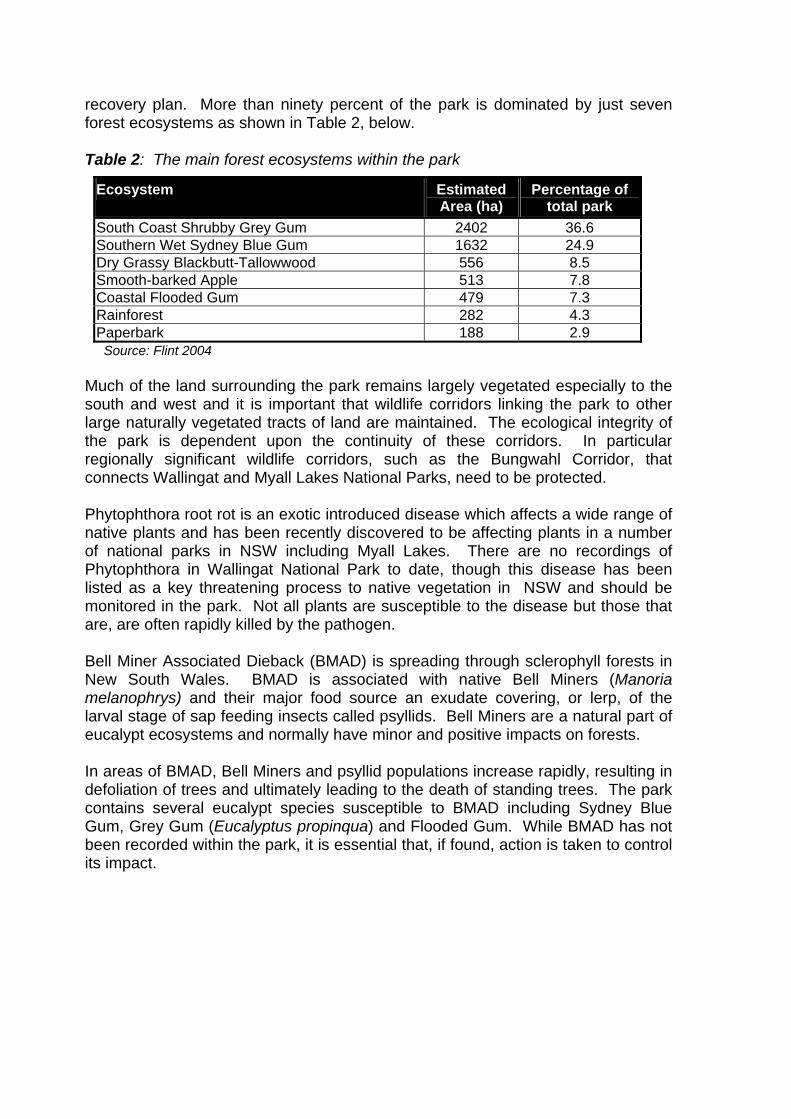
recovery plan. More than ninety percent of the park is dominated by just seven forest ecosystems as shown in Table 2, below. Table 2: The main forest ecosystems within the park
Ecosystem Estimated Area (ha)
Percentage of total park
South Coast Shrubby Grey Gum 2402 36.6 Southern Wet Sydney Blue Gum 1632 24.9 Dry Grassy Blackbutt-Tallowwood 556 8.5 Smooth-barked Apple 513 7.8 Coastal Flooded Gum 479 7.3 Rainforest 282 4.3 Paperbark 188 2.9
Source: Flint 2004 Much of the land surrounding the park remains largely vegetated especially to the south and west and it is important that wildlife corridors linking the park to other large naturally vegetated tracts of land are maintained. The ecological integrity of the park is dependent upon the continuity of these corridors. In particular regionally significant wildlife corridors, such as the Bungwahl Corridor, that connects Wallingat and Myall Lakes National Parks, need to be protected. Phytophthora root rot is an exotic introduced disease which affects a wide range of native plants and has been recently discovered to be affecting plants in a number of national parks in NSW including Myall Lakes. There are no recordings of Phytophthora in Wallingat National Park to date, though this disease has been listed as a key threatening process to native vegetation in NSW and should be monitored in the park. Not all plants are susceptible to the disease but those that are, are often rapidly killed by the pathogen. Bell Miner Associated Dieback (BMAD) is spreading through sclerophyll forests in New South Wales. BMAD is associated with native Bell Miners (Manoria melanophrys) and their major food source an exudate covering, or lerp, of the larval stage of sap feeding insects called psyllids. Bell Miners are a natural part of eucalypt ecosystems and normally have minor and positive impacts on forests. In areas of BMAD, Bell Miners and psyllid populations increase rapidly, resulting in defoliation of trees and ultimately leading to the death of standing trees. The park contains several eucalypt species susceptible to BMAD including Sydney Blue Gum, Grey Gum (Eucalyptus propinqua) and Flooded Gum. While BMAD has not been recorded within the park, it is essential that, if found, action is taken to control its impact.
Desired Outcome • The park is an important and viable conservation area that protects the diverse
native plant species, communities and habitats contained within. Strategies • The management of native plants within the park will give priority to threatened
species and endangered ecological communities.
• Verify existing records and undertake additional systematic plant surveys to improve understanding of floristic diversity within the park.
• Priorities Action Statements and recovery plans will be used to guide management of threatened species in the park.
• Encourage the retention and, where possible, improvement of wildlife corridors linking the park to other large naturally vegetated tracts of land.
• Use species indigenous to the area in planting and bush regeneration programs, except for grasses in high visitor use areas where they are proven to cause no environmental degradation to the park.
Actions 4.2.1 Map and monitor natural regeneration of forest plantation and timber stand
improvement areas. If there is a demonstrated need for active management then restoration measures may be undertaken.
4.2.2 Determine the distribution of threatened and significant plants, especially in areas where disturbance is proposed, such as along roads, trails and tracks.
4.2.3 Collect detailed data and map the locations of Melaleuca biconvexa and Asperula asthenes.
4.2.4 Determine whether Cynanchum elegans, Grevillea guthrieana, Callistemom acuminatus and Eucalyptus fergusonii ssp fergusonii occur in the park.
4.2.5 Undertake further plant surveys in areas not adequately covered by existing plant surveys.
4.2.6 Confirm the presence or absence of predicted endangered ecological communities and rare and vulnerable ecosystems within the park.
4.2.7 Implement an identification system to avoid damage to threatened plant species from management activities such as road works, fire management and weed control programs.
4.2.8 Monitor the park for the occurrence of Phytophthora root rot. If it is recorded, implement management actions to control its spread and if required, close management trails and/or roads to quarantine areas.
4.2.9 Implement an on-going monitoring program to determine the presence of BMAD. If found, undertake appropriate action to control any adverse impacts on the park’s values caused by BMAD.
4.2.10 Implement relevant strategies in priorities action statements and recovery actions for threatened plants.

4.3 NATIVE ANIMALS A total of 258 native animals have been recorded within the park with forty-seven of these species considered threatened or of conservation significance. The recorded locations of fauna within the park are of variable accuracy with fifty nine records only accurate to within 10km or more. Overall the park is considered to contain “an outstanding level of fauna diversity given the relatively small size of the park, and it highlights the high productivity and exceptional diversity of habitats within the park” (Flint 2004, p. 26). Table 3 lists threatened native animals that have been recorded within the park. Table 3: Threatened animals recorded in the park. 1
Common Name Scientific Name Legal Status 2 Amphibians Wallum Froglet Crinia tinnula V Birds Glossy Black-cockatoo Calyptorhynchus lathami V Powerful Owl Ninox strenua V Osprey Pandion haliaetus V Masked Owl Tyto novaehollandiae V Sooty Owl Tyto tenebricosa V Mammals Parma Wallaby Macropus parma V Little Bentwing-bat Miniopterus australis V Yellow-bellied Glider Petaurus australis V Koala Phascolarctos cinereus V Grey-headed Flying-fox Pteropus poliocephalus V * Greater Broad-nosed Bat Scoteanax rueppellii V Reptiles Stephens Banded Snake Hoplocephalus stephensii V
1 Table 3 does not include threatened animal records which are considered to be of low accuracy ie accurate to 10km or greater.
2 Status under TSC Act *also denotes species nationally threatened under the EPBC Act. Predictive distribution models’ have been developed for certain priority species in NSW (NSW NPWS 1999) and can be used to obtain a broad understanding of the distribution of important habitat for modelled species. These models predict that a further twenty nine species including the threatened Brush-tailed Phascogale (Phascogale tapoatafa), Eastern Freetail-bat (Mormopterus norfolkensis), Green-thighed Frog (Litoria brevipalmata) and the Spotted-tailed Quoll (Dasyurus maculatus) could occur in the park.

Priorities action statements and recovery plans will be used to guide management of threatened species in the park. Recovery Plans have been developed for the Yellow-bellied Glider, Koala and the Large Forest Owls: Powerful Owl, Sooty Owl, Masked Owl. The park is considered important for the large forest owls with all three having been recorded. The Barking Owl has been record in the park but it is considered of low accuracy as there is little habitat predicted to occur for this species. The park is also significant as it provides habitat for a number of species that are endemic to, or have their population strongholds, within the forests of north-east NSW and south-east Queensland. (Gilmore and Parnaby, cited in Flint 2004). It provides an important refuge for these species including the Red-tailed Calyptotis (Calyptotis ruficauda), Blue-speckled Forest-skink (Eulamprus murrayi), Glossy Black-cockatoo, Land Mullet (Egernia major), Powerful Owl and the Whirring Tree Frog (Litoria revelata). In particular the high number of records for the Glossy Black-cockatoo suggests that the park is of great importance to this species. Thirteen migratory bird species have been recorded in the park which are subject to international conservation agreements with; • the Government of Japan for the Protection of Migratory Birds and Birds in
Danger of Extinction and their Environment (JAMBA); and
• the Government of the People's Republic of China for the protection of Migratory Birds and their Environment (CAMBA).
Of the migratory species recorded, only three are considered to be of good accuracy: the Fork-tailed Swift (Apus pacificus), White-bellied Sea-eagle (Haliaeetus leucogaster) and the White-throated Needletail (Hirundapus caudacutus). Ongoing survey and habitat quality assessment needs to be conducted for threatened and significant species to ensure effective management of these species within the park. It is also important that the local community is aware of the presence of threatened fauna in the area, associated threats and appropriate management practices to help ensure their survival in the park and surrounding area. Feeding native animals by park visitors is becoming an increasing problem within national parks with some animals losing their natural fear of humans. This is especially evident with goannas, which have been known to harass campers for food. Visitors need to be discouraged from feeding wildlife to prevent this problem from escalating. Desired Outcome • The park continues to be an important and viable protected area that is
connected to other conservation areas and provides protection to the diverse native animals and their habitats.
Strategies • The management of native animals and habitats within the park will give priority
to threatened species, critical habitat and endangered populations.
• Priorities Action Statements and recovery plans will be used to guide management of threatened species in the park.
Actions 4.3.1 Verify existing species records and undertake additional native animal
surveys, research and assessment of habitat to improve understanding of fauna diversity within the park.
4.3.2 Continue to collect data and map the locations of threatened animals. 4.3.3 Assess modelled habitat to determine the presence or absence of
threatened animals that are predicted to occur within the park. 4.3.4 Implement relevant species recovery actions including the protection of
critical habitat such as hollow-bearing trees, roost sites, ensuring appropriate fire regimes and undertaking targeted pest management programs.
4.3.5 Promote the understanding and protection of native animals through interpretation programs.
4.3.6 Implement a signage and information strategy to discourage visitors from feeding native animals.
4.4 ABORIGINAL HERITAGE Aboriginal communities have an association with and connection to the land. The land and water biodiversity values within a landscape are central to Aboriginal spirituality and contribute to Aboriginal identity. Aboriginal communities associate natural resources with the use and enjoyment of foods and medicines, caring for the land, passing on cultural knowledge and strengthening social bonds. Aboriginal heritage and nature are inseparable from each other and need to be managed in an integrated manner across the landscape. The park is amongst a landscape that is part of the identity, spirituality, connection and resource base for the Aboriginal people of the Worimi Nation. Prior to European settlement the Worimi people in the Great Lakes region lived in an area from Port Stephens to Forster/Tuncurry and as far west as Gloucester. The Worimi Nation was made up of several nurras or local groups within the tribe and spoke dialects of the Kattang language. The park was likely to be significant to two of these groups, the Wallamba and Birrimbai. The Wallamba had a central campsite located at what is now known as Coomba Park. The Birrimbai congregated around the Bungwahl area (Marr 1995).

While the NPWS currently has legal responsibility for the protection of Aboriginal sites, the NPWS acknowledges the right of local Aboriginal people to be part of the decisions about their own heritage. Consultation has traditionally occurred with local Aboriginal people through Local Aboriginal Land Councils. The park falls within the Forster Local Aboriginal Land Council. The arrival of Europeans in the area resulted in progressive, and substantial, impacts on the Aboriginal traditional way of living. In these early years of European settlement, little effort was made to record information about the traditions or language of the Aboriginal people, so comparatively little is known about the Worimi tradition and culture as it relates to the park. There are few recorded sites within the park, however the park was likely to be used by Aboriginal people, especially as a medicine and food source. Aboriginal site surveys need to be conducted in the park to identify sites, assess their significance and determine management options. Desired Outcome • Aboriginal cultural values associated with the park are recognised, protected
and managed in partnership with the local Aboriginal people. Strategies • Protect identified Aboriginal sites, relics, historic places and culturally significant
features from damage by human activity and fire. Prepare management strategies where necessary in consultation with representatives of the Aboriginal community.
• An Aboriginal cultural heritage site will only be interpreted and/or promoted if supported by representatives of the local Aboriginal community.
• The broader community has an understanding of the cultural importance of the park to the local Aboriginal people.
Actions 4.4.1 Progressively record Aboriginal cultural sites and/or places of significance.
Priority should be given to areas most threatened by human impact or natural deterioration.
4.4.2 Consult with and involve the Forster Local Aboriginal Land Council and other representatives in the management and interpretation of the park’s Aboriginal cultural heritage.
4.4.3 Promote public understanding and appreciation of Aboriginal Heritage through the provision of appropriate interpretation and educational material.
4.5 HISTORIC HERITAGE In 1824 the Australian Agriculture (AA) Company was formed and granted one million acres “to ‘extend and improve the flocks of Merino sheep’ in New South Wales” (AA undated). The land, including the area covered by the park, proved unsuitable for pastoral development and around 1831 was exchanged for Land on the Liverpool Plains and at Goonoo Goonoo (formerly the Peel River). According to the Forestry Commission of NSW (FCNSW, 1960) exploitation of Wallingat’s timber resource appears to have commenced sometime in the 1860s, shortly after John Wright built a mill at Tuncurry. The Wallingat River was an important waterway for timber-cutters in that it allowed easy access and removal of the timber from the surrounding forest. Thus, much of the early timber harvesting was close to the river, with logs transported by drogher (small vessel), to Wallis Lake. On January 21, 1914, Wallingat State Forest was notified in the Government Gazette. However the Forestry Act did not go through Parliament until 1916 and Wallingat was number 48 out of the first 100 or so State Forests which were grouped together. Robert Godwin became the first overseer of the forest and lived at ‘The Rocks’, near the present day Wallingat River day use area. Evidence of the former house site and well still remain (Newton, L 2005, pers. comm., 14 April). Sawmills located at Bungwahl, Neranie, Boolambayte and Forster-Tuncurry were all serviced by timber sourced from the park area. A horse drawn tramway is thought to have extended into the southern part of the park along Jacks Creek, from Tarbuck Bay, terminating just south of Thomas Road. The tramway linked Wallingat to the Myall Lakes via Smiths Lake, though no evidence of the tramway has been found to date. By the 1960s, road transport began to replace bullock teams and water transport and this allowed greater utilisation of the forest. During this time the FCNSW was undertaking an intensive roading program within the park (FCNSW 1960). During the early 1980s, the FCNSW recognised recreation as an important use of the area and established several day use and camping areas within the former state forest. This included Sugar Creek and Whoota Whoota Lookout day use areas and Wallingat camping area. These facilities and much of their associated infrastructure remain and continue to be used today. Logging continued as the main use of the area through until 1 January 1999 when the area was gazetted as Wallingat National Park and logging operations ceased. Aside from logging, the area was also used for grazing of stock and bee keeping under State Forest occupation permits, all of which had expired prior to gazettal of the park.

An old wharf and Godwin’s house site are recorded in the Hunter Region Cultural Heritage Management Strategy 2003-2008 (NPWS 2003) as regionally and locally significant cultural heritage places and landscapes to be actively managed. In April 2004, the NPWS commissioned a bridge heritage assessment of nineteen timber bridges in the park. Of the nineteen bridges assessed two were found to be of very high heritage significance, six of high significance and eleven of medium significance at a regional level. Desired Outcome • The protection, maintenance and appropriate management of the park’s historic
heritage values. Strategy • Record and manage all historic places in a way that is appropriate to their
cultural significance and in accordance with the Australian ICOMOS Burra Charter of Australia and NPWS policy, including the ‘Hunter Region Cultural Heritage Management Strategy’ (NPWS 2003).
Actions 4.5.1 Encourage research into the identification and documentation of historic
features of the park, including oral history, and record relevant information on the NPWS Historic Heritage Information System (HHIMS). Encourage the involvement of local historical societies and interested members of the public where possible.
4.5.2 Systematically review HHIMS to check accuracy of information, identify gaps within the data and update site records for the park.
4.5.3 Implement a system to ensure bridges of very high to high significance are easily identified on the ground and identified in the fire management strategy. Any maintenance or modification to the bridges is to be recorded in accordance with recommendations set out in the “Heritage Assessment of Bridges, NPWS Northern Directorate” (Umwelt 2004).
4.5.4 Promote public understanding and appreciation of historic resources through interpretation and educational material.

5. PARK PROTECTION 5.1 GEOLOGY AND SOIL CONSERVATION Geology Flint (2004, p. 4) describes the geology of the park as “predominantly Carboniferous sedimentary and metamorphic rocks, with relatively minor areas of Quaternary sand and alluvium associated with the Wallingat River. Alluvial deposits forming estuarine basin muds have accumulated in the Wallingat River, including deltaic estuarine soils, and coastal floodplain alluvial deposition, at the tidal limit of brackish waters. This formation is composed of a combination of gravel, sands, silts and clay. The Carboniferous sediments and rocks were laid down some 300 million years ago and include a combination of sandstone, siltstone, claystone, shale, limestone and lavas. The south-eastern arm of the park is predominantly undifferentiated Late Carboniferous sediments, whilst there is a large composite unit of Yagon Siltstone and Booti Booti Sandstone extending in a north-south band in the central section of the park. Interbedded mudstone and structureless, lithic sandstones predominate in the northern and north-eastern sections of the park. Areas west of the Wallingat River are predominantly white siltstone with coal-rich crossbedded sandstone, and black-grey thinly bedded siltstone and mudstone.” Soil Conservation Erosion is recognised as a natural process within the park however the susceptibility of soils to erosion significantly increases in areas with steep slopes, during periods of high rainfall and where vegetation has been removed. Where this process has been accelerated by human activity or is threatening significant habitats or other park values appropriate control measures may be required. Accelerated rates of soil erosion can occur along roads, trails and tracks if adequate drainage is not maintained. Bare ground remaining from past disturbances such as former logging trails, old log dumps, quarries and borrow pits also needs to be managed to minimise erosion and subsequent sedimentation of waterways. Acid Sulphate soils exist along the low-lying areas of the Wallingat River and its tributaries and it is important these areas are identified and protected from disturbance. The accuracy of information on the location of acid sulphate soils within the park needs to be improved especially in areas where soil disturbance is likely to occur such as roads and visitor facilities. Visitor facilities need to be managed with soil conservation practices in mind to reduce visitor impacts in these areas. For example, erosion associated with the road leading to the Cockatoo day use area is a concern and stabilisation work is needed to reduce the amount of soil erosion from the track.

The banks of the Wallingat River, especially the section adjacent to the Wallingat camping area, are being damaged by visitor activity. This is particularly evident on the northern end of the camping area where access to the river is causing loss of vegetation and damage to the riverbank. Improved managed access to the river, from the camping area, is required to assist in bank stabilisation. Desired Outcome • The park’s geology and soils are protected and human activities managed to
minimise erosion. Strategies • Incorporate erosion and sediment control into all management activities
involving soil disturbance.
• Identify and protect potential acid sulphate soils from disturbance or manage to reduce the risk of activation with priority given to roads, trails and visitor facility areas.
• Manage recreation activities and other uses in the park to minimise erosion, changes to soil structure and degradation of catchment values.
Actions 5.1.1 Identify and prioritise disturbed areas that require rehabilitation such as
former log dumps, quarries and borrow pits. Rehabilitation may involve controlling access, improving drainage, installing silt fencing and/or revegetation.
5.1.2 Ensure the park road leading to Cockatoo day use area has sufficient erosion control measures to prevent siltation of the Wallingat River.
5.1.3 Redevelop the Wallingat camping area to provide protection to the bank of the Wallingat River through the construction of a wharf or similar structure that provides a ‘hardened’ access point to the river. Move camping back from the riverbank and revegetate disturbed bank sections (refer also to 6.2.2).
5.2 WATER QUALITY AND CATCHMENT MANAGEMENT The park falls within the Wallis Lake Catchment and provides important protection for the water quality in this part of the catchment. The park has two main drainage lines that are a result of distinctive north-west to south-east running ridgelines. The eastern side of the park drains directly into Wallis Lake via short creeks such as Duck Creek and Freshwater Creek. The western drainage system is dominated by the Wallingat River, which drains into Wallis Lake via the Coolongolook River.

The main creeks flowing from the park into the Wallingat River are Sugar Creek, Boggy Creek and Reedy Creek on the eastern side of the river and Ferny Creek and Teatree Creek on the western side. A small area of the park to the south-east drains via Jacks Creek into Smiths Lake. The addition of the lower sections of Sugar Creek and Boggy Creek to the park should be sought. The addition of these waterways to the park would result in most of their catchment being protected within the park or adjoining state forest. The Hunter – Central Rivers Catchment Management Authority (CMA) has produced a Draft Wallis Lake Catchment Management Plan (GLCMSC 2001), which rates the condition of the Wallingat River Sub-catchment as being good to very good. This is mainly due to the extent of forested lands within the catchment, with 32% of the sub-catchment occurring within the park. Therefore the maintenance of the park’s water quality and catchment values is not only important for the park but also for Wallis Lake. The catchment provides important habitat for threatened species and supports industries such as oyster growing, fishing and tourism. The Draft Wallis Lake Catchment Management Plan also identifies sedimentation, nutrients, faecal contamination and acid sulfate leachate as potential threats to water quality. To assist in the maintenance of the catchment’s water quality, park management considerations should include; 1. Revision of road network: The park contains an extensive road network
developed to assist with management of the forest for logging by Forests NSW. Many of these trails are no longer required for park management or recreational purposes and closure and rehabilitation is considered important to assist in the maintenance of the catchment’s water quality. In particular the track along the banks of Ferny Creek from the picnic area to the junction of Ferny Creek and Wallingat River needs to be rehabilitated. (refer to 6.1.1)
2. Education: Encourage visitors to adopt minimal-impact bushwalking and camping practices. This could be achieved through provision of information on these practices in visitor guides, information displays or Discovery Tours.
There is some community concern about boating activity on the Wallingat River in relation to speed and water skiing in narrow parts of the river. Although the river is not part of the park, these activities could have an impact on park values through increased erosion of the riverbank or disturbance to native species. NPWS and NSW Maritime Authority need to work cooperatively to manage boating activities within the river to ensure protection of park values.

Desired Outcome • Catchment values, water quality and the health of waterways in the park are
maintained or improved.
Strategies • Ensure the protection of the catchment’s water quality is considered when
upgrading or installing park facilities.
• Encourage visitors to adopt minimal-impact practices for all recreational activities to minimise pollution and environmental impact.
Actions 5.2.1 Liaise with local government and other relevant authorities to maintain the
water quality of the park’s catchments including participation as a member of the Wallis Lake Estuary Management Committee.
5.2.2 Seek the addition of the lower portions of Sugar Creek and Boggy Creek to the park.
5.2.3 Work cooperatively with the NSW Maritime Authority to address any identified boating activity issues on waterways in and adjoining the park that may impact on park values.
5.3 INTRODUCED PLANTS Introduced plants, commonly known as weeds, are those plants that are not native to an area. Weeds in the park can impact on forest structure, species diversity, habitat values, prevent natural regeneration and have the potential to spread to and from neighbouring land. The Noxious Weeds Act 1993 places an obligation upon public authorities to control noxious weeds on land that they occupy to the extent necessary to prevent such weeds spreading to adjoining lands. The NPWS Pest Management Strategy, Hunter Region (2002a) provides management direction at a regional level for pest management activities within NPWS managed lands. The strategy establishes high, medium and low priorities, on a regional basis, for introduced plant and animal species management programs. The strategy also identifies broad management actions for individual species based on the priority and probability of practical success for a control program. To further improve and target weed control, a program of weed mapping has been undertaken in the park. This will assist in determining the effectiveness of weed control programs over time. The overriding objective of the NPWS pest control program is to conserve biodiversity and cultural heritage. To ensure this occurs, all pest control activities proposed for the park will require an appropriate level of environmental assessment.

Past land-use practices such as timber getting, grazing and altered fire regimes have caused disturbance to natural vegetation communities and provided conditions suitable for the establishment of Lantana (Lantana camara) and Crofton Weed (Ageratine adenophora). The Hunter Region Pest Management Strategy identifies Crofton Weed, Lantana, Morning Glory (Ipomoea spp.) and Privet (Ligustrum sp.) as the main target species for weed control within the park. Ecosystems considered most vulnerable to weed invasion are those which have been subject to past disturbance such as logging and frequent fire. These ecosystems should be prioritised for weed management, mapping and monitoring. Aerial photographs can be utilised to identify and target past log dumps and logging roads for weed management as these are the areas most likely to require restoration and rehabilitation. Blackberry (Rubus spp.) and Privet have only been recorded in isolated infestations at the Wallingat Camping Area and hence have been targeted for control to prevent further spread. The major weed within the park is currently Lantana. Control programs have aimed to target isolated infestations and to improve the amenity of recreational areas and maintain access along park roads and management trails. Control of Crofton Weed has been undertaken to improve the amenity of Whoota Whoota Lookout and to treat isolated infestations along road edges. Co-operative pest control programs are to be encouraged, especially, where they enhance on-park programs through the inclusion of surrounding land managers such as Forests NSW, neighbouring property owners, Great Lakes Council and the Gloucester Rural Lands Protection Board (RLPB). Desired Outcome • Park values are maintained or improved by undertaking appropriate introduced
plant control programs. Strategy • Manage introduced plant species in accordance with the Noxious Weeds Act
and the priorities identified in the ‘Hunter Region Pest Management Strategy’ (NPWS 2002a).
Actions 5.3.1 Continue to map the distribution and abundance of introduced plant species. 5.3.2 Continue to record and map control programs that have been undertaken,
including biological control releases, to determine the effectiveness of these programs.
5.3.3 Treat isolated weed infestations, including Blackberry and Privet, within the park as a priority.
5.3.4 Continue to treat weeds at visitor areas (refer to Table 4) and along park roads and management trails prior to seed set, to maintain accessibility, visibility and to limit weed dispersal opportunities.
5.3.5 Encourage coordinated weed control programs with neighbours, Great Lakes Council, Forests NSW, RLPB and the Mid North Coast Weeds Committee.
5.4 INTRODUCED ANIMALS Introduced animals include feral and domestic animal species that are not native to an area. Introduced animals have a detrimental effect upon the natural condition of the park by disturbing the native vegetation, increasing soil erosion and through competition with, or predation on, native species. Introduced animals recorded in the park include wild dog (Canis familiaris), feral cat (Felis catis), fox (Vulpes vulpes), feral rabbits (Oryctolagus cunniculus), rusa deer (Cervus unicolor) and stray domestic stock. The Rural Lands Protection Act 1998 (RLP Act) requires pest animals declared under the Act to be controlled. Rabbits, pigs and wild dogs, including dingoes, have been declared as pest animals under the RLP Act throughout NSW. Hence the NPWS has a statutory obligation to control these pest animals on its estate. The RLP Act identifies two schedules for wild dog control, with the park being listed in Schedule 2, as high quality dingo habitat. The RLP Act requires the development of a ‘Wild Dog Management Plan’ coordinated and approved by the Rural Lands Protection Board for schedule 2 areas. These plans are to identify methods for the control of wild dogs and the conservation of dingoes in these areas. This involves balancing the prevention of wild dog attack on livestock while conserving dingoes in core areas of some national parks. A Draft Wild Dog Management Plan has been prepared for the D-Division of the Gloucester Rural Lands Protection Board, which includes the park. A population of Rusa deer occurs in the northern section of the park around Coomba Park. Feral deer are known to have a detrimental impact on native flora and have been listed as a ‘key threatening process’ under the TSC Act due to environmental degradation caused through grazing. Feral deer control programs need to be implemented in co-operation with adjoining landowners and other government agencies. A significant proportion of the park boundary adjoins private property. These boundaries are normally fenced where domestic stock is kept. The maintenance and, where necessary, further improvement of these fences is essential for the effective management of stock and the protection of the park values. This commitment between neighbours and the NPWS is an ongoing requirement for the park. Fencing agreements are negotiated with neighbours in accordance with NPWS boundary fencing policy. Priorities for fencing are generally established considering the condition of the existing fence line and potential conflicts with park management objectives.

Desired Outcome • Park values are maintained or improved by undertaking appropriate introduced
animal control programs. Strategies • Manage introduced animal species in accordance with the priorities identified in
the ‘Hunter Region Pest Management Strategy’ (NPWS 2002a).
• Encourage neighbours to undertake off-park control programs and report any new occurrences of pest animals to assist in the conservation of native animals.
• Continue to liaise with the Rural Lands Protection Board and park neighbours regarding pest animal control programs.
Actions 5.4.1 Assist in the finalisation and implementation of the wild dog management
plan which covers the park. 5.4.2 Prepare and implement a pest management strategy for the control of feral
deer in cooperation with the Rural Lands Protection Board, Great Lakes Council and the local community.
5.4.3 Undertake an inventory of boundary fencing around the park and where incursions of stock occur, consult with neighbouring landowners in regard to repair or replacement of the fence. Where required, negotiate fencing agreements in accordance with NPWS policy.
5.4.4 Monitor for any domestic animals grazing in the park and undertake action to effect their removal.
5.4.5 Provide information to park neighbours on the impacts and identification of feral animals.
5.5 FIRE MANAGEMENT Fire management is recognised as an important and complex area of park management. This plan of management provides the overall objectives for fire management in the park. However, a separate fire management strategy will detail a comprehensive analysis of the bushfire environment, potential threats and specific management actions and priorities, in accordance with NPWS policies. Under the Rural Fires Act 1997 (RF Act), the NPWS has a statutory obligation to protect life and property and to prevent fire from leaving its property. The RF Act also provides for the protection of the environment by requiring that fire management activities have regard to the principles of ecological sustainability.

The NPWS recognises that fire may pose a serious threat to life and property especially on the eastern and southern sides of the park. The NPWS acknowledges that the support of the local community, particularly the cooperation of park neighbours, is critical to successful fire management within the park. It is also important for neighbouring properties to undertake fuel management on their land to assist with fire management. The NPWS is an active member of the Manning Zone Bushfire Management Committee formed under the RF Act. This Committee plays a lead role in bushfire management across the zone including the coordination of risk management, planning response to wildfire and cooperative fire fighting arrangements. The NPWS regards fire as a natural phenomenon and one of the continuing physical factors influencing the Australian environment. Many native plants and animals have adapted to particular fire regimes. A fire regime refers to the frequency, season, intensity and spatial extent of fire. Inappropriate fire regimes have been identified as a key threatening process affecting the biological diversity of NSW. Scientific understanding of fire requirements for native plant communities is generally more advanced than for native animal communities, although recent research indicates that the conservation of many animal species depends on a mix of fire regimes, including occasional high intensity fires. The use of regular low intensity fires can have an unacceptable impact on critical habitat requirements for native animals, particularly on ground flora and undergrowth. Fire management and research needs to be undertaken with consideration given to: • enhancing and maintaining floristic and structural diversity of the vegetation
within known or potential habitat of the Yellow-bellied Glider and Greater Glider. • reducing the impact of burning to retain diverse understorey species and to
retain understorey density for the Parma Wallaby, and in particular to permit the regeneration of Forest Oaks (Allocasuarina torulosa) as a food source for the Glossy Black Cockatoo.
• protecting old and dead trees and maintaining understorey vegetation and ground litter for the Stephens Banded Snake, and other significant reptile species.
• protecting swamps, riparian vegetation and wetland buffers from fire to retain habitat values for the Wallum Froglet, Black Bittern and Black-necked Stork.
The NPWS also recognises that fire and fire management activities may pose a threat to cultural values such as Aboriginal sites and historic relics. Features such as scarred trees and historic structures can be permanently damaged or destroyed by wildfire. Fire management particularly needs to avoid damage to cultural resources from fire or through the use of heavy machinery.
Suppression of a wildfire in 2002 resulted in a containment line being constructed by heavy machinery through untracked moist sclerophyll and rainforest communities within the park. This has had an adverse impact on this section of park because it has resulted in damage to vegetation and creeks. Future fire suppression activities need to avoid sensitive environments wherever possible, especially where alternative trails and fire advantage lines exist. Rehabilitation of areas disturbed by fire management activities needs to occur as soon as possible after the fire to reduce soil erosion and assist in revegetation of the area. Information on fire history within the park will be maintained and used in fire planning to develop management strategies aimed at improving fire management within the park. This should also aim to ensure appropriate fire regimes are maintained. Desired Outcome • Fire regimes and fire related management activities are managed to protect life
and property and conserve the natural and cultural values of the park.
Strategies • As far as possible prevent wildfire from spreading to neighbouring property.
• Fire regimes will be managed to protect biodiversity in accordance with identified fire frequency thresholds (as identified in the park fire management strategy) for each vegetation group within the park.
• Heavy machinery will be excluded where possible from establishing new control lines aside from the pre-existing ones identified in the Fire Management Strategy, especially in the vicinity of rare plants, rainforests, cultural sites and wetlands.
• Rehabilitate any areas disturbed by fire management activities as soon as possible after the event.
Actions 5.5.1 Implement a Reserve Fire Management Strategy for the park which includes
measures to protect life and property, cultural sites and biodiversity, including threatened species. Regularly review this strategy to ensure it is achieving the desired outcome.
5.5.2 Continue active participation in the Manning Zone Bushfire Management Committee.
5.5.3 Encourage research into fire behaviour in the park and the effects of fire on plant and animal communities and biodiversity, in particular on rare and threatened plants and animals. Incorporate results into fire management programs and reviews of the fire management strategy.
5.5.4 Maintain fire history data for the park and adjacent areas and incorporate this information into fire-management planning.

6. VISITOR OPPORTUNITIES AND EDUCATION The park currently receives a low level of use by a variety of recreational users including bushwalkers, campers, 4WDs, car tourers, boaters, cyclists, fishers and horse riders. Visitors to the park are able to enjoy these activities as a result of the road and trail network and provision of visitor facilities at certain destination points. Visitor facilities are mainly concentrated in the south-east of the park. The public road network, which provides vehicle access to these facilities, currently results in most vehicles passing Gur-um-bee day use area. Having this one main access and information point assists park management by providing a focal point to disseminate information to visitors before they proceed further into the park. The northern and western sections of the park only contain one visitor facility, Ferny Creek camping area, and no more facilities will be provided in these areas. A minimal number of roads and trails will be retained in the northern and western sections where they are required for park management activities, neighbours or for access to Ferny Creek camping area. Currently visitor destination points are relatively small in size and vehicle parking capacity. To assist in protecting the park from over use, visitor destination points will be provided in accordance with limits set out in Table 4. While there is a lack of definitive information on the impacts that current recreational activities are having on the park, anecdotal evidence suggests that impacts from activities such as bushwalking, cycling and horse-riding at their current levels are low. Further research and monitoring is required to better identify and understand the impacts associated with these activities and outline management options. This information should then be used to assist in improving management of recreation within the park. 6.1 ROAD NETWORK The road network associated with the park (refer to park map) has a number of different uses and tenures. The road network was originally established to meet timber industry needs and will be refined to better meet park management and visitor needs and to protect habitat values. Park roads and management trails ‘Park roads’ are roads in national parks available for public vehicle access and managed by the NPWS. ‘Management trails’ are generally maintained to a lower standard than ‘park roads’ and are essentially for NPWS management activities. These trails are not available for vehicle use by the general public, though permission may be granted in certain circumstances for access by park neighbours or researchers (refer also to action 5.4.3).
Sugar Creek Road and Thomas Road are the main access roads into the park leading off from The Lakes Way and Coomba Park Roads respectively. These roads along with sections of River Road, Hotel Creek Road and Whoota Lookout Road form the main public access network within the park providing access to the main visitor facilities. The park road network links with adjoining public roads and provides visitors with the opportunity to undertake a ‘forest drive’ through the local area. The park road network is generally gravel with an average width of four metres and may be shared by several different types of users at once including vehicles, walkers, horse riders and cyclists. The road network also contains a number of timber bridges, some of which have limited load carrying capacity, and these need to be identified on the ground. The need for a reduction in vehicle speed should be investigated because of the variety of users, the road width, visibility and to assist in avoiding native animal mortality. This is especially critical on narrow winding sections and sections where the road will be shared by several users eg Sugar Creek Road, Thomas Road and Whoota Lookout Road. There is also a need to upgrade various park road intersections to improve safety, in particular, the Sugar Creek Road and Whoota Lookout Road intersection. Guideposts will continue to be installed along the main park road network to assist drivers in identifying the road edge and pipe and culvert locations. Heavy rain within the park and surrounding catchments can result in the short-term closure of many of the park roads due to flooding and to help protect the park road network from damage by vehicles. Signage within the park needs to be improved to advise road users that sections of the road network may be subject to flooding, as well as ensuring visitors are able to orientate themselves within the park. The concrete causeway on Hotel Creek Road, just before Sugar Creek day use area, has deteriorated to a point where the causeway needs to be replaced. The causeway is important because it provides the only vehicle access point into Sugar Creek day use area. It is proposed to construct a small carpark at the junction of Thomas Road and Hotel Creek Roads to provide an alternative access point to the Sugar Creek trail network. This will allow visitors to undertake walks in the Sugar Creek area as loop, or one way walks being picked up by a vehicle at the other end. A small carpark is also proposed at the junction of Whoota Lookout Road and Reedy Creek Trail. This will allow visitors to park and use Reedy Creek Trail. No facilities will be provided at these two carparks. There is concern that some of the steeper sections of the management trail network may be subject to increased erosion over time, especially where the use of the trails increases. Roads and trails will need to be monitored and, if unacceptable erosion is occurring, remedial actions undertaken.

The road network is to be named as shown on the park map to better reflect current management. Wherever possible existing road names are to be retained to avoid confusion but some roads, or sections of roads, need to be renamed to improve clarity. Ministerial roads ‘Ministerial Roads’ are roads which do not form part of the park but were created to ensure access arrangements that existed before the park’s creation could continue. Ministerial roads include Forest Road and the eastern end of Yarric Trail. The management of these roads is subject to the NPW Regulations and the requirements of the EPA Act. Ministerial roads need to be rationalised so that those no longer required, and/or those for which access can be dealt with in other ways, such as formal agreements, should be added to the park. Public roads ‘Public roads’ are roads outside the park that are managed by other authorities including Forests NSW and Great Lakes Council. Park roads and management trails often link with adjoining public roads. Adequate maintenance of adjoining public roads is essential to ensure vehicle access is maintained to visitor facilities within the park. In some cases the NPWS may require a higher maintenance regime of specific public roads than that required by the managing authority, especially where these roads provide important access to park facilities. In these cases it may be necessary for the NPWS to enter into a joint maintenance agreement or memorandum of understanding with the relevant authority regarding maintenance. A joint maintenance agreement is proposed between the NPWS and Forests NSW outlining access and joint maintenance arrangements for joint interest public roads and certain Ministerial roads. Roads to be covered by such an agreement include Sugar Creek Road, River Road, Rocky Gap Trail and Link Road. It is also necessary to discuss such an arrangement with Great Lakes Council in regard to the eastern section of Thomas Road. The park contains several crown reserve roads, which traverse or are contained wholly within the park. Where these roads are no longer required, and/or are wholly contained within the park, their addition to the park will be sought. Desired Outcome • The road network is ecologically sustainable and does not adversely impact on
the park’s natural and cultural values.

Strategies • Provide public vehicle access on the park road network as shown on the park
map. The main park road network, being Sugar Creek Road, Thomas Road, Hotel Creek Road, River Road and Whoota Lookout Road, to be maintained to dry-weather two-wheel drive standard. The remaining park roads to be maintained to a dry-weather four-wheel drive standard.
• Provide management trails as shown on the park map. These trails will be closed to public vehicular access (refer also to 9.1.1).
• Park roads and management trails may be temporarily closed during wet weather to ensure visitor safety and protect road and trail surfaces from damage and possible increased erosion. This may be achieved through signage and/or the temporary closure of roads and trails to specific activities.
Actions 6.1.1 Close and rehabilitate all roads or trails not shown on the park map. 6.1.2 Monitor recreational activities and numbers of users on park roads and
management trails for environmental effects, safety and conflict with other park users. Monitoring could be achieved using visitor surveys, vehicle and walker counters or other research and data capture methods. If necessary implement remedial actions to ensure protection of the environment, reduce conflict and improve visitor safety.
6.1.3 Bridges on the park road network where load limits are known will be sign posted.
6.1.4 Investigate options for a lower speed limit on the park road network and implement if considered feasible.
6.1.5 Improve road intersections throughout the park where a safety issue is present.
6.1.6 Install guideposts on the park road network to highlight road edges, culverts and bridge ends.
6.1.7 Improve directional signage within the park, and install advisory signs to inform visitors that sections of the park road network may be subject to flooding.
6.1.8 Upgrade the Hotel Creek causeway to improve vehicular access to Sugar Creek day use area.
6.1.9 Construct a small car parking area, with the maximum capacity of 5 vehicles at the following locations; - Thomas Road and Hotel Creek track intersection (refer also to 6.3.1). - Whoota Lookout Road and Reedy Creek Trail intersection.
6.1.10 Rename roads within the park in accordance with the park map. Park signage will be updated to reflect these road and trail names.
6.1.11 Continue to review Ministerial roads. Those no longer required should be added to the park.

6.1.12 Finalise and implement a joint roads and track maintenance agreement between NPWS and Forests NSW.
6.1.13 Negotiate a Memorandum of Understanding with Great Lakes Council regarding road maintenance for the public road section of Thomas Road.
6.1.14 Identify crown reserve roads that are wholly within the park or which traverse the park but which are not part of the park and seek their addition to the park.
6.2 CAMPING AND DAY USE AREAS The park contains facilities for picnicking, camping, walking and sightseeing at the locations outlined on the park map and in Tables 4 and 5. Given the range of existing facilities, the size of the park and the large number of similar facilities that exist in surrounding areas, no additional facilities are proposed. Table 4: Facilities at Day Use and Camping Areas
Wallingat Wallingat River
Gur-um-bee
Sugar Creek
Whoota Whoota
Ferny Creek
Cockatoo
Visitor use (Visitor asset class) a
Camping (C2)
Day Use (D1)
Day Use (D3)
Day Use (D1)
Day Use (D1)
Camping (C1)
Day Use (D2)
Picnic tables Yes Yes Yes Yes Yes Yes Yes Camp sites b Max 20 b No No No No Max 4 b No Shelter/Galley Yes No Yes No No No No Toilets Yes Yes Yes Yes No Yes No Information Yes No Yes Yes Yes Yes Yes Gas BBQ Yes c Yes Yes Yes No No No Wood BBQ Yes No No No No Yes No Walking track Yes No No Yes No No Yes Parking spaces 20 6 8 6 6 6 8 Boat ramp No No No No No No Yes Wharf/bank protection
Yes Yes No No No Yes d No
a Visitor asset classes referred to in table 4 are adapted from the NPWS Draft Recreation Planning Framework (NPWS
2002b). It provides a guide for setting appropriate development and use of visitor areas with class 1 being ‘wild/undeveloped’ and 5 as ‘developed’.
b Campsites may be either designated or a site equivalent within an area and the maximum number of people that may occupy a site is 6.
c Wood fires maybe replaced with gas BBQs in accordance with action 6.2.3 d Only if required to protect the banks of Ferny Creek.

Camping The Wallingat camping area is the main camping area in the park and is located on the eastern bank of the Wallingat River. While the park is a popular spot for camping, the number of campers using the park is relatively small. Given the relatively small size and accessibility of the park most campers are vehicle based with little or no remote bush camping being undertaken. It is therefore proposed to permit car-based camping in two locations within the park being Wallingat and Ferny Creek camping areas. Further car camping opportunities are provided in nearby national parks, such as Myall Lakes and Booti Booti. Wallingat camping area needs to be redeveloped to reduce detrimental impacts to the riverbank, native vegetation and to improve access to the river. A concept design for the proposed upgrade has been developed and needs to be implemented. Campsites may need to be temporarily closed and rested for periods throughout the year in order to minimise loss of ground cover and help reduce soil erosion. Wood fires will only be permitted within designated fireplaces. Visitors will be required to bring their own firewood to reduce the impact that firewood collection is having on the park, in particular, fallen timber which provides valuable habitat for native animals. Consideration will be given to the replacement of wood fires with gas barbecues in the Wallingat Camping Area. This will be done if there is a need to reduce the adverse impacts fire wood collection is having on the park and to help improve the visual and social amenity of the camping area. Ferny Creek camping area, on the banks of Ferny Creek, is the only visitor destination on the western side of the Wallingat River. This camping area will be kept small and have few facilities to provide an alternative experience to Wallingat camping area (refer to Table 4). The camping area currently allows vehicles and camping right to the edge of the creek. This has resulted in a loss of vegetation along the creek bank and some degradation of the bank. To reduce this impact and provide some protection to the creek bank, camping and vehicles will be moved away from the creek bank. It may be necessary to provide a small wharf to further improve bank protection if these measures are found to be inadequate. The camping area will be delineated to prevent further encroachment into the surrounding bush. A small toilet facility will also be installed to ensure protection of the Wallis Lake Catchment. Generators are considered inappropriate in the park’s camping and day use areas because of exhaust fumes, noisy operation and their potential to disturb other users. Their use will not be permitted in the park unless for management purposes or approved by NPWS for essential medical treatment. Water tanks provided by NSW State Forests at camping and day use areas will be removed and no longer provided due to the cost, difficulty of maintenance and public health requirements associated with the provision of drinking water. Small water tanks may be provided at toilet facilities for hand washing only. Waste

facilities will not be provided in the park. A sign will be provided in the camping areas explaining the waste strategy and will request visitors to take away their own rubbish. Day Use Currently the most popular destination in the park is Whoota Whoota Lookout which provides magnificent views over the coast and surrounding ranges. The lookout has attracted many visitors since it was established in the late 1960s and visitation is expected to increase. Access to the lookout was upgraded in 2001 to allow access by 2WD vehicles in most weather conditions. The vegetation on the lookout will continue to be maintained to provide views to the north-east and south-west. Gur-um-bee day use area is on the park boundary and includes a small part of Wallingat State Forest. Gur-um-bee is a Local Aboriginal word for white gum tree, many of which can be seen in the park. Through agreement with Forests NSW, this day use area is actively managed by the NPWS. The western edge of the day use area is bordered by Sugar Creek Road and measures need to be implemented to improve the visual aesthetics and public safety of the day use area along this road edge. Forests NSW has also agreed to examine the possible retention of a strip of vegetation along the edge of Sugar Creek Road for the length of the day use area in future logging operation plans. Sugar Creek day use area has two loop walks and picnic facilities including a gas BBQ whilst the Wallingat River day use area located on the banks of the Wallingat River provides opportunities for fishing, swimming and picnicking. The Wallingat River day use area also contains a small timber platform which provides access to the river while providing protection to the river bank. The wharf is in poor condition and needs to be repaired or replaced. Water based recreation is popular on the Wallingat River. Access to the river for fishing, swimming, boating and related activities will be provided from several locations including Wallingat and Ferny Creek camping areas and Wallingat River and Cockatoo day use areas. Access to the park is also possible by boat from Wallis Lake via Coolongolook River and Wallingat River. A timber boat ramp was established prior to the park being gazetted on the eastern side of the Wallingat River in what is now called Cockatoo day use area. Facilities will be provided in accordance with Table 4 and include a boat launching area and small vehicle and trailer parking area. Desired Outcome
• Day use and camping areas are managed to provide a high quality visitor experience that is ecologically sustainable and has minimal impacts on the park’s values.

Strategies • Provide and manage day use and camping areas in accordance with Table 4
and the park map.
• Regularly monitor the condition of campsites within the camping areas and ‘rotate and rest’ campsites as necessary to minimise loss of ground cover and soil erosion.
• Permit generator use only for management purposes or by written approval from NPWS where their use is proven to be essential for medical treatment.
• Maintain Gur-um-bee day use area as the main access and information point for the park.
Actions 6.2.1 Redevelop Wallingat camping area to improve camping sites, provide
protection to the Wallingat River bank, assess the health and safety of trees, reduce compaction around native vegetation and improve pedestrian access to the Wallingat River (refer also to 5.1.3).
6.2.2 Monitor the collection of firewood and the use of fires in and around Wallingat Camping Area. If required replace wood barbeques with gas barbeques.
6.2.3 Reduce the environmental impact of Ferny Creek camping area by moving camping and vehicles away from the banks of Ferny Creek, defining the extent of the camping area, providing designated fireplaces and installing a toilet.
6.2.4 Remove waste facilities from within the park and require visitors to remove their own rubbish.
6.2.5 Remove all water tanks from day use areas. Small water tanks may be provided at toilet facilities in camping areas where required for hand washing.
6.2.6 Continue to manage the vegetation on Whoota Whoota Lookout to ensure views are provided to the north-east and south-west. Low growing vegetation is to be retained for soil stability and consideration is to be given to minimising the visual impact (refer also to 4.1.1 and 4.1.2).
6.2.7 Improve the visual amenity and safety of Gur-um-bee day use area along the Sugar Creek Road edge through the installation of non-intrusive fencing and planting suitable native vegetation.
6.2.8 Formalise an agreement with Forests NSW for the retention of vegetation along Sugar Creek Road adjacent to Gur-um-bee day use area.
6.2.9 Assess the condition of the existing platform at Wallingat River day use area to determine whether it can be repaired or whether it needs to be replaced. Implement recommended option.
6.2.10 Rename boat ramp area as Cockatoo day use area and install appropriate signs.

6.2.11 Redevelop Cockatoo day use area to provide a small boat launching facility with formalised vehicle and trailer parking areas. Address environmental issues associated with erosion from the gravel access road and carpark.
6.3 BUSHWALKING The park contains four short walking tracks that were established before the park was gazetted. The tracks vary in length from approximately 800m to 1.7km. All the tracks have a natural earth surface and are in need of maintenance work to address environmental and safety issues. Tracks will be maintained in accordance with Australian Standards (AS) as shown in Table 5, under ‘proposed classification’. In addition to the designated walking tracks, the management trail network provides further walking opportunities. Table 5: Walking tracks in the park and their classification
Walking track name Current classification 1 Proposed classification 1 Coachwood Loop Hiking track (AS class 4) Walking track (AS class 3)
Cabbage Palm Loop Hiking track (AS class 4) Walking track (AS class 3) River Walk Marked route (AS class 5) Hiking track (AS class 4) Bullock Track 2 Hiking track (AS class 4) Walking track (AS class 3) Hotel Creek Track Walking track (AS class 3) Walking track (AS class 3)
1 AS refers to class of walking track as outlined in the Australian Standard (AS) 2156.1. 2 Refer to action 6.3.6
Sugar Creek Walking Tracks The main walking track network is located at Sugar Creek day use area and includes two loop tracks from the day use area, refer to park map. The loop tracks provide walks through tall eucalypt forest and an extensive stand of Cabbage Palms. The shorter Coachwood loop is 800m long and meanders along the banks of Pipeclay Creek. The first section of this track also forms part of the longer 1.7km Cabbage Palm loop that crosses over Pipeclay Creek and Hotel Creek before returning via Hotel Creek Track to the day use area. Better sign posting of the track network is required especially through the palm forest areas where palm fronds tend to fall and obscure the track. Plant identification labels are still evident along sections of the walking tracks but many are either missing or no longer readable.

The surface of the Sugar Creek walking tracks can be inundated with water after heavy rain and sections of the track and associated bridges are affected by periodic floodwater. In 2002, two of the four bridges were washed away by flood waters. Relocation of sections of the walking tracks needs to be investigated to try to reduce the amount of track subject to flooding. The shorter Coachwood loop could provide an ideal opportunity for the construction of a hard surface path or boardwalk to improve track surface. Further investigation of this proposal is required to determine if it is feasible, appropriate for the setting and environment and warranted for the number of visitors and size of Sugar Creek day use area. Hotel Creek Track The eastern section of Hotel Creek Road from Sugar Creek day use area to Thomas Road, dissects rainforest and moist sclerophyll forest communities within the Hotel Creek catchment. This trail, currently open to vehicles, will be closed to vehicles to help protect the conservation value of this area. The trail will then become part of the Sugar Creek track network and provide extended walks from the picnic area to Thomas Road and back. This track will also be available for cyclists and called ‘Hotel Creek Track’ (refer to park map). Public vehicle access will continue to be provided to Sugar Creek day use area from the west via Sugar Creek Road and then onto Hotel Creek Road. River Walking Track The River Walk meanders along the edges of the Wallingat River from the Wallingat camping area to Cockatoo day use area as shown on the park map. The track provides access for recreational fishers and walkers as well as a direct route between the Wallingat Camping Area and the boat ramp at Cockatoo day use area without walking along River Road. The track is currently in a poor state of repair and needs to be upgraded. Bullock Trail Walking Track The Bullock Trail walking track was a short loop walk from the Wallingat River day use area along an old ‘bullock trail’ and onto Pipers Trail returning to the day use area via River Road. The track has all but disappeared and an investigation into re-establishing the track, possibly as a short interpretive walk, needs to be undertaken. Options for increasing walker safety along the section of trail which uses River Road also need to be investigated. This may include re-routing the trail or installation of signs along this section to advise motorists of walkers. Desired Outcome • Bushwalking opportunities are provided that are ecologically sustainable and
have minimal adverse impact on the park’s natural and cultural values. Strategy • Provide the walking tracks identified on the park map. Develop and maintain
tracks in accordance with the proposed classification outlined in Table 5.
Actions 6.3.1 Convert the section of Hotel Creek Road from Sugar Creek day use area to
Thomas Road from a park road to a shared walking and cycle track. Call this section of track ‘Hotel Creek Track’.
6.3.2 Provide interpretative signage along the Sugar Creek walking tracks. 6.3.3 Improve directional signage on all walking tracks in accordance with the
track’s proposed classification as outlined in Table 5. 6.3.4 Investigate options for re-routing sections of the Coachwood and Cabbage
Tree walking tracks to reduce the length of track affected by floodwaters and provide longer walks. Re-route track if considered feasible and warranted.
6.3.5 Undertake a feasibility study for the construction of a hard surfaced track or boardwalk (Class 1 or 2) around the Coachwood Walk loop at Sugar Creek day use area. If considered feasible and warranted upgrade this section of the existing walking track.
6.3.6 Investigate the feasibility of re-establishing the Bullock Trail walking track, possibly as a short interpretive walk, and improve walker safety along River Road between Wallingat Camping Area and Wallingat River Picnic Area. If considered feasible and warranted construct the walking track.
6.4 CYCLING Wallingat National Park provides an ideal setting for cycling due to the variety of terrain. Trails such as Southern Boundary and Hotel Creek road provide relatively flat rides, while steeper terrain can be found on Whoota Lookout Road and Reedy Creek Trail. This variety allows cyclists of differing fitness and expertise to find a road or trail that suits their needs. The eastern section of Hotel Creek Road from Sugar Creek day use area to Thomas Road will be closed to vehicles and made available for walkers and cyclists (refer also to Section 6.3 Bushwalking). The track is considered suitable for dual use because of its width and the fact that vehicles will no longer be permitted access along the track. The walking track will be identified with signage as being available for cyclists.

In accordance with NPWS policy, cycling will be permitted on park roads, management trails and public roads but not on designated walking tracks except for Hotel Creek Track. Desired Outcome • Opportunities for cycling are provided on designated park roads and
management trails that are ecologically sustainable and have minimal adverse impact on the park’s natural and cultural values.
Strategies • Cycling will only be permitted on park roads and management trails shown on
the park map and on Hotel Creek Track.
• Cycling will not be permitted on roads and trails proposed for permanent closure and rehabilitation or when roads are temporarily closed to public vehicles.
• Cycling will not be permitted on walking tracks other than the Hotel Creek Track (refer also to Section 6.3 Bushwalking).
Actions 6.4.1 A shared walking/cycling track will be established along Hotel Creek Track
and signposted accordingly (refer also to 6.3.1). 6.4.2 Cycling routes may be highlighted on park signage and brochures to
encourage recreational cycling along appropriate routes within the park. 6.5 RECREATIONAL HORSE RIDING Recreational horse riding has occasionally been undertaken on parts of the park road and management trail network by a small number of local riders and typically includes adjoining state forest and public roads. Horse riding will be permitted on designated park roads and management trails as shown on the park map. Where horse riding is permitted, minimal impact riding practices will be encouraged through the adoption by horse riders of a ‘code of practice’. The horse trail network provides riders with the opportunity to undertake a variety of day rides including loop trails, same trail return or point to point rides where riders might be dropped off at one end and picked up at the other. Because rides within the park can be undertaken in a day there are no existing or established horse camps within the park and there is no intention to establish any. As a result overnight camping with horses and the erection of holding yards, water troughs or other related infrastructure will not be permitted in the park.

The park’s roads are narrow and visitor destination areas have limited vehicle parking and turning areas and as such are unable to cater for vehicle and trailer parking associated with horse riding. Representatives from local riding groups have indicated that there are suitable places where horses can be unloaded and loaded from horse trailers outside the park. Many of the horse riders who ride in the park live nearby and as such do not require trailer or vehicle access for horse riding. Horse trailers and associated vehicles will not be permitted to park within the park. Horse unloading and/or loading must be conducted outside the park and then horses ridden into the park via the designated access points. Designated entry points into the park have been designed to cater for both local users and trailer based riders in that they allow riders to enter the park on horseback from different places and directions around the park. Horse hooves have the potential to cause significant damage to soft grassed areas within camping and day use areas. There is also the potential for horses to leave manure in areas where visitors picnic and recreate. To protect the grassed areas and avoid potential conflict between other users, horses will not be permitted into any camping or day use areas within the park. Horses may be provided with hard surfaced hitching areas, outside Gur-um-bee day use area, where riders can hitch their horse while accessing the facilities. Horse manure at hitching areas is to be broken up by riders and scattered in the vicinity of the hitching rail to minimise accumulation. While the feeding of horses within the park is not considered to be a major issue at this stage it is important that hay or similar feeds are not brought into the park which may contain weeds, pest or diseases. Therefore any feed that is to be brought into the park must be the processed pellet-type feed. The park contains several dams that could be used as watering points for horses. These dams are located along the horse trail network near Gur-um-bee day use area and along Sugar Creek Road near its intersection with the Whoota Lookout Road. Before any dam can be made available it will be necessary to undertake an investigation into the environmental issues and safety of allowing horses and riders access to these dams. Where practical access points for water will be provided at these dams, thus removing the need for horses to be watered from more sensitive environments, such as creeks and rivers. There are currently no commercial horse-riding operators in the park and in order to maintain the low level of infrequent use they will not be permitted. In line with existing low use, occasional group activities or special events may be permitted with approval from NPWS.

Desired Outcome • Opportunities for horse riding are provided on designated park roads and
management trails that are ecologically sustainable and have minimal adverse impact on the park’s natural and cultural values.
Strategies • Horse riding will only be permitted on designated park roads and management
trails as shown on the park map.
• Horse trailer, float or truck parking will not be permitted or catered for in the park. Riders must enter the park via designated access points as shown on the park map.
• Horse riding roads and trails may be marked on park signage to encourage recreational horse riding in appropriate areas within the park.
• Overnight camping with horses and the erection of holding yards, water troughs or other related infrastructure will not be permitted in the park.
• Importation of hay or other horse feed, other than processed pellet-type feed, into the park will not be permitted.
• Horses will not be permitted direct access to water from rivers and streams within the park.
• Commercial horse riding activities will not be permitted in the park.
• Group horse riding activities or a special event, where 8 or more horse riders are involved, will be subject to approval from NPWS in accordance with Section 7. Commercial Activities, Group Activities & Special Events.
Actions 6.5.1 Promote minimal impact horse riding practices by developing and
implementing a ‘horse riding code of practice’ for the park. 6.5.2 Identify horse riding trails through appropriate signage. 6.5.3 If appropriate provide horse hitching rails near Gur-um-bee day use area. 6.5.4 Investigate the suitability of dams located near Gur-um-bee day use area
and Sugar Creek Road near its intersection with the Whoota Lookout Road for watering of horses. Where environmentally acceptable, safe and practical, provide access to these dams and identify them through signage.

6.6 VISITOR INFORMATION Visitor information is an important aspect of park management in that it enhances the visitor experience and understanding while promoting appropriate use and ongoing support for the conservation of the park. Visitor information includes promotional, interpretive and advisory material. This information is typically provided through tourist information sources, the NPWS website, park brochures, park newsletter, Discovery tours, signage and enquires with NPWS staff. Interpretive and promotional themes particularly relevant to the park include Aboriginal cultural values, change in landuse, past logging history and the diversity of native plants and animals. These themes can be promoted and interpreted to visitors in a manner that protects natural and cultural heritage values and encourages appropriate use. Information on complementary recreation opportunities located nearby should also be provided. This should include Myall Lakes, Booti Booti and Barrington Tops National Parks. Park information was developed in 2001 shortly after gazettal and included a new park visitor guide and the installation of information bays at Gur-um-bee and Sugar Creek day use areas and Wallingat camping area. Information provided was based on the theme ‘change in use’ and outlines park values, history and recreation opportunities both within the park and other national parks in the region. The information bay at the Wallingat camping area also serves as a self-registration camping fee station. The main park information bay is located at Gur-um-bee day use area. This is the main orientation point for park users before they head further into the park. Directional signage within the park needs to be improved to ensure visitors are able to locate destination points easily. Vehicle and walking track counters need to be installed at strategic locations within the park to monitor visitor numbers and their movements. The data captured from these counters can be used to improve understanding of visitor movements within the park to assist in park management. NPWS Discovery Rangers have been conducting the NPWS Discovery program in the park since 2003. The program provides the opportunity for schools, community groups and individuals to learn about the park’s values including native plants and animals, Aboriginal and historic heritage. The program adds value to the park by enabling visitors to better appreciate and understand these values. Desired Outcome • Visitors have an understanding of the environment, conservation significance
and recreational values of the park.

Strategies • Park promotion will be ‘low key’ and focus on visitor opportunities in accordance
with the objectives of this plan and facilities outlined in Tables 4 and 5.
• Promote education and interpretation themes associated with the change in use, cultural heritage values and diversity of plant and animal communities of the park.
• Promote the concept of minimal impact for all recreational activities including bushwalking, cycling, horse riding and camping.
Actions 6.6.1 Update the NPWS website, interpretive displays, park signage and park
brochures to ensure consistency with this plan. 6.6.2 Liase with other organisations, authors and publishers providing information
to park visitors to ensure all information is of high quality, accurate, consistent, up to date and promotes appropriate visitor expectations and behaviour.
6.6.3 Install vehicle and pedestrian counters at strategic locations to monitor visitor use.
6.6.4 Support and assist educational use of the park by schools, community groups and individuals through the provision of information and programs such as discovery walks, talks and tours.
7. COMMERCIAL ACTIVITIES, GROUP ACTIVITIES & SPECIAL EVENTS A commercial activity is an organised activity conducted within the park operated by an organisation, whether or not the organisation is a ‘for profit’ organisation, to generate income (or profit) where the costs recovered by the organisation exceed the direct costs of the activity. A group activity (or non-commercial activity) is an activity undertaken by a group of 20 or more people, or a group of 8 or more horse riders, within the park where income or profit will not be generated. A special event is a one-off non-commercial event. Commercial operators play a role in the provision of recreational opportunities within the community. A small number of commercial tour operators are known to have operated in the park in the past, while it was part of the former state forest, however there is currently only one commercial operator licensed to operate within the park. Given the growth in the tourism industries in the surrounding area, and the proximity to the tourism markets of both Newcastle and Sydney, the demand for commercial tours is likely to increase. Tours and commercial activities within the park have many potential benefits. They can increase visitor opportunities to participate in nature-based activities and provide instruction on safety and appropriate behaviour in the parks while outlining techniques to minimise their impacts on park values. Guided activities also provide opportunities to interpret and promote natural and cultural heritage. Conversely, these activities also have the potential to adversely impact on the natural, cultural and social values of the park and the experience of other visitors where there is competition for facilities and overcrowding of sites. Commercial activities in the park may be permitted under the NPW Act and Regulations. Commercial operators are required to have a lease or a licence with the NPWS, while organised non-commercial groups are required to have consent. Commercial and group activities should be nature-based and facilitate understanding and appreciation of the natural and cultural heritage values of the park. Proposals are also assessed against the availability of more appropriate off-park venues, conflict with other visitors, visitor safety and potential impacts on park values. Licence conditions may be imposed regarding group size, supervision, transport type, activities permitted, equipment and monitoring. Conditions may also be imposed regarding trip frequency, duration and itineraries. The park is considered more suitable to small group activities rather than large groups, especially where large heavy vehicles such as coaches might be used. Many of the day use areas in the park are small in size with limited facilities and parking or turning area. For example Sugar Creek day use area is not considered suitable for large vehicles due to the size of the parking and turning area. Large coaches will not be permitted to Whoota Whoota Lookout due to the narrow nature of the road and steep sections especially the section just before the lookout. Also several bridges within the park may not be suitable for large heavy vehicles limiting the road upon which they may travel.

The NPWS needs to monitor visitor numbers within the park, and if necessary, define appropriate numbers for those destinations within the park which may be negatively impacted by overuse or misuse, in order to create a sustainable and quality recreational experience. This also applies to non-commercial activities. An effective licensing system is required to ensure commercial operators and group activities are appropriate for the management objectives of the site and the resource. Commercial activities will not be provided exclusive use of a facility or area within the park. Desired Outcome • Provision of opportunities for commercial and group recreational activities within
the park that contribute to a positive, high quality, nature-based recreation experience that is compatible with other visitor use and has minimal impact on natural and cultural values.
Strategies • Issue licences or consents for commercial activities, group activities and special
events activities only where the activities are ecologically sustainable, appropriate for the setting, compatible with other visitor use and enhance visitor understanding of the park (refer also to strategies 6.5).
• Ensure the management of commercial and group recreational activities is consistent with relevant NPWS policies and guidelines.
• Access to the park by large vehicles such as buses and coaches will require prior written consent from the NPWS. Large vehicles will generally be prohibited from driving to Whoota Whoota Lookout and Sugar Creek day use area due to unsuitable road conditions and limits on space for turning and parking.
• Aircraft will be prohibited from landing in the park other than for essential management purposes or for emergencies.
Actions 7.1.1 Implement a commercial licensing system for all commercial activities within
the park in accordance with NPWS Policy and in particular the North Branch Interim Policy.
7.1.2 Monitor all commercial and non-commercial operators with respect to cumulative impacts, safety requirements, conflicts with other park users, quality of information being given and compliance with licence conditions. Place limits on or prohibit commercial and non-commercial activities where adverse impacts are identified.
8. RESEARCH AND MONITORING The primary function of research in the park is to assist in the understanding of its natural and cultural resources and its use and to provide information which will contribute to effective management. The park provides numerous research opportunities including its Aboriginal and European heritage values, diversity of native plants and animals and post-logging forest succession. From 1961 to 1969, the University of NSW held an occupation permit in Wallingat State Forest (in the area which is now park) for postgraduate field studies in biological sciences. The permit was allowed to lapse as a result of the flora reserve being established at Sugar Creek that enabled the area to be available for research and scientific use. Research and monitoring projects within the park will require prior approval from the NPWS. Any research proposals need to be assessed and managed to ensure appropriate use and mutually beneficial outcomes. Under the Lower North East Forest Agreement 1999 (FA) and the Regional Forest Agreement for North East NSW (RFA) (refer also to Section 1.3 Regional Forest Agreements), all forest managers including the NPWS must demonstrate ecologically sustainable forest management (ESFM). ESFM aims to maintain or increase forest values across the NSW native forest estate, including: - ecosystem biodiversity, health, vitality, productive capacity and functional
processes; - soil and water productive capacity and functional processes; - long term social and economic benefit; and - natural and cultural heritage values. Ecologically Sustainable Management is an over-riding management principle and will be applied to all ecosystem types, not just forests. It will be implemented primarily through monitoring to provide feedback on management programs and directions for future adaptive management. Performance indicators of ESFM are specified in the FA and RFA. Climate change is likely to be an on-going threat to the park’s current diversity of native plant and animal species. While local management actions are likely to have little impact on global warming, research into its effects within the park should be encouraged. Such research may be able to guide future management of the park to assist in the protection of native species. Desired Outcome • Improved understanding and knowledge of the park’s biodiversity which assists
in achieving better park management outcomes.
Strategy • Ensure research and monitoring projects are of benefit to park management,
conducted in accordance with best practices and results are communicated to relevant NPWS staff, and the public, where appropriate.
Actions 8.1.1 Encourage research and monitoring of the park where it will assist park
management and provide better outcomes for the protection of park values. Research and monitoring topics should include the following: - identification of threatened plant species along roads and trails to avoid
inadvertent damage; - identifying and mapping of significant vegetation communities, habitats
and native plant and animal species; - sites and/or places of significance to local Aboriginal people; - the significance of historic features within the park; - extent of change in floristic composition as a result of past forestry
silviculture practices along with recommendations for the future management of these areas;
- fire and biodiversity monitoring; - impacts of recreational activities within the park, in particular impacts
associated with vehicles, horse riding and cycling on the park’s natural and cultural values.
- research into the possible effects of global warming on the park’s native plant and animal species to provide recommendations for future park management to help protect native species.
9. NPWS OPERATIONS AND ALIEN LAND USES Park Management The management trail network as shown on the park map is to be maintained for management purposes. Locked gates and signs are needed to prevent unauthorised vehicle access and trail damage especially on steeper trails. There are many unformed tracks that remain from former logging operations, which were not intended or promoted for recreation use. Many are in poor condition, overgrown and not required for ongoing management purposes. The rehabilitation of these tracks is important to minimise erosion and improve habitat. Some park boundaries are difficult to locate on site. Permanent marking of some key park boundary points would help avoid incursions from adjoining land uses and provide useful reference points, particularly during fire fighting operations. The park contains two quarries. The Bachelor Road quarry contains an existing stockpile of gravel which may be used for on park management purposes. There are no plans to expand either of the quarries at this stage as alternative sources for gravel are currently available. Should the need arise in the future, then the proposal would first need to have the appropriate level of environmental assessment and consideration of alternative sources. Three dams can be found throughout the park and where they are useful for management purposes such as road works and fire fighting, they will be maintained. Where dams are no longer required, they should be rehabilitated as required. All dams to be retained need to be assessed for public safety and action taken to rectify any safety issues. Non-NPWS Infrastructure There are a number of non-park related land uses in and bordering the park including a radio transmission tower, electricity transmission lines, an in-holding, and crown reserve roads. Many of these land uses were pre-existing to park gazettal and may be an ‘existing interest’ under Section 39 of the NPW Act. Tenure arrangements need to be formalised under leases, or licences to occupy, or use land gazetted as National Park. The park contains one radio telecommunications site (refer to park map) currently leased by the NSW Police and NSW Ambulance. The site consists of a facility shed surrounded by a chain mesh fence with power supplied by solar panels mounted on the shed and a telegraph pole on which the antennas are mounted. The telecommunications site is located close to Whoota Whoota lookout, an important tourist destination within the park. To ensure the visual aesthetic of the park is maintained as well as ensuring the lookout remains as a site with few built structures, no further development or installations at the existing site will be

permitted. It would be preferable if an alternative site for this facility could be found outside the park. There are two powerlines on the edge of the park along Coomba Road and Shallow Bay Road which form part of the supply grid covering the region. No new powerlines and/or easements will be permitted within the park. ‘Barbies Bridge’, where Barbies Road crosses the upper reaches of the Wallingat River, provides a strategic link between the eastern and western portions of the park. The bridge is currently impassable and, while it is outside the park, its repair is considered highly desirable for improving access and travel times for park management purposes. An investigation of the options and feasibility of repairing this crossing in conjunction with Forests NSW, the landowner and Rural Fire Service needs to be undertaken. If an agreement can be reached then the repair of this bridge should only be undertaken for the use by the landowner and relevant authorities. The Great Lakes Local Environment Plan currently zones the park as 1(f) Forestry. This needs to be changed to ensure the park is zoned 8(a) which states the area ‘is classified as National Parks and State Recreation Area and can only be developed in accordance with the National Parks and Wildlife Act 1974’. Provisions within the Local Environment Plan should also ensure development outside the park does not adversely impact on the park’s values. Desired Outcome • Management of the park and non-NPWS infrastructure is undertaken in a
manner that protects the park’s natural and cultural values. Strategies • Maintain the management trail network shown on the park map to a standard
which is sustainable and suitable for its proposed use.
• Apart from the gravel stockpile in Bachelor Road quarry, prohibit the extraction of sand, clay, rock and gravel from the park, except for on park management purposes where no practical alternative is available and where the NPWS considers, through its environmental assessment process, that the environmental impacts are acceptable. Quarries not proposed for future use are to be rehabilitated.
• Continue to permit occupation of the Whoota telecommunications facility, in accordance with section 153 of the NPW Act until a feasible alternative location can be found outside the park. Prohibit any extension to this facility in terms of height, size or cleared area where it could impact on the park, in particular, its scenic values.
• A suitable level of environmental impact assessment and NPWS approval, will be required before any ‘non-maintenance’ alterations to existing non-NPWS infrastructure can be made.

• No additional telecommunications towers and/or powerlines will be permitted in the park.
Actions 9.1.1 Install locked gates on all management trails. Provide keys to relevant park
neighbours and authorities in accordance with access agreements where existing rights occur.
9.1.2 Install park boundary markers at key locations to enable easy boundary identification.
9.1.3 Use the gravel stockpiled in the Bachelor Road quarry for on park maintenance as required.
9.1.4 Existing dams necessary for management purposes will be retained and maintained. All other dams will be allowed to naturally regenerate or actively removed (refer also to 6.5.4).
9.1.5 Non NPWS utilities will be kept under review, with the aim of closure or relocation outside the park where feasible.
9.1.6 Formalise a lease or licence for the existing Whoota Whoota telecommunication facility in accordance with section 153 of the NPW Act.
9.1.7 Encourage the existing lessee of the Whoota Whoota telecommunications site to investigate alternative sites and the feasibility of relocating the telecommunications facility to a more appropriate site outside the park.
9.1.8 Investigate options for repairing ‘Barbies Bridge’ in conjunction with the landowner, Rural Fire Service and Forests NSW. If it is considered feasible, and an agreement between the relevant parties can be reached, then support implementation of the preferred option if for restricted use only.
9.1.9 Liase with Great Lakes Council in regard to the Local Environmental Plan and rezone the park 8a.

10. PLAN IMPLEMENTATION This plan of management is part of a system of management developed by the NPWS. The system includes the NPW Act, policies, established conservation and recreation philosophies and strategic planning at Corporate, Branch and Regional levels. The latter may include development of related plans such as regional recreation plans, species recovery plans, fire management plans and conservation plans. Section 81 of the Act requires that this plan of management shall be carried out and given effect to, and that no operations shall be undertaken in relation to the park unless they are in accordance with the plan. Relative priorities for identified activities are set out in Table 6. These priorities are determined in the context of Branch, Regional and Area strategic planning, and are subject to the availability of necessary staff and funds and to any special requirements of the Director-General or Minister. The environmental impact of proposed activities will be assessed at all stages in accordance with established environmental assessment procedures. Where impacts are found to be unacceptable, activities will be modified in accordance with the plan and NPWS policies. This plan of management will stay in force until amended or replaced in accordance with section 73B of the Act. The implementation of the plan will be monitored and its success in achieving the identified objectives will be periodically assessed. Desired Outcome • The plan is implemented in accordance with identified priorities.
Actions 10.1.1 Undertake an annual review of progress in implementing this plan. 10.1.2 Undertake an assessment every 7 years of the effectiveness of managing
the park in accordance with this plan and of the degree of success in achieving the plan’s desired outcomes.
IMPLEMENTATION - SUMMARY OF ACTIONS As a guide to the implementation of the specific actions in this plan, relative priorities have been assigned (high, medium, low) to each action which is summarised in Table 6. The following criteria have been used to allocate priorities. High: Actions that are imperative to achieve the plan’s desired outcomes and
if deferred would result in unacceptable loss of natural and/or cultural heritage values or unacceptable risk to the public.
Medium: Actions that are necessary to achieve the management outcomes set
out in the plan, but can be deferred without unacceptable loss of natural and/or cultural heritage values.
Low: Actions that are desirable to achieving the management objectives set
out in the plan but can be delayed until resources are made available. Table 6: Summary of actions High Priority 4.2.2 Determine the distribution of threatened and significant plants, especially in areas
where disturbance is proposed, such as along roads, trails and tracks. 4.2.7 Implement an identification system to avoid damage to threatened plant species
from management activities such as road works, fire management and weed control programs.
4.3.2 Continue to collect data and map the locations of threatened animals. 4.4.2 Consult with and involve the Forster Local Aboriginal Land Council and other
representatives in the management and interpretation of the park’s Aboriginal cultural heritage.
4.5.3 Implement a system to ensure bridges of very high to high significance are easily identified on the ground and identified in the fire management strategy. Any maintenance or modification to the bridges is to be recorded in accordance with recommendations set out in the “Heritage Assessment of Bridges, NPWS Northern Directorate” (Umwelt 2004).
5.1.2 Ensure the park road leading to Cockatoo day use area has sufficient erosion control measures to prevent siltation of the Wallingat River.
5.1.3 Redevelop the Wallingat camping area to provide protection to the bank of the Wallingat River through the construction of a wharf or similar structure that provides a ‘hardened’ access point to the river. Move camping back from the riverbank and revegetate disturbed bank sections (refer also to 6.2.2).
5.3.1 Continue to map the distribution and abundance of introduced plant species. 5.3.2 Continue to record and map control programs that have been undertaken, including
biological control releases, to determine the effectiveness of these programs. 5.3.3 Treat isolated weed infestations, including Blackberry and Privet, within the park as
a priority. 5.3.4 Continue to treat weeds at visitor areas (refer to Table 4) and along park roads and
management trails prior to seed set, to maintain accessibility, visibility and to limit weed dispersal opportunities.

5.4.2 Prepare and implement a pest management strategy for the control of feral deer in cooperation with the Rural Lands Protection Board, Great Lakes Council and the local community.
5.5.1 Implement a Reserve Fire Management Strategy for the park which includes measures to protect life and property, cultural sites and biodiversity, including threatened species. Regularly review this strategy to ensure it is achieving the desired outcome.
5.5.4 Maintain fire history data for the park and adjacent areas and incorporate this information into fire-management planning.
6.1.5 Improve road intersections throughout the park where a safety issue is present. 6.1.6 Install guideposts on the park road network to highlight road edges, culverts and
bridge ends. 6.1.7 Improve directional signage within the park, and install advisory signs to inform
visitors that sections of the park road network may be subject to flooding. 6.1.8 Upgrade the Hotel Creek causeway to improve vehicular access to Sugar Creek
day use area. 6.2.1 Redevelop Wallingat camping area to improve camping sites, provide protection to
the Wallingat River bank, assess the health and safety of trees, reduce compaction around native vegetation and improve pedestrian access to the Wallingat River (refer also to 5.1.3).
6.2.11 Redevelop Cockatoo day use area to provide a small boat launching facility with formalised vehicle and trailer parking areas. Address environmental issues associated with erosion from the gravel access road and carpark.
6.3.1 Convert the section of Hotel Creek Road from Sugar Creek day use area to Thomas Road from a park road to a shared walking and cycle track. Call this section of track ‘Hotel Creek Track’.
6.3.3 Improve directional signage on all walking tracks in accordance with the track’s proposed classification as outlined in Table 5.
6.5.1 Promote minimal impact horse riding practices by developing and implementing a ‘horse riding code of practice’ for the park.
6.5.2 Identify horse riding trails through appropriate signage. 6.6.3 Install vehicle and pedestrian counters at strategic locations to monitor visitor use. 9.1.1 Install locked gates on all management trails. Provide keys to relevant park
neighbours and authorities in accordance with access agreements where existing rights occur.
Medium Priority 4.1.1 Investigate options for reducing the visual prominence of Whoota Whoota lookout
on the skyline, such as the planting of trees along the ridgeline where it does not interfere with existing views (refer also to 6.2.7).
4.1.2 Ensure visitor facilities and infrastructure are not to be sited in visually prominent positions (refer also to 6.2.7).
4.2.3 Collect detailed data and map the locations of Melaleuca biconvexa and Asperula asthenes.
4.2.4 Determine whether Cynanchum elegans, Grevillea guthrieana, Callistemom acuminatus and Eucalyptus fergusonii ssp fergusonii occur in the park.

4.2.6 Confirm the presence or absence of predicted endangered ecological communities and rare and vulnerable ecosystems within the park.
4.2.8 Monitor the park for the occurrence of Phytophthora root rot. If it is recorded, implement management actions to control its spread and if required, close management trails and/or roads to quarantine areas.
4.2.9 Implement an on-going monitoring program to determine the presence of BMAD. If found, undertake appropriate action to control any adverse impacts on the park’s values caused by BMAD.
4.2.10 Implement relevant strategies in priorities action statements and recovery actions for threatened plants.
4.3.1 Verify existing species records and undertake additional native animal surveys, research and assessment of habitat to improve understanding of fauna diversity within the park.
4.3.3 Assess modelled habitat to determine the presence or absence of threatened animals that are predicted to occur within the park.
4.3.4 Implement relevant species recovery actions including the protection of critical habitat such as hollow-bearing trees, roost sites, ensuring appropriate fire regimes and undertaking targeted pest management programs.
4.3.5 Promote the understanding and protection of native animals through interpretation programs.
4.3.6 Implement a signage and information strategy to discourage visitors from feeding native animals.
4.4.1 Progressively record Aboriginal cultural sites and/or places of significance. Priority should be given to areas most threatened by human impact or natural deterioration.
4.4.3 Promote public understanding and appreciation of Aboriginal Heritage through the provision of appropriate interpretation and educational material.
4.5.1 Encourage research into the identification and documentation of historic features of the park, including oral history, and record relevant information on the NPWS Historic Heritage Information System (HHIMS). Encourage the involvement of local historical societies and interested members of the public where possible.
4.5.4 Promote public understanding and appreciation of historic resources through interpretation and educational material.
5.1.1 Identify and prioritise disturbed areas that require rehabilitation such as former log dumps, quarries and borrow pits. Rehabilitation may involve controlling access, improving drainage, installing silt fencing and/or revegetation.
5.2.1 Liaise with local government and other relevant authorities to maintain the water quality of the park’s catchments including participation as a member of the Wallis Lake Estuary Management Committee.
5.2.2 Seek the addition of the lower portions of Sugar Creek and Boggy Creek to the park.
5.2.3 Work cooperatively with the NSW Maritime Authority to address any identified boating activity issues on waterways in and adjoining the park that may impact on park values.
5.3.5 Encourage coordinated weed control programs with neighbours, Great Lakes Council, Forests NSW, RLPB and the Mid North Coast Weeds Committee.
5.4.1 Assist in the finalisation and implementation of the wild dog management plan which covers the park.
5.4.3 Undertake an inventory of boundary fencing around the park and where incursions of stock occur, consult with neighbouring landowners in regard to repair or replacement of the fence. Where required, negotiate fencing agreements in accordance with NPWS policy.
5.4.4 Monitor for any domestic animals grazing in the park and undertake action to effect their removal.
5.4.5 Provide information to park neighbours on the impacts and identification of feral animals.
5.5.2 Continue active participation in the Manning Zone Bushfire Management Committee.
5.5.3 Encourage research into fire behaviour in the park and the effects of fire on plant and animal communities and biodiversity, in particular on rare and threatened plants and animals. Incorporate results into fire management programs and reviews of the fire management strategy.
6.1.1 Close and rehabilitate all roads or trails not shown on the park map. 6.1.2 Monitor recreational activities and numbers of users on park roads and
management trails for environmental effects, safety and conflict with other park users. Monitoring could be achieved using visitor surveys, vehicle and walker counters or other research and data capture methods. If necessary implement remedial actions to ensure protection of the environment, reduce conflict and improve visitor safety.
6.1.3 Bridges on the park road network where load limits are known will be sign posted. 6.1.4 Investigate options for a lower speed limit on the park road network and implement
if considered feasible. 6.1.9 Construct a small car parking area, with the maximum capacity of 5 vehicles at the
following locations; - Thomas Road and Hotel Creek track intersection (refer also to 6.3.1). - Whoota Lookout Road and Reedy Creek Trail intersection.
6.1.10 Rename roads within the park in accordance with the park map. Park signage will be updated to reflect these road and trail names.
6.1.11 Continue to review Ministerial roads. Those no longer required should be added to the park.
6.1.12 Finalise and implement a joint roads and track maintenance agreement between NPWS and Forests NSW.
6.1.14 Identify crown reserve roads that are wholly within the park or which traverse the park but which are not part of the park and seek their addition to the park.
6.2.2 Monitor the collection of firewood and the use of fires in and around Wallingat Camping Area. If required replace wood barbeques with gas barbeques.
6.2.3 Reduce the environmental impact of Ferny Creek camping area by moving camping and vehicles away from the banks of Ferny Creek, defining the extent of the camping area, providing designated fireplaces and installing a toilet.
6.2.4 Remove waste facilities from within the park and require visitors to remove their own rubbish.

6.2.6 Continue to manage the vegetation on Whoota Whoota Lookout to ensure views are provided to the north-east and south-west. Low growing vegetation is to be retained for soil stability and consideration is to be given to minimising the visual impact (refer also to 4.1.1 and 4.1.2).
6.2.7 Improve the visual amenity and safety of Gur-um-bee day use area along the Sugar Creek Road edge through the installation of non-intrusive fencing and planting suitable native vegetation.
6.2.9 Assess the condition of the existing platform at Wallingat River day use area to determine whether it can be repaired or whether it needs to be replaced. Implement recommended option.
6.4.1 A shared walking/cycling track will be established along Hotel Creek Track and signposted accordingly (refer also to 6.3.1).
6.4.2 Cycling routes may be highlighted on park signage and brochures to encourage recreational cycling along appropriate routes within the park.
6.5.4 Investigate the suitability of dams located near Gur-um-bee day use area and Sugar Creek Road near its intersection with the Whoota Lookout Road for watering of horses. Where environmentally acceptable, safe and practical, provide access to these dams and identify them through signage.
6.6.1 Update the NPWS website, interpretive displays, park signage and park brochures to ensure consistency with this plan.
6.6.2 Liase with other organisations, authors and publishers providing information to park visitors to ensure all information is of high quality, accurate, consistent, up to date and promotes appropriate visitor expectations and behaviour.
6.6.4 Support and assist educational use of the park by schools, community groups and individuals through the provision of information and programs such as discovery walks, talks and tours.
7.1.1 Implement a commercial licensing system for all commercial activities within the park in accordance with NPWS Policy and in particular the North Branch Interim Policy.
7.1.2 Monitor all commercial and non-commercial operators with respect to cumulative impacts, safety requirements, conflicts with other park users, quality of information being given and compliance with licence conditions. Place limits on or prohibit commercial and non-commercial activities where adverse impacts are identified.
8.1.1 Encourage research and monitoring of the park where it will assist park management and provide better outcomes for the protection of park values. Research and monitoring topics should include the following: - identification of threatened plant species along roads and trails to avoid
inadvertent damage; - identifying and mapping of significant vegetation communities, habitats and
native plant and animal species; - sites and/or places of significance to local Aboriginal people; - the significance of historic features within the park; - extent of change in floristic composition as a result of past forestry silviculture
practices along with recommendations for the future management of these areas;
- fire and biodiversity monitoring;

- impacts of recreational activities within the park, in particular impacts associated with vehicles, horse riding and cycling on the park’s natural and cultural values.
- research into the possible effects of global warming on the park’s native plant and animal species to provide recommendations for future park management to help protect native species.
9.1.5 Non NPWS utilities will be kept under review, with the aim of closure or relocation outside the park where feasible.
9.1.6 Formalise a lease or licence for the existing Whoota Whoota telecommunication facility in accordance with section 153 of the NPW Act.
9.1.7 Encourage the existing lessee of the Whoota Whoota telecommunications site to investigate alternative sites and the feasibility of relocating the telecommunications facility to a more appropriate site outside the park.
9.1.8 Investigate options for repairing ‘Barbies Bridge’ in conjunction with the landowner, Rural Fire Service and Forests NSW. If it is considered feasible, and an agreement between the relevant parties can be reached, then support implementation of the preferred option if for restricted use only.
9.1.9 Liase with Great Lakes Council in regard to the Local Environmental Plan and rezone the park 8a.
10.1.1 Undertake an annual review of progress in implementing this plan. 10.1.2 Undertake an assessment every 7 years of the effectiveness of managing the park
in accordance with this plan and of the degree of success in achieving the plan’s desired outcomes.
Low Priority 4.2.1 Map and monitor natural regeneration of forest plantation and timber stand
improvement areas. If there is a demonstrated need for active management then restoration measures may be undertaken.
4.2.5 Undertake further plant surveys in areas not adequately covered by existing plant surveys.
4.5.2 Systematically review HHIMS to check accuracy of information, identify gaps within the data and update site records for the park.
6.1.13 Negotiate a Memorandum of Understanding with Great Lakes Council regarding road maintenance for the public road section of Thomas Road.
6.2.5 Remove all water tanks from day use areas. Small water tanks may be provided at toilet facilities in camping areas where required for hand washing.
6.2.8 Formalise an agreement with Forests NSW for the retention of vegetation along Sugar Creek Road adjacent to Gur-um-bee day use area.
6.2.10 Rename boat ramp area as Cockatoo day use area and install appropriate signs. 6.3.2 Provide interpretative signage along the Sugar Creek walking tracks. 6.3.4 Investigate options for re-routing sections of the Coachwood and Cabbage Tree
walking tracks to reduce the length of track affected by floodwaters and provide longer walks. Re-route track if considered feasible and warranted.
6.3.5 Undertake a feasibility study for the construction of a hard surfaced track or boardwalk (Class 1 or 2) around the Coachwood Walk loop at Sugar Creek day

use area. If considered feasible and warranted upgrade this section of the existing walking track.
6.3.6 Investigate the feasibility of re-establishing the Bullock Trail walking track, possibly as a short interpretive walk, and improve walker safety along River Road between Wallingat Camping Area and Wallingat River Picnic Area. If considered feasible and warranted construct the walking track.
6.5.3 If appropriate provide horse hitching rails near Gur-um-bee day use area. 9.1.2 Install park boundary markers at key locations to enable easy boundary
identification. 9.1.3 Use the gravel stockpiled in the Bachelor Road quarry for on park maintenance as
required. 9.1.4 Existing dams necessary for management purposes will be retained and
maintained. All other dams will be allowed to naturally regenerate or actively removed (refer also to 6.5.4).

11. BIBLIOGRAPHY APrince Consulting Environmental Management. 2002, Waste Management and
Recycling Strategy for Northern Directorate National Parks and Wildlife Service, report to NPWS.
Australian Agriculture Company (n.d.). The History of The Australian Agricultural Company (AA), [Online], Australian Agriculture Company, Available from: <http://www.aaco.com.au/html/history_a.htm#beginning> [25 January 2005]
Bell miner Associated Dieback Working Group, (2004). Bell Miner Associated Dieback Strategy. Prepared by the Bell miner Associated Dieback Working Group.
Flint, C. 2004, Wallingat National Park Conservation Data Assessment, unpublished report to NPWS.
Forestry Commission of NSW. 1960, Management Plan, Wallingat State Forest, No. 48, FCNSW report.
Forestry Commission of NSW. 1980, Management Plan for the Bulahdelah Management Area. Forestry Commission of NSW Period: July 1980 to June 1985, FCNSW report.
Great Lakes Catchment Management Steering Committee. 2001, Wallis Lake Catchment Management Plan (draft), Great Lakes Council.
Marr, N. (1995), Aboriginal History of the Great Lakes District (extract from Community Profile), [Online], Great Lakes Council, Available from: <http://www.greatlakes.nsw.gov.au/commprof/aborigin.htm> [26 January 2005]
Martens & Associates. 2001, Draft Sewage Management Strategy: NPWS Northern Directorate NSW, report to the NPWS.
NSW National Parks and Wildlife Service. 2002a, Pest Management Strategy, Hunter Region 2002-2005, NPWS Hunter Region.
NSW National Parks and Wildlife Service. 2002b, Recreation Planning Framework for NSW National Parks, (draft). Northern Directorate, Alstonville.
NSW National Parks and Wildlife Service. 2003, Hunter Region Cultural Heritage Management Strategy 2003-2008, NPWS report.
NSW Scientific Committee, (2002). Infection of native plants by Phytophthora cinnamomi - key threatening process declaration. NSW Scientific Committee Final Determination.
Umwelt Australia Pty Ltd. 2004, Heritage Assessment of Bridges NPWS Northern Directorate, report to NPWS.
Working Plan Sugar Creek Flora Reserve No. 79958 Wallingat State Forest No. 48.