draft north yukon · nan kak gwitr’it t’agwahaayàa geenjit ke’gidinìitin. whitefish,...
TRANSCRIPT
Draft North YukonRegional land Use Plan sUmmaRy
SuStainable Development | precautionary principle | conServation | aDaptive management
June 2009
north yukon regional land use plan NICHIH GWANAŁ’IN • LOOKING FORWARD
VUNTUT GWITCHIN GOVERNMENT
GOVERNMENT VUNTUT GWITCHIN GOVERNMENT
Letter of Approval for the North Yukon Regional Land Use Plan
In accordance with the approval process described in Section 11.6.0 of the Vuntut Gwitchin First Nation Final Agreement (VGFNFA), the Yukon and Vuntut Gwitchin governments hereby present the approved “North Yukon Regional Land Use Plan”. The review and approval of the North Yukon Regional Planning Commission’s Final Recommended Plan under 11.6.0 of the VGFNFA included formal consultations in Old Crow and with the First Nation of Nacho Nyak Dun as an affected First Nation. We congratulate the North Yukon Regional Planning Commission for its outstanding work in completing Yukon’s first regional plan under a First Nation Final Agreement. Their dedication and commitment to the process and their vision for sustainable development in the North Yukon Planning Region is to be commended. We offer our sincere thanks to the Commission and its staff. In approving this plan, the Vuntut Gwitchin and Yukon governments are approving the following:
1) Landscape Management Units The governments recognize and approve the 23 land management and sub-management units.
2) Land Use Designation System A zoning system based on intensity of use rather than type of use is also approved.
The Vuntut Gwitchin and Yukon governments will address and immediately implement the zoning recommendation concerning the areas affected by the lifting of the North Yukon land withdrawal. The governments approve the specific Land Use Designation system wherein Land Management Units are designated either Protected Area (PA) or Integrated Management Area (IMA). Designated IMAs are further classified into one of four zones (or management intent) which range from a conservation emphasis to a development emphasis based on the values and the sensitivity of the land and natural resources.
- i -
- ii -
3) Cumulative Effect Indicators
The governments will use surface disturbance and linear density indicators to track new activity, with consideration being given to previous activity in the planning region. For greater certainty governments will use these indicators as guides for adaptive management and will establish necessary protocols as part of implementation of the Plan. The indicator levels will not necessarily be construed as limits to development as these will be determined by the Parties depending on the particular circumstances.
4) Recommendations
Subject to the above points of clarification, the governments approve and commit to implement all the recommendations in the Plan including (but not limited to):
a) Establishing a Whitefish Wetland protected area and a study area for the proposed Summit Lake – Bell River protected area and related land withdrawals;
b) Accepting the recommended zoning for the balance of the North Yukon withdrawal area and removal of related land withdrawals as soon as possible;
c) Tracking surface and linear disturbance, and agreeing to meet to discuss management options if an LMU disturbance (indicator) level is reached; and,
d) To review and modify the plan at regular intervals.
5) Plan Implementation In addition to committing to implement the plan recommendations, the governments will:
a) Establish a protocol so that either party may trigger a review and amendment of the plan as it applies to its respective jurisdiction to accommodate significant nonconforming uses or changing circumstances;
b) Commit to tracking access from the Dempster Highway which is utilizing existing linear disturbances; and,
c) Take into consideration the general management directions in making land and resource decisions.
The Vuntut Gwitchin and Yukon governments will continue to jointly monitor plan implementation and to ensure proponents and resource decision makers understand and adhere to this plan. Mahsi’ Cho / Thank you,
Signed in Old Crow, June 29, 2009 _______________________ ____________________________ Joe Linklater Honourable Dennis Fentie Chief Premier Vuntut Gwitchin Government Government of Yukon
About the North Yukon Planning Commission The logo of the North Yukon Planning Commission depicts the significance of the Porcupine Caribou Herd to the people of North Yukon. The Mother and calf signifies the responsibility of parents and the older generation to their young and to the future. The circle shows how we are all inter-connected and dependant on a healthy environment. Looking Forward -Nichih Gwanal’in is a value inherent in the Vuntut Gwitchin culture; it is the responsibility of all to work towards a sustainable future for generations to come.
Commission Members The North Yukon Planning Commission is an arms length public planning body nominated by the Yukon and Vuntut Gwitchin governments.
Shirlee Frost Chair
Dave Brekke Dennis Frost Sr.
Marvin Frost Sr. Jane Montgomery
Planning Staff Shawn Francis Coordinator and Senior Land Use Planner
Richard Vladars GIS Specialist and Graphic Designer
John Ryder Land Use Planner
Kathleen Zimmer Administrator
For more information contact: Vuntut Gwitchin Government Yukon Government Department of Natural Resources Department of Energy Mines & Resources P.O. Box 94 P.O. Box 2703 Old Crow, Yukon, Canada, Y0B 1N0 Whitehorse, Yukon, Canada, Y1A 2C6 (867) 966-3261 (867) 667-5461 www.vgfn.ca www.emr.gov.yk.ca Or, visit the North Yukon Planning Commission web site: www.nypc.planyukon.ca
iiiCOVER PHOTO: Porcupine Caribou cow and calf in the Richardson Mountains of northern Yukon © Peter Mather

Foreword iv
Acknowledgements This land use plan was produced with the assistance of many Plan Partners. Several groups and agencies directly assisted NYPC with information collection and analysis, planning concepts and approaches, and writing/editing of various planning documents. Major contributors included Yukon Government (special thanks to Tim Sellars), Vuntut Gwitchin Government (special thanks to Shel Graupe), Ducks Unlimited Canada, Environment Canada (Canadian Wildlife Service and Northern Ecosystems Initiative), Fisheries and Oceans Canada, the Yukon Land Use Planning Council (special thanks to Jeff Hamm and Ron Cruikshank) and the Peel Watershed Planning Commission (special thanks to Brian Johnston). Vuntut Gwitchin Elders shared their traditional knowledge, wisdom and humour during the planning process. Several Elders passed on during production of the land use plan but their legacy, spirit and teachings remain. To them, we extend a special Mahsi’ Choo (thank you). Many Old Crow community members and land users made significant contributions to this regional land use plan. Without their knowledge and ongoing participation, this exercise would not have been possible. Doug Brownlee participated as a commission member during the initial years of the planning process. The NYPC members wish to extend a special thank you for his valuable contributions to land use planning concepts and efficient administration. The experiences and lessons learned by the prior Vuntut Planning Commission greatly assisted the NYPC. Thank you to the previous commission members for their contributions to the region and Chapter 11 regional planning. Other assistance was provided by Parks Canada, the North Yukon Renewable Resources Council, Environmental Dynamics Inc., Gartner Lee Limited, the United States Geological Survey — Cooperative Research Units (Alaska), the United States Fish & Wildlife Service (Alaska), Alaska Department of Fish and Game, the Porcupine Caribou Management Board, the Yukon Environmental & Socio-economic Assessment Board, Yukon College, the Yukon Habitat Stewards Program (Yukon Fish & Wildlife Management Board), Canadian Association of Petroleum Producers, Devon Canada Corporation and Access Consulting Group. Landscape management unit photos were provided by John Meikle, Val Lowen, Geoff Bradshaw, Cameron Eckert, and Jim Hawkings. Geoff Bradshaw of the Yukon Geological Survey provided the NYPC with an assessment of the region’s mineral potential, greatly assisting the planning process. Geoff died in a tragic helicopter accident in the summer of 2006. His energy, enthusiasm and dedication are greatly missed.
North Yukon Regional Land Use Plan

Foreword v
Plan Highlights
ENGLISH • The Plan provides a Sustainable
Development framework for land management in the North Yukon Planning Region.
• The Plan addresses two key issues: 1) oil and gas development in a significant portion of the annual range of the Porcupine Caribou herd; 2) management of development impacts in wetlands outside of Protected Areas.
• The Plan divides the region into 13 landscape management units and designates each unit (see Map 1, Appendix 1).
• Of the total region: o 50% is the Integrated Management Area
(IMA), and can be considered the ‘working landscape’. 80% of the IMA has a higher development focus.
o 36% has Protected Area status. The Plan recommends Protected Area designation for central Whitefish Wetlands and Summit Lake – Bell River (1,993 square kilometres, 4% of region).
o 12% is affected by the North Yukon Land Withdrawal.
o 2% is the Fishing Branch HPA. • The Plan recommends a land use designation
option for future consideration within the North Yukon Land Withdrawal.
• Plan recommendations include: o Conservation measures for the
Whitefish and Bluefish-Cadzow wetland complexes, and the Richardson Mountains.
o Managing the effects of multiple land use activities (cumulative impacts) through the consideration of cumulative effects indicator levels.
o Additional specific recommendations related to achieving social, economic and ecological objectives.
GWICH’IN • Nits’ òo nanh, nin, łuk ts’at gah jidii
vit’idaach’uu datthak vik’ahanaatyaa geenjit dinehtl’eh zhìt gwidinithatl’oo.
• Neekaii ch’andòo geenjit gwidinithatl’oo: 1) Nijin vadzaih nahaa’òo gwa’an khaii, khaiits’ò’ hèe gwandòo jii nan zhìt khaii juuk’a’ ts’at chuu juuk’a’ haa gwitr’it t’agwaa’in; 2) Van ts’at han gwinjìk gwa’an gwitr’it t’agwaa’in jì’ duulèh van ts’at han gwinjik gwiizuu gahahtsyaa.
• Nanh vakak gwiinlit gwitr’it t’agwaa’in jì’ nits’ò’ gwitr’it t’agwahaayaa geenjit gwidinithatl’oo.
• Nanh nihłinehch’i’ didich’uu nilii aii gwik’iighè’ dinehtl’eh tr’adantl’oo.
• Jii geenjit nits’ŏo gwitr’it t’agwahaayaa, ts’at nits’òo nanh vak’ahanaatyaa datthak:
o Nanh 50% nan zhìt khaii juuk’a’ ts’at chuu juuk’a’, nan zhit chii, gah nits’òo nan kak gwitr’it t’agwahaayàa geenjit ke’gidinìitin. Whitefish, Bluefish-Cadzow ts’at Richardson Mountain gwa’an ch’andòo gwiinzii gwik’ahanaatyàa.
o Nanh 36% agwahchii vigwak’anahtyaa. Jii Whitefish ts’at Summit Lake – Bell River gwitèetl’an geenjit chan dinehtl’eh k’eejit gihidinèetl’oo, ezhik danh nanh thok nitr’ihee’aa ji’.
o Ch’oodeenjik ee ts’aii khaii juuk’a’, chuu juuk’a’, nan zhit chii geenjit vigwak’anahtyaa, ezhik gwa’an duuwèh nanh hàa nigogwihee’aa. Yeendoo jì’ duulèh zhat gwa’an vigwak’anahtyaa kwaa. Yeendoo nits’òo nihłinehch’i’ gwizhit gwitr’it t’agwahaayàa tthak geenjit gwidinathatl’òo.
North Yukon Regional Land Use Plan
Foreword xi
Message from the Chair For thousands of years, the Vuntut Gwitchin and its neighbouring Gwich’in Nations have used and managed the land. Our ancestors were highly educated in land use and the management of all resources. Their land use practices were effective. What we take from the Mother Earth, we give thanks for and use with the utmost respect. Our ancestors taught us the most sacred of teachings…not to use or take more than you need and only what Mother Earth or all of Creation can provide. This teaching ensures a sustainable future for generations to come. In North Yukon, the Porcupine Caribou hold a special place in Gwich’in culture and life. It has been said that the Gwich’in and the Caribou hold a piece of each other’s heart. The Creator gave the Gwich’in the Caribou to feed and sustain the people, and to keep the teachings and responsibilities to our past, current and future generations alive. Like the relationship between the Gwich’in people and the Caribou, the Porcupine herd holds a special place in this land use plan. The Vuntut Gwitchin are a resourceful people and will not shy away from economic opportunities. However, the teachings of our ancestors resonate with each land use issue we are engaged in, and with each decision we must make. Vuntut Gwitchin Elders have been consulted throughout this process to gather, document and map important traditional use and wildlife areas. Their knowledge is represented directly in the North Yukon land use plan. We have been taught to do things in co-operation with others. The Plan Partners concept initiated from the beginning of this exercise embraces this teaching. Our intent has been to develop a regional land use plan for the Vuntut Gwitchin traditional territory with cooperation and engagement of our Plan Partners. The end result is a Plan that reflects the values of residents, is balanced, assists in making informed land use decisions, and can be implemented. A special Mahsi` Choo (thank you) to our Plan Partners. Our staff worked extremely hard to produce this Plan. Their skills, energy, dedication and commitment throughout this long and challenging planning process was a source of inspiration for the Commission members. Thank you to Shawn Francis, John Ryder, Richard Vladars and Kathleen Zimmer. We couldn’t have done this without you. The North Yukon regional land use plan embodies the guiding principles of the Vuntut Gwitchin people – Nichih Gwanal’in, Looking Forward. We trust this land use plan will assist in establishing a framework for sustainable land use in northern Yukon. Mahsi` Choo,
Shirlee Frost, Chair North Yukon Planning Commission
North Yukon Regional Land Use Plan
Foreword xii
Table of Contents Foreword Letter of Approval…………………………………………………………………… i About the North Yukon Planning Commission………………………………………...iii Acknowledgements……………………………………………………………………. iv Plan Highlights………………………………………………………………………… v Message from the Chair……………………………………………………………….. vi Table of Contents……………………………………………………………………… vii List of Acronyms………………………………………………………………………. xi Understanding the Plan………………………………………………………………... xii Plan Sections
1. Introduction 1.1 The Context………………………………………………………………. ………. 1-1 1.2 Scope of the Plan…………………………………………………………. ……… 1-1 1.3 What the Plan is About…………………………………………………… ………. 1-2 1.4 Plan Principles……………………………………………………………. ………. 1-3 1.5 Plan Goals…………………………………………………………………………. 1-5 2. Description of Planning Region
2.1 Setting……………………………………………………………………………... 2-1 2.2 Environment………………………………………………………………….…… 2-3 2.3 People………………………………………………………………………….….. 2-3 2.4 Economy……………………………………………………………………….….. 2-3
2.4.1 Transportation………………………………………………………………………. 2-3 2.4.2 Tourism……………………………………………………………………. ……….. 2-4 2.4.3 Oil and Gas…………………………………………………………………………..2-4 2.4.4 Mining………………………………………………………………………………. 2-4 2.4.5 Aggregate (gravel)……………………………………………………….................. 2-4 2.5 Significant Ecological and Cultural Values……………………………………….. 2-5 2.5.1 Heritage Resources…………………………………………………………………. 2-5 2.5.2 Wildlife and Plants………………………………………………………………….. 2-5 2.5.3 Wetlands, Lakes and Rivers………………………………………………………… 2-5 3. Plan Concepts 3.1 Landscape Management Units…………………………………………………….. 3-1 3.2 Land Use Designation System…………………………………………….………. 3-1 3.3 General Management Direction…………………………………………... ………. 3-4 3.3.1 Results-based Management Framework……………………………………………. 3-4 3.3.1.1 Cumulative Effects Indicators……………….............................................. 3-5 3.3.1.2 Cumulative Effects Indicator Levels………………................................... 3-6 4. Land Use Designation 4.1 Integrated Management Area……………………………………………….…….. 4-2 4.2 Protected Area……………………………………………………………………...4-2 4.2.1 Whitefish Wetlands…………………………………………………………………. 4-2 4.2.2 Summit Lake – Bell River………………………………………………………….. 4-3 4.3 Community Area…………………………………………………………………...4-4 4.4 North Yukon Land Withdrawal…………………………………………………… 4-5
North Yukon Regional Land Use Plan
Foreword xiii
5. General Management Direction 5.1 Sustainable Development………………………………………………….……… 5-1 5.1.1 Cumulative Effects Management………………………………................................ 5-3 5.1.2 Human-caused Land and Water Impacts…………………………………………… 5-4 5.1.2.1 Surface Disturbances……………………………………............................. 5-4 5.1.2.1 Contaminated Sites………………………………………………………....5-5 5.1.3 Climate Change……………………………………………………………………... 5-5 5.2 Ecological Resources……………………………………………………................ 5-7 5.2.1 Wildlife Habitat…………………………………………………………………….. 5-7 5.2.2 Focal Species Management…………………………………………….....................5-9 5.2.2.1 Porcupine Caribou…………………………………………………………. 5-9 5.2.2.2 Moose……………………………………………………………………… 5-10 5.2.2.3 Marten……………………………………………………………………... 5-10 5.2.2.4 Sheep………………………………………………………………………. 5-10 5.2.3 Other Wildlife Species……………………………………………………………… 5-11 5.2.4 Fish Habitat……………………………………………………………..................... 5-11 5.2.5 Wetlands, Lakes and Rivers……………………………………................................ 5-13 5.3 Heritage, Social and Cultural Resources………………………………………….. 5-17 5.3.1 Heritage Resources……………………………………………………..................... 5-19 5.3.1.1 VGFN Heritage Routes and Sites……………………………..................... 5-19 5.3.1.2 Other Heritage and Historic Resources……………………………………. 5-21 5.3.2 Current Community Use Areas……………………………………………………... 5-21
5.4 Economic Development …………………………………………………………... 5-22 5.4.1 Transportation and Access………………………………………………………….. 5-23
5.4.1.1 Dempster Highway………………………………………………………... 5-25 5.4.1.2 Old Crow All-season Road………………………………………………... 5-26 5.4.1.3 Eagle Plains Access Management…………………………………………. 5-26 5.4.1.4 North Slope Access……………………………………............................... 5-27
5.4.2 Community of Old Crow………………………………………................................ 5-27 5.4.3 Traditional Economy………………………………………………………………...5-27 5.4.4 Tourism and Recreation…………………………………………………………….. 5-28 5.4.5 Oil and Gas Resources……………………………………………………………… 5-29 5.4.6 Mineral Resources………………………………………………………………….. 5-29 5.4.7 Aggregate (Gravel) Resources……………………………………………. ……….. 5-30 5.4.8 Forest Resources……………………………………………………………………. 5-31 5.4.9 Renewable Energy………………………………………………………………….. 5-32 5.4.10 Guiding and Outfitting……………………………………………………………… 5-33
6. Landscape Management Units LMU #1: Old Crow Flats SMA………………………………………………………... 6-2 LMU #2: Lower Porcupine River……………………………………………………... 6-4 LMU #3: Driftwood River – Salmon Cache…………………………………………... 6-8 LMU #4: Northern Richardson Mountains and Foothills……………………………... 6-10 LMU #5: Bluefish Lake – Keele Range………………………………………….......... 6-14 LMU #6: Ahvee and Sharp Mountains………………………………………………... 6-16 LMU #7: Johnson Creek………………………………………………………………. 6-18 LMU #8: Whitefish Wetlands…………………………………………………………. 6-20 LMU #9: Eagle Plains…………………………………………………………………. 6-24 LMU #10: Southern Richardson Mountains and Foothills……………………………. 6-26 LMU #11: Whitestone River…………………………………………………………... 6-30 LMU #12: Ni’iinlii’njik (Fishing Branch) SMA…………............................................. 6-32 LMU #13: Kandik River………………………………………………………………. 6-34
North Yukon Regional Land Use Plan
Foreword xiv
7. Plan Implementation and Revision 7.1 Plan Implementation……………………………………………………… ………. 7-1
7.1.1 Implementation Responsibilities………………………………………….. ……….. 7-1 7.2 Plan Revision……………………………………………………………... ………. 7-2
7.2.1 Plan Review Check-List…………………………………………............... ……….. 7-2 8. References Appendices Appendix 1. Maps Map 1 – Land Use Categories and Integrated Management Area Zones Map 2 – Ecologically Important Areas Map 3 – Heritage Resources and Vuntut Gwitchin Land Use Map 4 – Economic Development Potential and Interests Appendix 2. Management Direction Summary Tables A2.1 North Yukon Land Use Plan Goals, Objectives and Strategies………………... A2-1 A2.2 North Yukon Land Use Plan Recommendations……………………………….. A2-8 A2.3 North Yukon Land Use Plan Best Management Practices……………………... A2-11 A2.4 North Yukon Land Use Plan – Landscape Management Unit Summary............. A2-16 Appendix 3. Other Management Plans
Table A3.1. Existing management plans, agreements and planning processes in the North Yukon Planning Region………………………………………………….. A3-1
Appendix 4. Suggested Research Priorities
Cumulative Effects Indicators…………………………………………………………. A4-1 Land and Resource Use………………………………………………………………... A4-1 Biophysical and Hydrology…………………………………………………………….A4-2
Appendix 5. Glossary of Terms
North Yukon Regional Land Use Plan

Foreword xv
List of Figures Figure 1.1 North Yukon Planning Region…………………………………………………. 1-2 Figure 1.2. Sustainable development is the guiding principle for the Plan.……………….. 1-4 Figure 2.1. Overview of North Yukon Planning Region…………………………………... 2-2 Figure 3.1. Zoning considerations for Integrated Management Area……………………… 3-3 Figure 3.2. Components of the North Yukon Planning Region results-based
management framework………………………………………………………. 3-5 Figure 4.1. Location of LMU 8A, Whitefish – Porcupine Lakes, within the
Whitefish Wetlands landscape management unit……………………………… 4-3 Figure 4.2. Location of LMU 4C, Summit Lake – Bell River, within the
Northern Richardson Mountains and Foothills landscape management unit….. 4-5 Figure 5.1. VGFN identified Heritage Routes……………………………………………... 5-20 List of Tables Table 3.1. Land use designation system for North Yukon Planning Region………………. 3-2 Table 3.2. IMA land use zones and proposed cumulative effects indicator levels………… 3-7 Table 4.1. Land use designation summary………………………………………………… 4-1 Table 7.1. Suggested items for consideration in future Plan Reviews…………………….. 7-3 Table 7.2. Potential regional indicators for sustainable development……………………... 7-4
North Yukon Regional Land Use Plan

Foreword xi
List of Acronyms ANWR Arctic National Wildlife Refuge
BMPs Best Management Practices
CA Community Area
GTC Gwich’in Tribal Council
HPA Habitat Protection Area
IMA Integrated Management Area
ISR Inuvialuit Settlement Region
LMU Land Management Unit
NND First Nation of Na-cho Nyak Dun
NYPC North Yukon Planning Commission
NYRRC North Yukon Renewable Resources Council
PA Protected Area
PCMB Porcupine Caribou Management Board
SARA Species at Risk Act
SMA Special Management Area
TGFN Tetlit Gwich’in First Nation
THFN Tr’ondek Hwech’in First Nation
VG Vuntut Gwitchin VGFN Vuntut Gwitchin First Nation
VGG Vuntut Gwitchin Government
YESAA Yukon Environmental and Socio-Economic Assessment Act
YESAB Yukon Environmental and Socio-Economic Assessment Board
YG Yukon Government
YLUPC Yukon Land Use Planning Council
North Yukon Regional Land Use Plan

Foreword xvii
Understanding the Plan A guide to using this land use plan is provided below.
STEP 1 Determine project location or area of interest
Refer to Map 1, Appendix 1.
• Is the project location or area of interest in the planning region?
• If in region, what landscape management unit does it occur within?
STEP 2 Determine broad management intent for landscape management unit
• Refer to Map 1, Appendix 1 for land use categories and zones
(land use designation).
• Refer to Section 3 for description of land use categories and zones (land use designation).
STEP 3 Determine what values might be affected
• Refer to Maps 2-4, Appendix 1 for locations of identified values.
• Refer to Section 6 for descriptions of identified values and special considerations.
STEP 4 Determine management direction for identified values or issues
• Refer to Section 5 for management direction regarding
identified values or issues.
• Refer to Section 6 for specific management issues and considerations within the area of interest (landscape management unit).
STEP 5 Determine other management direction, if required
• Refer to Appendix 3 for other management plans.
North Yukon Regional Land Use Plan

Section 1 – Introduction 1-1
1. Introduction 1.1 The Context The North Yukon Planning Region is the traditional territory of the Vuntut Gwitchin First Nation (VGFN). Encompassing 55,548 square kilometres, it is part of Beringia, the land that escaped the ice sheets during the last Ice Age. During that time, it was a refuge for plants, animals, and some of the first peoples in North America. Today, the region includes large intact ecosystems, healthy wildlife populations, internationally recognized wetlands, a wealth of natural resources, and archaeological and palaeontological resources of global significance. However, the level of economic development activity in northern Yukon is increasing. Greater economic development will bring many benefits to the people of the region and Yukon, but not without impacts. The North Yukon Land Use Plan (the Plan) is designed to protect the significant natural and cultural resources of the region while still allowing for current and future economic development opportunities. The guiding principle of the Plan is sustainable development. The Plan aims to reflect the vision, values and interests of the Vuntut Gwitchin, and of Yukoners as a whole. Created under the provisions of the Vuntut Gwitchin First Nation Final Agreement, this Plan is the first of a network of regional land use plans to be produced through the Yukon First Nation land claim agreements. 1.2 Scope of the Plan It is important to understand both what a regional land use plan is and what it is not. A regional land use plan is a collective statement about how to manage land and resources within a given area. It provides guidance for land and resource decision-making and helps us to achieve the kind of future we want to see. This regional land use plan, however, is not a legal document. It does not replace existing legislation. Neither does it affect First Nation rights as established by land claim agreements and constitutional law. The Plan applies only to the North Yukon Planning Region (Figure 1.1). It provides management direction for all Yukon public lands and all VGFN Settlement Lands outside of existing Protected Areas and Special Management Areas (SMAs). It does not apply to Vuntut National Park of Canada, the Ni’iinlii’njik (Fishing Branch) Ecological Reserve, Wilderness Preserve and Habitat Protection Area, Old Crow Flats SMA, or the village of Old Crow. The Plan does, however, consider these areas and existing management plans in providing management direction.
North Yukon Regional Land Use Plan
Section 1 – Introduction 1-2
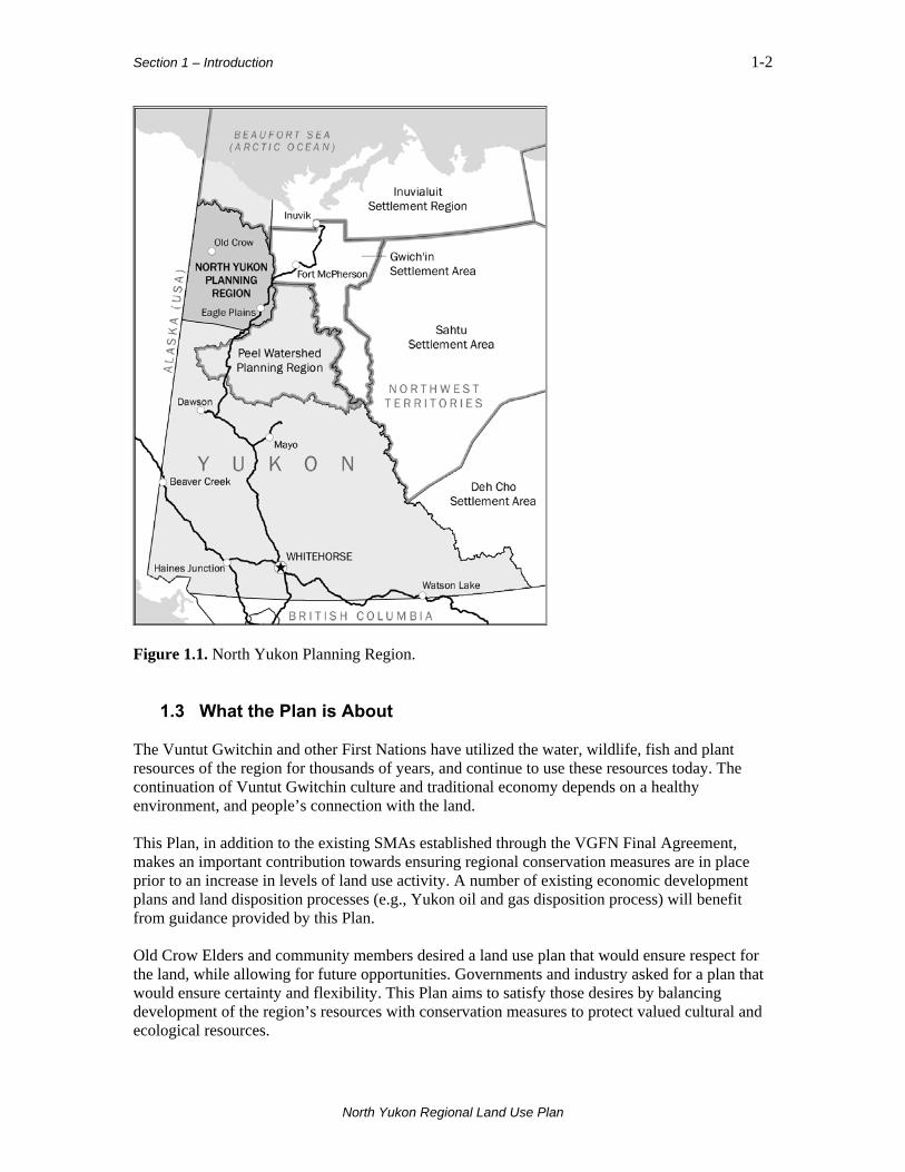
Figure 1.1. North Yukon Planning Region. 1.3 What the Plan is About The Vuntut Gwitchin and other First Nations have utilized the water, wildlife, fish and plant resources of the region for thousands of years, and continue to use these resources today. The continuation of Vuntut Gwitchin culture and traditional economy depends on a healthy environment, and people’s connection with the land. This Plan, in addition to the existing SMAs established through the VGFN Final Agreement, makes an important contribution towards ensuring regional conservation measures are in place prior to an increase in levels of land use activity. A number of existing economic development plans and land disposition processes (e.g., Yukon oil and gas disposition process) will benefit from guidance provided by this Plan. Old Crow Elders and community members desired a land use plan that would ensure respect for the land, while allowing for future opportunities. Governments and industry asked for a plan that would ensure certainty and flexibility. This Plan aims to satisfy those desires by balancing development of the region’s resources with conservation measures to protect valued cultural and ecological resources.
North Yukon Regional Land Use Plan

Section 1 – Introduction 1-3
Plan partners and stakeholders identified six major planning issues of both short-term and long-term importance to the North Yukon Planning Region: Oil and gas exploration and development in Eagle Plains How might exploration and development of North Yukon’s oil and gas resources affect the region? What are the cumulative effects and how will they affect the region’s economy, society and environment, particularly the Porcupine Caribou Herd? Land management and the Porcupine Caribou Herd Residents of Old Crow are concerned about immediate and long-term conservation of the Porcupine Caribou Herd. The culture, traditional values and subsistence economy of the Vuntut Gwitchin depend on continued access to and utilization of a healthy Porcupine Caribou Herd. Future development impacts on water, wetlands and riparian habitat Wetlands, lakes, rivers and riparian environments are biologically productive areas that hold many of the heritage, cultural and ecological values of the region. Future land use activities have the potential to impact these values. Opportunities to access land and resources Future natural resource development will require access to resources, such as oil and gas, aggregate and minerals. Restrictions on access to these resources may affect the establishment and growth of the region’s natural resource economy. Of particular concern are the Eagle Plains area and the land covered by the North Yukon Land Withdrawal. Transportation The current lack of ground transportation infrastructure in the region is seen as a barrier to natural resource development. All-season access roads may be required in the future to support economic development. However, roads and people’s use of these features could affect wildlife and fish populations. Climate change Climate change affects land, water, wildlife, fish and people’s use of these resources. The impacts of climate change may also compound potential future land use impacts. 1.4 Plan Principles Four important principles underlie the North Yukon Land Use Plan. Sustainable Development The core principle that guides the Plan is sustainable development, as defined in the VGFNFA:
“Beneficial socio-economic change that does not undermine the ecological and social systems upon which communities and societies are dependent.”
North Yukon Regional Land Use Plan

Section 1 – Introduction 1-4
Precautionary Principle Regional planning should consider potential impacts before making resource decisions. Our limited understanding of land use impacts on other resources in the North makes this especially important. The International Institute for Sustainable Development describes the Precautionary Principle as:
“A lack of conclusive scientific evidence does not justify inaction on managing the environment, particularly when the consequences of inaction may be undesirable or when the costs of action are negligible.”
Conservation The Plan proposes to manage fish and wildlife habitats using the conservation principle. Conservation, as defined by the VGFNFA is:
“The management of Fish and Wildlife populations and habitats and the regulation of users to ensure the quality, diversity and Long Term Optimum Productivity of Fish and Wildlife populations, with the primary goal of ensuring a sustainable harvest and its proper utilization.”
Adaptive Management Adaptive Management means responding to changing land use and/or environmental conditions as new or better information becomes available. It is a management philosophy that applies a structured, iterative process to decision-making. Adaptive Management means we must:
“Look, learn and adjust as required.”
Figure 1.2. Sustainable development is the guiding principle for the Plan. The VGFN Final Agreement provides guidance for Plan principles and goals.
North Yukon Regional Land Use Plan
Section 1 – Introduction 1-5
1.5 Plan Goals The underlying principle of sustainable development is expressed in the Plan in a set of six goals that cover economic, social and ecological considerations. Goal 1 Promote sustainable development by ensuring that social, cultural, economic and environmental policies are applied to the management, protection and use of land, water and resources in an integrated and coordinated manner. Goal 2 Maintain terrestrial habitat in a condition required to sustain regional wildlife populations. Goal 3 Maintain aquatic habitat in a condition required to sustain regional fish populations. Goal 4 Maintain the integrity of wetlands, lakes, rivers and sensitive permafrost areas. Goal 5 Recognize, conserve and promote the heritage and cultural resources and values of the Vuntut Gwitchin, other affected First Nations, and the Yukon. Goal 6 Facilitate economic development opportunities and activities that result in socio-economic benefits to the community of Old Crow, other affected First Nations and Yukon as a whole, and that meet the sustainable development criteria established by this Plan.
North Yukon Regional Land Use Plan

Section 2 – Description of Planning Region 2-1
2. Description of Planning Region
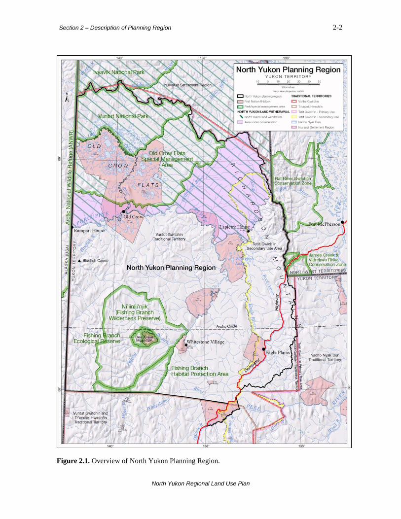
2.1 Setting The North Yukon Planning Region, shown in Figure 2.1, represents about 12% of Yukon. It is the traditional territory of the Vuntut Gwitchin First Nation. There is one major all-season road, the Dempster Highway. Old Crow is the only permanent community, and the only community in Yukon with no all-season road access. The planning region is part of the vast Gwich’in homeland of northwest Canada and Alaska. Portions of the Tetlit Gwich’in, Tr’ondek Hwech’in and Na-cho Nyak Dun traditional territories extend into it, including the Tetlit Gwich’in Secondary Use Area. The Inuvialuit Settlement Region is located to the north of the planning region, on the Yukon North Slope. Land and resource management in the planning region is shared between governments, other agencies and land claim boards. The Yukon and Vuntut Gwitchin governments are the primary land managers for most of the area. VGFN Settlement Lands cover 14% of the region. Most of the Settlement Lands fall under Category A, which means the First Nation owns both surface and subsurface rights. In cooperation with other groups and agencies, the Government of Canada (Parks Canada) manages Vuntut National Park. As of 2008, there is almost no private land ownership in the North Yukon Planning Region. Much of the land in northern Yukon and adjacent jurisdictions is managed with a strong conservation focus. The region contains three existing Protected Areas:
• Vuntut National Park;
• Old Crow Flats SMA; and,
• Ni’iinlii’njik (Fishing Branch) Wilderness Preserve, Ecological Reserve and VG R-05A. In total, these Protected Areas account for 32% of the region. Ivvavik National Park and the Arctic National Wildlife Refuge (ANWR) in Alaska border the northwest portion of the region. Inuvialuit Community Conservation Plans are in place for the Yukon North Slope. The Rat River and James Creek-Vittrekwa River Gwich’in Conservation Zones in NWT are located to the east. The North Yukon Land Withdrawal, an area that has not been available for land disposition and resource exploration since 1978, affects lands north of the Porcupine and west of the Bell rivers.
North Yukon Regional Land Use Plan
Section 2 – Description of Planning Region 2-2
Figure 2.1. Overview of North Yukon Planning Region.
North Yukon Regional Land Use Plan

Section 2 – Description of Planning Region 2-3
2.2 Environment The entire region is part of Beringia, an area extending from Yukon to Siberia. For almost two million years, Beringia remained free of glaciers, providing a refuge for plants, animals, and some of the first people of North America. The land, water, people, plants and animals have all been influenced by these ice-free conditions. One of the most extreme climate regions in Yukon, the North Yukon Planning Region is underlain by continuous permafrost. Low-stature spruce forests, shrub and tundra vegetation characterize low-mid elevation areas. High elevation mountain ranges contain extensive areas of rock and sparse vegetation. The region contains portions of six distinct ecoregions, including Old Crow Flats, Old Crow Basin, Eagle Plains, North Ogilvie Mountains, British-Richardson Mountains and Davidson Mountains. Elevation ranges from 325 to 1,700 metres above sea level. Most of the region is within the Porcupine River Watershed. Rivers experience very low winter flows and dramatic variations in the summer. 2.3 People As of 2008, the total regional population is about 300. All live in Old Crow and almost all (90%) are VGFN beneficiaries. Since 1985, the Old Crow population has remained relatively stable, with population growth trends currently less than 1%. There are an estimated 800 VGFN beneficiaries in total. 2.4 Economy The regional economy is a mixed economy in which traditional subsistence harvesting and wage-based activities co-exist. Subsistence hunting, gathering and trapping are still very important economic and cultural activities in Old Crow. A high participation rate in the traditional economy is important for the maintenance of Vuntut Gwitchin culture, ties to the land, and community well-being. The region, in 2008, had one of the lowest levels of wage-based economic activity in Yukon. The planning and delivery of government services and government transfer payments are the primary economic inputs. Transportation is currently the largest sector, followed by tourism linked with the Dempster Highway. Activity levels in all other sectors are low, including oil and gas and mining, and there is no commercial forestry, guiding and outfitting, or agriculture. At present, interest in developing sources of renewable energy is limited to the community of Old Crow. Major sectors are discussed briefly below.
2.4.1 Transportation The Dempster Highway connects southern Yukon and Canada to the Mackenzie Delta communities of the Northwest Territories (NWT). Regular scheduled air service facilitates the transport of goods and people between Old Crow, Dawson, Inuvik and Whitehorse. Major rivers provide summer and winter travel routes for Old Crow residents and tourists seeking wilderness
North Yukon Regional Land Use Plan

Section 2 – Description of Planning Region 2-4
recreation. Residents use many trails and routes for subsistence harvest, travel between communities, and other cultural activities.
2.4.2 Tourism Approximately 7,000 tourists travel the Dempster Highway annually. Outside of the highway corridor, however, tourism activity is currently low, tourism products and services are modest and the tourism market is not well developed. Improvements to Old Crow tourism infrastructure will be required if tourism is to grow. Although the region holds impressive natural and cultural features, North Yukon will likely continue to appeal to a small and specialized market. Important areas for future tourism activity include Old Crow and adjacent Protected Areas, Vuntut National Park, Ni’iinlii’njik (Fishing Branch), the Richardson Mountains, and several major rivers (Porcupine, Eagle and Bell rivers).
2.4.3 Oil and Gas Oil and gas activity is low but interest is increasing. The region contains a significant portion of Yukon’s total estimated natural gas and oil potential. The Eagle Plains basin, which contains proven reserves, is considered most important. Eagle Plains received a high level of oil and gas exploration in the 1960s-70s. Currently, resource assessments suggest substantial natural gas potential (mean estimate 7.9 trillion cubic feet), and moderate oil potential (mean estimate 536 million barrels). While large-scale natural gas exploration and development may generate significant economic activity, the lack of pipeline infrastructure is currently a major barrier to developing the potential natural gas resource of northern Yukon. Small-scale oil and gas development scenarios could occur separately from, and prior to, large-scale pipeline development and natural gas production. In late 2008, the region contained 14 Oil and Gas Permits, 13 of which were awarded in spring 2007. Two Significant Discovery Licenses date from the 1980s.
2.4.4 Mining Mineral exploration interest in the region has been low in the past but is increasing. Potential mineral resources remain largely unexplored, and there is a limited understanding of regional mineral potential. Based on existing information, a small portion of the region is considered to have high potential for mineral resources. Areas of higher mineral potential are located in the vicinity of Fishing Branch, the Old Crow Range, and in portions of the Richardson Mountains. Approximately 375 mineral claims were staked in 2007 and 2008, for a total of over 500 active claims in the region. There are no operating mines.
2.4.5 Aggregate (gravel) Aggregate is an important resource for the community of Old Crow and annual maintenance activities associated with the Dempster Highway. Large amounts of crushed rock, sand and gravel will also be required to support future industrial activity. The Beringian history of the region means there are very few glacial surface deposits, the major source of conventional aggregate materials. Suitable aggregate sources are therefore scarce, and are often associated with ancient and modern river channels and terraces. Gravel mining in these locations can have environmental impacts, and affect other land uses.
North Yukon Regional Land Use Plan

Section 2 – Description of Planning Region 2-5
2.5 Significant Ecological and Cultural Values The region contains a number of features and values of territorial, national and global significance, including both heritage and ecological resources.
2.5.1 Heritage Resources The past and the present are linked in northern Yukon. Through Beringia, the land, people and wildlife share a common past; they have coexisted for several thousand years. The region holds some of the oldest recorded sites of human occupation in North America. Evidence of human occupation in Bluefish Caves, 50 kilometres southwest of Old Crow, has been dated to 24,000 years ago. Sites in the Richardson Mountains are 12,000 years old. Some sites may be as old as 40,000 years. The fossil remains of extinct Ice Age mammals, such as mammoth, steppe bison and shortfaced bear, are common in the Old Crow, Bluefish and Bell-Whitefish basins. The region contains Gwich’in caribou fences, a form of communal caribou hunting technology. These fences are important cultural artefacts. More recent historical sites include Rampart House, Lapierre House, Whitestone and Johnston Creek villages, fur trade era trading posts and seasonal Gwich’in communities. Some heritage trails and routes are still used to travel between communities and to reach areas for hunting, trapping and fishing.
2.5.2 Wildlife and Plants The region is occupied seasonally or annually by approximately 40 species of mammals, 150 species of birds and 18 species of fish, including three species of salmon. Five wildlife species in the region are listed as being of national conservation concern—the Grizzly Bear, Wolverine, Short-eared Owl, Peregrine Falcon, and Rusty Blackbird. All five are considered stable in Yukon. Approximately 600 plant species have been documented; 93 are recorded as rare. The most significant and culturally-important wildlife resource in the planning region is the barren-ground Porcupine Caribou Herd. The migratory herd uses the entire region at various times of year. The highest usage occurs during the winter, spring migration, fall migration and late fall seasons. The Porcupine Caribou Herd is the eighth-largest herd of migratory caribou in North America. It has been the mainstay of Gwich’in culture for at least 20,000 years and is also important to other aboriginal peoples whose territories overlap its range. Beyond its value to humans, the herd is essential to the well-being of the entire North Yukon ecosystem. As the predominant large mammal species, its presence, or absence, influences this ecosystem and other resident species. The current (2008) population estimate is 110,000 animals. The herd has been steadily declining since 1989. The future health of the Porcupine Caribou Herd is one of the major issues identified in developing this Plan.
2.5.3 Wetlands, Lakes and Rivers The region contains three major wetland complexes—Old Crow Flats, Bluefish-Cadzow and Whitefish. Almost all of the lakes in the region are contained in these three wetlands. Reinforcing the ecological and cultural significance of these areas, the three wetlands account for most of VGFNs total settlement land area.
North Yukon Regional Land Use Plan
Section 2 – Description of Planning Region 2-6
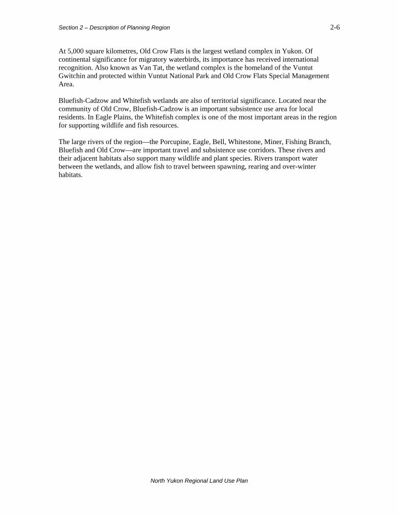
At 5,000 square kilometres, Old Crow Flats is the largest wetland complex in Yukon. Of continental significance for migratory waterbirds, its importance has received international recognition. Also known as Van Tat, the wetland complex is the homeland of the Vuntut Gwitchin and protected within Vuntut National Park and Old Crow Flats Special Management Area. Bluefish-Cadzow and Whitefish wetlands are also of territorial significance. Located near the community of Old Crow, Bluefish-Cadzow is an important subsistence use area for local residents. In Eagle Plains, the Whitefish complex is one of the most important areas in the region for supporting wildlife and fish resources. The large rivers of the region—the Porcupine, Eagle, Bell, Whitestone, Miner, Fishing Branch, Bluefish and Old Crow—are important travel and subsistence use corridors. These rivers and their adjacent habitats also support many wildlife and plant species. Rivers transport water between the wetlands, and allow fish to travel between spawning, rearing and over-winter habitats.
North Yukon Regional Land Use Plan
Section 3 – Plan Concepts 3-1
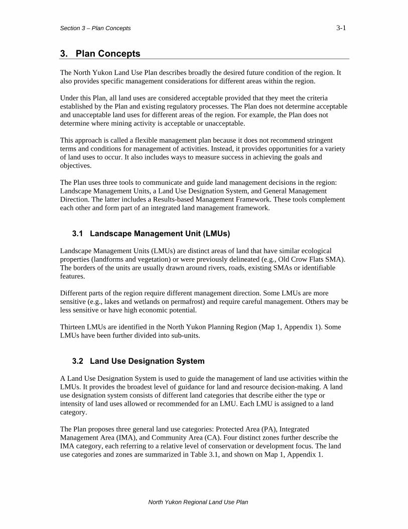
3. Plan Concepts The North Yukon Land Use Plan describes broadly the desired future condition of the region. It also provides specific management considerations for different areas within the region. Under this Plan, all land uses are considered acceptable provided that they meet the criteria established by the Plan and existing regulatory processes. The Plan does not determine acceptable and unacceptable land uses for different areas of the region. For example, the Plan does not determine where mining activity is acceptable or unacceptable. This approach is called a flexible management plan because it does not recommend stringent terms and conditions for management of activities. Instead, it provides opportunities for a variety of land uses to occur. It also includes ways to measure success in achieving the goals and objectives. The Plan uses three tools to communicate and guide land management decisions in the region: Landscape Management Units, a Land Use Designation System, and General Management Direction. The latter includes a Results-based Management Framework. These tools complement each other and form part of an integrated land management framework. 3.1 Landscape Management Unit (LMUs) Landscape Management Units (LMUs) are distinct areas of land that have similar ecological properties (landforms and vegetation) or were previously delineated (e.g., Old Crow Flats SMA). The borders of the units are usually drawn around rivers, roads, existing SMAs or identifiable features. Different parts of the region require different management direction. Some LMUs are more sensitive (e.g., lakes and wetlands on permafrost) and require careful management. Others may be less sensitive or have high economic potential. Thirteen LMUs are identified in the North Yukon Planning Region (Map 1, Appendix 1). Some LMUs have been further divided into sub-units. 3.2 Land Use Designation System A Land Use Designation System is used to guide the management of land use activities within the LMUs. It provides the broadest level of guidance for land and resource decision-making. A land use designation system consists of different land categories that describe either the type or intensity of land uses allowed or recommended for an LMU. Each LMU is assigned to a land category. The Plan proposes three general land use categories: Protected Area (PA), Integrated Management Area (IMA), and Community Area (CA). Four distinct zones further describe the IMA category, each referring to a relative level of conservation or development focus. The land use categories and zones are summarized in Table 3.1, and shown on Map 1, Appendix 1.
North Yukon Regional Land Use Plan

Section 3 – Plan Concepts 3-2
Table 3.1. Land use designation system for North Yukon Planning Region.
Land Use Category
Description
Protected Area (PA)
Legally designated land areas withdrawn from surface and subsurface rights issuance. Oil and gas, mining and other industrial land uses are not allowed. Examples include Vuntut National Park and Ni’iinlii’njik (Fishing Branch) Wilderness Preserve and Ecological Reserve. The working landscape—areas where oil and gas, mining, and other land uses are allowed, subject to the Plan recommendations and regulatory processes. Each LMU within this category is further described by one of the following zones, based on the values in the unit and the sensitivity of the land:
IMA Zone
Management Intent
Description
Zone I Lowest Development
Very high ecological and heritage/cultural values within a sensitive biophysical setting. Maintaining ecological integrity and protecting heritage and cultural resources is the priority. Land uses are acceptable provided they do not result in creation of significant functional disturbance 1. All-season industrial infrastructure is discouraged.
Zone II Low Development
High ecological and heritage/cultural values within a moderately sensitive biophysical setting. Maintaining ecological integrity, protecting heritage and cultural resources, and minimizing land use impacts is the priority.
Zone III Moderate Development
Moderate ecological and heritage/cultural values within a moderately sensitive biophysical setting. Conservative levels of land use are consistent with Zone III objectives.
Integrated
Management Area (IMA)
Zone IV Highest Development
Lower ecological and heritage/cultural values within a moderately sensitive biophysical setting. Higher levels of land use are consistent with Zone IV objectives.
Community Area (CA)
Areas around communities or municipalities where local planning is undertaken. This applies to the community of Old Crow.
1 Functional Disturbance: Physical land use disturbance that results in disruption of soil or hydrology, or that requires the cutting of trees. Activities considered exempt from functional disturbance creation are: 1) new linear features less than 1.5 m in width; 2) land use activities that occur on frozen water-bodies; 3) winter work with no required clearing of trees; 4) winter work that utilizes existing disturbances and linear features.
North Yukon Regional Land Use Plan

Section 3 – Plan Concepts 3-3
IMA zones are organized on the concept of acceptable levels of human-caused change and potential risks to ecological and cultural resources (Figure 3.1). Indicators of land use disturbance are part of the zone definitions and help to define the relative level of conservation or development focus in each zone. In addition to land use zones, some features require special consideration and additional management direction. The Dempster Highway Corridor is the only major all-weather road in the region and has a number of specific management issues. Major River Corridors identify the significant rivers and river valleys, which are of special biological and cultural importance.
Figure 3.1. Zoning considerations for Integrated Management Area.
North Yukon Regional Land Use Plan

Section 3 – Plan Concepts 3-4
3.3 General Management Direction The third tool that the Plan uses to guide land use decisions is general management direction, which is provided in the form of strategies, best management practices and recommendations. The management direction proposed in the Plan can be integrated into existing processes such as YESAB project reviews and the land application review process. General management direction applies to the Integrated Management Area (IMA).
3.3.1 Results-based Management Framework Wherever possible, management direction for the Plan is structured around a results-based management framework. A results-based management framework is a structured way to determine if Plan goals and objectives are being met. It is a way to link general, higher-level objectives with more detailed, operational decisions. The results-based management framework and its various components are summarized in Figure 3.2. Goals and objectives state the desired management outcomes. Strategies are approaches and actions that land managers can use to achieve specific objectives. Strategies may include recommendations and best management practices. Best management practices are ways of working that can reduce the time, intensity or duration of land use activities1. Many best management practices developed for Yukon relate directly to achieving objectives and strategies of this Plan. Appendix 3 contains references for applicable Yukon best management practices. Monitoring and assessment of indicators is necessary to determine if goals and objectives are being met. Strategies can be adjusted in response to the changing status of indicators, facilitating an adaptive management process. The Plan proposes that the condition of land use or ecological indicators be tracked and reported for each LMU. At this time, indicators are not provided for all Plan themes and do not address all strategies or monitoring requirements. Currently, the Plan focuses on cumulative effects indicators. Additional indicators are suggested in Table 7.2, for future consideration.
1 A description of best management practices is provided by the Yukon Department of Energy, Mines and Resources, Oil and Gas Management Branch, 2007: http://www.emr.gov.yk.ca/oilandgas/best_management_practices.html#What_are_Best_Management_Practices.
North Yukon Regional Land Use Plan
Section 3 – Plan Concepts 3-5
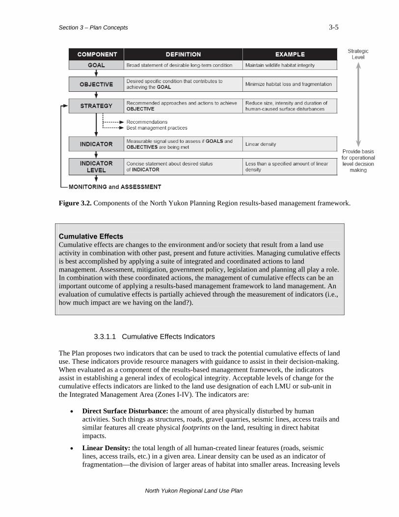
Figure 3.2. Components of the North Yukon Planning Region results-based management framework. Cumulative Effects Cumulative effects are changes to the environment and/or society that result from a land use activity in combination with other past, present and future activities. Managing cumulative effects is best accomplished by applying a suite of integrated and coordinated actions to land management. Assessment, mitigation, government policy, legislation and planning all play a role. In combination with these coordinated actions, the management of cumulative effects can be an important outcome of applying a results-based management framework to land management. An evaluation of cumulative effects is partially achieved through the measurement of indicators (i.e., how much impact are we having on the land?).
3.3.1.1 Cumulative Effects Indicators The Plan proposes two indicators that can be used to track the potential cumulative effects of land use. These indicators provide resource managers with guidance to assist in their decision-making. When evaluated as a component of the results-based management framework, the indicators assist in establishing a general index of ecological integrity. Acceptable levels of change for the cumulative effects indicators are linked to the land use designation of each LMU or sub-unit in the Integrated Management Area (Zones I-IV). The indicators are:
• Direct Surface Disturbance: the amount of area physically disturbed by human activities. Such things as structures, roads, gravel quarries, seismic lines, access trails and similar features all create physical footprints on the land, resulting in direct habitat impacts.
• Linear Density: the total length of all human-created linear features (roads, seismic lines, access trails, etc.) in a given area. Linear density can be used as an indicator of fragmentation—the division of larger areas of habitat into smaller areas. Increasing levels
North Yukon Regional Land Use Plan
Section 3 – Plan Concepts 3-6
of access may result from linear feature development, potentially leading to greater harvest of wildlife and fish, higher predation rates, and a change in how people and wildlife use the land. For this reason linear density is sometimes referred to as ‘access density’.
An increase in the level of either of these two indicators results in increased risk of damage to valued ecological and cultural resources. Social and economic values can also be affected when there are high levels of disturbance and activity on the land.
3.3.1.2 Cumulative Effects Indicator Levels The cumulative effects indicator levels identified in the Plan represent a theoretical point between acceptable and unacceptable levels of human-caused disturbance. The indicator levels recommended in the Plan provide guidance on what might be acceptable levels of human-caused disturbance within each LMU or sub-unit. As shown in Table 3.2, the cumulative effects indicator levels are linked to the Integrated Management Area zone designation (Zones I-IV), providing clear management direction for the different areas of the IMA. When the indicator levels are reached or exceeded, it is a signal that undesirable impacts to ecological and cultural resources may result2. The Plan proposes cautionary indicator levels as an early warning signal, allowing time for pro-active management steps to be considered or taken. When these cautionary indicators are reached, the respective governments should share information and review the health of the key ecological values, and if required, determine the management options to minimize and mitigate impacts. Critical indicator levels represent the point where the indicators may have reached or surpassed acceptable levels. Through the use of cumulative effects indicators, and their recommended levels, the Plan attempts to balance potential risks to ecological and cultural resources with the requirement for, and potential impacts of, economic development. Cumulative Effects Indicator Levels These levels are not intended to be an absolute cap on activities. They are intended to provide a clear statement regarding the level of human-caused environmental change that might be considered acceptable within a specific LMU. When used in a results-based management context, indicator levels are designed to promote pro-active and integrated land management. The recommended indicator levels serve as a benchmark, and provide the Parties responsible for plan implementation an opportunity to review and consider the potential outcomes of resource management decisions. They will also assist in the YESAA process by providing an indication of potential cumulative effects within a LMU.
2 As human-caused surface disturbances, including linear features, recover through natural re-vegetation or active reclamation, they are subtracted from the total amount of disturbed area. As a guide, human-caused surface disturbance is considered recovered when it no longer facilitates travel or access by wildlife and people. In forested areas, a feature can be considered recovered when it contains woody vegetation (trees and shrubs) approximately 1.5 metres in height. This definition is closely linked with human and predator access and potential effects on Porcupine caribou and moose, key values in the region.
North Yukon Regional Land Use Plan

Section 3 – Plan Concepts 3-7
Table 3.2. IMA land use zones and proposed cumulative effects indicator levels.
IMA Zone
Management Intent
Cumulative Effects Indicators
Cautionary Level 1
Critical Level
Surface disturbance 0.075% 0.1% Zone I 2 Lowest development
Linear density 0.075 km/km2 0.1 km/km2
Surface disturbance 0.15% 0.2% Zone II
Low development Linear density 0.15 km/km² 0.2 km/km²
Surface disturbance 0.375% 0.5% Zone III Moderate development
Linear density 0.375 km/km² 0.5 km/km²
Surface disturbance 0.75% 1.0% Zone IV Highest development
Linear density 0.75 km/km² 1.0 km/km²
1 Cautionary level is established as 75% of the upper, or critical level. 2 While cumulative effects indicator levels are identified for Zone I, the intent is to discourage development of new all-season industrial infrastructure, aggregate extraction and human settlements/structures.
North Yukon Regional Land Use Plan
Section 4 – Land Use Designation 4-1
North Yukon Regional Land Use Plan
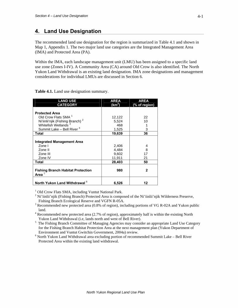
4. Land Use Designation The recommended land use designation for the region is summarized in Table 4.1 and shown in Map 1, Appendix 1. The two major land use categories are the Integrated Management Area (IMA) and Protected Area (PA). Within the IMA, each landscape management unit (LMU) has been assigned to a specific land use zone (Zones I-IV). A Community Area (CA) around Old Crow is also identified. The North Yukon Land Withdrawal is an existing land designation. IMA zone designations and management considerations for individual LMUs are discussed in Section 6. Table 4.1. Land use designation summary.
LAND USE CATEGORY
AREA (km2)
AREA (% of region)
Protected Area
Old Crow Flats SMA 1 12,122 22 Ni’iinlii’njik (Fishing Branch) 2 5,524 10 Whitefish Wetlands 3 468 1 Summit Lake – Bell River 4 1,525 3
Total 19,639 36 Integrated Management Area
Zone I 2,406 4 Zone II 4,484 8 Zone III 9,602 17 Zone IV 11,911 21
Total 28,403 50 Fishing Branch Habitat Protection Area 5
980
2
North Yukon Land Withdrawal 6
6,526
12
1 Old Crow Flats SMA, including Vuntut National Park. 2 Ni’iinlii’njik (Fishing Branch) Protected Area is composed of the Ni’iinlii’njik Wilderness Preserve,
Fishing Branch Ecological Reserve and VGFN R-05A. 3 Recommended new protected area (0.8% of region), including portions of VG R-02A and Yukon public
land. 4 Recommended new protected area (2.7% of region), approximately half is within the existing North
Yukon Land Withdrawal (i.e, lands north and west of Bell River). 5 The Fishing Branch Committee of Managing Agencies may consider an appropriate Land Use Category
for the Fishing Branch Habitat Protection Area at the next management plan (Yukon Department of Environment and Vuntut Gwitchin Government, 2004a) review.
6 North Yukon Land Withdrawal area excluding portion of recommended Summit Lake – Bell River Protected Area within the existing land withdrawal.
Section 4 – Land Use Designation 4-2
North Yukon Regional Land Use Plan
4.1 Integrated Management Area Fifty percent of the region is within the IMA, or working landscape, where applications for industrial land uses and other activities will be considered. Most (80%) of the IMA has a relatively high development focus (Zone III or IV), including areas with some of the highest potential for significant oil and gas and mineral resources.
4.2 Protected Area Existing Protected Areas represent 32% of the region. These are Old Crow Flats SMA (including Vuntut National Park) and Ni’iinlii’njik (Fishing Branch) Wilderness Preserve, Ecological Reserve and VGFN land selection R-05A. Two new PAs are recommended: 1) Whitefish Wetlands, and 2) Summit Lake – Bell River. Creating the new PAs would add approximately 4% of lands to the Protected Area category.
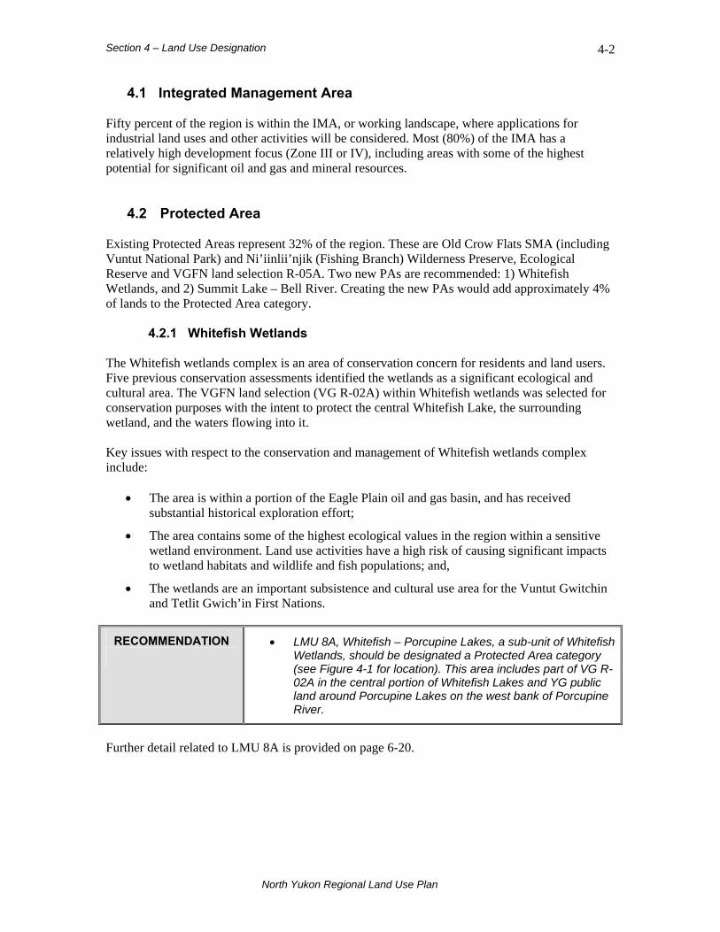
4.2.1 Whitefish Wetlands The Whitefish wetlands complex is an area of conservation concern for residents and land users. Five previous conservation assessments identified the wetlands as a significant ecological and cultural area. The VGFN land selection (VG R-02A) within Whitefish wetlands was selected for conservation purposes with the intent to protect the central Whitefish Lake, the surrounding wetland, and the waters flowing into it. Key issues with respect to the conservation and management of Whitefish wetlands complex include:
• The area is within a portion of the Eagle Plain oil and gas basin, and has received substantial historical exploration effort;
• The area contains some of the highest ecological values in the region within a sensitive wetland environment. Land use activities have a high risk of causing significant impacts to wetland habitats and wildlife and fish populations; and,
• The wetlands are an important subsistence and cultural use area for the Vuntut Gwitchin and Tetlit Gwich’in First Nations.
RECOMMENDATION
• LMU 8A, Whitefish – Porcupine Lakes, a sub-unit of Whitefish Wetlands, should be designated a Protected Area category (see Figure 4-1 for location). This area includes part of VG R-02A in the central portion of Whitefish Lakes and YG public land around Porcupine Lakes on the west bank of Porcupine River.
Further detail related to LMU 8A is provided on page 6-20.
Section 4 – Land Use Designation 4-3
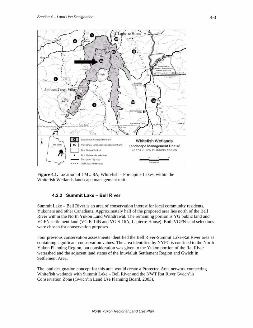
Figure 4.1. Location of LMU 8A, Whitefish – Porcupine Lakes, within the Whitefish Wetlands landscape management unit.
4.2.2 Summit Lake – Bell River Summit Lake – Bell River is an area of conservation interest for local community residents, Yukoners and other Canadians. Approximately half of the proposed area lies north of the Bell River within the North Yukon Land Withdrawal. The remaining portion is YG public land and VGFN settlement land (VG R-14B and VG S-16A, Lapierre House). Both VGFN land selections were chosen for conservation purposes. Four previous conservation assessments identified the Bell River-Summit Lake-Rat River area as containing significant conservation values. The area identified by NYPC is confined to the North Yukon Planning Region, but consideration was given to the Yukon portion of the Rat River watershed and the adjacent land status of the Inuvialuit Settlement Region and Gwich’in Settlement Area. The land designation concept for this area would create a Protected Area network connecting Whitefish wetlands with Summit Lake – Bell River and the NWT Rat River Gwich’in Conservation Zone (Gwich’in Land Use Planning Board, 2003).
North Yukon Regional Land Use Plan

Section 4 – Land Use Designation 4-4
North Yukon Regional Land Use Plan
Key issues with respect to the conservation and management of Bell River-Summit Lake include:
• The area contains some of the highest wildlife, fish, cultural, and heritage values in the region, including important concentrated use areas for the Porcupine Caribou Herd;
• Protected Area designation is consistent with the management intent for the Rat River Gwich’in Conservation Zone, currently under land withdrawal;
• Protected Area designation is consistent with adjacent Inuvialuit Settlement Region Aklavik Community Conservation Plan (Category D and E);
• Much of the proposal is within the Tetlit Gwich’in Secondary Use Area and is an important subsistence and cultural use area for Vuntut Gwitchin, Tetlit Gwich’in and Inuvialuit residents;
• The area has high wilderness tourism and recreation value and potential;
• A portion of the Rat River Watershed overlaps the Inuvialuit Settlement Region. The Inuvialuit must be consulted before any decisions are made with respect to this land;
• The proposed boundary for LMU 4C, Summit Lake – Bell River, is currently conceptual and represents a general area of interest. Further boundary refinement/delineation will be required; and,
• Future planning for Summit Lake – Bell River should consider potential Yukon North Slope transportation corridor options.
RECOMMENDATION
• LMU 4C, Summit Lake - Bell River, a sub-unit of the Northern Richardson Mountains and Foothills, should be designated a Protected Area category (see Figure 4-2 for location). This area is centered on Summit Lake-McDougall Pass and the lower Bell River corridor around Lapierre House, including portions of the upper Bell and LaChute river watersheds.
Further detail related to LMU 4C is provided on page 6-13.
4.3 Community Area A 5 km area around the Community of Old Crow, between the Porcupine River and Old Crow Flats SMA, is prioritized for community development requirements. The designation recognizes the requirements for economic development and infrastructure within the vicinity of Old Crow. This small area is not a major land use category, and is not represented in Table 4.1.
Section 4 – Land Use Designation 4-5
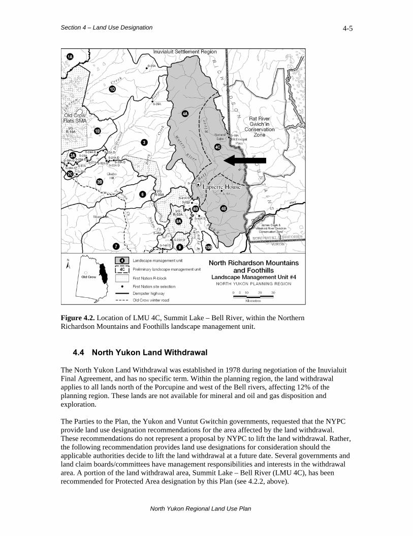
Figure 4.2. Location of LMU 4C, Summit Lake – Bell River, within the Northern Richardson Mountains and Foothills landscape management unit.
4.4 North Yukon Land Withdrawal The North Yukon Land Withdrawal was established in 1978 during negotiation of the Inuvialuit Final Agreement, and has no specific term. Within the planning region, the land withdrawal applies to all lands north of the Porcupine and west of the Bell rivers, affecting 12% of the planning region. These lands are not available for mineral and oil and gas disposition and exploration. The Parties to the Plan, the Yukon and Vuntut Gwitchin governments, requested that the NYPC provide land use designation recommendations for the area affected by the land withdrawal. These recommendations do not represent a proposal by NYPC to lift the land withdrawal. Rather, the following recommendation provides land use designations for consideration should the applicable authorities decide to lift the land withdrawal at a future date. Several governments and land claim boards/committees have management responsibilities and interests in the withdrawal area. A portion of the land withdrawal area, Summit Lake – Bell River (LMU 4C), has been recommended for Protected Area designation by this Plan (see 4.2.2, above).
North Yukon Regional Land Use Plan
Section 4 – Land Use Designation 4-6
North Yukon Regional Land Use Plan
Key issues with respect to the status of the land withdrawal include:
• The area contains some of the highest wildlife, fish, cultural, and heritage values in the region, including important concentrated use areas for the Porcupine caribou herd;
• Adjacent lands in the Arctic National Wildlife Refuge, Yukon North Slope and Gwich’in Settlement Region have a strong conservation management focus; and,
• The area is not currently available for rights issuance or non-renewable resource land uses, potentially impacting future economic opportunities in the region.
RECOMMENDATION
• Should the applicable authorities decide to lift the North Yukon Land Withdrawal at a future date, LMU 2A (Old Crow – Rampart House, LMU 3 (Driftwood River), and LMU 4A (Bell - Waters River) should be considered for Integrated Management Area Zone II designation (see Map 1, Appendix 1 for locations).

Section 5 – General Management Direction 5-1
North Yukon Regional Land Use Plan
5. General Management Direction This section deals with general management direction as it applies to the entire Integrated Management Area (IMA) of the North Yukon Planning Region. For a discussion of how general management direction is applied to specific landscape management units (LMUs), see Section 6 of this Plan. The management direction proposed here can be integrated into existing processes, such as the land application review process. Other management plans in effect or in preparation for the region should be consulted for additional direction and guidance (see Appendix 3). An overview of identified ecological, cultural and economic values and resources referenced in this section can be found in Maps 2-4, Appendix 1. Detailed maps and descriptions of resource values are contained in the North Yukon Resource Assessment Report (North Yukon Planning Commission, 2007a,b) and Land Use Scenarios Report (North Yukon Planning Commission, 2009). These materials are available from the NYPC website (www.nypc.planyukon.ca) and should be consulted when further information is required. Strategies and Best Management Practices This Plan assumes that whenever possible and practical, the recommended strategies and best management practices will be considered and implemented. Operational decisions regarding the strategies and best management practices are at the discretion of land users, assessment boards and agencies. A summary of best management practices from this section can be found in Appendix 2.
5.1 Sustainable Development Sustainable development requires consideration of the economic, social and ecological consequences of land use decisions, and management of lands and resources in an integrated and coordinated manner. Steps toward achieving sustainable development include establishing land management objectives, designating lands for management priorities, and minimizing and managing the potentially adverse impacts that can arise from multiple land use activities combined with other natural processes.
Section 5 – General Management Direction 5-2
North Yukon Regional Land Use Plan
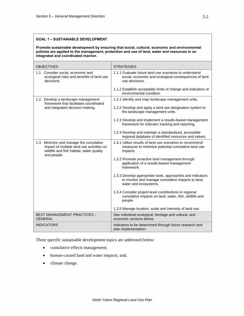
GOAL 1 – SUSTAINABLE DEVELOPMENT Promote sustainable development by ensuring that social, cultural, economic and environmental policies are applied to the management, protection and use of land, water and resources in an integrated and coordinated manner.
OBJECTIVES STRATEGIES
1.1. Consider social, economic and ecological risks and benefits of land use decisions.
1.1.1 Evaluate future land use scenarios to understand social, economic and ecological consequences of land use decisions.
1.1.2 Establish acceptable limits of change and indicators of
environmental condition.
1.2. Develop a landscape management framework that facilitates coordinated and integrated decision-making.
1.2.1 Identify and map landscape management units. 1.2.2 Develop and apply a land use designation system to
the landscape management units. 1.2.3 Develop and implement a results-based management
framework for indicator tracking and reporting. 1.2.4 Develop and maintain a standardized, accessible
regional database of identified resources and values.
1.3. Minimize and manage the cumulative impact of multiple land use activities on wildlife and fish habitat, water quality and people.
1.3.1 Utilize results of land use scenarios to recommend measures to minimize potential cumulative land use impacts.
1.3.2 Promote proactive land management through
application of a results-based management framework.
1.3.3 Develop appropriate tools, approaches and indicators
to monitor and manage cumulative impacts to land, water and ecosystems.
1.3.4 Consider project-level contributions to regional
cumulative impacts on land, water, fish, wildlife and people.
1.3.5 Manage location, scale and intensity of land use.
BEST MANAGEMENT PRACTICES – GENERAL
See individual ecological, heritage and cultural, and economic sections below.
INDICATORS Indicators to be determined through future research and plan implementation.
Three specific sustainable development topics are addressed below:
• cumulative effects management;
• human-caused land and water impacts; and,
• climate change.

Section 5 – General Management Direction 5-3
North Yukon Regional Land Use Plan
5.1.1 Cumulative Effects Management Cumulative effects are changes to the environment and/or society that result from a land use activity in combination with other past, present and future activities. Negative effects are called cumulative impacts. While one activity may have only a small impact, the combined effect of a number of activities may have a significant impact. Managing cumulative effects is best accomplished by applying a suite of integrated and coordinated actions to land management. Assessment, mitigation, government policy, legislation and planning all play a role. In the Yukon, no single agency or group is responsible for cumulative effects management. Adherence to this Plan on its own is not sufficient to manage cumulative effects. However, the tools and approaches in this Plan provide responsible agencies and land users with a framework for cumulative effects management. Among the key issues related to managing cumulative effects:
• Assessing and mitigating land use activities on a project-by-project basis is not an effective strategy for managing cumulative effects.
• Cumulative effects management must consider both direct and indirect impacts to valued resources.
• Monitoring the impacts of multiple land use activities is necessary to assess and evaluate potential cumulative effects.
RECOMMENDATION
• As a general guideline for decision makers and land users, in
the Integrated Management Area the amount of surface disturbance in a landscape management unit should be maintained below the cumulative effects indicator levels recommended in the Plan.
Many of the recommended strategies and best management practices relating to industrial land use activity contribute to maintaining the amount of surface disturbance below the recommended cautionary and critical cumulative effects indicator levels. These strategies should be considered by both project proponents and decision-makers. The process for maintaining surface disturbance below cautionary or critical levels will involve dialogue between the implementing Parties, the Yukon and Vuntut Gwitchin governments. This process will recognize the discretion of the Parties to make final decisions informed by:
• indicator levels;
• other land use plan recommendations; and,
• advice from third parties, such as YESAB. Maintaining surface disturbance below these levels will also involve the land users, who will be expected to apply this Plan as a guide when developing project proposals, carrying out operations and decommissioning projects. The mechanics for enforcing this recommendation will be at the discretion of the Parties and will be addressed by the Parties as part of implementation planning.

Section 5 – General Management Direction 5-4
North Yukon Regional Land Use Plan
5.1.2 Human-caused Land and Water Impacts
5.1.2.1 Surface Disturbances Human-caused surface disturbance is the physical human footprint on the land, the most visible legacy of land use activities. Increasing levels of surface disturbance and habitat change represent increasing risks to native wildlife and fish populations, and overall integrity of natural systems. Approximately 10,000 kilometres of linear features, representing 9,500 hectares of surface disturbance, were created in the region by historical oil and gas and mineral exploration, and transportation infrastructure (Map 4, Appendix 1). Almost all historical linear features are seismic lines, tote roads and winter trails. Some historical features are relatively permanent and will remain in a disturbed condition for decades. Many historical linear features have recovered to the point where they are no longer functional surface disturbances. Very few of these linear features are actively used by people. A human-caused surface disturbance is considered recovered when it no longer facilitates travel or access by wildlife and people 1. In forested areas, a feature can be considered recovered when it contains woody vegetation (trees and shrubs) approximately 1.5m in height. As human-caused surface disturbances, including linear features, recover through natural re-vegetation or active reclamation, they are subtracted from the total amount of disturbed area. Reclaiming surface disturbances upon completion of activities will allow higher levels of land use to occur in relation to recommended surface disturbance and linear density indicator levels. Among the key issues related to managing surface disturbances:
• Surface disturbances create direct and indirect impacts to wildlife and fish.
• Visual quality of the landscape for human use and enjoyment can be affected for long periods of time.
• Comparisons of current levels of surface disturbances to recommended indicator levels are required to monitor and track the cumulative effects of land use.
BEST MANAGEMENT PRACTICES – SURFACE DISTURBANCES
• The size, intensity and duration of all surface disturbances should be reduced.
• Native endemic plants should be used for active reclamation of disturbed sites.
1 This definition of recovered is closely linked with human and predator access and potential effects on Porcupine caribou and moose, key values in the region.
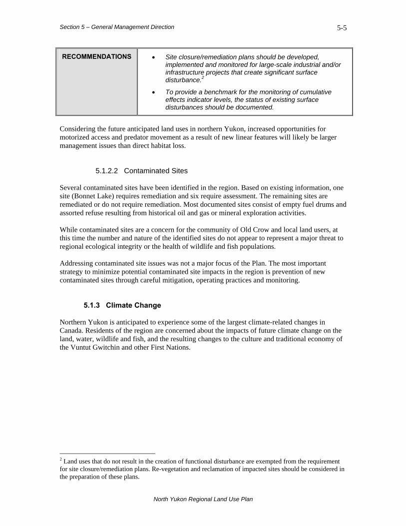
Section 5 – General Management Direction 5-5
North Yukon Regional Land Use Plan
RECOMMENDATIONS • Site closure/remediation plans should be developed, implemented and monitored for large-scale industrial and/or infrastructure projects that create significant surface disturbance.2
• To provide a benchmark for the monitoring of cumulative effects indicator levels, the status of existing surface disturbances should be documented.
Considering the future anticipated land uses in northern Yukon, increased opportunities for motorized access and predator movement as a result of new linear features will likely be larger management issues than direct habitat loss.
5.1.2.2 Contaminated Sites Several contaminated sites have been identified in the region. Based on existing information, one site (Bonnet Lake) requires remediation and six require assessment. The remaining sites are remediated or do not require remediation. Most documented sites consist of empty fuel drums and assorted refuse resulting from historical oil and gas or mineral exploration activities. While contaminated sites are a concern for the community of Old Crow and local land users, at this time the number and nature of the identified sites do not appear to represent a major threat to regional ecological integrity or the health of wildlife and fish populations. Addressing contaminated site issues was not a major focus of the Plan. The most important strategy to minimize potential contaminated site impacts in the region is prevention of new contaminated sites through careful mitigation, operating practices and monitoring.
5.1.3 Climate Change Northern Yukon is anticipated to experience some of the largest climate-related changes in Canada. Residents of the region are concerned about the impacts of future climate change on the land, water, wildlife and fish, and the resulting changes to the culture and traditional economy of the Vuntut Gwitchin and other First Nations.
2 Land uses that do not result in the creation of functional disturbance are exempted from the requirement for site closure/remediation plans. Re-vegetation and reclamation of impacted sites should be considered in the preparation of these plans.
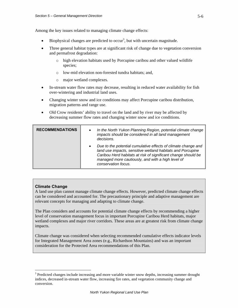
Section 5 – General Management Direction 5-6
North Yukon Regional Land Use Plan
Among the key issues related to managing climate change effects:
• Biophysical changes are predicted to occur3, but with uncertain magnitude.
• Three general habitat types are at significant risk of change due to vegetation conversion and permafrost degradation:
o high elevation habitats used by Porcupine caribou and other valued wildlife species;
o low-mid elevation non-forested tundra habitats; and,
o major wetland complexes.
• In-stream water flow rates may decrease, resulting in reduced water availability for fish over-wintering and industrial land uses.
• Changing winter snow and ice conditions may affect Porcupine caribou distribution, migration patterns and range use.
• Old Crow residents’ ability to travel on the land and by river may be affected by decreasing summer flow rates and changing winter snow and ice conditions.
RECOMMENDATIONS • In the North Yukon Planning Region, potential climate change impacts should be considered in all land management decisions.
• Due to the potential cumulative effects of climate change and land use impacts, sensitive wetland habitats and Porcupine Caribou Herd habitats at risk of significant change should be managed more cautiously, and with a high level of conservation focus.
Climate Change A land use plan cannot manage climate change effects. However, predicted climate change effects can be considered and accounted for. The precautionary principle and adaptive management are relevant concepts for managing and adapting to climate change. The Plan considers and accounts for potential climate change effects by recommending a higher level of conservation management focus in important Porcupine Caribou Herd habitats, major wetland complexes and major river corridors. These areas are at greatest risk from climate change impacts. Climate change was considered when selecting recommended cumulative effects indicator levels for Integrated Management Area zones (e.g., Richardson Mountains) and was an important consideration for the Protected Area recommendations of this Plan.
3 Predicted changes include increasing and more variable winter snow depths, increasing summer drought indices, decreased in-stream water flow, increasing fire rates, and vegetation community change and conversion.

Section 5 – General Management Direction 5-7
North Yukon Regional Land Use Plan
5.2 Ecological Resources The region contains significant ecological resources and sensitive habitats for a variety of species. The Vuntut Gwitchin and other First Nations have relied on the wildlife and fish resources of the region for thousands of years; First Nations and non-First Nations people continue to rely on them today. Sustaining regional wildlife and fish populations requires the maintenance of regional habitat integrity and management of significant habitats. Ecologically important areas that support wildlife and fish populations are shown in Map 2, Appendix 1. Strategies to maintain habitat integrity for wildlife and fish populations are directed at focal species (Porcupine caribou, moose, marten and sheep) and wetlands, lakes and rivers.
5.2.1 Wildlife Habitat Wildlife populations are susceptible to a variety of impacts that can affect both population health and the integrity of habitat. Among the key issues related to managing wildlife habitat:
• Industrial land use activities may create direct wildlife habitat impacts including habitat loss, alteration and fragmentation. Potential indirect wildlife habitat effects include avoidance or reduced use of habitat around areas actively being used.
• Human and predator access facilitated by linear features associated with industrial land use activity (seismic lines, trails and winter and all-season roads) may provide increased opportunities for harvesting and/or predation, potentially leading to higher rates of mortality.
• Climate change effects on wildlife habitats and populations are uncertain and require a precautionary and adaptive management approach.
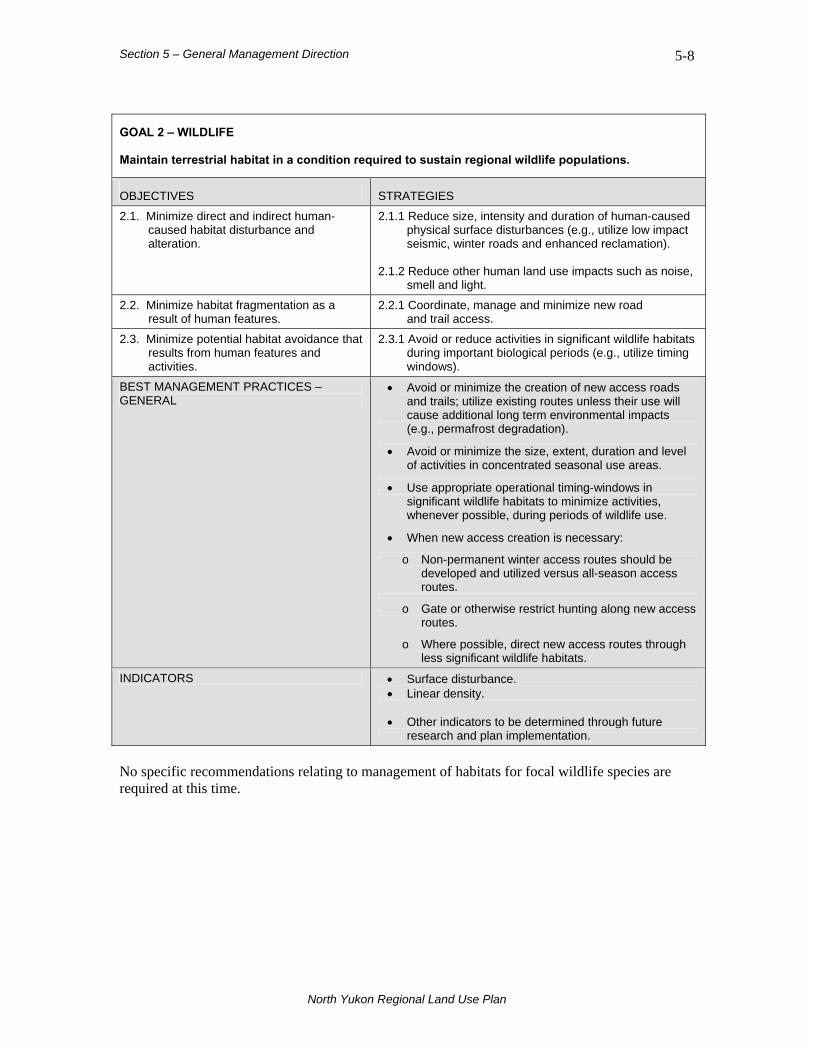
Section 5 – General Management Direction 5-8
North Yukon Regional Land Use Plan
GOAL 2 – WILDLIFE Maintain terrestrial habitat in a condition required to sustain regional wildlife populations.
OBJECTIVES STRATEGIES
2.1. Minimize direct and indirect human-caused habitat disturbance and alteration.
2.1.1 Reduce size, intensity and duration of human-caused physical surface disturbances (e.g., utilize low impact seismic, winter roads and enhanced reclamation).
2.1.2 Reduce other human land use impacts such as noise,
smell and light.
2.2. Minimize habitat fragmentation as a result of human features.
2.2.1 Coordinate, manage and minimize new road and trail access.
2.3. Minimize potential habitat avoidance that results from human features and activities.
2.3.1 Avoid or reduce activities in significant wildlife habitats during important biological periods (e.g., utilize timing windows).
BEST MANAGEMENT PRACTICES – GENERAL
• Avoid or minimize the creation of new access roads and trails; utilize existing routes unless their use will cause additional long term environmental impacts (e.g., permafrost degradation).
• Avoid or minimize the size, extent, duration and level of activities in concentrated seasonal use areas.
• Use appropriate operational timing-windows in significant wildlife habitats to minimize activities, whenever possible, during periods of wildlife use.
• When new access creation is necessary:
o Non-permanent winter access routes should be developed and utilized versus all-season access routes.
o Gate or otherwise restrict hunting along new access routes.
o Where possible, direct new access routes through less significant wildlife habitats.
INDICATORS • Surface disturbance. • Linear density. • Other indicators to be determined through future
research and plan implementation. No specific recommendations relating to management of habitats for focal wildlife species are required at this time.

Section 5 – General Management Direction 5-9
North Yukon Regional Land Use Plan
5.2.2 Focal Species Management
5.2.2.1 Porcupine Caribou The Porcupine Caribou Herd is the most important and valued ecological and socio-cultural resource in the region. Caribou management priorities are focused on areas showing concentrated and general use by animals over many years (mid-1980s to present), or where animals occupy the same area during many seasons within a year, suggesting a high intensity of caribou use. It is important to note that the Porcupine Caribou Herd uses the entire planning region, at various times of year. The herd has been declining since 1989 and, as of March 2008, there is no current evidence that the decline is reversing. Managing concentrated use areas with a higher level of conservation focus will support the Yukon, Vuntut Gwitchin and Federal governments in their national and international efforts to conserve the herd. While there is variability from season to season and year to year in how the herd utilizes its range, the current concentrated use assessment is based on the best available information. Consistent with the precautionary principle, a high degree of harvest and management caution is warranted across the herd’s range. Range use may change over time in response to many factors, including changing climate and human activities. More specific areas of concentrated use, by season, are provided in the North Yukon Resource Assessment map series (see Maps 19-24 of North Yukon Planning Commission, 2007b). BEST MANAGEMENT PRACTICES – PORCUPINE CARIBOU
• Avoid or minimize the size, extent, duration and level of activities in concentrated seasonal use areas (see Map 2, Appendix 1 for locations).
• Avoid using or crossing seasonal migration corridors with new access routes.
• Define and implement safe operating distances from the herd.
• Consider the following seasons when determining appropriate operational timing-windows (seasons when Porcupine caribou occupy the region as reported by McNeil et al., 2005):
Winter: December 1 to March 31
Spring migration: April 1 to May 31
Early summer: July 1 to July 15
Mid to late summer: July 16 to August 7
Fall migration: August 8 to October 7
Rut: October 8 to November 30

Section 5 – General Management Direction 5-10
North Yukon Regional Land Use Plan
5.2.2.2 Moose Moose use most of the planning region at various times of year. Areas of importance on a seasonal or annual basis are the region’s lakes, wetlands, rivers, and river valleys. Moose are not subjected to as high a harvesting pressure as Porcupine caribou, but they are an important alternative subsistence species when caribou are not available. Moose are fairly tolerant of disturbance from land use activities, but they are susceptible to increased harvest as a result of new road and trail access. Management of linear features (roads, trails and seismic lines), and of their use, is an important consideration for this species. During certain periods of the year, moose prefer younger forest and shrub habitats. Habitat conditions may therefore improve as a result of increased fire activity and re-generating land use disturbances. Specific areas of suitable habitat for moose, by season, are shown in the North Yukon Resource Assessment map series (see Maps 25-29 in North Yukon Planning Commission, 2007b). BEST MANAGEMENT PRACTICES – MOOSE
• Avoid seasonal use/concentration areas and migration corridors.
• Avoid using or crossing seasonal migration corridors with new access routes.
5.2.2.3 Marten Marten use most of the planning region at various times of year. Areas of importance on a seasonal or annual basis include stands of mixed-wood or coniferous forest, particularly within river/stream valleys. Marten are an important trapping resource for First Nation and non-First Nation residents. Marten are generally fairly tolerant of and resilient to disturbance. However, documented information on marten in the region is limited, and the species is poorly understood in northern environments. More specific areas of suitable winter habitat for marten are provided in the North Yukon Resource Assessment map series (see Map 30 of North Yukon Planning Commission, 2007b). Specific recommendations relating to management of marten habitat are not required at this time.
5.2.2.4 Sheep Sheep generally use high elevation and alpine habitats. Sheep management priorities are focused on key habitat areas (Yukon Department of Environment, 2005) and local knowledge areas. Sheep hunting is not a major part of First Nation subsistence harvest activities in the region. Sheep winter range is an important and sensitive habitat. Critical winter habitat for sheep generally characterized as relatively snow-free, wind-swept, south-facing slopes. Sheep have strong fidelity to specific areas, and tend to use those areas around the same time each year. Sheep populations are vulnerable to direct habitat loss and disturbance from various activities.

Section 5 – General Management Direction 5-11
North Yukon Regional Land Use Plan
More specific areas of suitable habitat for sheep are provided in the North Yukon Resource Assessment map series (see Map 16 of North Yukon Planning Commission, 2007b). BEST MANAGEMENT PRACTICES – SHEEP
• Avoid sensitive sheep habitats and key areas, with emphasis on winter range avoidance (see Map 2, Appendix 1 for locations).
Specific recommendations relating to management of sheep habitat are not required at this time. VGFN, the Tetlit Gwich’in First Nation, and other groups have prepared a draft sheep management plan for the Richardson Mountains (Working Group for Northern Richardson Mountains Dall’s Sheep, 2008).
5.2.3 Other Wildlife Species The region contains several other important mammal species, including grizzly bear, black bear, wolverine, wolf, and fox. Most of these species are occasionally hunted or trapped. The Federal Species at Risk Act (SARA) lists grizzly bear and wolverine as species with special concern status. The majority of bird species in the region are migratory and present only during the breeding season, which extends from approximately May to September. There are three bird species under SARA—the Rusty Blackbird is at risk but has not yet been listed (as of February 2008), the Short-eared Owl and Peregrine Falcon (tundrius subspecies) have special concern status, and the Peregrine Falcon (anatum subspecies) has threatened species status. The anatum subspecies is most common in the region. A national recovery plan for the anatum subspecies was prepared in 1988 (Erickson et al. 1988), but Yukon populations are doing very well (Tom Jung, Yukon Department of Environment, pers. comm.). There are currently no specific SARA guidelines or required management prescriptions for species with special concern status. There are also no immediate conservation or management concerns regarding these two mammal and three bird species in northern Yukon.
5.2.4 Fish Habitat Fish populations are susceptible to a variety of impacts that can affect both population health and the integrity of habitat. The level of understanding of fish and fish habitat in the region is generally considered poor, particularly for lakes and wetlands. Salmon (Coho, Chum, and Chinook) use most of the major river/streams in the Porcupine watershed. Adult salmon may be present from July (Chinook migration) to December (Coho migration). Juvenile salmon are present throughout the year. Freshwater fish are present throughout the watershed, and many important stocks migrate between summer and over-wintering habitats. Among the key issues related to managing fish habitat:
• Industrial land use activities may create direct fish habitat impacts including habitat loss, degradation and barriers to fish passage.
• In-stream water withdrawals required for industrial land uses may lead to impacts on fish over-wintering habitat.

Section 5 – General Management Direction 5-12
North Yukon Regional Land Use Plan
• Human access facilitated by linear features related to industrial land use activity (seismic lines, trails and winter and all-season roads) may increase opportunities for harvesting, potentially leading to decreased fish populations.
• Climate change effects are anticipated to result in decreased stream-flow rates, potentially impacting fish habitats and populations.
Fish species goals, objectives, and strategies were developed to conserve significant fish stocks and habitats. Specific strategies are aimed at minimizing human disturbances in significant or sensitive habitat, with special focus on over-wintering habitat.
GOAL 3 – FISH Maintain aquatic habitat in a condition required to sustain regional fish populations.
OBJECTIVES STRATEGIES
3.1. Minimize human-caused aquatic habitat disturbance and alteration.
3.1.1 Minimize surface and vegetation disturbance in riparian areas.
3.1.2 Avoid in-stream aggregate (gravel) extraction.
3.2. Minimize stream crossings and/or stream crossing impacts as a result of roads and trails.
3.2.1 Coordinate and manage road and trail access.
3.3. Maintain significant fish over-wintering and spawning habitat.
3.3.1 Avoid direct disturbance to sensitive over-wintering habitats.
3.3.2 Avoid significant salmon spawning habitat. 3.3.3 Avoid or reduce activities in fish habitat during
important biological periods or seasons (e.g., utilize timing windows).
3.3.4 Avoid or reduce winter in-stream water withdrawals in
sensitive over-wintering fish habitat.
3.4. Maintain fish migration routes and access to required seasonal habitats.
3.4.1 Avoid direct or indirect blocking of identified fish migration routes.
BEST MANAGEMENT PRACTICES – GENERAL
• To minimize potential impacts to regional fish populations, aggregate (gravel) mining should be prohibited in significant fish habitats.
• If aggregate mining is required in significant fish habitats, appropriate operational timing-windows should be utilized to minimize activities during important biological periods.
INDICATORS • Indicators to be determined through future research and plan implementation.
Given the current level and type of land use activity, the use of ice roads or winter roads as river crossings—if conducted in accordance with best management practices—is generally considered adequate to mitigate potential impacts to fish stocks or habitats4.
4 Al von Finster, Department of Fisheries and Oceans, pers. comm., February 2008.

Section 5 – General Management Direction 5-13
North Yukon Regional Land Use Plan
RECOMMENDATIONS • To minimize potential impacts to regional fish populations, in-stream and lake over-wintering habitat should be identified in advance of the assessment process for large-scale industrial and/or infrastructure projects.
• Water withdrawals in sensitive5 fish over-wintering areas should be prohibited (see Map 2, Appendix 1 for known locations).
Given the current low levels of land use activity, implementation of the first recommendation is not required at this time. The need to identify sensitive fish habitat should be reviewed on an ongoing basis in consideration of industrial activity levels.
5.2.5 Wetlands, Lakes and Rivers Wetlands are ecologically and culturally significant and sensitive areas that provide a variety of goods and services, such as wildlife and fish habitat, carbon storage and clean drinking water. They are also important travel and use corridors for a variety of socio-cultural and wilderness/cultural tourism activities. In this Plan, wetlands6 are defined as “all open water aquatic environments, both lentic (still water) and lotic (moving water) features, and their adjacent environments.” Environments adjacent to wetlands include riparian and peatland (bogs and fens) habitats, although peatlands are likely underestimated by this definition. Wetland complexes are concentrated groupings of individual wetlands, and may include both wetland and non-wetland habitats. Wetland complexes function as an integrated hydrologic system. The Porcupine, Bell, Whitestone, Miner, Fishing Branch, Old Crow, and Eagle rivers are identified as Major River corridors. The corridor includes the river channel with a 1-km buffer on either side, for a 2-km total corridor width. A comprehensive and accurate map showing all wetland, lake, and river habitats in the region is not currently available.
5 The sensitivity of fish habitat to water withdrawals depends on a variety of factors. Significant over-wintering habitats in some of the Major Rivers may be relatively resilient to water withdrawals, due to their size and rate of flow. The sensitivity of over-wintering fish habitats requires additional assessment. 6 The National Wetlands Working Group (1988) define wetlands as “land that has the water table at, near, or above the land’s surface or which is saturated for a long enough period to promote wetland or aquatic processes as indicated by hydric soils, hydrophytic vegetation, and various kinds of biological activity that are adapted to the wet environment”. Permafrost conditions can create poor soil drainage conditions across broad geographic areas, resulting in hydric soil conditions for much of the growing season with possible seasonal standing water. Such areas would typically not be considered wetlands.

Section 5 – General Management Direction 5-14
North Yukon Regional Land Use Plan
Among the key issues related to managing wetlands, lakes and rivers:
• Minor alterations to wetland hydrology through construction of all season roads, well pads and similar features can result in significant impacts.
• Large volumes of aggregate are typically required to support all-season infrastructure in wetland environments, making reclamation difficult.
• Land use conflicts might arise between: a) traditional economic activities and industrial land uses, and b) wilderness/cultural tourism and industrial land uses.
Wetland, lake and river management goals, objectives, and strategies were developed to maintain significant habitats, to mitigate potential development impacts in areas susceptible to surface disturbance, permafrost degradation, and altered hydrology, and to maintain water quality/quantity.

Section 5 – General Management Direction 5-15
North Yukon Regional Land Use Plan
GOAL 4 – WETLANDS, LAKES AND RIVERS Maintain the integrity of wetlands, lakes, rivers and sensitive permafrost areas.
OBJECTIVES STRATEGIES
4.1. Minimize amount of human-caused surface disturbance within and adjacent to lakes, rivers, wetlands and sensitive permafrost areas.
4.1.1 Avoid or minimize industrial land use activities in wetlands and riparian areas.
4.1.2 Coordinate and manage road and trail access. 4.1.3 Reduce surface and vegetation impacts in riparian
and sensitive permafrost areas.
4.2. Maintain wetland and riparian connectivity.
4.2.1 Avoid or minimize industrial land use activities in wetlands and riparian areas.
4.2.2 Coordinate and manage road and trail access.
4.2.3 Reduce surface and vegetation impacts in riparian and sensitive permafrost areas.
4.2.4 Minimize alteration of drainage patterns, water flow and soil temperature.
4.3. Maintain visual quality and aesthetics of Major River corridors.
4.3.1 Avoid or minimize industrial land use activities in wetlands and riparian areas.
4.3.2 Coordinate and manage road and trail access.
4.3.3 Reduce surface and vegetation impacts in riparian and sensitive permafrost areas.
4.3.4 Avoid large-scale industrial and/or infrastructure projects within Major River corridors.
4.4. Maintain significant seasonal habitats for wetland-dependent organisms.
4.4.1 Avoid or reduce activities in wetland habitat during important biological periods or seasons for breeding waterbirds and other wetland-dependent organisms (e.g., utilize timing windows).
4.5. Maintain quantity, quality and rate of water flow, including seasonal rate of flow.
4.5.1 Avoid or reduce water withdrawals in sensitive wetland areas.
BEST MANAGEMENT PRACTICES – WETLANDS & LAKES
• All-season infrastructure should be discouraged in key wetland complexes7 (see Map 2, Appendix 1 for locations).
• Locations of all-season infrastructure should maintain a minimum distance of 100m from wetlands and lakes8.
• Activities in the vicinity of wetlands and wetland complexes should be carried out during the winter period.
• If land use activities are required in wetlands, hydrology, water flow, and natural drainage patterns should be maintained.
• If required, surface disturbance within and adjacent to wetlands and lakes should not result in diminished water quality or quantity.
BEST MANAGEMENT PRACTICES – • To maintain visual quality and aesthetics, all-season
7 Key wetland complexes are those defined in the Yukon Department of Environment Key Areas database. 8 Source: Petrula (1994).

Section 5 – General Management Direction 5-16
North Yukon Regional Land Use Plan
MAJOR RIVERS & RIVER VALLEYS infrastructure should be discouraged within Major River corridors (see Map 2, Appendix 1 for locations).
• Minimize construction of new permanent river crossing structures and routing new all-season access roads through Major River and other riparian corridors (see Map 2, Appendix 1).
• Where new all-season or winter access roads and/or trails are required to cross Major River and other riparian corridors, these should be designed, constructed, and used in a manner that minimizes direct and indirect impacts to fish, wildlife and their habitats.
• Surface disturbance and land use activities within and adjacent to Major River and other riparian corridors should not result in diminished water quality, quantity or flow.
• Whenever possible, avoid aggregate (gravel) mining activities in Major River Corridors.
INDICATORS • Surface disturbance. • Linear density. • Other indicators to be determined through future
research and plan implementation.
RECOMMENDATIONS • To minimize potential impacts to regional wetlands, an
assessment of wetland hydrology and connectivity should be conducted in advance of the assessment process for large-scale industrial and/or infrastructure projects.
• Water withdrawals in ecologically sensitive wetland areas should be prohibited.
Given the current low levels of land use activity, implementation of the first recommendation is not required at this time. The need to identify ecologically sensitive wetland areas should be reviewed on an ongoing basis in consideration of industrial activity levels. There is currently no wetlands policy in the Yukon to provide additional management guidance for the Plan.
Section 5 – General Management Direction 5-17
North Yukon Regional Land Use Plan
5.3 Heritage, Social and Cultural Resources Maintaining and conserving heritage, social and cultural resources and values are important objectives of the Plan. Significant heritage resources, current community use areas, and Vuntut Gwitchin culturally important areas are shown in Map 3, Appendix 1. Heritage resources include sites and objects that are 45 years old or older and relate to human history, including archaeological and historic sites and artifacts. This definition also includes palaeontological resources—fossil and other remains of extinct or prehistoric plants and animals. Current community use areas include important locations for current subsistence harvest activities, cultural pursuits, and travel, including the community of Old Crow. Cultural resources include places and locations associated with events, stories, and legends. Significant heritage, current community use areas, and cultural resources were identified and mapped from local and traditional knowledge, with the focus on areas of importance to the Vuntut Gwitchin First Nation and community of Old Crow. Tetlit Gwich’in areas of cultural significance were considered within the Tetlit Gwich’in Secondary Use Area (Mackenzie Delta-Beaufort Sea Regional Land Use Planning Commission, 1991). There are currently few issues with respect to the management of identified heritage sites and current community use areas. They are not generally at risk from land use activities. Among the key issues related to the maintenance of heritage sites and current community use areas:
• Conservation and maintenance of significant heritage and community use areas are important to maintain the First Nations traditional economy.
• First Nations opportunities to participate in traditional economic activities and other cultural pursuits depend on the continued availability of and access to heritage and cultural areas.
• Conflicts might arise between community use and conservation of heritage values within the Dempster Highway Corridor and Whitefish wetlands complex and future industrial land use impacts within these areas.
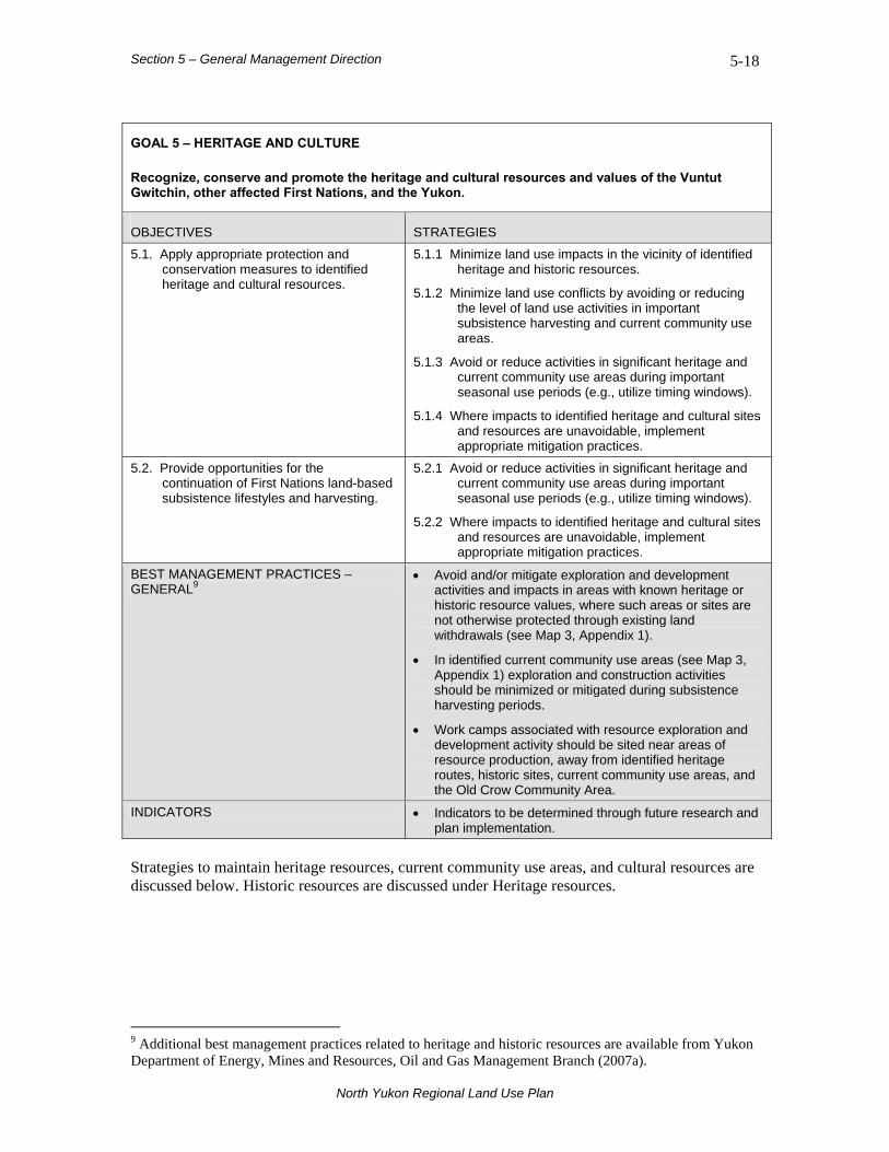
Section 5 – General Management Direction 5-18
North Yukon Regional Land Use Plan
GOAL 5 – HERITAGE AND CULTURE Recognize, conserve and promote the heritage and cultural resources and values of the Vuntut Gwitchin, other affected First Nations, and the Yukon.
OBJECTIVES STRATEGIES
5.1. Apply appropriate protection and conservation measures to identified heritage and cultural resources.
5.1.1 Minimize land use impacts in the vicinity of identified heritage and historic resources.
5.1.2 Minimize land use conflicts by avoiding or reducing the level of land use activities in important subsistence harvesting and current community use areas.
5.1.3 Avoid or reduce activities in significant heritage and current community use areas during important seasonal use periods (e.g., utilize timing windows).
5.1.4 Where impacts to identified heritage and cultural sites and resources are unavoidable, implement appropriate mitigation practices.
5.2. Provide opportunities for the continuation of First Nations land-based subsistence lifestyles and harvesting.
5.2.1 Avoid or reduce activities in significant heritage and current community use areas during important seasonal use periods (e.g., utilize timing windows).
5.2.2 Where impacts to identified heritage and cultural sites and resources are unavoidable, implement appropriate mitigation practices.
BEST MANAGEMENT PRACTICES – GENERAL9
• Avoid and/or mitigate exploration and development activities and impacts in areas with known heritage or historic resource values, where such areas or sites are not otherwise protected through existing land withdrawals (see Map 3, Appendix 1).
• In identified current community use areas (see Map 3, Appendix 1) exploration and construction activities should be minimized or mitigated during subsistence harvesting periods.
• Work camps associated with resource exploration and development activity should be sited near areas of resource production, away from identified heritage routes, historic sites, current community use areas, and the Old Crow Community Area.
INDICATORS • Indicators to be determined through future research and plan implementation.
Strategies to maintain heritage resources, current community use areas, and cultural resources are discussed below. Historic resources are discussed under Heritage resources.
9 Additional best management practices related to heritage and historic resources are available from Yukon Department of Energy, Mines and Resources, Oil and Gas Management Branch (2007a).
Section 5 – General Management Direction 5-19
North Yukon Regional Land Use Plan
5.3.1 Heritage Resources
Priority areas for heritage resource conservation were identified during the North Yukon Planning Commission’s community consultations and research. Locations of identified historic, archaeological and palaeontological sites were obtained from Yukon Department of Tourism and Culture, Cultural Services Branch.
5.3.1.1 VGFN Heritage Routes and Sites One recommendation is proposed in relation to specific provisions of the VGFN Final Agreement (Section 13.4.6.2 and Chapter 13, Schedule A):
RECOMMENDATION • Management guidelines for identified routes and sites within the Integrated Management Area should be developed jointly by the Vuntut Gwitchin and Yukon governments10.
Within the IMA, eight VGFN heritage routes11 and no sites were identified as per Chapter 13, Schedule A. The identified heritage routes in the IMA occur on both settlement and non-settlement lands (Figure 5.1). The remaining identified heritage routes and sites are located in protected areas or within the North Yukon Land Withdrawal. No issues associated with the management of heritage routes within the IMA were identified during the planning process. The status of this recommendation should be evaluated in future Plan reviews.
10 Existing standards and guidelines for the management of heritage resources (Standards and Guidelines for Conservation of Historic Places in Canada) could be adopted for the management of identified routes and sites (Parks Canada, 2003). 11 VGFN identified heritage routes include: 1) Old Crow to Whitestone Village, 2) Old Crow to Ft. McPherson via Salmon Cache and Lapierre House, 3) Whitestone Village to Johnson Creek Village, 4) Johnson Creek Village to LaChute River via Whitefish Lake, 5) Whitestone Village route connecting with the Old Crow—Ft. McPherson route (Route #2, above) at the western approach to the Northwest Territories border, 6) Whitestone Village route connecting with the Old Crow—Ft. McPherson route (Route #2, above) via Upper Stony Creek, 7) Old Crow to Rampart House, and 8) Old Crow to Johnson Creek Village via White Snow Mountain (#10 shown on map).

Section 5 – General Management Direction 5-20
Figure 5.1. VGFN identified Heritage Routes.
North Yukon Regional Land Use Plan
Section 5 – General Management Direction 5-21
North Yukon Regional Land Use Plan
5.3.1.2 Other Heritage and Historic Resources Important First Nation heritage resources include Vuntut Gwitchin camps/cabins, historical fish traps, travel routes, hunting/fishing/trapping areas, and caribou fences. Many camps and cabins are S-sites (see Map 1, Appendix 1). S-sites are site-specific Yukon First Nation settlement lands of heritage, cultural or traditional economic significance to the First Nation. Historic resources include: (a) a historic site, (b) a historic object, and (c) any work or assembly of works of nature or of human endeavour that is of value for its archaeological, palaeontological, prehistoric, historic, scientific, or aesthetic features Historic objects include: (a) an object that is more than 45 years old and has been abandoned, (b) an archaeological object, (c) a palaeontological object, and (d) an object designated under subsection (2) of the Historic Resources Act as a historic object.
RECOMMENDATION • Known historic camps/cabins, historical fish trap locations, archaeological sites and other heritage resources should be identified prior to exploration and development activities, and protected from disturbance.
Documented sites and areas are not currently considered at risk from land use activities. Project proponents should contact heritage offices of the Vuntut Gwitchin and Yukon governments for information on the location of heritage sites of concern for a proposed development.
5.3.2 Current Community Use Areas Community use areas support such activities as hunting, fishing, trapping, wood cutting, berry picking, and general travel. First Nations and other residents of the region spend a considerable amount of time on the land participating in various seasonal activities. The use and enjoyment of community areas depends on the continued health of the land, water, and ecosystems. The long-term availability and health of community use areas contributes to the maintenance of Vuntut Gwitchin culture and assists in providing economic opportunities within the regional mixed economy. Current community use areas are shown in Map 3, Appendix 1. Many of these activities occur in the vicinity of Old Crow, but areas as far as Whitestone Village and the Eagle and Bell rivers are utilized. Summer boat travel between Old Crow and Ft. Yukon in Alaska is common. Some Old Crow and Fort McPherson residents travel by snow machine between the two communities via the Old Crow – Ft. McPherson trail (see Figure 5.1, Route 2). The timing of these activities, particularly harvesting, varies in response to the availability of resources and travel conditions. Proponents and land users are encouraged to contact the Vuntut Gwitchin Government for further information regarding community use areas. Given the current low levels of land use activity, specific recommendations relating to the maintenance of current community use areas are not required at this time.
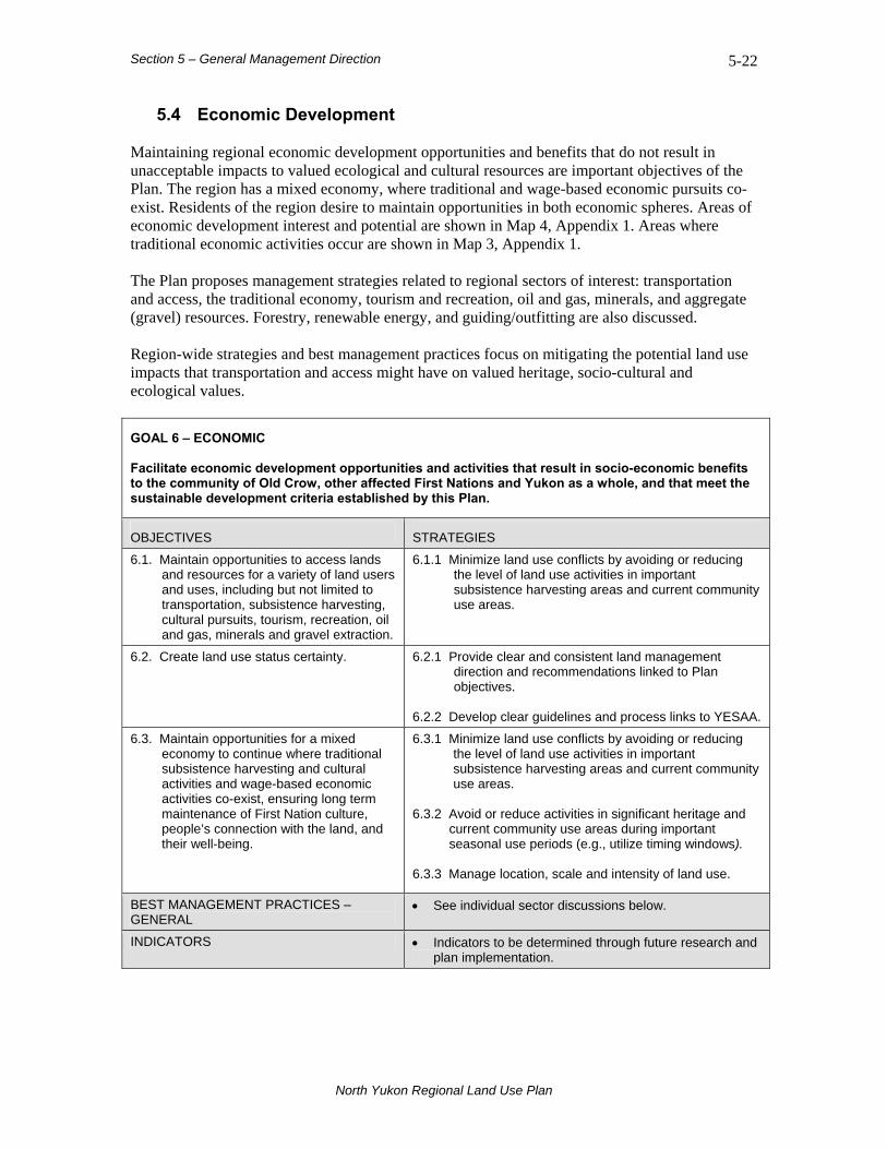
Section 5 – General Management Direction 5-22
North Yukon Regional Land Use Plan
5.4 Economic Development Maintaining regional economic development opportunities and benefits that do not result in unacceptable impacts to valued ecological and cultural resources are important objectives of the Plan. The region has a mixed economy, where traditional and wage-based economic pursuits co-exist. Residents of the region desire to maintain opportunities in both economic spheres. Areas of economic development interest and potential are shown in Map 4, Appendix 1. Areas where traditional economic activities occur are shown in Map 3, Appendix 1. The Plan proposes management strategies related to regional sectors of interest: transportation and access, the traditional economy, tourism and recreation, oil and gas, minerals, and aggregate (gravel) resources. Forestry, renewable energy, and guiding/outfitting are also discussed. Region-wide strategies and best management practices focus on mitigating the potential land use impacts that transportation and access might have on valued heritage, socio-cultural and ecological values.
GOAL 6 – ECONOMIC Facilitate economic development opportunities and activities that result in socio-economic benefits to the community of Old Crow, other affected First Nations and Yukon as a whole, and that meet the sustainable development criteria established by this Plan.
OBJECTIVES STRATEGIES
6.1. Maintain opportunities to access lands and resources for a variety of land users and uses, including but not limited to transportation, subsistence harvesting, cultural pursuits, tourism, recreation, oil and gas, minerals and gravel extraction.
6.1.1 Minimize land use conflicts by avoiding or reducing the level of land use activities in important subsistence harvesting areas and current community use areas.
6.2. Create land use status certainty.
6.2.1 Provide clear and consistent land management direction and recommendations linked to Plan objectives.
6.2.2 Develop clear guidelines and process links to YESAA.
6.3. Maintain opportunities for a mixed economy to continue where traditional subsistence harvesting and cultural activities and wage-based economic activities co-exist, ensuring long term maintenance of First Nation culture, people’s connection with the land, and their well-being.
6.3.1 Minimize land use conflicts by avoiding or reducing the level of land use activities in important subsistence harvesting areas and current community use areas.
6.3.2 Avoid or reduce activities in significant heritage and
current community use areas during important seasonal use periods (e.g., utilize timing windows).
6.3.3 Manage location, scale and intensity of land use.
BEST MANAGEMENT PRACTICES – GENERAL
• See individual sector discussions below.
INDICATORS • Indicators to be determined through future research and plan implementation.

Section 5 – General Management Direction 5-23
North Yukon Regional Land Use Plan
Specific recommendations are provided below for issues related to:
• transportation and access;
• development in the community of Old Crow; and,
• industrial land use activities.
5.4.1 Transportation and Access
Transportation networks and infrastructure have a major influence on the pattern of land use and economic development in remote northern jurisdictions. Many of the impacts that result from industrial land uses, particularly to wildlife and fish populations, are a result of the direct and indirect effects of roads and people’s use of them. Transportation and access management considerations are closely linked with maintaining regional ecological integrity and socio-cultural values. The management approaches advocated by the Plan are intended to provide opportunities to create required road and access routes, while mitigating potential impacts. Road, air and water are all important modes of transportation in the region, but transportation and access options are currently very limited. Road access, outside the all-season Dempster Highway corridor, typically relies on construction of ice roads or winter roads. Major Rivers, particularly the Porcupine, Eagle and Bell, are important transportation corridors for residents and tourism/recreation users in the region. Access to Resources The Plan considered the maintenance of access to resources across the working landscape through land use designation and cumulative effects indicators. The Plan does not recommend specific locations for future road and access routes, nor does it prescribe road construction techniques. As a general guideline, in order to minimize potential impacts to valued ecological and heritage/cultural resources it is recommended that where road access is required, winter roads, ice roads and other temporary access techniques be utilized preferentially over all-season roads. Requirements and locations for new road and access construction are at the discretion of a project proponent in consideration of the strategies, best management practices, and recommendations proposed in the Plan.

Section 5 – General Management Direction 5-24
North Yukon Regional Land Use Plan
Among the key issues related to transportation and access:
• The construction and use of linear features may result in direct loss and fragmentation of wildlife habitat, and indirect impacts on wildlife, including avoidance of such features, increased harvest pressures, and/or increased levels of predation.
• Where roads and access routes cross rivers, improperly constructed stream crossings may impact fish directly through habitat disturbance or indirectly through increasing harvesting pressures or blockage of fish passage/migration.
• Significant water and gravel withdrawals for road building or maintenance may cause direct disturbance to fish and wildlife habitat.
• Where all-season roads and access routes become established, they tend to persist for long periods of time, making full decommissioning and reclamation difficult.
BEST MANAGEMENT PRACTICES – TRANSPORTATION & ACCESS
• Avoid or minimize the creation of new access roads and trails; utilize existing routes unless their use will cause additional long term environmental impacts (e.g., permafrost degradation).
• Where new all-season or winter access roads and/or trails are required, these should be designed, constructed and used in a manner that minimizes direct and indirect impacts to fish and wildlife, their habitats and human viewscapes (i.e., minimize size and extent of features).
• Avoid significant caribou, moose, marten, and sheep habitat when constructing new access routes.
• Avoid important trapping, harvesting, and current use areas (see Map 3, Appendix 1).
• Avoid using or crossing wildlife seasonal migration corridors with new access routes.
• Whenever possible, land use activities should be coordinated to utilize the same access route(s).
• Reclamation requirements and decommissioning strategies should be considered during planning and assessment of new road and access features.
• Limit and/or control use of new industrial access routes to authorized users only.
Specific recommendations for the Dempster Highway Corridor, an Old Crow all-season road, and Eagle Plains access management are provided below.

Section 5 – General Management Direction 5-25
North Yukon Regional Land Use Plan
5.4.1.1 Dempster Highway The Dempster Highway provides an important corridor for many activities, including transportation, tourism, subsistence harvesting and communications. The highway is recognized as critical infrastructure for future regional economic development—uninterrupted operation and maintenance of the Dempster Highway is therefore a regional priority. A cooperative Yukon Government and northern Yukon First Nations (VGFN, THFN, and NNDFN) effort to create an economic development plan for the highway area is ongoing. In 2005, the highway was designated a Northern and Remote Route under the National Highway System (Council of Ministers Responsible for Transportation and Highway Safety, 2005).
New potential access routes off the Dempster Highway will likely be one of the most important management issues facing the region in the future. Among the key issues related to management of activities within the Dempster Highway corridor:
• The highway is a multiple use corridor. A development corridor must be maintained to support current and future land use activity without undermining the heritage, social and ecological resource values in the vicinity of the highway.
• The highway is promoted as both a scenic tourism route and an industrial/ transportation infrastructure corridor.
• Access to adequate gravel resources in close proximity to the highway is required for regular maintenance and potential future upgrades.
• A potential future pipeline and related infrastructure would likely parallel the highway.
RECOMMENDATION • In recognition of the strategic importance of the Dempster Highway and its designation as a Northern and Remote Route under the National Highway System, surface disturbance and linear density indicator reporting and evaluation are exempt within a distance of 1 km on each side of the highway centre line (2-km total corridor width).
The Dempster Highway corridor is intended to encourage the location of land use activities within the existing zone of influence of the highway. Under this recommendation, surface disturbance and linear density indicator reporting and evaluation would be considered only for new activities outside of the 2-km corridor buffer. Numerous archaeological sites exist within the corridor and these would need to be identified and protected prior to additional development, as per existing regulations. Detailed assessment and planning of new developments within the corridor should also carefully consider visual impacts, and mitigate to the extent practicable. This recommendation and the need for more detailed management direction within the Dempster Highway corridor should be evaluated during future Plan reviews.
Section 5 – General Management Direction 5-26
North Yukon Regional Land Use Plan
5.4.1.2 Old Crow All-season Road The Old Crow winter road provides an occasional winter transportation route between the Dempster Highway, near Eagle Plains Lodge, and the community of Old Crow (see Map 4, Appendix 1). The winter road is constructed as required, primarily in response to community needs for the transportation of materials and equipment. All-season road construction to Old Crow received limited attention during the regional planning exercise. NYPC did not evaluate specific issues associated with potential all-season road access or possible alternative surface transportation options. Periodic construction of the winter road along the existing access route is currently sufficient to meet community needs for surface transportation. The existing Old Crow winter road route should be maintained and used as required. However, in the future there may be climate change considerations related to winter road construction and operation. In relation to the VGFN Final Agreement (Specific Provision 11.10.1), the following recommendation is provided:
RECOMMENDATION • An all-season access road to Old Crow is not required at this time.
This recommendation should be evaluated in future Plan reviews.
5.4.1.3 Eagle Plains Access Management The Eagle Plain oil and gas basin may receive significant levels of future industrial activity, particularly from the energy sector. One recommendation is proposed to address future access management in the Eagle Plain basin.
RECOMMENDATION • In advance of significant levels of energy sector activity, an access management plan should be developed for the Eagle Plain oil and gas basin.
This recommendation is intended to foster a coordinated approach to new road and access route development in an area where focused oil and gas exploration and development activities are probable. The timing and scope of this recommendation will be at the discretion of the Parties and will be addressed by the Parties as part of implementation planning. Specific strategies and best management practices related to road and access route siting may be included as part of this future access management plan.
Section 5 – General Management Direction 5-27
North Yukon Regional Land Use Plan
5.4.1.4 North Slope Access Previous studies have identified a conceptual transportation corridor, through the Northern Richardson Mountains, along the Bell River, providing access to Yukon North Slope shipping opportunities at Kings Point (Yukon Government, Department of Energy, Mines and Resources, 2003). It is the perspective of the North Yukon Planning Commission and recent port and rail assessments (KPMG and Gartner Lee Ltd., 2007) that port access at Kings Point on the Yukon North Slope is an unlikely scenario in the coming decades. However, options for a possible transportation corridor to the Yukon North Slope should be considered at a future date, including potential routing through the proposed Summit Lake – Bell River Protected Area (LMU 4C). Such consideration would be subject to applicable planning processes for the protected area, and may be linked to the Eagle Plain Access Management recommendation of this Plan (see Section 5.4.1.3, above).
5.4.2 Community of Old Crow
The community of Old Crow and surrounding area is the economic and cultural centre of the region. Many land use issues facing the community are municipal concerns – housing, roads, and recreation facilities, for example. Other key considerations are access to gravel resources and land for new development.
RECOMMENDATION • To support maintenance and growth of Old Crow, the Community Area (CA) should be exempt from surface disturbance and linear density indicator monitoring.
Development plans for the community of Old Crow are referenced in Appendix 3.
5.4.3 Traditional Economy In Old Crow, considerable economic activity is still focused on subsistence harvesting. Residents spend time on the land participating in traditional economic pursuits such as hunting, fishing and berry harvesting in order to provide staple food items for themselves and feed (e.g., chum salmon) for dog teams. Trapping is still a main or supplementary economic activity when fur prices warrant. Traditional economic activities are strongly linked to the maintenance of Vuntut Gwitchin culture and Old Crow community well-being. Important subsistence harvesting and trapping areas are shown on Map 3, Appendix 1. Among the key issues related to maintenance and pursuit of traditional economic activities:
• The traditional economy is vital to maintaining Vuntut Gwitchin culture, community well-being and ties to the land.
• Subsistence harvesting and traditional economic activities are important means of offsetting the high cost of food in Old Crow.
• Subsistence harvesting opportunities may benefit from construction of new roads and trails resulting in increased harvest of wildlife and fish resources
Section 5 – General Management Direction 5-28
North Yukon Regional Land Use Plan
• Land use conflicts might arise between: a) traditional economic activities and industrial land uses, b) traditional economic activities and wilderness/cultural tourism, and c) traditional economic activities and Porcupine Caribou Herd conservation.
Specific recommendations relating to traditional economic activities are not required at this time. Subsistence use/harvesting activities have few, if any, direct impacts on other land use sectors.
5.4.4 Tourism and Recreation Current tourism and recreation activity in the region is low, tourism products and services are modest, and the tourism market is not well developed. Opportunities are associated with wilderness travel, wildlife viewing, Old Crow visits and stays, touring along the Dempster Highway, and travel in major river corridors (Porcupine, Eagle, and Bell rivers). Approximately 7,000 tourists travel the Dempster Highway annually. Exposure to VGFN culture is an important draw for Old Crow tourism activities and wilderness travel. There is good potential to develop a small-scale, carefully managed tourism industry based on the cultural and ecological resources of northern Yukon. Maintenance of visual quality and ecological values are important considerations for wilderness tourism. Priority areas for maintaining visual quality are major river corridors and sections of the Dempster Highway, particularly in the vicinity of the Southern Richardson Mountains and Foothills (LMU 10) (see Map 4, Appendix 1). Among the key issues related to tourism and recreation:
• Wilderness tourism and recreation pursuits require access to large, intact wilderness areas.
• Land use conflicts12 might arise between: a) wilderness/cultural tourism activities and industrial land uses, and b) wilderness/cultural tourism activities and traditional economic activities/First Nations culture.
Specific recommendations relating to the management of tourism and recreation activities are not required at this time. The site-specific and temporary nature of wilderness tourism activity, the relatively small ecological footprint of these operations, and the anticipated low levels of future tourism activity are expected to result in relatively few significant impacts to ecological resources, traditional economic activities, and other land use sectors in the region. Refer to the North Yukon Tourism Strategy (Yukon Department of Tourism and Culture and Vuntut Gwitchin First Nation, 2006) for specific tourism objectives. Best management practices related to wilderness tourism are available from Yukon Department of Energy, Mines and Resources, Oil and Gas Management Branch (2007c).
12 Conflicts between wilderness tourism, recreation, and other land uses are likely to be most acute within Major River Corridors and along the Dempster highway corridor paralleling the Southern Richardson Mountains and Foothills.
Section 5 – General Management Direction 5-29
North Yukon Regional Land Use Plan
5.4.5 Oil and Gas Resources The Plan is intended to assist in establishing land use certainty for oil and gas activities. While oil and gas activity in the region is currently low, the region holds moderate oil and significant natural gas potential. Access to pipeline infrastructure is considered to be a major factor limiting natural gas development in northern Yukon. The region contains three oil and gas basins: Eagle Plain, Kandik, and Old Crow Flats. Eagle Plain is currently the basin of highest interest, and is considered to have the highest resource potential. As of fall 2008, there were 16 oil and gas exploration permits and licenses covering about 5,000 square kilometres, or nine percent of the planning region. All parcels are in Eagle Plain. Locations of identified oil and gas resources and potential areas are shown in Map 4, Appendix 1. Among the key issues related to oil and gas exploration/development activities:
• Oil and gas exploration and development activities and associated land uses
(transportation, gravel extraction, and water withdrawal) can cause cumulative and adverse change over large landscapes.
• Impacts could affect valued ecological resources, including Porcupine Caribou Herd, moose, marten, wetlands, lakes and rivers.
• The construction and ongoing operations of large-scale oil and gas infrastructure would bring many new workers to the region.
• Coordinated and effective management of the Porcupine Caribou Herd habitat and population requires an integrated management approach, in advance of increasing industrial land use.
• Land use conflicts might arise between: a) oil and gas and wilderness/cultural tourism, b) oil and gas and traditional economic activities and cultural pursuits, and c) oil and gas and Porcupine Caribou Herd use of winter range.
Specific recommendations relating to the management of oil and gas exploration and development activities are not required at this time. Standard oil and gas industry practices have a much smaller footprint and impact on ecological values than practices used in the 1960’s. Current operating practices significantly reduce the potential for major long-term impacts. Given the current low levels of activity, existing site-specific best management practices, used in combination with the direction provided by this Plan, are considered adequate to mitigate potential impacts of oil and gas activity.
5.4.6 Mineral Resources The Plan is intended to assist in establishing land use certainty for mineral exploration and development activities. Mineral interest and activity in the region is currently low. A lack of land use certainty, low mineral potential, remoteness and limited road infrastructure are contributing factors. Mineral potential in the planning region is not well understood. However, relative to other areas of Yukon, it is currently considered low. Placer and gemstone potentials have not been assessed. There is a low likelihood that a producing mine will be established in the region in the near future.
Section 5 – General Management Direction 5-30
North Yukon Regional Land Use Plan
As of March 2008, there were 509 active mineral claims in the North Yukon Planning Region, covering an area of about 11,000 hectares. Most mineral claims are located in the vicinity of the Dempster Highway in the Southern Richardson Mountains and Foothills (LMU 10). Areas with mineral potential, and existing mineral claims, are shown in Map 4, Appendix 1. Among the key issues related to mineral exploration/development activities:
• Mineral activities require access to large areas of land, and substantial exploration efforts are required to identify economically viable deposits.
• The construction and ongoing operations of large-scale mining activity would bring many new workers to the region.
• Mine site operations can lead to local and downstream water impacts and localized wildlife/habitat disturbance.
• Land use conflicts might arise between: a) mineral activities and wilderness/cultural tourism, b) mineral activities and traditional economic activities and cultural pursuits, and c) mineral activities and Porcupine Caribou Herd use of seasonal ranges.
Specific recommendations relating to the management of mineral activities are not required at this time. Given the low levels of activity, existing site-specific best management practices, used in combination with the direction provided by the Plan, are considered adequate to mitigate potential impacts of mineral activity.
5.4.7 Aggregate (Gravel) Resources Gravel is an important but scarce resource in northern Yukon. Existing gravel pits supply the requirements of the Dempster Highway and the community of Old Crow. As of 2008, there were 28 active gravel pits in the planning region; 27 are within one kilometre of the Dempster Highway. Active quarrying affects about 190 hectares of land. Aggregate along the portion of the Dempster Highway within the planning region is in limited supply. In the Eagle Plains area, there are generally no identified conventional gravel sources. Aggregate sources are present along the northern portion of the Dempster Highway, in the vicinity of the Southern Richardson Mountains and Foothills, but are of poor quality. The community of Old Crow has established a gravel quarry on Crow Mountain to secure suitable aggregate materials. Future land use scenarios for the region project that substantial volumes of aggregate will be required to support the development of industrial infrastructure, particularly for the oil and gas and transportation sectors. These future requirements would be in addition to existing required volumes utilized by Dempster Highway maintenance and upgrades, and Old Crow infrastructure. A regional aggregate assessment has not been completed outside of the Dempster Highway corridor. Potential sources of new aggregate materials are high terraces above rivers, exposed ridges and bedrock, and dry river/creek beds. Some river valleys offer potential sources of aggregate but also contain some of the most important ecological and cultural values in the region.
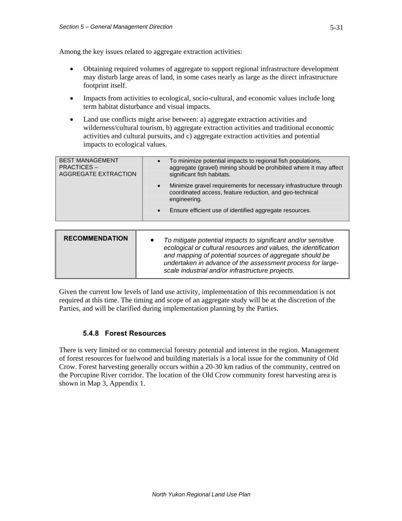
Section 5 – General Management Direction 5-31
North Yukon Regional Land Use Plan
Among the key issues related to aggregate extraction activities:
• Obtaining required volumes of aggregate to support regional infrastructure development may disturb large areas of land, in some cases nearly as large as the direct infrastructure footprint itself.
• Impacts from activities to ecological, socio-cultural, and economic values include long term habitat disturbance and visual impacts.
• Land use conflicts might arise between: a) aggregate extraction activities and wilderness/cultural tourism, b) aggregate extraction activities and traditional economic activities and cultural pursuits, and c) aggregate extraction activities and potential impacts to ecological values.
BEST MANAGEMENT PRACTICES – AGGREGATE EXTRACTION
• To minimize potential impacts to regional fish populations, aggregate (gravel) mining should be prohibited where it may affect significant fish habitats.
• Minimize gravel requirements for necessary infrastructure through coordinated access, feature reduction, and geo-technical engineering.
• Ensure efficient use of identified aggregate resources.
RECOMMENDATION • To mitigate potential impacts to significant and/or sensitive ecological or cultural resources and values, the identification and mapping of potential sources of aggregate should be undertaken in advance of the assessment process for large-scale industrial and/or infrastructure projects.
Given the current low levels of land use activity, implementation of this recommendation is not required at this time. The timing and scope of an aggregate study will be at the discretion of the Parties, and will be clarified during implementation planning by the Parties.
5.4.8 Forest Resources There is very limited or no commercial forestry potential and interest in the region. Management of forest resources for fuelwood and building materials is a local issue for the community of Old Crow. Forest harvesting generally occurs within a 20-30 km radius of the community, centred on the Porcupine River corridor. The location of the Old Crow community forest harvesting area is shown in Map 3, Appendix 1.

Section 5 – General Management Direction 5-32
North Yukon Regional Land Use Plan
Among the key issues related to forest management and community harvest:
• Securing an adequate and accessible long-term wood supply.
• Forest harvesting activities that occur in proximity to cabins and camps.
RECOMMENDATION • A future Old Crow Forest Management Plan should maintain community fuelwood and forest harvesting opportunities within the identified fuelwood and forest harvesting area shown in Map 3, Appendix 1.
The Plan does not directly address forest management or forest harvesting strategies and did not consider best management practices for community forest harvesting activities.
5.4.9 Renewable Energy Renewable energy refers to the generation of heat and electricity from natural resources that are not depleted over time. Examples include hydro, wind, solar, geothermal (heat from steam or hot groundwater), earth (heating or cooling using below ground ambient temperatures), and trees or other vegetation that can regenerate after some of the resources are used. Old Crow, through a variety of partnerships, has actively investigated wind energy on Crow Mountain. Through the Northern Canada Power Commission, potential large-scale hydro sites were identified in the planning region the 1960s and 70s, including Porcupine Canyon at Rampart House, and Salmon Cache canyon, both on the Porcupine River. Neither site received a formal feasibility assessment and, given the scale of the conceptual projects, neither is likely to be economic. In northern Yukon, wind and small-scale hydro are considered to hold the greatest potential for renewable energy production. Site-specific seasonal solar power and additional tree biomass fuels may also be options. It is unlikely that diesel generation will be replaced completely by renewable energy in the near term. As mentioned above, the community of Old Crow also utilizes fuel wood for a portion of its heating requirements. Among the key issues related to renewable energy production:
• Almost all power needs in the region are currently met by the costly and polluting combustion of diesel fuel.
• Per capita, Old Crow carbon emissions are approximately twice those of the average Canadian.
• The community of Old Crow actively desires to decrease diesel fuel consumption and increase use of renewable energy options.
RECOMMENDATION • Renewable energy options and solutions for the community of Old Crow should continue to be researched and promoted.
Addressing renewable energy issues was not a major focus of the Plan.
Section 5 – General Management Direction 5-33
North Yukon Regional Land Use Plan
5.4.10 Guiding and Outfitting There are no guiding and outfitting concessions in the region. VGFN view the communal use of wildlife and fish resources as required for subsistence and cultural purposes, and not to be pursued for monetary gain. VGFN does not wish to participate in or have commercially guided sport hunting or fishing occur within their traditional territory at this time. Non-consumptive guiding and outfitting tours may represent future business and employment opportunities for VGFN citizens and other residents of Yukon. A range of opportunities related to wildlife viewing and wilderness travel have been recognized as potential tourism and recreation opportunities by the North Yukon Tourism Strategy (Yukon Department of Tourism and Culture, 2006). Specific recommendations relating to guiding and outfitting are not required at this time. Interest in guiding and outfitting should be evaluated in future Plan reviews.
Section 6 – Landscape Management Units 6-1
6. Landscape Management Units This section describes the values and management issues associated with specific landscape management units (LMUs) in the North Yukon Planning Region. Thirteen LMUs and a number of sub-units are identified. A summary of the LMUs is provided in Appendix 2. The general management direction described in Section 5 applies to LMUs in the Integrated Management Area. An overview of identified ecological, cultural and economic values and resources referenced in this section can be found in Maps 2-4, Appendix 1. Detailed maps and descriptions of resource values are contained in the North Yukon Resource Assessment Report (North Yukon Planning Commission, 2007a,b). The resource report is available from the NYPC website (www.nypc.planyukon.ca) and should be consulted when further information is required.
North Yukon Regional Land Use Plan
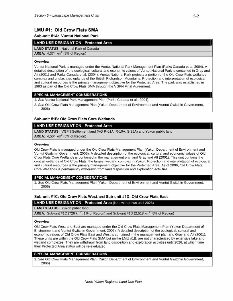
Section 6 – Landscape Management Units 6-2
LMU #1: Old Crow Flats SMA Sub-unit #1A: Vuntut National Park
LAND USE DESIGNATION: Protected Area LAND STATUS: National Park of Canada AREA: 4,374 km2 (8% of Region)
Overview Vuntut National Park is managed under the Vuntut National Park Management Plan (Parks Canada et al. 2004). A detailed description of the ecological, cultural and economic values of Vuntut National Park is contained in Gray and Alt (2001) and Parks Canada et al. (2004). Vuntut National Park protects a portion of the Old Crow Flats wetlands complex and unglaciated uplands of the British Richardson Mountains. Protection and interpretation of ecological and cultural resources is the primary management objective for the Protected Area. The park was established in 1993 as part of the Old Crow Flats SMA through the VGFN Final Agreement.
SPECIAL MANAGEMENT CONSIDERATIONS 1. See Vuntut National Park Management Plan (Parks Canada et al., 2004). 2. See Old Crow Flats Management Plan (Yukon Department of Environment and Vuntut Gwitchin Government,
2006)
Sub-unit #1B: Old Crow Flats Core Wetlands
LAND USE DESIGNATION: Protected Area LAND STATUS: VGFN Settlement land (VG R-01A, R-10A, S-25A) and Yukon public land AREA: 4,504 km2 (8% of Region)
Overview Old Crow Flats is managed under the Old Crow Flats Management Plan (Yukon Department of Environment and Vuntut Gwitchin Government, 2006). A detailed description of the ecological, cultural and economic values of Old Crow Flats Core Wetlands is contained in the management plan and Gray and Alt (2001). This unit contains the central wetlands of Old Crow Flats, the largest wetland complex in Yukon. Protection and interpretation of ecological and cultural resources is the primary management objective for the Protected Area. As of 2006, Old Crow Flats Core Wetlands is permanently withdrawn from land disposition and exploration activities.
SPECIAL MANAGEMENT CONSIDERATIONS 1. See Old Crow Flats Management Plan (Yukon Department of Environment and Vuntut Gwitchin Government,
2006)
Sub-unit #1C: Old Crow Flats West, and Sub-unit #1D: Old Crow Flats East LAND USE DESIGNATION: Protected Area (land withdrawn until 2026) LAND STATUS: Yukon public land AREA: Sub-unit #1C (726 km2, 1% of Region) and Sub-unit #1D (2,518 km2, 5% of Region)
Overview Old Crow Flats West and East are managed under the Old Crow Flats Management Plan (Yukon Department of Environment and Vuntut Gwitchin Government, 2006). A detailed description of the ecological, cultural and economic values of Old Crow Flats East and West is contained in the management plan and Gray and Alt (2001). These units are within the Old Crow Flats SMA but unlike LMU #1B, are not characterized by extensive lake and wetland complexes. They are withdrawn from land disposition and exploration activities until 2026, at which time their Protected Area status will be re-evaluated.
SPECIAL MANAGEMENT CONSIDERATIONS 1. See Old Crow Flats Management Plan (Yukon Department of Environment and Vuntut Gwitchin Government,
2006)
North Yukon Regional Land Use Plan

Section 6 – Landscape Management Units 6-3
BIOPHYSICAL SETTING Setting: Extensive wetland complex with
surrounding basin and low mountains.
Ecoregions: Old Crow Flats, Old Crow Basin, British Richardson Mountains and Davidson Mountains.
Bioclimate Zones:
Taiga Wooded, Taiga Shrub, Alpine and Tundra (minor).
Habitat Types:
Wetland and riparian; low elevation coniferous forest, shrub and herb; high elevation sparsely vegetated, herb, shrub and rock.
Watersheds: Porcupine River (Old Crow River and tributaries).
Old Crow Flats Core Wetlands, LMU #1B
North Yukon Regional Land Use Plan
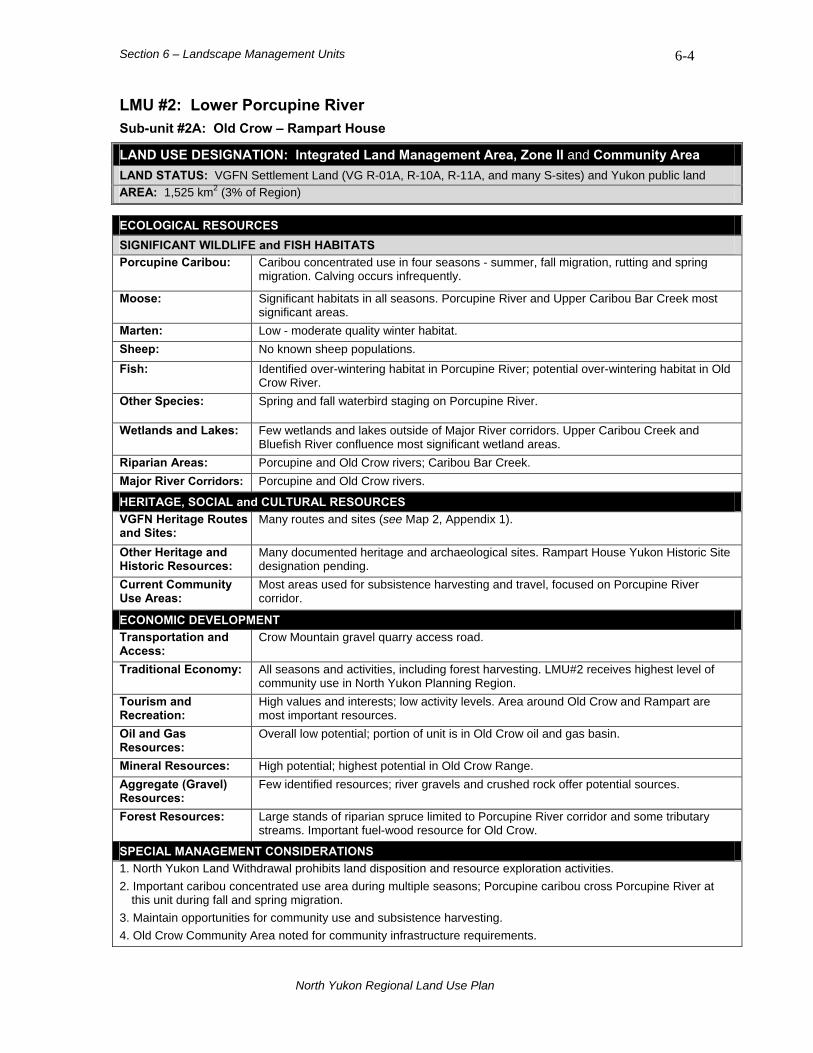
Section 6 – Landscape Management Units 6-4
LMU #2: Lower Porcupine River Sub-unit #2A: Old Crow – Rampart House LAND USE DESIGNATION: Integrated Land Management Area, Zone II and Community Area LAND STATUS: VGFN Settlement Land (VG R-01A, R-10A, R-11A, and many S-sites) and Yukon public land AREA: 1,525 km2 (3% of Region)
ECOLOGICAL RESOURCES SIGNIFICANT WILDLIFE and FISH HABITATS Porcupine Caribou:
Caribou concentrated use in four seasons - summer, fall migration, rutting and spring migration. Calving occurs infrequently.
Moose: Significant habitats in all seasons. Porcupine River and Upper Caribou Bar Creek most significant areas.
Marten: Low - moderate quality winter habitat. Sheep: No known sheep populations. Fish: Identified over-wintering habitat in Porcupine River; potential over-wintering habitat in Old
Crow River. Other Species: Spring and fall waterbird staging on Porcupine River.
Wetlands and Lakes: Few wetlands and lakes outside of Major River corridors. Upper Caribou Creek and Bluefish River confluence most significant wetland areas.
Riparian Areas: Porcupine and Old Crow rivers; Caribou Bar Creek. Major River Corridors: Porcupine and Old Crow rivers.
HERITAGE, SOCIAL and CULTURAL RESOURCES VGFN Heritage Routes and Sites:
Many routes and sites (see Map 2, Appendix 1).
Other Heritage and Historic Resources:
Many documented heritage and archaeological sites. Rampart House Yukon Historic Site designation pending.
Current Community Use Areas:
Most areas used for subsistence harvesting and travel, focused on Porcupine River corridor.
ECONOMIC DEVELOPMENT Transportation and Access:
Crow Mountain gravel quarry access road.
Traditional Economy: All seasons and activities, including forest harvesting. LMU#2 receives highest level of community use in North Yukon Planning Region.
Tourism and Recreation:
High values and interests; low activity levels. Area around Old Crow and Rampart are most important resources.
Oil and Gas Resources:
Overall low potential; portion of unit is in Old Crow oil and gas basin.
Mineral Resources: High potential; highest potential in Old Crow Range. Aggregate (Gravel) Resources:
Few identified resources; river gravels and crushed rock offer potential sources.
Forest Resources: Large stands of riparian spruce limited to Porcupine River corridor and some tributary streams. Important fuel-wood resource for Old Crow.
SPECIAL MANAGEMENT CONSIDERATIONS 1. North Yukon Land Withdrawal prohibits land disposition and resource exploration activities. 2. Important caribou concentrated use area during multiple seasons; Porcupine caribou cross Porcupine River at
this unit during fall and spring migration. 3. Maintain opportunities for community use and subsistence harvesting. 4. Old Crow Community Area noted for community infrastructure requirements.
North Yukon Regional Land Use Plan
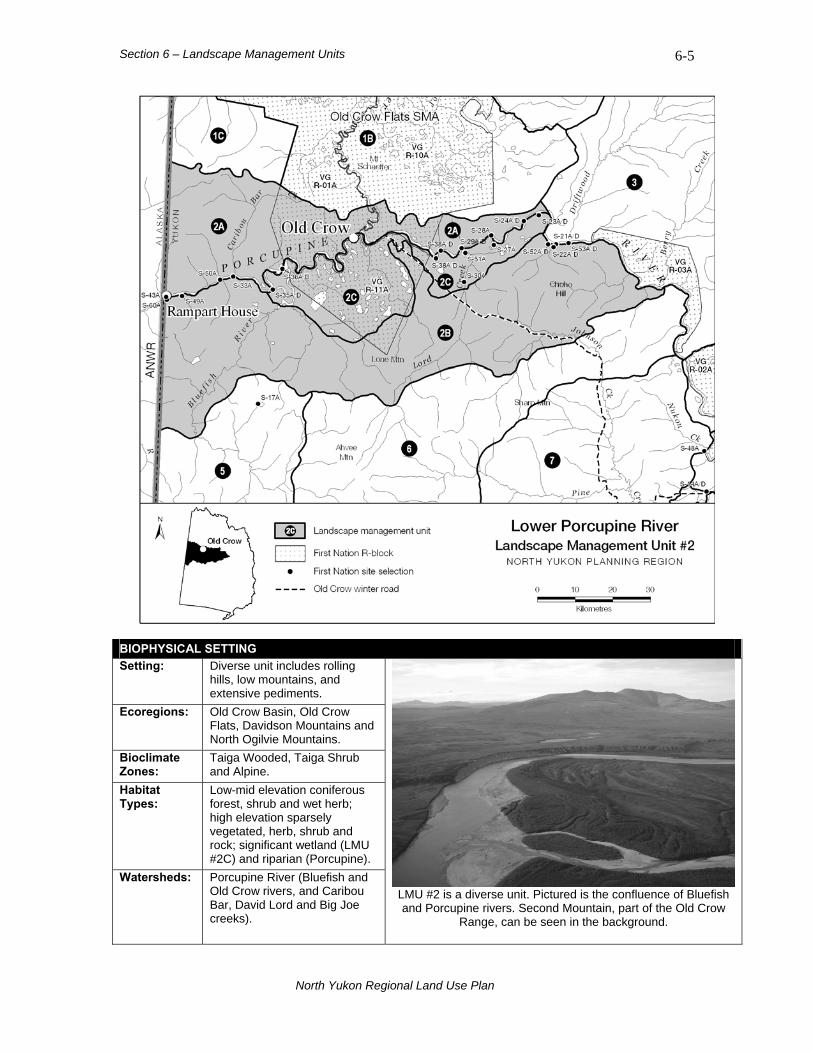
Section 6 – Landscape Management Units 6-5
BIOPHYSICAL SETTING Setting: Diverse unit includes rolling
hills, low mountains, and extensive pediments.
Ecoregions: Old Crow Basin, Old Crow Flats, Davidson Mountains and North Ogilvie Mountains.
Bioclimate Zones:
Taiga Wooded, Taiga Shrub and Alpine.
Habitat Types:
Low-mid elevation coniferous forest, shrub and wet herb; high elevation sparsely vegetated, herb, shrub and rock; significant wetland (LMU #2C) and riparian (Porcupine).
Watersheds: Porcupine River (Bluefish and Old Crow rivers, and Caribou Bar, David Lord and Big Joe creeks).
LMU #2 is a diverse unit. Pictured is the confluence of Bluefish and Porcupine rivers. Second Mountain, part of the Old Crow
Range, can be seen in the background.
North Yukon Regional Land Use Plan
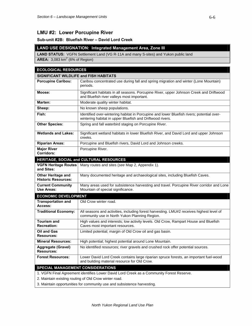
Section 6 – Landscape Management Units 6-6
LMU #2: Lower Porcupine River Sub-unit #2B: Bluefish River – David Lord Creek LAND USE DESIGNATION: Integrated Management Area, Zone III LAND STATUS: VGFN Settlement Land (VG R-11A and many S-sites) and Yukon public land AREA: 3,083 km2 (6% of Region)
ECOLOGICAL RESOURCES SIGNIFICANT WILDLIFE and FISH HABITATS Porcupine Caribou:
Caribou concentrated use during fall and spring migration and winter (Lone Mountain) periods.
Moose: Significant habitats in all seasons. Porcupine River, upper Johnson Creek and Driftwood and Bluefish river valleys most important.
Marten: Moderate quality winter habitat. Sheep: No known sheep populations. Fish: Identified over-wintering habitat in Porcupine and lower Bluefish rivers; potential over-
wintering habitat in upper Bluefish and Driftwood rivers. Other Species: Spring and fall waterbird staging on Porcupine River.
Wetlands and Lakes: Significant wetland habitats in lower Bluefish River, and David Lord and upper Johnson creeks.
Riparian Areas: Porcupine and Bluefish rivers, David Lord and Johnson creeks. Major River Corridors:
Porcupine River.
HERITAGE, SOCIAL and CULTURAL RESOURCES VGFN Heritage Routes and Sites:
Many routes and sites (see Map 2, Appendix 1).
Other Heritage and Historic Resources:
Many documented heritage and archaeological sites, including Bluefish Caves.
Current Community Use Areas:
Many areas used for subsistence harvesting and travel. Porcupine River corridor and Lone Mountain of special significance.
ECONOMIC DEVELOPMENT Transportation and Access:
Old Crow winter road.
Traditional Economy: All seasons and activities, including forest harvesting. LMU#2 receives highest level of community use in North Yukon Planning Region.
Tourism and Recreation:
High values and interests; low activity levels. Old Crow, Rampart House and Bluefish Caves most important resources.
Oil and Gas Resources:
Limited potential; margin of Old Crow oil and gas basin.
Mineral Resources: High potential; highest potential around Lone Mountain. Aggregate (Gravel) Resources:
No identified resources; river gravels and crushed rock offer potential sources.
Forest Resources: Lower David Lord Creek contains large riparian spruce forests, an important fuel-wood and building material resource for Old Crow.
SPECIAL MANAGEMENT CONSIDERATIONS 1. VGFN Final Agreement identifies Lower David Lord Creek as a Community Forest Reserve. 2. Maintain existing routing of Old Crow winter road. 3. Maintain opportunities for community use and subsistence harvesting.
North Yukon Regional Land Use Plan
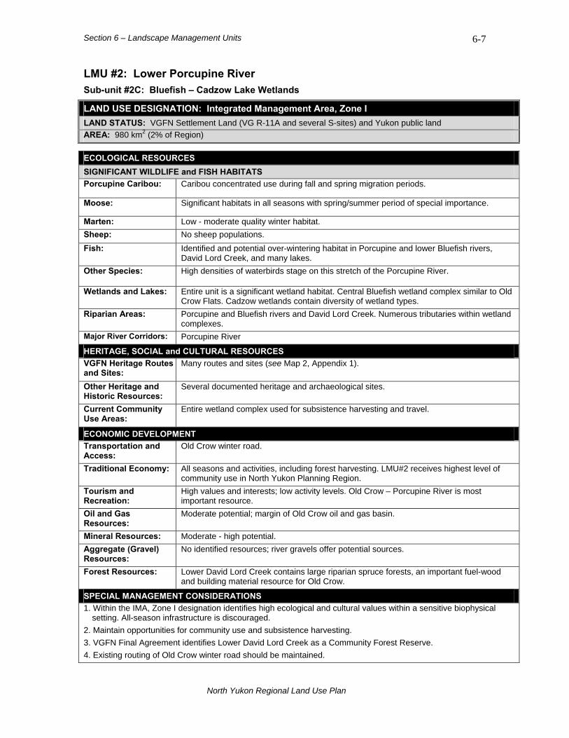
Section 6 – Landscape Management Units 6-7
LMU #2: Lower Porcupine River Sub-unit #2C: Bluefish – Cadzow Lake Wetlands LAND USE DESIGNATION: Integrated Management Area, Zone I LAND STATUS: VGFN Settlement Land (VG R-11A and several S-sites) and Yukon public land AREA: 980 km2 (2% of Region)
ECOLOGICAL RESOURCES SIGNIFICANT WILDLIFE and FISH HABITATS Porcupine Caribou: Caribou concentrated use during fall and spring migration periods.
Moose: Significant habitats in all seasons with spring/summer period of special importance.
Marten: Low - moderate quality winter habitat. Sheep: No sheep populations. Fish: Identified and potential over-wintering habitat in Porcupine and lower Bluefish rivers,
David Lord Creek, and many lakes. Other Species: High densities of waterbirds stage on this stretch of the Porcupine River.
Wetlands and Lakes: Entire unit is a significant wetland habitat. Central Bluefish wetland complex similar to Old Crow Flats. Cadzow wetlands contain diversity of wetland types.
Riparian Areas: Porcupine and Bluefish rivers and David Lord Creek. Numerous tributaries within wetland complexes.
Major River Corridors: Porcupine River
HERITAGE, SOCIAL and CULTURAL RESOURCES VGFN Heritage Routes and Sites:
Many routes and sites (see Map 2, Appendix 1).
Other Heritage and Historic Resources:
Several documented heritage and archaeological sites.
Current Community Use Areas:
Entire wetland complex used for subsistence harvesting and travel.
ECONOMIC DEVELOPMENT Transportation and Access:
Old Crow winter road.
Traditional Economy: All seasons and activities, including forest harvesting. LMU#2 receives highest level of community use in North Yukon Planning Region.
Tourism and Recreation:
High values and interests; low activity levels. Old Crow – Porcupine River is most important resource.
Oil and Gas Resources:
Moderate potential; margin of Old Crow oil and gas basin.
Mineral Resources: Moderate - high potential. Aggregate (Gravel) Resources:
No identified resources; river gravels offer potential sources.
Forest Resources: Lower David Lord Creek contains large riparian spruce forests, an important fuel-wood and building material resource for Old Crow.
SPECIAL MANAGEMENT CONSIDERATIONS 1. Within the IMA, Zone I designation identifies high ecological and cultural values within a sensitive biophysical
setting. All-season infrastructure is discouraged. 2. Maintain opportunities for community use and subsistence harvesting. 3. VGFN Final Agreement identifies Lower David Lord Creek as a Community Forest Reserve. 4. Existing routing of Old Crow winter road should be maintained.
North Yukon Regional Land Use Plan

Section 6 – Landscape Management Units 6-8
LMU #3: Driftwood River – Salmon Cache LAND USE DESIGNATION: Integrated Land Management Area, Zone II LAND STATUS: Yukon public land and VGFN Settlement Land (VG R-03A and several S-sites) AREA: 2,876 km2 (5% of Region)
ECOLOGICAL RESOURCES SIGNIFICANT WILDLIFE and FISH HABITATS Porcupine Caribou:
Caribou concentrated use in four seasons - summer, fall migration, rutting and winter. Calving occurs infrequently.
Moose: Significant habitats in all seasons. High quality winter habitat in Driftwood River corridor.
Marten: Low - moderate quality winter habitat. Sheep: No known sheep populations. Fish: Identified over-wintering habitat in Porcupine River; potential over-wintering habitat in
lower Driftwood River. Other Species: Significant grizzly Bear habitat around mouth of Berry Creek and Salmon Cache
archaeological site. Wetlands and Lakes: Lower Driftwood River and Berry Creek corridors contain wetlands. Riparian Areas: Driftwood River valley, Berry Creek valley and numerous small stream valleys. Major River Corridors:
Porcupine River
HERITAGE, SOCIAL and CULTURAL RESOURCES VGFN Heritage Routes and Sites:
Old Crow to Ft. McPherson trail, via Salmon Cache and Lapierre House.
Other Heritage and Historic Resources:
Significant heritage resource values. Documented caribou fences and many archaeological sites.
Current Community Use Areas:
Lower Driftwood River, Porcupine River, Salmon Cache and Burnt Hill.
ECONOMIC DEVELOPMENT Transportation and Access:
No existing transportation infrastructure; a conceptual access route has been identified in the southern portion of unit1.
Traditional Economy: Summer and winter subsistence and forest harvesting; general land use. Tourism and Recreation:
Low interests and activity (outside of Porcupine River corridor).
Oil and Gas Resources:
Overall low potential; southern margin of unit is in Eagle Plain oil and gas basin.
Mineral Resources: Overall low potential; western margin of unit contains high potential. Aggregate (Gravel) Resources:
No identified resources.
Forest Resources: Large stands of riparian spruce limited to lower Driftwood River.
SPECIAL MANAGEMENT CONSIDERATIONS 1. North Yukon Land Withdrawal prohibits land disposition and resource exploration activities. 2. Important caribou concentrated use area during multiple seasons; Porcupine caribou cross Porcupine River at
this unit during fall and spring migration. 3. High heritage resource and cultural values. 4. Maintain opportunities for community use and subsistence harvesting.
1 Source: Yukon Government, Department of Energy Mines and Resources. 2003.
North Yukon Regional Land Use Plan
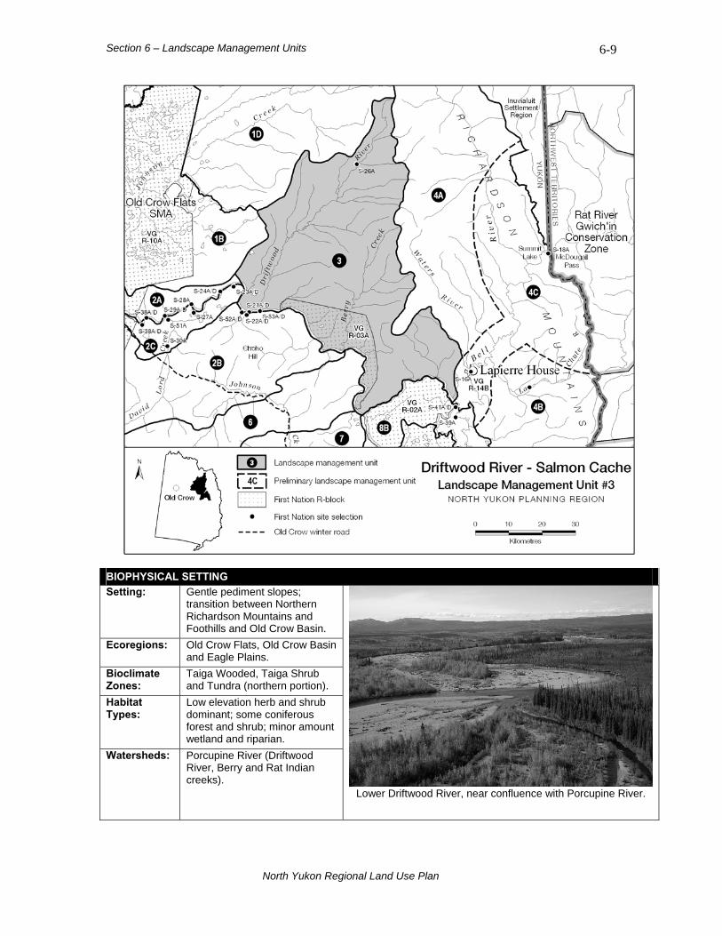
Section 6 – Landscape Management Units 6-9
BIOPHYSICAL SETTING Setting: Gentle pediment slopes;
transition between Northern Richardson Mountains and Foothills and Old Crow Basin.
Ecoregions: Old Crow Flats, Old Crow Basin and Eagle Plains.
Bioclimate Zones:
Taiga Wooded, Taiga Shrub and Tundra (northern portion).
Habitat Types:
Low elevation herb and shrub dominant; some coniferous forest and shrub; minor amount wetland and riparian.
Watersheds: Porcupine River (Driftwood River, Berry and Rat Indian creeks).
Lower Driftwood River, near confluence with Porcupine River.
North Yukon Regional Land Use Plan
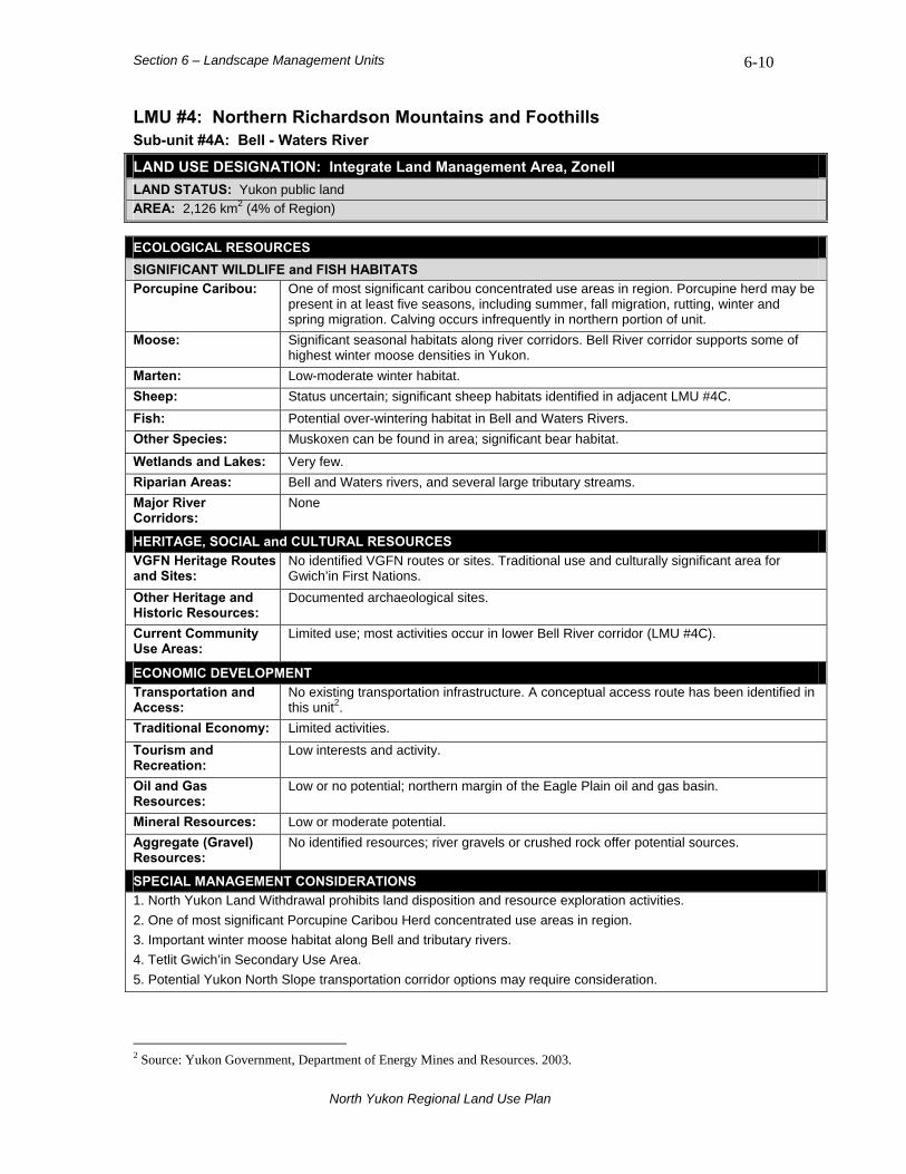
Section 6 – Landscape Management Units 6-10
LMU #4: Northern Richardson Mountains and Foothills Sub-unit #4A: Bell - Waters River
LAND USE DESIGNATION: Integrate Land Management Area, ZoneII LAND STATUS: Yukon public land AREA: 2,126 km2 (4% of Region)
ECOLOGICAL RESOURCES SIGNIFICANT WILDLIFE and FISH HABITATS Porcupine Caribou:
One of most significant caribou concentrated use areas in region. Porcupine herd may be present in at least five seasons, including summer, fall migration, rutting, winter and spring migration. Calving occurs infrequently in northern portion of unit.
Moose: Significant seasonal habitats along river corridors. Bell River corridor supports some of highest winter moose densities in Yukon.
Marten: Low-moderate winter habitat. Sheep: Status uncertain; significant sheep habitats identified in adjacent LMU #4C. Fish: Potential over-wintering habitat in Bell and Waters Rivers. Other Species: Muskoxen can be found in area; significant bear habitat.
Wetlands and Lakes: Very few. Riparian Areas: Bell and Waters rivers, and several large tributary streams. Major River Corridors:
None
HERITAGE, SOCIAL and CULTURAL RESOURCES VGFN Heritage Routes and Sites:
No identified VGFN routes or sites. Traditional use and culturally significant area for Gwich’in First Nations.
Other Heritage and Historic Resources:
Documented archaeological sites.
Current Community Use Areas:
Limited use; most activities occur in lower Bell River corridor (LMU #4C).
ECONOMIC DEVELOPMENT Transportation and Access:
No existing transportation infrastructure. A conceptual access route has been identified in this unit2.
Traditional Economy: Limited activities. Tourism and Recreation:
Low interests and activity.
Oil and Gas Resources:
Low or no potential; northern margin of the Eagle Plain oil and gas basin.
Mineral Resources: Low or moderate potential. Aggregate (Gravel) Resources:
No identified resources; river gravels or crushed rock offer potential sources.
SPECIAL MANAGEMENT CONSIDERATIONS 1. North Yukon Land Withdrawal prohibits land disposition and resource exploration activities. 2. One of most significant Porcupine Caribou Herd concentrated use areas in region. 3. Important winter moose habitat along Bell and tributary rivers. 4. Tetlit Gwich’in Secondary Use Area. 5. Potential Yukon North Slope transportation corridor options may require consideration.
2 Source: Yukon Government, Department of Energy Mines and Resources. 2003.
North Yukon Regional Land Use Plan

Section 6 – Landscape Management Units 6-11
BIOPHYSICAL SETTING Setting: Remote mountainous unit with
sub-arctic conditions. Ecoregions: British Richardson Mountains.
Bioclimate Zones:
Taiga Shrub, Alpine and Tundra (minor).
Habitat Types:
High elevation sparsely vegetated, herb, shrub and rock; low elevation coniferous forest and shrub; minor wetland and riparian.
Watersheds: Porcupine River (Bell, Little Bell and Waters rivers, headwaters of Driftwood River).
Bell River corridor in Northern Richardson Mountains is a significant Porcupine Caribou and moose habitat.
North Yukon Regional Land Use Plan
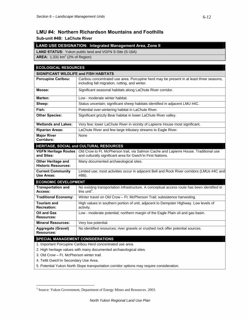
Section 6 – Landscape Management Units 6-12
LMU #4: Northern Richardson Mountains and Foothills Sub-unit #4B: LaChute River
LAND USE DESIGNATION: Integrated Management Area, Zone II LAND STATUS: Yukon public land and VGFN S-Site (S-16A) AREA: 1,331 km2 (2% of Region)
ECOLOGICAL RESOURCES SIGNIFICANT WILDLIFE and FISH HABITATS Porcupine Caribou:
Caribou concentrated use area. Porcupine herd may be present in at least three seasons, including fall migration, rutting, and winter.
Moose: Significant seasonal habitats along LaChute River corridor.
Marten: Low - moderate winter habitat. Sheep: Status uncertain; significant sheep habitats identified in adjacent LMU #4C. Fish: Potential over-wintering habitat in LaChute River. Other Species: Significant grizzly Bear habitat in lower LaChute River valley.
Wetlands and Lakes: Very few; lower LaChute River in vicinity of Lapierre House most significant. Riparian Areas: LaChute River and few large tributary streams to Eagle River. Major River Corridors:
None
HERITAGE, SOCIAL and CULTURAL RESOURCES VGFN Heritage Routes and Sites:
Old Crow to Ft. McPherson trail, via Salmon Cache and Lapierre House. Traditional use and culturally significant area for Gwich’in First Nations.
Other Heritage and Historic Resources:
Many documented archaeological sites.
Current Community Use Areas:
Limited use; most activities occur in adjacent Bell and Rock River corridors (LMUs #4C and #8B).
ECONOMIC DEVELOPMENT Transportation and Access:
No existing transportation infrastructure. A conceptual access route has been identified in this unit3.
Traditional Economy: Winter travel on Old Crow – Ft. McPherson Trail; subsistence harvesting. Tourism and Recreation:
High values in southern portion of unit, adjacent to Dempster Highway. Low levels of activity.
Oil and Gas Resources:
Low - moderate potential; northern margin of the Eagle Plain oil and gas basin.
Mineral Resources: Very low potential. Aggregate (Gravel) Resources:
No identified resources; river gravels or crushed rock offer potential sources.
SPECIAL MANAGEMENT CONSIDERATIONS 1. Important Porcupine Caribou Herd concentrated use area. 2. High heritage values with many documented archaeological sites. 3. Old Crow – Ft. McPherson winter trail. 4. Tetlit Gwich’in Secondary Use Area. 5. Potential Yukon North Slope transportation corridor options may require consideration.
3 Source: Yukon Government, Department of Energy Mines and Resources. 2003.
North Yukon Regional Land Use Plan
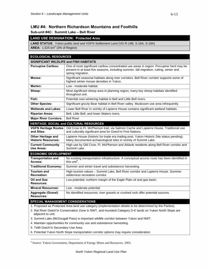
Section 6 – Landscape Management Units 6-13
LMU #4: Northern Richardson Mountains and Foothills Sub-unit #4C: Summit Lake – Bell River
LAND USE DESIGNATION: Protected Area LAND STATUS: Yukon public land and VGFN Settlement Land (VG R-14B, S-16A, S-18A) AREA: 1,525 km2 (3% of Region)
ECOLOGICAL RESOURCES SIGNIFICANT WILDLIFE and FISH HABITATS Porcupine Caribou:
One of most significant caribou concentrated use areas in region. Porcupine herd may be present in at least five seasons, including summer, fall migration, rutting, winter and spring migration.
Moose: Significant seasonal habitats along river corridors. Bell River corridor supports some of highest winter moose densities in Yukon.
Marten: Low - moderate habitat. Sheep: Most significant sheep area in planning region; many key sheep habitats identified
throughout unit. Fish: Potential over-wintering habitat in Bell and Little Bell rivers. Other Species: Significant grizzly Bear habitat in Bell River valley. Muskoxen use area infrequently.
Wetlands and Lakes: Lower Bell River in vicinity of Lapierre House contains significant wetland habitats. Riparian Areas: Bell, Little Bell, and lower Waters rivers. Major River Corridors: Bell River
HERITAGE, SOCIAL and CULTURAL RESOURCES VGFN Heritage Routes and Sites:
Old Crow to Ft. McPherson trail, via Salmon Cache and Lapierre House. Traditional use and culturally significant area for Gwich’in First Nations.
Other Heritage and Historic Resources:
Lapierre House (historic fur-trade era trading post, Yukon Historic Site status pending). Many documented archaeological sites in vicinity of Summit Lake.
Current Community Use Areas:
High use by Old Crow, Ft. McPherson and Aklavik residents along Bell River corridor and Summit Lake.
ECONOMIC DEVELOPMENT Transportation and Access:
No existing transportation infrastructure. A conceptual access route has been identified in this unit4.
Traditional Economy: Summer and winter travel and subsistence harvesting. Tourism and Recreation:
High tourism values – Summit Lake, Bell River corridor and Lapierre House. Summer wilderness recreation corridor.
Oil and Gas Resources:
Low potential; northern margin of the Eagle Plain oil and gas basin.
Mineral Resources: Low - moderate potential. Aggregate (Gravel) Resources:
No identified resources; river gravels or crushed rock offer potential sources.
SPECIAL MANAGEMENT CONSIDERATIONS 1. Proposed as Protected Area land use category (implementation details to be determined by the Parties). 2. Rat River Gwich’in Conservation Zone in NWT, and Inuvialuit Category D-E lands on Yukon North Slope are
adjacent to unit. 3. Summit Lake (McDougall Pass) is important wildlife corridor between Yukon and NWT. 4. Maintain opportunities for community use and subsistence harvesting. 5. Tetlit Gwich’in Secondary Use Area. 6. Potential Yukon North Slope transportation corridor options may require consideration.
4 Source: Yukon Government, Department of Energy Mines and Resources. 2003.
North Yukon Regional Land Use Plan

Section 6 – Landscape Management Units 6-14
LMU #5: Bluefish Lake – Keele Range LAND USE DESIGNATION: Integrated Management Area, Zone III LAND STATUS: Yukon public land and two VGFN S-sites (S-17A and S-19A) AREA: 2,066 km2 (3% of Region)
ECOLOGICAL RESOURCES SIGNIFICANT WILDLIFE and FISH HABITATS Porcupine Caribou:
Caribou concentrated use in eastern portion of unit during three seasons - spring migration, fall migration and winter.
Moose: Significant habitats in all seasons. High quality habitat in Bluefish River, Bluefish Lake and Salmon Fork River corridors.
Marten: Moderate - high quality winter habitat in forested valleys and mountain slopes. Sheep: Sheep population (unconfirmed) near Mount Rover. Fish: Potential over-wintering habitat in middle Bluefish River. Other Species: Significant furbearer habitat in northern portion of unit.
Wetlands and Lakes: Bluefish and Salmon Fork river corridors contain wetlands. Bluefish and Useful lakes are present.
Riparian Areas: Bluefish and Salmon Fork river valleys. Major River Corridors:
None
HERITAGE, SOCIAL and CULTURAL RESOURCES VGFN Heritage Routes and Sites:
No identified VGFN heritage routes or sites.
Other Heritage and Historic Resources:
High cultural values at Useful Lake, Bluefish Lake and Nest Mountain. One documented archaeological site near Bluefish Lake. Potential for caves to be present.
Current Community Use Areas:
Bluefish and Useful lakes, and several winter trails.
ECONOMIC DEVELOPMENT Transportation and Access:
No existing transportation infrastructure.
Traditional Economy: Winter trapping and subsistence harvesting. Tourism and Recreation:
Low interests and activity.
Oil and Gas Resources:
Very low potential.
Mineral Resources: High potential. Aggregate (Gravel) Resources:
No identified resources; river gravels or crushed rock offer potential sources.
SPECIAL MANAGEMENT CONSIDERATIONS 1. High potential for discovery of heritage resources. Numerous limestone caves present. 2. Arctic National Wildlife Refuge is adjacent to western border of unit (Yukon-Alaska border).
North Yukon Regional Land Use Plan

Section 6 – Landscape Management Units 6-15
BIOPHYSICAL SETTING Setting: Remote, rugged mountainous
unit with some of highest elevations in region.
Ecoregions: North Ogilvie Mountains.
Bioclimate Zones:
Taiga Wooded, Taiga Shrub and Alpine.
Habitat Types:
Extensive areas of high elevation sparsely vegetated, rock, herb and shrub; lower elevation valleys contain coniferous forest and shrub; some wetland and limited riparian.
Watersheds: Porcupine River (Bluefish River) and Yukon River (Salmon Fork River). Extensive areas of high elevation, sparsely vegetated habitats
are present in the Keele Range of LMU #5.
North Yukon Regional Land Use Plan
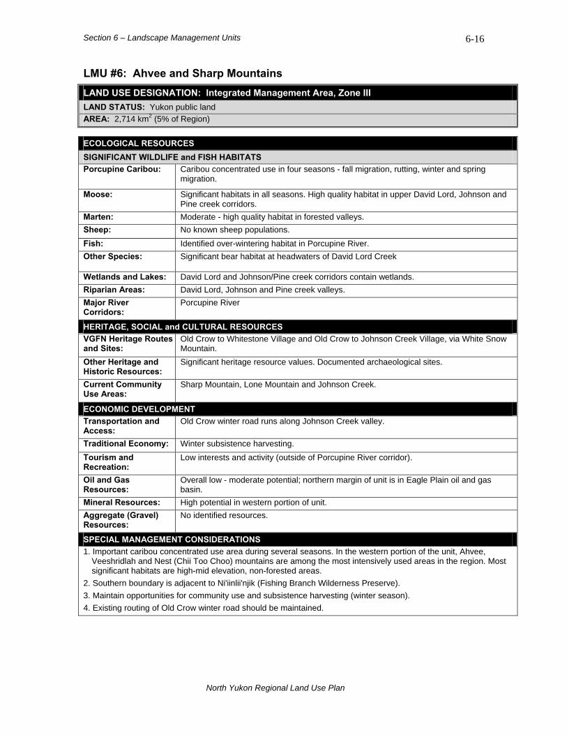
Section 6 – Landscape Management Units 6-16
LMU #6: Ahvee and Sharp Mountains LAND USE DESIGNATION: Integrated Management Area, Zone III LAND STATUS: Yukon public land AREA: 2,714 km2 (5% of Region)
ECOLOGICAL RESOURCES SIGNIFICANT WILDLIFE and FISH HABITATS Porcupine Caribou:
Caribou concentrated use in four seasons - fall migration, rutting, winter and spring migration.
Moose: Significant habitats in all seasons. High quality habitat in upper David Lord, Johnson and Pine creek corridors.
Marten: Moderate - high quality habitat in forested valleys. Sheep: No known sheep populations. Fish: Identified over-wintering habitat in Porcupine River. Other Species: Significant bear habitat at headwaters of David Lord Creek
Wetlands and Lakes: David Lord and Johnson/Pine creek corridors contain wetlands. Riparian Areas: David Lord, Johnson and Pine creek valleys. Major River Corridors:
Porcupine River
HERITAGE, SOCIAL and CULTURAL RESOURCES VGFN Heritage Routes and Sites:
Old Crow to Whitestone Village and Old Crow to Johnson Creek Village, via White Snow Mountain.
Other Heritage and Historic Resources:
Significant heritage resource values. Documented archaeological sites.
Current Community Use Areas:
Sharp Mountain, Lone Mountain and Johnson Creek.
ECONOMIC DEVELOPMENT Transportation and Access:
Old Crow winter road runs along Johnson Creek valley.
Traditional Economy: Winter subsistence harvesting. Tourism and Recreation:
Low interests and activity (outside of Porcupine River corridor).
Oil and Gas Resources:
Overall low - moderate potential; northern margin of unit is in Eagle Plain oil and gas basin.
Mineral Resources: High potential in western portion of unit. Aggregate (Gravel) Resources:
No identified resources.
SPECIAL MANAGEMENT CONSIDERATIONS 1. Important caribou concentrated use area during several seasons. In the western portion of the unit, Ahvee,
Veeshridlah and Nest (Chii Too Choo) mountains are among the most intensively used areas in the region. Most significant habitats are high-mid elevation, non-forested areas.
2. Southern boundary is adjacent to Ni'iinlii'njik (Fishing Branch Wilderness Preserve). 3. Maintain opportunities for community use and subsistence harvesting (winter season). 4. Existing routing of Old Crow winter road should be maintained.
North Yukon Regional Land Use Plan
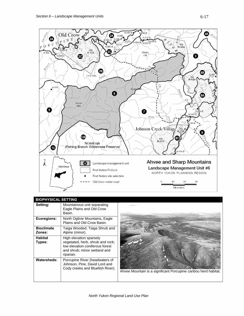
Section 6 – Landscape Management Units 6-17
BIOPHYSICAL SETTING Setting: Mountainous unit separating
Eagle Plains and Old Crow Basin.
Ecoregions: North Ogilvie Mountains, Eagle Plains and Old Crow Basin.
Bioclimate Zones:
Taiga Wooded, Taiga Shrub and Alpine (minor).
Habitat Types:
High elevation sparsely vegetated, herb, shrub and rock; low elevation coniferous forest and shrub; minor wetland and riparian.
Watersheds: Porcupine River (headwaters of Johnson, Pine, David Lord and Cody creeks and Bluefish River).
Ahvee Mountain is a significant Porcupine caribou herd habitat.
North Yukon Regional Land Use Plan
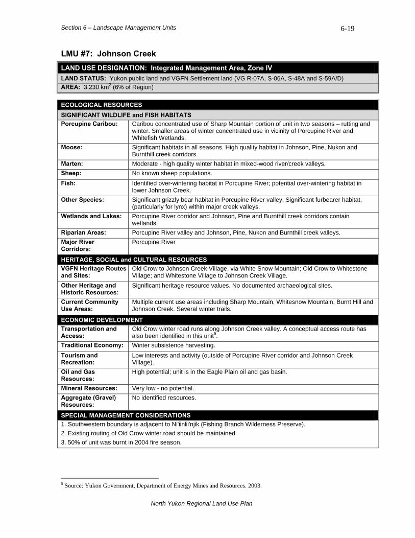
Section 6 – Landscape Management Units 6-19
LMU #7: Johnson Creek LAND USE DESIGNATION: Integrated Management Area, Zone IV LAND STATUS: Yukon public land and VGFN Settlement land (VG R-07A, S-06A, S-48A and S-59A/D) AREA: 3,230 km2 (6% of Region)
ECOLOGICAL RESOURCES SIGNIFICANT WILDLIFE and FISH HABITATS Porcupine Caribou:
Caribou concentrated use of Sharp Mountain portion of unit in two seasons – rutting and winter. Smaller areas of winter concentrated use in vicinity of Porcupine River and Whitefish Wetlands.
Moose: Significant habitats in all seasons. High quality habitat in Johnson, Pine, Nukon and Burnthill creek corridors.
Marten: Moderate - high quality winter habitat in mixed-wood river/creek valleys. Sheep: No known sheep populations. Fish: Identified over-wintering habitat in Porcupine River; potential over-wintering habitat in
lower Johnson Creek. Other Species: Significant grizzly bear habitat in Porcupine River valley. Significant furbearer habitat,
(particularly for lynx) within major creek valleys. Wetlands and Lakes: Porcupine River corridor and Johnson, Pine and Burnthill creek corridors contain
wetlands. Riparian Areas: Porcupine River valley and Johnson, Pine, Nukon and Burnthill creek valleys. Major River Corridors:
Porcupine River
HERITAGE, SOCIAL and CULTURAL RESOURCES VGFN Heritage Routes and Sites:
Old Crow to Johnson Creek Village, via White Snow Mountain; Old Crow to Whitestone Village; and Whitestone Village to Johnson Creek Village.
Other Heritage and Historic Resources:
Significant heritage resource values. No documented archaeological sites.
Current Community Use Areas:
Multiple current use areas including Sharp Mountain, Whitesnow Mountain, Burnt Hill and Johnson Creek. Several winter trails.
ECONOMIC DEVELOPMENT Transportation and Access:
Old Crow winter road runs along Johnson Creek valley. A conceptual access route has also been identified in this unit5.
Traditional Economy: Winter subsistence harvesting. Tourism and Recreation:
Low interests and activity (outside of Porcupine River corridor and Johnson Creek Village).
Oil and Gas Resources:
High potential; unit is in the Eagle Plain oil and gas basin.
Mineral Resources: Very low - no potential. Aggregate (Gravel) Resources:
No identified resources.
SPECIAL MANAGEMENT CONSIDERATIONS 1. Southwestern boundary is adjacent to Ni'iinlii'njik (Fishing Branch Wilderness Preserve). 2. Existing routing of Old Crow winter road should be maintained. 3. 50% of unit was burnt in 2004 fire season.
5 Source: Yukon Government, Department of Energy Mines and Resources. 2003.
North Yukon Regional Land Use Plan
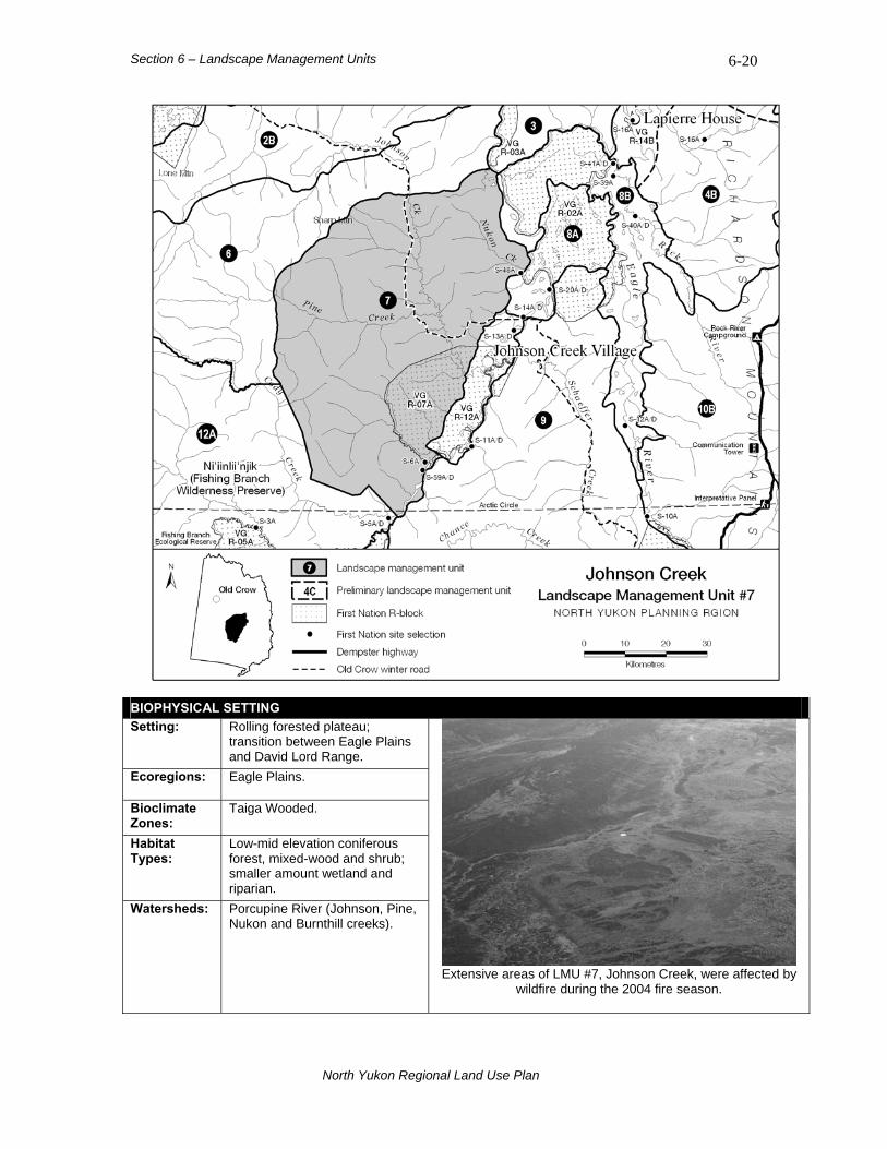
Section 6 – Landscape Management Units 6-20
BIOPHYSICAL SETTING Setting: Rolling forested plateau;
transition between Eagle Plains and David Lord Range.
Ecoregions: Eagle Plains.
Bioclimate Zones:
Taiga Wooded.
Habitat Types:
Low-mid elevation coniferous forest, mixed-wood and shrub; smaller amount wetland and riparian.
Watersheds: Porcupine River (Johnson, Pine, Nukon and Burnthill creeks).
Extensive areas of LMU #7, Johnson Creek, were affected by
wildfire during the 2004 fire season.
North Yukon Regional Land Use Plan
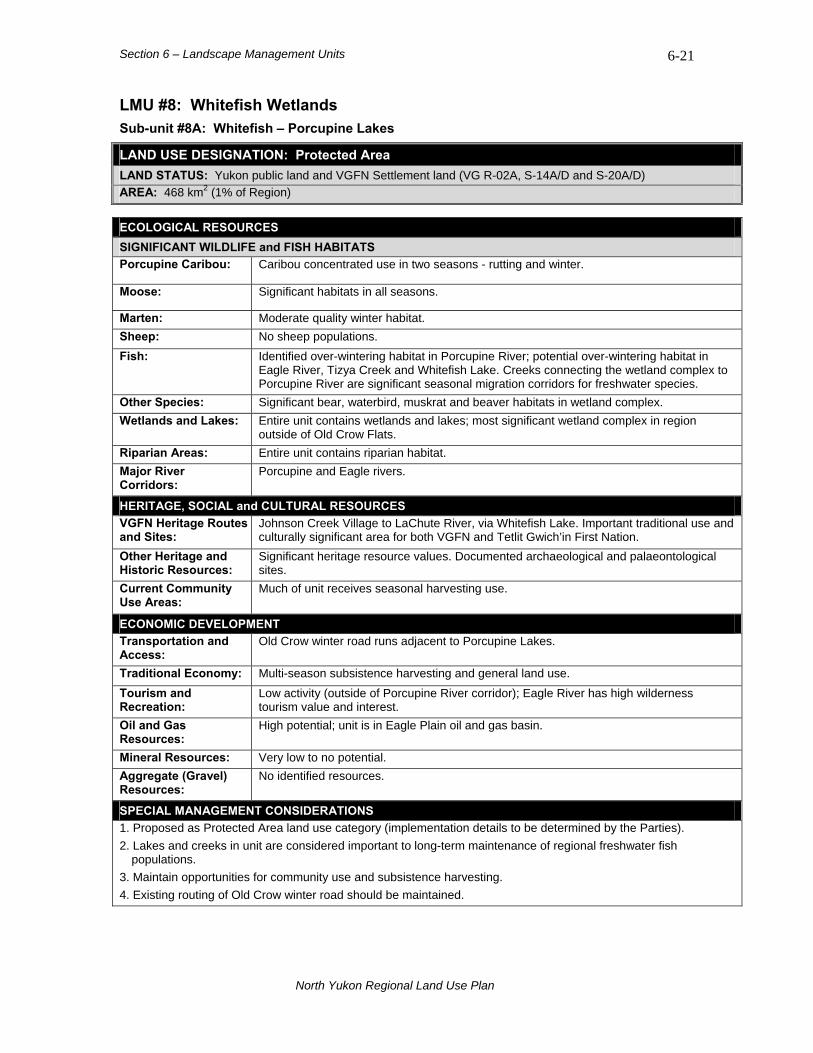
Section 6 – Landscape Management Units 6-21
LMU #8: Whitefish Wetlands Sub-unit #8A: Whitefish – Porcupine Lakes
LAND USE DESIGNATION: Protected Area LAND STATUS: Yukon public land and VGFN Settlement land (VG R-02A, S-14A/D and S-20A/D) AREA: 468 km2 (1% of Region)
ECOLOGICAL RESOURCES SIGNIFICANT WILDLIFE and FISH HABITATS Porcupine Caribou: Caribou concentrated use in two seasons - rutting and winter.
Moose: Significant habitats in all seasons.
Marten: Moderate quality winter habitat. Sheep: No sheep populations. Fish: Identified over-wintering habitat in Porcupine River; potential over-wintering habitat in
Eagle River, Tizya Creek and Whitefish Lake. Creeks connecting the wetland complex to Porcupine River are significant seasonal migration corridors for freshwater species.
Other Species: Significant bear, waterbird, muskrat and beaver habitats in wetland complex. Wetlands and Lakes: Entire unit contains wetlands and lakes; most significant wetland complex in region
outside of Old Crow Flats. Riparian Areas: Entire unit contains riparian habitat. Major River Corridors:
Porcupine and Eagle rivers.
HERITAGE, SOCIAL and CULTURAL RESOURCES VGFN Heritage Routes and Sites:
Johnson Creek Village to LaChute River, via Whitefish Lake. Important traditional use and culturally significant area for both VGFN and Tetlit Gwich’in First Nation.
Other Heritage and Historic Resources:
Significant heritage resource values. Documented archaeological and palaeontological sites.
Current Community Use Areas:
Much of unit receives seasonal harvesting use.
ECONOMIC DEVELOPMENT Transportation and Access:
Old Crow winter road runs adjacent to Porcupine Lakes.
Traditional Economy: Multi-season subsistence harvesting and general land use. Tourism and Recreation:
Low activity (outside of Porcupine River corridor); Eagle River has high wilderness tourism value and interest.
Oil and Gas Resources:
High potential; unit is in Eagle Plain oil and gas basin.
Mineral Resources: Very low to no potential. Aggregate (Gravel) Resources:
No identified resources.
SPECIAL MANAGEMENT CONSIDERATIONS 1. Proposed as Protected Area land use category (implementation details to be determined by the Parties). 2. Lakes and creeks in unit are considered important to long-term maintenance of regional freshwater fish
populations. 3. Maintain opportunities for community use and subsistence harvesting. 4. Existing routing of Old Crow winter road should be maintained.
North Yukon Regional Land Use Plan
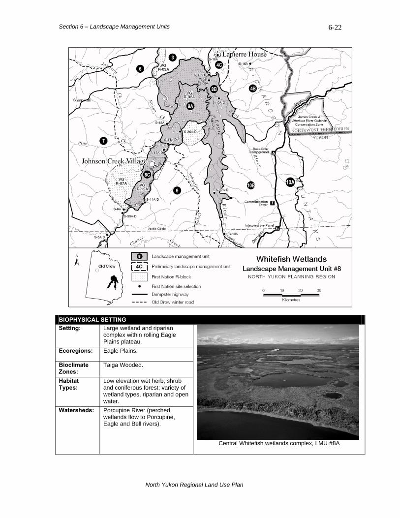
Section 6 – Landscape Management Units 6-22
BIOPHYSICAL SETTING Setting: Large wetland and riparian
complex within rolling Eagle Plains plateau.
Ecoregions: Eagle Plains.
Bioclimate Zones:
Taiga Wooded.
Habitat Types:
Low elevation wet herb, shrub and coniferous forest; variety of wetland types, riparian and open water.
Watersheds: Porcupine River (perched wetlands flow to Porcupine, Eagle and Bell rivers).
Central Whitefish wetlands complex, LMU #8A
North Yukon Regional Land Use Plan

Section 6 – Landscape Management Units 6-23
LMU #8: Whitefish Wetlands Sub-unit #8B: Eagle – Bell River
LAND USE DESIGNATION: Integrated Management Area, Zone I LAND STATUS: Yukon public land and VGFN Settlement land (VG R-02A and a number of S-sites) AREA: 1,124 km2 (2% of Region)
ECOLOGICAL RESOURCES SIGNIFICANT WILDLIFE and FISH HABITATS Porcupine Caribou: Concentrated caribou use during fall rutting and winter seasons.
Moose: Significant habitats in all seasons.
Marten: Moderate quality winter habitat. Sheep: No sheep populations. Fish: Identified and potential over-wintering habitat in Eagle, Bell and Rock rivers Other Species: Significant bear, waterbird and beaver habitats.
Wetlands and Lakes: With exception of low hills south of Bell River, most of unit contains wetlands and lakes. Riparian Areas: Most of unit contains riparian habitat. Major River Corridors:
Eagle and Bell rivers
HERITAGE, SOCIAL and CULTURAL RESOURCES VGFN Heritage Routes and Sites:
Johnson Creek Village to LaChute River via Whitefish Lake, and Whitestone Village route via Upper Stony Creek. Important traditional use and culturally significant area for both VGFN and Tetlit Gwich’in.
Other Heritage and Historic Resources:
Significant heritage resource values. Documented archaeological and palaeontological sites.
Current Community Use Areas:
Much of unit receives seasonal harvesting use.
ECONOMIC DEVELOPMENT Transportation and Access:
No existing transportation infrastructure.
Traditional Economy: Multi-season subsistence harvesting and general land use. Tourism and Recreation:
Low activity (outside of Eagle River corridor); Eagle and Bell river have high wilderness tourism value and interest.
Oil and Gas Resources:
High potential; Eagle Plain oil and gas basin.
Mineral Resources: Low or no potential. Aggregate (Gravel) Resources:
Preliminary aggregate assessment available for upper Eagle River6; potential sources identified in high river terraces.
SPECIAL MANAGEMENT CONSIDERATIONS 1. In the IMA, Zone I designation identifies high ecological and cultural values within a sensitive biophysical setting.
All-season infrastructure is discouraged. 2. Tetlit Gwich’in Secondary Use Area.
6 Kennedy and Froese (2008).
North Yukon Regional Land Use Plan

Section 6 – Landscape Management Units 6-24
LMU #8: Whitefish Wetlands Sub-unit #8C: Porcupine River
LAND USE DESIGNATION: Integrated Management Area, Zone I LAND STATUS: Yukon public land and VGFN Settlement land (VG R-07A, R-12A, S-11A/D and S-13A/D) AREA: 302 km2 (1% of Region)
ECOLOGICAL RESOURCES SIGNIFICANT WILDLIFE and FISH HABITATS Porcupine Caribou: Caribou general use area during fall rutting and winter seasons.
Moose: Significant habitats in all seasons.
Marten: High winter habitat values. Sheep: No sheep populations. Fish: Identified and potential over-wintering habitat in Porcupine River, Johnson Creek and
adjacent lakes. Other Species: Significant bear, waterbird and beaver habitats.
Wetlands and Lakes: Most of unit contains off-channel wetland and lake habitats. Riparian Areas: Unit contains some of the best examples of productive riparian habitats in region. Major River Corridors:
Porcupine River
HERITAGE, SOCIAL and CULTURAL RESOURCES VGFN Heritage Routes and Sites:
Whitestone Village to Johnson Creek Village and Old Crow to Johnson Creek Village via White Snow Mountain. Important traditional use and culturally significant area for both VGFN and Tetlit Gwich’in.
Other Heritage and Historic Resources:
Documented archaeological sites. Historic fur trade era Johnson Creek Village.
Current Community Use Areas:
Porcupine River receives seasonal use (summer and winter).
ECONOMIC DEVELOPMENT Transportation and Access:
Old Crow winter road crosses Porcupine River at Anik Island.
Traditional Economy: Multi-season subsistence harvesting and general land use. Tourism and Recreation:
Low activity. Porcupine River has high wilderness tourism value and interest. Johnson Creek Village identified as potential future tourism node.
Oil and Gas Resources:
High potential; Eagle Plain oil and gas basin.
Mineral Resources: Low or no potential. Aggregate (Gravel) Resources:
No identified resources; river gravels may provide potential source.
SPECIAL MANAGEMENT CONSIDERATIONS 1. In the IMA, Zone I designation identifies high ecological and cultural values within a sensitive biophysical setting.
All-season infrastructure is discouraged. 2. Johnson Creek Village is important VGFN cultural and heritage resource. 3. Existing routing of Old Crow winter road should be maintained. 4. Regionally significant and rare riparian mixed-wood forests occur in unit.
North Yukon Regional Land Use Plan

Section 6 – Landscape Management Units 6-25
LMU #9: Eagle Plains LAND USE DESIGNATION: Integrated Management Area, Zone IV LAND STATUS: Yukon public land and VGFN Settlement land (VG R-02A, R-06A, R-08A, R-12A, S-07A) AREA: 6,415 km2 (11% of Region)
ECOLOGICAL RESOURCES SIGNIFICANT WILDLIFE and FISH HABITATS Porcupine Caribou:
General fall rutting and winter use area. Some concentrated use occurs in western and northern portions of unit, near Porcupine River and Whitefish Wetlands, and southern portion of unit in vicinity of Dempster Highway and VG R-08A.
Moose: Significant seasonal habitats. Shaeffer, Chance and Ellen creeks, and several other small tributary streams contain highest values.
Marten: Moderate - high value habitats; mixed-wood riparian and upland habitats most important. Sheep: No sheep populations. Fish: No documented fish over-wintering habitat. Other Species: Wetlands and Lakes: Significant wetland habitats along lower Shaeffer Creek; wet habitats in most valleys. Riparian Areas: Shaeffer, Chance and Ellen creeks, and several small tributary streams. Major River Corridors: Porcupine and Eagle rivers.
HERITAGE, SOCIAL and CULTURAL RESOURCES VGFN Heritage Routes and Sites:
Old Crow to Whitestone Village, and Old Crow to Johnson Creek Village via White Snow Mountain.
Other Heritage and Historic Resources:
Important historical use area with highest use in vicinity of Whitestone and Johnson Creek Villages. Documented archaeological sites (southeast of Dempster Highway).
Current Community Use Areas:
Vicinity of Whitestone and Johnson Creek villages, Whitefish Wetlands, and Dempster Highway corridor.
ECONOMIC DEVELOPMENT Transportation and Access:
Dempster Highway Corridor and Old Crow winter road. A conceptual access route has also been identified in this unit7.
Traditional Economy: Caribou harvesting along Dempster Highway (fall, winter and spring); summer travel and harvesting in Major River Corridors.
Tourism and Recreation:
High summer values and activity along Dempster Highway. Eagle Plains Lodge important tourism service centre. Major River Corridors (Eagle and Porcupine) receive highest recreation use. Whitestone and Johnson Creek villages are possible future interests.
Oil and Gas Resources:
Highest oil and gas potential in region; LMU #9 contains most prospective portion of Eagle Plain oil and gas basin.
Mineral Resources: Low or no potential. Small portion of southeast corner holds high potential. Aggregate (Gravel) Resources:
Many existing gravel quarries along Dempster Highway corridor. High river terraces along Eagle River represent possible future sources8.
SPECIAL MANAGEMENT CONSIDERATIONS 1. Potential new all-season access roads into LMU #9 from Dempster Highway corridor require careful assessment
and management. 2. Tetlit Gwich’in Secondary Use Area, Na-cho Nyak Dun Traditional Territory (east of Dempster Highway), and
Tr’ondëk Hwëch’in Traditional Territory (south of 66°N latitude). Tr’ondëk Hwëch’in First Nation R-block (TH R-49A) adjacent to southwestern boundary of unit.
3. Northern portion of unit is adjacent to LMU#8, Whitefish Wetlands. 4. 25% of unit was affected by wildfire in summers of 2004 and 2005.
7 Source: Yukon Government, Department of Energy Mines and Resources. 2003. 8 Kennedy and Froese (2008).
North Yukon Regional Land Use Plan

Section 6 – Landscape Management Units 6-26
BIOPHYSICAL SETTING Setting: Rolling forested plateau.
Ecoregions: Eagle Plains.
Bioclimate Zones:
Taiga Wooded.
Habitat Types:
Low-mid elevation coniferous and mixed-wood forest and shrub; wetland habitats in valley bottoms; minor riparian.
Watersheds: Porcupine River (Ellen and Shaeffer creeks; Chance Creek – tributary to Whitestone River; several tributaries flowing to Eagle River).
Rolling forested hills with wet valley-bottom habitats are characteristic of the Eagle Plains area.
North Yukon Regional Land Use Plan

Section 6 – Landscape Management Units 6-27
LMU #10: Southern Richardson Mountains and Foothills Sub-unit #10A: Southern Richardson Mountains
LAND USE DESIGNATION: Integrated Management Area, Zone II LAND STATUS: Yukon public land AREA: 780 km2 (1% of Region)
ECOLOGICAL RESOURCES SIGNIFICANT WILDLIFE and FISH HABITATS Porcupine Caribou:
One of most significant caribou concentrated use areas in region. Porcupine herd may be present in four seasons, including fall migration, rutting, winter and spring migration.
Moose: Overall low moose habitat value. Seasonal habitats along headwaters of rivers.
Marten: Low winter habitat value. Sheep: Significant all-season sheep habitats. One of most important identified areas in planning
region. Fish: No identified over-wintering habitat. Other Species: Significant grizzly Bear habitat. Wetlands and Lakes: No identified wetlands or lakes. Riparian Areas: Very few; portions of Rock River and Vyah Kit most significant. Major River Corridors:
None.
HERITAGE, SOCIAL and CULTURAL RESOURCES VGFN Heritage Routes and Sites:
No identified routes or sites.
Other Heritage and Historic Resources:
Significant archaeological resources present; many identified sites with highest concentrations in Rock River-Whitefox Creek area. Dempster Highway route was traditional Gwich’in travel route.
Current Community Use Areas:
Dempster Highway is a multi-season use corridor; caribou harvesting most important activity.
ECONOMIC DEVELOPMENT Transportation and Access:
Dempster Highway Corridor.
Traditional Economy: Seasonal caribou harvesting. Tourism and Recreation:
High values and levels of activity (regionally). Dempster Highway, Arctic circle crossing, Rock River Campground are most important locations. Scenic viewscapes and wildlife in this unit are considered most important part of the Dempster Highway tourism experience.
Oil and Gas Resources:
Very limited potential.
Mineral Resources: High potential. Aggregate (Gravel) Resources:
Many existing gravel quarries along Dempster Highway.
SPECIAL MANAGEMENT CONSIDERATIONS 1. Maintaining the visual quality of mountain and sub-arctic viewscapes along this segment of Dempster Highway is
a management priority. 2. Important Porcupine Caribou Herd concentrated use area during fall, winter and spring periods. 3. Potential new all-season access roads into LMU #10A from Dempster Highway corridor require careful
assessment and management. 4. Vittrekwa River Gwich’in Conservation Zone (in NWT) adjacent to northern boundary. 5. Telit Gwich’in Secondary Use Area and Na-cho Nyak Dun Traditional Territory.
North Yukon Regional Land Use Plan
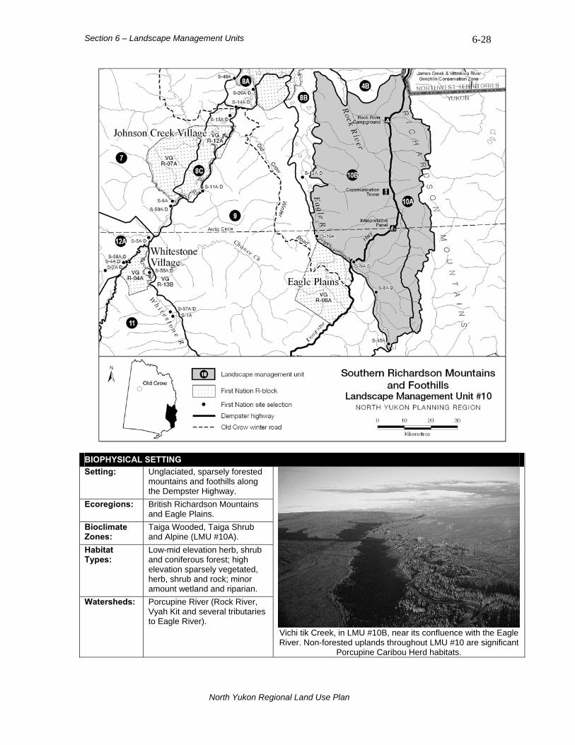
Section 6 – Landscape Management Units 6-28
BIOPHYSICAL SETTING Setting: Unglaciated, sparsely forested
mountains and foothills along the Dempster Highway.
Ecoregions: British Richardson Mountains and Eagle Plains.
Bioclimate Zones:
Taiga Wooded, Taiga Shrub and Alpine (LMU #10A).
Habitat Types:
Low-mid elevation herb, shrub and coniferous forest; high elevation sparsely vegetated, herb, shrub and rock; minor amount wetland and riparian.
Watersheds: Porcupine River (Rock River, Vyah Kit and several tributaries to Eagle River).
Vichi tik Creek, in LMU #10B, near its confluence with the Eagle River. Non-forested uplands throughout LMU #10 are significant
Porcupine Caribou Herd habitats.
North Yukon Regional Land Use Plan
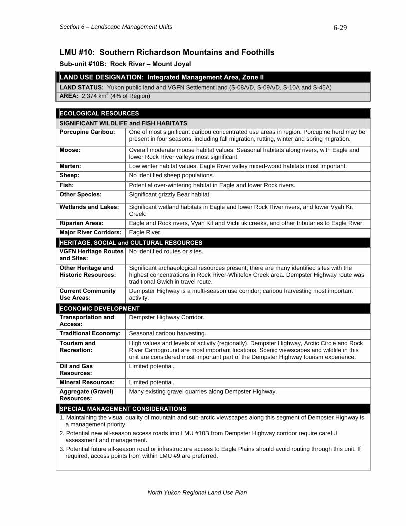
Section 6 – Landscape Management Units 6-29
LMU #10: Southern Richardson Mountains and Foothills Sub-unit #10B: Rock River – Mount Joyal
LAND USE DESIGNATION: Integrated Management Area, Zone II LAND STATUS: Yukon public land and VGFN Settlement land (S-08A/D, S-09A/D, S-10A and S-45A) AREA: 2,374 km2 (4% of Region)
ECOLOGICAL RESOURCES SIGNIFICANT WILDLIFE and FISH HABITATS Porcupine Caribou:
One of most significant caribou concentrated use areas in region. Porcupine herd may be present in four seasons, including fall migration, rutting, winter and spring migration.
Moose: Overall moderate moose habitat values. Seasonal habitats along rivers, with Eagle and lower Rock River valleys most significant.
Marten: Low winter habitat values. Eagle River valley mixed-wood habitats most important. Sheep: No identified sheep populations. Fish: Potential over-wintering habitat in Eagle and lower Rock rivers. Other Species: Significant grizzly Bear habitat.
Wetlands and Lakes: Significant wetland habitats in Eagle and lower Rock River rivers, and lower Vyah Kit Creek.
Riparian Areas: Eagle and Rock rivers, Vyah Kit and Vichi tik creeks, and other tributaries to Eagle River. Major River Corridors: Eagle River.
HERITAGE, SOCIAL and CULTURAL RESOURCES VGFN Heritage Routes and Sites:
No identified routes or sites.
Other Heritage and Historic Resources:
Significant archaeological resources present; there are many identified sites with the highest concentrations in Rock River-Whitefox Creek area. Dempster Highway route was traditional Gwich’in travel route.
Current Community Use Areas:
Dempster Highway is a multi-season use corridor; caribou harvesting most important activity.
ECONOMIC DEVELOPMENT Transportation and Access:
Dempster Highway Corridor.
Traditional Economy: Seasonal caribou harvesting. Tourism and Recreation:
High values and levels of activity (regionally). Dempster Highway, Arctic Circle and Rock River Campground are most important locations. Scenic viewscapes and wildlife in this unit are considered most important part of the Dempster Highway tourism experience.
Oil and Gas Resources:
Limited potential.
Mineral Resources: Limited potential. Aggregate (Gravel) Resources:
Many existing gravel quarries along Dempster Highway.
SPECIAL MANAGEMENT CONSIDERATIONS 1. Maintaining the visual quality of mountain and sub-arctic viewscapes along this segment of Dempster Highway is
a management priority. 2. Potential new all-season access roads into LMU #10B from Dempster Highway corridor require careful
assessment and management. 3. Potential future all-season road or infrastructure access to Eagle Plains should avoid routing through this unit. If
required, access points from within LMU #9 are preferred.
North Yukon Regional Land Use Plan
Section 6 – Landscape Management Units 6-30
Sub-unit #10B: Rock River – Mount Joyal SPECIAL MANAGEMENT CONSIDERATIONS (cont.) 4. Important Porcupine Caribou Herd concentrated use area during fall, winter and spring periods. 5. Tetlit Gwich’in Secondary Use Area and Na-cho Nyak Dun Traditional Territory (east of Dempster Highway). 6. Potential Yukon North Slope transportation corridor options from Dempster Highway may require consideration.
North Yukon Regional Land Use Plan
Section 6 – Landscape Management Units 6-31
LMU #11: Whitestone River LAND USE DESIGNATION: Integrated Management Area, Zone III LAND STATUS: Yukon public land and VGFN Settlement land (VG R-04A, R-09A, R-13B, S-01A, S-55A/D and
S-57A/D) AREA: 1,740 km2 (3% of Region)
ECOLOGICAL RESOURCES SIGNIFICANT WILDLIFE and FISH HABITATS Porcupine Caribou:
Concentrated and general use area during fall rutting and winter seasons. Important migration route along higher elevation ridges.
Moose: Significant seasonal habitats along Major River corridors (Whitestone and Miner).
Marten: Moderate - high value winter habitats; mixed-wood riparian habitats most important. Sheep: No known sheep populations. Fish: Significant fish habitats. Important fish over-wintering and spawning habitats in both Miner
and Whitestone rivers. Other Species: Important bear habitat (riparian areas).
Wetlands and Lakes: Significant wetland habitats in Whitestone and Miner river corridors; area around Whitestone village of special significance.
Riparian Areas: Regionally significant mixed-wood riparian forests along Whitestone and Miner rivers. Major River Corridors:
Whitestone and Miner rivers.
HERITAGE, SOCIAL and CULTURAL RESOURCES VGFN Heritage Routes and Sites:
No identified heritage routes or sites.
Other Heritage and Historic Resources:
Concentration of heritage resources at confluence of Miner, Fishing Branch and Whitestone rivers, including documented archaeological sites. Whitestone Village and surrounding landscape was important traditional use area.
Current Community Use Areas:
Summer use at Whitestone Village and along Major River Corridors.
ECONOMIC DEVELOPMENT Transportation and Access:
No existing transportation infrastructure.
Traditional Economy: Infrequent summer use; general travel and subsistence harvesting. Tourism and Recreation:
Low interests and activity. Whitestone Village possible future tourism interest.
Oil and Gas Resources:
High potential; contains a prospective portion of Eagle Plain oil and gas basin.
Mineral Resources: Overall low potential. Small area of high potential in western portion of unit. Aggregate (Gravel) Resources:
No identified resources.
SPECIAL MANAGEMENT CONSIDERATIONS 1. The confluence of Whitestone, Miner and Fishing Branch rivers, in vicinity of Whitestone Village, is an
ecologically important area. 2. Western boundary is adjacent to Fishing Branch HPA (LMU #12B). 3. Whitestone and Miner rivers contain documented salmon spawning and over-wintering habitats. 4. Most of this unit was affected by wildfire in summer of 2004. 5. Adjacent to Tr’ondëk Hwëch’in Traditional Territory (south of 66°N latitude)
North Yukon Regional Land Use Plan
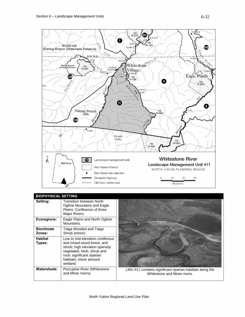
Section 6 – Landscape Management Units 6-32
BIOPHYSICAL SETTING Setting: Transition between North
Ogilvie Mountains and Eagle Plains. Confluence of three Major Rivers.
Ecoregions: Eagle Plains and North Ogilvie Mountains.
Bioclimate Zones:
Taiga Wooded and Taiga Shrub (minor).
Habitat Types:
Low to mid-elevation coniferous and mixed-wood forest, and shrub; high elevation sparsely vegetated, herb, shrub and rock; significant riparian habitats; minor amount wetland.
Watersheds: Porcupine River (Whitestone and Miner rivers).
LMU #11 contains significant riparian habitats along the Whitestone and Miner rivers.
North Yukon Regional Land Use Plan

Section 6 – Landscape Management Units 6-33
LMU #12: Ni’iinlii’njik (Fishing Branch) SMA Sub-unit #12A: Ni'iinlii'njik Protected Area
LAND USE DESIGNATION: Protected Area LAND STATUS: Yukon public land (Ni'iinlii'njik Wilderness Preserve, Fishing Branch Ecological Reserve) and VGFN Settlement land (VG R-05A and several S-Sites) AREA: 5,524 km2 (10% of Region)
Overview The Ni'iinlii'njik Protected Area is managed under the Ni'iinlii'njik (Fishing Branch) SMA Management Plans (Yukon Department of Environment and Vuntut Gwitchin Government, 2004a,b). A detailed description of the ecological, cultural and economic values of the area is contained in the management plans. The Protected Area portion of the SMA is centered on the Fishing Branch Ecological Reserve and VG R-05A (Bear Cave Mountain), a unique groundwater – salmon spawning – grizzly bear system. Limestone caves host significant archaeological and paleontological resources. Protection and interpretation of ecological and cultural resources is the primary management objective for the Protected Area. Ni'iinlii'njik was established in 1999.
SPECIAL MANAGEMENT CONSIDERATIONS 1. See Ni'iinlii'njik (Fishing Branch) SMA Management Plans (Yukon Department of Environment and Vuntut
Gwitchin Government, 2004a,b).
Sub-unit #12B: Fishing Branch HPA
LAND USE DESIGNATION: Habitat Protection Area LAND STATUS: Yukon public land (Habitat Protection Area) AREA: 980 km2 (2% of Region)
Overview The Fishing Branch HPA is part of the Ni'iinlii'njik SMA, and is also managed under Yukon Department of Environment and Vuntut Gwitchin Government (2004a). A detailed description its ecological, cultural and economic values is contained in the management plan. The Fishing Branch HPA encompasses many ecological and heritage resources, and is intended to act as a buffer for the core Protected Area. The HPA is managed to maintain ecological integrity and protect heritage resources, but is not withdrawn from land disposition and resource exploration and development. The current management plan should be referenced for guidelines regarding any land use activity within the HPA.
SPECIAL MANAGEMENT CONSIDERATIONS 1. See Fishing Branch HPA Management Plan (Yukon Department of Environment and Vuntut Gwitchin
Government, 2004a). 2. Southern boundary is adjacent to the Tr’ondëk Hwëch’in Traditional Territory (south of 66°N latitude).
RECOMMENDATIONS
• The Fishing Branch Committee of Managing Agencies should
consider applying the land use designation concepts and criteria used in this Plan to the Fishing Branch HPA at the next HPA management plan review.
• Further delineation of the Fishing Branch HPA southern boundary should also be considered during the next HPA management plan review.
North Yukon Regional Land Use Plan
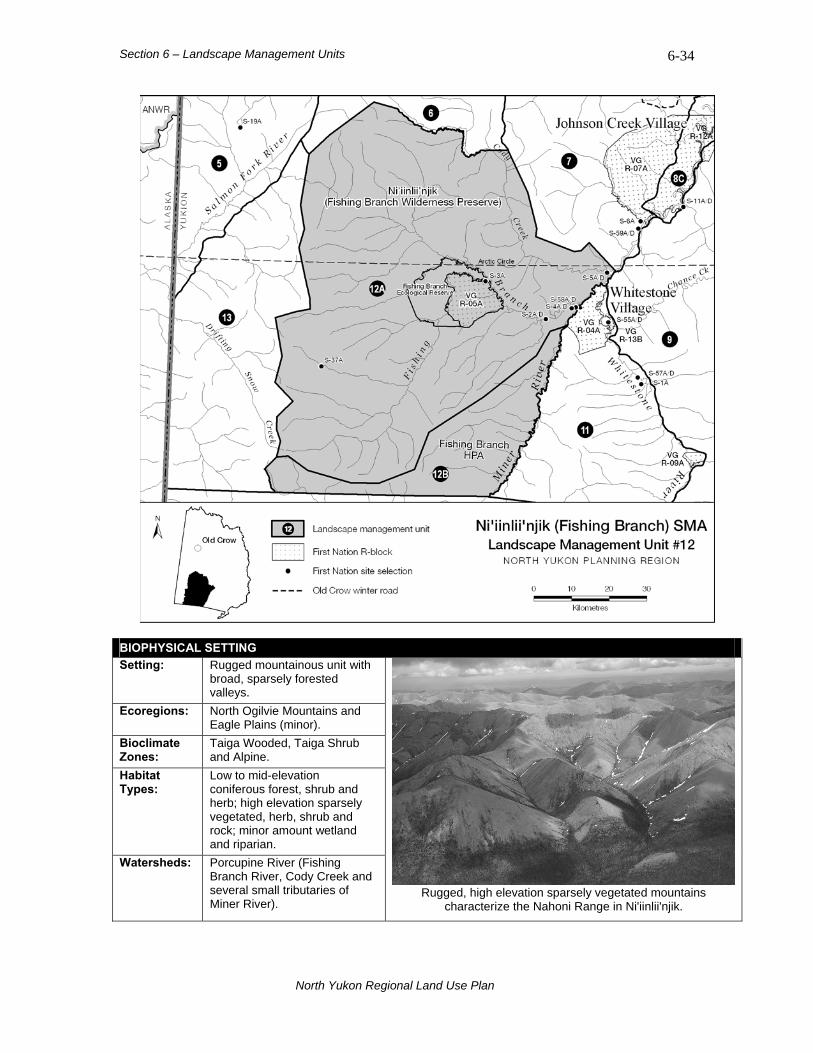
Section 6 – Landscape Management Units 6-34
BIOPHYSICAL SETTING Setting: Rugged mountainous unit with
broad, sparsely forested valleys.
Ecoregions: North Ogilvie Mountains and Eagle Plains (minor).
Bioclimate Zones:
Taiga Wooded, Taiga Shrub and Alpine.
Habitat Types:
Low to mid-elevation coniferous forest, shrub and herb; high elevation sparsely vegetated, herb, shrub and rock; minor amount wetland and riparian.
Watersheds: nd
ributaries of Miner River).
Porcupine River (Fishing Branch River, Cody Creek aseveral small t Rugged, high elevation sparsely vegetated mountains
characterize the Nahoni Range in Ni'iinlii'njik.
North Yukon Regional Land Use Plan
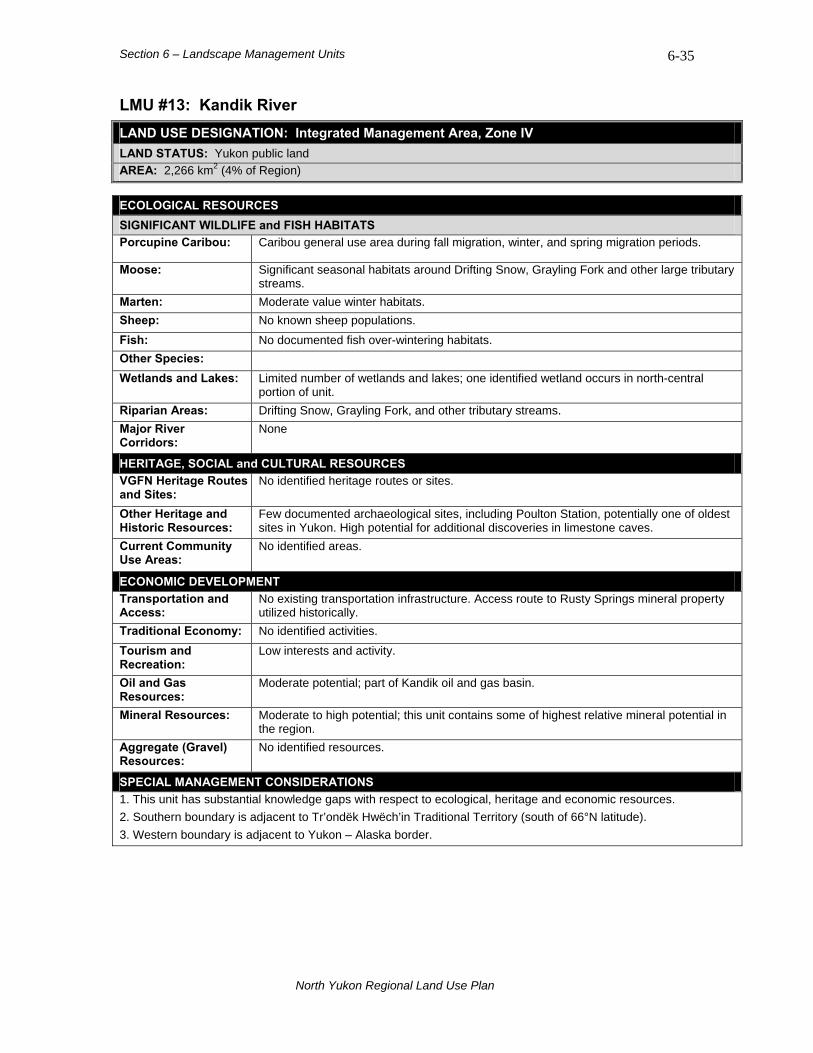
Section 6 – Landscape Management Units 6-35
LMU #13: Kandik River LAND USE DESIGNATION: Integrated Management Area, Zone IV LAND STATUS: Yukon public land AREA: 2,266 km2 (4% of Region)
ECOLOGICAL RESOURCES SIGNIFICANT WILDLIFE and FISH HABITATS Porcupine Caribou: Caribou general use area during fall migration, winter, and spring migration periods.
Moose: Significant seasonal habitats around Drifting Snow, Grayling Fork and other large tributary streams.
Marten: Moderate value winter habitats. Sheep: No known sheep populations. Fish: No documented fish over-wintering habitats. Other Species: Wetlands and Lakes: Limited number of wetlands and lakes; one identified wetland occurs in north-central
portion of unit. Riparian Areas: Drifting Snow, Grayling Fork, and other tributary streams. Major River Corridors:
None
HERITAGE, SOCIAL and CULTURAL RESOURCES VGFN Heritage Routes and Sites:
No identified heritage routes or sites.
Other Heritage and Historic Resources:
Few documented archaeological sites, including Poulton Station, potentially one of oldest sites in Yukon. High potential for additional discoveries in limestone caves.
Current Community Use Areas:
No identified areas.
ECONOMIC DEVELOPMENT Transportation and Access:
No existing transportation infrastructure. Access route to Rusty Springs mineral property utilized historically.
Traditional Economy: No identified activities. Tourism and Recreation:
Low interests and activity.
Oil and Gas Resources:
Moderate potential; part of Kandik oil and gas basin.
Mineral Resources: Moderate to high potential; this unit contains some of highest relative mineral potential in the region.
Aggregate (Gravel) Resources:
No identified resources.
SPECIAL MANAGEMENT CONSIDERATIONS 1. This unit has substantial knowledge gaps with respect to ecological, heritage and economic resources. 2. Southern boundary is adjacent to Tr’ondëk Hwëch’in Traditional Territory (south of 66°N latitude). 3. Western boundary is adjacent to Yukon – Alaska border.
North Yukon Regional Land Use Plan
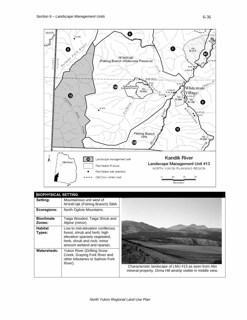
Section 6 – Landscape Management Units 6-36
BIOPHYSICAL SETTING Setting: Mountainous unit west of
Ni’iinlii’njik (Fishing Branch) SMA Ecoregions: North Ogilvie Mountains.
Bioclimate Zones:
Taiga Wooded, Taiga Shrub and Alpine (minor).
Habitat Types:
Low to mid-elevation coniferous forest, shrub and herb; high elevation sparsely vegetated, herb, shrub and rock; minor amount wetland and riparian.
Watersheds: Yukon River (Drifting Snow Creek, Graying Fork River and other tributaries to Salmon Fork River).
Characteristic landscape of LMU #13 as seen from Alto mineral property. Orma Hill airstrip visible in middle view.
North Yukon Regional Land Use Plan

Section 7 – Plan Implementation and Revision
7-1
7. Plan Implementation and Revision The implementation of a land use plan is a crucial stage in the planning process. It is during implementation that the guiding principles, goals and objectives of the Plan are put into action. Periodic monitoring of Plan implementation activities provides an opportunity to evaluate its effectiveness, to determine if goals and objectives are being met, and to determine whether the Plan has been used in land and resource decision-making processes. If land use circumstances change in the region, changes to the Plan may be necessary.
7.1 Plan Implementation The Parties to the Plan, the Yukon and Vuntut Gwitchin governments, will make best efforts to implement the Plan in its entirety. However, Plan implementation is at the discretion of the Parties. Nothing in this Plan diminishes the ability of the Parties to make land and resource decisions under their current authority. This Plan provides a framework and tools that enable the Parties to make well-informed land and resource management decisions. The Plan also provides guidance to land and resource users when developing project proposals, and when conducting land use activities in the region. The Parties will develop a detailed Plan implementation strategy concurrently with, or subsequent to, the approval of a Final Land Use Plan.
7.1.1 Implementation Responsibilities The Yukon and Vuntut Gwitchin governments are the Parties to the North Yukon Land Use Plan; they have primary responsibilities for its implementation. Implementation responsibilities may also involve other groups, including the following:
• North Yukon Planning Commission (NYPC);
• Yukon Land Use Planning Council (YLUPC);
• Yukon Environmental and Socio-economic Assessment Board (YESAB);
• Government of Canada; and,
• UFA boards and committees. Until an agreement between the Parties has been reached, implementation roles and responsibilities for other groups are undetermined.
North Yukon Regional Land Use Plan

Section 7 – Plan Implementation and Revision
7-2
7.2 Plan Revision This Plan is intended to be a living document, open to change and revision at periodic intervals, as agreed to by the Parties. The VGFN Final Agreement provides for these revisions. Periodic changes to the Plan can incorporate new research findings and contribute to improved decision-making. A process for reviewing and changing the Plan supports the adaptive management approach. Changes to the Plan may be required when:
• New land management concepts emerge;
• New land and resource information becomes available;
• Knowledge about land use impacts is advanced;
• Land management values that the Plan is based upon change; or,
• Demand for land and resources in the region changes. There are three ways to accommodate changes to the Plan:
• Plan Variance: when minor changes to the Plan are required;
• Plan Amendment: when alterations to management strategies presented in the Plan are required; and,
• Plan Review: a formal process when the entire Plan is re-evaluated, usually when major changes and revisions to the Plan are deemed necessary.
Plan Reviews will occur on an agreed-upon schedule, or whenever the Yukon and Vuntut Gwitchin governments agree, it is required. Methods and timelines for changing the Plan will be developed as part of the detailed implementation strategy.
7.2.1 Plan Review Check-list The status of Plan recommendations should be evaluated in future Plan Reviews. When preparing the Plan, NYPC received comments regarding research or management items for additional consideration. Some have been deferred for future consideration. Table 7.1 lists suggested items for consideration in future Plan Reviews.
North Yukon Regional Land Use Plan
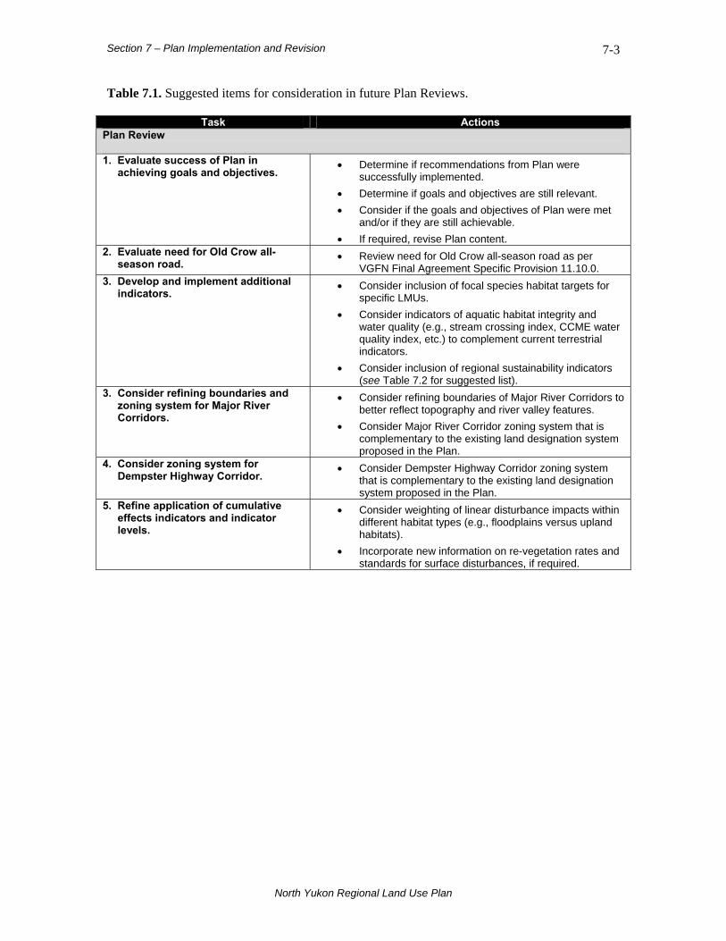
Section 7 – Plan Implementation and Revision
7-3
Table 7.1. Suggested items for consideration in future Plan Reviews.
Task Actions Plan Review 1. Evaluate success of Plan in
achieving goals and objectives. • Determine if recommendations from Plan were
successfully implemented. • Determine if goals and objectives are still relevant. • Consider if the goals and objectives of Plan were met
and/or if they are still achievable. • If required, revise Plan content.
2. Evaluate need for Old Crow all-season road.
• Review need for Old Crow all-season road as per VGFN Final Agreement Specific Provision 11.10.0.
3. Develop and implement additional indicators.
• Consider inclusion of focal species habitat targets for specific LMUs.
• Consider indicators of aquatic habitat integrity and water quality (e.g., stream crossing index, CCME water quality index, etc.) to complement current terrestrial indicators.
• Consider inclusion of regional sustainability indicators (see Table 7.2 for suggested list).
3. Consider refining boundaries and zoning system for Major River Corridors.
• Consider refining boundaries of Major River Corridors to better reflect topography and river valley features.
• Consider Major River Corridor zoning system that is complementary to the existing land designation system proposed in the Plan.
4. Consider zoning system for Dempster Highway Corridor.
• Consider Dempster Highway Corridor zoning system that is complementary to the existing land designation system proposed in the Plan.
5. Refine application of cumulative effects indicators and indicator levels.
• Consider weighting of linear disturbance impacts within different habitat types (e.g., floodplains versus upland habitats).
• Incorporate new information on re-vegetation rates and standards for surface disturbances, if required.
North Yukon Regional Land Use Plan

Section 7 – Plan Implementation and Revision
7-4
Table 7.2. Potential regional indicators for sustainable development.
Indicator-Type
Indicator Current Indicator Status
Description
Old Crow Population
270 people (2005 census)
Provides measure of Old Crow population trend – reflective of general social and economic conditions. Reported by Yukon Bureau of Statistics.
Old Crow resident time-on-the-land
From ABEKC reports
Provides measure of resident participation in subsistence economy and traditional pursuits. Reported by Arctic Borderlands Ecological Knowledge Co-op (ABEKC).
Availability of Current Use Areas
From VGG Natural Resources Dept.
Provides measure of loss/gain of current use areas for subsistence harvesting and cultural purposes as a result of other land use activities. Not currently reported but current use areas were documented in this Plan.
Number of Old Crow residents receiving social assistance
From VGG Social Services
Provides measure of self-sufficiency of individuals – reflective of general social and economic conditions. Reported by VGG Social Services.
Regional Gross Domestic Product (GDP)
From Yukon Economic Development
Provides measure of regional economic activity and production.
Median Household Income $28,224 (120 households)
Provides measure of household monetary wealth / wage income. Reported by Canada Census.
Median Individual Income for Women
$14,667 (105 females)
Provides measure of individual female (15 yrs and older) monetary wealth / wage income. Female vs. male income levels should be tracked to establish gender wage-based equity. Reported by Canada Census.
Socio-Economic
Median Individual Income for Men
$15,232 (105 males)
Provides measure of individual male (15 yrs and older) monetary wealth / wage income. Reported by Canada Census.
North Yukon Regional Land Use Plan

Section 7 – Plan Implementation and Revision
7-5
Table 7.2 (cont’d). Potential regional indicators for sustainable development.
Indicator-Type
Indicator Current Indicator Status
Description
Porcupine Caribou Herd population status
Estimated at 110,000 animals
PCH is the most important ecological and social value to Vuntut Gwitchin residents. Barren ground population declines in neighbouring Canadian herds are being experienced. Reported by YG/Alaska Department of Fish and Game/PCMB.
Regional habitat integrity Annual Regional Assessments
Regional assessment of terrestrial habitat conditions, including “hot spot” identification. Surface disturbance and linear density indicators provide measure of habitat integrity.
Landscape Management Unit habitat integrity
Annual Regional Assessments
Assessment of terrestrial habitat conditions by LMU. Surface disturbance and linear density indicators provide measure of habitat integrity.
Regional aquatic habitat integrity
Annual Regional Assessments
Regional assessment of aquatic habitat conditions, including “hot spot” identification. Stream crossing index and water quality suggested as future indicators.
Ecological
Landscape Management Unit (or watershed) aquatic habitat integrity
Annual Regional Assessments
Regional assessment of aquatic habitat conditions by LMU or watershed. Future indicator. Stream crossing index and water quality suggested as future indicators.
North Yukon Regional Land Use Plan
Section 8 – References 8-1
8. References Council of Ministers Responsible for Transportation and Highway Safety. 2005. National
Highway System Review Task Force Report (v. September 2005). Council of Ministers Responsible for Transportation and Highway Safety. Unpublished document. 52 pp.
Department of Indian Affairs and Northern Development. 1993. Vuntut Gwitchin First Nation
Final Agreement. Department of Indian Affairs and Northern Development. Ottawa, ON, Canada. 414 pp.
Fisheries and Oceans Canada. Fisheries and Oceans Canada – oceans and fish habitat.
Streamlining referrals. Accessed April 28, 2007. Department of Fisheries and Oceans Canada website: www.dfo-mpo.gc.ca
Gray, D.R., and Alt, B.T. 2001. Resource description and analysis of Vuntut National Park of
Canada. Parks Canada, Western Canada Service Centre. Final Report. 54 pp. Gwich’in Land Use Planning Board. 2003. Nành’ Geenjit Gwitr’it Tigwaa’in, Working for the
Land – The Gwich’in Land Use Plan (v. August 2003). Gwich’in Land Use Planning Board. Inuvik, NT, Canada. 166 pp.
International Institute for Sustainable Development. IISD Definitions. Accessed October, 2007.
IISD website: www.iisd.org. Kennedy, K., and Froese, D. 2008. Aggregate resource exploration using a process-depositional
model of meltwater channel development in the Eagle Plains area, northern Yukon. In: Emond, D.S., Blackburn, L.R., Hill, R.P., and L.H. Weston (editors), Yukon Exploration and Geology 2007. Yukon Geological Survey, p. 169-178.
MacKenzie Delta-Beaufort Sea Regional Land Use Planning Commission. 1991. A community-
based regional land use plan for the MacKenzie Delta-Beaufort Sea Region (v. October 1991). MacKenzie Delta-Beaufort Sea Regional Land Use Planning Commission. Inuvik, NT, Canada. 318 pp.
Mining Environment Research Group. 2006. Flying in sheep country: how to minimize
disturbance from aircraft. MERG Report 2002-6, Whitehorse, YT, Canada. 17 pp. National Wetlands Working Group. 1988. Wetlands of Canada. Ecological Land Classification
Series no. 24. Sustainable Development Branch. Environment Canada, Ottawa, Ontario and Polyscience Publications Inc. Montreal, Quebec, Canada. 452 pp.
North Yukon Planning Commission. 2007a. North Yukon Planning Region Resource Assessment
Report. NYPC website: www.nypc.planyukon.ca. North Yukon Planning Commission. 2007b. North Yukon Planning Region Resource Assessment
Report - Maps. NYPC website: www.nypc.planyukon.ca. North Yukon Planning Commission. 2009. North Yukon Planning Region Land Use Scenarios
Report. NYPC website: www.nypc.planyukon.ca.
North Yukon Regional Land Use Plan
Section 8 – References 8-2
Parks Canada. 2003. Standards and Guidelines for Conservation of Historic Places in Canada.
Parks Canada. Ottawa, ON, Canada. 174 pp. Parks Canada, Vuntut Gwitchin First Nation, and North Yukon Renewable Resources Council.
2004. Vuntut National Park of Canada Management Plan. Parks Canada. Whitehorse, YT, Canada. 79 pp.
Petrula, M.J. 1994. Ecology of ducks nesting in interior Alaska. M.S. Thesis, University of
Alaska, Fairbanks. 124 pp. Porcupine Caribou Management Board. 2000. Porcupine Caribou Herd Management Plan –
2000/2001 to 2002/2003. PCMB, Whitehorse, YT, Canada. 28 pp. Vuntut Gwitchin First Nation. 2000. Old Crow Physical Development Plan. Prepared by
Inukshuk Planning & Development. Whitehorse, YT, Canada. February, 2000. 21 pp. Vuntut Gwitchin First Nation. 2003. Old Crow Capital Plan, 2003-2008. Prepared by Inukshuk
Planning & Development. Whitehorse, YT, Canada. February, 2003. 26 pp. Vuntut Gwitchin First Nation, Government of Canada, and Yukon Territorial Government. 1998.
Vuntut Gwitchin First Nation Economic Opportunities Plan. Unpublished document. VGFN. Old Crow, YT, Canada. 16 pp.
Vuntut Gwitchin First Nation and Government of Yukon. 1999. Rampart House Historic Site and
Lapierre House Historic Site Management Plan. Prepared by Ecogistics Consulting. Wells, BC, Canada. 281 pp.
Working Group for Northern Richardson Mountains Dall’s Sheep. 2008. Management Plan for
Dall’s Sheep in the Northern Richardson Mountains (2008-2013). Recommended Draft Plan. June 20, 2008. 33 pp.
Yukon Department of Energy, Mines and Resources, Oil and Gas Management Branch. 2007a.
Best Management Practices for Historic Resources. Yukon Government Oil and Gas Best Management Practices website. Accessed April 28, 2007. Website: www.emr.gov.yk.ca
Yukon Department of Energy, Mines and Resources, Oil and Gas Management Branch. 2007b.
Best Management Practices for Seismic Exploration. Yukon Government Oil and Gas Best Management Practices website. Accessed April 28, 2007. Website: www.emr.gov.yk.ca
Yukon Department of Energy, Mines and Resources, Oil and Gas Management Branch. 2007c.
Best Management Practices for Wilderness Tourism. Yukon Government Oil and Gas Best Management Practices website. Accessed April 30, 2007. Website: www.emr.gov.yk.ca
Yukon Department of Environment. 1996. Guidelines for Reclamation/Re-vegetation in the
Yukon – Volume II. Kennedy, C.E. (ed.). Whitehorse, YT, Canada. Yukon Department of Environment and Vuntut Gwitchin Government. 2004a. Ni’iinlii’Njik
(Fishing Branch) Wilderness Preserve & Habitat Protection Area Management Plan. Fishing Branch Local Planning Team. 32 pp.
North Yukon Regional Land Use Plan
Section 8 – References 8-3
Yukon Department of Environment and Vuntut Gwitchin Government. 2004b. Ni’iinlii’Njik (Fishing Branch) Ecological Reserve and Settlement Land R-5A & S-3A1 Management Plan. Fishing Branch Local Planning Team. 42 pp.
Yukon Department of Environment and Vuntut Gwitchin Government. 2006. Old Crow Flats
Special Management Area Management Plan. Old Crow Flats Technical Working Group and Management Committee. 54 pp.
Yukon Department of Environment, Vuntut Gwitchin First Nation and North Yukon Renewable
Resources Council. 2008. North Yukon Fish and Wildlife Management Plan. A guide to the management of fish and wildlife in the traditional territory of the Vuntut Gwitchin. 29 pp.
Yukon Department of Tourism and Culture and Vuntut Gwitchin First Nation. 2006. North
Yukon Tourism Strategy. Prepared by TransNorthern Management Consulting. Whitehorse, YT, Canada. March, 2004. 47 pp.
Yukon Environmental and Socio-economic Assessment Board. 2007. Flow Tests at Three
Existing Well-Sites. YESAA Designated Office Evaluation Report, Project File Number 2006-0285. Dawson, YT, Canada. 101 pp.
Yukon Government, Vuntut Gwitchin First Nation, First Nation of Nacho Nyak Dun, and
Tr’ondek Hwech’in First Nation. 2006. Northern Yukon Economic Development Partnership Agreement – Dempster corridor economic opportunities identification. Unpublished document. Yukon Government. Whitehorse, YT, Canada. 7 pp.
Yukon Government, Department of Energy Mines and Resources. 2003. Conceptual study report
to identify potential natural resource infrastructure access corridors Yukon, 2002-2003. Prepared by Access Consulting Group, Whitehorse, YT. March, 2003. 89 pp.
Yukon Placer Implementation Steering Committee and the Yukon Placer Working Committee.
2005. An Integrated Regulatory Regime for Yukon Placer Mining (v. April 2005). Government of Yukon, Fisheries and Oceans Canada, Council of Yukon First Nations, and Klondike Placer Miners’ Association. Whitehorse, YT, Canada. 42 pp.
North Yukon Regional Land Use Plan

Appendix 1 - Maps
Appendix 1. Maps - Available by seperate download Map 1 – Land Use Categories and Integrated Management Area Zones
Map 2 – Ecologically Important Areas
Map 3 – Heritage Resources and Vuntut Gwitchin Land Use
Map 4 – Economic Development Potential and Interests
North Yukon Regional Land Use Plan
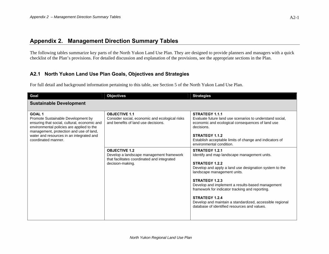
Appendix 2 – Management Direction Summary Tables A2-1
Appendix 2. Management Direction Summary Tables The following tables summarize key parts of the North Yukon Land Use Plan. They are designed to provide planners and managers with a quick checklist of the Plan’s provisions. For detailed discussion and explanation of the provisions, see the appropriate sections in the Plan. A2.1 North Yukon Land Use Plan Goals, Objectives and Strategies For full detail and background information pertaining to this table, see Section 5 of the North Yukon Land Use Plan. Goal Objectives Strategies
Sustainable Development
OBJECTIVE 1.1 Consider social, economic and ecological risks and benefits of land use decisions.
STRATEGY 1.1.1 Evaluate future land use scenarios to understand social, economic and ecological consequences of land use decisions. STRATEGY 1.1.2 Establish acceptable limits of change and indicators of environmental condition.
GOAL 1 Promote Sustainable Development by ensuring that social, cultural, economic and environmental policies are applied to the management, protection and use of land, water and resources in an integrated and coordinated manner.
OBJECTIVE 1.2 Develop a landscape management framework that facilitates coordinated and integrated decision-making.
STRATEGY 1.2.1 Identify and map landscape management units. STRATEGY 1.2.2 Develop and apply a land use designation system to the landscape management units. STRATEGY 1.2.3 Develop and implement a results-based management framework for indicator tracking and reporting. STRATEGY 1.2.4 Develop and maintain a standardized, accessible regional database of identified resources and values.
North Yukon Regional Land Use Plan
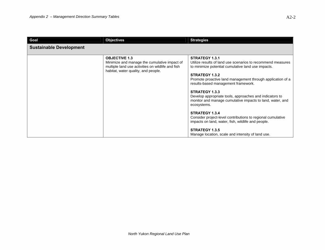
Appendix 2 – Management Direction Summary Tables A2-2
Goal Objectives Strategies
Sustainable Development
OBJECTIVE 1.3 Minimize and manage the cumulative impact of multiple land use activities on wildlife and fish habitat, water quality, and people.
STRATEGY 1.3.1 Utilize results of land use scenarios to recommend measures to minimize potential cumulative land use impacts. STRATEGY 1.3.2 Promote proactive land management through application of a results-based management framework. STRATEGY 1.3.3 Develop appropriate tools, approaches and indicators to monitor and manage cumulative impacts to land, water, and ecosystems. STRATEGY 1.3.4 Consider project-level contributions to regional cumulative impacts on land, water, fish, wildlife and people. STRATEGY 1.3.5 Manage location, scale and intensity of land use.
North Yukon Regional Land Use Plan

Appendix 2 – Management Direction Summary Tables A2-3
Goal Objectives Strategies
Ecological
OBJECTIVE 2.1 Minimize direct and indirect human-caused habitat disturbance and alteration.
STRATEGY 2.1.1 Reduce size, intensity and duration of human-caused physical surface disturbances (e.g., utilize low impact seismic, winter roads and enhanced reclamation). STRATEGY 2.1.2 Reduce other human land use impacts such as noise, smell and light.
OBJECTIVE 2.2 Minimize habitat fragmentation as a result of human features.
STRATEGY 2.2.1 Coordinate, manage and minimize new road and trail access.
WILDLIFE GOAL 2 Maintain the terrestrial habitat in a condition required to sustain regional wildlife populations.
OBJECTIVE 2.3 Minimize potential habitat avoidance that results from human features and activities.
STRATEGY 2.3.1 Avoid or reduce activities in significant wildlife habitats during important biological periods (e.g., utilize timing windows).
OBJECTIVE 3.1 Minimize human-caused aquatic habitat disturbance and alteration.
STRATEGY 3.1.1 Minimize surface and vegetation disturbance in riparian areas. STRATEGY 3.1.2 Avoid in-stream aggregate (gravel) extraction.
OBJECTIVE 3.2 Minimize stream crossings and/or stream crossing impacts as a result of roads and trails.
STRATEGY 3.2.1 Coordinate and manage road and trail access.
FISH GOAL 3 Maintain aquatic habitat in a condition required to sustain regional fish populations.
OBJECTIVE 3.3 Maintain significant fish over-wintering and spawning habitat.
STRATEGY 3.3.1 Avoid direct disturbance to sensitive over-wintering habitats. STRATEGY 3.3.2 Avoid significant salmon spawning habitat.
North Yukon Regional Land Use Plan

Appendix 2 – Management Direction Summary Tables A2-4
Goal Objectives Strategies
Ecological
STRATEGY 3.3.3Avoid or reduce activities in fish habitat during important biological periods or seasons (e.g., utilize timing windows). STRATEGY 3.3.4 Avoid or reduce winter in-stream water withdrawals in sensitive over-wintering fish habitat.
OBJECTIVE 3.4 Maintain fish migration routes and access to required seasonal habitats.
STRATEGY 3.4.1 Avoid direct or indirect blocking of identified fish migration routes.
OBJECTIVE 4.1 Minimize amount of human-caused surface disturbance within and adjacent to lakes, rivers, wetlands and sensitive permafrost areas.
STRATEGY 4.1.1 Avoid or minimize industrial land use activities in wetlands and riparian areas. STRATEGY 4.1.2 Coordinate and manage road and trail access. STRATEGY 4.1.3 Reduce surface and vegetation impacts in riparian and sensitive permafrost areas.
WETLANDS, LAKES and RIVERS GOAL 4 Maintain the integrity of wetlands, lakes, rivers and sensitive permafrost areas.
OBJECTIVE 4.2 Maintain wetland and riparian connectivity.
STRATEGY 4.2.1 Avoid or minimize industrial land use activities in wetlands and riparian areas. STRATEGY 4.2.2 Coordinate and manage road and trail access. STRATEGY 4.2.3 Reduce surface and vegetation impacts in riparian and sensitive permafrost areas. STRATEGY 4.2.4 Minimize alteration of drainage patterns, water flow and soil temperature.
North Yukon Regional Land Use Plan
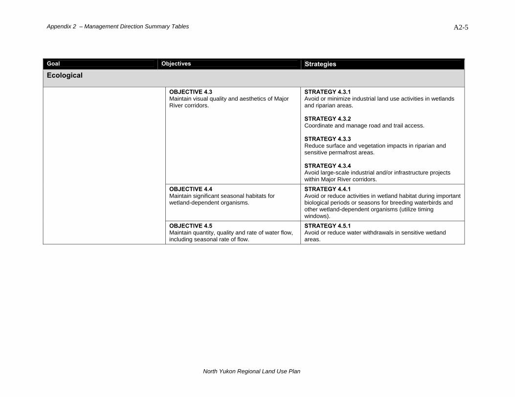
Appendix 2 – Management Direction Summary Tables A2-5
Goal Objectives Strategies
Ecological
OBJECTIVE 4.3 Maintain visual quality and aesthetics of Major River corridors.
STRATEGY 4.3.1 Avoid or minimize industrial land use activities in wetlands and riparian areas. STRATEGY 4.3.2 Coordinate and manage road and trail access. STRATEGY 4.3.3 Reduce surface and vegetation impacts in riparian and sensitive permafrost areas. STRATEGY 4.3.4 Avoid large-scale industrial and/or infrastructure projects within Major River corridors.
OBJECTIVE 4.4 Maintain significant seasonal habitats for wetland-dependent organisms.
STRATEGY 4.4.1 Avoid or reduce activities in wetland habitat during important biological periods or seasons for breeding waterbirds and other wetland-dependent organisms (utilize timing windows).
OBJECTIVE 4.5 Maintain quantity, quality and rate of water flow, including seasonal rate of flow.
STRATEGY 4.5.1 Avoid or reduce water withdrawals in sensitive wetland areas.
North Yukon Regional Land Use Plan

Appendix 2 – Management Direction Summary Tables A2-6
Goal Objectives Strategies
Socio-Economic
OBJECTIVE 5.1 Apply appropriate protection and conservation measures to identified heritage and cultural resources.
STRATEGY 5.1.1 Minimize land use impacts in the vicinity of identified heritage and historic resources. STRATEGY 5.1.2 Minimize land use conflicts by avoiding or reducing the level of land use activities in important subsistence harvesting and current community use areas. STRATEGY 5.1.3 Avoid or reduce activities in significant heritage and current community use areas during important seasonal use periods (e.g., utilize timing windows). STRATEGY 5.1.4 Where impacts to identified heritage and cultural sites and resources are unavoidable, implement appropriate mitigation practices.
HERITAGE, SOCIAL and CULTURAL RESOURCES GOAL 5 Recognize, conserve and promote the heritage and cultural resources and values of the Vuntut Gwitchin, other affected First Nations, and the Yukon.
OBJECTIVE 5.2 Provide opportunities for the continuation of First Nations land-based subsistence lifestyles and harvesting.
STRATEGY 5.2.1 Avoid or reduce activities in significant heritage and current community use areas during important seasonal use periods (e.g., utilize timing windows). STRATEGY 5.2.2 Where impacts to identified heritage and cultural sites and resources are unavoidable, implement appropriate mitigation practices.
North Yukon Regional Land Use Plan
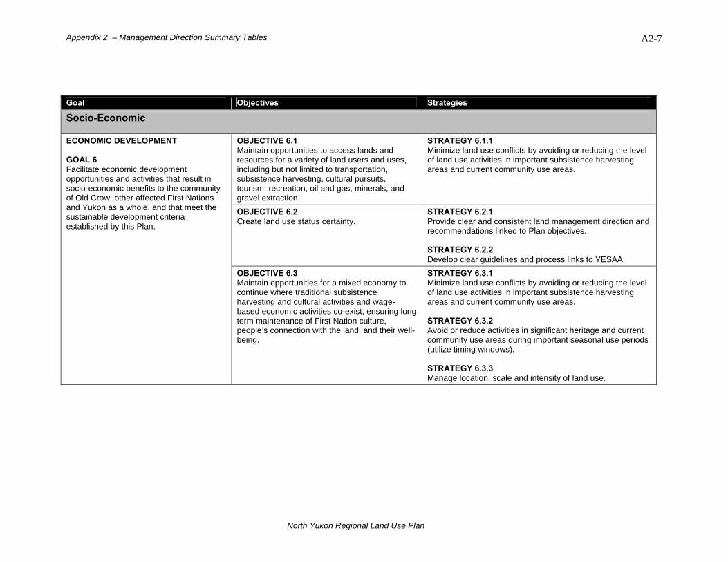
Appendix 2 – Management Direction Summary Tables A2-7
Goal Objectives Strategies
Socio-Economic
OBJECTIVE 6.1 Maintain opportunities to access lands and resources for a variety of land users and uses, including but not limited to transportation, subsistence harvesting, cultural pursuits, tourism, recreation, oil and gas, minerals, and gravel extraction.
STRATEGY 6.1.1 Minimize land use conflicts by avoiding or reducing the level of land use activities in important subsistence harvesting areas and current community use areas.
OBJECTIVE 6.2 Create land use status certainty.
STRATEGY 6.2.1 Provide clear and consistent land management direction and recommendations linked to Plan objectives. STRATEGY 6.2.2 Develop clear guidelines and process links to YESAA.
ECONOMIC DEVELOPMENT GOAL 6 Facilitate economic development opportunities and activities that result in socio-economic benefits to the community of Old Crow, other affected First Nations and Yukon as a whole, and that meet the sustainable development criteria established by this Plan.
OBJECTIVE 6.3 Maintain opportunities for a mixed economy to continue where traditional subsistence harvesting and cultural activities and wage-based economic activities co-exist, ensuring long term maintenance of First Nation culture, people’s connection with the land, and their well-being.
STRATEGY 6.3.1 Minimize land use conflicts by avoiding or reducing the level of land use activities in important subsistence harvesting areas and current community use areas. STRATEGY 6.3.2 Avoid or reduce activities in significant heritage and current community use areas during important seasonal use periods (utilize timing windows). STRATEGY 6.3.3 Manage location, scale and intensity of land use.
North Yukon Regional Land Use Plan

Appendix 2 – Management Direction Summary Tables A2-8
A2.2 North Yukon Land Use Plan Recommendations For full detail and background information pertaining to this table, see Sections 4 – 7 of the North Yukon Land Use Plan. Topic Recommendation
Section 4. Land Use Designation
Section 4.2.1 Whitefish Wetlands
LMU 8A, Whitefish – Porcupine Lakes, a sub-unit of Whitefish Wetlands, should be designated a Protected Area category (see Figure 4-1 for location). This area includes part of VG R-02A in the central portion of Whitefish Lakes and YG public land around Porcupine Lakes on the west bank of Porcupine River.
Section 4.2.2 Summit Lake – Bell River
LMU 4C, Summit Lake - Bell River, a sub-unit of the Northern Richardson Mountains and Foothills, should be designated a Protected Area category (see Figure 4-2 for location). This area is centered on Summit Lake-McDougall Pass and the lower Bell River corridor around Lapierre House, including portions of the upper Bell and LaChute river watersheds.
Section 4.4 North Yukon Land Withdrawal
Should the applicable authorities decide to lift the North Yukon Land Withdrawal at a future date, LMU 2A (Old Crow – Rampart House, LMU 3 (Driftwood River), and LMU 4A (Bell - Waters River) should be considered for Integrated Management Area Zone II designation (see Map 1, Appendix 1 for locations).
Section 5.1. Sustainable Development
Section 5.1.1 Cumulative Effects
As a general guideline for decision makers and land users, in the Integrated Management Area the amount of surface disturbance in a landscape management unit should be maintained below the cumulative effects indicator levels recommended in the Plan.
Site closure/remediation plans should be developed, implemented and monitored for large-scale industrial and/or infrastructure projects that create significant surface disturbance. Section 5.1.2.1
Surface Disturbances To provide a benchmark for the monitoring of cumulative effects indicator levels, the status of existing surface disturbances should be documented.
In the North Yukon Planning Region, potential climate change impacts should be considered in all land management decisions.
Section 5.1.3 Climate Change Due to the potential cumulative effects of climate change and land use impacts, sensitive wetland habitats and Porcupine Caribou
Herd habitats at risk of significant change should be managed more cautiously, and with a high level of conservation focus.
North Yukon Regional Land Use Plan
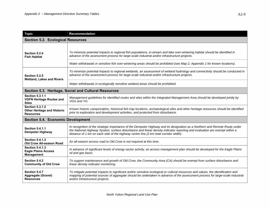
Appendix 2 – Management Direction Summary Tables A2-9
Topic Recommendation
Section 5.2. Ecological Resources
To minimize potential impacts to regional fish populations, in-stream and lake over-wintering habitat should be identified in advance of the assessment process for large-scale industrial and/or infrastructure projects.
Section 5.2.4 Fish Habitat
Water withdrawals in sensitive fish over-wintering areas should be prohibited (see Map 2, Appendix 1 for known locations).
To minimize potential impacts to regional wetlands, an assessment of wetland hydrology and connectivity should be conducted in advance of the assessment process for large-scale industrial and/or infrastructure projects. Section 5.2.5
Wetland, Lakes and Rivers Water withdrawals in ecologically sensitive wetland areas should be prohibited.
Section 5.3. Heritage, Social and Cultural Resources Section 5.3.1.1 VGFN Heritage Routes and Sites
Management guidelines for identified routes and sites within the Integrated Management Area should be developed jointly by VGG and YG.
Section 5.3.1.2 Other Heritage and Historic Resources
Known historic camps/cabins, historical fish trap locations, archaeological sites and other heritage resources should be identified prior to exploration and development activities, and protected from disturbance.
Section 5.4. Economic Development
Section 5.4.1.1 Dempster Highway
In recognition of the strategic importance of the Dempster Highway and its designation as a Northern and Remote Route under the National Highway System, surface disturbance and linear density indicator reporting and evaluation are exempt within a distance of 1 km on each side of the highway centre line (2-km total corridor width).
Section 5.4.1.2 Old Crow All-season Road An all-season access road to Old Crow is not required at this time.
Section 5.4.1.3 Eagle Plains Access Management
In advance of significant levels of energy sector activity, an access management plan should be developed for the Eagle Plains oil and gas basin.
Section 5.4.2 Community of Old Crow
To support maintenance and growth of Old Crow, the Community Area (CA) should be exempt from surface disturbance and linear density indicator monitoring.
Section 5.4.7 Aggregate (Gravel) Resources
To mitigate potential impacts to significant and/or sensitive ecological or cultural resources and values, the identification and mapping of potential sources of aggregate should be undertaken in advance of the assessment process for large-scale industrial and/or infrastructure projects.
North Yukon Regional Land Use Plan
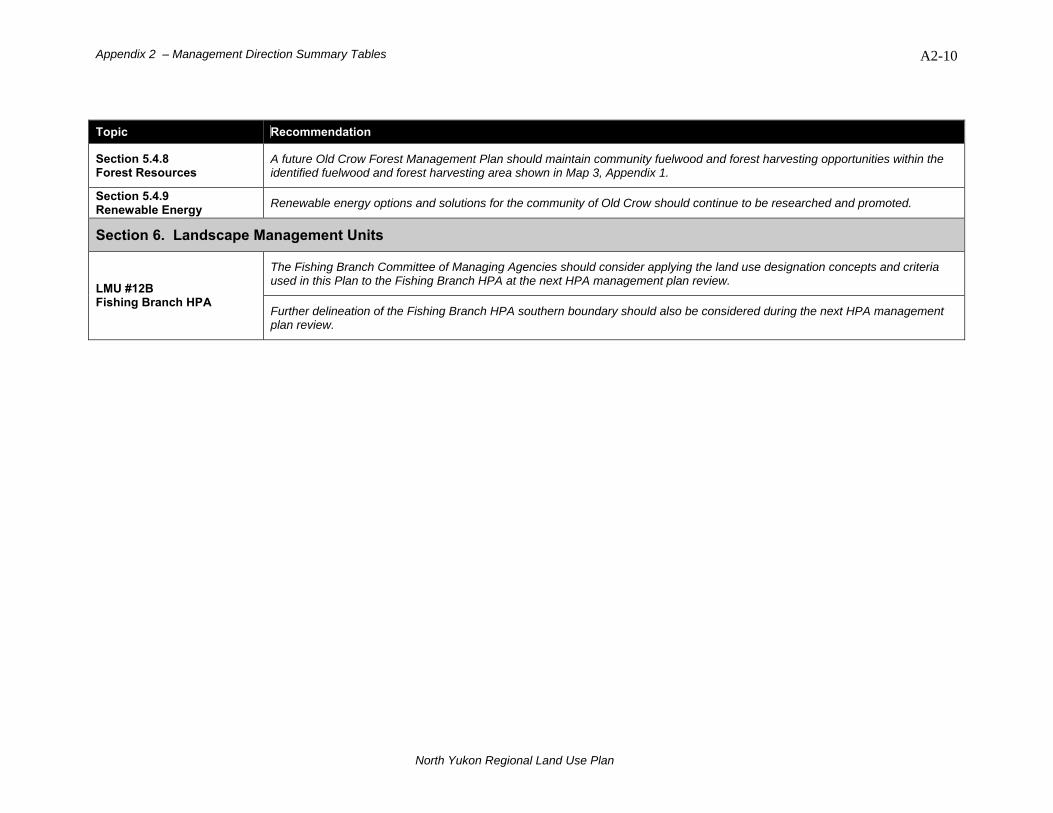
Appendix 2 – Management Direction Summary Tables A2-10
Topic Recommendation
Section 5.4.8 Forest Resources
A future Old Crow Forest Management Plan should maintain community fuelwood and forest harvesting opportunities within the identified fuelwood and forest harvesting area shown in Map 3, Appendix 1.
Section 5.4.9 Renewable Energy Renewable energy options and solutions for the community of Old Crow should continue to be researched and promoted.
Section 6. Landscape Management Units
The Fishing Branch Committee of Managing Agencies should consider applying the land use designation concepts and criteria used in this Plan to the Fishing Branch HPA at the next HPA management plan review. LMU #12B
Fishing Branch HPA Further delineation of the Fishing Branch HPA southern boundary should also be considered during the next HPA management plan review.
North Yukon Regional Land Use Plan
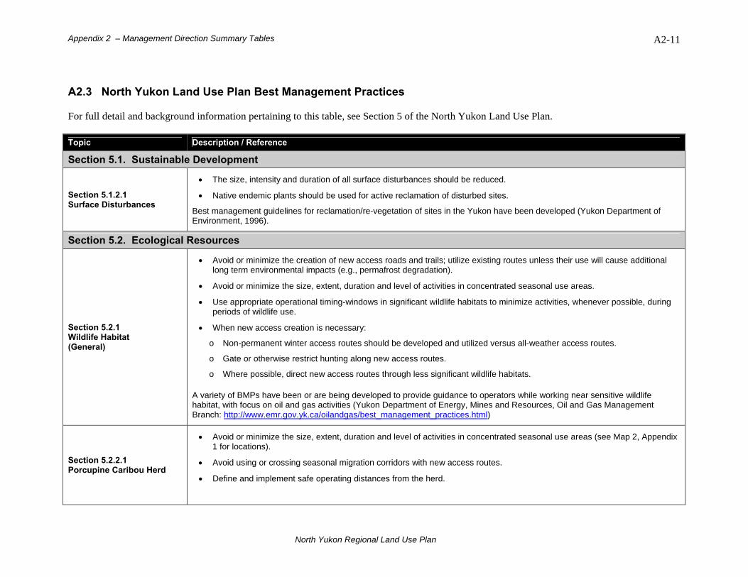
Appendix 2 – Management Direction Summary Tables A2-11
A2.3 North Yukon Land Use Plan Best Management Practices For full detail and background information pertaining to this table, see Section 5 of the North Yukon Land Use Plan. Topic Description / Reference
Section 5.1. Sustainable Development
Section 5.1.2.1 Surface Disturbances
• The size, intensity and duration of all surface disturbances should be reduced.
• Native endemic plants should be used for active reclamation of disturbed sites.
Best management guidelines for reclamation/re-vegetation of sites in the Yukon have been developed (Yukon Department of Environment, 1996).
Section 5.2. Ecological Resources
Section 5.2.1 Wildlife Habitat (General)
• Avoid or minimize the creation of new access roads and trails; utilize existing routes unless their use will cause additional long term environmental impacts (e.g., permafrost degradation).
• Avoid or minimize the size, extent, duration and level of activities in concentrated seasonal use areas.
• Use appropriate operational timing-windows in significant wildlife habitats to minimize activities, whenever possible, during periods of wildlife use.
• When new access creation is necessary:
o Non-permanent winter access routes should be developed and utilized versus all-weather access routes.
o Gate or otherwise restrict hunting along new access routes.
o Where possible, direct new access routes through less significant wildlife habitats.
A variety of BMPs have been or are being developed to provide guidance to operators while working near sensitive wildlife habitat, with focus on oil and gas activities (Yukon Department of Energy, Mines and Resources, Oil and Gas Management Branch: http://www.emr.gov.yk.ca/oilandgas/best_management_practices.html)
Section 5.2.2.1 Porcupine Caribou Herd
• Avoid or minimize the size, extent, duration and level of activities in concentrated seasonal use areas (see Map 2, Appendix 1 for locations).
• Avoid using or crossing seasonal migration corridors with new access routes.
• Define and implement safe operating distances from the herd.
North Yukon Regional Land Use Plan
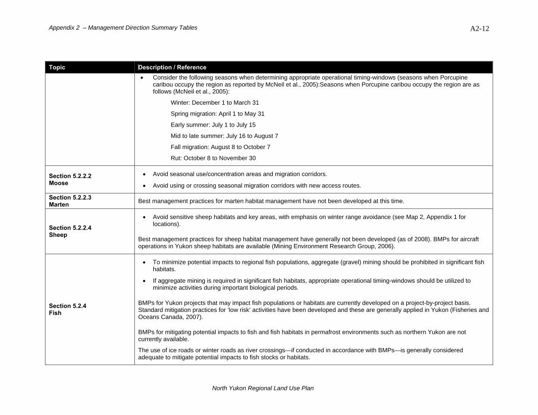
Appendix 2 – Management Direction Summary Tables A2-12
Topic Description / Reference • Consider the following seasons when determining appropriate operational timing-windows (seasons when Porcupine
caribou occupy the region as reported by McNeil et al., 2005):Seasons when Porcupine caribou occupy the region are as follows (McNeil et al., 2005):
Winter: December 1 to March 31
Spring migration: April 1 to May 31
Early summer: July 1 to July 15
Mid to late summer: July 16 to August 7
Fall migration: August 8 to October 7
Rut: October 8 to November 30
Section 5.2.2.2 Moose
• Avoid seasonal use/concentration areas and migration corridors.
• Avoid using or crossing seasonal migration corridors with new access routes.
Section 5.2.2.3 Marten Best management practices for marten habitat management have not been developed at this time.
Section 5.2.2.4 Sheep
• Avoid sensitive sheep habitats and key areas, with emphasis on winter range avoidance (see Map 2, Appendix 1 for locations).
Best management practices for sheep habitat management have generally not been developed (as of 2008). BMPs for aircraft operations in Yukon sheep habitats are available (Mining Environment Research Group, 2006).
Section 5.2.4 Fish
• To minimize potential impacts to regional fish populations, aggregate (gravel) mining should be prohibited in significant fish habitats.
• If aggregate mining is required in significant fish habitats, appropriate operational timing-windows should be utilized to minimize activities during important biological periods.
BMPs for Yukon projects that may impact fish populations or habitats are currently developed on a project-by-project basis. Standard mitigation practices for ‘low risk’ activities have been developed and these are generally applied in Yukon (Fisheries and Oceans Canada, 2007).
BMPs for mitigating potential impacts to fish and fish habitats in permafrost environments such as northern Yukon are not currently available.
The use of ice roads or winter roads as river crossings—if conducted in accordance with BMPs—is generally considered adequate to mitigate potential impacts to fish stocks or habitats.
North Yukon Regional Land Use Plan
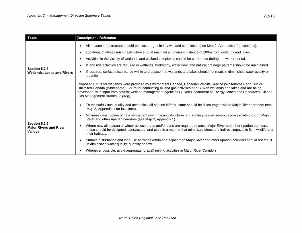
Appendix 2 – Management Direction Summary Tables A2-13
Topic Description / Reference
Section 5.2.5 Wetlands, Lakes and Rivers
• All-season infrastructure should be discouraged in key wetland complexes (see Map 2, Appendix 1 for locations).
• Locations of all-season infrastructure should maintain a minimum distance of 100m from wetlands and lakes.
• Activities in the vicinity of wetlands and wetland complexes should be carried out during the winter period.
• If land use activities are required in wetlands, hydrology, water flow, and natural drainage patterns should be maintained.
• If required, surface disturbance within and adjacent to wetlands and lakes should not result in diminished water quality or quantity.
Proposed BMPs for wetlands were provided by Environment Canada, Canadian Wildlife Service (Whitehorse), and Ducks Unlimited Canada (Whitehorse). BMPs for conducting oil and gas activities near Yukon wetlands and lakes and are being developed, with input from several wetland management agencies (Yukon Department of Energy, Mines and Resources, Oil and Gas Management Branch, in prep).
Section 5.2.5 Major Rivers and River Valleys
• To maintain visual quality and aesthetics, all-season infrastructure should be discouraged within Major River corridors (see Map 2, Appendix 1 for locations).
• Minimize construction of new permanent river crossing structures and routing new all-season access roads through Major River and other riparian corridors (see Map 2, Appendix 1).
• Where new all-season or winter access roads and/or trails are required to cross Major River and other riparian corridors, these should be designed, constructed, and used in a manner that minimizes direct and indirect impacts to fish, wildlife and their habitats.
• Surface disturbance and land use activities within and adjacent to Major River and other riparian corridors should not result in diminished water quality, quantity or flow.
• Whenever possible, avoid aggregate (gravel) mining activities in Major River Corridors.
North Yukon Regional Land Use Plan
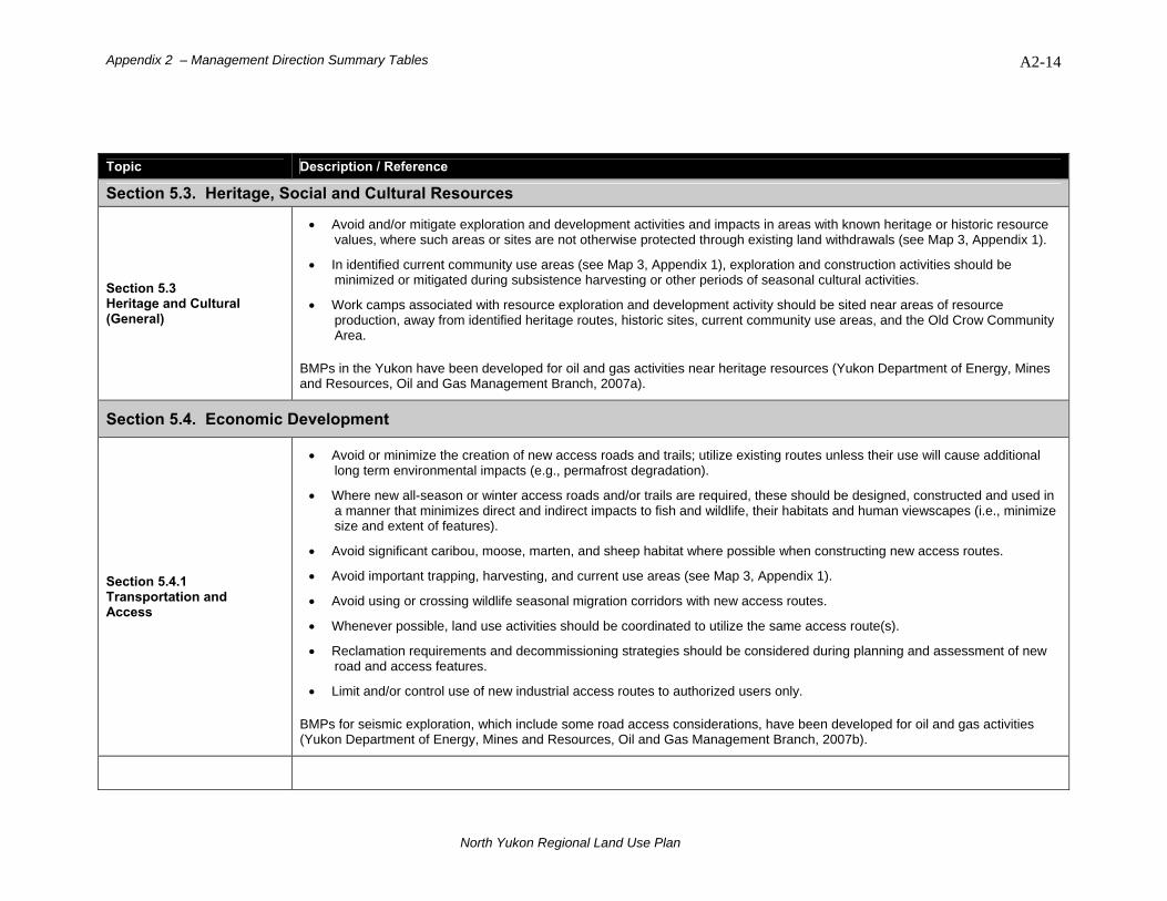
Appendix 2 – Management Direction Summary Tables A2-14
Topic Description / Reference
Section 5.3. Heritage, Social and Cultural Resources
Section 5.3 Heritage and Cultural (General)
• Avoid and/or mitigate exploration and development activities and impacts in areas with known heritage or historic resource values, where such areas or sites are not otherwise protected through existing land withdrawals (see Map 3, Appendix 1).
• In identified current community use areas (see Map 3, Appendix 1), exploration and construction activities should be minimized or mitigated during subsistence harvesting or other periods of seasonal cultural activities.
• Work camps associated with resource exploration and development activity should be sited near areas of resource production, away from identified heritage routes, historic sites, current community use areas, and the Old Crow Community Area.
BMPs in the Yukon have been developed for oil and gas activities near heritage resources (Yukon Department of Energy, Mines and Resources, Oil and Gas Management Branch, 2007a).
Section 5.4. Economic Development
Section 5.4.1 Transportation and Access
• Avoid or minimize the creation of new access roads and trails; utilize existing routes unless their use will cause additional long term environmental impacts (e.g., permafrost degradation).
• Where new all-season or winter access roads and/or trails are required, these should be designed, constructed and used in a manner that minimizes direct and indirect impacts to fish and wildlife, their habitats and human viewscapes (i.e., minimize size and extent of features).
• Avoid significant caribou, moose, marten, and sheep habitat where possible when constructing new access routes.
• Avoid important trapping, harvesting, and current use areas (see Map 3, Appendix 1).
• Avoid using or crossing wildlife seasonal migration corridors with new access routes.
• Whenever possible, land use activities should be coordinated to utilize the same access route(s).
• Reclamation requirements and decommissioning strategies should be considered during planning and assessment of new road and access features.
• Limit and/or control use of new industrial access routes to authorized users only.
BMPs for seismic exploration, which include some road access considerations, have been developed for oil and gas activities (Yukon Department of Energy, Mines and Resources, Oil and Gas Management Branch, 2007b).
North Yukon Regional Land Use Plan
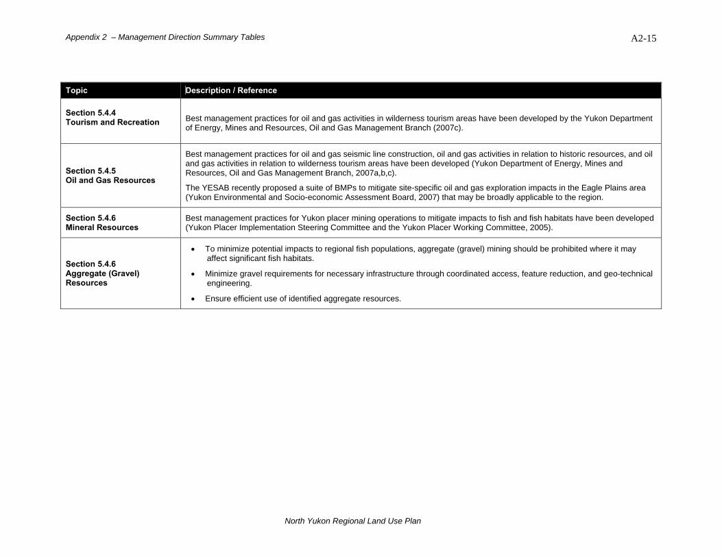
Appendix 2 – Management Direction Summary Tables A2-15
Topic Description / Reference Section 5.4.4 Tourism and Recreation
Best management practices for oil and gas activities in wilderness tourism areas have been developed by the Yukon Department of Energy, Mines and Resources, Oil and Gas Management Branch (2007c).
Section 5.4.5 Oil and Gas Resources
Best management practices for oil and gas seismic line construction, oil and gas activities in relation to historic resources, and oil and gas activities in relation to wilderness tourism areas have been developed (Yukon Department of Energy, Mines and Resources, Oil and Gas Management Branch, 2007a,b,c).
The YESAB recently proposed a suite of BMPs to mitigate site-specific oil and gas exploration impacts in the Eagle Plains area (Yukon Environmental and Socio-economic Assessment Board, 2007) that may be broadly applicable to the region.
Section 5.4.6 Mineral Resources
Best management practices for Yukon placer mining operations to mitigate impacts to fish and fish habitats have been developed (Yukon Placer Implementation Steering Committee and the Yukon Placer Working Committee, 2005).
Section 5.4.6 Aggregate (Gravel) Resources
• To minimize potential impacts to regional fish populations, aggregate (gravel) mining should be prohibited where it may affect significant fish habitats.
• Minimize gravel requirements for necessary infrastructure through coordinated access, feature reduction, and geo-technical engineering.
• Ensure efficient use of identified aggregate resources.
North Yukon Regional Land Use Plan
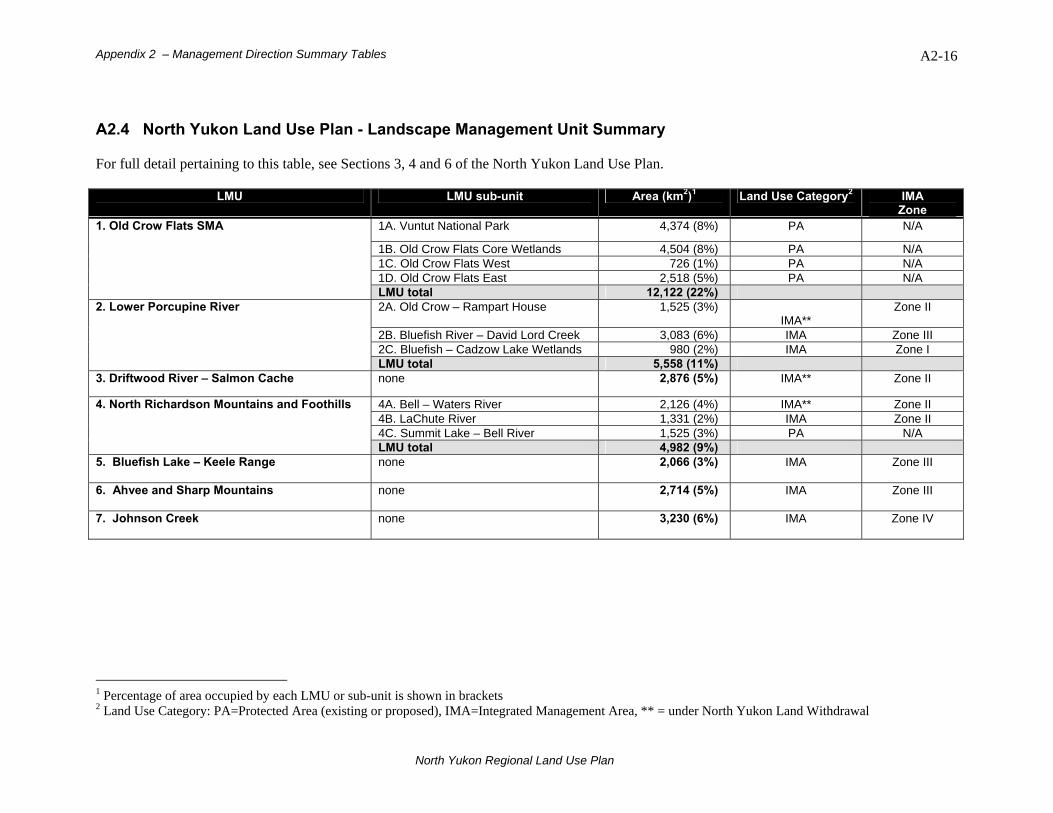
Appendix 2 – Management Direction Summary Tables A2-16
A2.4 North Yukon Land Use Plan - Landscape Management Unit Summary For full detail pertaining to this table, see Sections 3, 4 and 6 of the North Yukon Land Use Plan.
LMU LMU sub-unit Area (km2)1 Land Use Category2 IMA Zone
1A. Vuntut National Park 4,374 (8%) PA N/A
1B. Old Crow Flats Core Wetlands 4,504 (8%) PA N/A 1C. Old Crow Flats West 726 (1%) PA N/A 1D. Old Crow Flats East 2,518 (5%) PA N/A
1. Old Crow Flats SMA
LMU total 12,122 (22%) 2A. Old Crow – Rampart House 1,525 (3%)
IMA** Zone II
2B. Bluefish River – David Lord Creek 3,083 (6%) IMA Zone III 2C. Bluefish – Cadzow Lake Wetlands 980 (2%) IMA Zone I
2. Lower Porcupine River
LMU total 5,558 (11%) 3. Driftwood River – Salmon Cache none 2,876 (5%) IMA** Zone II
4A. Bell – Waters River 2,126 (4%) IMA** Zone II 4B. LaChute River 1,331 (2%) IMA Zone II 4C. Summit Lake – Bell River 1,525 (3%) PA N/A
4. North Richardson Mountains and Foothills
LMU total 4,982 (9%) 5. Bluefish Lake – Keele Range
none 2,066 (3%) IMA Zone III
6. Ahvee and Sharp Mountains none 2,714 (5%)
IMA Zone III
7. Johnson Creek none
3,230 (6%) IMA Zone IV
1 Percentage of area occupied by each LMU or sub-unit is shown in brackets 2 Land Use Category: PA=Protected Area (existing or proposed), IMA=Integrated Management Area, ** = under North Yukon Land Withdrawal
North Yukon Regional Land Use Plan

Appendix 2 – Management Direction Summary Tables A2-17
LMU LMU sub-unit Area (km2) Land Use Category IMA
Zone 8A. Whitefish – Porcupine Lakes 468 (1%) PA N/A 8B. Eagle – Bell River 1,124 (2%) IMA Zone I 8C. Porcupine River 302 (1%) IMA Zone I
8. Whitefish Wetlands
LMU total 1,894 (4%) 9. Eagle Plains none 6,415 (11%)
IMA Zone IV
10A. South Richardson Mountains 780 (1%) IMA Zone II 10B. Rock River – Mount Joyal 2,374 (4%) IMA Zone II
10. South Richardson Mountains and Foothills
LMU total 3,154 (5%) 11. Whitestone River
none 1,740 (3%) IMA Zone III
12A. Ni’iinlii’njik Protected Area 5,524 (10%) PA N/A 12B. Fishing Branch Habitat Protection
Area 980 (2%) See below3 N/A
12. Ni’iinlii’njik (Fishing Branch) SMA
LMU total 6,504 (12%) 13. Kandik River none 2,266 (4%)
IMA Zone IV
3 Fishing Branch HPA Land Use Category is currently undetermined. The Fishing Branch Committee of Managing Agencies may consider an appropriate Land Use Category for LMU 12B at the next Fishing Branch HPA management plan (Yukon Department of Environment and Vuntut Gwitchin Government, 2004a) review.
North Yukon Regional Land Use Plan

Appendix 3 – Other Management Plans
A3-1
Appendix 3. Other Management Plans
Table A3.1. Existing management plans, agreements and planning processes in the North Yukon Planning Region.
Plan or Planning Process
Agency Description Relationship to North Yukon Land Use Plan
Existing Plans Old Crow Flats Special Management Area Management Plan (2006)
• VGG • YG • NYRRC
Management plan for Old Crow Flats Special Mgmt Area (see Chapter 10, Schedule C of VGFN Final Agreement
• OCF management objectives and recommendations informs NY land use plan
• NY land use plan does not apply directly to OCF SMA
North Yukon Tourism Strategy (2004) * Approved in 2006
• VGG • YG
Tourism strategy for Vuntut Gwitchin Traditional Territory
• Identifies current and future potential tourism opportunities in the North Yukon Planning Region
Dempster Highway Economic Development Agreement (2006)
• VGFN • YG • NND • THHN
YG/FNs Development Partnership Agreement
• Scoping document that may lead to detailed study of economic opportunities within 50km of the Dempster Hwy
Vuntut National Park of Canada Management Plan (2004)
• Parks Canada • VGFN • CWS • NYRRC
Management plan for Vuntut National Park of Canada (see Chapter 10, Schedule A of VGFN Final Agreement
• VNP management objectives and recommendations inform NY land use plan
• VNP ecological criteria and indicators assist NY land use plan
• NY land use plan does not apply directly to Vuntut National Park of Canada
Ni'iinlii'njik (Fishing Branch) Wilderness Preserve, Ecological Reserve and Settlement Land R-5A and S-3A1 Management Plan (2004)
• VGFN • Yukon
Environment • DFO • NYRRC
Management plan for Ni'iinlii'njik (Fishing Branch) SMA (see Chapter 10, Schedule B of VGFN Final Agreement
• Ni'iinlii'njik (Fishing Branch) management objectives and recommendations inform NY land use plan
• Identified special wildlife considerations inform NY land use plan
• NY land use plan does not apply directly to Ni'iinlii'njik (Fishing Branch) SMA
Ni'iinlii'njik (Fishing Branch) Wilderness Preserve and Habitat Protection Area (2004)
• VGFN • Yukon Environment
Management plan for Ni'iinlii'njik (Fishing Branch) SMA (See Chapter 10, Schedule B of VGFN Final Agreement
• NY land use plan considers HPA as part of the region’s IMA or ‘working landscape’ and makes relevant management recommendations in order to provide linkage with remainder of region
Old Crow Physical Development Plan / Capital Plan (2003 – 2008)
• VGFN Community development plan for Old Crow
• Identifies community infrastructure development needs for Old Crow
• Outlines transportation and material requirements for Old Crow
• Plan informs NY land use plan regarding community needs
North Yukon Regional Land Use Plan
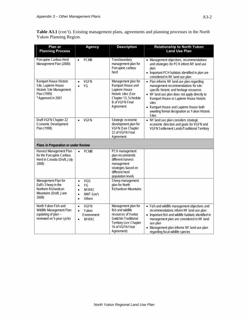
Appendix 3 – Other Management Plans
A3-2
Table A3.1 (con’t). Existing management plans, agreements and planning processes in the North Yukon Planning Region.
Plan or Planning Process
Agency Description Relationship to North Yukon Land Use Plan
Porcupine Caribou Herd Management Plan (2000)
• PCMB Transboundary management plan for Porcupine caribou herd
• Management objectives, recommendations and strategies for PCH inform NY land use plan
• Important PCH habitats identified in plan are considered in NY land use plan
Rampart House Historic Site, Lapierre House Historic Site Management Plan (1999) * Approved in 2001
• VGFN • YG
Management plan for Rampart House and Lapierre House historic sites (See Chapter 13, Schedule B of VGFN Final Agreement
• Plan informs NY land use plan regarding management recommendations for site-specific historic and heritage resources
• NY land use plan does not apply directly to Rampart House or Lapierre House historic sites
• Rampart House and Lapierre House both awaiting formal designation as Yukon Historic Sites
Draft VGFN Chapter 22 Economic Development Plan (1998)
• VGFN Strategic economic development plan for VGFN (See Chapter 22 of VGFN Final Agreement
• NY land use plan considers strategic economic direction and goals for VGFN and VGFN Settlement Lands/Traditional Territory
Plans in Preparation or under Review Harvest Management Plan for the Porcupine Caribou Herd in Canada (Draft, July 2008)
• PCMB PCH management plan recommends different harvest management strategies based on different herd population levels
Management Plan for Dall’s Sheep in the Northern Richardson Mountains (Draft, June 2008)
• VGG • YG • NYRRC • NWT Gov’t • Others
Sheep management plan for North Richardson Mountains
North Yukon Fish and Wildlife Management Plan (updating of plan – reviewed on 5-year cycle)
• VGFN • Yukon
Environment • NYRRC
Management plan for fish and wildlife resources of Vuntut Gwitchin Traditional Territory (see Chapter 16 of VGFN Final Agreement)
• Fish and wildlife management objectives and recommendations inform NY land use plan
• Important fish and wildlife habitats identified in management plan are considered in NY land use plan
• Management plan informs NY land use plan regarding focal wildlife species
North Yukon Regional Land Use Plan

Appendix 4 – Suggested Research Priorities
A4-1
Appendix 4. Suggested Research Priorities Further research improves our understanding of land use and contributes to mitigating land use impacts in the North Yukon Planning Region. Research helps to achieve regional management objectives, and supports many of the identified implementation tasks of this Plan. Incorporating research results into the Plan is an important part of the adaptive management process. The following are suggested research priorities identified during production of this Plan—they do not represent commitments or obligations on the part of the Yukon Government or Vuntut Gwitchin Government. While the Parties will make best efforts to follow these suggestions, research items will be initiated at their discretion, subject to available resources and changing circumstances. Cumulative Effects Indicators:
• Further investigation of cause and effect relationships for recommended cumulative effects indicators should be undertaken, with focus on the following:
o relationship between barren-ground caribou and land use activities, with focus on range utilization in response to surface disturbance and linear density;
o cumulative impacts of exploration and development activities on Porcupine Caribou herd population viability; and,
o cumulative surface disturbance impacts and potential effects on habitat quantity and quality.
• Establish cause and effect relationships between land use activities and aquatic impacts, with focus on the following:
o Relationship between stream crossing methods, human-caused stream impacts and aquatic integrity in permafrost areas (note: stream crossing index is one method to measure potential human-caused stream impacts. Stream crossing index should incorporate fish stock habitat values and level of risk based on type of infrastructure); and,
o Relationship between CCME water quality indicators, other contaminant indicators, and aquatic health.
• Establish benchmark conditions for suggested regional sustainable development indicators (see Table 7.2).
Land and Resource Use:
• Identify potential aggregate (gravel) sources where required; Eagle Plains and Dempster Highway corridor should receive initial focus.
• Conduct research on renewable energy options and solutions that can be effectively adopted and used in Old Crow.
• Dempster Highway view shed analysis – mapping the view shed of the Dempster Highway would allow for planning of development activities in a manner that minimizes their visibility from the Highway.
North Yukon Regional Land Use Plan

Appendix 4 – Suggested Research Priorities
A4-2
Biophysical and Hydrology:
• Wetlands require further definition, mapping and increased understanding of function:
o Develop standardized definition of wetlands, including peatlands (bogs and fens), in accordance with Canadian Wetlands Classification System; and,
o Wetland function (hydrology and connectivity—see Section 5.2.5), potential factors impacting wetland function (land use, permafrost degradation, climate change) and carbon storage should be examined.
• Conduct hydrology studies in Eagle Plains region to establish winter water quality and flow rates in order to determine potential water availability for industrial uses.
• Identify fish over-wintering habitats in tributary watersheds to Major River Corridors in Eagle Plains and determine their significance and sensitivity to in-stream water withdrawals (task is related to hydrology studies) (see Section 5.2.4)
• Refine and update North Yukon Landscape Types (Biophysical) Map as required.
• Continue research on climate change related risks—refine and update habitat impact hypotheses and models
North Yukon Regional Land Use Plan
Glossary of Terms A5-1
Appendix 5. Glossary of Terms The following definitions pertain to terminology used in this Plan:
Adaptive Management: A systematic approach to resource management that uses structured, collaborative research and monitoring with the goal of improving land and resource management policies, objectives and practices over time. Aggregate Resources: Any combination of sand, gravel, or crushed stone in a natural or processed state. Aggregates are used in the construction of highways, dams and airports, as well as residential, industrial and institutional buildings. Also known as granular resources. Beringia: An ancient landscape of northwestern North America and eastern Siberia that remained unglaciated during the last Ice Ages (3 million to 10,000 years ago). Best Management Practices: A range of practices that can reduce the time, intensity or duration of industrial activities (i.e. footprints) on the land base. Bioclimate Zone: An ecological zone, observable at broad spatial scales that represents a relatively stable, observable vegetation type or environment. Four bioclimate zones, organized by elevation and latitude, are recognized in the planning region: Taiga Wooded, Taiga Shrub, Alpine and Tundra. Category A: Settlement land owned fully by a Yukon First Nation, including both surface and sub-surface (mines, minerals and hydrocarbon) rights. Category B: Settlement land owned fully by a Yukon First Nation, not including sub-surface (mines, minerals and hydrocarbon) rights. Community Area: A land use category in the Plans’ land use designation system. Community Areas are located around communities or municipalities, such as Old Crow, where local planning is undertaken. Concentrated Use Area: A geographic area or habitat that is occupied at a higher density of animals (e.g., area where animals are congregated) compared to other areas within the animals range. This term is specifically used in the plan to describe areas where satellite-collared Porcupine Caribou Herd cows congregate, for various seasons. Concentrated use areas are often referred to as core areas. Conservation (principle of): “…the management of Fish and Wildlife populations and habitats and the regulation of users to ensure the quality, diversity and Long Term Optimum Productivity of Fish and Wildlife populations, with the primary goal of ensuring a sustainable harvest and its proper utilization” (Chapter 1, VGFN Final Agreement). Contaminated Site: An area of land in which the soil, including groundwater lying beneath it, or the water, including the sediment and bed below it, contain a contaminant in an amount, concentration or level which is equal to or greater than that prescribed by the Contaminated Sites Regulations, Yukon O.I.C. 2002/171 (YESAA).
North Yukon Regional Land Use Plan

Glossary of Terms A5-2
Critical Indicator Level: The point where an indicator has reached or surpassed an acceptable level of change. Cultural Resources: Places and locations associated with events, stories and legends. Cultural resources can include such things as the Porcupine caribou herd, moose, marten, wetlands, lakes and rivers, and locations associated with legends, traditional economic activities and cultural activities. Cumulative Effects: Changes to the environment and/or society that result from a land use activity in combination with other past, present and future activities. The changes can be positive or negative. Cumulative Impacts: Negative consequences of cumulative effects; may involve both direct and indirect impacts. Direct Impacts: Impacts that result directly from a land use activity. Physical development footprints create direct habitat impacts. Direct Surface Disturbance: Visible, human-caused disturbances that result in the physical disruption of soil or hydrology, or the clearing of trees and woody vegetation. Disposition Process: a legal instrument (such as a sale, lease, license or permit) that allows a government to give a benefit from public land to any person or company. Ecodistrict: Part of an Ecoregion characterized by a distinct assemblage of relief, geology, landforms, soils and vegetation. Ecodistricts are sub-units of Ecoregions and part of the National Ecological Framework. Ecological Integrity: The degree to which the physical, chemical and biological components, including composition, structure and function, of an ecosystem and their relationships are present, functioning and capable of self-renewal. Ecological Reserve: A park established to protect an area of unique natural significance, unique ecological characteristics or importance for a population of rare or endangered flora or fauna which is intended to remain in its natural state (Parks and Land Certainty Act). Ecoregion: An area of the earth surface characterized by distinctive physiography (geology and surface features) and ecological responses to climate as expressed by the development of vegetation, soil, water, fauna, etc. Under the National Ecological Framework, the planning region contains portions of six Ecoregions. Ecosystem: A community of organisms and their physical environment interacting as a distinct ecological unit at a range of spatial scales. Ecozone: Very large areas of the earth’s surface representative of broad-scale and generalized ecological conditions. Major physiographic conditions (e.g. mountains versus plains) and climate are the primary basis for determining terrestrial Ecozones. The planning region is entirely within the Taiga Cordillera Ecozone. Endangered Species: Those species listed in Part 2 of Schedule 1 to the Species at Risk Act. (YESAA).
North Yukon Regional Land Use Plan
Glossary of Terms A5-3
Endemic: A species or organism that is only found in a particular region and that has a relatively restricted distribution, due to factors such as isolation or response to soil or climatic conditions. Fish Habitat: Spawning grounds and nursery, rearing, food supply and migration areas on which fish depend directly or indirectly in order to carry out their life processes (YESAA). Focal species: The species of most value and interest, either socially or economically, to residents of a region. The focal species in this Plan (Porcupine caribou, moose, and marten) were determined by Vuntut Gwitchin First Nation and other Plan Partners. Footprint: The area directly disturbed by a road, gravel pit, seismic line or any other feature is considered the physical ‘footprint’ of that feature. Fragmentation: The disruption of large continuous areas of habitat into smaller, less continuous areas of habitat. Functional Disturbance(s): Physical land use disturbance that results in disruption of soil or hydrology, or that requires the cutting of trees. Activities considered exempt from functional disturbance creation are: 1) new linear features less than 1.5 m in width; 2) land use activities that occur on frozen water-bodies; 3) winter work with no required clearing of trees; 4) winter work that utilizes existing disturbances and linear features. Functional Integrity: Maintaining the functional capacity of an area or value in an adequate state to maintain ecological integrity and ecosystem function, even though the area or value may be altered from its pristine state. General Management Direction: In this Plan, prescriptive resource management recommendations and approaches that address region-wide issues (e.g. caribou habitat or Major River Corridors). Habitat: The particular kind of environment in which a plant or animal lives. Habitat Integrity: The ability or capacity of habitat to support wildlife or plant populations. For wildlife, a landscape with high habitat integrity contains habitat of adequate amount, composition, structure and function to support the long-term persistence of healthy wildlife populations. Habitat Protection Area (HPA): An area identified as requiring special protection under the Yukon Wildlife Act. The level of protection varies depending on the management plan developed for each particular HPA. Heritage Resources: Sites and objects that are 45 years old or older and relate to human history, including archaeological and historic sites and artefacts. This definition also includes palaeontological resources. Historic Site: A location at which is found a work or assembly of works of human endeavour or of nature that is of value for its archaeological, palaeontological, prehistoric, historic, scientific or aesthetic features. Yukon historic sites are designated under the Yukon Historic Resources Act and Chapter 10 of the Umbrella Final Agreement. National Historic Sites are designated under the federal Historic Sites and Monuments Act.
North Yukon Regional Land Use Plan
Glossary of Terms A5-4
Hydric (soil): Soils with a high water content and poor drainage capacity (i.e. wet soils). Hydrologic system: The interconnected water system, including soil, surface water, groundwater and atmosphere. Indicator: A signal, typically measurable, that can be used to assess performance of a system. Indirect Impacts: Impacts that result indirectly from a land use activity. Habitat avoidance around land use features or increased hunting mortality around roads are examples of indirect impacts. Industrial Development: (YESAA)
a) mining and the development of an energy resource or of agricultural land; b) for commercial purposes, cutting standing or fallen trees or removing fallen or cut
trees; c) the development of a townsite; and d) any land use or the construction, operation, modification, decommissioning or
abandonment of a structure, facility or installation associated with any activity referred to in the paragraphs (a) to (c), above.
Impact(s): When a land use activity or activities have a negative effect or influence on a value(s) and/or resource(s). Impacts may be direct or indirect. Integrated Management Area: A land use category in the Plans’ land use designation system. These are areas where mineral and oil and gas disposition processes, other industrial activities, and other land uses are allowed, subject to Plan recommendations and regulatory processes. The Integrated Management Area is further divided into four Zones. This land category is also referred to as the working landscape. Integrated Resource Management: A land management approach that uses and manages the environment and natural resources to achieve Sustainable Development. An integrated resource management approach considers environmental, social and economic issues, and attempts to accommodate all uses with minimal conflict and impact. Landscape: A large, observable land unit that has identifiable and repeating patterns of landforms and vegetation. Landscapes may also have characteristic natural disturbance regimes and hydrologic patterns. Landscapes with similar properties are assumed to respond in a consistent manner to management prescriptions. Landscape Management Unit (LMU): An observable land unit that has identifiable and repeating patterns of landforms and vegetation (i.e., a landscape) and that forms a logical land management unit for regional planning. Some LMUs may contain sub-units that require special consideration. In this Plan, LMUs form the primary land management units to which land use designation categories or zones are applied. LMU borders are usually formed by rivers, roads, existing SMAs or other identifiable features. Landscape Type: A generalized vegetation-terrain association or land cover class that is readily observable and has definable characteristics. Landscape types are the biophysical ‘building blocks’ of landscapes. The February 2006 version of the North Yukon biophysical map recognizes 28 distinct landscape types.
North Yukon Regional Land Use Plan
Glossary of Terms A5-5
Land Use Designation System: A land use designation system consists of different land categories that describe either the type or intensity of land uses that are allowed or recommended for each specific landscape management unit or sub-unit. A land use designation system may also be referred to as ‘land use zoning’ or ‘resource management zoning’. Land Withdrawal: A land area that is not available, either permanently or temporarily, for land disposition and oil and gas or mineral exploration activities. Land withdrawals are enacted or terminated by government Orders in Council. Large Scale (Industrial) Project: A project that is submitted to the Executive Committee of the Yukon Environmental and Socio-economic Assessment Board (YESAB) as further defined in Schedule 3 of the 2005 regulations under the Yukon Environmental and Socio-economic Assessment Act (YESAA). See also: “Industrial Development” in this Glossary. Limits of Acceptable Change (or levels of acceptable change): A planning approach that establishes an acceptable limit or level of change for a specific value or resource. Under a results-based management system, limits of acceptable change for indicators are required to differentiate between ‘acceptable’ and ‘unacceptable’ conditions. The limits are based on a combination of science and social choice. See Critical Indicator Level. Linear Density: The total length of all human-created linear features (measured in kilometres), within a landscape management unit or sub-unit (measured in square kilometres). Linear density is expressed as km/km2. Linear density provides a measure of landscape fragmentation and habitat integrity. Linear Feature: A type of human-caused surface disturbance, including trails, survey lines, seismic lines, roads, power transmission lines, and any similar feature. Major River Corridor: The large rivers in the region, with the greatest ecological and cultural significance. In this Plan, Major River Corridors are the Porcupine, Eagle, Bell, Fishing Branch, Old Crow, Whitestone, and Miner rivers. Mesic (soils): Soils of moderate moisture content and drainage capacity. Mitigate: Decrease the impact or effect of an action or land use activity. Mixed-Economy: An economy where both traditional subsistence harvesting and wage-based (or market-based) activities co-exist. Mixed-wood: Forests composed of a mixture of deciduous (trees with leaves) and coniferous (trees with needles) species. Non-settlement Land: All public land in Yukon not affected by First Nation settlement lands. See Settlement Land. Palaeontological Resources: Animal and plant remains from long ago. Pediment: Broad, gently sloping land surfaces with low relief at the base of a steeper slope. Pediments are usually covered with unconsolidated sediments resulting from the transport and
North Yukon Regional Land Use Plan
Glossary of Terms A5-6
deposition of materials by gravity over very long time periods. Old Crow Basin Ecoregion contains extensive pediments. Permafrost: Ground in which a temperature below 0°C has existed continuously for two or more years. Permafrost is defined exclusively on the basis of temperature; ground ice does not need to be present. Porcupine Caribou Herd: A tundra (barren-ground) herd of Grant’s caribou that ranges from Northeastern Alaska to the Yukon/Northwest Territories border (west to east), and from the Beaufort Sea to the Ogilvie Mountains (north to south). Precautionary Principle: A lack of conclusive scientific evidence does not justify inaction on managing the environment, particularly when the consequences of inaction may be undesirable or when the costs of action are negligible. Prescriptive: Stipulation(s) applied to a land use activity, with specific requirements as to how that activity should proceed or be conducted. Protected Area: A land use category in the Plans’ land use designation system. Protected Areas remove an area from oil and gas and mineral disposition, and prohibit exploration activities. Protection of ecological and cultural resources is the management goal. In this Plan, Protected Areas meet the International Union for Conservation of Nature (IUCN) Protected Area Categories I, II or III conservation criteria for ‘full protection’. See Special Management Areas. Reclamation: Focused and deliberate actions that attempt to restore or return disturbed lands to a pre-disturbed state, or to a former productive capacity. Regional Land Use Plan: A collective statement about how to use and manage land and resources within a geographic area. Regional Sustainable Development Indicators: General signals or information about the status and health of the region’s economy, society and environment. Renewable Energy: The generation of heat or electricity from natural resources that are not depleted over time. Results-Based Management Framework: A structured process to link a plan’s goals and objectives, tools, approaches, and monitoring needs into one cohesive strategy. Monitoring and tracking progress toward meeting various plan goals and objectives is an important outcome in the delivery of results-based management. Riparian Zone (or area): Flowing water (lotic) environments and their adjacent terrestrial surroundings influenced by the moving water (fluvial) processes of erosion and deposition, commonly referred to as river or stream valleys. In northern Yukon, riparian zones typically support the most productive vegetation and tree growth due to warmer and better drained soil conditions. S-Sites: Site-specific Yukon First Nation settlement lands. Generally, these are parcels of land smaller than Category A and B land selections, and are of heritage, cultural or traditional economic significance to the First Nation.
North Yukon Regional Land Use Plan

Glossary of Terms A5-7
Scenarios (land use scenarios): In land use planning, the development of an outline or model of plausible land uses that may occur, including possible time-lines, benefits, and impacts of those land uses. The development of land use scenarios differs from discrete options. Scenarios are used to explore potential alternative futures. Secondary Use Area: A large area of land in the Richardson Mountains and foothills where the Tetlit Gwich’in of NWT have the right to subsistence harvesting and trapping, use of water, and forest harvesting in relation to subsistence harvesting, under the terms of the Gwich’in Comprehensive Land Claim Agreement. Settlement Land: All land in Yukon owned by a Yukon First Nation with a Final Agreement. Settlement land may be Category A or B (see above). Special Management Area (SMA): A conservation area identified and established within a Traditional Territory of a Yukon First Nation under a Final Agreement. SMAs can be Yukon Parks, Habitat Protection Areas, National Parks or Wildlife Areas, or other types. The level of protection is defined in a management plan developed for each particular area, with management shared between the Yukon government, First Nation governments, and Renewable Resource Councils, depending on the area and jurisdiction (Chapter 10, VGFNFA). Subsistence Harvesting (for VGFN): (a) the use of Edible Fish or Wildlife Products, or edible Plant products, by Vuntut Gwitchin for sustenance and for food for traditional ceremonial purposes including potlatches; and (b) the use by Vuntut Gwitchin of Non-Edible By-Products of harvests of Fish or Wildlife under (a) for such domestic purposes as clothing, shelter or medicine, and for domestic, spiritual and cultural purposes; but (c) except for traditional production of handicrafts and implements by Vuntut Gwitchin, does not include commercial uses of: (i) Edible Fish or Wildlife Products; (ii) Non-Edible By-Products; or (iii) edible Plant products. (Chapter 10, VGFN Final Agreement) Surface Disturbance(s): The amount of area physically disturbed by human activities. Human structures, roads, gravel quarries, seismic lines, access trails and similar features all create physical footprints on the land, resulting in direct habitat impacts. Surface disturbances create functional disturbances of varying size, intensity and duration. See Functional Disturbance. Sustainable Development: “…beneficial socio-economic change that does not undermine the ecological and social systems upon which communities and societies are dependent.” (Chapter 1, VGFN Final Agreement) Target: A point where an indicator is reaching, or has reached, a desired level or condition. The target is a pre-determined condition related to a specific management goal or objective. Threatened Species: Those species listed in Part 3 of Schedule 1 to the Species at Risk Act. (YESAA) Timing windows: The practice of conducting land use activities during specific time periods with the purpose of minimizing potential impacts on a valued ecological or cultural resource. Traditional Economy: An economy based on hunting, trapping, gathering and fishing activities, for household use or barter; also called a subsistence or land-based economy.
North Yukon Regional Land Use Plan

Glossary of Terms A5-8
Ungulate: A four-legged, plant eating mammal with hoofs. Caribou, moose, deer and musk-oxen are ungulates. Wage-Based Economy: An economic system in which goods and services are produced and exchanged for money. Water Body: An inland water feature, up to its ordinary high-water mark, in a liquid or frozen state, including a swamp, marsh, bog, fen, reservoir and any other land that is covered by water during at least three consecutive months of the year, but does not include a sewage or waste treatment lagoon, a dugout to hold water for livestock and a mine tailings pond (YESAA). Watercourse: A natural water-way, water body or water supply, including one that contains water intermittently, and includes groundwater, springs, swamps and gulches (YESAA). Watershed: The region or area drained by a river or stream system, divided from adjacent drainage basins by a height of land. Wetland: For this Plan, wetlands are defined as all open water aquatic environments, both still water (lentic) and moving water (lotic) features, or concentrations of those features, and their adjacent environments. Wetland Complex: A concentrated geographic grouping of individual wetlands. Wetland complexes may include both wetland and non-wetland biophysical landscape types. Wetland complexes function as an integrated hydrologic system. Wilderness Preserve: A park established with a view to protecting an ecological unit or representative core area by conserving biodiversity and ecological viability (Parks and Land Certainty Act). Wildlife Key Areas: Locations used by wildlife for critical, seasonal life functions. Winter Road: A temporary road constructed during the winter period without the use of gravel or other soil materials. Packed snow typically forms the roadbed. Working Landscape: See Integrated Management Area. Yukon First Nations: As stated in the Yukon Umbrella Final Agreement, any one of the following: Carcross/Tagish First Nation; Champagne and Aishihik First Nations; Tr’ondek Hwech’in First Nation; Kluane First Nation; Kwanlin Dun First Nation; Liard First Nation; Little Salmon/Carmacks First Nation; First Nation of Nacho Nyak Dun; Ross River Dena Council; Selkirk First Nation; Ta'an Kwach'an Council; Teslin Tlingit Council; Vuntut Gwitchin First Nation; or White River First Nation. Yukon Indian People: A term used in the Yukon First Nations Final Agreements referring to people of aboriginal ancestry. A person enrolled under one of the Yukon First Nation Final Agreements in accordance with criteria established in Chapter 3, Eligibility and Enrolment.
North Yukon Regional Land Use Plan