draft mitigated negative declaration
TRANSCRIPT

Draft Mitigated Negative Declaration P18-0083-0085 and P18-0616-0617 1
WARD: 3
1. Case Numbers: P18-0083 (Conditional Use Permit), P18-0084 (Grading Exception), P18-0085 (Certificate of Appropriateness), P18-0616 (Grading Exception) and P18-0617 (Grading Exception)
2. Project Title: Olivewood Memorial Park Expansion
3. Hearing Date: May 16, 2019
4. Lead Agency: City of Riverside Community & Economic Development Department Planning Division 3900 Main Street, 3rd Floor
Riverside, CA 92522
5. Contact Person: Mathew Taylor, Associate Planner
6. Phone Number: (951) 826-5944
7. Project Location: 3300 Central Avenue, Riverside, California, 92506
8. Project Applicant/Project Sponsor’s Name and Address:
Matt Acton (Holt Architecture) for Olivewood Memorial Park 3300 Central Avenue Riverside, California 92506
9. General Plan Designation: PF – Public Facilities/Institutional
10. Zoning: RC – Residential Conservation Zone
11. Description of Project:
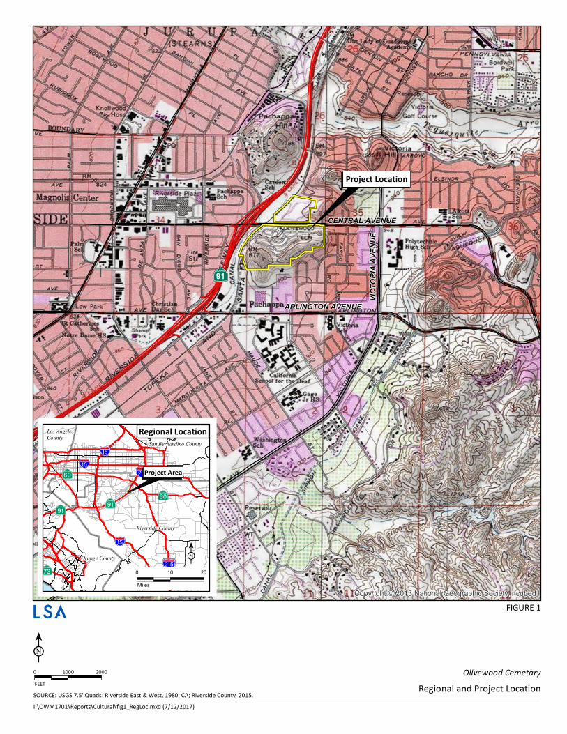
The Project is located within the Olivewood Memorial Park. Olivewood Memorial Park is a cemeterycomprised of 70.34 acres in the Victoria neighborhood in the City of Riverside (City), California at 3300Central Avenue (Assessor’s Parcel Numbers [APNs] 223-150-010, 225-350-074, 223-050-004, and 223-070-001), with parcels on the north and south side of Central Avenue. It is located west of Rumsey Drive and eastof the Riverside Canal and State Route 91 (SR-91). The Project is depicted on the United States GeologicalSurvey (USGS) Riverside West, California 7.5-minute topographic quadrangle map in Township 2 South,Range 5 West within the Jurupa (Stearns) Land Grant, San Bernardino Baseline and Meridian (SBBM). TheProject location is detailed in Figure 1.
DRAFTMITIGATEDNEGATIVEDECLARATION
COMMUNITY & ECONOMIC DEVELOPMENTDEPARTMENT PLANNING DIVISION
CENTRAL AVENUE
·|}þ91
ARLINGTON AVENUE
VICTO
RIA
AVEN
UE
Copyright:© 2013 National Geographic Society, i-cubed
Olivewood CemetaryRegional and Project Location
I:\OWM1701\Reports\Cultural\fig1_RegLoc.mxd (7/12/2017)
?l
?q
A»A»
!"a$
%&g(
A¥
?q
!"a$
!"a$
%&h(
%&h(!"̀$
Riverside County
San Bernardino County
Orange County
Los AngelesCounty
S!!N0 10 20Miles
Project Area
Regional Location
SOURCE: USGS 7.5' Quads: Riverside East & West, 1980, CA; Riverside County, 2015.
FIGURE 1
0 1000 2000FEET
S!!N
Project Location
Draft Mitigated Negative Declaration P18-0083-0085 and P18-0616-0617 3
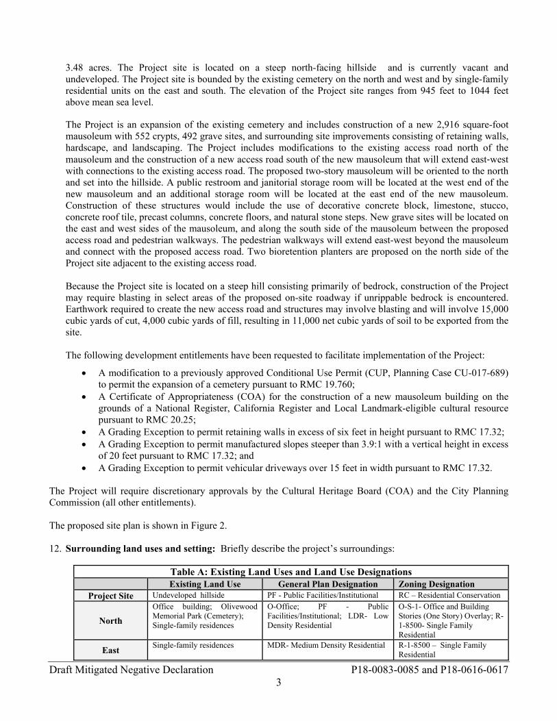
3.48 acres. The Project site is located on a steep north-facing hillside and is currently vacant and undeveloped. The Project site is bounded by the existing cemetery on the north and west and by single-family residential units on the east and south. The elevation of the Project site ranges from 945 feet to 1044 feet above mean sea level.
The Project is an expansion of the existing cemetery and includes construction of a new 2,916 square-foot mausoleum with 552 crypts, 492 grave sites, and surrounding site improvements consisting of retaining walls, hardscape, and landscaping. The Project includes modifications to the existing access road north of the mausoleum and the construction of a new access road south of the new mausoleum that will extend east‐west with connections to the existing access road. The proposed two-story mausoleum will be oriented to the north and set into the hillside. A public restroom and janitorial storage room will be located at the west end of the new mausoleum and an additional storage room will be located at the east end of the new mausoleum. Construction of these structures would include the use of decorative concrete block, limestone, stucco, concrete roof tile, precast columns, concrete floors, and natural stone steps. New grave sites will be located on the east and west sides of the mausoleum, and along the south side of the mausoleum between the proposed access road and pedestrian walkways. The pedestrian walkways will extend east-west beyond the mausoleum and connect with the proposed access road. Two bioretention planters are proposed on the north side of the Project site adjacent to the existing access road. Because the Project site is located on a steep hill consisting primarily of bedrock, construction of the Project may require blasting in select areas of the proposed on-site roadway if unrippable bedrock is encountered. Earthwork required to create the new access road and structures may involve blasting and will involve 15,000 cubic yards of cut, 4,000 cubic yards of fill, resulting in 11,000 net cubic yards of soil to be exported from the site. The following development entitlements have been requested to facilitate implementation of the Project:
A modification to a previously approved Conditional Use Permit (CUP, Planning Case CU-017-689) to permit the expansion of a cemetery pursuant to RMC 19.760;
A Certificate of Appropriateness (COA) for the construction of a new mausoleum building on the grounds of a National Register, California Register and Local Landmark-eligible cultural resource pursuant to RMC 20.25;
A Grading Exception to permit retaining walls in excess of six feet in height pursuant to RMC 17.32; A Grading Exception to permit manufactured slopes steeper than 3.9:1 with a vertical height in excess
of 20 feet pursuant to RMC 17.32; and A Grading Exception to permit vehicular driveways over 15 feet in width pursuant to RMC 17.32.
The Project will require discretionary approvals by the Cultural Heritage Board (COA) and the City Planning Commission (all other entitlements). The proposed site plan is shown in Figure 2.
12. Surrounding land uses and setting: Briefly describe the project’s surroundings:
Table A: Existing Land Uses and Land Use Designations Existing Land Use General Plan Designation Zoning Designation
Project Site Undeveloped hillside PF - Public Facilities/Institutional RC – Residential Conservation
North
Office building; Olivewood Memorial Park (Cemetery); Single-family residences
O-Office; PF - Public Facilities/Institutional; LDR- Low Density Residential
O-S-1- Office and Building Stories (One Story) Overlay; R-1-8500- Single Family Residential
East Single-family residences MDR- Medium Density Residential
R-1-8500 – Single Family Residential
Draft Mitigated Negative Declaration P18-0083-0085 and P18-0616-0617 4
South Single- family residences; vacant land
HR - Hillside Residential; Medium Density Residential
RC- Residential Conservation; R-1-8500 – Single FamilyResidential Insert
West
Burlington Northern Santa Fe (BNSF) railway; commercial storage facility
C – Commercial; O – Office RWY – Railway; CG-S-2- Commercial General and Building Stories (Two Story) Overlay
13. Other public agencies whose approval is required (e.g., permits, financial approval, or participationagreement.):
a. South Coast Air Quality Management District (SCAQMD) – Dust Control Planb. Regional Water Quality Control Board (RWQCB), Santa Ana Region – National Pollutant Discharge
Elimination System (NPDES) Construction General Permitc. RWQCB, Santa Ana Region – Storm Water Pollution Prevention Plan (SWPPP)d. RWQCB, Santa Ana Region – 401 Water Quality Certification – Waste Discharge Requirement (WDR)
14. Other Environmental Reviews Incorporated by Reference in this Review:
a. City of Riverside General Plan 2025 (GP 2025)b. City of Riverside General Plan 2025 Final Programmatic EIR (FPEIR)
15. List of Appendices
A: Air Quality and Greenhouse Gas Memorandum
B: MSHCP Consistency Analysis
C: Cultural Resources Assessment
D1: Geotechnical Investigation
D2: Seismic Refraction Investigation
E: EDR Radius Map Report
F: Project Specific Water Quality Management Plan
G: Noise and Vibration Memorandum
16. Acronyms
AB ................................. Assembly Bill ADT .............................. Average Daily Trips AQMP ........................... Air Quality Management Plan ARB .............................. California Air Resources Board ASTM ........................... American Society for Testing and Materials Basin ............................. South Coast Air Basin BAU .............................. Business As Usual BMP .............................. Best Management Practice California Register ........ California Register of Historical Resources CalRecycle .................... California Department of Resources Recycling and Recovery CAP ............................... Climate Action Plan CAPCOA ...................... California Air Pollution Control Officers Association CBC .............................. California Building Code CCR .............................. California Code of Regulations CDFW ........................... California Department of Fish and Wildlife CDR .............................. Conceptual Design Review CEC ............................... California Energy Commission
Draft Mitigated Negative Declaration P18-0083-0085 and P18-0616-0617 5
CEQA ............................ California Environmental Quality Act CFCs ............................. Chlorofluorocarbons CH4 ................................ Methane CHL .............................. California Historical Landmarks CHRIS ........................... California Historical Resources Information System City ................................ City of Riverside CMP .............................. Congestion Management Plan CNEL ............................ Community Noise Equivalent Level CO ................................. Carbon monoxide CO2 ................................ Carbon Dioxide CPHI ............................. California Points of Historical Interest CUP ............................... Conditional Use Permit CVC .............................. California Vehicle Code CWA ............................. Federal Clean Water Act DAMP ........................... Drainage Area Management Plan dBA ............................... A-weighted decibels DCV .............................. Design Capture Volume Division ......................... Planning Division DMA ............................. Drainage Management Area DOC .............................. California Department of Conservation EIC ................................ Eastern Information Center EIR ................................ Environmental Impact Report EO ................................. Executive Order EOP ............................... Emergency Operations Plan EPA ............................... United States Environmental Protection Agency ESA ............................... Environmental Site Assessment FEMA ........................... Federal Emergency Management Agency FPEIR ............................ Final Programmatic Environmental Impact Report FTA ............................... Federal Transit Administration GAP .............................. Green accountability performance GCC .............................. Global Climate Change GHG .............................. Greenhouse Gas GIS ................................ Geographic Information System GP ................................. General Plan GP 2025 ........................ General Plan 2025 HCM ............................. Highway Capacity Manual HCOC ............................. Hydrologic Condition of Concern HCP ............................... Habitat Conservation Plan HFCs ............................. Hydrofluorocarbons HRI ................................ Historic Resource Inventory HVAC ........................... Heating, Ventilation and Air-Conditioning I-215 .............................. Interstate 215 IS ................................... Initial Study lbs/day ........................... Pounds per day LHMP ........................... Local Hazard Mitigation Plan Lmax ................................ maximum noise level LOS ............................... Level of Service LSA ............................... LSA Associates, Inc. LST ............................... Localized Significance Threshold MBTA ........................... Migratory Bird Treaty Act MDR ............................. Medium Density Residential MGD ............................. Million Gallons Per Day
Draft Mitigated Negative Declaration P18-0083-0085 and P18-0616-0617 6
MH ................................ Mobile Home MLD .............................. Most Likely Descendant MND ............................. Mitigated Negative Declaration mph ............................... Mile per Hour MS4 ............................... Municipal Separate Storm Sewer Systems MSHCP ......................... Western Riverside County Multiple Species Habitat Conservation Plan MT CO2e ....................... metric tons of carbon dioxide-equivalent gases N2O ............................... Nitrous Oxide NAHC ........................... Native American Heritage Commission National Register .......... National Register of Historic Places NEPSSA ........................ Narrow Endemic Plant Species Survey Area NPDES .......................... National Pollutant Discharge Elimination System NOx ............................... Nitrogen oxides O3 .................................. Ozone OEM .............................. Office of Emergency Services PEV ............................... plug-in electric vehicle PF .................................. Public Facilities PFCs .............................. Perfluorocarbons PM10 .............................. Particulate matter less than 10 microns in size PM2.5 ............................. Particulate matter less than 2.5 microns in size ppm ............................... parts per million PRC ............................... Public Resources Code PRD ............................... Planned Residential Development PRIMP .......................... Paleontological Resource Impact Mitigation Program R-1-7000 ....................... Single-Family Residential RCALUCP .................... Riverside County Airport Land Use Compatibility Plan RCP ............................... Regional Comprehensive Plan RCRA ............................ Resource Conservation and Recovery Act RCTC ............................ Riverside County Transportation Commission RFD ............................... Riverside Fire Department RMC .............................. Riverside Municipal Code ROC .............................. Reactive Organic Compounds RPD ............................... Riverside Police Department RPU ............................... Riverside Public Utilities RPWD ........................... Riverside Public Works Department RRG .............................. Riverside Restorative Growthprint RRG-CAP ..................... Riverside Restorative Growthprint Climate Action Plan RRG-EPAP ................... Riverside Restorative Growthprint Economic Prosperity Action Plan RTA .............................. Riverside Transit Agency RTP ............................... Regional Transportation Plan RUSD ............................ Riverside Unified School District RWQCB ........................ Regional Water Quality Control Board SB .................................. Senate Bill SCAG ............................ Southern California Association of Governments SCAQMD ..................... South Coast Air Quality Management District SCCIC ........................... South Central Coastal Information Center SCS ............................... Sustainable Communities Strategy SF6 ................................. Sulfur Hexafluoride SKR ............................... Stephens’ Kangaroo Rat SLCP ............................. Short-Lived Climate Pollutant SLF ................................ Sacred Lands File SOx .............................. Sulfur oxides
Draft Mitigated Negative Declaration P18-0083-0085 and P18-0616-0617 7
SWPPP .......................... Storm Water Pollution Prevention Plan SWRCB ........................ State Water Resources Control Board TAC .............................. Toxic Air Contaminant TIA ................................ Traffic Impact Analysis USACE ......................... United States Army Corps of Engineers USFWS ......................... United States Fish and Wildlife Service USGS ............................ United States Geological Survey UWMP .......................... Urban Water Management Plan VOC .............................. Volatile Organic Compounds WDR ............................. Waste Discharge Requirement WQMP .......................... Water Quality Management Plan WRCOG ........................ Western Riverside Council of Governments

1244'
175'-0
"
241'-4
"
975' T.O.W.
967' T.O.W.
973.5' T.O.W.
969' T.O.W.
GRAVE SITES, TYP.
PROPOSED
BIORETENTION "A"
PROPOSED
BIORETENTION "B"
PROPOSED
BIORETENTION
PLANTER BOX "F"
4:1 SLOPE 4:1 SLOPE
DN
DN
DRIVEWAY
EXISTING
DRIVEWAY
EXISTING DRIVEWAY
HICKOCKW
AY CARSONRD
xx
xx
xx
xx
xx
xx
x
x
xx
xx
xx
xx
xx
xx
xx
xx
xx
xx
xx
xx
xx
x
x
x x x x x x x x xx
x
x
xxxxxxxxx
x
xxx
xx
xx
xx
x
D
IRR IRR
MH-S
(E) BUILDING
(E) MAUSOLEUMS
(E) BUILDINGS
CENTRAL AVE.
(N) MAUSOLEUM
(E) MAUSOLEUM
PROPOSED "A" STREET
LIMIT OF WORK
LIMIT OF WORK
ITEM:
APN
INFORMATION:
ACTUAL BUILDING (SF)
REFER TO:
SITE AREA (ACRE)
NUMBER OF STORIES
OVERALL HEIGHT
CONSTRUCTION TYPE
OCCUPANCY TYPE
NUMBER OF (N) CRYPTS
NUMBER OF (N) GRAVES
NOTES:
1. PARKING
RMC TABLE 19.580.060 - "Parking ratio to be determined by the
designated Approving or Appeal Authority in conjunction with
required land use or development permits, based on the impacts of
the particular proposal and similar uses in this table."
- New Mausoleum is a non-occupied building and, consequently,
proposed project does not include additional designated parking.
COVERED AREA (SF)
PROJECT SUMMARY
223150010
2916
N/A
SD-110
3.48 SD-010
2 SD-200
2O'-2" SD-200
V-B N/A
UNOCCUPIED N/A
552 SD-110
492 SD-110
3060 SD-110
FIGURE 24
Site Plan
Olivewood Cemetery
SOURCE: Holt Architecture, 2019
I:\OWM1701\G\Site_Plan.cdr (4/19/2019)
N
NO SCALE
Draft Mitigated Negative Declaration P18-0083-0085 and P18-0616-0617 9
ENVIRONMENTAL FACTORS POTENTIALLY AFFECTED:
The environmental factors checked below would be potentially affected by this Project, involving at least one impact that is a “Potentially Significant Impact” as indicated by the checklist on the following pages.
Aesthetics Agriculture & Forest Resources Air Quality
Biological Resources Cultural Resources Geology/Soils
Greenhouse Gas Emissions Hazards & Hazardous Materials Hydrology/Water Quality
Land Use/Planning Mineral Resources Noise
Population/Housing Public Service Recreation
Transportation/Traffic Tribal Cultural Resources Utilities/Service Systems
Mandatory Findings of Significance
DETERMINATION: (To be completed by the Lead Agency)
On the basis of this initial evaluation which reflects the independent judgment of the City of Riverside, it is recommended that:
The City of Riverside finds that the proposed Project COULD NOT have a significant effect on the environment,and a NEGATIVE DECLARATION will be prepared.
The City of Riverside finds that although the proposed Project could have a significant effect on the environment,there will not be a significant effect in this case because revisions in the Project have been made by or agreed toby the Project proponent. A MITIGATED NEGATIVE DECLARATION will be prepared.
The City of Riverside finds that the proposed Project MAY have a significant effect on the environment, and anENVIRONMENTAL IMPACT REPORT is required.
The City of Riverside finds that the proposed Project MAY have a “potentially significant impact” or “potentiallysignificant unless mitigated” impact on the environment, but at least one effect 1) has been adequately analyzed inan earlier document pursuant to applicable legal standards, and 2) has been addressed by mitigation measuresbased on the earlier analysis as described on attached sheets. An ENVIRONMENTAL IMPACT REPORT isrequired, but it must analyze only the effects that remain to be addressed.
The City of Riverside finds that although the proposed Project could have a significant effect on the environment,because all potentially significant effects (a) have been analyzed adequately in an earlier EIR or NEGATIVE DECLARATION pursuant to applicable standards, and (b) have been avoided or mitigated pursuant to that earlierEIR or NEGATIVE DECLARATION, including revisions or mitigation measures that are imposed upon theproposed Project, nothing further is required.
Signature Date
Printed Name & Title Matthew Taylor, Associate Planner For City of Riverside
Environmental Initial Study P18-0083-0085 and P18-0616-0617 1
EVALUATION OF ENVIRONMENTAL IMPACTS:
1) A brief explanation is required for all answers except “No Impact” answers that are adequately supportedby the information sources a lead agency cites in the parentheses following each question. A “NoImpact” answer is adequately supported if the referenced information sources show that the impact simplydoes not apply to projects like the one involved (e.g., the project falls outside a fault rupture zone). A“No Impact” answer should be explained where it is based on project-specific factors as well as generalstandards (e.g., the project will not expose sensitive receptors to pollutants, based on a project-specificscreening analysis).
2) All answers must take account of the whole action involved, including off-site as well as on-site,cumulative as well as project-level, indirect as well as direct, and construction as well as operationalimpacts.
3) Once the lead agency has determined that a particular physical impact may occur, then the checklistanswers must indicate whether the impact is potentially significant, less than significant with mitigation,or less than significant. “Potentially Significant Impact” is appropriate if there is substantial evidence thatan effect may be significant. If there are one or more “Potentially Significant Impact” entries when thedetermination is made, an EIR is required.
4) “Negative Declaration: Less Than Significant With Mitigation Incorporated” applies where theincorporation of mitigation measures has reduced an effect from “Potentially Significant Impact” to a“Less Than Significant Impact.” The lead agency must describe the mitigation measures, and brieflyexplain how they reduce the effect to a less than significant level (mitigation measures from “EarlierAnalyses,” as described in (5) below, may be cross-referenced).
5) Earlier analyses may be used where, pursuant to the tiering, program EIR, or other CEQA process, aneffect has been adequately analyzed in an earlier EIR or negative declaration. Section 15063(c)(3)(D). Inthis case, a brief discussion should identify the following:
a. Earlier Analysis Used. Identify and state where they are available for review.
b. Impacts Adequately Addressed. Identify which effects from the above checklist were withinthe scope of and adequately analyzed in an earlier document pursuant to applicable legalstandards, and state whether such effects were addressed by mitigation measures based on theearlier analysis.
c. Mitigation Measures. For effects that are “Less than Significant with Mitigation MeasuresIncorporated,” describe the mitigation measure which were incorporated or refined from theearlier document and the extent to which they address site-specific conditions for the project.
6) Lead agencies are encouraged to incorporate into the checklist references to information sources forpotential impacts (e.g., general plans, zoning ordinances). Reference to a previously prepared or outsidedocument should, where appropriate, include a reference to the page or pages where the statement issubstantiated.
ENVIRONMENTALINITIALSTUDY
COMMUNITY & ECONOMIC DEVELOPMENTDEPARTMENT PLANNING DIVISION
Environmental Initial Study P18-0083-0085 and P18-0616-0617 2
7) Supporting Information Sources: A source list should be attached, and other sources used or individuals
contacted should be cited in the discussion. 8) The explanation of each issue should identify:
a. the significance criteria or threshold, if any, used to evaluate each question; and
b. the mitigation measure identified, if any, to reduce the impact to less than significance.
9) Mitigation Measures are provided to reduce impacts to less than significance. As the Lead Agency, the City is responsible for ensuring full compliance with the Mitigation Measures adopted for the proposed project. The City will monitor and report on all mitigation activities. Mitigation Measures will be implemented at different stages of development throughout the project site.
10) Standard Conditions and Regulations are presented in instances where the proposed project would not create a significant impact but would be required to adhere to regulatory requirements in order to ensure impacts do not become significant. Standard Conditions and Regulations outline compliance with various federal, State, and/or local acts, laws, rules, regulations, municipal codes, etc.
Environmental Initial Study P18-0083-0085 and P18-0616-0617 3
ISSUES (AND SUPPORTING INFORMATION SOURCES):
Potentially Significant
Impact
Less Than Significant
With Mitigation
Incorporated
Less Than Significant
Impact
No Impact
1. AESTHETICS. Would the project:
a. Have a substantial adverse effect on a scenic vista?
1a. Response: (Source: General Plan 2025 Figure CCM-4 – Master Plan of Roadways, General Plan 2025 FPEIR Figure 5.1-1 – Scenic and Special Boulevards and Parkways, Table 5.1-A – Scenic and Special Boulevards, and Table 5.1-B – Scenic Parkways)
Less Than Significant Impact. The Project consists of the construction of a mausoleum, grave sites, and an access road within the existing Olivewood Memorial Park. The Project site is located on a hillside and the proposed mausoleum and the cut into the hillside for the access road would be visible from travelers along Central Avenue and SR-91. The portion of Olivewood Memorial Park south of Central Avenue is located in a RC – Residential Conservation Zone and is therefore required to comply with the City’s Hillside and Arroyo Grading Ordinance enumerated in Municipal Code Section 17.28.020. The Hillside and Arroyo Grading Ordinance is intended to implement General Plan Land Use Objectives LU-31 and LU-42 and Open Space Objective OS-23 by protecting natural amenities such as trees and other vegetation, rock outcroppings and other landforms, arroyos, ridgelines, and hillsides that are found on Riverside’s prominent hills and ridges. The Hillside and Arroyo Grading Ordinance also contains specific and quantified grading standards intended to ensure development blends in with the surrounding hillsides, preserves natural amenities, and provides adequate erosion control. Due to the steep slopes within the proposed Project footprint, some of the specific grading standards cannot be met and therefore the Project includes requests for exceptions to these standards. However, the Project includes design features in the form of engineered plans that incorporate elements and features that reduce the potential for erosion to acceptable levels. Project Landscape Plans incorporate native and ornamental plantings throughout the project scope area to provide erosion controls as required in the Hillside and Arroyo Grading Ordinance. Plants are native to the area and exist currently or are compatible with the adjacent natural vegetation. The Project also includes design features in the plans that incorporate elements and features that blend the proposed access road and mausoleum into the hillside in a manner similar to the existing access roads and mausoleums located within the south half of Olivewood Memorial Park. Due to the slope of the hillside, the proposed access road will not be visible from Central Avenue and will be partially blocked by the mausoleum structure, although the access road cut into the hillside will be visible. The mausoleum structure will be imbedded into the hillside, so that the top of the building meets the natural slope line. These features can be seen in the building elevations of the crypt and mausoleum shown in Figure 3. With implementation of Project design features contained in the engineered Project plans and design, erosion control will be accommodated at an acceptable level and the Project will blend into the hillside resulting in a continuation of the existing development pattern found in Olivewood Memorial Park. Therefore, the Project will have a less than significant impact directly, indirectly or cumulatively to scenic vistas. No mitigation is required.
b. Substantially damage scenic resources, including, but not limited to, trees, rock outcroppings, and historic buildings within a state scenic highway?
1b. Response: (Source: General Plan 2025 Figure CCM-4 – Master Plan of Roadways, General Plan 2025 FPEIR Figure 5.1-1 – Scenic and Special Boulevards, Parkways, Table 5.1-A – Scenic and Special Boulevards, Table
1 Objective LU-3 states: Preserve prominent ridgelines and hillsides as important community visual, recreational and
biological assets. 2 Objective LU-4 states: Minimize the extent of urban development in the hillsides, and mitigate any adverse impacts
associated with urbanization to the extent feasible. 3 Objective OS-2 states: Minimize the extent of urban development in the hillsides, and mitigate any significant
adverse consequences associated with urbanization.
Environmental Initial Study P18-0083-0085 and P18-0616-0617 4
ISSUES (AND SUPPORTING INFORMATION SOURCES):
Potentially Significant
Impact
Less Than Significant
With Mitigation
Incorporated
Less Than Significant
Impact
No Impact
5.1-B – Scenic Parkways, the City’s Urban Forest Tree Policy Manual, Title 20 – Cultural Resources, Title 19 – Article V – Chapter 19.100 – Residential Zones - RC Zone, and Cultural Resources Assessment for the Olivewood Memorial Park prepared by LSA in June 2018)
Less Than Significant Impact. There are no scenic highways within the City that could potentially be impacted. In addition the Project is not located along or within view of a scenic boulevard, parkway or special boulevard as designated by the City’s General Plan 2025 and therefore will not have any effect on any scenic resources within a scenic roadway. Ornamental trees consisting of olive, eucalyptus, pine, and juniper trees are located within the Project site. However, no trees are located in a City right of way and no native trees are present in the Project site. There are no rock outcroppings within the Project area so no impacts to rock outcroppings are expected. There is one historic building within view of the Project, the Art Deco Mausoleum located adjacent to the Project site. The Cultural Resources Assessment evaluated the potential for effects on the Art Deco Mausoleum and determined the Project to be consistent with the Secretary of the Interior’s Standards for Treatment of Historic Properties (Rehabilitation). The Project site is also located in the Residential Conservation Zone (RC). The RC works to protect prominent ridges and hillsides, slopes, arroyos, ravines and canyons, and other areas with high visibility or unique topographic conditions from adverse development practices for consistency with General Plan objectives and voter-approved initiatives. As discussed in response to Checklist Response 1(a), above, Project design features contained in the engineered Project plans and design will blend the proposed access road and mausoleum into the hillside resulting in a continuation of the existing development pattern found in Olivewood Memorial Park. With these design features, the Project was determined to have a less than significant impact on scenic vistas. Similarly, the Project will have a less than significant impact directly, indirectly or cumulatively to scenic resources. No mitigation is required.
c. Substantially degrade the existing visual character or quality of the site and its surroundings?
1c. Response: (Source: General Plan 2025, General Plan 2025 FPEIR, Zoning Code, Citywide Design and Sign Guidelines)
No Impact. The Project consists of expanding an existing cemetery up a hillside. As discussed in the response to Checklist Response 1(a), above, Project design features contained in the engineered Project plans and design will blend the proposed access road and mausoleum into the hillside resulting in a continuation of the existing development pattern found in Olivewood Memorial Park. With these design features, the Project was determined to have a less than significant impact on scenic vistas. Therefore, the Project will not degrade the existing visual character of the area resulting in a less than significant impact directly, indirectly or cumulatively to visual character or quality will occur. No mitigation is required.
d. Create a new source of substantial light or glare which would adversely affect day or nighttime views in the area?
1d. Response: (Source: General Plan 2025, General Plan 2025 FPEIR Figure 5.1-2 – Mount Palomar Lighting Area, Title 19 – Article VIII – Chapter 19.556 – Lighting, Citywide Design and Sign Guidelines)
Less Than Significant Impact. The Project site is not within the Mount Palomar Nighttime Lighting Policy Area. However, new sources of light associated with the mausoleum will contribute to light and glare. The amount of light given off from the Project would be nominal when added to the existing light emitted by the cemetery as a whole. Therefore impacts to day or nighttime views from substation light or glare would be less than significant impact. No mitigation is required.
Environmental Initial Study P18-0083-0085 and P18-0616-0617 5
ISSUES (AND SUPPORTING INFORMATION SOURCES):
Potentially Significant
Impact
Less Than Significant
With Mitigation
Incorporated
Less Than Significant
Impact
No Impact
2. AGRICULTURE AND FOREST RESOURCES:
In determining whether impacts to agricultural resources are significant environmental effects, lead agencies may refer to the California Agricultural Land Evaluation and Site Assessment Model (1997) prepared by the California Dept. of Conservation as an optional model to use in assessing impacts on agriculture and farmland. In determining whether impacts to forest resources, including timberland, are significant environmental effects, lead agencies may refer to information complied by the California Department of Forestry and Fire Protection regarding the state’s inventory of forest land, including the Forest and Range Assessment Project and the Forest Legacy Assessment project; and the forest carbon measurement methodology provided in the Forest Protocols adopted by the California Air Resources Board. Would the project:
a. Convert Prime Farmland, Unique Farmland, or Farmland of Statewide Importance (Farmland), as shown on the maps prepared pursuant to the Farmland Mapping and Monitoring Program of the California Resources Agency, to non-agricultural use?
2a. Response: (Source: General Plan 2025 – Figure OS-2 – Agricultural Suitability) No Impact. The Project is located within an urbanized area. A review of Figure OS-2 – Agricultural Suitability of the General Plan 2025 reveals that the Project site is not designated as, and is not adjacent to or in proximity to any land classified as, Prime Farmland, Unique Farmland, or Farmland of Statewide Importance, as shown on the maps prepared pursuant to the Farmland Mapping and Monitoring Program of the California Resources Agency. Therefore, the Project will have no impact directly, indirectly or cumulatively to agricultural uses. No mitigation is required.
b. Conflict with existing zoning for agricultural use, or a Williamson Act contract?
2b. Response: (Source: General Plan 2025 – Figure OS-3 - Williamson Act Preserves, General Plan 2025 FPEIR – Figure 5.2-4 – Proposed Zones Permitting Agricultural Uses, and Title 19)
No Impact. A review of Figure 5.2-2 – Williamson Act Preserves of the General Plan 2025 FPEIR reveals that the Project site is not located within an area that is affected by a Williamson Act Preserve or under a Williamson Act Contract. The Project site is located in the RC – Residential Conservation Zone, which allows agricultural uses by right. However, Olivewood Memorial Park has been a cemetery dating back to the late 1880s and it reasonable to conclude the proposed Project and all of Olivewood Memorial Park will remain a cemetery in perpetuity. Therefore, the Project will have no impact directly, indirectly or cumulatively on Williamson Act Preserves, Contracts, or agricultural zoning. No mitigation is required.
c. Conflict with existing zoning for, or cause rezoning of, forest land (as defined in Public Resources Code section 12220(g)), timberland (as defined in Public Resources Code section 4526), or timberland zoned Timberland Production (as defined by Government Code section 51104(g))?
2c. Response: (Source: GIS Map – Forest Data) No Impact. The City has no forest land that can support 10-percent native tree cover nor does it have any timberland. Therefore, the Project will have no impact directly, indirectly or cumulatively on forestland, timberland, or timberland
Environmental Initial Study P18-0083-0085 and P18-0616-0617 6
ISSUES (AND SUPPORTING INFORMATION SOURCES):
Potentially Significant
Impact
Less Than Significant
With Mitigation
Incorporated
Less Than Significant
Impact
No Impact
production. No mitigation is required.
d. Result in the loss of forest land or conversion of forest land to non-forest use?
2d. Response: (Source: GIS Map – Forest Data) No Impact. The City has no forest land that can support 10-percent native tree cover nor does it have any timberland. Therefore, the Project will have no impact directly, indirectly or cumulatively on forestland. No mitigation is required.
e. Involve other changes in the existing environment which, due to their location or nature, could result in conversion of Farmland, to non-agricultural use or conversion of forest land to non-forest use?
2e. Response: (Source: General Plan – Figure OS-2 – Agricultural Suitability, Figure OS-3 – Williamson Act Preserves, Title 19 – Article V – Chapter 19.100 – Residential Zones – RC Zone and RA-5 Zone and GIS Map – Forest Data)
No Impact. The Project is located in an urbanized area of the City. Additionally, the Project site is identified as urban/built out land and therefore does not support agricultural resources or operations. The Project will not result in the conversion of designated farmland to non-agricultural uses. In addition, there are no agricultural resources or operations, including farmlands within proximity of the Project site. Furthermore, the City has no forest land that can support 10-percent native tree cover. Therefore, the Project will have no impact directly, indirectly or cumulatively related to the conversion of Farmland, to non-agricultural use or to the loss of forest land. No mitigation is required.
3. AIR QUALITY.
Where available, the significance criteria established by the applicable air quality management or air pollution control district may be relied upon to make the following determinations. Would the project:
a. Conflict with or obstruct implementation of the applicable air quality plan?
3a. Response: (Source: South Coast Air Quality Management District’s 2016 Air Quality Management Plan (AQMP), Air Quality and Greenhouse Gas Memorandum prepared by LSA on August 17, 2018)
Less than Significant Impact. The Project site is located in the South Coast Air Basin (Basin), which is under the jurisdiction of the South Coast Air Quality Management District (SCAQMD). The Basin includes all of Orange County and portions of Los Angeles, Riverside, and San Bernardino Counties. The SCAQMD adopted an Air Quality Management Plan (AQMP), the main purpose of which is to describe air pollution control strategies to be taken by a city, county, or region classified as a nonattainment area in order to bring the area into compliance with federal and state air quality standards. A nonattainment area is considered to have air quality worse than the National Ambient Air Quality Standards (NAAQS) as defined in the Federal Clean Air Act. The Basin is in nonattainment for the federal and state standards for ozone (O3) and particulate matter less than 2.5 microns in diameter (PM2.5) and in nonattainment for the state standards for particulate matter less than 10 microns in diameter (PM10) and nitrogen dioxide (NO2). The Basin is in attainment/maintenance/unclassified status for all other federal and state criteria pollutant standards.
Consistency with the 2016 AQMP for the Basin means that a Project will be consistent with the goals, objectives, and assumptions in the respective plan to achieve the federal and state air quality standards. Pursuant to the methodology provided in Chapter 12 of the 1993 SCAQMD CEQA Air Quality Handbook, consistency with the Basin 2016 AQMP is affirmed when a project (1) does not increase the frequency or severity of an air quality standards violation or cause a new violation; and (2) is consistent with the growth assumptions in the AQMP. For the proposed Project to be consistent with the AQMP adopted by the SCAQMD, the pollutants emitted from the project should not exceed the SCAQMD daily threshold or cause a significant impact on air quality, or the project must already have been included in the AQMP projections. Additionally, if feasible mitigation measures are implemented and shown to reduce the impact level from significant to less
Environmental Initial Study P18-0083-0085 and P18-0616-0617 7
ISSUES (AND SUPPORTING INFORMATION SOURCES):
Potentially Significant
Impact
Less Than Significant
With Mitigation
Incorporated
Less Than Significant
Impact
No Impact
than significant, a project may be deemed consistent with the AQMP.
According to the CEQA Air Quality Handbook, consistency with AQMP growth assumptions must be analyzed for new or amended General Plan elements, Specific Plans, and significant projects. The proposed uses are consistent with the existing cemetery uses within Olivewood Memorial Park. Although cemeteries are not permitted uses within the underlying RC – Residential Conservation Zone, Olivewood Memorial Park is a legally non-conforming land use with historical connections to the City. In addition, as shown in General Plan Figure LU-2 Urban Design Framework, the cemetery is labeled “Major Open Space and Parks.” As shown in shown in General Plan Figure LU-10 Land Use Policy Map, the cemetery is labeled “Public Facilities/Institutional.” The City’s General Plan is consistent with the Southern California Association of Governments (SCAG) Regional Comprehensive Plan Guidelines and the SCAQMD AQMP. In addition, the proposed Project is not considered a significant project (e.g., large-scale projects such as airports, electrical generating facilities, petroleum and gas refineries, designation of oil drilling districts, water ports, solid waste disposal sites, and offshore drilling facilities). As discussed in response to Checklist Response 3b, below, the proposed Project’s short-term construction and long-term pollutant emissions will not exceed the emissions thresholds established in the SCAQMD’s CEQA Air Quality Handbook; therefore, the Project would not result in an increase in the frequency or severity of any air quality standards violation and will not cause a new air quality standard violation. For these reasons, the proposed Project is consistent with the City’s General Plan and the regional AQMP. Therefore, impacts related to implementation of the AQMP would be less than significant directly, indirectly and cumulatively. No mitigation is required.
b. Violate any air quality standard or contribute substantially to an existing or projected air quality violation?
3b. Response: (Source: General Plan 2025 FPEIR Table 5.3-B SCAQMD CEQA Regional Significance Thresholds, South Coast Air Quality Management District’s 2007 AQMP, CalEEMod, and Air Quality and Greenhouse Gas Memorandum prepared by LSA on August 17, 2018)
Less Than Significant Impact. A Project-specific air quality analysis (Appendix A) was prepared for the proposed Project using the most recent version of the California Emission Estimator Model (CalEEMod, Version 2016.3.2) in order to calculate the peak daily construction and operation emissions for the proposed Project.
The default construction duration was changed in CalEEMod based on information received from the Project applicant, including the export of 11,000 net cubic yards of soil. The construction equipment list in CalEEMod is attached in Appendix A and is used to calculate on-site emissions for each phase of construction. The total peak-day regional construction emissions for each phase are summarized in Table B.
Table B: Short-Term Regional Construction Emissions
Construction Phase Total Regional Pollutant Emissions (lbs/day)
VOC NOX CO SO2 Fugitive
PM10 Exhaust
PM10 Fugitive
PM2.5 Exhaust
PM2.5 Grading 3 43 19 <1 4 2 2 1 Building Construction 3 24 19 <1 <1 2 <1 1 Paving 1 13 13 <1 <1 <1 <1 <1 Peak Daily Emissions 3 43 19 <1 45 3 SCAQMD Thresholds 75 100 550 150 150 55 Significant Emissions? No No No No No No Source: Table E, Air Quality and Greenhouse Gas Memorandum (Appendix A). Note: Column totals may not add due to rounding from the model results. CO = carbon monoxide lbs/day = pounds per day NOx = nitrogen oxides PM2.5 = particulate matter less than 2.5 microns in size
PM10 = particulate matter less than 10 microns in size SCAQMD = South Coast Air Quality Management District SOx = sulfur oxides VOC = volatile organic compounds
As detailed in Table B, no pollutant emissions rate would exceed their respective SCAQMD threshold during construction of the Project.
Environmental Initial Study P18-0083-0085 and P18-0616-0617 8
ISSUES (AND SUPPORTING INFORMATION SOURCES):
Potentially Significant
Impact
Less Than Significant
With Mitigation
Incorporated
Less Than Significant
Impact
No Impact
Localized Significance Thresholds (LSTs) are developed based upon the size or total area of the emissions source from the construction equipment activities, the ambient air quality levels in each source receptor area (SRA) in which the emission source is located, and the distance to the sensitive receptor. LSTs represent the maximum emissions from a project that would not cause or contribute to an exceedance of the most stringent applicable federal or state ambient air quality standard, and are developed based on the ambient concentrations of that pollutant for each SRA. For the proposed Project, the appropriate SRA for the LST is SRA 23 (Metropolitan Riverside).
The SCAQMD LST methodology presents mass emission rates for each SRA, project sizes of 1, 2, and 5 acres, and nearest receptor distances of 25, 50, 100, 200, and 500 meters. For project sizes between the values given, or with receptors at distances between the given receptors, the methodology uses linear interpolation to construct new data points within the range of the values given or distances measured in order to determine the thresholds. If receptors are within 25 meters of the site, SCAQMD methodology indicates the threshold for the 25-meter distance is appropriate.
Localized significance is determined by comparing the onsite-only portion of the construction emissions with emissions thresholds derived by the SCAQMD to ensure pollutant concentrations at nearby sensitive receptors would be below ambient air quality standards established by the SCAQMD. Based on the SCAQMD recommended methodology and the construction equipment planned, no more than two (2) acres would be disturbed on any single day. Therefore, the 2-acre mass emission rates are used for construction emissions. The nearest sensitive receptors in proximity to the Project site are single-family residential uses located approximately 75 feet (approximately 23 meters) to the east of the Project construction limits. Table C lists the emissions thresholds for the SRA Metropolitan Riverside County area (SRA 23) that would apply during Project construction and operation.
Table C details the on-site localized emissions during construction.
Table C: Summary of On-Site Construction Emissions, Localized Significance
Construction Emission Rates (lbs/day)
NOX CO PM101 PM2.5
1 On-Site Emissions 43 19 5 3
Localized Significance Threshold 170 883 7 4 Exceed Significance? No No No No
Source: Table F, Air Quality and Greenhouse Gas Memorandum (Appendix A). SRA – Metropolitan Riverside County Area, 2 acres, receptors at 25 meters 1 Total PM10 and PM2.5 daily emissions with fugitive dust control measures implemented. CO = carbon monoxide lbs/day = pounds per day NOX = nitrogen oxides
PM10 = particulate matter less than 10 microns in size PM2.5 = particulate matter less than 2.5 microns in size
As detailed in Table C, none of the construction emission rates would exceed the LSTs for the existing sensitive receptors approximately 75 feet east of the Project construction limits.
Pursuant to SCAQMD LST Methodology, LSTs would apply to the operational phase of a project if it were to include emission sources of a stationary nature, or if it were to attract mobile emission sources which would spend time queuing and idling at the site (e.g. warehouse or transfer facilities). Vehicle traffic generated by cemetery expansion is expected to be minimal; likewise, the increased landscaping maintenance and occasional maintenance staff trips would be minimal. Excavation of the new gravesites associated with the proposed Project would generate equipment and vehicular emissions in the same manner, or as a continuum, of existing activities. No additional emissions from these activities would occur because the emissions would fall within existing baseline conditions. Therefore, the change in operational criteria pollutant emissions from baseline conditions as a result of cemetery expansion would be negligible, and the proposed Project’s long-term operational emissions and operational LST emissions would not exceed SCAQMD emissions thresholds.
The proposed Project is required to comply with SCAQMD Rules 402 and 403, applicable California Code of Regulations, and CalRecycle Sustainable (Green) Building Program regulations, which include implementation of standard control measures for fugitive dust and construction equipment emissions. Pursuant to Title 13, Section 2449(d)(d) of the California

Environmental Initial Study P18-0083-0085 and P18-0616-0617 9
ISSUES (AND SUPPORTING INFORMATION SOURCES):
Potentially Significant
Impact
Less Than Significant
With Mitigation
Incorporated
Less Than Significant
Impact
No Impact
Code of Regulations, operators of off-road vehicles (i.e., self-propelled diesel-fueled vehicles 25 horsepower and up that were not designed to be driven on-road) are required to limit vehicle idling to five minutes or less. Additionally, at least 50 percent of all construction materials (including, but not limited to, soil, mulch, vegetation, concrete, lumber, metal, and cardboard) shall be recycled/reused and “green building materials” (e.g., those materials that are rapidly renewable or resource-efficient, and recycled and manufactured in an environmentally friendly way) shall be used for at least 10 percent of the Project in accordance with California Department of Resources Recycling and Recovery (CalRecycle) Sustainable (Green) Building Program regulations. Tables A and B demonstrate that, with compliance with applicable regulatory policy designed to reduce emissions, the proposed Project would not exceed any SCAQMD threshold during construction. Additionally, operation of the Project would not include any stationary sources of emissions, nor would it attract mobile emission sources which would spend time queuing and idling at the site (e.g. warehouse or transfer facilities). Therefore, the Project would not violate any air quality standard or contribute substantially to an existing or projected air quality violation. Impacts would be less than significant directly, indirectly, and cumulatively. No mitigation is required.
c. Result in a cumulatively considerable net increase of any criteria pollutant for which the project region is non-attainment under an applicable federal or state ambient air quality standard (including releasing emissions which exceed quantitative thresholds for ozone precursors)?
3c. Response: (Source: Air Quality and Greenhouse Gas Memorandum prepared by LSA on August 17, 2018)
Less Than Significant Impact. The cumulative impacts analysis is based on projections in the regional AQMP. As detailed in response to Checklist Question 3a, above, the proposed Project is consistent with the overall growth projections of the General Plan and would not conflict with or obstruct implementation of the regional AQMP.
No single project is sufficient in size to, by itself, to result in nonattainment of ambient air quality standards. Instead, a project’s individual emissions contribute to existing cumulatively significant adverse air quality impacts. The SCAQMD developed the operational thresholds of significance based on the level above which a project’s individual emissions would result in a cumulatively considerable contribution to the Basin’s existing air quality conditions. Therefore, a project that exceeds the SCAQMD operational thresholds would also have a cumulatively considerable contribution to a significant cumulative impact. As described in response to Checklist Question 3b, vehicle traffic generated by cemetery expansion is expected to be minimal; likewise, the increased landscaping maintenance and occasional maintenance staff trips would be minimal. Therefore, the change in operational criteria pollutant emissions from baseline conditions as a result of cemetery expansion would be negligible, and the proposed Project’s operational emissions would not exceed air quality emissions thresholds. Without any exceedance in air quality emissions thresholds, the proposed Project would not result in a cumulatively considerable contribution to significant air quality impacts. Long-term cumulative air quality impacts would be less than significant directly, indirectly, and cumulatively. No mitigation is required.
d. Expose sensitive receptors to substantial pollutant concentrations?
3d. Response: (Source: Air Quality and Greenhouse Gas Memorandum prepared by LSA on August 17, 2018) Less Than Significant Impact. The SCAQMD recommends the evaluation of localized NOx, CO, PM10, and PM2.5 concentration-related impacts to sensitive receptors in the immediate vicinity of a project site. Sensitive receptors include but are not limited to residential land uses, schools, open space and parks, recreational facilities, hospitals, resident care facilities, daycare facilities, or other facilities that may house individuals with health conditions that would be affected by poor air quality.
The Project site is surrounded primarily by existing cemetery uses and single family residential uses to the east and south. The nearest residential use east of the Project site is located approximately 75 feet from the Project construction limits. Per the SCAQMD LST guidance, for receptors less than 82 feet (25 meters) away, LST screening thresholds at 82 feet (25 meters) are used as the SCAQMD-recommended LST thresholds. Table C presented in response to Checklist Question 3b, above, identifies the on-site construction emissions of CO, NOx, PM10, and PM2.5 and demonstrates that all concentrations of pollutants would be below the SCAQMD thresholds of significance. Furthermore, as stated in response to Checklist
Environmental Initial Study P18-0083-0085 and P18-0616-0617 10
ISSUES (AND SUPPORTING INFORMATION SOURCES):
Potentially Significant
Impact
Less Than Significant
With Mitigation
Incorporated
Less Than Significant
Impact
No Impact
Question 3b, above, SCAQMD LST Methodology dictates that LSTs would apply to the operational phase of a project if it were to include emission sources of a stationary nature, or if it were to attract mobile emission sources which would spend time queuing and idling at the site (e.g. warehouse or transfer facilities). Vehicle traffic generated by cemetery expansion is expected to be minimal; likewise, the increased landscaping maintenance and occasional maintenance staff trips would be minimal. Therefore, the change in operational criteria pollutant emissions from baseline conditions as a result of cemetery expansion would be negligible, and operational emission rates are not expected to exceed the NOx, CO, PM10, and PM2.5 LSTs for the existing sensitive receptors located within the 82-foot minimum distance for LST analyses. Therefore, both short-term (i.e., construction) and long-term (i.e., operational) LST air quality impacts would be less than significant directly, indirectly, and cumulatively. No mitigation is required.
e. Create objectionable odors affecting a substantial number of people?
3e. Response: (Source: Air Quality and Greenhouse Gas Memorandum prepared by LSA on August 17, 2018) Less Than Significant Impact. While exact quantification of objectionable odors cannot be determined due to the subjective nature of what is considered “objectionable,” objectionable odor may be emitted during the operation of diesel-fueled equipment during construction of the Project. However, these odors would occur only during daylight hours, be short-term in duration, and would be isolated to the immediate vicinity of the construction site. Therefore, they would not expose a substantial number of people to objectionable odors on a permanent basis. Operations associated with the Project would not involve any activities that would emanate objectionable odors. Therefore, the Project will not cause objectionable odors affecting a substantial number of people. Impacts would be less than significant directly, indirectly and cumulatively. No mitigation is required.
4. BIOLOGICAL RESOURCES. Would the project:
a. Have a substantial adverse effect, either directly or through habitat modifications, on any species identified as a candidate, sensitive, or special status species in local or regional plans, policies, or regulations, or by the California Department of Fish and Game or U.S. Fish and Wildlife Service?
4a. Response: (Source: General Plan 2025 – Figure OS-6 – Stephen’s Kangaroo Rat (SKR) Core Reserve and Other Habitat Conservation Plans (HCP), Figure OS-7 – MSHCP Cores and Linkages, Figure OS-8 – MSHCP Cell Areas, General Plan 2025 FPEIR Figure 5.4-2 – MSHCP Area Plans, Figure 5.4-4 - MSHCP Criteria Cells and Subunit Areas, Figure 5.4-6 – MSHCP Narrow Endemic Plant Species Survey Area, Figure 5.4-7 – MSHCP Criteria Area Species Survey Area, Figure 5.4-8 – MSHCP Burrowing Owl Survey Area and MSHCP Consistency Analysis prepared by LSA in August, 2017)
Less Than Significant with Mitigation. A Multiple Species Habitat Conservation Plan (MSHCP) Consistency Analysis was prepared by a qualified biologist for the Project (Appendix B). The findings of the analysis show that the Project site is within the MSHCP burrowing owl survey area. A habitat suitability assessment was conducted for burrowing owl (a California species of special concern) on July 19, 2017. No burrowing owls were observed during the field survey and the habitat suitability assessment concluded that the study area currently does not contain suitable habitat for the burrowing owl due to the presence of tall, dense non-native grasslands and developed areas. Due to the lack of suitable habitat, focused surveys were not conducted. If site conditions change prior to the start of site grading (i.e. disking or mowing) a pre-construction burrowing owl survey would be required in accordance with the MSHCP 30-day Pre-Construction Burrowing Owl Survey Guidelines as described in Mitigation Measure BIO-1 below. Implementation of BIO-1 would reduce the potential for impacts to the burrowing owl to a less than significant level. Mitigation Measure BIO-1: Prior to the issuance of a grading permit, a pre-construction burrowing owl survey must
be conducted 30 days prior to the beginning of grading to determine if the Project site contains suitable burrowing owl habitat and to avoid any potential impacts to the
Environmental Initial Study P18-0083-0085 and P18-0616-0617 11
ISSUES (AND SUPPORTING INFORMATION SOURCES):
Potentially Significant
Impact
Less Than Significant
With Mitigation
Incorporated
Less Than Significant
Impact
No Impact
species. The survey shall include 100 percent coverage of the Project site. If the survey reveals no suitable habitat for burrowing owl is present, no additional actions related to this measure are required.
If active burrowing owl burrows are determined to be present, the burrow(s) shall be flagged and up to an 820-foot buffer shall be created in accordance with MSHCP Species Conservation Guidelines. The buffer limits may vary depending on burrow location and burrowing owl sensitivity to human activity. Any relocation efforts must be coordinated with the City of Riverside and California Department of Fish and Wildlife (CDFW).
Trees, shrubs and non-native grasslands that are present within and adjacent to the Project site provide suitable habitat for migratory and nesting birds. Vegetation-clearing and preliminary ground-disturbance work should be completed outside nesting bird season (February 1 to August 31). If vegetation clearing and preliminary ground disturbance work cannot be completed outside the nesting bird season, a preconstruction nesting bird survey would be required as described in Mitigation Measure BIO-2 below. Implementation of BIO-2 would reduce potential impacts to migratory and nesting birds to a less than significant level.
Mitigation Measure BIO-2: If Project activities are planned during the bird nesting season (February 1 to August 31), a nesting bird survey shall be conducted within three (3) days prior to any ground-disturbing activities, including, but not limited to clearing, grubbing, and/or rough grading, to ensure birds protected under the MBTA are not disturbed by on-site activities. Any such survey(s) shall be conducted by a qualified biologist. If no active nests are found, no additional actions related to this measure are required. If active nests are found, the nest locations shall be mapped by the biologist. The nesting bird species shall be documented and, to the degree feasible, the nesting stage (e.g., incubation of eggs, feeding of young, near fledging) determined. An exclusionary buffer shall be established by a qualified biologist. The buffer may be up to 500 feet in diameter, depending on the species of nesting bird found. The buffer shall be clearly marked in the field by construction personnel under guidance of the qualified biologist, and construction or clearing will not be conducted within the buffered zone until the qualified biologist determines that the young have fledged or the nest is no longer active.
The Project site is also within the fee boundary of the Habitat Conservation Plan for the Stephens’ Kangaroo Rat in Western Riverside County California. As such, the Project would be subject to mitigation fees in accordance with Riverside County Ordinance 663 as outlined in Standard Condition and Regulation BR-1 below. Compliance with Standard Condition and Regulation BR-1 would reduce the potential for impacts to the Stephens’ Kangaroo Rat to a less than significant level.
Standard Condition and Regulation: No mitigation is required; however, the following Standard Condition is a regulatory requirement that would be implemented in order to comply with the Habitat Conservation Plan for the Stephens’ Kangaroo Rat in Western Riverside County California.
Standard Condition and Regulation BR-1: Consistent with the Habitat Conservation Plan for the Stephens’ Kangaroo Rat in Western Riverside County California (HCP) (Riverside County Habitat Conservation Agency 1996) the Project area is within the fee boundary for the Stephens’ kangaroo rat (SKR) which is a covered species in the Multiple Species Habitat Conservation Plan. The Project will be subject to the SKR HCP mitigation fees in accordance with Riverside County Ordinance 663. Ordinance 663 requires that applicants for development permits within the boundaries of the SKR fee area pay a mitigation fee of $500.00 per gross acre of the parcel(s) proposed for development. This
Environmental Initial Study P18-0083-0085 and P18-0616-0617 12
ISSUES (AND SUPPORTING INFORMATION SOURCES):
Potentially Significant
Impact
Less Than Significant
With Mitigation
Incorporated
Less Than Significant
Impact
No Impact
condition and regulation shall be implemented to the satisfaction of the City Planning Division.
b. Have a substantial adverse effect on any riparian habitat or other sensitive natural community identified in local or regional plans, policies, regulations or by the California Department of Fish and Game or U.S. Fish and Wildlife Service?
4b. Response: (Source: General Plan 2025 – Figure OS-6 – Stephen’s Kangaroo Rat (SKR) Core Reserve and Other Habitat Conservation Plans (HCP), Figure OS-7 – MSHCP Cores and Linkages, Figure OS-8 – MSHCP Cell Areas, General Plan 2025 FPEIR Figure 5.4-2 – MSHCP Area Plans, Figure 5.4-4 - MSHCP Criteria Cells and Subunit Areas, Figure 5.4-6 – MSHCP Narrow Endemic Plant Species Survey Area, Figure 5.4-7 – MSHCP Criteria Area Species Survey Area, Figure 5.4-8 – MSHCP Burrowing Owl Survey Area, MSHCP Section 6.1.2 - Protection of Species Associated with Riparian/Riverine Areas and Vernal Pools, and MSHCP Consistency Analysis prepared by LSA in August, 2017)
No Impact. The MSHCP Consistency Analysis concluded that no wetland or riparian vegetation exists on the Project site. Furthermore, the Project site is located within an urban built-up area, and contains existing development. Generally, the surrounding area has been developed for many years and a long history of severe disturbance exists in the area, such that there is little chance that any riparian habitat could have persisted. Therefore, the Project will have no impact directly, indirectly and cumulatively to any riparian habitat or other sensitive natural community identified in local or regional plans, policies, or regulations, or by the California Department of Fish and Game or U.S. Fish and Wildlife Service. No mitigation is required.
c. Have a substantial adverse effect on federally protected wetlands as defined by Section 404 of the Clean Water Act (including, but not limited to, marsh, vernal pool, coastal, etc.) through direct removal, filling, hydrological interruption, or other means?
4c. Response: (Source: City of Riverside GIS/CADME USGS Quad Map Layer, and Project Specific Water Quality Management Plan for Olivewood Memorial Park prepared by Armstrong & Brooks on April 19, 2018)
Less Than Significant Impact. The Project site is located within an urban built-up area, contains existing development, and has a long history of severe disturbance such that the Project would not have a substantial adverse effect, on federally protected wetlands as defined by Section 404 of the Clean Water Act (including, but not limited to, marsh, vernal pool, coastal, etc.) through direct removal, filling, hydrological interruption or other means. Therefore, the Project will have a less than significant impact directly, indirectly and cumulatively related to the direct removal, filling, or hydrological interruption of federally protected wetlands as defined by Section 404 of the Clean Water Act. No mitigation is required.
d. Interfere substantially with the movement of any native resident or migratory fish or wildlife species or with established native resident or migratory wildlife corridors, or impede the use of native wildlife nursery sites?
4d. Response: (Source: MSHCP, General Plan 2025 –Figure OS-7 – MSHCP Cores and Linkage and MSHCP Consistency Analysis prepared by LSA in August, 2017)
Less Than Significant Impact. The Project is subject to the MSHCP and is consistent with the General Plan 2025. The Project will not conflict with General Plan 2025 Policy OS-6.4 which requires the City to continue efforts to establish a wildlife movement corridor between Sycamore Canyon Wilderness Park and the Box Springs Mountain Regional Park, between Box Springs Mountain Reserve and the Santa Ana River via Springbrook Wash or between the Santa Ana River and La Sierra/Norco Hills as identified in the MSHCP and the City’s General Plan 2025. Therefore, through implementation of the General Plan 2025 policies discussed here, as well as adherence to the MSHCP, the Project will have a less than significant impact directly, indirectly and cumulatively for impacts to the movement of any native resident or

Environmental Initial Study P18-0083-0085 and P18-0616-0617 13
ISSUES (AND SUPPORTING INFORMATION SOURCES):
Potentially Significant
Impact
Less Than Significant
With Mitigation
Incorporated
Less Than Significant
Impact
No Impact
migratory fish or wildlife species or the establishment of native resident or migratory wildlife corridors, or impede the use of native wildlife nursery sites.
e. Conflict with any local policies or ordinances protecting biological resources, such as a tree preservation policy or ordinance?
4e. Response: (Source: MSHCP, Title 16 Section 16.72.040 – Establishing the Western Riverside County MSHCP Mitigation Fee, Title 16 Section 16.40.040 – Establishing a Threatened and Endangered Species Fees, City of Riverside Urban Forest Tree Policy Manual, and MSHCP Consistency Analysis prepared by LSA in August, 2017)
Less Than Significant Impact. Implementation of the Project is subject to all applicable Federal, State, and local policies and regulations related to the protection of biological resources and tree preservation. In addition, the Project is required to comply with Riverside Municipal Code Section 16.72.040 establishing the MSHCP mitigation fee and Section 16.40.040 establishing the Threatened and Endangered Species Fees. Although construction of the Project will require the removal of some ornamental trees on the Project site, because the Project is not located within City right of way it is not subject to the policies established in the Urban Forest Tree Policy Manual pertaining to tree removal. Therefore, the Project will have a less than significant impact directly, indirectly and cumulatively related to local policies or ordinances protecting biological resources. No mitigation is required.
f. Conflict with the provisions of an adopted Habitat Conservation Plan, Natural Community Conservation Plan, or other approved local, regional, or state habitat conservation plan?
4f. Response: (Source: MSHCP, General Plan 2025 – Figure OS-6 – Stephen’s Kangaroo Rat (SKR) Core Reserve and Other Habitat Conservation Plans (HCP), Stephens’ Kangaroo Rat Habitat Conservation Plan, and the MSHCP Consistency Analysis prepared by LSA in August, 2017)
Less Than Significant Impact With Mitigation. The Project site is located within an urban built-up area, however the results of the MSHCP Consistency Analysis show that the Project site is within the MSHCP burrowing owl survey area and the SKR fee area, and contains trees, shrubs and non-native grasslands that provide suitable habitat for migratory and nesting birds. Implementation of Mitigation Measures BIO-1 and BIO-2 and compliance with Standard Condition and Regulation BR-1 above would reduce potential impacts to species covered by the MSHCP to less than significant levels and ensure compliance with the provisions of the MSHCP. Therefore, with implementation of Mitigation Measures BIO-1 and BIO-2 and compliance with Standard Condition and Regulation BR-1, the Project will have a less than significant impact directly, indirectly and cumulatively related to the provisions of an adopted Habitat Conservation Plan, Natural Community Conservation Plan, or other approved local, regional, or state habitat conservation plan.
5. CULTURAL RESOURCES. Would the project:
a. Cause a substantial adverse change in the significance of a historical resource as defined in § 15064.5 of the CEQA Guidelines?
5a. Response: (Source: GP 2025 FPEIR Table 5.5-A Historical Districts and Neighborhood Conservation Areas, Title 20 of the Riverside Municipal Code, and Cultural Resources Assessment for the Olivewood Memorial Park prepared by LSA in June 2018)
Less Than Significant Impact. CEQA defines a “historical resource” as a resource that meets one or more of the following criteria: (1) is listed in, or determined eligible for listing in, the California Register of Historical Resources (California Register); (2) is listed in a local register of historical resources as defined in Public Resources Code (PRC) Section 5020.1(k); (3) is identified as significant in a historical resource survey meeting the requirements of PRC Section 5024.1(g); or (4) is determined to be a historical resource by a project’s Lead Agency (PRC Section 21084.1 and State CEQA Guidelines Section 15064.5[a]). A “substantial adverse change” to a historical resource, according to PRC
Environmental Initial Study P18-0083-0085 and P18-0616-0617 14
ISSUES (AND SUPPORTING INFORMATION SOURCES):
Potentially Significant
Impact
Less Than Significant
With Mitigation
Incorporated
Less Than Significant
Impact
No Impact
§5020.1(q), “means demolition, destruction, relocation, or alteration such that the significance of a historical resource would be impaired.”
A Cultural Resources Assessment (Appendix C) was conducted for the portion of Olivewood Memorial Park located south of Central Avenue which includes the Project site. The assessment consisted of a cultural resources records search, additional research, and an intensive pedestrian field survey by a qualified archaeologist and architectural historian. The records search was conducted at the Eastern Information Center (EIC) on July 13, 2017, located at the University of California Riverside. The Assessment identified one cultural resource recorded within the Olivewood Memorial Park, the Ulysses Shinsei Kaneko Family Plot; however, this resource is not within the Project site. The Assessment also identified 36 cultural resources recorded within a one-mile radius of Olivewood Memorial Park including 3 commercial properties, 5 public locations, 25 historic residential properties, and 3 prehistoric Native American resources. Additional research indicated that the northwest quadrant of the portion of the cemetery located south of Central Avenue (Sections C, D, E, F, and L) was previously evaluated as eligible for Local Landmark designation under the theme of Ethnic Heritage due to the presence of Asian and Asian-American burials.
The archaeological field survey did not reveal the presence of any archaeological features in the Project site. The architectural field survey identified two historic-period buildings: a 1923 Spanish Eclectic style office building and the 1930/1959 Art Deco mausoleum. The office building was evaluated and determined ineligible for listing in the National Register, California Register, or for a local designation. The Art Deco mausoleum was evaluated and determined eligible for the National Register, the California Register, and as a Local Landmark for its association with master architect Henry L.A. Jekel. As a result, the Project was evaluated under the Secretary of the Interior’s Standards for the Treatment of Historic Properties (Rehabilitation) to evaluate potential impacts to the Art Deco mausoleum from implementation of the Project. This impact assessment, included in the Cultural Resources Assessment, determined that the Project would not result in potential adverse effects to the Ethnic Heritage burial sites or the Art Deco mausoleum. Therefore, the Project will have a less than significant impact related to historical resources. No mitigation is required. Please refer to Checklist Response 12(a), below, regarding the project’s potential blasting/vibration impacts to the on-site historic mausoleum.
b. Cause a substantial adverse change in the significance of an archeological resource pursuant to § 15064.5 of the CEQA Guidelines?
5b. Response: (Source: GP 2025 FPEIR Figure 5.5-1 - Archaeological Sensitivity and Figure 5.5-2 - Prehistoric Cultural Resources Sensitivity, Cultural Resources Study and Cultural Resources Assessment for the Olivewood Memorial Park prepared by LSA in June 2018)
Less Than Significant Impact with Mitigation. A site survey for archeological resources was conducted by LSA archaeologist Gini Austerman on July 19, 2017. The survey meets the Secretary of the Interior Standards and Guidelines and found that there are no known archeological resources present on the Project site. Native American Tribal Consultation was also conducted pursuant to California Assembly Bill (AB) 52 (Public Resources Code §21080.3.1 et. Seq.) to evaluate potential impacts to cultural and tribal cultural resources within the vicinity of the project. Although the discovery of any previously unidentified archaeological resources during ground-disturbing activities is unlikely, Mitigation Measures CUL-1 through CUL-3 will reduce the potential for impacts to unidentified archaeological resources to a less than significant level:
Mitigation Measure CUL-1: Changes to Project: Prior to Grading Permit issuance, if there are any changes to Project site design and/or proposed grading, the Applicant and the City shall contact Consulting Tribes to provide an electronic copy of the revised plans for review. Additional consultation shall occur between the City and Consulting Tribes to discuss any proposed changes and review any new impacts and/or potential avoidance/preservation of the cultural resources on the Project site. The City and the Applicant shall make all attempts to avoid and/or preserve in place as many cultural and paleontological resources as possible
Environmental Initial Study P18-0083-0085 and P18-0616-0617 15
ISSUES (AND SUPPORTING INFORMATION SOURCES):
Potentially Significant
Impact
Less Than Significant
With Mitigation
Incorporated
Less Than Significant
Impact
No Impact
that are located on the Project site if the site design and/or proposed grades should be revised.
Mitigation Measure-CUL-2: On call Project Archaeologist: Prior to the issuance of a grading permit, the Property Owner/Developer shall provide a letter from a Secretary of the Interior Standards-qualified Archaeologist and Paleontologist stating that the Property Owner/Developer has retained the services these individuals, and that the Archaeologist and Paleontologist shall be on call during all grading and other significant ground-disturbing activities in native sediments.
Mitigation Measure CUL-3: Treatment and Disposition of Cultural Resources: In the event that Native American
cultural resources are inadvertently discovered during the course of grading for this Project, the following procedures will be carried out for treatment and disposition of the discoveries:
1. Temporary Curation and Storage: During the course of construction, all discovered
resources shall be temporarily curated in a secure location onsite or at the offices of the Project Archaeologist. The removal of any artifacts from the Project site will need to be thoroughly inventoried with tribal monitor oversite of the process; and
2. Treatment and Final Disposition: The landowner(s) shall relinquish ownership of
all cultural resources, including sacred items, burial goods, and all archaeological artifacts and non-human remains as part of the required mitigation for impacts to cultural resources. The Applicant shall relinquish the artifacts through one or more of the following methods and provide the City of Riverside Community & Economic Development Department with evidence of same:
a. Accommodate the process for onsite reburial of the discovered items with the
consulting Native American tribes or bands. This shall include measures and provisions to protect the future reburial area from any future impacts. Reburial shall not occur until all cataloguing and basic recordation have been completed;
b. A curation agreement with an appropriate qualified repository within Riverside County that meets federal standards per 36 CFR Part 79 and therefore would be professionally curated and made available to other archaeologists/researchers for further study. The collections and associated records shall be transferred, including title, to an appropriate curation facility within Riverside County, to be accompanied by payment of the fees necessary for permanent curation:
c. If more than one Native American tribe or band is involved with the Project and cannot come to a consensus as to the disposition of cultural materials, they shall be curated at the Western Science Center by default; and
d. At the completion of grading, excavation and ground disturbing activities on the site, a Phase IV Monitoring Report shall be submitted to the City documenting monitoring activities conducted by the Project Archaeologist and Native Tribal Monitors within 60 days of completion of grading. This report shall document the impacts to the known resources on the property; describe how each mitigation measure was fulfilled; document the type of cultural resources recovered and the disposition of such resources; provide evidence of the required cultural sensitivity training for the construction staff held during the required pre-grade meeting; and, in a confidential appendix, include the daily/weekly monitoring notes from the
Environmental Initial Study P18-0083-0085 and P18-0616-0617 16
ISSUES (AND SUPPORTING INFORMATION SOURCES):
Potentially Significant
Impact
Less Than Significant
With Mitigation
Incorporated
Less Than Significant
Impact
No Impact
archaeologist. All reports produced will be submitted to the City of Riverside, Eastern Information Center and interested tribes.
c. Directly or indirectly destroy a unique paleontological resource or site or unique geologic feature?
5c. Response: (Source: General Plan 2025 Policy HP-1.3 and Geologic Map of the Riverside West 7.5’ Quadrangle, Riverside County, California )
No Impact. Construction of the Project including earth-disturbing activities could damage or destroy fossils in rock units. As with archaeological resources, paleontological resources are generally considered to be historical resources, as defined in CEQA Guidelines Section 15064.5(a)(3)(D). However, the Project site is underlain by Granite of the Riverside area (Krg) formed during the Cretaceous Period (79 million to 145 million years ago). Granite is an igneous rock with no potential for the preservation of fossils because granite is derived from molten rock (magma), which would have melted any fossils contained in the original rock matrix during its formation. The Project will be constructed along the north face within the base of the granitic hillside but will not affect the overall geologic feature comprised of the hill and ridgeline. Therefore, the Project will have no impact directly, indirectly and cumulatively related to destroying a unique paleontological resource or site or unique geological feature. No mitigation is required.
d. Disturb any human remains, including those interred outside of formal cemeteries?
5d. Response: (Source: GP 2025 FPEIR Figure 5.5-1 - Archaeological Sensitivity and Figure 5.5-2 - Prehistoric Cultural Resources Sensitivity)
Less Than Significant. Where construction is proposed in undeveloped areas of the Project site, disturbance to vacant land has the potential to disturb or destroy unknown buried Native American human remains as well as other human remains, including those interred outside of formal cemeteries. As the Project site is within the boundaries of the existing cemetery, in the event unanticipated Native American human remains or other human remains are encountered during construction whose internment has not been documented by Olivewood Memorial Park, compliance with Standard Condition and Regulation CULT-1 will ensure potential impacts to Native American resources or human remains are less than significant.
Standard Condition and Regulation CULT-1: In the event that human remains (or remains that may be human) are discovered at the Project site during grading or earthmoving, the construction contractors, Project Archaeologist, and/or designated Native American Monitor shall immediately stop all activities within 100 feet of the find. The Project proponent shall then inform the Riverside County Coroner and the City of Riverside Community & Economic Development Department immediately, and the coroner shall be permitted to examine the remains as required by California Health and Safety Code Section 7050.5(b) unless more current State law requirements are in effect at the time of the discovery. Section 7050.5 requires that excavation be stopped in the vicinity of discovered human remains until the coroner can determine whether the remains are those of a Native American. If human remains are determined as those of Native American origin, the Applicant shall comply with the state relating to the disposition of Native American burials that fall within the jurisdiction of the NAHC (PRC Section 5097). The coroner shall contact the NAHC to determine the most likely descendant(s). The MLD shall complete his or her inspection and make recommendations or preferences for treatment within 48 hours of being granted access to the site. The Disposition of the remains shall be overseen by the most likely descendant(s) to determine the most appropriate means of treating the human remains and any associated grave artifacts.
The specific locations of Native American burials and reburials will be proprietary and
Environmental Initial Study P18-0083-0085 and P18-0616-0617 17
ISSUES (AND SUPPORTING INFORMATION SOURCES):
Potentially Significant
Impact
Less Than Significant
With Mitigation
Incorporated
Less Than Significant
Impact
No Impact
not disclosed to the general public. The County Coroner will notify the Native American Heritage Commission in accordance with California Public Resources Code 5097.98.
According to California Health and Safety Code, six or more human burials at one location constitute a cemetery (Section 8100), and disturbance of Native American cemeteries is a felony (Section 7052) determined in consultation between the Project proponent and the MLD. In the event that the Project proponent and the MLD are in disagreement regarding the disposition of the remains, State law will apply and the mediation and decision process will occur with the NAHC (see Public Resources Code Section 5097.98(e) and 5097.94(k)).
6. GEOLOGY AND SOILS. Would the project:
a. Expose people or structures to potential substantial adverse effects, including the risk of loss, injury, or death involving:
i. Rupture of a known earthquake fault, as delineated on the most recent Alquist-Priolo Earthquake Fault Zoning Map issued by the State Geologist for the area or based on other substantial evidence of a known fault? Refer to Division of Mines and Geology Special Publication 42.
6i. Response: (Source: General Plan 2025 Figure PS-1 – Regional Fault Zones & General Plan 2025 FPEIR, Geotechnical Investigation for Olivewood Memorial Park prepared by CHJ Consultants on April 24, 2015)
No Impact. Seismic activity is to be expected in Southern California. In the City, there are no Alquist-Priolo zones. The Project site does not contain any known fault lines and the potential for fault rupture or seismic shaking is low. Compliance with the California Building Code regulations will ensure that no impacts related to strong seismic ground will occur directly, indirectly and cumulatively. No mitigation is required.
ii. Strong seismic ground shaking? 6ii. Response: (Source: General Plan 2025 FPEIR, Geotechnical Investigation for Olivewood Memorial Park
prepared by CHJ Consultants on April 24, 2015)
No Impact. The San Jacinto Fault Zone located in the northeastern portion of the City, or the Elsinore Fault Zone, located in the southern portion of the City’s Sphere of Influence, have the potential to cause moderate to large earthquakes that would cause intense ground shaking. Because the Project would comply with California Building Code regulations, the Project will have no impact directly, indirectly and cumulatively associated with strong seismic ground shaking. No mitigation is required.
iii. Seismic-related ground failure, including liquefaction?
6iii. Response: (Source: General Plan 2025 Figure PS-1 – Regional Fault Zones, Figure PS-2 – Liquefaction Zones, General Plan 2025 FPEIR Figure PS-3 – Soils with High Shrink-Swell Potential, and Geotechnical Investigation for Olivewood Memorial Park prepared by CHJ Consultants on April 24, 2015)
No Impact. The Project site is located partly in an area with low potential for liquefaction and partly in an area with no potential for liquefaction as depicted in the General Plan 2025 Liquefaction Zones Map – Figure PS-2. Compliance with the California Building Code regulations will ensure that impacts related to seismic-related ground failure, including liquefaction would have no impact directly, indirectly and cumulatively. No mitigation is required.
iv. Landslides?
6iv. Response: (Source: General Plan 2025 FPEIR Figure 5.6-1 – Areas Underlain by Steep Slope, Title 18 –
Environmental Initial Study P18-0083-0085 and P18-0616-0617 18
ISSUES (AND SUPPORTING INFORMATION SOURCES):
Potentially Significant
Impact
Less Than Significant
With Mitigation
Incorporated
Less Than Significant
Impact
No Impact
Subdivision Code, Title 17 – Grading Code, and Geotechnical Investigation prepared by CHJ Consultants on April 24, 2015)
Less Than Significant Impact. The Project site underlain by slopes ranging from 0 to greater than 40 percent, with an overall average natural slope of 27.6 percent. The average natural slope of the proposed area of disturbance is equal to 40.7 percent (see Figure 5.6-1 of the General Plan 2025 Program Final PEIR). Landslides may occur from heavy rainfall, erosion, and removal of vegetation, seismic activity or other factors. Slope stability depends on many factors and their interrelationships. According to the General Plan FPEIR, areas of high susceptibility to seismically-induced landslides and rockfalls correspond to steep slopes in excess of 30 percent.
Pursuant to Subdivision Code Section 18.090.050, a Project-specific geotechnical investigation was prepared to determine the soil properties and specific potential for landslides and rockfalls based upon the proposed development (Appendix D1). The geotechnical investigation evaluates the geotechnical engineering of geologic conditions of the site and provides appropriate geotechnical engineering recommendations for the design and construction of the proposed Project. Based on site-specific geology, exploratory borings, and drilling and seismic refraction data, the Project site is not located within an area identified as having the potential for landslides. Although the Project site is underlain by slopes ranging from 0 to greater than 30 percent, no surface outcrops that include boulders with a potential for roll down are located above the site.
Based on interpolated data from the soil borings and refraction lines, a colluvial/alluvial layer up to 10 feet thick covers granitic bedrock on portions of the site. Accordingly, cuts in colluvium/alluvium may form stable temporary slopes at a ratio of 1 (horizontal) to 1 (vertical) up to a maximum height of 20 feet, while cuts in bedrock at ½ horizontal (h) to 1 vertical (v) up to 20 feet in height will stand as temporary slopes during construction. Flatter back cuts would be used, as necessary, to ensure the safety of Project personnel during construction.
Resistance to lateral loads will be provided by passive earth pressure and base friction. Minimum factors of safety of 2.0 and 1.5 shall be applied to the passive lateral earth pressure and friction coefficient, respectively, based on allowable lateral resistance values. The resulting allowable lateral resistance values are detailed in Table D:
Table D: Allowable Lateral Resistance Values
Ultimate Allowable Factor of Safety
Passive Lateral Earth Pressure (psf/ft) 385 192 2.0
Base Friction Coefficient (on Compacted Fill) 0.36 0.24 1.5
Base Friction Coefficient (on Bedrock) 0.43 0.29 1.5
Source: Table 2, Geotechnical Investigation Report for Proposed Mausoleum, Olivewood Memorial Park Project, CHJ Consultants, City of Riverside, California (Appendix D1)
psf = pounds per square foot ft = foot
Passive earth pressure only applies to level, properly drained backfill with no additional surcharge loadings. As detailed in Table D, passive earth pressure may be considered to be developed at a rate of 385 pounds per square foot (psf) per foot of depth for footings bearing against compacted fill. Base friction may be computed at 0.36 times the normal load for footings bearing on compacted fill and 0.43 for footings bearing on bedrock. Base friction and passive earth pressure may be combined without reduction.
For preliminary retaining wall design, earth pressures should be utilized for properly drained backfill with no additional surcharge loadings, as detailed in Table E:
Table E: Lateral Active Earth Pressures
Backfill Inclination Active (psf/ft)
Level 45
3(h):1(v) 55
Environmental Initial Study P18-0083-0085 and P18-0616-0617 19
ISSUES (AND SUPPORTING INFORMATION SOURCES):
Potentially Significant
Impact
Less Than Significant
With Mitigation
Incorporated
Less Than Significant
Impact
No Impact
2(h):1(v) 70
Source: Table 3, Geotechnical Investigation Report for Proposed Mausoleum, Olivewood Memorial Park Project, CHJ Consultants, City of Riverside, California (Appendix D1)
psf = pounds per square foot ft = foot h=horizontal v=vertical
For restrained conditions, an at-rest earth pressure of 65 psf per foot of depth should be utilized for level, properly drained backfill with no additional surcharge loadings.
The "at-rest" condition applies toward braced walls that are not free to tilt. The "active" condition applies toward unrestrained cantilevered walls where wall movement is anticipated. Values for active and at-rest earth pressures do not include a factor of safety other than conservative modeling of the soil strength parameters and are based on backfills with on-site materials compacted to 95 percent of relative compaction, which shall be verified prior to construction.
The total lateral active seismic earth pressures (including static active earth pressures) to be utilized for unrestrained conditions are provided in Table F.
Table F: Lateral Active Seismic Earth Pressures
Backfill Inclination Active (psf/ft)
Level 70
3(h):1(v) 125
2(h):1(v) 135
Source: Table 4, Geotechnical Investigation Report for Proposed Mausoleum, Olivewood Memorial Park Project, CHJ Consultants, City of Riverside, California (Appendix D1)
psf = pounds per square foot ft = foot h=horizontal v=vertical
Future landscaping/planting and improvements adjacent to the retaining walls shall also be taken into account in the design of the retaining walls. Excessive soil disturbance, trenches (excavation and backfill), future landscaping adjacent to footings, and over-saturation can adversely affect retaining structures and result in reduced lateral resistance. Backfill behind retaining walls should consist of a soil of sufficient granularity that the backfill will properly drain. Additionally, surface drainage comprised of either a 4-inch-diameter perforated PVC (Schedule 40) pipe or equivalent at the base of the stem encased in 2 cubic feet of granular drain material per linear foot of pipe, or synthetic drains such as Enkadrain, Miradrain, Hydraway 300 or equivalent, must be provided to prevent ponding of water behind walls.
All construction and development within the Project site would be required to comply with applicable provisions of the latest edition of the California Building Code and the City’s building regulations as a routine action conditioned by the City. Proper engineering design and construction in conformance with the California Building Code standards and Project-specific geotechnical recommendations, as required by Standard Condition and Regulation GEO-1, would ensure that potential impacts from landslides would be less than significant. No mitigation is required.
Standard Condition and Regulation: No mitigation is required; however, the following Standard Condition and Regulation is a regulatory requirement as a routine action conditioned by the City through General Plan Policy PS-1.1 in order to comply with the applicable provisions of the latest edition of the California Building Code, the City’s building regulations, and the Project-specific geotechnical recommendations.
Standard Condition and Regulation GEO-1: Prior to the issuance of grading and building permits, the applicant shall provide evidence to the City for review and approval that on-site structures, features, and facilities have been designed and will be constructed in conformance with
Environmental Initial Study P18-0083-0085 and P18-0616-0617 20
ISSUES (AND SUPPORTING INFORMATION SOURCES):
Potentially Significant
Impact
Less Than Significant
With Mitigation
Incorporated
Less Than Significant
Impact
No Impact
applicable provisions of the California Building Code and the recommendations cited in the Project-specific geotechnical investigation. Geotechnical recommendations include development of the Project site in accordance with applicable seismic code values and design methods determined by the Project Structural Engineer, as well as remedial earthwork and/or ground improvement to provide a sufficient layer of engineered fill or densified soil beneath the structural footings/foundations. A qualified geotechnical engineer or engineering geologist shall be present during all clearing and grading operations and shall examine excavations during grading to assess the potential for instability along joints or fractures in the bedrock and to confirm foundation placement in suitable subgrade materials. This measure shall be implemented to the satisfaction of the Director of the City of Riverside Public Works Department, Building and Safety Division, or designee.
Pursuant to State law and in accordance with General Plan Policy PS-1.1, the proposed Project will be designed to resist landslides in accordance with current California Building Code requirements and Title 16 (Buildings and Construction) of the Riverside Municipal Code. Prior to issuance of any entitlements, the City will review and approve plans to confirm that the siting, design and construction of all structures and facilities are in accordance with the regulations established in the California Building Code, City Building Code, and/or professional engineering standards appropriate for the seismic zone in which such construction may occur. Additionally, all grading plans will be subject to City Staff review for regulatory compliance in accordance with Riverside Municipal Code, Section 17.16.010. Proper engineering design and construction in conformance with California Building Code standards and Project-specific geotechnical recommendations (Standard Condition and Regulation GEO-1) would ensure that impacts related to landslides would be less than significant directly, indirectly, and cumulatively. No mitigation is required.
b. Result in substantial soil erosion or the loss of topsoil?
6b. Response: (Source: General Plan 2025 FPEIR Figure 5.6-1 – Areas Underlain by Steep Slope, Figure 5.6-4 – Soils, Table 5.6-B – Soil Types, Title 18 – Subdivision Code, Title 17 – Grading Code)
Less Than Significant Impact. As detailed in Figure 5.6-4 of the FPEIR, the Project site consists of both Buren and Cieneba soils. Buren soils are slight to moderately erosive and Cieneba soils are highly erosive. State and Federal requirements call for the preparation and implementation of a Storm Water Pollution Prevention Plan (SWPPP) establishing erosion and sediment controls for construction activities. The Project must also comply with the National Pollutant Discharge Elimination System (NPDES) regulations. In addition, the Project must comply with erosion control standards (Title 18) and the Grading Code (Title 17) which requires the implementation of measures designed to minimize soil erosion. Compliance with State and Federal requirements as well as with Titles 18 and 17 will ensure that the Project will have a less than significant impact directly, indirectly and cumulatively related to soil erosion or loss of topsoil. No mitigation is required.
c. Be located on a geologic unit or soil that is unstable, or that would become unstable as a result of the project, and potentially result in on- or off-site landslide, lateral spreading, subsidence, liquefaction or collapse?
6c. Response: (Source: General Plan 2025 Figure PS-1 – Regional Fault Zones, Figure PS-2 – Liquefaction Zones, General Plan 2025 FPEIR Figure PS-3 – Soils with High Shrink-Swell Potential, Figure 5.6-1 - Areas Underlain by Steep Slope, Figure 5.6-4 – Soils, Table 5.6-B – Soil Types, and Geotechnical Investigation prepared by CHJ Consultants on April 24, 2015)
Less Than Significant Impact. The Project is underlain by granite bedrock, covered by dry silty sand and sandy gravel. Compliance with the City’s existing codes and the policies contained in the General Plan 2025 will ensure that the Project will have less than significant impacts directly, indirectly and cumulatively related to geologic conditions.
Landslides: See response 6 a iv.
Environmental Initial Study P18-0083-0085 and P18-0616-0617 21
ISSUES (AND SUPPORTING INFORMATION SOURCES):
Potentially Significant
Impact
Less Than Significant
With Mitigation
Incorporated
Less Than Significant
Impact
No Impact
Lateral spreading: According to the Geotechnical Investigation performed by CHJ Consultants (2015), conditions conducive to lateral spreading are not present at the Project site. However, the Project’s adherence to the City’s Grading and Subdivision Codes as well as the California Building Code will prevent lateral spreading through the use of retaining walls.
Subsidence: The Geotechnical Investigation (CHJ 2015) prepared for the Project indicates that the soil properties of the Project site do not have the potential for subsidence.
Liquefaction: See response 6 a iii.
Collapse: Adherence to the City’s grading and building requirements will ensure that the Project site is adequately prepared for development to prevent the collapse of the graded pad and/or slopes.
d. Be located on expansive soil, as defined in Table 18-1-B of the Uniform Building Code (1994), creating substantial risks to life or property?
6d. Response: (Source: General Plan 2025 FPEIR Figure 5.6-4 – Soils, Table 5.6-B – Soil Types, Figure 5.6-5 – Soils with High Shrink-Swell Potential, California Building Code as adopted by the City of Riverside and set out in Title 16 of the Riverside Municipal Code, Geotechnical Investigation prepared by CHJ Consultants on April 24, 2015)
Less Than Significant Impact. Expansive soil is defined under California Building Code. The Project site consists of Buren and Cieneba soil types (See Figure 5.64 – Soils of the General Plan 2025 Program Final PEIR.) The Geotechnical Investigation (CHJ 2015) prepared for the Project indicates that the soil is not critically expansive. Compliance with the recommendations in the geotechnical report and applicable provisions of the City’s Subdivision Code- Title 18 and the California Building Code specific to soil hazards related to the expansive soils, the Project will have a less than significant impact directly, indirectly and cumulatively related to expansive soils. No mitigation is required.
e. Have soils incapable of adequately supporting the use of septic tanks or alternative waste water disposal systems where sewers are not available for the disposal of waste water?
6e. Response: (Source: General Plan 2025 FPEIR Figure 5.6-4 – Soils, Table 5.6-B – Soil Types) No Impact. The Project will be served by existing sewer infrastructure associated with the Olivewood Memorial Park, and therefore, does not include the use of septic tanks or alternative waste water disposal systems. The Project will have no impact directly, indirectly and cumulatively. No mitigation is required.
7. GREENHOUSE GAS EMISSIONS. Would the project:
a. Generate greenhouse gas emissions, either directly or indirectly, that may have a significant impact on the environment?
7a. Response: (Source: Air Quality and Greenhouse Gas Memorandum prepared by LSA on August 17, 2018)
Less Than Significant Impact. State CEQA Guidelines Section 15064(b) provides that the “determination of whether a project may have a significant effect on the environment calls for careful judgment on the part of the public agency involved, based to the extent possible on scientific and factual data,” and further states that an “ironclad definition of significant effect is not always possible because the significance of an activity may vary with the setting.”
Currently, there is no statewide greenhouse gas (GHG) emissions threshold used to determine potential greenhouse gas emissions impacts of a project. Air districts in the State are still developing and revising threshold methodology and
Environmental Initial Study P18-0083-0085 and P18-0616-0617 22
ISSUES (AND SUPPORTING INFORMATION SOURCES):
Potentially Significant
Impact
Less Than Significant
With Mitigation
Incorporated
Less Than Significant
Impact
No Impact
thresholds. SCAQMD has developed a tiered approach to evaluate GHG impacts for development projects that includes several options that a Lead Agency can select from. Based on these options, the City typically uses the SCAQMD Tier 3 composite threshold of 3,000 MTCO2e per year for all land use types to determine the significance of a proposed project’s greenhouse gas emissions.
Construction and operation of the proposed Project would generate greenhouse gas emissions, with the majority of energy consumption (and associated generation of greenhouse gas emissions) occurring during the Project’s construction (as opposed to during its operation). A site-specific Air Quality and Greenhouse Gas analysis (Appendix A) was prepared to calculate GHG emissions during construction and operation of the proposed Project.
Construction Emissions: The Project would result in short-term emissions of GHGs during construction. GHGs would be emitted through the operation of construction equipment and from worker and vendor vehicles, each of which typically uses fossil-based fuels to operation. The combustion of fossil-based fuels creates GHGs such as CO2, CH4, and N2O. Furthermore, CH4 is emitted during the fueling of heavy equipment. Exhaust emissions from on-site construction activities would vary daily as construction activity levels change. Table G lists the estimated greenhouse gas emissions associated with construction of the Project.
Table G: Construction Greenhouse Gas Emissions
Construction Phase Greenhouse Gas Emissions (Metric Tons/Year)
CO2 CH4 N2O CO2e
2018 Grading 94 <1 0 94 Building Construction 49 <1 0 50
2019 Building Construction 296 <1 0 298 Paving 23 <1 0 23
Total Construction Emissions 462 <1 0 465 Amortized over 30 years 15 <1 0 15
Source: Table G, Air Quality and Greenhouse Gas Memorandum (Appendix A). Note: Column totals may not add due to rounding from the model results. CH4 = methane CO2 = carbon dioxide CO2e = carbon dioxide equivalent
N2O = nitrous oxide
Operational Emissions: During Project operation, vehicle traffic generated by cemetery expansion is expected to be minimal; likewise, the increased landscaping maintenance and occasional maintenance staff trips would be minimal. Although excavation of the additional 492 gravesites when placed into service would result in GHG emissions in the form of exhaust from excavators, these emissions would be the same as those currently being generated in the cemetery and would not exceed baseline conditions. However, long-term operation of the Project would generate GHG emissions from off-site utility providers as a result of demand for electricity and water by the Project.
Table H lists the estimated greenhouse gas emissions associated with operation of the Project.
Table H: Operational Greenhouse Gas Emissions
Source Pollutant Emissions (Metric Tons/Year)
Bio- CO2 NBio- CO2
Total CO2
CH4 N2O CO2e
Construction emissions amortized over 30 years
0 15 15 <1 0 15
Operational Emissions Area Sources 0 <1 <1 <1 0 <1 Energy Sources 0 10 10 <1 <1 10 Mobile Sources 0 0 0 0 0 0 Waste Sources <1 0 <1 <1 0 <1 Water Usage 0 23 23 <1 <1 23 Total Project Emissions 0 48 48 0 0 48
Environmental Initial Study P18-0083-0085 and P18-0616-0617 23
ISSUES (AND SUPPORTING INFORMATION SOURCES):
Potentially Significant
Impact
Less Than Significant
With Mitigation
Incorporated
Less Than Significant
Impact
No Impact
Source: Table H, Air Quality and Greenhouse Gas Memorandum (Appendix A). Note: Numbers in table may not appear to add up correctly due to rounding. Bio-CO2 = biologically generated CO2 CH4 = methane CO2 = carbon dioxide CO2e = carbon dioxide equivalent
N2O = nitrous oxide NBio-CO2 = Non-biologically generated CO2
As detailed in Table H, the Project would result in GHG emissions of 31 metric tons of carbon dioxide-equivalent gases (MT CO2e) per year. This emission level is less than the GHG threshold of 3,000 MT CO2e per year for commercial projects. Therefore, the proposed Project will not generate greenhouse gas emissions that would have a significant impact on the environment. Impacts will be less than significant directly, indirectly, and cumulatively. No mitigation is required.
Environmental Initial Study P18-0083-0085 and P18-0616-0617 24
ISSUES (AND SUPPORTING INFORMATION SOURCES):
Potentially Significant
Impact
Less Than Significant
With Mitigation
Incorporated
Less Than Significant
Impact
No Impact
b. Conflict with any applicable plan, policy or regulation of an agency adopted for the purpose of reducing the emissions of greenhouse gases?
7b. Response: (Source: Air Quality and Greenhouse Gas Memorandum prepared by LSA on August 17, 2018, SCAQMD Greenhouse Gases CEQA Significance Thresholds Working Group Meeting No. 15. September 28, 2010, City of Riverside Restorative Growthprint - Climate Action Plan RRG, 2015)
Less Than Significant Impact. In 2014, the City was one of 12 that collaborated with the Western Riverside Council of Governments on a Subregional Climate Action Plan that includes 36 measures to guide the City’s greenhouse gas reduction efforts through 2020. Through the Western Riverside Council of Governments Subregional Climate Action Plan process, the City has committed to a 2020 emissions target of 2,224,908 MT CO2e, which is 26.4 percent below the City’s 2007 baseline and 15 percent below 2010 emissions. This represents a reduction of 779,304 MT CO2e from the City’s 2020 business-as-usual forecast. The City is aiming for a 2035 emissions target of 1,542,274 MT CO2e, which is 49 percent below the 2007 baseline and represents a reduction of 2,120,931 metric tons of MT CO2e from the 2035 business-as-usual forecast. The City adopted its Riverside Restorative Growthprint Economic Prosperity Action Plan and Climate Action Plan (RRG-EPAP-CAP) in January 2016.
The RRG-EPAP-CAP expands upon the efforts of the Western Riverside Council of Governments Subregional Climate Action Plan, employing local measures to help the City achieve deep greenhouse gas reductions through the year 2035. To further develop local greenhouse gas reduction measures for the RRG-EPAP-CAP, the City conducted a detailed assessment of local strategies and actions related to the measures identified in the Subregional Climate Action Plan and expanded the discussion and analysis with respect to implementation (particularly post-2020), costs and funding, performance metrics, and local co-benefits. Importantly, the discussions identify local economic and entrepreneurship opportunities that can be integrated with local, regional, and global greenhouse gas reductions (e.g., the development of green enterprise zones).
The Project would be consistent with the strategies and goals from the RRG-EPAP-CAP and would not conflict with Assembly Bill (AB) 32, which establishes a goal of reducing greenhouse gas emissions to 1990 levels by the year 2020, or Executive Order (EO) S-3-05, which establishes a goal of reducing greenhouse gas emissions 80 percent below 1990 levels by 2050. In order to ensure that the proposed Project complies with and would not conflict with or impede the implementation of reduction goals identified by the City or State, the proposed Project would comply with the latest California Building Code’s Title 24 energy standards regarding the energy efficiency of buildings, appliances, and lighting, which would reduce the Project’s electricity demand by enhancing the design and construction of proposed buildings through the use of building concepts having a positive environmental impact and encouraging sustainable construction practices.
In order to ensure that the proposed Project complies with and would not conflict with or impede the implementation of reduction goals identified in AB 32, EO S-3-05, and other strategies to help reduce GHGs to the level proposed by the Governor, the proposed Project would be constructed in compliance with the latest California Department of Resources Recycling and Recovery (CalRecycle) Sustainable (Green) Building Program regulations and California Building Code’s Title 24 energy standards. Specifically, at least 50 percent of all construction materials (including, but not limited to, soil, mulch, vegetation, concrete, lumber, metal, and cardboard) shall be recycled/reused and “green building materials” (e.g., those materials that are rapidly renewable or resource-efficient, and recycled and manufactured in an environmentally friendly way) shall be used for at least 10 percent of the Project. All on-site lighting would be energy efficient, and daylight would be utilized as an integral component of building lighting systems. On-site landscaping would be drought tolerant to the extent feasible and would incorporate water-efficient irrigation systems and devices such as soil moisture-based irrigation controls. Additionally, buildings would be designed to be water efficient and incorporate water-efficient fixtures and appliances, including low-flow faucets and toilets. Furthermore, Project design would restrict watering methods to prohibit systems that apply water to non-vegetated surfaces and to control runoff.
With implementation of GHG emission reduction strategies detailed in the latest California Department of Resources Recycling and Recovery (CalRecycle) Sustainable (Green) Building Program regulations and California Building Code’s Title 24 energy standards, the Project’s greenhouse gas emissions (31 MT CO2e) would not exceed the GHG threshold of 3,000
Environmental Initial Study P18-0083-0085 and P18-0616-0617 25
ISSUES (AND SUPPORTING INFORMATION SOURCES):
Potentially Significant
Impact
Less Than Significant
With Mitigation
Incorporated
Less Than Significant
Impact
No Impact
metric tons of MT CO2e for commercial projects. Accordingly, the proposed Project would not conflict with or impede implementation of the reduction goals identified in the RRG-EPAP-CAP, AB 32, and EO S-3-05. Impacts related to conflict with any applicable plan, policy, or regulation of an agency adopted for the purpose of reducing the emissions of greenhouse gases would be less than significant directly, indirectly, and cumulatively. No mitigation is required.
8. HAZARDS & HAZARDOUS MATERIALS. Would the project:
a. Create a significant hazard to the public or the environment through the routine transport, use, or disposal of hazardous materials?
8a. Response: (Source: General Plan 2025 Public Safety Element, GP 2025 FPEIR, California Health and Safety Code, Title 49 of the Code of Federal Regulations, California Building Code, Riverside Fire Department EOP, 2002 and Riverside Operational Area – Multi-Jurisdictional LHMP, 2004 Part 1, OEM’s Strategic Plan, and Olivewood Memorial Park Expansion Project EDR Radius Map Report with GeoCheck prepared by EDR on June 12, 2018)
Less Than Significant Impact. The Project in and of itself will not pose a significant hazard to the public or environment through the routine transport, use or disposal of hazardous materials. However, construction of the Project has the potential to create a temporary hazard to the public or environment through the transportation, use and disposal of construction-related hazardous materials such as fuels, oils, solvents, and other materials. These materials are typical of materials delivered to construction sites.
The future use of the site as a mausoleum could include the storage and use of hazardous materials such as fuels, oils, solvents, pesticides, electronic waste, and other materials. These materials would be stored on site in small quantities, and therefore would not pose a significant threat to the public. Oversight by the appropriate Federal, State, and local agencies, and the Project’s compliance with applicable regulations related to the handling, storage and disposal of hazardous materials will ensure the Project has a less than significant impact directly, indirectly and cumulatively. No mitigation is required.
b. Create a significant hazard to the public or the environment through reasonably foreseeable upset and accident conditions involving the release of hazardous materials into the environment?
8b. Response: (Source: General Plan 2025 Public Safety Element, GP 2025 FPEIR Tables 5.7 A – D, California Health and Safety Code, Title 49 of the Code of Federal Regulations, California Building Code, City of Riverside’s EOP, 2002 and Riverside Operational Area – Multi-Jurisdictional LHMP, 2004 Part 1, OEM’s Strategic Plan and Olivewood Memorial Park Expansion Project EDR Radius Map Report with GeoCheck prepared by EDR on June 12, 2018)
Less Than Significant. The Project may involve the use of hazardous materials but will comply with all applicable Federal, State, and local laws and regulations pertaining to the transport, use, disposal, handling, and storage of hazardous waste, including but not limited to Title 49 of the Code of Federal Regulations implemented by Title 13 of the CCR, which describes strict regulations for the safe transportation of hazardous materials. (See response 7a above for more details). Compliance with all applicable Federal, State and local laws related to the transportation, use and storage of hazardous materials would reduce the likelihood and severity of accidents during transit, use and storage of hazardous materials to less than significant directly, indirectly and cumulatively. No mitigation is required.
c. Emit hazardous emissions or handle hazardous or acutely hazardous materials, substances, or waste within one-quarter mile of an existing or proposed school?
8c. Response: (Source: General Plan 2025 Public Safety and Education Elements, GP 2025 FPEIR Table 5.7-D -
Environmental Initial Study P18-0083-0085 and P18-0616-0617 26
ISSUES (AND SUPPORTING INFORMATION SOURCES):
Potentially Significant
Impact
Less Than Significant
With Mitigation
Incorporated
Less Than Significant
Impact
No Impact
CalARP RMP Facilities in the Project Area, Figure 5.13-2 – RUSD Boundaries, Table 5.13-D RUSD Schools, Figure 5.13-3 AUSD Boundaries, Table 5.13-E AUSD Schools, Figure 5.13-4 – Other School District Boundaries, California Health and Safety Code, Title 49 of the Code of Federal Regulations, California Building Code and Olivewood Memorial Park Expansion Project EDR Radius Map Report with GeoCheck prepared by EDR on June 12, 2018)
Less Than Significant Impact. Although hazardous materials and waste generated from the proposed development such as fuels, oils, solvents, pesticides, electronic waste, and other materials may pose a health risk to nearby existing or proposed schools, the nearest school, California School for the Deaf- Riverside, is 0.33 miles from the Project site. All businesses that handle or have on-site transportation of hazardous materials are required to comply with the provisions of the City’s Fire Code and any additional regulations as required in the California Health and Safety Code Article 1 Chapter 6.95 for the Business Emergency Plan. Compliance with existing Federal and State regulations impacts associated with the exposure of schools to hazardous materials caused by this Project will be a less than significant impact directly, indirectly and cumulatively. No mitigation is required.
d. Be located on a site which is included on a list of hazardous materials sites compiled pursuant to Government Code Section 65962.5 and, as a result, would it create a significant hazard to the public or the environment?
8d. Response: (Source: General Plan 2025 Figure PS-5 – Hazardous Waste Sites, GP 2025 FPEIR Tables 5.7-A – CERCLIS Facility Information, Figure 5.7-B – Regulated Facilities in TRI Information, 5.7-C – DTSC EnviroStor Database Listed Sites, Olivewood Memorial Park Expansion Project EDR Radius Map Report with GeoCheck prepared by EDR on June 12, 2018, and State Water Resources Control Board GeoTracker)
Less Than Significant Impact. Based on the EDR Radius Map Report4 prepared for the proposed Project on June 12, 2018 (Appendix E), and the State Water Resources Control Board GeoTracker website,5 a Leaking Underground Storage Tank (LUST) site was identified on the Project site. The LUST case was opened on the Project site on January 3, 1990 for soil contamination from gasoline (Case number 083301499T). The Project site was assessed on April 13th and June 7th, 1990. Site remediation began February 26, 1991 and the case was completed and closed on June 20, 1990. Because Federal, State and local regulations dictate how a contaminated site is identified and remediated and because these regulations were followed at the Project site, the Project will have a less than significant impact directly, indirectly or cumulatively related to hazardous materials sites. No mitigation is required.
e. For a project located within an airport land use plan or, where such a plan has not been adopted, within two miles of a public airport or public use airport, would the project result in a safety hazard for people residing or working in the project area?
8e. Response: (Source: GP 2025 FPEIR Figure 5.7-2- Airport Safety Zones and Compatibility Zone, RCALUCP and March Air Reserve Base/March Inland Port Comprehensive Land Use Plan (1999), Air Installation Compatible Use Zone Study for March Air Reserve Base (August 2005)
No Impact. The Project site is located in Compatibility Zone E of the March Air Reserve Base/Inland Port Airport Land Use Compatibility Plan. Compatibility Zone E is characterized by low noise compatibility issues and low safety risk from aircraft crashes. Occasional overflights occur in this zone that can be intrusive to some outdoor activities, but such issues have not been documented in the past. Due to the low noise potential and low safety concerns associated with March airport related aircraft, impacts are considered to be less than significant directly, indirectly or cumulatively related to a safety hazard for people residing or working in the Project area. No mitigation is required.
4 The EDR Radius Map™ Report with GeoCheck, Olivewood Memorial Park Expansion Project, Inquiry Number:
5328789.2s, June 12, 2018. 5 Website accessed June 15, 2018. https://geotracker.waterboards.ca.gov/
Environmental Initial Study P18-0083-0085 and P18-0616-0617 27
ISSUES (AND SUPPORTING INFORMATION SOURCES):
Potentially Significant
Impact
Less Than Significant
With Mitigation
Incorporated
Less Than Significant
Impact
No Impact
f. For a project within the vicinity of a private airstrip, would the project result in a safety hazard for people residing or working in the project area?
8f. Response: (Source: GP 2025 FPEIR Figure 5.7-2- Airport Safety Zones and Compatibility Zone)
No Impact. Because the Project is not located within proximity of a private airstrip, and does not propose a private airstrip, the Project will not expose people residing or working in the City to excessive noise levels related to a private airstrip. The Project will have no impact directly, indirectly or cumulatively related to a safety hazard for people residing or working in the Project area. No mitigation is required.
g. Impair implementation of or physically interfere with an adopted emergency response plan or emergency evacuation plan?
8g. Response: (Source: GP 2025 FPEIR Chapter 7.5.7 – Hazards and Hazardous Materials, City of Riverside’s EOP, 2002 and Riverside Operational Area – Multi-Jurisdictional LHMP, 2004 Part 1, and OEM’s Strategic Plan)
No Impact. The Project is located within the existing Olivewood Memorial Park and will not result in physical alterations to the Project site that would impair implementation or physically interfere with an adopted emergency plan. Therefore, the Project will have no impact directly, indirectly or cumulatively related to an emergency response or evacuation plan. No mitigation is required.
h. Expose people or structures to a significant risk of loss, injury or death involving wildland fires, including where wildlands are adjacent to urbanized areas or where residences are intermixed with wildlands?
8h. Response: (Source: General Plan 2025 Figure PS-7 – Fire Hazard Areas, GIS Map Layer VHFSZ 2010, City of Riverside’s EOP, 2002, Riverside Operational Area – Multi-Jurisdictional LHMP, 2004 Part 1/Part 2 and OEM’s Strategic Plan)
No Impact. The Project is located in an urbanized area where no wildlands exist and the Project site is not located within a Very High Fire Severity Zone (VHFSZ) or adjacent to wildland areas or a VHFSZ. Therefore, the Project will have no impact directly, indirectly or cumulatively related to wildland fires. No mitigation is required.
9. HYDROLOGY AND WATER QUALITY. Would the project:
a. Violate any water quality standards or waste discharge requirements?
9a. Response: (Source: GP 2025 FPEIR Table 5.8-A – Beneficial Uses Receiving Water and Project-Specific Water Quality Management Plan prepared by Armstrong & Brooks on 4/19/2018)
Less Than Significant Impact. The development area of the Project (Project site) is located on the southern edge of the existing cemetery south of Central Avenue on approximately 3.48 acres within the Santa Ana River Watershed. The Project site is located on a steep hill sloping up from the northern limit of the Project site to the southern limit. The total area of existing impervious surface is approximately 12,160 square feet. According to the preliminary Water Quality Management Plan, (Appendix F) the Project would create approximately 58,500 square feet (1.34 acres) of impervious surface area. The site clearing and grading phases would disturb vegetation and surface soils, potentially resulting in erosion and sedimentation. If left exposed and with no vegetative cover, the site’s bare soil would be subject to wind and water erosion. Since the Project involves more than one acre of ground disturbance, it is subject to NPDES requirements. Coverage under an NPDES permit includes the submittal of a Notice of Intent (NOI) application to the State Water Resources Control Board (SWRCB), the receipt of a Waste Discharge Identification Number (WDIN) from SWRCB, and the preparation of an SWPPP for construction discharges. Implementation of site-specific best management practices
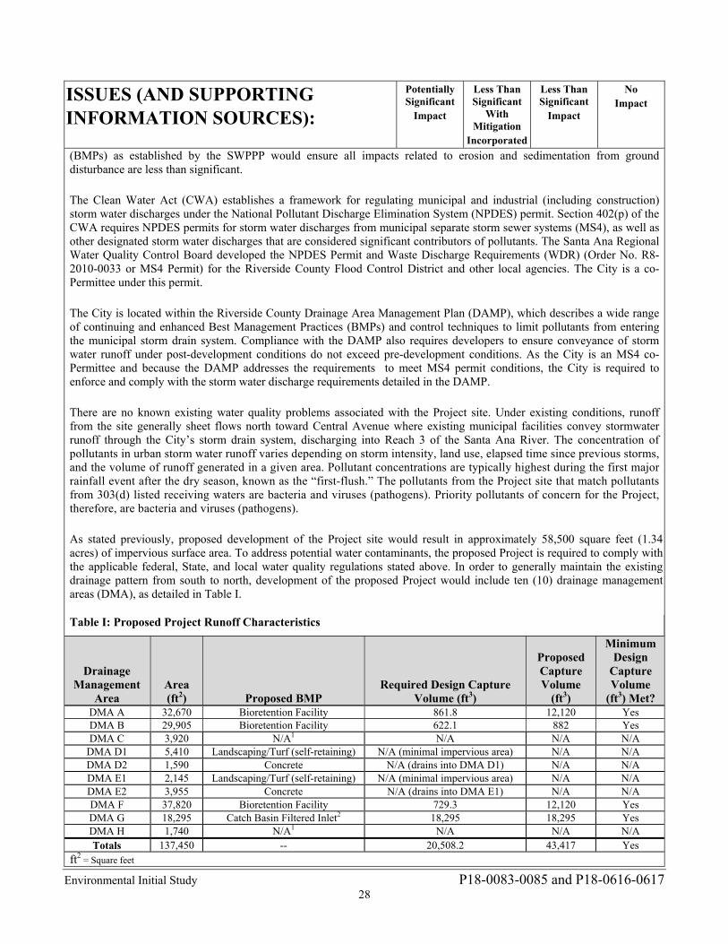
Environmental Initial Study P18-0083-0085 and P18-0616-0617 28
ISSUES (AND SUPPORTING INFORMATION SOURCES):
Potentially Significant
Impact
Less Than Significant
With Mitigation
Incorporated
Less Than Significant
Impact
No Impact
(BMPs) as established by the SWPPP would ensure all impacts related to erosion and sedimentation from ground disturbance are less than significant. The Clean Water Act (CWA) establishes a framework for regulating municipal and industrial (including construction) storm water discharges under the National Pollutant Discharge Elimination System (NPDES) permit. Section 402(p) of the CWA requires NPDES permits for storm water discharges from municipal separate storm sewer systems (MS4), as well as other designated storm water discharges that are considered significant contributors of pollutants. The Santa Ana Regional Water Quality Control Board developed the NPDES Permit and Waste Discharge Requirements (WDR) (Order No. R8-2010-0033 or MS4 Permit) for the Riverside County Flood Control District and other local agencies. The City is a co-Permittee under this permit. The City is located within the Riverside County Drainage Area Management Plan (DAMP), which describes a wide range of continuing and enhanced Best Management Practices (BMPs) and control techniques to limit pollutants from entering the municipal storm drain system. Compliance with the DAMP also requires developers to ensure conveyance of storm water runoff under post-development conditions do not exceed pre-development conditions. As the City is an MS4 co-Permittee and because the DAMP addresses the requirements to meet MS4 permit conditions, the City is required to enforce and comply with the storm water discharge requirements detailed in the DAMP. There are no known existing water quality problems associated with the Project site. Under existing conditions, runoff from the site generally sheet flows north toward Central Avenue where existing municipal facilities convey stormwater runoff through the City’s storm drain system, discharging into Reach 3 of the Santa Ana River. The concentration of pollutants in urban storm water runoff varies depending on storm intensity, land use, elapsed time since previous storms, and the volume of runoff generated in a given area. Pollutant concentrations are typically highest during the first major rainfall event after the dry season, known as the “first-flush.” The pollutants from the Project site that match pollutants from 303(d) listed receiving waters are bacteria and viruses (pathogens). Priority pollutants of concern for the Project, therefore, are bacteria and viruses (pathogens). As stated previously, proposed development of the Project site would result in approximately 58,500 square feet (1.34 acres) of impervious surface area. To address potential water contaminants, the proposed Project is required to comply with the applicable federal, State, and local water quality regulations stated above. In order to generally maintain the existing drainage pattern from south to north, development of the proposed Project would include ten (10) drainage management areas (DMA), as detailed in Table I.
Table I: Proposed Project Runoff Characteristics
Drainage Management
Area Area (ft2) Proposed BMP
Required Design Capture Volume (ft3)
Proposed Capture Volume
(ft3)
Minimum Design
Capture Volume
(ft3) Met? DMA A 32,670 Bioretention Facility 861.8 12,120 Yes DMA B 29,905 Bioretention Facility 622.1 882 Yes DMA C 3,920 N/A1 N/A N/A N/A
DMA D1 5,410 Landscaping/Turf (self-retaining) N/A (minimal impervious area) N/A N/A DMA D2 1,590 Concrete N/A (drains into DMA D1) N/A N/A DMA E1 2,145 Landscaping/Turf (self-retaining) N/A (minimal impervious area) N/A N/A DMA E2 3,955 Concrete N/A (drains into DMA E1) N/A N/A DMA F 37,820 Bioretention Facility 729.3 12,120 Yes DMA G 18,295 Catch Basin Filtered Inlet2 18,295 18,295 Yes DMA H 1,740 N/A1 N/A N/A N/A Totals 137,450 -- 20,508.2 43,417 Yes
ft2 = Square feet
Environmental Initial Study P18-0083-0085 and P18-0616-0617 29
ISSUES (AND SUPPORTING INFORMATION SOURCES):
Potentially Significant
Impact
Less Than Significant
With Mitigation
Incorporated
Less Than Significant
Impact
No Impact
ft3 = Cubic feet
BMP = Best Management Practice DMA = Drainage Management Area N/A = Not applicable 1DMA C (3,920 ft2) and DMA H (1,740 ft2) both contain proposed asphalt-concrete paving. It is considered infeasible to incorporate low impact development BMPs for these DMAs due to their insignificant treatment areas as well as the unreasonable financial burden it would place on the developer to implement treatment BMPs. 2 Alternative Compliance measure due to infeasibility of low impact development BMP. Source: Tables C.1, C.3, C.4, C.5, D.2, and D.3, Project Specific Water Quality Management Plan, Olivewood Memorial Park Prop. Access Road & Mausoleum Expansion (Appendix F).
DMAs A, B, and F comprise the vast majority of the Project site surface area and would drain to on-site BMPs comprised of bioretention facilities designed to remove 85 percent of bacteria and viruses (pathogens), which are the priority pollutants of concern for the Project. Additionally, each of these DMAs would incorporate bioretention facilities designed to exceed the required design capture volume of stormwater runoff to ensure post-development stormwater runoff does not exceed pre-development flows for the overall Project site.
DMA G consists of 11,075 square feet of landscaped area within a maximum slope ratio of 2 to 1, as well as 7,220 square feet of proposed road, totaling 18,295 square feet of surface area. The landscape area will be utilized by the cemetery for proposed gravesites. A bioretention facility is not feasible to treat DMA G due to it impacting the space available for proposed grave sites. Therefore, an alternative compliance feature comprised of a catch basin insert filter will treat stormwater runoff from DMA G. Flow will be picked up in a proposed 16-inch by 16-inch catch basin inlet within a low point in the proposed on-site roadway. From there it will flow into a proposed Flogard Filter with a design filtered flow of 0.7 cubic feet per second (cfs), which meets the two-year and one-hour peak flow rate of 0.7 cfs for this area. After flow is treated, it will be discharged northerly towards Central Avenue and mimic existing drainage patterns.
DMAs C and H both contain proposed asphalt-concrete paving, and it is considered infeasible to incorporate low impact development BMPs for these DMAs due to their insignificant treatment areas as well as the unreasonable financial burden it would place on the developer to implement treatment BMPs. DMAs D1 and E1 are comprised of pervious, vegetated surfaces and are therefore considered self-retaining area; DMAs D2 and E2 will be developed with impervious concrete surfaces which would drain into the self-retaining DMAs D1 and E1.
According to the WQMP, the bioretention facilities serving DMAs A, B, and F are designed to remove 85 percent of bacteria and viruses (pathogens), which are the priority pollutants of concern for the Project. Additionally, the full design capture volume required on-site would be met with the proposed bioretention facilities serving DMAs A, B, and F, as well as the [alternative compliance] catch basin filtered inlet serving DMA G, to ensure post-development stormwater runoff flows would not exceed pre-development flow conditions. Furthermore, all runoff is conveyed southwestward to Reach 3 of the Santa Ana River, flowing downstream through the Prado Basin Management Zone, and ultimately into the Pacific Ocean. Because all downstream conveyance channels to an adequate sump engineered and regularly maintained to ensure design flow capacity (i.e., Prado Basin Management Zone), the Project will not result in a hydrologic condition of concern (HCOC).
Standard Conditions and Regulations: Proper engineering design and construction in conformance with the requirements of the City, the Riverside County DAMP, the intent of the NPDES Permit for Riverside County and the incorporated cities of Riverside County within the Santa Ana Region (MS4 permit), SWRCB treatment requirements, and Project-specific recommendations outlined in a WQMP are routine actions conditioned by the City. Accordingly, the following City Standard Conditions and Regulations are required for the proposed Project to ensure impacts remain less than significant. No mitigation is required.
Standard Condition and Regulation HYD-1: Prior to the issuance of a grading permit, the Project applicant shall file and obtain a Notice of Intent (NOI) with the Regional Water Quality Control Board in order to be in compliance with the State NPDES General Construction Storm Water Permit for discharge of surface runoff associated with construction activities. Evidence
Environmental Initial Study P18-0083-0085 and P18-0616-0617 30
ISSUES (AND SUPPORTING INFORMATION SOURCES):
Potentially Significant
Impact
Less Than Significant
With Mitigation
Incorporated
Less Than Significant
Impact
No Impact
that this has been obtained (i.e., a copy of the Waste Discharger’s Identification Number) shall be submitted to the City for coverage under the NPDES General Construction Permit. The NOI shall address the potential for an extended and discontinuous construction period based on funding availability. This measure shall be implemented to the satisfaction of the Director of the City of Riverside Public Works Department, or designee.
Standard Condition and Regulation HYD-2: Prior to the issuance of a grading permit, the Project applicant shall submit to and receive approval from the City of Riverside of a Storm Water Pollution Prevention Plan (SWPPP). The SWPPP shall include a surface water control plan and erosion control plan citing specific measures to control on-site and off-site erosion during the entire grading and construction period. In addition, the SWPPP shall emphasize structural and nonstructural Best Management Practices (BMPs) to control sediment and non-visible discharges from the site. The SWPPP shall include inspection forms for routine monitoring of the site during both the demolition and construction phases to ensure NPDES compliance and that additional BMPs and erosion control measures will be documented in the SWPPP and utilized if necessary. The SWPPP shall address the potential for an extended and discontinuous construction period based on funding availability. The SWPPP shall be kept on site for the entire duration of Project construction and shall be available to the local Regional Water Quality Control Board (RWQCB) for inspection at any time. BMPs to be implemented may include the following:
Sediment discharges from the site may be controlled by the following: sandbags, silt fences, straw wattles and temporary basins (if deemed necessary), and other discharge control devices. The construction and condition of the BMPs shall be periodically inspected during demolition and construction, and repairs shall be made when necessary as required by the SWPPP.
Materials that have the potential to contribute to non-visible pollutants to storm water must not be placed in drainage ways and must be contained, elevated, and placed in temporary storage containment areas.
All loose piles of soil, silt, clay, sand, debris, and other earthen material shall be protected in a reasonable manner to eliminate any discharge from the site. Stockpiles shall be surrounded by silt fences and covered with plastic tarps.
In addition, the construction contractor shall be responsible for performing and documenting the application of BMPs identified in the SWPPP. Weekly inspections shall be performed on sandbag barriers and other sediment control measures called for in the SWPPP. Monthly reports and inspection logs shall be maintained by the contractor and reviewed by the City of Riverside and the representatives of the State Water Resources Control Board. In the event that it is not feasible to implement specific BMPs, the City can make a determination that other BMPs will provide equivalent or superior treatment either on- or off-site.
This measure shall be implemented to the satisfaction of the Director of the City of Riverside Public Works Department, or designee.
Standard Condition and Regulation HYD-3: Prior to the issuance of a grading permit, the Project applicant shall submit a Final Water Quality Management Plan (WQMP) to the City of Riverside for review and approval. The Project shall implement Project design features identified in the WQMP. The WQMP shall demonstrate that any proposed on-site development plan includes BMPs for source control, pollution prevention, site design, low impact
Environmental Initial Study P18-0083-0085 and P18-0616-0617 31
ISSUES (AND SUPPORTING INFORMATION SOURCES):
Potentially Significant
Impact
Less Than Significant
With Mitigation
Incorporated
Less Than Significant
Impact
No Impact
development (LID) implementation, and structural treatment control. BMPs shall be designed and implemented to retain the Project site’s minimum design capture volume of 20,508.2 cubic feet of runoff to ensure post-development storm water runoff volume or time of concentration does not exceed pre-development storm water runoff. Periodic maintenance of any required bioretention facilities and landscaped areas during Project occupancy and operation shall be in accordance with the schedule outlined in the WQMP. This measure shall be implemented to the satisfaction of the Director of the City of Riverside Public Works Department, or designee.
The Final WQMP would be reviewed and approved as a routine action during the processing of the Project by the City; therefore, it is reasonable that the required measures and features detailed in the WQMP to safeguard water quality would be incorporated into the proposed Project. Given compliance with all applicable federal, State, and local laws regulating surface water quality, (i.e., Standard Conditions and Regulations HYD-1 through HYD-3 and requirements included in the NPDES permit, SWPPP, and Final WQMP), the proposed Project as designed is anticipated to result in a less than significant impact directly, indirectly, and cumulatively to any water quality standards or waste discharge. No mitigation is required.
b. Substantially deplete groundwater supplies or interfere substantially with groundwater recharge such that there would be a net deficit in aquifer volume or a lowering of the local groundwater table level (e.g., the production rate of pre-existing nearby wells would drop to a level which would not support existing land uses or planned uses for which permits have been granted)?
9b. Response: (Source: General Plan 2025 Table PF-1 – RPU Projected Domestic Water Supply (AC-FT/YR), Table PF-2 – RPU Projected Water Demand, RPU Urban Water Management Plan, Riverside General Plan and Supporting Documents Environmental Impact Report Page 5.16-33, Table 5.16-E – RPU Projected Domestic Water Supply (AC-FT/YR), Table 5.16-F – RPU Projected Water Demand, Table 5.16-G – General Plan Projected Water Demand for RPU Including Water Reliability for 2025, Table 5.16-H – Current and Projected Domestic Water Supply (AC-FT/YR) Western Municipal Water District, Table 5.16-I – Current and Projected Water Use for Western Municipal Water District, Table 5.16-J – General Plan Projected Water Demand for Western Municipal Water District Including Water Reliability 2025, Title 19 – Article VIII – Chapter 19.570 – Water Efficient Landscaping and Irrigation, California Department of Water Resources, Groundwater Basin Boundary Assessment Tool (https://gis.water.ca.gov/app/bbat/) accessed August 13, 2018.)
Less than Significant Impact. Water service for the site would be provided by Riverside Public Utilities (RPU). RPU extracts groundwater from five groundwater basins, which accounts for the majority of its supplies. Approximately 60 percent comes from the Bunker Hill Basin, within which water rights are adjudicated. The proposed Project is located within the Upper Santa Ana Valley - Riverside-Arlington Groundwater Subbasin. RPU’s water rights are based on the long-term yield of the basin estimated for normal, dry, and multiple-dry years. Pursuant to the 2015 Urban Water Management Plan (UWMP), the RPU maintains sufficient supplies of water (including groundwater) during normal, dry, and multiple-dry years and would have a reliable and sufficient water supply, which would exceed Projected demand through the year 2040.
The UWMP bases its demand estimates on broad categories of uses (e.g., single-family residential, commercial/industrial/institutional) and growth projections identified by the City. The Project site has a General Plan land use designation of Public Facilities/Institutional (PF) as shown in Figure LU-10 Land Use Policy Map. The Project site has an underlying zoning designation of RC - Residential Conservation. The proposed uses are consistent with the existing cemetery uses within Olivewood Memorial Park. Although cemeteries are not permitted uses within the underlying RC – Residential Conservation Zone, Olivewood Memorial Park is a legally non-conforming land use with historical connections to the City. In addition, as shown in General Plan Figure LU-2 Urban Design Framework, the cemetery is labeled “Major Open Space and Parks.” Olivewood Memorial Park has been a cemetery dating back to the late 1880s and it reasonable to conclude the
Environmental Initial Study P18-0083-0085 and P18-0616-0617 32
ISSUES (AND SUPPORTING INFORMATION SOURCES):
Potentially Significant
Impact
Less Than Significant
With Mitigation
Incorporated
Less Than Significant
Impact
No Impact
proposed Project and all of Olivewood Memorial Park will remain a cemetery in perpetuity. The Project would otherwise comply with all applicable provisions of the General Plan and Zoning Code. Based on these considerations, it is reasonable to conclude that water demand for existing Olivewood Memorial Park has been previously included in the estimates of future demand. It is also reasonable to conclude that the small, incremental increase in water demand attributable to the proposed Project would not cause there to be a substantial depletion of the City’s groundwater reserves.
The proposed Project site has been designed to maximize the landscape areas, thereby minimizing the impervious area to the maximum extent possible; runoff from the site would disperse into bioretention facilities located within DMAs A, B, and F or landscaped areas located within DMAs D1 and E1 prior to discharging into the city storm drain. Additionally, the proposed Project would utilize water conservation project design features such as low-flush toilets, low-flow faucets, and drought-tolerant landscaping pursuant to the requirements of the City’s adopted Water Efficient Landscape Ordinance.
The Project site is underlain by impermeable bedrock. Therefore, there is no natural infiltration capacity on-site. However, the Project site is not located within a designated groundwater recharge area, nor does it propose direct additions to or withdrawals of groundwater. Furthermore, the proposed construction does not reach depths that would impair or alter the direction or rate of flow of groundwater. Through implementation of Standard Condition and Regulation HYD-3, a Project-specific Final WQMP shall be developed to specify BMPs designed and implemented to retain the Project site’s minimum design capture volume. Storm water shall be captured on-site, filtered with an 85 percent pollutant removal efficacy, and reused for irrigation as needed prior to discharging into the City’s existing stormwater facilities. Accordingly, post-development storm water runoff volume or time of concentration will not exceed pre-development storm water runoff. Periodic maintenance of any required bioretention facilities and landscaped areas during Project occupancy and operation shall be in accordance with the schedule outlined in the Final WQMP. Through implementation of Standard Condition and Regulation HYD-3, the Project’s potential impacts to groundwater availability, quality, or recharge capabilities would be less than significant directly, indirectly, and cumulatively. No mitigation is required.
c. Substantially alter the existing drainage pattern of the site or area, including through the alteration of the course of a stream or river, in a manner which would result in substantial erosion or siltation on- or off-site?
9c. Response: (Source: Preliminary grading plan, and Project Specific Water Quality Management Plan prepared by Armstrong & Brooks on 4/19/2018)
Less Than Significant Impact. Development of the proposed Project (buildings and pavement) would alter the amount of existing pervious surface area and the amount of generated runoff. Construction would disturb paved and/or vegetated surfaces and expose on-site soils to erosion and siltation potential. Pursuant to Standard Condition and Regulation HYD-2, the Project applicant shall submit to and receive approval from the City of Riverside of an SWPPP prior to the issuance of a grading permit. The SWPPP shall include a surface water control plan and erosion control plan citing specific measures to control on-site and off-site erosion during the entire grading and construction period. In addition, the SWPPP shall emphasize structural and nonstructural BMPs to control sediment and non-visible discharges from the site. The SWPPP shall include inspection forms for routine monitoring of the site during construction to ensure NPDES compliance and that additional BMPs and erosion control measures will be documented in the SWPPP and utilized if necessary. The SWPPP shall address the potential for an extended and discontinuous construction period based on funding availability.
Pursuant to Standard Condition and Regulation HYD-3, the applicant shall prepare a Final WQMP to specify BMPs designed and implemented to retain the Project site’s minimum design capture volume. Storm water shall be captured on-site, filtered with an 85 percent pollutant removal efficacy, and reused for irrigation as needed prior to discharging into the existing stormwater facilities. Accordingly, post-development storm water runoff volume or time of concentration will not exceed pre-development storm water runoff. Through implementation of Standard Condition and Regulation HYD-3 and project design features such as roof downspouts draining into landscaped areas, and maintenance of existing surface flows across the Project site into the proposed bioretention facilities, development of the Project would maintain the site’s existing drainage pattern and prevent erosion or siltation. Periodic maintenance of any required bioretention facility and landscaped area during Project occupancy and operation shall be in accordance with the schedule outlined in the Final WQMP.
With implementation of Standard Conditions and Regulations HYD-2 and HYD-3, impacts related to substantial
Environmental Initial Study P18-0083-0085 and P18-0616-0617 33
ISSUES (AND SUPPORTING INFORMATION SOURCES):
Potentially Significant
Impact
Less Than Significant
With Mitigation
Incorporated
Less Than Significant
Impact
No Impact
alteration of the existing drainage pattern of the site or area in a manner which would result in substantial erosion or siltation on- or off-site would be less than significant directly, indirectly, and cumulatively. No mitigation is required.
d. Substantially alter the existing drainage pattern of the site or area, including through the alteration of the course of a stream or river, or substantially increase the rate or amount of surface runoff in a manner which would result in flooding on- or off-site?
9d. Response: (Source: Preliminary grading plan, and Project Specific Water Quality Management Plan prepared by Armstrong & Brooks on 4/19/2018)
Less Than Significant Impact. See response to Checklist Question 9c. With implementation of Standard Condition and Regulation HYD-3, impacts related to substantial alteration of the existing drainage pattern of the site or area or substantial increase in the rate or amount of surface runoff in a manner which would result in flooding on- or off-site would remain less than significant directly, indirectly, and cumulatively. No mitigation is required.
e. Create or contribute runoff water which would exceed the capacity of existing or planned stormwater drainage systems or provide substantial additional sources of polluted runoff?
9e. Response: (Source: Preliminary Grading Plan, and Project Specific Water Quality Management Plan prepared by Armstrong & Brooks on 4/19/2018)
Less Than Significant Impact. See response to Checklist Question 9c. Implementation of Standard Conditions and Regulations HYD-2 and HYD-3 would ensure polluted runoff during site preparation and construction would be addressed by the SWPPP, and post-development storm water runoff volume or time of concentration would not exceed pre-development conditions. Therefore, impacts related to the creation or contribution of runoff water which would exceed the capacity of existing or planned storm water drainage systems or provide substantial additional sources of polluted runoff would remain less than significant directly, indirectly, and cumulatively. No mitigation is required.
f. Otherwise substantially degrade water quality? 9f. Response: (Source: Preliminary Grading Plan, and Project Specific Water Quality Management Plan prepared
by Armstrong & Brooks on 4/19/2018)
Less Than Significant Impact. Refer to response to Checklist Question 9a. Implementation of Standard Conditions and Regulations HYD-1 through HYD-3 would ensure compliance with the State NPDES General Construction Storm Water Permit for discharge of surface runoff associated with construction activities. Polluted runoff during site preparation and construction would be addressed by the SWPPP. Post-development storm water runoff volume or time of concentration would not exceed pre-development conditions. The SWPPP and WQMP would be reviewed and approved as a routine action during the processing of the Project by the City; therefore, it is reasonable to conclude that the required measures and features detailed in the SWPPP and WQMP to safeguard the existing drainage pattern of the site and area from storm water runoff would be incorporated into the proposed Project. The Project would not have any substantial effects on a stream or river, as no such features exist on or adjacent to the Project site, and site-specific structural BMPs shall be designed and implemented to retain the Project site’s minimum design capture volume of 20,508.2 cubic feet of runoff. Adherence to Standard Conditions and Regulations HYD-1 through HYD-3 and requirements included in the NPDES permit, SWPPP, and WQMP would ensure potential water quality impacts remain less than significant directly, indirectly, and cumulatively. No mitigation is required.
g. Place housing within a 100-year flood hazard area as mapped on a federal Flood Hazard Boundary or Flood Insurance Rate Map or other flood hazard delineation map?
9g. Response: (Source: General Plan 2025 Figure PS-4 – Flood Hazard Areas, and FEMA Flood Hazard Maps

Environmental Initial Study P18-0083-0085 and P18-0616-0617 34
ISSUES (AND SUPPORTING INFORMATION SOURCES):
Potentially Significant
Impact
Less Than Significant
With Mitigation
Incorporated
Less Than Significant
Impact
No Impact
Zone X, Panel 06071C8702H)
No Impact. A review of National Flood Insurance Rate Map (Map Number 06071C8702H Effective Date August 28, 2008) and Figure 5.8-2 – Flood Hazard Areas of the General Plan Program FPEIR, shows that the Project is, 1) not located within or near a 100-year flood hazard area, and 2) the Project does not involve the construction of housing. There will be no impact caused by this Project directly, indirectly, or cumulatively, as it will not place housing within a 100-year flood hazard area. No mitigation is required.
h. Place within a 100-year flood hazard area structures which would impede or redirect flood flows?
9h. Response: (Source: General Plan 2025 Figure PS-4 – Flood Hazard Areas, and FEMA Flood Hazard Maps Zone X, Panel 06071C8702H)
No Impact. The Project site is not located within or near a 100-year flood hazard area as depicted on General Plan 2025 Program FPEIR Figure 5.8-2 – Flood Hazard Areas and the National Flood Insurance Rate Map (Map Number 06071C8702H Effective Date August 28, 2008). Therefore, the Project will not place a structure within a 100-year flood hazard area that would impede or redirect flood flows and no impact will occur directly, indirectly or cumulatively.
i. Expose people or structures to a significant risk of loss, injury or death involving flooding, including flooding as a result of the failure of a levee or dam?
9i. Response: (Source: General Plan 2025 Figure PS-4 – Flood Hazard Areas, and FEMA Flood Hazard Maps Zone X, Panel 06071C8702H)
No Impact. The Project site is not located within or near a flood hazard area as depicted on General Plan 2025 Program FPEIR Figure 5.8-2 – Flood Hazard Areas and the National Flood Insurance Rate Map (Map Number 06071C8702H Effective Date August 28, 2008) or subject to dam inundation as depicted on General Plan 2025 Program FPEIR Figure 5.8-2 – Flood Hazard Areas. Therefore, the Project will not place a structure within a flood hazard or dam inundation area that would expose people or structures to a significant risk of loss, injury or death involving flooding, including flooding as a result of the failure of a levee or dam and therefore no impact directly, indirectly or cumulatively will occur.
j. Inundation by seiche, tsunami, or mudflow?
9j. Response: (Source: GP 2025 FPEIR Chapter 7.5.8 – Hydrology and Water Quality)
Less than Significant Impact. Seiches are oscillations in enclosed bodies of water that are caused by a number of factors, most often wind or seismic activity. There are no large open water bodies in proximity to the Project site. Since the Project site is not located within a 100-year flood zone or dam inundation area, seiche-related flooding is not anticipated to occur on-site. No impacts due to seiches will occur directly, indirectly or cumulatively.
Tsunamis are large waves that occur in coastal areas; therefore, since the City is not located in a coastal area, no impacts due to tsunamis will occur directly, indirectly or cumulatively.
As detailed in response to Checklist Question 6a iv, the Project site underlain by slopes ranging from 0 to greater than 30 percent (see Figure 5.6-1 of the General Plan 2025 Program Final PEIR). However, the geotechnical investigation concludes the Project site is not located within an area identified as having the potential for landslides or mudflows. Although the Project site is underlain by slopes ranging from 0 to greater than 30 percent, no surface outcrops that include boulders with a potential for roll down are located above the site. The Project would include slope retaining walls constructed to the specifications of the Project-specific geotechnical report (Appendix D1). Additionally, future landscaping/planting and improvements adjacent to the retaining walls shall also be taken into account in the design of the retaining walls. Excessive soil disturbance, trenches (excavation and backfill), future landscaping adjacent to footings, and over-saturation can adversely affect retaining structures and result in reduced lateral resistance. Backfill behind retaining walls should consist of a soil of sufficient granularity that the backfill will properly drain. Surface drainage comprised of either a 4-inch-diameter perforated PVC (Schedule 40) pipe or equivalent at the base
Environmental Initial Study P18-0083-0085 and P18-0616-0617 35
ISSUES (AND SUPPORTING INFORMATION SOURCES):
Potentially Significant
Impact
Less Than Significant
With Mitigation
Incorporated
Less Than Significant
Impact
No Impact
of the stem encased in 2 cubic feet of granular drain material per linear foot of pipe, or synthetic drains such as Enkadrain, Miradrain, Hydraway 300 or equivalent, must be provided to prevent ponding of water behind walls.
Pursuant to State law and in accordance with General Plan Policy PS-1.1, the proposed Project will be designed to resist mudflows in accordance with current California Building Code requirements and Title 16 (Buildings and Construction) of the Riverside Municipal Code. Prior to issuance of any entitlements, the City will review and approve plans to confirm that the siting, design and construction of all structures and facilities are in accordance with the regulations established in the California Building Code, City Building Code, and/or professional engineering standards appropriate for the seismic zone in which such construction may occur. Additionally, all grading plans will be subject to City Staff review for regulatory compliance in accordance with Riverside Municipal Code, Section 17.16.010. Proper engineering design and construction in conformance with California Building Code standards and Project-specific geotechnical recommendations (Standard Condition and Regulation GEO-1) would ensure that impacts related to mudflows would be less than significant directly, indirectly, and cumulatively. No mitigation is required.
10. LAND USE AND PLANNING: Would the project:
a. Physically divide an established community?
10a. Response: (Source: General Plan 2025 Land Use and Urban Design Element, Project site plans, City of Riverside GIS/CADME map layers)
No Impact. The Project is an expansion of an existing cemetery, and can be characterized as an infill project currently served by fully improved public streets and other infrastructure and does not involve the subdivision of land or the creation of streets that could alter the existing surrounding pattern of development or an established community. The addition of the proposed access road in the Project site will only facilitate circulation within the cemetery and will not connect to the surrounding public street system. Therefore, the Project will have no impact directly, indirectly or cumulatively to an established community. No mitigation is required.
b. Conflict with any applicable land use plan, policy, or regulation of an agency with jurisdiction over the project (including, but not limited to the general plan, specific plan, local coastal program, or zoning ordinance) adopted for the purpose of avoiding or mitigating an environmental effect?
10b. Response: (Source: General Plan 2025, General Plan 2025 Figure LU-10 – Land Use Policy Map, Table LU-5 – Zoning/General Plan Consistency Matrix, Figure LU-7 – Redevelopment Areas, Title 19 – Zoning Code, Title 18 – Subdivision Code, Title 7 – Noise Code, Title 17 – Grading Code, Title 20 – Cultural Resources Code, Title 16 – Buildings and Construction and Citywide Design and Sign Guidelines)
Less Than Significant Impact With Mitigation. The proposed uses are consistent with the existing cemetery uses within Olivewood Memorial Park. Although cemeteries are not permitted uses within the underlying RC – Residential Conservation Zone, Olivewood Memorial Park is a legally non-conforming land use with historical connections to the City. In addition, as shown in General Plan Figure LU-2 Urban Design Framework, the cemetery is labeled “Major Open Space and Parks.” As shown in shown in General Plan Figure LU-10 Land Use Policy Map, the cemetery is labeled “Public Facilities/Institutional.” Olivewood Memorial Park has been a cemetery dating back to the late 1880s and it reasonable to conclude the proposed Project and all of Olivewood Memorial Park will remain a cemetery in perpetuity. Although the Project is a legal non-confirming land use, the Project is consistent with the General Plan 2025. The Project would otherwise comply with all applicable provisions of the General Plan and Zoning Code and would therefore will have less than significant impacts directly, indirectly or cumulatively with implementation of mitigation related to the City’s General Plan and Zoning Code regulations. The Project is located within the boundaries of the MSHCP burrowing owl survey area. Implementation of Mitigation Measure BIO-1, listed in Section 4a, requiring preconstruction burrowing owl surveys 30 days prior to the issuance of a grading permit will reduce the potential impacts to burrowing owls associated with construction of the Project. Therefore,
Environmental Initial Study P18-0083-0085 and P18-0616-0617 36
ISSUES (AND SUPPORTING INFORMATION SOURCES):
Potentially Significant
Impact
Less Than Significant
With Mitigation
Incorporated
Less Than Significant
Impact
No Impact
the Project will have less than significant impacts directly, indirectly or cumulatively with implementation of mitigation related to applicable provisions of the MSHCP.
c. Conflict with any applicable habitat conservation plan or natural community conservation plan?
10c. Response: (Source: General Plan 2025, General Plan 2025 – Figure LU-10 – Land Use Policy Map, Table LU-5 – Zoning/General Plan Consistency Matrix, Figure LU-7 – Redevelopment Areas, enter appropriate Specific Plan if one, Title 19 – Zoning Code, Title 18 – Subdivision Code, Title 7 – Noise Code, Title 17 – Grading Code, Title 20 – Cultural Resources Code, Title 16 – Buildings and Construction and Citywide Design and Sign Guidelines, and MSHCP Consistency Analysis prepared by LSA in August, 2017)
Less Than Significant With Mitigation. The Project site is located within an urban built-up area, however the results of the MSHCP Consistency Analysis show that the Project site is within the MSHCP burrowing owl survey area and the SKR fee area, and contains trees, shrubs and non-native grasslands that provide suitable habitat for migratory and nesting birds. With implementation of Mitigation Measures BIO-1 and BIO-2 and compliance with Standard Condition and Regulation BR-1 described in Section 4. Biological Resources, potential impacts to burrowing owls, migratory birds, and protected species will be reduced to less than significant levels. Therefore, the Project will have less than significant impacts with implementation of mitigation related to the provisions of an adopted Habitat Conservation Plan, Natural Community Conservation Plan.
11. MINERAL RESOURCES. Would the project:
a. Result in the loss of availability of a known mineral resource that would be of value to the region and the residents of the state?
11a. Response: (Source: General Plan 2025 Figure – OS-1 – Mineral Resources, General Plan 2025 Open Space and Conservation Element)
No Impact. As depicted in Figure OS-1 of the General Plan 2025 Open Space Element, the Project site is located within the designated MRZ-3 zone, defined as containing inferred mineral occurrences of undetermined mineral resource significance. The Project site has minimal potential to be mined in the future because it is completely surrounded by urban development and is not considered a state-designated mineral resource extraction zone. Therefore, the Project will not result in the loss of a known mineral resource that would be of value to the region or residents of the state. The Project will result in no impact directly, indirectly or cumulatively on regionally or statewide significant mineral resources. No mitigation is required.
b. Result in the loss of availability of a locally-important mineral resource recovery site delineated on a local general plan, specific plan or other land use plan?
11b. Response: (Source: General Plan 2025 Figure – OS-1 – Mineral Resources) No Impact. As depicted in Figure OS-1 of the General Plan 2025 Open Space Element, the Project site is located within the designated MRZ-3 zone, defined as containing inferred mineral occurrences of undetermined mineral resource significance. The General Plan 2025 and the General Plan Environmental Impact Report concluded there are no locally-important mineral resource recovery sites within the City and implementation of the General Plan 2025 would not significantly preclude potential extraction of significant mineral resources. The Project is consistent with the General Plan 2025 land use designation and City zoning designation. Therefore, the Project will have no impact directly, indirectly, or cumulatively on locally significant mineral resources. No mitigation is required.
Environmental Initial Study P18-0083-0085 and P18-0616-0617 37
ISSUES (AND SUPPORTING INFORMATION SOURCES):
Potentially Significant
Impact
Less Than Significant
With Mitigation
Incorporated
Less Than Significant
Impact
No Impact
12. NOISE. Would the project result in:
a. Exposure of persons to or generation of noise levels in excess of standards established in the local general plan or noise ordinance, or applicable standards of other agencies?
12a. Response: (Source: General Plan 2025 FPEIR, City of Riverside Municipal Code Title 7 – Nose Control, Federal Transit Administration Transit Noise and Vibration Impact Assessment, 2006, 18th Edition of the International Society of Explosives Engineer’s (ISEE’s) Blasters’ Handbook, Noise and Vibration Memorandum for the Olivewood Cemetery Project in the City of Riverside, California, prepared by LSA Associates, Inc. on August 1, 2018, Geotechnical Investigation for Olivewood Memorial Park prepared by CHJ Consultants on April 24, 2015, Seismic Refraction Investigation for Olivewood Memorial Park prepared by CHJ Consultants on June 16, 2017, Assessment of Potential Rock Blasting Impacts and Recommended Practices For the Olivewood Memorial Park Mausoleums Project prepared by Revey Associates, Inc. 2019)
Less Than Significant with Mitigation Incorporated. The Project would have a significant effect on the environment related to noise if it would substantially increase the ambient noise levels for adjoining areas or conflict with adopted environmental plans and goals of the community in which it is located. The applicable noise standards governing the Project site are the noise criteria listed in the Noise Element of the General Plan 2025 and in Title 7 - Noise Control of the City’s Municipal Code.
City of Riverside General Plan Noise Element. The Noise Element specifies the maximum allowable unmitigated exterior noise levels for new developments impacted by transportation noise sources such as arterial roads, freeways, airports, and railroads. In addition, the Noise Element identifies several policies to minimize the impacts of excessive noise levels throughout the community, and establishes noise level requirements for all land uses.
The City may consider its noise/land use compatibility guidelines in its land use decisions. The Noise/Land Use Compatibility Criteria describes categories of compatibility and not specific noise standards. These guidelines generally identify conditions where development of a particular use may be “Normally Acceptable,” “Conditionally Acceptable,” “Normally Unacceptable,” or “Conditionally Unacceptable.” For cemeteries, a noise level of up to 70 A-weighted decibels (dBA) Community Noise Equivalent Level (CNEL) is considered normally acceptable, a noise level between 70 dBA CNEL and 80 dBA CNEL is considered normally unacceptable, and a level greater than 80 dBA CNEL is considered conditionally unacceptable.
The nearest sensitive receptors in proximity to the Project site are single-family residential uses approximately 75 feet east of the Project construction and operation limits. Single-family residences are “Normally Acceptable” in exterior noise environments up to 60 A-weighted decibels (dBA) Community Noise Equivalent Level (CNEL) and “Conditionally Acceptable” in exterior noise environments of up to 65 dBA CNEL. Interior noise levels within residential structures are acceptable up to 45 dBA CNEL. For “Conditionally Acceptable” single-family residential uses, new development should only be undertaken after an analysis of noise reduction requirements and identification of noise reduction/insulation features. As stated in the City’s General Plan 2025 Noise Element “… Depending on the ambient environment of a particular community, these basic guidelines may be tailored to reflect existing noise and land use characteristics.”
For the purposes of this analysis, cemetery uses exposed to noise levels exceeding 70 dBA CNEL would require mitigation. Additionally, Single-family residential uses with outdoor active use areas (e.g., backyards or balconies) exposed to noise levels exceeding 60 dBA CNEL would require mitigation. Furthermore, interior noise levels for new residential development is required to comply with standards set forth in Title 24 of the State Health and Safety Code. New construction is required to incorporate special insulation, windows, and sealants in order to ensure that interior noise levels meet Title 24 standards. The interior noise standard for residences is 45 dBA CNEL.
City of Riverside Municipal Code Noise Ordinance. Section 7.25.010 of the C i t y Municipal Code establishes exterior noise standards for various land use categories over certain periods of time. Per the Code, noise from operations at any
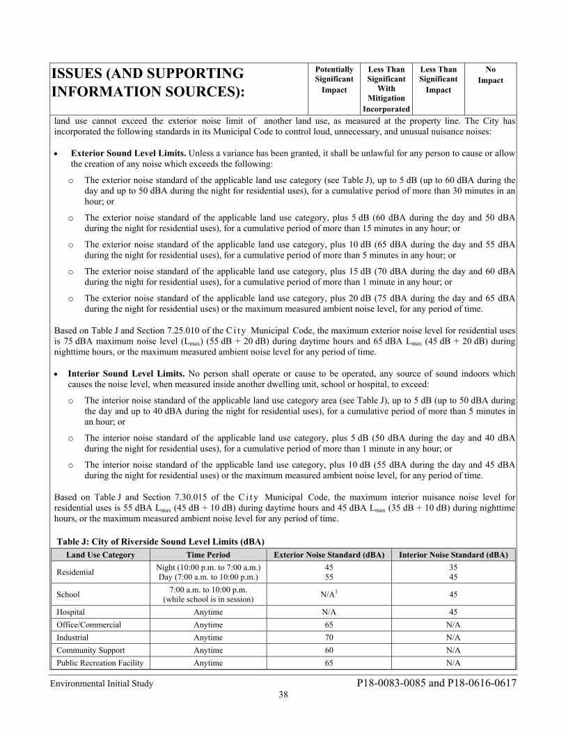
Environmental Initial Study P18-0083-0085 and P18-0616-0617 38
ISSUES (AND SUPPORTING INFORMATION SOURCES):
Potentially Significant
Impact
Less Than Significant
With Mitigation
Incorporated
Less Than Significant
Impact
No Impact
land use cannot exceed the exterior noise limit of another land use, as measured at the property line. The City has incorporated the following standards in its Municipal Code to control loud, unnecessary, and unusual nuisance noises:
Exterior Sound Level Limits. Unless a variance has been granted, it shall be unlawful for any person to cause or allow the creation of any noise which exceeds the following:
o The exterior noise standard of the applicable land use category (see Table J), up to 5 dB (up to 60 dBA during the day and up to 50 dBA during the night for residential uses), for a cumulative period of more than 30 minutes in an hour; or
o The exterior noise standard of the applicable land use category, plus 5 dB (60 dBA during the day and 50 dBA during the night for residential uses), for a cumulative period of more than 15 minutes in any hour; or
o The exterior noise standard of the applicable land use category, plus 10 dB (65 dBA during the day and 55 dBA during the night for residential uses), for a cumulative period of more than 5 minutes in any hour; or
o The exterior noise standard of the applicable land use category, plus 15 dB (70 dBA during the day and 60 dBA during the night for residential uses), for a cumulative period of more than 1 minute in any hour; or
o The exterior noise standard of the applicable land use category, plus 20 dB (75 dBA during the day and 65 dBA during the night for residential uses) or the maximum measured ambient noise level, for any period of time.
Based on Table J and Section 7.25.010 of the C i t y Municipal Code, the maximum exterior noise level for residential uses is 75 dBA maximum noise level (Lmax) (55 dB + 20 dB) during daytime hours and 65 dBA Lmax (45 dB + 20 dB) during nighttime hours, or the maximum measured ambient noise level for any period of time.
Interior Sound Level Limits. No person shall operate or cause to be operated, any source of sound indoors which causes the noise level, when measured inside another dwelling unit, school or hospital, to exceed:
o The interior noise standard of the applicable land use category area (see Table J), up to 5 dB (up to 50 dBA during the day and up to 40 dBA during the night for residential uses), for a cumulative period of more than 5 minutes in an hour; or
o The interior noise standard of the applicable land use category, plus 5 dB (50 dBA during the day and 40 dBA during the night for residential uses), for a cumulative period of more than 1 minute in any hour; or
o The interior noise standard of the applicable land use category, plus 10 dB (55 dBA during the day and 45 dBA during the night for residential uses) or the maximum measured ambient noise level, for any period of time.
Based on Table J and Section 7.30.015 of the C i t y Municipal Code, the maximum interior nuisance noise level for residential uses is 55 dBA Lmax (45 dB + 10 dB) during daytime hours and 45 dBA Lmax (35 dB + 10 dB) during nighttime hours, or the maximum measured ambient noise level for any period of time.
Table J: City of Riverside Sound Level Limits (dBA)
Land Use Category Time Period Exterior Noise Standard (dBA) Interior Noise Standard (dBA)
Residential Night (10:00 p.m. to 7:00 a.m.) Day (7:00 a.m. to 10:00 p.m.)
45 55
35 45
School 7:00 a.m. to 10:00 p.m.
(while school is in session) N/A1 45
Hospital Anytime N/A 45
Office/Commercial Anytime 65 N/A
Industrial Anytime 70 N/A
Community Support Anytime 60 N/A
Public Recreation Facility Anytime 65 N/A
Environmental Initial Study P18-0083-0085 and P18-0616-0617 39
ISSUES (AND SUPPORTING INFORMATION SOURCES):
Potentially Significant
Impact
Less Than Significant
With Mitigation
Incorporated
Less Than Significant
Impact
No Impact
Non-urban Anytime 70 N/A
Source: Riverside Municipal Code Table 7.25.010A and Table 7.30.015 1 N/A = Not Applicable; the City of Riverside has not established a sound level limit for this land use. dBA = A-weighted decibels
Existing Conditions. The Project site is adjacent to cemetery uses to the north, west, and south, and east, with single-family residential uses located approximately 75 feet to the east. State Route 91 and railroad tracks shared by Union Pacific, Burlington Northern Santa Fe, Metrolink, and Amtrak proceed adjacent to the cemetery, approximately 1,200 and 1,000 feet respectively to the west of the Project site. According to Figure 5.11-3 of the General Plan 2025 FPEIR, the Project site is currently experiencing 65 dBA CNEL on account of its proximity to State Route 91 and the railroad tracks. Upon buildout of the 2025 General Plan, the Project site would experience 70 dBA CNEL on account of its proximity to the railroad tracks, as detailed in Figure 5.11-8 of the General Plan 2025 FPEIR. Therefore, the Project site is located in an area currently subjected to potentially high levels of noise from adjacent roadways and railways.
Construction Impacts. Section 7.35.020.G, Exemptions, of the City’s Noise Ordinance, states that “Noise sources associated with construction, repair, remodeling, or grading of any real property; provided a permit has been obtained from the City as required; and provided said activities do not take place between the hours of 7:00 p.m. and 7:00 a.m. on weekdays, between the hours of 5:00 p.m. and 8:00 a.m. on Saturdays, or at any time on Sunday or a federal holiday” are exempt from the noise level limits of the Municipal Code.
According to the Project-specific geotechnical investigation (Appendix D1) and seismic refraction investigation (Appendix D2), localized zones of marginally rippable bedrock (i.e., bedrock that can be physically reduced to removable aggregate) occur along the proposed roadway alignment, and blasting may be required as an alternative method of excavation in these areas. This analysis assumes blasting is an atypical construction activity and therefore is analyzed for impacts to noise-sensitive receptors.
Blasting activities generally include the pre-drilling of holes in the hard rock area, preparation and placement of the charges in the drilled holes, a pre-blast horn signal, additional pre-blast horn signals immediately prior to the blast, and the blast itself. An additional horn signal is sounded to indicate the “all clear” after the blast and the blasting contractor has inspected the blasting area. The noise from the blast itself starts with a cracking sound from the detonator, located at a distance from the charges, and ends with the low crackling sound from each charge as they are subsequently set off. Blasts typically occur for only a few seconds, depending on their design. It is important to note that no other construction equipment will be operating during each blast in the blast area, but will commence operation once the blasting contractor indicates it is safe to do so.
The noise produced by blasting activities is referred to as air overpressure, or an “airblast,” which is generated when explosive energy in the form of gases escape from the detonating blast holes. Much like a point source, airblasts radiate outward in a spherical pattern and attenuate with each doubling of distance from the blast location, depending on the design of the blast and amount of containment.. The following calculations, analyses, and findings provided in this analysis are based on Assessment of Potential Rock Blasting Impacts and Recommended Practices For the Olivewood Memorial Park Mausoleums Project (Revey Associates, Inc. 2019).
Revey and Associates, Inc. (Revey) estimated blasting impacts in the granitic rock formations at the Project site based on experience at Perris Dam that contained similar rock formations. Based on this experience, Revey determined that noise and vibration impacts from blasting would be minimized with implementation of specific practices and limitations. With implementation of the blasting practices and limitations proposed by the technical expert (Revey), noise and vibration impacts associated with blasting on the Project site would be conducted in a safe manner and impacts to adjacent residences and on-site structures, including the existing mausoleums, would be reduced to acceptable levels. These practices and limitations are contained in Mitigation Measure NOI-1.
Mitigation Measure NOI-1: If the Project applicant determines blasting is required to construct the Project, the applicant shall retain a qualified blasting expert to prepare a site-specific blasting plan
Environmental Initial Study P18-0083-0085 and P18-0616-0617 40
ISSUES (AND SUPPORTING INFORMATION SOURCES):
Potentially Significant
Impact
Less Than Significant
With Mitigation
Incorporated
Less Than Significant
Impact
No Impact
that incorporates the following measures. These limitations should be included in Project contract specifications. All vibration and air-overpressure monitoring should conform to ISEE Guidelines as provided in Assessment of Potential Rock Blasting Impacts and Recommended Practices dated January 2019 (See Initial Study Appendix G, Attachment B. These measures are:
1. Blast‐hole diameter shall not exceed 2.5 inches. 2. Only fixed‐cartridge explosives shall be used for this work. 3. The minimum scaled distance to residential structures shall be 90 ft/lb1/2. 4. The minimum scaled distance to existing mausoleum structures shall be 50 ft/lb1/2. 5. The minimum confining rock burden on all charges shall be at least 25 charge�
diameters. 6. Charges shall be stemmed with at least 25 charge�diameters of clean crushed stone. 7. No more than 2,000 pounds of explosives shall be used in individual blasts. 8. Rubber-tire and Steel-cable blasting mats or weed barrier fabric and three feet of soil
cover shall be used to control movement of blasted rock. 9. Peak Particle Velocity (PPV) at residential property shall not exceed 0.5 in/s and
PPV at the existing mausoleum shall not exceed 1.0 in/s. 10. Air-overpressure measured at nearest offsite structures shall not exceed 133 dBL. 11. At least two seismographs shall be deployed to measure PPV and air-overpressure at
the nearest structures of concern. 12. Blast areas shall be sprayed water to suppress dust when conditions are dry and/or
windy.
This measure shall be implemented to the satisfaction of the Director of the City of Riverside Community and Economic Development Department, Building and Safety Division as well as the planning Division, or designee(s).
Compliance with Section 7.35.020.G of the City’s Noise Ordinance and implementation of Mitigation Measure NOI-1 would ensure construction-related noise and blasting impacts to the nearby sensitive receptors (adjacent residences) and on-site structures (existing mausoleums) are less than significant with mitigation incorporated.
Operational Impacts. Long-term noise associated with the Project site would be generated from stationary-source noise activities. These activities are potential point sources of noise that could affect existing off-site residences to the east of the Project site. On-site noise-producing activities include vehicle and equipment movements on the Project site, surface parking lots, people conversing, and excavation of gravesites. Noise generated from parking activities would include noise generated by vehicles traveling at slow speeds, engine start-up noise, car door slams, car horns, car alarms, tire squeals. Excavator noise would generate from the engines and excavation apparatus.
As previously stated, the Project site is located in an area currently subjected to potentially high levels of noise from adjacent roadways and railways. CEQA Guidelines section 15126.2(a) generally requires an analysis of environmental conditions and hazards existing on a proposed project site if such conditions and hazards may cause substantial adverse impacts to future users of the project. CEQA calls upon an agency to evaluate existing conditions in order to assess whether a project could exacerbate hazards that are already present. In California Building Industry Association v. Bay Area Air Quality Management District (2015), the California Supreme Court held that CEQA generally does not require that public agencies analyze the impact existing environmental conditions might have on a project’s future users unless the project itself might exacerbate those environmental hazards or conditions that already exist. In those specific instances, it is the project’s impact on the environment—and not the environment’s impact on the project—that compels an evaluation of how future users could be affected by exacerbated conditions. As indicated in the following analysis, the Project would not exacerbate existing noise levels; therefore, further discussion of the environment’s impact on the Project’s residents (i.e., noise generated from State Route 91 and the railway) is not required.
Environmental Initial Study P18-0083-0085 and P18-0616-0617 41
ISSUES (AND SUPPORTING INFORMATION SOURCES):
Potentially Significant
Impact
Less Than Significant
With Mitigation
Incorporated
Less Than Significant
Impact
No Impact
As noise spreads from a source, it loses energy, so that the farther away the noise receiver is from the noise source, the lower the perceived noise level would be. Geometric spreading causes the sound level to attenuate or be reduced, resulting in a 6-decibel reduction in the noise level for each doubling of distance from a single-point source of noise, such as an idling vehicle or a vehicle door slamming, to the noise sensitive receptor of concern. Although individual activity associated with the proposed Project could generate relatively high and intermittent noise, these noise levels would be compatible with noise levels generated by other traffic and residential-related noise sources that currently exist both on-site as well as off-site at the residential uses east of the Project site.
According to the Project-specific noise analysis (Appendix G), representative parking activities would generate approximately 60 to 70 dBA Lmax at 50 feet. The closest residential use to the east is approximately 75 feet from the proposed Project improvements. At a distance of 75 feet, noise would be attenuated by 3.5 dBA compared to the noise level measured at 50 feet from the source. Noise generated by on-site activities at the closest off-site residential use would range from 56.5 to 66.5 dBA equivalent continuous sound level (Leq). Intermittent noise levels from vehicle and equipment movements on the Project site, surface parking lot activities, people conversing, and excavation of gravesites would not exceed the City’s daytime exterior maximum noise standard of 75 dBA Lmax for residential uses. It is not expected that operations would occur during the more sensitive nighttime hours of 10:00 p.m. to 7:00 a.m. Therefore, long-term stationary source noise impacts to off-site sensitive receptors would be less than significant directly, indirectly, or cumulatively. No mitigation measures are required during operation of the Project.
b. Exposure of persons to or generation of excessive groundborne vibration or groundborne noise levels?
12b. Response: (Source: General Plan 2025 FPEIR, Federal Transit Administration Transit Noise and Vibration Impact Assessment, 2006, 18th Edition of the International Society of Explosives Engineer’s (ISEE’s) Blasters’ Handbook, Noise and Vibration Memorandum for the Olivewood Cemetery Project in the City of Riverside, California, prepared by LSA Associates, Inc. on August 1, 2018, Geotechnical Investigation for Olivewood Memorial Park prepared by CHJ Consultants on April 24, 2015, Seismic Refraction Investigation for Olivewood Memorial Park prepared by CHJ Consultants on June 16, 2017).
Less Than Significant with Mitigation Incorporated. As discussed in the response to Checklist Response 12(a), above, Compliance with Section 7.35.020.G of the City’s Noise Ordinance and implementation of Mitigation Measure NOI-1 would ensure construction-related noise and blasting impacts to the nearby sensitive receptors (adjacent residences) and on-site structures (existing mausoleums) are less than significant with mitigation incorporated. Mitigation Measure NOI-1 includes specific blasting practices and limitations that will be included in the Project construction specifications. These specifications would ensure blasting noise and vibration impacts associated with blasting on the Project site would be conducted in a safe manner and impacts to adjacent residences and on-site structures, including the existing mausoleums, would be reduced to acceptable levels.
c. A substantial permanent increase in ambient noise levels in the project vicinity above levels existing without the project?
12c. Response: (Source: General Plan 2025 FPEIR, City of Riverside Municipal Code Title 7 – Nose Control, Federal Transit Administration Transit Noise and Vibration Impact Assessment, 2006, 18th Edition of the International Society of Explosives Engineer’s (ISEE’s) Blasters’ Handbook, Noise and Vibration Memorandum for the Olivewood Cemetery Project in the City of Riverside, California, prepared by LSA Associates, Inc. on August 1, 2018, Geotechnical Investigation for Olivewood Memorial Park prepared by CHJ Consultants on April 24, 2015, Seismic Refraction Investigation for Olivewood Memorial Park prepared by CHJ Consultants on June 16, 2017)
Less Than Significant Impact. Ambient noise can be defined as the total existing noise in an area. The Project site is adjacent to cemetery uses to the north, west, and south, and east, with single-family residential uses located approximately 75 feet to the east. State Route 91 and railroad tracks shared by Union Pacific, Burlington Northern Santa Fe, Metrolink, and Amtrak proceed adjacent to the cemetery, approximately 1,200 and 1,000 feet respectively to the west of the Project
Environmental Initial Study P18-0083-0085 and P18-0616-0617 42
ISSUES (AND SUPPORTING INFORMATION SOURCES):
Potentially Significant
Impact
Less Than Significant
With Mitigation
Incorporated
Less Than Significant
Impact
No Impact
site. According to Figure 5.11-3 of the General Plan 2025 FPEIR, the Project site is currently experiencing 65 dBA CNEL due to its proximity to State Route 91 and the railroad tracks. Upon buildout of the 2025 General Plan, the Project site would experience 70 dBA CNEL on account of its proximity to the railroad tracks, as detailed in Figure 5.11-8 of the General Plan 2025 FPEIR. Therefore, the Project site is located in an area currently subjected to potentially high levels of noise from adjacent roadways and railways.
As detailed in Response 12a, individual activity associated with the proposed Project could generate relatively high and intermittent noise. However, these noise levels would be compatible with noise levels generated by other traffic and residential-related noise sources that currently exist both on-site as well as off-site at the residential uses east of the Project site. On-site noise-producing activities include vehicle and equipment movements on the Project site, surface parking lots, people conversing, and excavation of gravesites. Noise generated from parking activities would include noise generated by vehicles traveling at slow speeds, engine start-up noise, car door slams, car horns, car alarms, and tire squeals. These sources of noise are commensurate with noise sources expected to occur at residential uses. Since noise associated with operation of the proposed on-site uses would be substantially similar to noise sources currently occurring both on-site as well as at the residential uses 75 feet to the east, no significant change in ambient noise levels in the Project area would occur. Impacts related to permanent increases in ambient noise levels would be less than significant directly, indirectly, and cumulatively. No mitigation is required.
d. A substantial temporary or periodic increase in ambient noise levels in the project vicinity above levels existing without the project?
12d. Response: (Source: General Plan 2025 FPEIR, Federal Transit Administration Transit Noise and Vibration Impact Assessment, 2006, 18th Edition of the International Society of Explosives Engineer’s (ISEE’s) Blasters’ Handbook, Noise and Vibration Memorandum for the Olivewood Cemetery Project in the City of Riverside, California, prepared by LSA Associates, Inc. on August 1, 2018, Geotechnical Investigation for Olivewood Memorial Park prepared by CHJ Consultants on April 24, 2015, Seismic Refraction Investigation for Olivewood Memorial Park prepared by CHJ Consultants on June 16, 2017)
Less Than Significant with Mitigation Incorporated. As discussed in response to Checklist Question 12a, implementation of the proposed Project would include construction activities that would result in a substantial temporary increase in ambient noise levels in the Project site vicinity above levels existing without the Project, but would no longer occur once construction is completed. Sensitive receptors in the Project vicinity are as close as 75 feet east of the proposed construction areas. Should blasting be deemed necessary, there is potential for the airblast and/or vibration levels to exceed the ISEE Blasters’ Handbook 133 dB airblast threshold and/or the FTA’s 0.5 in/sec PPV threshold if the blasts are not partially and/or substantially confined. This could result in a significant temporary noise and/or vibration impact, so Mitigation Measure NOI-1 requiring a site-specific blasting analysis and measures to reduce blasting noise levels to within acceptable thresholds is required if blasting is necessary to construct the Project. Compliance with the hours specified in Section 7.35.020.G, Exemptions, of the City’s Noise Ordinance and implementation of Mitigation Measure NOI-1 regarding construction activities would ensure construction noise impacts on nearby noise-sensitive land uses would be less than significant directly, indirectly, and cumulatively.
e. For a project located within an airport land use plan or, where such a plan has not been adopted, within two miles of a public airport or public use airport, would the project expose people residing or working in the project area to excessive noise levels?
12e. Response: (Source: Riverside County Airport Land Use Compatibility Plan (RCALUCP))
No Impact. As discussed in response to Checklist Question 8e, the Project site is located in Compatibility Zone E of the March Air Reserve Base/Inland Port Airport Land Use Compatibility Plan. Compatibility Zone E is characterized by low noise compatibility issues. Due to the low noise potential associated with March airport related aircraft, impacts were previously determined to be less than significant directly, indirectly or cumulatively related to a noise impact for people residing or working in the Project area. No mitigation is required.
Environmental Initial Study P18-0083-0085 and P18-0616-0617 43
ISSUES (AND SUPPORTING INFORMATION SOURCES):
Potentially Significant
Impact
Less Than Significant
With Mitigation
Incorporated
Less Than Significant
Impact
No Impact
f. For a project within the vicinity of a private airstrip, would the project expose people residing or working in the project area to excessive noise levels?
12f. Response: (Source: General Plan 2025 FPEIR Page 5.11-42)
No Impact. Per the City’s 2025 FPEIR, there are no private airstrips within the City that would expose people working or residing in the City to excessive noise levels. Because the proposed Project consists of development anticipated under the General Plan 2025, is not located within proximity of a private airstrip, and does not propose a private airstrip, the Project would not expose people residing or working in the City to excessive noise levels related to a private airstrip. No impact would occur directly, indirectly or cumulatively. No mitigation is required.
13. POPULATION AND HOUSING. Would the project:
a. Induce substantial population growth in an area, either directly (for example, by proposing new homes and businesses) or indirectly (for example, through extension of roads or other infrastructure)?
13a. Response: (Source: General Plan 2025 Table LU-3 – Land Use Designations, FPEIR Table 5.12-A – SCAG Population and Households Forecast, Table 5.12-B – General Plan Population and Employment Projections–2025, Table 5.12-C – 2025 General Plan and SCAG Comparisons, Table 5.12-D - General Plan Housing Projections 2025, Capital Improvement Program and SCAG’s RCP and RTP)
No Impact. The Project is in an urbanized area and does not include development of new homes or businesses that would directly induce substantial population growth, and does not involve the addition of new roads or infrastructure that would indirectly induce substantial population growth. The Project does include development of a new road within the cemetery to provide access to the new mausoleum; however, the new access road will only facilitate circulation within the cemetery and will not connect to the surrounding public street system. Therefore, the Project will have no impact directly, indirectly or cumulatively on population growth. No mitigation is required.
b. Displace substantial numbers of existing housing, necessitating the construction of replacement housing elsewhere?
13b. Response: (Source: CADME Land Use 2003 Layer, Google imaging etc.)
No Impact. The Project will not displace existing housing, necessitating the construction of replacement housing elsewhere because the Project site is proposed on vacant land that has no existing housing that will be removed or affected by the Project. Therefore, the Project will have no impact directly, indirectly or cumulatively on existing housing. No mitigation is required.
c. Displace substantial numbers of people, necessitating the construction of replacement housing elsewhere?
13c. Response: (Source: CADME Land Use 2003 Layer, Google imaging etc.)
No Impact. The Project will not displace any people, necessitating the construction of replacement housing elsewhere because the Project site is proposed on vacant land that has no existing housing or residents that will be removed or affected by the Project. Therefore, the Project will have no impact directly, indirectly or cumulatively on people, necessitating the need for replacement housing. No mitigation is required.
Environmental Initial Study P18-0083-0085 and P18-0616-0617 44
ISSUES (AND SUPPORTING INFORMATION SOURCES):
Potentially Significant
Impact
Less Than Significant
With Mitigation
Incorporated
Less Than Significant
Impact
No Impact
14. PUBLIC SERVICES.
Would the project result in substantial adverse physical impacts associated with the provision of new or physically altered governmental facilities, need for new or physically altered governmental facilities, the construction of which could cause significant environmental impacts, in order to maintain acceptable service ratios, response times or other performance objectives for any of the public services:
a. Fire protection?
14a. Response: (Source: FPEIR Table 5.13-B – Fire Station Locations, Table 5.13-C – Riverside Fire Department Statistics and Ordinance 5948 § 1)
No Impact. The Project consists of the construction of a mausoleum, grave sites, and an internal access road. Adequate fire facilities and services for the Project will be provided by Station #3, Magnolia Center, located at 6395 Riverside Avenue. Additionally, with implementation of General Plan 2025 policies, compliance with existing codes and standards, and through Fire Department practices, the Project will have no impact directly, indirectly or cumulatively on the demand for additional fire facilities or services. No mitigation is required.
b. Police protection?
14b. Response: (Source: General Plan 2025 Figure PS-8 – Neighborhood Policing Centers) No Impact. The Project consists of construction of a mausoleum, grave sites, and an internal access road. Adequate police facilities and services for the Project will be provided by the Neighborhood Policing Center Lincoln Station located at located at 8181 Lincoln Avenue. Additionally, with implementation of General Plan 2025 policies, compliance with existing codes and standards, and through Police Department practices, the Project will have no impact directly, indirectly or cumulatively on the demand for additional police facilities of services. No mitigation is required.
c. Schools?
14c. Response: (Source: FPEIR Figure 5.13-2 – RUSD Boundaries, Table 5.13-D – RUSD, Figure 5.13-3 – AUSD Boundaries, Table 5.13-E – AUSD, Table 5.13-G – Student Generation for RUSD and AUSD By Education Level, and Figure 5.13-4 – Other School District Boundaries)
No Impact. The Project is a non-residential use that will not involve the development of any housing units that would increase numbers of school age children in the Project area. Therefore, the Project will have no impact directly, indirectly or cumulatively on the demand for additional school facilities or services. No mitigation is required.
d. Parks?
14d. Response: (Source: General Plan 2025 Figure PR-1 – Parks, Open Spaces and Trails, Table PR-4 – Park and Recreation Facilities, Parks Master Plan 2003, GP 2025 FPEIR Table 5.14-A – Park and Recreation Facility Types, and Table 5.14-C – Park and Recreation Facilities Funded in the Riverside Renaissance Initiative)
No Impact. The Project is a non-residential use that will not involve the development of any housing units that would increase the population. Therefore, the Project will have no impact directly, indirectly or cumulatively on the demand for additional park facilities or services. No mitigation is required.
e. Other public facilities?
14e. Response: (Source: General Plan 2025 Figure LU-8 – Community Facilities, FPEIR Figure 5.13-5 - Library Facilities, Figure 5.13-6 - Community Centers, Table 5.3-F – Riverside Community Centers, Table 5.13-H – Riverside Public Library Service Standards)
No Impact. The Project consists of construction of a mausoleum, grave sites, and an internal access road. Adequate
Environmental Initial Study P18-0083-0085 and P18-0616-0617 45
ISSUES (AND SUPPORTING INFORMATION SOURCES):
Potentially Significant
Impact
Less Than Significant
With Mitigation
Incorporated
Less Than Significant
Impact
No Impact
public facilities and services, including libraries and community centers, are available to serve this Project. In addition, with implementation of General Plan 2025 policies, compliance with existing codes and standards, and through Park and Recreation and Community Services and Library practices, the Project will have no impacts on the demand for additional public facilities or services. No mitigation is required.
15. RECREATION.
a. Would the project increase the use of existing neighborhood and regional parks or other recreational facilities such that substantial physical deterioration of the facility would occur or be accelerated?
15a. Response: (Source: General Plan 2025 Figure PR-1 – Parks, Open Spaces and Trails, Table PR-4 – Park and Recreation Facilities, Figure CCM-6 – Master plan of Trails and Bikeways, Parks Master Plan 2003, FPEIR Table 5.14-A – Park and Recreation Facility Types, and Table 5.14-C – Park and Recreation Facilities Funded in the Riverside Renaissance Initiative, Table 5.14-D – Inventory of Existing Community Centers, Riverside Municipal Code Chapter 16.60 - Local Park Development Fees, Bicycle Master Plan May 2007)
No Impact. The Project consists of construction of a mausoleum, grave sites, and an internal access road. The Project will not result in an intensification of land use and therefore, the Project will have no impact directly, indirectly or cumulatively on the demand for additional recreational facilities. No mitigation is required.
b. Does the project include recreational facilities or require the construction or expansion of recreational facilities which might have an adverse physical effect on the environment?
15b. Response: No Impact. The Project will not include new recreational facilities or require the construction or expansion of recreational facilities; therefore, the Project will have no impact directly, indirectly or cumulatively on the demand for recreational facilities. No mitigation is required.
16. TRANSPORTATION/TRAFFIC. Would the project result in:
a. Conflict with an applicable plan, ordinance or policy establishing measures of effectiveness for the performance or policy establishing measures of effectiveness for the performance of the circulation system, taking into account all modes of transportation including mass transit and non-motorized travel and relevant components of the circulation system, including but not limited to intersections, streets, highways and freeways, pedestrian and bicycle paths, and mass transit?
16a. Response: (Source: General Plan 2025 Figure CCM-4 – Master Plan of Roadways, FPEIR Figure 5.15-4 – Volume to Capacity (V/C) Ratio and Level of Service (LOS) (Typical 2025), Table 5.15-D – Existing and Future Trip Generation Estimates, Table 5.15-H – Existing and Typical Density Scenario Intersection Levels of Service, Table 5.15-I – Conceptual General Plan Intersection Improvement Recommendations, Table 5.15-J – Current Status of Roadways Projected to Operate at LOS E or F in 2025, Table 5.15.-K – Freeway Analysis Proposed General Plan, Appendix H – Circulation Element Traffic Study and Traffic Study Appendix, SCAG’s RTP)
Less than Significant Impact. The Project will result in an incremental increase in traffic entering and exiting the Olivewood Memorial Park. However, the Project is consistent with the General Plan 2025 Typical densities and the traffic model prepared for the General Plan 2025 found Central Avenue to operate at a LOS of A to C when constructed to Typical buildout densities (see Figure 5.15-4 of the General Plan 2025 Program Final PEIR). This Project is within the range for the Typical buildout densities analyzed therefore impacts to the capacity of the existing circulation system will be
Environmental Initial Study P18-0083-0085 and P18-0616-0617 46
ISSUES (AND SUPPORTING INFORMATION SOURCES):
Potentially Significant
Impact
Less Than Significant
With Mitigation
Incorporated
Less Than Significant
Impact
No Impact
less than significant directly, indirectly or cumulatively. No mitigation is required.
b. Conflict with an applicable congestion management program, including but not limited to level of service standards and travel demand measures, or other standards established by the county congestion management agency for designated roads or highways?
16b. Response: (Source: General Plan 2025 Figure CCM-4 – Master Plan of Roadways, FPEIR Figure 5.15-4 –Volume to Capacity (V/C) Ratio and Level of Service (LOS) (Typical 2025), Table 5.15-D – Existing and Future Trip Generation Estimates, Table 5.15-H – Existing and Typical Density Scenario Intersection Levels of Service, Table 5.15-I – Conceptual General Plan Intersection Improvement Recommendations, Table 5.15-J – Current Status of Roadways Projected to Operate at LOS E or F in 2025, Table 5.15.-K – Freeway Analysis Proposed General Plan, Appendix H – Circulation Element Traffic Study and Traffic Study Appendix, SCAG’s RTP)
No Impact. The Project site does not include a state highway or principal arterial within Riverside County’s Congestion Management Program (CMP) and the Project is consistent with the Transportation Demand Management/Air Quality components of the Program; therefore, there is no impact either directly, indirectly or cumulatively to the CMP. No mitigation is required.
c. Result in a change in air traffic patterns, including either an increase in traffic levels or a change in location that results in substantial safety risks?
16c. Response: (Source: General Plan 2025 Figure PS-6 – Airport Safety Zones and Influence Areas, RCALUCP, March Air Reserve Base/March Inland Port Comprehensive Land Use Plan (1999)and Air Installation Compatible Use Zone Study for March Air Reserve Base (August 2005)
No Impact. The Project will not change air traffic patterns, increase air traffic levels or change the location of air traffic patterns. It is not located within an airport influence area. As such, this Project will have no impact directly, indirectly or cumulatively on air traffic patterns. No mitigation is required.
d. Substantially increase hazards due to a design feature (e.g., sharp curves or dangerous intersections) or incompatible uses (e.g., farm equipment)?
16d. Response: (Source: Project Site Plans, Lane Striping and Signing Plans) Less Than Significant Impact. The proposed Project is compatible with adjacent existing uses of the Olivewood Memorial Park. It has been designed so as not to cause any incompatible use or any hazards to the surrounding area or general public. In addition, the proposed use is compatible with other uses on the site. Construction activities may include the export of 11,000 cubic yards of soil to an off-site location, temporarily affecting vehicular traffic on Central Avenue. Appropriate measures to facilitate the passage of persons and vehicles through/around any required road or lane closures would be identified by the City’s Fire and Police Departments as part of the standard project review process constructed for all development projects in the City and implemented via standard conditions of approval. Therefore, a less than significant impact would occur associated with the export of 11,000 cubic yards of soil. As such this Project will have a less than significant impact on increasing hazards through design or incompatible uses directly, indirectly and cumulatively. No mitigation is required.
e. Result in inadequate emergency access?
16e. Response: (Source: California Department of Transportation Highway Design Manual, Municipal Code, and Fire Code)
No Impact. The Project has been developed in compliance with Title 18, Section 18.210.030 and the City’s Fire Code

Environmental Initial Study P18-0083-0085 and P18-0616-0617 47
ISSUES (AND SUPPORTING INFORMATION SOURCES):
Potentially Significant
Impact
Less Than Significant
With Mitigation
Incorporated
Less Than Significant
Impact
No Impact
Section 503 (California Fire Code 2007); therefore, there will be no impact directly, indirectly or cumulatively to emergency access. No mitigation is required.
f. Conflict with adopted policies, plans or programs regarding public transit, bicycle, or pedestrian facilities, or otherwise decrease the performance or safety of such facilities)?
16f. Response: (Source: FPEIR, General Plan 2025 Land Use and Urban Design, Circulation and Community Mobility and Education Elements, Bicycle Master Plan, School Safety Program – Walk Safe! – Drive Safe!)
No Impact. The Project, as designed, does not create conflicts with adopted policies, plans or programs supporting alternative transportation (e.g. bus turnouts, bicycle racks). The Project is an extension of the existing Olivewood Memorial Park and contains only internal circulation elements that will not affect the existing entrance and exit ways. As such, the Project will have no impact directly, indirectly or cumulatively on adopted policies, plans, or programs supporting alternative transportation. No mitigation is required.
17. TRIBAL CULTURAL RESOURCES. Would the project cause a substantial adverse change in the significance of a tribal cultural resource, defined in Public Resources Code Section 21074 as either a site, feature, place, cultural landscape that is geographically defined in terms of the size and scope of the landscape, sacred place, or object with cultural value to a California Native American tribe, and that is:
:
a. Listed or eligible for listing in the California Register of Historical Resources, or in a local register of historical resources as defined in Public Resources Code Section 5020.1(k), or
17a. Response: (Source: Cultural Resources Assessment prepared by LSA Associates in June 2018; Native American Tribal Consultation conducted pursuant to AB52)
Less than Significant Impact. As required under AB 52, the City of Riverside sent consultation notices to Native American tribal representatives regarding the proposed project. As discussed in Appendix C, there are no documented historic or cultural resources associated with area Native American tribes within the project site. Consulting Native American Tribes also do not indicate any knowledge of listed or eligible Tribal cultural resources located on the project site. Impacts will be less than significant.
b. A resource determined by the lead agency, in its discretion
and supported by substantial evidence, to be significant pursuant to criteria set forth in subdivision (c) of Public Resources Code Section 5024.1. In applying the criteria set forth in subdivision (c) of Public Resources Code Section 5024.1, the lead agency shall consider the significance of the resource to a California Native American tribe.
17b. Response: (Source: Cultural Resources Assessment prepared by LSA Associates in June 2018; Native American Tribal Consultation conducted pursuant to AB52)
Less than Significant with Mitigation Incorporated. As required under AB 52, the City of Riverside sent consultation notices to Native American tribal representatives regarding the proposed project. As discussed in Appendix C, there are no documented historic or cultural resources associated with area Native American tribes within the project site. Consulting Tribes also did not indicate any knowledge of Tribal cultural resources on the project site. However, disturbance of native soils and development of vacant land has the potential to reveal previously unknown archaeological or cultural resources, which could result in potentially significant impacts to Tribal cultural resources. Implementation of Mitigation Measures
Environmental Initial Study P18-0083-0085 and P18-0616-0617 48
ISSUES (AND SUPPORTING INFORMATION SOURCES):
Potentially Significant
Impact
Less Than Significant
With Mitigation
Incorporated
Less Than Significant
Impact
No Impact
CUL-1 through CUL-3 will ensure that impacts to Tribal Cultural Resources are reduced to less than significant.
18. UTILITIES AND SYSTEM SERVICES. Would the project:
a. Exceed wastewater treatment requirements of the applicable Regional Water Quality Control Board?
18a. Response: (Source: General Plan 2025 Figure PF-2 – Sewer Facilities Map, FPEIR Figure 5.16-5 – Sewer Service Areas, Table 5.16-K - Estimated Future Wastewater Generation for the City of Riverside’s Sewer Service Area, Table 5.16-L - Estimated Future Wastewater Generation for the Planning Area Served by WMWD , , Figure 5.8-1 – Watersheds, Wastewater Integrated Master Plan and Certified EIR)
Less Than Significant. The Project includes the construction of restroom facilities in the new mausoleum. All new development is required to comply with the provisions of the NPDES program and the City’s Municipal Separate Sewer Permit (MS4), as enforced by the Regional Water Quality Control Board (RWQCB). Therefore, the Project will not exceed applicable wastewater treatment requirements of the RWQCB with respect to discharges to the sewer system or stormwater system within the City. Because the Project is required to adhere to the above regulations related to wastewater treatment, the Project will have a less than significant impact directly, indirectly and cumulatively. No mitigation is required.
b. Require or result in the construction of new water or wastewater treatment facilities or expansion of existing facilities, the construction of which could cause significant environmental effects?
18b. Response: (Source: General Plan 2025 Table PF-1 – RPU PROJECTED DOMESTIC WATER Supply (AC-FT/YR), Table PF-2 – RPU Projected Water Demand, FPEIR Table 5.16-G – General Plan Projected Water Demand for RPU Including Water Reliability for 2025, Table 5.16-K - Estimated Future Wastewater Generation for the City of Riverside’s Sewer Service Area, Figure 5.16-4 – Water Facilities and Figure 5.16-6 – Sewer Infrastructure and Wastewater Integrated Master Plan and Certified EIR.)
No Impact. The Project will not require or result in the construction of new or expanded water or wastewater treatment facilities. The Project is consistent with the Typical Growth Scenario of the General Plan 2025 where future water and wastewater generation was determined to be adequate (see Tables 5.16-E, 5.16-F, 5.16-G, 5.16-H, 5.16-I, 5.16-J and 5.16-K of the General Plan 2025 Final PEIR). Therefore, the Project will have no impact directly, indirectly and cumulatively relating to the construction of new water or wastewater treatment facilities or the expansion of existing facilities. No mitigation is required.
c. Require or result in the construction of new storm water drainage facilities or expansion of existing facilities, the construction of which could cause significant environmental effects?
18c. Response: (Source: FPEIR Figure 5.16-2 - Drainage Facilities) Less Than Significant. The Project will result in an increase of impervious surface area of 1.34 acres on the Project site. The increase in impervious surface area will generate increased storm water flows with potential to impact drainage facilities and require the provision of additional facilities. However, the Subdivision Code (Title 18, Section 18.48.020) requires drainage fees to be paid to the City for new construction. Fees are transferred into a drainage facilities fund that is maintained by Riverside County Flood Control and Water Conservation District. This Section also complies with the California Government Code (section 66483), which provides for the payment of fees for construction of drainage facilities. Fees are required to be paid as part of the conditions of approval/waiver for filing of a final map or parcel map. General Plan 2025 Policies PF 4.1 and PF 4.3 require the City to continue to routinely monitor its storm drain system and to fund and improve those systems as identified in the City’s Capital Improvement plan. Implementation of these policies
Environmental Initial Study P18-0083-0085 and P18-0616-0617 49
ISSUES (AND SUPPORTING INFORMATION SOURCES):
Potentially Significant
Impact
Less Than Significant
With Mitigation
Incorporated
Less Than Significant
Impact
No Impact
will ensure that the City is adequately served by drainage systems. The General Plan 2025 also includes policies and programs that will minimize the environmental effects of the development of such facilities. Therefore, the Project will have less than significant impacts directly, indirectly or cumulatively on existing storm water drainage facilities that would not require the expansion of existing facilities. No mitigation is required.
d. Have sufficient water supplies available to serve the project from existing entitlements and resources, or are new or expanded entitlements needed?
18d. Response: (Source: FPEIR Figure 5.16-3 – Water Service Areas, Figure 5.16-4 – Water Facilities, Table 5.16-E – RPU Projected Domestic Water Supply (AC-FT/YR, Table 5.16-F – Projected Water Demand, Table 5.16-G – General Plan Projected Water Demand for RPU including Water Reliability for 2025, Table 5.16-H – Current and Projected Domestic Water Supply (acre-ft/year), RPU Master Plan)
No Impact. The Urban Water Management Plan (UWMP) bases its demand estimates on broad categories of uses (e.g., single-family residential, commercial/industrial/institutional) and growth projections identified by the City. The Project site has a General Plan land use designation of Public Facilities/Institutional (PF) as shown in Figure LU-10 Land Use Policy Map. The Project site has an underlying zoning designation of RC - Residential Conservation. The proposed uses are consistent with the existing cemetery uses within Olivewood Memorial Park. Although cemeteries are not permitted uses within the underlying RC – Residential Conservation Zone, Olivewood Memorial Park is a legally non-conforming land use with historical connections to the City. In addition, as shown in General Plan Figure LU-2 Urban Design Framework, the cemetery is labeled “Major Open Space and Parks.” Olivewood Memorial Park has been a cemetery dating back to the late 1880s and it reasonable to conclude the proposed Project and all of Olivewood Memorial Park will remain a cemetery in perpetuity. The Project would otherwise comply with all applicable provisions of the General Plan and Zoning Code. Based on these considerations, it is reasonable to conclude that water demand for existing Olivewood Memorial Park has been previously included in the estimates of future demand. It is also reasonable to conclude that the small, incremental increase in water demand attributable to the proposed Project would not cause there to be a substantial depletion of the City’s groundwater reserves. The Project will not exceed expected water supplies. The Project is consistent with the General Plan 2025 Typical Growth Scenario where future water supplies were determined to be adequate (see Tables 5.16-E, 5.16-F, 5.16-G, 5.16-H, 5.16-I and 5.16-J of the General Plan 2025 Final PEIR). Therefore, the Project will have no impact directly, indirectly or cumulatively related to water supplies. No mitigation is required.
e. Result in a determination by the wastewater treatment provider which serves or may serve the project that it has adequate capacity to serve the project’s projected demand in addition to the provider’s existing commitments?
18e. Response: (Source: FPEIR Figure 5.16-5 - Sewer Service Areas, Figure 5.16-6 -Sewer Infrastructure, Table 5.16-K - Estimated Future Wastewater Generation for the City of Riverside’s Sewer Service Area, and Wastewater Integrated Master Plan and Certified EIR)
No Impact. The Project will not exceed wastewater treatment requirements of the Santa Ana Regional Water Quality Control Board. The Project is consistent with the General Plan 2025 Typical Growth Scenario where future wastewater generation was determined to be adequate (see Table 5.16-K of the General Plan 2025 Final PEIR). Further, the current Wastewater Treatment Master Plan anticipates and provides for this type of project. Therefore, the Project will have no impact directly, indirectly or cumulatively related to wastewater treatment. No mitigation is required.
f. Be served by a landfill with sufficient permitted capacity to accommodate the project’s solid waste disposal needs?
18f. Response: (Source: FPEIR Table 5.16-A – Existing Landfills and Table 5.16-M – Estimated Future Solid Waste Generation from the Planning Area)
No Impact. The Project is consistent with the General Plan 2025 Typical Build-out Project level where future landfill capacity was determined to be adequate (see Tables 5.16-A and 5.16-M of the General Plan 2025 Final PEIR). Therefore, the Project will have no impact directly, indirectly and cumulatively related to landfill capacity. No mitigation is required.
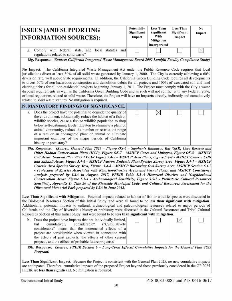
Environmental Initial Study P18-0083-0085 and P18-0616-0617 50
ISSUES (AND SUPPORTING INFORMATION SOURCES):
Potentially Significant
Impact
Less Than Significant
With Mitigation
Incorporated
Less Than Significant
Impact
No Impact
g. Comply with federal, state, and local statutes and regulations related to solid waste?
18g. Response: (Source: California Integrated Waste Management Board 2002 Landfill Facility Compliance Study) No Impact. The California Integrated Waste Management Act under the Public Resource Code requires that local jurisdictions divert at least 50% of all solid waste generated by January 1, 2000. The City is currently achieving a 60% diversion rate, well above State requirements. In addition, the California Green Building Code requires all developments to divert 50% of non-hazardous construction and demolition debris for all projects and 100% of excavated soil and land clearing debris for all non-residential projects beginning January 1, 2011. The Project must comply with the City’s waste disposal requirements as well as the California Green Building Code and as such will not conflict with any Federal, State, or local regulations related to solid waste. Therefore, the Project will have no impacts directly, indirectly and cumulatively related to solid waste statutes. No mitigation is required.
19. MANDATORY FINDINGS OF SIGNIFICANCE.
a. Does the project have the potential to degrade the quality of the environment, substantially reduce the habitat of a fish or wildlife species, cause a fish or wildlife population to drop below self-sustaining levels, threaten to eliminate a plant or animal community, reduce the number or restrict the range of a rare or an endangered plant or animal or eliminate important examples of the major periods of California history or prehistory?
19a. Response: (Source: General Plan 2025 – Figure OS-6 – Stephen’s Kangaroo Rat (SKR) Core Reserve and Other Habitat Conservation Plans (HCP), Figure OS-7 – MSHCP Cores and Linkages, Figure OS-8 – MSHCP Cell Areas, General Plan 2025 FPEIR Figure 5.4-2 – MSHCP Area Plans, Figure 5.4-4 - MSHCP Criteria Cells and Subunit Areas, Figure 5.4-6 – MSHCP Narrow Endemic Plant Species Survey Area, Figure 5.4-7 – MSHCP Criteria Area Species Survey Area, Figure 5.4-8 – MSHCP Burrowing Owl Survey Area, MSHCP Section 6.1.2 - Protection of Species Associated with Riparian/Riverine Areas and Vernal Pools, and MSHCP Consistency Analysis prepared by LSA in August, 2017, FPEIR Table 5.5-A Historical Districts and Neighborhood Conservation Areas, Figure 5.5-1 - Archaeological Sensitivity, Figure 5.5-2 - Prehistoric Cultural Resources Sensitivity, Appendix D, Title 20 of the Riverside Municipal Code, and Cultural Resources Assessment for the Olivewood Memorial Park prepared by LSA in June 2018)
Less Than Significant with Mitigation. Potential impacts related to habitat of fish or wildlife species were discussed in the Biological Resources Section of this Initial Study, and were all found to be less than significant with mitigation. Additionally, potential impacts to cultural, archaeological and paleontological resources related to major periods of California and the City of Riverside’s history or prehistory were discussed in the Cultural Resources and Tribal Cultural Resources Section of this Initial Study, and were found to be less than significant with mitigation.
b. Does the project have impacts that are individually limited, but cumulatively considerable? (“Cumulatively considerable” means that the incremental effects of a project are considerable when viewed in connection with the effects of past projects, the effects of other current projects, and the effects of probable future projects)?
19b. Response: (Source: FPEIR Section 6 – Long-Term Effects/ Cumulative Impacts for the General Plan 2025 Program)
Less Than Significant Impact. Because the Project is consistent with the General Plan 2025, no new cumulative impacts are anticipated. Therefore, cumulative impacts of the proposed Project beyond those previously considered in the GP 2025 FPEIR are less than significant. No mitigation is required.
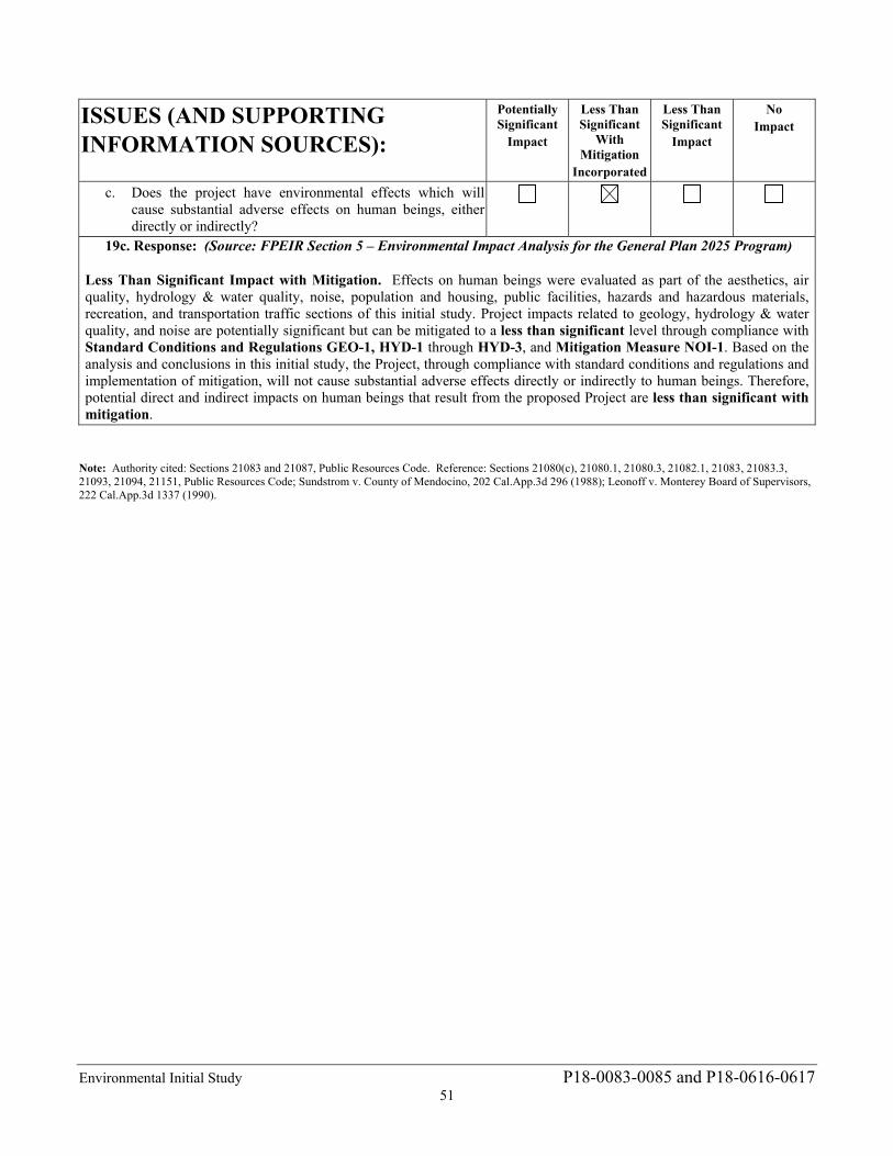
Environmental Initial Study P18-0083-0085 and P18-0616-0617 51
ISSUES (AND SUPPORTING INFORMATION SOURCES):
Potentially Significant
Impact
Less Than Significant
With Mitigation
Incorporated
Less Than Significant
Impact
No Impact
c. Does the project have environmental effects which will cause substantial adverse effects on human beings, either directly or indirectly?
19c. Response: (Source: FPEIR Section 5 – Environmental Impact Analysis for the General Plan 2025 Program)
Less Than Significant Impact with Mitigation. Effects on human beings were evaluated as part of the aesthetics, air quality, hydrology & water quality, noise, population and housing, public facilities, hazards and hazardous materials, recreation, and transportation traffic sections of this initial study. Project impacts related to geology, hydrology & water quality, and noise are potentially significant but can be mitigated to a less than significant level through compliance with Standard Conditions and Regulations GEO-1, HYD-1 through HYD-3, and Mitigation Measure NOI-1. Based on the analysis and conclusions in this initial study, the Project, through compliance with standard conditions and regulations and implementation of mitigation, will not cause substantial adverse effects directly or indirectly to human beings. Therefore, potential direct and indirect impacts on human beings that result from the proposed Project are less than significant with mitigation.
Note: Authority cited: Sections 21083 and 21087, Public Resources Code. Reference: Sections 21080(c), 21080.1, 21080.3, 21082.1, 21083, 21083.3, 21093, 21094, 21151, Public Resources Code; Sundstrom v. County of Mendocino, 202 Cal.App.3d 296 (1988); Leonoff v. Monterey Board of Supervisors, 222 Cal.App.3d 1337 (1990).
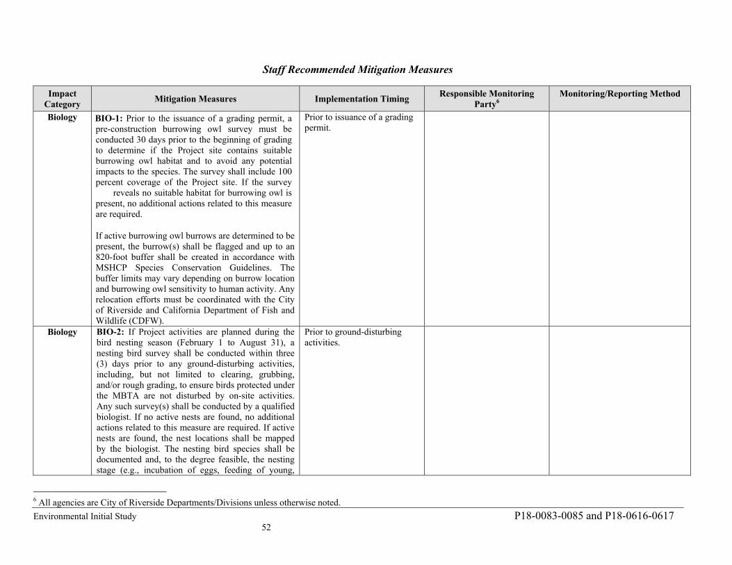
Environmental Initial Study P18-0083-0085 and P18-0616-0617 52
Staff Recommended Mitigation Measures
Impact Category
Mitigation Measures Implementation Timing Responsible Monitoring
Party6 Monitoring/Reporting Method
Biology BIO-1: Prior to the issuance of a grading permit, a pre-construction burrowing owl survey must be conducted 30 days prior to the beginning of grading to determine if the Project site contains suitable burrowing owl habitat and to avoid any potential impacts to the species. The survey shall include 100 percent coverage of the Project site. If the survey reveals no suitable habitat for burrowing owl is present, no additional actions related to this measure are required.
If active burrowing owl burrows are determined to be present, the burrow(s) shall be flagged and up to an 820-foot buffer shall be created in accordance with MSHCP Species Conservation Guidelines. The buffer limits may vary depending on burrow location and burrowing owl sensitivity to human activity. Any relocation efforts must be coordinated with the City of Riverside and California Department of Fish and Wildlife (CDFW).
Prior to issuance of a grading permit.
Biology BIO-2: If Project activities are planned during the bird nesting season (February 1 to August 31), a nesting bird survey shall be conducted within three (3) days prior to any ground-disturbing activities, including, but not limited to clearing, grubbing, and/or rough grading, to ensure birds protected under the MBTA are not disturbed by on-site activities. Any such survey(s) shall be conducted by a qualified biologist. If no active nests are found, no additional actions related to this measure are required. If active nests are found, the nest locations shall be mapped by the biologist. The nesting bird species shall be documented and, to the degree feasible, the nesting stage (e.g., incubation of eggs, feeding of young,
Prior to ground-disturbing activities.
6 All agencies are City of Riverside Departments/Divisions unless otherwise noted.
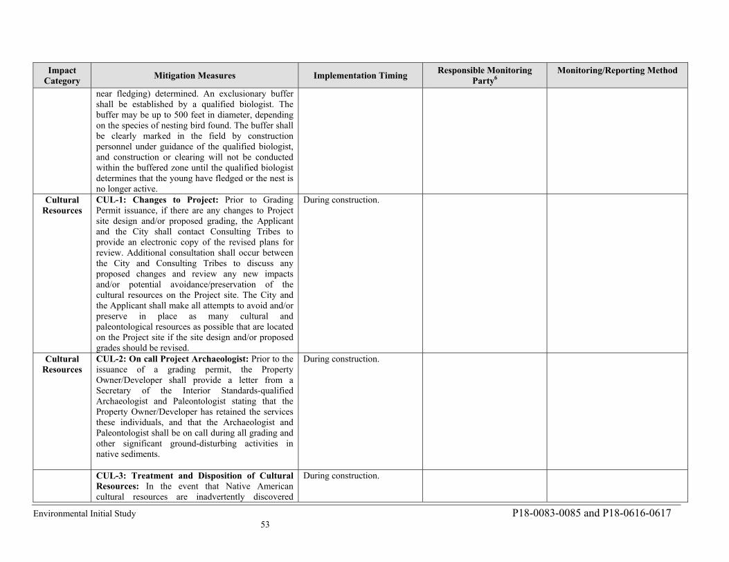
Environmental Initial Study P18-0083-0085 and P18-0616-0617 53
Impact Category
Mitigation Measures Implementation Timing Responsible Monitoring
Party6 Monitoring/Reporting Method
near fledging) determined. An exclusionary buffer shall be established by a qualified biologist. The buffer may be up to 500 feet in diameter, depending on the species of nesting bird found. The buffer shall be clearly marked in the field by construction personnel under guidance of the qualified biologist, and construction or clearing will not be conducted within the buffered zone until the qualified biologist determines that the young have fledged or the nest is no longer active.
Cultural Resources
CUL-1: Changes to Project: Prior to Grading Permit issuance, if there are any changes to Project site design and/or proposed grading, the Applicant and the City shall contact Consulting Tribes to provide an electronic copy of the revised plans for review. Additional consultation shall occur between the City and Consulting Tribes to discuss any proposed changes and review any new impacts and/or potential avoidance/preservation of the cultural resources on the Project site. The City and the Applicant shall make all attempts to avoid and/or preserve in place as many cultural and paleontological resources as possible that are located on the Project site if the site design and/or proposed grades should be revised.
During construction.
Cultural Resources
CUL-2: On call Project Archaeologist: Prior to the issuance of a grading permit, the Property Owner/Developer shall provide a letter from a Secretary of the Interior Standards-qualified Archaeologist and Paleontologist stating that the Property Owner/Developer has retained the services these individuals, and that the Archaeologist and Paleontologist shall be on call during all grading and other significant ground-disturbing activities in native sediments.
During construction.
CUL-3: Treatment and Disposition of Cultural Resources: In the event that Native American cultural resources are inadvertently discovered
During construction.
Environmental Initial Study P18-0083-0085 and P18-0616-0617 54
Impact Category
Mitigation Measures Implementation Timing Responsible Monitoring
Party6 Monitoring/Reporting Method
during the course of grading for this Project, the following procedures will be carried out for treatment and disposition of the discoveries: 1. Temporary Curation and Storage: During the course of construction, all discovered resources shall be temporarily curated in a secure location onsite or at the offices of the Project Archaeologist. The removal of any artifacts from the Project site will need to be thoroughly inventoried with tribal monitor oversite of the process; and 2. Treatment and Final Disposition: The landowner(s) shall relinquish ownership of all cultural resources, including sacred items, burial goods, and all archaeological artifacts and non-human remains as part of the required mitigation for impacts to cultural resources. The Applicant shall relinquish the artifacts through one or more of the following methods and provide the City of Riverside Community & Economic Development Department with evidence of same: a. Accommodate the process for onsite reburial of the discovered items with the consulting Native American tribes or bands. This shall include measures and provisions to protect the future reburial area from any future impacts. Reburial shall not occur until all cataloguing and basic recordation have been completed; b. A curation agreement with an appropriate qualified repository within Riverside County that meets federal standards per 36 CFR Part 79 and therefore would be professionally curated and made available to other archaeologists/researchers for further study. The collections and associated records shall be transferred, including title, to an appropriate curation facility within Riverside County, to be
Environmental Initial Study P18-0083-0085 and P18-0616-0617
55
Impact
Category Mitigation Measures Implementation Timing
Responsible Monitoring
Party4
Monitoring/Reporting Method
accompanied by payment of the fees necessary for
permanent curation:
c. If more than one Native American tribe or
band is involved with the Project and cannot come to
a consensus as to the disposition of cultural materials,
they shall be curated at the Western Science Center by
default; and
d. At the completion of grading, excavation and
ground disturbing activities on the site, a Phase IV
Monitoring Report shall be submitted to the City
documenting monitoring activities conducted by the
Project Archaeologist and Native Tribal Monitors
within 60 days of completion of grading. This report
shall document the impacts to the known resources on
the property; describe how each mitigation measure
was fulfilled; document the type of cultural resources
recovered and the disposition of such resources;
provide evidence of the required cultural sensitivity
training for the construction staff held during the
required pre-grade meeting; and, in a confidential
appendix, include the daily/weekly monitoring notes
from the archaeologist. All reports produced will be
submitted to the City of Riverside, Eastern
Information Center and interested tribes.
Noise NOI-1: If the Project applicant determines blasting is
required to construct the Project, the applicant shall
retain a qualified blasting expert to prepare a site-
specific blasting plan that incorporates the following
measures. These limitations should be included in
Project contract specifications. All vibration and air-
overpressure monitoring should conform to ISEE
Guidelines.
1. Blast‐hole diameter shall not exceed 2.5 inches.
2. Only fixed‐cartridge explosives shall be used for
this work.
3. The minimum scaled distance to residential
structures shall be 90 ft/lb1/2.
Prior to issuance of a grading
permit and during
construction.
Environmental Initial Study P18-0083-0085 and P18-0616-0617
56
Impact
Category Mitigation Measures Implementation Timing
Responsible Monitoring
Party4
Monitoring/Reporting Method
4. The minimum scaled distance to existing
mausoleum structures shall be 50 ft/lb1/2.
5. The minimum confining rock burden on all
charges shall be at least 25 charge‐diameters.
6. Charges shall be stemmed with at least 25 charge‐
diameters of clean crushed stone.
7. No more than 2,000 pounds of explosives shall be
used in individual blasts.
8. Rubber-tire and Steel-cable blasting mats or weed
barrier fabric and three feet of soil cover shall be
used to control movement of blasted rock.
9. Peak Particle Velocity (PPV) at residential
property shall not exceed 0.5 in/s and PPV at the
existing mausoleum shall not exceed 1.0 in/s.
10. Air-overpressure measured at nearest offsite
structures shall not exceed 133dBL.
11. At least two seismographs shall be deployed to
measure PPV and air-overpressure at the nearest
structures of concern.
12. Blast areas shall be sprayed water to suppress dust
when conditions are dry and/or windy.
This measure shall be implemented to the satisfaction
of the Director of the City of Riverside Community
and Economic Development Department, Building
and Safety Division as well as the planning Division,
or designee(s).
Standard Conditions and Regulations
Impact
Category Standard Condition/Regulation Implementation Timing
Responsible Monitoring
Party5
Monitoring/Reporting Method
Biology BR-1: Consistent with the Habitat Conservation Plan
for the Stephens’ Kangaroo Rat in Western Riverside
County California (HCP) (Riverside County Habitat
Conservation Agency 1996) the Project area is within
Prior to issuance of a grading
permit.
5 All agencies are City of Riverside Departments/Divisions unless otherwise noted.
Environmental Initial Study P18-0083-0085 and P18-0616-0617
57
Impact
Category Standard Condition/Regulation Implementation Timing
Responsible Monitoring
Party5
Monitoring/Reporting Method
the fee boundary for the Stephens’ kangaroo rat
(SKR) which is a covered species in the Multiple
Species Habitat Conservation Plan. The Project will
be subject to the SKR HCP mitigation fees in
accordance with Riverside County Ordinance 663.
Ordinance 663 requires that applicants for
development permits within the boundaries of the
SKR fee area pay a mitigation fee of $500.00 per
gross acre of the parcel(s) proposed for development.
This condition and regulation shall be implemented
to the satisfaction of the City Planning Division.
CULT-1: In the event that human remains (or remains
that may be human) are discovered at the Project site
during grading or earthmoving, the construction
contractors, Project Archaeologist, and/or designated
Native American Monitor shall immediately stop all
activities within 100 feet of the find. The Project
proponent shall then inform the Riverside County
Coroner and the City of Riverside Community &
Economic Development Department immediately,
and the coroner shall be permitted to examine the
remains as required by California Health and Safety
Code Section 7050.5(b) unless more current State law
requirements are in effect at the time of the discovery.
Section 7050.5 requires that excavation be stopped in
the vicinity of discovered human remains until the
coroner can determine whether the remains are those
of a Native American. If human remains are
determined as those of Native American origin, the
Applicant shall comply with the state relating to the
disposition of Native American burials that fall within
the jurisdiction of the NAHC (PRC Section 5097).
The coroner shall contact the NAHC to determine the
most likely descendant(s). The MLD shall complete
his or her inspection and make recommendations or
preferences for treatment within 48 hours of being
granted access to the site. The Disposition of the
remains shall be overseen by the most likely
descendant(s) to determine the most
Cultural During construction.
Environmental Initial Study P18-0083-0085 and P18-0616-0617 58
Impact Category
Mitigation Measures Implementation Timing Responsible Monitoring
Party7 Monitoring/Reporting Method
appropriate means of treating the human remains and any associated grave artifacts. The specific locations of Native American burials and reburials will be proprietary and not disclosed to the general public. The County Coroner will notify the Native American Heritage Commission in accordance with California Public Resources Code 5097.98. According to California Health and Safety Code, six or more human burials at one location constitute a cemetery (Section 8100), and disturbance of Native American cemeteries is a felony (Section 7052) determined in consultation between the Project proponent and the MLD. In the event that the Project proponent and the MLD are in disagreement regarding the disposition of the remains, State law will apply and the mediation and decision process will occur with the NAHC (see Public Resources Code Section 5097.98(e) and 5097.94(k)).
Geology GEO-1: Prior to the issuance of grading and building permits, the applicant shall provide evidence to the City for review and approval that on-site structures, features, and facilities have been designed and will be constructed in conformance with applicable provisions of the California Building Code and the recommendations cited in the Project-specific geotechnical investigation. Geotechnical recommendations include development of the Project site in accordance with applicable seismic code values and design methods determined by the Project Structural Engineer, as well as remedial earthwork and/or ground improvement to provide a sufficient layer of engineered fill or densified soil beneath the structural footings/foundations. A qualified geotechnical engineer or engineering geologist shall be present during all clearing and grading operations and shall examine excavations during grading to
Prior to issuance of grading and building permits.
Environmental Initial Study P18-0083-0085 and P18-0616-0617 59
Impact Category
Mitigation Measures Implementation Timing Responsible Monitoring
Party7 Monitoring/Reporting Method
assess the potential for instability along joints or fractures in the bedrock and to confirm foundation placement in suitable subgrade materials. This measure shall be implemented to the satisfaction of the Director of the City of Riverside Community and Economic Development Department, Building and Safety Division, or designee.
Hydrology HYD-1: Prior to the issuance of a grading permit, the Project applicant shall file and obtain a Notice of Intent (NOI) with the Regional Water Quality Control Board in order to be in compliance with the State NPDES General Construction Storm Water Permit for discharge of surface runoff associated with construction activities. Evidence that this has been obtained (i.e., a copy of the Waste Discharger’s Identification Number) shall be submitted to the City for coverage under the NPDES General Construction Permit. The NOI shall address the potential for an extended and discontinuous construction period based on funding availability. This measure shall be implemented to the satisfaction of the Director of the City of Riverside Public Works Department, or designee.
Prior to issuance of a grading permit.
Hydrology HYD-2: Prior to the issuance of a grading permit, the Project applicant shall submit to and receive approval from the City of Riverside of a Storm Water Pollution Prevention Plan (SWPPP). The SWPPP shall include a surface water control plan and erosion control plan citing specific measures to control on-site and off-site erosion during the entire grading and construction period. In addition, the SWPPP shall emphasize structural and nonstructural Best Management Practices (BMPs) to control sediment and non-visible discharges from the site. The SWPPP shall include inspection forms for routine monitoring of the site during both the demolition and construction phases to ensure NPDES compliance and that additional BMPs and erosion control measures will be documented in the SWPPP and
Prior to issuance of a grading permit.
Environmental Initial Study P18-0083-0085 and P18-0616-0617 60
Impact Category
Mitigation Measures Implementation Timing Responsible Monitoring
Party7 Monitoring/Reporting Method
utilized if necessary. The SWPPP shall address the potential for an extended and discontinuous construction period based on funding availability. The SWPPP shall be kept on site for the entire duration of Project construction and shall be available to the local Regional Water Quality Control Board (RWQCB) for inspection at any time. BMPs to be implemented may include the following:
Sediment discharges from the site may be controlled by the following: sandbags, silt fences, straw wattles and temporary basins (if deemed necessary), and other discharge control devices. The construction and condition of the BMPs shall be periodically inspected during demolition and construction, and repairs shall be made when necessary as required by the SWPPP.
Materials that have the potential to contribute to non-visible pollutants to storm water must not be placed in drainage ways and must be contained, elevated, and placed in temporary storage containment areas.
All loose piles of soil, silt, clay, sand, debris, and other earthen material shall be protected in a reasonable manner to eliminate any discharge from the site. Stockpiles shall be surrounded by silt fences and covered with plastic tarps.
In addition, the construction contractor shall be responsible for performing and documenting the application of BMPs identified in the SWPPP. Weekly inspections shall be performed on sandbag barriers and other sediment control measures called for in the SWPPP. Monthly reports and inspection logs shall be maintained by the contractor and reviewed by the City of Riverside and the representatives of the State Water Resources Control Board. In the event
Environmental Initial Study P18-0083-0085 and P18-0616-0617 61
Impact Category
Mitigation Measures Implementation Timing Responsible Monitoring
Party7 Monitoring/Reporting Method
that it is not feasible to implement specific BMPs, the City can make a determination that other BMPs will provide equivalent or superior treatment either on- or off-site.
This measure shall be implemented to the satisfaction of the Director of the City of Riverside Public Works Department, or designee.
Hydrology HYD-3: Prior to the issuance of a grading permit, the Project applicant shall submit a Final Water Quality Management Plan (WQMP) to the City of Riverside for review and approval. The Project shall implement project design features identified in the WQMP. The WQMP shall demonstrate that any proposed on-site development plan includes BMPs for source control, pollution prevention, site design, low impact development (LID) implementation, and structural treatment control. BMPs shall be designed and implemented to retain the Project site’s minimum design capture volume of 20,508.2 cubic feet of runoff to ensure post-development storm water runoff volume or time of concentration does not exceed pre-development storm water runoff. Periodic maintenance of any required bioretention facilities and landscaped areas during Project occupancy and operation shall be in accordance with the schedule outlined in the WQMP. This measure shall be implemented to the satisfaction of the Director of the City of Riverside Public Works Department, or designee.
Prior to issuance of a grading permit.