draft kirkland high quality pozzolan mine …
TRANSCRIPT

Q:\Jobs\1900's\1998.01\ENV\Draft EA\Transportation Alternatives\DRAFT Submittal 03.29.18\DRAFT Supplemental Traffic Analysis _2018.03.29.docx WestLand Resources, Inc.
DRAFT KIRKLAND HIGH QUALITY POZZOLAN MINE
SUPPLEMENTAL TRAFFIC ANALYSIS Prepared for: Bureau of Land Management Prepared by: WestLand Resources, Inc. Date: March 29, 2018 Project No.: 1998.01 BLM File No.: AZA 37212
TABLE OF CONTENTS
1. INTRODUCTION AND BACKGROUND ...................................................................................... 1 2. METHODS ................................................................................................................................................ 2 3. RESULTS ................................................................................................................................................... 4 4. REFERENCES ......................................................................................................................................... 8
TABLES
Table 1. Year 2019 (Opening Year) Projected Traffic Conditions along Haul Route 1, 2, and 3 ...... 5 Table 2. Year 2040 Projected Traffic Conditions along Haul Route 1, 2, and 3 .................................. 6 Table 3. Worst-Case Scenario 2019 Projected Traffic Increases (% Ranges) from Mine Operations
along the Three Haul Routes ......................................................................................................... 7 Table 4. Worst-Case Scenario 2040 Projected Traffic Increases (% Ranges) from Mine Operations
along the Three Haul Routes ......................................................................................................... 7
FIGURES (follow text)
Figure 1. Vicinity Map Figure 2. Traffic Routes
ATTACHMENTS
Attachment 1. Methods and Analysis of 2016 ADOT Traffic Conditions Along SR 89

DRAFT Kirkland High Quality Pozzolan Mine March 29, 2018 Supplemental Traffic Analysis Page 1
Q:\Jobs\1900's\1998.01\ENV\Draft EA\Transportation Alternatives\DRAFT Submittal 03.29.18\DRAFT Supplemental Traffic Analysis _2018.03.29.docx WestLand Resources, Inc.
1. INTRODUCTION AND BACKGROUND
Kirkland Mining Company (KMC) developed a Draft Mining and Reclamation Plan of Operation (Draft MRPO) to mine a high quality natural pozzolan (HQP) and remove a stockpile of screened HQP fines from a previous mining operation (the Project) on land administered by the Bureau of Land Management (BLM) within the unpatented lode claims and the Capital Association Placer mining claim held by KMC in a portion of Section 28 of Township 13 North, Range 4 West, Gila and Salt River Baseline and Meridian (the Project Area, Figure 1). The Draft MRPO outlines anticipated mine production operations and sale of materials to potential customers. KMC anticipates opening the mine in 2019 and steadily ramping up operations over a 5-year period, and continuing operations at maximum capacity until conditions require activity reduction. The anticipated life of the mine is 40 years.
Transport of the mined HQP to Kirkland’s market is a non-Federal connected action to the Project per the BLM National Environmental Policy Act (NEPA) Handbook, H-1790-1 (BLM 2008). The effects associated with the transport of the mined HQP are indirect effects of the Project and will be analyzed in the Environmental Assessment (EA) prepared for the Project as part of the BLM’s review of the Project under the NEPA.
KMC retained Lee Engineering, LLC (Lee Engineering) to develop a traffic study that analyzes effects of the transport of HQP from the mine to Kirkland’s market on the local transportation network. The effects on the local transportation network will inform effects on other resources such as air quality and wildlife resources. To bound the transportation effects analysis, alternatives to the transportation network will be discussed in the EA in the context of the direct and indirect effects analysis of the proposed action.
Lee Engineering prepared a Traffic Impact Statement (TIS) that identified current traffic conditions, roadway conditions, and sensitive areas near KMC’s proposed mine entrance and along the potential roadway network that could be used to distribute mine materials (Lee Engineering 2018). The TIS quantified and compared projected baseline traffic conditions on roadways that would be used to haul materials from the mine against the potential increase in traffic associated with mine operations through the year 2040 and reviewed baseline conditions along these roadways. The TIS also determined if modifications to roadway characteristics were needed to safely accommodate additional traffic associated with mine operations.
The purpose of this technical memorandum is to provide a supplement to the TIS prepared by Lee Engineering to allow for a conservative assessment of Project impacts on traffic during the anticipated opening year of the mine (2019) and in 2040 (identified in the TIS as the horizon year for the 40-year Project). The conservative estimates of Project traffic counts provided in this memo are worst-case estimates that assume 100% of all Project traffic generated at full production would travel on only one
DRAFT Kirkland High Quality Pozzolan Mine March 29, 2018 Supplemental Traffic Analysis Page 2
Q:\Jobs\1900's\1998.01\ENV\Draft EA\Transportation Alternatives\DRAFT Submittal 03.29.18\DRAFT Supplemental Traffic Analysis _2018.03.29.docx WestLand Resources , Inc.
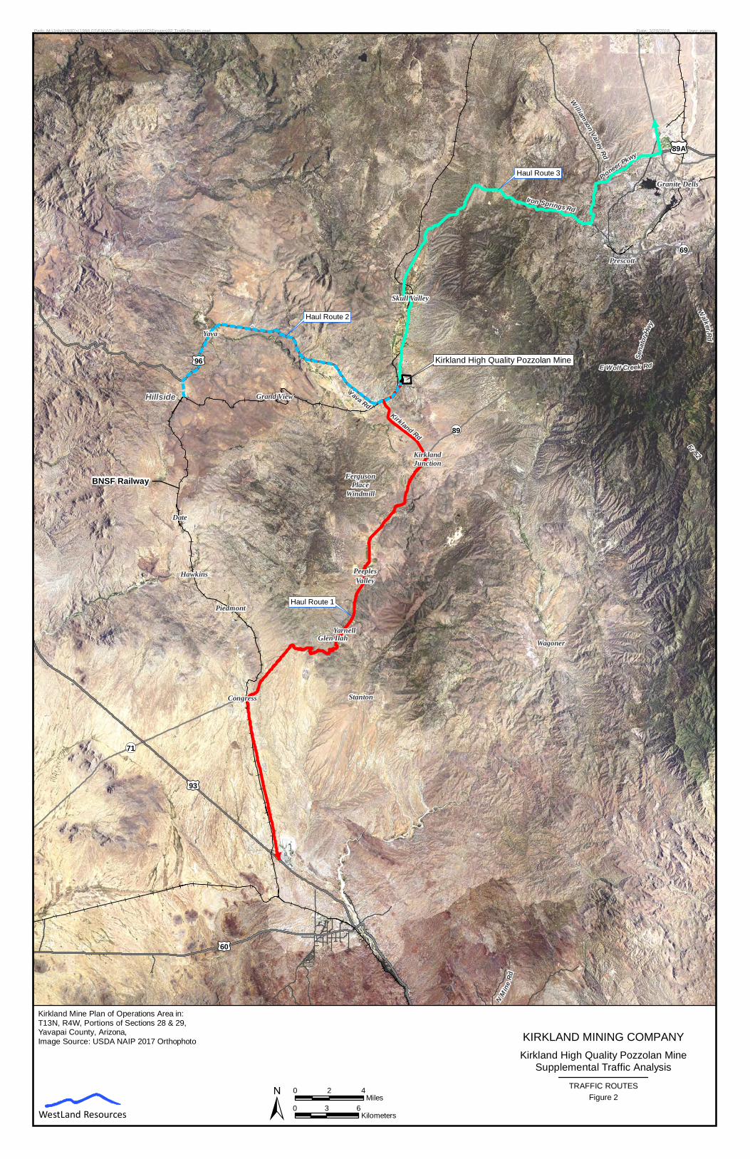
of the three routes when in fact, some combination of all three routes would be used to transport the mined material. This assessment will be used as a bounding analysis of traffic impacts to support the Draft EA being prepared for the Project. The summary presented in this memo also extends the analysis of Route 1, provided in the TIS to US Highway 93, to allow for an assessment of Project traffic on State Route 89 (Figure 2).
2. METHODS
WestLand Resources, Inc. (WestLand) evaluated the data provided in the TIS and provided a summary of the traffic counts for each of the three haul routes assuming 100% of the Project transportation needs at full production. This assessment provides a conservative estimate of impacts because 100% of the Project transportation needs would be divided between all three routes and no single route would be used. Some combination of all three routes would ultimately be used to haul the HQP product from the mine site to market, but at this time KMC does not know the distribution of the trucks along the three potential haul routes that could be used to transport material. Also, the need for transport of the material at full production is not anticipated to be required for five years, but this assessment assumes full production in year 1.
WestLand extended the analysis of Haul Route 1 to include State Route (SR) 89 from Kirkland Valley Road to U.S. Route 93 near Wickenburg, Arizona.
Identification of Haul Routes Analyzed
The haul routes (Figure 2) defined for the purposes of this assessment are as follows:
1. Haul Route 1 – Iron Springs Road from the mine entrance to SR 89 via Kirkland Valley Road, and to US Route 93 via SR 89
2. Haul Route 2 – Iron Springs Road from the mine entrance to the Hillside area via Yava Road 3. Haul Route 3 – Iron Springs Road from the mine entrance to SR 89 north of Prescott via
Williamson Valley Road and Pioneer Parkway
The Arizona Department of Transportation (ADOT) has classified the majority of the three routes as major collectors (ADOT 2013). Major collectors generally gather and funnel traffic from local roads to arterial networks. Two of the three haul routes identified funnel traffic to a larger arterial network: Haul Route 1 conveys traffic south to U.S. Route 93, identified as a principal arterial road, while Haul Route 3 conveys traffic north to Williamson Valley Road and Pioneer Parkway, roads classified as minor arterial roads. Major collectors offer more mobility than minor collectors and in general are longer in length, have lower connecting driveway densities, have higher speed limits, are spaced at greater intervals, have higher annual average traffic volumes (expressed as Annual Average Daily Traffic [AADT]), and may have more travel lanes than minor collectors. Minor arterials provide

DRAFT Kirkland High Quality Pozzolan Mine March 29, 2018 Supplemental Traffic Analysis Page 3
Q:\Jobs\1900's\1998.01\ENV\Draft EA\Transportation Alternatives\DRAFT Submittal 03.29.18\DRAFT Supplemental Traffic Analysis _2018.03.29.docx WestLand Resources , Inc.
service for trips of moderate length and connect major and minor collectors to the larger arterial networks (FHWA 2013).
Both major collectors and minor arterials networks are further classified into rural and urban designations based on if they are located within urban areas defined by ADOT. All roadways identified in the three haul routes are classified as rural roadways, with the exception of portions of Williamson Valley Road and Pioneer Parkway along Haul Route 3, that are located within the urban designation of Prescott; therefore, these roads are classified as urban roadways (ADOT 2013). Rural major collectors can range in AADT from 300-2,600 vehicles and urban major collectors can range in AADT from 1,100-6,300 vehicles. Rural minor arterials range in AADT from 1,500-6,000 vehicles and urban minor arterials range in AADT from 3,000-14,000 vehicles (FHWA 2013). In an urban context, minor arterials interconnect and augment the higher arterial system, provide intracommunity continuity, and may carry local bus routes. In the rural settings, minor arterials typically provide relatively high overall travel speeds with minimum interference to through movement and are spaced to provide connectivity from developed areas and higher-level arterial roadways.
Haul Route 2 terminates in Hillside based on the assumption that the product transported to Hillside would be loaded on to the BNSF Railway for further transport to market.
Assumptions used in the Estimation of Project Traffic Counts
The TIS outlined anticipated mine operation parameters for mining and shipping operation hours, estimated truck load rates (per day), truck types, number of mine employees, maximum annual production rates, etc. to develop conservative assumptions for the number of vehicles that would enter and exit the mine per day. Using the conservative approach that the mine will operate at full capacity upon site opening (anticipated for 2019), the TIS estimated that to haul 500,000 tons of material per year, KMC would require 160 truck trips per day (80 trucks entering and 80 trucks leaving the mine) to haul away materials. This estimation of project-related haul truck counts includes an estimate of 5 to 9 water truck trips needed for dust suppression activities during active mining onsite (pers comm. Al Burch, KMC).
Lee Engineering also estimated that a total of 25 employees working at the mine will add 50 passenger vehicle trips per day (25 vehicles entering and 25 vehicles exiting the mine). Therefore, the TIS assumes that a total of 210 total vehicle trips per day will be added from mine operations. During the analysis, the TIS assumed that half of the employees would enter and exit the mine from the north along Iron Springs Road and half of the employees would enter and exit the mine from the south along Iron Springs Road.

DRAFT Kirkland High Quality Pozzolan Mine March 29, 2018 Supplemental Traffic Analysis Page 4
Q:\Jobs\1900's\1998.01\ENV\Draft EA\Transportation Alternatives\DRAFT Submittal 03.29.18\DRAFT Supplemental Traffic Analysis _2018.03.29.docx WestLand Resources , Inc.
Methods Used in Calculating Existing and Forecasted Traffic Counts along Haul Routes
Lee Engineering used available roadway and traffic-related information from the Yavapai County Public Works Department and ADOT for multiple years along the three routes that were analyzed to calculate an annual projected growth rate for traffic along these routes and established these traffic projections as a type of baseline for comparison against anticipated traffic increases associated with the mine. The TIS also captured traffic conditions near the mine access point by conducting a 48-hr traffic count where vehicle types and speeds were measured. Additionally, roadway characteristics and sensitive receptors were identified near the mine and at the mine entrance.
Lee Engineering compiled Yavapai County’s most recent traffic counts (2015) as well as ADOT’s most recent traffic counts (2011) along Iron Springs Road and compared the traffic counts between the two years. In 2015, Yavapai County reported that 771 vehicles passed northbound and 815 vehicles passed southbound along Iron Springs Road, approximately 245 feet northeast of the Kirkland Valley Road, in a 24-hr period, totaling 1,586 vehicles. In 2011, ADOT reported that a daily traffic volume of 1,693 vehicles travel along Iron Springs Road east of the junction with Kirkland Valley Road (in both directions). Lee Engineering conducted a 48-hr traffic count to determine the current, daily traffic conditions near the entrance of the mine in 2017, and compared this count of 1,656 total vehicles (186 which were trucks) in a 24-hr period to Yavapai County’s daily count of 1,586 vehicles in 2015 as these data were collected during the same time of the year (winter). Based on the 2-year difference between the historical data (2015) and current data collected in 2017, Lee Engineering determined that an average annual growth rate of 2.2% would likely occur without mine operations. This growth rate was applied to 2017 traffic volume data collected during the 48-hr traffic count (1,656 total vehicles with 186 trucks) and extrapolated out to year 2040. At year 2040, the TIS added the estimated vehicle trips per day associated with the mine to calculate a percent increase in total vehicles and trucks associated with the mine compared to conditions where the mine would not be in operation. For a full discussion of methods used by Lee Engineering please see the TIS.
WestLand used the same assumptions for growth (2.2% per year) in estimating traffic counts for 2019 and for the portion of Haul Route 1 along SR 89 using ADOT 2016 AADT data.
3. RESULTS
The traffic data collected by Lee Engineering for each haul route and data1 supplemented by WestLand for Haul Route 1 are provided in Tables 1 and 2. The TIS assumes that no matter which haul route is used to convey 100% of the mine truck traffic (160 truck trips), the employee traffic (50 passenger vehicle trips) will be split along the three routes. The TIS assumes that 50% of the employee traffic (25 passenger vehicle trips) would travel to and from the mine along Iron Springs Road north of the mine entrance, while the remaining 50% of employee traffic (25 passenger vehicle trips) would travel 1 WestLand compiled 2016 data collected by ADOT along SR 89.

DRAFT Kirkland High Quality Pozzolan Mine March 29, 2018 Supplemental Traffic Analysis Page 5
Q:\Jobs\1900's\1998.01\ENV\Draft EA\Transportation Alternatives\DRAFT Submittal 03.29.18\DRAFT Supplemental Traffic Analysis _2018.03.29.docx WestLand Resources , Inc.
to and from the mine along Iron Springs Road south of the mine entrance. The TIS further assumes that the 50% of employee traffic (25 passenger vehicle trips) traveling south of the mine entrance would be split with 13 passenger vehicle trips traveling from Yava Road and 13 passenger vehicle trips traveling from Kirkland Valley Road. Each haul route was analyzed to include 100% of the mine truck traffic [160 truck trips] along each route and between 25% and 50% of employee traffic [13-25 passenger vehicle trips] as described above. Attachment 1 describes the methods used in interpreting the ADOT data for the portion of Haul Route 1 along SR 89.
The conservative estimates provided in Tables 1 through 4 are worst-case estimates that assume 100% of all the Project traffic generated at full production would travel on only one of the three routes when in fact, the Project traffic would travel on some combination of all three of the routes to transport the mined material. This assessment will be used as a bounding analysis of traffic impacts to support the Draft EA being prepared for the Project.
Table 1. Year 2019 (Opening Year) Projected Traffic Conditions along Haul Route 1, 2, and 3 Note: The Project estimates provided for each haul route are 100% of the estimated Project traffic. The
estimates presented are intended to be maximum worst-case estimates for each haul route.
Haul Route Portion of Haul Route
2019 Projected Daily Traffic
Worst Case 2019 Projected
Daily Traffic with Mine Operations
Worst Case Percent Increase in Daily Traffic from Mine Operations
Total Vehicles Trucks Total
Vehicles Trucks Total
Vehicles (%)
Trucks (%)
1
Iron Springs Road: Mine Entrance to Kirkland Valley Road* 1,730 194 1,915 354 10.7% 82.5%
Kirkland Valley Road to SR 89** 1,216 135 1,389 295 14.2% 118.5% SR 89 to U.S. Route 93** 1,413 130 1,586 290 12.2% 123.1%
2 Iron Springs Road: Mine Entrance to Yava Road* 1,730 194 1,915 354 10.7% 82.5%
Yava Road to Hillside Road** 719 79 892 239 24.1% 202.5%
3
Iron Springs Road: Mine Entrance to Williamson Valley Road* 6,638 544 6,523 704 2.9% 29.4%
Williamson Valley Road and Pioneer Parkway to SR 89* 1,730 194 1,915 354 10.7% 82.5%
*Traffic increases associated with the mine was assumed to be 185 vehicle trips (includes 160 truck trips and 25 passenger vehicle trips) for this portion of the haul route.
**Traffic increases associated with the mine was assumed to be 173 vehicle trips (includes 160 truck trips and 13 passenger vehicle trips) for this portion of the haul route.
DRAFT Kirkland High Quality Pozzolan Mine March 29, 2018 Supplemental Traffic Analysis Page 6
Q:\Jobs\1900's\1998.01\ENV\Draft EA\Transportation Alternatives\DRAFT Submittal 03.29.18\DRAFT Supplemental Traffic Analysis _2018.03.29.docx WestLand Resources , Inc.
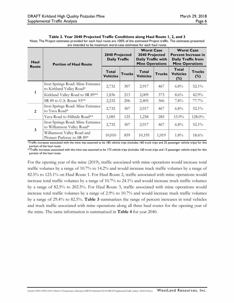
Table 2. Year 2040 Projected Traffic Conditions along Haul Route 1, 2, and 3 Note: The Project estimates provided for each haul route are 100% of the estimated Project traffic. The estimates presented
are intended to be maximum worst-case estimates for each haul route.
Haul Route Portion of Haul Route
2040 Projected Daily Traffic
Worst Case 2040 Projected
Daily Traffic with Mine Operations
Worst Case Percent Increase in Daily Traffic from Mine Operations
Total Vehicles Trucks Total
Vehicles Trucks Total
Vehicles (%)
Trucks (%)
1
Iron Springs Road: Mine Entrance to Kirkland Valley Road* 2,732 307 2,917 467 6.8% 52.1%
Kirkland Valley Road to SR 89** 1,836 213 2,009 373 8.6% 42.9% SR 89 to U.S. Route 93** 2,232 206 2,405 366 7.8% 77.7%
2 Iron Springs Road: Mine Entrance to Yava Road* 2,732 307 2,917 467 6.8% 52.1%
Yava Road to Hillside Road** 1,085 125 1,258 285 15.9% 128.0%
3
Iron Springs Road: Mine Entrance to Williamson Valley Road* 2,732 307 2,917 467 6.8% 52.1%
Williamson Valley Road and Pioneer Parkway to SR 89* 10,010 859 10,195 1,019 1.8% 18.6%
*Traffic increases associated with the mine was assumed to be 185 vehicle trips (includes 160 truck trips and 25 passenger vehicle trips) for this portion of the haul route.
**Traffic increases associated with the mine was assumed to be 173 vehicle trips (includes 160 truck trips and 13 passenger vehicle trips) for this portion of the haul route.
For the opening year of the mine (2019), traffic associated with mine operations would increase total traffic volumes by a range of 10.7% to 14.2% and would increase truck traffic volumes by a range of 82.5% to 123.1% on Haul Route 1. For Haul Route 2, traffic associated with mine operations would increase total traffic volumes by a range of 10.7% to 24.1% and would increase truck traffic volumes by a range of 82.5% to 202.5%. For Haul Route 3, traffic associated with mine operations would increase total traffic volumes by a range of 2.9% to 10.7% and would increase truck traffic volumes by a range of 29.4% to 82.5%. Table 3 summarizes the range of percent increases in total vehicles and truck traffic associated with mine operations along all three haul routes for the opening year of the mine. The same information is summarized in Table 4 for year 2040.

DRAFT Kirkland High Quality Pozzolan Mine March 29, 2018 Supplemental Traffic Analysis Page 7
Q:\Jobs\1900's\1998.01\ENV\Draft EA\Transportation Alternatives\DRAFT Submittal 03.29.18\DRAFT Supplemental Traffic Analysis _2018.03.29.docx WestLand Resources , Inc.
Table 3. Worst-Case Scenario 2019 Projected Traffic Increases (% Ranges) from Mine Operations along the Three Haul Routes
Note: The range of increase provided for each haul route include 100% of the estimated Project traffic. The estimates presented are intended to be maximum worst-case estimates for each haul route.
Haul Routes Range of % Increase (Total Vehicles)
Range of % Increase (Total Trucks)
1 - Iron Springs Road from the mine entrance to SR 89 via Kirkland Valley Road 10.7% - 14.2% 82.5% - 123.1%
2 - Iron Springs Road from the mine entrance to Hillside via Yava Road 10.7% - 24.1% 82.5% - 202.5%
3 - Iron Springs Road from the mine entrance to SR 89 north of Prescott via Williamson Valley Road and Pioneer Parkway
2.9% - 10.7% 29.4% - 82.5%
Table 4. Worst-Case Scenario 2040 Projected Traffic Increases (% Ranges) from Mine Operations along the Three Haul Routes
Note: The range of increase provided for each haul route include 100% of the estimated Project traffic. The estimates presented are intended to be maximum worst-case estimates for each haul route.
Haul Routes Range of % Increase (Total Vehicles)
Range of % Increase (Total Trucks)
1 - Iron Springs Road from the mine entrance to SR 89 via Kirkland Valley Road 6.8% - 8.6% 42.9% - 77.7%
2 - Iron Springs Road from the mine entrance to Hillside via Yava Road 6.8% - 15.9% 52.1% - 128.0%
3 - Iron Springs Road from the mine entrance to SR 89 north of Prescott via Williamson Valley Road and Pioneer Parkway
1.8% - 6.8% 18.6% - 52.1%

DRAFT Kirkland High Quality Pozzolan Mine March 29, 2018 Supplemental Traffic Analysis Page 8
Q:\Jobs\1900's\1998.01\ENV\Draft EA\Transportation Alternatives\DRAFT Submittal 03.29.18\DRAFT Supplemental Traffic Analysis _2018.03.29.docx WestLand Resources , Inc.
4. REFERENCES
Arizona Department of Transportation (ADOT). 2016. Arizona Department of Transportation (ADOT). 2016. Highway Performance Monitoring System Location Report for State Routes in 2016. Available at https://www.azdot.gov/docs/default-source/planning/2016-aadt-publication-state-routes.pdf?sfvrsn=2.
_____. 2013. Yavapai County Functionally Classified Roads. Map. Arizona Department of Transportation Multimodal Planning Division Transportation Analysis GIS Section. June 2013. Accessed at: https://www.azdot.gov/docs/default-source/maps/yavapai-county-fc-map.pdf?sfvrsn=8.
Bureau of Land Management (BLM). 2008. National Environmental Policy Act: Handbook H-1790-1. Bureau of Land Management Office of the Assistant Director, Renewable Resources and Planning (WO-200), Washington, D.C. January 2008.
Federal Highway Administration (FHWA). 2013. Highway Functional Classification Concepts, Criteria and Procedures. U.S. Department of Transportation, 2013 Edition. Accessed at http://www.sddot.com/transportation/highways/classification/docs/HwyFunctionalClassification.pdf.
Lee Engineering. 2018. Kirkland Mine Yavapai County, Arizona: Traffic Impact Statement. Prepared for Kirkland Mining Company. Lee Engineering, LLC, Phoenix, Arizona. March 2018.

FIGURES

Service Layer Credits: Sources: Esri, HERE,DeLorme, USGS, Intermap, INCREMENT P,NRCan, Esri Japan, METI, Esri China (HongKong), Esri Korea, Esri (Thailand),MapmyIndia, NGCC, © OpenStreetMapcontributors, and the GIS User Community
YUMATUCSON
PHOENIX
FLAGSTAFF
!
!
!
!
!
!
!
!
!
!
!
!
!
!
!!
!
!
!
!
!!
!
!
!
!
!
!
CoRd
10
Iron SpringsRd
Skull Valley
- Kirkland Rd
Approximate Scale 1 Inch = 10 Miles
ARIZONA
PROJECT LOCATION
PROJECT VICINITY
Kirkland Mine Plan of Operations Area in:T13N, R4W, Portions of Sections 28 & 29,Yavapai County, Arizona,Kirkland USGS 7.5' QuadrangleImage Source: ArcGIS Online, World Street Map
Path: M:\Jobs\1900's\1998.01\ENV\TrafficNetwork\MXD\Figures\01 Vicinity.mxd Date: 3/15/2018 User: evinson
LegendKirkland High Quality Pozzolan Mine
WestLand Resources ±0 1,000 2,000
Feet0 300 600
Meters
KIRKLAND MINING COMPANY
VICINITY MAPFigure 1
Kirkland High Quality Pozzolan MineSupplemental Traffic Analysis
Service Layer Credits: USDA-FSA-APFOAerial Photography Field Office
!(
!(
!(
!(
!(
!(
!(
!(
!(
!(
!(
!(
!(
!(
!(
!(
!(
!( !(
!(
BNSF Railway
Kirkland High Quality Pozzolan Mine
Hillside
Sena
torHw
y
Williamson Valley Rd
N MineRd
Yava Rd
E Wolf Creek Rd
Fr 52Walker Rd
Kirkland Rd
Pioneer Pkwy
Iron Springs Rd
£¤93
£¤89A
£¤60
£¤96
¬«89
¬«69
¬«71
Haul Route 2
Haul Route 3
Haul Route 1
Congress
PeeplesValley
Yarnell
Prescott
Date
FergusonPlace
Windmill
Grand View
Hawkins
KirklandJunction
Piedmont
Skull Valley
Stanton
Wagoner
Yava
Glen Ilah
Granite Dells
Path: M:\Jobs\1900's\1998.01\ENV\TrafficNetwork\MXD\Figures\02 TrafficRoutes.mxd Date: 3/20/2018 User: evinson
± 0 3 6Kilometers
0 2 4Miles
Kirkland Mine Plan of Operations Area in:T13N, R4W, Portions of Sections 28 & 29,Yavapai County, Arizona,Image Source: USDA NAIP 2017 Orthophoto
WestLand Resources
KIRKLAND MINING COMPANY
TRAFFIC ROUTESFigure 2
Kirkland High Quality Pozzolan MineSupplemental Traffic Analysis

ATTACHMENT 1 Methods and
Analysis of 2016 ADOT
Traffic Conditions along SR 89

Q:\Jobs\1900's\1998.01\ENV\Draft EA\Transportation Alternatives\DRAFT Submittal 03.20.18\Attachment 1. Methods and Analysis.docx WestLand Resources, Inc.
METHODS AND ANALYSIS OF 2016 ARIZONA DEPARTMENT OF
TRANSPORTATION TRAFFIC CONDITIONS ALONG STATE ROUTE 89
WestLand extended the analysis along Haul Route 1 to include an analysis of traffic conditions along
State Route (SR) 89 south from Kirkland Valley Road to U.S. Route 93. WestLand reviewed Arizona
Department of Transportation (ADOT) traffic counts and compiled 2016 Annual Average Daily
Traffic (AADT) data along SR 89 between U.S. Route 93 and Kirkland Valley Road. WestLand
summarized this data in Table 1. WestLand used the most conservative (lowest) traffic counts along
SR 89 between U.S. Route 93 and Kirkland Valley Road to project daily traffic counts in 2019 and
2040, following the same traffic growth assumptions used within the TIS of 2.2% annual growth of
traffic not associated with mine operations. The lowest traffic counts occurred along the portion of
SR 89 between Hays Ranch Road and the junction with Kirkland Valley Road. Along this 5-mile
stretch of SR 89, the AADT was 1,324 vehicles of which 122 vehicles were trucks.
Table 1. 2016 AADT along SR 89 between U.S. Route 93 and Kirkland Valley Road1
Segment of SR 89 2016 AADT (All Vehicles) 2016 AADT (Trucks)
U.S. Route 93 to Escapees Way 2,044 187
Escapees Way to SR 71 2,039 187
SR 71 to Shrine Road 1,798 166
Shrine Road to Hays Ranch Road 2,156 197
Hays Ranch Road to Kirkland Valley Road 1,324 122 1 Source Data: Arizona Department of Transportation (ADOT). 2016. Highway Performance Monitoring System Location Report for State Routes
in 2016. Available at https://www.azdot.gov/docs/default-source/planning/2016-aadt-publication-state-routes.pdf?sfvrsn=2.
WestLand applied the 2.2% annual growth rate developed in the TIS to traffic counts along SR 89
between Hays Ranch Road and Kirkland Valley Road to project estimated traffic not associated with
mine operations through the year 2040. Table 2 provides the projected traffic (AADT) along SR 89
between 2017 and 2040. It is expected that in year 2040, the daily traffic conditions along SR 89 would
be 2,232 vehicles, of which 206 would be trucks.

Kirkland High Quality Pozzolan March 20, 2018
Supplemental Traffic Analysis – Attachment 1 Page 2
Q:\Jobs\1900's\1998.01\ENV\Draft EA\Transportation Alternatives\DRAFT Submittal 03.20.18\Attachment 1. Methods and Analysis.docx WestLand Resources, Inc.
Table 2. Projected Traffic (AADT) Not Associated with Mine Operations along SR
89 (2017-2040) Using 2.2% Annual Growth Rate
Year Projected AADT (All Vehicles) Projected AADT (Trucks)
2017 1,353 125
2018 1,383 127
2019 1,413 130
2020 1,444 133
2021 1,476 136
2022 1,509 139
2023 1,542 142
2024 1,576 145
2025 1,610 148
2026 1,646 152
2027 1,682 155
2028 1,719 157
2029 1,757 162
2030 1,796 165
2031 1,835 169
2032 1,875 173
2033 1,917 177
2034 1,959 180
2035 2,002 184
2036 2,046 189
2037 2,091 193
2038 2,137 197
2039 2,184 201
2040 2,232 206