draft jefferson county, washington off-highway vehicle ... · chapter 1: introduction jefferson...
TRANSCRIPT
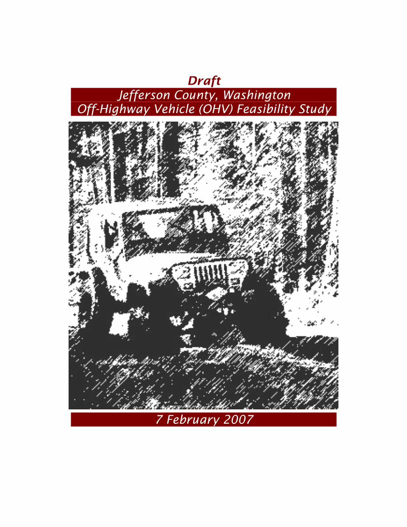
Draft
Jefferson County, Washington Off-Highway Vehicle (OHV) Feasibility Study
7 February 2007
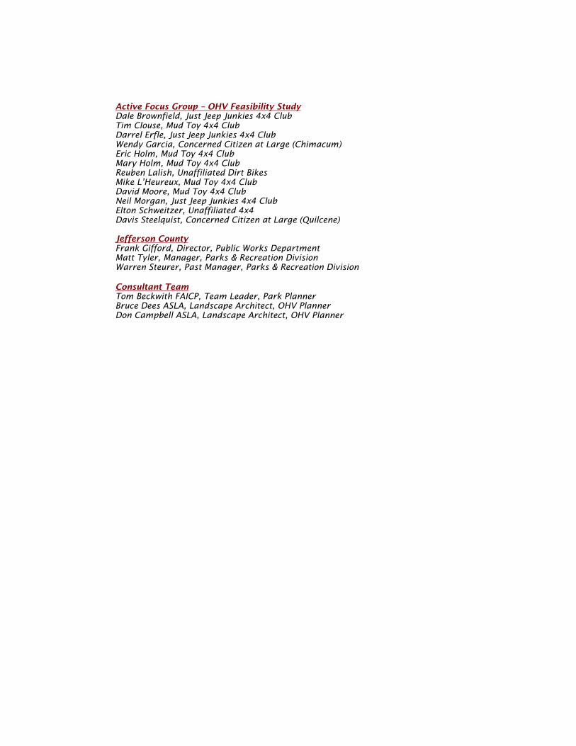
Active Focus Group – OHV Feasibility Study Dale Brownfield, Just Jeep Junkies 4x4 Club Tim Clouse, Mud Toy 4x4 Club Darrel Erfle, Just Jeep Junkies 4x4 Club Wendy Garcia, Concerned Citizen at Large (Chimacum) Eric Holm, Mud Toy 4x4 Club Mary Holm, Mud Toy 4x4 Club Reuben Lalish, Unaffiliated Dirt Bikes Mike L’Heureux, Mud Toy 4x4 Club David Moore, Mud Toy 4x4 Club Neil Morgan, Just Jeep Junkies 4x4 Club Elton Schweitzer, Unaffiliated 4x4 Davis Steelquist, Concerned Citizen at Large (Quilcene) Jefferson County Frank Gifford, Director, Public Works Department Matt Tyler, Manager, Parks & Recreation Division Warren Steurer, Past Manager, Parks & Recreation Division Consultant Team Tom Beckwith FAICP, Team Leader, Park Planner Bruce Dees ASLA, Landscape Architect, OHV Planner Don Campbell ASLA, Landscape Architect, OHV Planner
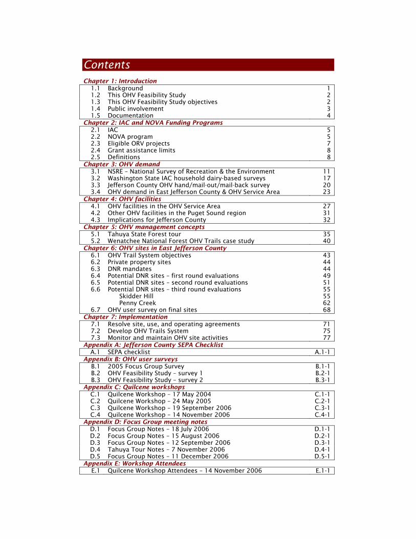
Contents Chapter 1: Introduction
1.1 Background 1 1.2 This OHV Feasibility Study 2 1.3 This OHV Feasibility Study objectives 2 1.4 Public involvement 3 1.5 Documentation 4
Chapter 2: IAC and NOVA Funding Programs 2.1 IAC 5 2.2 NOVA program 5 2.3 Eligible ORV projects 7 2.4 Grant assistance limits 8 2.5 Definitions 8
Chapter 3: OHV demand 3.1 NSRE – National Survey of Recreation & the Environment 11 3.2 Washington State IAC household dairy-based surveys 17 3.3 Jefferson County OHV hand/mail-out/mail-back survey 20 3.4 OHV demand in East Jefferson County & OHV Service Area 23
Chapter 4: OHV facilities 4.1 OHV facilities in the OHV Service Area 27 4.2 Other OHV facilities in the Puget Sound region 31 4.3 Implications for Jefferson County 32
Chapter 5: OHV management concepts 5.1 Tahuya State Forest tour 35 5.2 Wenatchee National Forest OHV Trails case study 40
Chapter 6: OHV sites in East Jefferson County 6.1 OHV Trail System objectives 43 6.2 Private property sites 44 6.3 DNR mandates 44 6.4 Potential DNR sites – first round evaluations 49 6.5 Potential DNR sites – second round evaluations 51 6.6 Potential DNR sites – third round evaluations 55
Skidder Hill 55 Penny Creek 62
6.7 OHV user survey on final sites 68 Chapter 7: Implementation
7.1 Resolve site, use, and operating agreements 71 7.2 Develop OHV Trails System 75 7.3 Monitor and maintain OHV site activities 77
Appendix A: Jefferson County SEPA Checklist A.1 SEPA checklist A.1-1
Appendix B: OHV user surveys B.1 2005 Focus Group Survey B.1-1 B.2 OHV Feasibility Study – survey 1 B.2-1 B.3 OHV Feasibility Study – survey 2 B.3-1
Appendix C: Quilcene workshops C.1 Quilcene Workshop – 17 May 2004 C.1-1 C.2 Quilcene Workshop – 24 May 2005 C.2-1 C.3 Quilcene Workshop – 19 September 2006 C.3-1 C.4 Quilcene Workshop – 14 November 2006 C.4-1
Appendix D: Focus Group meeting notes D.1 Focus Group Notes – 18 July 2006 D.1-1 D.2 Focus Group Notes – 15 August 2006 D.2-1 D.3 Focus Group Notes – 12 September 2006 D.3-1 D.4 Tahuya Tour Notes – 7 November 2006 D.4-1 D.5 Focus Group Notes – 11 December 2006 D.5-1
Appendix E: Workshop Attendees E.1 Quilcene Workshop Attendees – 14 November 2006 E.1-1

1 Chapter 1: Introduction
Jefferson County OHV Feasibility Study
Chapter 1: Introduction
Off-Highway Vehicle (OHV) activities have increased considerably in Washington State, East Jefferson County, and the East Jefferson County OHV Service Area (East Jefferson, Kitsap, Mason, and Clallam Counties) since Jefferson County completed the park, recreation, and open space plan in 2001. The choices that confront OHV enthusiasts and East Jefferson County residents concerning OHV use in sanctioned OHV trail systems or in undesignated off-highway environments at the present time are significant and could alter the character and quality of this recreational activity if not adequately managed. This document outlines the choices that are available and the means for implementing possible actions found to be most feasible for this type of recreational activity in East Jefferson County. 1.1 Background An OHV study process was originally initiated in January 2004 by OHV user organizations and individuals concerned about the growing number of OHV enthusiasts in East Jefferson County and the lack of appropriately designated and managed use areas. In the absence of a designated and managed trail system, OHV use is frequently occurring on scattered public and private lands throughout East Jefferson County that lack public access, critical area and habitat protections, noise and nuisance management, proper trail and use area maintenance, safety and security response capabilities, and sanitary facilities. OHV organizations requested the Jefferson County Board of Commissioners (BOCC) provide assistance and direction to determine an appropriately designated use area in East Jefferson County. As a result of BOCC direction an OHV Focus Group was formed in June 2004 to work with the Jefferson County Parks & Recreation Division, Parks & Recreation Advisory Board, Sheriff’s Office, Department of Natural Resources (DNR), and private timber companies to determine the need for and the feasibility of developing and OHV Trails System in East Jefferson County. The OHV Focus Group believes the creation of an OHV Trails System in East Jefferson County will address the need for this popular family recreation pastime. The OHV Focus Group also believes the establishment of an OHV Trails System must be done in a safe, legal, and environmentally responsible fashion. During 2004 and 2005 the Jefferson County Parks & Recreation Division staff and OHV Focus Group conducted public workshops in Quilcene and the Tri-Area about possible OHV use and benefits. Exploratory meetings and workshops were also conducted by the Jefferson County Parks & Recreation Division and OHV Focus Group with the Quilcene Chamber of Commerce, Jefferson County Parks & Recreation Advisory Board, Jefferson County Sheriff’s Office,, Washington State Department of Natural Resources (DNR), and private timber companies. Following these exploratory workshops, the BOCC agreed with the need for an OHV Trails System, applied for and was awarded a grant from the Washington State Interagency Committee for Outdoor Recreation (IAC) to conduct this OHV Feasibility Study under the Non-highway Off-Road Vehicle Activities (NOVA) program in 2005.
2 Chapter 1: Introduction Jefferson County OHV Feasibility Study
1.2 This OHV Feasibility Study This IAC funded OHV Feasibility Study was initiated by the Jefferson County Parks & Recreation Division with the assistance of the OHV Focus Group beginning in March 2005 and the hiring of the consulting team in May 2006. This IAC funded OHV Feasibility Study is to determine the feasibility of establishing an OHV Trail System in East Jefferson County to be developed for trail bikes, all-terrain vehicles (ATV), and 4-wheel drive (4WD) vehicles. Jefferson County’s IAC NOVA grant application identified 11 DNR managed properties in East Jefferson County for possible evaluation. The 11 possible sites are to be evaluated during this OHV Feasibility Study process for public access, critical area and wildlife habitat characteristics, possible noise and land use impacts, safety and security implications, and user opportunities and interests, among other factors, to determine if any of the sites are feasible for an OHV Trail System. This study is also to determine different options or plans available to adequately manage and maintain an OHV Trail System. 1.3 This OHV Feasibility Study Objectives As outlined above, the specific objectives of this OHV Feasibility Study were to: Determine the potential demand/need – for Off-Highway Vehicle (OHV) Trail
Systems in East Jefferson County including trail bikes, all terrain vehicles (ATVs) or quads, and 4 wheel drive vehicles (4WD) from users residing in East Jefferson County, and the Jefferson County OHV Service Area that includes Jefferson, Kitsap, Clallam, and Mason Counties (hereafter be referred to as the OHV Service Area). Inventory – of existing regional OHV trail systems and facilities assets to
determine where OHV enthusiasts from Jefferson County and the surrounding service area currently must go to engage in OHV activities. Evaluate alternative sites for an East Jefferson County OHV Trail System –
from a list of 11 DNR managed properties that have been identified as possible OHV trail sites. (Previous discussions with private landowners in East Jefferson County determined there was no current interest on their part to use their properties for an OHV Trails System.) Create illustrative concept plans - for developing the most feasible of the 11
DNR managed properties for an OHV Trail System accounting for critical or unusable environmental soils or areas, noise impact contours, impacts on adjacent land uses, and other factors. Determine the probable costs or consequences - involved in owning or
leasing, developing, managing, maintaining, providing security, and other aspects of an OHV Trail System assuming one or another of the most feasible DNR properties is a potential site. Identify appropriate roles – between Jefferson County, DNR, and OHV user
organizations concerning the alternative options for owning, managing, developing, maintaining, and operating an OHV Trail System in East Jefferson County. Obtain public opinion – from potential OHV enthusiasts, local community
residents, and adjacent land owners from surveys, newspaper articles, and public workshops on the feasibility/desirability of an OHV Trail System on the most feasible of the 11 DNR managed properties in East Jefferson County and the possible impacts.
3 Chapter 1: Introduction
Jefferson County OHV Feasibility Study
Define an implementation program - outlining the actions necessary to create
an OHV Trail System in East Jefferson County based on the findings of this OHV Feasibility Study. 1.4 Public involvement This OHV Feasibility Study process was accomplished by a consultant team and overseen by the Manager of the Jefferson County Parks & Recreation Division and the OHV Focus Group. The OHV Focus Group and Jefferson County Park & Recreation Advisory Board provided reviews and comments during the course of the following planning process. OHV Focus Group review meetings and workshops - were conducted during
the process to review inventory findings, demand projections, the 11 DNR site evaluations, illustrative concept plans for the most feasible sites, and alternative approaches to developing, operating, and managing an OHV Trail System. The workshop sessions were also occasionally attended by members of the Park & Recreation Advisory Board, DNR and WDFW representatives, OHV enthusiasts, and the public at large including residents of the Quilcene area. Progress briefings – were given to the Jefferson County Park & Recreation
Advisory Board on the 2nd of August, 4th of October, 1st of November, and to the BOCC on the 16th of October. Tahuya State Forest OHV tour – was sponsored by the OHV Focus Group and
was conducted of the OHV Trails System that has been developed in the Tahuya State Forest and Multiple Use Area on the 7th of November. The tour was intended for the BOCC, Park & Recreation Advisory Board, Jefferson County Sheriff, Jefferson County Public Works Director, Jefferson County Fire Dist 2, and interested members of the public. Briefings were provided during the tour by South Puget Sound Region DNR, Tahuya Forest management staff, and 4-wheel drive organization representatives. Public workshops - were conducted in Quilcene on the 13th of May 2004 by
the Jefferson County Parks & Recreation Division during the initial exploratory events. Additional public workshops were conducted by the Jefferson County Parks & Recreation Division and the OHV Focus Group on the 24th of May 2005 and the 18th of July 2006 to advise interested agencies and the public of the IAC NOVA grant application and the pending initiation of this OHV Feasibility Study. The consultant team, Jefferson County Parks & Recreation Division, and the OHV Focus Group conducted additional workshops on the 19th of September nd the 14th of November 2006 to review this OHV Feasibility Study’s progress and obtain comments on the illustrative concept plans and potential impacts for the 2 most feasible DNR sites located in Skidder Hill and Penney Creek. Mail-back surveys –were conducted in 2005 by the OHV Focus Group and at
the beginning of this OHV Feasibility Study by the consultant team to determine OHV riding areas, behaviors, and other characteristics of OHV enthusiasts within East Jefferson County and the OHV Service Area. A third survey was conducted by the consultant towards the end of this study to evaluate OHV user reactions to the 2 most feasible DNR sites at Skidder Hill and Penney Creek. Public exhibits – were displayed on the Jefferson County Park & Recreation
website (http://www.countyrec.com) of the agenda and handouts provided during the 2006 public workshops in Quilcene. The findings outlined within this document represent the results of the information and comments developed from these events.
4 Chapter 1: Introduction Jefferson County OHV Feasibility Study
1.5 Documentation This report is organized into 7 chapters outlining OHV user profiles and interest, existing OHV facilities, evaluation of the 11 possible DNR sites, illustrative concept plans for the 2 most feasible sites, and prototypical management and maintenance agreements. A Jefferson County SEPA checklist is provided as an appendix for a programmatic OHV Trail System with a summary evaluation of the 2 most feasible DNR sites. Separate technical appendices detail the comments collected during the OHV surveys, public workshops, meeting notes, and the Quilcene public workshop lists of attendees.

5 Chapter 2: IAC and NOVA Funding Programs
Jefferson County OHV Feasibility Study
Chapter 2: IAC and NOVA Funding Programs
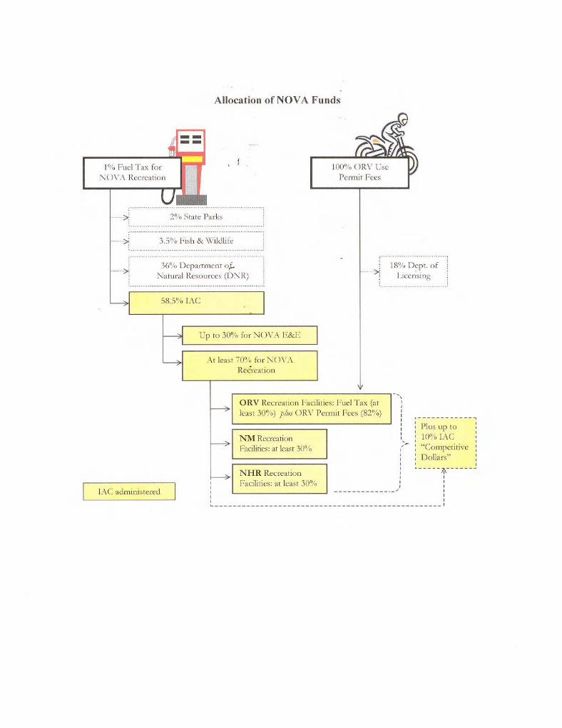
2.1 IAC The Washington State Interagency Committee for Outdoor Recreation (IAC) was created in 1964 by a public vote of the citizens of Washington State. This Executive branch state agency consists of 5 citizen members appointed by the Governor, and the Directors (or designees) of the Department of Fish & Wildlife (WDFW), Department of Natural Resources (DNR), and State Parks & Recreation Commission (P&RC). IAC’s staff consists of a Director appointed by the Governor and other professionals engaged in administrative, planning, and project functions. IAC is a planning and grants agency and does not operate facilities. IAC grant programs include funding for general parks and recreation, boating, non-motorized trails, water access, habitat conservation, off-road or off-highway activities, and shooting/archery ranges. 2.2 NOVA program In 1972, the legislature set aside 1% of the state’s gasoline fuel excise tax to providing funding for the NOVA (Non-highway & Off-Road Vehicle Activities) program (Chapter 46.09 RCW). A second source for funds was later added to include ORV registration fees (RCW 46.09.110) The NOVA legislation was amended several times, notably in 1986, in part to provide funding for non-motorized trails activities, and again in 2004 to revise funding distributions, and broaden the education-enforcement categories, among others. IAC’s administrative rules for the NOVA program are established in WAC 286-04, 286-06, 286-13, and 286-26. NOVA grants are intended to allow various user groups and agencies to provide quality opportunities for recreational enthusiasts – opportunities that satisfy user needs, are environmentally responsible, and minimize conflicts between user groups. NOVA grants can fund planning activities, land acquisition projects, development projects, education and enforcement programs, and maintenance and operations projects for the following 4 programs: NHR – Non-highway Road Non-highway Road category projects are intended to serve receptionists who, for the most part, recreate on or adjacent to non-highway roads including but not limited to: Boating (non-motorized – canoe, kayak, etc) Camping Driving for pleasure, sightseeing, viewing wildlife, etc Fishing Gathering (berries, mushrooms, wood, etc) Hunting Picnicking
NM – Non-motorized Non-motorized category projects are intended to serve recreational enthusiasts who access trail related activities via a non-highway road including but not limited to: Cross-country skiing Hiking Horseback riding Mountain bicycling Snowshoeing
7 Chapter 2: IAC and NOVA Funding Programs
Jefferson County OHV Feasibility Study
ORV – Off-Road Vehicle Off-road vehicle category projects are intended to serve recreational enthusiasts who access trail related activities via a non-highway road or consume fuel in ORVs for recreational purposes including but not limited to: Motorcycling or trail bikes All-terrain vehicle (ATV) riding 4-wheel driving (4WD)
E&E – Education-Enforcement E&E grants primarily help preserve opportunities by encouraging responsible recreational behaviors through positive management techniques by: Augment local capabilities that result in improved NOVA recreation
management. NOVA funding shall not be used to replace local law enforcement funding.
Encourage projects that contact NOVA recreational enthusiasts in the field on DNR and USFS management lands during high use seasons.
2.3 Eligible ORV projects NOVA grant funds may be used to fund activities within the following categories: Planning projects – include all phases of planning including one or all of the following elements: Comprehensive plans Construction drawings Environmental assessments Feasibility and preconstruction studies Route surveys and reconnaissance Site master plans
Land acquisition – may include purchase in fee title, or lesser interests such as leases and easements. IAC requires a ease period of at least 25 years for projects requiring leases. Development projects – may include the following elements: Access roads, parking, trails, and trailheads Sanitary facilities including sewer systems and other related utilities that meet
applicable local and state health requirements Route and interpretive signs and informational bulletin boards Picnic and camping areas Wildlife viewing facilities Non-motorized boating access facilities Utilities including, water, electric, and phone service Extensive or redevelopment of existing improvements when:
They have deteriorated to the point where their usefulness and/or safety is impaired (although not because of inadequate maintenance) and/or
When the facility has become outmoded ORV sports park facilities, including but not limited to, motocross tracks, sand
drag strips, 4-wheel drive competitive and play facilities, spectator facilities, concession buildings, and park administration and maintenance facilities.
Employee residences (typically related to an ORV sports park facility). The construction of residences must be for employees directly involved in the operation and maintenance of a NOVA assisted project provided that:
The residence will help assure increased public service and protection of park facilities.
The employee assigned to or using the residence must normally be available in the park on a 24-hour basis during the season the park is open. The employee must be assigned to ORV facilities and activities at least 75% of their time.
8 Chapter 2: IAC and NOVA Funding Programs Jefferson County OHV Feasibility Study
The park residence must be one component of a comprehensive park development.
The residence or improvements must be permanent at this site. Maintenance and operations projects – may be accomplished for the following facilities: Open ORV riding areas Trails Trailheads, day-use areas, and campgrounds ORV sports parks and ORV intensive use areas Support structures and facilities Snow removal and trail grooming for non-snowmobile recreation Water access sites that serve primarily non-motorized activities
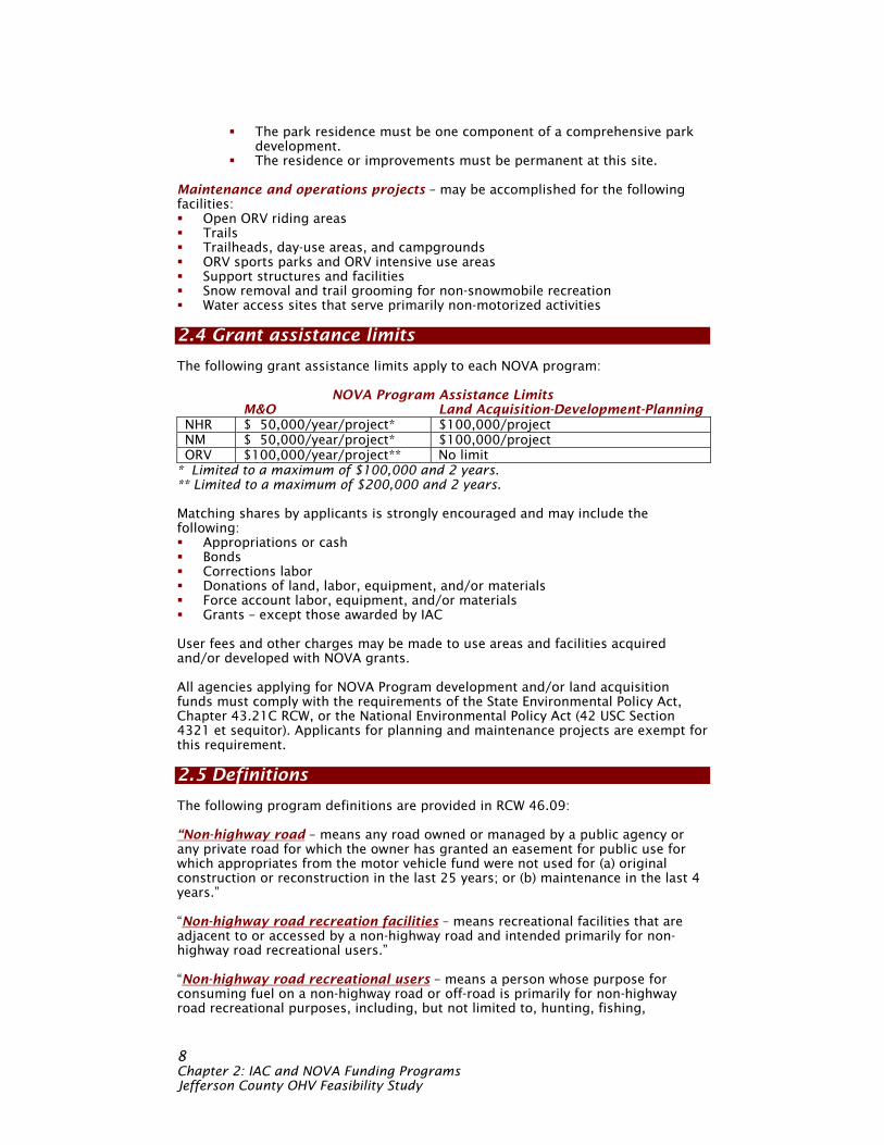
2.4 Grant assistance limits The following grant assistance limits apply to each NOVA program:
NOVA Program Assistance Limits M&O Land Acquisition-Development-Planning NHR $ 50,000/year/project* $100,000/project NM $ 50,000/year/project* $100,000/project ORV $100,000/year/project** No limit
* Limited to a maximum of $100,000 and 2 years. ** Limited to a maximum of $200,000 and 2 years. Matching shares by applicants is strongly encouraged and may include the following: Appropriations or cash Bonds Corrections labor Donations of land, labor, equipment, and/or materials Force account labor, equipment, and/or materials Grants – except those awarded by IAC
User fees and other charges may be made to use areas and facilities acquired and/or developed with NOVA grants. All agencies applying for NOVA Program development and/or land acquisition funds must comply with the requirements of the State Environmental Policy Act, Chapter 43.21C RCW, or the National Environmental Policy Act (42 USC Section 4321 et sequitor). Applicants for planning and maintenance projects are exempt for this requirement. 2.5 Definitions The following program definitions are provided in RCW 46.09: “Non-highway road – means any road owned or managed by a public agency or any private road for which the owner has granted an easement for public use for which appropriates from the motor vehicle fund were not used for (a) original construction or reconstruction in the last 25 years; or (b) maintenance in the last 4 years.” “Non-highway road recreation facilities – means recreational facilities that are adjacent to or accessed by a non-highway road and intended primarily for non-highway road recreational users.” “Non-highway road recreational users – means a person whose purpose for consuming fuel on a non-highway road or off-road is primarily for non-highway road recreational purposes, including, but not limited to, hunting, fishing,
9 Chapter 2: IAC and NOVA Funding Programs
Jefferson County OHV Feasibility Study
camping, sightseeing, wildlife viewing, picnicking, driving for pleasure, kayaking/canoeing, and gathering berries, firewood, mushrooms, and other natural products.” “Non-highway vehicle – means any motorized vehicle including an ORV when used for recreational purposes on non-highway roads, trails, or a variety of other natural terrain. Non-highway vehicle does not include: Any vehicle designed primarily for travel on, over, or in the water; Snowmobiles or any military vehicles; or Any vehicle eligible for a motor vehicle fuel tax exemption or rebate under
Chapter 82.36 RCW while an exemption or rebate is claimed. This exemption includes, but is not limited to farm, construction, and logging vehicles.”
“ORV or Off-road vehicle – means any non-street licensed vehicle when used for recreational purposes on non-highway roads, trails, or a variety of other natural terrain. Such vehicles include, but are not limited to, all-terrain vehicles (ATVs), motorcycles (trail bikes), 4-wheel drive vehicles (4WD), and dune buggies.” “ORV recreation facilities – include but are not limited to, ORV trails, trailheads, campgrounds, ORV sports parks, and ORV use areas, designated for ORV use by the managing authority that are intended primarily for ORV recreational users.” Note – OHV (Off-highway vehicle) – is a recent definition meant to include all ORVs as defined above that use off-road and off-highway trail systems to include USFS, DNR, and other logging, access, and other non-highway routes into natural terrain.

10 Chapter 2: IAC and NOVA Funding Programs Jefferson County OHV Feasibility Study
11 Chapter 3: OHV Demand
Jefferson County OHV Feasibility Study
Chapter 3: OHV demand
3.1 NSRE-National Survey of Recreation & the Environment The National Survey of Recreation and the Environment (NSRE) is a collaborative project between the Forest Service (Research and Development and Strategic Planning and Resource Assessment Offices), National Oceanic and Atmospheric Administration, the University of Georgia and the University of Tennessee. Other agencies are partners in sponsoring the NSRE. The NSRE is a general population, random-digit-dialed household telephone survey designed to measure the outdoor recreation and environmental behavior and attitudes of Americans age 16 and older. The NSRE is the 8th in a series of national recreation surveys that began in 1960. Between the fall of 1999 and 2004, more than 81,000 people were interviewed for the NSRE. The survey was divided into 18 separate versions, each of which included different recreation activities and environmental issues. OHV use The “core” of the NSRE asked about recreational activity participation and personal demographics. All but 2 of the 18 versions included a question asking if the participant drove off-road (off-highway) for recreation using a motorcycle (trail bike), ATV, or 4WD vehicle. In total, nearly 74,000 people age 16 or older responded to this NSRE OHV question. (Note – previous NSRE surveys used the phrase “off-road”. For this study, the NSRE considered off-highway and off-road to be the same activity. Off-highway is used as the current term to capture a broader band of uses including backcountry roads, trails, and cross-country riding.) The large sample size provides for sound statistical estimates, not only for the nation, but for regions and states. No state had fewer than 500 respondents (Washington had 1,270 respondents). The sample was also spread fairly evenly during each year between 1999 and 2004 to allow tracking of short-term trends in recreation participation, including OHV participation. OHV activities The NSRE collected data on off-highway driving of motor vehicles from the fall of 1999 through late 2004. Off-highway vehicles were defined by the NSRE to include: Motorcycles designed for off-highway use including trail bikes All-terrain vehicles (ATVs) 4-wheel drive jeeps, automobiles, or sport utility vehicles (4WD), and Other specially designed off-road motor vehicles used in a variety of ways.
Snowmobiles, which are used on off-road or off-highway activities, were not included in the NSRE survey. While some OHVs are used frequently for business, commuting, and other work-related activities, particularly the 4WD category, the report and survey focused only on the recreational use of OHVs. Further, while a person may own an OHV for many purposes, the NSRE asks the questions directly whether the individual drove the motorcycle (trail bike), ATV, or 4WD off-highway for recreation during the year of the survey. OHV volume trends OHV use is increasing rapidly in recent years in total volume and the percent of the population that participates in the activity. According to the NSRE surveys:
13 Chapter 3: OHV Demand
Jefferson County OHV Feasibility Study
OHV increased from 23,300,000 users when data was conducted for OHV
activities in 1994-1995 to 36,000,000 users when data was collected between fall 1999 and summer 2000 or by an increase of 32%. The total number of OHV participants continued to increase from 36,000,000
users in 2000 to 51,000,000 users by the end of 2004 or by another 42%. Based on the latest survey, nearly 1-in-4 Americans (or 23.8% of the population)
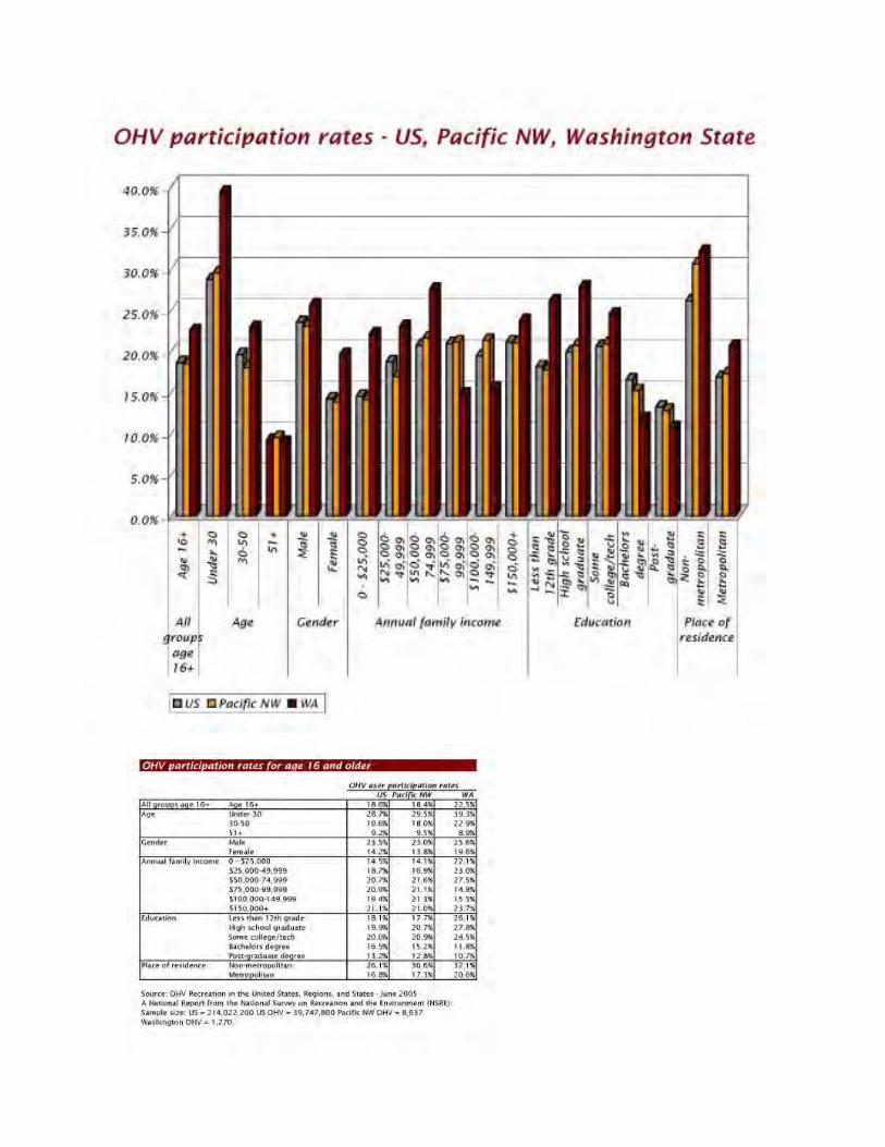
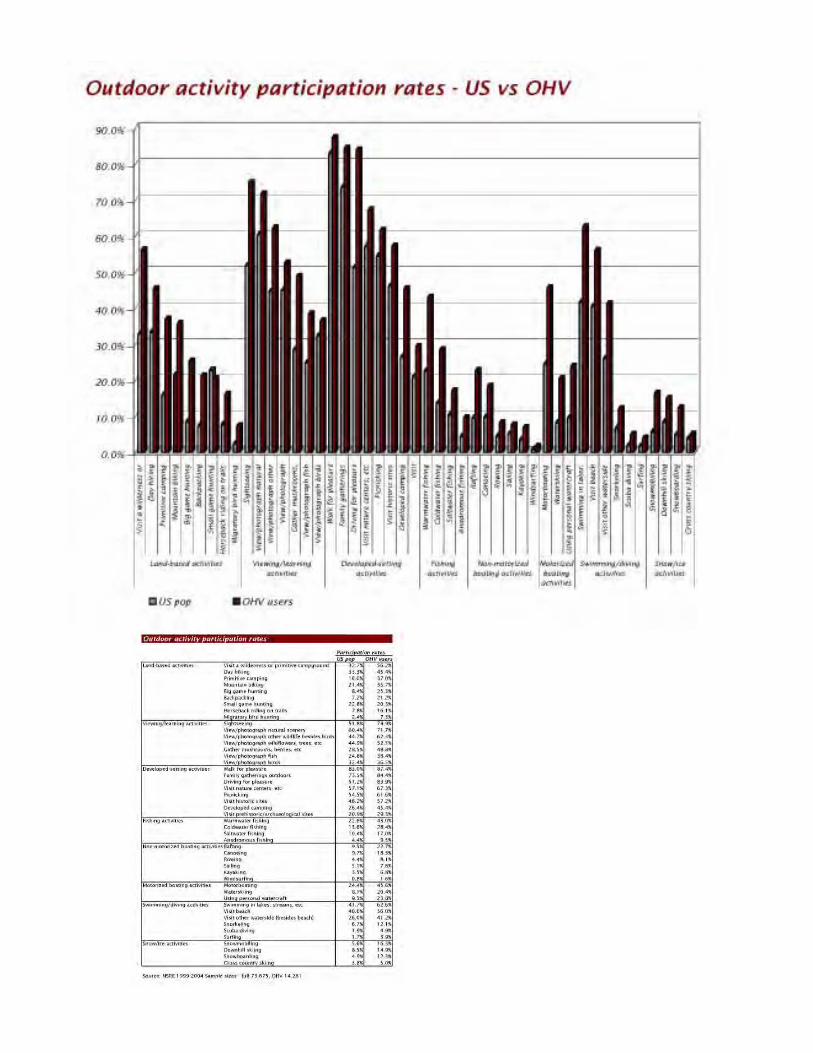
age 16 and older participated 1 or more times in OHV recreation within the past year (2004). OHV participation rates for US, Pacific Northwest Region, and Washington State The NSRE asked survey respondents for the survey period 1999-2004 to provide basic demographic information in order to determine the percent of each demographic group who participated in OHV activities for the US, the Pacific Northwest Region (Alaska, Hawaii, California, Oregon, and Washington), and Washington State. The results are shown in the graphic and table on the preceding page, following is a summary of the major findings: Overall participation rate – or the percent of all persons age 16 and older
who participate in OHV activities was found to be higher in Washington State (22.5%) compared to 18.4% percent for the Pacific NW region (Alaska, California, Hawaii, Oregon, and Washington), and 18.6% for the US. Age group – a greater percent participate in the under 30 age group in
Washington State (39.3%) compared to 29.5% for the Pacific NW region, and 28.7% for the US. Conversely, a lesser percentage participate in the over 51 age group in Washington State (8.9%) compared to 9.5% in the Pacific NW, and 9.2% in the US. Gender – a greater percent of males participate in OHV activities in Washington
State (25.6%) compared to 23.0% in the Pacific NW region, and 23.5% in the US. Likewise, a greater percent of females participate in OHV activities in Washington State (19.6%) compared to 13.8% in the Pacific NW region, and 14.2% in the US. Annual family income – a greater percent of persons participate in OHV
activities in the lower and upper income groups in Washington State (22.1% under $25,000 annual family income and 23.7% over $150,000 annual family income) compared to 14.1% and 21.0% respectively in the Pacific NW region, and 14.5% and 21.1% respectively in the US. Education – a greater percent of persons participate in OHV activities with
some college or less in Washington State (24.5% with some college, 27.8% high school graduates, and 26.1% with less than 12th grade education) compared to 20.9%, 20.7%, and 17.7% respectively in the Pacific NW region, and 20.6%, 19.9%, and 18.1% respectively in the US. Place of residence – a greater percentage of persons participate in OHV
activities in non-metropolitan places in Washington State (32.1%) compared to 30.6% in the Pacific NW region, and 26.1% in the US. Likewise, a greater percentage of persons participate in OHV activities in metropolitan places in Washington State (20.6%) compared to 17.3% in the Pacific NW region, and 16.8% in the US. Generally, OHV users within Washington State participate in OHV activities in greater percentages than is common of the Pacific NW Region and the US in the total population, younger to middle ages groups, for males and females, in low to lower middle and the upper most income groups, with under 12th grade to college graduate education levels, from non-metropolitan to metropolitan places of residence.
15 Chapter 3: OHV Demand
Jefferson County OHV Feasibility Study
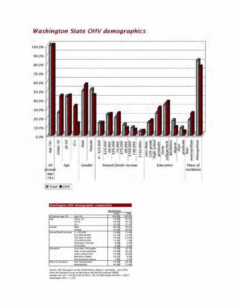
Demographic composition of Washington State OHV users compared to the general state population The NSRE survey results also depict the differences between the general population and OHV users in Washington State. The statistics are shown in the graphic and table on the preceding page, following is a summary of major findings: Age – Washington State OHV users are concentrated proportionately in greater
percentages within the younger age 16-30 age groups (43.5%) compared to the Washington State population at large (24.9%) and less within the older age groups 51 years and up (12.7%) compared to the general state population (32.2%). The proportion of Washington State OHV users within the middle 30-50 year age group is approximately the same between OHV users (43.7%) and the general state population (43.0%). Gender – Washington State OHV users include proportionately more men
(56.0%) than the general state population (49.2%) and less women (44.0%) than the general state population (50.6%). Annual family income – Washington State OHV users include about the same
percentage of low to middle income in the 0-$49,999 range (36.6%) compared to the general state population (36.3%), more middle income $50,000-74,999 (23.9%) compared to the general state population (19.6%), less upper middle income $75,000-149,999 (13.2%) compared to the state general population (19.7%), and about the same upper income $150,000+ (4.5%) compared to the general state population (4.3%). Education – Washington State OHV users include more under 12th grade and
high school graduates (46.3%) compared to the general state population (38.3%), more with some college (36.8%) compared to the general state population (33.8%)< and less college graduates (12.2%) compared to the general state population (24.1%). Place of residence – Washington State OHV users include more non-
metropolitan residents (24.1%) compared to the general state population (16.9%) and correspondingly less metropolitan residents (75.9%) compared to the general state population (82.9%). Generally, however, Washington State OHV users have characteristics which are representative of the general state populations but with a more pronounced younger age group, more male, middle income, less undergraduate and upper degree but more college graduate educations, living in non-metropolitan areas. Outdoor activities of OHV users compared to the US population at large The NSRE compared OHV with all survey respondents for the survey period 1999-2004 to determine if US OHV users participated in outdoor activities in general at different rates than the general US population. Land-based activities – US OHV users participate to a significantly greater
percent than the general US population in all land-based outdoor activities including visiting a wilderness or primitive campground, day hiking, primitive camping, mountain biking, big game hunting, backpacking, horseback riding on trails, and migratory bird hunting. Small game hunting was the only land-based outdoor activity in which US OHV users participate to a lesser degree than the general population. Viewing/learning activities – US OHV users participate to a significantly
greater percent than the general US population in all viewing/learning outdoor activities including sightseeing, viewing and photographing natural scenery, wildlife, wildflowers, gathering mushrooms, and viewing and photographing fish and birds.
17 Chapter 3: OHV Demand
Jefferson County OHV Feasibility Study
Developed-setting activities – US OHV users participate to a significantly
greater percent than the general US population in all developed-setting outdoor activities including walking for pleasure, family gathering outdoors, driving for pleasure, visiting nature centers, picnicking, visiting historic sites, developed campgrounds, and visiting prehistoric and archaeological sites. Fishing activities – US OHV users participate to a significantly greater percent
than the general US population in fishing activities including warmwater, coldwater, saltwater, and anadromous settings. Non-motorized boating activities – US OHV users participate to a significantly
greater percent than the general US population in non-motorized boating activities including rafting, canoeing, rowing, sailing, kayaking, and windsurfing. Motorized boating activities – US OHV users participate to a significantly
greater percent than the general US population in motorized boating activities including motor-boating, waterskiing, and using personal watercraft. Swimming/diving activities – US OHV users participate to a significantly
greater percent than the general US population in swimming/diving outdoor activities including swimming in lakes, visiting a beach or other waterside, snorkeling, scuba diving, and surfing. Snow/ice activities – US OHV users participate to a significantly greater
percent than the general US population in snow and ice activities including snowmobiling, downhill skiing, snowboarding, and cross country skiing. In general, the NSRE survey indicates OHV users are more active in every outdoor activity measured except small game hunting than is common of the general US population. 3.2 Washington State IAC household diary-based surveys During 1999-2000 the Washington State Interagency Committee for Outdoor Recreation (IAC) conducted a diary-based survey of 1,200 households with over 3,400 household members concerning the outdoor recreation activities they participated in over a 12 month period. The IAC survey asked the household member participants to record which activities they participated in, on which week and weekend days, in which kinds of physical settings over the 12 month period. The IAC survey covered an extensive list of indoor and outdoor activities including off-road or off-highway vehicles. Off-road or off-highway was defined to be on a road not constructed or maintained by state motor fuel taxes and included federal roads such as USFS access and logging roads, and state forest roads managed by the Department of Natural Resources (DNR), and the Department of Fish & Wildlife (WDFW) roads found in wildlife recreation areas. Non-highway vehicle is defined by state law (RCW 46.09.020) to mean “any motorized vehicle when used for recreation travel on trails and non-highway roads or for recreation cross-country travel on any one of the following or a combination thereof – land, water, snow, ice, marsh, swampland, and other natural terrain. Such vehicles include but are not limited to, off-road vehicles, 2, 3, or 4-wheel vehicles, motorcycles (trail bikes), 4-wheel drive vehicles, dune buggies, amphibious vehicles, ground effects or air cushion vehicles, and any other means of land transportation driving motive power form any source other than muscle or wind.” The IAC survey asked respondents whether they participated in off-road or off-highway activities regardless of the type of on or off-highway vehicle. The results indicated survey respondents used both types of vehicles for off-road or off-highway activities.
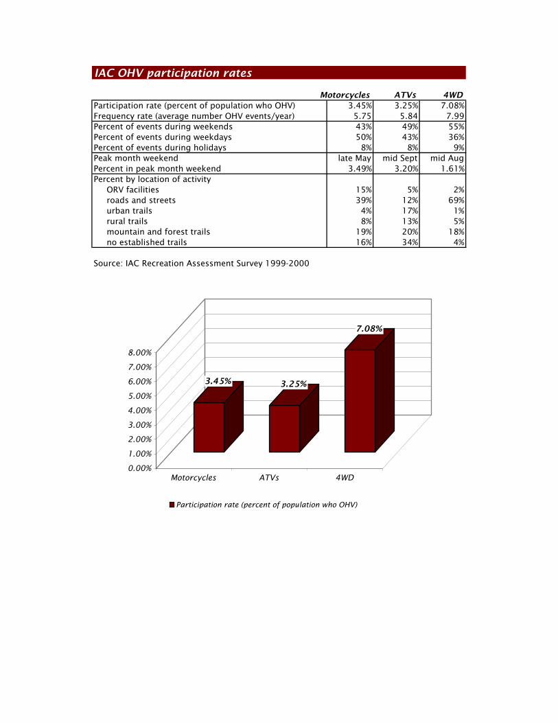
IAC OHV participation rates
Motorcycles ATVs 4WDParticipation rate (percent of population who OHV) 3.45% 3.25% 7.08%Frequency rate (average number OHV events/year) 5.75 5.84 7.99Percent of events during weekends 43% 49% 55%Percent of events during weekdays 50% 43% 36%Percent of events during holidays 8% 8% 9%Peak month weekend late May mid Sept mid AugPercent in peak month weekend 3.49% 3.20% 1.61%Percent by location of activity ORV facilities 15% 5% 2% roads and streets 39% 12% 69% urban trails 4% 17% 1% rural trails 8% 13% 5% mountain and forest trails 19% 20% 18% no established trails 16% 34% 4%
Source: IAC Recreation Assessment Survey 1999-2000
3.45% 3.25%
7.08%
0.00%
1.00%
2.00%
3.00%
4.00%
5.00%
6.00%
7.00%
8.00%
Motorcycles ATVs 4WD
Participation rate (percent of population who OHV)
19 Chapter 3: OHV Demand
Jefferson County OHV Feasibility Study
For example, the Washington State Department of Licensing registered 61,308 off-road vehicles in 2000. IAC survey results, however, indicated approximately 7% of the total population in all age groups or about 400,000 people participated in off-road or off-highway activity – meaning the general population was using street-legal 4-wheel drive, off-road capable trucks, and probably even sport utility vehicles (SUVs) for off-road or off-highway activities as well as daily commuting and driving activities. The IAC household diary-based survey covered all age groups, compared to the NSRE surveys that were conducted for persons age 16 and over. The IAC survey results are shown in the graphic and table on the preceding page, following is a summary of major findings: Trail bikes – were used by 3.45% of the total population an average of 5.75
times per year in an off-road or off-highway recreational activity of which 43% occurred during weekends, 50% during weekdays, and 8% during weekends. The peak month weekend occurred in late May during which 3.49% of the year’s total activity occurred. Approximately 15% of OHV use by motorcycles occurred at ORV facilities, 39% on roads and streets, 4% on urban trails, 8% on rural trails, 19% on mountain and forest trails, and 16% on no established trails. ATV (all-terrain vehicles) – were used by 3.25% of the total population an
average of 5.84 times per year in an off-road or off-highway recreational activity of which 49% occurred during weekends, 43% during weekdays, and 8% during weekends. The peak month weekend occurred in mid September during which 3.20% of the year’s total activity occurred. Approximately 5% of OHV use by ATVs occurred at ORV facilities, 12% on roads and streets, 17% on urban trails, 13% on rural trails, 20% on mountain and forest trails, and 34% on no established trails. 4WD (4-wheel drive vehicles) – were used by 7.08% of the total population an
average of 7.99 times per year in an off-road or off-highway recreational activity of which 55% occurred during weekends, 36% during weekdays, and 9% during weekends. The peak month weekend occurred in mid August during which 1.61% of the year’s total activity occurred. Approximately 2% of OHV use by 4WDs occurred at ORV facilities, 69% on roads and streets, 1% on urban trails, 5% on rural trails, 18% on mountain and forest trails, and 4% on no established trails. Generally, 4WD vehicles are used for OHV activity by a greater percent of the population, on a more frequent basis, primarily during weekends, but spread out more over the year with a less than peak day occurrence, with more activity on roads and streets, but with less activity at ORV facilities or areas with no established trails than Motorcycles or ATVs. Conversely, Motorcycles (trail bikes) are used by a lesser percent of the population, on a less frequent basis, primarily during weekdays, with a peak in late Spring, with more activity at an ORV facility and areas with no established trails than 4WD vehicles. Note – ORV or OHV use areas or trail systems are located on streets or roads or trails in USFS forest lands, multiple use state (DNR) forests, fish and wildlife recreation areas, on private forest lands, in designated open riding areas such as sand dunes, informal sites in urban and suburban lots, and at ORV sports parks. ORV or OHV use is prohibited in National parks and all congressionally-designated wilderness areas. State lands designated for natural areas also restrict ORV or OHV use. The term ORV facility refers to an ORV Sports Park and not an OHV use area or trail system. There are 3 ORV Sports Parks located in the state at Richland, Spokane, and Thurston County (Straddleline ORV Sports Park).
20 Chapter 3: OHV Demand Jefferson County OHV Feasibility Study
The IAC expects OHV use will increase an average rate of 1% per year over the next 20 year forecast period statewide. 3.3 OHV user survey The consultant conducted a survey during the early stages of this Feasibility Study of OHV user within East Jefferson County and the OHV Service Area (consisting of Kitsap, Clallam, Mason, and Jefferson Counties) to determine the characteristics and opinions of likely users of an OHV Trail System within East Jefferson County. The survey was completed by 74 OHV users – the complete text of which is provided in the Appendix. (The consultant survey duplicated some questions from the first survey conducted in 2005 by the OHV Focus Group – which is also provided in the Appendix.) The consultant’s survey, which had more respondents, had the following major findings. Characteristics Place of residence – 54% of the mail-back survey respondents lived in Jefferson
County including 20% in Port Townsend, 11% lived in Clallam County, 8% in Kitsap, 1% in Mason County, 16% somewhere else, and 9% who did not indicate a place of residence. According to the survey, a majority of potential OHV trail system users will likely come from within Jefferson County. Number of OHV riders per household – 49% of all survey respondents
involved 2 persons from the household, 22% involved 3 persons, and 19% involved 4 or more, while 8% involved a single person. OHV activities are a family event. Type of vehicle – 65% of the survey respondents rode or drove a 4WD, 54% a
motorcycle or trail bike, and 42% an ATV. Some of the survey respondents rode or drove more than one vehicle type. Years ridden – 49% of the survey respondents have ridden or driven an OHV
over 15 years, less than 1% have ridden or driven an OHV less than a year. 44% have been riders or drivers between 2 and 15 years. OHV activities are generally a long time recreational pursuit. Age group – 31% of all riders or drivers were between age 35-49, 23% between
50-64, 19% between 25-34, 12% between 18-24, 8% over age 54, and 5% under age 17. Gender – 81% of all survey respondents were male, 15% female, 4% did not
identify a gender. OHV transport – 32% of all survey respondents brought their OHV by trailer,
26% drove their truck to the site, 22% drove another OHV type to the site, 11% towed the OHV behind a motor home, and 5% hauled the OHV behind a camp trailer. Number of riders per vehicle – 50% of the OHVs’ were occupied by 2 persons,
26% by 4 persons, 16% by 3 persons, 3% by 5 or more persons, and 3% by 1 person. Distance – 38% of all survey respondents drove 2 or more hours to get to an
OHV site, 32% between 30-60 minutes, and 27% between 1-2 hours. Average stay – 46% of all survey respondents stayed between 1-3 days at an
OHV site, 42% between 6-12 hours, and 7% more than 3 days. Overnight – 70% of all survey respondents camped in the OHV area, 16%
camped at a location off-site, 5% at other lodging off-site. Expenditures – 32% of all survey respondents spent between $1,000-2,4999
last year in an OHV area or trail including vehicle tabs, insurance, gas, food, hotel,
21 Chapter 3: OHV Demand
Jefferson County OHV Feasibility Study
etc, 20% spend between $2,500-4,999, 18% spent $500-999, 15% spend $100-499, 8% spend $5,000-$9,999, and 1% spent more than $10,000. Reason to use the facility – 76% of all survey respondents went to the OHV
site to ride for pleasure, 8% to compete in an event (where competition was allowed), 4% to learn how to ride, and 1% to watch others ride. Frequency – 42% of all survey respondents frequent the OHV site on a monthly
basis, 20% on a yearly basis, 9% weekly, 1% daily, and 8% never at an OHV site. Source of information – 53% of all survey respondents get OHV information
on a monthly basis from a book or magazine, 32% from an internet website, and 31% by word of mouth. Frequencies Frequency during weekdays – all survey respondents indicated that during
weekdays 11% rode on a daily basis, 24% on a weekly basis, 34% on a monthly basis, 14% on a yearly basis, and 8% never. Frequency during weekends – all survey respondents indicated that during
weekends 15% rode on a daily basis, 46% on a weekly basis, 34% on a monthly basis, 0% on a yearly basis, and 3% never. Frequency during holidays – all survey respondents indicated that during
holidays 19% rode on a daily basis, 23% on a weekly basis, 22% on a monthly basis, 23% on a yearly basis, and 5% never. Frequency during spring – all survey respondents indicated that during the
spring season 15% rode on a daily basis, 36% on a weekly basis, 35% on a monthly basis, 5% on a yearly basis, and 3% never. Frequency during summer – all survey respondents indicated that during the
summer season 16% rode on a daily basis, 43% on a weekly basis, 36% on a monthly basis, 0% on a yearly basis, and 1% never. Frequency during fall – all survey respondents indicated that during the fall
season 11% rode on a daily basis, 41% on a weekly basis, 39% on a monthly basis, 3% on a yearly basis, and 1% never. Frequency during winter – all survey respondents indicated that during the
winter season 8% rode on a daily basis, 26% on a weekly basis, 43% on a monthly basis, 16% on a yearly basis, and 4% never. In general, survey respondents were most likely to ride on a weekly or monthly basis during all days and seasons. Location Ride on vacant or undeveloped private land – all survey respondents
indicated that 3% rode on vacant or undeveloped private land on a daily basis, 12% on a weekly basis, 26% on a monthly basis, 22% on a yearly basis, and 34% never. Ride on power or gas line corridors – all survey respondents indicated that
1% rode on power or gas line corridors on a daily basis, 12% on a weekly basis, 28% on a monthly basis, 26% on a yearly basis, and 30% never. Ride on old logging roads on private land – all survey respondents indicated
that 3% rode on old logging roads on private land on a daily basis, 12% on a weekly basis, 26% on a monthly basis, 24% on a yearly basis, and 31% never.
22 Chapter 3: OHV Demand Jefferson County OHV Feasibility Study
Ride on old logging roads on public land – all survey respondents indicated that 3% rode on old logging roads on public land on a daily basis, 11% on a weekly basis, 54% on a monthly basis, 20% on a yearly basis, and 8% never. Ride at Clallam County Burnt Hill OHV site – all survey respondents indicated
that 1% rode at the Clallam County Burnt Hill OHV site on a daily basis, 3% on a weekly basis, 27% on a monthly basis, 28% on a yearly basis, and 32% never. Ride at Clallam County Sadie Creek OHV site – all survey respondents
indicated that 0% rode at the Clallam County Sadie Creek OHV site on a daily basis, 1% on a weekly basis, 35% on a monthly basis, 38% on a yearly basis, and 23% never. Ride at Clallam County Foothills OHV site – all survey respondents indicated
that 0% rode at the Clallam County Foothills OHV site on a daily basis, 7% on a weekly basis, 15% on a monthly basis, 23% on a yearly basis, and 43% never. Ride at Kitsap/Mason County Tahuya Forest OHV site – all survey
respondents indicated that 0% rode at the Kitsap/Mason County Tahuya Forest OHV site on a daily basis, 7% on a weekly basis, 30% on a monthly basis, 38% on a yearly basis, and 20% never. Priorities Survey respondents were asked to prioritize possible feature at an OHV riding area or trail system on a 1 to 5 scale where 1 was the lowest and 5 the highest priority. Following is a summary of their responses from the highest to the lowest priority improvement where survey respondents indicated an opinion. Trail designs – 72% of survey respondents gave provisions that would
adequate design trails for each OHV use a 4-5 or the highest rating, 22% a 3 or average rating, and 1% a 1-2 or low rating. Trail signs and markings – 70% of survey respondents gave adequate trail
signs and markings a 4-5 or the highest rating, 15% a 3 or average rating, and 15% a 1-2 or low rating. Trail conflicts – 67% of survey respondents gave provisions to avoid conflicts
between trail users a 4-5 or the highest rating, 18% a 3 or average rating, and 7% a 1-2 or low rating. Adequate parking – 62% of survey respondents gave adequate parking a 4-5
or the highest rating, 24% a 3 or average rating, and 7% a 1-2 or low rating. Adequate safety provisions – 62% of survey respondents gave provisions for
adequate safety a 4-5 or the highest rating, 18% a 3 or average rating, and 15% a 1-2 or low rating. Environmental damage – 59% of survey respondents gave the prevention of
environmental damage a 4-5 or the highest rating, 22% a 3 or average rating, and 12% a 1-2 or low rating. Congestion on trails – 58% of survey respondents gave public restrooms a 4-5
or the highest rating, 23% a 3 or average rating, and 11% a 1-2 or low rating. Overcrowding at trailheads – 51% of survey respondents gave avoiding
overcrowding at trailheads a 4-5 or the highest rating, 34% a 3 or average rating, and 8% a 1-2 or low rating. Access information – 51% of survey respondents gave the ability to obtain
access information from forest maps a 4-5 or the highest rating, 34% a 3 or average rating, and 8% a 1-2 or low rating.
23 Chapter 3: OHV Demand
Jefferson County OHV Feasibility Study
Public restrooms – 44% of survey respondents gave public restrooms a 4-5 or
the highest rating, 28% a 3 or average rating, and 20% a 1-2 or low rating. Facility maintenance – 42% of survey respondents gave facility maintenance a
4-5 or the highest rating, 41% a 3 or average rating, and 9% a 1-2 or low rating. OHV site security – 42% of survey respondents gave provisions to provide
security at OHV sites a 4-5 or the highest rating, 27% a 3 or average rating, and 26% a 1-2 or low rating. 3.4 OHV demand in East Jefferson County and the OHV Service Area The Washington State Office of Financial Management (OFM) projects Jefferson County’s population will increase from 27,600 persons in 2005 to 40,807 persons by the year 2025 or by 13,207 people or 48% over the next 20 years which coincides with the county’s planning period. OFM projects the OHV Service Area (Jefferson, Clallam, Mason, and Kitsap Counties) population will increase from 382,703 persons in 2005 to 525,215 persons by the year 2025 or by 142,512 persons or 37% over the next 20 years. The following OHV user projections are based on the IAC diary-survey participation rates discussed in the preceding sections of this chapter. The projection statistics are shown in the table on the succeeding page following is a brief summary of the major findings: 2005-2025 Jefferson County Trail bikes – the probable number of OHV trail bike users who will: reside within the county will increase from 952 in 2005 to 1,408 riders in
2025, the number of riding occurrences from 5,475 in 2005 to 8,095 in 2025, the number of riding occurrences that will occur in a peak month weekend in
late May from 191 in 2005 to 283 in 2025, the number of occurrences that will likely occur at an OHV riding area or rural,
mountain or forest trail system from 96 users in 2005 to 141 in 2025, and at an OHV riding area (not necessarily within East Jefferson County) from 29
users in 2005 to 42 in 2025. All- Terrain Vehicles (ATVs) – the probable number of OHV ATV users who will: reside within the county will increase from 897 in 2005 to 1,326 riders in
2025, the number of riding occurrences from 5,238 in 2005 to 7,745 in 2025, the number of riding occurrences that will occur in a peak month weekend in
mid September from 168 in 2005 to 248 in 2025, the number of occurrences that will likely occur at an OHV riding area or rural,
mountain, or forest trail system from 64 users in 2005 to 94 in 2025, and at an OHV riding area (not necessarily within East Jefferson County) from 8
users in 2005 to 12 in 2025. 4-Wheel Drive (4WD) – the probable number of OHV 4WD (recreational) users who will: reside within the county will increase from 1,954 in 2005 to 2,889 riders in
2025, the number of riding occurrences from 15,613 in 2005 to 23,084 in 2025, the number of riding occurrences that will occur in a peak month weekend in
mid August from 251 in 2005 to 372 in 2025,
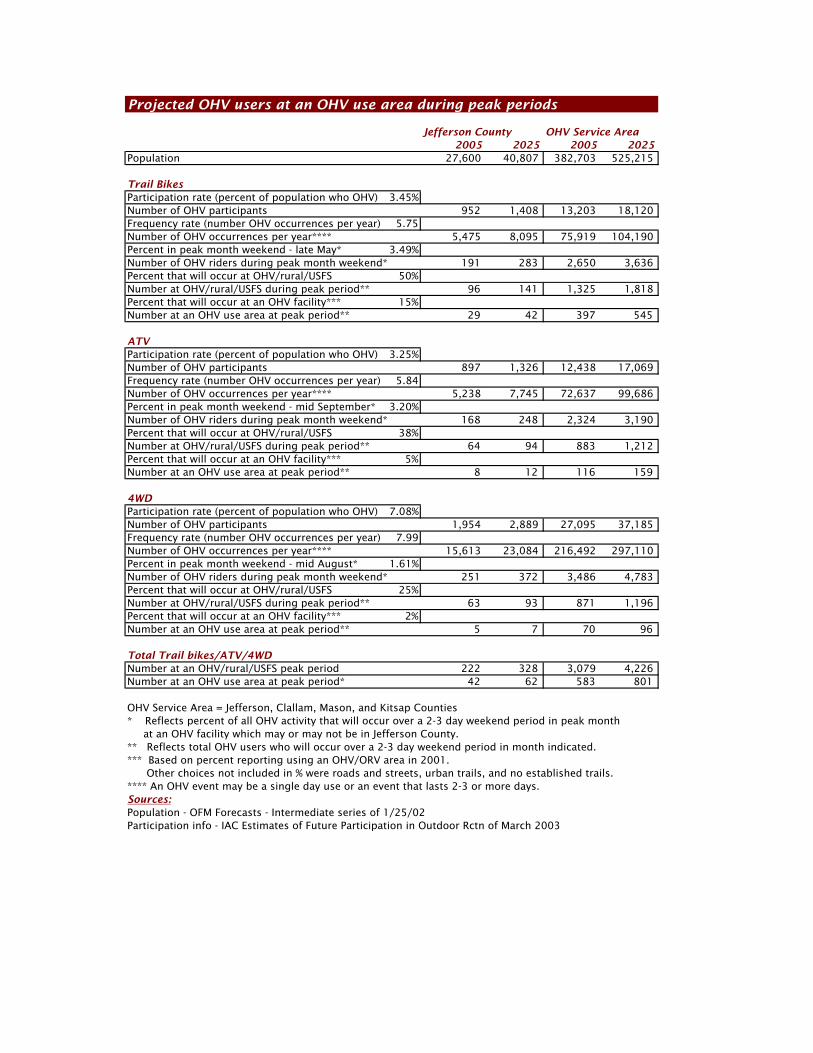
Projected OHV users at an OHV use area during peak periods
Jefferson County OHV Service Area2005 2025 2005 2025
Population 27,600 40,807 382,703 525,215
Trail BikesParticipation rate (percent of population who OHV) 3.45%Number of OHV participants 952 1,408 13,203 18,120Frequency rate (number OHV occurrences per year) 5.75Number of OHV occurrences per year**** 5,475 8,095 75,919 104,190Percent in peak month weekend - late May* 3.49%Number of OHV riders during peak month weekend* 191 283 2,650 3,636Percent that will occur at OHV/rural/USFS 50%Number at OHV/rural/USFS during peak period** 96 141 1,325 1,818Percent that will occur at an OHV facility*** 15%Number at an OHV use area at peak period** 29 42 397 545
ATVParticipation rate (percent of population who OHV) 3.25%Number of OHV participants 897 1,326 12,438 17,069Frequency rate (number OHV occurrences per year) 5.84Number of OHV occurrences per year**** 5,238 7,745 72,637 99,686Percent in peak month weekend - mid September* 3.20%Number of OHV riders during peak month weekend* 168 248 2,324 3,190Percent that will occur at OHV/rural/USFS 38%Number at OHV/rural/USFS during peak period** 64 94 883 1,212Percent that will occur at an OHV facility*** 5%Number at an OHV use area at peak period** 8 12 116 159
4WDParticipation rate (percent of population who OHV) 7.08%Number of OHV participants 1,954 2,889 27,095 37,185Frequency rate (number OHV occurrences per year) 7.99Number of OHV occurrences per year**** 15,613 23,084 216,492 297,110Percent in peak month weekend - mid August* 1.61%Number of OHV riders during peak month weekend* 251 372 3,486 4,783Percent that will occur at OHV/rural/USFS 25%Number at OHV/rural/USFS during peak period** 63 93 871 1,196Percent that will occur at an OHV facility*** 2%Number at an OHV use area at peak period** 5 7 70 96
Total Trail bikes/ATV/4WDNumber at an OHV/rural/USFS peak period 222 328 3,079 4,226Number at an OHV use area at peak period* 42 62 583 801
OHV Service Area = Jefferson, Clallam, Mason, and Kitsap Counties* Reflects percent of all OHV activity that will occur over a 2-3 day weekend period in peak month at an OHV facility which may or may not be in Jefferson County.** Reflects total OHV users who will occur over a 2-3 day weekend period in month indicated.*** Based on percent reporting using an OHV/ORV area in 2001. Other choices not included in % were roads and streets, urban trails, and no established trails.**** An OHV event may be a single day use or an event that lasts 2-3 or more days.Sources:Population - OFM Forecasts - Intermediate series of 1/25/02Participation info - IAC Estimates of Future Participation in Outdoor Rctn of March 2003
25 Chapter 3: OHV Demand
Jefferson County OHV Feasibility Study
the number of occurrences that will likely occur at an OHV riding area or rural,
mountain, or forest trail system from 63 users in 2005 to 93 in 2025, and at an OHV riding area (not necessarily within East Jefferson County) from 5
users in 2005 to 7 in 2025. 2005-2025 OHV Service Area (Jefferson, Clallam, Mason, and Kitsap Counties) Trail bikes – the probable number of OHV trail bike users who will: reside within the service area will increase from 13,203 in 2005 to 18,120
riders in 2025, the number of riding occurrences from 75,919 in 2005 to 104,190 in 2025, the number of riding occurrences that will occur in a peak month weekend in
late May from 2,650 in 2005 to 3,636 in 2025, the number of occurrences that will likely occur at an OHV riding area or rural,
mountain or forest trail system from 1,325 users in 2005 to 1,818 in 2025, and at an OHV riding area (not necessarily within East Jefferson County) from 397
users in 2005 to 545 in 2025. All- Terrain Vehicles (ATVs) – the probable number of OHV ATV users who will: reside within the service area will increase from 12,438 in 2005 to 17,069
riders in 2025, the number of riding occurrences from 72,637 in 2005 to 99,686 in 2025, the number of riding occurrences that will occur in a peak month weekend in
mid September from 2,324 in 2005 to 3,190 in 2025, the number of occurrences that will likely occur at an OHV riding area or rural,
mountain, or forest trail system from 883 users in 2005 to 1,212 in 2025, and at an OHV riding area (not necessarily within East Jefferson County) from 116
users in 2005 to 159 in 2025. 4-Wheel Drive (4WD) – the probable number of OHV 4WD (recreational) users who will: reside within the service area will increase from 27,095 in 2005 to 37,185
riders in 2025, the number of riding occurrences from 216,492 in 2005 to 297,110 in 2025, the number of riding occurrences that will occur in a peak month weekend in
mid August from 3,486 in 2005 to 4,783 in 2025, the number of occurrences that will likely occur at an OHV riding area or rural,
mountain, or forest trail system from 871 users in 2005 to 1,196 in 2025, and at an OHV riding area (not necessarily within East Jefferson County) from 70
users in 2005 to 96 in 2025. 2005-2025 total all OHV vehicles Jefferson County Trail Bike/ATV/4WD totals - the probable number of combined OHV trail bike, ATV, and 4WD users who will: reside within the county that will ride on a peak weekend (assuming all peak
weekends coincided) at an OHV riding area or rural, mountain, or forest trail system will increase from 222 users in 2005 to 328 in 2025, and at an OHV riding area (not necessarily within East Jefferson County) from 42
users in 2005 to 62 in 2025. OHV Service Area Trail Bike/ATV/4WD totals - the probable number of combined OHV trail bike, ATV, and 4WD users who will: reside within the OHV Service Area that will ride on a peak weekend (assuming
all peak weekends coincided) at an OHV riding area or rural, mountain, or forest trail system will increase from 3,079 users in 2005 to 4,226 in 2025, and at an OHV riding area (not necessarily within East Jefferson County) from 583
users in 2005 to 801 in 2025.

26 Chapter 3: OHV Demand Jefferson County OHV Feasibility Study
27 Chapter 4: OHV Facilities
Jefferson County OHV Feasibility Study
Chapter 4: OHV facilities 4.1 OHV facilities within the OHV Service Area Within the OHV Service Area (Jefferson, Kitsap, Mason, and Clallam Counties) there are 9 OHV use areas and trail systems on US Olympic National Forest and Washington State Department of Natural Resource (DNR) lands that provide 118.5 miles of trail bike, 13.3 miles of ATV, and 15.8 miles of 4WD trails. Following is a brief summary of each site. Olympic National Forest Olympic National Forest covers most of the Olympic Mountain range extending from the Pacific Ocean, along the Strait of Juan De Fuca, and down Hood Canal through portions of Clallam, Jefferson, Mason, and Grays Harbor Counties. The Forest is known for its marine climate, lush rain forests, Roosevelt elk, and rugged, mountainous terrain. The Olympic National Forest has over 250 miles of trail of which half are located at low elevations that can be accessed year-round. All OHV use is prohibited within the National Park, Wilderness Areas, and most of the National Forest proper due to terrain and access issues. Forest trails of a combined length of 22.2 miles that can be accessed from the Hood Canal Ranger District on the east side of the Olympic Mountains permit use by trail bikes, although all other OHV use is prohibited. The locations and mileage for each type of OHV use is shown in the graphic and table on succeeding pages, following is a brief description of the trails located within the Hood Canal Ranger District within the OHV Service Area: 1: Gold Creek Trail #830 – is located 14.5 miles south of Sequim. The trail
can be accessed 2 miles north of Sequim Bay State Park on US 101 then south on Palo Alto Road to Forest Service (FS) Road #28, then south to the intersection with FS Road #2880, then right on FS Road #2880 past the Dungeness Forks Campground on FS Road #2870, then left on FS Road #2870-230 to the trailhead. The 6.2 mile trail is open year-round for motorbikes, mountain bikes, and pack and saddle stock and extends along an old road bed that through some steep grades with sections exceeding 20% from elevations from 1,000-3,300 feet. The trail can be looped by street legal motorbikes by continuing on FS Road #2870 back to the trailhead. There is a small parking area located along the side of the road at the trailhead. Destinations are located at Gold Creek Shelter at 0.6 miles and FS Road #2860 and the Trailhead for Tubal Cain Trail #842 at 6.4 miles. The nearest facilities are located in Dungeness Forks Campground. 2: Lower Dungeness Trail #833.3 – is located 12 miles south of Sequim. The
trail can be accessed from US 101 across from Sequim Bay State Park onto Louella Road, then south onto Palo Alto Road, then south onto FS Road #28 to FS Road #2880, then right onto FS #2880 past Dungeness Forks Campground, then left on FS Road #2870, then left on FS Road #2870-230 to the end of the road. The 6.3 mile trail is open year-round for motorbikes, mountain bikes, horseback riding, backpacking, and hiking. The trail climbs from 1,500 to 2,500 feet in elevation with grades mostly in the 10-15% range with some 20%. There is a small parking area located along the side of the road. Destination sites are located at the junction with 3 O’Clock Ridge at 2.8 miles, River Camp at 4.8 miles, and FS Road #2860 and Upper Dungeness Trailhead at 6.3 miles. The nearest facilities are located in Dungeness Forks Campground.
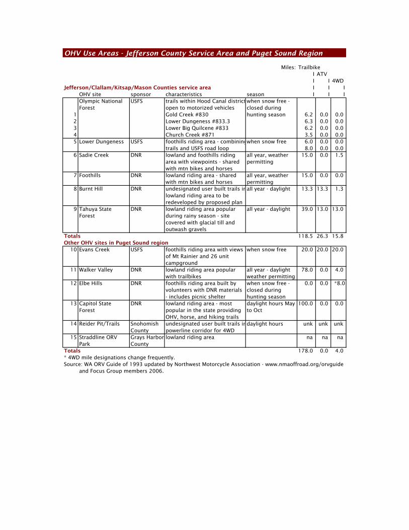
OHV Use Areas - Jefferson County Service Area and Puget Sound Region
Miles: Trailbike I ATV I I 4WD
Jefferson/Clallam/Kitsap/Mason Counties service area I I IOHV site sponsor characteristics season I I IOlympic National USFS trails within Hood Canal district when snow free -Forest open to motorized vehicles closed during
1 Gold Creek #830 hunting season 6.2 0.0 0.02 Lower Dungeness #833.3 6.3 0.0 0.03 Lower Big Quilcene #833 6.2 0.0 0.04 Church Creek #871 3.5 0.0 0.05 Lower Dungeness USFS foothills riding area - combiningwhen snow free 6.0 0.0 0.0
trails and USFS road loop 8.0 0.0 0.06 Sadie Creek DNR lowland and foothills riding all year, weather 15.0 0.0 1.5
area with viewpoints - shared permittingwith mtn bikes and horses
7 Foothills DNR lowland riding area - shared all year, weather 15.0 0.0 0.0with mtn bikes and horses permitting
8 Burnt Hill DNR undesignated user built trails inall year - daylight 13.3 13.3 1.3lowland riding area to be redeveloped by proposed plan
9 Tahuya State DNR lowland riding area popular all year - daylight 39.0 13.0 13.0Forest during rainy season - site
covered with glacial till andoutwash gravels
Totals 118.5 26.3 15.8Other OHV sites in Puget Sound region
10 Evans Creek USFS foothills riding area with views when snow free 20.0 20.0 20.0of Mt Rainier and 26 unitcampground
11 Walker Valley DNR lowland riding area popular all year - daylight 78.0 0.0 4.0with trailbikes weather permitting
12 Elbe Hills DNR foothills riding area built by when snow free - 0.0 0.0 *8.0volunteers with DNR materials closed during - includes picnic shelter hunting season
13 Capitol State DNR lowland riding area - most daylight hours May 100.0 0.0 0.0Forest popular in the state providing to Oct
OHV, horse, and hiking trails14 Reider Pit/Trails Snohomish undesignated user built trails indaylight hours unk unk unk
County powerline corridor for 4WD15 Straddline ORV Grays Harbor lowland riding area na na na
Park CountyTotals 178.0 0.0 4.0* 4WD mile designations change frequently.Source: WA ORV Guide of 1993 updated by Northwest Motorcycle Association - www.nmaoffroad.org/orvguide
and Focus Group members 2006.
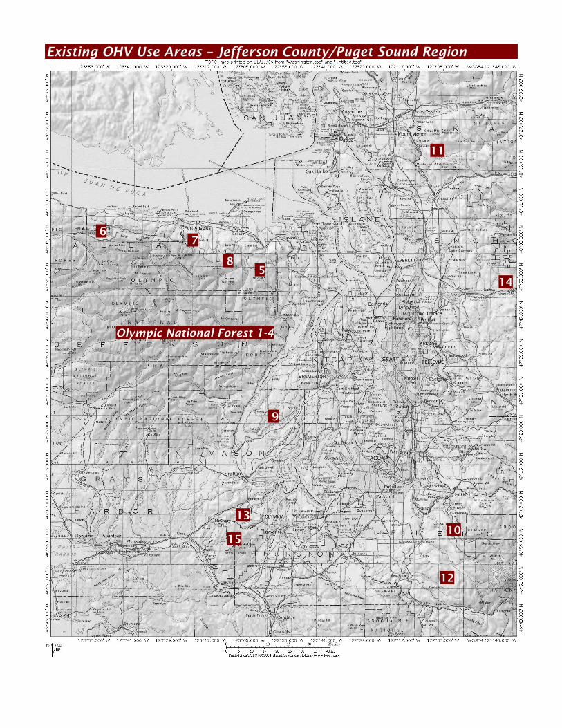
Existing OHV Use Areas – Jefferson County/Puget Sound Region
11
6 7
5
9
13
15 10
12
Olympic National Forest 1-4
8
14
30 Chapter 4: OHV Facilities Jefferson County OHV Feasibility Study
3: Lower Big Quilcene Trail #833 – is located 6 miles southwest of Quilcene.
The trail can be accessed from US 101 south of Quilcene onto Penny Creek Road, then south onto Big Quilcene River Road to FS Road #27 to FS Road #080, then left onto FS Road #080 to the trailhead. The 6.2 mile trail is open year-round to motorbikes, mountain bikes, pack stock, horseback riding, and hiking. The trail extends from 1,200 to 2,500 feet in elevation with grades from 10-15%. There is a small parking area, primitive campground, and vault toilet at the trailhead. Primitive campsites are located along the trail at Bark Shanty at 2.6 miles, Camp Jolley at 4.7 miles, and 10 Mile Shelter at FS Road #2750 at 6.2 miles. 4: Church Creek Trail #871 – is located at the end of Forest Service (FS) Road
#2361-600 in Grays Harbor County. The 3.5 mile trail extends along Church Creek to Satsop Lakes. The trail is closed during the winter from 1 October to 1 May. 5: Lower Dungeness – is located 10 miles south of Sequim in the Olympic
National Forest adjacent to the Buckhorn Wilderness. The site can be accessed from US 101 onto Palo Alto Road, then south onto FS Road #28 to FS Road #2860, then south past East Crossing Campground on the Dungeness River to the end of the road. The 6.0 mile trail loop is open when snow free to motorbikes and can be extended into a 14.0 mile trail loop on forest roads with street legal bikes. The trails traverse both sides of a picturesque segment of the Lower Dungeness River drainage. There is a small parking area along the side of the road at the trailhead. The nearest facilities are located at East Crossing Campground 2 miles north of the trails and includes 10 ten and 21 foot RV campsites with drinking water and restrooms. Washington State Department of Natural Resources (DNR) DNR provides multiple use recreational opportunities on state forest lands in accordance with RCW mandates. Recreational pursuits remain secondary activities to DNR’s principal mandate, however, to raise monies for schools and local governmental jurisdictions. Accordingly, DNR provides the following OHV multiuse trail systems within the OHV Service Area. 6: Sadie Creek – is located 8 miles west of Joyce off SR-112 adjacent to the
Olympic National Forest. The OHV site can be accessed from SR-112 to East Twin Road leading to staging area. The multiuse site provides 15.0 miles of year-round trail bike trails, 1.5 miles of 4WD trails, and shared and other trails with mountain bikes, and horseback riders. The trails extend through lowland and rugged mountain terrain from 600 to 2,500 feet in elevation with numerous vistas of the Strait of Juan de Fuca, Mount Baker, Vancouver and the San Juan Islands. A parking area is located at the trailhead but there are no other facilities. 7: Foothills – is located 5 miles south of Port Angeles in the Foothills Area
close to Olympic National Forest and National Park. The site can be accessed from US 101 then south on Black Diamond Road to Little River Road, then east to 1000 Road to the trailhead. The site provides 15.0 miles of year-round trail bike loop trails along with mountain bike and horseback riders. A 7.0 mile loop trail is good for novice trail bikers and family groups with shortcut trails and 3 smaller trail loops. A parking area is located at the trailhead but there are no other facilities.
31 Chapter 4: OHV Facilities
Jefferson County OHV Feasibility Study
8: Burnt Hill – is located south of Sequim off US-101. The site can be accessed from US-101 onto Happy Valley Road then Johnson Creek Road south to the trailhead. The multiuse site currently provides over 44.0 miles of trail bike, 1.0 mile of ATV, and 1.3 miles of 4WD trails that have been developed and maintained on a volunteer basis. The site has also been used by mountain bikers, hikers, and other recreational interests on an informal basis. DNR initiated a formal recreation assessment and planning process for the site beginning with an IAC grant in 1998 and in a Draft Burnt Hill Recreational Trail Plan and SEPA document in 2005 that is currently out for public comment and discussion. The proposed plan will designate 16.3 miles of trail which, except for the Palo Alto/608 trail, will be shared by ATV, trail bikes, hikers, horseback riders, and mountain bikes. A single multiple use trail will also include 4WD. The site will be managed as a day-use facility only with parking at a trailhead and minimal services. 9: Tayhua State Forest – is located 8 miles southwest of Belfair off North
Shore Road/SR-300. The OHV use area can be accessed from North Shore Road/SR-300 to Belfair State Park, then right onto Belfair Tahuya Road to Elfendahl Pass Road, then right onto Elfendahl Pass Road to the trailhead. The multiuse site is open year-round with 39.0 miles of trail bike and 13.0 miles of 4WD trails (which were built by volunteers). The trails are covered with glacial till and outwash gravels ideal for the rainy weather trail activities. There are numerous campground facilities located within the forest nearby the OHV use area including Kamenga Canyon, Camp Spillman, the Tahuya River Horse Camp, and Twin Lakes – which may be closed in the off season. Nearby Belfair State Park also serves users of the OHV trails at enjoying Tahuya State Forest. 4.2 Other OHV facilities within the Puget Sound region In addition to the sites listed above, within the Puget Sound region outside of the OHV Service Area there are 6 OHV use areas, trail system, and an OHV Sports Park on US Forest Service land, DNR land, on easement property within Snohomish County, and in an intensive ORV Sports Park facility in Thurston/Grays Harbor Counties. The locations and mileage for OHV use areas are shown in the graphic and table on preceding pages, following is a brief summary of each site: US Forest Service 10: Evans Creek – is located 12 miles south of Wilkerson in Pierce County in
the Mount Baker- Snoqualmie National Forest adjacent to Mount Rainier National Park. The site can be accessed from SR-165 onto FS Road #7920 to a day use parking area and onto FS #7930 to Evans Creek Campground. The multiuse OHV site is open when snow free and provides 20 miles of trail for motorbikes, ATVs, and short-wheel base 4WD vehicles. The site has a 26 unit campground and group picnic shelter. The trail extends into the Cascade Mountains with grades varying from 10-15%. Destinations are located along the trail providing several vista points of Mount Rainier. A Northwest Forest Pass is required to use the area. Washington State Department of Natural Resources (DNR) 11: Walker Valley – is located 7 miles southeast of Mount Vernon off SR-9.
The site can be accessed from SR-9 onto Walker Valley Road east onto Peter Burns Road to the trailhead.
32 Chapter 4: OHV Facilities Jefferson County OHV Feasibility Study
The OHV site is open year-round with 78.0 miles of trail bike trails and 4.0 miles of 4WD trails in the lowland areas ranging from 500 to 3,000 feet in elevation. Most of the trails were built and are maintained by user groups. 12: Elbe Hills – is located 6.3 miles east of Elbe off SR-706 in DNR’s Elbe Hills
State Forest. The OHV site can be accessed from SR-706 west of National at Stoner Road, then north on 1000 Road into the site. The site is a Cooperative Road Management area where volunteers have built 8.0 miles of rugged 4WD trails for short wheelbase vehicles with winch requirements when snow free. A parking area is located at the trailhead along with a group picnic area. The site is closed to all vehicles by the Department of Fish & Wildlife during big game hunting seasons. 13: Capitol State Forest – is located 12 miles southwest of Olympia off SR-8
and SR-12. The OHV site can be accessed from US-101 from Olympia to SR-8 to the Rock Candy Entrance at the S-Line on the north boundary, or from US101 to Delphi Road to Waddell Road to the Delphi Entrance on the east boundary. The multiuse site provides over 100.0 miles of trail bike trails (but prohibits ATV and 4WD vehicles across the north half of the forest with a connection to Grays Harbor County’s Straddleline ORV Sports Park. The southern portion of the forest is reserved for horse and hikers. The trails extend over ridge lines and across ravines in rugged lowland forests. The trails are closed during the winter season from 1 November to 1 April. Numerous campground facilities are located across the middle and southern portions of the site. Snohomish County 14: Reider Pit/Trails – are located under the BPA power lines in a corridor
extending from Snohomish east to Sultan. The trails are accessed from numerous local road crossings along the corridor. The motorcycle and 4WD trails have been developed by user groups, and recently sanctioned on an informal basis as an OHV facility by Snohomish County Parks & Recreation. Grays Harbor County 15: Straddleline ORV Sports Park – is located 16 miles west of Olympia and 3
miles east of McCleary on SR-8 adjacent to the Capitol State Forest. The 155.0 acre site is split almost equally between Thurston and Grays Harbor Counties and may be accessed from SR-8 at the Willis Road interchange. Formerly the Thurston County ORV Sports Park, the facility was developed in 1977 and is one of only 3 ORV Sports Parks in Washington State – the others being in Richland and Spokane. Straddleline was transferred to and is now operated by Grays Harbor County and numerous user groups with funding assistance through the IAC NOVA program. Straddleline is an intensive use facility that includes 5 miles of bike trails in the park and access to over 100 miles of trails within Capitol State Forest. The facility provides over 150 acres of open riding, 1 mile of MX track, 0.125 mile flat rack, off-road courses, sand drag strip kid’s mini MX course, 4WD drive obstacle course, campsites, meeting hall, restrooms with showers, concession stand with restrooms, covered grandstands, a main office, and a caretakers residence. 4.3 Implications for Jefferson County The 15 OHV trail systems and an ORV sport park are the only designated OHV use areas within the Puget Sound region. These sites are used by OHV enthusiasts that reside within the 11 county Puget Sound areas and likely by OHV users drawn to
33 Chapter 4: OHV Facilities
Jefferson County OHV Feasibility Study
the most popular State Forest multiple use sites and the Grays Harbor ORV Sports Park from across the state and regions beyond. These sites have been in place and used for a considerable period, there are no new facilities in the inventory within the Puget Sound region even though OHV use has increased in the past decade and is expected to continue to increase at a rate of at least 1% per year according to the IAC demand projections described in the preceding chapter. As a result of the limited inventory, OHV enthusiasts who reside inside and outside of the OHV Service Area and Puget Sound are increasingly drawn to use and camp at the most popular OHV sites at the multiple use recreational/OHV trail systems that have been designated at Tahuya and Capitol State Forests. Given the increasing demand for OHV use within the Puget Sound region in general and the OHV Service Area in particular, the existing inventory of OHV trail systems sites will not be sufficient to meet OHV demand without incurring overuse, conflicts with non-OHV recreational activities, conflicts with DNR’s forest resource management goals, and possibly exceeding environmental capacity. For this reason, IAC has and will be funding OHV assessment and feasibility studies like that underway for 8: Burnt Hill and for a potential site within East Jefferson County that is the subject of this analysis. IAC’s objectives are to increase the available supply of OHV trail systems and use areas within close proximity to resident users, and in more varied site and use area settings.

34 Chapter 4: OHV Facilities Jefferson County OHV Feasibility Study
35 Chapter 5: OHV Management Concepts Jefferson County OHV Feasibility Study
Chapter 5: OHV management concepts 5.1 Tahuya State Forest tour The OHV Focus Group invited the Jefferson County Board of County Commissioners (BOCC), Parks & Recreation Advisory Board, Sheriff, Fire District 2 Fire Chief, Director of Public Works, and members of the public for a tour of the Tahuya State Forest OHV trail system on the 7th of November 2006. The tour was scheduled during the daytime on a weekday since it would constitute an official meeting of the Board of County Commissioners and to accommodate the working schedules of DNR Recreation Managers Office in Olympia, Tahuya DNR personnel, and other participating agency staff. The purposes of the tour were to: Introduce the BOCC, Parks & Recreation Advisory Board, and general public to
the characteristics of an off-highway trail system in the field, Differentiate between an off-highway trail system and an off-road sports park, Provide an overview of what constitutes a good staging area for an OHV trail
system, and Discuss issues related to maintenance, management, safety, EMS, funding with
DNR managers and OHV trail users. Provide tour participants a view of all aspects, impacts, and needs of an OHV
Trail System. The event began with an information and discussion session and was followed by a riding tour. The riding tour stopped at different locations to discuss the various activities (mudding, rock-crawling, hill climbing, etc.) provided along the route, and to also see where volunteers had erected barriers to prevent unauthorized trail construction (spider-webbing) and vehicular access. Following is a summary of the major points made by DNR, 4WD user representatives, and other agency spokespersons for the tour participants – a detailed accounting of the tour is provided in the Appendix. Tahuya State Forest background Tahuya State Forest is a working forest managed by the Washington State
Department of Natural Resources (DNR). The land is primarily managed for timber sales to support the local school systems (School Trust Land) and other revenue recipients including county agencies. In accordance with RCW mandates , the Forest also provides multiple use recreational activities. Recreation is allowed as long as the activity does not conflict with the forest's primary purpose - that being the sale of timber to support school systems and other agencies. The forest is a true, multi-use, recreation area consisting of trails for both
motorized and non-motorized use including horseback riding, hiking, backpacking, mountain biking, hunting, and OHV trails. Although the trails are separated by use, many trails are shared by multiple users including motorized and non-motorized users. OHV trail systems also provide areas specifically for mud-bogging, rock crawling, and hill climbing approved by DNR and constructed by user group volunteers. The area is considered a trail system and not a sports park. No race tracks,
ovals, or road-courses are provided nor are racing events allowed within the park. Over 170 miles of multi-use trails are provided of which 39.0 miles are
designated for trail bikes and 13.0 total miles for 4WD and ATVs. There are no designated trails for ATV use only within the Forest.