draft integrated definite project report and draft ... · pdf filedraft integrated definite...
TRANSCRIPT

Draft Integrated Definite Project Report and Draft Environmental Assessment
Blacksnake Creek Section 205 Flood Risk Management
St. Joseph, Missouri PN # 105940
June 24, 2015
This report presents the findings of a feasibility study conducted under the Continuing Authorities Program, Section 205 Authority. Section 205 of the Flood Control Act of 1948, as amended by the Water Resources Development Act of 1986. This authority provides the U.S. Army Corps of Engineers (USACE) authority to plan, design, and construct small flood control projects that have not been specifically authorized by Congress. The study addresses flood risk in the Blacksnake Creek basin, located in Andrew and Buchanan Counties, Missouri. The study was sponsored by the City of St. Joseph, Missouri. For this study, the Definite Project Report and Environmental Assessment (EA) are integrated into a single decision document that fulfills the requirements of the National Environmental Policy Act (NEPA).

This page left blank intentionally

Table of Contents • Feasibility Study Report
iii
Table of Contents
Executive Summary ....................................................................................................................................................... ES-1 Section 1 Introduction ................................................................................................................................................. 1-1
1.1 Study Authority ........................................................................................................................................................... 1-1 1.2 Purpose and Scope ..................................................................................................................................................... 1-1 1.3 Description of the Study Area ............................................................................................................................... 1-1 1.4 Existing Conditions .................................................................................................................................................... 1-1 1.5 Prior Studies and Reports ....................................................................................................................................... 1-4
Section 2 Plan Formulation ....................................................................................................................................... 2-1 2.1 Assessment of Problems and Opportunities .................................................................................................. 2-1
2.1.1 Future without Project Conditions ......................................................................................................... 2-1 2.1.2 Problems and Opportunities ..................................................................................................................... 2-1
2.2 Objectives and Constraints ..................................................................................................................................... 2-1 2.2.1 Objectives ........................................................................................................................................................... 2-1 2.2.2 Constraints ........................................................................................................................................................ 2-1
2.3 Affected Environment ............................................................................................................................................... 2-2 2.3.1 Air Quality .......................................................................................................................................................... 2-2 2.3.2 Water Quality ................................................................................................................................................... 2-2 2.3.3 Noise ..................................................................................................................................................................... 2-3 2.3.4 Aesthetics ........................................................................................................................................................... 2-3 2.3.5 Climate ................................................................................................................................................................ 2-3 2.3.6 Recreation .......................................................................................................................................................... 2-3 2.3.7 Geology and Soils ............................................................................................................................................ 2-3 2.3.8 Land Use ............................................................................................................................................................. 2-4 2.3.9 Disposal Areas ................................................................................................................................................. 2-4 2.3.10 Hazardous, Toxic, and Radioactive Waste ........................................................................................ 2-4 2.3.11 Aquatic Habitat ............................................................................................................................................. 2-5 2.3.12 Terrestrial Habitat ...................................................................................................................................... 2-5 2.3.13 Wetlands .......................................................................................................................................................... 2-6 2.3.14 Fish and Wildlife ....................................................................................................................................... 2-10 2.3.15 Threatened and Endangered Species .............................................................................................. 2-11 2.3.16 Access ............................................................................................................................................................. 2-12 2.3.17 Socioeconomic Conditions .................................................................................................................... 2-12 2.3.18 Archaeological and Cultural Resources .......................................................................................... 2-13 2.3.19 Floodplain .................................................................................................................................................... 2-13
2.4 Plan Development ................................................................................................................................................... 2-15 2.4.1 Structural Measures ................................................................................................................................... 2-15 2.4.2 Nonstructural Measures ........................................................................................................................... 2-20
2.5 Hydrologic and Hydraulic Analysis ................................................................................................................. 2-23 2.5.1 Previous Hydrologic and Hydraulic Studies .................................................................................... 2-23 2.5.2 Existing Conditions Hydrologic Analyses ......................................................................................... 2-23 2.5.3 Existing Conditions Hydraulic Analyses ............................................................................................ 2-25
2.6 Plan Screening ........................................................................................................................................................... 2-28 2.6.1 Structural Measures ................................................................................................................................... 2-28
2.6.1.1 Socioeconomic Analysis ............................................................................................................ 2-28 Section 3 Recommended Plan ..................................................................................................................................... 3-1
3.1 Economics ...................................................................................................................................................................... 3-1 3.1.1 NED Plan Costs ................................................................................................................................................ 3-1
Table of Contents • Feasibility Study Report
iv
3.1.2 NED Plan Benefits .......................................................................................................................................... 3-2 3.1.3 Benefit-Cost Ratio for the NED Plan ...................................................................................................... 3-2 3.1.4 Residual Risk .................................................................................................................................................... 3-3
3.2 Plan Components........................................................................................................................................................ 3-3 3.2.1 Detention Basin ............................................................................................................................................... 3-3 3.2.2 Spillway .............................................................................................................................................................. 3-6 3.2.3 Roads ................................................................................................................................................................... 3-6 3.2.4 Utilities ................................................................................................................................................................ 3-9
3.2.4.1 Sanitary Sewer ................................................................................................................................. 3-9 3.2.4.2 Natural Gas ......................................................................................................................................... 3-9 3.2.4.3 Drinking Water............................................................................................................................... 3-10 3.2.4.4 Electrical ........................................................................................................................................... 3-10 3.2.4.5 Communications ............................................................................................................................ 3-15
3.2.5 Hydraulic Structures ................................................................................................................................... 3-15 3.3 Design and Construction Considerations ...................................................................................................... 3-15
3.3.1 Earthwork ....................................................................................................................................................... 3-15 3.3.2 Clearing and Grubbing ............................................................................................................................... 3-18 3.3.3 Stormwater Management ......................................................................................................................... 3-18 3.3.4 Construction Sequencing .......................................................................................................................... 3-19 3.3.5 Schedule ........................................................................................................................................................... 3-19 3.3.6 Recommendations for Additional Investigation ............................................................................ 3-21
3.4 Lands, Easements, Rights-of-Way, Relocations, or Disposal Areas (LERRD) Considerations3-21 3.4.1 Lands, Easements, Rights-of-Way ......................................................................................................... 3-21 3.4.2 Relocations ...................................................................................................................................................... 3-21 3.4.3 Disposal Areas ............................................................................................................................................... 3-21
3.5 Operation and Maintenance Considerations................................................................................................ 3-21 3.5.1 Recommended Plan .................................................................................................................................... 3-23 3.5.2 Cost Risk Analysis ........................................................................................................................................ 3-23
3.6 Environmental Impacts ......................................................................................................................................... 3-23 3.6.1 Air Quality ....................................................................................................................................................... 3-25 3.6.2 Water Quality ................................................................................................................................................. 3-26 3.6.3 Noise .................................................................................................................................................................. 3-27 3.6.4 Aesthetics ........................................................................................................................................................ 3-28 3.6.5 Climate .............................................................................................................................................................. 3-29 3.6.6 Recreation ....................................................................................................................................................... 3-29 3.6.7 Geology and Soils ......................................................................................................................................... 3-30 3.6.8 Disposal Areas ............................................................................................................................................... 3-31 3.6.9 Land Use ........................................................................................................................................................... 3-31 3.6.10 Hazardous, Toxic, and Radioactive Waste (HTRW) ................................................................... 3-32 3.6.11 Aquatic Habitat ........................................................................................................................................... 3-33 3.6.12 Terrestrial Habitat .................................................................................................................................... 3-35 3.6.13 Wetlands ....................................................................................................................................................... 3-36 3.6.14 Fish and Wildlife ........................................................................................................................................ 3-36 3.6.15 Threatened and Endangered Species ............................................................................................... 3-37 3.6.16 Access ............................................................................................................................................................. 3-39 3.6.18 Cultural Resources .................................................................................................................................... 3-40 3.6.19 Floodplain ..................................................................................................................................................... 3-41 3.6.20 Environmental Impacts Summary ..................................................................................................... 3-41 3.6.21 Cumulative Impacts .................................................................................................................................. 3-43
Section 4 Plan Implementation................................................................................................................................ 4-1 4.1 Cost Sharing .................................................................................................................................................................. 4-1
Table of Contents • Feasibility Study Report
v
4.1.1 Federal Responsibilities .............................................................................................................................. 4-1 4.1.2 Non-Federal Responsibilities .................................................................................................................... 4-2 4.2 Real Estate Considerations ............................................................................................................................ 4-2
Section 5 Public Involvement and Agency Coordination ............................................................................... 5-1 Section 6 Compliance with Environmental Requirements ............................................................................ 6-1
6.1 Agency Compliance with Other Environmental Laws ................................................................................ 6-1
List of Figures
Figure 1-1 Blacksnake Creek Study Area................................................................................................................................. 1-3 Figure2-1 Blacksnake Creek NWI ............................................................................................................................................... 2-8 Figure 2-2 Softball Complex NWI ................................................................................................................................................ 2-9 Figure 2-3 Elwood Bottoms Spoil Area NWI ....................................................................................................................... 2-10 Figure 2.4 Floodplain Inundation Boundaries ................................................................................................................... 2-14 Figure 2-5 Detention Plan Alternatives 1 through 4 ....................................................................................................... 2-16 Figure 2-6 Detention Plan Alternatives 5 through 8 ....................................................................................................... 2-19 Figure 2-7 Blacksnake Creek Watershed and Subareas ................................................................................................ 2-24 Figure 2-8 HEC-RAS Model Cross Section Locations and Flow Load Points ......................................................... 2-26 Figure 2-9 Economic Study Reaches ....................................................................................................................................... 2-30 Figure 3-1 Recommended Plan Detention Basin Footprint ............................................................................................ 3-5 Figure 3-2 Roads Located Within the Footprint of the Proposed Detention Basin .............................................. 3-8 Figure 3-3 Sanitary Sewer Alignments. ................................................................................................................................. 3-11 Figure 3-4 Gas Utility Impacted by the Construction of the Detention Basin ...................................................... 3-12 Figure 3-5 Water Lines Impacted by the Construction of the Detention Basin .................................................. 3-13 Figure 3-6 Electrical and Communications Lines Impacted by the Construction of the Detention Basin3-14 Figure 3-7 Preliminary Detention Basin Grading Plan ................................................................................................... 3-16 Figure 3-8 Cross Section through the Primary Spillway................................................................................................ 3-17 Figure 3-9 Cross Section through the Secondary Spillway ........................................................................................... 3-18 Figure 3-10 Clearing and Grubbing Required for Construction of the Detention Basin ................................. 3-20 Figure 3-11 Disposal Areas ......................................................................................................................................................... 3-22
List of Tables
Table 2-1 HEC-HMS Modeling Results ................................................................................................................................... 2-23 Table 2-2 Flows Used in Existing Conditions HEC-RAS Model ................................................................................... 2-25 Table 2-3 Existing Conditions HEC-RAS Model Results at Selected Cross-Sections.......................................... 2-27 Table 2-4 Blacksnake Creek Total Investment ($1,000s; 2015 prices) .................................................................. 2-32 Table 2-5 Existing & Future Without-Project Conditions Results (FY 15 prices) .............................................. 2-33 Table 2-6 Benefits and Costs by Alternative ....................................................................................................................... 2-37 Table 2-7 Engineering Performance of Alternatives ....................................................................................................... 2-38 Table 2-8 Summary of Alternative Plan Screening Analysis ........................................................................................ 2-39 Table 3-1 Total Project Cost .......................................................................................................................................................... 3-1 Table 3-2 Annual Costs .................................................................................................................................................................... 3-2 Table 3-3 Annual Benefits .............................................................................................................................................................. 3-2 Table 3-4 Benefit-Cost Data ........................................................................................................................................................... 3-2 Table 3-6 Times to Drain Detention Basin by Storm Event ............................................................................................ 3-3 Table 3-7 Utilities Impacted by Construction ........................................................................................................................ 3-9 Table 3-8 Design and Construction Schedule ..................................................................................................................... 3-19

Table of Contents • Feasibility Study Report
vi
Table 4-1 Fully Funded Cost Estimate for Implementation (Design and Construction) ................................... 4-1 Table 4-2 Cost Share Based on 65/35 Requirements (000) .......................................................................................... 4-2 Table 6-1 Agency Compliance with Other Environmental Laws .................................................................................. 6-1
Appendices Appendix A HTRW Phase I Assessment Appendix B Public Involvement and Agency Coordination Appendix C Hydrology and Hydraulics Appendix D Geotechnical Engineering Appendix E Cost Estimate Appendix F Not Used Appendix G Real Estate Appendix H Not Used Appendix I Economics Appendix J Preliminary Jurisdictional Determination and 404(b)(1)
Acronyms
ACE Annual Chance Exceedance APWA American Public Works Association ASTM American Society for Testing and Materials ATR Agency Technical Review BFE base flood elevation BCOE bidability, constructability, operability, and environmental compliance BMP best management practices CEQ Council on Environmental Quality CENWK U.S. Army Corps of Engineers, Kansas City District CWBS civil works break down structure CAP Continuing Authorities Program City St. Joseph, Missouri CSO combined sewer overflow CSS combined sewer system EAD equivalent annual damage EOP Emergency Operation Plan FDA Flood Damage Analysis FEMA Federal Emergency Management Agency FIS Flood Insurance Study GIS geographic information system H horizontal HEC Hydrologic Engineering Center HMS Hydrologic Modeling System HTRW Hazardous, Toxic and Radioactive Waste

Table of Contents • Feasibility Study Report
vii
IWR Institute of Water Resources KCP&L Kansas City Power & Light KV kilovolt LERRD Lands, Easements, Rights-of-Way, Relocations, or Disposal Areas LOMA Letter of Map Amendment LTCP Long Term Control Plan MCACES Micro Computer Aided Cost Engineering System MDNR Missouri Department of Natural Resources MCX Mandatory Center of Expertise mgd million gallons per day MGE Missouri Gas Energy MRLS Missouri River Levee System MII Second Generation NED National Economic Development NFIP National Flood Insurance Program NAVD North American Vertical Datum NGVD National Geodetic Vertical Datum NOAA National Oceanic and Atmospheric Administration NEPA National Environmental Policy Act NPDES national pollutant discharge elimination system NHPA National Historic Preservation Act NRHP National Register of Historic Places NWD U.S. Army Corps of Engineers, Northwestern Division NWI National Wetland Inventory OMRR&R Operation and Maintenance, Repair, Replacement, and Rehabilitation O&M operation and maintenance PED preconstruction engineering and design PPA Project Partnership Agreement PVC polyvinyl chloride SHPO State Historic Preservation Officers SWPPP storm water pollution prevention plan TPC total project cost USACE U.S. Army Corps of Engineers USFWLS U.S. Fish and Wildlife Service V vertical

Table of Contents • Feasibility Study Report
viii
This page left blank intentionally

Section 1 • Introduction
ES-1
Executive Summary St. Joseph, Missouri (City) is the county seat of Buchanan County and the eighth largest city in Missouri with 76,780 residents (2010 Census). The City encompasses approximately 44 square miles and intersects eight basins, including the Blacksnake Creek watershed. The Blacksnake Creek watershed, which is the focus of the feasibility study, conveys storm water runoff through a combination of an open, natural channel in the upper reach to an enclosed system at Karnes Road. Daily flow runs through the wastewater treatment plan. During storm events where flow exceeds the treatment plant capacity, the excess flow is discharged into the Missouri River directly via a diversion structure. Historically there have been several major flood events that have caused major damages to developed property.
This report focuses on identifying, describing, and offering recommendations to reduce the damages incurred by flooding within the basin. The reduction in damages is accomplished by construction of a detention basin to be located at Karnes Road. The detention basin provides reduction in flood damages to properties in the downstream reach. The recommended plan has less than significant direct or cumulative environmental impacts. Consistent with Executive Order 11988 the plan does not increase downstream risk or encourage future development within the floodplain.
The Recommended Plan for the Blacksnake Creek Section 205 is Alternative 8, which is the National Economic Development (NED) Plan. The Plan is a dry detention basin. It has a construction footprint of 35.6 acres and involves clearing of about 13.4 acres of riparian vegetation and 22.2 acres of turf and open field. The Plan uses natural topography and excavation north of Northwest Parkway to create 443 acre-feet of detention storage. There are no traditional structural flood risk management measures required, thus no dam, levees, or floodwalls are proposed. Excavation is approximately 660,000 bank cubic yards at a depth estimated between 5 feet to 20 feet, and the area will include a low flow channel. Primary and secondary spillways will deliver excess runoff over the top of Northwest Parkway at approximately 4% Annual Chance Exceedance (ACE) event and less frequent events. Roadways and utilities will be impacted. The needed utility relocations, the City’s road improvement plan and combined sewer improvement plan were all duly considered in the development of the Recommended Plan. The Recommended Plan includes erosion control to be strategically placed at locations of potential high erosion.
The estimated total project cost (TPC) used for the economic analysis of the recommended plan was $13,579,000 (excluding Feasibility costs) to be shared with the local sponsor. Based on the analysis, the total annual benefits are $3,059,000; annual costs are $587,000, and the net benefits are $2,472,000. The resultant Benefit-Cost Ratio (BCR) is 5.2.
The sponsor will receive credit for the cost of any necessary lands, easements, right-of-way, relocations or disposal area (LERRD). A late discovery of an omission of a LERRD creditable cost for the relocation of a City owned east sewer line resulted in an adjustment to the final Total Project Cost Estimate. The Real Estate Plan was revised to include the relocation and the costs associated with construction for the relocation were subsequently incorporated into a final revised estimate. Economic analysis was not re-evaluated as the adjustments would have negligible impact on the results as presented above. However, the updated costs are the basis for a cost shared project. The final revised estimated TPC are $13,976,000. The implementation of the project (design and construction) will be cost shared. The 65 percent Federal implementation cost is estimated at $9,085,000 and the 35 percent local sponsor costs are estimated at $4,892,000.

Table of Contents • Feasibility Study Report
ES-2
The statutory cost share limit for Federal participation in a Section 205 project is $10,000,000. This limit is inclusive of all Federal participation in the project. The Federal participation cost for Feasibility Phase was $899,000. This amount, in combination with the estimated Federal participation cost for the implementation phase of $9,085,000 totals $9,984,000, and is within the statutory limits. The project conducted a cost risk analysis to develop the TPC. Based on cost risks identified, appropriate contingencies –overall 24 percent - are included in the estimate. The City of St. Joseph, Missouri will be the sponsor for the project. The City understands the requirements for cost sharing and the statutory limit for Federal contribution. The sponsor will take ownership of the project and assume all operation, maintenance, repair, and replacement costs of the completed works.
j

Section 1 • Introduction
1-1
Section 1 Introduction
1.1 Study Authority This study is authorized under Section 205 of the Flood Control Act of 1948, as amended by the Water Resources Development Act of 1986. Section 205, one of several existing authorities in the Continuing Authorities Program (CAP), gives the U.S. Army Corps of Engineers (USACE) authority to plan, design, and construct small flood control projects that have not been specifically authorized by Congress. Federal participation in Section 205 projects is limited by statute to $10 million.
1.2 Purpose and Scope This report presents the results of the USACE feasibility study conducted to identify, evaluate, and recommend an appropriate and implementable solution for flood damage reduction in the Blacksnake Creek Basin in Missouri. The feasibility study included an assessment of existing conditions, plan formulation, cost estimates, socioeconomic analysis, engineering and design analysis of the recommended plan, and National Environmental Policy Act (NEPA) documentation.
NEPA established a national environmental policy and goals for the protection, maintenance and enhancement of the environment. It also provides a process for implementing these goals within Federal agencies. It requires all Federal agencies to incorporate environmental considerations in planning and decision-making. NEPA also established the President’s Council on Environmental Quality (CEQ) and empowered the Council to develop regulations by which all Federal agencies would comply with NEPA. These regulations are published in the Code of Federal Regulations (CFR) at 40 CFR 1500-1508.
The Corps of Engineers has promulgated their own Procedures for Implementing NEPA (ER 200-2-2) to provide guidance for the procedural provisions of NEPA. ER 200-2-2 supplements, and is used in conjunction with, the CEQ regulations. Within the CEQ NEPA regulations and ER 200-2-2, a process is set forth where agencies must assess the environmental impact of proposed Federal actions and consider reasonable alternatives to their proposed actions. This Draft Definite Project Report with integrated Environmental Assessment has been prepared in accordance with NEPA and CEQ Regulation as reflected in the Corps of Engineers’ Engineering Regulation, ER 200-2-2.
1.3 Description of the Study Area St. Joseph, Missouri (City) is the county seat of Buchanan County and the eighth largest city in Missouri with 76,780 residents (2010 Census). The City encompasses approximately 44 square miles and intersects eight basins, including the Blacksnake Creek watershed. The Blacksnake Creek watershed, which is the focus of the feasibility study, conveys storm water runoff through a combination of an open, natural channel in the upper reach to an enclosed system at Karnes Road that ultimately discharges to the Missouri River. The study area is shown in Figure 1-1.
1.4 Existing Conditions Blacksnake Creek is a small left bank tributary of the Missouri River located in Andrew and Buchanan Counties, Missouri. The creek enters the City about 4.3 miles above its mouth and flows south-southwest through the City to join the Missouri River. The watershed has a total drainage area of 8.2

Table of Contents • Feasibility Study Report
1-2
square miles. The channel in the lower 3.2 square miles of the basin is enclosed in a combined sewer of varying size up to 17 feet in diameter. The upper 5 square miles of the basin above the combined sewer inlet at Karnes Road is drained by open channel. During intense storm events (greater than or equal to a 0.20 Annual Chance Exceedance (ACE)), the Karnes Road combined sewer inlet capacity is exceeded. When this occurs, flow from Blacksnake Creek overtops Karnes Road and flows south via streets and yards to flood residential, commercial, and industrial properties within the City. Flooding within the Blacksnake Creek watershed affects approximately 200 residential, commercial, and industrial properties along the St. Joseph Avenue corridor.
There have been at least six major flood events in recorded history, each causing major damages to developed property. One of the most damaging floods occurred on June 9, 1984, and caused several million dollars in damages. The remaining five significant storms happened in June 1943, June 1949, May and August of 1959, and May 1962. Ongoing upper basin development and floodplain encroachment are potential factors in continuing flood related damage during larger storm events.
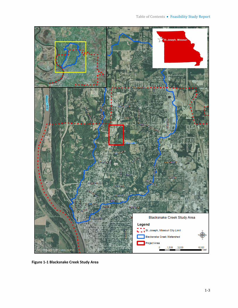
Table of Contents • Feasibility Study Report
1-3
Figure 1-1 Blacksnake Creek Study Area

Table of Contents • Feasibility Study Report
1-4
1.5 Prior Studies and Reports As a result of the June 9, 1984 flood, the USACE Kansas City District conducted a reconnaissance study1 of the flooding issues in the City. The purpose of the study was to examine alternatives for flood damage reduction in the City and to determine the Federal interest and local support for such alternatives. The tributaries evaluated include Blacksnake Creek, Charles Street Drainage, Brookdale, Whitehead Creek, Brown's Branch, and Contrary Creek. Flood damages were found to be most severe along Blacksnake Creek, Whitehead Creek, and in the Southwest portion of the City (Contrary Creek and Brown's Branch). Structural and nonstructural measures were identified and evaluated to reduce flood damages at those locations. The reconnaissance study assessed construction of a detention structure/road raise within the Blacksnake Creek basin at Karnes Road. Based upon the potential impacts to landowners in the basin and to flood prone occupants downstream of the detention structure, two different elevations of detention structures, 898 and 905 National Geodetic Vertical Datum (NGVD), were developed for further analysis. The 898 NGVD detention structure would control the 2-year flood event and would be overtopped by larger events. The 905 NGVD detention structure would control the 25-year flood event and would be overtopped by larger events. The evaluation of those alternatives, based on economic and environmental criteria, indicated there was a Federal interest in continuing planning studies to the feasibility phase. It was recommended that feasibility phase studies be undertaken with the City of St. Joseph as the non-Federal sponsor.
In 1998, Black and Veatch completed a storm water management plan2 for the City to identify flooding problem areas, analyze the drainage system, and identify improvements to mitigate the flooding. Three separate detention basin alternatives were considered to reduce flooding in the Blacksnake Creek watershed: (1) between St. Joseph Avenue and Savannah Road, (2) north of Cook Road near Savannah Road, and (3) just upstream from the entrance of the combined sewer system (CSS)north of Karnes Road and east of St. Joseph Avenue. Only the detention basin at Karnes and St. Joseph Avenue was carried forward into the feasibility study. The other basins were located too far upstream to provide a significant reduction in flow.
In 2002, URS completed a study3 of flood control opportunities on the Blacksnake Creek for USACE. The preliminary assessment considered an array of alternatives for flood damage reduction in the Blacksnake Creek watershed. These included construction of a detention basin north of Karnes Road, increasing the capacity of the existing combined sewer, nonstructural measures within the floodplain, and diverting water away from the flood prone areas. The detention basin alternative north of Karnes Road was chosen for further analysis. The preliminary analysis indicated that the proposed detention basin would significantly reduce flood damages in the study area and that potential economic benefits exceed project costs.
Black and Veatch evaluated and summarized potential alternatives to separate and remove creek (i.e., storm water) flows from the City’s CSS. The 2010 technical memorandum4 recommended removing creek flows from the CSS by diverting them through a storm water separation conduit aligned along an existing City owned right-of-way (abandoned railway) east of St. Joseph Avenue. Further study and design of the storm water separation conduit was not part of the feasibility study.
1 Reconnaissance Report, St. Joseph, Missouri, USACE Kansas City District, December 1987 2 Storm water Management Report, Black & Veatch, November 20, 1998 3 Blacksnake Creek, St. Joseph, Missouri, Preliminary Assessment, Section 205 Feasibility Phase, URS, November 2001 4 Technical Memorandum No. TM-CSO-5, Storm water Separation Conduits, Black & Veatch, January 15, 2010
Table of Contents • Feasibility Study Report
1-5
It is noted that prior reports and public information regarding this project have referred to hydrologic events (rainfall or flood events) in terms of the terms of the return interval in years, such as a 100-year event. This report adopts an updated convention of referring to hydrologic events of a specific magnitude in terms of the probability of the hydrologic event occurring in any given year. The event having a 1 in 100 probability (formerly referred to as the “100-year flood”) would have a 1 percent annual chance exceedance (ACE). The event is interchangeably designated as the 1 percent ACE or the 1 percent-chance event. Similarly the event having a 25 in 100 probability (formerly referred to as a “25-year flood”) would be the 4 percent ACE or 4 percent-chance event. The change is intended to better convey the relative chance of the hydrologic events occurring in a given year.

Table of Contents • Feasibility Study Report
1-6
This page left blank intentionally

2-1
Section 2 Plan Formulation
2.1 Assessment of Problems and Opportunities 2.1.1 Future without Project Conditions Under without-project future conditions, homes and businesses will continue to be subject to flooding. Although much of the lower basin is highly urbanized and the population of the City has remained stable, at least some development is likely to continue in the upper portion of the watershed and could potentially contribute to an increase in flooding in the City.
2.1.2 Problems and Opportunities During storm events greater than or equal to a 20 percent ACE, the capacity of the Karnes Road combined sewer inlet is exceeded, flooding the area downstream of Karnes Road. During intense storm events (greater than or equal to a 20 percent ACE), the Karnes Road combined sewer inlet capacity is exceeded. When this occurs, flow from Blacksnake Creek overtops Karnes Road and flows south via streets and yards to flood residential, commercial, and industrial properties within the City. There are over 200 residential, commercial, and industrial structures along the St. Joseph Avenue corridor. Attenuation of peak flows from the more rural upstream 5.6 square miles of the Blacksnake Creek watershed via detention storage would minimize damages.
2.2 Objectives and Constraints 2.2.1 Objectives Apply modern understanding of flood risk and uncertainty along with updated hydrologic and hydraulic modeling and current period of record analysis to adequately evaluate the flood risk and damage susceptibility to the population, investment, structures and infrastructure on the St. Joseph Avenue corridor affected by Blacksnake Creek.
Formulate plans with a resulting recommended plan to substantially decrease flood risk and damage susceptibility to the population, investment and infrastructure on the St. Joseph Avenue corridor for a 50 year period of performance.
2.2.2 Constraints As much as possible, minimize the reliance upon high cost structural flood risk management features that increase the risk associated with non-performance in the with- project condition.
Minimize the impacts to and/or relocation of home and businesses in the St. Joseph Avenue corridor due to implementation of flood risk management alternatives.
Alternatives plans should be compatible with the City of St. Joseph’s surrounding infrastructure and storm water improvement plans within the Blacksnake Creek basin.

Section 2 • Plan Formulation
2-2
2.3 Affected Environment Blacksnake Creek is a small left bank tributary of the Missouri River that enters the City of St. Joseph , Missouri about 4.3 miles above its mouth and flows south-southwest to join the Missouri River at Mile 449.1. The Blacksnake Creek watershed encompasses an 8.6-square-mile basin in Buchannan and Andrew Counties in the northern portion of the City. It has an elliptical shape that is about 6 miles long north-south with a maximum width of about 2 miles east-west. The bed slope of the watershed is defined as “steep”.
The project area consists of an approximate 37acre area located along Blacksnake that extends west towards the residences along St. Joseph Avenue, and east towards Karnes Road. The project area extends north-south from Cook Road to Northwest Parkway and encompasses the proposed detention basin boundary and adjacent land (Figures 1-1 and 3-1).
The City’s ongoing road improvements for the area and utility realignments are discussed in detail within the feasibility study, sections 3.1.3 and 3.1.4, respectively. Impacts as a result of roadwork and utilities are relatively minor compared to the overall project, and the vast majority of these impacts are included with the detention basin excavation and included in the excavation quantities presented in Table 2-8, Summary of Alternative Plan Screening Analysis.
Approximately 420-feet of gas line realignment are outside of the detention excavation. This realignment occurs for all of the action alternatives evaluated. Impacts as a result of utilities modifications include clearing, grubbing, and excavation, and are included with overall impact assessment and not addressed separately. A temporary diversion channel capable of accommodating the Blacksnake Creek base flow will need to be excavated for construction. The diversion channel is anticipated to be located within the construction footprint, the exact location of the diversion channel will be determined in design. The Missouri River is located approximately 2 miles west of Blacksnake Creek and the creek enters the Missouri River approximately 2.5 miles downstream of the project area. Potential impacts to the Missouri River are only discussed in the water quality section as the River would not be impacted by physical construction of the action alternatives proposed.
Resources of concern identified during the NEPA process include: air quality, water quality, noise, aesthetics, climate, recreation, geology and soils, land use, disposal areas, hazardous, toxic, and radioactive waste (HTRW), aquatic habitat, terrestrial habitat, wetlands, fish and wildlife, threatened and endangered species, access, socioeconomics, archeological and cultural resources, and floodplain. These resources as well as disposal areas proposed to be used for the action alternatives are discussed below.
2.3.1 Air Quality In accordance with the Clean Air Act, the USEPA set National Ambient Air Quality Standards for "criteria" pollutants considered harmful to the environment and public health. Criteria pollutants monitored in the St. Joseph, MO area include carbon monoxide, nitrogen dioxide, ozone, sulfur dioxide, inhalable particles and fine inhalable particles. Based on air quality index reports, St. Joseph overall air quality is generally "good" (USEPA, 2013). Sources of criteria pollutants in the St. Joseph area include auto emissions, coal burning, road traffic and construction, and industrial processes.
2.3.2 Water Quality Blacksnake Creek is mapped as an unnamed intermittent stream that is not listed on Missouri’s water quality (305b) report or 303(d) list of impaired waters. Due to urbanization within the watershed and

Section 2 • Plan Formulation
2-3
increasing urbanization upstream, creek water quality is likely impacted by both rural and urban nonpoint source pollution.
The Missouri River in the vicinity of St. Joseph is classified as a permanent flow general warm water fishery resource. The River provides protection to both game and non-game fish occurring in the area. The River provides a water source for irrigation, livestock/wildlife watering, aquatic life protection, boating, drinking water supply, and industrial withdrawal (USFWS, 2006).
2.3.3 Noise Noise within the study area generally includes traffic and periodic construction. Sensitive noise receptors within the vicinity of the study area include Robidoux Middle school, which is located about 0.10 miles southwest of Savannah Road. Northwood Terrace Apartments are located directly to the west of St. Joseph Ave. and the project area. A few private residences are located along St. Joseph Ave. to the west, and a relatively dense row of private residences lines St. Joseph Ave. to the east. Krug Park is a 163 acre area directly west of Karnes Road, which includes walking trails, picnic areas, playgrounds, an amphitheater, and additional amenities. St. Peter Lutheran Church is located about 0.16 miles south of Karnes Rd. and Marvin McMurry United Methodist Church is located about 0.28 miles south of Karnes Rd. The Northside Complex basketball courts, baseball field, and associated parking are located directly south of Karnes Rd.
2.3.4 Aesthetics Aesthetics within the project area primarily include riparian vegetation, open field, manicured lawn, urban dwellings, businesses, and associated infrastructure. The creek channel is generally not visible as it is incised and contained within the riparian corridor.
2.3.5 Climate The climate of the area is characterized by wide fluctuations in temperature and precipitation, both daily and seasonal. The coldest month is generally January, with an average temperature of 24.9°F (-3.94°C). The warmest month is July, with an average temperature of 78.5°F (25.8°C).
The annual average precipitation in the area is 34.06 inches. Summer precipitation is generally in the form of high intensity thunderstorms and short duration rains. Hourly rainfall in the range of 1 to 1.5 inches is common. The maximum 24-hour rainfall reported in St. Joseph was 7.12 inches in May 1962. The majority of rainfall occurs between April and September, with the greatest amount of precipitation received during spring and summer.
2.3.6 Recreation Krug Park is a 164 acre area located just west of the project area that includes trails, playgrounds, and additional recreation amenities. The Northside Recreational Complex, located south of Karnes Rd. along St. Joseph Ave., is a multiuse facility that has a swimming pool, baseball field, basketball and tennis courts, and associated parking facilities. Football fields are located further south of the study area, just north of Randolph Street. Blacksnake Creek provides some recreation as observed by the presence of abandoned fishing hook and line.
2.3.7 Geology and Soils The geology within the majority of the City limits of St. Joseph and project area consists of pre-Illinoisan to Early Wisconsin Loess (Langer et al, 2002). The depth to bedrock within the project area
Section 2 • Plan Formulation
2-4
is unknown. Shallow limestone is known to occur north of Karnes Road to the east of the abandoned railroad right-of-way.
Soils within the watershed are primarily Marshall-Contrary soils characterized by well drained soils, with slopes from 2 percent to 20 percent. These are predominately silt-loam soils. Near the confluence with the Missouri River, the floodplain soils are poorly drained and predominately clay.
The vast majority of the project area from north to south is mapped as Colo silty clay loam. The area south of Karnes Road is mapped as “urban land, bottomland”, and the southeastern portion of the project site is mapped as Judson-Colo complex. Colo silty clay loam is designated by the NRCS as “prime farmland if drained”. All areas of Judson-Colo complex are considered prime farmland. Both Colo silty clay loam and Judson-Colo complex are listed as hydric on the NRCS Buchanan County hydric soils list. “Urban land, bottomland” is not classified as prime farmland, but may be hydric in localized areas. Soil samples taken within the project area confirmed that the primary soil type is Colo silty clay loam with a hue, value and chroma of 10YR3/1.
2.3.8 Land Use The land use of the watershed is divided between predominately urban land use in the lower basin, which encompasses the approximate the southern half of the watershed, and a mix of suburban residential and rural land use in the upper, northern half of the basin.
The Blacksnake Creek watershed is approximately 57 percent residential, 6 percent commercial/industrial, 12 percent parks, 20 percent agriculture, and 5 percent other. The composite impervious percentage for the watershed is 29 percent. The project area generally urbanized with some open land bordering the creek and residences.
2.3.9 Disposal Areas Disposal areas would be required for all of the action alternatives proposed. Disposal areas are discussed in Section 3.6.8 of the feasibility report with locations shown on Figure 3-11. The Heritage Park Softball Complex (Complex) would be used for material separation, and impervious material would be hauled and stored in Elwood Bottoms. These locations were chosen out of four proposed disposal locations as they are closest to the project area and would result in cost savings over the other locations proposed. In addition to softball fields and parking, the Complex contains areas of open land. Unusable material separated from impervious material would be stockpiled for future fill or spread and compacted onto existing land. A portion of Elwood Bottoms has been recently cleared of trees and a portion of the area is leased agricultural land. Due to the relatively large volume of the impervious material that would be stockpiled, soil would likely be placed in both cleared and leased agricultural portions of Elwood Bottoms.
2.3.10 Hazardous, Toxic, and Radioactive Waste A Phase I Environmental Site Assessment was performed by U.S. Army Corps of Engineers, Kansas City District (CENWK) within the project area in March 2004 to identify Hazardous, Toxic, and Radioactive Waste (HTRW) concerns and potential impacts to HTRW as a result of the proposed flood risk management project (Appendix A). A database search of appropriate Federal and State records was performed as well as a site reconnaissance. Available Sanborn Maps were obtained to identify historical land use. Proposed disposal areas including the Complex and Elwood Bottoms were field surveyed for the presence of hazardous waste in June 2013.

Section 2 • Plan Formulation
2-5
2.3.11 Aquatic Habitat Blacksnake Creek is an urbanized stream that flows for about 3,200 linear feet through the project area. The channel was straightened and the bottom concrete lined for the last 530 linear feet of the channel before subverting into an underground channel (combined sewer) through an inlet located immediately north of Karnes Road. The storm system north of Karnes Road consists mostly of open channels, while the system south of Karnes Road is largely piped. The substrate of the unlined portions of the creek is composed of silt and clay. There is a large amount of concrete debris and asphalt in the channel, as well as a variety of litter. Therefore, viable aquatic habitat is very limited.
The piped portion of the system is a combined sewer and dry weather flows are routed to the existing water protection facility or waste water treatment plant (WWTP) via a 36-inch diameter diversion structure located just upstream of the Missouri River. The combined sewer consists of piping ranging in size from 12-foot diameter at the upstream end just south of Karnes Road, to a 16-foot, 10-inch high oval-shaped pipe near its outlet at the Missouri River. There is a large wooden flap gate at the combined sewer outlet.
Several tributaries, both open channel and piped, enter Blacksnake Creek. In the upstream open channel area between Blackwell and Green Valley Road, there is a large tributary that enters the left bank of the main stem via an 8-foot diameter pipe. An additional large open channel enters along the left bank just north of the sewer entering the main stem combined sewer at Grand Avenue. There are also numerous smaller piped and un-piped tributaries entering the main stem along its length.
Similar to the creek, there is a small ephemeral tributary to the east of Blacksnake Creek with a width of about 15 feet, riparian corridor and a substrate composed of silt and clay. The ephemeral stream functions more as a natural system as it does not contain a concrete lined channel, a low water crossing, or numerous culverts.
A preliminary jurisdictional determination was conducted by the Kansas City District Operations Division Regulatory Office (OD-R) on April 10, 2015, to determine the jurisdictional status of potential waters of the US including Blacksnake Creek and the tributary to the east of Blacksnake Creek located within the southeast portion of the project area (Appendix J). OD-R determined that both the creek and the ephemeral tributary to the east of the creek are jurisdictional waters of the US within the project area. OD-R estimated that the length of jurisdictional waters within Blacksnake Creek is 2,650 linear feet with a width of 25 feet that equals 1.52 ac of aquatic resource, with an ordinary high water mark (OHWM) three feet above the streambed elevation. OD-R estimated the length of jurisdictional ephemeral stream within the project area as 1,380 linear feet with a width of 15 feet that equals 0.48 ac of aquatic resource, with an OHWM two feet above the streambed elevation. Therefore, the estimated length of jurisdictional water within the project area totals 4,030 linear feet with a total aquatic resource area of two acres.
2.3.12 Terrestrial Habitat The project area is located within the Missouri River Loess Woodland/Forest Breaks land type association, typified by steep slopes, narrow drainages, historically oak and mixed hardwoods but is now second growth forest. Open areas in this region are generally cool season pasture. However, increasing urbanization has resulted in the increasing conversion of open areas to fescue.
The terrestrial habitat within the project area primarily consists of the Blacksnake Creek riparian area, riparian lined drainage to the east of the creek and north of Karnes Road, and open field and

Section 2 • Plan Formulation
2-6
lawns to the west of the creek. For the purposes of this report, both the Blacksnake Creek riparian area and the riparian lined ephemeral drainage to the east of the creek are collectively referred to as the Blacksnake Creek riparian area or corridor. The open field west of the creek that is not maintained fescue is dominated by woody shrubs (locust, slippery elm, and box elder), fescue, grapevine, wild onion, red clover, sweet clover (Melilotus), ground ivy, ragweed, asters, and plantain.
The extent of riparian vegetation is variable depending on the depth of the riparian area and the amount of edge available adjacent to top of bank. Dominant interior riparian vegetation includes silver maple, walnut, slippery elm, dock (Rumex), Japanese honeysuckle, honey locust, white mulberry, hackberry, poison ivy, Virginia creeper, box elder, garlic mustard (Alliaria), Virginia and Canada wild rye, asters, and cottonwood.
Edge species were generally dominated by black walnut, white mulberry, locust, grapevine, gallium, aster, ragweed, Japanese honeysuckle, silver maple, box elder, and poison ivy. The northern riparian edge also contained slippery elm, American elm, and hackberry. The riparian lined drainage to the east of the creek contained similar species, but also contained catalpa, occasional small red and white oaks and basswood, sugar maple, gooseberry, and lots of slippery elm. The field north of the riparian lined drainage was dominated by fescue, red and white clover, thistle, and occasional Rumex.
There is considerable variety in the age of the trees within the riparian area, as periodic maintenance and floods have removed the vast majority of older second growth trees. The average age of trees within the corridor is estimated to be 10-20 years. Some of the larger trees including cottonwood and sycamore had circumferences of about 26 inches, with a few larger cottonwoods present.
Some areas of the Complex and Elwood Bottoms (disposal areas) also contain riparian vegetation dominated by species similar to those along Blacksnake Creek including cottonwood, sycamore, and silver maple. A portion of Elwood Bottoms was recently cleared of trees and part of the area is leased agricultural land. Tree clearing was not conducted as a result of this project and is not related to this project. Tree clearing was conducted to minimize the potential for the area to become an attractive bird habitat due to concerns with bird air strike hazards by the nearby Rosecrans Memorial Airport. The riparian areas within the Complex are generally located both north and south of the ball fields and associated facilities, adjacent to the Missouri River.
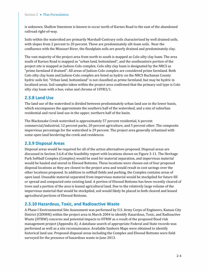
2.3.13 Wetlands National wetland inventory (NWI) database maps of the project area vicinity indicate that one palustrine forested wetland and one palustrine emergent wetland are present north of Karnes Rd. and east of Joseph Ave ( Figure 2-1 Blacksnake Creek NWI). The entire project area and vicinity including the locations of NWI-mapped wetlands was surveyed during field reconnaissance conducted on August 29, 2003, June 19, 2008, June 7, 2013, and September 9, 2014. The project area is generally developed and disturbed with relatively flat topography. Soil samples taken within the project area confirmed that the primary soil type is Colo silty clay loam with a hue, value and chroma of 10YR3/1. Although project area soils are hydric, no wetlands including NWI-mapped wetlands were observed during field surveys, primarily due to the absence of wetland hydrology. The banks of Blacksnake Creek are relatively steep and not conducive to wetland development. Very limited shelving was observed during field surveys. Overbank flow was not observed to have resulted in wetland development in the vicinity of Blacksnake Creek including the drainage to the southeast of the creek. No additional sources of wetland hydrology were observed within the project area.

Section 2 • Plan Formulation
2-7
The areas proposed for soil disposal and stockpiling, which include the Complex and the Elwood Bottoms contain NWI-mapped wetlands. Wetlands mapped in the vicinity of the Complex are primarily located in the southern portion of the Complex, and adjacent to the Missouri River. Some wetland acreage is mapped adjacent to the ball fields (Figure 2-2 Softball Complex NWI). Elwood Bottoms has been severely disturbed due to tree clearing, earthmoving, and agricultural activity. One emergent wetland is NWI-mapped within the area of proposed spoil placement (Figure 2-3 Elwood Spoil Area NWI). This wetland was not observed to exist during field reconnaissance. All areas of borrow and spoil placement will be assessed for changed conditions prior to construction.
Section 2 • Plan Formulation
2-8
Figure2-1 Blacksnake Creek NWI

Section 2 • Plan Formulation
2-9
Figure 2-2 Softball Complex NWI

Section 2 • Plan Formulation
2-10
Figure 2-3 Elwood Bottoms Spoil Area NWI 2.3.14 Fish and Wildlife Information regarding the fish and wildlife of the Missouri River and adjacent habitat that may found within the vicinity of the project area was obtained from USFWS, 2006. Buchanan County fish and wildlife information was obtained from Missouri Department of Conservation (MDC) Natural Heritage Database, 2015 (Appendix B).
Mammals associated with wooded riparian habitat include white-tailed deer, eastern cottontail, and red and gray squirrels. Aquatic and terrestrial furbearers present in the area include beaver, mink, and muskrat (dependent on aquatic habitat), opossum, coyote, raccoon, and striped skunk (dependent on terrestrial habitat). However, small mammals, such as mice, voles, rats, and bats account for the majority of the species present. The white-tailed deer is the only naturally occurring large mammal still common in developed urban areas. Eastern wild turkeys are present in the open, less developed floodplain areas.
The avifauna of the area includes permanent residents, summer residents, transients, and winter residents. The project area provides year-around habitat for approximately 31 bird species, with
Ellwood Bottoms Spoil Storage Area

Section 2 • Plan Formulation
2-11
another estimated 67 species using the project area for nesting and another 14 species as winter residents only.
Over 110 species use the river corridor during the fall migration. Summer resident species associated with aquatic habitats include waterfowl, wading birds, and some passerines. Summer waterfowl are dominated by wood ducks which nest in wooded bottomlands and rear their young in nearby aquatic habitats. Nesting by other waterfowl, primarily mallards, is minor. Wading birds, such as the great blue heron and green heron, utilize shallow areas as foraging habitat. Additional migrating species include the Canada goose, mallard, pintail, and snow goose.
Amphibians that may be found within the vicinity of the project area likely include the bullfrog, leopard frog, northern cricket frog, plains spadefoot toad, eastern American toad, western narrow-mouthed toad, Woodhouse’s toad, and Cope’s gray treefrog. Reptiles likely found within the vicinity of the project area include the snapping turtle, ornate box turtle, painted turtle, smooth soft-shelled turtles, common five-lined and Great Plains skink. The prairie ringneck snake, eastern hognose snake, racer, bullsnake, prairie kingsnake, watersnake, red milksnake, red-sided garter snake, copperhead, and timber rattlesnake likely occur within the vicinity of the project area. Additional amphibians and reptiles may occur within and adjacent to the study area.
The Missouri River’s fishery is characterized by species typical of large, turbid rivers including the smallmouth buffalo, bigmouth buffalo, common carp, river carpsucker, shortnose gar, and channel catfish (USFWS, MRLS 471-460 DCAR). Gizzard shad is the most dominant forage species. In addition to channel catfish, sport species present include flathead and blue catfish, white crappie, freshwater drum, green sunfish, and bluegill. Other forage and nongame species present include various minnows and shiners.
Unidentified minnows, crayfish burrows, water striders, and a bullfrog were observed within the Blacksnake Creek channel. The creek is generally shallow and narrow, and may contain common fish species such as red shiner, fathead minnows, bullhead catfish, bluegill, green sunfish, and common carp. However, creek fauna is considered rather limited based upon field observations.
Wildlife within the project area is typical of an urbanized area. Wildlife observed during field surveys includes eastern cottontail rabbit, opossum, whitetailed deer, southern leopard frog, bullfrog, wild turkey, mourning dove, black-capped Chickadee, northern cardinal, mallard, dragonflies and damselflies. Many species of mammals, birds, reptiles, and amphibians likely use the habitat provided by the riparian corridor and adjacent habitat.
2.3.15 Threatened and Endangered Species All agency correspondence is included in Appendix B. In an agency coordination letter dated December 10, 2003, the US Fish and Wildlife Service stated that the Indiana bat (Myotis sodalis) was the only federally listed species likely to occur within the project area. During the summer, Indiana bats roost in trees with exfoliating bark. Overwintering occurs in caves, or occasionally abandoned mines. In a follow-up letter to the USFWS in April 2013 regarding project status, the USFWS responded in May 2013 and stated that they had no additional comments in addition to what they had already provided and still recommended that tree removal occur between November 1 and March 31 to minimize impacts to the Indiana bat. Follow-up coordination with the USFWS occurred in June, 2015 with an email that included Recommended Plan information and a figure of the construction footprint. The USFWS responded in June, 2015 with an email suggesting entering project information on the Information for Planning and Conservation (IPaC) website (http://ecos.fws.gov/ipac). The IPaC

Section 2 • Plan Formulation
2-12
generated response contained a list of threatened and endangered species that may occur in the proposed project location and/or may be affected by the proposed project. These species included the threatened piping plover, red knot, and northern long-eared bat, and the endangered least tern, pallid sturgeon and Indiana bat.
The MDC Natural Heritage Database was accessed in June 2008 and September 2014 prior to field investigations and again in April 2015 for updated county species information. MDC was contacted directly in 2008 due to a Database record of Regal Fritillary Butterflies within Buchanan County, currently state ranked “vulnerable”. MDC Policy Coordination indicated that the Regal Fritillary record was due to a fifteen year old record of a population located within six miles of the Blacksnake Creek Project and that the project area likely did not contain the Regal Fritillary. This butterfly species is found in areas that contain violets, where they lay their eggs. Field visits were conducted in August 29, 2003, June 19, 2008, June 7, 2013, and September 19, 2014. No violets or Regal Fritillary butterflies were observed during any of the field visits to the project area.
The Database was queried again in April 2015 for an updated list of Buchanan County sensitive species and habitats. Two additional species on the 2015 list include the brassy minnow (Hybognathus hankinsoni), state listed as vulnerable and tall agrimony (Agrimonia gryposepala), state listed as unrankable. The brassy minnow inhabits pools of small, moderately clear streams with sand or gravel bottoms and little or no current, and also uses seasonally flooded habitats for spawning, recruitment, and growth. Tall agrimony generally occurs in rocky woodlands and thickets. Neither of these species has ever been observed during field visits and their preferred habitat does not occur within or adjacent to the project area. Heritage Database results from 2015 are included in Appendix B.
2.3.16 Access Roads within the project area primarily include Savannah Road to the north, St. Joseph Avenue to the west, Maxwell Road Connector located in the approximate center of the project area, Karnes Road and Northwest Parkway to the south. One resident uses the Maxwell Connector to access St. Joseph Avenue and additional roads to the west of the Maxwell Connector. Roads are addressed in Section 3.1.3 and shown in Figure 3-2.
2.3.17 Socioeconomic Conditions The U.S, Census Bureau, American Community Survey (ACS), 5-year estimates 2008-2012, indicates the estimated total population of St. Joseph was 77,176 which is 3.8 percent more than in 2000. The population growth rate is lower than both the state average rate of 7.0 percent and the national average rate of 9.7 percent. The most prevalent races in St. Joseph include white, which represent 88.3 percent of the total population, followed by black (5.2 percent), and persons of Hispanic or Latino origin (5.7 percent). St. Joseph per capita income ($22,184) is slightly lower than Buchanan County ($22,184) and significantly lower than for the state ($25,546) and the nation ($28,051). A larger proportion of St. Joseph’s residents (18.4 percent) were below the poverty line than in the state (15 percent) and the U.S. (14 percent). The median age is 35, with 16.7 percent of the population age 62 years and over. The housing stock in St. Joseph of which 53.8 percent was built before 1960, is much older than for the state (31.5 percent) and for the nation (30.3). The average St. Joseph home value of $121,234 was significantly lower than the comparable values for the county ($135,418) and the state (169,314), and was less than half that national value of $254,710.
Additional socioeconomic analysis is presented in Section 2.6.1.1.

Section 2 • Plan Formulation
2-13
2.3.18 Archaeological and Cultural Resources A cultural resource background review of the proposed Blacksnake Creek Flood Risk Management Project area was conducted by the Kansas City District Archeologist. The review consisted of an examination of the National Register of Historic Places (NRHP); background files in the Kansas City District office; the Missouri Department of Natural Resources Archaeological Viewer (on-line); files supplied by the Missouri State Historic Preservation Office; and geological and soil maps were examined to determine if there is potential for unrecorded archeological sites in the area.
The background review found one NRHP listed district, the St. Joseph Park and Parkway System, which crosses the proposed project area. The NRHP district consists of 983 acres of park land and includes 11.5 miles of parkways and boulevards. Northwest Parkway located along the southern end of the project area is included in this District. Adjacent park elements including a ball park, tennis court, and swimming pool are not considered contributing elements to the historic district.
No archeological sites are mapped within or near the project area or within the proposed spoil deposition areas in St. Joseph and near Elwood, Kansas. However, the project area had not been previously surveyed for archeological sites. The field survey identified no archeological sites. The proposed project location was found to have been largely disturbed by past urban development including construction of a rail bed and roadways, park development, housing and commercial construction surrounding the area, and park development. Because of these previous disturbances, it is unlikely that any archeological sites eligible for the NRHP would be impacted by the project. In compliance with the National Historic Preservation Act (NHPA), the Corps has coordinated a finding of “no adverse effect” for the proposed project with the Kansas and Missouri State Historic Preservation Officers (SHPO) (Appendix B). The project will also be coordinated with affiliated federally recognized Native American tribes with the posting of this document on the Kansas City District Regulatory Website (http://www.nwk.usace.army.mil/Missions/RegulatoryBranch.aspx).
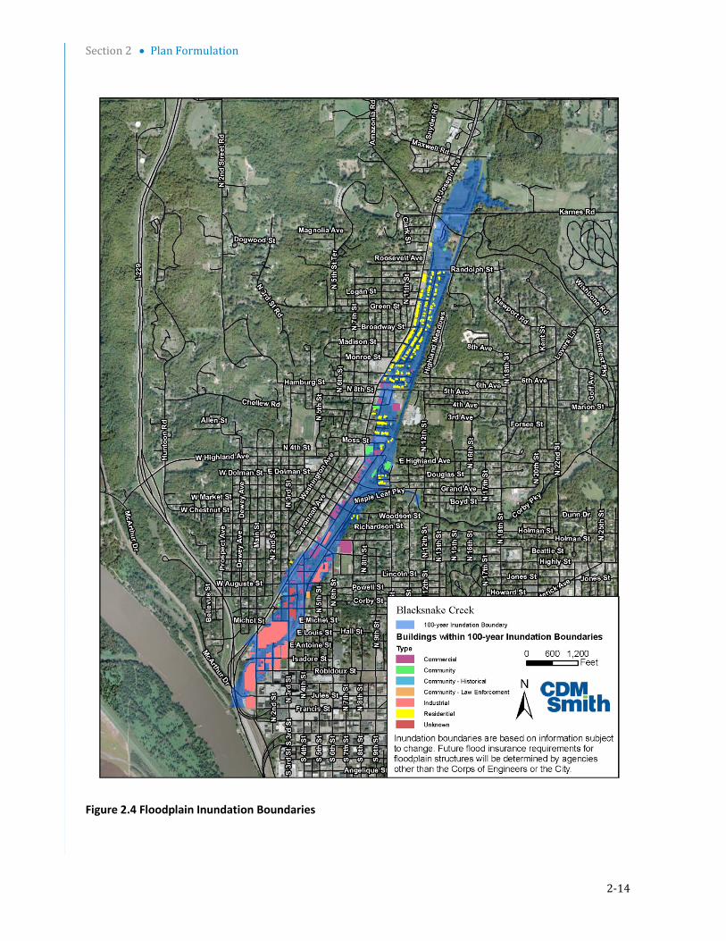
2.3.19 Floodplain The 1 percent ACE floodplain within the project area generally includes the area encompassing the Blacksnake corridor west towards the residences along St. Joseph, Avenue (Figure 2-4), and north past Maxwell Avenue encompassing the creek riparian corridor. At least six major flood events in this area in recent history have caused major damage to developed properties. The area of most concern is the lower, urbanized portion of the basin, southwest of Karnes Road. This area experiences the most flooding and is served by the CSS. Approximately in nomenclature 123 homes and 43 businesses, utilities, etc. are located within the 1 percent ACE floodplain below Karnes Road. The City participates in the Federal Flood Insurance Program. Upper basin development and floodplain encroachment has historically contributed to increased flood-related risk.
Section 2 • Plan Formulation
2-14
Figure 2.4 Floodplain Inundation Boundaries
Section 2 • Plan Formulation
2-15
2.4 Plan Development 2.4.1 Structural Measures Structural flood mitigation measures reduce flood hazard by keeping the floodwaters away from people and damageable property. The structural measures considered included the excavation of a detention basin and construction of a detention dam, levee, and floodwall. Initial plan formulation included the development and engineering review of four dry detention plans for the area north of Karnes Road and east of St. Joseph Avenue, with levels of protection in the range of a 10 to 4 percent ACE flood event. The detention plans included:
Raising Karnes Road to act as a detention dam, with associated drainage and outlet structures.
Construction of a levee on the west side of the detention basin from Karnes Road to Savannah Road and a floodwall on the east bank of Blacksnake Creek north of Savannah Road to protect existing residences and structures.
Excavation of the Blacksnake Creek floodplain north of Karnes Road to increase detention.
Site grading, utility/sewer relocations and other appurtenances.
Acquisition/buyout of properties.
The four initial dry detention plan alternatives are shown in Figure 2-5 and briefly outlined below.
Alternative 1 - Alternative 1 raises Karnes Road to elevation 905 NAVD to act as a detention dam but includes no excavation of the existing basin to increase storage. This alternative also includes construction of a levee and a floodwall upstream of Karnes Road to provide protection to existing residences and structures. The levee would be located to the east of and parallel to St. Joseph Avenue. The floodwall would be located farther upstream, just to the north of Savannah Road. In this alternative, an overflow spillway at Karnes Road would be the point of overtopping.
Alternative 2 - Alternative 2, in addition to the features of Alternative 1, would excavate the detention basin within the Blacksnake Creek floodplain north of Karnes Road between St. Joseph Avenue and an abandoned railroad right-of-way to increase the detention capacity.
Alternative 3 - Alternative 3 would increase the detention capacity of Alternative 2 by extending the detention area to the east of the abandoned railroad right-of-way. The abandoned railroad right-of-way would be removed to access the additional detention volume to the east.
Alternative 4 - Alternative 4 would increase the detention capacity of Alternative 3 by removing a portion of Karnes Road, extending the levee downstream of Karnes Road to Northwest Parkway, and additional excavation within the basin area. This alternative does not include the replacement of Karnes Road. In this alternative, an overflow spillway at Northwest Parkway would be the point of overtopping.
Estimating assumptions were made for structures (detention dam, levee, etc.), geotechnical and civil/utilities modifications, and relocations. Primary material quantities, labor, land acquisition, and design cost estimates were used to develop a preliminary cost estimate for each alternative. USACE independent technical review of the alternatives recommended structural modifications to the levee and Karnes Road detention dam that would increase the estimated cost for each alternative.

Section 2 • Plan Formulation
2-16
Figure 2-5 Detention Plan Alternatives 1 through 4

Section 2 • Plan Formulation
2-17
Based on the initial value engineering review of the alternatives and discussions regarding the relatively high costs of the initial alternatives with the sponsor, and on public comment (negative views of locating levees and floodwalls behind the residences along St. Joseph Avenue), three additional alternatives were developed using the natural topography and a lower pool height to eliminate the need for the traditional and costly structures (detention dam, levee, and floodwall) in Alternatives 1 through 4. Alternatives 1-4 are presented in this report and were carried through the analysis; however, additional refinement (development of costs) was not conducted on these alternatives after the initial formulation because these alternatives were too costly for the project to remain under the Section 205 program limits. These initial alternatives included built up structural features such as a dam, levees, and floodwalls which would have required more considerations for safety assurance, further increasing costs.
The City original goals were for a project that would provide for flood protection for the 1 percent ACE flood, however due to the high costs and the potential for additional costs associated with safety assurance considerations, additional formulation was conducted. There was interest in seeing if there would still be significant flood damage reduction benefits, with a recognition that these alternatives would perform at a lesser storm event than the 1- percent ACE flood event.
The newly formulated alternatives would eliminate the need for the built up structures but would look at best options for locating and sizing the basin. Three additional alternatives (5, 6 and 7), were developed that did not include built up structural features and rely on existing topography and excavation to create a detention basin. The detention plan for Alternatives 5, 6, and 7 are shown in Figure 2-6 and briefly outlined below:
Alternative 5 - The Blacksnake Creek floodplain north of Karnes Road between St. Joseph Avenue and an abandoned railroad right-of-way would be excavated to increase the detention capacity. The abandoned railroad right-of-way along the east side of the basin would be removed to access additional detention volume to the east. An overflow spillway would be constructed at an elevation of 895 NAVD on Karnes Road. In this alternative, an overflow spillway at Karnes Road would be the point of overtopping.
Alternative 6 - Alternative 6 would increase the detention capacity of Alternative 5 by excavating the area between Karnes Road and Northwest Parkway. Culverts would be constructed to provide a connection between the areas north and south of the Karnes Road. In this alternative, an overflow spillway constructed at an elevation of 895 NAVD at Northwest Parkway would be the point of overtopping.
Alternative 7 - Alternative 7 would increase the detention capacity of Alternative 6 by expanding the basin north of Karnes Road to the west. This alternative would require the purchase and demolition of the residences on the west side of the basin along St. Joseph Avenue. In this alternative, an overflow spillway constructed at an elevation of 895 NAVD at Northwest Parkway would be the point of overtopping.
As part of the reformulation effort, a new HMS model and HEC RAS model were developed, and structural alternatives (1-7) were evaluated for performance using the updated models.
Subsequent to the development of Alternatives 1 through 7, the City approved a transportation plan that included the City’s abandonment of the Karnes Road section crossing the basin. Therefore, one

Section 2 • Plan Formulation
2-18
additional alternative that excavates the abandoned Karnes Road was formulated. The detention plan for Alternative 8 is shown in Figure 2-5 and briefly outlined below.
Alternative 8 - Alternative 8 modifies Alternative 6 by removing Karnes Road. The removal of Karnes Road reduces the construction cost by eliminating the need to raise, reconstruct, and armor the road, and for the installation of culverts to provide a hydraulic connection between the basin areas north and south of the road. Alternative 8 also uses the volume gained by the removal of Karnes Road to construct utility pads around three 161 KV power poles that were to be relocated under Alternative 6 while maintaining the same detention volume. While the detention volume remained the same, the screening level costs were reduced by approximately $1.0M.

Section 2 • Plan Formulation
2-19
Figure 2-6 Detention Plan Alternatives 5 through 8

Section 2 • Plan Formulation
2-20
2.4.2 Nonstructural Measures
In addition to the alternatives presented in the previous section, traditional nonstructural measures were considered relative to conditions in the watershed, the flood threat, and the nature of the protected area and structures. Measures evaluated during preliminary measures screening included flood proofing and evacuation. These approaches have merit when the site characteristics and the flooding threat are compatible with the nonstructural capabilities. The intent of nonstructural measures is not to prevent the flooding from occurring through modification of flood flows, but to reduce the damages and consequences caused by the flooding. Nonstructural flood mitigation measures such as structure elevation, flood proofing, and localized protection measures can reduce flood damages by modifying or relocating property susceptible to flooding. Floodplain evacuation relocates the damageable structures from the threatened area. Implementation of nonstructural measures such as structure acquisition, demolition/relocation, structure elevation, and flood proofing would be costly due to the number of structures, and would be ineffective in much of the basin because of the types of structures and would not provide a comprehensive solution to the flooding problems. Figure 2-4 illustrates the extent of structures within the 1 percent floodplain.
A significant number of the structures are commercial and not residential (40 percent) and contain most of the economic investment. The residential structures are of very low value. There is a wide diversity of structure construction types and in the types of businesses in the floodplain. Due to the wide diversity of construction types, and given the nature of the residential type structures, flood proofing is deemed not to be a viable option. The structures are so diverse and of the types of construction in terms of framing, wall, and foundation construction that it would not be structurally feasible nor cost effective to develop a flood proofing as a component of comprehensive flood protection plan.
Based upon the significant experience in this region and with this study area, buyouts of investment that would have any significant effect on reducing damages would not be cost effective. Buyouts would destroy the urban, cultural and economic integrity of the St. Joseph Avenue Corridor which would be unacceptable to the sponsors and would represent potential adverse socioeconomic impacts. In addition, the measures or a combination of these measures would not meet the constraints imposed by the City’s storm water improvement plan.
The Blacksnake Creek base flow currently enters a combined sewer inlet at Karnes Road. It is the City’s intention to construct a separate storm water conveyance and to re-direct the base flow from Blacksnake Creek to the new storm water conveyance. This conveyance, when built, will be retrofitted to the detention basin. The combined effect of a detention basin and the separate storm water conveyance would result in both flood damage reduction benefits for the downstream community and a reduction in the amount of combined sewer flow that requires treatment at the City’s sewage plant. The City’s planned separate storm water conveyance was analyzed for its potential impact to the flood risk reduction project. It was determined that it would not negatively affect the performance of the flood risk management project.
A conventional non-structural approach was screened out of plan formulation before detailed economic analysis as this approach would not meet the planning goals and objectives of the study.

Section 2 • Plan Formulation
2-21
A draft Floodplain Management Plan was developed as part the cost shared Feasibility Study. The draft Floodplain Management outlines applicable City Floodplain Policies and Ordnances and identifies a recommended action and implementation plan. The sponsor will continue to evaluate local measures for flood risk reduction as they finalize their Floodplain Management Plan, including with input and data from the Corps design process as the design effort is underway. The Floodplain Management plan will remain in draft form pending construction of a project, at which time the City may elect to update and implement the plan. The City maintains emergency response through its Emergency Operations Plan. Floodplain regulation is accomplished through the City’s Floodplain Management Ordinance.
One of the potential action items identified is to implement localized flood reduction measures to supplement the dry detention project once it is in place. The localized measures would target habitable structures remaining in the floodplain after the implementation of the project that could benefit from being better protected from flood hazards. Some structures could potentially be removed from the 1 percent ACE floodplain with the construction of free standing structures such as small berms or floodwalls. This could serve to complement the effectiveness of the detention basin in further reducing damages. The implementation of these actions would are separate actions that may be pursued after the project is in place and were not included with the performance analysis of the structural alternatives. The City implements applicable measures through their Emergency Operating Plan, floodplain ordnance, land use plan, and storm water code to address flood and storm water management within the City limits.
The flood-fighting (non-structural) measure attempts to reduce flood damages and address all objectives through temporary means implemented during a flood event. Plans for flood fighting procedures are in-place under the City’s Emergency Operating Plan. This plan includes plans related to emergency warning, disaster response, post disaster assessment, and communication. The EOP addressed multiple types of disaster events, including flood events and applies to the portions of the Blacksnake Creek watershed that lies within the City limits. Due to the temporary nature of any flood-fighting measure it offers no complete or effective long-term solutions for major flood risk management problems. Additional measures for flood fighting beyond existing response measures implemented through the City’ EOP were not identified and carried forward for the study.
Land use planning measures are implemented through the City’s Floodplain Management Ordinance and the City’s Land Use Plan. The development of the Floodplain Management Ordinance and the Land Use Plan include setting restrictions for development where land is unsuited for such development due to potential flood hazards.
The City Floodplain Management Ordinance is found in Chapter 31 of their Code of Ordinance. Article IV Floodplain Management Section 31-200 to Section 31-225. The purpose of this ordinance is to minimize losses related to periodic flood inundation, including: loss of life and/or property, hindered health and safety, disruption of commerce and governmental services, extraordinary public expenditures for flood protection and relief, and impairment of the tax base. Additionally this code was adopted as part of the eligibility requirement for the NFIP. The Floodplain Management Code focuses on the following areas: Restricting or prohibiting uses which are dangerous to health, safety, or property in times of flooding or which cause increases in flood heights or velocities, 2. requiring uses which are vulnerable to floods, including public facilitate to be provided with flood protection at the time of constructions, and protecting individuals from buying lands with are unsuited for proposed development purposes due to flood hazard.

Section 2 • Plan Formulation
2-22
The City’s 2004-2024 Land Use Plan’s purpose is to provide a framework which will direct future growth in the City. Specific goals in this plan include: preventing development from occurring in environmentally sensitive areas such as floodplains and wetlands; minimizing development in floodplain areas which represent a threat to public health, safety, individual welfare, and the economic viability of property; and supporting the development of conservation focused designs.
The Floodplain Management Ordinance and the City Land Use Plan are applicable to all development, re-development, and capital improvement activities within the Blacksnake Creek watershed within the City limits. No new measures for land use planning or ordinances were identified and carried forward for the study.

Section 2 • Plan Formulation
2-23
2.5 Hydrologic and Hydraulic Analysis Hydrologic studies involve estimating the discharges or flows resulting from rainfall runoff associated with specific design storms, while hydraulic studies use the resultant hydrology flows to estimate water surface elevations along a creek or river. The Blacksnake Creek hydrologic and hydraulic analysis is summarized below. A detailed account of this analysis is provided in Appendix C.
2.5.1 Previous Hydrologic and Hydraulic Studies A Flood Insurance Study (FIS) was published for the City of St. Joseph, Missouri in September 1984. The study included flood profiles for Blacksnake Creek that were mapped from its confluence with the Missouri River up to the City’s corporate limits, approximately 4.2 miles. It was noted in the FIS that peak discharges were based on data previously developed by the Corps of Engineers in 1979; however the actual discharges used were not listed. Other studies that included hydrologic and hydraulic evaluations for Blacksnake Creek are noted in Section 1.5 of this report.
2.5.2 Existing Conditions Hydrologic Analyses A hydrologic evaluation of the Blacksnake Creek watershed in St. Joseph, Missouri, was conducted using the US Army Corps of Engineers, Hydrologic Engineering Center (HEC) Hydrologic Modeling System (HMS), Version 3.5, computer model. The HEC-HMS model was used to simulate the existing conditions runoff hydrographs resulting from rainfalls corresponding to the 100, 50, 20, 10, 4, 2, 1, 0.4, and 0.2 percent ACE storm events. Estimates of rainfall for the noted return periods were originally developed using the Rainfall Frequency Atlas of the Midwest (Bulletin 71). However, since the initial development of the Blacksnake Creek HEC-HMS model, updated rainfall estimates for the Midwestern States were published by the National Oceanic and Atmospheric Administration (NOAA) in 2013. The report is titled “NOAA Atlas 14 – Precipitation Frequency Atlas of the United States – Volume 8 – Version 2.0: Midwestern States”. Because this update was released prior to finalizing the feasibility study report the rainfall estimates have been modified to reflect the most current data.
The HMS model divides the watershed into 32 subareas ranging in size from 84 acres to 313 acres and aggregates the flows from this network of contributing subareas into discharges at various points within the channel and watershed. The model takes into account characteristics of the basin such as land use, imperviousness, channel length, and channel slope to estimate discharges. Table 2-1 shows computed discharges at two key points in the watershed. Figure 2-7 depicts the Blacksnake Creek watershed and the delineated HMS subareas. Detailed output from the HEC-HMS model is included in Appendix C.
Table 2-1 HEC-HMS Modeling Results
Hydrologic Location
ID Description
Existing Conditions Peak Flow Rates (cfs)
100% ACE
50% ACE
20% ACE
10% ACE
4% ACE
2% ACE
1% ACE
0.4% ACE
0.2% ACE
Junction 13 Karnes Road 1533 1996 2856 3705 4978 6069 7296 8988 10715
Junction 01 Confluence
with Missouri River
2069 2725 3943 5135 6994 8578 10325 12717 15099

Section 2 • Plan Formulation
2-24
Figure 2-7 Blacksnake Creek Watershed and Subareas

Section 2 • Plan Formulation
2-25
2.5.3 Existing Conditions Hydraulic Analyses Hydraulic modeling was performed using HEC-RAS Version 4.1.0 steady state option. The objective was to produce a detailed hydraulic model that reflects the complexities in local topography, provides an effective tool for assessing flood risk, and can be used to evaluate options for reducing flood risk. Based on existing topography and land use conditions, the HEC-RAS model simulates the watershed’s primary storm water flow path in the lower portion of the basin. The model extends from just upstream of Karnes Road to the confluence with the Missouri River.
Profiles were developed depicting the 100, 50, 20, 10, 4, 2, 1, 0.4, and 0.2 percent ACE storm event water surface elevations for the overland flow path downstream of Karnes Road. Frequency flows were based on output from the HEC-HMS model described in Section 2.5.2. Peak flows used in the HEC-RAS model cross sections downstream of Karnes Road only include the portion of flow that does not enter the CSS. Based on studies by others the average full flow capacity of the CSS was estimated to be 1803 cfs. It should be noted that flow within the CSS was not evaluated as a part of this study. The flows used within the HEC-RAS model are listed in Table 2-2. In addition, the HEC-RAS model cross section locations and flow load points are shown in Figure 2-8.
Table 2-3 lists HEC-RAS model results at three selected cross-sections. Detailed HEC-RAS model output is included in Appendix C.
Table 2-2 Flows Used in Existing Conditions HEC-RAS Model
Event/Peak Flow, cfs
HEC-HMS Junction ID
XS1 Station
ID
100% ACE
50% ACE
20% ACE
10% ACE
4% ACE
2% ACE
1% ACE
0.4% ACE
0.2% ACE
J-16 15365 1331 1732 2489 3234 4369 5350 6458 7983 9559
J-14 14527 1485 1933 2770 3595 4835 5899 7100 8754 10447
J-132 13763 5 192 1053 1901 3175 4265 5493 7185 8911
J-11 11909 5 343 1272 2191 3577 4756 6082 7912 9774
J-10 9407 5 366 1312 2242 3662 4867 6214 8065 9937
J-09 7879 5 427 1401 2359 3824 5067 6452 8360 10285
J-04 6520 198 829 1995 3139 4914 6421 8082 10365 12650
J-03 4847 230 872 2061 3227 5040 6580 8279 10611 12939
J-02 3740 236 881 2077 3250 5073 6626 8340 10687 13026
J-01 480 266 922 2139 3332 5190 6774 8522 10914 13295 1 XS = cross section 2 Flows downstream of J-14 reflect the 1803 cfs flow reduction to account for the CSS capacity.

Section 2 • Plan Formulation
2-26
Figure 2-8 HEC-RAS Model Cross Section Locations and Flow Load Points

Section 2 • Plan Formulation
2-27
Table 2-3 Existing Conditions HEC-RAS Model Results at Selected Cross-Sections
Cross Section Description Profile Q Total*
(cfs) W.S. Elev*
(ft) Vel Chnl*
(ft/s)
13763 Karnes Road
1 5 893.01 00
0.50 192 894.47 0.1
0.20 1053 896.3 0.6
0.10 1901 897.16 0.9
0.04 3175 898.11 1.2
0.02 4265 898.79 1.4
0.01 4593 899.46 1.5
0.004 7185 900.27 1.7
0.002 8911 901.03 1.9
8987 5th Street
1 5 868.36 0.3
0.50 366 870.62 1.6
0.20 1312 872.03 3.9
0.10 2242 872.78 4.8
0.04 3662 873.62 5.8
0.02 4867 874.09 6.5
0.01 6214 874.47 7.4
0.004 8065 875.19 8.4
0.002 9937 875.9 8.9
6520 Grand Avenue
1 198 858.07 0.6
0.50 829 859.11 4.0
0.20 1995 860.01 7.3
0.10 3139 860.72 8.8
0.04 4914 861.95 9.6
0.02 6421 862.91 10.5
0.01 8082 864.05 10.7
0.004 10365 865.52 10.1
0.002 12650 866.96 9.5 * Q Total = total flow, cfs W.S. Elev = water surface elevation, feet Vel Chnl = velocity in the channel, fps
Section 2 • Plan Formulation
2-28
2.6 Plan Screening 2.6.1 Structural Measures 2.6.1.1 Socioeconomic Analysis The USACE completed a socioeconomic analysis of each structural alternative to identify the National Economic Development (NED) plan, which is the alternative with the highest annual net benefits.
Socioeconomic Conditions St. Joseph, Missouri, which lies approximately 55 miles north of Kansas City on the Missouri/Kansas border, is a regional center for a four-county metro area and for several other rural counties beyond the metro area. St. Joseph’s population of 76,780 as of the 2010 Census made it the eighth-largest city in Missouri, while the St. Joseph MSA (metropolitan statistical area), had an estimated population of 127,927. Based on block data from the 2010 Census for blocks adjoining Blacksnake Creek, the study area population is estimated at 2,525. The population at risk (PAR) of the study area, which includes workers and others temporarily in the area in addition to residents, is estimated at 3,500.
Blacksnake Creek originates in a rural area of Andrew County immediately north of St. Joseph and subsequently flows through the northwestern portion of the city, eventually arriving at its mouth in downtown St. Joseph. The creek generally follows U.S. Highway 59, known locally as St. Joseph Avenue, throughout almost the entire study area. Generally the creek is located just to the east of St. Joseph Avenue and the busy commercial strip along the street. Land uses gradually shift from rural and residential uses upstream to commercial and industrial uses downstream. The Blacksnake basin, especially the urbanized portion, is one of the oldest parts of the city. A community known as Industrial City developed along the railroad tracks in this area soon after the 1827 establishment of a trading post near the mouth of Blacksnake Creek.
Today, the city’s dominant industries are health care and manufacturing, and in particular, the city has a large cluster of businesses, academics, agencies and educators working in the animal health and life sciences sector. This sector, known as the KC Animal Health Corridor, includes businesses, academics, agencies and scientists working in a regional corridor in Missouri and Kansas that includes St. Joseph, Kansas City, Topeka, Lawrence and Columbia. Nearly one-third of the $19 billion global animal health industry is concentrated within this corridor.
The Blacksnake Creek study area as of 2014 contains 123 homes and 43 businesses, primarily small and medium-sized, many in retail and the Census designation “other services” which includes auto repair garages. Total investment in the study area, which is summarized in Table 2-4, is estimated at $93.5 million (2015 dollars).
Although the toll of flash flooding along this small stream has never been well quantified, it is clear that flooding became an issue as early as a major flash flood in 1849 and has remained one to the present day. Another major flash flood is known to have occurred in 1943, although details are not readily available. In 1959, the Blacksnake basin experienced two major flash flooding events. The most severe of the 1959 events occurred in May, sending a high-velocity wave of water 6 to 8 feet deep down St. Joseph Avenue and the railroad right-of-way. Newspaper accounts indicated significant damage to about 130 homes and 23 businesses. One death was reported in the flood, at a location that is key to this study: the covered channel entrance at Karnes Road. Further flash flood events culminated in a June 1984 event believed to have been a 200- to 300-year storm. One post-flood estimate put the damage at $3.6 million, or about $7.6 million in 2013 dollars. A Corps reconnaissance
Section 2 • Plan Formulation
2-29
study followed the 1984 event, culminating in the 1987 report which identified an interest in Federal action.
Plan Screening – Socioeconomic Analysis
For the economic analysis, the study area was originally divided into three reaches. One of these was not carried over into the final stages of the study, and the economic analysis results will be reported in relation to two reaches. The reaches are illustrated on Figure 2-9 and are discussed below:
Reach 1 – Reach 1 is the most downstream reach, extending from the mouth of Blacksnake Creek upstream to Fillmore/Grand Street just north of downtown St. Joseph. The stream in this area is a covered channel flowing through a primarily industrial portion of the city. This reach has a small amount of residential land use, but is mostly industrial and commercial. As of 2014, Reach 1 included 10 homes and 24 businesses spread between 57 non-residential structures. Wire Rope is a major business presence in this reach, but most of the businesses are small and medium-sized enterprises. Most structures in this reach are older structures in average condition.
Reach 2 – Like Reach 1, Reach 2 is covered channel. Reach 2 runs from Fillmore/Grand Street upstream to Karnes Road, where the open stream enters the covered channel. Reach 2 contains much more residential land use than Reach 1 but also has a commercial/retail strip along St. Joseph Avenue/Highway 59. There are 113 homes and 23 non-residential structures housing 19 businesses in Reach 2.
The other original reach, which was removed from the later stages of the economic analysis, was Reach 3. This reach is the upstream portion of Blacksnake Creek, from Karnes Road upstream to the headwaters in southernmost Andrew County. This segment is an open channel, running through rural areas and residential neighborhoods of northern St. Joseph. Homes in this area are generally newer and larger than further downstream, and the great majority of these homes are near Blacksnake Creek but are on high ground above the floodplain (with a few exceptions where homes could be affected by the largest potential flood events).
Since the proposed project would be constructed just north of Karnes Road, benefits from less frequent/severe flooding would affect only Reaches 1 and 2. Reach 3 was included in the study to ensure that any adverse induced impacts from the project are fully considered. As the study developed, it became clear that impacts from the project in this area would be negligible and it was dropped from further economic analysis.
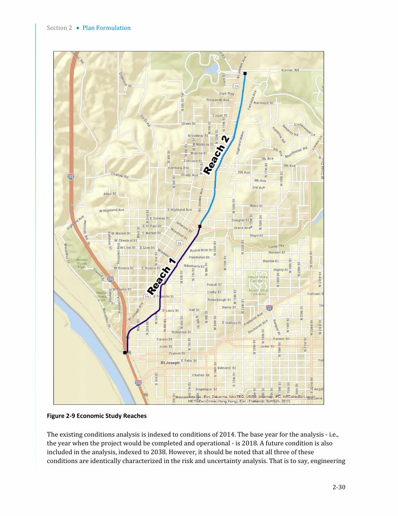
Section 2 • Plan Formulation
2-30
Figure 2-9 Economic Study Reaches The existing conditions analysis is indexed to conditions of 2014. The base year for the analysis - i.e., the year when the project would be completed and operational - is 2018. A future condition is also included in the analysis, indexed to 2038. However, it should be noted that all three of these conditions are identically characterized in the risk and uncertainty analysis. That is to say, engineering

Section 2 • Plan Formulation
2-31
data, including water surface profiles, and economic development assumptions are considered constant in all respects from 2014 through 2067, the economic period of analysis.
Except for the screening analysis, the economic analysis in this report is based on a FY 2015 price level (index: 1 October 2014), a 50-year period of analysis, and the current Federal interest rate for water resource projects of 3.375 percent.
The economic database for the Blacksnake Creek analysis was based on a complete, structure-by-structure field survey supplemented by data from tax records. Economic data collected for the inventory included structure characteristics such as occupancy, construction quality/class, number of stories, exterior wall type, basement type, garage type, and condition. Areas of buildings and garages, which were not available from the tax data, were estimated from maps. District staff used the building characteristics in conjunction with Marshall and Swift estimating data to estimate depreciated replacement values for residential, commercial, and public structures. Streets also were added to the economic database using typical replacement costs per mile based on an average of estimates made by transportation departments of Missouri and several other states; however, streets in the Blacksnake floodplain generally consist only of side streets sloping down into the floodplain, and flood damage potential for streets is minimal. Elevations, stream stations, and first floor elevations were assigned to each structure using aerial photography and 2-foot contour mapping provided by the City of St. Joseph. Emergency costs and disaster relief costs also were added to the economic analysis. For details on the valuation and damage characterization of the residential and nonresidential properties, streets and emergency costs, see Appendix I.
Water surface profiles were prepared for eight flood events: 50, 20, 10, 4, 2, 1, 0.4, and 0.2 percent ACE. These profiles and the economic data were loaded into the HEC- Flood Damage Analysis (FDA) program. HEC-FDA is the acronym for the Flood Damage Analysis program produced by the Hydrologic Engineering Center. This program is standard in Corps of Engineers economic risk analyses for flood risk studies, and the newest, certified version, 1.2.5a, was used in the analysis. The program utilizes Monte Carlo analysis, which randomly samples multiple probability distribution functions to produce thousands of possible flood events instead of a few discrete scenarios. The results provide a single expected value for damages that represents an average of the thousands of synthetic events. Even though it is a single value, it embodies a number of variables along with their uncertainty distributions. The goal of the economic screening of alternatives is to identify the National Economic Development (NED) plan. The NED plan is the plan with the highest net benefits. This is considered the most economically efficient alternative.
Without-Project Conditions Analysis Investment in the Blacksnake study area, including residential and non-residential structures and contents and streets, is estimated at $94.1 million (2015 prices). As shown in Table 2-4, the two project reaches include 123 homes, valued at $20.1 million, and 80 non-residential structures, valued at $69.1 million. These totals include contents as well as structure value. The remaining $4.7 million of total investment is accounted for by streets. These investment totals are assumed to remain constant under existing, base year and future without-project conditions.

Section 2 • Plan Formulation
2-32
Table 2-4 Blacksnake Creek Total Investment ($1,000s; 2015 prices)
Reach 1 Reach 2 Total
RESIDENTIAL
Quantity 10 113 123
Value - Structures 393.9 $11,9962.2
$12,390.1
Value - Contents $328.0 $7,478.4 $7,806.4
Value - Total $721.9 $19,474.6 $20,196.5
NON-RESIDENTIAL
Quantity 57 23 80
Value - Structures $26,449.4 $8,099.4 $34,548.8
Value - Contents $25,857.1 $8,728.5 $34,585.6
Value - Total $52,306.5 $16,827.9 $69,134.4
ROADS & STREETS
Value $3,576.2 $1,105.2 $4,681.4
TOTAL VALUE $56.604.6 $37,407.7 $94,012.3
Reach 1 is the floodplain area from the mouth of Blacksnake Creek at the Missouri River, upstream to Fillmore.
Reach 2 is the floodplain area from Fillmore to Karnes Road.
Equivalent annual damage (EAD) as calculated in the HEC-FDA analysis is summarized in Table 2-5. Risk and uncertainty-based estimates concerning the probability of damaging floods also result from the HEC-FDA analysis. These results are applicable to existing, base year, and future conditions. The totals in Table 2-5 therefore represent the future without-project condition which serves as a base for subsequent alternatives evaluation. A few noteworthy points can be made based on execution of the HEC-FDA risk analysis model:
Total EAD for the project reaches is estimated at $3,545,900. An earlier estimate of $2,890,000 was used in the screening analysis, but the benefit-cost data for the NED plan are based on without-project condition EAD of $3,545,900.
Approximately 71 percent of the EAD is associated with Reach 1, the downstream reach with the highest commercial and industrial development.
Approximately 63.8 percent of total EAD is non-residential, while 25.8 percent is residential, 1.8 percent streets, and 8.6 percent emergency costs and disaster relief.
The risk and uncertainty-informed estimate of the threshold at which damaging overbank flooding occurs, over the long run, is 38.7 percent – approximately a 2.5 year flood. (This is in contrast to early estimates in the study that the threshold was at least a 20 percent (5 year) flood – an estimate based only on nominal estimates and not informed by risk and uncertainty considerations.)

Section 2 • Plan Formulation
2-33
Table 2-5 Existing & Future Without-Project Conditions Results (FY 15 prices)
Reach
Residential ($1,000s)
Non-Residential
($1,000s)
Streets
($1,000s)
Emerg. Costs
($1,000s)
Total
($1,000s) 1 $87.4 $2,201.5 $63.4 $171.6 $2,523.9 2 $828.7 $60.2 $0.0 $133.1 $1,022.0 Total $916.1 $2,261.7 $63.4 $304.6 $3,545.9
Plan Screening – Comparison of Plans Eight action alternatives ultimately were developed and quantitatively evaluated for this study. All eight alternatives are structural flood risk reduction measures. Alternatives 1 through 4 form one group of similar (although separate) alternatives, while Alternatives 5 through 8 are a second group of similar alternatives. The pertinent features of the alternatives are summarized below:
Alternatives 1 through 4
- These alternatives are variants of the same basic plan, which involves raising Karnes Road to act as a dry detention dam with an overflow spillway.
- Alternative 1 includes no excavation for the detention area upstream of Karnes Road, while 2, 3 and 4 involve increasing amounts of excavation.
- All four alternatives would include a levee/floodwall combination upstream of Karnes Road. This feature is meant to protect homes in that area from any adverse effects of the detention basin. It does not reduce flood risk relative to the without-project condition.
- Alternative 4 extends the detention basin downstream of Karnes Road, removing a short portion of Karnes and adding a second levee.
Alternatives 5 through 8
- These four alternatives are also variants of the same plan.
- Like Alternatives 1 through 4, these plans involve dry detention upstream of Karnes Road.
- Unlike Alternatives 1 through 4, they use the natural topography and a lower pool height to avoid the need for the Karnes Road dam and levee/floodwall combination upstream.
- The dry detention area in Alternative 5 is upstream of Karnes Road. Alternative 6 extends it a short distance downstream to Northwest Parkway, as in Alternative 4. Alternative 7 expands the detention area upstream of Karnes to the west. Thus, project scale increases in moving from Alternative 5 to 6 to 7, as it does in moving from 1 to 2, 3, and 4.
- Alternative 8 is similar to 6 but takes into account the City’s plan to abandon the section of Karnes Road crossing the basin as part of its approved area transportation plan. The abandonment of Karnes Roads allows a reduction in project cost by eliminating the need to raise, reconstruct, and armor the road, and for the installation of culverts to provide a hydraulic connection between the basin areas north and south of the road. The volume gained by the removal of Karnes Road is used to construct utility pads around three 161 KV

Section 2 • Plan Formulation
2-34
power poles that were to be relocated under Alternative 6 while maintaining the same detention volume.
Nonstructural alternatives were also examined, although the early screening indicated detailed cost –benefit analysis was not warranted. In general, non-structural measures are unlikely to be cost-effective in addressing flooding in this area. A buyout plan would be hampered by the dispersal of the at-risk properties over a lengthy area; none of the clusters of structures along the stream are concentrated enough to stand out from the other areas in terms of flood damage history or potential for future flooding. Buying out all of the properties in the flood plain would be far more expensive than the structural alternatives and would also reduce the city’s tax base. Estimated costs for effective flood proofing would amount to a large percentage of the total values of the affected structures. Avoidance measures such as evacuation of property or certain kinds of flood proofing requiring early action in a flood event would likely be of limited usefulness given the small amount of warning time afforded by flash flooding in this area.
The structural alternatives were costed in 2009 at an equivalent screening level of detail. First costs for the eight alternatives (subsequently updated to October 2011 prices) range from $14.7 million to $25 million, as shown in Table 2-6. The first costs were annualized based on an assumed interest rate of 4.125 percent (subsequently updated to the 3.75 percent Federal rate for 2013); a period of analysis of 50 years; and an installation period of six years from preconstruction engineering and design (PED) to project completion (used in calculating interest during construction). The first costs accounted for design, real estate, and construction costs.
Operation and maintenance, repair, replacement, and rehabilitation (OMRR&R) costs also were estimated at the screening level and added to the annualized first costs. OMRR&R costs were estimated at $130,000 for Alternatives 1 through 4 and $24,000 for Alternatives 5 through 8. Alternatives 5 through 8 have lower OMRR&R costs because they do not include the Karnes Road detention dam and the levee/floodwall and are designed to work with rather than against the natural topography of the area.
Annualized costs for the eight alternatives were paired with the benefits evaluated in HEC-FDA for each alternative to arrive at the screening results for this analysis.
Screening Results Table 2-6 summarizes the main results of the benefit-cost analysis of the seven screening alternatives, Table 2-7 shows the project assurance ratings for each alternative (i.e., the likelihood that the project’s capacity would be exceeded), and Table 2-8 provides a comparison of the estimated cost, benefit cost ratio, and elements of the seven alternative plans. The main points emerging from the economic screening analysis are as follows:
The HEC-FDA analysis estimated equivalent annual damages (EAD) of $2,890,000 for the without-project condition. (The EAD of $3,545,900 cited above is a later estimate of EAD in 2014 dollars.) All alternatives reduce these damages by approximately 73 to 87 percent. All alternatives have benefit-cost ratios exceeding unity, ranging from 1.8 to 3.3.
Alternatives 5, 6, and 8 were the economically optimal alternatives. Alternative 5 had a small but insignificant margin of superiority in net benefits over alternative 6, but 5 and 6 came in second in the rankings to alternative 8. Alternative 8 has a margin of 3.2 percent in net benefits over the second-ranking alternative, Alternative 5.

Section 2 • Plan Formulation
2-35
All alternatives dramatically alleviate long-term flood risk, but by no means do they eliminate it. Not only the largest flood events, but also those of more modest scale would continue to result in damaging floods -- see the annual exceedance probabilities in Table 2-7, which show that none of the alternatives can improve annual exceedance probability in Reach 1 to more than about 10 percent.
However, the projects generally have a much greater effect on preventing damaging floods in Reach 2, which is the location of the entrance to the sewer.
Alternative 8 is the NED plan emerging from the screening analysis. This alternative would provide $1,726,200 in net benefits. Alternatives 5 and 6 – two of the other three alternatives that provide dry detention just upstream of Karnes Road without the necessity of using Karnes Road as a dam – are the second and third-ranking alternatives, with net benefits of $1,672,300 and $1,665,800 respectively, but are 3.2 percent and 3.6 percent behind Alternative 8. Alternative 8 has a benefit-cost ratio of 3.3. The plan would cost $15,105,000 to build as well as an estimated $24,000 in annual OMRR&R costs. (These benefits and costs are updated for the NED plan in section 3.)
According to the screening-level conditional non-exceedance probability statistics produced by the HEC-FDA analysis and summarized in Table 2-7, the chance of a damaging flood over a 10-year period with Alternative 8 in place would be about 62.0 percent in Reach 1 and 11.2 percent in Reach 2. (The Reach 2 figure is notable since the entrance to the covered channel and the frequently-damaged Burnside Avenue area is in that reach.) The same 10-year risk in the without-project condition exceeds 98 percent. For the reference 1 percent flood event, Alternative 8 would have essentially no chance of substantially containing this event in Reach 1 and only about a 0.7 percent chance in Reach 2. But long-term annual damages would be reduced to about 14 percent of without-project condition damages. More detailed estimates of assurance for the NED plan can be found in section 3.
Atlas 14 Impacts Very late in the feasibility study (subsequent to the Alternative Formulation Briefing), the National Oceanic and Atmospheric Administration (NOAA) published a new precipitation-frequency atlas for the U.S., known as Atlas 14. The new precipitation-frequency data potentially affects and alters the hydrology and hydraulics prepared for many Corps flood risk management studies, in many cases indicating significantly higher stages than previously estimated. Although the Atlas 14 data was released very late in the Blacksnake Creek study, the Kansas City District decided to perform a sensitivity analysis using the new data to find out whether economic justification or identification of the NED plan could be affected by the new data. Kansas City District engineering staff prepared a new set of water surface profiles reflecting the Atlas 14 estimates for the events considered in the economic analysis. These profiles were entered into the HEC-FDA model and a sensitivity analysis was executed.
The effects of the Atlas 14 profiles were very minimal in the Blacksnake Creek study area. Without-project EAD increased by less than 2 percent, and residual damages with the alternatives in place increased by less than 3 percent in most cases. In terms of economic justification, none of the benefit-cost ratios for the alternatives changed by more than a point (i.e., from 3.0 to 3.1), and the benefit-cost ratio for Alternative 8, the NED plan, did not change at all. The other issue that required investigation was the screening rankings. Although the margin of superiority that Alternative 8 held in net benefits over the other alternatives narrowed somewhat, the screening rankings did not change in any way and Alternative 8 continued to be the NED plan.

Section 2 • Plan Formulation
2-36
Since the effect of the Atlas 14 data on the economic analysis was essentially nonexistent in the sensitivity test, it was decided that no further action was required in response to the new data; i.e., damage and benefit computations previously completed for the study did not need to be revised to reflect the Atlas 14 data. Thus, no change was made in the damages and benefits previously computed for use in the study. All damages and benefits reported in the tables are based on the pre-Atlas 14 hydrologic/hydraulic data.

Section 2 • Plan Formulation
2-37
Table 2-6 Benefits and Costs by Alternative
Alternative Features
Total project costs
($1,000s)
Annual OMRR&R
costs ($1,000s)
Annual costs ($1,000s)
Annual damages ($1,000s)
Annual benefits ($1,000s)
Benefit-cost ratio
Net benefits ($1,000s)
Existing Existing conditions n.a. n.a. n.a. $2,890.0 n.a. n.a. n.a.
1
Dry detention pond; levee/ floodwall upstream of Karnes Road; raise of Karnes Road to act as dam
$16,093.0 $130.0 $906.4 $657.8 $2,232.2 2.5 $1,325.8
2
Similar to 1, but larger detention pond requiring more excavation
$22,372.0 $130.0 $1,210.5 $524.0 $2,366.0 2.0 $1,155.5
3
Similar to 2, but larger detention pond, extending north of Karnes Road, with more excavation than either 1 or 2
$25,032.0 $130.0 $1,337.4 $447.0 $2,443.0 1.8 $1,105.5
4
Similar to 3, plus removal/relocation of segment of Karnes Road to increase storage and second levee to protect ball field
$24,838.0 $130.0 $1,328.2 $480.6 $2,409.4 1.8 $1,081.3
5
Detention basin with lower pool height; no levee, floodwall, or dam; excavation without impacting structures; overflow spillway on Karnes Road
$14,732.0 $24.0 $739.9 $477.7 $2,412.3 3.3 $1,672.3
6
Similar to 5, but more storage by excavation area between Karnes Road and Northwest Parkway
$16,298.0 $24.0 $813.9 $410.2 $2,479.8 3.0 $1,665.8
7
Similar to 6, but expanded storage in pond north of Karnes Road; requires acquisition and removal of homes west of St. Joseph Ave.
$22,950.0 $24.0 $1,134.0 $371.3 $2,518.7 2.2 $1,384.7
8
NED Plan - Similar to 6, but excavates an abandoned Karnes Road and uses the volume gained to construct pads around three 161 KV power poles that were to be relocated.
$15,105.1 $24.0 $753.6 $410.2 $2,479.8 3.3 $1,726.2
OMRR&R - Operation and Maintenance, Repair, Replacement, and Rehabilitation Price level - October 2011; interest rate – 3.75%

Section 2 • Plan Formulation
2-38
Table 2-7 Engineering Performance of Alternatives
Alternative Annual Exceedance
Probability* Non-exceedance
Probability in 1% Event Chances of Flooding Over
10 Years
Reach 1 Reach 2 Reach 1 Reach 2 Reach 1 Reach 2
Existing 0.3893 0.3288 0.0000 0.0000 99.3% 98.1%
< 5 year < 5 year
1 0.1244 0.0384 0.0000 0.0428 73.5% 33.8%
< 10 year ~ 25 year
2 0.1128 0.0174 0.0000 0.1783 69.8% 16.1%
~ 10 year > 50 year
3 0.1007 0.0081 0.0000 0.9998 65.4% 7.9%
~ 10 year ~ 125 year
4 0.1052 0.0038 0.0000 0.9998 67.1% 3.7%
~ 10 year > 250 year
5 0.0966 0.0213 0.0000 0.1816 63.8% 18.8%
~ 10 year ~ 50 year
6 0.0922 0.0118 0.0000 0.0072 62.0% 11.2%
~ 10 year > 75 year
7 0.0841 0.0038 0.0000 0.9998 58.5% 3.8%
> 10 year > 250 year
8 0.0922 0.0118 0.0000 0.0072 62.0% 11.2%
~ 10 year > 75 year
*Annual exceedance probability is the probability that a damaging flood (of whatever magnitude would occur during any given year **Non-exceedance probability in the 1% event is the probability that the project would contain the 1% chance flood event without significant damage from overtopping or project failure.

Section 2 • Plan Formulation
2-39
Table 2-8 Summary of Alternative Plan Screening Analysis Alternative Element Alternative
1 2 3 4 5 6 7 8 Estimated Cost 1 $16,093,000 $22,372,000 $25,032,000 $24,838,000 $14,732,000 $16,298,000 $22,950,000 $15,105,060 Annual Benefit $2,232,200.00 $2,366,000.00 $2,443,000.00 $2,409,400.00 $2,412,300.00 $2,479,800.00 $2,518,700.00 $2,479,800.00 Annual Cost $906,400.00 $1,210,500.00 $1,337,400.00 $1,328,200.00 $739,900.00 $813,900.00 $1,134,000.00 $753,600.00 Benefit – Cost Ratio 2.5 2 1.8 1.8 3.3 3 2.2 3.3 Annual Net Benefit $1,325,800.00 $1,155,500.00 $1,105,500.00 $1,081,300.00 $1,672,300.00 $1,665,800.00 $1,384,700.00 $1,726,200.00 Pool Elevation 905 feet 905 feet 905 feet 905 feet 895 feet 895 feet 895 feet 895 feet Estimated Detention Event2 10- to 4-% ACE 4- to 2-% ACE 2- to 1-% ACE 1- to .4-% ACE 4- to 2-% ACE 4- to 2-% ACE 1- to .4-% ACE 4- to 2-% ACE Estimated Detention Volume 240 acre-feet 400 acre-feet 520 acre-feet 650 acre-feet 370 acre-feet 440 acre-feet 660 acre-feet 440 acre-feet Residential Properties Impacted 24 24 24 24 21 21 21 21 Non Residential Properties Impacted 6 6 6 6 6 6 6 6 Detention Basin Excavation Volume 0 cubic yards 250,000 cubic yards 465,000 cubic yards 589,000 cubic yards 539,000 cubic yards 660,000 cubic yards 1,060,000 cubic yards 660,000 cubic yards Levee Yes Yes Yes Yes No No No No Levee Interior Drainage Issues Yes Yes Yes Yes No No No No Long-term Levee Maintenance Yes Yes Yes Yes No No No No Detention Dam Yes Yes Yes Yes No No No No Long-term Dam Maintenance Yes Yes Yes Yes No No No No Floodwall Yes Yes Yes Yes No No No No Concrete Culvert under Karnes Road No No No No No Yes Yes No Emergency Spillway Yes Yes Yes Yes Yes Yes Yes Yes Demolition and/or Relocation of Sanitary Sewer Lines Yes Yes Yes Yes Yes Yes Yes Yes
Demolition and/or Relocation of Potable Water Lines Yes Yes Yes Yes Yes Yes Yes Yes
Demolition and/or Relocation of Electrical Lines Yes Yes Yes Yes Yes Yes Yes Yes
Demolition and/or Relocation of Natural Gas Lines Yes Yes Yes Yes Yes Yes Yes Yes
Demolition and/or Relocation of Communications Lines Yes Yes Yes Yes Yes Yes Yes Yes
Modification to Culvert and Sewer No No No No No No No No Raise Karnes Road Yes Yes Yes No No No No No Raise Maxwell Road Extension Yes Yes Yes Yes No No No No Impact to Recreational Facilities Yes Yes Yes Yes Yes Yes Yes Yes Notes: 1 Cost estimates were prepared using the Micro Computer Aided Cost Engineering System (MCACES) Second Generation (MII) software. Costs presented are considered Class 5 (Concept Screening) with an accuracy range of
+100/-50 according to the American Society for Testing and Materials designation E 2516–06 Standard Classification for Cost Estimate Classification System. Costs include contingency and are rounded up to nearest thousand. Costs are considered 2011 costs. Costs were not escalated to mid-point of construction because costs are for screening comparison only. 2 ACE is the estimated Annual Chance Exceedance event.

Section 2 • Plan Formulation
2-40
This page left blank intentionally
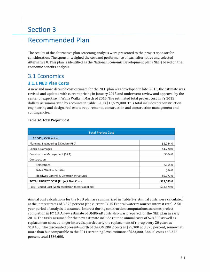
3-1
Section 3 Recommended Plan The results of the alternative plan screening analysis were presented to the project sponsor for consideration. The sponsor weighed the cost and performance of each alternative and selected Alternative 8. This plan is identified as the National Economic Development plan (NED) based on the economic benefits analysis.
3.1 Economics 3.1.1 NED Plan Costs A new and more detailed cost estimate for the NED plan was developed in late 2013, the estimate was revised and updated with current pricing in January 2015 and underwent review and approval by the center of expertise in Walla Walla in March of 2015. The estimated total project cost in FY 2015 dollars, as summarized by accounts in Table 3-1, is $13,579,000. This total includes preconstruction engineering and design, real estate requirements, construction and construction management and contingencies.
Table 3-1 Total Project Cost
Total Project Cost
$1,000s; FY54 prices
Planning, Engineering & Design (PED) $2,044.0
Lands & Damages $1,220.0
Construction Management (S&A) $504.0
Construction Relocations $154.0
Fish & Wildlife Facilities $84.0
Floodway Control & Diversion Structures $9,077.0
TOTAL PROJECT COST (Project First Cost) $13,083.0
Fully-Funded Cost (With escalation factors applied) $13,579.0
Annual cost calculations for the NED plan are summarized in Table 3-2. Annual costs were calculated at the interest rates of 3.375 percent (the current FY 15 Federal water resources interest rate). A 50-year period of analysis is assumed. Interest during construction computations assumes project completion in FY 18. A new estimate of OMRR&R costs also was prepared for the NED plan in early 2014. The tasks assumed for the new estimate include routine annual costs of $28,300 as well as replacement costs at longer intervals, particularly the replacement of riprap every 20 years at $19,400. The discounted present-worth of the OMRR&R costs is $29,300 at 3.375 percent, somewhat more than but comparable to the 2011 screening-level estimate of $23,000. Annual costs at 3.375 percent total $586,600.

Section 3 • Preferred Alternative
3-2
Table 3-2 Annual Costs
Annual Costs
$1,000s; FY 15 prices
First Costs $13,083.0
IDC $289.1
Total Investment Cost $13,372.1
I&A factor (3.375%, 50 years) 0.04168
Annual Cost subtotal $557.3
Annual OMRR&R Cost $29.3
TOTAL ANNUAL COST $586.6
3.1.2 NED Plan Benefits Benefits for the NED plan were recalculated most recently in early 2015 to account for price level changes in structure inventory values and other adjustments (such as adding emergency costs). Summarized in Table 3-3, annual benefits total $3,058,800 in FY15 dollars. (This total is not affected by interest rate changes.) The without-project EAD of $3,545,900 is reduced by about 86 percent with the NED plan in place. Reach 1 accounts for 69 percent of the benefits, while Reach 2 contributes the remaining 31 percent.
Table 3-3 Annual Benefits
Annual Benefits
$1,000s; FY15 prices BENEFITS Reach 1 Reach 2 Total
Future without-project EAD $2,523.9 $1,031.7 $3,545.9 Residual with-project EAD $423.6 $85.6 $487.1 Damage reduction EAD $2,102.9 $946.1 $3,058.8 Percentage 68.7% 31.3% 100.0%
3.1.3 Benefit-Cost Ratio for the NED Plan As seen in Table 3-4, at the 3.375 percent interest rate, the NED plan for Blacksnake Creek has a very strong benefit-cost ratio of 5.2. Annual benefits total $3,058,800, annual costs are estimated at $586,600, and annual net benefits total $2,472,200.
Table 3-4 Benefit-Cost Data
TABLE 3-4 -- BENEFIT-COST DATA
FY 15 prices; interest rate = 3.375%; $1,000s
Annual Benefits $3,058.8 Annual Costs $586.6 Benefit-Cost Ratio 5.2 Net Benefits $2,472.2

Section 3 • Preferred Alternative
3-3
3.1.4 Residual Risk No project that conceivably could be constructed would successfully contain every possible flood. Significant flood risk will continue after the Blacksnake project is implemented. The chances that a damaging flood will occur in the project area even with the project in place are not reduced significantly except in the smaller, more frequent floods. The ACE of the NED plan design (probability of flooding in any given year with a project in place) is approximately 9 percent. Residual risk can be expressed by the probability of a project being exceeded over a certain number of years. Long-term risk indicates how well the project will contain floods under conditions of uncertainty over a long period of time. The evaluation of residual risk indicates that over a 10-year period the probability of the top of project being exceeded is approximately 61.2 percent. Over a 30-year period, the long-term risk is 94.2 percent and it is 99.1 percent over 50 years. Additional information is included in Appendix I, Socio- Economics.
Exceedance probability (the chances of flood damage) in a 4 percent event, which is 100 percent for without-project conditions, is only reduced to 96 percent by the project, and is close to 100 percent for events higher than the 4 percent with the project in place. A total of $487,000 in residual expected annual damages is estimated by the HEC-FDA model. The high continuing probability that damaging flood events will occur in the project area does not mean that the project is ineffective. As can be seen in the discussion of benefits above, the project very substantially reduces potential economic damage over the long term. But it accomplishes this not by completely preventing floods from occurring, but by alleviating depths of flooding to much less dangerous and harmful levels when floods do occur. There will be a continuing need, even after project implementation, to monitor potential flood events diligently and take appropriate precautions.
3.2 Plan Components 3.2.1 Detention Basin The recommended plan uses the natural topography and excavation within the Blacksnake Creek floodplain north of Northwest Parkway to create the detention basin. The basin would be a dry pond with a low flow channel and would not store water during non-storm events. Based on refinement of the hydrologic model, the elevation of the overflow spillway was raised from elevation of 895 to 897 NAVD to contain the 4 percent ACE event. With the higher pool elevation the basin would provide a detention capacity of 443 acre-feet. The basin footprint is shown in Figure 3-1.
The estimated maximum water surface elevation for the 1 percent ACE event for the existing (without project) conditions at Karnes Road, based the June 2012 HEC Hydrologic Modeling System (HMS) model, is 898.9 NAVD. Modification of the model to incorporate the detention basin results in an estimated maximum water surface elevation for the 1 percent ACE event at Karnes Road of 898.7 NAVD, indicating that construction of the basin will not increase the 1 percent ACE flood elevation over existing conditions. The effective FEMA Flood Insurance Rate Map (effective September 1984) shows a maximum water surface elevation for the 1 percent ACE event at Karnes Road of 895 NAVD. A Letter of Map Amendment (LOMA) would need to be submitted to FEMA to request a revision to the effective floodplain map to show changes to floodplains, floodways, and flood elevations.
The HEC-HMS model indicates that the proposed detention basin will drain within 24 hours from the time of peak water surface elevation to full dewatering for storm events up to the 1 percent ACE event. The estimated times to drain based on the modified model are shown in Table 3.6.
Table 3-6 Times to Drain Detention Basin by Storm Event

Section 3 • Preferred Alternative
3-4
ACE Event Estimated Hours 50 % 14
10 % 13
4 % 15
2 % 17
1 % 18
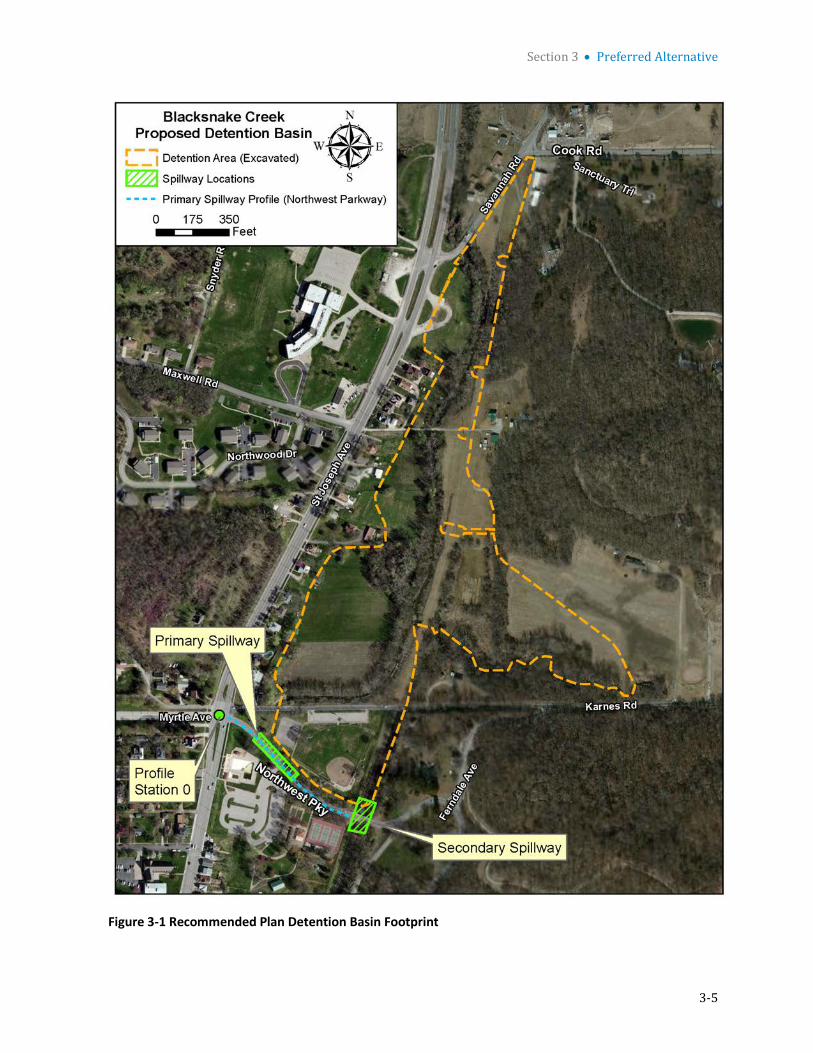
Section 3 • Preferred Alternative
3-5
Figure 3-1 Recommended Plan Detention Basin Footprint

Section 3 • Preferred Alternative
3-6
3.2.2 Spillway During events larger than the rated level of protection, the primary spillway would deliver excess runoff over the top of Northwest Parkway and into a nearby parking lot in the vicinity of the existing community pool. The overflow section would consist of a concrete paved roadway section with a minimum thickness of 9 inches. A toe-wall at the downstream edge of the pavement is recommended to protect against undermining of the pavement structure. Riprap protection would be installed on the downstream and upstream slope of the overflow section. The secondary spill at the southeast corner of the basin will deliver excess runoff over to the abandoned railroad right-of-way and will be protected with riprap. The location of the overflow spillways are shown in Figure 3-1. The spillway riprap sizing is discussed in the geotechnical engineering analysis provided in Appendix D.
Base on the June 2012 HEC HMS model and 2012 site topographic survey5, the overflow spillway at Northwest Parkway would need to be constructed at elevation 897 NAVD to contain the 4 percent ACE event. The secondary spill would be set at elevation 898 NAVD.
3.2.3 Roads Roads located within and adjacent to the project area include Savannah Road, Cook Road, Maxwell Road Extension, Karnes Road, Northwest Parkway, and St. Joseph Avenue (see Figure 3-2). Cook Road, Maxwell Road Extension, Karnes Road, and Northwest Parkway are east west thoroughfares that cross the project area from north to south respectively. Savannah Road and St. Joseph Avenue are north south thoroughfares.
3.2.3.1 Project Impacted Roads Northwest Parkway forms the southern boundary of the basin and would be the point of overtopping when the capacity of the basin is exceeded. The road will be reconstructed and armored as the primary overflow spillway.
Maxwell Road Extension crosses near the mid-point of the proposed detention basin and provides access to a single residence on the east side of the basin. Maxwell Road Extension will be removed and access to the single residence will be via a new access road on the east side of the project.
3.2.3.2 City Road Improvements
As part of the City’s road improvement plan, the City is planning to reduce the number of connectors to St. Joseph Avenue in the vicinity of the project. The intersection of St. Joseph Avenue, Karnes Road, and Northwest Parkway has multiple connectors within a short span and will be updated. As a result of the improvement the segment of Karnes Road from Ferndale Avenue to St. Joseph Avenue will be closed thus routing traffic to Northwest Parkway. The City will install barricades and strip the road of asphalt from St. Joseph Avenue to approximately the detention boundary but leave the asphalt from the detention boundary to Ferndale Avenue to allow access to a single resident. The intersection improvement and resulting closure of Karnes Road works well with the proposed Blacksnake Project but is not part of the Federal Project.
Also in attempt to reduce the number of connectors to St. Joseph Avenue the City plans to abandon the connection at Savannah Road. A segment of Savannah Road will be closed by installing barricades,
5 Survey Report, Blacksnake Creek Section 205 Feasibility Study, CDM Smith, May 2012.

Section 3 • Preferred Alternative
3-7
stripping the roads of asphalt, and covering the area with top soil. The abandonment of Savannah Road is not part of the Federal Project.
3.2.3.3 Access Roads
Two new access roads will be constructed along the east side of the basin. The southern road will extend north from Karnes Road to provide maintenance access to a power pole supporting 161 kilovolt (KV) power lines. The northern road will extend south from Cook Road to the residence formerly accessed by way of Maxwell Road Extension and to provide maintenance access to three 161 KV power poles. The access roads will be 20 feet wide with 6 inches of base gravel. The approximate total length of these access roads is 2,400 feet. These access roads would be constructed as part of the Federal project.
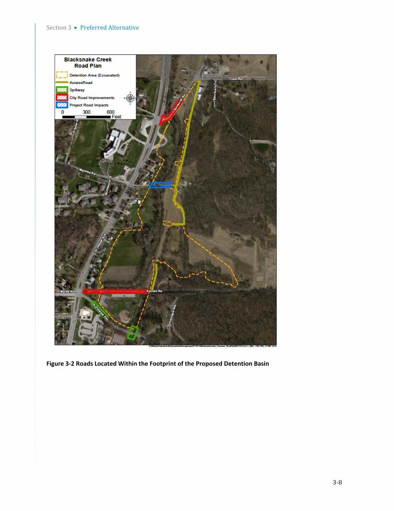
Section 3 • Preferred Alternative
3-8
Figure 3-2 Roads Located Within the Footprint of the Proposed Detention Basin

Section 3 • Preferred Alternative
3-9
3.2.4 Utilities Utilities impacted by construction of the proposed detention basin include sanitary, natural gas, water, electric, and communications. Utilities and owners are provided in Table 3-7.
Table 3-7 Utilities Impacted by Construction
Utility Type Owner
Sanitary City
Natural Gas Missouri Gas Energy
Water American Water
Electric - transmission KCP&L
Electric - distribution KCP&L
Communications AT&T
Communications Suddenlink
3.2.4.1 Sanitary Sewer There are two sanitary sewer lines which are owned by the City, one of which is impacted by the proposed detention basin project. The first conveys flow from the north end of the project site south, and runs approximately through the middle of the basin, as shown in Figure 3-3. This line is referred to as the West Line and is currently scheduled to be relocated as part of the City’s combined sewer improvement program and is not part of the project. Another sanitary sewer, termed the East Line, conveys flow from the east boundary of the basin to the west, where it ties into the West Line, as shown in Figure 3-3.
Sanitary Sewer - East Line The east branch of the existing sanitary sewer will be re-located as part of the project. The existing east branch of sanitary sewer is made of 12-inch vitrified clay pipe and is 1,400 feet in length. The east branch has 6 manholes which are made of prefabricated concrete. The average existing capacity of the East Line was found to be 2.9 mgd.
The existing East Line is proposed to be replaced with a 2,700-foot-long sanitary sewer which runs outside of the detention basin along its east boundary, as shown in Figure 3-3. The proposed sewer will convey sanitary flow north and will connect to the existing sanitary sewer at Savannah Road. It will be constructed of 18-inch ASTM F679 PVC pipe with an average slope of 0.4 percent and an estimated average capacity of 4.5 mgd. Additionally, there will be a total of 6 manholes at a maximum of every 500 feet to meet APWA standards for sewer maintenance. It will be buried to a minimum depth of 4 feet in accordance with APWA standards. Depth to bedrock along this alignment is not known and should be investigated prior to design.
There is one house located on the east side of the basin that may be on a septic system that will be connected to the new East Line sewer.
3.2.4.2 Natural Gas Natural gas lines are operated by Missouri Gas Energy (MGE). An existing 12-inch coated steel natural gas line runs north from Northwest Parkway, turns east to follow Karnes Road, and then diverts to the north as shown in Figure 3-4. This portion of gas line is 2,100 feet long. Communications with MGE indicate that the line was diverted north of Karnes Road east of the abandoned railroad right-of-way
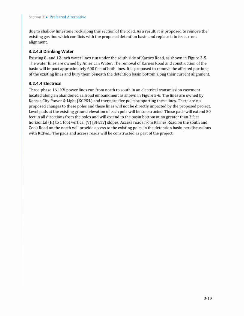
Section 3 • Preferred Alternative
3-10
due to shallow limestone rock along this section of the road. As a result, it is proposed to remove the existing gas line which conflicts with the proposed detention basin and replace it in its current alignment.
3.2.4.3 Drinking Water Existing 8- and 12-inch water lines run under the south side of Karnes Road, as shown in Figure 3-5. The water lines are owned by American Water. The removal of Karnes Road and construction of the basin will impact approximately 600 feet of both lines. It is proposed to remove the affected portions of the existing lines and bury them beneath the detention basin bottom along their current alignment.
3.2.4.4 Electrical Three-phase 161 KV power lines run from north to south in an electrical transmission easement located along an abandoned railroad embankment as shown in Figure 3-6. The lines are owned by Kansas City Power & Light (KCP&L) and there are five poles supporting these lines. There are no proposed changes to these poles and these lines will not be directly impacted by the proposed project. Level pads at the existing ground elevation of each pole will be constructed. These pads will extend 50 feet in all directions from the poles and will extend to the basin bottom at no greater than 3 feet horizontal (H) to 1 foot vertical (V) [3H:1V] slopes. Access roads from Karnes Road on the south and Cook Road on the north will provide access to the existing poles in the detention basin per discussions with KCP&L. The pads and access roads will be constructed as part of the project.
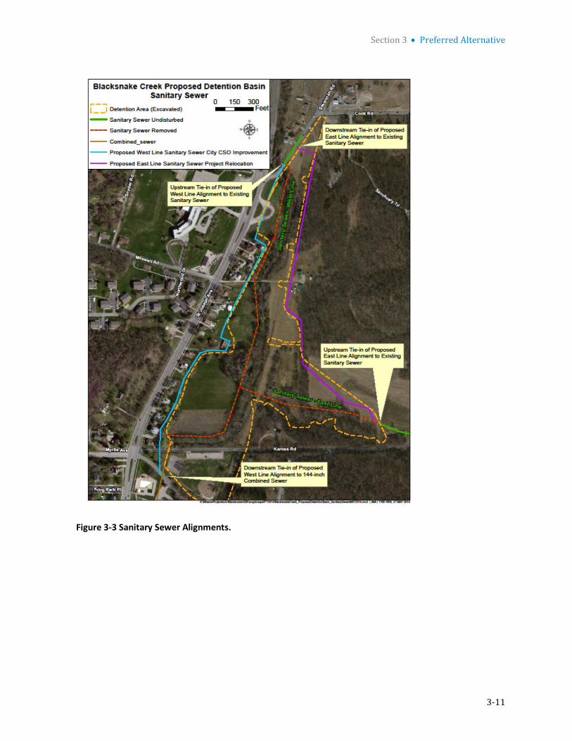
Section 3 • Preferred Alternative
3-11
Figure 3-3 Sanitary Sewer Alignments.

Section 3 • Preferred Alternative
3-12
Figure 3-4 Gas Utility Impacted by the Construction of the Detention Basin

Section 3 • Preferred Alternative
3-13
Figure 3-5 Water Lines Impacted by the Construction of the Detention Basin
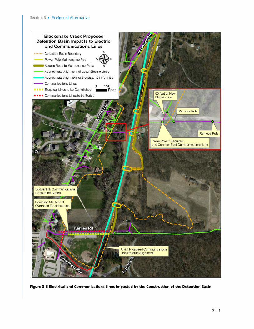
Section 3 • Preferred Alternative
3-14
Figure 3-6 Electrical and Communications Lines Impacted by the Construction of the Detention Basin
Section 3 • Preferred Alternative
3-15
The electric utility is proposed to be modified east of the intersection of Maxwell Road and St. Joseph Avenue where two utility poles are planned to be removed as shown in Figure 3-6. The lines are proposed to be routed using the remaining pole to the west, which is in line with the back edge of the properties to the north, adding additional height to it if necessary. KCP&L has agreed to the improvement per the email dated May 18, 2012. In addition, the 500 feet of electrical line which currently runs along the south side of Karnes Road is also proposed to be removed. Demolition of this line was discussed, and KCP&L agreed to its removal per the email dated May 18, 2012.
3.2.4.5 Communications Approximately 900 feet of communication lines owned by AT&T and Suddenlink run along Karnes Road in the public right-of-way. Both communications companies have agreed that they will re-route the communications lines at no cost to the project. AT&T has proposed to re-route their communications lines south from Karnes Road along the railroad embankment and north-west along Northwest Parkway to St. Joseph Avenue, as shown in Figure 3-6 and per the telephone report dated May 15, 2012. The new alignment will run approximately 1,400 feet in length. Suddenlink has agreed to bury its communication line beneath the detention basin along its current 900 foot long alignment per the telephone report dated May 17, 2012.
The communication lines that traverse the basin in the north area of the proposed detention basin will remain in place. If required, the pole that runs the communications lines from the west side to the east side of the proposed basin will be raised. The pole that is in the center of the north side of the proposed detention basin will be removed.
3.2.5 Hydraulic Structures The combined sewer inlet is a 12-foot by 12-foot reinforced concrete double box culvert. The inlet serves as transition from open channel flow in Blacksnake Creek upstream of Karnes Road to piped flow for the remainder of the creek. The double box inlet is aligned in an east-to-west direction for approximately 90 feet at which point it transitions into a single 12-foot diameter concrete pipe culvert that flows south. A 36-inch reinforced concrete pipe sewer line enters the box culvert from the north, downstream of the box culvert inlet. The 36-inch sewer line will be relocated to tie into the sewer at Northwest Parkway. The double box structure will not be modified as part of the recommended plan. The design and construction of a new inlet may be conducted by the City as part of the combined sewer improvements, but is not part of the Federal project.
3.3 Design and Construction Considerations 3.3.1 Earthwork Approximately 660,000 cubic yards of material would need to be excavated to create the detention basin. The side slope of the excavation would be 3H:1V. The minimum slope of the detention basin bottom would be 1 percent to provide positive drainage to Blacksnake Creek. A preliminary grading plan for the basin is shown in Figure 3-7. Cross section through the primary and secondary overflow spillways are shown in Figures 3-8 and 3-9.
The existing open channel running through the project site is approximately 2,700 feet long, has a typical bottom width of 15 feet, and side slopes that vary between 1- and 2- foot H to 1-foot V. The existing open channel will be modified in cross-sectional geometry and alignment. The proposed channel will have an approximate length of 2,800 feet and an average slope of 0.6 percent through the project site. It will have a side slope of 3H:1V on the left bank and a side slope of 5H:1V on the right bank.

Section 3 • Preferred Alternative
3-16
Figure 3-7 Preliminary Detention Basin Grading Plan

Section 3 • Preferred Alternative
3-17
Figure 3-8 Cross Section through the Primary Spillway

Section 3 • Preferred Alternative
3-18
Figure 3-9 Cross Section through the Secondary Spillway
The final slopes would be seeded to provide erosion protection. Riprap protection would be added to areas of the stream channel and basin slopes susceptible to erosion during flood events. The slope stability analysis and riprap sizing for the basin are provided in the geotechnical engineering analysis provided in Appendix D.
3.3.2 Clearing and Grubbing Clearing and grubbing of trees and vegetation will be required for approximately 13.4 acres, as shown in Figure 3-10. Throughout the rest of the 23 acres within the detention basin, clearing of turf will be required.
3.3.3 Storm water Management The base flow for Blacksnake Creek is 2 mgd6. A large temporary diversion channel capable of accommodating this flow will need to be created during construction. The diversion channel is anticipated to be located within the construction footprint, the exact location of the diversion channel will be determined in design. Development and adherence to a water control plan will be required for construction. A preliminary water control plan is discussed in the geotechnical engineering analysis provided in Appendix D.
6 Technical Memorandum No. TM-CSO-5, Storm water Separation Conduits, Black & Veatch, January 15, 2010.

Section 3 • Preferred Alternative
3-19
Implementation and maintenance of erosion control measures would be necessary during construction. Storm water pollution prevention best management practices (BMP) will need to be utilized for all aspects of the project. Development and adherence to the storm water pollution prevention plan (SWPPP) is critical.
3.3.4 Construction Sequencing Construction activities will be greatly influenced by the time of year, proposed alignment, and conditions for erosion control stabilization. A preliminary construction sequence illustrating assumptions and challenges of construction, while accommodating Blacksnake Creek flows, is presented in the geotechnical engineering analysis provided in Appendix D.
3.3.5 Schedule Table 3-8 presents the schedule for the major tasks for the design and construction of the detention basin. A more detailed schedule is provided with the cost estimate in Appendix E.
Table 3-8 Design and Construction Schedule
Task Duration (calendar days)
35 percent Design 120
65 percent Design 120
95 percent Design 60
100 percent Design and Construction Contract Documents 45
Construction 325
Real Estate Acquisition 120

Section 3 • Preferred Alternative
3-20
Figure 3-10 Clearing and Grubbing Required for Construction of the Detention Basin

Section 3 • Preferred Alternative
3-21
3.3.6 Recommendations for Additional Investigation An additional geotechnical investigation and laboratory testing program should be conducted to verify the soil stratigraphy and shear strength parameters determined as part of this preliminary feasibility study.
The investigation should consist of hollow-stem auger borings, each with a depth of 50 feet, or refusal, whichever occurs first. Soil boring locations should be selected based on critical components of the project. For example, transmission tower pads, inlet and outlet locations, overflow embankments, and tall or otherwise critical embankment slopes. Additionally, soil borings should be appropriately spaced around the perimeter of the project to provide adequate information about depth to bedrock and stratigraphic changes from one end of the project to the other.
The soil borings should include shelby-tube (for cohesive materials) and split-spoon (for granular materials) sampling at 5-foot intervals for the full depth of the soil borings. A laboratory testing program would then be developed including moisture content testing, Atterberg limit testing, unconfined compression testing, unconsolidated undrained, and consolidated undrained with pore water pressure triaxial compression testing. The tests should be well-distributed throughout the soil boring depth to provide sufficient testing within each encountered stratum.
3.4 Lands, Easements, Rights-of-Way, Relocations, or Disposal Areas (LERRD) Considerations 3.4.1 Lands, Easements, Rights-of-Way There are 24 parcels of land with a total acreage of approximately 42.17 that will be affected by the detention project. The type of interest to be acquired includes Fee Simple and Easements. The majority of the land (34.85 acres) will be acquired in fee simple. Approximately 7.19 acres of land will be acquired in the form of utility easements and approximately 20 acres of land will be acquired for a Temporary Work Area Easement.
3.4.2 Relocations The utilities impacted by the construction of this project include natural gas, water, electric, sanitary sewer and communications lines. The east line sanitary sewer relocation is a project relocation cost. Although a significant effort was made to identify all required relocations, there is a possibility the project will require additional unknown relocations which will be addressed in the Engineering and Design phase of the project.
3.4.3 Disposal Areas Four spoil sites were identified for disposal of the excavated soil. The locations of spoils sites, haul distance from the project site, and approximate acres of each are show on Figure 3-11. Excavated soils that are suitable for use in levee construction will be stockpiled at Elwood Bottoms. Material that is not suitable for levee construction would be stockpiled at the complex. Some of this material would be distributed within the complex and compacted, and some material may be transported off site
3.5 Operation and Maintenance Considerations O&M tasks include mowing and general cleanup, riprap inspection and replacement, debris removal in the channel and combined sewer inlet, and spillway inspection and maintenance.

Section 3 • Preferred Alternative
3-22
Figure 3-11 Disposal Areas

Section 3 • Preferred Alternative
3-23
3.5.1 Recommended Plan The cost estimate for the recommended plan provided in Appendix E was prepared using the Micro Computer Aided Cost Engineering System Second Generation (MII) software version 4.1, build 2 and using the latest available/supported MII databases: 2012 English Cost Book, 2014 MII Equipment Region 5 Library, and labor cost using local Davis-Bacon prevailing wage rates and professional labor rates. Material costs from the 2012 English Cost Book were updated using vendor quotes or adjusted to 2015 material costs. The 2014 Region 5 equipment library area factors were adjusted to account for current cost-of-money, state sales tax and fuel costs (gasoline and on- and off-highway diesel) at the time of estimate preparation.
The quantities used in the estimate preparation were determined from preliminary concepts for the work and calculations made by the project engineers. Quantity assumptions were used for concept components not shown or otherwise quantified. The structure of the estimate is based on the civil works breakdown structure (CWBS) and the tasks that would likely be required to complete the project.
The costs presented in the estimates are considered Class 5 according to the American Society for Testing and Materials (ASTM) Standard Classification for Cost Estimate Classification System (Designation E 2516-06). This cost estimate is an opinion of probable construction cost only, as defined by the documents provided at the level of design indicated.
3.5.2 Cost Risk Analysis The current USACE guidance requires a formal cost risk analysis on all projects where the estimated total project cost (TPC) exceeds $40 million. However, the USACE has established an Abbreviated Risk Analysis process as an acceptable method in addressing the regulations for risk based analysis for TPC under $40 million. A cost risk analysis was provided on the TPC.
Cost risk analysis process identified and measured the cost impact of project uncertainties on the estimated TPC. The overall cost risk analysis process for the project involved (1) identifying risk factors, (2) analyzing and quantifying the properties of those risk factors, (3) mitigating the impact of the factors on planned project performance, and (4) developing and implementing a risk management plan.
Key risks were identified by the project team and risk management strategies were identified as the risk analysis was conducted. In cases where the team identified quantity adjustments were needed, the adjustments were made to the project estimate. In cases where there is a remaining cost risk that will not be quantifiable until some of the initial design data is available during the design the analysis the risk is managed by adding contingency to the TPC for implementation. Based on the cost risk analysis, the overall contingency for the project is approximately 24 percent.
3.6 Environmental Impacts CENWK prepared a preliminary hydraulic analysis and identified four dry detention plans with the feasibility of meeting the designated levels of protection (CDM, 2009). These initially formulated alternatives (Alternatives 1 through 4) all included the construction of a detention dam, levee, and floodwall with different detention capacities. These alternatives were essentially screened out early in the feasibility phase due to a variety of issues. It was determined through economic and engineering analysis that the initial four structural alternatives were cost prohibitive from both the construction and operation standpoint, and would result in drainage issues as the construction of a levee would
Section 3 • Preferred Alternative
3-24
result in trapping water runoff within the yards of the homes bordering St. Joseph Avenue to the east, between Karnes Road and Savannah Boulevard. The levee itself would measure between 5 and 13 ft high with a base width of 50-100 ft, crest width of 10 ft, and a total length of 2500 ft. Opposition to structural alternatives was expressed at the April, 2005 public meeting.
The Blacksnake Creek Section 205 Feasibility Study Non-Structural Flood Mitigation Alternatives Analysis (CDM Smith, 2012) was completed for this feasibility study. Non-structural measures considered include structure acquisition, demolition/relocation, structure elevation, flood proofing, localized flood reduction measures, flood emergency preparedness system, and floodplain regulation. Nonstructural flood risk management measures were considered ineffective to meet project objectives due to the numbers and distribution of structures in the downstream reach and were subsequently screened out during the early screening process.
Four dry detention plan alternatives with levels of protection in the range of a 25 to 250-year flood event were subsequently added as Alternatives 5 through 8. The alternative plan with highest net benefits is the National Economic Development Plan (NED). The NED plan is considered the most economically efficient alternative and is the Recommended Plan as a result of economic analysis. The Recommended Plan is described in detail in Section 3 Recommended Plan. Alternatives 5, 6 and 8 are very similar, with the primary exceptions of the excavation of Karnes Road and not relocating the 161 KV power poles, which are included in Alternative 8. Alternative 7 is similar to 5, 6 and 8, but has an additional difference in that it would also involve 21 relocations. Figure 2-6 provides a graphic of the alternatives with an overlay of Alternatives 5, 6, 7, and 8. Construction footprint acreages are included below in the alternatives descriptions. The maximum excavation depth is estimated at 5 feet to 15 feet for all of the action alternatives proposed.
Alternative 5: Detention Basin with lower pool height, no levee, flood wall or dam; excavation without impacting structures; overflow spillway on Karnes Road: The Blacksnake Creek floodplain north of Karnes Road between St. Joseph Avenue and an abandoned railroad right-of-way would be excavated to increase detention capacity. The abandoned railroad right-of-way along the east side of the basin would be removed to access additional detention volume to the east. An overflow spillway would be constructed at an elevation of 895 NAVD on Karnes Road. In this alternative, an overflow spillway at Karnes Road would be the point of overtopping. Alternative 5 includes a construction footprint of approximately 23 acres.
Alternative 6: Similar to 5, but more storage by excavating between Karnes Road and Northwest Parkway: Alternative 6 would increase the detention capacity of Alternative 5 by excavating the area between Karnes Road and Northwest Parkway. Culverts would be constructed to provide a connection between the areas north and south of Karnes Road. In this alternative, an overflow spillway constructed at Northwest Parkway would be the point of overtopping. Alternative 6 includes a construction footprint of approximately 28.3 acres.
Alternative 7: Similar to 6, but expanded storage located north of Karnes Road; requires acquisition and removal of homes west of St. Joseph Avenue: Alternative 7 would increase the detention capacity of Alternative 6 by expanding the basin north of Karnes Road to the west. This alternative would require the purchase and demolition of the residences on the west side of the basin along St. Joseph Avenue. In this alternative, an overflow spillway constructed at Northwest Parkway would be the point of overtopping. Alternative 7 includes a construction footprint of approximately 37 acres.
Alternative 8 (NED Plan and Recommended Plan): Similar to Alternative 6, but excavates abandoned Karnes Road and uses the volume gained to construct utility pads around three 161 KV

Section 3 • Preferred Alternative
3-25
power poles that were to be relocated: Alternative 8 is similar to Alternative 6, but takes into account the City’s plan to abandon the section of Karnes Road crossing the basin as part of its approved area transportation plan. The abandonment of Karnes Roads allows a reduction in cost by eliminating the need to raise, reconstruct, and armor the road, and for the installation of culverts to provide a hydraulic connection between the basin areas north and south of the road. The volume gained by the removal of Karnes Road is used to construct pads around three 161 KV power poles that were to be relocated under Alternative 6 while maintaining the same detention volume. The cost savings associated with removing Karnes Road and not relocating the 161 KV power poles out of the basin is approximately $1 million. Alternative 8 includes a construction footprint of approximately 35.6 acres.
Environmental impacts resulting from the no action alternative and dry detention Alternatives 5 through 8 brought forth through feasibility are discussed below. Unlike Alternatives 1 through 4, Alternatives 5 through 8 use the natural topography and a lower pool height to avoid the need for the Karnes Road dam and levee/floodwall combination upstream. “Construction” refers to all activities required to complete the proposed project including clearing and grubbing, excavation of spoil, hauling and placement, utility relocations, and all other related construction activities. As described above, Alternative 8 is the Recommended Plan. The terms “Alternative 8” and “Recommended Plan” are used interchangeably below.
3.6.1 Air Quality Air quality impacts as a result of the action alternatives proposed including the Recommended Plan are anticipated to be minor, short-term adverse impacts primarily due to clearing and grubbing, excavation, hauling, separation and the placement of soil and stone. These activities would result in the generation of common air quality pollutants including nitrogen oxides, ground level ozone, dust and windblown particulate matter.
Alternatives 5, 6, and 7 would each result in clearing 12.4 acres of trees and excavating soil volumes of 539,000 cy, 660,000 cy, and 1,060,000 cy, respectively. Therefore, Alternative 5 would likely result in the least air quality impacts, with Alternatives 6 and 8 resulting in similar air quality impacts. Alternative 7 would be anticipated to result in the most air quality impacts due to the largest volume of soil excavated among the proposed action alternatives. The Recommended Plan results in clearing 13.4 acres of trees and excavating 660,000 cy of soil, one acre of trees more than the other alternatives proposed, but less soil excavated compared to Alternative 7.
Construction related air quality impacts are expected to be short-term and minor. During construction, best management practices such as watering roads and construction sites could be implemented to minimize fugitive dust emissions. Spoil locations would be seeded after placement to prevent additional dust and windblown particulates. Construction of any of the action alternatives is anticipated to conform to National Ambient Air Quality Standards.
Post construction air quality impacts are anticipated to be short-term and minor. Clearing 12.4 acres of trees would reduce the number of trees within the project area available to reduce evaporative emissions from vehicles and other fuel storage. Tree clearing also reduces the surface area of leaves that can allow for removal (deposition) of ozone, nitrogen dioxide, and to a lesser extent particulate matter. Several different factors affect pollutant removal. These factors include how long a parcel of air is in contact with the leaf, the amount of leaf area, as well as the specific pollutant of interest. Air quality would also be impacted by future maintenance as it would include mowing and debris removal from the channel, combined sewer inlet, and spillway. Minor earthwork and reseeding may be required in erosion prone areas and rip-rap may need to be moved or replaced due to the settling

Section 3 • Preferred Alternative
3-26
process or high flows. Air quality impacts would be mitigated by tree replacement as discussed in Section 3.6.12. There are also relatively large acreages of trees located adjacent to the project area that would continue to provide air quality benefits (Figure 1-1).
In the absence of a Federal project, the project Sponsor would not follow through with a flood risk management project. The no action alternative would likely result in increased adverse air quality impacts over the action alternatives proposed as long-term, repeated, minor adverse impacts to air quality due to future flood events in the 5-year range as these would result in the continued mobilization and operation of emergency vehicles, generators, and associated equipment in the absence of a Federal project that provides increased flood risk management. Due to the apparent age of the riparian corridor, which appears to be between approximately 10 and 20 years, selective clearing would continue to adversely impact portions of the riparian corridor that provide air quality benefits, but would not be anticipated to totally clear the riparian corridor.
3.6.2 Water Quality Short-term, minor impacts to water quality would be anticipated as a result of implementing any of the action alternatives proposed. Construction would include the removal of riparian vegetation, excavation, grading, and hauling of soil, timber, and stone. Alternative 5 would likely result in the least potential for adverse water quality impacts as it requires less excavation area and volume than the other action alternatives proposed. Alternatives 6 and 8 would be expected to result in similar potential impacts to water quality as they require the same excavation volume, although the excavation area of Alternative 8 (Recommended Plan) is 7.3 acres larger than the excavation area of Alternative 6. Alternative 7 would likely result in the largest potential impacts to water quality as the largest area and volume of soil would be excavated compared to the other action alternatives (Figure 2-6). In addition to basin excavation, a temporary diversion channel capable of accommodating the Blacksnake Creek base flow will need to be excavated for construction for all of the action alternatives proposed. The diversion channel is anticipated to be located within the construction footprint. The location of the diversion channel will be determined in design.
All of the action alternatives would be anticipated to result in a short-term, minor increase in suspended solids and turbidity in the vicinity of the Missouri River outfall. These impacts would decrease as the construction area stabilizes following construction and the detention of floodwater would provide a positive impact to downstream water quality due to the settling of suspended solids and organics. Potential impacts to downstream Blacksnake Creek and the Missouri River water quality are not anticipated to be significant as best management practices (BMPs), a storm water pollution prevention plan (SWPPP), and a water control plan would be implemented during construction to prevent potential water quality impacts. A preliminary water control plan is discussed in the geotechnical engineering analysis provided in Appendix D. A national pollutant discharge elimination system (NPDES) permit and Section 401 water quality certification would be obtained prior to construction.
BMPs would be designed to minimize the incidental fallback of material into the waterway during construction and to minimize the introduction of fuel, petroleum products, or other deleterious material from entering the waterway. Such measures could include the use of erosion control fences; storing equipment, solid waste, and petroleum products above the ordinary high water mark and away from areas prone to runoff; and requiring that all equipment be clean and free of leaks. To prevent spoil from reaching water sources by wind or runoff, spoil would be covered, stabilized or mulched, and silt fences would be used as required. Potential impacts would be avoided and/or minimized to the greatest extent possible by the implementation of BMPs and measures required

Section 3 • Preferred Alternative
3-27
under the NPDES permit. Disturbed areas and spoil areas would be seeded concurrently with construction or as soon as practicable following construction. Post construction water quality impacts are anticipated to be short-term and minor as maintenance would include mowing and debris removal from the channel, combined sewer inlet, and spillway. Minor earthwork and reseeding may be required in erosion prone areas and rip-rap may need to be moved or replaced due to the settling process or high flows.
In the absence of a Federal project, the project Sponsor would not follow through with a flood risk management project. The no action alternative would result in major, short- and long-term impacts to water quality as periodic flooding would introduce waste and contaminants from the City’s CSS and overland flow into flood prone areas. Adverse post-construction water quality impacts from the Recommended Plan would be minimized compared to the no action alternative as the proposed project is designed to provide flood risk management for the 4- to 2- percent ACE event.
3.6.3 Noise No significant noise impacts are anticipated due to the construction of any of the build alternatives proposed. All of the proposed build alternatives would result in a short-term, relatively minor adverse noise increase over existing conditions due to construction. Project noise impacts would result from the operation of construction equipment including excavators, graders, and haulers, and increased construction traffic on area roads. The difference between noise generated as a result of the construction of the action alternatives is primarily due to the cubic yards excavated and the acreage of clearing and grubbing. Alternative 5 would result in the least construction noise compared to the other action alternatives as it requires less clearing and grubbing and less excavation compared to the other action alternatives proposed. Alternatives 6 and 8 require the same detention basin excavation, with Alternative 8 requiring more clearing and grubbing (7.3 acres) of woody vegetation. Alternative 7 requires more clearing and grubbing and more excavation than the other action alternatives proposed and would therefore likely result in the most construction noise of the alternatives proposed.
In the absence of a Federal project, the project Sponsor would not follow through with a flood risk management project. The “No Action” alternative would result in recurring flood events and increased short- and long-term noise over the action alternatives proposed as no action would provide existing 20 percent ACE flood risk management protection compared to the 4- to 0.4- percent ACE event protection that the action alternatives provide. Increased noise would result from the recurring mobilization of emergency vehicles, generators, and associated equipment to clean and repair flood damaged areas.
The Recommended Plan provides flood risk management protection in the 4- to 2 percent ACE range. Noise associated with the operation of the action alternatives includes the periodic mowing, removal of woody vegetation from the detention basin, and other maintenance activities. Noise generated within the project area may travel farther as a result of riparian corridor removal as fewer trees would be available to buffer sound. The City plans to replant trees to lessen the impact of riparian corridor removal. Minor, short-term adverse post construction noise impacts anticipated include mowing, debris removal, and rip rap adjustment or replacement.
To lessen the impact of noise during construction, the public would be made aware of pending construction. Source control, site noise emissions, and work hours may be coordinated with sensitive noise receptors to manage the impact of construction noise.
Section 3 • Preferred Alternative
3-28
3.6.4 Aesthetics All of the action alternatives proposed would result in moderate, long-term adverse impacts to aesthetics within the project area. The impact of the Blacksnake Creek riparian corridor removal would be anticipated to be more prevalent to the residents along St. Joseph Avenue whose property faces the creek, and those who drive along the roads in the vicinity of Blacksnake Creek. Alternatives 5, 6, and 7 would impact 12.4 acres of trees with a progression in clearing and grubbing of approximately 23.0 ac, 28.3 ac, and 37.0 ac. Alternative 8 impacts approximately 13.4 ac of riparian vegetation with a total cleared and grubbed area of 35.6 ac. Alternative 7 would result in a major, long-term impact to aesthetics compared to the other action alternatives proposed as 21 homes and associated structures located west of Karnes Road would be removed for detention.
The conversion of the baseball field, basketball courts, and parking lot located south of Karnes Road to detention basin as a result of Alternatives 6 through 8 is considered a moderate, long-term adverse aesthetic impact as conversion to detention is different than existing conditions. However, the baseball field, basketball courts and parking area are aged, only periodically maintained and show visible wear from use and their existing aesthetic value is considered relatively low. A portion of Northwest Parkway is a designated scenic drive and is lined with trees, which will lessen the aesthetic impact of tree removal adjacent to Karnes Road. The detention basin would eventually be colonized by herbaceous and woody vegetation, which would likely be periodically cleared to convey flow.
The City has developed a tree mitigation plan so that trees cleared for detention basin excavation would be replaced by the construction contractor and therefore lessens the aesthetic impact associated with tree impacts due to the action alternatives proposed, including the Recommended Plan. Tree replacement is anticipated to provide aesthetic benefits similar to the trees removed after about 10-20 years of growth. Additionally, Blacksnake Creek upstream of the project area would retain its riparian corridor and there are hundreds of acres of trees within the vicinity of the project area with similar species as those to be removed (Figure 2-1). Therefore, the aesthetic impact as a result of tree and recreational facility removal, and the excavation of a detention basin are considered moderate, long-term and less than significant.
The storage of soil at the Complex and Elwood Bottoms is anticipated to result in a short-term, minor adverse impact to aesthetics. Soil separation is anticipated to occur within the winter timeframe, which is typically when construction occurs and softball season has ended. Separated soil is expected to be graded concurrently with construction. Some soil may need to be stockpiled temporarily within the Complex, and would be graded into the existing grade of the complex prior to spring. Tree clearing, excavation and earth moving have recently occurred within the Elwood Bottoms. Soils may be stockpiled for approximately two years, which would result in a short-term, minor adverse aesthetic impact considering the amount of disturbance and altering of aesthetics that has already occurred within the Bottoms.
Post construction aesthetics would not be anticipated to appreciably change with regular maintenance of the project. Operations and maintenance considerations include periodic inspections of the project, occasional mowing and debris removal to maintain flow conveyance. Increased aesthetic impacts would occur if a lack of maintenance allows woody vegetation to grow to an appreciable size prior to clearing to maintain conveyance.
In the absence of a Federal project, the project Sponsor would not follow through with a flood risk management project. The no action alternative would result in major, long-term adverse aesthetic impacts as periodic flooding of the corridor, residences, and businesses would occur more frequently

Section 3 • Preferred Alternative
3-29
than implementing an action alternative. Due to the apparent age of the overall riparian corridor, which is estimated to be between approximately 10 and 20 years, selective clearing would continue to impact portions of the riparian corridor, but would not be anticipated to totally clear the riparian corridor. Existing riparian corridor located upstream of the project area would be expected to remain intact in the short-term, although increasing urbanization may result in additional impacts to the riparian corridor. The baseball field, basketball courts, and parking lot located south of Karnes Road would continue to require periodic maintenance such us painting, repaving, mowing, weed control, seeding, and cleaning after flood events to maintain or improve existing aesthetics.
3.6.5 Climate Climate change is generally attributed to extreme weather events such as El Nino and global warming due to the deterioration of the Ozone layer. The action alternatives proposed including the Recommended Plan would result in a minor, short-term impact to air quality due to construction emissions and a minor, relatively long-term impact due to the removal of vegetation as replacement vegetation would take a few years to get established and provide environmental benefits. The construction activities proposed for all of the action alternatives are similar to construction that occurs periodically within the vicinity of the project area and throughout parts of the City, but would occur on a larger scale in a single timeframe. Construction and post construction impacts are anticipated to have a negligible impact on climate change as maintenance would include occasional mowing, debris removal, and/or rock adjustment or replacement.
In the absence of a Federal project, the project Sponsor would not follow through with a flood risk management project. The no action alternative would result in a continued minor, long-term adverse impact to air quality due to the mobilization of emergency vehicles and construction equipment during and following a flood event. The no action alternative and the action alternatives proposed are not anticipated to appreciably affect extreme climate and weather events, drought, or climate change in general.
3.6.6 Recreation The extent of recreation associated with Blacksnake Creek is unknown, but likely minimal as the creek is relatively narrow and shallow with intermittent flow, incised banks and a limited fishery. All of the action alternatives proposed would result in minor, short-term impacts to Blacksnake Creek recreation as creek recreation would not be available during construction. Creek recreation would be available post-construction, although the creek recreation opportunities within the project area would differ in the long-term due to the removal of the riparian corridor and armoring of the stream banks.
Alternative 5 would result in no impacts to the Northside Recreational Complex and associated parking south of Karnes Road. Alternatives 6, 7, and 8 would result in long-term, minor impacts to recreation as the ball field, basketball courts and associated parking just south of Karnes Road would be excavated for detention. Minor impacts are anticipated as according to the City, this single ball field is rarely used compared to other recreational amenities within and adjacent to the project area including those mentioned in the affected environment section, including Krug Park. Additional ball fields are available at the Heritage Park Softball Complex located to the southwest of the project area, and additional locations within the vicinity of the project area.
The conversion of the two basketball courts located to the northwest of the ball field is considered a minor, long-term recreation impact. According to the City, these two courts are reportedly used more frequently than the ball diamond, but still generally seldom used. The nearest locations of additional public basketball courts include Humboldt Elementary, 1520 N 2nd St.; Robidoux Middle School, 4212
Section 3 • Preferred Alternative
3-30
St. Joseph Ave; Lindbergh Elementary, 2812 St. Joseph Ave; and Field Elementary, 2602 Gene Field Rd. Although the parking area just south of Karnes Rd. adjacent to the ball field would be removed, additional parking is located just east of St. Joseph Ave, south of Northwest Pkwy.
An overall minor, long-term adverse impact to local recreation as addressed above would occur due to the implementation of Alternatives 6, 7, or 8. However, similar recreation alternatives are available within the local area and region. Impacts to the Northside Recreational Complex may occur post construction during and/or following severe precipitation events with the implementation of an action alternative including the Recommended Plan as overtopping may result in inundating the swimming pool, parking area, tennis courts, and football fields. The City plans to either relocate or construct new recreational features impacted by the project, although no definite plans are set. The Recommended Plan would result in flood risk management at an estimated range of 4- to 2 percent ACE event compared to the approximate current level of flood risk management at the 40 percent ACE event. Post construction maintenance including the mowing and clearing of vegetation and debris within the channel, combined sewer inlet, and spillway would not be anticipated to impact recreation. Minor earthwork and reseeding may be required in erosion prone areas and rip-rap may need to be moved or replaced due to the settling process or high flows.
In the absence of a Federal project, the project Sponsor would not follow through with a flood risk management project. The no action alternative would result in minor, short-term impacts to recreation as the creek and recreational amenities south of Karnes Road including the Northside Recreational Complex would be unavailable during, and for an undetermined timeframe following approximate 5-yr flood events.
3.6.7 Geology and Soils Long-term, minor adverse impacts to soils and geology would be anticipated from all of the action alternatives proposed due to the excavation of approximately 660,000 cubic yards of alluvium, soil mapped as prime farmland and hydric soil, and its removal from the project area, separation and storage of soil within proposed disposal areas and the removal of rock from a local quarry. Alternative 5 would result in the least amount of soil removed (estimated 539,000 cubic yards) as it requires less excavation than the other action alternatives proposed. Alternatives 6 and 8 would be expected to result in similar impacts to soils as they require the same volume of excavation (estimated 660,000 cubic yards). Alternative 7 would result in the largest impact to soils as this alternative requires the largest volume of soil to be excavated compared to the other action alternatives (estimated 1,060,000 cubic yards). All action alternatives would use similar amounts of rip rap to armor areas of potential erosion along Blacksnake Creek and aggregate to construct access roads.
Prime farmland soils, prime farmland if drained, and prime farmland of statewide importance removed from the project area would be separated and placed on existing mapped prime farmland soils and hydric soil located in the proposed disposal areas. Stockpiled soil is anticipated to be used for the Missouri River Levee System (MRLS) R471-460 and L 455 levee projects. No spoil would be placed in wetlands or within riparian areas. Rock would be avoided during detention basin excavation and not excavated if encountered. Rock used to armor the stream banks would be obtained from an existing quarry located in Missouri or Kansas and would meet the criteria specified in Engineering Manual 1110-2-1601, Engineering and Design - Hydraulic Design of Flood Control Channels. This impact to soils is considered minor as there is a very large amount of loess and alluvium, prime farmland and hydric soils mapped within Buchanan County, the vicinity of the project area and disposal areas.

Section 3 • Preferred Alternative
3-31
Post construction impacts to geology and soils would be anticipated to be negligible. Some minor, short-term geology and soil impacts could occur due to soil and rock replacement with the operation of the project.
In the absence of a Federal project, the project Sponsor would not follow through with a flood risk management project. The no action alternative would be anticipated to result in the continued erosion and deposition of alluvium within the floodplain due to periodic high flows. Geology, prime farmland and hydric soils within the vicinity of the project area would be anticipated to be adversely impacted by future maintenance and construction activities.
The no action alternative would result in no soil separation at the Complex and no stockpiling of soil at Elwood Bottoms. The soils within the Complex are highly disturbed due to the construction of ball fields and associated amenities. No spoil would be placed and/or graded into existing ground. Elwood Bottoms soils are disturbed due to tree removal and grading, and would be anticipated to continue to be leased for agriculture and seasonally tilled. Geology would not be anticipated to be adversely impacted as a result of the no action alternative as subsurface activities would not be anticipated to occur within the Complex or Elwood Bottoms areas as a result of their current and anticipated future use. Spoil from detention basin excavation would not be temporarily stored within Elwood Bottoms in the absence of a Federal project.
3.6.8 Disposal Areas The disposal areas designated for construction would be anticipated to receive relatively short-term, minor impacts as a result of the action alternatives proposed including the Recommended Plan. Spoil excavated from the proposed project area would be separated at the Heritage Park Softball Complex. Impervious material would be transported to the Elwood Bottoms spoil area. Separated material located at the Complex would be stockpiled for future use, or graded into the existing open areas of the Complex. Impervious material would be stockpiled in the Bottoms for up to approximately two years and is planned to be used to raise MRLS Units L-455 and R-471-460. The long-term existing land use of the disposal areas is not expected to change and is anticipated to resume post construction.
In the absence of a Federal project, the project Sponsor would not follow through with a flood risk management project. The no action alternative would result in no soil separation at the Complex and no stockpiling of soil at Elwood Bottoms. The soils within the Complex are highly disturbed due to the construction of ball fields and associated amenities. No spoil would be placed and/or graded into existing ground. Elwood Bottoms soils are disturbed due to tree removal and grading, and would be anticipated to continue to be leased for agriculture and seasonally tilled. Geology would not be anticipated to be adversely impacted as a result of the no action alternative as subsurface activities would not be anticipated to occur within the Complex or Elwood Bottoms areas as a result of their current and anticipated future use. Spoil from detention basin excavation would not be temporarily stored within Elwood Bottoms in the absence of a Federal project.
3.6.9 Land Use Land use within the watershed is not expected to change appreciably within the short-term. The lower basin is already predominantly urban. Existing agricultural land within the upper basin would be expected to convert to urban land uses in the long-term as this seems to be the trend in similar watersheds.
Land use within the vicinity of the proposed project area would be anticipated to remain primarily urban and would not be anticipated to appreciably change as a result of any of the action alternatives
Section 3 • Preferred Alternative
3-32
proposed, including the Recommended Plan. Implementation of any of the action alternatives proposed would result in increased flood risk management within the estimated 4- to 0.4- percent ACE event range. Alternative 7 would result in a major, long-term impact to land use compared to the other action alternatives proposed as 21 homes and associated structures located west of Karnes Road would be removed for detention. The Recommended Plan is anticipated to provide flood risk management in the range of the 4- to 2- percent ACE flood event, which would provide a long-term, positive impact to existing land use. Although existing residences and businesses would gain increased flood risk management, severe precipitation events would likely result in some flooding within the areas currently impacted by flooding. Post construction maintenance activities such as reseeding and riprap replacement, mowing, debris removal from the channel, combined sewer inlet, and spillway is not anticipated to change land use.
In the absence of a Federal project, the project Sponsor would not follow through with a flood risk management project. The no action alternative would not be anticipated to appreciably change the existing land use within the basin or project area as it is highly urbanized, but would continue to result in major, periodic adverse impacts to the business and residences impacted by flooding, contributing a general economic decline in the area. Some businesses and/or residents may choose to relocate to higher ground to avoid flooding or choose to relocate out of the floodplain; however, such relocations are not assured and cannot be quantified.
The land use of the proposed spoil areas would not be anticipated to change in the long-term as a result of any of the action alternatives proposed, or the no action alternative. The Complex would continue to provide the same recreational benefits whether or not soil separation occurs with or without a Federal project due to the amount of acreage available for stockpiling soil and per the City, the soil would not be stockpiled and graded into existing areas used to play softball or softball spectating. Complex recreation during construction and post construction would be no different than current conditions, although access may be encumbered if construction would occur during active use of the Complex. Stockpiling of soil at Elwood Bottoms would result in a minor, short-term change in land use as a portion of the existing agricultural land within the Bottoms would not be farmed for a couple of years due to stockpiling soils. Agriculture within the stockpiled area is expected to resume once the stockpiled soil is removed and the area graded to the surrounding elevation. In the absence of a Federal project, no soil separation would occur at the Complex and no soil stockpiling would occur within Elwood Bottoms.
3.6.10 Hazardous, Toxic, and Radioactive Waste (HTRW) The Phase I Site Assessment concluded that there was little evidence of HTRW within the vicinity of the project area (Appendix A). The Assessment provided the following recommendations to avoid adverse HTRW impacts:
1) “It is recommended that the abandoned railroad embankment not be used for borrow to construct any features of the proposed project, although the risk of significant contamination is small. If it is required that this material be used, soil testing should be performed to verify the presence or lack of contamination.”
2) “There are two upright 55 gallon drums located on adjacent private property within the limits of the proposed retention pond. Prior to removal, the contents of the drums (if any) should be identified so proper disposal measures can be taken.”
Section 3 • Preferred Alternative
3-33
There is no history of development or disposal of HTRW in the areas proposed for spoil separation and stockpiling, and no physical features that would indicate the past or present storage or use of HTRW. The portion of Elwood Bottoms that would be used for stockpiling has recently been cleared and graded and is partially actively used for agriculture. The Complex is actively used for athletics, primarily softball. No HTRW was identified in the proposed disposal areas.
The railroad embankment would not be used for borrow. Any HTRW encountered including the two 55 gallon drums mentioned above would be removed and properly disposed prior to construction of any of the action alternatives proposed, including the Recommended Plan. HTRW removal is the responsibility of the project sponsor. Operation and maintenance of the detention basin following construction may include the localized use of herbicides and/or pesticides. However, operation and maintenance is not anticipated to result in any appreciable change regarding existing or new HTRW within the vicinity of the project area.
In the absence of a Federal project, the project Sponsor would not follow through with a flood risk management project. The no action alternative would be anticipated to result in no appreciable change in HTRW within the project area. Any existing HTRW would be expected to remain in place. No new sources of HTRW would be anticipated as a result of the no-action alternative as the history of the area includes minimal use and/or storage of HTRW within the vicinity of the project area and the land use is not anticipated to change in the absence of a flood risk management project.
3.6.11 Aquatic Habitat Blacksnake Creek aquatic habitat quality is low as the creek is channelized, incised and highly disturbed due to selective clearing of the riparian corridor, channelization, the lining of concrete, and the dumping of asphalt, concrete, and litter into and adjacent to the creek. The existing riparian corridor provides shade and the removal of the tree canopy and rock armoring power pole foundations and potential areas of erosion would result in disturbance of the existing aquatic habitat, less stream shading and more impervious surface that would be anticipated to result in localized increased water temperatures and lower dissolved oxygen. Daylighting the creek would also be anticipated to result in a change of the aquatic community that is currently present within the project area. Water temperature would be anticipated to cool down after flowing underground from the project area to the Missouri River and movement of water out of an outfall and into the Missouri River would compensate and increase dissolved oxygen content due to the mixing of water and air at the outfall. Therefore, less shading and rock placement is not anticipated to increase runoff pollution and adversely impact the dissolved oxygen content in the Missouri River. The settling of floodwater in detention would allow for particulate matter and organics to settle out prior to outfall to the Missouri River and the aquatic community would become reestablished within the project area following construction and stabilization of the project.
To determine the amount of fill that would be placed in jurisdictional waters of the U.S., a 404(b)(1) evaluation was conducted by the Kansas City District Regulatory Branch (OD-R) (Appendix J). Blacksnake Creek jurisdictional water measures a total of 2,650 total linear feet within project area, and 1,200 linear feet would be excavated three to four feet deeper than the existing creek substrate. The creek bottom would also be widened an average of 20 feet along its length as it is currently incised and stream banks would be shaped. Areas that are realigned for power pole foundations would bump the channel out and function as small meanders. The estimated amount of material to be excavated below the ordinary high water mark (OHWM) totals 44,000 cubic yards and the estimated total amount of fill is approximately 2,700 cubic yards for a net excavation of 41,300 cubic yards.
Section 3 • Preferred Alternative
3-34
Excavated material will be reused as fill and would be moved around to shape the stream and stream banks. Remaining suitable material would be used to elevate power pole foundations.
Approximately 2140 tons of riprap would be placed below the ordinary high water mark (OHWM) at river bends. Approximately 30,980 tons of rock would be placed above the OHWM. Placement of rock above the OHWM includes around power pole pads, at the primary and secondary spillways, and at river bends. Approximately 3800 tons of aggregate will be used for permanent and temporary access roads. Therefore, a total of approximately 33,120 tons of riprap for erosion control and 3800 tons of aggregate surfacing would be placed.
The ephemeral stream to the east of Blacksnake Creek would be impacted similar to the creek. The total stream length is 1,380 linear feet. Trees would be removed to convey flow, 240 linear feet of stream would be realigned and 1,060 linear feet of stream would be shaped to convey flow more efficiently. The estimated amount of material to be excavated below the OHWM totals 284 cubic yards and the total estimated amount of fill required is 53 cubic yards. Excavation would not occur deeper than the existing streambed and excavated material would be moved around to shape the stream and stream banks. Sixty linear feet of the existing channel would be permanently filled. Riparian corridor removal would result in daylighting the stream. However, flow would be directed into the creek similar to existing conditions and mixing would occur at the Missouri River outfall. Therefore, no discernible change in Missouri River dissolved oxygen would be anticipated. The ephemeral stream aquatic community would become reestablished within the project area following construction and stabilization of the project.
To determine aquatic habitat impacts, OD-R conducted impact assessment using the 2013 Missouri Stream Mitigation Method (Appendix J). The project results in an overall minor long-term adverse impact to aquatic habitat as there is a total of 4,451.52 debits and a total of 4,350 credits, for a net debit of 101.52. However, there are differences in the impacts to Blacksnake Creek and the ephemeral stream as their existing conditions are different. As mentioned above, the creek is incised and has been adversely impacted by concrete lined channel, culvert installations, placement of a low water crossing and debris and trash dumped into the creek and within its riparian corridor. The ephemeral stream is less incised and functions more as a natural system as it does not contain concrete lined channel, culverts, a low water crossing and less trash than the creek. Therefore, the degree of project impact is different for these resources. Additionally, OD-R stream impact does not include tree removal and daylighting. Impacts to the creek and stream are addressed below.
For all of the action alternatives proposed including the Recommended Plan, there would be a net overall minor, long-term positive impact to Blacksnake Creek. Aquatic habitat adverse impacts result in 3,648 debits due to stream relocation. These debits are offset by 4,008 credits that result in positive impacts to the stream and include concrete lined channel removal, culvert and low water crossing removal. Therefore, there are 360 net credits and a minor, long-term positive net benefit occurs to Blacksnake Creek with the Recommended Plan. However, tree removal and daylighting the creek would still result in a moderate, long-term adverse project impact although the existing aquatic habitat is severely disturbed.
The no-action alternative would leave the creek in its current state and result in long-term adverse impacts as selective clearing, littering, increased incision and erosion would be anticipated to continue.
The ephemeral stream is not as severely impacted by incision and littering as the creek and does not contain concrete lined channel, a low water crossing, or multiple culvert removal and functions more

Section 3 • Preferred Alternative
3-35
as a natural system. Aquatic habitat adverse impacts are due to overall construction disturbance and result in 803.52 debits. Positive impacts to the stream primarily include stream widening and bank shaping, which would prevent future increased incision and is considered a long-term, minor positive impact with credits totaling 342. The net overall debit as a result of construction is 461.52. In-stream disturbance, tree removal and daylighting the stream result in an overall moderate, long-term adverse impact to the ephemeral stream. The no action alternative would be anticipated to result in short-term and long-term adverse impacts to the stream and downstream water quality due to litter accumulation, increased incision and erosion.
Based on the stream impact assessment conducted by OD-R, the Recommended Plan results in a net debit of 101.52. In-kind stream mitigation would be conducted using a mitigation bank located as near as practicable to the Blacksnake Creek watershed.
The City’s future maintenance of the both the creek and the stream to convey flow is also considered a long-term, minor positive impact as they would remove litter and deleterious material that impedes flow. Post construction operation and maintenance would primarily include periodic mowing and debris removal from the channel, combined sewer inlet, and spillway, riprap replacement, and reseeding of erosion prone areas. Therefore, operation and maintenance activities are not anticipated to result in appreciable post construction adverse impacts to aquatic habitat as they would function to convey flow and prevent erosion.
3.6.12 Terrestrial Habitat All of the proposed action alternatives including the Recommended Plan would result in a moderate, long-term impact to the riparian corridor of Blacksnake Creek. Alternatives 5 through 7 have a construction footprint of 23.0 ac, 28.3 ac, and 37.0 ac, respectively, and each of these alternatives result in clearing 12.4 acres of riparian corridor, with the remaining acreage comprised of turf. The Recommended Plan has a construction footprint of 35.6 ac and clears about 13.4 acres of riparian corridor and 22.2 acres of turf. Therefore, Alternative 5 would result in slightly less acreage impacted as the other action alternatives proposed as the detention basin would not extend south of Karnes Road. Alternative 7 would impact slightly more terrestrial habitat than the other action alternatives proposed as this alternative has a slightly larger construction footprint. Alternatives 6 and 8 have a similar construction footprint, with Alternative 8 impacting slightly more acreage.
There are hundreds of acres of terrestrial habitat comprised of similar species with similar ecosystem benefits as those impacted by the proposed project that are located within and adjacent to the area of proposed action and the Blacksnake Creek watershed, particularly to the east of the project area (Figure 2-1). The construction contractor would be required to plant tree species similar to those impacted. Seven separate tree replacement areas are proposed with a total usable area of about 95 acres and a minimum of 13.4 acres of impacted trees would planted within this available acreage (Appendix G). Tree spacing and the total number of trees to be planted would be determined in design and depend on species selected. No terrestrial habitat would be anticipated to be impacted by spoil placement at the Complex or Elwood Bottoms as there is enough cleared area within the Complex for spoil stockpiling and/or grading into existing ground, and the area of spoil placement within Elwood Bottoms consists mostly of land cleared of trees and some leased agricultural ground.
Post construction terrestrial habitat impacts would include the occasional mowing and clearing of vegetation, particularly woody vegetation, from the creek channel and banks to maintain flow conveyance.

Section 3 • Preferred Alternative
3-36
In the absence of a Federal project, the project Sponsor would not follow through with a flood risk management project. The no-action alternative would result in no immediate short-term impacts to terrestrial habitat. Terrestrial habitat within the project area would be anticipated to receive occasional minor, adverse impacts in the long-term due to periodic flooding and maintenance within the vicinity of the corridor, which has resulted in past selective clearing.
3.6.13 Wetlands No wetlands would be impacted by any of the action alternatives proposed as no wetlands are located within the vicinity of the proposed detention basin. Similarly, in the absence of a Federal project, the project Sponsor would not follow through with a flood risk management project and the no action alternative would result in no adverse wetland impacts. The no action alternative would not be anticipated to result in the restoration or creation of wetlands as continued periodic flooding up until this point in time has not resulted in the restoration or creation of wetlands within the vicinity of the creek corridor or downstream of the proposed project area.
Although the detention basin design is for “dry” detention, vegetation that is found in riparian, wetland, and old field habitats would likely seasonally colonize shallow, localized depressions that may occur within or adjacent to the project area after construction.
Soil separation and placement within the proposed disposal areas would not impact existing wetlands within these areas. Although there are NWI-mapped wetlands in both locations, impacts to any existing wetlands would be avoided as sufficient area is available within the proposed spoil sites to separate and stockpile soil without impacting wetland resources. Spoil areas would be surveyed again prior to construction and any existing wetlands would be cordoned off and not impacted by soil separation or stockpiling. Stockpiled soils would be contained to prevent runoff into adjacent habitat. The proposed action alternatives including the Recommended Plan would not result in the destruction or modification of wetlands and would not directly or indirectly support new construction in wetlands. Therefore, the proposed project is determined to be in compliance with Executive Order 11990, Protection of Wetlands.
3.6.14 Fish and Wildlife The Blacksnake Creek fishery is not documented and is very limited based on field observations. Therefore, it is anticipated that a minor, long-term impact would occur to fish and associated aquatic organisms as a result of any of the action alternatives proposed. All of the action alternatives proposed would result in similar, long-term, minor adverse impacts to wildlife. Alternatives 5, 6, and 7 impact 12.4 ac of riparian corridor, whereas Alternative 8 impacts 13.4 acres of riparian corridor. The remaining terrestrial habitat impact for the action alternatives include the clearing and grubbing of up to an estimated maximum of 24.6 ac.
Long-term, minor adverse impacts to fish and wildlife are anticipated primarily due to the removal of the Blacksnake Creek riparian corridor. The impacts to wildlife resources would be related to noise, mechanical clearing and general disturbance of the riparian corridor, creek and ephemeral drainage substrates and banks. The removal of trees would result in the loss of connectivity between the large forested areas located to the east of the project area (Figure 2-1). However, wildlife known to occur within the project area are common species and include white-tailed deer, squirrel, opossum, and additional species that don’t require vegetated corridors to travel between habitats.
Fish and wildlife within the construction footprint would be anticipated to move away from the construction disturbance, likely upstream to available riparian areas and stream areas not disturbed
Section 3 • Preferred Alternative
3-37
by construction. Mortality would be expected for immobile and less mobile organisms. Although the substrate and banks of the creek and ephemeral drainage located within the eastern portion of the project area would be disturbed due to excavation and shaping, a long-term positive impact to fish would occur due to the removal of concrete and miscellaneous debris, and widening incised channels. Bank armoring would provide some stream habitat as a form of structure for fish and invertebrates.
All of the proposed action alternatives would attenuate flood events within the 25 to 250- year range and reduce overland flooding impacts and combined sewer back-ups, which would benefit fish and wildlife in the long-term. The impacts to fishery resources in addition to the tree clearing and creek disturbance mentioned above would be related to potential site runoff and increased suspended solids and turbidity. BMPs and a water control plan with a SWPPP would be implemented during construction and an NPDES permit and Section 401 water quality certification would be obtained prior to construction and adhered to throughout construction to minimize impacts to downstream water quality and aquatic life. Trees would be replaced by the construction contractor as part of the project in areas that would not impede creek flow, which would benefit wildlife after construction. Tree replacement would be conducted by the construction contractor, primarily south of the project within seven areas proposed by the City and would provide long-term benefits to wildlife. Tree replacement is discussed in Section 3.6.12, and tree replacement areas are shown in Appendix G.
In the absence of a Federal project, the project Sponsor would not follow through with a flood risk management project. The no-action alternative would result in no immediate adverse impacts to fish and wildlife. Fish and wildlife would be subject to long-term adverse impacts as the project area would still be impacted by occasional flooding and periodic selective clearing within the riparian corridor. The no action alternative would still result in overbank flooding and backing up of the combined sewer system, which results in adverse water quality impacts and impacts to fish and wildlife.
The separation of soil at the Complex and placement of spoil in Elwood Bottoms is anticipated to have a short-term, minor impact to wildlife due the movement of construction equipment and associated dust and noise. The Complex is primarily turf, dirt, and concrete with some adjacent trees and shrubs. Some NWI-mapped wetlands are located within the Complex. Woodlands exist to the northeast and west along the Missouri River. The Elwood Bottoms spoil area is primarily agricultural land with the Missouri River located about 0.5 miles to the east.
3.6.15 Threatened and Endangered Species The US Fish and Wildlife Service indicated that the Federally listed threatened piping plover, red knot, and northern long-eared bat, and the endangered least tern, pallid sturgeon and Indiana bat may occur in the proposed project location and/or may be affected by the proposed project. The sources of information for the following species includes the USFWS IPaC notification and Missouri Fish and Wildlife Information System (http://mdc4.mdc.mo.gov/applications/mofwis/Mofwis_Search1.aspx), accessed June 13, 2015. The piping plover is a rare transient species that inhabits ponds, lakes or reservoirs with sand or rubble shores, wetland edges and mudflats. The red knot is a rare transient species that is associated with ponds, lakes and reservoirs with sandy or stony beaches. The least tern occurs on sand or gravel bars of streams, ponds, lakes or reservoirs and nests in areas where vegetation is sparse or absent. This species is a rare summer resident with small nesting colonies on large, open sandbars along major rivers. The pallid sturgeon is a migratory species that inhabits large, turbid rivers with swift current and a firm sand or gravel bottom. Northern long-eared bat and Indiana bats hibernate in caves or mines only during the winter. The rest of the year they roost under loose tree bark in tree crevices

Section 3 • Preferred Alternative
3-38
or cavities during the day and forage around tree canopies of floodplain, riparian, and upland forests at night. Trees which should be considered potential roosting habitat include those exhibiting loose or shaggy bark, crevices, or hollows. Tree species often include, but are not limited to: shellbark hickory, shagbark hickory, white oak, cottonwood, and maple. There is no viable habitat for the piping plover, red knot and least tern within the vicinity of the project location. The pallid sturgeon may migrate within the Missouri River downstream of the project area. However, the Recommended Plan may result in a slight increase in turbidity and suspended particulates during construction, which would not adversely impact the pallid sturgeon. The project area contains viable habitat for the northern long-eared and Indiana bats and these species have similar habitat requirements. The riparian corridor of Blacksnake Creek is generally isolated by St. Joseph Avenue to the west and a utility corridor to the east. The riparian corridor is relatively narrow with a relatively low number of trees greater than 12 inches in diameter and a dense understory. However, trees greater than 12 inches in diameter with exfoliating bark do exist including cottonwoods, silver maple and sycamore. Additional preferred habitat is located within the basin upstream of Blacksnake Creek along its corridor and the corridors of the additional streams in the basin. The Missouri River is relatively close to the project area and also contains preferred Indiana bat habitat and in larger quantities than provided by the proposed project area.
As discussed in Section 3.6.14, tree clearing would result in a loss of connectivity between large forested areas oriented north-south and located east of the project area (Figure 2-1). However, the loss of connectivity would result in no impacts to threatened and endangered species as the treed area that provides the connectivity is relatively narrow and there are no threatened and endangered species within the project area that require connectivity between these habitats.
All of the proposed action alternatives including the Recommended Plan would result in similar impacts to the riparian corridor and adjacent land, with the Recommended Plan clearing about one more acre of riparian acreage than the other action alternatives proposed. In accordance with the USFWS guidance within their May 2, 2013 project coordination letter (Appendix B), tree clearing would be scheduled between November 1 and March 31 to avoid adverse impacts to the Indiana bat and northern long-eared bat. Therefore, the Recommended Plan is not likely to adversely affect the Indiana or northern long-eared bat. If it is not feasible to schedule tree removal within this timeframe, the USFWS would be contacted and an Indiana bat/northern long-eared bat acoustic survey and/or mist netting would be conducted per current USFWS guidelines by a qualified biologist to determine the presence/absence of this species.
In the absence of a Federal project, the project Sponsor would not follow through with a flood risk management project. No tree clearing would occur with the exception of periodic selective clearing of the riparian corridor.
None of the sensitive habitats or species listed in the Natural Heritage Database would be anticipated to occur within or adjacent to the project area or spoil areas. Riverine, wetland, and grassland matrix are the preferred habitat of the vast majority of the animal and plant species listed. No wetlands or grasslands are located within or adjacent to the project area. Some relatively small NWI-mapped wetlands occur within the Complex. The fish species listed would occur within the Missouri River, not within Blacksnake Creek. The eastern tiger salamander and long-tailed weasel have the potential to occur within the vicinity of the project area as they inhabit woodlands near water. However, no populations are documented to occur within the vicinity of the project area or spoil areas. No adverse impacts to the sensitive habitats and species recorded by the Database to occur within Buchanan County would be anticipated to occur as a result of the no action alternative, and action alternatives
Section 3 • Preferred Alternative
3-39
proposed including the Recommended Plan as they are either not located within the project area or spoil areas, or are highly unlikely to occur within the highly disturbed project area and spoil areas.
3.6.16 Access As a result of the action alternatives proposed, including the Recommended Plan, the Maxwell Road Extension which provides access to a single household residence, would be abandoned due to any of the action alternatives proposed as it is located within the approximate northern center of the proposed detention basin. Karnes Road and Savannah Road to the north will be abandoned as part of the City’s overall transportation plan for this area of the city and are not part of the Federal project. Following construction, the single household residence that uses the Maxwell Connector to access roads to the west will be able to use the northern access road that would be constructed as part of the action alternatives proposed (Figure 3-2). Abandoning the Maxwell Connector would result in a longer commute for the single household residence to access the roads to the west and south of the proposed detention basin. The City’s abandonment of Karnes Road is anticipated to slightly increase commuting times as most Karnes Road commuters will instead use Northwest Parkway to the south. Similarly, the abandonment of a portion of Savannah Road to the north will result in the use of alternative routes resulting in increased commuting times for the residences and businesses that use Savannah Road. Impacts to access as a result of detention basin construction are considered long-term and minor.
In the absence of a Federal project, the project Sponsor would not follow through with a flood risk management project. The Maxwell Road extension would not be abandoned. Karnes Road and Savannah Road would still be abandoned as part of the City’s overall transportation plan.
3.6.17 Socioeconomic Conditions The socioeconomic environment of the project area and vicinity would be anticipated to receive a major, long-term positive impact as a result of any of the action alternatives proposed, including the Recommended Plan. Periodic flooding occurs minimally due to the 20 percent ACE flood event and affects over 200 residential, commercial, and industrial structures resulting in total equivalent annual damages estimated at $3.9 million in 2014 dollars (Appendix I). Flooding in this area has also resulted in death.
The action alternatives proposed would result in attenuating the affects of floods between the 4- and 0.4- percent ACE event. The Recommended Plan would result in flood risk management from flood events up to the 2 percent ACE event and help to maintain, and perhaps improve, the socioeconomic conditions of the affected area and vicinity. With continued industrial and commercial stability enhanced by the increased reliability against flooding, existing neighborhoods and populations would be expected to remain relatively stable, barring impacts from other sources.
Alternative 7 would result in long-term, adverse impacts to residents located just east of St. Joseph Avenue as 21 homes would be removed due to the construction footprint of the proposed detention basin (Figure 2-2). The other action alternatives proposed, including the Recommended Plan, do not directly and adversely impact residences and/or businesses.
Construction of any of the action alternatives, including the Recommended Plan, would also be expected to temporarily increase employment in the region. In the short term, project construction may bring a temporary increase in demand for some services in the local area, and also a temporary increase in business, profits, and sales tax receipts at the local retail and service establishments. It is also expected, based on existing resources in the area, that the community service base is adequate to accommodate temporary construction workers. Public health and safety would also be enhanced by

Section 3 • Preferred Alternative
3-40
the action alternatives including the Recommended Plan and its increased reliability against flooding. The removal of approximately 70 acres of land from active agricultural within the Elwood Bottoms is considered a short-term, minor impact. Active agricultural occurs within the vicinity of the impacted agricultural area and the impacted area would be expected to resume agricultural activity within about a two-year timeframe when the stockpile is removed. Although there would be a short-term revenue loss, the use of this area for spoil results in a significant cost savings compared to multiple disposal site management with increased haul distances and/or acquiring land for disposal.
All required construction access would use public roadway and/or established access. Accessibility to individual businesses in the project area would not be expected to be significantly impacted by construction of the action alternatives or the Recommended Plan as access would still be available.
Implementation of any of the action alternatives proposed including the Recommended Plan is not anticipated to result in disproportionate impacts to minority or low income groups, or substantially disrupt the continuity and quality of life within a community. The proposed project provides equitable levels of protection for affected residences and businesses. Therefore, the project is determined to be compliant with Executive Order 12898 - Federal Actions to Address Environmental Justice in Minority Populations and Low-Income Populations.
In the absence of a Federal project, the project Sponsor would not follow through with a flood risk management project. The no action alternative would leave the affected area vulnerable minimally to the 5-year event. It is unknown if residences and/or businesses would relocate due to periodic flooding, but based on historical response, it is likely that there would be continued occupation of the structures in the floodplain and that the area would face a gradual general economic decline If relocations of existing businesses were to occur, this would have a major, long-term adverse impact on the socioeconomic environment, particularly if businesses and/or residences relocated out of the affected area and were not replaced by viable businesses and additional residents.
3.6.18 Cultural Resources Alternatives 1-4 included in this Section 205 feasibility study were eliminated from consideration. The impacts to cultural resources for the alternatives still under consideration are presented below.
“No Action” Alternative: In the absence of a Federal project, the project Sponsor would not follow through with a flood risk management project. The “No-Action” alternative would not impact any cultural resources as the NRHP listed St. Joseph Park and Parkway System would not be impacted by a project and would remain in its present condition and no archeological sites were identified in the project area during the field survey or background research.
Alternative 5: Detention Basin with lower pool height, no levee, flood wall or dam; excavation without impacting structures; overflow spillway on Karnes Road: Alternative 5 would not impact any cultural resources as the NRHP listed St. Joseph Park and Parkway System would not be impacted by a project and would remain in its present condition and no archeological sites were identified in the project area during the field survey or background research.
Alternative 6: Similar to Alternative 5 but more storage by excavation between Karnes Road and Northwest Parkway: Alternative 6 would not impact any cultural resources as the NRHP listed St. Joseph Park and Parkway System would not be impacted by a project and would remain in its present condition and no archeological sites were identified in the project area during the field survey or background research.
Section 3 • Preferred Alternative
3-41
Alternative 7: Similar to Alternative 6, but expanded storage in the area north of Karnes Road; requires acquisition and removal of homes west of St. Joseph Avenue: The St. Joseph Park and Parkway System property listed on the NRHP is situated within the project area. The removal of homes west of St. Joseph Avenue may impact the NRHP site. In addition, these homes would need to be evaluated as to their eligibility for the NRHP and if found eligible they would need to be mitigated or avoided by the project. No archeological sites were identified in the project area during the field survey or background research.
Alternative 8 (Recommended Plan): NED Plan, Similar to Alternative 6, but excavation of abandoned Karnes Road and uses the volume gained to construct utility pads around three 161 KV power poles that were to be relocated: Alternative 8 would not impact any cultural resources as the NRHP listed St. Joseph Park and Parkway System and no archeological sites were identified in the project area during the field survey or background research.
In compliance with NHPA, the Corps has coordinated a finding of “no adverse effect” for the proposed project with the Kansas and Missouri State Historic Preservation Officers (SHPO) (Appendix B). Both SHPOs have concurred with this finding. The project will also be coordinated with affiliated federally recognized Native American tribes.
3.6.19 Floodplain The excavation of the detention basin and associated construction for all of the action alternatives proposed, including the Recommended Plan, will not increase the 100-year flood elevation over existing conditions. Accordingly, floodplain impacts are considered to be short-term and minor. A Letter of Map Amendment would need to be submitted to FEMA to request a revision to the existing floodplain map to show changes to floodplains, floodways, and flood elevations.
The Blacksnake Creek floodplain existing condition is highly urbanized and disturbed. The City’s Floodplain Management Code and Land Use Plan minimizes losses related to periodic flood inundation, including loss of life and/or property, but does not mitigate damages to existing buildings. Detention basin excavation would not be anticipated to result in additional floodplain development as the remaining floodplain is vastly urbanized within the project area.
The Recommended Plan (NED Plan) uses the natural topography and excavation of approximately 660,000 bank cubic yards within the Blacksnake Creek floodplain north of Northwest Parkway to create a detention basin. The basin would be a dry detention basin with a low flow channel and would not store water during non-storm events. Hydraulic analysis indicates no net increase for the base flood event; removal of 104 structures from the base floodplain; minimizes impact to an additional 74 structures; and does not induce development. Factors such as impact of floods on human safety, the functional need for locating at this particular location, fish and wildlife habitat impacts, as well as aesthetics, socio-economic and economics have been considered and brought forth to the public. The public is in favor of this project because of the reduction in flood risks. Therefore, the proposed NED Alternative is determined to be in compliance with Executive Order 11988, Floodplain Management.
3.6.20 Environmental Impacts Summary The primary project environmental impact due to the action alternatives proposed, including the Recommended Plan, is the excavation of dry detention with a total construction footprint of approximately 35.6 acres and clearing up to 13.4 acres of the Blacksnake Creek riparian corridor. Although the creek has been channelized and portions are concrete lined, removal of the riparian corridor and daylighting the creek, and excavating detention around the creek is a change from
Section 3 • Preferred Alternative
3-42
existing conditions. Tree clearing and detention basin excavation result in moderate, long-term adverse impacts to terrestrial habitat, aesthetics, and aquatic habitat for both the creek and the stream. Overall long-term, positive impacts to the creek and stream includes channel widening, bank shaping and stabilizing the banks, which would prevent future incision and erosion. Hundreds of acres of trees that provide similar ecosystem benefits as the trees to be removed are located primarily to the east of the creek and riparian corridor upstream of the project area would not be removed for the project. The City will also provide approximately 95 acres of land for tree planting and tree planting would be included in the construction contract. Ecosystem benefits provided by the planted trees would be similar to the trees removed in about 10-20 years based on the estimated age of the impacted trees
The project is anticipated to result in minor, long-term adverse impacts to wildlife. Although riparian corridor would be removed, similar vegetation available to wildlife is located within the vicinity of the project area and within the watershed. The adverse impact to aesthetics, terrestrial habitat and wildlife is anticipated to be lessened over time with the implementation of tree plantings conducted as part of the construction contract and the maturation of planted trees. A long-term, minor adverse impact would occur to geology and soils, and disposal areas due to construction and the stockpiling of soil, and a potential, minor, short-term adverse impact to water quality may occur as some soil may incidentally be introduced into the creek and potentially the Missouri River during construction. Long-term positive impacts to water quality would occur due to a reduction in flooding and combined sewer overflows. A minor, long-term impact to fish and aquatic life is anticipated due to implementing the Recommended Plan as the creek has been observed to have a very limited fishery. The City’s LTCP projects provide positive impacts as they decrease overflows and flooding and therefore improve downstream water quality. Floodwater detention and particulate settling prior to outfall would also result in benefits to downstream water quality and fisheries.
A long-term, minor impact to recreation is anticipated as the action alternatives result in the removal of two basketball courts and a baseball field from public use. This impact is considered minor as similar recreation alternatives are available within the area. The City also plans to either relocate or construct new recreational features impacted by the project, but locations are not yet identified. A long-term, positive socioeconomic impact would occur with the implementation of any of the action alternatives proposed as flooding and associated damage would occur within the 25-50 year range instead of the five year range. Construction of any of the action alternatives proposed would result in a short-term benefit to the local economy due to construction and a long-term socioeconomic benefit as a result of increased flood risk management.
No disproportionate adverse impacts would occur to minority or low-income populations as the project is designed to provide flood risk management benefits for affected properties within the project area. The proposed project provides equitable benefits to all residents and businesses impacted by Blacksnake Creek flooding. Similarly, a long-term positive impact to existing land use is anticipated due to increased flood risk management. As a result of this project, access within the project area will result in a long–term minor impact for a single residence due to abandonment of the Maxwell Connector. This residence will be able to use access roads constructed for the project instead of the Maxwell Connector, which will result in a slight increase in commute time.
Construction and operation of the proposed project would result in both minor, long-term and short-term adverse noise and air quality impacts within the project area due to the removal of trees during construction and the detention basin maintenance post construction. A relatively small, localized area

Section 3 • Preferred Alternative
3-43
of impact is not anticipated to affect extreme climate and weather events, drought, or climate change in general.
No impacts to wetlands, threatened and endangered species, or cultural resources are anticipated as none are known to exist within or adjacent to the project area. As recommended by the USFWS, tree clearing would occur between November 1 and March 31 to avoid potential impacts to the Indiana bat. It is the responsibility of the project sponsor to remove all HTRW prior to initiating construction of a Federal project. Project construction and operation is not expected to result in HTRW storage and use above ambient conditions. Removal and proper disposal of HTRW is a positive impact.
Detention basin excavation would not be anticipated to result in additional floodplain development as the remaining floodplain is vastly urbanized within the project area. A Letter of Map Amendment could be submitted to FEMA by the non-Federal sponsor to request a revision to the existing floodplain map to show changes to floodplains, floodways, and flood elevations after construction of the project.
3.6.21 Cumulative Impacts The Council on Environmental Quality (CEQ) Regulations defines cumulative impacts as “the impact on the environment which results from the incremental impact of the action when added to other past, present, and reasonably foreseeable future actions, regardless of what agency (Federal or non-Federal) or person undertakes such other actions. Cumulative impacts can result from individually minor but collectively significant actions taking place over a period of time” (CEQ, 1997). The cumulative impacts addressed in this document consist of the impacts of multiple actions that result in similar effects on the natural resources. The geographical area of consideration for actions includes the Blacksnake watershed and vicinity. The following past, present and reasonably foreseeable future actions were identified as having the potential to interact with or have impacts related to those of the Recommended Plan. The vast majority of the actions identified below are construction related and can be assumed to have generally resulted, or will result in adverse cumulative, construction related impacts to air quality, water quality, terrestrial habitat, aquatic habitat, noise, aesthetics, geology and soils.
Past and Present Actions In 1961, the City was mandated by the U.S. Government to construct and operate a wastewater treatment facility. Design work was completed early in 1964 and the primary treatment plant was operational in November 1965. Prior to that time, the city had no wastewater treatment of any kind and all sanitary/industrial waste was discharged directly to the Missouri River. In addition to the primary treatment plant, the Whitehead Pumping Station and Force Main, interceptor sewer along the Missouri River and Brown's Branch Pumping Station and Force Main were constructed. A secondary portion of the primary treatment plant came on line in April, 1979. South St. Joseph Pumping Station and Force Main, Easton Road Pumping Station and Force Main, and Faraon Street Pumping Station and Force Main were included in the secondary treatment project. A review of 1958 aerial photography shows that the location of the wastewater treatment plant and associated facilities primarily impacted existing agricultural land within the Missouri River floodplain. The Recommended Plan does not impact agricultural land. Therefore, there is no cumulative project impact to agricultural land.
In 2008, the City submitted a Long Term Control Plan (LTCP) to reduce sewer overflows to the Missouri Department of Natural Resources (MDNR). The LTCP details the city’s commitment to controlling the amount of sewer overflows and the frequency of overflows that discharge into the
Section 3 • Preferred Alternative
3-44
Missouri River to comply with the Clean Water Act. In accordance with the Plan, the City conducted major maintenance to diversion structures, pump stations, and treatment plants in 2012. The City repaired 68 cave-ins (manhole replacements, storm sewer line repair, and related major maintenance), cleaned 2,434 inlets (remove vegetative growth, sand, rock, and additional accumulated deposits), and repaired or replaced 355 sewer inlets in addition to regular minor inspections and maintenance and response to emergency situations. These maintenance actions provided positive impacts to water quality and no discernible adverse impacts to natural resources as they were relatively small in scope and targeted existing infrastructure. The Recommended Plan will complement these actions as the project’s purpose is to reduce sewer overflows and flooding, which will provide a cumulative positive impact to downstream water quality.
Similar to the Blacksnake Creek Project, the City conducted an evaluation of design alternatives to address CSO issues and potential improvements to the Roy’s Branch Basin and the Whitehead Basin combined sewer system.
Roy's Branch drainage basin is located in the northwest corner of the City of St. Joseph and is currently served by a combined sewer system. Plans included the separation of storm water inlets from the sewer system by providing a separate storm water sewer system within the developed portion of the drainage basin. The construction project was divided into two phases and areas. Phase I includes the northern area of Dewey Ave. from Dolman north to the alley north of Highland Ave and Highland from Main St. to Dewey. Phase I work was completed in 2008.
The second phase of the Roy’s Branch sewer separation project includes the construction of a separate storm water system to capture runoff before it enters the sanitary sewer system. Phase II consists of the southern area of Elwood from Chestnut to Market, Bellevue from Chestnut to Market, Prospect from mid block between Rosine and Cherry to Market, Chestnut from I-229 to Dewey Ave., and A St. Phase II is anticipated to be completed over the next two years.
The Whitehead Creek Storm water Separation project consists of a new large pipe that will transport a portion of the storm water runoff in the Whitehead Creek Basin directly to the Missouri River. Currently, storm water runoff that reaches Whitehead Creek is piped along with wastewater (sewage) in a 16-foot diameter pipe known as the Whitehead Creek Combined Sewer. The existing pipe carries both storm water and sewage and overflows into the Missouri River during most rain storms. The project purpose is to construct a diversion structure and second pipe to intercept storm water runoff from the creek before it reaches a larger pipe to reduce sewer overflows as part of the City’s LTCP. The design includes: 4,000 feet of 78- to 126-inch diameter conduit to convey storm water, 1,300 feet of 8-foot diameter tunnel, a 9-foot diameter railroad jack and bore, storm water diversion structure on Whitehead Creek, outfall structure and downstream channel improvements, modifications to the existing Whitehead combined sewer diversion structure, 2,000 feet of 36-inch diameter separated sanitary sewer piping, street and utility improvements in affected areas.
Roy’s branch is relatively small and experiences some of the fewest overflows of local steams that flow into the Missouri River (REF - Roy’s Branch Next Phase of Sewer Project) compared to other streams in the area. The Roy’s Branch Project primarily impacted existing sewer line in residential areas and resulted in a relatively small gain of overflow protection, but has increased the longevity of the sewer system. The Whitehead Creek Project is estimated to reduce combined sewer overflows from 1.7 billion gallons per year to 580 million gallons per year and eliminate the cost of treating a maximum of about 2 million gallons of dry weather creek water per day (City of St. Joseph, Missouri 2014). LTCP projects including the Recommended Plan will continue to result in adverse cumulative impacts to
Section 3 • Preferred Alternative
3-45
aquatic and terrestrial habitat and aesthetics due to construction. However, these projects provide long-term positive impacts to water quality and socioeconomics as they separate storm water and wastewater and decrease overflows that cause flooding and adversely impact downstream water quality. Tree replacement is intended to mitigate impacted vegetation, although the full ecosystem benefits of tree replacement may not be achieved until tree maturation.
In 2012, the City completed a Green Project within the City’s parkway system near the intersection of N. 22nd Street and Northeast Parkway about 1.3 miles south of the project area to refurbish a detention pond formerly used to hold water runoff. The project included hiking and biking paths and native vegetation was planted around the pond along with an explanation of how the detention pond can keep runoff out of the combined sewer system. The pond includes a bypass pipe to drain the basin for maintenance. Construction of the Green Project occurred in areas already disturbed by the construction of Northwest Parkway and therefore did not adversely impact resources of concern and the project provided positive impacts to recreation and water quality. Although the Recommended Plan results in adverse impacts to basketball and baseball recreation, it provides cumulative positive impacts to flood risk management, land use, socioeconomics and downstream water quality.
The CENWK regulatory database was searched for regulatory actions that have occurred within the past 10 years within and adjacent to the Blacksnake Creek watershed. These actions occurred in a variety of locations and primarily included bridge replacement and repair, roadway repair and maintenance, residential and commercial construction, ditch work and box culvert extensions. Although there is no specific information available regarding the impacts associated with these permitted actions, the nature of the work conducted and the nature of the work proposed by the Recommended Plan would be anticipated to result in some degree of adverse cumulative impacts to terrestrial and aquatic habitat, aesthetics, air quality, noise, and water quality.
Continued commercial development on the East Side within St. Joseph has resulted in the need for new and upgraded water utilities. The Eastowne Business Park is an approximate 300 acre development located approximately 5.5 miles southeast of the Blacksnake Creek project area that consists of mixed office and industrial space. To provide the necessary water utilities needed for development, a new sanitary sewer pump station near Candy Creek, along with associated force mains and gravity sewer interceptors would be constructed. The new pump station replaces the existing Easton Road pump station, which is under capacity and not in the proper location to meet future service needs. The need to rehab the Faraon Street Pump Station and associated force main will also be evaluated. Adverse impacts associated with this development primarily include agricultural land, terrestrial and aquatic habitat and associated fish and wildlife as an unnamed intermittent stream and associated riparian corridor are located within the area to be developed. Positive socioeconomic impacts would occur due to increased businesses and available jobs within the St. Joseph area. Therefore, this development and the Recommended Plan result in cumulative adverse impacts to terrestrial and aquatic habitat, fish and wildlife and aesthetics, and positive cumulative impacts to socioeconomics and water quality.
The following future actions are also anticipated to have adverse impacts to the resources they impact. Impacts due to future actions are generally dependent on the resources within and adjacent to their respective construction footprint, the existing condition of the resources and the degree of disturbance to resources due to construction.
Section 3 • Preferred Alternative
3-46
Future Actions
In conjunction with the Eastowne Development, a new wastewater treatment plant would be constructed. The location of the plant would occur following a future siting study and plant construction would occur in about 20 years (City of St. Joseph, Missouri 2014). Therefore, the adverse impacts associated with a new plant are unknown and are dependent on the existing condition of the resources within the proposed future site location. Similar to other projects conducted under the LTCP, the new plant would provide positive impacts to downstream water quality.
A proposal to construct a commercial subdivision at 3411 Ashland Ave. and 3137 Karnes Rd., located approximately 1.4 miles east of the project area is under review by the City.
A proposal to construct a minor subdivision that includes the properties at 403 and 405 Woodbine Road is under review by the City.
The locations of these proposals are generally located adjacent to residential or commercial structures and infrastructure with existing access. Construction would impact existing turf and terrestrial habitat including some trees and shrubs. As such, a minor cumulative adverse impact would occur to terrestrial habitat and aesthetics. These proposals are not anticipated to affect access within the vicinity of the project area as they are located 1.4 miles east and 3.1 miles southeast of the project area, respectively. It is anticipated that these developments will not need a new treatment plant, pump station, or other water utility infrastructure as none have been proposed.
A request to vacate a portion of the St. Paul Street right-of-way between Dewey Street and the Prospect Street right-of-way is under review by the City.
A request to vacate a portion of the street right-of-way at Fairleigh Terrace and Frederick Avenue is under review by the City.
These proposals are not anticipated to impact the project purpose or cumulatively impact road access within the vicinity of Blacksnake Creek project area as they are relatively minor in scale and located about 1.5 miles southwest and 1.8 miles southeast of the project area, respectively. The City’s long-term transportation plan would also serve to improve local transportation movement within the City.
A modification to the existing Missouri River Levee System (MRLS) R471-460 and L 455 was authorized in 2007, but is not yet constructed. The levee units comprise the protective works that provide flood protection for areas in St. Joseph, Buchanan and Andrew Counties, Missouri and Elwood, Wathena, Doniphan County, Kansas. R471-460 is located on the right bank of the Missouri River between river miles 441.7 and 456.6 in eastern Doniphan County, Kansas, and northwestern Buchanan County, Missouri. This levee would be raised three feet.
L-455 is located on the left bank of the Missouri River in Buchanan County, Missouri and extends from the mouth of Whitehead Creek (Missouri River mile marker 447.3) ten miles downstream to Contrary Creek at river mile marker 437.3 and provides flood protection for the southwestern portion of the City. L-455 would be raised slightly to account for the impacts resulting from the right bank raise. These earthen raises require obtaining large quantities of earthen fill. If both the Blacksnake Creek detention project and the MRLS R471-460 project are constructed in a coordinated time frame, the excavated material from the detention project could be utilized as a source of earthen fill for the levee raise, and potentially result in significant cost savings to the MRLS R471-460 and L 455 project.

Section 3 • Preferred Alternative
3-47
According to the flood damage reduction study conducted for the levee raise, the Recommended Plan results in positive socioeconomic impacts and adverse impacts primarily occur to terrestrial habitat and wetlands as 7.0 acres of riparian vegetation 13.0 acres of shrub land, and 4.9 acres of farmed wetland would be impacted. Adverse impacts to these resources will be mitigated in kind and the study concluded that there would be no appreciable cumulative impact on project area resources. Similar to the MRLS R471-460 and L 455 project, positive socioeconomic benefits are anticipated and an adverse cumulative impact to terrestrial habitat would occur with the Blacksnake Creek Recommended Plan. However, as part of this project, the adverse impacts to terrestrial habitat due to the creek project would also be mitigated to replace impacted vegetation.

Section 3 • Preferred Alternative
3-48
This page left blank intentionally

4-1
Section 4 Plan Implementation This section presents the requirements for implementing the recommended plan, including cost sharing and Federal and non-Federal responsibilities. These costs are based on a final cost estimate for the project. This final cost reflects a cost update that came about with the review process for the project. The result was a very slight in the total project costs. Because the economic results would not be substantially affected by the updated costs, the final economic evaluation presented in Section 3 of this report was not revisited. The cost share for implementation phase is affected by the adjustment. The final cost estimate is presented in this section of the report.
4.1 Cost Sharing Studies under Section 205 have the same project cost sharing requirements as a structural or nonstructural flood damage reduction projects implemented under specific congressional authorization. Therefore the cost sharing requirements state that for this project the non-Federal sponsors are responsible for a minimum of 35 percent of the total project costs to a maximum 50 percent of total project costs during the design and implementation period. A summary of the fully funded total project cost estimate, which includes project contingency and the application of escalation factors, is shown below in Table 4-1. This estimate forms the basis of the cost share for implementation phase work (design and construction). It is noted that the economic evaluation presented in Section 3.1 is based on project first costs (exclusive of the application of escalation factors).
Table 4-1 Fully Funded Cost Estimate for Implementation (Design and Construction)
Project Feature Fully Funded Cost
(000) 02 Relocations $388
06 Fish and Wildlife Facilities $87 15 Floodway Control & Diversion Structures $9,452 01 Lands and Damages
$1,307 30 Planning, Engineering & Design $2,193 31 Construction Management $548
Project Cost Totals $13,976 4.1.1 Federal Responsibilities Section 205 projects implemented on non-Federal lands are implemented under cost share with the local sponsor. Under this program the Federal Government will provide 65 percent of the total project costs up to the statutory limit of $10,000,000 for a Section 205 project – inclusive of the planning

Section 4 • Plan Implementation
4-2
phase work. Table 4-2 shows the cost breakout under the 65/35 requirements and demonstrates the Federal costs inclusive of the planning phase work are projected to be below the statutory threshold.
Table 4-2 Cost Share Based on 65/35 Requirements (000)
Total Project Cost Federal Non-Federal Total Feasibility $899 $800 $1,699
Implementation $9,095 $4,892 $13,976
Project Cost Totals $9,984 $5,692 $15,675
4.1.2 Non-Federal Responsibilities The City of St. Joseph, Missouri is the non-Federal sponsor for this project and is responsible for a minimum of 35 percent of the total implementation phase project costs. In addition, the Federal sponsor has the following responsibilities:
• Provide a minimum of 5 percent of total project costs in cash.
• Provide all Lands, Easements, Relocations, Rights of Way and Disposal Areas (LERRD) required for the project, participate in the Project Coordination Team, perform necessary non-Federal audits, and perform investigations necessary to identify the existence and extent of hazardous substances on LERRD required for the project.
• Provide, during construction additional planning, design, and implementation costs that would normally be part of the Federal share but over the statutory Federal per project limit.
• Operate, maintain, repair, replace, and rehabilitate the completed project for functional portion of the completed project at no cost to the Federal Government, in accordance with the applicable Federal and State laws and any specific directions prescribed by the Federal Government for so long as the project is authorized. The annualized operation and maintenance costs are estimated at $24,000.
The non-Federal sponsor will provide work-in-kind during final design. The estimated amount of credit will be reflected in the PPA. The value of the LERRDs needed for the project will be deducted from this amount as well as any work-in-kind that is completed with appropriate documentation. A PPA has been drafted for review by the non-Federal sponsor and its legal representative. The non-Federal sponsor is aware of its responsibilities. The PPA will be executed after the Northwestern Division (NWD) Corps of Engineers approves the project. The PPA will be executed prior to design and construction.
4.2 Real Estate Considerations The City of St. Joseph will acquire a fee simple title, road easement, utility easement, and a temporary work area easement to the lands affected by the project. Under current laws and regulations, the non-Federal Sponsor may receive credit towards its share of project costs for the value of the LERRD provided for project purposes. The estimated LERRD costs are shown as Relocations (estimated at $388,000) and Lands and Damages ($1,307,000) in Table 4-1. Additional information on LERRD of the project is presented in the Real Estate Plan provided in Appendix G.

5-1
Section 5 Public Involvement and Agency Coordination A public meeting was held just west of the project area at Robidoux Middle School on April 7, 2005. The purpose of the meeting was to present proposed designs to manage flood risk. Attendees were provided an informational handout that summarized flood events and a proposal to construct wet detention within the area of the current proposed project area. The informational handout included two attachments showing: 1) the area of proposed detention, floodwall and levee, and 2) an additional area of proposed wet detention with enhancements to include “hike and bike trails, water quality improvements and roadway reconstruction” (Appendix B).
The public was provided an opportunity to provide spoken comments during the public meeting and a comment form was also provided to solicit the public’s written opinion of the proposed project (Appendix B). Spoken and written comments concerning the project primarily included the dislike of levees and floodwalls, the potential taking of land, depreciation of property values, and increased public access to private property.
An additional public meeting to present current design alternatives and the Recommended Plan occurred October 6, 2014, at Lindbergh Elementary School, which is located about one mile southeast of the project area. The meeting format was the same as the public meeting conducted on April 7, 2005. A public meeting summary, public comments and responses are included in Appendix B. A wide variety of questions were received from the public. These ranged from support of the project to questions of basin design and operation, access improvements, impacts to aesthetics and recreation, and other topics.
All agency coordination is included in Appendix B. Agency coordination was initiated in 2003 with a letter introducing the proposed project to the USFWS. A follow up agency coordination letter was sent to the USFWS and coordination letters introducing the project were provided to the US Environmental Protection Agency, US Department of Agriculture – Natural Resources Conservation Service, Missouri Department of Conservation, and Missouri Department of Natural Resources in April 2013. The Kansas City District Archaeologist provided project information to the Missouri and Kansas State Historic Preservation Officers (SHPOs) in December 2013. The USFWS responded in May 2013. The Missouri SHPO responded in January 2014 and the Kansas SHPO responded in March 2014. No additional agency responses were received. USFWS coordination was again conducted in June, 2015 with an updated coordination letter. The USFWS responded in June, 2015 and suggested obtaining a threatened and endangered species list from IPaC. This list was obtained and all species on the list are addressed within this document.

Section 5 • Public Involvement and Agency Coordination
5-2
This page left blank intentionally

6-1
Section 6 Compliance with Environmental Requirements
6.1 Agency Compliance with Other Environmental Laws Table 6-1 summarizes Federal environmental laws and the project compliance.
Table 6-1 Agency Compliance with Other Environmental Laws Federal Polices Compliance Archeological Resources Protection Act, 16 U.S.C. 470, et seq. Full Compliance Clean Air Act, as amended, 42 U.S. C. 7401-7671g, et seq. Full Compliance Clean Water Act (Federal Water Pollution Control Act), 33 U.S.C. 1251, et seq.
Full Compliance
Coastal Zone Management Act, 16 U.S.C. 1451, et seq. Not Applicable Endangered Species Act, 16 U.S.C. 1531, et seq. Full Compliance Estuary Protection Act, 16 U.S.C. 1221, et seq. Not Applicable Fish and Wildlife Coordination Act, 16 U.S.C. 661, et seq. Full Compliance Land and Water Conservation Fund Act, 16 U.S.C. 4601-4, et seq. Not Applicable Marine Protection Research and Sanctuary Act, 33 U.S.C. 1401, et seq.
Not Applicable
National Environmental Policy Act, 42 U.S.C. 4321, et seq. Full Compliance National Historic Preservation Act of 1966, as amended, 16 U.S.C. 470a, et seq.
Full Compliance
Watershed Protection and Flood Prevention Act, 16 U.S.C. 1001, et seq.
Full Compliance
Wild and Scenic River Act, 16 U.S.C. 1271, et seq. Not Applicable Farmland Protection Policy Act, 7 U.S.C. 4201, et. seq. Full Compliance Protection & Enhancement of the Cultural Environment (Executive Order 11593)
Full Compliance
Floodplain Management (Executive Order 11988) Full Compliance
Protection of Wetlands (Executive Order 11990) Full Compliance Environmental Justice (Executive Order 12898) Full Compliance NOTES: a. Full compliance. Having met all requirements of the statute for the current stage of planning (either preauthorization or post-authorization). b. Partial compliance. Not having met some of the requirements that normally are met in the current stage of planning. c. Noncompliance. Violation of a requirement of the statute. d. Not applicable. No requirements for the statute required; compliance for the current stage of planning.
6.2 Draft Finding of No Significant Impact
Summary The U.S. Army Corps of Engineers, Kansas City District (CENWK), in cooperation with the project sponsor, City of St. Joseph, Missouri, proposes to construct the Blacksnake Creek Flood Risk Management Project under the authority of Section 205 of the Flood Control Act of 1948, as amended by the Water Resources Development Act of 1986. The proposed project would involve the excavation of a detention basin to retain floodwater and associated earthwork and utility modifications. The
Section 5 • Public Involvement and Agency Coordination
6-2
project is located within the City of St. Joseph, MO on Blacksnake Creek, 39°48ˈ06.78ʺN, 94°50ʹ27.96ʺW. Alternatives Four dry detention alternatives were initially formulated (Alternatives 1 through 4) and all of these alternatives included the construction of a detention dam, levee, and floodwall with different detention capacities. These alternatives were screened out early in the feasibility phase due to a variety of issues including excessive cost and constructability. Similarly, nonstructural alternatives were considered too cost prohibitive and were screened out during feasibility. Four additional alternatives that do not include levees and floodwalls were subsequently formulated (Alternatives 5 through 8). The dry detention area in Alternative 5 is upstream of Karnes Road. Alternative 6 extends it a short distance downstream to Northwest Parkway, and Alternative 7 expands the detention area upstream of Karnes Rd. to the west. Thus, project scale increases in moving from Alternative 5 to 7. Alternative 8 includes the City’s plan to remove Karnes Road and not relocating 161 KV power poles. Alternative 5: Detention Basin with lower pool height, no levee, flood wall or dam; excavation without impacting structures; overflow spillway on Karnes Road: The Blacksnake Creek floodplain north of Karnes Road between St. Joseph Avenue and an abandoned railroad right-of-way would be excavated to increase detention capacity. The abandoned railroad right-of-way along the east side of the basin would be removed to access additional detention volume to the east. An overflow spillway would be constructed at an elevation of 895 NAVD on Karnes Road. In this alternative, an overflow spillway at Karnes Road would be the point of overtopping. Alternative 5 includes a construction footprint of approximately 23 acres.
Alternative 6: Similar to 5, but more storage by excavation area between Karnes Road and Northwest Parkway: Alternative 6 would increase the detention capacity of Alternative 5 by excavating the area between Karnes Road and Northwest Parkway. Culverts would be constructed to provide a connection between the areas north and south of the Karnes Road. In this alternative, an overflow spillway constructed at Northwest Parkway would be the point of overtopping. Alternative 6 includes a construction footprint of approximately 28.3 acres.
Alternative 7: Similar to 6, but expanded storage located north of Karnes Road; requires acquisition and removal of homes west of St. Joseph Avenue: Alternative 7 would increase the detention capacity of Alternative 6 by expanding the basin north of Karnes Road to the west. This alternative would require the purchase and demolition of the residences on the west side of the basin along St. Joseph Avenue. In this alternative, an overflow spillway constructed Northwest Parkway would be the point of overtopping. Alternative 7 includes a construction footprint of approximately 37 acres.
Alternative 8 (NED Plan and Recommended Plan): Similar to Alternative 6, but excavates abandoned Karnes Road and uses the volume gained to construct utility pads around three 161 KV power poles that were to be relocated: Alternative 8 is similar to Alternative 6, but takes into account the City’s plan to abandon the section of Karnes Road crossing the basin as part of its approved area transportation plan. The abandonment of Karnes Roads allows a reduction in cost by eliminating the need to raise, reconstruct, and armor the road, and for the installation of culverts to provide a hydraulic connection between the basin areas north and south of the road. The volume gained by the removal of Karnes Road is used to construct pads around three 161 KV power poles that were to be relocated under Alternative 6 while maintaining the same detention volume. The cost

6-3
savings associated with removing Karnes Road and not relocating the 161 KV power poles out of the basin is approximately $1 million. Alternative 8 includes a construction footprint of approximately 35.6 acres.
Recommended Plan The Recommended Plan, Alternative 8, is described in detail in Section 3 of this the Draft Integrated Definite Project Report. Of the build alternatives considered, Alternative 8 is recommended because it meets the project purpose and need with no significant environmental impacts. The Recommended Plan and the other action alternatives proposed would result in similar environmental impacts due to the commonality of an excavated detention basin in the same general area. No Action Alternative In the absence of a Federal project, the project Sponsor would not follow through with a flood risk management project. The no-action alternative is not anticipated to appreciably change the existing land use within the basin or project area as it is highly urbanized, but would continue to result in major, periodic adverse impacts to the business and residences impacted by flooding. Some businesses and/or residents may choose to relocate to existing urban, higher ground areas to avoid flooding, or choose to relocate out of the floodplain Summary of Environmental Impacts Environmental impacts would be relatively similar for the build alternatives proposed as they are similar in regard to location and general configurations. The construction footprint incrementally increases for alternatives 5 through 7 up to 37 acres and decreases slightly to 35.6 acres for Alternative 8, the Recommended Plan. A moderate, adverse long-term environmental impact would occur to aquatic habitat, terrestrial habitat and aesthetics for all of the action alternatives proposed, primarily due to the clearing of 13.4 acres of riparian vegetation along Blacksnake Creek and the ephemeral stream to the east. However, a moderate, positive long-term impact would occur due to broadening the incised creek and stream channel and placing rock in the creek that would prevent erosion and create small creek meanders. The removal of existing HTRW is the responsibility of the project sponsor and would occur prior to construction. Removing any existing HTRW is considered a long-term, positive impact. A long-term, moderate positive impact would also occur to water quality as combined sewer overflows and flooding would decrease with implementation of the Recommended Plan. Similarly, the Recommended Plan would result in long-term, moderate positive impacts to socioeconomics and stabilize land use. The Recommended Plan results in no environmental justice impacts as no minority or low-income populations are adversely impacted by the Recommended Plan. Minor, long-term adverse impacts are anticipated to occur to, fish and wildlife, geology and soils, recreation, access, and aquatic habitat. Short-term, minor adverse impacts to air quality, water quality, noise, and disposal areas would occur during construction. The project is not anticipated to appreciably affect extreme climate and weather events, drought, or climate change in general. No adverse impacts are anticipated to occur to wetlands, cultural resources, or threatened and endangered species. The Recommended Plan will not increase the 100-year flood elevation over existing conditions. Accordingly, floodplain impacts are considered to be short-term and minor. A Letter of Map Amendment would need to be submitted to FEMA to request a revision to the existing floodplain map to show changes to floodplains, floodways, and flood elevations. Adverse cumulative impacts would occur to terrestrial habitat, aquatic habitat, fish and wildlife and aesthetics. Positive cumulative impacts would occur to flood risk management, socioeconomics and water quality. Impacts to resources as a result of implementing the Recommended Plan are considered less than significant and mitigation measures are discussed below.

Section 5 • Public Involvement and Agency Coordination
6-4
Mitigation Measures The Recommended Plan would result in clearing approximately 13.4 acres of riparian vegetation and 22.2 acres of turf. As part of the project, trees would be planted by the construction contractor within the vicinity of the impacted riparian corridor, north and south of the project area within an area of approximately 95 acres. Disturbed areas would be seeded concurrently or as soon as practicable following construction. The Recommended Plan results in impacts to both Blacksnake Creek and an ephemeral stream to the east of the creek. Based on the stream impact assessment conducted by the Kansas City District, Regulatory Branch, the Recommended Plan results in a net debit of 101.52. In-kind stream mitigation would be conducted using a mitigation bank located as near as practicable to the Blacksnake Creek watershed. No mitigation is proposed as a result of project impacts to recreational facilities as similar facilities are located within the local area. However, the City plans to either relocate or construct new recreational features impacted by the project, although locations have not been identified. In accordance with the USFWS guidance provided within their May 2, 2013, project coordination letter, tree clearing would be scheduled between November 1st and March 31th to avoid adverse impacts to the Indiana bat. Public Availability Prior to a decision on whether to prepare an Environmental Impact Statement, the USACE circulated a Notice of Availability (Notice) to the public and resource agencies with a thirty day comment period ending on July 17, 2015. The Notice was e-mailed to individuals/agencies/businesses listed on the USACE Regulatory e-mail mailing list. The Notice informed these individuals that the Draft Integrated Definite Project Report is available on the USACE webpage or that they could request a hard copy in order to provide comment. Conclusion After evaluating the anticipated environmental, economic, and social effects of the proposed activity, it is my determination that construction of the proposed Section 205 Blacksnake Creek Flood Risk Management Project to decrease the frequency of flooding within the City of St. Joseph, Buchanan County, Missouri, does not constitute a major Federal action that would significantly affect the quality of the human environment; therefore, preparation of an Environmental Impact Statement is not required. Date: _____________________ ___________________________________ Andrew D. Sexton Colonel, Corps of Engineers
District Commander