draft final screening level risk assessmentand remedial
TRANSCRIPT

DRAFT FINAL SCREENING LEVEL RISK ASSESSMENTAND REMEDIAL ACTION
PLAN THEATRE SQUARE PROPERTY
PETALUMA, CALIFORNIA
Prepared for
Petaluma Theatre Square, LLC
Prepared by
IRIS ENVIRONMENTAL 1615 Broadway, Suite 1003
Oakland, California
April 25, 2005 Project No. 04-333-E

I:\Petaluma\draft era\draft final slra and rap\Final Draft era and rap.doc i IRIS ENVIRONMENTAL
CONTENTS
I. INTRODUCTION............................................................................................................. 1
II. SITE OVERVIEW............................................................................................................ 2
A. SITE DESCRIPTION................................................................................................... 2
B. SITE HISTORY............................................................................................................ 2 1. On-Site History ............................................................................................................2 2. History of Surrounding Properties ...............................................................................3 3. History of Site Investigations and Remediation ..........................................................3
C. PROPOSED SITE USES.............................................................................................. 5
III. SUMMARY OF SITE INVESTIGATIONS................................................................... 6
A. OVERVIEW OF RESULTS........................................................................................ 6 1. Soils..............................................................................................................................6 2. Groundwater ................................................................................................................7 3. Soil Gas........................................................................................................................7
B. COMPARISON OF RESULTS TO ENVIRONMENTAL SCREENING LEVELS........................................................................................................................................ 8
1. Overview......................................................................................................................8 2. Unrestricted Land Use Scenario ..................................................................................9 3. Commercial Land Use Scenario ................................................................................12
IV. CONCLUSIONS ............................................................................................................. 15
A. CONCLUSIONS OF SCREENING LEVEL RISK ASSESSMENT..................... 15
B. PROPOSED REMEDIAL ACTION PLAN............................................................. 15
V. REFERENCES................................................................................................................ 17

I:\Petaluma\draft era\draft final slra and rap\Final Draft era and rap.doc ii IRIS ENVIRONMENTAL
FIGURES Figure 1 Site Location and Layout
Figure 2 Historic Site Features
Figure 3 Proposed Site Layout
Figure 4 Concentrations of Key Contaminants in Shallow Soils – Compared to Residential ESLs (Direct Contact)
Figure 5 Concentrations of Key Contaminants in Shallow Soils – Southwestern Corner – Compared to Residential ESLs (Direct Contact)
Figure 6 Concentrations of Key Contaminants in Shallow Soils - Compared to Residential ESLs (Nuisance)
Figure 7 Concentrations of Key Contaminants in Shallow Soils – Southwestern Corner – Compared to Residential ESLs (Nuisance)
Figure 8 Concentrations of Key Contaminants in Groundwater – Compared to Residential ESLs (Indoor Air Quality)
Figure 9 Concentrations of Key Contaminants in Shallow Soil Gas – Compared to Residential ESLs (Indoor Air Quality)
Figure 10 Concentrations of Key Contaminants in Shallow Soil Gas – Compared to Residential ESLs (Nuisance)
Figure 11 Concentrations of Key Contaminants in Shallow Soils – Compared to Commercial ESLs (Direct Contact)
Figure 12 Concentrations of Key Contaminants in Shallow Soils – Southwestern Corner – Compared to Commercial ESLs (Direct Contact)
Figure 13 Concentrations of Key Contaminants in Shallow Soils - Compared to Commercial ESLs (Nuisance)
Figure 14 Concentrations of Key Contaminants in Shallow Soils – Southwestern Corner – Compared to Commercial ESLs (Nuisance)
Figure 15 Concentrations of Key Contaminants in Groundwater – Compared to Commercial ESLs (Indoor Air Quality)
Figure 16 Concentrations of Key Contaminants in Shallow Soil Gas – Compared to Commercial ESLs (Indoor Air Quality)
Figure 17 Concentrations of Key Contaminants in Shallow Soil Gas – Compared to Commercial ESLs (Nuisance)
APPENDICES Appendix A Laboratory Test Certificates – Lead Analysis
Appendix B Draft Deed Restriction and Risk Management Plan
I:\Petaluma\draft era\draft final slra and rap\Final Draft era and rap.doc 1 IRIS ENVIRONMENTAL
I. INTRODUCTION
This screening level risk assessment and remedial action plan (RAP) has been prepared for the redevelopment of the Theatre Square property (the Site), located between C and D Streets and between 2nd Street and Petaluma Boulevard South in Petaluma, California. The location of the Site is indicated in Figure 1.
This document has been prepared at the request of the San Francisco Bay Regional Water Quality Control Board (RWQCB), and is the culmination of a series of environmental investigations which have been conducted at the Site.
The Site covers a block of approximately 1.4 acres in downtown Petaluma. Various portions of the property have been used in the past for vehicle maintenance, repair, painting and fueling. Three off-Site gasoline stations were located on corners opposite the Site. As a result of historic on-site and off-Site activities, Site soils and groundwater have been impacted.
Basin Street Properties (Petaluma Theatre Square, LLC) is planning to redevelop the Site as a commercial and residential complex, with commercial premises on the first (ground) floor, and residential premises on the second and third floors.
The objectives of this screening level risk assessment are to:
• Assess human health risks associated with conditions at the Site, both under an unrestricted residential land use scenario, and for the proposed commercial and upper floor residential development;
• Describe the remedial action plan (RAP) that would be appropriate for the management of potential human health risks; and
• Obtain RWQCB approval for the proposed RAP.
This document provides:
• An overview of the Site history and proposed redevelopment (Section II);
• A summary of the results of the investigations conducted at the Site, in comparison to Environmental Screening Levels (ESLs) (Section III); and
• A proposed RAP (Section IV).
It should be noted that this screening-level risk assessment does not consider risks to drinking water resources, terrestrial biota, and aquatic habitats as: groundwater in the vicinity of the Site is not used as drinking water; the Site is located in downtown Petaluma on a paved city block where terrestrial biota is absent; and any groundwater contamination originating at the Site is likely to attenuate to levels which would not significantly impact aquatic habitats before it reaches the Petaluma River (Iris 2004).

I:\Petaluma\draft era\draft final slra and rap\Final Draft era and rap.doc 2 IRIS ENVIRONMENTAL
II. SITE OVERVIEW
A. SITE DESCRIPTION The Site covers one city block, which incorporates the following addresses: 101, 115, 119 and 120 Petaluma Boulevard South, and 205 and 209 C Street. The location of the Site, and the current layout of the Site, is indicated in Figure 1.
A single-story building currently occupies the central and northwestern portions of the Site. The building is mostly used for parking, with the exception of the southern portion, which is used by Basin Street Properties as a project management office. The southwestern corner of the Site is used for the temporary storage of construction materials. Two temporary office trailers are located in the center of the Site. The remainder of the Site is used for parking. The majority of the Site is covered by either buildings, concrete or asphalt. A small area on the western portion of the Site is covered with gravel.
The Site is located within a commercial, retail office and light industrial area. The nearest natural water body is the Petaluma River, which is approximately 450 feet to the northwest of the Site. Groundwater in the vicinity of the Site occurs at depths of between approximately 12 and 18 feet below ground surface (bgs). Groundwater at the Site flows generally to the north, toward the Petaluma River. Municipal water is supplied for use at the Site. Groundwater in the vicinity of the Site is not used for drinking water.
B. SITE HISTORY
1. On-Site History The history of the Site has been investigated and documented in the Phase I Environmental Site Assessment Report prepared by Kleinfleder (2003). Significant aspects of Site history are as follows:
• From sometime after 1910 until at least 1965, two gasoline and oil service stations were present at the southeastern and southwestern corners of the Site. According to historical aerial photographs, the service station in the southeastern corner of the Site was not present in 1971. There are no records of removal of underground storage tanks (USTs) associated with this service station, and the status of the USTs is not known. It is understood that the service station in the southwestern corner ceased operation prior to 1986, at which time four underground storage tanks (USTs) were removed. The area of this former service station has subsequently been the subject of soil, groundwater and soil gas investigations, as discussed in Section II.B.3 below.
• A motorcycle repair shop was located in the center of the Site from before 1923 until some time before 1949. In 1949 the motorcycle repair shop was removed and an automobile sales and service building was developed.

I:\Petaluma\draft era\draft final slra and rap\Final Draft era and rap.doc 3 IRIS ENVIRONMENTAL
• An auto body and paint shop was located in the western end of the current Site building in the past.
• An automotive detailing shop was located on the western side of the Site.
2. History of Surrounding Properties The history of properties surrounding the Site has been investigated and documented in the Phase I Report (Kleinfelder 2003). Significant aspects of the history of surrounding properties are as follows:
• A former Unocal service station was located at 201 Petaluma Boulevard South, approximately 65 feet east of the Site (across D Street) and reportedly experienced a release of gasoline (discovered in 1978) and a release of white gasoline and waste oil (discovered in 1992). Soil and groundwater conditions have been assessed at the 201 Petaluma Boulevard South property by Gettler-Ryan, Inc, who found that soil and groundwater in the vicinity of the former service station have been impacted by gasoline. Although the extent of impacted soil and groundwater has not been fully established, impacted groundwater reportedly extends at least to within 5 or 10 feet east of the Site. Although the former service station is likely to be cross-gradient of the Site, it is possible that contaminants found at the Site may have migrated from the former service station.
• Two additional gasoline stations were located up-gradient of the Site in the immediate vicinity of the Site. One gasoline station was located diagonally opposite the Unocal station, on the corner of D Street and Petaluma Boulevard South. The other gasoline station was located on the corner of Petaluma Boulevard South and C Street, directly south of 101 Petaluma Boulevard South. It appears that these gasoline stations were removed prior to 1980, and that no further information is available regarding any spills or leaks which may have occurred at these properties. Given the proximity of these properties to the Site, and assuming a northerly groundwater flow direction, any spills or leaks which did occur could have impacted soil and groundwater conditions at the Site.
3. History of Site Investigations and Remediation The Site has been the subject of investigation and remediation activities in the past, summarized as follows:
• Multiple subsurface investigations of the former gasoline station in the southwest portion of the Site have been conducted over the last 15 years. Locations of the former underground storage tanks (USTs) are illustrated on Figure 2. Extensive soil and groundwater sampling has been conducted in the area, as indicated in the Phase II Environmental Site Assessment Report (Iris 2004). The USTs and the contaminated soil accessible around the gasoline station have been excavated and removed. Areas of contaminated soil were left in place under buildings, sidewalks and possibly under the street, as these were reportedly not accessible.

I:\Petaluma\draft era\draft final slra and rap\Final Draft era and rap.doc 4 IRIS ENVIRONMENTAL
• A waste oil UST was removed from the parking lot near the northeast corner of the former auto dealership building at 119 Petaluma Boulevard South. A small volume of contaminated soil was reportedly found and removed.
• A gasoline UST was removed from the northern portion of the Site in 1989. Sampling and analysis indicated that significant contamination by petroleum-related compounds did not occur, and no additional soils were removed.
As indicated above, a Phase I Environmental Site Assessment was conducted by Kleinfelder in 2003 in order to identify known or suspected releases of hazardous substances on or near the Site.
Additional soil, groundwater and soil gas investigations were completed at the Site in 2003, in an attempt to identify residual environmental issues resulting from past uses of the Site, as they related to the proposed redevelopment.. The results of these investigations were reported in the Phase II Report prepared by Iris (2004). Results from earlier investigations are also included in the Phase II Report, as appropriate, for a comprehensive understanding of Site conditions.
The Phase II Report was submitted to the RWQCB in October 2004. After reviewing the Phase II Report, the RWQCB requested that the following additional investigations be conducted (RWQCB 2004):
• An evaluation of the potential presence of shallow gasoline-contaminated soil in the southeastern corner of the Site, by trenching aimed at identifying whether any free-phase hydrocarbons are present; and;
• The collection of additional soil gas data in the western portion of the Site.
The scope of the trenching and soil gas investigation was approved by the RWQCB on December 10, 2004 by email. The investigations were completed, and the Soil Gas Investigation and Trench Excavation Report (Iris 2005) was submitted to the RWQCB on January 13, 2005.
Subsequent to a meeting with the RWQCB on February 14, 2005, the RWQCB identified potential concerns regarding a sample collected at a depth of 1.5 ft bgs at location #2 in the southeastern portion of the Site, which contained a high concentration of lead (2,000 milligrams per kilogram (mg/kg)). Iris prepared a work plan for the investigation of lead concentrations in this area, and submitted it to the RWQCB. The RWQCB approved the work plan by email on February 28, 2005. The lead investigation was conducted on March 9, 2005, and involved the collection and testing of soil samples within 0.5 ft of location #2, at a location designated as Lead-K2. At location Lead-K2, samples were collected from depths of 0.5 ft and 2.5ft bgs from the layer of clayey fill material which was present between these depths. These samples were forwarded to Curtis & Tompkins Ltd. in Berkeley and analyzed for lead by EPA method 6010. The test results are discussed in Section III.
The results of Site investigations which are relevant to this screening-level risk assessment, are discussed in more detail in Section III.

I:\Petaluma\draft era\draft final slra and rap\Final Draft era and rap.doc 5 IRIS ENVIRONMENTAL
C. PROPOSED SITE USES Basin Street Properties (Petaluma Theatre Square, LLC) is planning to redevelop the Site as a commercial and residential complex, with commercial premises on the first (ground) floor, and residential apartments on the second and third floors. The proposed complex comprises three buildings, with a total footprint of approximately 41,800 square feet. Site redevelopment will result in the entire Site surface being covered with a combination of buildings and hardscape, with the exception of small tree wells covered with grates. The proposed layout of the development is indicated in Figure 3.

I:\Petaluma\draft era\draft final slra and rap\Final Draft era and rap.doc 6 IRIS ENVIRONMENTAL
III. SUMMARY OF SITE INVESTIGATIONS
A. OVERVIEW OF RESULTS As discussed in Section II.B, previous Site investigations indicate that the Site soils and groundwater are contaminated with chemicals that may be related to past on-site and off-site activities. The chemicals detected in soils, groundwater and soil gas are as follows:
• Soils – total petroleum hydrocarbons (TPH), selected volatile organic compounds (VOCs), and metals;
• Groundwater – TPH and selected VOCs;
• Soil Gas – TPH as gasoline (TPHg), benzene, toluene, ethyl benzene and xylenes (BTEX compounds).
The chemicals of concern, as discussed more fully below in Section III.B (Comparison of Results to Environmental Screening Levels), identified as those which are present at concentrations exceeding health-based screening levels, are as follows:
• Soils – Gasoline (TPHg), TPH as diesel (TPHd), benzene and lead.
• Groundwater – Benzene.
• Soil vapor – TPHg and benzene.
The areas impacted by these chemicals are on the western portion of the Site, and in the southeastern corner, and generally correspond to the areas which formerly operated as service stations. The following sections include a brief summary of site conditions, followed by a more detailed discussion of the methodology and results of the screening-level risk assessment in Section III.B.
1. Soils
Soils at the Site have generally been found to comprise silty clay to depths of between 6 and 16 feet bgs, underlain by silty sand. At some locations, a surface layer of gravel sand and clay is present to a maximum depth of 3.5 feet bgs (Iris 2004). One soil sample has been collected from the southeastern corner of the Site at a depth of 5 feet bgs (within the silty clay zone), and tested for moisture content, dry density, total porosity and total organic matter. Results indicated that the soil was relatively moist and impermeable (Iris 2005).
At the request of the RWQCB (RWQCB 2004), and for the purposes of this screening level risk assessment, our analysis of soil conditions has focused on shallow soils (less than 10 feet bgs). Analytical results for shallow soils are presented in Tables 1, 2 and 3..
As discussed more fully below, TPHg, TPHd, benzene and lead were the only chemicals detected in on-site soils at concentrations that exceed health-based screening goals. The highest concentrations of TPHg, TPHd and benzene were

I:\Petaluma\draft era\draft final slra and rap\Final Draft era and rap.doc 7 IRIS ENVIRONMENTAL
generally found to be in soils between 7.5 and 10 feet bgs. The maximum concentrations of the TPHg, TPHd and benzene (670 mg/kg, 2600mg/kg, and 24 mg/kg, respectively) occur in the southwestern corner of the Site. It should be noted that the trenching investigation conducted in the southeastern corner of the Site at the request of the RWQCB did not encounter free-phase product (Iris 2005).
The maximum concentration of lead encountered at the Site was 2,000 mg/kg (1.5ft bgs) at location # 2 in the southeastern corner of the Site. This location was the subject of additional investigation in March 2005. The results of the lead investigation which was conducted on March 9, 2005 are included in Table 3 (results for location Lead-K2). Laboratory test certificates are provided in Appendix A. It should be noted that the high concentrations of lead reported at location #2 were not duplicated in this re-sampling effort.
2. Groundwater Groundwater is present at depths of between approximately 12 and 18 feet bgs, and generally flows in a northerly direction. Analytical results for groundwater are presented in Tables 4 and 5. As discussed more fully below, benzene was the only chemical detected in on-site groundwater at concentrations that exceed health-based screening goals. The maximum concentration of benzene reported in groundwater was 2,100 micrograms per liter (µg/L) in the southeastern corner of the Site.
3. Soil Gas Soil gas surveys were conducted in the southeastern corner of the Site and in the western portion of the Site, in areas where elevated concentrations of volatile compounds were reported in soil and / or groundwater. Analytical results for shallow soil gas (collected from up to 5 feet bgs) are presented in Table 6.
As noted above, benzene and TPHg are the only chemicals detected in soil gas at concentrations that exceed health-based screening levels. The maximum concentrations of TPHg and benzene reported in shallow soil gas were 2,100 µg/L and 9.2 µg/L, respectively. These samples are co-located in the southeastern corner of the Site.
It should be noted that it was not possible to obtain shallow soil gas samples at 5 of the 8 locations attempted on the western portion of the Site, as subsurface soils proved too impermeable to allow collection of an adequate sample. At these five locations, soil gas samples were collected from deeper depths (between 10 and 13 feet bgs). These deep soil gas results are presented in Table 7. The concentrations reported ranged between 4.5 and 6,800 µg/L for TPHg and 0.099 and 140 µg/L for benzene.
Methane sampling was conducted at eleven locations at the Site in December 2004. Results indicated that methane concentrations in soil gas were generally low, and ranged between 0.0016 % and 1.1 % (Iris 2005). The highest

I:\Petaluma\draft era\draft final slra and rap\Final Draft era and rap.doc 8 IRIS ENVIRONMENTAL
concentration of methane was reported at one location in the southwestern portion of the Site. The lower explosive limit (LEL) for methane is 5 %.
B. COMPARISON OF RESULTS TO ENVIRONMENTAL SCREENING LEVELS
1. Overview This screening-level assessment focuses on potential human health risks associated with the presence of chemicals at the Site. As described in Section II.C, the Site will be redeveloped as a commercial and residential complex with commercial premises on the first (ground) floor, and residential apartments on the second and third floors. Accordingly, both future on-site resident and commercial worker populations are included in this screening level risk assessment.
Site redevelopment will result in the entire Site surface being covered with a combination of buildings and hardscape, with the exception of small tree wells covered with grates. As the surface soils will be completely covered under the proposed development, direct contact with soils is not considered a complete exposure pathway for future on-site residents or commercial workers. However, as requested by RWQCB, direct exposure to soils is included here as part of a baseline assessment of potential risks. Thus, for this evaluation, exposure pathways which are relevant for the Site and that therefore have been considered include direct contact with soils and inhalation of vapors which could potentially migrate to indoor air from the subsurface. In addition, aesthetic / nuisance aspects are considered for chemicals in soils and / or soil gas if the nuisance screening level for a specific chemical is more conservative than the health-based screening level. TPHg, TPHd, and TPHmo were the only chemicals detected at concentrations that exceed nuisance screening levels.
Analytical results for shallow soils i.e., top 10 feet) have been used to assess the direct contact pathway. As recommended by the RWQCB and other regulatory agencies, the indoor air pathway has been assessed using shallow soil gas data and groundwater data. The nuisance aspects associated with the presence of chemicals have been assessed using shallow soil and soil gas data, as applicable.
The screening level risk assessment has been conducted by comparing Site data to the Environmental Screening Levels (ESLs) published by the RWQCB (2005). For carcinogens, the ESL used in this analysis corresponds to a cancer risk of 10-6. For evaluating the potential for noncancer health effects, the ESL corresponding to a hazard quotient (HQ) of one (1) is used in this analysis. Additionally, the following modifications to the default ESLs have been incorporated into this analysis:
• For the assessment of cadmium concentrations in soils, the USEPA Region IX Preliminary Remediation Goal (PRG) has been used as a screening level, to reflect the CalEPA opinion that cadmium is not considered to be carcinogenic via ingestion.
I:\Petaluma\draft era\draft final slra and rap\Final Draft era and rap.doc 9 IRIS ENVIRONMENTAL
• For the assessment of chromium concentrations in soils, the USEPA Region IX PRG assuming a 1:6 ratio of hexavalent chromium to trivalent chromium has been used as a screening level. This assumption is considered conservative as there is no known source of hexavlent chromium at the Site.
• For the assessment of lead in soils in an unrestricted land use scenario, the ESL has been modified to assume that no ingestion of lead occurs through the consumption of home-grown produce. Given the specific development plans, which consist of commercial and medium density apartments without private yards or garden space, this assumption is reasonable and appropriate.
• The ESLs applicable to non-drinking water resources have been used, as the groundwater in the vicinity of the Site is not used for drinking water.
• When evaluating groundwater data for potential indoor air impacts, the ESL for low / moderate permeability soils has been uses, as this is consistent with subsurface conditions encountered at the Site.
As indicated in Section I, it should be noted that risks to drinking water resources, aquatic habitats and terrestrial biota have not been included in this assessment as they are not considered relevant to Site conditions, the Site setting and the proposed redevelopment of the Site.
2. Unrestricted Land Use Scenario Site data has been compared to unrestricted land use (residential) ESLs, as presented in Tables 1 to 6 and Figures 4 to 10.
Soils
Site soils data for all chemicals detected at the Site has been compared to residential direct contact ESLs, as indicated in Tables 1 and 2, and 3. Analytical results and associated boring locations where chemicals were detected in soils at levels exceeding residential screening levels are presented in Figures 4 and 5. The comparison indicates that:
• At five locations, the noncancer ESL for TPHg (800 mg/kg) was exceeded. All of these locations were in the southwestern corner of the Site. The soils which exceeded the ESL were from depths of more than 4.5 feet bgs, and concentrations ranged between 820 and 2,600 mg/kg. The samples exceed the ESL by factors of between 1.02 and 3.25, which correspond to HQs of between 1.02 and 3.25. One sample, collected at location TW-6 (2,600 mg/kg TPHg) exceeds an individual HQ of 3.0 (2,400 mg/kg).
• The concentrations of benzene in soils exceeded the carcinogenic ESL of 0.18 mg/kg in twenty-five of the samples analyzed. The samples with elevated concentrations of benzene (between 0.19 and 24 mg/kg) were generally collected from the southwestern corner and western portion of the Site, at depths of more than 4.5 feet bgs. The samples exceed the ESLs by factors of between 1.05 and 133, which corresponds to incremental cancer risks of
I:\Petaluma\draft era\draft final slra and rap\Final Draft era and rap.doc 10 IRIS ENVIRONMENTAL
between 1.05x10⁻⁶ and 1.33x10⁻⁴. One sample, collected at location 101-PBS-5 (24 mg/kg benzene), exceeds the 10-4 risk level for carcinogens.
• The concentrations of metals in soils have been compared to ESLs in Table 3. The concentrations of lead reported in soils exceeded the modified ESL of 255 mg/kg at three locations (#2, #4, and K-20) across the Site, as indicated in Figure 4. The maximum concentration was detected at location #2 (2,000 mg/kg). As indicated in Table 3, re-sampling of this location, performed by Iris Environmental in March 2005, detected lead concentrations of 85 mg/kg and 4.2 mg/kg at depths of 0.5 ft and 2.5 ft bgs, respectively. These results suggest that the 2,000 mg/kg result could be an anomaly, and should not be considered as representative of soil conditions at location #2. The highest concentration of lead at locations #4 and K-20 was 490 mg/kg.
• Potential cumulative cancer risks associated with the presence of multiple chemicals in soil were assessed by comparison of the maximum concentration of each chemical in soil to the soil screening level for direct contact. Results of these comparisons are presented in Tables 1, 2, and 3. As noted above, for chemicals detected in soils, cumulative cancer risk is driven primarily by benzene and the maximum risk associated with benzene is above the target cancer risk level of 1 x 10⁻⁴. The presence of two other carcinogenic compounds detected infrequently at concentrations below the ESLs (e.g., naphthalene) would not materially alter the overall conclusions regarding the potential cancer risk posed by chemicals remaining in soils at the Site. Similarly, the cumulative noncancer hazard is driven primarily by TPHg, and is above an HI of 1. The presence of other noncarcinogenic chemicals would not materially alter the overall conclusions regarding the potential noncancer hazard posed by chemicals remaining in soils at the Site.
Nuisance screening levels are indicated in Tables 1 and 2. The comparison of soil data to residential nuisance screening levels indicates that:
• At approximately 50% of the locations where TPHg was detected in soils, the concentration exceeded the nuisance screening level of 100 mg/kg by factors of between 1.1 and 26. Samples that exceeded the nuisance screening level were generally located in the southeastern and southwestern areas of the Site;
• The TPHd nuisance screening level of 100 mg/kg was exceeded at eight locations in the western portion of the Site by factors of between 1.0 and 26;
• The nuisance screening level for TPHmo (500 mg/kg) was exceeded at one location in the southwestern corner of the Site (S1, 630 mg/kg).
Those locations which exceed the nuisance screening level for residential land use are highlighted on Figures 6 and 7.
Groundwater
The concentrations of chemicals present in groundwater have been compared to ESLs which are protective of residential indoor air quality in Tables 4 and 5. Analytical results and associated groundwater sampling locations where

I:\Petaluma\draft era\draft final slra and rap\Final Draft era and rap.doc 11 IRIS ENVIRONMENTAL
chemicals were detected in groundwater at levels exceeding residential screening levels are presented in Figure 8. The comparison indicates that the concentrations of chemicals reported in groundwater were lower than the residential indoor air ESLs at all locations, with the exception of location #12 in the southeastern corner of the Site. At location #12 the concentration of benzene (2,100 µg/l) exceeded the ESL of 1,900 µg/l by a factor of 1.10, corresponding to a cancer risk level of 1.10 x 10⁻⁶ at this location. TPHg was also detected at high concentrations in groundwater, although no screening level is currently available for comparison. The maximum concentration of TPHg reported in groundwater was 22,000 µg/L, at location #3 also in the southeastern corner of the Site.
Potential cumulative risks were assessed by comparison of the maximum concentration of each chemical in groundwater to the groundwater screening level for the evaluation of indoor air impacts. Results of these comparisons are presented in Tables 4 and 5. As noted above, for chemicals detected in groundwater, the cumulative cancer risk is driven primarily by benzene and is slightly above a target cancer risk level of 1x10⁻⁶. The presence of two other carcinogenic compounds detected infrequently at concentrations below the ESLs (e.g., naphthalene, 1,2-DCA) would not materially alter the overall conclusions regarding the potential cancer risk posed by chemicals remaining in groundwater at the Site. The cumulative noncancer hazard is below a HI of 1, as all noncarginogenic VOCs (e.g., ethylbenzene, toluene, xylenes, and chlorobenzene) were detected at concentrations well below their respective groundwater screening levels.
Soil Gas
The concentrations of chemicals present in shallow soil gas have been compared to ESLs which are protective of residential indoor air quality in Table 6. Analytical results and associated soil gas monitoring locations where chemicals were detected in soil gas at levels exceeding residential screening levels are presented in Figure 9.. The comparison indicates that concentrations of TPHg and benzene exceed the residential ESLs of 52 µg/l (for TPHg) and 0.085 µg/l (for benzene). As indicated in Figure 9, the locations with elevated concentrations are mainly focused in the southeastern corner of the Site, with the highest concentrations were reported at location #7 (8,100 µg/l TPHg and 9.2 µg/l benzene).
The samples exceed the TPH-g ESL by factors of between 1.0 and 156, which corresponds to a Hazard Quotient of between 1.0 and 156. Concentrations of TPHg exceed a screening level equivalent to an HQ of 1 (52 µg/l) at 10 locations. At six locations, the concentrations of TPHg exceed a screening level based on a HQ of 3.0 (156 µg/l).
At 9 locations, the concentrations of benzene reported in shallow soil gas exceed the screening level based on a target cancer risk of 10-6. Of these 9 locations, three exceed cancer risk levels of 10-5 (locations 4 and 7 in the south east of the

I:\Petaluma\draft era\draft final slra and rap\Final Draft era and rap.doc 12 IRIS ENVIRONMENTAL
Site and IR-1 in the south west), and one location (location #7, in the south east of the Site) exceeds a cancer risk level of 10-4.
Potential cumulative risks were assessed by comparison of the maximum concentration of each chemical to the soil gas screening level for the evaluation of indoor air impacts. Results of these comparisons are presented in Table 6. As noted above, for chemicals detected in soil gas, cumulative cancer risks are driven solely by benzene and the maximum risk associated with benzene is above the target cancer risk level of 1x10⁻⁴. The cumulative noncancer hazard is driven primarily by TPHg, as the other noncarcinogenic chemicals (i.e., toluene, ethylbenzene, and xylenes) were detected at concentrations well below their respective soil gas screening levels. However, concentrations of TPHg alone exceed an HI of 1.
The nuisance screening levels for chemicals detected in soil gas are also listed in Table 6. The nuisance screening levels are lower than the health-based indoor air ESLs for xylenes, ethylbenzene, and TPHg. However, only the nuisance screening levels for TPHg were exceeded at several locations, principally in the southeastern corner of the Site, as indicated in Figure 10. The nuisance screening levels for benzene were not exceeded.
It should be noted that residential property will be located only on the second and third floors of the proposed development and will have a separate HVAC system than the commercial space. Therefore, projected estimates of health risks to future on-site residents from vapor intrusion into indoor air, as discussed here via the comparison to ESLs, are likely significantly higher than the actual risks that may be posed by the Site.
3. Commercial Land Use Scenario Site data has been compared to commercial land use ESLs, as presented in Tables 1 to 6 and Figures 11 to 17.
Soils
Site soils data for all chemicals have been compared to commercial direct contact ESLs, as indicated in Tables 1, 2 and 3. Analytical results and associated boring locations where chemicals were detected in soils at levels exceeding commercial screening levels are presented in Figures 11 and 12.. The comparison indicates that:
• The concentrations of benzene in soils exceeded the ESL of 0.38mg/kg in twenty-two of the samples analyzed. The samples with elevated concentrations of benzene (between 0.40 and 24 mg/kg) were generally collected from the southwestern corner and western portion of the Site, at depths of more than 4.5 feet bgs. The samples exceed the ESLs by factors of between 1.05 and 63, which corresponds to incremental cancer risks of between 1.05x10⁻⁶ and 6.3x10⁻⁵. None of the samples collected exceed the 10-4 risk level for carcinogens.

I:\Petaluma\draft era\draft final slra and rap\Final Draft era and rap.doc 13 IRIS ENVIRONMENTAL
• The concentrations of lead reported in soils were less than the ESL of 750 mg/kg at all locations except location #2, where 2,000 mg/kg lead was reported. Re-sampling adjacent to this location (location Lead-K2) has shown that the result for location #2 is not representative of soil conditions in this area, and that lead concentrations are typically much lower than the ESL of 750 mg/kg.
• Potential cumulative risks were assessed by comparison of the maximum concentration of each chemical in soil to the soil screening level for direct exposure. Results of these comparisons are presented in Tables 1, 2, and 3. As noted above, for chemicals detected in soils, cumulative cancer risk is driven primarily by benzene and is within the target cancer risk range between 1 x 10⁻⁴ and 1 x 10⁻⁶. The presence of other carcinogenic compounds detected infrequently at concentrations below the ESLs (e.g., naphthalene) would not materially alter the overall conclusions regarding the potential cancer risk posed by chemicals remaining in soils at the Site. The cumulative noncancer hazard is driven primarily by TPHg, and is above an HI of 1. The presence of other noncarcinogenic chemicals would not materially alter the overall conclusions regarding the potential noncancer hazard posed by chemicals remaining in soils at the Site.
Nuisance screening levels for commercial land use are indicated in Tables 1 and 2. The comparison of soil data to commercial nuisance screening levels indicates that:
• At approximately 20% of the locations where TPHg was detected in soils, the concentration exceeded the nuisance screening level of 500 mg/kg;
• The TPHd nuisance screening level of 500 mg/kg was exceeded at one location in the southwestern corner of the Site;
Those locations which exceed the nuisance screening level for commercial land use are highlighted on Figures 13 and 14.
Groundwater
The concentrations of chemicals present in groundwater have been compared to ESLs which are protective of commercial indoor air quality in Tables 4 and 5. Analytical results and associated groundwater monitoring well locations where chemicals were detected in groundwater at levels exceeding commercial screening levels are presented in Figure 15. The comparison indicates that the concentrations of chemicals reported in groundwater were lower than the commercial indoor air ESLs at all locations.
Potential cumulative risks were assessed by comparison of the maximum concentration of each chemical detected in groundwater to the groundwater screening level for evaluation of indoor air impacts. Results of these comparisons are presented in Tables 4 and 5. As noted above, for chemicals detected in groundwater, cumulative cancer risks are driven primarily by benzene. The presence of two other carcinogenic compounds detected infrequently at

I:\Petaluma\draft era\draft final slra and rap\Final Draft era and rap.doc 14 IRIS ENVIRONMENTAL
concentrations below the ESLs (e.g., naphthalene, 1,2-DCA) would not materially alter the overall conclusions regarding the potential cancer risk posed by chemicals remaining in groundwater at the Site. The cumulative noncancer hazard is below a HI of 1, as all noncarginogenic VOCs (e.g., ethylbenzene, toluene, xylenes, and chlorobenzene) were detected at concentrations well below their respective groundwater screening levels.
Soil Gas
The concentrations of chemicals present in shallow soil gas have been compared to ESLs which are protective of commercial indoor air quality in Table 6. Analytical results and associated soil gas monitoring locations where chemicals were detected in soil gas at levels exceeding commercial screening levels are presented in Figure 16. The comparison indicates that concentrations of TPHg and benzene exceed the commercial ESLs of 144 µg/l (for TPHg) and 0.29 µg/l (for benzene). As indicated in Figure 16, the locations with elevated concentrations are mainly focused in the southeastern corner of the Site. The highest concentration of benzene reported in shallow soil gas (9.2 µg/l) is well below the 10-4 cancer risk level of 29 µg/l. Benzene concentrations exceed the ESLs by factors of between 1.41 and 32, which corresponds to incremental cancer risks of between 1.41x10⁻⁶ and 3.2x10⁻⁵. TPHg concentrations exceed the ESL by factors of between 1.25 and 56, which correspond to Hazard Quotients of between 1.25 and 56
At locations 6 and 7, the concentrations of TPHg exceed a screening level based on a HQ of 3.0 (432 µg/l).
Potential cumulative risks were assessed by comparison of the maximum concentration of each chemical to the appropriate soil gas screening level. Results of these comparisons are presented in Table 6. As noted above, for chemicals detected in soil gas, cumulative cancer risk is driven solely by benzene and is within the target cancer risk range of between 1x10⁻⁴ and 1x10⁻⁶. The cumulative noncancer hazard is driven primarily by TPHg, as toluene, ethylbenzene, and xylene were detected at concentrations well below their respective soil gas screening levels. However, concentrations of TPHg alone exceed an HI of 1.
The nuisance screening levels for TPHg and benzene are listed in Table 6. The nuisance screening levels are higher than the health-based indoor air ESLs. The nuisance screening level for TPHg was exceeded at a number of locations, principally in the southeastern corner of the Site, as indicated in Figure 17. The nuisance screening level for benzene was not exceeded.
I:\Petaluma\draft era\draft final slra and rap\Final Draft era and rap.doc 15 IRIS ENVIRONMENTAL
IV. CONCLUSIONS
A. CONCLUSIONS OF SCREENING LEVEL RISK ASSESSMENT As described in the preceding sections, petroleum hydrocarbon-related compounds are present in soil, groundwater, and soil gas across the Site, principally in the western and southeastern portion of the Site. A screening level risk assessment was conducted by comparing the concentrations detected to the relevant ESLs, as set forth by the RWQCB. The significant findings and conclusions of the screening level risk assessment are as follows:
• Concentrations of TPH-g, and benzene are present in soil across portions of the Site at levels that exceed the residential direct contact ESLs. Concentrations of benzene are present in soil across portions of the Site at levels that exceed the commercial direct contact ESL. Because the development plans for the Site will result in a complete covering of the soils, principally with buildings and hardscape, direct contact with the soils will not occur. Thus, the development will effectively mitigate any potential risks associated with direct contact pathways.
• Concentrations of TPH-g and benzene are present in soil gas across the south-eastern and western portion of the Site at levels that exceed residential and commercial indoor-air ESLs. As residences will be located on the second and third floors, with separate HVAC systems, actual health risks to future on-site residents from vapor intrusion into indoor air will likely be significantly lower than the projected health risks presented in this screening level risk assessment. However, it would be prudent to incorporate certain design elements into the construction of the buildings to mitigate the potential for future migration of vapors from the subsurface into the buildings.
B. PROPOSED REMEDIAL ACTION PLAN Soils and groundwater at the Site contain compounds related to petroleum hydrocarbons, predominantly in the western and south eastern portions of the Site. As discussed above, the Theatre Square development will be constructed in a manner such that contact with and exposure to the residual concentrations of compounds left in soil and groundwater at the Site will be controlled in a safe and thorough manner.
When the Theatre Square project is developed, the surface of the Site will be entirely covered with buildings and associated hardscape. The entire ground floor of the Theatre Square development will be reserved for commercial use. Only in the tree wells, which are covered with heavy metal grates, will there be soils exposed at the surface. Soil in tree wells will consist of imported horticultural fill placed around the trees to promote healthy tree growth. The illustration of the post development Site configuration is presented on Figure 3 including building footprints, hardscape areas and tree wells.

I:\Petaluma\draft era\draft final slra and rap\Final Draft era and rap.doc 16 IRIS ENVIRONMENTAL
Special protective measures are to be undertaken at the Theatre Square development to limit the potential for migration of vapors from the subsurface into future Site buildings. As agreed to with the RWQCB, a Liquid Boot® membrane/liner will be installed beneath the slabs of all buildings constructed at the Site. Additionally, a Liquid Boot® GeoVent will be incorporated beneath the slab of the building in the southeastern portion of the Site where more elevated detections of vapors have been detected.
Restrictions are to be placed on the deed of the property according to guidelines provided by the RWQCB on February 16, 2005. A draft deed restriction and associated Risk Management Plan (RMP) are presented in Appendix B. Specifically, the presence of the Liquid Boot® membrane/liner and Liquid Boot® GeoVent will be disclosed and a prohibition against the use of groundwater at the Site will be instituted.

I:\Petaluma\draft era\draft final slra and rap\Final Draft era and rap.doc 17 IRIS ENVIRONMENTAL
V. REFERENCES
Iris Environmental. 2004. Phase II Environmental Site Assessment. Theatre Square. Petaluma, California. October 28.
Iris Environmental. 2005. Soil Gas Investigation and Trench Excavation Report. Theatre Square Property. Petaluma, California. January 12.
Kleinfelder. 2003b. Phase I Environmental Site Assessment. Rose Property. Petaluma, California. December 30.
San Francisco Bay Regional Water Quality Control Board (RWQCB). 2005. Screening for Environmental Concerns at Sites With Contaminated Soil and Groundwater. Interim Final. February 18.
San Francisco Bay Regional Water Quality Control Board (RWQCB). 2004. Review of Phase II Environmental Site Assessment, Theatre Square, Petaluma, CA (Memo from Roger Brewer to John Jang). November 12.

TABLE 1PETROLEUM HYDROCARBONS IN SHALLOW SOIL (<10 ft)
THEATRE SQUARE
Concentrations in mg/kgPetroleum Hydrocarbons
1-2 7/17/03 4.5 <5 <1 <1 <0.005 <0.005 <0.005 <0.0052-2 7/17/03 4.5 49 9.5 <1 <0.005 0.0087 0.017 0.113-2 7/17/03 4.5 5.0 13 29 0.14 <0.01 0.098 0.0354-2 7/17/03 4.5 <5 3.2 14 <0.005 <0.005 <0.005 0.0515-2 7/17/03 4.5 13 1.3 <1 <0.005 <0.005 <0.005 <0.0056-2 7/17/03 4.5 <5 <1 <1 <0.005 <0.005 <0.005 <0.0057-2 7/17/03 4.5 <5 <1 <1 <0.005 <0.005 <0.005 <0.0058-2 7/17/03 4.5 <5 <1 <1 <0.005 <0.005 <0.005 <0.0059-2 7/17/03 4.5 190 43 26 <0.005 <0.005 0.01 0.3310-2 7/17/03 4.5 <5 3.1 <1 <0.005 <0.005 <0.005 <0.00511-2 7/17/03 5 <5 <1 <1 <0.005 <0.005 <0.005 <0.00512-2 7/17/03 4.5 5.7 1.3 <1 <0.005 <0.005 <0.005 <0.00513-1 7/18/03 1.5 <5 1.2 7.1 <0.005 <0.005 0.0082 0.08313-2 7/18/03 4.5 <5 7.8 28 <0.005 <0.005 0.021 0.213-3 7/18/03 7.5 <5 77 260 <0.33 <0.33 <0.33 2.1K14-1 9/29/03 1.5 <5 1.0 <1 <0.005 <0.005 <0.005 0.056K14-2 9/29/03 4.5 <5 2.4 6.2 0.01 <0.005 0.028 0.073K14-3 9/29/03 7.5 <5 53 240 0.68 1.3 4.2 17K15-1 9/30/03 1.5 <5 1.1 <1 <0.005 0.014 <0.005 0.018K15-2 9/30/03 4.5 <5 <1 8.9 0.034 0.021 <0.005 0.028K15-3 9/30/03 7.5 <5 85 430 <0.5 <0.5 1.2 0.62K16-1 9/30/03 1.5 <5 <1 <1 <0.005 <0.005 <0.005 <0.005K16-2 9/30/03 4.5 <5 <1 1.6 <0.005 0.0098 <0.005 0.015K16-3 9/30/03 7.5 <5 7.0 39 <0.05 0.066 0.16 0.079K17-1 9/30/03 1.5 <5 <1 <1 <0.005 <0.005 <0.005 <0.005K17-2 9/30/03 4.5 <5 <1 3.6 <0.005 <0.005 <0.005 <0.005K17-3 9/30/03 7.5 <5 52 240 0.54 <0.2 1.9 1.2K18-1 9/29/03 1.5 86 37 <1 <0.005 <0.005 <0.005 <0.005K18-2 9/29/03 4.5 <5 <1 3.9 0.1 0.0096 0.009 0.042K18-3 9/29/03 7.5 <5 65 300 1.3 0.28 4.9 6.3K19-1 9/29/03 1.5 <5 <1 <1 <0.005 <0.005 <0.005 <0.005K19-2 9/29/03 3.5 <5 <1 <1 <0.005 <0.005 <0.005 <0.005K19-3 9/29/03 6.5 <5 <1 <1 <0.005 <0.005 <0.005 <0.005K19-4 9/29/03 9.5 <5 5.0 100 0.16 0.098 0.83 0.35K20-2 9/29/03 4.5 <5 <1 <1 <0.005 <0.005 <0.005 <0.005K20-3 9/29/03 7.5 7.7 <1 37 <0.017 0.079 <0.017 0.085Boring 1-3 (B1) 4/8/1988 3 <10 <10 NA NA NA NA NABoring 1-7.5 (B1) 4/8/1988 7.5 <10 <10 NA NA NA NA NABoring 2 - 4.5 (B2) 4/8/1988 4.5 <10 <10 NA NA NA NA NABoring 2 - 9.5 (B2) 4/8/1988 9.5 <10 <10 NA NA NA NA NAMaximum Concentration 630 670 2600 24 50.98 110 34
2,100 800 800 0.18 510 400 1,60023,000 3,700 3,700 0.38 1,700 400 5,900
Ratio of Maximum Concentration/Res. ESL 0.30 0.84 3.3 133 0.10 0.275 0.021Ratio of Maximum Concentration/Com. ESL 0.027 0.18 0.70 63 0.030 0.275 0.006
500 100 100 500 500 230 2102500 500 500 1000 520 230 210
NOTES:TPH-mo - Total Petroleum Hydrocarbons as Motor Oil < - Not Detected at or above the detection limit noted.TPH-d - Total Petroleum Hydrocarbons as Diesel NA - Not AnalyzedTPH-g - Total Petroleum Hydrocarbons as Gasoline TPH-mo and TPH-d analyzed by Modified EPA Test Method 8015 B - Benzene TPH-g and BTEX analyzed by EPA Test Method 8015T - Toluene Exceeds ESL - Direct Exposure, ResidentialE - Ethylbenzene Exceeds ESL - Direct Exposure, Residential and CommercialX - Xylenes(1) Saturation limit. ESL - Direct Exposure, Residential : Direct exposure screening level, residential exposure scenario, referenced from ESL Table K-1 For carcinogens (i.e. Benzene), the ESL corresponds to a target cancer risk of 1x10⁻⁶. For noncarcinogens, the ESL corresponds to a hazard quotient of 1.ESL - Direct Exposure, Commercial: Direct exposure screening level, commercial/industrial worker exposure scenario, referenced from ESL Table K-2 For carcinogens (i.e. Benzene), the ESL corresponds to a target cancer risk of 1x10⁻⁶. For noncarcinogens, the ESL corresponds to a hazard quotient of 1.
SampleLocation
SampleDepth(Ft)
ESL - Direct Exposure, ResidentialESL - Direct Exposure, Commercial
Health-based Screening Levels
Nuisance Screening LevelsResidential SoilsCommercial Soils
TPH-mo TPH-dSampleDate XTPH-g B T E
(1)(1)
Page 1 of 3

TABLE 1PETROLEUM HYDROCARBONS IN SHALLOW SOIL (<10 ft)
THEATRE SQUARE
Concentrations in mg/kgPetroleum Hydrocarbons
SampleLocation
SampleDepth(Ft) TPH-mo TPH-dSample
Date XTPH-g B T E
Sample 1 (S1) 8/30/1988 8.5 630 <6 23 <0.01 0.9 0.24 1.02Sample 2 (S2) 8/30/1988 8.5 <30 <6 182 9.0 10.4 1.1 12Sample 3 (S3) 8/30/1988 8.5 <30 <6 4.3 <0.01 0.6 <0.01 0.12TW-6 5/15/2001 6 NA 300 2600 0.59 <0.5 6.9 1.8TM-6 5/15/2001 6 NA 23 290 <0.2 <0.2 1 0.48TE-6 5/15/2001 6 NA 200 300 <0.1 <0.1 <0.1 <0.1B-AW1 4/8/1991 6 <10 20 5.2 0.02 <0.0025 0.0035 0.014B-AW2 4/8/1991 5 18 30 290 0.027 0.0083 <0.003 0.071B-AW3 4/8/1991 5 <10 NA <1 <0.0025 <0.0025 <0.003 <0.003B-AW8 11/14/1991 10 <10 NA <1 <0.0025 <0.0025 <0.003 <0.003B-AW9 11/14/1991 10 <10 NA <1 <0.0025 <0.0025 <0.003 <0.003B-AW10 11/14/1991 10 <10 NA <1 <0.0025 <0.0025 <0.003 <0.003B-AW11 11/14/1991 10 <10 NA 43 0.19 0.4 0.42 2.7B-AW12 11/14/1991 10 <10 NA 1.2 0.062 0.01 0.032 0.088B-AW19 3/10/1992 8.5 NA NA 15 0.2 0.16 0.22 0.35B-AW21 6/23/1992 5 NA NA 270 <0.0025 2.9 3.1 12B-AW21 6/24/1992 9.5 NA NA 440 <0.0025 2 4.6 15B-AW22 6/24/1992 5.5 NA NA <1 <0.0025 <0.0025 <0.0025 <0.0025B-AW22 6/24/1992 9 NA NA 2.8 <0.0025 <0.0025 <0.0025 0.016B-AW24 6/24/1992 5.5 NA NA 1.7 0.0078 0.0043 0.011 0.021B-AW24 6/24/1992 9.5 NA NA 30 <0.0025 <0.0025 <0.0025 0.12B-AW25 6/24/1992 5 NA NA 1.2 <0.0025 <0.0025 <0.0025 0.0071B-AW26 6/24/1992 5 NA NA <1 <0.0025 <0.0025 <0.0025 0.0068B-AW26 6/24/1992 9 NA NA <1 0.0035 <0.0025 <0.0025 <0.0025B-AW27 6/24/1992 5 NA NA 300 <0.0025 1.3 3.6 12B-AW27 6/24/1992 8.5 NA NA 500 <0.0025 3.8 5.8 22B-AW28 6/24/1992 5 NA NA <1 <0.0025 <0.0025 <0.0025 <0.0025B-AW29 6/24/1992 10 NA NA <1 <0.0025 <0.0025 <0.0025 <0.0025B-8 (MW-4) 5/19/1994 8 NA NA 160 0.28 0.051 ND 0.67B-9 (MW-5) 5/19/1994 9 NA NA ND ND ND ND NDB-12 10/26/1995 5.5 NA <5 <0.2 <0.001 <0.001 <0.001 <0.002B-12 10/26/1995 9.5 NA <5 <0.2 <0.001 <0.001 <0.001 <0.002B-13 10/26/1995 5.5 NA <5 <0.2 <0.001 <0.001 <0.001 <0.002B-13 10/26/1995 9.5 NA <5 <0.2 <0.001 <0.001 <0.001 <0.002B-21 (MW-9) 11/21/1995 6 NA 260 660 <0.25 <0.25 7.2 24MW-9R 12/6/1999 5 NA <1 <1 <0.005 <0.005 <0.005 <0.005MW-9R 12/6/1999 8 NA <1 <1 <0.005 <0.005 <0.005 <0.005MW-A1 7/30/1990 4.0 NA NA <1 <0.005 <0.005 <0.005 <0.005Maximum Concentration 630 670 2600 24 50.98 110 34
2100 800 800 0.18 510 400 160023,000 3,700 3,700 0.38 1,700 400 5,900
Ratio of Maximum Concentration/Res. ESL 0.30 0.84 3.3 133 0.10 0.041 0.021Ratio of Maximum Concentration/Com. ESL 0.027 0.18 0.70 63 0.030 0.009 0.006
500 100 100 500 500 230 2102500 500 500 1000 520 230 210
NOTES:TPH-mo - Total Petroleum Hydrocarbons as Motor Oil ND - Not Detected, detection limits are not known.TPH-d - Total Petroleum Hydrocarbons as Diesel NA - Not AnalyzedTPH-g - Total Petroleum Hydrocarbons as Gasoline < - Not Detected at or above the detection limit noted.B - Benzene TPH-mo and TPH-d analyzed by Modified EPA Test Method 8015 T - Toluene TPH-g andExceeds ESL - Direct Exposure, ResidentialE - Ethylbenzene Exceeds ESL - Direct Exposure, Residential and CommercialX - Xylenes(1) Saturation limit. ESL - Direct Exposure, Residential : Direct exposure screening level, residential exposure scenario, referenced from ESL Table K-1 For carcinogens (i.e. Benzene), the ESL corresponds to a target cancer risk of 1x10⁻⁶. For noncarcinogens, the ESL corresponds to a hazard quotient of 1.ESL - Direct Exposure, Commercial: Direct exposure screening level, commercial/industrial worker exposure scenario, referenced from ESL Table K-2 For carcinogens (i.e. Benzene), the ESL corresponds to a target cancer risk of 1x10⁻⁶. For noncarcinogens, the ESL corresponds to a hazard quotient of 1.
Health-based Screening LevelsESL - Direct Exposure, ResidentialESL - Direct Exposure, Commercial
Nuisance Screening LevelsResidential SoilsCommercial Soils
(1)(1)
Page 2 of 3

TABLE 1PETROLEUM HYDROCARBONS IN SHALLOW SOIL (<10 ft)
THEATRE SQUARE
Concentrations in mg/kgPetroleum Hydrocarbons
SampleLocation
SampleDepth(Ft) TPH-mo TPH-dSample
Date XTPH-g B T E
MW-A1 7/30/1990 7.5 NA NA <1 <0.005 <0.005 <0.005 <0.005MW-10-5.5 10/19/2000 5.5 NA <5 11 <0.005 <0.005 <0.005 <0.022MW-10-8 10/19/2000 8 NA 1.8 17 <0.005 0.033 <0.005 <0.022MW-11-5.5 5/21/2001 5.5 NA <5 <1 0.004 <0.005 <0.005 0.022MW-11-8 5/21/2001 8 NA 170 650 3.1 3 10 34101PBS-1-SW-4' 9/15/1998 4 NA 11 <1 <0.005 <0.005 <0.005 <0.005101PBS-2-SW-8' 9/15/1998 8 NA <5 440 4.7 5.1 5.2 2.5101PBS-4-SW-4' 9/15/1998 4 NA <5 <1 <0.005 0.028 <0.005 <0.005101PBS-5-SW-8' 9/15/1998 8 NA <5 2000 24 19 24 31101PBS-7-SW-7' 9/16/1998 7 NA <5 530 5.7 4.7 4.7 2101PBS-8-SW-7' 9/16/1998 7 NA <5 690 4.7 3.4 16 5.4101PBS-10-SW-7' 9/16/1998 7 NA <5 38 1.5 0.46 10 2.7101PBS-12-SW-5' 9/16/1998 5 NA <5 <1 <0.005 <0.005 <0.005 <0.005101PBS-13-SW-5' 9/16/1998 5 NA 8.1 <1 0.059 <0.005 0.053 0.035101PBS-14-SW-5' 9/16/1998 5 NA 7.4 <1 0.009 <0.005 0.007 <0.005101PBS-15-SW-5' 9/16/1998 5 NA <5 <1 0.014 <0.005 <0.005 0.006101PBS-16-SW-5' 9/17/1998 5 NA <5 <1 <0.005 <0.005 0.01 <0.005101PBS-17-SW-8' 9/17/1998 8 NA <5 260 1.1 0.28 6.6 2.7101PBS-18-SW-5' 9/17/1998 5 NA <5 1.3 0.07 <0.005 0.094 0.03101PBS-19-SW-8' 9/17/1998 8 NA 12 680 2 0.6 28 7.7101PBS-20-SW-8' 9/17/1998 8 NA <5 820 3.8 1 19 5.6101PBS-21-SW-8' 9/17/1998 8 NA <5 1100 6.7 50.98 110 20101PBS-24-SW-8' 9/17/1998 8 NA 36 690 3.7 0.49 50 11101PBS-25-SW-8' 9/17/1998 8 NA <5 <1 0.006 <0.005 0.079 0.021101PBS-27-SW-8' 9/17/1998 8 NA <5 610 5.7 1.2 22 9101PBS-32-SW-8' 9/18/1998 8 NA 110 480 <0.005 <0.005 3.2 <0.005B-101-4.5 8/23/2002 4.5 <100 <5 67 0.26 0.6 0.24 0.42B-101-8 8/23/2002 8 <100 <5 5.2 0.037 0.034 0.044 0.024B-102-4.5 8/23/2002 4.5 <100 670 1200 0.58 5.6 2.6 12B-102-8 8/23/2002 8 <100 190 290 0.6 2.2 1.2 4.3B-103-4.5 8/23/2002 4.5 <100 <5 <1 <0.005 <0.005 <0.005 <0.015B-103-8 8/23/2002 8 <100 150 340 0.77 2.4 1.4 2.7B-104-5 8/23/2002 5 <100 <5 6.3 0.012 0.064 <0.01 0.05B-104-8 8/23/2002 8 <100 56 150 0.4 1 0.49 1.6AWPE-1 8/8/1989 9.5 NA NA <10 <0.005 0.0066 <0.005 <0.015WAFE-1 8/8/1989 9.5 NA NA <10 <0.005 <0.005 <0.005 <0.015TRENCH-DEEP 12/29/2004 9.5 59 580 550 1 * <0.1 * 5.9 * <0.1 *Maximum Concentration 630 670 2600 24 50.98 110 34
2100 800 800 0.18 510 400 160023,000 3,700 3,700 0.38 1,700 400 5,900
Ratio of Maximum Concentration/Res. ESL 0.30 0.84 3.3 133 0.10 0.041 0.021Ratio of Maximum Concentration/Com. ESL 0.027 0.18 0.70 63 0.030 0.009 0.006
500 100 100 500 500 230 2102500 500 500 1000 520 230 210
NOTES:TPH-mo - Total Petroleum Hydrocarbons as Motor Oil < - Not Detected at or above the detection limit noted.TPH-d - Total Petroleum Hydrocarbons as Diesel NA - Not AnalyzedTPH-g - Total Petroleum Hydrocarbons as Gasoline TPH-mo and TPH-d analyzed by Modified EPA Test Method 8015 B - Benzene TPH-g and BTEX analyzed by EPA Test Method 8015, unless indicates otherwiseT - Toluene * BTEX analyzed by EPA Test Method 8021E - Ethylbenzene Exceeds ESL - Direct Exposure, ResidentialX - Xylenes Exceeds ESL - Direct Exposure, Residential and Commercial(1) Saturation limit. ESL - Direct Exposure, Residential : Direct exposure screening level, residential exposure scenario, referenced from ESL Table K-1 For carcinogens (i.e. Benzene), the ESL corresponds to a target cancer risk of 1x10⁻⁶. For noncarcinogens, the ESL corresponds to a hazard quotient of 1.ESL - Direct Exposure, Commercial: Direct exposure screening level, commercial/industrial worker exposure scenario, referenced from ESL Table K-2 For carcinogens (i.e. Benzene), the ESL corresponds to a target cancer risk of 1x10⁻⁶. For noncarcinogens, the ESL corresponds to a hazard quotient of 1.
Health-based Screening Levels
Residential SoilsCommercial Soils
ESL - Direct Exposure, ResidentialESL - Direct Exposure, Commercial
Nuisance Screening Levels
(1)(1)
Page 3 of 3

TABLE 2VOLATILE ORGANIC COMPOUNDS IN SHALLOW SOIL (<10 ft) THEATRE SQUARE
Concentrations in mg/kgVOCs
1-2 7/17/03 4.5 <0.005 <0.005 0.0062 <0.005 <0.005 <0.005 <0.005 <0.005 <0.005 <0.005 <0.005 <0.005 <0.005 <0.0052-2 7/17/03 4.5 <0.005 <0.005 0.0073 <0.005 <0.005 <0.005 <0.005 <0.005 <0.005 <0.005 <0.005 <0.005 <0.005 <0.0053-2 7/17/03 4.5 0.22 0.077 0.032 <0.02 <0.2 0.22 0.32 0.37 0.13 0.39 0.12 0.055 0.086 <0.024-2 7/17/03 4.5 0.013 <0.005 <0.005 <0.005 <0.005 <0.005 <0.005 <0.005 <0.005 <0.005 <0.005 <0.005 <0.005 <0.0055-2 7/17/03 4.5 <0.005 <0.005 <0.005 <0.005 <0.005 <0.005 <0.005 <0.005 <0.005 <0.005 <0.005 <0.005 <0.005 <0.0056-2 7/17/03 4.5 <0.005 <0.005 <0.005 <0.005 <0.005 <0.005 <0.005 <0.005 <0.005 <0.005 <0.005 <0.005 <0.005 <0.0057-2 7/17/03 4.5 <0.005 <0.005 <0.005 <0.005 <0.005 <0.005 <0.005 <0.005 <0.005 <0.005 <0.005 <0.005 <0.005 <0.0058-2 7/17/03 4.5 <0.005 <0.005 <0.005 <0.005 <0.005 <0.005 <0.005 <0.005 <0.005 <0.005 <0.005 <0.005 <0.005 <0.0059-2 7/17/03 4.5 0.08 <0.02 <0.02 <0.02 <0.2 0.022 0.035 <0.02 0.11 0.075 0.14 0.09 <0.02 <0.0210-2 7/17/03 4.5 <0.005 <0.005 <0.005 <0.005 <0.005 <0.005 <0.005 <0.005 <0.005 <0.005 <0.005 <0.005 <0.005 <0.00511-2 7/17/03 5 <0.005 <0.005 <0.005 <0.005 <0.005 <0.005 <0.005 <0.005 <0.005 <0.005 <0.005 <0.005 <0.005 <0.00512-2 7/17/03 4.5 <0.005 <0.005 <0.005 <0.005 <0.005 <0.005 <0.005 <0.005 <0.005 <0.005 <0.005 <0.005 <0.005 <0.00513-1 7/18/03 1.5 <0.005 <0.005 0.0068 <0.005 <0.005 0.0068 0.0084 <0.005 <0.005 <0.005 <0.005 <0.005 <0.005 <0.00513-2 7/18/03 4.5 0.011 <0.005 <0.005 <0.005 <0.005 0.0072 0.013 <0.005 <0.005 <0.005 <0.005 <0.005 <0.005 <0.00513-3 7/18/03 7.5 <0.033 <0.033 <0.033 <0.033 <0.33 <0.033 <0.033 <0.033 <0.033 <0.033 <0.033 <0.033 <0.033 <0.033K14-1 9/29/03 1.5 <0.005 <0.005 <0.005 <0.005 <0.005 <0.005 <0.005 <0.005 <0.005 <0.005 <0.005 <0.005 <0.005 <0.005K14-2 9/29/03 4.5 <0.005 0.012 0.022 <0.005 <0.005 <0.005 0.0082 <0.005 <0.005 <0.005 0.077 0.027 <0.005 <0.005K14-3 9/29/03 7.5 <0.33 2.8 13 0.73 <3.3 0.35 1.3 1.1 <0.33 1.4 7.0 2.1 <0.33 <0.33K15-1 9/30/03 1.5 <0.005 <0.005 0.0051 <0.005 <0.005 <0.005 <0.005 <0.005 <0.005 <0.005 <0.005 <0.005 <0.005 <0.005K15-2 9/30/03 4.5 <0.005 <0.005 0.01 <0.005 <0.005 <0.005 <0.005 <0.005 <0.005 <0.005 0.15 0.019 0.011 <0.005K15-3 9/30/03 7.5 0.66 1.2 <0.1 <0.1 <1 0.96 3.2 2 0.28 <0.1 <0.1 <0.1 <0.1 <0.1K16-1 9/30/03 1.5 <0.005 <0.005 <0.005 <0.005 <0.005 <0.005 <0.005 <0.005 <0.005 <0.005 <0.005 <0.005 <0.005 <0.005K16-2 9/30/03 4.5 <0.005 <0.005 0.01 <0.005 <0.005 <0.005 <0.005 <0.005 <0.005 <0.005 0.025 <0.005 <0.005 <0.005K16-3 9/30/03 7.5 0.06 0.12 0.013 <0.01 <0.1 0.06 0.16 0.18 0.018 <0.01 0.02 0.034 <0.01 <0.01K17-1 9/30/03 1.5 <0.005 <0.005 <0.005 <0.005 <0.005 <0.005 <0.005 <0.005 <0.005 <0.005 <0.005 <0.005 <0.005 <0.005K17-2 9/30/03 4.5 <0.005 <0.005 <0.005 <0.005 <0.005 <0.005 <0.005 <0.005 <0.005 <0.005 <0.005 <0.005 <0.005 <0.005K17-3 9/30/03 7.5 0.31 1.9 0.89 <0.1 <1 0.43 1.6 1.5 <0.1 0.87 0.17 0.76 0.18 <0.1K18-1 9/29/03 1.5 <0.005 <0.005 <0.005 <0.005 <0.005 <0.005 <0.005 <0.005 <0.005 <0.005 <0.005 <0.005 <0.005 0.051K18-2 9/29/03 4.5 0.012 0.015 0.029 0.0051 <0.005 0.026 0.094 0.037 <0.005 0.013 0.023 0.01 0.084 <0.005K18-3 9/29/03 7.5 0.24 3.3 4.2 <0.2 <2 0.47 1.7 1.3 <0.2 1.2 8.1 2.6 0.34 <0.2K19-1 9/29/03 1.5 <0.005 <0.005 <0.005 <0.005 <0.005 <0.005 <0.005 <0.005 <0.005 <0.005 <0.005 <0.005 <0.005 <0.005K19-2 9/29/03 3.5 <0.005 <0.005 <0.005 <0.005 <0.005 <0.005 <0.005 <0.005 <0.005 <0.005 <0.005 <0.005 <0.005 <0.005K19-3 9/29/03 6.5 <0.005 <0.005 <0.005 <0.005 <0.005 <0.005 <0.005 <0.005 <0.005 <0.005 <0.005 <0.005 <0.005 <0.005K19-4 9/29/03 9.5 0.084 0.69 0.21 <0.033 <0.33 0.14 0.51 0.41 0.04 0.14 0.43 0.43 0.035 <0.033K20-2 9/29/03 4.5 <0.005 <0.005 <0.005 <0.005 <0.005 <0.005 <0.005 <0.005 <0.005 <0.005 <0.005 <0.005 <0.005 <0.005K20-3 9/29/03 7.5 0.031 0.0066 <0.005 <0.005 <0.005 0.0089 0.04 0.039 <0.005 <0.005 <0.005 <0.005 <0.005 <0.005Maximum Concentration 0.66 3.3 13 0.73 <0.33 0.96 3.2 2 0.28 1.4 8.1 2.6 0.34 0.051
* 400 1600 510 13000 * * * * 1.5 * * 0.18 0.43* 400 5,900 1,700 52,000 * * * * 3.8 * * 0.38 1.1
Ratio of Maximum Concentration/Res. ESL * 0.008 0.008 0.001 0.00003 * * * * 0.93 * * 1.9 0.1Ratio of Maximum Concentration/Com. ESL * 0.0083 0.002 0.0004 0.00001 * * * * 0.37 * * 0.9 0.0
* 230 210 520 500 * * * * 500 * * 500 370* 230 210 520 1,000 * * * * 1,000 * * 1,000 370
NOTES:(1) Saturation Limit. ESL - Direct Exposure, Residential : Direct exposure screening level, residential exposure scenario, referenced from ESL Table K-1 < - Not Detected at or above the detection limit noted. Exceeds ESL - Direct Exposure, Residential For carcinogens (i.e. Benzene, naphthalene, and tetrachloroethene), the ESL corresponds to a target cancer risk of 1x10⁻⁶. NA - Not Analyzed Exceeds ESL - Direct Exposure, Residential and Commercial For noncarcinogens, the ESL corresponds to a hazard quotient of 1. * ESL not availableESL - Direct Exposure, Commercial : Direct exposure screening level, commercial/industrial worker exposure scenario, referenced from ESL Table K-2 All samples analyzed using EPA Test Method 8260 For carcinogens (i.e. Benzene, naphthalene, and tetrachloroethene), the ESL corresponds to a target cancer risk of 1x10⁻⁶. For noncarcinogens, the ESL corresponds to a hazard quotient of 1.
n-Propyl benzeneTolueneSampleDate
Tetrachloro-ethenesec-Butyl benzene Ethylbenzene Acetone Isopropylbenzene 1,2,4-Trimethylbenzene 1,3,5-Trimethylbenzene Benzenen-Butyl benzene 4-Isopropyl toluene NaphthaleneSample
LocationSample
Depth (Ft) Xylenes
Health-based Screening Levels
Commercial Soils
ESL - Direct Exposure, ResidentialESL - Direct Exposure, Commercial
Nuisance Screening LevelsResidential Soils
(1)(1)
Page 1 of 1

TABLE 3METALS IN SHALLOW SOIL (<10 ft bgs)
THEATRE SQUARE
Concentrations in mg/kgMetals
1-1 7/17/03 1.5 2.5 29 6.0 37 452-1 7/17/03 1.5 3.0 38 2000 38 290Lead K-2 3/9/2005 0.5 NA NA 85 NA NALead K-2 3/9/2005 2.5 NA NA 4.2 NA NA3-1 7/17/03 1.5 2.7 19 22 37 494-1 7/17/03 1.5 2.8 32 490 27 3305-1 7/17/03 1.5 2.8 44 74 79 1606-1 7/17/03 1.5 2.2 39 73 53 917-1 7/17/03 1.5 1.3 20 110 30 599-1 7/17/03 1.5 2.3 33 160 44 17010-1 7/17/03 2 1.1 11 6.5 14 2211-1 7/17/03 2 3.0 37 190 42 25012-1 7/17/03 1.5 1.5 27 75 39 5713-1 7/18/03 1.5 1.5 42 8.1 30 15K14-1 9/29/03 1.5 1.5 20.4 3.1 22.4 41.8K15-1 9/30/03 1.5 2.4 41.4 1.5 29.4 22.4K16-1 9/30/03 1.5 2.0 40.4 1.9 27.4 19.5K17-1 9/30/03 1.5 2.8 60.4 1.8 41.6 29.8K18-1 9/29/03 1.5 1.1 25.0 6.7 36.0 26.0K19-1 9/29/03 1.5 1.7 28.6 106 26.8 104K20-1 9/29/03 1.5 3.6 27.4 426 23.6 326Maximum Concentration 3.6 60.4 2000 79 330
37 210 255 1,550 23,000450 450 750 1,000 290,000
Ratio of Maximum Concentration/Res. ESL 0.10 0.288 7.84 0.05 0.01Ratio of Maximum Concentration/Com. ESL 0.01 0.1342 2.67 0.08 0.001
NOTES:Samples analyzed using EPA Test Method 6010Cd - CadmiumCr - ChromiumPb - LeadNi - Nickel Zn - ZincESL - Direct Exposure, Residential : Direct exposure screening level, residential exposure scenario, referenced from ESL Table K-1. For noncarcinogens, the ESL corresponds to a hazard quotient of 1.ESL - Direct Exposure, Commercial: Direct exposure screening level, commercial/industrial worker exposure scenario, referenced from ESL Table K-2 For carcinogens (i.e. nickel for the commercial scenario), the ESL corresponds to a target cancer risk of 1x10⁻⁶. For noncarcinogens, the ESL corresponds to a hazard quotient of 1.(1) Adjusted to reflect the CalEPA opinion that cadmium is not considered a carcinogen via ingestion (corresponds to the USEPA Region IX PRG)(2) USEPA Region IX PRG that assumes 1:6 ratio of Cr VI:Cr III. (3) Modified ESL assumes no exposure to lead in soil via ingestion of home-grown produce.
Exceeds ESL - Direct Exposure, ResidentialExceeds ESL - Direct Exposure, Residential and Commercial
Ni SampleDate Zn Cd Cr Pb
ESL - Direct Exposure, ResidentialESL - Direct Exposure, Commercial
Health-based Screening Levels
SampleLocation
SampleDepth (Ft)
(1)(1))
(3)(2)(2)
1 of 1

TABLE 4PETROLEUM HYDROCARBONS IN GROUNDWATER
THEATRE SQUARE
Concentrations in ug/L
MW-1 3/20/2003 NA NA <50 <0.5 <0.5 <0.5 <1.5MW-3 3/20/2003 NA NA <50 <0.5 <0.5 <0.5 <1.5MW-4 3/20/2003 NA NA 2,300 15 22 12 29MW-5 3/20/2003 NA NA <50 <0.5 <0.5 <0.5 <1.5MW-6 3/20/2003 NA NA <50 <0.5 <0.5 <0.5 <1.5MW-7 3/20/2003 NA NA <50 <0.5 <0.5 <0.5 <1.5MW-8 3/20/2003 NA NA <50 <0.5 <0.5 <0.5 <1.5MW-9R 3/20/2003 NA NA 2,100 130 23 56 35MW-10 3/20/2003 NA NA 310 5.1 1.7 10 7.7MW-11 3/20/2003 NA <50 6,900 970 160 170 190MW-A1 3/20/2003 NA NA <50 <0.5 <0.5 <0.5 <1.51 07/17/03 NA NA <50 <0.5 <0.5 0.52 2.42 07/17/03 NA NA <50 <0.5 <0.5 <0.5 0.683 07/17/03 NA NA 22,000 940 53 600 444 07/17/03 NA NA 1,300 1.7 <0.5 <0.5 1.25 07/17/03 NA NA <50 <0.5 <0.5 0.65 3.36 07/17/03 NA NA <50 <0.5 <0.5 <0.5 <0.57 07/17/03 NA NA <50 <0.5 <0.5 <0.5 <0.58 07/17/03 NA NA <50 <0.5 <0.5 <0.5 <0.59 07/17/03 NA NA <50 <0.5 <0.5 <0.5 <0.510 07/17/03 NA NA <50 <0.5 <0.5 <0.5 <0.512 07/17/03 NA NA 19,000 2,100 37 180 89K14 09/29/03 <250 340 18,000 530 150 430 1,300K15 09/30/03 <250 56 93 1.2 <0.5 0.8 1.5K16 09/30/03 <250 <50 <50 0.79 <0.5 1.3 0.53K17 09/30/03 <250 71 <50 <0.5 <0.5 <0.5 0.73K18 09/29/03 <250 <50 64 2.1 0.56 2.0 3.5K19 09/29/03 <250 <50 460 1.6 <0.5 15 4.8K20 09/29/03 <250 60 <50 <0.5 <0.5 0.88 0.58Maximum Concentration <250 340 22000 2100 160 600 1300ESL - IA, Residential * * * 1,900 530,000 170,000 160,000ESL - IA, Commercial * * * 6,400 530,000 170,000 160,000Ratio of Maximum Concentration/Res. ESL * * * 1.105263 0.000301887 0.003529412 0.008125Ratio of Maximum Concentration/Com. ESL * * * 0.328125 0.000301887 0.003529412 0.008125NOTES:All samples analyzed using EPA Test Method 8015 B - BenzeneTPH-mo - Total Petroleum Hydrocarbons as Motor Oil T - TolueneTPH-d - Total Petroleum Hydrocarbons as Diesel E - EthylbenzeneTPH-g - Total Petroleum Hydrocarbons as Gasoline X - XylenesESL - IA, Residential: Groundwater screening level for the evaluation of potential indoor-air impacts for residential land use - low / moderate permeability soil, referenced from ESL Table E1a. For carcinogens (i.e. Benzene), the ESL corresponds to a target cancer risk of 1x10⁻⁶. For noncarcinogens, the ESL corresponds to a hazard quotient of 1.IA, Commercial: Groundwater screening level for the evaluation of potential indoor-air impacts for commercial/industrial land use - low / moderate permeability soil, referenced from ESL Table E1a. For carcinogens (i.e. Benzene), the ESL corresponds to a target cancer risk of 1x10⁻⁶. For noncarcinogens, the ESL corresponds to a hazard quotient of 1.< - Not Detected at or above the detection limit noted.NA - Not Analyzed
Exceeds ESL - IA, Residential Exceeds ESL - IA, Residential and Commercial
(1) Saturation Limit.
SampleLocation TPH-mo TPH-d TPH-gSample
Date B T E X
(1)(1) (1) (1)
(1)(1)
1 of 1

TABLE 5VOLATILE ORGANIC COMPOUNDS IN GROUNDWATER
THEATRE SQUARE
Concentrations in ug/L
VOCs
1 07/17/03 0.94 4.1 0.54 <0.5 <0.5 <0.5 <0.5 <0.5 <0.5 <0.5 <0.5 <0.5 <0.5 <0.5 <0.52 07/17/03 <0.5 1.9 <0.5 <0.5 <0.5 <0.5 <0.5 <0.5 <0.5 <0.5 <0.5 <0.5 <0.5 <0.5 <0.53 07/17/03 870 240 110 240 <50 190 630 910 120 330 490 <50 <50 <50 <504 07/17/03 0.56 3.6 1.3 6.7 0.78 <0.5 <0.5 1.8 9.3 6.5 3.2 0.79 <0.5 <0.5 <0.55 07/17/03 1.1 5.2 0.57 <0.5 <0.5 <0.5 <0.5 <0.5 <0.5 <0.5 <0.5 <0.5 <0.5 <0.5 <0.56 07/17/03 <0.5 1.1 <0.5 <0.5 <0.5 <0.5 <0.5 <0.5 <0.5 <0.5 <0.5 <0.5 <0.5 <0.5 <0.57 07/17/03 <0.5 0.55 <0.5 <0.5 <0.5 <0.5 <0.5 <0.5 <0.5 <0.5 <0.5 <0.5 <0.5 <0.5 <0.58 07/17/03 <0.5 <0.5 <0.5 <0.5 <0.5 <0.5 <0.5 <0.5 <0.5 <0.5 <0.5 <0.5 <0.5 <0.5 <0.59 07/17/03 <0.5 <0.5 <0.5 <0.5 <0.5 <0.5 <0.5 <0.5 <0.5 <0.5 <0.5 <0.5 <0.5 <0.5 <0.510 07/17/03 <0.5 <0.5 <0.5 <0.5 <0.5 <0.5 <0.5 <0.5 <0.5 <0.5 <0.5 <0.5 <0.5 <0.5 <0.512 07/17/03 320 170 83 250 <0.5 86 510 2100 130 330 530 <0.5 <0.5 <0.5 <0.5K14 09/29/03 48 210 13 10 <1 <1 12 53 2.8 6.3 13 <1 73 20 <1K15 09/30/03 0.65 <0.5 <0.5 <0.5 <0.5 <0.5 <0.5 0.87 <0.5 <0.5 <0.5 <0.5 0.58 <0.5 <0.5K16 09/30/03 0.73 <0.5 <0.5 <0.5 <0.5 <0.5 <0.5 <0.5 <0.5 <0.5 <0.5 <0.5 0.61 <0.5 1.7K17 09/30/03 <0.5 <0.5 <0.5 <0.5 <0.5 <0.5 <0.5 <0.5 <0.5 <0.5 <0.5 <0.5 <0.5 <0.5 1.2K18 09/29/03 0.68 1.6 <0.5 <0.5 <0.5 <0.5 <0.5 0.63 <0.5 <0.5 <0.5 <0.5 0.77 <0.5 <0.5K19 09/29/03 13 4.4 <0.5 2.6 <0.5 <0.5 2.2 0.84 0.6 1.6 5.7 <0.5 11 <0.5 <0.5K20 09/29/03 0.62 <0.5 <0.5 <0.5 <0.5 <0.5 <0.5 <0.5 <0.5 <0.5 <0.5 <0.5 0.59 <0.5 <0.5Maximum Concentration 870 240 110 250 0.78 190 630 2100 130 330 530 0.79 73 20 1.7ESL - IA, Residential 170,000 160,000 530,000 * * * 5,000 1,900 * * * 42,000 * * 490ESL - IA, commercial 170,000 160,000 530,000 * * * 17,000 6,400 * * * 120,000 * * 1,700Ratio of Maximum Concentration/Res. ESL 0.005 0.002 0.0002 * * * 0.13 1.1 * * * 0.00002 * * 0.003Ratio of Maximum Concentration/Com. ESL 0.005 0.002 0.0002 * * * 0.037 0.328 * * * 0.00001 * * 0.001
NOTES:All samples analyzed using EPA Test Method 8260B - Benzene * ESL not availableT - Toluene Exceeds ESL - IA, Residential E - Ethylbenzene Exceeds ESL - IA, Residential and CommercialX - Xylenes < - Not Detected at or above the detection limit noted.1,2 DCA - 1,2 Dichloroethane (1) Saturation Limit. Samples collected from "MW" wells were not analyzed for the VOCs listed here, with the exception of BTEX compounds. BTEX results for "MW" wells are indicated in Table 4.ESL - IA, Residential: Groundwater screening level for the evaluation of potential indoor-air impacts for residential land use - low / moderate permeability soil, referenced from ESL Table E-1a. For carcinogens (i.e. Benzene, naphthalene, and 1,2-DCA), the ESL corresponds to a target cancer risk of 1x10⁻⁶. For noncarcinogens, the ESL corresponds to a hazard quotient of 1.ESL - IA, Commercial: Groundwater screening level for the evaluation of potential indoor-air impacts for commercial/industrial land use - low / moderate permeability soil, referenced from ESL Table E-1a. For carcinogens (i.e. Benzene, naphthalene, and 1,2-DCA), the ESL corresponds to a target cancer risk of 1x10⁻⁶. For noncarcinogens, the ESL corresponds to a hazard quotient of 1.
SampleLocation Ethylbenzene Xylenes TolueneSample
Date n-Butyl benzene tert-Butyl benzene 4-Isopropyl toluene Naphthalene Benzene 1,2,4-Trimethylbenzene 1,2,-DCAsec-Butyl benzene Isopropylbenzene n-Propyl benzene chlorobenzene 1,3,5-Trimethylbenzene
(1)(1)
(1)(1) (1)
(1)
32744\SRO4R022 1 of 1

TABLE 6SHALLOW SOIL GAS ANALYTICAL RESULTS
THEATRE SQUARE
Concentrations in ug/LPetroleum Hydrocarbons
1 2 to 4 9/5/2003 43 0.039 0.29 1.0 4.82 2 to 4 9/5/2003 84 0.13 0.42 3 163 2 to 4 9/5/2003 180 0.41 1.2 1.4 5.54 2 to 4 9/5/2003 410 2.0 2.9 3.6 135 2 to 4 9/5/2003 270 0.24 1.9 3.7 146 2 to 4 9/5/2003 490 0.79 3.7 4.6 147 2 to 4 9/5/2003 8100 9.2 57 66.0 1508 2 to 4 9/5/2003 100 0.22 0.2 4.3 239 2 to 4 9/5/2003 33 <0.058 0.09 3.4 2010 2 to 4 9/5/2003 26 <0.050 0.097 2.5 1411 2 to 4 9/5/2003 52 <0.086 0.11 5.3 3012 2 to 4 9/5/2003 37 <0.078 0.11 3.9 2313 2 to 4 9/5/2003 30 <0.038 0.16 2.7 14.014 2 to 4 9/5/2003 30 <0.036 0.13 2.7 1515 2 to 4 9/5/2003 4.2 0.016 0.056 0.34 2.216 2 to 4 9/5/2003 19 0.032 0.13 1.8 9.617 2 to 4 9/5/2003 4.8 0.02 0.11 0.43 2.618 2 to 4 9/5/2003 2.1 0.013 0.1 0.16 1.119 2 to 4 9/5/2003 130 <0.22 <0.26 14 8020 2 to 4 9/5/2003 12 0.028 0.054 0.9 4.9IR-1 5 12/16/2004 400 4.9 1.4 0.57 2.4IR-2 5 12/16/2004 39 0.13 1 0.09 0.11 0.24IR-3 5 12/16/2004IR-4 5 12/16/2004 7.1 0.027 1 0.067 0.086 0.35IR-5 5 12/16/2004IR-6 5 12/16/2004IR-7 5 12/16/2004IR-8 5 12/16/2004Maximum Concentration 8100 9.2 57 66 150
ESL - IA Impacts, Residential 52 0.085 315 2,100 750ESL - IA Impacts, Commercial 144 0.29 925 6,300 2,050Ratio of Maximum Concentration/Res. ESL 156 108 0.18 0.03 0.2Ratio of Maximum Concentration/Com. ESL 56 32 0.062 0.010 0.073
100 4,890 30,000 2,000 441200 9,780 60,000 4,000 882
NOTES:All samples analyzed using Modified EPA Test Method T0-3TPH-g - Total Petroleum Hydrocarbons as Gasoline< - Not Detected at or above the detection limit noted.1 The laboratory reported that this value may be biased due to matrix interference2 It was not possible to obtain a sample at this depth, as the soil was too impermeable and moist to give up a soil vapor samplESL - IA, Residential: Shallow (<5ft) soil gas screening level for the evaluation of potential indoor-air impacts for residential land use, referenced from ESL Table E-2. For carcinogens (i.e. Benzene), the ESL corresponds to a target cancer risk of 1x10⁻⁶. For noncarcinogens, the ESL corresponds to a hazard quotient of 1.ESL - IA, Commercial: Shallow (<5ft) soil gas screening level for the evaluation of potential indoor-air impacts for commercial/industrial land use, referenced from ESL Table E-2. For carcinogens (i.e. Benzene), the ESL corresponds to a target cancer risk of 1x10⁻⁶. For noncarcinogens, the ESL corresponds to a hazard quotient of 1.
Exceeds ESL - IA, Residential Exceeds ESL - IA, Residential and Commercial
Sample Not Obtained 2
Sample Not Obtained 2
Sample Not Obtained 2
Sample Not Obtained 2
Sample Not Obtained 2
SampleLocation XylenesTPH-g Benzene Toluene EthlybenzeneSample
DateSample Depth (feet bgs)
Health-based Screening Levels
Nuisance Screening LevelsResidential Soil Gas, Indoor Air ImpactsCommercial Soils, Indoor Air Impacts
Page 1 of 1

TABLE 7SUMMARY OF DEEP SOIL GAS ANALYTICAL RESULTS
THEATRE SQUARE
Sample Location
Sample Depth
(feet bgs)TPHg (µg/L)
Benzene (µg/L)
Toluene (µg/L)
Ethyl Benzene (µg/L)
Xylenes (µg/L)
IR-3R 12.5 2200 110 2.8 <0.61 <0.61IR-5R 10 6800 140 23 7.7 8.8IR-6R 13 3600 44 2.2 0.88 <0.72IR-7R 11 100 0.93 1 0.58 0.24 0.31 1
IR-8R 12 4.5 0.099 0.037 <0.0097 0.014
Notes:1 The laboratory reported that this value may be biased due to matrix interference
Page 1 of 1


Concentrations of Key Contaminants in Shallow Soils - Compared to Residential ESLs (Direct Contact)Theatre Square PropertyPetaluma, California 4
N
SCALE IN FEET
0 40
Figure
1615 Broadway, Suite 1003Oakland, California 94612Ph. (510) 834-4747 Fax: (510) 834-4199
IRIS ENVIRONMENTAL
Drafter: Date: Contract Number: 04-333-EEBH
EXPLANATION:
Environet soil confirmation sample (Sept. 1998)
Soil boring location (1988-2001)
Environet additional investigation soil boring location (Aug. 2002)
Kleinfelder boring location (July. 2003)
Kleinfelder boring location (Sept. 2003)
Kleinfelder boring location (July 2003)and Iris duplicate sample for lead (Mar. 2005)
Monitoring well (installed 1994-1997)
Approximate footprint of proposed future buildings A and B
Areas of soil excavation/UST removal
Existing building
Depth in feet bgs
Concentration of Total Petroleum Hydrocarbons as gasoline (mg/kg)
Concentration of Total Petroleum Hydrocarbons as diesel (mg/kg)
Concentration of Benzene (mg/kg)
Concentration of Lead (mg/kg)
Not tested
DepthTPHgTPHd
BPb
1.5--10--
490
4.514150.5--
--
4/11/05
DepthTPHgTPHd
B
5<1<1
<0.005
DepthTPHgTPHd
BPb
2------
190
5<1<1
<0.005--
DepthTPHgTPHd
BPb
4.5<1<1
<0.005--
DepthTPHgTPHd
BPb
1.5------
160
4.52643
<0.005--
DepthTPHgTPHd
BPb
1.5<1<1
<0.0051.9
4.51.6<1
<0.005--
DepthTPHgTPHd
BPb
1.5<11.1
<0.0051.5
4.58.9<1
0.034--
DepthTPHg
B
5<1
<0.025
1.5<1<1
<0.0051.8
4.53.6<1
<0.005--
DepthTPHg
B
5300
<0.00251.5<137
<0.0056.7
4.53.9<10.1--
DepthTPHgTPHd
BPb
2------
6.5
4.5<13.1
<0.005--
DepthTPHg
B
5270
<0.0025
4.5<1<1
<0.005--
DepthTPHgTPHd
BPb
1.5<1<1
<0.005106
3.5<1<1
<0.005--
DepthTPHgTPHd
BPb
1.5------
110
4.5<1<1
<0.005--
DepthTPHg
B
4<1
<0.005
DepthTPHgTPHd
BPb
1.5------74
4.5<11.3
<0.005--
DepthTPHgTPHd
BPb
1.5------73
4.5<1<1
<0.005--
DepthTPHgTPHd
BPb
1.5------
490
4.5143.2
<0.005--
DepthTPHgTPHd
BPb
1.5------75
4.5<11.3
<0.005--
DepthTPHgTPHd
BPb
1.5------22
4.52913
0.14--
DepthTPHgTPHd
BPb
1.5------
2,000
4.5<19.5
<0.005--
DepthTPHgTPHd
BPb
1.57.11.2
<0.0058.1
4.5287.8
<0.005--
DepthTPHgTPHd
BPb
1.5------6
4.5<1<1
<0.005--
DepthTPHg
B
5<1
<0.0025
8<1<1
<0.005
7.5<1
<0.005
7.543085
<0.5--
7.5397.0
<0.5--
8.5500
<0.0025
9<1
0.0035
7.526077
<0.33--
6.5<1<1
<0.005--
9.51005.00.16
--
DepthTPHgTPHd
B
6660260
<0.25
DepthTPHgTPHd
B
5.5<1<5
0.004
86501703.1
DepthTPHgTPHd
B
5.5<0.2<5
<0.001
9.5<0.2<5
<0.001
SEE FIGURE 5FOR RESULTS
EXCAVATION AREA
DepthTPHg
B
9.5<10
<0.005
DepthTPHg
B
9.5<10
<0.005
9.5440
<0.0025
DepthTPHgTPHd
B
5.5<0.2<5
<0.001
9.5<0.2<5
<0.001
DepthTPHgTPHd
B
9.5550580
1
7.537<1
<0.017--
TPHg > HQ of 1 (800 mg/kg)
TPHg > HQ of 3 (2,400 mg/kg)
TPHd > HQ of 1 (800 mg/kg)
TPHd > HQ of 3 (2,400 mg/kg)
Benzene risk level > 10 (0.18 mg/kg)
Benzene risk level > 10 (18 mg/kg)
Modified residential ESL for lead (255 mg/kg)
DepthTPHgTPHd
BPb
1.5<11.0
<0.0053.1
4.56.22.40.01
--
7.524053
0.68--
DepthTPHg
B
5.5<12.8
9<1
<0.0025
-4
-6
5
DepthTPHgTPHd
BPb
1.5------
426
DepthTPHgTPHd
BPb
7.524052
0.54--
DepthTPHgTPHd
BPb
7.5300651.3--
SAMPLE ID: 2
DepthPb
0.585
2.54.2
2/LEAD-K2

Concentrations of Key Contaminants in Shallow Soils - Southwestern Corner - Compared to Residential ESLs (Direct Contact)Theatre Square PropertyPetaluma, California 5
N SCALE IN FEET
0 40
Figure
1615 Broadway, Suite 1003Oakland, California 94612Ph. (510) 834-4747 Fax: (510) 834-4199
IRIS ENVIRONMENTAL
Drafter: Date: Contract Number: 04-333-EEBH 4/11/05
DepthTPHgTPHd
B
51.3<5
0.07
DepthTPHgTPHd
B
529030
0.027
DepthTPHgTPHd
B
5<1<5
<0.005
DepthTPHgTPHd
B
5<1<5
0.014
DepthTPHgTPHd
B
5<17.4
0.009
DepthTPHgTPHd
B
4.567<5
0.26
DepthTPHgTPHd
B
56.3<5
0.012
DepthTPHg
B
51.2
<0.0025
8820<53.8
81,100
<56.7
85.2<5
0.037(delect)
8150560.4
DepthTPHgTPHd
B
4.51,2006700.58
82901900.6
DepthTPHgTPHd
B
4.5<1<5
<0.005
83401500.77
DepthTPHgTPHd
B
4<1<5
<0.005
82,000
<524
DepthTPHgTPHd
B
4<1<5
<0.005
8<1<5
0.006
DepthTPHgTPHd
B
5<18.1
0.059
8610<55.7
DepthTPHg
B
5.51.7
0.0078
930
<0.005
DepthTPHgTPHd
B
10<1<1
<0.0025
DepthTPHgTPHd
B
10<1<1
<0.0025
DepthTPHgTPHd
B
10<1<1
<0.0025
DepthTPHgTPHd
B
1043<1
0.19
DepthTPHgTPHd
B
101.2<1
0.062
DepthTPHgTPHd
B
65.220
0.02
DepthTPHgTPHd
B
8.523<6
<0.01
DepthTPHgTPHd
B
62,6003000.59
DepthTPHg
B
10<1
<0.0025
DepthTPHgTPHd
B
629023
<0.2
DepthTPHgTPHd
B
6300200<0.2
DepthTPHg
B
8.5150.2
DepthTPHd
4.5<10
9.5<10
DepthTPHd
3<10
7.5<10
DepthTPHgTPHd
B
8.54.3<6
<0.01
DepthTPHgTPHd
B
5.511<5
<0.005
8171.8
<0.005
DepthTPHg
B
81600.28
DepthTPHgTPHd
B
7530<55.7
DepthTPHgTPHd
B
7690<54.7
DepthTPHgTPHd
B
8480110
<0.005
8680122
8260<51.1
738<51.5
DepthTPHgTPHd
B
DepthTPHgTPHd
B
8690363.7
DepthTPHg
B
9NDND
DepthTPHgTPHd
B
8.5182<69.0
DepthTPHgTPHd
B
4<111
<0.005
8440<54.7
EXPLANATION:
Environet soil confirmation sample (Sept. 1998)
Soil boring location (1988-2001)
Environet additional investigation soil boring location (Aug. 2002)
Kleinfelder boring location (July. 2003)
Kleinfelder boring location (Sept. 2003)
Monitoring well (installed 1994-1997)
Approximate footprint of proposed future buildings A and B
Areas of soil excavation/UST removal
Existing building
Depth in feet bgs
Concentration of Total Petroleum Hydrocarbons as gasoline (mg/kg)
Concentration of Total Petroleum Hydrocarbons as diesel (mg/kg)
Concentration of Benzene (mg/kg)
Concentration of Lead (mg/kg)
Not tested
DepthTPHgTPHd
BPb
1.5--10--
490
4.514150.5--
--
TPHg > HQ of 1 (800 mg/kg)
TPHg > HQ of 3 (2,400 mg/kg)
TPHd > HQ of 1 (800 mg/kg)
TPHd > HQ of 3 (2,400 mg/kg)
Benzene risk level > 10 (0.18 mg/kg)
Benzene risk level > 10 (18 mg/kg)
Modified residential ESL for lead (255 mg/kg)
-4
-6
5
101PBS-4,5
TW-6

Concentrations of Key Contaminants in Shallow Soils - Compared to Residential ESLs (Nuisance)Theatre Square PropertyPetaluma, California 6
N SCALE IN FEET
0 40
Figure
1615 Broadway, Suite 1003Oakland, California 94612Ph. (510) 834-4747 Fax: (510) 834-4199
IRIS ENVIRONMENTAL
Drafter: Date: Contract Number: 04-333-EEBH 4/11/05
DepthTPHgTPHd
B
5<1<1
<0.005
DepthTPHgTPHd
BPb
2------
190
5<1<1
<0.005--
DepthTPHgTPHd
BPb
4.5<1<1
<0.005--
DepthTPHgTPHd
BPb
1.5------
160
4.52643
<0.005--
DepthTPHgTPHd
BPb
1.5<1<1
<0.0051.9
4.51.6<1
<0.005--
DepthTPHgTPHd
BPb
1.5<11.1
<0.0051.5
4.58.9<1
0.034--
DepthTPHg
B
5<1
<0.025
1.5<1<1
<0.0051.8
4.53.6<1
<0.005--
DepthTPHg
B
5300
<0.0025
DepthTPHgTPHd
BPb
1.5<11.0
<0.0053.1
4.56.22.40.01
--
DepthTPHgTPHd
BPb
2------
6.5
4.5<13.1
<0.005--
DepthTPHg
B
5270
<0.0025
DepthTPHgTPHd
BPb
1.5------
426
4.5<1<1
<0.005--
1.5<1<1
<0.005106
3.5<1<1
<0.005--
DepthTPHgTPHd
BPb
1.5------
110
4.5<1<1
<0.005--
DepthTPHg
B
4<1
<0.005
DepthTPHgTPHd
BPb
1.5------74
4.5<11.3
<0.005--
DepthTPHgTPHd
BPb
1.5------73
4.5<1<1
<0.005--
DepthTPHgTPHd
BPb
1.5------
490
4.5143.2
<0.005--
DepthTPHgTPHd
BPb
1.5------75
4.5<11.3
<0.005--
DepthTPHgTPHd
BPb
1.5------22
4.52913
0.14--
DepthTPHgTPHd
BPb
1.5------
2,000
4.5<19.5
<0.005--
DepthTPHgTPHd
BPb
1.57.11.2
<0.0058.1
4.5287.8
<0.005--
DepthTPHgTPHd
BPb
1.5------6
4.5<1<1
<0.005--
DepthTPHg
B
5<1
<0.0025
8<1<1
<0.005
7.5<1
<0.005
7.543085
<0.5--
7.5397.0
<0.5--
7.524053
0.68--
8.5500
<0.0025
9<1
0.0035
7.526077
<0.33--
6.5<1<1
<0.005--
DepthTPHgTPHd
B
6660260
<0.25
DepthTPHg
B
5.5<12.8
9<1
<0.0025
DepthTPHgTPHd
B
5.5<1<5
0.004
86501703.1
DepthTPHgTPHd
B
5.5<0.2<5
<0.001
9.5<0.2<5
<0.001
SEE FIGURE 7FOR RESULTS
EXCAVATION AREA
DepthTPHg
B
9.5<10
<0.005
DepthTPHg
B
9.5<10
<0.005
9.5440
<0.0025
DepthTPHgTPHd
B
5.5<0.2<5
<0.001
9.5<0.2<5
<0.001
DepthTPHgTPHd
B
9.5550580
1
7.537<1
<0.017--
>TPHg nuisance screening level for residential (100 mg/kg)
>TPHd nuisance screening level for residential (100 mg/kg)
EXPLANATION:
Environet soil confirmation sample (Sept. 1998)
Soil boring location (1988-2001)
Environet additional investigation soil boring location (Aug. 2002)
Kleinfelder boring location (July. 2003)
Kleinfelder boring location (Sept. 2003)
Monitoring well (installed 1994-1997)
Approximate footprint of proposed future buildings A and B
Areas of soil excavation/UST removal
Existing building
Depth in feet bgs
Concentration of Total Petroleum Hydrocarbons as gasoline (mg/kg)
Concentration of Total Petroleum Hydrocarbons as diesel (mg/kg)
Concentration of Benzene (mg/kg)
Concentration of Lead (mg/kg)
Not tested
DepthTPHgTPHd
BPb
1.5--10--
490
4.514150.5--
--
5
DepthTPHgTPHd
BPb
7.524052
0.54--
1.5<137
<0.0056.7
4.53.9<10.1--
DepthTPHgTPHd
BPb
7.5300651.3--
DepthTPHgTPHd
BPb
9.51005.00.16
--

Concentrations of Key Contaminants in Shallow Soils - Southwestern Corner - Compared to Residential ESLs (Nuisance)Theatre Square PropertyPetaluma, California 7
NSCALE IN FEET
0 40
Figure
1615 Broadway, Suite 1003Oakland, California 94612Ph. (510) 834-4747 Fax: (510) 834-4199
IRIS ENVIRONMENTAL
Drafter: Date: Contract Number: 04-333-EEBH 4/11/05
DepthTPHgTPHd
B
51.3<5
0.07
DepthTPHgTPHd
B
529030
0.027
DepthTPHgTPHd
B
5<1<5
<0.005
DepthTPHgTPHd
B
5<1<5
0.014
DepthTPHgTPHd
B
5<17.4
0.009
DepthTPHgTPHd
B
4.567<5
0.26
DepthTPHgTPHd
B
56.3<5
0.012
DepthTPHg
B
51.2
<0.0025
8820<53.8
81,100
<56.7
85.2<5
0.037(delect)
8150560.4
DepthTPHgTPHd
B
4.51,2006700.58
82901900.6
DepthTPHgTPHd
B
4.5<1<5
<0.005
83401500.77
DepthTPHgTPHd
B
4<111
<0.005
8440<54.7
DepthTPHgTPHd
B
4<1<5
<0.005
82,000
<524
DepthTPHgTPHd
B
4<1<5
<0.005
8<1<5
0.006
DepthTPHgTPHd
B
5<18.1
0.059
8610<55.7
DepthTPHg
B
5.51.7
0.0078
930
<0.005
DepthTPHgTPHd
B
10<1<1
<0.0025
DepthTPHgTPHd
B
10<1<1
<0.0025
DepthTPHgTPHd
B
10<1<1
<0.0025
DepthTPHgTPHd
B
1043<1
0.19
DepthTPHgTPHd
B
101.2<1
0.062
DepthTPHgTPHd
B
65.220
0.02
DepthTPHgTPHd
TPHmoB
8.523<6630
<0.01
DepthTPHgTPHd
B
62,6003000.59
DepthTPHg
B
10<1
<0.0025
DepthTPHgTPHd
B
8.5182<69.0
DepthTPHgTPHd
B
629023
<0.2
DepthTPHgTPHd
B
6300200<0.2
DepthTPHg
B
8.5150.2
DepthTPHd
4.5<10
9.5<10
DepthTPHd
3<10
7.5<10
DepthTPHgTPHd
B
8.54.3<6
<0.01
DepthTPHgTPHd
B
5.511<5
<0.005
8171.8
<0.005
DepthTPHg
B
81600.28
DepthTPHgTPHd
B
7530<55.7
DepthTPHgTPHd
B
7690<54.7
DepthTPHgTPHd
B
8480110
<0.005
8680122
8260<51.1
738<51.5
DepthTPHgTPHd
B
DepthTPHgTPHd
B
8690363.7
DepthTPHg
B
9NDND
>TPHg nuisance screening level for residential (100 mg/kg)
>TPHd nuisance screening level for residential (100 mg/kg)
>TPHmo nuisance screening level for residential (500 mg/kg)
EXPLANATION:
Environet soil confirmation sample (Sept. 1998)
Soil boring location (1988-2001)
Environet additional investigation soil boring location (Aug. 2002)
Kleinfelder boring location (July. 2003)
Kleinfelder boring location (Sept. 2003)
Monitoring well (installed 1994-1997)
Approximate footprint of proposed future buildings A and B
Areas of soil excavation/UST removal
Existing building
Depth in feet bgs
Concentration of Total Petroleum Hydrocarbons as gasoline (mg/kg)
Concentration of Total Petroleum Hydrocarbons as diesel (mg/kg)
Concentration of Benzene (mg/kg)
Concentration of Lead (mg/kg)
ND Not Detected - Detection limit not known
Not tested
DepthTPHgTPHd
BPb
1.5--10--
490
4.514150.5--
--
5

Concentrations of Key Contaminants in Groundwater - Compared Residential ESLs (Indoor Air Quality)Theatre SquarePetaluma, California 8
N
SCALE IN FEET
0 30
Figure
1615 Broadway, Suite 1003Oakland, California 94612Ph. (510) 834-4747 Fax: (510) 834-4199
IRIS ENVIRONMENTAL
Drafter: Date: Contract Number: 04-333-EEBH
EXPLANATION:
Boring location (Sept. 2003)
Boring by Kleinfelder (July 2003)
Monitoring well (installed 1994-1997) 2003 data
Approximate footprint of proposed future buildings A and B
Areas of soil excavation/UST removal
Existing building
Concentration of Total Petroleum Hydrocarbons as gasoline (µg/L)
Concentration of Benzene (µg/L)
5
TPHgB
931.2
TPHgB
18,000530
TPHgB
6,900970
TPHgB
642.1
TPHgB
4601.6
TPHgB
<500.79
TPHgB
<50<0.5
TPHgB
<50<0.5
TPHgB
2,100130
TPHgB
<50<0.5
TPHgB
<50<0.5
TPHgB
<50<0.5
TPHgB
<50<0.5
TPHgB
<50<0.5
TPHgB
<50<0.5
TPHgB
<50<0.5
TPHgB
<50<0.5
TPHgB
<50<0.5
TPHgB
<50<0.5
TPHgB
<50<0.5
TPHgB
1,3001.7
TPHgB
19,0002,100
TPHgB
22,000940
TPHgB
<50<0.5
TPHgB
3105.1
TPHgB
2,30015
TPHgB
<50<0.5
TPHgB
6,900970
TPHgB
<50<0.5
3/10/05
Benzene risk level >10 (1,900 µg/L)
Benzene risk level >10 (190,000 µg/L)
TPHg screening not available.
-6
-4

Concentrations of Key Contaminants in Shallow Soil Gas - Compared to Residential ESLs (Indoor Air)Theatre SquarePetaluma, California 9
N
SCALE IN FEET
0 30
Figure
1615 Broadway, Suite 1003Oakland, California 94612Ph. (510) 834-4747 Fax: (510) 834-4199
IRIS ENVIRONMENTAL
Drafter: Date: Contract Number: 04-333-EEBH
EXPLANATION:
Kleinfelder soil gas sampling location (Sept. 2003)
Iris Environmental soil gas sample location (Dec. 2004)
Approximate footprint of proposed future buildings A and B
Areas of soil excavation/UST removal
Existing building
Sample not obtained, as soils at this depth were too moist and impermeable to give an adequate soil vapor sample
Sampling depth (feet below ground surface)
Concentration of Total Petroleum Hydrocarbons as gasoline in soil gas (µg/L)
Concentration of Benzene in soil gas (µg/L)
DepthTPHg
B
2-419
0.032
DepthTPHg
B
2-412
0.028
DepthTPHg
B
2-4130<0.5
DepthTPHg
B
2-42.1
0.013
DepthTPHg
B
2-44.80.02
DepthTPHg
B
2-419
0.032
DepthTPHg
B
2-452
<0.086
DepthTPHg
B
2-437
<0.078
DepthTPHg
B
2-430
<0.38
DepthTPHg
B
2-430
<0.039
DepthTPHg
B
2-44.2
0.016
DepthTPHg
B
2-426
<0.050
DepthTPHg
B
2-433
<0.058
DepthTPHg
B
2-41000.22
DepthTPHg
B
2-48,100
9.2
DepthTPHg
B
2-44900.79
DepthTPHg
B
2-443
0.039
DepthTPHg
B
2-484
0.13
DepthTPHg
B
2-41800.41
DepthTPHg
B
2-44102.0
DepthTPHg
B
2-42700.24
DepthTPHg
B
5**
DepthTPHg
B
5**
DepthTPHg
B
5**
DepthTPHg
B
5**
DepthTPHg
B
5**
DepthTPHg
B
57.1
0.027
DepthTPHg
B
54004.9
DepthTPHg
B
539
0.13
*
3/14/05
Benzene risk level > 10 (0.085 µg/L)
Benzene risk level >10 (8.5 µg/L)
TPHg > HQ of 1 (52 µg/L)
TPHg > HQ of 3 (156 µg/L)
-6
-4
IR-4

Concentrations of Key Contaminants in Shallow Soil Gas - Compared to Residential ESLs (Nuisance)Theatre SquarePetaluma, California 10
N
SCALE IN FEET
0 30
Figure
1615 Broadway, Suite 1003Oakland, California 94612Ph. (510) 834-4747 Fax: (510) 834-4199
IRIS ENVIRONMENTAL
Drafter: Date: Contract Number: 04-333-EEBH
EXPLANATION:
Kleinfelder soil gas sampling location (Sept. 2003)
Iris Environmental soil gas sample location (Dec. 2004)
Approximate footprint of proposed future buildings A and B
Areas of soil excavation/UST removal
Existing building
Sample not obtained, as soils at this depth were too moist and impermeable to give an adequate soil vapor sample
Sampling depth (feet below ground surface)
Concentration of Total Petroleum Hydrocarbons as gasoline in soil gas (µg/L)
Concentration of Benzene in soil gas (µg/L)
>TPHg nuisance screening level for residential (100 µg/L)
DepthTPHg
B
2-419
0.032DepthTPHg
B
2-412
0.028
DepthTPHg
B
2-4130<0.5
DepthTPHg
B
2-42.1
0.013
DepthTPHg
B
2-44.80.02
DepthTPHg
B
2-419
0.032
DepthTPHg
B
2-452
<0.086
DepthTPHg
B
2-437
<0.078
DepthTPHg
B
2-430
<0.38
DepthTPHg
B
2-430
<0.039
DepthTPHg
B
2-44.2
0.016
DepthTPHg
B
2-426
<0.050
DepthTPHg
B
2-433
<0.058
DepthTPHg
B
2-41000.22
DepthTPHg
B
2-48,100
9.2
DepthTPHg
B
2-44900.79
DepthTPHg
B
2-443
0.039
DepthTPHg
B
2-484
0.13
DepthTPHg
B
2-41800.41
DepthTPHg
B
2-44102.0
DepthTPHg
B
2-42700.24
DepthTPHg
B
5**
DepthTPHg
B
5**
DepthTPHg
B
5**
DepthTPHg
B
5**
DepthTPHg
B
5**
DepthTPHg
B
57.1
0.027
DepthTPHg
B
54004.9
DepthTPHg
B
539
0.13
*
3/10/05
IR-4

Concentrations of Key Contaminants in Shallow Soils - Compared to Commercial ESLs (Direct Contact)Theatre Square PropertyPetaluma, California 11
N
SCALE IN FEET
0 40
Figure
1615 Broadway, Suite 1003Oakland, California 94612Ph. (510) 834-4747 Fax: (510) 834-4199
IRIS ENVIRONMENTAL
Drafter: Date: Contract Number: 04-333-EEBH
EXPLANATION:
Environet soil confirmation sample (Sept. 1998)
Soil boring location (1988-2001)
Environet additional investigation soil boring location (Aug. 2002)
Kleinfelder boring location (July. 2003)
Kleinfelder boring location (Sept. 2003)
Kleinfelder boring location (July 2003)and Iris duplicate sample for lead (Mar. 2005)
Monitoring well (installed 1994-1997)
Approximate footprint of proposed future buildings A and B
Areas of soil excavation/UST removal
Existing building
Depth in feet bgs
Concentration of Total Petroleum Hydrocarbons as gasoline (mg/kg)
Concentration of Total Petroleum Hydrocarbons as diesel (mg/kg)
Concentration of Benzene (mg/kg)
Concentration of Lead (mg/kg)
Not tested
5
--
4/11/05
DepthTPHgTPHd
B
5<1<1
<0.005
DepthTPHgTPHd
BPb
2------
190
5<1<1
<0.005--
DepthTPHgTPHd
BPb
4.5<1<1
<0.005--
DepthTPHgTPHd
BPb
1.5------
160
4.52643
<0.005--
DepthTPHgTPHd
BPb
1.5<1<1
<0.0051.9
4.51.6<1
<0.005--
DepthTPHgTPHd
BPb
1.5<11.1
<0.0051.5
4.58.9<1
0.034--
DepthTPHg
B
5<1
<0.025
1.5<1<1
<0.0051.8
DepthTPHg
B
5300
<0.0025
DepthTPHgTPHd
BPb
1.5<11.0
<0.0053.1
4.56.22.40.01
--
1.5<137
<0.0056.7
4.53.9<10.1--
DepthTPHgTPHd
BPb
2------
6.5
4.5<13.1
<0.005--
DepthTPHg
B
5270
<0.0025
DepthTPHgTPHd
BPb
1.5------
426
4.5<1<1
<0.005--
DepthTPHgTPHd
BPb
1.5<1<1
<0.005106
3.5<1<1
<0.005--
DepthTPHgTPHd
BPb
1.5------
110
4.5<1<1
<0.005--
DepthTPHg
B
4<1
<0.005
DepthTPHgTPHd
BPb
1.5------74
4.5<11.3
<0.005--
DepthTPHgTPHd
BPb
1.5------73
4.5<1<1
<0.005--
DepthTPHgTPHd
BPb
1.5------
490
4.5143.2
<0.005--
DepthTPHgTPHd
BPb
1.5------75
4.5<11.3
<0.005--
DepthTPHgTPHd
BPb
1.5------22
4.52913
0.14--
DepthTPHgTPHd
BPb
1.5------
2,000
4.5<19.5
<0.005--
DepthTPHgTPHd
BPb
1.57.11.2
<0.0058.1
4.5287.8
<0.005--
DepthTPHgTPHd
BPb
1.5------6
4.5<1<1
<0.005--
DepthTPHg
B
5<1
<0.0025
8<1<1
<0.005
7.5<1
<0.005
7.543085
<0.5--
7.5397.0
<0.5--
7.524053
0.68--
8.5500
<0.0025
9<1
0.0035
7.526077
<0.33--
6.5<1<1
<0.005--
9.51005.00.16
--
DepthTPHgTPHd
B
6660260
<0.25
DepthTPHg
B
5.5<12.8
9<1
<0.0025
DepthTPHgTPHd
B
5.5<1<5
0.004
86501703.1
DepthTPHgTPHd
B
5.5<0.2<5
<0.001
9.5<0.2<5
<0.001
SEE FIGURE 12FOR RESULTS
EXCAVATION AREA
DepthTPHg
B
9.5<10
<0.005
DepthTPHg
B
9.5<10
<0.005
9.5440
<0.0025
DepthTPHgTPHd
B
5.5<0.2<5
<0.001
9.5<0.2<5
<0.001
DepthTPHgTPHd
B
9.5550580
1
7.537<1
<0.017--
TPHg > HQ of 1 (3,700 mg/kg)
TPHg > HQ of 3 (11,000 mg/kg)
TPHd > HQ of 1 (3,700 mg/kg)
TPHd > HQ of 3 (11,000 mg/kg)
Benzene risk level > 10 (0.38 mg/kg)
Benzene risk level > 10 (38 mg/kg)
Commercial ESL for lead (750 mg/kg)
DepthTPHgTPHd
BPb
4.53.6<1
<0.005--
DepthTPHgTPHd
BPb
7.524052
0.54--
7.5300651.3--
-6
-4
2/LEAD-K2
DepthTPHgTPHd
BPb
1.5------22
4.52913
0.14--

Concentrations of Key Contaminants in Shallow Soils - Southwestern Corner - Compared to Commercial Direct Exposure ESLs (Direct Contact)Theatre Square PropertyPetaluma, California 12
NSCALE IN FEET
0 40
Figure
1615 Broadway, Suite 1003Oakland, California 94612Ph. (510) 834-4747 Fax: (510) 834-4199
IRIS ENVIRONMENTAL
Drafter: Date: Contract Number: 04-333-EEBH 4/11/05
DepthTPHgTPHd
B
51.3<5
0.07
DepthTPHgTPHd
B
529030
0.027
DepthTPHgTPHd
B
5<1<5
<0.005
DepthTPHgTPHd
B
5<1<5
0.014
DepthTPHgTPHd
B
5<17.4
0.009
DepthTPHgTPHd
B
4.567<5
0.26
DepthTPHgTPHd
B
56.3<5
0.012
DepthTPHg
B
51.2
<0.0025
8820<53.8
81,100
<56.7
85.2<5
0.037(delect)
DepthTPHgTPHd
B
4.51,2006700.58
82901900.6
DepthTPHgTPHd
B
4.5<1<5
<0.005
83401500.77
DepthTPHgTPHd
B
4<111
<0.005
8440<54.7
DepthTPHgTPHd
B
4<1<5
<0.005
82,000
<524
DepthTPHgTPHd
B
4<1<5
<0.005
8<1<5
0.006
DepthTPHgTPHd
B
5<18.1
0.059
8610<55.7
DepthTPHg
B
5.51.7
0.0078
930
<0.005
DepthTPHgTPHd
B
10<1<1
<0.0025
DepthTPHgTPHd
B
10<1<1
<0.0025
DepthTPHgTPHd
B
10<1<1
<0.0025
DepthTPHgTPHd
B
1043<1
0.19
DepthTPHgTPHd
B
101.2<1
0.062
DepthTPHgTPHd
B
65.220
0.02
DepthTPHgTPHd
B
8.523<6
<0.01
DepthTPHgTPHd
B
62,6003000.59
DepthTPHg
B
10<1
<0.0025
DepthTPHgTPHd
B
8.5182<69.0
DepthTPHgTPHd
B
629023
<0.2
DepthTPHgTPHd
B
6300200<0.2
DepthTPHg
B
8.5150.2
DepthTPHd
4.5<10
9.5<10
DepthTPHd
3<10
7.5<10
DepthTPHgTPHd
B
8.54.3<6
<0.01
DepthTPHgTPHd
B
5.511<5
<0.005
8171.8
<0.005
DepthTPHg
B
81600.28
DepthTPHgTPHd
B
7530<55.7
DepthTPHgTPHd
B
7690<54.7
DepthTPHgTPHd
B
8480110
<0.005
8680122
8260<51.1
738<51.5
DepthTPHgTPHd
B
DepthTPHgTPHd
B
8690363.7
DepthTPHg
B
9NDND
8150560.4
EXPLANATION:
Environet soil confirmation sample (Sept. 1998)
Soil boring location (1988-2001)
Environet additional investigation soil boring location (Aug. 2002)
Kleinfelder boring location (July. 2003)
Kleinfelder boring location (Sept. 2003)
Monitoring well (installed 1994-1997)
Approximate footprint of proposed future buildings A and B
Areas of soil excavation/UST removal
Existing building
Depth in feet bgs
Concentration of Total Petroleum Hydrocarbons as gasoline (mg/kg)
Concentration of Total Petroleum Hydrocarbons as diesel (mg/kg)
Concentration of Benzene (mg/kg)
Concentration of Lead (mg/kg)
Not Detected - Detection limit not known
Not tested
5
DepthTPHgTPHd
BPb
1.5--10--
490
4.514150.5--
--
TPHg > HQ of 1 (3,700 mg/kg)
TPHg > HQ of 3 (11,000 mg/kg)
TPHd > HQ of 1 (3,700 mg/kg)
TPHd > HQ of 3 (11,000 mg/kg)
Benzene risk level > 10 (0.38 mg/kg)
Benzene risk level > 10 (38 mg/kg)
Commercial ESL for lead (750 mg/kg)
-6
-4

Concentrations of Key Contaminants in Shallow Soils - Compared to Commercial ESLs (Nuisance)Theatre Square PropertyPetaluma, California 13
N
SCALE IN FEET
0 40
Figure
1615 Broadway, Suite 1003Oakland, California 94612Ph. (510) 834-4747 Fax: (510) 834-4199
IRIS ENVIRONMENTAL
Drafter: Date: Contract Number: 04-333-EEBH
>TPHg nuisance screening level for commercial (500 mg/kg)
>TPHd nusance screening level for commecial (500 mg/kg)
4/11/05
DepthTPHgTPHd
B
5<1<1
<0.005
DepthTPHgTPHd
BPb
2------
190
5<1<1
<0.005--
DepthTPHgTPHd
BPb
4.5<1<1
<0.005--
DepthTPHgTPHd
BPb
1.5------
160
4.52643
<0.005--
DepthTPHgTPHd
BPb
1.5<1<1
<0.0051.9
4.51.6<1
<0.005--
DepthTPHgTPHd
BPb
1.5<11.1
<0.0051.5
4.58.9<1
0.034--
DepthTPHg
B
5<1
<0.025
DepthTPHgTPHd
BPb
1.5<1<1
<0.0051.8
4.53.6<1
<0.005--
DepthTPHg
B
5300
<0.0025
DepthTPHgTPHd
BPb
1.5<11.0
<0.0053.1
4.56.22.40.01
--
DepthTPHgTPHd
BPb
1.5<137
<0.0056.7
4.53.9<10.1--
DepthTPHgTPHd
BPb
2------
6.5
4.5<13.1
<0.005--
DepthTPHg
B
5270
<0.0025
DepthTPHgTPHd
BPb
1.5------
426
4.5<1<1
<0.005--
DepthTPHgTPHd
BPb
1.5<1<1
<0.005106
3.5<1<1
<0.005--
DepthTPHgTPHd
BPb
1.5------
110
4.5<1<1
<0.005--
DepthTPHg
B
4<1
<0.005
DepthTPHgTPHd
BPb
1.5------74
4.5<11.3
<0.005--
DepthTPHgTPHd
BPb
1.5------73
4.5<1<1
<0.005--
DepthTPHgTPHd
BPb
1.5------
490
4.5143.2
<0.005--
DepthTPHgTPHd
BPb
1.5------75
4.5<11.3
<0.005--
DepthTPHgTPHd
BPb
1.5------22
4.52913
0.14--
DepthTPHgTPHd
BPb
1.5------
2,000
4.5<19.5
<0.005--
DepthTPHgTPHd
BPb
1.57.11.2
<0.0058.1
4.5287.8
<0.005--
DepthTPHgTPHd
BPb
1.5------6
4.5<1<1
<0.005--
DepthTPHg
B
5<1
<0.0025
8<1<1
<0.005
7.5<1
<0.005
7.543085
<0.5--
7.5397.0
<0.5--
7.524053
0.68--
8.5500
<0.0025
7.524052
0.54--
7.5300651.3--
9<1
0.0035
7.526077
<0.33--
6.5<1<1
<0.005--
9.51005.00.16
--
DepthTPHgTPHd
B
6660260
<0.25
DepthTPHg
B
5.5<12.8
9<1
<0.0025
DepthTPHgTPHd
B
5.5<1<5
0.004
86501703.1
DepthTPHgTPHd
B
5.5<0.2<5
<0.001
9.5<0.2<5
<0.001
SEE FIGURE 14FOR RESULTS
EXCAVATION AREA
DepthTPHg
B
9.5<10
<0.005
DepthTPHg
B
9.5<10
<0.005
9.5440
<0.0025
DepthTPHgTPHd
B
5.5<0.2<5
<0.001
9.5<0.2<5
<0.001
DepthTPHgTPHd
B
9.5550580
1
7.537<1
<0.017--
EXPLANATION:
Environet soil confirmation sample (Sept. 1998)
Soil boring location (1988-2001)
Environet additional investigation soil boring location (Aug. 2002)
Kleinfelder boring location (July. 2003)
Kleinfelder boring location (Sept. 2003)
Monitoring well (installed 1994-1997)
Approximate footprint of proposed future buildings A and B
Areas of soil excavation/UST removal
Existing building
Depth in feet bgs
Concentration of Total Petroleum Hydrocarbons as gasoline (mg/kg)
Concentration of Total Petroleum Hydrocarbons as diesel (mg/kg)
Concentration of Benzene (mg/kg)
Concentration of Lead (mg/kg)
Not tested
5
DepthTPHgTPHd
BPb
1.5--10--
490
4.514150.5--
--

Concentrations of Key Contaminants in Shallow Soils - Southwestern Corner - Compared to Commercial Direct Exposure ESLs (Nuisance)Theatre Square PropertyPetaluma, California 14
N
SCALE IN FEET
0 40
Figure
1615 Broadway, Suite 1003Oakland, California 94612Ph. (510) 834-4747 Fax: (510) 834-4199
IRIS ENVIRONMENTAL
Drafter: Date: Contract Number: 04-333-EEBH 4/11/05
DepthTPHgTPHd
B
51.3<5
0.07
DepthTPHgTPHd
B
529030
0.027
DepthTPHgTPHd
B
5<1<5
<0.005
DepthTPHgTPHd
B
5<1<5
0.014
DepthTPHgTPHd
B
5<17.4
0.009
DepthTPHgTPHd
B
4.567<5
0.26
DepthTPHgTPHd
B
56.3<5
0.012
DepthTPHg
B
51.2
<0.0025
8820<53.8
81,100
<56.7
85.2<5
0.037(delect)
8150560.4
DepthTPHgTPHd
B
4.51,2006700.58
82901900.6
DepthTPHgTPHd
B
4.5<1<5
<0.005
83401500.77
DepthTPHgTPHd
B
4<111
<0.005
8440<54.7
DepthTPHgTPHd
B
4<1<5
<0.005
82,000
<524
DepthTPHgTPHd
B
4<1<5
<0.005
8<1<5
0.006
DepthTPHgTPHd
B
5<18.1
0.059
8610<55.7
DepthTPHg
B
5.51.7
0.0078
930
<0.005
DepthTPHgTPHd
B
10<1<1
<0.0025
DepthTPHgTPHd
B
10<1<1
<0.0025
DepthTPHgTPHd
B
10<1<1
<0.0025
DepthTPHgTPHd
B
1043<1
0.19
DepthTPHgTPHd
B
101.2<1
0.062
DepthTPHgTPHd
B
65.220
0.02
DepthTPHgTPHd
B
8.523<6
<0.01
DepthTPHgTPHd
B
62,6003000.59
DepthTPHg
B
10<1
<0.0025
DepthTPHgTPHd
B
8.5182<69.0
DepthTPHgTPHd
B
629023
<0.2
DepthTPHgTPHd
B
6300200<0.2
DepthTPHg
B
8.5150.2
DepthTPHd
4.5<10
9.5<10
DepthTPHd
3<10
7.5<10
DepthTPHgTPHd
B
8.54.3<6
<0.01
DepthTPHgTPHd
B
5.511<5
<0.005
8171.8
<0.005
DepthTPHg
B
81600.28
DepthTPHgTPHd
B
7530<55.7
DepthTPHgTPHd
B
7690<54.7
DepthTPHgTPHd
B
8480110
<0.005
8680122
8260<51.1
738<51.5
DepthTPHgTPHd
B
DepthTPHgTPHd
B
8690363.7
DepthTPHg
B
9NDND
EXPLANATION:
Environet soil confirmation sample (Sept. 1998)
Soil boring location (1988-2001)
Environet additional investigation soil boring location (Aug. 2002)
Kleinfelder boring location (July. 2003)
Kleinfelder boring location (Sept. 2003)
Monitoring well (installed 1994-1997)
Approximate footprint of proposed future buildings A and B
Areas of soil excavation/UST removal
Existing building
Depth in feet bgs
Concentration of Total Petroleum Hydrocarbons as gasoline (mg/kg)
Concentration of Total Petroleum Hydrocarbons as diesel (mg/kg)
Concentration of Benzene (mg/kg)
Concentration of Lead (mg/kg)
ND Not Detected - Detection limit not known
Not tested
>TPHg nuisance screening level for commercial (500 mg/kg)
>TPHd nuisance screening level for commercial (500 mg/kg)
5
DepthTPHgTPHd
BPb
1.5--10--
490
4.514150.5--
--
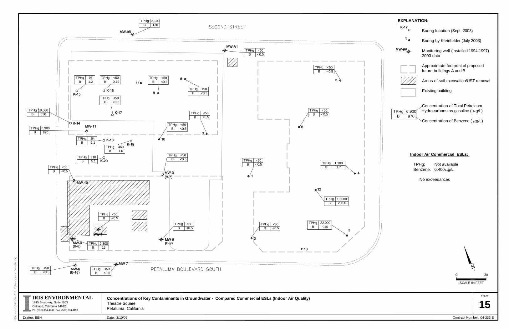
Concentrations of Key Contaminants in Groundwater - Compared Commercial ESLs (Indoor Air Quality)Theatre SquarePetaluma, California 15
N
SCALE IN FEET
0 30
Figure
1615 Broadway, Suite 1003Oakland, California 94612Ph. (510) 834-4747 Fax: (510) 834-4199
IRIS ENVIRONMENTAL
Drafter: Date: Contract Number: 04-333-EEBH
EXPLANATION:
Boring location (Sept. 2003)
Boring by Kleinfelder (July 2003)
Monitoring well (installed 1994-1997) 2003 data
Approximate footprint of proposed future buildings A and B
Areas of soil excavation/UST removal
Existing building
Concentration of Total Petroleum Hydrocarbons as gasoline ( g/L)
Concentration of Benzene ( g/L)
5
TPHgB
931.2
TPHgB
18,000530
TPHgB
6,900970
TPHgB
642.1
TPHgB
4601.6
TPHgB
<500.79
TPHgB
<50<0.5
TPHgB
<50<0.5
TPHgB
2,100130
TPHgB
<50<0.5
TPHgB
<50<0.5
TPHgB
<50<0.5
TPHgB
<50<0.5
TPHgB
<50<0.5
TPHgB
<50<0.5
TPHgB
<50<0.5
TPHgB
<50<0.5
TPHgB
<50<0.5
TPHgB
<50<0.5
TPHgB
<50<0.5
TPHgB
1,3001.7
TPHgB
19,0002,100
TPHgB
22,000940
TPHgB
<50<0.5
TPHgB
3105.1
TPHgB
2,30015
TPHgB
<50<0.5
TPHgB
6,900970
Indoor Air Commercial ESLs:
TPHg: Not availableBenzene: 6,400 g/L
No exceedances
TPHgB
<50<0.5
3/10/05

Concentrations of Key Contaminants in Shallow Soil Gas - Compared to Commercial ESLs (Indoor Air)Theatre SquarePetaluma, California 16
N
SCALE IN FEET
0 30
Figure
1615 Broadway, Suite 1003Oakland, California 94612Ph. (510) 834-4747 Fax: (510) 834-4199
IRIS ENVIRONMENTAL
Drafter: Date: Contract Number: 04-333-EEBH
EXPLANATION:
Kleinfelder soil gas sampling location (Sept. 2003)
Iris Environmental soil gas sample location (Dec. 2004)
Approximate footprint of proposed future buildings A and B
Areas of soil excavation/UST removal
Existing building
Sample not obtained, as soils at this depth were too moist and impermeable to give an adequate soil vapor sample
Sampling depth (feet below ground surface)
Concentration of Total Petroleum Hydrocarbons as gasoline in soil gas (µg/L)
Concentration of Benzene in soil gas (µg/L)
DepthTPHg
B
2-419
0.032
DepthTPHg
B
2-412
0.028
DepthTPHg
B
2-4130<0.5
DepthTPHg
B
2-42.1
0.013
DepthTPHg
B
2-44.80.02
DepthTPHg
B
2-419
0.032
DepthTPHg
B
2-452
<0.086
DepthTPHg
B
2-437
<0.078
DepthTPHg
B
2-430
<0.38
DepthTPHg
B
2-430
<0.039
DepthTPHg
B
2-44.2
0.016
DepthTPHg
B
2-426
<0.050
DepthTPHg
B
2-433
<0.058
DepthTPHg
B
2-41000.22
DepthTPHg
B
2-48,100
9.2
DepthTPHg
B
2-44900.79
DepthTPHg
B
2-443
0.039
DepthTPHg
B
2-484
0.13
DepthTPHg
B
2-41800.41
DepthTPHg
B
2-44102.0
DepthTPHg
B
2-42700.24
DepthTPHg
B
5**
DepthTPHg
B
5**
DepthTPHg
B
5**
DepthTPHg
B
5**
DepthTPHg
B
5**
DepthTPHg
B
57.1
0.027
DepthTPHg
B
54004.9
DepthTPHg
B
539
0.13
*
3/14/05
Benzene risk level > 10 (0.29 µg/L)
Benzene risk level >10 (29 µg/L)
TPHg > HQ of 1 (144 µg/L)
TPHg > HQ of 3 (432 µg/L)
IR-4
-6
-4

Concentrations of Key Contaminants in Shallow Soil Gas - Compared to Commercial ESLs (Nuisance)Theatre SquarePetaluma, California 17
N
SCALE IN FEET
0 30
Figure
1615 Broadway, Suite 1003Oakland, California 94612Ph. (510) 834-4747 Fax: (510) 834-4199
IRIS ENVIRONMENTAL
Drafter: Date: Contract Number: 04-333-EEBH
EXPLANATION:
Kleinfelder soil gas sampling location (Sept. 2003)
Iris Environmental soil gas sample location (Dec. 2004)
Approximate footprint of proposed future buildings A and B
Areas of soil excavation/UST removal
Existing building
Sample not obtained, as soils at this depth were too moist and impermeable to give an adequate soil vapor sample
Sampling depth (feet below ground surface)
Concentration of Total Petroleum Hydrocarbons as gasoline in soil gas (µg/L)
Concentration of Benzene in soil gas (µg/L)
>TPHg nuisance screening level for commercial (200 µg/L)
DepthTPHg
B
2-419
0.032
DepthTPHg
B
2-412
0.028
DepthTPHg
B
2-4130<0.5
DepthTPHg
B
2-42.1
0.013
DepthTPHg
B
2-44.80.02
DepthTPHg
B
2-419
0.032
DepthTPHg
B
2-452
<0.086
DepthTPHg
B
2-437
<0.078
DepthTPHg
B
2-430
<0.38
DepthTPHg
B
2-430
<0.039
DepthTPHg
B
2-44.2
0.016
DepthTPHg
B
2-426
<0.050
DepthTPHg
B
2-433
<0.058
DepthTPHg
B
2-41000.22
DepthTPHg
B
2-48,100
9.2
DepthTPHg
B
2-44900.79
DepthTPHg
B
2-443
0.039
DepthTPHg
B
2-484
0.13
DepthTPHg
B
2-41800.41
DepthTPHg
B
2-44102.0
DepthTPHg
B
2-42700.24
DepthTPHg
B
5**
DepthTPHg
B
5**
DepthTPHg
B
5**
DepthTPHg
B
5**
DepthTPHg
B
5**
DepthTPHg
B
57.1
0.027
DepthTPHg
B
54004.9
DepthTPHg
B
539
0.13
*
3/14/05
IR-4

\\iris1\Iris\Petaluma\draft era\Draft eraalp.plf.doc IRIS ENVIRONMENTAL
APPENDIX A

Lead
Lab #: 178131 Location: Petaluma-Bash St.Property Client: Iris Environmental Prep: EPA 3050B Project#: 04-333-B Analysis: EPA 6010B Analyte: Lead Batch#: 99906 Matrix: Soil Sampled: 03/09/05 Units: mg/Kg Received: 03/09/05 Basis: as received Prepared: 03/10/05 Diln Fac: 1.000 Analyzed: 03/10/05
Field ID Type Lab ID Result RL LEAD-K2-0.5 SAMPLE 178131-013 85 0.12 LEAD-K2-2.5 SAMPLE 178131-014 4.2 0.15
BLANK QC285406 0.32 0.15
RL= Reporting LimitPage 1 of 1 2.0

Batch QC Report
Lead
Lab #: 178131 Location: Petaluma-Bash St.Property Client: Iris Environmental Prep: EPA 3050B Project#: 04-333-B Analysis: EPA 6010B Analyte: Lead Diln Fac: 1.000 Field ID: ZZZZZZZZZZ Batch#: 99906 MSS Lab ID: 178105-010 Sampled: 03/08/05 Matrix: Soil Received: 03/08/05 Units: mg/Kg Prepared: 03/10/05 Basis: as received Analyzed: 03/10/05
Type Lab ID MSS Result Spiked Result %REC Limits RPD LimBS QC285407 100.0 96.50 97 80-120 BSD QC285408 100.0 93.00 93 80-120 4 20 MS QC285409 73.04 91.74 131.7 64 55-128 MSD QC285410 79.37 116.3 54 * 55-128 5 24
*= Value outside of QC limits; see narrativeRPD= Relative Percent DifferencePage 1 of 1 3.0


\\iris1\Iris\Petaluma\draft era\Draft eraalp.plf.doc IRIS ENVIRONMENTAL
APPENDIX B

• Recording Requested By: • Petaluma Theatre Square LLC, c/o Basin Street Properties • Attn: Jennifer Tompkins • 1318 Redwood Way, Suite 140 • Petaluma, California 94954 • • When Recorded, Mail To: • Bruce H. Wolfe, Executive Officer • California Regional Water Quality Control Board • San Francisco Bay Region • 1515 Clay Street, Suite 1400 • Oakland, California 94612 • •
• COVENANT AND ENVIRONMENTAL RESTRICTION • ON PROPERTY
• • Theatre Square, D Street and Petaluma Boulevard South, Petaluma, CA 94952
• • This Covenant and Environmental Restriction on Property (this "Covenant") is made as of the ____ day of __________, 20__ by Petaluma Theatre Square, LLC ("Covenantor") who is the Owner of record of that certain property situated at D Street and Petaluma Boulevard South, in the City of Petaluma, County of Sonoma, State of California, which is more particularly described in Exhibit A attached hereto and incorporated herein by this reference (such portion hereinafter referred to as the "Burdened Property"), for the benefit of the California Regional Water Quality Control Board for the San Francisco Bay Region (the "Board"), with reference to the following facts: • • A. The southeastern and western portions of the Burdened Property and groundwater underlying these portions of the property contain hazardous materials. •
B. Contamination of the Burdened Property. Soil at the Burdened Property was contaminated by the historic use of various portions of the property for vehicle maintenance, repair, painting and fueling, particularly the operation of gasoline stations on the southeastern and southwestern corners of the Property, conducted by previous owners and/or tenants at the Property. These operations resulted in contamination of soil and groundwater with organic and inorganic chemicals including total petroleum hydrocarbons (TPH) as gasoline and diesel, volatile organic compounds (VOCs), principally benzene, and metals, principally, lead, which constitute hazardous materials as that term is defined in Health & Safety Code Section 25260. Soil vapor at the Burdened Property has also been impacted by TPH and benzene. The Burdened Property has been the subject of extensive soil, groundwater and soil vapor investigations in the last fifteen years. The underground storage tanks (USTs) and contaminated soil accessible

2 DOCSSV1-55004.1/final draft deedrestriction-apr.24
around the gasoline station in the southwestern portion of the Burdened Property have been excavated and removed. A waste oil UST was removed from the northern portion of the Burdened Property, and a small volume of associated contaminated soil was found and removed. A gasoline UST was removed from the northern portion of the Burdened Property. Sampling and analysis in the vicinity of this gasoline UST indicated that significant contamination by petroleum-related compounds did not occur, and no additional soils were removed. In order to control impacts associated with residual contaminants in soil, groundwater, and soil vapor, the redevelopment of the Burdened Property has covered the entire surface of the Burdened Property with buildings and associated hardscape, except for small tree wells which are covered by metal grates. A Liquid Boot® membrane/liner has been installed beneath the slabs of all buildings constructed at the Burdened Property. A Liquid Boot® GeoVent has been incorporated beneath the slab of the building in the southeastern portion of the Site, in the area indicated in Exhibit A. There are separate HVAC (heating, ventilation, and air conditioning) systems for the first floor and the upper floors. A deed restriction and a Risk Management Plan (RMP) has been recorded and implemented at the Burdened Property. The purpose of the RMP is to identify activities where residual contaminants may be encountered, provide a notification procedure for those activities, develop procedures to ensure the integrity of the remedial controls, and to develop health and safety procedures to ensure safe and proper handling of the impacted soil and groundwater.
• • C. Exposure Pathways. The contaminants addressed in this Covenant are present in soil, groundwater, and soil vapor at the Burdened Property. Without the mitigation measures which have been performed on the Burdened Property, exposure to these contaminants could take place via direct contact with soils and inhalation of vapors which could potentially migrate to indoor air from the subsurface. The risk of public exposure to the contaminants has been substantially lessened by the remediation and controls described herein. • • D. Adjacent Land Uses and Population Potentially Affected. The Burdened Property is used for commercial premises on the ground floor, with residences on the second and third floors and is adjacent to residential and commercial land uses. • • E. Full and voluntary disclosure to the Board of the presence of hazardous materials on the Burdened Property has been made and extensive sampling of the Burdened Property has been conducted. • • F. Covenantor desires and intends that in order to benefit the Board, and to protect the present and future public health and safety, the Burdened Property shall be used in such a manner as to avoid potential harm to persons or property that may result from hazardous materials that may have been deposited on portions of the Burdened Property. • • G. Management of Residual Pollution. In order to assure continued protection of human health and the environment, a Risk Management Plan (RMP) has been prepared and is attached hereto and incorporated herein by this reference as “Exhibit B”. A copy of this document must be maintained by the Property Owner and shall be consulted prior to and complied with during any activities highlighted in the RMP.

3 DOCSSV1-55004.1/final draft deedrestriction-apr.24
• ARTICLE I
• GENERAL PROVISIONS •
• 1.1 Provisions to Run with the Land. This Covenant sets forth protective provisions, covenants, conditions and restrictions (collectively referred to as "Restrictions") upon and subject to which the Burdened Property and every portion thereof shall be improved, held, used, occupied, leased, sold, hypothecated, encumbered, and/or conveyed. The restrictions set forth in Article III are reasonably necessary to protect present and future human health and safety or the environment as a result of the presence on the land of hazardous materials. Each and all of the Restrictions shall run with the land, and pass with each and every portion of the Burdened Property, and shall apply to, inure to the benefit of, and bind the respective successors in interest thereof, for the benefit of the Board and all Owners and Occupants. Each and all of the Restrictions are imposed upon the entire Burdened Property unless expressly stated as applicable to a specific portion of the Burdened Property. Each and all of the Restrictions run with the land pursuant to section 1471 of the Civil Code. Each and all of the Restrictions are enforceable by the Board. • • 1.2 Concurrence of Owners and Lessees Presumed. All purchasers, lessees, or possessors of any portion of the Burdened Property shall be deemed by their purchase, leasing, or possession of such Burdened Property, to be in accord with the foregoing and to agree for and among themselves, their heirs, successors, and assignees, and the agents, employees, and lessees of such owners, heirs, successors, and assignees, that the Restrictions as herein established must be adhered to for the benefit of the Board and the Owners and Occupants of the Burdened Property and that the interest of the Owners and Occupants of the Burdened Property shall be subject to the Restrictions contained herein. • • 1.3 Incorporation into Deeds and Leases. Covenantor desires and covenants that the Restrictions set out herein shall be incorporated in and attached to each and all deeds and leases of any portion of the Burdened Property. Recordation of this Covenant shall be deemed binding on all successors, assigns, and lessees, regardless of whether a copy of this Covenant and Agreement has been attached to or incorporated into any given deed or lease. • • 1.4 Purpose. It is the purpose of this instrument to convey to the Board real property rights, which will run with the land, to facilitate the remediation of past environmental contamination and to protect human health and the environment by reducing the risk of exposure to residual hazardous materials.
• • ARTICLE II
• DEFINITIONS •
• 2.1 Board. "Board" shall mean the California Regional Water Quality Control Board for the San Francisco Bay Region and shall include its successor agencies, if any. • • 2.2 Improvements. "Improvements" shall mean all buildings, roads, driveways, regradings, and paved parking areas, constructed or placed upon any portion of the Burdened Property.

4 DOCSSV1-55004.1/final draft deedrestriction-apr.24
• • 2.3 Occupants. "Occupants" shall mean Owners and those persons entitled by ownership, leasehold, or other legal relationship to the exclusive right to use and/or occupy all or any portion of the Burdened Property. • • 2.4 Owner or Owners. "Owner" or "Owners" shall mean the Covenantor and/or its successors in interest, who hold title to all or any portion of the Burdened Property.
• ARTICLE III • DEVELOPMENT, USE AND CONVEYANCE OF THE BURDENED PROPERTY
• • 3.1 Restrictions on Development and Use. Covenantor promises to restrict the use of the Burdened Property as follows: • • a. Development on the ground floor of the Burdened Property shall be restricted to industrial, commercial or office space; • • b. No residence for human habitation shall be permitted on the ground floor of the Burdened Property; • • c. No hospitals shall be permitted on the ground floor of the Burdened Property; • • d. No schools for persons under 21 years of age shall be permitted on the ground floor of the Burdened Property; • • e. No day care centers for children or day care centers for Senior Citizens shall be permitted on the ground floor of the Burdened Property.; • • f. No Owners or Occupants of the Property or any portion thereof shall conduct any excavation work on the Property, without prior notification to the Board as outlined in the RMP. As outlined in the RMP, some excavation projects will require prior written permission from the Board. • • g. All uses and development of the Burdened Property shall be consistent with any applicable Board Order or Risk Management Plan, each of which is hereby incorporated by reference including future amendments thereto. All uses and development shall preserve the integrity of any cap, any remedial measures taken or remedial equipment installed, and any groundwater monitoring system installed on the Burdened Property pursuant to the requirements of the Board, unless otherwise expressly permitted in writing by the Board. • • h. No Owners or Occupants of the Property or any portion thereof shall drill, bore, otherwise construct, or use a well for the purpose of extracting water for any use, including but not limited to, domestic, potable, or industrial uses, unless expressly permitted in writing by the Board. •
5 DOCSSV1-55004.1/final draft deedrestriction-apr.24
• i. The Owner shall notify the Board of each of the following: (1) The type, cause, location and date of any disturbance to any cap, any remedial measures taken or remedial equipment installed, and of the groundwater monitoring system installed on the Burdened Property pursuant to the requirements of the Board, which could affect the ability of such cap or remedial measures, remedial equipment, or monitoring system to perform their respective functions and (2) the type and date of repair of such disturbance. Notification to the Board shall be made by registered mail within ten (10) working days of both the discovery of such disturbance and the completion of repairs. j. The Owner shall submit an annual summary report to the Board that describe in detail the type, cause, location and date of all of the previous year’s disturbance to any cap, any remedial measures taken or remedial equipment installed, and of the groundwater monitoring system installed on the Burdened Property pursuant to the requirements of the Board, which could affect the ability of such cap or remedial measures, remedial equipment, or monitoring system to perform their respective functions and the type and date of repair of such disturbance. • • k. The Covenantor agrees that the Board, and/or any persons acting pursuant to Board orders, shall have reasonable access to the Burdened Property for the purposes of inspection, surveillance, maintenance, or monitoring, as provided for in Division 7 of the Water Code. • • l. No Owner or Occupant of the Burdened Property shall act in any manner that will aggravate or contribute to the existing environmental conditions of the Burdened Property. All use and development of the Burdened Property shall preserve the integrity of any capped areas. • • 3.2 Enforcement. Failure of an Owner or Occupant to comply with any of the restrictions, as set forth in paragraph 3.1, shall be grounds for the Board, by reason of this Covenant, to have the authority to require that the Owner modify or remove any Improvements constructed in violation of that paragraph. Violation of the Covenant shall be grounds for the Board to file civil actions against the Owner as provided by law. • • 3.3 Notice in Agreements. After the date of recordation hereof, all Owners and Occupants shall execute a written instrument which shall accompany all purchase agreements or leases relating to the property. Any such instrument shall contain the following statement:
• • The land described herein contains hazardous materials in soils and in the ground water under the property, and is subject to a deed restriction dated as of ________________, 199_, and recorded on _______________, 199_, in the Official Records of ___________ County, California, as Document No. __________, which Covenant and Restriction imposes certain covenants, conditions, and restrictions on usage of the property described herein. This statement is not a declaration that a hazard exists.
• ARTICLE IV • VARIANCE AND TERMINATION
•

6 DOCSSV1-55004.1/final draft deedrestriction-apr.24
• 4.1 Variance. Any Owner or, with the Owner's consent, any Occupant of the Burdened Property or any portion thereof may apply to the Board for a written variance from the provisions of this Covenant. • • 4.2 Termination. Any Owner or, with the Owner's consent, any Occupant of the Burdened Property or a portion thereof may apply to the Board for a termination of the Restrictions as they apply to all or any portion of the Burdened Property. • • 4.3 Term. Unless terminated in accordance with paragraph 4.2 above, by law or otherwise, this Covenant shall continue in effect in perpetuity. • •
• ARTICLE V • MISCELLANEOUS
• • 5.1 No Dedication Intended. Nothing set forth herein shall be construed to be a gift or dedication, or offer of a gift or dedication, of the Burdened Property or any portion thereof to the general public. • • 5.2 Notices. Whenever any person gives or serves any notice, demand, or other communication with respect to this Covenant, each such notice, demand, or other communication shall be in writing and shall be deemed effective (1) when delivered, if personally delivered to the person being served or official of a government agency being served, or (2) three (3) business days after deposit in the mail if mailed by United States mail, postage paid certified, return receipt requested: • If To: "Covenantor" • Petaluma Theatre Square LLC, c/o Basin Street Properties • Attn: Property Manager and General Counsel • 1318 Redwood Way, Suite 140 • Petaluma, California 94954 • If To: "Board" • Regional Water Quality Control Board • San Francisco Bay Region • Attention: Executive Officer • 1515 Clay Street, Suite 1400 • Oakland, California 94612 • 5.3 Partial Invalidity. If any portion of the Restrictions or terms set forth herein is determined to be invalid for any reason, the remaining portion shall remain in full force and effect as if such portion had not been included herein. • • 5.4 Article Headings. Headings at the beginning of each numbered article of this Covenant are solely for the convenience of the parties and are not a part of the Covenant.
7 DOCSSV1-55004.1/final draft deedrestriction-apr.24
• • 5.5 Recordation. This instrument shall be executed by the Covenantor and by the Executive Officer of the Board. This instrument shall be recorded by the Covenantor in the County of Sonoma within ten (10) days of the date of execution. • • 5.6 References. All references to Code sections include successor provisions. 5.7 Construction. Any general rule of construction to the contrary notwithstanding, this instrument shall be liberally construed in favor of the Covenant to effect the purpose of this instrument and the policy and purpose of the Water Code. If any provision of this instrument is found to be ambiguous, an interpretation consistent with the purpose of this instrument that would render the provision valid shall be favored over any interpretation that would render it invalid. • IN WITNESS WHEREOF, the parties execute this Covenant as of the date set forth above. • Covenantor: ___________________________________ • By: __________________________________________ • Title: _________________________________________ • Date: _________________________________________ • Agency: State of California • Regional Water Quality Board, • San Francisco Bay Region • By:___________________________________________ • • Title: Executive Officer • Date:__________________________________________

8 DOCSSV1-55004.1/final draft deedrestriction-apr.24
• • STATE OF CALIFORNIA ) • ) • COUNTY OF ____________ ) • On __________, 20__ before me, the undersigned a Notary Public in and for said state, personally appeared [Covenantor], personally known to me or proved to me on the basis of satisfactory evidence to be the person who executed the within instrument. • WITNESS my hand and official seal. • _________________________________ • Notary Public in and for said • County and State • STATE OF CALIFORNIA ) • ) • COUNTY OF ____________ ) • On __________, 20__ before me, the undersigned a Notary Public in and for said state, personally appeared [EXECUTIVE OFFICER], personally known to me or proved to me on the basis of satisfactory evidence to be the person who executed the within instrument. • WITNESS my hand and official seal. • _________________________________ • Notary Public in and for said • County and State

9 DOCSSV1-55004.1/final draft deedrestriction-apr.24
• EXHIBIT A
• LEGAL DESCRIPTION OF PROPERTY


10 DOCSSV1-55004.1/final draft deedrestriction-apr.24
• EXHIBIT B
• RISK MANAGEMENT PLAN •
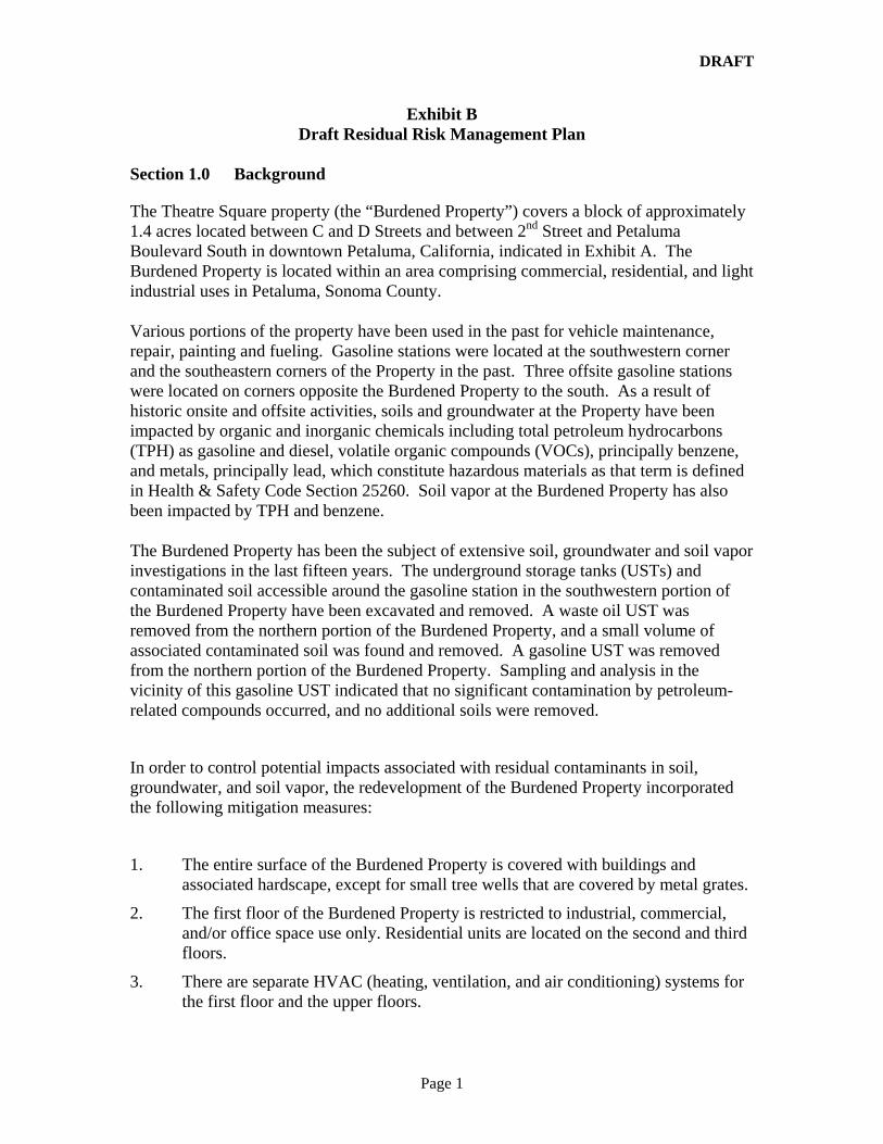
DRAFT
Page 1
Exhibit B Draft Residual Risk Management Plan
Section 1.0 Background
The Theatre Square property (the “Burdened Property”) covers a block of approximately 1.4 acres located between C and D Streets and between 2nd Street and Petaluma Boulevard South in downtown Petaluma, California, indicated in Exhibit A. The Burdened Property is located within an area comprising commercial, residential, and light industrial uses in Petaluma, Sonoma County.
Various portions of the property have been used in the past for vehicle maintenance, repair, painting and fueling. Gasoline stations were located at the southwestern corner and the southeastern corners of the Property in the past. Three offsite gasoline stations were located on corners opposite the Burdened Property to the south. As a result of historic onsite and offsite activities, soils and groundwater at the Property have been impacted by organic and inorganic chemicals including total petroleum hydrocarbons (TPH) as gasoline and diesel, volatile organic compounds (VOCs), principally benzene, and metals, principally lead, which constitute hazardous materials as that term is defined in Health & Safety Code Section 25260. Soil vapor at the Burdened Property has also been impacted by TPH and benzene.
The Burdened Property has been the subject of extensive soil, groundwater and soil vapor investigations in the last fifteen years. The underground storage tanks (USTs) and contaminated soil accessible around the gasoline station in the southwestern portion of the Burdened Property have been excavated and removed. A waste oil UST was removed from the northern portion of the Burdened Property, and a small volume of associated contaminated soil was found and removed. A gasoline UST was removed from the northern portion of the Burdened Property. Sampling and analysis in the vicinity of this gasoline UST indicated that no significant contamination by petroleum-related compounds occurred, and no additional soils were removed.
In order to control potential impacts associated with residual contaminants in soil, groundwater, and soil vapor, the redevelopment of the Burdened Property incorporated the following mitigation measures:
1. The entire surface of the Burdened Property is covered with buildings and associated hardscape, except for small tree wells that are covered by metal grates.
2. The first floor of the Burdened Property is restricted to industrial, commercial, and/or office space use only. Residential units are located on the second and third floors.
3. There are separate HVAC (heating, ventilation, and air conditioning) systems for the first floor and the upper floors.
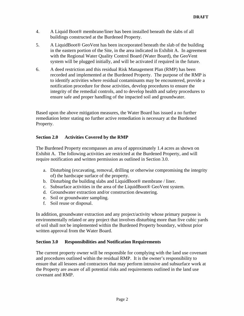
DRAFT
Page 2
4. A Liquid Boot® membrane/liner has been installed beneath the slabs of all buildings constructed at the Burdened Property.
5. A LiquidBoot® GeoVent has been incorporated beneath the slab of the building in the eastern portion of the Site, in the area indicated in Exhibit A. In agreement with the Regional Water Quality Control Board (Water Board), the GeoVent system will be plugged initially, and will be activated if required in the future.
6. A deed restriction and this residual Risk Management Plan (RMP) has been recorded and implemented at the Burdened Property. The purpose of the RMP is to identify activities where residual contaminants may be encountered, provide a notification procedure for those activities, develop procedures to ensure the integrity of the remedial controls, and to develop health and safety procedures to ensure safe and proper handling of the impacted soil and groundwater.
Based upon the above mitigation measures, the Water Board has issued a no further remediation letter stating no further active remediation is necessary at the Burdened Property.
Section 2.0 Activities Covered by the RMP The Burdened Property encompasses an area of approximately 1.4 acres as shown on Exhibit A. The following activities are restricted at the Burdened Property, and will require notification and written permission as outlined in Section 3.0.
a. Disturbing (excavating, removal, drilling or otherwise compromising the integrity of) the hardscape surface of the property.
b. Disturbing the building slabs and LiquidBoot® membrane / liner. c. Subsurface activities in the area of the LiquidBoot® GeoVent system. d. Groundwater extraction and/or construction dewatering. e. Soil or groundwater sampling. f. Soil reuse or disposal.
In addition, groundwater extraction and any project/activity whose primary purpose is environmentally related or any project that involves disturbing more than five cubic yards of soil shall not be implemented within the Burdened Property boundary, without prior written approval from the Water Board. Section 3.0 Responsibilities and Notification Requirements The current property owner will be responsible for complying with the land use covenant and procedures outlined within the residual RMP. It is the owner’s responsibility to ensure that all lessees and contractors that may perform intrusive and subsurface work at the Property are aware of all potential risks and requirements outlined in the land use covenant and RMP.

DRAFT
Page 3
The following notification must be provided if any of the activities listed in Section 2.0 are performed at the Burdened Property.
A. Internal – Prior to the commencement of any intrusive or subsurface activities identified in Section 2.0, the Owner’s Representative, listed below, must be notified in writing, and written approval must be obtained from the Owner’s Representative. Notification shall consist of a written plan describing in detail the proposed restricted activity and showing the locations of all subsurface activities. Any excavation will be restricted to the designated area and depth as outlined within the plan unless additional written approval is granted by the Owner’s Representative. A site-specific and project-specific health and safety plan must also be developed in accordance with 29 Code of Federal Regulations (29 CFR) and approved by the Owner’s Representative.
B. External - At least three working days prior to the commencement of any
intrusive or subsurface activities identified in Section 2.0, the Owner must notify the Regional Water Quality Control Board Toxics Cleanup Division in writing. The written notification shall describe in detail the type, cause, location and date of the intrusive or subsurface activities. Written approval from the Board will be required for any project/activity whose primary purpose is environmentally related or for any project that involves disturbing more than five cubic yards of soil. . The Water Board representative currently charged with the project site is listed below.
C. External - The Owner shall notify the Water Board of each of the following: (1)
The type, cause, location and date of any disturbance to any cap, any remedial measures taken or remedial equipment installed, and of the groundwater monitoring system installed on the Burdened Property pursuant to the requirements of the Water Board, which could affect the ability of such cap or remedial measures, remedial equipment, or monitoring system to perform their respective functions and (2) the type and date of repair of such disturbance. Notification to the Water Board shall be made by registered mail within ten (10) working days of both the discovery of such disturbance and the completion of repairs.
Phone Number Email Owner’s Representative Stephanie Burlingame (707) 793 1938 [email protected] Water Board Representative John Jang (510) 622-2366 [email protected] The current Property owner will be responsible for maintaining a current contact list. The contact information must be updated annually or as needed.

DRAFT
Page 4
Section 4.0 Health and Safety Plan Requirements Due to the potential exposure to residual TPH, benzene and isolated areas of lead that remain at the Property, a site-specific and project-specific health and safety plan (HASP) must be developed if any of the activities identified in Section 2.0 are performed at the Property. The HASP must be developed in accordance with 29 CFR and must address at a minimum potential exposure due to dermal contact and inhalation of residual TPH and benzene. The HASP must also specify an air monitoring program for VOCs when performing subsurface earth work and appropriate personal protective equipment (PPE) to be used. Section 5.0 Requirements for Disturbances to Hardscape, Building Slabs and
GeoVent System A. Hardscape As indicated in Section 3.0, a written plan must be prepared for any work in which the hardscape will be disturbed. The plan must include a description of the method by which the hardscape will be reinstated, and the schedule for the reinstatement of the hardscape. The plan must be approved by the Owner’s Representative. The reinstatement of the hardscape must be completed to the satisfaction of the Owner’s Representative, and must prevent contact with subsurface soils and infiltration of surface water. The Owner’s Representative must document the reinstatement of the hardscape. B. LiquidBoot® Membrane and GeoVent System Disturbance to the LiquidBoot® membrane under the building slab and / or GeoVent system should be avoided. If disturbance is unavoidable, a written plan must be prepared and must include a description of the method by which the membrane and / or GeoVent system will be reinstated. The plan must be approved by the Owner’s Representative. The repair of the membrane and / or GeoVent system must be completed to the satisfaction of the Owner’s Representative. The Owner’s Representative must retain documentation on the reinstatement of the membrane and / or GeoVent system and must make the documentation available to the Water Board on request. Section 6.0 Soil and Groundwater Management Requirements A. Soil Management A site-specific soil management plan (SMP) must be developed prior to the implementation of restricted activities listed in Section 2.0. At a minimum, the SMP should include dust control and monitoring measures, and management of soil stockpiles, etc. All soil at the Burdened Property must be handled in accordance with applicable local, state and federal regulations, the site and project specific HASP, and the site-specific

DRAFT
Page 5
soils management plan. If any soil is to be disposed of offsite, the soil must be tested for the applicable landfill acceptance criteria. At a minimum these are to include TPH, benzene and lead. B. Groundwater Management No groundwater shall be extracted and / or discharged from the Burdened Property without prior approval from the Water Board. Prior approval from other agencies may also be required. If dewatering activities will be conducted within the Burdened Property, then a groundwater sampling and handling plan must be developed and approved by the Owner’s Representative and the Water Board. C. Decontamination All equipment used in subsurface activities will be decontaminated before leaving the Burdened Property using visual inspection to verify that residual soils or groundwater have been removed. In addition, all operations that have the potential to generate or release hazardous material will be conducted in a controlled area using appropriate engineering controls. Specific decontamination techniques will be established based on conditions at the Property, and the activities to be performed. Decontamination procedures will be reviewed with all personnel onsite. Section 7.0 Annual Summary Report The Owner shall submit an annual summary report to the Board that describe in detail the type, cause, location and date of all of the previous year’s disturbance to any cap, any remedial measures taken or remedial equipment installed, and of the groundwater monitoring system installed on the Burdened Property pursuant to the requirements of the Water Board, which could affect the ability of such cap or remedial measures, remedial equipment, or monitoring system to perform their respective functions and the type and date of repair of such disturbance.