draft environmental study report for the phase 2...
TRANSCRIPT

FINAL ENVIRONMENTAL STUDY REPORT FOR THE PHASE 2 CONNECTING 17 REMOTE FIRST NATION COMMUNITIES PROJECT SECTION 3.0: PROJECT DESCRIPTION
November 2018 Report No. 18102677 GAL-005-REP-V1
APPENDIX 3.10A Corridor Alternatives Analysis


APPENDIX 3.10A Corridor Alternatives Analysis
November 2018 Report No. 18102677 GAL-005-REP-V1 i
Table of Contents
3.10A1.0 INTRODUCTION ..............................................................................................................................................1
3.10A2.0 CORRIDOR ALTERNATIVE ANALYSIS METHOD ........................................................................................2
3.10A3.0 RESULTS ........................................................................................................................................................5
3.10A3.1 Red Lake Subsystem .....................................................................................................................................5
3.10A3.1.1 North Spirit Lake First Nation to McDowell Lake First Nation .....................................................................5
3.10A3.1.2 Deer Lake First Nation to Sandy Lake First Nation ................................................................................... 11
3.10A3.2 Pickle Lake Subsystem ................................................................................................................................ 17
3.10A3.2.1 Muskrat Dam Transformer Station to Muskrat Dam First Nation .............................................................. 17
3.10A3.2.2 Kitchenuhmaykoosib Inninuwug to Wapekeka First Nation ...................................................................... 20
3.10A3.2.3 Kingfisher Lake First Nation to Wunnumin Lake First Nation .................................................................... 23
3.10A3.2.4 Wawakapewin First Nation to Kasabonika Lake First Nation .................................................................... 27
3.10A3.2.5 Muskrat Dam First Nation to Sachigo Lake First Nation ........................................................................... 31
3.10A3.2.6 Connection to Phase 1 Pickle Lake Transformer Station .......................................................................... 35
3.10A4.0 REFERENCES............................................................................................................................................... 39
TABLES Table 3.10A-1: Concordance between the Applicable Ministry of Natural Resources and Forestry Screening Criteria
and the Alternatives Assessment Metric Categories ................................................................................... 3
Table 3.10A-2: Corridor Alternative Analysis – North Spirit Lake First Nation to McDowell Lake First Nation ..................... 6
Table 3.10A-3: Corridor Alternative Analysis – Deer Lake First Nation to Sandy Lake First Nation................................... 12
Table 3.10A-4: Corridor Alternative Analysis – Muskrat Dam Transformer Station to Muskrat Dam First Nation .............. 17
Table 3.10A-5: Corridor Alternative Analysis – Kitchenuhmaykoosib Inninuwug to Wapekeka First Nation ...................... 20
Table 3.10A-6: Corridor Alternative Analysis – Kingfisher Lake First Nation to Wunnumin Lake First Nation ................... 23
Table 3.10A-7: Corridor Alternative Analysis – Wawakapewin First Nation to Kasabonika Lake First Nation ................... 27
Table 3.10A-8: Corridor Alternative Analysis – Muskrat Dam First Nation to Sachigo Lake First Nation ........................... 31
Table 3.10A-9: Baseline Characterization of the Revised Connection from the Pickle Lake Subsystem to Phase 1 Pickle Lake Transformer Station and Comparison of Transmission Line Rights-of-Way .......................... 36

APPENDIX 3.10A Corridor Alternatives Analysis
November 2018 Report No. 18102677 GAL-005-REP-V1 ii
ANNEXES ANNEX A Alternatives Metric Tables

APPENDIX 3.10A Corridor Alternatives Analysis
November 2018 Report No. 18102677 GAL-005-REP-V1 1
3.10A1.0 INTRODUCTION Section 3.10 Project Alternatives in the Draft Environmental Study Report (ESR) presents the corridor routing analysis, including consideration of results of engagement with First Nation communities, land use planning, and available baseline environmental spatial data. As noted in Section 3.10.3.3 of the Draft ESR, a further evaluation of corridor alternatives was completed in this appendix due to following:
To meet the requirement of the Class Environmental Assessment for MNR Resource Stewardship and Facility Development Projects (Ministry of Natural Resources [MNR]1 2003; Class EA for RSFD), an evaluation of corridor alternatives for sections of the line designed to operate at less than 115 kV is required to be undertaken for the Project’s transmission line connections between:
North Spirit Lake First Nation and McDowell Lake First Nation;
Muskrat Dam Transformer Station and Muskrat Dam First Nation;
Kitchenuhmaykoosib Inninuwug and Wapekeka First Nation;
Kingfisher Lake First Nation and Wunnumin Lake First Nation; and
Wawakapewin First Nation and Kasabonika Lake First Nation.
Evaluation of alternatives to determine the preferred corridor from corridors identified in the Project’s Notice of Commencement of the EA was also undertaken for the Project’s transmission line connections between:
Deer Lake First Nation and Sandy Lake First Nation; and
Muskrat Dam First Nation and Sachigo Lake First Nation.
The corridor alternatives are shown in Figure 3.10-4 and Figures 3.10-4A and 3.10-4B of the Draft ESR. Two specific corridor alternatives were evaluated for each corridor segment, except for the 25-kV transmission line connection between Kitchenuhmaykoosib Inninuwug and Wapekeka First Nation. The alternatives assessment for this segment of the transmission line was completed by comparing the proposed corridor to areas where a corridor could alternatively be located for this segment of the transmission line (i.e., areas within a 2-km-wide corridor along the proposed ROW). The proposed alignment is linked to the existing Diesel Generating Station (DGS) Upgrade and Micro Grid Connection Project, which follows the existing all-season road. The road represents the single linear corridor between the two communities. The Draft ESR conservatively includes this segment of the transmission line as part of the Phase 2 Project footprint, understanding that approvals continue to advance for the DGS Upgrade and Micro Grid Connection Project. Should the 25 kV line associated with the DGS Upgrade and Micro Grid Connection Project be constructed as planned in advance of development of the Phase 2 Project, the Phase 2 Project will connect to this existing project rather than constructing a new 25 kV line to connect these communities.
1 The Ministry of Natural Resources and Forestry (MNRF) was formerly known as the Ministry of Natural Resources (MNR) prior to its name
change in 2014.
APPENDIX 3.10A Corridor Alternatives Analysis
November 2018 Report No. 18102677 GAL-005-REP-V1 2
This appendix provides a high-level baseline characterization for the re-alignment of approximately 1.5 km of the Project’s 115-kV transmission line connecting the Pickle Lake subsystem to the proposed Phase 1 Pickle Lake transformer station2. The re-location of the proposed Phase 1 Pickle Lake transformer station requires an adjustment of the southern segment of the Project’s transmission line presented and assessed as part of the preliminary footprint in the Draft ESR report. The baseline characterization is presented for the modified transmission line ROW and is also compared against the baseline conditions identified for the preliminary transmission line ROW initially identified for this segment of the Project. The modified and preliminary transmission line ROWs are shown in Figure 3.10-4D of the Draft ESR.
The evaluation of alternative corridor options for sections of the Project crossing provincial parks and regulated dedicated protected areas, as required by the Class Environmental Assessment for Provincial Parks and Conservation Reserves (MNR2 2005), is presented in Appendix 7.4B of the Draft ESR as part of the non-Aboriginal land and resource use assessment.
3.10A2.0 CORRIDOR ALTERNATIVE ANALYSIS METHOD The following five key factors were considered in the evaluation of corridor alternatives:
natural environment;
land use and resource management;
socio-economic and cultural;
Aboriginal interest; and
technical, including constructability and relative cost which is derived primarily from technical constraints. Cost was not considered as the sole or overriding justification.
The metrics that were considered in the alternatives evaluation are presented in Annex A. The reported metrics represent publicly available datasets and datasets collected for the Project relevant to the study areas for the comparison of these corridor alternatives.
A review and comparison of the screening criteria in the Class EA for RSFD (MNR 2003) was completed against the alternatives assessment metrics, and a concordance exercise was undertaken to identify how each of the Class EA for RSFD screening criteria would be captured in the alternatives analysis presented herein. The concordance exercise, which was based on the criteria outlined in Table 3.1: Screening Criteria in the Class EA for RSFD (MNR 2003), is summarized in Table 3.10A-1.
Where screening criteria from the Class EA for RSFD (MNR 2003) have not been identified as metrics, they are not judged to mark a distinguishing characteristic between the alternatives (e.g., the Project is not expected to affect permafrost by identifying and avoiding through design; release of contaminants in soils and sediments will be managed through best management practices for all alternatives; the Project will have a high positive effect for
2 The proposed transformer station in Central Patricia part of Wataynikaneyap’s Phase 1, the New Transmission Line to Pickle Lake Project.
This transformer station is referred to in this document as the proposed Phase 1 Pickle Lake transformer station. The location of the proposed Phase 1 Pickle Lake transformer station is being adjusted due to historical contamination identified in the previously proposed site (Golder 2018).

APPENDIX 3.10A Corridor Alternatives Analysis
November 2018 Report No. 18102677 GAL-005-REP-V1 3
the 17 First Nations under all alternatives). See Table 9-11 in Section 9.0 of the Draft ESR for consideration of other screening criteria and identified mitigation. Mitigation measures summarized for the Project in Section 9.0 of the Draft ESR are applicable in all work areas for the Project.
Table 3.10A-1: Concordance between the Applicable Ministry of Natural Resources and Forestry Screening Criteria and the Alternatives Assessment Metric Categories
MNRF Screening Considerations
(MNR 2003) MNRF Screening Criteria
(MNR 2003) Applicable Alternatives
Assessment Metric Categories (see Annex A for data sources)
Natural Environment Air quality Point of reception Water quality or quantity (ground or surface) Waterbodies and watercourses Species at risk or their habitat Threatened and endangered
species or their habitat Significant earth or life science features ANSI Fish or other aquatic species, communities, or their habitat (including movement of resident or migratory species)
Waterbodies and watercourses
Land subject to natural or human-made hazards n/a Recovery of a species under a special management program (e.g., elk restoration)
Threatened and endangered species or their habitat
Ecological integrity ANSI; Wetlands; Waterbodies and watercourses; Vegetation; Wildlife habitat; Threatened and endangered
species or their habitat; and Bald eagle nesting sites
Terrestrial wildlife (including numbers, diversity and movement of resident or migratory species)
Wildlife habitat; Threatened and endangered
species or their habitat; and Bald eagle nesting sites
Natural vegetation and terrestrial habitat linkages or corridors through fragmentation, alteration and/or critical loss
ANSI; Wetlands; Vegetation; and Wildlife habitat
Permafrost n/a; discrete areas of permafrost will be avoided through Project design (e.g., through corridor routing; pole installation method) for less than 115 kV sections of the line

APPENDIX 3.10A Corridor Alternatives Analysis
November 2018 Report No. 18102677 GAL-005-REP-V1 4
Table 3.10A-1: Concordance between the Applicable Ministry of Natural Resources and Forestry Screening Criteria and the Alternatives Assessment Metric Categories
MNRF Screening Considerations
(MNR 2003) MNRF Screening Criteria
(MNR 2003)
Applicable Alternatives Assessment Metric Categories (see Annex A for data sources)
Natural Environment Soils and sediment quality n/a Drainage or flooding Waterbodies and watercourses Sedimentation or erosion Waterbodies and watercourses Release of contaminants in soils, sediments n/a Natural heritage features and areas (e.g. areas of natural and scientific interest, provincially significant wetlands)
ANSI; and Wetlands
Land Use, Resource Management
Access to trails or inaccessible areas (land or water) Trails Or obstruct navigation Waterbodies and watercourses Other resource management projects Land designation Traffic patterns or traffic infrastructure Existing infrastructure Recreational importance – public or private Tourism and recreation Creation of waste n/a Or commit a significant amount of a non-renewable resource (e.g. aggregates, agricultural land)
Land designation
Noise levels Point of reception
Views or aesthetics Tourism and recreation Or be a precondition or justification for implementing another project
n/a
Adjacent or nearby uses, persons or property Land designation; Tourism and recreation; Existing infrastructure; and Point of reception
Socio-economic and, Cultural
Cultural heritage resources – including archaeological sites, built heritage, and cultural heritage landscapes
Archaeology and cultural heritage
Built heritage and cultural heritage landscapes Archaeology and cultural heritage Or displace people, businesses, institutions, or public facilities
Land designation; Tourism and recreation; and Existing infrastructure
Community character, enjoyment of property, or local amenities
Tourism and recreation
Or increase demands on government services or infrastructure
Existing infrastructure
Public health and/or safety Point of reception Local, regional or provincial economies or businesses
Land designation
Tourism values (e.g. resource-based tourist lodge) Tourism and recreation
APPENDIX 3.10A Corridor Alternatives Analysis
November 2018 Report No. 18102677 GAL-005-REP-V1 5
Table 3.10A-1: Concordance between the Applicable Ministry of Natural Resources and Forestry Screening Criteria and the Alternatives Assessment Metric Categories
MNRF Screening Considerations
(MNR 2003) MNRF Screening Criteria
(MNR 2003)
Applicable Alternatives Assessment Metric Categories (see Annex A for data sources)
Aboriginal Interests First Nation reserves or communities Traditional land and resource use Spiritual, ceremonial, or cultural sites Traditional land or resources used for harvesting, activities Aboriginal values
Lands subject to land claims n/a
ANSI = Area of Natural and Scientific Interest; MNRF = Ontario Ministry of Natural Resources and Forestry; n/a = Not applicable.
3.10A3.0 RESULTS This section presents the comparative evaluation of the corridor alternatives. The alternatives metric tables used to support the analysis are presented in Annex A. The corridor alternatives were evaluated by comparing the presence of features within or where applicable, adjacent to the ROW, and by highlighting notable differences between corridor alternatives. The results are presented for each Project subsystem in the following order:
corridor segments designed to operate at 25 kV;
corridor segments designed to operate at 44 kV; and
corridor segments designed to operate at 115 kV.
The high-level baseline characterization for the modified ROW connecting the Project to the Phase 1 Pickle Lake transformer station is presented in Section 3.10A3.2.6.
The width of the ROW, the transmission line within it and the related construction activities are assumed to be as defined in Sections 3.4 and 3.5 of the Project Description for either alternative corridor.
The preferred corridors will be further refined during detailed design within the limits of work in an effort to avoid sensitive features, to the extent practical, and use previously disturbed areas. Efforts will be made to reduce environmental effects associated with the preferred corridor, and Wataynikaneyap with their contractor(s) will commit to implementing mitigation measures identified in the Draft ESR and adhere to all permits and approvals required for the Project.
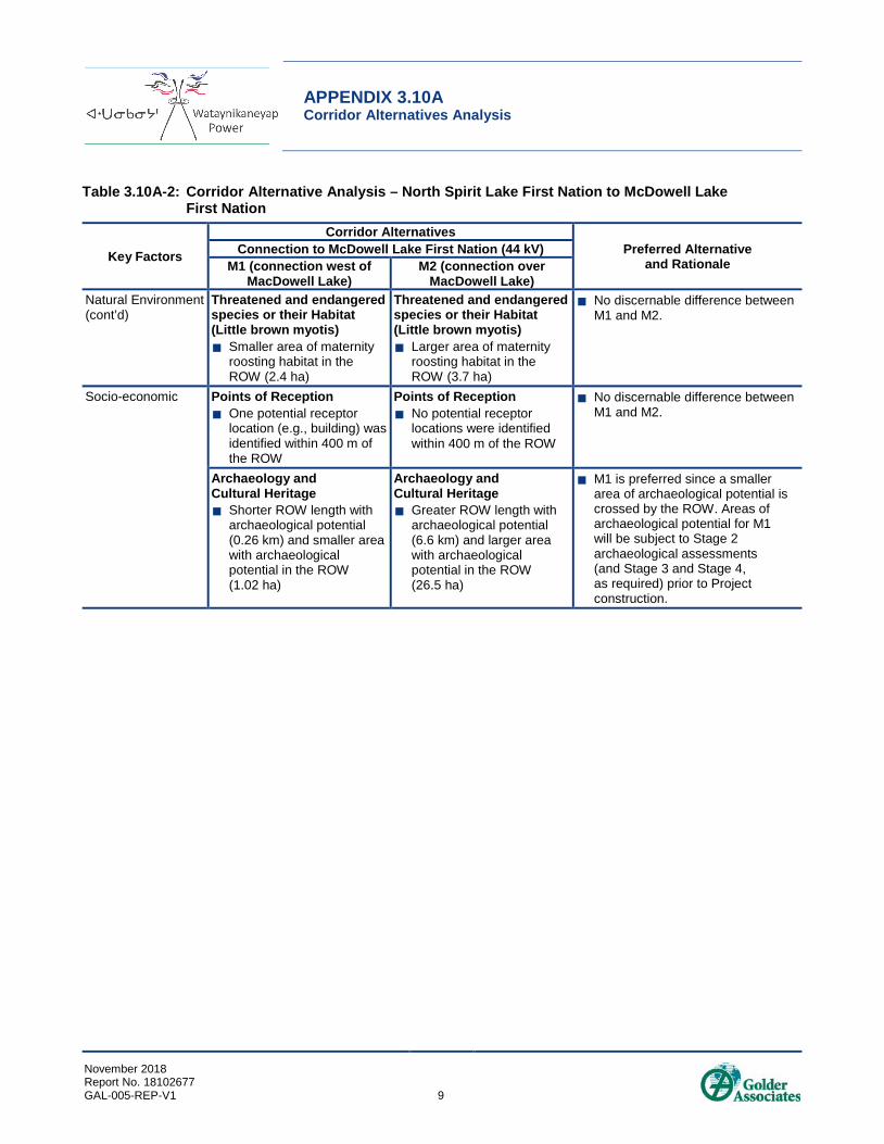
3.10A3.1 Red Lake Subsystem 3.10A3.1.1 North Spirit Lake First Nation to McDowell Lake First Nation The corridor alternative analysis for the transmission line connection to McDowell Lake First Nation is provided in Table 3.10A-2. The full set of metrics considered are presented in Annex A. Generally, habitat for wildlife criteria is similarly abundant and distributed along both corridor alternatives. No potential bat hibernacula features were observed along either of the corridor alternatives during field surveys in 2016 and 2017.

APPENDIX 3.10A Corridor Alternatives Analysis
November 2018 Report No. 18102677 GAL-005-REP-V1 6
Table 3.10A-2: Corridor Alternative Analysis – North Spirit Lake First Nation to McDowell Lake First Nation
Key Factors
Corridor Alternatives Preferred Alternative
and Rationale Connection to McDowell Lake First Nation (44 kV)
M1 (connection west of MacDowell Lake)
M2 (connection over MacDowell Lake)
Technical Size Larger ROW (42.5 km in
length and with an area of 170 ha)
Greater length of the ROW within 500 m of an existing linear corridor (3.7 km)
Size Smaller ROW (33.9 km in
length and with an area of 135.7 ha)
Shorter length of the ROW within 500 m of an existing linear corridor (0 km)
Includes a large water of crossing through MacDowell Lake
No discernable difference between M1 and M2 in size. The ROW for M1 is longer and requires a crossing of one existing road. A portion of the ROW (4.7 km) will be in proximity to the existing North Spirit Lake First Nation winter road, which minimizes disturbance to the natural environment by following other existing/planned disturbances, and by potentially using existing roads as access roads for the Project.
M1 is preferred as it avoids a large water crossing including in-water transmission structures for the section through MacDowell Lake.
Existing Infrastructure Greater number of existing
roads crossed by the ROW (1)
Existing Infrastructure No existing roads are
crossed by the ROW (0)
No discernable difference between M1 and M2.
Natural Environment Areas of Natural and Scientific Interest Larger area of mapped
candidate ANSI (Earth Science and Life Science) crossed by the ROW (69.3 ha)
Areas of Natural and Scientific Interest Smaller area of mapped
candidate ANSI (Earth Science and Life Science) in the ROW (19.1 ha)
M2 is preferred since a smaller area of candidate ANSI is crossed by the ROW.
Wetlands(a) Smaller area of mapped
wetlands in the ROW (30 ha)
Wetlands(a) Larger area of mapped
wetlands in the ROW (31.5 ha)
No discernable difference between M1 and M2.
Waterbodies and Watercourses(b) Fewer mapped
watercourses and waterbodies being crossed by the ROW (12 and 1, respectively)
Smaller area of mapped waterbodies(c) crossed by the ROW (0.1 ha)
Waterbodies and Watercourses(b) Greater number of mapped
watercourses and waterbodies being crossed by the ROW (22 and 3, respectively)
Larger area of mapped waterbodies(c) crossed by the ROW (17.9 ha)
Includes a large water of crossing through MacDowell Lake
M1 is preferred since fewer watercourses and waterbodies are crossed by the ROW. M1 is also preferred as it avoids crossing the transmission line through MacDowell Lake.

APPENDIX 3.10A Corridor Alternatives Analysis
November 2018 Report No. 18102677 GAL-005-REP-V1 7
Table 3.10A-2: Corridor Alternative Analysis – North Spirit Lake First Nation to McDowell Lake First Nation
Key Factors
Corridor Alternatives Preferred Alternative
and Rationale Connection to McDowell Lake First Nation (44 kV)
M1 (connection west of MacDowell Lake)
M2 (connection over MacDowell Lake)
Natural Environment (cont’d)
Vegetation Larger area of most
common land cover class in the ROW (83 ha; sparse forest)
Smaller area of least common land cover class in the ROW (0 ha; forest-dense deciduous and forest-regenerating depletion)
Vegetation Smaller area of most
common land cover class in the ROW (53.4 ha; sparse forest)
Larger area of least common land cover class in the ROW (1.2 ha - forest-dense deciduous)
M1 is preferred as the ROW would remove less area of the least common land cover class present in the ROW.
Wildlife Habitat Larger area of moose
habitat in the ROW (118.6 ha)
Smaller area of horned grebe habitat in the ROW (0.1 ha)
Larger area of bald eagle habitat in the ROW (26 ha)
Larger area of Canada warbler habitat in the ROW (49.9 ha)
Larger area of common nighthawk habitat in the ROW (120.9 ha)
Larger area of olive-sided flycatcher habitat in the ROW (35.6 ha)
The ROW does not cross areas of mapped potential habitat supporting provincially tracked wildlife species (0 ha).
Wildlife Habitat Smaller area of moose
habitat in the ROW (91.3 ha)
Larger area of horned grebe habitat in the ROW (19.5 ha)
Smaller area of bald eagle habitat in the ROW (14.4 ha)
Smaller area of Canada warbler habitat in the ROW (46.5 ha)
Smaller area of common nighthawk habitat in the ROW (76.5 ha)
Smaller area of olive-sided flycatcher habitat in the ROW (34.1 ha)
The ROW crosses areas of mapped potential habitat supporting provincially tracked wildlife species (39.5 ha).
No discernable difference between M1 and M2. While the ROW for M1 does not cross areas of mapped potential habitat supporting provincially tracked wildlife species, the ROW for M2 crosses slightly less modelled habitat for moose, breeding habitat for horned grebe, bald eagle, Canada warbler, common nighthawk and olive-sided flycatcher habitat (total of 144.7 ha of habitat in the ROW for M1 and total of 125.2 ha of habitat in the ROW for M2). Portions of the ROW for M1 are in proximity to areas where existing or proposed corridors are located/will be located, which may reduce potential effects to habitat distribution and connectivity, and sensory disturbance. Mitigation measures will be implemented for the Project in relation to wildlife habitat as described in Section 6.3 of the Draft ESR.
Bald Eagle Nesting Sites There is one known bald
eagle nest within the ROW
Bald Eagle Nesting Sites There are no known bald
eagle nests within the ROW
M2 is slightly preferred as there are no known bald eagle nests in the ROW. However, data on bald eagle nests in the Project area is not comprehensive and Project mitigation to limit disturbance to bald eagle nests, which may include relocating to maintain the appropriate setback (within the limits of works where possible) would be followed.

APPENDIX 3.10A Corridor Alternatives Analysis
November 2018 Report No. 18102677 GAL-005-REP-V1 8
Table 3.10A-2: Corridor Alternative Analysis – North Spirit Lake First Nation to McDowell Lake First Nation
Key Factors
Corridor Alternatives Preferred Alternative
and Rationale Connection to McDowell Lake First Nation (44 kV)
M1 (connection west of MacDowell Lake)
M2 (connection over MacDowell Lake)
Natural Environment (cont’d)
Threatened and endangered species or their Habitat (Woodland caribou) Smaller area of mapped
Category 1 high-use habitat (nursery areas) in the ROW (15.5 ha)
Larger area of mapped Category 2 seasonal range habitat in the ROW (151.3 ha)
Smaller area of mapped Category 3 habitat in the ROW (2.8 ha)
Larger area of travel corridors crossed by the ROW (38.3 ha – Spring; April, and 58.8 ha – Fall; November)
Threatened and endangered species or their Habitat (Woodland caribou) Larger area of mapped
Category 1 high-use habitat (nursery areas) in the ROW (37.1 ha)
Smaller area of mapped Category 2 seasonal range habitat in the ROW (80.7 ha)
Larger area of mapped Category 3 habitat in the ROW (17 ha)
Smaller area of travel corridors crossed by the ROW (21.4 ha – Spring; April, and 7.7 ha – Fall; November)
No discernable difference between M1 and M2. While the ROW for M1 overall crosses larger areas of mapped functional habitat for woodland caribou and woodland caribou travel corridors, it crosses less Category 1 habitat (nursery areas), which is high-use habitat considered to have features or areas that have the lowest tolerance to alteration before their function or usefulness is compromised (see Section 6.3 Wildlife and Appendix 6.3C Caribou Assessment for additional details on woodland caribou habitat classification). Portions of the ROW for M1 are in proximity to areas where existing or proposed corridors are located/will be located (see discussion for the size alternative feature above), which minimizes potential effects to habitat distribution and connectivity, and sensory disturbance.
Threatened and endangered species or their Habitat (Wolverine) Larger area of habitat in
the ROW (157.2 ha) Greater number of
identified boulder fields or blowdown areas representing potential den habitat crossed by the ROW (1). The potential den habitat was identified during field programs in the vicinity of the ROW
Threatened and endangered species or their Habitat (Wolverine) Smaller area of habitat in
the ROW (115.6 ha) No identified boulder fields
or blowdown areas representing potential den habitat crossed by the ROW
M2 is preferred since the ROW crosses a smaller area of wolverine habitat and there are no potential wolverine den habitat areas crossed by the ROW. However, data on potential wolverine den locations in the Project area is not comprehensive and Project mitigation to limit disturbance to active dens would be followed.
Portions of the ROW for M1 are in proximity to areas where existing or proposed corridors are located/will be located (, which may reduce potential effects to habitat distribution and connectivity, and sensory disturbance. Project mitigation to limit disturbance to active dens would be followed if active den sites are observed during Project construction (see Section 6.3 o).
APPENDIX 3.10A Corridor Alternatives Analysis
November 2018 Report No. 18102677 GAL-005-REP-V1 9
Table 3.10A-2: Corridor Alternative Analysis – North Spirit Lake First Nation to McDowell Lake First Nation
Key Factors
Corridor Alternatives Preferred Alternative
and Rationale Connection to McDowell Lake First Nation (44 kV)
M1 (connection west of MacDowell Lake)
M2 (connection over MacDowell Lake)
Natural Environment (cont’d)
Threatened and endangered species or their Habitat (Little brown myotis) Smaller area of maternity
roosting habitat in the ROW (2.4 ha)
Threatened and endangered species or their Habitat (Little brown myotis) Larger area of maternity
roosting habitat in the ROW (3.7 ha)
No discernable difference between M1 and M2.
Socio-economic Points of Reception One potential receptor
location (e.g., building) was identified within 400 m of the ROW
Points of Reception No potential receptor
locations were identified within 400 m of the ROW
No discernable difference between M1 and M2.
Archaeology and Cultural Heritage Shorter ROW length with
archaeological potential (0.26 km) and smaller area with archaeological potential in the ROW (1.02 ha)
Archaeology and Cultural Heritage Greater ROW length with
archaeological potential (6.6 km) and larger area with archaeological potential in the ROW (26.5 ha)
M1 is preferred since a smaller area of archaeological potential is crossed by the ROW. Areas of archaeological potential for M1 will be subject to Stage 2 archaeological assessments (and Stage 3 and Stage 4, as required) prior to Project construction.

APPENDIX 3.10A Corridor Alternatives Analysis
November 2018 Report No. 18102677 GAL-005-REP-V1 10
Table 3.10A-2: Corridor Alternative Analysis – North Spirit Lake First Nation to McDowell Lake First Nation
Key Factors
Corridor Alternatives Preferred Alternative
and Rationale Connection to McDowell Lake First Nation (44 kV)
M1 (connection west of MacDowell Lake)
M2 (connection over MacDowell Lake)
Aboriginal considerations
Traditional Land and Resource Use McDowell Lake First Nation An old trapline road, a
trapline, and a fish spawning area are crossed by the ROW.
Engagement input from a community elder advising that routing should better utilize the existing winter road out of North Spirit Lake First Nation and should stay to the west and south of MacDowell Lake. A possible watercourse crossing was identified.
North Spirit Lake First Nation Three winter trails,
three trapping areas, and one special place (spiritual/cultural) are crossed by the ROW.
Traditional Land and Resource Use McDowell Lake First Nation A trapline is crossed
by the ROW. North Spirit Lake
First Nation A trapping area and a
fishing area are crossed by the ROW.
M1 is preferred. While fewer mapped features are crossed by the ROW of M2, M1 is preferred based on input from an Elder from McDowell Lake First Nation advising that routing should better utilize the existing winter road out of North Spirit Lake First Nation and should stay to the west and south of McDowell Lake First Nation. Support was given by community representatives during engagements for the input provided by the community Elder.
Preferred Alternative M1 (connection west of MacDowell Lake)
a) All wetlands are understood to be unevaluated. b) In employing a conservative approach, this assessment assumes that all waterbodies and watercourses have the potential to support fish and fish habitat. c) Waterbodies not including watercourses.

APPENDIX 3.10A Corridor Alternatives Analysis
November 2018 Report No. 18102677 GAL-005-REP-V1 11
M1 (connection west of MacDowell Lake) is preferred over M2 (connection over MacDowell Lake). There are no existing linear corridor connections to McDowell Lake First Nation. The M1 option follows the existing winter road from North Spirit Lake First Nation where possible. M1 is preferred over M2 since it avoids crossing through MacDowell Lake, which is preferred from a socio-economic (visual aesthetics), natural environment, and technical perspective (crossing a larger body of water). M1 is also preferred since the ROW has less watercourse crossings overall and crosses fewer areas of archaeological potential. The ROW for M1 avoids mapped potential habitat supporting provincially tracked wildlife species and crosses smaller areas of mapped Category 1 high-use woodland caribou habitat. The M1 option crosses a slightly larger area of modelled habitat for certain wildlife criteria including some threatened/endangered wildlife species (e.g., wolverine); however, the M1 alternative include a larger area of land compared with M2 and portions of the ROW for M1 are in proximity to areas where existing or proposed corridors are located/will be located, which may reduce potential effects to habitat distribution and connectivity, and sensory disturbance. The M1 option does cross a larger area of candidate ANSIs (MacDowell Lake Flooded Fens and Harling Creek Valley candidate ANSIs); however, the Harling Creek Valley candidate ANSI would be crossed by either corridor option. The M1 option is in proximity to one known bald eagle nest location, where mitigation to limit disturbance to the nest would be implemented (see Section 6.3). The M1 option reflects the preference in routing identified through input received from community members of McDowell Lake First Nation during engagement activities, including the recommendation by a community Elder that routing should better utilize the existing winter road out of North Spirit Lake First Nation and should stay to the west and south of McDowell Lake First Nation. Therefore, M1 is considered the best alternative for the connection to McDowell Lake First Nation.
3.10A3.1.2 Deer Lake First Nation to Sandy Lake First Nation The alternative analysis for the southern portion of the transmission line connection between Deer Lake First Nation to Sandy Lake First Nation is provided in Table 3.10A-3. The full set of metrics considered are presented in Annex A. Generally, habitat for wildlife criteria is similarly abundant and distributed along both corridor alternatives. No bald eagle nests were observed along either of the corridor alternatives during field surveys in 2016 and 2017.

APPENDIX 3.10A Corridor Alternatives Analysis
November 2018 Report No. 18102677 GAL-005-REP-V1 12
Table 3.10A-3: Corridor Alternative Analysis – Deer Lake First Nation to Sandy Lake First Nation
Key Factors
Corridor Alternatives
Preferred Alternative and Rationale
Deer Lake First Nation to Sandy Lake First Nation (115 kV)
DS1 (connection along
existing winter road)
DS2 (connection along new ROW from Deer Lake
First Nation) Technical Size
Larger ROW (35.7 km in length and with an area of 142.8 ha)
Greater length of the ROW within 500 m of an existing linear corridor (35.7 km)
Size Smaller ROW (35.5 km in
length and with an area of 142.3 ha)
Shorter length of the ROW within 500 m of an existing linear corridor (2.4 km)
DS1 is preferred. The entire length of the ROW for DS1 is located within 500 m of an existing linear corridor, which will minimize disruption to the natural environment by having the ROW following other existing disturbances, and by using existing roads as access roads for the Project, where possible.
Existing Infrastructure Fewer existing roads within
the ROW (1) Greater number of
crossings of existing roads within the ROW (18)
Existing Infrastructure Greater number of existing
roads within the ROW (2) Fewer crossings of existing
roads within the ROW (2)
No discernable difference between DS1 and DS2. Although the ROW for DS1 has a greater number of existing road crossings, the main reason behind the several road crossings is that the entire length of the ROW follows an existing winter road.
Natural Environment Wetlands(a) Smaller area of mapped
wetlands in the ROW (17.2 ha)
Wetlands(a) Larger area of mapped
wetlands in the ROW (26.8 ha)
DS1 is preferred since a smaller area of mapped wetlands are crossed by the ROW.
Waterbodies and watercourses(b) Fewer mapped
watercourses crossed by the ROW (12)
Smaller area of mapped waterbodies(c) crossed by the ROW (0.1 ha)
Waterbodies and watercourses(b) Greater number of mapped
watercourses crossed by the ROW (17)
Larger area of mapped waterbodies(c) crossed by the ROW (0.3 ha)
No discernable difference between DS1 and DS2.
Vegetation Smaller area of most
common land cover class in the ROW (54 ha; forest-dense coniferous)
Smaller area of least common land cover class in the ROW (less than 0.1 ha; fen-treed)
Vegetation Larger area of most
common land cover class in the ROW (74.8 ha; forest-dense coniferous)
Larger area of least common land cover class in the ROW (0.1 ha; open water)
No discernible difference between DS1 and DS2

APPENDIX 3.10A Corridor Alternatives Analysis
November 2018 Report No. 18102677 GAL-005-REP-V1 13
Table 3.10A-3: Corridor Alternative Analysis – Deer Lake First Nation to Sandy Lake First Nation
Key Factors
Corridor Alternatives
Preferred Alternative and Rationale
Deer Lake First Nation to Sandy Lake First Nation (115 kV)
DS1 (connection along
existing winter road)
DS2 (connection along new ROW from Deer Lake
First Nation) Natural Environment (cont’d)
Wildlife Habitat Smaller area of moose
habitat in the ROW (121 ha)
Larger area of horned grebe habitat in the ROW (0.5 ha)
Smaller area of bald eagle habitat in the ROW (80.4 ha)
Larger area of Canada warbler habitat in the ROW (37.6 ha)
Larger area of common nighthawk habitat in the ROW (50 ha)
Smaller area of olive-sided flycatcher habitat in the ROW (81.1 ha)
The ROW does not cross areas of mapped potential habitat supporting provincially tracked wildlife species (0 ha).
Wildlife Habitat Larger area of moose
habitat in the ROW (126 ha)
Smaller area of horned grebe habitat in the ROW (0.4 ha)
Larger area of bald eagle habitat in the ROW (87.3 ha)
Smaller area of Canada warbler habitat in the ROW (27.8 ha)
Smaller area of common nighthawk habitat in the ROW (45.1 ha)
Larger area of olive-sided flycatcher habitat in the ROW (91.4 ha)
The ROW crosses areas of mapped potential habitat supporting provincially tracked wildlife species (10.2 ha).
DS1 is preferred since no areas of mapped potential habitat supporting provincially tracked wildlife species are crossed by the ROW and overall less habitat for wildlife criteria (not threatened or endangered species) is crossed by the ROW (201.9 ha in the ROW for DS1 and 213.7 ha in the ROW for DS2).

APPENDIX 3.10A Corridor Alternatives Analysis
November 2018 Report No. 18102677 GAL-005-REP-V1 14
Table 3.10A-3: Corridor Alternative Analysis – Deer Lake First Nation to Sandy Lake First Nation
Key Factors
Corridor Alternatives
Preferred Alternative and Rationale
Deer Lake First Nation to Sandy Lake First Nation (115 kV)
DS1 (connection along
existing winter road)
DS2 (connection along new ROW from Deer Lake
First Nation) Natural Environment (cont’d)
Threatened and endangered species or their Habitat (Woodland Caribou) Mapped Category 1 high-
use habitat (nursery areas) in the ROW (36 ha)
No mapped Category 1 habitat (winter areas) in the ROW (0 ha)
No mapped Category 2 seasonal range habitat in the ROW (0 ha)
Larger area of mapped Category 3 habitat in the ROW (106.8 ha)
Smaller area of travel corridors crossed by the ROW (22.3 ha – Spring; April, and 38.3 ha – Fall; November)
Threatened and endangered species or their Habitat (Woodland Caribou) No mapped Category 1
habitat (nursery areas) in the ROW (0 ha)
Mapped Category 1 habitat (winter areas) in the ROW (53.5 ha)
Mapped Category 2 seasonal range habitat in the ROW (40.6 ha)
Smaller area of mapped Category 3 habitat in the ROW (48.2 ha)
Larger area of travel corridors crossed by the ROW (74.2 ha – Spring; April, and 0 ha – Fall; November)
DS1 is preferred. While the ROW for DS1 overall crosses a similar amount of mapped functional habitat for woodland caribou and woodland caribou travel corridors to the ROW of DS2, DS1 crosses less Category 1 habitat which is high-use habitat considered to have features or areas that have the lowest tolerance to alteration before their function or usefulness is compromised (see Section 6.3 Wildlife and Appendix 6.3C Caribou Assessment for additional details on woodland caribou habitat classification). Also, the Category 1 habitat crossed by DS1 represents nursery areas and not winter use areas. As Project construction will require winter construction activities, timing windows to avoid disturbance to nursery areas can more readily be implemented. Areas of spring and fall travel corridors are crossed by DS1.
DS1 does not cross Category 2 seasonal range habitat (features or areas that have moderate tolerance to alteration).
The entire ROW for DS1 is within 500 m of existing linear corridors (see discussion for the size alternative feature above), which in turn minimizes potential effects to habitat distribution and connectivity, and sensory disturbance.

APPENDIX 3.10A Corridor Alternatives Analysis
November 2018 Report No. 18102677 GAL-005-REP-V1 15
Table 3.10A-3: Corridor Alternative Analysis – Deer Lake First Nation to Sandy Lake First Nation
Key Factors
Corridor Alternatives
Preferred Alternative and Rationale
Deer Lake First Nation to Sandy Lake First Nation (115 kV)
DS1 (connection along
existing winter road)
DS2 (connection along new ROW from Deer Lake
First Nation) Natural Environment (cont’d)
Threatened and endangered species or their Habitat (Wolverine) Smaller area of habitat in
the ROW (136.1 ha) There are no identified
boulder fields or blowdown areas representing potential den habitat crossed by the ROW
Threatened and endangered species or their Habitat (Wolverine) Larger area of habitat in
the ROW (138.6 ha) Greater number of
identified boulder fields or blowdown areas representing potential den habitat crossed by the ROW (2). The potential den habitat was identified during field programs in the vicinity of the ROW.
DS1 is preferred since the ROW does not cross areas representing potential wolverine den habitat. However, data on potential wolverine den locations in the Project area is not comprehensive and Project mitigation to limit disturbance to active dens would be followed if active den sites are observed during Project construction (see Section 6.3).
Threatened and endangered species or their Habitat (Little brown myotis) Larger area of maternity
roosting habitat in the ROW (26.4 ha)
Potential bat hibernacula locations were identified during field programs in the vicinity of the ROW (3 locations)
Threatened and endangered species or their Habitat (Little brown myotis) Smaller area of maternity
roosting habitat in the ROW (12.5 ha)
Potential bat hibernacula locations were identified during field programs in the vicinity of the ROW (3 locations)
No discernable difference between DS1 and DS2.
Mitigation measures will be implemented for the Project in relation to bat maternity roosting habitat and hibernacula, including timing restrictions for Project construction, as described in Section 6.3.
Land Use Land Designation Greater number of mining
claims (3) and larger area of active mining claims (6.7 ha) crossed by the ROW.
Land Designation No mining claims are
crossed by the ROW (0).
DS2 is preferred since no mining claims are crossed by the ROW.
Socio-economic Points of Reception No potential receptor
locations (e.g., building) were identified within 400 m of the ROW
Points of Reception 30 potential receptor
locations (e.g., building) were identified within 400 m of the ROW
DS1 is preferred since no potential receptor locations (e.g., building) were identified within 400 m of the ROW
Tourism and Recreation Equal number of non-OTN
trails crossed by the ROW (2) but greater length of non-OTN trails crossed (0.19 km)
Tourism and Recreation Equal number of non-OTN
trails crossed by the ROW (2) but shorter length of non-OTN trails crossed (0.08 km)
No discernable difference between DS1 and DS2.

APPENDIX 3.10A Corridor Alternatives Analysis
November 2018 Report No. 18102677 GAL-005-REP-V1 16
Table 3.10A-3: Corridor Alternative Analysis – Deer Lake First Nation to Sandy Lake First Nation
Key Factors
Corridor Alternatives
Preferred Alternative and Rationale
Deer Lake First Nation to Sandy Lake First Nation (115 kV)
DS1 (connection along
existing winter road)
DS2 (connection along new ROW from Deer Lake
First Nation) Aboriginal considerations
Traditional Land and Resource Use Sandy Lake First Nation A woodland caribou
crossing, one trapline, and a hunting area are crossed by the ROW. Spiritual sites are said to occur throughout the land used by Sandy Lake First Nation as all land is stated as sacred by the community.
Deer Lake First Nation One trapline, two fish
spawning areas, and one moose hunting area are crossed by the ROW.
North Spirit Lake First Nation One summer trail, one
winter trail, and a trapping area are crossed by the ROW
Traditional Land and Resource Use Sandy Lake First Nation Two traplines and a
woodland caribou crossing are crossed by the ROW. Spiritual sites are said to occur throughout the land used by Sandy Lake First Nation as all land is stated as sacred by the community.
Deer Lake First Nation One trapline, seven
travel routes, one plant harvesting area, two fish spawning areas, one moose area, and six moose hunting areas are crossed by the ROW.
Deer Lake First Nation and Sandy Lake First Nation community members identified that DS2 passes through important woodland caribou habitat.
DS1 is preferred. A general preference was shown by both Sandy Lake First Nation and Deer Lake First Nation communities for DS1 since it follows an existing winter road and it avoids important woodland caribou habitat crossed by DS2.
Preferred Alternative DS1 (connection along existing winter road)
a) All wetlands are understood to be unevaluated. b) In employing a conservative approach, this assessment assumes that all waterbodies and watercourses have the potential to support fish and fish habitat. c) Waterbodies not including watercourses.
DS1 is technically preferred since it follows the existing winter road from its junction with Deer Lake First Nation/North Spirit Lake First Nation, facilitating better access for construction (see Figure 3.10-1 in Section 3.10 of the Draft ESR). Preference to follow the existing winter road was also expressed by Sandy Lake First Nation and Deer Lake First Nation during engagement activities. DS1 is also preferred as the ROW crosses a smaller area of mapped wetlands, crosses slightly less habitat for wildlife criteria (not threatened or endangered), avoids areas of mapped potential habitat supporting provincially tracked wildlife species, crosses less Category 1

APPENDIX 3.10A Corridor Alternatives Analysis
November 2018 Report No. 18102677 GAL-005-REP-V1 17
high-use woodland caribou habitat overall and less winter use habitat in particular, and avoids Category 2 seasonal range woodland caribou habitat. The DS1 option does cross a larger area of maternity roosting habitat for little brown myotis, a larger area of Canada warbler habitat, and a slightly larger area of common nighthawk habitat; however, DS1 avoids areas of potential wolverine den habitat, crosses slightly less habitat for olive-sided flycatcher, and the entire ROW for DS1 is within 500 m of existing linear corridors, which in turn minimizes potential effects to habitat distribution and connectivity, and sensory disturbance. Moreover, no potential receptor locations (e.g., building) were identified within 400 m of the ROW for DS1. Therefore, DS1 is considered the best alternative for the southern connection between Deer Lake First Nation to Sandy Lake First Nation.
3.10A3.2 Pickle Lake Subsystem 3.10A3.2.1 Muskrat Dam Transformer Station to Muskrat Dam First Nation The alternative analysis for the 25-kV transmission line connection to Muskrat Dam First Nation is provided in Table 3.10A-4. The full set of metrics considered are presented in Annex A. Generally, habitat for wildlife criteria is similarly abundant and distributed along both corridor alternatives. No bald eagle nests, potential bat hibernacula features, or areas of potential wolverine den habitat were observed along either of the corridor alternatives during field surveys in 2016 and 2017.
Table 3.10A-4: Corridor Alternative Analysis – Muskrat Dam Transformer Station to Muskrat Dam First Nation
Key Factors
Corridor Alternatives
Preferred Alternative and Rationale
Muskrat Dam Transformer Station to Muskrat Dam First Nation (25 kV)
MD1 (connection following existing winter road
alignment)
MD2 (connection following
preliminary 115-kV transmission line ROW)
Technical Size Larger ROW (6.1 km in
length, 40 m wide, and with an area of 24.4 ha)
The ROW follows the existing winter road alignment, and would require a greater number of turning points.
Size Smaller ROW (5.7 km
in length, 20 m wide where the ROW is adjacent to the 115 kV line ROW, and with an area of 15.9 ha)
The ROW follows the Project’s preliminary 115-kV transmission line ROW, and would require less turning points for the 25-kV transmission line.
MD2 is preferred. Twinning the planned 40-m-wide alignment ROW for the 115-kV line allows the 25-kV section to overlap the existing corridor, so less clearing is required compared with the option of twinning the existing winter road, which would require additional clearing to maintain a 40-m-wide clearance.
Existing Infrastructure Greater number of
other existing linear corridors crossed by the ROW (9)
Existing Infrastructure Fewer existing linear
corridors crossed by the ROW (3)
MD2 is preferred since the ROW crosses existing linear corridors fewer times.

APPENDIX 3.10A Corridor Alternatives Analysis
November 2018 Report No. 18102677 GAL-005-REP-V1 18
Table 3.10A-4: Corridor Alternative Analysis – Muskrat Dam Transformer Station to Muskrat Dam First Nation
Key Factors
Corridor Alternatives
Preferred Alternative and Rationale
Muskrat Dam Transformer Station to Muskrat Dam First Nation (25 kV)
MD1 (connection following existing winter road
alignment)
MD2 (connection following
preliminary 115-kV transmission line ROW)
Natural Environment Wetlands(a) Larger area of mapped
wetlands in the ROW (12.5 ha)
Wetlands(a) Smaller area of
mapped wetlands in the ROW (7.5 ha)
No discernable difference between MD1 and MD2.
Vegetation Larger area of most
common land cover class in the ROW (6.9 ha; forest-dense mixed)
Vegetation Smaller area of most
common land cover class in the ROW (5.8 ha; forest-dense mixed)
No discernable difference between MD1 and MD2.
Wildlife Habitat Larger area of moose
habitat in the ROW (21.3 ha)
Larger area of bald eagle habitat in the ROW (8.5 ha)
Larger area of mapped occurrences of potential habitat supporting provincially tracked wildlife species in the ROW (24.4 ha)
Larger area of Canada warbler habitat in the ROW (16.4 ha)
Larger area of common nighthawk habitat in the ROW (4.9 ha)
Larger area of olive-sided flycatcher habitat in the ROW (17.5 ha)
Wildlife Habitat Smaller area of moose
habitat in the ROW (14.2 ha)
Smaller area of bald eagle habitat in the ROW (6.6 ha)
Smaller area of mapped occurrences of potential habitat supporting provincially tracked wildlife species in the ROW (15.9 ha)
Smaller area of Canada warbler habitat in the ROW (10.6 ha)
Smaller area of common nighthawk habitat in the ROW (3.6 ha)
Smaller area of olive-sided flycatcher habitat in the ROW (11.1 ha)
No discernable difference between MD1 and MD2. While the ROW for MD1 crosses a slightly larger area of potential habitat supporting provincially tracked wildlife species as well as non-endangered or threatened species, the entirety of the ROW follows an existing linear disturbance (i.e., the existing winter road). The ROW for MD2 is also located within 500 m of the existing winter road.
Threatened and endangered species or their Habitat (Woodland caribou) Greater area of
mapped Category 3 habitat in the ROW (24.4 ha)
Threatened and endangered species or their Habitat (Woodland caribou) Smaller area of
mapped Category 3 habitat in the ROW (15.9 ha)
No discernable difference between MD1 and MD2. While the ROW for MD1 crosses a larger area of mapped Category 3 habitat for woodland caribou, the entirety of the ROW follows an existing linear disturbance (i.e., the existing winter road). The ROW for MD2 is also located within 500 m of the existing winter road.

APPENDIX 3.10A Corridor Alternatives Analysis
November 2018 Report No. 18102677 GAL-005-REP-V1 19
Table 3.10A-4: Corridor Alternative Analysis – Muskrat Dam Transformer Station to Muskrat Dam First Nation
Key Factors
Corridor Alternatives
Preferred Alternative and Rationale
Muskrat Dam Transformer Station to Muskrat Dam First Nation (25 kV)
MD1 (connection following existing winter road
alignment)
MD2 (connection following
preliminary 115-kV transmission line ROW)
Natural Environment (cont’d)
Threatened and endangered species or their Habitat (Wolverine) Larger area of habitat
crossed by the ROW (23 ha).
Threatened and endangered species or their Habitat (Wolverine) Smaller area of habitat
crossed by the ROW (15.0 ha).
No discernable difference between MD1 and MD2.
Threatened and endangered species or their Habitat (Little brown myotis) Larger area of
maternity roosting habitat crossed by the ROW (7.3 ha).
Threatened and endangered species or their Habitat (Little brown myotis) Smaller area of
maternity roosting habitat crossed by the ROW (6.1 ha).
No discernable difference between MD1 and MD2.
Aboriginal considerations
Traditional Land and Resource Use No traditional land and
resource use features were identified within the ROW by Muskrat Dam First Nation community members
Traditional Land and Resource Use No traditional land and
resource use features were identified within the ROW by Muskrat Dam First Nation community members
No difference between MD1 and MD2.
Preferred Alternative MD2 (connection following preliminary 115-kV transmission line ROW)
a) All wetlands are understood to be unevaluated. b) In employing a conservative approach, this assessment assumes that all waterbodies and watercourses have the potential to support fish and fish habitat.
MD2 (connection following the preliminary 115-kV transmission line ROW) is preferred over MD1 (connection following the existing winter road alignment). As shown in Figure 3.10-4A, the ROW for MD1 has a greater number of turning points compared to the ROW for MD2. The higher the turning points along the transmission line, the greater the technical complexity and costs associated with its construction and maintenance, which in turn could affect the Project schedule. Regarding the natural environment, there is no discernable difference between MD1 and MD2.
A high-ground winter/potential all-season road between North Caribou Lake, Muskrat Dam, Sachigo Lake and Bearskin Lake First Nations is currently being studied and planned, which may replace the need for the existing winter road location to which the MD1 option is aligned. Accordingly, having the 25-kV section aligned with the 115-kV line may reduce the number of permanent linear corridors. MD2 is also preferred because a large portion of the ROW would be adjacent to the preliminary 115-kV transmission line ROW for the Project, so a smaller area

APPENDIX 3.10A Corridor Alternatives Analysis
November 2018 Report No. 18102677 GAL-005-REP-V1 20
of clearing (approximately 20-m-wide ROW) would be required for the 25-kV transmission line instead of a 40-m-wide ROW in these areas3.
3.10A3.2.2 Kitchenuhmaykoosib Inninuwug to Wapekeka First Nation This section presents the alternative analysis for the segment of the 25-kV transmission line connection between Kitchenuhmaykoosib Inninuwug and Wapekeka First Nation for a 3-km section between the reserve boundaries. A summary of features within the ROW (i.e., 40-m-wide corridor) are provided in Table 3.10A-5 and the full set of metrics considered are presented in Annex A. These metrics were qualitatively compared to areas within the 2-km-wide corridor along the proposed ROW to understand which features were also present or absent within these areas, and whether another 40-m-wide corridor alternative within the 2-km-wide corridor could be viable for this segment of the transmission line connection between Kitchenuhmaykoosib Inninuwug and Wapekeka First Nation. This qualitative comparison is also provided in Table 3.10A-5. Generally, habitat for wildlife criteria is similarly abundant and distributed along the proposed ROW and areas within the 2-km wide corridor along the proposed ROW. No bald eagle nests, potential bat hibernacula features, or potential wolverine den habitat were observed along the proposed ROW or adjacent to it within the 2-km-wide corridor during field surveys in 2016 and 2017.
Table 3.10A-5: Corridor Alternative Analysis – Kitchenuhmaykoosib Inninuwug to Wapekeka First Nation
Key Factors
Connection to Wapekeka First Nation (25 kV) Rationale for the Proposed ROW as the Preferred Alternative
(connection following routing planned for the Proposed DGS Upgrade and Micro Grid Connection Project4)
Technical Size Total length of the proposed ROW is 2.8 km and total area of the ROW is 11.2 ha.
The ROW provides a relatively direct connection between Kitchenuhmaykoosib Inninuwug and Wapekeka First Nation and to the rest of the 25-kV transmission line connection, requiring minimal turning points.
A re-alignment of the ROW within the 2-km-wide corridor may require additional length for the transmission line connection and increased turning points, which are not preferred from a technical perspective.
Existing Infrastructure The proposed ROW follows existing linear corridors for the entirety of its length and also
follows the route of the Proposed DGS Upgrade and Micro Grid Connection Project. No additional existing linear corridors are located within the 2-km-wide corridor along the
proposed ROW that span in an east to west direction, which could potentially be followed by an alternative ROW.
Natural Environment Wetlands(a) 5.4 ha of mapped wetlands are within the proposed ROW. Mapped wetlands are also present within the 2-km-wide corridor along the proposed ROW;
however, with fewer mapped wetlands south of the proposed ROW.
3 The Project transmission line ROW along these portions of the line would be 60-m-wide to accommodate both the 115kV line (40-m-wide corridor) and the MD2 25-kV line (20-m-wide corridor). 4 As part of a third-party-led project, the Proposed DGS Upgrade and Micro Grid Connection is in progress, which includes development of a
25-kV overhead line connecting Kitchenuhmaykoosib Inninuwug and Wapekeka First Nation. Should this 25-kV line be constructed as planned in advance of development of the Phase 2 Project, the Phase 2 Project will connect to this existing project rather than constructing a new 25-kV line to connect these communities.

APPENDIX 3.10A Corridor Alternatives Analysis
November 2018 Report No. 18102677 GAL-005-REP-V1 21
Table 3.10A-5: Corridor Alternative Analysis – Kitchenuhmaykoosib Inninuwug to Wapekeka First Nation
Key Factors
Connection to Wapekeka First Nation (25 kV) Rationale for the Proposed ROW as the Preferred Alternative
(connection following routing planned for the Proposed DGS Upgrade and Micro Grid Connection Project4)
Natural Environment (cont’d)
Waterbodies and Watercourses(b) No mapped waterbodies or watercourses are crossed by the proposed ROW. Four mapped waterbodies and two mapped watercourses are present within the 2-km-wide
corridor along the proposed ROW. Vegetation The entirety of the proposed ROW crosses areas of mapped occurrences of provincially
tracked vegetation species. These areas of mapped occurrences are also located within the 2-km-wide corridor along
the proposed ROW. Four hectares of forest-sparse land cover (most common) and 1 ha of forest-dense
coniferous land cover (least common) are crossed by the proposed ROW. Wildlife Habitat Habitat for all wildlife criteria (not threatened or endangered) is located within the proposed
ROW and areas adjacent to it within the 2-km-wide corridor along the proposed ROW, except for horned grebe habitat.
The entirety of the proposed ROW crosses areas of mapped occurrences of potential habitat supporting provincially tracked wildlife species. These areas of mapped occurrences are also located within the 2-km-wide corridor along the proposed ROW.
Threatened and Endangered Species or their Habitat The entirety of the ROW crosses mapped Category 2 seasonal range habitat for woodland
caribou. These areas of Category 2 seasonal range habitat for woodland caribou are also mapped within the 2-km-wide corridor along the proposed ROW.
Category 1 high-use habitat (winter use areas) for woodland caribou is not crossed by the ROW, but is mapped within 10 km north of the proposed ROW.
Timing restrictions during Project construction would be applied by Wataynikaneyap
if required by MNRF for specific project activities in high use areas within 10 km of the Project footprint to avoid disturbing woodland caribou during sensitive periods (between December 1 and March 31 for winter use areas).
Habitat for all other wildlife criteria (threatened or endangered species) is located within the proposed ROW and areas adjacent to it within the 2-km-wide corridor along the proposed ROW, except for bank swallow habitat.
Aboriginal considerations
Traditional Land and Resource Use Wapekeka First Nation Two traplines are crossed by the ROW. No other traditional land and resource use features were identified within the proposed
ROW or the 2-km-wide corridor along the ROW by Kitchenuhmaykoosib Inninuwug and Wapekeka First Nation community members.
Community members from Wapekeka First Nation and Kitchenuhmaykoosib Inninuwug identified the proposed route.
a) All wetlands are understood to be unevaluated. b) In employing a conservative approach, this assessment assumes that all waterbodies and watercourses have the potential to support fish and fish habitat.

APPENDIX 3.10A Corridor Alternatives Analysis
November 2018 Report No. 18102677 GAL-005-REP-V1 22
The proposed ROW is preferred from a technical perspective since it provides a relatively direct connection between Kitchenuhmaykoosib Inninuwug and Wapekeka First Nation and to the rest of the 25-kV transmission line connection, reducing the need for a greater length for the ROW and potential additional turning points. The higher the turning points along the transmission line connection, the greater the technical complexity and costs associated with its construction and maintenance, which in turn could also affect the Project schedule. Moreover, the proposed ROW follows existing linear corridors for the entirety of its length (e.g., existing all-season road and fibre optic line between Kitchenuhmaykoosib Inninuwug to Wapekeka First Nation) and was defined by member of both communities as the preferred route for a 25-kV connection. Following existing linear corridors minimizes disruption to the natural environment by following other existing disturbances. No additional existing linear corridors are located within the 2-km-wide corridor along the ROW that span in an east to west direction connecting the two communities. This section of line is also currently in the later stages of an approval process associated with the Proposed DGS Upgrade and Micro Grid Connection Project and construction is underway (clearing completed) within the First Nation reserve boundaries on either end of this section of the line. It is understood that a Land Use Permit has been granted by the MNRF for the section between the reserves and construction is likely to commence in spring/summer 2018. As discussed in Section 3.10A1.0, should the transmission line associated with the Proposed DGS Upgrade and Micro Grid Connection Project be constructed in advance of development of the Phase 2 Project, the Phase 2 Project will connect to this existing project rather than constructing a new 25-kV line to connect Kitchenuhmaykoosib Inninuwug and Wapekeka First Nation.
Regarding natural environment features, the proposed ROW crosses 5.4 ha of mapped wetlands. Mapped wetlands are also present elsewhere within the 2-km-wide corridor. There are areas approximately 750 m south of the western end of the proposed ROW where there are fewer mapped wetlands. While it would be preferred to have the ROW cross areas where there is less presence of wetlands, the proposed ROW would follow existing linear disturbances for the entirety of its length, minimizing the disruption to surrounding wetlands. Moreover, the proposed ROW does not cross mapped waterbodies or watercourses, while four mapped waterbodies and two mapped watercourses are located north and south of the proposed ROW, within the 2-km-wide corridor. Avoiding crossings of waterbodies and watercourses is preferred both from a technical and a natural environment perspective.
The entire proposed ROW crosses areas of mapped occurrences of provincially tracked vegetation species and mapped occurrences of potential habitat supporting provincially tracked wildlife species. However, the entirety of the 2-km-wide corridor along the proposed ROW crosses these same areas, therefore, there are no advantages or disadvantages on this regard when comparing the proposed ROW to other areas within the 2-km-wide corridor. Similarly, mapped Category 2 seasonal range habitat for woodland caribou is crossed both by the entire proposed ROW and the 2-km-wide corridor. Re-aligning the ROW to the north would position the modified ROW closer to Category 1 high-use habitat (winter use areas) mapped within 10 km north of the proposed ROW, while moving the ROW to the south would position the modified ROW further away from the habitat. The proposed ROW is located approximately 8 km south of this habitat, and timing restrictions during Project construction would be applied by Wataynikaneyap if required by MNRF for specific project activities in high use areas within 10 km of the Project footprint to avoid disturbing woodland caribou during sensitive periods (between December 1 to March 31 for winter use areas). Habitat for all other wildlife criteria is located in the proposed ROW, as well as areas adjacent to it within the 2-km-wide corridor along the proposed ROW, except for horned grebe and bank swallow habitat.

APPENDIX 3.10A Corridor Alternatives Analysis
November 2018 Report No. 18102677 GAL-005-REP-V1 23
Regarding Aboriginal considerations, community members from Kitchenuhmaykoosib Inninuwug and Wapekeka First Nation did not identify constraints from a traditional land and resource use perspective for this segment of the proposed ROW. As noted, members from both communities identified the proposed ROW as their preferred route.
3.10A3.2.3 Kingfisher Lake First Nation to Wunnumin Lake First Nation The alternative analysis for the transmission line connection to Wunnumin Lake First Nation is provided in Table 3.10A-6. The full set of metrics considered are presented in Annex A. Generally, habitat for wildlife criteria is similarly abundant and distributed along both corridor alternatives. No bald eagle nests or potential bat hibernacula features were observed along either of the corridor alternatives during field surveys in 2016 and 2017.
Table 3.10A-6: Corridor Alternative Analysis – Kingfisher Lake First Nation to Wunnumin Lake First Nation
Key Factors
Corridor Alternatives
Preferred Alternative and Rationale
Connection to Wunnumin Lake First Nation (44 kV) W1 (connection from
Kingfisher Lake First Nation to Wunnumin Lake
First Nation)
W2 (connection to Wunnumin Lake
First Nation along existing winter road)
Technical Size Smaller ROW (41 km in
length and with an area of 164 ha)
Smaller length of the ROW within 500 m of an existing linear corridor (8.4 km)
The majority of the ROW is aligned with an existing snowmobile trail.
Size Larger ROW (55 km in
length and with an area of 220.1 ha)
Longer length of the ROW within 500 m of an existing linear corridor (21.1 km)
This option requires addition of a new substation (switching station) to the transmission system
W2 is preferred. While the ROW for W2 is larger, approximately 35% of the ROW would be in proximity to the current winter road to Wunnumin Lake First Nation linear corridor, which minimizes disturbance to the natural environment by having the ROW following other existing/planned disturbances, and by using existing roads as access roads for the Project, where possible.
An additional substation for the Project would be required to construct the W2 option compared with W1.
Existing Infrastructure Greater number of existing
roads within the ROW (12) Greater number of existing
road crossings within the ROW (12)
Less number of other existing linear corridors crossed by the ROW (1)
Existing Infrastructure Less number of existing
roads within the ROW (2) Fewer existing road
crossings within the ROW (8)
Greater number of other existing linear corridors crossed by the ROW (9)
W1 is preferred since the ROW overall has fewer crossings of other linear corridors.
Natural Environment Wetlands(a) Smaller area of mapped
wetlands in the ROW (25.4 ha)
Wetlands(a) Larger area of mapped
wetlands in the ROW (46.9 ha)
W1 is preferred since there is a smaller area of mapped wetlands within the ROW.

APPENDIX 3.10A Corridor Alternatives Analysis
November 2018 Report No. 18102677 GAL-005-REP-V1 24
Table 3.10A-6: Corridor Alternative Analysis – Kingfisher Lake First Nation to Wunnumin Lake First Nation
Key Factors
Corridor Alternatives
Preferred Alternative and Rationale
Connection to Wunnumin Lake First Nation (44 kV) W1 (connection from
Kingfisher Lake First Nation to Wunnumin Lake
First Nation)
W2 (connection to Wunnumin Lake
First Nation along existing winter road)
Natural Environment (cont’d)
Waterbodies and watercourses(b) Less number of mapped
watercourses and greater number of mapped waterbodies crossed by the ROW (13 and 5, respectively)
Smaller area of mapped waterbodies(c) crossed by the ROW (1.0 ha)
Waterbodies and watercourses(b) Greater number of mapped
watercourses and greater number of mapped waterbodies crossed by the ROW (23 and 3, respectively)
Larger area of mapped waterbodies(c) crossed by the ROW (0.8 ha)
W1 is preferred since there are overall less mapped watercourses and waterbodies crossed by the ROW (i.e., a total of 18 for W1 compared to a total of 26 for W2). During public engagement activities, it was noted by a community member that W2 crosses a major canoe route on Pipestone River.
Vegetation Smaller area of most
common land cover class in the ROW (63 ha; forest-sparse)
Vegetation Larger area of most
common land cover class in the ROW (76 ha; forest-dense coniferous)
No discernible difference between W1 and W2
Wildlife Habitat Smaller area of moose
habitat in the ROW (150.6 ha)
Smaller area of horned grebe habitat in the ROW (2.2 ha)
Smaller area of bald eagle habitat in the ROW (78.8 ha)
Smaller area of Canada warbler habitat in the ROW (43.9 ha)
Smaller area of common nighthawk habitat in the ROW (64.6 ha)
Smaller area of olive-sided flycatcher habitat in the ROW (87.3 ha)
Wildlife Habitat Larger area of moose
habitat in the ROW (194.1 ha)
Larger area of horned grebe habitat in the ROW (2.8 ha)
Larger area of bald eagle habitat in the ROW (103.9 ha)
Larger area of Canada warbler habitat in the ROW (63.9 ha)
Larger area of common nighthawk habitat in the ROW (81.9 ha)
Larger area of olive-sided flycatcher habitat in the ROW (125.9 ha)
W1 is preferred since the ROW crosses less habitat for wildlife criteria (not threatened or endangered).

APPENDIX 3.10A Corridor Alternatives Analysis
November 2018 Report No. 18102677 GAL-005-REP-V1 25
Table 3.10A-6: Corridor Alternative Analysis – Kingfisher Lake First Nation to Wunnumin Lake First Nation
Key Factors
Corridor Alternatives
Preferred Alternative and Rationale
Connection to Wunnumin Lake First Nation (44 kV) W1 (connection from
Kingfisher Lake First Nation to Wunnumin Lake
First Nation)
W2 (connection to Wunnumin Lake
First Nation along existing winter road)
Natural Environment (cont’d)
Threatened and Endangered Species or their Habitat (Woodland Caribou) Smaller area of mapped
Category 2 seasonal range habitat in the ROW (17.1 ha)
Larger area of mapped Category 3 habitat in the ROW (146.9 ha)
Threatened and Endangered Species or their Habitat (Woodland Caribou) Larger area of mapped
Category 2 seasonal range habitat in the ROW (96.7 ha)
Smaller area of mapped Category 3 habitat in the ROW (123.1 ha)
W1 is preferred since the ROW crosses a smaller area of mapped functional habitat for woodland caribou overall, and in particular, it crosses less area of Category 2 seasonal range habitat (features or areas that have moderate tolerance to alteration; see Section 6.3 Wildlife and Appendix 6.3C Caribou Assessment for additional details on woodland caribou habitat classification).
Threatened and Endangered Species or their Habitat (Wolverine) Smaller area of habitat
crossed by the ROW (157.5 ha).
Fewer identified boulder fields or blowdown areas representing potential den habitat crossed by the ROW (1). The potential wolverine den habitat was identified during field programs in the vicinity of the ROW
Threatened and Endangered Species or their Habitat (Wolverine) Larger area of habitat
crossed by the ROW (214.8 ha).
Greater number of identified boulder fields or blowdown areas representing potential den habitat crossed by the ROW (2). The potential wolverine den habitat was identified during field programs in the vicinity of the ROW
W1 is preferred since the ROW crosses less wolverine habitat and crosses less potential wolverine den habitat.
Threatened and Endangered Species or their Habitat (Little brown myotis) Larger area of maternity
roosting habitat crossed by the ROW (33.9 ha).
Threatened and Endangered Species or their Habitat (Little brown myotis) Smaller area of maternity
roosting habitat crossed by the ROW (28.1 ha).
No discernable difference between W1 and W2.
Socio-economic Points of Reception 55 potential receptor
locations (e.g., building) were identified within 400 m of the ROW.
Points of Reception No potential receptor
locations (e.g., building) were identified within 400 m of the ROW.
W2 is preferred since no potential receptor locations were identified within 400 m of the ROW.

APPENDIX 3.10A Corridor Alternatives Analysis
November 2018 Report No. 18102677 GAL-005-REP-V1 26
Table 3.10A-6: Corridor Alternative Analysis – Kingfisher Lake First Nation to Wunnumin Lake First Nation
Key Factors
Corridor Alternatives
Preferred Alternative and Rationale
Connection to Wunnumin Lake First Nation (44 kV) W1 (connection from
Kingfisher Lake First Nation to Wunnumin Lake
First Nation)
W2 (connection to Wunnumin Lake
First Nation along existing winter road)
Socio-economic (cont’d)
Archaeology and Cultural Heritage Shorter ROW length with
archaeological potential (2.8 km) and smaller area with archaeological potential in the ROW (11.2 ha)
Archaeology and Cultural Heritage Greater ROW length with
archaeological potential (3.1 km) and larger area with archaeological potential in the ROW (12.7 ha)
No discernable difference between W1 and W2. Areas of archaeological potential for W1 will be subject to Stage 2 archaeological assessments (and Stage 3 and Stage 4, as required) prior to Project construction.
Aboriginal considerations
Traditional Land and Resource Use Wunnumin Lake
First Nation Two trails,
two traplines, and an area of community interest are crossed by the ROW
Kingfisher Lake First Nation Fur trapping areas,
traplines, and several trails (including seasonal trails) are crossed by the ROW
Traditional Land and Resource Use Wunnumin Lake
First Nation Area of traditional
hunting grounds, two traplines, and an area of community interest are crossed by the ROW
Through engagement, a trapline area located in the central portion of the W2 corridor was identified as an area not to be crossed by the line by multiple family members who indicate the trapline is overseen by their family
Kingfisher Lake First Nation One trail, four
traplines, and two sensitive/active areas for hunting crossed by the ROW
W1 is preferred since it avoids trapline areas identified as needing to be avoided by land users and trappers from Wunnumin Lake First Nation and Kingfisher Lake First Nation during engagement activities. This trapline area is crossed by W2. Through several community meetings between trappers and land users from Kingfisher Lake First Nation and Wunnumin Lake First Nation (see Section 2.0 for further details on meetings), the W1 alignment along an existing snowmobile trail and a suggested water crossing location were identified as the preferred corridor to Wunnumin Lake First Nation by community representatives from both communities.
Preferred Alternative W1 (connection from Kingfisher Lake First Nation to Wunnumin Lake First Nation)
a) All wetlands are understood to be unevaluated. b) In employing a conservative approach, this assessment assumes that all waterbodies and watercourses have the potential to support fish and fish habitat. c) Waterbodies not including watercourses.

APPENDIX 3.10A Corridor Alternatives Analysis
November 2018 Report No. 18102677 GAL-005-REP-V1 27
As discussed in Section 3.10.3.2 of the Draft ESR, W1 follows an existing snowmobile trail between Wunnumin Lake First Nation and Kingfisher Lake First Nation. The ROW for W2 would be in proximity to the current winter road to Wunnumin Lake First Nation linear corridor over approximately 35% of its length. W1 is preferred because it avoids trapline areas identified as needing to be avoided by land users and trappers from Wunnumin Lake First Nation and Kingfisher Lake First Nation during engagement activities. As noted in Appendix 2.3A Aboriginal Record of Engagement Summary Report, Section 2.3A9.1.7, the W1 corridor was adjusted and confirmed during a workshop between the Chiefs, community Elders, and land users from both Kingfisher Lake First Nation and Wunnumin Lake First Nation on January 23, 2017. This trapline area is crossed by W2. W1 is also preferred over W2 because the ROW for W1 crosses a smaller area of mapped wetlands, has less crossings at mapped watercourse and waterbodies, crosses a smaller area of mapped functional habitat for woodland caribou, and crosses a smaller area of habitat for all other wildlife criteria (except maternity roosting habitat for little brown myotis; W1 crosses a slightly larger area of maternity roosting habitat than W2). W1 also crosses fewer existing linear corridors and allows one few substation locations to be required for the overall transmission system. Therefore, W1 is considered the best alternative for the connection to Wunnumin Lake First Nation.
3.10A3.2.4 Wawakapewin First Nation to Kasabonika Lake First Nation The alternative analysis for the transmission line connection to Kasabonika Lake First Nation is provided in Table 3.10A-7. The full set of metrics considered are presented in Annex A. Generally, habitat for wildlife criteria is similarly abundant and distributed along both corridor alternatives.
Table 3.10A-7: Corridor Alternative Analysis – Wawakapewin First Nation to Kasabonika Lake First Nation
Key Factors
Corridor Alternatives
Preferred Alternative and Rationale
Connection to Kasabonika Lake First Nation (44 kV) K1 (connection to Kasabonika Lake
First Nation along existing winter road)
K2 (connection to Kasabonika Lake
First Nation north along historic tractor train route)
Technical Size Larger ROW (46 km in
length and with an area of 184.2 ha)
Greater length of the ROW within 500 m of an existing linear corridor (44.7 km)
Size Smaller ROW (36.3 km in
length and with an area of 145.4 ha)
Shorter length of the ROW within 500 m of an existing linear corridor (8.7 km)
K1 is preferred, though the ROW is slightly longer. Most of the length of the ROW for K1 is located within 500 m of an existing linear corridor (winter road to Kingfisher Lake First Nation), which will minimize disruption to the natural environment by following other existing disturbances, and by using existing roads as access roads for the Project, where possible.
Existing Infrastructure Greater number of
existing road crossings within the ROW (25)
Less number of other existing linear corridors crossed by the ROW (1)
Existing Infrastructure Less number of existing
road crossings within the ROW (4)
Greater number of other existing linear corridors crossed by the ROW (3)
No discernable difference between K1 and K2. Although the ROW for K1 has a greater number of existing road crossings, the main reason behind the several road crossings is that the entire length of the ROW follows an existing winter road.

APPENDIX 3.10A Corridor Alternatives Analysis
November 2018 Report No. 18102677 GAL-005-REP-V1 28
Table 3.10A-7: Corridor Alternative Analysis – Wawakapewin First Nation to Kasabonika Lake First Nation
Key Factors
Corridor Alternatives
Preferred Alternative and Rationale
Connection to Kasabonika Lake First Nation (44 kV) K1 (connection to Kasabonika Lake
First Nation along existing winter road)
K2 (connection to Kasabonika Lake
First Nation north along historic tractor train route)
Natural Environment Wetlands(a) Smaller area of mapped
wetlands in the ROW (31.9 ha)
Wetlands(a) Larger area of mapped
wetlands in the ROW (35.7 ha)
No discernable difference between K1 and K2.
Waterbodies and Watercourses(b) Greater number of
mapped waterbodies(c) crossed by the ROW (7)
Smaller area of mapped waterbodies(c) crossed by the ROW (0.4 ha)
Waterbodies and Watercourses(b) Smaller number of
mapped waterbodies(c) crossed by the ROW (6)
Larger area of mapped waterbodies(c) crossed by the ROW (2.5 ha)
No discernable difference between K1 and K2.
Vegetation Larger area of most
common land cover class in the ROW (93 ha; forest-sparse)
Smaller area of least common land cover class in the ROW (less than 1 ha; forest-dense deciduous)
Vegetation Smaller area of most
common land cover class in the ROW (65 ha; forest-sparse)
Larger area of least common land cover class in the ROW (1 ha; bog-open)
No discernable difference between K1 and K2.
Wildlife Habitat Larger area of moose
habitat in the ROW (162.9 ha)
Smaller area of horned grebe habitat in the ROW (1.3 ha)
Smaller area of bald eagle habitat in the ROW (27.2 ha)
Larger area of Canada warbler habitat in the ROW (51.2 ha)
Larger area of common nighthawk habitat in the ROW (126.3 ha)
Larger area of olive-sided flycatcher habitat in the ROW (45.2 ha)
Wildlife Habitat Smaller area of moose
habitat in the ROW (125.8 ha)
Larger area of horned grebe habitat in the ROW (4.4 ha)
Larger area of bald eagle habitat in the ROW (29.4 ha)
Smaller area of Canada warbler habitat in the ROW (39.5 ha)
Smaller area of common nighthawk habitat in the ROW (88.1 ha)
Smaller area of olive-sided flycatcher habitat in the ROW (39.5 ha)
K1 is preferred. The ROW for K2 overall crosses less habitat for wildlife criteria (not threatened or endangered species); 159.6 ha for K2 as opposed to 191.4 ha for K1. However, most of the length of the ROW for K1 is located within 500 m of an existing linear corridor (winter road to Kasabonika Lake First Nation), which in turn minimizes potential effects to habitat distribution and connectivity, and sensory disturbance.

APPENDIX 3.10A Corridor Alternatives Analysis
November 2018 Report No. 18102677 GAL-005-REP-V1 29
Table 3.10A-7: Corridor Alternative Analysis – Wawakapewin First Nation to Kasabonika Lake First Nation
Key Factors
Corridor Alternatives
Preferred Alternative and Rationale
Connection to Kasabonika Lake First Nation (44 kV) K1 (connection to Kasabonika Lake
First Nation along existing winter road)
K2 (connection to Kasabonika Lake
First Nation north along historic tractor train route)
Natural Environment (cont’d)
Threatened and Endangered Species or their Habitat (Woodland Caribou) Larger area of mapped
woodland caribou Category 2 seasonal range habitat in the ROW (83 ha)
Larger area of mapped woodland caribou Category 3 habitat in the ROW (102.4 ha)
Larger area of woodland caribou travel corridors crossed by the ROW (8.1 ha – Spring; April, and 21.8 ha – Fall; November)
Threatened and Endangered Species or their Habitat (Woodland Caribou) Smaller area of mapped
woodland caribou Category 2 seasonal range habitat in the ROW (50.2 ha)
Smaller area of mapped woodland caribou Category 3 habitat in the ROW (95.1 ha)
Smaller area of woodland caribou travel corridors crossed by the ROW (8.4 ha – Spring; April, and 0 ha – Fall; November)
K1 is preferred. The ROW for K2 crosses smaller areas of mapped functional habitat for woodland caribou and woodland caribou travel corridors. However, most of the ROW for K1 is within 500 m of existing linear corridors, which in turn minimizes potential effects to habitat distribution and connectivity, and sensory disturbance.
Threatened and Endangered Species or their Habitat (Wolverine) Larger area of habitat
crossed by the ROW (172.2 ha).
Greater number of identified boulder fields or blowdown areas representing potential den habitat crossed by the ROW (1). The potential den habitat was identified during field programs in the vicinity of the ROW.
Threatened and Endangered Species or their Habitat (Wolverine) Smaller area of habitat
crossed by the ROW (134.2 ha).
There are no identified boulder fields or blowdown areas representing potential den habitat crossed by the ROW.
K2 is preferred since the ROW does not cross areas of potential wolverine den habitat and crosses less wolverine habitat in general.
Project mitigation to limit disturbance to active dens would be followed if active den sites are observed during Project construction (see Section 6.3).
Threatened and Endangered Species or their Habitat (Little brown myotis) Smaller area of maternity
roosting habitat crossed by the ROW (9.2 ha).
Threatened and Endangered Species or their Habitat (Little brown myotis) Larger area of maternity
roosting habitat crossed by the ROW (17.5 ha).
No discernable difference between K1 and K2.

APPENDIX 3.10A Corridor Alternatives Analysis
November 2018 Report No. 18102677 GAL-005-REP-V1 30
Table 3.10A-7: Corridor Alternative Analysis – Wawakapewin First Nation to Kasabonika Lake First Nation
Key Factors
Corridor Alternatives
Preferred Alternative and Rationale
Connection to Kasabonika Lake First Nation (44 kV) K1 (connection to Kasabonika Lake
First Nation along existing winter road)
K2 (connection to Kasabonika Lake
First Nation north along historic tractor train route)
Socio-economic Points of Reception Seven potential receptor
locations (e.g., building) were identified within 400 m of the ROW
Points of Reception Six potential receptor
locations (e.g., building) were identified within 400 m of the ROW
No discernable difference between K1 and K2.
Tourism and Recreation Greater number and
larger area of BHA crossed by the ROW (4 BHA; 107.9 ha)
Tourism and Recreation Less number and smaller
area of BHA crossed by the ROW (3 BHA; 94.3 ha)
K2 is preferred since the ROW crosses less BHA.
Archaeology and Cultural Heritage Greater ROW length with
archaeological potential (3.9 km) and larger area with archaeological potential in the ROW (15.3 ha)
Archaeology and Cultural Heritage Smaller ROW length with
archaeological potential (3.5 km) and smaller area with archaeological potential in the ROW (14.4 ha)
No discernable difference between K1 and K2. Areas of archaeological potential for K1 will be subject to Stage 2 archaeological assessments (and Stage 3 and Stage 4, as required) prior to Project construction.
Aboriginal considerations
Traditional Land and Resource Use Kasabonika Lake
First Nation One gravel road and
one trapline are crossed by the ROW
Kitchenuhmaykoosib Inninuwug One trapline is
crossed by the ROW
Traditional Land and Resource Use Kasabonika Lake
First Nation One gravel road, one
travel corridor for hunting, and one trapline are crossed by the ROW
Wawakapewin First Nation One moose hunting
area and one area of spiritual importance to be avoided are crossed by the ROW
Kitchenuhmaykoosib Inninuwug One trapline is
crossed by the ROW
K1 is preferred as it crosses fewer traditional land and resource use features identified by the communities, and avoids an area of spiritual importance identified by Wawakapewin First Nation. Engagement with Kasabonika Lake First Nation has supported the K1 option.
Preferred Alternative K1 (connection to Kasabonika Lake First Nation along existing winter road)
a) All wetlands are understood to be unevaluated. b) In employing a conservative approach, this assessment assumes that all waterbodies and watercourses have the potential to support fish and fish habitat. c) Waterbodies not including watercourses.

APPENDIX 3.10A Corridor Alternatives Analysis
November 2018 Report No. 18102677 GAL-005-REP-V1 31
K1 is preferred because the ROW follows a current linear disturbance; the existing winter road between Wawakapewin First Nation and Kasabonika Lake First Nation, which reduces the amount of additional access and linear disturbance required for the Project, minimizing potential effects. K1 avoids an area of spiritual importance identified by Wawakapewin First Nation community members. K1 is considered the best alternative for the connection to Kasabonika Lake First Nation in consideration of the traditional land and resource use input provided by the First Nation communities.
3.10A3.2.5 Muskrat Dam First Nation to Sachigo Lake First Nation The alternative analysis for the 115-kV transmission line connection to Sachigo Lake First Nation is provided in Table 3.10A-8. The full set of metrics considered are presented in Annex A. Generally, habitat for wildlife criteria is similarly abundant and distributed along both corridor alternatives. No bald eagle nests or potential bat hibernacula features were observed along either of the corridor alternatives during field surveys in 2016 and 2017.
Table 3.10A-8: Corridor Alternative Analysis – Muskrat Dam First Nation to Sachigo Lake First Nation
Key Factors
Corridor Alternatives
Preferred Alternative and Rationale
Connection to Sachigo Lake First Nation (115 kV) S1 (connection along southern corridor to
Sachigo Lake First Nation)
S2 (connection along northern corridor to
Sachigo Lake First Nation) Technical Size
Larger ROW (92.7 km in length and with an area of 370.9 ha)
Shorter length of the ROW within 500 m of an existing linear corridor (14.2 km) or planned linear corridor (6.8 km)
Size Smaller ROW (85.1 km in length
and with an area of 340.4 ha) Greater length of the ROW
within 500 m of an existing linear corridor (28.1 km) or planned linear corridor (18.8 km)
S2 is preferred since the ROW is smaller. A greater portion of the ROW is located within 500 m of an existing linear corridor (current winter road), which would minimize disruption to the natural environment by following other existing disturbances, and by the potential use of existing roads as access roads, where possible.
Existing Infrastructure Less number of existing roads
within the ROW (4) Greater number of existing road
crossings within the ROW (9) Less number of other existing
linear corridors crossed by the ROW (1)
Existing Infrastructure Greater number of existing
roads within the ROW (3) Fewer existing road crossings
within the ROW (5) Greater number of other existing
linear corridors crossed by the ROW (15)
S1 is preferred since it crosses fewer other linear corridors.

APPENDIX 3.10A Corridor Alternatives Analysis
November 2018 Report No. 18102677 GAL-005-REP-V1 32
Table 3.10A-8: Corridor Alternative Analysis – Muskrat Dam First Nation to Sachigo Lake First Nation
Key Factors
Corridor Alternatives
Preferred Alternative and Rationale
Connection to Sachigo Lake First Nation (115 kV) S1 (connection along southern corridor to
Sachigo Lake First Nation)
S2 (connection along northern corridor to
Sachigo Lake First Nation) Natural Environment Wetlands(a)
Smaller area of mapped wetlands in the ROW (164 ha)
Wetlands(a) Larger area of mapped wetlands
in the ROW (189.4 ha)
S1 is preferred since there is a smaller area of mapped wetlands within the ROW.
Waterbodies and Watercourses(b) Smaller number of mapped
watercourses and waterbodies crossed by the ROW (18 and 5, respectively)
Larger area of mapped waterbodies(c) crossed by the ROW (2.2 ha)
Waterbodies and Watercourses(b) Larger number of mapped
watercourses and waterbodies crossed by the ROW (30 and 2, respectively)
Smaller area of mapped waterbodies(c) crossed by the ROW (0.9 ha)
S1 is preferred since there are fewer mapped watercourses and waterbodies crossed by the ROW.
Vegetation Larger area of mapped
provincially tracked vegetation species in the ROW (7.2 ha)
Larger area of least common land cover class in the ROW (3 ha; open water)
Vegetation No areas of mapped provincially
tracked vegetation species in the ROW (0)
Smaller area of least common land cover class in the ROW (1 ha; fen-open)
S2 is preferred since no areas of mapped provincially tracked vegetation species are crossed by the ROW.
No discernible difference between S1 and S2 in terms of vegetation removal.
Wildlife Habitat Larger area of moose habitat in
the ROW (289.2 ha) Smaller area of horned grebe
habitat in the ROW (2.7 ha) Smaller area of bald eagle
habitat in the ROW (105.5 ha) Smaller area of Canada warbler
habitat in the ROW (186.9 ha) Smaller area of common
nighthawk habitat in the ROW (123.3 ha)
Smaller area of olive-sided flycatcher habitat in the ROW (178.8 ha)
Larger area of mapped potential habitat supporting provincially tracked wildlife species in the ROW (193 ha).
Wildlife Habitat Smaller area of moose habitat in
the ROW (270.8 ha) Larger area of horned grebe
habitat in the ROW (3.5 ha) Larger area of bald eagle
habitat in the ROW (131.3 ha) Larger area of Canada warbler
habitat in the ROW (191.6 ha) Larger area of common
nighthawk habitat in the ROW (127.7 ha)
Larger area of olive-sided flycatcher habitat in the ROW (180.3 ha)
Smaller area of mapped potential habitat supporting provincially tracked wildlife species in the ROW (169.3 ha).
No discernable difference between the overall area of wildlife criteria habitat (not threatened or endangered species) crossed by S1 and S2 (397.4 ha for S1, 405.6 ha for S2)
S2 is preferred since less areas of mapped potential habitat supporting provincially tracked wildlife species are crossed by the ROW.

APPENDIX 3.10A Corridor Alternatives Analysis
November 2018 Report No. 18102677 GAL-005-REP-V1 33
Table 3.10A-8: Corridor Alternative Analysis – Muskrat Dam First Nation to Sachigo Lake First Nation
Key Factors
Corridor Alternatives
Preferred Alternative and Rationale
Connection to Sachigo Lake First Nation (115 kV) S1 (connection along southern corridor to
Sachigo Lake First Nation)
S2 (connection along northern corridor to
Sachigo Lake First Nation) Natural Environment (cont’d)
Threatened and Endangered Species or their Habitat (Woodland Caribou) Larger area of mapped
Category 1 high-use habitat (nursery areas) in the ROW (25.6 ha)
Smaller area of mapped Category 2 seasonal range habitat in the ROW (177.8 ha)
Larger area of mapped Category 3 habitat in the ROW (167 ha)
No travel corridors crossed by the ROW (0 ha)
Threatened and Endangered Species or their Habitat (Woodland Caribou) Smaller area of mapped
Category 1 high-use habitat (nursery areas) in the ROW (3.7 ha)
Larger area of mapped Category 2 seasonal range habitat in the ROW (205 ha)
Smaller area of mapped Category 3 habitat in the ROW (131.4 ha)
Larger area of travel corridors crossed by the ROW (6.6 ha – Spring; April, and 0 ha – Fall; November)
S2 is preferred since the ROW crosses smaller areas of mapped functional habitat for woodland caribou.
Threatened and Endangered Species or their Habitat (Wolverine) Larger area of habitat crossed
by the ROW (337.7 ha) Greater number of identified
boulder fields or blowdown areas representing potential wolverine den habitat crossed by the ROW (5). The potential wolverine den habitat was identified during field programs in the vicinity of the ROW
Threatened and Endangered Species or their Habitat (Wolverine) Smaller area of habitat crossed
by the ROW (330.0 ha) Fewer identified boulder fields
or blowdown areas representing potential wolverine den habitat crossed by the ROW (1). The potential wolverine den habitat was identified during field programs in the vicinity of the ROW
S2 is preferred since the ROW crosses less areas of potential wolverine den habitat.
Threatened and Endangered Species or their Habitat (Little brown myotis) Smaller area of maternity
roosting habitat crossed by the ROW (74.8 ha).
Threatened and Endangered Species or their Habitat (Little brown myotis) Smaller area of maternity
roosting habitat crossed by the ROW (96.4 ha).
No discernable difference between S1 and S2.

APPENDIX 3.10A Corridor Alternatives Analysis
November 2018 Report No. 18102677 GAL-005-REP-V1 34
Table 3.10A-8: Corridor Alternative Analysis – Muskrat Dam First Nation to Sachigo Lake First Nation
Key Factors
Corridor Alternatives
Preferred Alternative and Rationale
Connection to Sachigo Lake First Nation (115 kV) S1 (connection along southern corridor to
Sachigo Lake First Nation)
S2 (connection along northern corridor to
Sachigo Lake First Nation) Socio-economic Tourism and Recreation
No existing buildings within the ROW (0).
Tourism and Recreation One existing building within the
ROW (1).
S1 is preferred since there are no existing buildings within the ROW.
Archaeology and Cultural Heritage Greater ROW length with
archaeological potential (2.6 km) and larger area with archaeological potential in the ROW (10.5 ha)
Archaeology and Cultural Heritage Smaller ROW length with
archaeological potential (1.4 km) and smaller area with archaeological potential in the ROW (5.7 ha)
S2 is slightly preferred since there is a smaller area of archaeological potential within the ROW. Areas of archaeological potential will be subject to Stage 2 archaeological assessments (and Stage 3 and Stage 4, as required) prior to Project construction.
Aboriginal considerations
Traditional Land and Resource Use Sachigo Lake First Nation An old tractor train route, a
campground, four traplines, two woodland caribou areas and one woodland caribou crossing, a high-use area for hunting/fishing, a sensitive area and a community gathering area are crossed by the ROW. Community members also identified a watershed protection area around Sachigo Lake.
Traditional Land and Resource Use Sachigo Lake First Nation An old tractor train route,
four traplines, a goose hunting/trapping area, a high-use area for hunting/fishing, a caribou crossing, and a sensitive area are crossed by the ROW. Community members also identified a watershed protection area around Sachigo Lake.
Input from a head trapper in this area during engagements indicated a strong lack of support for this corridor option.
S1 is preferred. Though both S1 and S2 cross similar types of features, the ROW of S1 encroaches less into the watershed protection area surrounding Sachigo Lake.
Preferred Alternative S1 (connection along southern corridor to Sachigo Lake First Nation)
a) All wetlands are understood to be unevaluated. b) In employing a conservative approach, this assessment assumes that all waterbodies and watercourses have the potential to support fish and fish habitat. c) Waterbodies not including watercourses.
APPENDIX 3.10A Corridor Alternatives Analysis
November 2018 Report No. 18102677 GAL-005-REP-V1 35
S1 (connection along the southern corridor to Sachigo Lake First Nation) is preferred because the ROW encroaches less into the watershed protection area surrounding Sachigo Lake (i.e., 30 km no development buffer zone surrounding the lake identified by Sachigo Lake First Nation community members). The community has expressed their understanding that the transmission line will have to pass through this watershed protection area, and engagement with the community has been ongoing to choose a routing that minimizes effects of the Project through this area, to date represented by the S1 option. Moreover, S1 does not cross existing buildings, crosses a smaller area of wetlands, crosses less mapped watercourses and waterbodies, and crosses less existing roads and other linear corridors. It is noted that both options cross areas of Category 1 high-use habitat and that the S1 option does cross areas of mapped potential habitat supporting provincially tracked wildlife species, as well as mapped areas of provincially tracked vegetation species occurrences. It is also noted that there is no discernable difference between S1 and S2 regarding habitat for wildlife criteria (not threatened or endangered) being crossed by the ROWs. However, the ROW for S1 does cross slightly less habitat for wildlife criteria (not threatened or endangered species) overall, as well as slightly less habitat for other wildlife criteria (threatened or endangered species), except for wolverine (slightly more habitat and more potential den habitat areas crossed by the ROW for S1).
Based on the findings of this assessment, S1 is considered the best alternative for the connection to Sachigo Lake First Nation. However, on-going engagement with the community and regulatory agencies will continue with respect to the S1 alternative, acknowledging concerns from a head trapper regarding proximity to Sachigo Lake, evolving future roads planning by the community and the presence of wetlands, potential for permafrost presence, several water crossings and Category 1 caribou habitat crossed by the ROW.
3.10A3.2.6 Connection to Phase 1 Pickle Lake Transformer Station The high-level baseline characterization for the modified transmission line ROW connecting the Project’s Pickle Lake subsystem to the proposed Phase 1 Pickle Lake transformer station (i.e., approximately 1.5 km of the southern end of the 115-kV transmission line in the Pickle Lake subsystem) is presented in Table 3.10A-9. The metrics for the preliminary transmission line ROW initially identified for this segment of the Project and a comparison between the two corridors are also presented in Table 3.10A-9. The full set of metrics considered are presented in Annex A. Generally, habitat for wildlife criteria is similarly abundant and distributed along both corridors. No bald eagle nests, potential bat hibernacula features, or potential wolverine den habitat were observed along either of the corridors during field surveys in 2016 and 2017.
The footprint of the proposed Phase 1 Pickle Lake transformer station is not considered in the metrics provided in Table 3.10-9, since this proposed transformer station is already being assessed as part of the footprint of Wataynikaneyap’s Phase 1 Project and is not part of the scope of the Phase 2 Project.

APPENDIX 3.10A Corridor Alternatives Analysis
November 2018 Report No. 18102677 GAL-005-REP-V1 36
Table 3.10A-9: Baseline Characterization of the Revised Connection from the Pickle Lake Subsystem to Phase 1 Pickle Lake Transformer Station and Comparison of Transmission Line Rights-of-Way
Key Factors
Connection to Phase 1 Pickle Lake Transformer Station (115 kV) Comparison between
Transmission Line ROWs P1 (modified transmission
line ROW)
P2 (preliminary transmission
line ROW) Technical Size
Smaller ROW (1.2 km in length and with an area of 5.1 ha)
The entirety of the ROW is located within 500 m of an existing linear corridor
The location of the ROW takes into consideration the adjusted location of the proposed Phase 1 Pickle Lake transformer station
Size Larger ROW (1.5 km in
length and with an area of 5.9 ha)
The entirety of the ROW is located within 500 m of an existing linear corridor
The ROW connects to the previously proposed site for the Phase 1 Pickle Lake transformer station. The previously proposed site for the transformer station is no longer viable due to historical contamination at the site (Golder 2018)
The ROW for P1 is smaller. The entirety of the ROWs for both P1 and P2 are located in proximity to the existing GoldCorp M1M transmission line.
The ROW for P1 provides a direct connection to the adjusted location for the proposed Phase 1 Pickle Lake transformer station.
Existing Infrastructure One road crossing located
within the ROW
Existing Infrastructure One road crossing located
within the ROW The ROW crosses another
existing linear corridor
No discernable difference between P1 and P2
Natural Environment Wetlands(a)
No mapped wetlands are crossed by the ROW
Wetlands(a) Greater area of mapped
wetlands crossed by the ROW (0.1 ha)
The ROW for P1 does not cross mapped wetlands
Waterbodies and Watercourses(b)
One mapped watercourse crossed by the ROW
Waterbodies and Watercourses(b) One mapped watercourse
crossed by the ROW
No discernable difference between P1 and P2
Vegetation Larger area of most common
land cover class in the ROW (2.6 ha; forest-sparse)
Smaller area of least common land cover class in the ROW (0 ha; bog-treed, forest-dense mixed, and forest-dense deciduous)
Vegetation Smaller area of most
common land cover class in the ROW (2.2 ha; forest-sparse)
Smaller area of least common land cover class in the ROW (0.07 ha; bog-treed)
No discernable difference between P1 and P2

APPENDIX 3.10A Corridor Alternatives Analysis
November 2018 Report No. 18102677 GAL-005-REP-V1 37
Table 3.10A-9: Baseline Characterization of the Revised Connection from the Pickle Lake Subsystem to Phase 1 Pickle Lake Transformer Station and Comparison of Transmission Line Rights-of-Way
Key Factors
Connection to Phase 1 Pickle Lake Transformer Station (115 kV) Comparison between
Transmission Line ROWs P1 (modified transmission
line ROW)
P2 (preliminary transmission
line ROW) Natural Environment(cont’d)
Wildlife Habitat Larger area of moose habitat
in the ROW (3.8 ha) Smaller area of bald eagle
habitat in the ROW (1.2 ha) No Canada warbler habitat is
crossed by the ROW (0 ha). Larger area of common
nighthawk habitat in the ROW (2.6 ha)
Similar area of olive-sided flycatcher habitat in the ROW (1.2 ha)
Wildlife Habitat Smaller area of moose
habitat in the ROW (3.4 ha) Larger area of bald eagle
habitat in the ROW (1.6 ha) Larger area of Canada
warbler habitat in the ROW (0.5 ha)
Smaller area of common nighthawk habitat in the ROW (2.2 ha)
Similar area of olive-sided flycatcher habitat in the ROW (1.2 ha)
No discernable difference between P1 and P2
Threatened or endangered species or their Habitat (Woodland caribou) Smaller area of mapped
Category 3 habitat in the ROW (5.1 ha)
Threatened or endangered species or their Habitat (Woodland caribou) Larger area of mapped
Category 3 habitat in the ROW (5.9 ha)
No discernable difference between P1 and P2, although P1 crosses slightly less area of mapped woodland caribou Category 3 habitat. The ROW for P1 (as well as P2) avoids mapped woodland caribou Category 1 high-use habitat, Category 2 seasonal range habitat, and travel corridors (see Section 6.3 Wildlife and Appendix 6.3C Caribou Assessment for additional details on woodland caribou habitat classification). The entire ROW for P1 (as well as P2) is within 500 m of existing linear corridors (see discussion for the size alternative feature above), which in turn minimizes potential effects to habitat distribution and connectivity, and sensory disturbance.
Threatened or endangered species or their Habitat (Wolverine) Similar area of habitat
crossed in the ROW (3.8 ha)
Threatened or endangered species or their Habitat (Wolverine) Similar area of habitat
crossed in the ROW (3.8 ha)
No difference between P1 and P2.
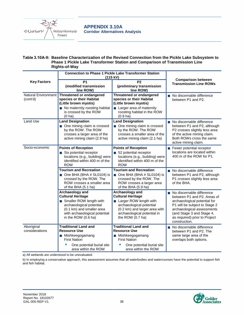
APPENDIX 3.10A Corridor Alternatives Analysis
November 2018 Report No. 18102677 GAL-005-REP-V1 38
Table 3.10A-9: Baseline Characterization of the Revised Connection from the Pickle Lake Subsystem to Phase 1 Pickle Lake Transformer Station and Comparison of Transmission Line Rights-of-Way
Key Factors
Connection to Phase 1 Pickle Lake Transformer Station (115 kV) Comparison between
Transmission Line ROWs P1 (modified transmission
line ROW)
P2 (preliminary transmission
line ROW) Natural Environment(cont’d)
Threatened or endangered species or their Habitat (Little brown myotis) No maternity roosting habitat
is crossed by the ROW (0 ha).
Threatened or endangered species or their Habitat (Little brown myotis) Larger area of maternity
roosting habitat in the ROW (0.9 ha).
No discernable difference between P1 and P2.
Land Use Land Designation One mining claim is crossed
by the ROW. The ROW crosses a larger area of the active mining claim (2.9 ha)
Land Designation One mining claim is crossed
by the ROW. The ROW crosses a smaller area of the active mining claim (2.1 ha)
No discernable difference between P1 and P2, although P2 crosses slightly less area of the active mining claim. Both ROWs cross the same active mining claim.
Socio-economic Points of Reception Six potential receptor
locations (e.g., building) were identified within 400 m of the ROW
Points of Reception 52 potential receptor
locations (e.g., building) were identified within 400 m of the ROW
Fewer potential receptor locations are located within 400 m of the ROW for P1.
Tourism and Recreation One BHA (BHA # SL0104) is
crossed by the ROW. The ROW crosses a smaller area of the BHA (5.1 ha)
Tourism and Recreation One BHA (BHA # SL0104) is
crossed by the ROW. The ROW crosses a larger area of the BHA (5.9 ha)
No discernable difference between P1 and P2, although P1 crosses slightly less area of the BHA.
Archaeology and Cultural Heritage Smaller ROW length with
archaeological potential (0.1 km) and smaller area with archaeological potential in the ROW (0.6 ha)
Archaeology and Cultural Heritage Larger ROW length with
archaeological potential (0.2 km) and larger area with archaeological potential in the ROW (0.7 ha)
No discernable difference between P1 and P2. Areas of archaeological potential for P1 will be subject to Stage 2 archaeological assessments (and Stage 3 and Stage 4, as required) prior to Project construction.
Aboriginal considerations
Traditional Land and Resource Use Mishkeegogamang
First Nation One potential burial site
area within the ROW
Traditional Land and Resource Use Mishkeegogamang
First Nation One potential burial site
area within the ROW
No discernable difference between P1 and P2. The same large area of the overlaps both options.
a) All wetlands are understood to be unevaluated. b) In employing a conservative approach, this assessment assumes that all waterbodies and watercourses have the potential to support fish and fish habitat.

APPENDIX 3.10A Corridor Alternatives Analysis
November 2018 Report No. 18102677 GAL-005-REP-V1 39
There are no discernable differences between the baseline conditions presented for P1 and P2 in Table 3.10A-9 and Annex A. The ROW for P1 is slightly smaller than the ROW of P2; however, both ROWs are located within 500 m of an existing linear corridor (i.e., the existing GoldCorp M1M transmission line). The ROW for P1 does not cross mapped wetlands and only crosses one mapped watercourse. The ROW for P1 does not cross other existing linear corridors. Similar to P2, the ROW for P1 avoids mapped Category 1 high-use habitat, Category 2 seasonal range habitat and travel corridors for woodland caribou. The ROW for P1 crosses slightly less mapped Category 3 habitat for woodland caribou (i.e., 5.1 ha as opposed to 5.9 ha crossed by the ROW for P2). The ROW for both P1 and P2 crosses/avoids similar habitat for all other wildlife criteria. Both ROWs cross the same active mining claim and the same BHA, and both ROWs have areas of archaeological potential (0.6 ha within the ROW for P1 and 0.7 ha within the ROW for P2). From a socio-economic perspective, fewer receptor locations are located within 400 m of the ROW for P2 (i.e., six locations, as opposed to 52 locations for the POR of P2). With regards to traditional land and resource use, a potential burial site area was identified within the ROW of P1 and P2 by community members of Mishkeegogamang First Nation. Wataynikaneyap will work with Mishkeegogamang First Nation to confirm the location of the burial site and to avoid or minimize potential effects to the burial site, as required. P1 is ultimately preferred for the Project since it considers and provides a direct connection to the adjusted location of the proposed Phase 1 Pickle Lake Transformer station.
Based on the baseline information available for P1, it is predicted that the potential environmental effects and associated mitigation measures will generally be similar to those identified for the Project as a whole in Sections 5.0 through 8.0 of the Draft ESR, except for predicted effects or mitigation that are specific to particular areas along the Project or that are specific to Project components (e.g., parks and protected areas [P1 does not intersect any parks or protected areas]; woodland caribou habitat; temporary construction camps; transformer stations [noise effects/mitigation]). Project effects identified as part of the assessment in Sections 5.0 to 8.0 of the Draft ESR also applicable to P1 are documented in the net effects and cumulative effects assessment summary tables provided in Sections 10.0 and 11.0 of the Draft ESR.
3.10A4.0 REFERENCES
Golder. 2018. Wataynikaneyap Phase 1 Final Environmental Assessment – Revised Transformer Station Location and Associated Transmission Line Re-alignment. April 13, 2018.
Government of Ontario. 2006. Provincial Parks and Conservation Reserves Act, 2006. https://www.ontario.ca/laws/statute/06p12/.
MNR (Ontario Ministry of Natural Resources). 2003. Class Environmental Assessment for MNR Resource Stewardship and Facility Development Projects.
MNR. 2005. Class Environmental Assessment for Provincial Parks and Conservation Reserves.
MNRF (Ministry of Natural Resources and Forestry). 2015. Land Information Ontario. Electronic data. https://www.ontario.ca/page/land-information-ontario
MNRF. 2017. Land Information Ontario. Electronic data. https://www.ontario.ca/page/land-information-ontario

APPENDIX 3.10A Corridor Alternatives Analysis
November 2018 Report No. 18102677 GAL-005-REP-V1 40
NHIC (Natural Heritage Information Centre). 2015. Natural Heritage Information Centre: Get Natural Heritage Information. Electronic data. https://www.ontario.ca/page/get-natural-heritage-information.
NHIC. 2017. Natural Heritage Information Centre: Get Natural Heritage Information. Electronic data. https://www.ontario.ca/page/get-natural-heritage-information.
NRCan (Natural Resources Canada). 2016. Earth Sciences Sector, GeoGratis, CanVec Data Product. Electronic data. http://www.geogratis.gc.ca.
NRCan. 2017. Earth Sciences Sector, GeoGratis, CanVec Data Product. Electronic data. http://www.geogratis.gc.ca.
SENES. 2014. Transmission Line Routing Study to Connect Remote CCEG Community Members to the Provincial Grid.
.

APPENDIX 3.10A Corridor Alternatives Analysis
November 2018 Report No. 18102677 GAL-005-REP-V1
ANNEX A Alternatives Metrics Tables

APPENDIX 3.10A ANNEX A Alternatives Metric Tables
June 2018 Report No. 1544751 GAL-005-REP-V1 A-i
Table of Contents
TABLES Table A-1: Corridor Analysis Factors and Metrics .............................................................................................................1
Table A-2: Metrics Considered in the Corridor Alternative Analysis – Red Lake Subsystem.............................................3
Table A-3: Metrics Considered in the Corridor Alternative Analysis – Pickle Lake Subsystem..........................................7

APPENDIX 3.10A ANNEX A Alternatives Metric Tables
June 2018 Report No. 1544751 GAL-005-REP-V1 A-ii
This page intentionally left blank
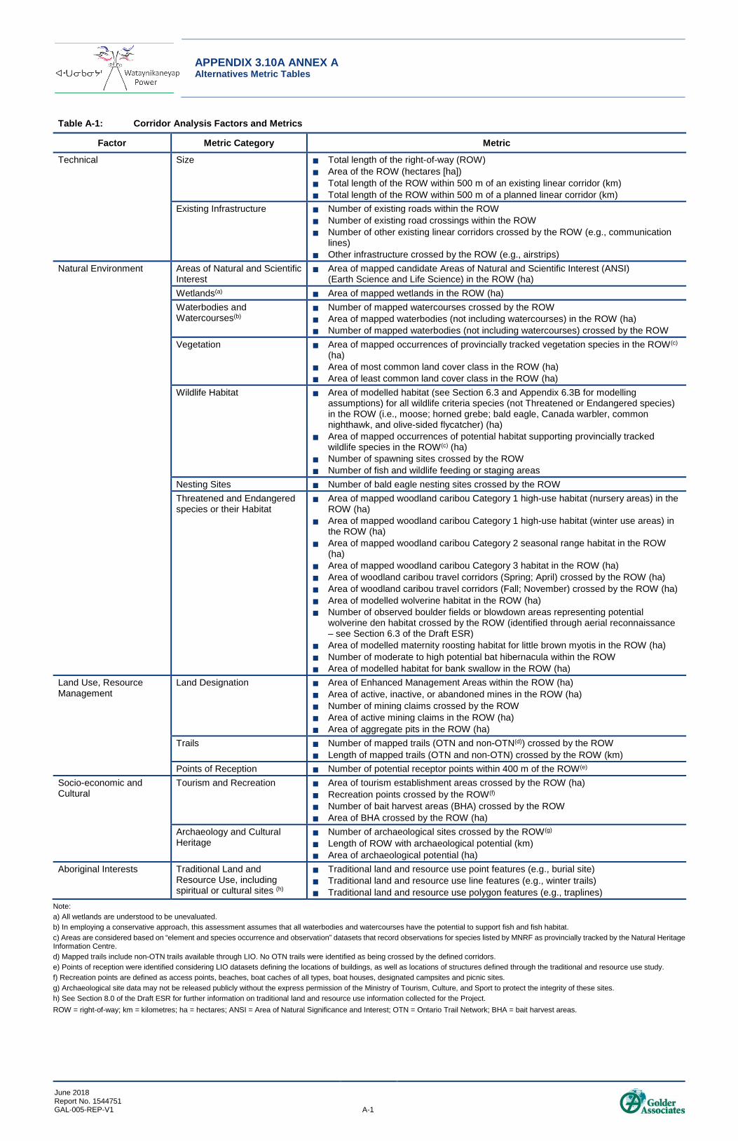
APPENDIX 3.10A ANNEX A Alternatives Metric Tables
June 2018 Report No. 1544751 GAL-005-REP-V1 A-1
Table A-1: Corridor Analysis Factors and Metrics
Factor Metric Category Metric
Technical Size Total length of the right-of-way (ROW) Area of the ROW (hectares [ha]) Total length of the ROW within 500 m of an existing linear corridor (km) Total length of the ROW within 500 m of a planned linear corridor (km)
Existing Infrastructure Number of existing roads within the ROW Number of existing road crossings within the ROW Number of other existing linear corridors crossed by the ROW (e.g., communication
lines) Other infrastructure crossed by the ROW (e.g., airstrips)
Natural Environment Areas of Natural and Scientific Interest
Area of mapped candidate Areas of Natural and Scientific Interest (ANSI) (Earth Science and Life Science) in the ROW (ha)
Wetlands(a) Area of mapped wetlands in the ROW (ha) Waterbodies and Watercourses(b)
Number of mapped watercourses crossed by the ROW Area of mapped waterbodies (not including watercourses) in the ROW (ha) Number of mapped waterbodies (not including watercourses) crossed by the ROW
Vegetation Area of mapped occurrences of provincially tracked vegetation species in the ROW(c) (ha)
Area of most common land cover class in the ROW (ha) Area of least common land cover class in the ROW (ha)
Wildlife Habitat Area of modelled habitat (see Section 6.3 and Appendix 6.3B for modelling assumptions) for all wildlife criteria species (not Threatened or Endangered species) in the ROW (i.e., moose; horned grebe; bald eagle, Canada warbler, common nighthawk, and olive-sided flycatcher) (ha)
Area of mapped occurrences of potential habitat supporting provincially tracked wildlife species in the ROW(c) (ha)
Number of spawning sites crossed by the ROW Number of fish and wildlife feeding or staging areas
Nesting Sites Number of bald eagle nesting sites crossed by the ROW Threatened and Endangered species or their Habitat
Area of mapped woodland caribou Category 1 high-use habitat (nursery areas) in the ROW (ha)
Area of mapped woodland caribou Category 1 high-use habitat (winter use areas) in the ROW (ha)
Area of mapped woodland caribou Category 2 seasonal range habitat in the ROW (ha)
Area of mapped woodland caribou Category 3 habitat in the ROW (ha) Area of woodland caribou travel corridors (Spring; April) crossed by the ROW (ha) Area of woodland caribou travel corridors (Fall; November) crossed by the ROW (ha) Area of modelled wolverine habitat in the ROW (ha) Number of observed boulder fields or blowdown areas representing potential
wolverine den habitat crossed by the ROW (identified through aerial reconnaissance – see Section 6.3 of the Draft ESR)
Area of modelled maternity roosting habitat for little brown myotis in the ROW (ha) Number of moderate to high potential bat hibernacula within the ROW Area of modelled habitat for bank swallow in the ROW (ha)
Land Use, Resource Management
Land Designation Area of Enhanced Management Areas within the ROW (ha) Area of active, inactive, or abandoned mines in the ROW (ha) Number of mining claims crossed by the ROW Area of active mining claims in the ROW (ha) Area of aggregate pits in the ROW (ha)
Trails Number of mapped trails (OTN and non-OTN(d)) crossed by the ROW Length of mapped trails (OTN and non-OTN) crossed by the ROW (km)
Points of Reception Number of potential receptor points within 400 m of the ROW(e) Socio-economic and Cultural
Tourism and Recreation Area of tourism establishment areas crossed by the ROW (ha) Recreation points crossed by the ROW(f) Number of bait harvest areas (BHA) crossed by the ROW Area of BHA crossed by the ROW (ha)
Archaeology and Cultural Heritage
Number of archaeological sites crossed by the ROW(g) Length of ROW with archaeological potential (km) Area of archaeological potential (ha)
Aboriginal Interests Traditional Land and Resource Use, including spiritual or cultural sites (h)
Traditional land and resource use point features (e.g., burial site) Traditional land and resource use line features (e.g., winter trails) Traditional land and resource use polygon features (e.g., traplines)
Note: a) All wetlands are understood to be unevaluated. b) In employing a conservative approach, this assessment assumes that all waterbodies and watercourses have the potential to support fish and fish habitat. c) Areas are considered based on “element and species occurrence and observation” datasets that record observations for species listed by MNRF as provincially tracked by the Natural Heritage Information Centre. d) Mapped trails include non-OTN trails available through LIO. No OTN trails were identified as being crossed by the defined corridors. e) Points of reception were identified considering LIO datasets defining the locations of buildings, as well as locations of structures defined through the traditional and resource use study. f) Recreation points are defined as access points, beaches, boat caches of all types, boat houses, designated campsites and picnic sites. g) Archaeological site data may not be released publicly without the express permission of the Ministry of Tourism, Culture, and Sport to protect the integrity of these sites. h) See Section 8.0 of the Draft ESR for further information on traditional land and resource use information collected for the Project. ROW = right-of-way; km = kilometres; ha = hectares; ANSI = Area of Natural Significance and Interest; OTN = Ontario Trail Network; BHA = bait harvest areas.

APPENDIX 3.10A ANNEX A Alternatives Metric Tables
June 2018 Report No. 1544751 GAL-005-REP-V1 A-2
This page intentionally left blank
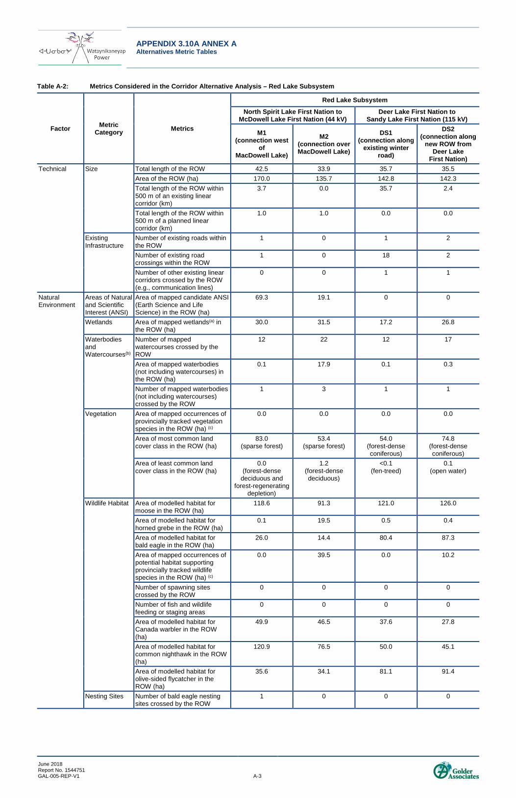
APPENDIX 3.10A ANNEX A Alternatives Metric Tables
June 2018 Report No. 1544751 GAL-005-REP-V1 A-3
Table A-2: Metrics Considered in the Corridor Alternative Analysis – Red Lake Subsystem
Factor Metric Category Metrics
Red Lake Subsystem
North Spirit Lake First Nation to McDowell Lake First Nation (44 kV)
Deer Lake First Nation to Sandy Lake First Nation (115 kV)
M1 (connection west
of MacDowell Lake)
M2 (connection over MacDowell Lake)
DS1 (connection along
existing winter road)
DS2 (connection along
new ROW from Deer Lake
First Nation) Technical Size Total length of the ROW 42.5 33.9 35.7 35.5
Area of the ROW (ha) 170.0 135.7 142.8 142.3 Total length of the ROW within 500 m of an existing linear corridor (km)
3.7 0.0 35.7 2.4
Total length of the ROW within 500 m of a planned linear corridor (km)
1.0 1.0 0.0 0.0
Existing Infrastructure
Number of existing roads within the ROW
1 0 1 2
Number of existing road crossings within the ROW
1 0 18 2
Number of other existing linear corridors crossed by the ROW (e.g., communication lines)
0 0 1 1
Natural Environment
Areas of Natural and Scientific Interest (ANSI)
Area of mapped candidate ANSI (Earth Science and Life Science) in the ROW (ha)
69.3 19.1 0 0
Wetlands Area of mapped wetlands(a) in the ROW (ha)
30.0 31.5 17.2 26.8
Waterbodies and Watercourses(b)
Number of mapped watercourses crossed by the ROW
12 22 12 17
Area of mapped waterbodies (not including watercourses) in the ROW (ha)
0.1 17.9 0.1 0.3
Number of mapped waterbodies (not including watercourses) crossed by the ROW
1 3 1 1
Vegetation Area of mapped occurrences of provincially tracked vegetation species in the ROW (ha) (c)
0.0 0.0 0.0 0.0
Area of most common land cover class in the ROW (ha)
83.0 (sparse forest)
53.4 (sparse forest)
54.0 (forest-dense coniferous)
74.8 (forest-dense coniferous)
Area of least common land cover class in the ROW (ha)
0.0 (forest-dense
deciduous and forest-regenerating
depletion)
1.2 (forest-dense deciduous)
<0.1 (fen-treed)
0.1 (open water)
Wildlife Habitat Area of modelled habitat for moose in the ROW (ha)
118.6 91.3 121.0 126.0
Area of modelled habitat for horned grebe in the ROW (ha)
0.1 19.5 0.5 0.4
Area of modelled habitat for bald eagle in the ROW (ha)
26.0 14.4 80.4 87.3
Area of mapped occurrences of potential habitat supporting provincially tracked wildlife species in the ROW (ha) (c)
0.0 39.5 0.0 10.2
Number of spawning sites crossed by the ROW
0 0 0 0
Number of fish and wildlife feeding or staging areas
0 0 0 0
Area of modelled habitat for Canada warbler in the ROW (ha)
49.9 46.5 37.6 27.8
Area of modelled habitat for common nighthawk in the ROW (ha)
120.9 76.5 50.0 45.1
Area of modelled habitat for olive-sided flycatcher in the ROW (ha)
35.6 34.1 81.1 91.4
Nesting Sites Number of bald eagle nesting sites crossed by the ROW
1 0 0 0

APPENDIX 3.10A ANNEX A Alternatives Metric Tables
June 2018 Report No. 1544751 GAL-005-REP-V1 A-4
Table A-2: Metrics Considered in the Corridor Alternative Analysis – Red Lake Subsystem
Factor Metric Category Metrics
Red Lake Subsystem
North Spirit Lake First Nation to McDowell Lake First Nation (44 kV)
Deer Lake First Nation to Sandy Lake First Nation (115 kV)
M1 (connection west
of MacDowell Lake)
M2 (connection over MacDowell Lake)
DS1 (connection along
existing winter road)
DS2 (connection along
new ROW from Deer Lake
First Nation) Natural Environment (cont’d)
Threatened and Endangered species or their Habitat
Area of mapped woodland caribou Category 1 high-use habitat (nursery areas) in the ROW (ha)
15.5 37.1 36.0 0.0
Area of mapped woodland caribou Category 1 high-use habitat (winter use areas) in the ROW (ha)
0.0 0.0 0.0 53.5
Area of mapped woodland caribou Category 2 seasonal range habitat in the ROW (ha)
151.3 80.7 0.0 40.6
Area of mapped woodland caribou Category 3 habitat in the ROW (ha)
2.8 17.0 106.8 48.2
Area of woodland caribou travel corridors (Spring; April) crossed by the ROW (ha)
38.3 21.4 22.3 74.2
Area of woodland caribou travel corridors (Fall; November) crossed by the ROW (ha)
58.8 7.7 38.3 0.0
Area of modelled wolverine habitat in the ROW (ha)
157.2 115.6 136.1 138.6
Number of boulder fields or blowdown areas representing potential wolverine den habitat crossed by the ROW (identified through aerial reconnaissance – see Section 6.3 of the Draft ESR)
1 0 0 2
Area of modelled maternity roosting habitat for little brown myotis in the ROW (ha)
2.4 3.7 26.4 12.5
Number of potential bat hibernacula crossed by the ROW (identified through aerial reconnaissance – see Section 6.3 of the Draft ESR)
0 0 3 3
Area of modelled habitat for bank swallow in the ROW (ha)
0.0 0.0 0.0 0.0
Land Use, Resource Management
Land Designations
Area of Enhanced Management Areas within the ROW (ha)
0.0 0.0 0.0 0.0
Area of active, inactive, or abandoned mines in the ROW (ha)
0.0 0.0 0.0 0.0
Number of mining claims crossed by the ROW
0.0 0.0 3 0
Area of active mining claims in the ROW (ha)
0.0 0.0 6.7 0.0
Area of existing aggregate pits in the ROW (ha)
0.0 0.0 0.0 0.0
Number of mapped trails crossed by the ROW (d)
0 0 2 2
Length of mapped trails crossed by the ROW (km)
0.0 0.0 0.19 0.08

APPENDIX 3.10A ANNEX A Alternatives Metric Tables
June 2018 Report No. 1544751 GAL-005-REP-V1 A-5
Table A-2: Metrics Considered in the Corridor Alternative Analysis – Red Lake Subsystem
Factor Metric Category Metrics
Red Lake Subsystem
North Spirit Lake First Nation to McDowell Lake First Nation (44 kV)
Deer Lake First Nation to Sandy Lake First Nation (115 kV)
M1 (connection west
of MacDowell Lake)
M2 (connection over MacDowell Lake)
DS1 (connection along
existing winter road)
DS2 (connection along
new ROW from Deer Lake
First Nation) Socio-economic and cultural
Points of Reception(g)
Number of potential receptor points within 400m of the ROW(e)
1 0 0 30
Tourism and Recreation
Number of MNRF trapper cabin locations
0 0 0 0
Area of tourism establishment areas crossed by the ROW (ha)
0.0 0.0 0.0 0.0
Recreation points crossed by the ROW (f)
0 0 0 0
Number of BHA crossed by the ROW
0 0 0 0
Area of BHA crossed by the ROW (ha)
0.0 0.0 0.0 0.0
Archaeology and Cultural Heritage
Number of archaeological sites crossed by the ROW(g)
0 0 0 0
Length of ROW with archaeological potential (km)
0.26 6.6 0.32 0.32
Area of archaeological potential (ha)
1.02 26.5 1.28 1.28
Aboriginal Interests
Traditional Land and Resource Use, including spiritual or cultural sites(h)
Traditional land and resource use point features (e.g., burial sites) within the ROW
0 0 0 0
Traditional land and resource use line features (e.g., winter trails) crossed by the ROW
MLFN – 1 fish spawning area NSLFN – 3 winter trails
0 SLFN – 1 hunting area NSLFN – 1 summer trail and 1 winter trail
DLFN – 7 travel routes
Traditional land and resource use polygon features (e.g., traplines) crossed by the ROW
MLFN - 1 old trapline road, 1 trapline, 1 possible watercourse crossing NSLFN – 3 trapping areas, 1 special place (spiritual/ cultural)
MLFN – 1 trapline NSLFN – 1 trapping area and 1 fishing area
SLFN – 1 caribou crossing, 1 trapline DLFN – 1 trapline, 2 fish spawning areas, 1 moose hunting area NSLFN – 1 trapping area
SLFN – 1 caribou crossing, 2 traplines DLFN – 1 trapline, 1 plant harvesting area, 2 fish spawning areas, one moose area, and six moose hunting areas SLFN/DLFN - Passes through important woodland caribou habitat.
Note: a) All wetlands are understood to be unevaluated. b) In employing a conservative approach, this assessment assumes that all waterbodies and watercourses have the potential to support fish and fish habitat. c) Areas are considered based on “element and species occurrence and observation” datasets that record observations for species listed by MNRF as provincially tracked by the Natural Heritage Information Centre. d) Mapped trails include non-OTN trails available through LIO. No OTN trails were identified as being crossed by the defined corridors. e) Points of reception were identified considering LIO datasets defining the locations of buildings, as well as locations of structures defined through the traditional and resource use study. f) Recreation points are defined as access points, beaches, boat caches of all types, boat houses, designated campsites and picnic sites. g) Archaeological site data may not be released publicly without the express permission of the Ministry of Tourism, Culture, and Sport to protect the integrity of these sites. h) See Section 8.0 of the Draft Environmental Study Report (ESR) for further information traditional land and resource use information collected for the Project. Not all traditional land and resource use features represent sites to be avoided by the line (e.g., number of trapline areas crossed). kV = kilovolts; ROW = right-of-way; EA = environmental assessment; km = kilometre; ha = hectare; OTN = Ontario Trail Network; BHA = bait harvest area; m = metres; ANSI = Areas of Natural and Scientific Interest; MLFN = McDowell Lake First Nation; NSLFN = North Spirit Lake First Nation; SLFN: Sandy Lake First Nation; DLFN = Deer Lake First Nation

APPENDIX 3.10A ANNEX A Alternatives Metric Tables
June 2018 Report No. 1544751 GAL-005-REP-V1 A-6
This page intentionally left blank

APPENDIX 3.10A ANNEX A Alternatives Metric Tables
June 2018 Report No. 1544751 GAL-005-REP-V1 A-7
Table A-3: Metrics Considered in the Corridor Alternative Analysis – Pickle Lake Subsystem
Factor Metric Category Metrics
Pickle Lake Subsystem
Muskrat Dam Transformer Station to
Muskrat Dam First Nation (25 kV)
Kitchenuhmaykoosib Inninuwug to
Wapekeka First Nation (25 Kv)
Kingfisher Lake First Nation to Wunnumin Lake
First Nation (44 kV)
Wawakapewin First Nation to
Kasabonika Lake First Nation
(44 kV)
Muskrat Dam First Nation to Sachigo Lake First Nation
(115 kV)
Connection to Phase 1 Pickle Lake Transformer
Station (115 kV)
MD1 (connection
following existing
winter road alignment)
MD2 (connection
following preliminary
115 kV transmission line ROW)
Proposed ROW (connection following
routing planned for the Proposed Diesel
Generating Station Upgrade and Micro
Grid Connection project)
W1 (connection
from Kingfisher
Lake First Nation
to Wunnumin
Lake First Nation)
W2 (connection to Wunnumin
Lake First Nation
along existing winter road)
K1 (connection
to Kasabonika
Lake First Nation
along existing
winter road)
K2 (connection
to Kasabonika
Lake First Nation north along
historic tractor train
route)
S1 (connection
along southern corridor to
Sachigo Lake First Nation)
S2 (connection
along northern
corridor to Sachigo Lake First Nation)
P1 (modified
transmission line ROW)
P2 (preliminary transmission line ROW)
Technical Size Total length of the ROW 6.1 5.7 2.8 41.0 55.0 46.0 36.3 92.7 85.1 1.2 1.5 Area of the ROW (ha) 24.4 15.9 11.2 164.0 220.1 184.2 145.4 370.9 340.4 5.1 5.9 Total length of the ROW within 500 m of an existing linear corridor (km)
5.5 5.7 2.8 8.4 21.1 44.7 8.7 14.2 28.1 1.2 1.5
Total length of the ROW within 500 m of a planned linear corridor (km)
0.0 0.0 0.0 0.0 0.0 0.0 0.0 6.8 18.8 0.0 0.0
Existing Infrastructure Number of existing roads within the ROW 5 4 2 12 2 4 4 4 3 1 1 Number of existing road crossings within the ROW 4 4 2 12 8 25 4 9 5 1 1 Number of other existing linear corridors crossed by the ROW (e.g., communication lines)
9 3 2 1 9 1 3 1 15 0 1
ANSI Area of mapped candidate ANSI (Earth Science and Life Science) in the ROW (ha)
0.0 0.0 0.0 0.0 0.0 0.0 0.0 0.0 0.0 0.0 0.0

APPENDIX 3.10A ANNEX A Alternatives Metric Tables
June 2018 Report No. 1544751 GAL-005-REP-V1 A-8
Table A-3: Metrics Considered in the Corridor Alternative Analysis – Pickle Lake Subsystem
Factor Metric Category Metrics
Pickle Lake Subsystem
Muskrat Dam Transformer Station to
Muskrat Dam First Nation (25 kV)
Kitchenuhmaykoosib Inninuwug to
Wapekeka First Nation (25 Kv)
Kingfisher Lake First Nation to Wunnumin Lake
First Nation (44 kV)
Wawakapewin First Nation to
Kasabonika Lake First Nation
(44 kV)
Muskrat Dam First Nation to Sachigo Lake First Nation
(115 kV)
Connection to Phase 1 Pickle Lake Transformer
Station (115 kV)
MD1 (connection
following existing
winter road alignment)
MD2 (connection
following preliminary
115 kV transmission line ROW)
Proposed ROW (connection following
routing planned for the Proposed Diesel
Generating Station Upgrade and Micro
Grid Connection project)
W1 (connection
from Kingfisher
Lake First Nation
to Wunnumin
Lake First Nation)
W2 (connection to Wunnumin
Lake First Nation
along existing winter road)
K1 (connection
to Kasabonika
Lake First Nation
along existing
winter road)
K2 (connection
to Kasabonika
Lake First Nation north along
historic tractor train
route)
S1 (connection
along southern corridor to
Sachigo Lake First Nation)
S2 (connection
along northern
corridor to Sachigo Lake First Nation)
P1 (modified
transmission line ROW)
P2 (preliminary transmission line ROW)
Natural Environment
Wetlands Area of mapped wetlands(a) in the ROW (ha) 12.5 7.5 5.4 25.4 46.9 31.9 35.7 164.0 189.4 0.0 0.1 Waterbodies and Watercourses(b) Number of mapped watercourses crossed by the
ROW 2 2 0 13 23 18 18 18 30 1 1
Area of mapped waterbodies (not including watercourses) in the ROW (ha)
0.0 0.0 0.0 1.0 0.8 0.4 2.5 2.2 0.9 0.0 0.0
Number of mapped waterbodies (not including watercourses) crossed by the ROW
0 0 0 5 3 7 6 5 2 0 0
Vegetation Area of mapped occurrences of provincially tracked vegetation species in the ROW (ha) (c)
0.0 0.0 11.2 0.0 0.0 0.0 0.0 7.2 0.0 0.0 0.0
Area of most common land cover class (ha) 7 (forest-dense mixed)
6 (forest-dense mixed)
4 (forest-sparse) 63 (forest -sparse)
76 (forest-dense
coniferous)
93 (forest-sparse)
65 (forest-sparse)
84 (forest-sparse)
84 (forest-dense mixed)
2.6 (forest-sparse)
2.2 (forest-sparse)
Area of least common land cover class (ha) <1 (bog-open)
<1 (bog-open)
1 (forest-dense coniferous)
1 (bog-open) 1 (forest-dense deciduous)
<1 (forest-dense
deciduous)
1 (bog-open)
3 (open water) 1 (fen-open) 0 (bog-treed, forest-dense mixed, and
forest-dense deciduous)
0.07 (bog-treed

APPENDIX 3.10A ANNEX A Alternatives Metric Tables
June 2018 Report No. 1544751 GAL-005-REP-V1 A-9
Table A-3: Metrics Considered in the Corridor Alternative Analysis – Pickle Lake Subsystem
Factor Metric Category Metrics
Pickle Lake Subsystem
Muskrat Dam Transformer Station to
Muskrat Dam First Nation (25 kV)
Kitchenuhmaykoosib Inninuwug to
Wapekeka First Nation (25 Kv)
Kingfisher Lake First Nation to Wunnumin Lake
First Nation (44 kV)
Wawakapewin First Nation to
Kasabonika Lake First Nation
(44 kV)
Muskrat Dam First Nation to Sachigo Lake First Nation
(115 kV)
Connection to Phase 1 Pickle Lake Transformer
Station (115 kV)
MD1 (connection
following existing
winter road alignment)
MD2 (connection
following preliminary
115 kV transmission line ROW)
Proposed ROW (connection following
routing planned for the Proposed Diesel
Generating Station Upgrade and Micro
Grid Connection project)
W1 (connection
from Kingfisher
Lake First Nation
to Wunnumin
Lake First Nation)
W2 (connection to Wunnumin
Lake First Nation
along existing winter road)
K1 (connection
to Kasabonika
Lake First Nation
along existing
winter road)
K2 (connection
to Kasabonika
Lake First Nation north along
historic tractor train
route)
S1 (connection
along southern corridor to
Sachigo Lake First Nation)
S2 (connection
along northern
corridor to Sachigo Lake First Nation)
P1 (modified
transmission line ROW)
P2 (preliminary transmission line ROW)
Natural Environment (cont’d)
Wildlife Habitat Area of modelled habitat for moose in the ROW (ha) 21.3 14.2 6.8 150.6 194.1 162.9 125.8 289.2 270.8 3.8 3.4 Area of modelled habitat for horned grebe in the ROW (ha)
0.0 0.0 0.0 2.2 2.8 1.3 4.4 2.7 3.5 0.0 0.0
Area of modelled habitat for bald eagle in the ROW (ha)
8.5 6.6 2.0 78.8 103.9 27.2 29.4 105.5 131.3 1.2 1.6
Area of mapped occurrences of potential habitat supporting provincially tracked wildlife species in the ROW (ha) (c)
24.4 15.9 11.2 0.0 0.0 0.0 0.0 193 169.3 0.0 0.0
Number of spawning sites crossed by the ROW 0 0 0 0 0 0 0 0 0 0 0 Number of fish and wildlife feeding or staging areas 0 0 0 0 0 0 0 0 0 0 0 Area of modelled habitat for Canada warbler in the ROW (ha)
16.4 10.6 3.8 43.9 63.9 51.2 39.5 186.9 191.6 0 0.5
Area of modelled habitat for common nighthawk in the ROW (ha)
4.9 3.6 3.9 64.6 81.9 126.3 88.1 123.3 127.7 2.6 2.2
Area of modelled habitat for olive-sided flycatcher in the ROW (ha)
17.5 11.1 4.3 87.3 125.9 45.2 39.5 178.8 180.3 1.2 1.2
Nesting Sites Number of bald eagle nesting sites crossed by the ROW
0 0 0 0 0 0 0 0 0 0 0

APPENDIX 3.10A ANNEX A Alternatives Metric Tables
June 2018 Report No. 1544751 GAL-005-REP-V1 A-10
Table A-3: Metrics Considered in the Corridor Alternative Analysis – Pickle Lake Subsystem
Factor Metric Category Metrics
Pickle Lake Subsystem
Muskrat Dam Transformer Station to
Muskrat Dam First Nation (25 kV)
Kitchenuhmaykoosib Inninuwug to
Wapekeka First Nation (25 Kv)
Kingfisher Lake First Nation to Wunnumin Lake
First Nation (44 kV)
Wawakapewin First Nation to
Kasabonika Lake First Nation
(44 kV)
Muskrat Dam First Nation to Sachigo Lake First Nation
(115 kV)
Connection to Phase 1 Pickle Lake Transformer
Station (115 kV)
MD1 (connection
following existing
winter road alignment)
MD2 (connection
following preliminary
115 kV transmission line ROW)
Proposed ROW (connection following
routing planned for the Proposed Diesel
Generating Station Upgrade and Micro
Grid Connection project)
W1 (connection
from Kingfisher
Lake First Nation
to Wunnumin
Lake First Nation)
W2 (connection to Wunnumin
Lake First Nation
along existing winter road)
K1 (connection
to Kasabonika
Lake First Nation
along existing
winter road)
K2 (connection
to Kasabonika
Lake First Nation north along
historic tractor train
route)
S1 (connection
along southern corridor to
Sachigo Lake First Nation)
S2 (connection
along northern
corridor to Sachigo Lake First Nation)
P1 (modified
transmission line ROW)
P2 (preliminary transmission line ROW)
Natural Environment (cont’d)
Threatened and Endangered species or their Habitat
Area of mapped woodland caribou Category 1 high-use habitat (nursery areas) in the ROW (ha)
0.0 0.0 0.0 0.0 0.0 0.0 0.0 25.6 3.7 0.0 0.0
Area of mapped woodland caribou Category 1 high-use habitat (winter use areas) in the ROW (ha)
0.0 0.0 0.0 0.0 0.0 0.0 0.0 0.0 0.0 0.0 0.0
Area of mapped woodland caribou Category 2 seasonal range habitat in the ROW (ha)
0.0 0.0 11.2 17.1 96.7 83.0 50.2 177.8 205.0 0.0 0.0
Area of mapped woodland caribou Category 3 habitat in the ROW (ha)
24.4 15.9 0.0 146.9 123.1 102.4 95.1 167.0 131.4 5.1 5.9
Area of woodland caribou travel corridors (Spring; April) crossed by the ROW (ha)
0.0 0.0 0.0 0.0 0.0 8.1 8.4 0.0 6.6 0.0 0.0
Area of woodland caribou travel corridors (Fall; November) crossed by the ROW (ha)
0.0 0.0 0.0 0.0 0.0 21.8 0.0 0.0 0.0 0.0 0.0
Area of wolverine habitat in the ROW (ha) 23.0 15.0 10.3 157.5 214.8 172.2 134.2 337.7 330.0 3.8 3.8 Number of boulder fields or blowdown areas representing potential wolverine den habitat crossed by the ROW (identified through aerial reconnaissance – see Section 6.3 of the Draft ESR)
0 0 0 1 2 1 0 5 1 0 0
Area of modelled maternity roosting habitat for little brown myotis in the ROW (ha)
7.3 6.1 1.5 33.9 28.1 9.2 17.5 74.8 96.4 0 0.9
Number of potential bat hibernacula crossed by the ROW (identified through aerial reconnaissance – see Section 6.3 of the Draft ESR)
0 0 0 0 0 0 0 0 0 0 0
Area of modelled habitat for bank swallow in the ROW (ha)
0.0 0.0 0.0 0.0 0.0 0.0 0.0 0.0 0.0 0.0 0.0

APPENDIX 3.10A ANNEX A Alternatives Metric Tables
June 2018 Report No. 1544751 GAL-005-REP-V1 A-11
Table A-3: Metrics Considered in the Corridor Alternative Analysis – Pickle Lake Subsystem
Factor Metric Category Metrics
Pickle Lake Subsystem
Muskrat Dam Transformer Station to
Muskrat Dam First Nation (25 kV)
Kitchenuhmaykoosib Inninuwug to
Wapekeka First Nation (25 Kv)
Kingfisher Lake First Nation to Wunnumin Lake
First Nation (44 kV)
Wawakapewin First Nation to
Kasabonika Lake First Nation
(44 kV)
Muskrat Dam First Nation to Sachigo Lake First Nation
(115 kV)
Connection to Phase 1 Pickle Lake Transformer
Station (115 kV)
MD1 (connection
following existing
winter road alignment)
MD2 (connection
following preliminary
115 kV transmission line ROW)
Proposed ROW (connection following
routing planned for the Proposed Diesel
Generating Station Upgrade and Micro
Grid Connection project)
W1 (connection
from Kingfisher
Lake First Nation
to Wunnumin
Lake First Nation)
W2 (connection to Wunnumin
Lake First Nation
along existing winter road)
K1 (connection
to Kasabonika
Lake First Nation
along existing
winter road)
K2 (connection
to Kasabonika
Lake First Nation north along
historic tractor train
route)
S1 (connection
along southern corridor to
Sachigo Lake First Nation)
S2 (connection
along northern
corridor to Sachigo Lake First Nation)
P1 (modified
transmission line ROW)
P2 (preliminary transmission line ROW)
Land Use, Resource Management
Land Designations Area of Enhanced Management Areas within the ROW (ha)
0.0 0.0 0.0 0.0 0.0 0.0 0.0 0.0 0.0 0.0 0.0
Area of active, inactive, or abandoned mines in the ROW (ha)
0.0 0.0 0.0 0.0 0.0 0.0 0.0 0.0 0.0 0.0 0.0
Number of mining claims crossed by the ROW 0 0 0 0 0 0 0 0 0 1 1 Area of active mining claims in the ROW (ha) 0.0 0.0 0.0 0.0 0.0 0.0 0.0 0.0 0.0 2.9 2.1 Area of existing aggregate pits in the ROW (ha) 0.0 0.0 0.0 0.0 0.0 0.0 0.0 0.0 0.0 0.0 0.0 Number of mapped trails crossed by the ROW (d) 0 0 0 0 0 0 0 0 0 0 0
Length of mapped trails crossed by the ROW (km) 0.0 0.0 0.0 0.0 0.0 0.0 0.0 0.0 0.0 0.0 0.0
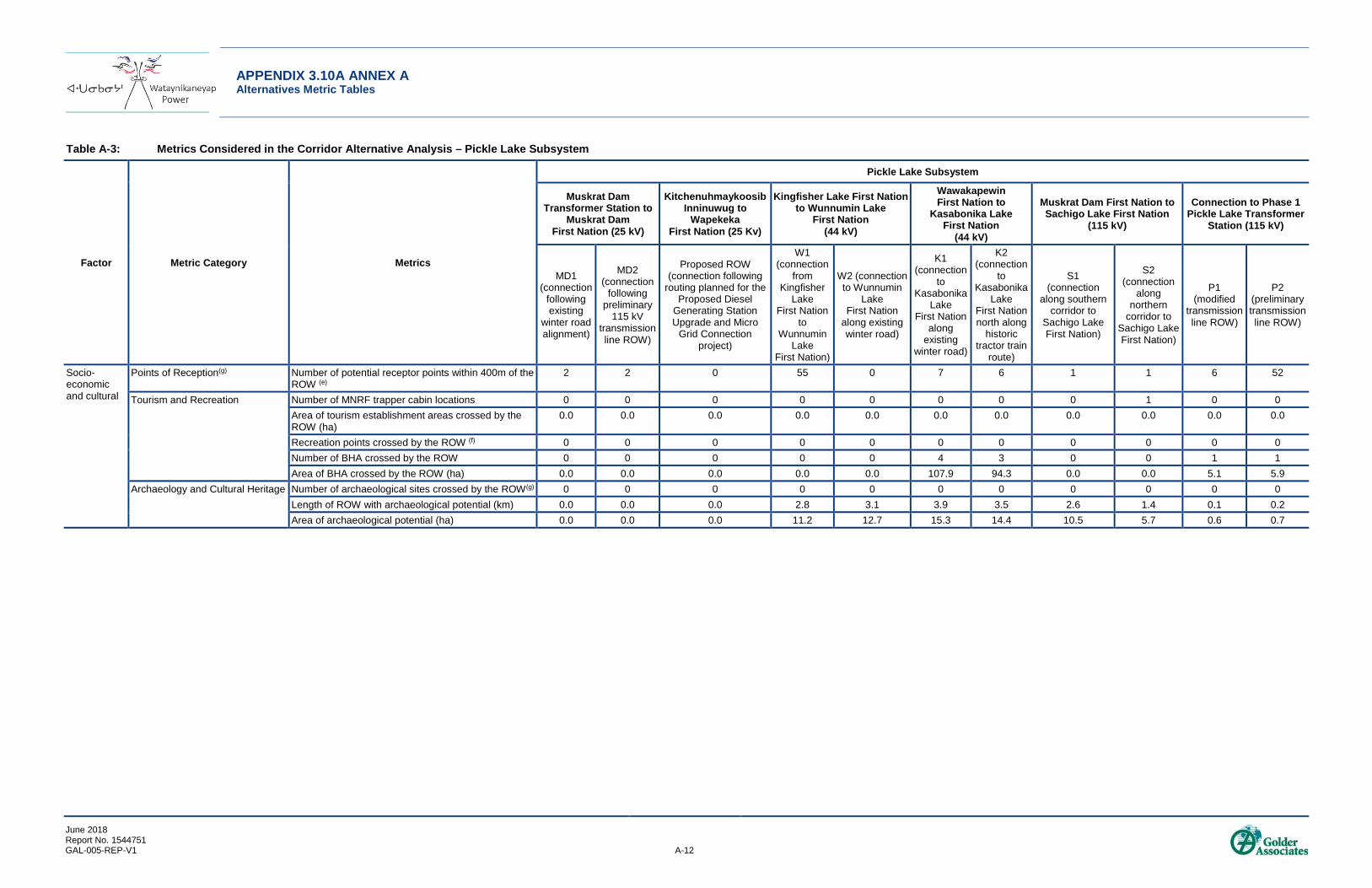
APPENDIX 3.10A ANNEX A Alternatives Metric Tables
June 2018 Report No. 1544751 GAL-005-REP-V1 A-12
Table A-3: Metrics Considered in the Corridor Alternative Analysis – Pickle Lake Subsystem
Factor Metric Category Metrics
Pickle Lake Subsystem
Muskrat Dam Transformer Station to
Muskrat Dam First Nation (25 kV)
Kitchenuhmaykoosib Inninuwug to
Wapekeka First Nation (25 Kv)
Kingfisher Lake First Nation to Wunnumin Lake
First Nation (44 kV)
Wawakapewin First Nation to
Kasabonika Lake First Nation
(44 kV)
Muskrat Dam First Nation to Sachigo Lake First Nation
(115 kV)
Connection to Phase 1 Pickle Lake Transformer
Station (115 kV)
MD1 (connection
following existing
winter road alignment)
MD2 (connection
following preliminary
115 kV transmission line ROW)
Proposed ROW (connection following
routing planned for the Proposed Diesel
Generating Station Upgrade and Micro
Grid Connection project)
W1 (connection
from Kingfisher
Lake First Nation
to Wunnumin
Lake First Nation)
W2 (connection to Wunnumin
Lake First Nation
along existing winter road)
K1 (connection
to Kasabonika
Lake First Nation
along existing
winter road)
K2 (connection
to Kasabonika
Lake First Nation north along
historic tractor train
route)
S1 (connection
along southern corridor to
Sachigo Lake First Nation)
S2 (connection
along northern
corridor to Sachigo Lake First Nation)
P1 (modified
transmission line ROW)
P2 (preliminary transmission line ROW)
Socio-economic and cultural
Points of Reception(g) Number of potential receptor points within 400m of the ROW (e)
2 2 0 55 0 7 6 1 1 6 52
Tourism and Recreation Number of MNRF trapper cabin locations 0 0 0 0 0 0 0 0 1 0 0 Area of tourism establishment areas crossed by the ROW (ha)
0.0 0.0 0.0 0.0 0.0 0.0 0.0 0.0 0.0 0.0 0.0
Recreation points crossed by the ROW (f) 0 0 0 0 0 0 0 0 0 0 0 Number of BHA crossed by the ROW 0 0 0 0 0 4 3 0 0 1 1 Area of BHA crossed by the ROW (ha) 0.0 0.0 0.0 0.0 0.0 107.9 94.3 0.0 0.0 5.1 5.9
Archaeology and Cultural Heritage Number of archaeological sites crossed by the ROW(g) 0 0 0 0 0 0 0 0 0 0 0 Length of ROW with archaeological potential (km) 0.0 0.0 0.0 2.8 3.1 3.9 3.5 2.6 1.4 0.1 0.2 Area of archaeological potential (ha) 0.0 0.0 0.0 11.2 12.7 15.3 14.4 10.5 5.7 0.6 0.7

APPENDIX 3.10A ANNEX A Alternatives Metric Tables
June 2018 Report No. 1544751 GAL-005-REP-V1 A-13
Table A-3: Metrics Considered in the Corridor Alternative Analysis – Pickle Lake Subsystem
Factor Metric Category Metrics
Pickle Lake Subsystem
Muskrat Dam Transformer Station to
Muskrat Dam First Nation (25 kV)
Kitchenuhmaykoosib Inninuwug to
Wapekeka First Nation (25 Kv)
Kingfisher Lake First Nation to Wunnumin Lake
First Nation (44 kV)
Wawakapewin First Nation to
Kasabonika Lake First Nation
(44 kV)
Muskrat Dam First Nation to Sachigo Lake First Nation
(115 kV)
Connection to Phase 1 Pickle Lake Transformer
Station (115 kV)
MD1 (connection
following existing
winter road alignment)
MD2 (connection
following preliminary
115 kV transmission line ROW)
Proposed ROW (connection following
routing planned for the Proposed Diesel
Generating Station Upgrade and Micro
Grid Connection project)
W1 (connection
from Kingfisher
Lake First Nation
to Wunnumin
Lake First Nation)
W2 (connection to Wunnumin
Lake First Nation
along existing winter road)
K1 (connection
to Kasabonika
Lake First Nation
along existing
winter road)
K2 (connection
to Kasabonika
Lake First Nation north along
historic tractor train
route)
S1 (connection
along southern corridor to
Sachigo Lake First Nation)
S2 (connection
along northern
corridor to Sachigo Lake First Nation)
P1 (modified
transmission line ROW)
P2 (preliminary transmission line ROW)
Aboriginal Interests
Traditional Land and Resource Use, including spiritual or cultural sites(h)
Traditional land and resource use point features (e.g., burial sites) within the ROW
0 0 0 0 0 0 0 0 0 0 0
Traditional land and resource use line features (e.g., winter trails) crossed by the ROW
0 0 0 WLFN - 1 trail KFLFN - several trails (including seasonal trails)
0 KLFN – 1 gravel road
KLFN – 1 gravel road
SALFN – 1 old tractor train trail
SALFN – 1 old tractor train trail
0 0
Traditional land and resource use polygon features (e.g., traplines) crossed by the ROW
0 0 WPFN – two traplines WLFN - 1 trail corridor, 2 traplines, and an area of community interest KFLFN - trail corridors, Fur trapping areas and traplines
WLFN - Area of traditional hunting grounds, 2 traplines, and an area of community interest KFLFN – 1 trail corridor, 4 traplines, and 2 sensitive/active areas for hunting
KLFN – 1 trapline KI – 1 trapline
KLFN – 1 travel corridor for hunting, and 1 trapline WFN – 1 moose hunting area and an area of spiritual importance to be avoided KI – 1 trapline
SALFN – 1 campground, 4 traplines, 2 woodland caribou areas and 1 woodland caribou crossing, a high-use area for hunting/ fishing, a sensitive area and a community gathering area. Watershed protection area (30 km buffer) around Sachigo Lake.
SALFN – 4 traplines, a goose hunting/ trapping area, a high-use area for hunting/ fishing, a caribou crossing, and a sensitive area. Watershed protection area (30 km buffer) around Sachigo Lake.
MKFN – 1 potential grave site area
MKFN – 1 potential grave site area
APPENDIX 3.10A ANNEX A Alternatives Metric Tables
June 2018 Report No. 1544751 GAL-005-REP-V1 A-14
Note: a) All wetlands are understood to be unevaluated. b) In employing a conservative approach, this assessment assumes that all waterbodies and watercourses have the potential to support fish and fish habitat.F c) Areas are considered based on “element and species occurrence and observation” datasets that record observations for species listed by MNRF as provincially tracked by the Natural Heritage Information Centre. d) Mapped trails include non-OTN trails available through LIO. No OTN trails were identified as being crossed by the defined corridors. e) Points of reception were identified considering LIO datasets defining the locations of buildings, as well as locations of structures defined through the traditional land and resource use study. f) Recreation points are defined as access points, beaches, boat caches of all types, boat houses, designated campsites and picnic sites. g) Archaeological site data may not be released publicly without the express permission of the Ministry of Tourism, Culture, and Sport to protect the integrity of these sites. h) See Section 8.0 of the Draft ESR for further information traditional land and resource use information collected for the Project. Not all traditional land and resource use features represent sites to be avoided by the line (e.g., number of trapline areas crossed). kV = kilovolts; ROW = right-of-way; EA = environmental assessment; km = kilometre; ha = hectare; OTN = Ontario Trail Network; BHA = bait harvest area; m = metres; ANSI = Areas of Natural and Scientific Interest; WLFN = Wunnumin Lake First Nation; KFLFN = Kingfisher Lake First Nation; KLFN = Kasabonika Lake First Nation; KI = Kitchenuhmaykoosib Inninuwug; WFN =Wawakapewin First Nation; SALFN = Sachigo Lake First Nation; WPFN = Wapekeka First Nation; MKFN = Mishkeegogamang First Nation.