draft environmental assessment atlantic coast of long … · 2012-07-13 · i draft environmental...
TRANSCRIPT

i
DRAFT ENVIRONMENTAL ASSESSMENT
Atlantic Coast of Long Island, Fire Island Inlet to Montauk Point, New York West of Shinnecock Inlet
Interim Plan for Storm Damage Protection The responsible lead agency is the U.S. Army Corps of Engineers, New York District. ABSTRACT: The proposed West of Shinnecock Inlet Interim Plan for Storm Damage Protection would be located along the barrier island immediately west of Shinnecock Inlet in the Town of Southampton, Suffolk County, New York. The proposed project is a provisional plan designed to provide a limited degree of protection to the barrier island and mainland shore area until the Reformulation Study for the overall Fire Island Inlet to Montauk Point (FIMP) Beach Erosion Control and Hurricane Protection Project is completed, and potentially implemented. The design and analysis of the interim plan has been evaluated for a period of six years. This interim project will be maintained for six years, including the period of initial construction and two scheduled nourishment cycles. This time period should be sufficient to complete the Reformulation Study, and potentially implement the results. However, to account for the possibility that a decision in the Reformulation Study is not reached in this time, and that the period of nourishment would need to be extended by a decision other one than one made to pursuant to the Reformulation Study, the analyses contained within this report recognize the impacts associated with continuation of the interim project beyond the six year duration (up to fifteen years), and the process for making a decision whether to continue nourishment. The proposed plan would involve fill deposition in the 4,000-foot stretch immediately west of Shinnecock Inlet (the placement area). The beach fill placement would be tapered into the existing shoreline profiles and area topography. The placement area would blend with the existing beach and dunes to the west, which currently have dune elevations averaging +15 to +25 feet National Geodetic Vertical Datum (NGVD). The elevation of the placement area itself currently averages less than +14 feet NGVD. The design profile in the placement area would have a minimum 25-foot-wide dune with a maximum design crest elevation of +15 feet NGVD, and a minimum design beach berm width of 90 feet at a design elevation of +9.5 feet NGVD extending seaward from the seaward dune toe. This would involve an initial fill volume of approximately 810,000 cubic yards (cy) of beach fill and a renourishment volume of approximately 390,000 cy for each cycle. Beach fill would be hydraulically dredged from several possible borrow area locations, including an Atlantic Ocean offshore borrow area, the flood shoal and the inlet navigation channel and associated deposition basin. The offshore borrow area would be the primary source of material for the proposed project, and a supplemental source would be material from the flood shoal and navigation channel/deposition basin. The availability of fill material from the flood shoal is contingent on positive results from a sediment suitability analysis, cultural resources impact

ii
assessment, and monitoring of the response of the inlet system to dredging. Availability of material from the inlet navigation channel / deposition basin is dependent upon availability and the need for maintenance dredging operations. The proposed beach nourishment and dredging operations would result in environmental impacts associated with the dredging of fill material from the proposed borrow areas, including temporarily increased turbidity levels associated with dredging. Nourishment involves placement of fill materials on the beach berm and in the open water to develop and maintain the design profiles. The environmental impact analysis considered the type and abundance of organisms in the study area, the existing developments and land uses in the study area, and the amount and quality of material proposed for fill placement. No significant adverse impacts are anticipated to result from implementation of the proposed interim storm damage protection plan. Under the interim plan, there would be a temporary loss of macrobenthic communities, temporary loss of terrestrial wildlife habitat, temporary displacement of finfish and marine mammals from the impact area, potential impacts to adjacent areas due to down-current drift of suspended sediment, and potential contact between construction workers/equipment and marine mammals and turtles. The proposed project incorporates measures to minimize these potential impacts to the greatest extent practicable. Impacts to the beach habitat are expected to be localized and temporary. Beach replenishment would only affect the biota utilizing the southern portion of the beach immediately adjacent to the nearshore environment. After deposition of sand from the borrow area, plants and animals would again recolonize the area. The nearshore habitat, located between the beach and the offshore borrow area, is likely to be the least affected by the plan. No direct impacts are anticipated to occur to the fish or shellfish species likely to utilize the habitat. The macrobenthic invertebrates associated with the sediments of the borrow area will be the most affected of all the biota found in the area; they will be almost completely eliminated from this offshore habitat. This impact, however, will be only temporary, as individuals from the surround-ing habitat are expected to quickly recolonize the area. The invertebrate community structure will be dictated by the grain size of the sediment remaining after activities cease. Finfish may tempo-rarily avoid the area during construction if suspended particulates affect gill respiration. Con-versely, other species may be attracted to the discharge area to feed on out rained invertebrates. Back-bay habitat will be affected during any breach, but these impacts may be brief, as the breach is expected to be repaired rapidly. It is anticipated that the biological recovery of the disturbed areas would take place rapidly due to the relocation of organisms from outlying areas to the project site. Site recovery is optimized

iii
when beach fill material matches the grain size and texture of existing beach material, and generally prevailing beach profiles are maintained. The interim plan observes both of these criteria. Some unavoidable adverse impacts would be associated with the dredging operations and beach fill deposition. These would include loss of benthic organisms in the borrow area and turbidity in the water column in the borrow area and placement area. However, these impacts would likely be minor and of short duration. The positive impacts associated with the proposed interim plan are as follows: much reduced likelihood of breaching of the barrier island; reduced probability of Dune Road being washed out; protection of the current commercial and recreational uses on the barrier island; protection of the Federal inlet; protection of the low-lying developed bay areas from increased wave attack, tidal surges, and flooding that could result from a breach or significant overwash of the barrier island; creation of additional beach habitat for the Federal-listed threatened piping plover (Charadrius melodus), State-listed endangered least tern (Sterna albifrons), and State-listed threatened common tern (S. hirundo); protection of existing habitats (including eel grass, shellfish beds, and finfish nursery habitat); continued availability of food sources for migratory shore birds, wading birds, water fowl, and benthic invertebrates; and protection of intertidal wetland. For further information or comments on this assessment, please contact: Peter Weppler Project Biologist U.S. Army Corps of Engineers, CENAN-PL-ES 26 Federal Plaza New York, New York 10278-0090 (212) 264-0195

TABLE OF CONTENTS ITEM PAGE
1. PROJECT HISTORY EA-1 2. PROJECT DESCRIPTION EA-2 3. NEED FOR PROPOSED ACTION EA-4 4. ALTERNATIVES EA-5 5. AFFECTED ENVIRONMENT EA-7 6. CULTURAL RESOURCES EA-24 7. ENVIRONMENTAL IMPACTS EA-25 8. COORDINATION EA-50 9. COMPLIANCE WITH ENVIRONMENTAL REQUIREMENTS AND EA-51
PROTECTION STATUTES REFERENCES APPENDIX A—DRAFT USFWS FISH & WILDLIFE COORDINATION ACT
SECTION 2(b) REPORT (February 1998) APPENDIX B—SECTION 404(b)(1) EVALUATION REPORT APPENDIX C—APPLICABLE NYS COASTAL ZONE MANAGEMENT POLICIES APPENDIX D—FINDING OF NO SIGNIFICANT IMPACT (FONSI)—Unsigned APPENDIX E—DRAFT CLEAN AIR ACT CONFORMITY STATEMENT APPENDIX F—PERTINENT CORRESPONDENCE

LIST OF TABLES TABLE PAGE
1. WEST OF SHINNECOCK: INVENTORY OF STRUCTURES EA-8 2. BIRD SPECIES COMMONLY FOUND WEST OF SHINNECOCK EA-18/19 3. TYPICAL FINFISH FOUND WITHIN SHINNECOCK BAY EA-20 4. SPECIES OF SPECIAL CONCERN EA-21 5. COMMON OVERWINTERING WATERFOWL ON SHINNECOCK BAY EA-22/23 6. NO ACTION ALTERNATIVE BORROW AREA SIZE BY PROJECT EA-33 7. IMPACT ACTIVITY EA-45 8. BORROW AREA SIZE BY PROJECT EA-47 9. COMPLIANCE WITH ENVIRONMENTAL REQUIREMENTS AND EA-51
AND PROTECTION STATUTES LIST OF FIGURES FOLLOWING
FIGURE PAGE 1. ORIGINAL AUTHORIZED PROJECT EA-1 2. PROJECT LOCATION EA-2 3. IDENTIFICATION OF OFFSHORE BORROW AREAS EA-3 4. PLACEMENT AREA—BEACH NOURISHMENT EA-3
DESIGN SECTION 5. PLACEMENT AREA—BEACH NOURISHMENT LAYOUT EA-3 6. PROJECT STUDY AREA EA-3 7. ZONING EA-7 8. BUSINESS DISTRICT STRUCTURES EA-7

1) PROJECT HISTORY a) The proposed West of Shinnecock Interim Project for Storm Damage Protection involves the placement of sand along the stretch of barrier island immediately west of Shinnecock Inlet in the Town of Southampton, Suffolk County, New York. The proposed interim project is within the larger area under study as part of the Atlantic Coast of Long Island, Fire Island Inlet to Montauk Point (FIMP), Combined Beach Erosion Control and Hurricane Protection Project, which spans an 83-mile stretch of the south shore of Long Island (see Figure 1). b) The interim project’s study area extends west from the western Shinnecock Inlet jetty for a distance of approximately 4,000 feet (See Figure 2). The study area includes the ocean-fronting shoreline, bay shoreline, adjacent back-bay areas, the inlet system and offshore borrow area as a source of sand. The proposed project would provide limited storm damage protection to the severely eroded beach segment immediately west of Shinnecock Inlet in the interim period pending the completion of the FIMP Reformulation Study, and potential implementation of the results. c) The interim plan has been evaluated over a period of six years. Although this project has been evaluated for a period of six years in to the future, it may be continued, based on the outcome of the Reformulation Study (completion signified by Final Environmental Impact Statement [FEIS] and filing of the Record of Decision). In the unlikely instance that the Reformulation Study is not completed, a separate, stand-alone analysis would be undertaken to consider continuation of action under this plan. To account for possible continuation of the interim project, this analysis, while focusing on the impacts for a duration of six years, also recognizes the impacts associated with furhter continuation of nourishment operations. d) The overall authorized Fire Island Inlet to Montauk Point beach erosion control and hurricane protection project was authorized for construction in 1960. Portions of the authorized project (15 groins) were constructed for the Moriches Inlet to Shinnecock Inlet Reach between 1965 and 1970. Two additional groins and beach fill were constructed in East Hampton in 1966. In 1976 and 1978, draft and final EISs analyzed a comprehensive program of dune reconstruction and beach stabilization for the entire 83-mile project reach. The final EIS was referred to the President's Council on Environmental Quality (CEQ) due to other Federal Agencies’ judgement that the document did not adequately address the environmental impacts associated with the proposed dune reconstruction and beach stabilization project. On June 6, 1978, CEQ recommended to the Chief of Engineers that the project be reformulated. The Chief of Engineers in turn directed the U.S. Army Corps of Engineers, New York District (New York District) to reformulate the project. Project reformulation was initiated in 1980, but suspended in 1984. In
ΕΑ−2
1993, reformulation was reinitiated, and a comprehensive, feasibility-level Reformulation Study is currently being developed by the New York District. The Reformulation Study seeks to determine the optimum design for any potentially feasible storm damage reduction project along the south shore of Long Island from Fire Island Inlet to Montauk Point. e) Shinnecock Inlet, formed during the Great Hurricane of September 1938, is located approximately 98 miles east of the Battery in New York City. Shinnecock Inlet was initially stabilized by Suffolk County in 1939, and further stabilized by Suffolk County during the 1950's for navigational and tidal flushing purposes (Spencer & Terchunian, 1997). f) In March 1988, the New York District developed a General Design Memorandum for a Federally maintained Shinnecock Inlet Project, which recommended improvements to Shinnecock Inlet consisting of (1) developing an inner channel with a width of 100 feet, and a 6-foot low-water depth within Shinnecock Bay; (2) developing an outer channel with a 200-foot-wide 10-foot low-water depth, and an 800-foot-wide and 20-foot-deep deposition basin; (3) rehabilitating the east and west jetties of the inlet; (4) constructing a 1,000-foot-wide revetment that to face Shinnecock Bay on the eastern shoulder of the inlet; and (5) sand bypassing of the inlet during maintenance dredging. g) The Federal navigation project was constructed between 1990 and 1993. In October 1990, the navigation channel was dredged, resulting in 668,000 cy of dredged material, of which 260,000 cy were placed at Ponquogue Beach, 193,000 cy were stockpiled on the east side of the inlet for use as fill behind the bayside revetment, 138,000 cy were placed immediately west of the inlet, and 77,000 cy were placed in a scour hole near the southern end of the west jetty. The deposition basin was dredged in 1993, resulting in the removal of a total of 475,000 cy of dredged material. Of this material, 371,000 cy were placed immediately west of the inlet and 104,000 cy were placed in a scour hole located near the southern end of the west jetty. Since 1993, shore protection activities in the project area has been limited to remedial action, including emergency trucking of material by the Town, County, and State in response to storm events, and placement of bay dredge material in 1997 by the County and State. In June and September 1998, approximately 416,000 cy of maintenance material were dredged from the navigation channel and placed immediately west of the inlet.

ΕΑ−3
2) PROJECT DESCRIPTION a) The proposed West of Shinnecock Interim Storm Damage Protection Project is an interim plan designed to provide a limited degree of protection to the barrier island and mainland shore area until the Reformulation Study for the overall FIMP Beach Erosion Control and Hurricane Protection Project is complete and a long-term solution could be potentially implemented. b) The proposed interim project involves nourishing the project area’s beach berm and dune system by placing fill to the 4,000 foot section of the barrier island (the placement area) immediately west of Shinnecock Inlet (see Figure 2). The purpose of the interim project is to restore and maintain the shoreline to reduce the potential for storm damages to the barrier island and mainland areas as a result of breaching and overwash of the barrier island. Beach fill would be hydraulically dredged from several possible borrow area locations, including Atlantic Ocean offshore borrow area identified by the U.S. Army Corps of Engineers (see Figure 3), the inlet flood shoal, and the inlet navigation channel and associated deposition basin. c) The proposed beach fill improvement plan for the placement area would involve the construction of a minimum design 25-foot-wide dune with a design crest elevation of +15.0 feet NGVD with side slopes of 1 vertical foot for every 5 horizontal feet (1(v):5(h)); a minimum design 90-foot-wide beach berm at a design elevation of +9.5 feet NGVD with a nearshore slope of 1(v):15(h) to a design elevation of -6.0 feet NGVD; and an offshore slope of 1(v):40(h) (see Figures 4 and 5). The design fill (described above) would be fronted by approximately 60 feet of advance fill to account for loss of sand over the 2-year period prior to renourishment. The placement area design fill would blend with the existing topography. The existing dune elevations immediately west of the placement area currently average between +15 to +25 feet NGVD, while elevations in the placement area itself average lower than +14 feet NGVD. The proposed project would increase average dune elevations in the placement area to approximately +15 feet NGVD. d) The initial fill volume for the placement area would consist of approximately 810,000 cy of beach fill. Two renourishment cycles are scheduled after initial construction, on a 2 year cycle. Each renourishment operation would deposit approximately 390,000 cy to offset long-term erosion and storm-induced erosion, and to ensure that the design fill cross section is not compromised. The renourishment operations would result in a total renourishment volume of approximately 800,000 cy of beach fill over the course of the interim project. Initial and renourishment fill volumes would total approximately 1,600,000 cy over the life of the project. The construction period for initial fill and renourishment would last approximately 5-6 months and 2-3 months, respectively.

ΕΑ−4
e) Beach fill material for initial construction would be hydraulically dredged from an Atlantic Ocean offshore borrow area (see Figure 3), the flood shoal, and the inlet navigation channel and associated deposition basin (see Figure 6). The offshore borrow area would be the primary source of material for the proposed project nourishment, supplemented by material from the flood shoal and navigation channel/deposition basin. f) Other methods of providing the necessary fill materials were investigated, but were found not to be able to supply the required quality or volume of material. (For detailed information, please refer to the Plan Formulation - Sand Sources Section of the accompanying Main Report). g) The offshore borrow area would be dredged to obtain beach fill to a depth not to exceed 10 feet below the existing bathymetry as indicated by a pre-dredge survey. Sediment suitability analyses conducted in 1983 and 1996 indicated that the grain size and texture of the material at the offshore borrow area is compatible with the sand at the proposed placement area. Sand from the offshore borrow area would be supplemented with available material from the inlet flood shoal and navigation channel/deposition basin (see Figure 6), contingent on positive results from a sediment suitability analysis, cultural resource impact assessment, and monitoring of the response of the inlet system to dredging. h) The proposed project site, as described above, includes the portion of the beach extending from Shinnecock Inlet west for 4,000 feet (the placement area), and several possible borrow area locations, including the offshore borrow area identified above, the inlet ebb shoal, and the inlet navigation channel/deposition basin. These locations are subject to the further analyses for potential impacts. i) The project study area, which is an area larger than the proposed project site, consists of the barrier island from Shinnecock Inlet extending a distance of approximately 4,000 feet west of the jetty, including the shoreline fronting the Atlantic Coast, the bay shore line, and the adjacent back-bay area, as well as the mainland bay shore on the north side of Shinnecock Bay (Figure 7 depicts the mainland bay shore). The study area also includes the offshore borrow area, the inlet flood shoal, and the inlet navigation channel/deposition basin. j) The proposed interim project is based on the criteria that the plan would provide limited storm damage protection, reduce severe storm-induced damages, and mitigate the negative effects of long-term erosion. In addition, the interim plan is designed to preserve the barrier island conditions until the completion and potential implementation of the Reformulation Study.

ΕΑ−5
3) NEED FOR PROPOSED ACTION a) The primary goal of the West of Shinnecock Interim Project for Storm Damage Protection is to reduce the potential for future barrier island breaches and overwash due to frequently occurring storm events, which would adversely affect structures along the mainland bay shoreline, the commercial fishing establishment near Shinnecock Inlet, Coast Guard Station-Group Moriches, and the use of Shinnecock Inlet as a navigable waterway. b) Beach erosion in the West of Shinnecock Inlet study area has been severe, particularly in recent years, and has narrowed the width of the barrier island, increasing the potential for breaching and severe overwashing as a result of high frequency storm events. The erosion of the beach west of Shinnecock Inlet has advanced to the point where remedial low-cost mitigation, such as trucking of sand and inlet maintenance dredging, are not sufficient to maintain an adequate protective beach. c) Dune Road is located adjacent to the bay side of the dune system, and is the sole source of access to the commercial fisheries, private enterprises, and recreational facilities in the study area. In the past, Dune Road has been damaged severely enough by coastal storms to be rendered inaccessible for long periods of time, most recently as a result of the December 1992 storm event. d) Continued erosion could render the shoreline vulnerable to major damage, including an increased potential for breach or inlet formation along the barrier island west of Shinnecock Inlet. The following impacts are associated with the formation of a breach: structures located in the vicinity of the breach could be destroyed; critical habitat and nest sites of the Federal-listed threatened piping plover (Charadrius melodus), State-listed endangered least tern (Sterna albifrons), and State-listed threatened common tern (S. hirundo) could be altered; beach grass habitats could be destroyed; the newly formed breach could migrate along the coastline, possibly resulting in additional structures and habitat being compromised; there could be a loss of berthing area within the fishing cooperative and the Coast Guard Station-Group Moriches; the additional opening to Shinnecock Bay could have potential impacts on the hydrodynamics of the bay, including changes in bay tide levels, salinity, dissolved oxygen, turbidity, and temperature levels and circulation patterns; the existing inlet could be destabilized, possibly resulting in its closure; the new opening could trap significant quantities of longshore sediment leading to further downdrift erosion of adjacent beaches; and the mainland shoreline and coastal developments could be exposed to greater ocean storm surge, flooding, and wave damage due to the increased flow of ocean tidal water from the additional breach formation.

ΕΑ−6
4) ALTERNATIVES a) The primary goal of the West of Shinnecock Interim Project is to reduce the potential for future barrier island breaches and overwash due to frequently occurring storm events, which would adversely affect structures along the mainland bay shoreline, the commercial fishing establishment near Shinnecock Inlet, and the use of Shinnecock Inlet as a navigable waterwayt. The west of Shinnecock Inlet study area is particularly vulnerable to these types of damages due to existing severe beach erosion conditions. As a result of the screening of alternatives (contained in the Main Report), only the beach nourishment alternative set forth as this project, was considered to meet the constraints of an interim project and was carried forward for further evaluation. The interim beach nourishment alternative was compared with the No Action Alternative, described below.
A. No Action. Under the No Action Alternative, no additional measures would be taken to provide storm damage protection and erosion control in the study area.
The No Action Alternative would have a significant adverse effect on the project area. Due to the severity of the erosion conditions in the study area, there would be a continued ongoing threat to mainland and barrier island residential, commercial, and public developments. In addition, should a short-term breaching of the barrier island occur (the No Action Alternative assumes that the Breach Contingency Plan is in place), the increased flow of ocean water into Shinnecock Bay could alter the bay ecosystem so that changes in bay salinity, temperature, and dissolved oxygen levels, tide levels, and circulation patterns could adversely impact estuarine fauna and flora in the study area. A breach could also impact the use of the inlet as a navigable channel.
This alternative does not meet any of the objectives or needs of the project. Although this alternative was not considered for further development, it does provide baseline conditions by which the with-project benefits can be measured. As mentioned above, the No Action Alternative assumes that the Breach Contingency Plan is in place, and that any breach that may occur in the study area would be closed within 3 months by the New York District and New York State Department of Environmental Conservation (NYSDEC) under the authority provided by the Breach Contingency Plan. This alternative is a reactive, with the potential of repetitive closures occurring.
A. Beach Nourishment. The beach nourishment alternative involves obtaining compatible sand from the proposed borrow area and placing on the eroding shoreline immediately west of the inlet to restore the protective natural characteristics. Beach fill operations typically involve reestablishment of both the beach berm and dune area. The restored berm and the dune together prevent erosion and inundation damages to leeward areas. Beach restoration requires maintenance via renourishment to offset the erosion of the newly placed sand
ΕΑ−7
thereby maintaining an adequate level of protection. Refer to the Main Report, Section IX Proposed Interim Project, for more information.
5) AFFECTED ENVIRONMENT a) The project study area, located in the Town of Southampton, Suffolk County, New York,consists of an approximately 4,000-foot segment of the barrier island extending west from Shinnecock Inlet, and includes the shoreline fronting the Atlantic Coast, the bay shore line and the adjacent back-bay area, as well as the bay shore on the north side of Shinnecock Bay, and the proposed borrow area locations. The proposed project site is located within the project study area, and includes the placement area, and the proposed borrow area locations, including the offshore borrow area, the flood shoal, and the inlet navigation channel/deposition basin. b) Transportation. The Ponquogue Bridge (County Route 32) is the primary access route to the study area from the mainland. Dune Road is the only road providing east-west access along the barrier island. The study area is convenient to major population centers, including New York City, through a network of highways and railroad systems, including the Long Island Expressway (I-495), Sunrise Highway (Route 27), and the Montauk Highway (County Route 80). The Montauk branch of the Long Island Rail Road (LIRR) provides public rail transportation to the vicinity of the study area. Land Use, Zoning, and Development c) The portion of the study area on the barrier island west of Shinnecock Inlet is generally undeveloped, consisting largely of open space areas under the ownership of Suffolk County and the Town of Southampton. There is a small waterfront business district directly adjacent to Shinnecock Inlet, made up of several commercial fisheries, restaurants, marinas, Town-owned landing docks, and the facilities used by the U.S. Coast Guard for rescues and operations. The land uses along the barrier island are beach recreation; recreational fishing; duck hunting; and business uses, including commercial fisheries and restaurants. The navigational channel of Shinnecock Inlet is utilized by commercial fishing boats, charter boats, and recreational vessels. The properties on the bay shore on the north side of Shinnecock Bay are owned by private landowners in the Town of Southampton, and are used for various commercial, residential, and limited recreational purposes.

ΕΑ−8
d) The barrier island portion of the study area is largely zoned as Open Space Conservation (OSC) areas, with a Resort and Waterfront Business (RWB) district located directly west of the inlet (see Figure 7, above). The OSC district designates natural areas characterized by scenic beauty. Buildings are not permitted in this district, except structures associated with open space uses such as bathhouses. The RWB district permits waterfront-related commercial uses, including resort lodging, restaurants, marinas, and commercial fishing facilities (Code of the Town of Southampton, 1996). e) Development in the study area is primarily limited to the RWB district immediately adjacent to Shinnecock Inlet. The business district includes three bayside commercial fishing docks, three restaurants, a marina, a currently vacant bait and tackle shop (which may reopen as a retail fish market), and two Town landing docks utilized by commercial fishing operators (see Table 1 and Figure 8). The commercial fisheries operate out of three buildings and three docks, and operate a fleet totaling 48 vessels. The fisheries employ approximately 170 employees.1 In 1995, the fishery landed a total of 17.9 million pounds of fish valued at approximately $10.3 million (1996 dollars) (New York District, 1997[2]).
Table 1 West of Shinnecock Inlet: Inventory of Structures
Map
Number
Name
Description
1
Coast Guard Tower
Navigational aid 2
Town Landing
Town dock for commercial boats (2 slips)
3
Oakland’s Bait & Tackle
Vacant 4
Oakland’s Restaurant and Marina
Restaurant (indoor/outdoor seating for 220, about
5,000 square feet) and recreational boat marina (42 slips)
5
The Sunset Deck Restaurant
Restaurant (indoor/outdoor seating for 200, about 3,600 square feet)
6
Pell’s Dock Marina Commercial dock and fish packing facility, with some
recreational vessels docked (34 slips) 7
Capt. Norm’s Fresh Seafood and Restaurant and
Shinnecock Cooperative Dock
Restaurant (indoor/outdoor seating for 280, about 12,000 square feet) and commercial dock and fish
packing facility 8
Abandoned Structure
Vacant
9
Shinnecock Fish Dock, Inc.
Commercial dock and fish packing facility 10
Town Landing
Town dock for commercial boats (20 slips)
1Commercial fishing vessels staff between 2 and 5 employees, depending on the size of the vessel. The
employment figure assumes an average of 3.5 employees per fishing vessel.

ΕΑ−9
f) The restaurants collectively generate approximately $2.9 million (1997 dollars) in annual sales2 and employ approximately 60 full-time equivalent (FTE) workers per year (about 120 part-time workers).3 A U.S. Coast Guard tower is located directly adjacent to the inlet, and operates as a beacon to assist incoming and outgoing vessels navigating through the inlet.
g) The majority of the study area consists of public lands. Suffolk County owns most of the public lands in the study area, including Shinnecock Park West, which is primarily used by beach recreationists, fishermen, surfers, and duck hunters (see above). The ocean side of the County parklands are beaches, while the bay side are primarily tidal wetlands and salt marshes. The Town of Southampton has jurisdiction over Ponquogue Beach Park (located adjacent to Road J), which is the only developed beach park in the study area and receives the majority of beach-going traffic in this area. Ponquogue Beach Park has restroom and shower facilities, food concessions, lifeguards, and parking facilities for more than 500 cars. Although located in the project study area, Ponquogue Beach Park is not part of the project site.
h) Access to the beach is primarily constrained by parking availability, as the majority of beach recreationists travel to the beaches by automobile. Suffolk County operates a horseshoe-shaped parking lot located directly adjacent to the inlet that accommodates about 80 cars. Approximately 175,000 beach-goers utilize the beaches in the project area each year.4
i) Shinnecock Inlet provides access to deep sea fishing grounds in the Atlantic Ocean for charter boats and recreational fishing boats based out of the bay shore area of Ponquogue. There are approximately 38 charter boats and 1,800 recreational boats in the Ponquogue area of Shinnecock Bay. Charter boats average approximately 1,900 trips per year, and earn an average annual net income of $505,000 (1996 dollars). Of the 1,800 recreational boats in the area, about 600 boats regularly utilize Shinnecock Inlet, averaging approximately 28,000 boat trips per year.
j) Utilities. Electric service is provided to the barrier island via above ground power lines that cross Shinnecock Bay about 2,000 feet west of Quogue Lane Bridge just west of the project area. Telephone service is provided to the barrier island through a conduit located under the Ponquogue Bridge. On the barrier island, electric and telephone service is distributed via above ground utility
2Assumes median sales of $200 per square foot (restaurants that serve liquor) as provided in the
Dollars and Cents of Shopping Centers: 1997 from the Urban Land Institute. Based on full-time operation during the peak season and weekend (Friday, Saturday, and Sunday) operation during the off-peak season.
3Based on 4 FTE per thousand square feet of restaurant space, and assumes full-time operation during peak season and weekend operation during off-peak.
4Based on the number of available parking spaces in the study area and a vehicle occupancy of 2.5 people per car. It is assumed that peak-season weekend occupancies at all of the parking areas are 90 percent, except the horseshoe lot, which has an occupancy of 50 percent; peak-season weekday occupancies are 50 percent, except the horseshoe lot, which has 25 percent occupancy; off-peak weekend and weekday occupancies are 25 and 10 percent, respectively, at the beach access road lots; and off-peak weekend and weekday occupancies are 10 percent and 5 percent, respectively, at the horseshoe lot and Ponquogue Beach Park. It was further assumed that 20 percent of peak season days have inclement weather, and 33 percent of off-peak season days have inclement weather. In addition, a 5 percent passenger drop-off rate was factored for beach-goers at Town facilities during peak season weekends.

ΕΑ−10
poles running along the south side of Dune Road. Water service is provided by individual wells along the barrier island. Sewage treatment is handled by on-site septic systems.
k) Coastal Barrier Resources Act. The Coastal Barrier Resources Act (CBRA) established the Coastal Barrier Resources System (CBRS). Coastal barrier units within the CBRS are prohibited from receiving Federal monies or financial assistance for the development of coastal barriers in areas that are currently undeveloped. The placement area site is not within a coastal barrier unit, but is adjacent to an “otherwise protected area” (F13P—Tiana Beach) as defined by the CBRS. The project study area is included within coastal barrier unit F13—Tiana Beach.
Natural Resources
l) Introduction. The following sections present a synopsis of ecological conditions in the study area. The objective of this EA is not to present an exhaustive dissertation on the resident and transient biota, but to describe only those biological communities most likely to be impacted by the proposed project. This objective must be kept in mind when reviewing the baseline natural resources.
m) The project study area is subdivided into the four major habitat types: 1) offshore, 2) the nearshore ocean, which includes the placement and flood shoal areas; 3) the barrier island; and 4) the back bay. For each of these major habitats, natural resources are presented according to the latest literature cited. To confirm (ground truth) the data for the barrier island, site visits were made by field biologists.
n) The following narrative is primarily derived from a review of the existing literature and current studies. During project coordination, the New York State Department of Environmental Conservation (NYSDEC) commented on the applicability of the referenced data and studies. At the request of the NYSDEC, the referenced data will be supplemented by a pre- and post costruction monitoring program scheduled to begin in March 1999. In addition to additional macrobenthic invertebrate and surf clam surveys, the District has agreed to conduct sampling for finfish, shellfish, and squid eggs in the proposed active portion of the borrow site and an adjacent undisturbed reference area. The purpose of the pre-construction monitoring program is to collect sufficient data to validate the baseline biological conditions and provide a reference for comparison with other previous and on-going Corps of Engineers studies. Sampling methods are described in further detail in the Appendix. It is anticipated that the first phase of this effort will entail 12 months of sampling throughout the collection process. The raw data and summary reports will be provided to NYSDEC, in support of the Water Quality Certification (WQC). The District, with NYSDEC, will evaluate the necessity of continuing the sampling near the conclusion of this first phase.
o) Offshore Oceanic Environment and Borrow Area. The offshore borrow area is located approximately ½ to 1½ miles offshore (1½ miles southeast and southwest of Shinnecock Inlet) in approximately 30 to 60 feet MLW of water. The vicinity around the borrow area consists primarily of fine to medium sands (> 90 percent), with little or no relief in topography, with the exception of two potential cultural resources (discussed below) in the northwest and southeast quadrants of the borrow site. There are no wrecks or rock piles evident on the NOAA navigation chart in the vicinity of the borrow area.

ΕΑ−11
5.16 There are no known HTRW, CERCLA, or RCRA sites within the study area; therefore, no HTRW impacts are expected. Since sediments beneath navigable waters proposed for dredging are considered as HTRW only if they are within the boundaries of a site designated by the EPA or a state for a response action or if they are part of the National Priority List (NPL) site under CERCLA, no preliminary assessment for HTRW at the borrow area was necessary.
5.17 Sand from the borrow area is predominantly quartzose sand; as such, it lacks affinity for binding of contaminants. The extremely low organic carbon and clay content of the borrow area sediments makes the presences of contaminants, at other than trace levels, extremely unlikely. Borrow area investigations revealed that clay channels exist within the delineated borrow area. As currently planned, dredging for this project will avoid the channels, so, the clay layers will not be affected. Furthermore, the borrow area is geographically removed from the direct influence of any known point source of contaminants and from any historical disposal area.
5.18 Proposed Monitoring Program. The purpose of the monitoring plan is to collect sufficient baseline data on demersal finfish, shellfish, squid, macrobenthic invertebrates and surf clams. The pre-construction monitoring program includes the monthly collection of finfish via an otter trawl. Throughout the course of fish collection, special emphasis will be placed during the May and June sampling events toward identifying the presence of long-finned squid (Loligo pealei)and their eggs in the sampling area. The macrobenthic invertebrates will also be sampled biannually (Spring/Fall) with a grab sampler to estimate densities and species composition within the borrow and reference area. Finfish stomach contents will also be analyzed to determine if fish using the macrobenthic invertebrates as a food source. The final component of the pre-construction monitoring program will be to determine the utilization of the sampling area by surf clams. This will be achieved by using a modified commercial clam dredge. This sampling will be conducted during the summer of 1999.
5.19 As described in the introduction, this monitoring program is anticipated to commence in the March of 1999. The findings of this pre-construction monitoring program will be reviewed by both NYSDEC and District as the data is received, and will serve to supplement the existing published information, as presented below.
5.20 Macrobenthic Invertebrates. The most recent studies were directly associated with the borrow locations west of Shinnecock and were conducted by B.A. Vittor’s Associates, Inc. (1998) and RMC Environmental Service (1996). Other reports include those by USACE (1998), Cerrato (1983); Ray and Clark (1995); Steimle and Stone (1973); and Franz and Harris (1988). All support the findings by B.A. Vittor and RMC Environmental Services. The benthic community found in 30 to 60 feet of water consists of similar sand and high energy species.
5.21 These studies indicate that species dominance shifts with the season. During June 1997 samples were dominated by the polychaete Spiophanes bombyx, the amphipods Psammonyx nobilis and Protohaustorius sp., the dwarf tellin (Tellina agilis) and the surf clam Spisula solidissima along with a ribbon worm of the Phylum Rhynchocoela. The RMC Environmental Services report stated that the sediments of the proposed project’s borrow area is dominated primarily by four amphipod species (Protohaustorius wigleyi, Psammonyx nobilis, Grammarus annulatus, and Acanthohaustorius mills), and one bivalve (Tellina agilis). The four amphipods species represent 50 percent of all benthic invertebrates present at the site. This clam represented 10.7 percent of the

ΕΑ−12
species at the site. There were a total of 54 species of macro invertebrates in the study area, 43 percent of which were polychaete worm species. This total is somewhat lower than others reported for sand locations. Ray and Clarke (1995), report 111 to 124 taxa for three sand borrow areas in New Jersey.
5.22 Community structure and densities vary seasonally as clearly shown by B.A. Vittor (1998). In general, however, the range of species found at the proposed project’s borrow area is comparable to those anticipated for a sand environment.
5.23 Limited information is available concerning the megabenthic invertebrates associated with the borrow area (i.e., large clams and crabs). The District will be undertaking a survey of the surf clam within the borrow area this summer. RMC Environmental Services (1996) indicated that the commercially important surf clam is present at the borrow area. Conversations with commercial surf clam fishermen in 1997 indicated that clam densities might be high in the study area. NYSDEC has also indicated that surf clams may be numerous in the vicinity of the borrow area (Pavacic, July 15, 1998). Hence, a surf clam survey is scheduled to validate both these claims and earlier studies for the borrow area.
5.24 Rock crab (Cancer irroratus) and Jonah crabs (Cancer borealis) have been reportedly abundant in the study area at certain times of the year (Briggs and Mushacke, 1982). Typical species found in association with the crab species include the lady crab (Ovalipes ocellatus), spider crab (Libinia spp.), and the moon snail (Lunatia heros). Given the sand habitat, it is unlikely that any significant number of American lobster (Homarus americanus) would be present in the borrow area. Many other large marine invertebrates are likely to be reported from either a trawl or pot survey.
5.25 Finfish. The most abundant fish species in the study area are likely to be benthic forms, such as summer flounder (Paralichthys dentatus), windowpane (Scophthalmus aquosus), and little skate (Raja erinacea). Many other inshore species are likely to migrate through the area during spring and fall migration, but are unlikely to establish residence in the area. A partial list of these species would include: sea herring (Clupea harengus), alewife (Alsoa pseudoharengus), American shad (Alosa sapidissima), Atlantic mackerel (Scomber scombrus), and weakfish (Cynoscion regalis). Some of these species will aggregate in the depression formed by the sand dredging (borrow area), creating higher densities than surrounding areas. True structure-oriented fish, such as blackfish (Tautoga unitis), black sea bass (Centropristis striata), and scup (Stenotomus sp.) are unlikely to be found in the study area, except as a transient form. It is unlikely that the macrobenthic invertebrates in the borrow area represent a significant food source that is likely to attract and hold any of the fish species discussed.
5.26 The Atlantic sturgeon (Acipenser oxyrhynchus) may utilize the offshore borrow area. NYSDEC is concerned about potential impacts to this anadromous fish species which is a dwindling population in New York State. The Atlantic sturgeon frequents the shallow oceanic waters of the continental shelf, and migrates up large coastal rivers to spawn (Robbins et al. 1986). According to Smith (1985), habitat for this species in New York State is confined to the deeper waters of the Hudson River. Sturgeon do not migrate up rivers until they mature at approximately 12 years of age (Bigelow and Schroeder 1953). Spawning takes place in fresh water, just upstream of the salt/fresh water interface. Males enter the river before females in April when water temperatures reach 42-43°F. The peak of spawning occurs from May to early July. Afterwards, females return to the sea, but males

ΕΑ−13
may stay in the river until cold weather sets in . Larval and juvenile sturgeon may live several years in the lower tidal reaches of the rivers in which they were spawned until they have grown to a length of 2½ to 3 feet. Sometime in October or November between their second and sixth year, the immature sturgeon will move downstream and wander at sea anywhere from the near shore coastal waters to the offshore fishing banks. The Atlantic sturgeon is a bottom feeder that preys upon worms, amphipods, isopods, midge larvae and small fish, especially sand lance, in the ocean and estuarine waters (Smith 1985). This species is in severe state of decline due to over-harvesting and the detrimental effects of dams and pollution (Page et al. 1991). The NYSDEC has put a complete closure on the fishery with no harvest allowed. Atlantic sturgeon have been fished heavily for their meat and roe during their migration for spawning up large coastal rivers (e.g., Hudson, Delaware, etc).
5.27 Planktonic Forms. The water column contains several marine species from different trophic levels throughout the year. Most of these species are transient, and are not dependent on the presence of the borrow pits. Both zooplankton and ichthyoplankton will be present in the water column above the borrow pits in varying degrees of abundance and diversity as the seasons change. The zooplankton population consists primarily of several copepod species, such as Acartia hunsonica, A. tonsa, Temora longicornis, Labidocera aestive, and Pseudocalanus sp. Zooplankton densities can approach levels in excess of 100,000 individuals per 100 cubic meters of water at certain times of the year, particularly in March and April, when zooplankton abundance typically peaks.
5.28 Although no major concentration of finfish is anticipated to occur in the study area, eggs and larva (ichthyoplankton) will be present, mainly from April through July. Species spawning both offshore and in Shinnecock Bay will be transported through the study area. The fish larvae feed primarily on zooplankton, so the abundance and diversity of the fish larvae is strongly influenced by the zooplankton population. Species expected to be observed include both bluefish and summer flounder, which spawn offshore. The developing larvae drift inshore into the bays. Sea herring, red hake (Urophysis chuss), spotted hake (Urophysis regia), and striped and northern sea robin (Prionotus evolans and carolinus, respectively) are all nearshore spawners. The sand lance (Ammodytes americanus), an offshore and important bait fish species to many piscivorous fish, spawns throughout the winter months, and occurs in the study area.
5.29 Essential Fish Habitat for Finfish, Marine Mammals and Sea Turtles. Pursuant to the Magnuson-Stevens Act amendments of 1996, the National Marine Fisheries Service (NMFS) in coordination with NOAA and the Mid Atlantic Fisheries Management Council (MAFMC) has been analyzing aquatic habitats along the Atlantic coast and evaluating their importance to finfish, shellfish, marine mammals and sea turtles. The most significant and imperiled areas that have been identified are currently being considered by the NMFS for designation as “Essential” habitats. This designation will help focus future protection and habitat enhancement strategies in all fishery management plans. MAFMC maps and management recommendations have been prepared for each of the Essential Fish Habitats that are currently under review. It is still unknown at this time whether the proposed borrow area lies within or contiguous to any designated Essential Fish Habitat (Hoff, October 9, 1998).
5.30 In addition to fin and shellfish species, marine mammals and sea turtles could potentially occur in the area. Three species of whales—the fin-backed (Balaenoptera physalus), hump-backed (Megaptera novaeangliae), and right (Balaena glacialis)—have the potential to pass through the waters above the borrow area. All three species are State and Federal endangered species. They are found significantly farther offshore, but have the (limited) potential to enter the area during spring

ΕΑ−14
and fall migration periods. Additional marine mammals include the harbor seal (Phoca vitulina) and hooded seal (Crytophora cristata), which have been observed utilizing the jetties at Shinnecock Inlet as a haul-out location. Neither species is currently considered to be endangered or threatened by either State or Federal agencies.
5.31 Five species of marine reptiles have been reported to occasionally utilize the waters above the borrow area. These are the leatherback sea turtle (Dermochelys coriacea), hawksbill sea turtle (Eretmochelys imbricata), Kemp’s ridley sea turtle (Lepidochelys kempi), loggerhead sea turtle (Caretta caretta), and green sea turtle (Chelonia mydas). Three species—the leatherback, hawksbill and Kemp’s ridley sea turtle—are identified as endangered species by both New York State and the Federal government agencies. The loggerhead and green sea turtles are identified as threatened by both New York State and the Federal agencies.
5.32 Nearshore Oceanic Environment. The nearshore environment extends from the intertidal and littoral zones to approximately ½ mile offshore, and includes the placement and flood shoal areas. The nearshore bathymetry is complex due to the presence of the stabilized Shinnecock Inlet, with periodic dredging, groin construction, and episodic erosion. Project seabed characteristics are discussed in detail in the Main Report.
5.33 Recent samplng (EEA, Inc, 1998) identifies the presence of macrobenthic invertebrates from the wrackline to below the intertidal zone. Samples were dominated by the blue mussel (Mytilus edulis—77 percent) along with the class oligochaeta (7 percent), and the nemertean worms (6 percent), which accounted for 90 percent of all organisms sampled. These findings are supported by USACE 1998 sampling conducted on the beaches of New Jersey.
5.34 Other direct applicable data would include the nearshore benthic study conducted by the USACE (1998) which sampled benthos in the nearshore zone (approx. 20 ft deep) off the beaches of Monmouth County, New Jersey. Here the Corps found a benthic community dominated by the polychaete worm (Mageloma papillicornis—36 percent), the dwarf tellin (Tellina agilisa—21 percent) and nepthyid polychaetes—14 percent).
5.35 Studies have been conducted by RMC Environmental Services (1996) at the Shinnecock Borrow Site; Ray and Clarke (1995) at borrow sites off Belmar, N.J.; Cerrato (1983) at borrow locations along the south shore of Long Island; Franz and Harris (1988), throughout the New York Bight; and Steimle and Stone (1973), similarly throughout the bight. These sites are all characterized as sandy substrates, which will support an amphipod-dominated community, although species may vary. The results of these data indicate that sand associated benthic communities are numerically dominated by amphipods, mostly Acanthohaustorius millsi, Prothaustorius wigleyi, Psammonyx nobilis, Grammarus annulatus, Paraphoxus epistomus, Bathyporeia parkeri, and the small clam (Tellina agilis). As the reports indicate, the nearshore benthic communities, although numerically dominated by a few amphipod species and a single clam species, have their diversity dominated primarily by polychaete worms. Based on the RMC Environmental Services report, the most abundant polychaete worm in the Shinnecock area is Theories acutus.
5.36 The National Marine Fisheries Service (NMFS), 1979, and the New York District, 1980, have reported numerous finfish species, including the bluefish (Pomatomus saltatrix), winter flounder

ΕΑ−15
(Pseudopleuronectes americanus), striped bass (Morone saxitilis), Atlantic mackerel, scup, butterfish (Peprilus triacanthus), and summer flounder. The NMFS conducted its survey within 3 miles of shore.
5.37 A report issued by Morreale and Standora, 1991, documents the occurrence, movement, and behavior of the sea turtle, in particular Kemp’s ridley, loggerhead, and green turtle in Long Island waters. A Kemp’s ridley tagged with a radio/sonic transmitter migrated through the study area during October 1990.
5.38 Barrier Island. The natural resources of the West of Shinnecock reach are generally similar to the typical barrier island ecological communities found along the south shore of Long Island. However, this particular stretch (Shinnecock Inlet to the Ponquogue Bridge) has fewer natural resources than other reaches because of the fishing basin and the commercial activities along Dune Road. Although limited in its diversity, Tiana Beach has been designated as Significant Fish and Wildlife Habitat by the State of New York Department of State (NYSDOS) for Federal-listed threatened piping plover, State-listed endangered least tern, and State-listed threatened common tern habitat. Additionally, the severe scouring of the beach immediately west of the inlet has eliminated or severely limited the habitat for species normally found in these areas.
5.39 Typically, a south-shore barrier island has a variety of habitats ranging from high-energy surf and intertidal zones along the coast to primary and secondary dunes covered with beach grass farther inland. Swale areas are often found behind the dunes, where they transition to high marsh, ultimately leading to intertidal marsh on the back-bay side. The ocean side of barrier islands provide habitat to those species adapted to salt spray, wind, xeric conditions, and shifting substrates. On the back-bay side, conditions are more favorable and thus provide considerably more diverse habitat. Nearly all plant species are herbaceous, and trees are nonexistent except for cultivars and those in sheltered areas like the Sunken Forest on Fire Island. The harsh environment, however, does limit successional changes; usually the colonizing plants, such as beach grass, form stable communities.
5.40 Shorefront Intertidal Communities. The intertidal zone is alternately exposed and submerged as a result of tidal fluctuations and subject to the turbulence of waves and currents, resulting in the shifting of substrates. The high energy environment is likely to contain the coarse sand and gravel substrates found throughout the study areas. Macro invertebrate diversity is likely to be extremely low in this environment. Species that have adapted to this environment are usually very successful and are present in high abundance (Naqvi and Pullen, 1982). Two of the most common intertidal species are the Haustorid amphipod and Acanthohaustonus millsi . A. millsi is the most common and widely distributed member of the genus. Another abundant species is the mole crab (Emerita talpoida), which lives in the turmoil of broken waves on sandy beaches only moving to deeper water during the winter months.
5.40 Botanical Resources. Because of the harsh physical conditions—including exposure to storms, salt spray, and lack of soil nutrients—beach-front botanical communities are generally limited to a few well-adapted species, and the area under study is no exception to this rule.
5.41 In addition to reviewing the literature, two field visits were made to the site; the first on August 15 and the second on October 27, 1997. The purpose of the field investigations was to obtain first-hand data on the site and to verify (ground truth) the information gathered and evaluated during the literature search. For the purpose of this analysis, two related, though separate, vegetative

ΕΑ−16
communities can be described. The first lies between the ocean beach and Dune Road and the second between Dune Road and the back bay.
5.42 The first community begins immediately adjacent to the west breakwater and is composed almost entirely of dense stands of beach grass (Ammophila breviligulata), portions previously planted. The cusp shaped scour line just to the west is an indication to how the primary dunes (and the beach grass) have been heavily eroded. Mixed in with the beach grass are occasional clumps of seaside goldenrod (Solidago semprevirens) and, farther inland, some bayberry (Myrica pensylvanica). Across the road, the vegetation becomes more diverse and, although still dominated by beach grass, the stands include bayberry, seaside goldenrod, dusty miller (Artemesia stelleriana), Queen Anne's lace (Daucus carota), beach pea (Lathyrus japonicus) and mugwort (Artemesia vulgaris). Many of these latter species are found along the more disturbed road edges.
5.43 Continuing on toward the bay, immediately west of the commercial basin, shallow tide pools are present. The high marsh is supported by isolated, but dense, stands of prairie cordgrass (Spartina pectinata), saltmeadow cordgrass (S. patens), groundsel tree (Baccharis halimifolia), seaside goldenrod, bayberry, and sea lavender (Limonium carolinianum). Pockets of thin stands of common reed (Phragmites australis) are also found, but are not well developed. Along the bay shore line are intertidal marshes composed of saltmarsh cordgrass (S. alterniflora) and glasswort (Salicornia sp.).
5.44 Macroalgae observed along the shorelines include sea lettuce (Ulva lactuca), green fleece (Codium fragile), rockweed (Fucus vesiculosis), and hollow green weed (Enteropmorpha sp.). A number of saltmarsh cordgrass marshes were observed being smothered by sand driven ashore during northeaster storms from the back-bay area. The storm-driven sands are incompatible substrates for the Spartina communities, which normally root in peat or silty muds.
5.45 Trends for tidal wetlands have been documented by NYSDEC from 1974 through 1995 (Fallon and Mushacke, 1996). Prior to 1974, demographic factors were the primary cause of tidal wetland losses in New York State. More recently, wetland losses can be attributed to natural causes. In 1974, Shinnecock Bay supported 831 acres of vegetated wetlands, consisting of high marsh (HM) and intertidal marsh (IM). Since then, there has been an increase in IM and HM wetlands of 161 acres, bringing the total to 992. There was a significant landward movement of tidal wetlands forming 65 additional HM islands in 1995. The majority of wetlands destruction was due to damage resulting from a storm in November 1992. Losses due to human activities are minor relative to the changes resulting from these other factors.
5.46 A second transect was made across the island approximately 250 meters east of the Ponquogue Bridge. While containing vegetation similar to that found west of the commercial basin, the area appeared more diverse and the vegetation more dense. Besides the species described above, a number of grasses were encountered, including switchgrass (Panicum virgatum), as well as Juncus sp., glasswort, and slender-leaved goldenrod (Solidago tenuifolia). Along the raised areas adjacent to the road, beach heather (Hudsonia tomentosa) and nut sedge (Cyperus esculentus) were found, as was sea lavender. Taken as a whole, the flora of the site is rich and varied, given the physical regimes imposed.

ΕΑ−17
5.47 Two rare but unprotected plant species in New York were reported by the New York Natural Heritage Program (NYNHP) as occurring within the vicinity of the subject area (NYNHP, October 29, 1997). Seabeach amaranth (Amaranthus pumilus) is listed as “Formerly Threatened” in the US, and carries a global rank of G2 (imperiled throughout its range due to rarity), and a state rank of SI (critically imperiled in New York Stated because of extreme rarity). It was last reported in the project area in 1994. Seabeach amaranth is an annual plant, typically found on actively accreting beaches. In New York State, it tends to be found away from well-developed and stable dune systems and has an affinity for inlets, storm washouts, and other rapidly eroding or accreting shorelines, sometimes precariously close to the surf (Mangels 1990). A seabeach amaranth site survey will be conducted, or alternately, the District will contact the New York Heritage program for their most recent information.
5.48 Seabeach knotweed (Polygonum glaucum) is unlisted federally, but carries a global rank of G3 (either very rare and local throughout its range, within a restricted range or vulnerable to extinction due to biological factors), and a state rank of S3 (rare in New York State). It was last reported in the project area in 1991, in a habitat area that has since been destroyed. Seabeach knotweed is also an annual plant that is generally associated with sandy beaches, brackish swales, dunes and the edge of salt marshes (Duncan and Duncan, 1987). Neither species were found during site reconnaissance conducted for this project (EEA, Inc., August and October 1997).
5.49 Avifauna. Birds found at the project site include shorebirds, urban species, raptors, and waterfowl. Of the shorebirds, the piping plover, least tern, and common tern have generated the most interest because of their status. As mentioned above, the piping plover is Federally listed as threatened, the least tern is New York State listed as endangered, and the common tern is State listed as threatened. All of these species occupy the same habitat: the open sandy shoreline to the foot of, and sometimes behind, the primary dunes. They are also found in the back-bay areas.
5.50 In 1996, NYSDEC conducted a survey of piping plovers on Westhampton Island, including the Shinnecock West site. During the survey, five piping plover nests were found on- site. The productivity (number of chicks hatched) for the specific site, though low, is not clear; the data sheets refer to loss of eggs and fledglings due to predation and beach traffic due to Flight 800 operations. Flooding of the area from Hurricane Bertha presumably destroyed many nests. For the entire island, the NYSDEC survey recorded 14 nests and 48 eggs, of which 20 chicks hatched and 1 survived as a fledgling.
5.51 According to a U.S. Fish & Wildlife Service (USFWS) report (1994), piping plovers return to Atlantic Coast beaches in March and breed from mid-April to late July. Clutch size is usually four eggs, and incubation takes approximately four weeks. Nests are in the open, on the beach, or in dunes. Predation by feral dogs and cats as well as other predators—including raccoons, fox, gulls, and crows—are thought to take a heavy toll on the eggs and chicks. Vehicular and pedestrian traffic may also cause some losses because the nests are small and difficult to see, especially at night. The continued presence of piping plovers in the vicinity of the project site was confirmed by letters from USFWS and the NYSDEC Natural Heritage Program.
5.52 Plovers feed on a variety of invertebrates, including polychaetes, beetles, crustaceans, or mollusks. Typical feeding areas include intertidal zones of ocean beaches, mudflats, sandbars, and marshes.

ΕΑ−18
5.53 A nesting colony of approximately 125 least terns was also recorded on-site. For the entire island, 215 least terns were observed in 1996, of which 4 fledglings were produced. Like plovers, terns nest on the open beaches; however, they are colonial, nesting in large groups of a hundred or more. Terns feed primarily on small fish and invertebrates. Their eggs and chicks are subject to the same predatory pressure as plovers.
5.54 Other bird species commonly found in the project site are shown in Table 2, below (USFWS, 1994). Many of the species listed above are common, typically found in urban areas. The gull population, for example, is probably bolstered by the presence of the fishing fleet. Egrets commonly hunt in the shallow waters of the back bay, while cormorants dive in the deeper waters to catch fish.
5.55 The project area lies within the Atlantic Flyway, an important migratory route for a great variety of waterfowl, shorebirds, songbirds, and raptors. Migratory passerines, such as warblers, thrushes and many other species may be observed flying over the barrier island, or descending into the shrub habitat areas to temporarily rest or feed on berries and insects. More than 150 species of songbirds were banded during an avian study conducted at the Fire Island Lighthouse between 1969 and 1972 (McCormick, January 1975).
5.56 Additionally, during the fall and spring migratory seasons, the site may be utilized as a hunting and resting areas by various birds of prey. The most abundant raptors counted at Fire Island during the fall migration are American kestrel (Falco sparverius), merlin (Falco columbarius), sharp-shinned hawk (Accipiter striatus), northern harrier (Circus cyaneus), osprey
Table 2 Bird Species Commonly Found West of Shinnecock
Common Name
Scientific Name
Common Tern1,2
(Sterna hirundo)
Roseate Tern (Sterna dougalli dougalli)
Least Tern1 (Sterna albigrons)
Piping Plover1 (Charadrius melodus)
Semipalmated Plover (Charadrius semipalmatus)
Black-Bellied Plover (Pluvialis squatarola)
Ruddy Trunstone (Arenaria interpres)
Willet 1,2 (Catoptrophorus semipalmatus)
American Oystercatcher 2 (Haematopus paliatus)
Sanderling (Calidris alba)
Red Knot (Calidris cannutus)
Black Skimmer1 (Rynchops niger)
Double-Crested Cormorant (Phalacrocorax auritus)
Ring-Billed Gull (Larus delawarensis)
Herring Gull 2 (Larus argentatus)
Greater Black-Backed Gull 2 (Larus marinus)
Killdeer (Charadrius wilsonia)
Great Egret 2 (Casmerodius albus)
Snowy Egret (Egretta thula)
Red-Winged Blackbird (Agelaius phoeniceus)

ΕΑ−19
Table 2 Bird Species Commonly Found West of Shinnecock
Common Name
Scientific Name
Common Grackle 2 (Quiscalus quiscula) Northern Mockingbird
(Minus polyglottos)
Osprey 1 (Pandion haliaetus)
American Crow 2 (Corvus brachyrhynchos)
Seaside Sparrow 2 (Ammospiza maritima)
Notes: 1 Observed breeding on Westhampton Island and are probably
breeding on the project site. 2 Observed during field observation.
(Pandion haliaetus), peregrine falcon (Falco peregrinus), and Cooper’s hawk (Accipiter cooperii) (USFWS, 1998).
5.57 Mammals. The Environmental Inventory for Fire Island Inlet to Montauk Point (USFWS, February 1981) lists 36 species of terrestrial mammals that utilize the Long Island barrier island system and headland areas in East Hampton. Not all of these species are known to occupy the project area as the available literature is not limited to the project area. The following species are known (based upon actual observations) or expected to utilize the study area, based upon the types of habitats present: white tailed deer (Odocoileus virginianus), red fox (Vulpes fulva), rabbits (Sylvilagus sp.), white-footed mice (Peromycus leucopus), muskrat (Ondatra zibethica), and little brown bat (Myotis lucifugus). Black and/or Norway rats (Rattus sp.) are present, particularly near the fishing station.
5.58 Back-Bay Area. Shinnecock Bay is connected to Moriches Bay on the west by Quogue Canal and to Great Peconic Bay to the north via the Shinnecock Canal. The back-bay area is bordered by a residential population on the northern shoreline of the study area and small craft harbor facilities (north and west sides). It contains extensive areas of open water and contiguous tidal wetlands and mud flats along the southern shoreline from the Ponquogue Bridge eastward to the Shinnecock Basin Marina. The entire Shinnecock Bay area supports eight NYSDOS Designated Significant Fish and Wildlife Habitats: 1) Southampton Beach; 2) Tiana Beach; 3) Shinnecock Bay; 4) Dune Road Marsh; 5) Far Pond Inlet; 6) Middle Pond Inlet; 7) Quantauck Creek; and 8) Quogue Refuge.
5.59 The substrate within Shinnecock Bay consists of fine-grained sand and silt materials. Due to its proximity to the inlet, the average water salinity is approximately 29 parts per thousand (ppt) (NYSDEC, 1977).
hhh) Submerged Aquatic Vegetation. Seagrass meadows dominated by eelgrass (Zostera marina) are abundant in Shinnecock Bay. They are an important resource habitat and have fluctuated in density in the mid-Atlantic region during this century. These meadows reduce the effects of currents and wave action, stabilize sediments, and have high primary production rates. Additionally, they provide food and shelter for a diverse community of bay plants and animals. Although not documented, several gastropods are likely to use eelgrass habitat within the bay. Those species include bittium (Bittium alternatum), common periwinkle (Littorina littorea), and crescent mitrella (Mitrella lunata), as well as shore shrimp (Palaemonetes vulgaris).

ΕΑ−20
iii) Observations of macroalgae on October 24, 1997 revealed that the bay supports hollow green algae and sea lettuce. Brown algae is abundant in the intertidal zone. The dominant species is rockweed. Other algae likely to be present, but not observed, include green fleece, Cladophera sp., and graceful redweed (Gracilaria sp.).
jjj) Several animals of commercial or recreational importance are abundant in eelgrass meadows and depend on this habitat as a nursery and adult habitat. Larvae of the bay scallop (Aequipecten irradians) depend on dense eelgrass for protection from predators. Hard clam (Mercenaria mercenaria) use eelgrass beds for protection from predators as well. Winter flounder (Pleuronectes americanus) use eelgrass meadows as nursery habitat. The distribution of major waterfowl feeding and nesting areas closely correspond to the distribution of eelgrass meadows.
kkk) Finfish. Shinnecock Bay is productive for several marine finfish. The bay serves as a feeding area and nursery from April through November for the finfish species outlined in Table 3.
Table 3 Typical Finfish Found Within Shinnecock Bay
Common Name
Scientific Name
Utilization
Bluefish
Pomatomus saltatrix
Feeding and Nursery
Summer Flounder Paralichtys dentatus
Feeding and Nursery
Winter Flounder Pleuronectes americanus
Feeding and Nursery
Tautog Tautoga onitis
Feeding and Nursery
Scup Stenotomus chrysops
Feeding and Nursery
Atlantic Silverside Menidia menidia
Forage Species
Mumichog Fundulus heteroclitis
Forage Species
Striped Killifish Fundulus majalis
Forage Species
Northern Pipefish Syngnathus fuscus
Forage Species
Kingfish Menticirrhus saxatilis
Feeding and Nursery
Source: NYSDOS, 1987
lll) The USFWS lists several other fish “Species of Special Emphasis” as utilizing the waters of Shinnecock Bay (USFWS, February 1998). These additional Species appear in Table 4.
mmm) It should be noted that Shinnecock Bay is a natural sink for many tropical species that arrive by way of the Gulf Stream during the summer months. Many species of grouper, snapper, butterflyfish, and tang have been collected in the bay as juveniles.
nnn) Benthic invertebrates. Shinnecock Bay is inhabited by hard clam, soft shell clam (Mya arenaria), bay scallop (Aequipecten irradians), blue mussel (Mytilus edulis), blue crab (Callinectes sapidus), and ribbed mussel (Modiolus demissus). A field reconnaissance also revealed the presence of the mud snail (Nassarius obsoletus), fiddler crab (Uca pugilator), and

ΕΑ−21
numerous remains of the horseshoe crab (Limulus polyphemus). The salt marsh snail (Melampus bidentatus) and the marsh crab (Sesarma reticulatum) could also be found.
Table 4
Species of Special Emphasis
Common Name
Scientific Name
Utilization Clearnose skate
Raja eglanteria
NI
Little skate Raja erinacea
Feeding
Winter skate Raja ocellana
Feeding and Migration
Atlantic sturgeon Acipenser axyrinchus
NI
American sandlance Ammodytes americanus
Spawning, Nursery and Feeding
American eel Anquilla rostrata
Nursery, Feeding and Overwintering
Inland silverside Menidia beryllina
NI
Oyser toadfish Opsanus tau
Spawning, Nursery and Feeding
Windowpane Scophthalmus aquosus
NI
Blueback herring Alosa aestivalis
Spawning, Nursery and Feeding
Alewife Alosa pseudoharengus
Spawning, Nursery and Feeding
American shad Alosa sapidissima
Spawning, Nursery and Overwintering
Atlantic menhaden Brevoortia tyrannus
Nursery and Feeding
Atlantic herring Clupea harengus
Spawning, Nursery and Feeding
Spotfin killifish Fundulus luciae
NI
Bay anchovy Anchoa mitchilli
NI
Atlantic tomcod Microgadus tomcod
Nursery and Feeding
Red hake Urophycis chuss
Nursery and Feeding
Naked goby Gobiosoma bosci
NI
Seaboard goby Gobiosoma ginsburgi
NI
Cunner Tautogolabrus adspersus
Spawning, Nursery, Feeding and Overwintering
Striped mullet Mugil cephalus
NI
Rainbow smelt Osmerus mordax
NI
White perch Morone americana
Spawning, Nursery, Feeding and Overwintering
Striped bass Morone saxatilis
Nursery and Feeding
Brown trout Salmo trutta
NI
Weakfish Cynoscion regalis
Spawning, Nursery and Feeding
ΕΑ−22
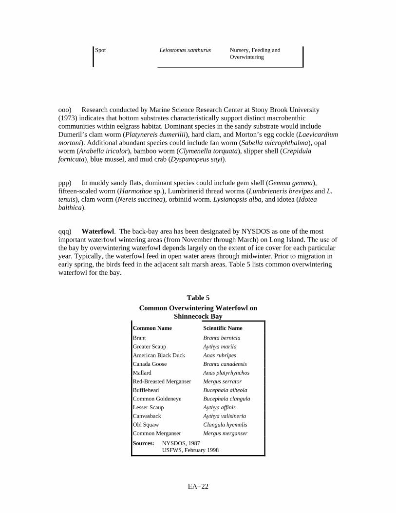
Spot Leiostomas xanthurus Nursery, Feeding and Overwintering
ooo) Research conducted by Marine Science Research Center at Stony Brook University (1973) indicates that bottom substrates characteristically support distinct macrobenthic communities within eelgrass habitat. Dominant species in the sandy substrate would include Dumeril’s clam worm (Platynereis dumerilii), hard clam, and Morton’s egg cockle (Laevicardium mortoni). Additional abundant species could include fan worm (Sabella microphthalma), opal worm (Arabella iricolor), bamboo worm (Clymenella torquata), slipper shell (Crepidula fornicata), blue mussel, and mud crab (Dyspanopeus sayi).
ppp) In muddy sandy flats, dominant species could include gem shell (Gemma gemma), fifteen-scaled worm (Harmothoe sp.), Lumbrinerid thread worms (Lumbrieneris brevipes and L. tenuis), clam worm (Nereis succinea), orbiniid worm. Lysianopsis alba, and idotea (Idotea balthica).
qqq) Waterfowl. The back-bay area has been designated by NYSDOS as one of the most important waterfowl wintering areas (from November through March) on Long Island. The use of the bay by overwintering waterfowl depends largely on the extent of ice cover for each particular year. Typically, the waterfowl feed in open water areas through midwinter. Prior to migration in early spring, the birds feed in the adjacent salt marsh areas. Table 5 lists common overwintering waterfowl for the bay.
Table 5 Common Overwintering Waterfowl on
Shinnecock Bay Common Name
Scientific Name
Brant
Branta bernicla
Greater Scaup Aythya marila
American Black Duck Anas rubripes
Canada Goose Branta canadensis
Mallard Anas platyrhynchos
Red-Breasted Merganser Mergus serrator
Bufflehead Bucephala albeola
Common Goldeneye Bucephala clangula
Lesser Scaup Aythya affinis
Canvasback Aythya valisineria
Old Squaw Clangula hyemalis
Common Merganser Mergus merganser
Sources: NYSDOS, 1987
USFWS, February 1998

ΕΑ−23
rrr) Migratory Shorebirds. As discussed earlier, the project lies within the Atlantic Flyway, an important migratory pathway for many shorebirds. Warner Island, located within the bay, has been documented as one of the most significant shorebird nesting sites in the project vicinity. The site provides nesting habitat for the common tern, black-backed gull, and herring gull. The adjacent shallows provide an adequate food source of fish and invertebrates for these species.
sss) Wading Birds. Wading birds were observed utilizing the intertidal wetland areas during both site visits. Species observed include the great egret (Casmerodius albus), snowy egret (Leucophoyx thula), and the great blue heron (Ardea herodius).
ttt) The greater yellowlegs (Tringa melanoleuca), lesser yellowlegs (T. flavipes), and American oystercatcher (Haematopus palliatus) were observed feeding within the tidal flat areas of the back bay.
uuu) Mammals. From December through early May, harbor seals can be seen in the bay. Approximately 20 to 40 seals each year have been documented using the bay and the exposed sand shoals near the inlet as a haul-out area (New York District, 1997[1]).
Rare and Endangered Species
vvv) Nearshore and Offshore Environment. No State or Federal-listed endangered or threatened marine species are known to breed within the nearshore or offshore project area. The New York State Natural Heritage Program has indicated that several sea turtles may be in the vicinity, including, the State-listed threatened and Federal-listed endangered leatherback, Atlantic ridley, and Atlantic hawksbill. Additionally, the Federal-listed threatened loggerhead, and Federal- and State-listed threatened green sea turtles may be present in the project vicinity and back-bay area for feeding during the summer and early fall months.
www) Three species of whale designated as State and/or Federally endangered may potentially wander into the borrow area during the spring and fall migratory periods. Those species include the fin-backed whale, hump-backed whale, and right whale.
xxx) Barrier Island. The Federal-listed piping plover, and the State-listed threatened common tern and the endangered least tern all use the beach habitat west of Shinnecock Inlet. The New York District is undertaking formal consultation with the USFWS regarding the potential impacts of the proposed project on the piping plover and seabeach amaranth. The Draft Coordination Report is attached as Appendix A.
yyy) The New York State Natural Heritage Program database notes that the seabeach amaranth was last reported in the project vicinity in 1993.
zzz) Back Bay. No State or Federal-listed endangered or threatened marine species are known to breed within the back-bay area. As stated above, the State-threatened loggerhead, and

ΕΑ−24
the endangered Atlantic ridley, Atlantic leatherback, and green sea turtles may be present in the back bay area for feeding during the summer and early fall months.
aaaa) The intertidal marsh associated with the back bay provides feeding habitat during the migration period for several State and Federally endangered species, including the peregrine falcon, the State-listed osprey and northern harrier, and two State species of special concern—the short-eared owl (Asio flammeus) and Cooper’s hawk (USFWS, 1998).
bbbb) The State-listed endangered/Federal-listed threatened piping plover, and the State-listed threatened common tern and the endangered least tern have been documented using the tidal marshes located immediately west of the inlet. During the 1996 Piping Plover Productivity Survey, piping plovers were observed consistently in the project area by NYSDEC and the Nature Conservancy. The NYSDEC Long Island Colonial Waterbird and Piping Plover Surveys also indicate that the Federally endangered roseate tern (Sterna dougallii) had been utilizing the back bay marsh islands for several years (1990-1996). The USFWS has yet to conclude if the will be impacted by the project (USFWS, 1998).
6)00 CULTURAL RESOURCES
a) Sand Placement Area. There are no properties listed on the National Register of Historic Places (NRHP) within the bounds of the sand placement area. File research at the office of the New York State Historic Preservation Officer (NYSHPO) indicates a number of archaeological sites are located in the vicinity of the project area. Most of these sites are situated in the back-bay areas or the interior uplands of the Long Island south shore. Portions of two historic sites are located on or near Great South Beach on Fire Island, well west of the project site (Greeley-Polhemus Group, 1997).
b) A portion of the project area was subjected to a shovel test survey when one of the alternatives considered for the project to include the placement of steel sheet pile within the sand placement area. This alternative is no longer being considered. The shovel test survey consisted of a single transect of 80 shovel test units. According to the shovel tests, the east end of the project area has been extensively disturbed from cut-and-fill activities related to the construction of Road H, a parking lot and buildings. No intact soil horizons were found in any of the shovel tests. Several of the units revealed thin bands within the dunes, which probably reflect distinct episodes of sand deposition resulting from storms, tidal currents, and aeolian deposition. No artifacts were recovered from undisturbed cultural contexts. One shovel test excavated in a disturbed area yielded chert or chalcedony flakes that were probably introduced with fill material (Greeley-Polhemus Group, 1997).
c) Borrow area. A remote sensing survey of the proposed borrow area was completed utilizing a magnetometer, side scan sonar, and side sub-bottom profiler sensor in October 1996 (Greeley-Polhemus Group and Dolan Research, 1997). Two potentially significant targets were identified by this survey. One of the targets was identified slightly outside of the northwest quadrant of the proposed borrow site. The targer has a strong, sustained magnetic signature across a wide area; however, it does not have an associated acoustic signature, indicating that it is buried. The second

ΕΑ−25
target is located within the southeast quadrant of the borrow site. It has both a strong magnetic signature and an associated acoustic image. Sonar records indicate the presence of two large rectangular hard objects, possible boilers and machinery, that extend off the ocean bottom. Associated objects extend away from these hard objects and appear to become buried in the sand. The target appears to be part of a single large shipwreck site or possibly two different smaller shipwreck sites. The area of this signature is popular with local fishing boats, and informant interviews suggest the site may be the remains of the Panther, a steamer that sank off Southampton in 1893.
7) ENVIRONMENTAL IMPACTS
a) No Action Alternative. Under the No Action Alternative for the proposed interim project, the only measures that would be taken by the Federal government to provide for storm damage protection in the study area would be those authorized by the Breach Contingency Plan. The No Action Alternative does not meet the objectives of the project. Although this alternative was not considered for further development, it does provide the basis by which the with-project benefits can be measured. The cumulative impacts of the No Action Alternative are discussed below.
b) The No Action Alternative assumes that the Breach Contingency Plan is in place, and that any breach that may occur in this area would be closed within 3 months to an elevation of +9 feet NGVD using the authority provided under this plan. The intent of the Breach Contingency Plan is to close breaches and retard inlet migration (should one be formed) by filling storm-induced breach areas when the State of New York and the New York District determine that there is an emergency situation and the breach area should be closed. (For an assessment of the Breach Contingency Plan, refer to the Fire Island to Montauk Point (FIMP), Long Island, New York Breach Contingency Plan Executive Summary and Environmental Assessment dated January 1996.)
c) In the placement area, the critical threshold for a barrier island breach is exceeded during a 10- to 15-year storm event under current conditions. Given the long-term erosion rate of 25 feet per year associated with this area, the level of protection provided decreases to a 2-year storm event in the placement area after a period of 1 year. In light of recent efforts, it is likely that historical protection will be maintained for a period of years. The cost to close a breach is approximately $2.9 million in 1996 dollars ( New York District, 1997[2]).
Social Impacts with the No Action Alternative
d) Many of the social impacts associated with the No Action Alternative stem from the potential closure of Dune Road, which provides the only access to the commercial fisheries, restaurants, marinas, and public beaches in the study area. If Dune Road washed out, the aforementioned businesses would be inaccessible, placing them in financial jeopardy. Furthermore, the breach-stranded areas would not be accessible to emergency vehicles, and waterborne conveyance would be required to respond to life-threatening or emergency situations. Without the project, long-term erosion is estimated to continue at a rate of 25 feet per year in the placement area (New York District, 1997[1]). This is a conservative estimate given that higher erosion rates have been

ΕΑ−26
recorded in recent years. Considering an erosion rate of 25 feet per year in the placement area, it is likely that Dune Road would be vulnerable to damages in the immediate future (i.e., within 2 years).
e) Many socioeconomic impacts would result from a breach, including interrupted business operations, damages to commercial structures valued at $6.6 million (1996 dollars), lost recreational opportunities for beach recreationists, interrupted chartered and recreational boating operations, increased mainland flooding and resulting damages to structures and their contents, and likely disruption of utility services provided to developed portions of the barrier island. These impacts are discussed below.
f) Commercial Businesses and Facilities. Taking no action would have a significant negative effect on the commercial enterprises in the project area. As discussed above, there are seven businesses in the study area, including commercial fisheries, restaurants/marinas, and a currently vacant bait-and-tackle shop. At the current rate of erosion, it is likely that Dune Road will be vulnerable to damage in the immediate future, which could temporarily sever vehicular access to these businesses.
g) In particular, the Shinnecock Inlet commercial fishing industry would not be accessible via the roadway, and would likely relocate to nearby fishing facilities, with the space to accomodate the vessels. The vessels would likely disperse to Freeport, NY, Greenport, NY, Cape May, RI, or New Bedford, MA, as discussed in the Main Report, Economic Analysis. The loss access for the commercial fisheries and the potential ultimate loss of the cooperative would be of great economic loss to the local economy. The commercial fisheries contributed more than $10 million (1996 dollars) to the local economy in 1995. Because the fishery enterprises would likely relocate, the economic activity would not be lost on a macro level; however, the direct and indirect impacts of the fisheries’ economic activity would be lost to the local community. Also, the fisheries would experience lower net returns due to the increased travel distance to the fishing grounds from the relocated site.
h) In addition, the segment of the barrier island where the commercial enterprises are located is the area most vulnerable to breaching. The No Action Alternative assumes that barrier island breaches would be closed under the authority of the Breach Contingency Plan. The design cross-section prescribed under the plan to mitigate breaches would result in regular overwash of the placement area and have a high potential for future breaches. Hence, even with the breach repair, it is likely that the businesses would opt to relocate, because of the high potential for future disturbance.
i) Beach Recreation. According to the New York District (1997[2]), beach use in the project area has declined due to beach erosion. Under the No Action Alternative, beach erosion is likely to continue at a rate of 25 feet per year in the placement area. This would result in reduced beach frontage, and lost recreational opportunities for visitors and residents of Long Island who rely on the public beaches for a significant portion of their recreation. Given the increased future vulnerability of Dune Road to wash out under the No Action Alternative, access to public beaches could be impaired for some portion of the study area (depending on the location of the wash out), resulting in lost recreation opportunities for beach-goers and lost direct and indirect beach-related tourism revenues for the local economy. Furthermore, the public beach facilities at

ΕΑ−27
the Ponquogue Beach Park may be damaged or rendered inaccessible due to continued beach erosion or a breach of the barrier island.
j) Boating. Charter and recreational deep sea fishing boats rely on Shinnecock Inlet as an ingress and egress to reach deep-sea fishing grounds in the Atlantic Ocean. A breach could disrupt charter and recreational boat traffic through the navigational channel of the inlet. Under existing conditions in the vicinity of Shinnecock Inlet, the critical threshold for breaching would be exceeded by a 10- to 15-year storm event, and after a period of 1 year, the level of protection would decrease to a 2-year storm event. A breach is likely to cause instability in the existing inlet, resulting in significant shoaling and siltation in the channel, rendering the inlet unnavigable. Due to safety concerns, the U.S. Coast Guard could limit boat traffic through the inlet during and after breach formation, as well as during breach closure operations when dredge boats may be blocking access to the inlet (New York District, 1997[2]).
k) In the event of a breach, charter boat operations would likely be disrupted for an indefinite period of time. This is because this type of business is sensitive to service interruptions since reservations are made well in advance and lost business may not be recoverable. Recreational deep-sea fishing boats would likely be temporarily relocated to Montauk in the event of a breach, resulting in increased travel time and expense for boat owners.
l) Mainland Inundation Impacts. The barrier island protects the south shore of Long Island from direct wave impacts and tidal surges. Should the barrier island breach, business and residential structures located in low-lying areas near the bay shore would experience increased flooding and tidal surges potentially leading to extensive damages to the structures and their contents as well as possible utility service interruptions. Under the No Action Alternative, annual damages to structures and their contents in the Shinnecock Bay area have been estimated at approximately $3,800,000 (1996 dollars) by the New York District (1997[2]).
m) Utilities. Utility lines servicing the barrier island are located along Dune Road on above-ground utility poles. In the event that Dune Road is undermined or the barrier island breaches, utility services are likely to be interrupted, resulting in down-line customers losing utility services or necessitating the expensive repair/relocation of the utilities to service them.
Biological Impacts Associated with the No Action Alternative
n) Offshore and Nearshore Oceanic Environment. In the No Action Alternative, there would be no positive or negative impacts to the offshore and nearshore environment that differ from current conditions (including ongoing human activities). Overwashes and breaches may continue to occur absent beach nourishment. However, breaches are expected to be sealed within ninety days of creation, due to the Breach Contingency Plan (BCP). This impacts section, therefore, concentrates on this concept.
o) Barrier Beach. As stated previously, in the No Action Alternative, there would be continuing shoreline erosion and a strong possibility of a breach occurring during a tropical or extratropical storm. The first impact of such a breach would be the destruction of the beach grass

ΕΑ−28
habitats from the ocean to the back bay. The extent of this destruction would depend on the width of the breach. While the overwash and/or breach could possibly provide additional habitat for shorebirds, including the piping plover and least tern, timing may limit the extent of loss. Most overwashes occur during northeaster (fall and winter) storms when the plovers have migrated elsewhere. In addition, the loss of beachfront habitat (Tiana Beach, NYSDOS Designated Significant Fish and Wildlife Habitat) would negate the beneficial impacts of overwash habitat creation. However, because plover and tern numbers are so low, it is doubtful that lack of habitat would cause their decline. Available habitat along the south shore would support far larger plover and tern populations than currently exist. Should a breach occur in the summer due to a tropical storm or hurricane, the storm's destruction of plover nests by wind and flooding (as happened in 1996 during Hurricane Bertha) would be a more negative impact than any presumed short-term overwash habitat gain.
p) The avifauna and mammals dependent on barrier-beach habitats would be displaced or eliminated in the immediate area of any overwash or breach. While this is a negative impact, it is probably not significant in the context of the overall south-shore barrier island system.
q) Back Bay. Impacts without the proposed project (and with a presumed breach) would be both positive and negative. In general terms, barrier island breaches generally tend to increase bay tidal ranges, decrease previously established inlet flow velocities, increase bay salinities and reduce bay water residence times (Moffat & Nichol, Engineers, November 1994). Positive impacts include increased bay circulation, reduced bay water residence times, and potentially improved habitat conditions for benthic invertebrates, finfish, and migratory shorebirds. Increased tidal flushing generally promotes accelerated clam growth, decreased “small form” algae populations, and dispersion of phosphorous and nitrogen loadings (Cashin Associates, 1993). Negative impacts to the back-bay area (NYSDOS Designated Significant Fish and Wildlife Habitat) include increased tidal prism, washover, and smothering of existing intertidal marshes. These negative impacts would increase temporary scouring of back-bay shoreline, increased turbidity during the ebbing tide, increased light extinction to subaquatic vegetation, increased salinity, loss of quiet water habitat, and changes in shoreline vegetative community structure. These impacts are expected to adversely affect the overwintering habitat for waterfowl. The magnitude and extent of these impacts (positive and negative) would depend on the size of the breach, degree of associated turbidity, and shoaling within the back-bay area. Impacts to Warner Island as a result of the overwash are expected to occur, resulting in habitat losses for migratory shorebird nesting areas due to increased daily tidal prism. Additionally, the potential exists for structural damage to septic and petroleum lines associated with the resort and waterfront business district, which could increase coliform bacteria and levels of petroleum hydrocarbons. The degree to which these impacts would occur are dependent on the size and location of the breach. More wetlands were destroyed in Shinnecock Bay within a few hours during the 1992 December northeaster storm than in several decades of human activity (Fallon and Mushacke, 1996).
r) Bay Water Circulation and Tide Levels. A breach through the system would have the potential to improve water quality by reducing the number of waterborne pathogens, reducing turbidity of incoming tide, and by moderating water temperatures. These positive impacts would be favorable for the production of shellfish, particularly the hard clam. Additionally, eelgrass beds could potentially flourish, thus providing vital habitat for the bay scallop. Since the BCP will be implemented, these are changes are considered short-term.

ΕΑ−29
s) On the negative side, increased tide levels could flood and drown existing intertidal marsh systems within the back-bay area. Additionally, water depth could increase enough (at high tide) to block necessary light for the production of eelgrass meadows, although this is uncertain.
t) If a breach occurs within this section of the barrier, water temperature and salinity could change significantly from current conditions because of the proximity to the new inlet. Cooler ocean waters, ranging from 4 to 21 degrees Centigrade (USFWS, 1981), infiltrating into bay water, which ranges from 0 to 30 degrees Centigrade, could improve temperature conditions for hard clams. Hard clam growth is optimal between 20-23 degrees Centigrade.
u) Submerged Aquatic Vegetation. On the bay side, the sand transported north from a breach could scour or smother any submerged aquatic vegetation in the bay adjacent to the breach. Turbidity is expected to increase during the ebbing tide as overwash sediments are moved throughout the bay, establishing new shorelines, shoals, and islands. Increased turbidity and consequent reduction of the photic zone could adversely impact existing eelgrass meadows.
v) Eelgrass meadows may not be capable of re-establishing due to increased deeper water habitat and increased wave action. Species that could be most adversely impacted due to the loss of eelgrass meadows include the bay scallop, tautog, winter flounder, and waterfowl. In general, small fish utilize eelgrass meadows, as they provide an abundant food source. New York Sea Grant (1993) also indicates that juvenile tautog and cunner (Tautogolabrus adspersus) depend strongly on eelgrass habitat as shelter and/or nursery and would be adversely impacted by loss of that habitat.
w) Historically, eelgrass beds within Shinnecock Bay have established on top of relict flood tidal deltas. This is a natural process and it is therefore expected that eelgrass beds would establish on newly formed tidal deltas. Presumably, the newly formed shoals colonized by eelgrass would compensate for those beds destroyed by the breach.
x) Intertidal Wetlands. In the event of a breach, overwash sands transported to the northern shoreline of the barrier island would scour or smother the intertidal marsh grasses. Cashin Associates (1993) point out that tidal marsh areas near active, migrating inlets would stay in early stages of vegetative succession, maintaining their highest rate of organic production and export to the estuary. Habitat destruction caused by overwashing of the intertidal marshes may be permanent or temporary, depending on the size of the breach and timing until closure. The system is dynamic and unpredictable. Although tidal wetland trends have been studied in Shinnecock Bay from 1974 to 1995, the system remains dynamic and unpredictable immediately following storm events. Fallon and Mushacke (1996) note that extensive wetland areas were buried by overwash caused by a 1992 storm.
y) Benthic Invertebrates. Benthic invertebrate species that benefit from these marshes include the mud snail, salt marsh snail, ribbed mussel, marsh crab, and the fiddler crab. These invertebrates are an important food source for mammals and birds that utilize the intertidal wetland areas.

ΕΑ−30
z) Finfish. It is not anticipated that finfish would be significantly affected by a breach. The new channel would provide new habitat for certain species, especially bluefish, and newly established intertidal habitat would provide nursery grounds for small baitfish. Generally, unvegetated bottom is the preferred habitat of most benthic fishes.
aa) Waterfowl. Shinnecock Bay is a significant wintering waterfowl area. Opening of a breach is unlikely to either positively or negatively impact waterfowl populations to any measurable degree.
bb) Migratory Shorebirds. Certain migratory shorebirds rely on the back-bay environment for feeding and roosting. Breach formation could have both positive and negative impacts to these populations. These effects are different than those on avifauna that rely on the barrier island habitat. Obviously, scouring and destruction of intertidal marshes would be negative, but creation of new shoal areas would be positive. As discussed earlier, the timing of breach creation could obviate most impacts as a winter breach (due to extratropical storms) would occur when the birds were elsewhere. A summer (tropical) storm would physically create new habitat, but also directly destroy nests and fledglings.
cc) Since it is doubtful that the currently low reproductive success of shorebirds is due to lack of habitat, the impacts of a breach on these habitats may be insignificant.
dd) Wading Birds. Wading birds rely on intertidal wetland systems for roosting and feeding. The small baitfish typically found in the back-bay area, including Atlantic silverside and mummichog, make up the dominant food source for the common species of wading birds. Wading birds have recently begun to overwinter in the back-bay area. The most common overwintering species include the great blue heron and night crown heron. As with shorebirds, the impacts of a breach would be both positive and negative, and effects of a breach on these populations are inconclusive.
ee) Mammals. Harbor seals could possibly benefit from additional shoal areas created by the natural processes of breaching. The seals use this habitat as haul-out areas.
ff) Endangered and Threatened Species. Breaching of the barrier would provide improved habitat for shorebirds, including the piping plover and the least tern, but this effect would only balance (at best) the loss of beach shorefront caused by the breach. Additionally, tropical storms or hurricanes may flood nests during the breeding season if the beach is not nourished to a sufficient elevation. Overwash sands from the foreshore area may expose existing seed banks of seabeach amaranth in both the foreshore area and back bay elevated overwash areas. This could provide the potential for improved habitat for the re-colonization of seabeach amaranth in these areas, if they are destroyed by the overwash.
Cultural Resources Impacts with the No Action Alternative
ΕΑ−31
gg) Adverse impacts on archaeological resources from both the prehistoric and historic periods could result from the No Action Alternative. As a result of this alternative, continued erosion could expose prehistoric land surfaces that may contain the remains of the area’s early inhabitants. A breach in the barrier island and lack of stabilization could permit wave, wind, and other actions to cause irreversible damage and loss to archaeological sites in breach areas. Unknown archaeological resources—including sites located beneath the barrier islands or shipwrecks buried in the nearshore area—could be uncovered, damaged, or destroyed as a result of a breach.
hh) The Breach Contingency Plan outlines a process for treatment of archaeological sites in accordance with Section 106 of the National Historic Preservation Act, to avoid adverse impacts on such resources. Exposed sites or wrecks located adjacent to a breach would be investigated prior to sand placement to avoid adverse impacts from use of heavy equipment, as well as from the placement of sand over such resources. If peat layers preserving prehistoric land surfaces are exposed, surveys by trained personnel would be conducted to the extent feasible under conditions at that time. The investigation would determine if a site is potentially eligible to be listed on the NRHP; if sand placement would have an adverse impact on the archaeological resources; and if additional studies would be required. The results of the investigation would be coordinated with NYSHPO. If the site is eligible for the NRHP and would be impacted by sand placement, then the alternative of avoidance of the site would be explored. If avoidance is not feasible, then the Advisory Council on Historic Preservation (ACHP) and NYSHPO would be advised and a plan for the documentation of the eligible properties would be developed and undertaken prior to fill of the breach.
ii) To avoid impacts on cultural resources located within offshore borrow area, the borrow areas would require a remote sensing survey—including side scan sonar, magnetometer, and sub-bottom profiling—to determine if there are any potential NRHP-eligible remains of shipwrecks. All work would be coordinated with NYSHPO. All targets identified by this survey would be avoided during dredging, if feasible. If avoidance is not feasible, then the targets would require additional investigations in the form of underwater archaeological surveys to determine which targets are the remains of wrecks and their NRHP eligibility. A plan for documentation of all NRHP-eligible wrecks would be developed and implemented in coordination with ACHP and NYSHPO. Stabilization may serve to protect archaeological sites from destruction or irreversible damage.
jj) This plan would become operative if a breach occurred and the breach was not filled using emeregency authorization within 30 days of the occurrence of the disaster or emergency. However, archaeological sites located at the breach would likely be destroyed when the breach was created and therefore, the No Action Alternative could result in the loss of archaeological resources. In addition, archaeological resources could be adversely impacted if it is necessary for the New York District to undertake emergency measures within 30 days of the occurrence of a disaster or emergency. For those emergency actions that are undertaken soon after the occurrence of the emergency, a waiver will be sought from either NYSHPO, the Advisory Council, or the Secretary of the Interior, in accordance with current Federal regulations.
Cumulative Impacts Associated with the No Action Alternative

ΕΑ−32
kk) Federal Governmental Actions. Several other Federal projects are located along the Atlantic and south shore coast of Long Island. The four civil projects near the proposed interim West of Shinnecock Inlet Plan are: 1) Shinnecock Inlet Navigation Project, 2) the Westhampton Interim Project, 3) the Moriches Inlet Navigation Project, and 4) the Fire Island Interim Project. As discussed above, the Breach Contingency Plan would affect the area west of Shinnecock Inlet and the Reformulation Project includes the West of Shinnecock Inlet project area. The Reformulation Plan, since it would occur at a latter date, would have to consider the cumulative impacts of the No Action Alternative. Farther to the west, three Federal projects are completed or proposed, at Coney Island, East Rockaway, and Long Beach. To determine the potential cumulative impacts from these projects under the No Action Alternative, the areal extent of the borrow areas was calculated, and the results are shown in Table 6. The acreage includes all borrow areas between the 18- and 60-foot contours from Breezy Point to Montauk Point.
Table 6 No Action Alternative
Borrow Area Size by Project
Project
Status
Acres Coney Island
Constructed
528.0
East Rockaway
Constructed
521.1 Long Beach
Proposed
1,193.8
Westhampton Interim1
Constructed
308.5 Fire Island Interim1
Proposed
1,704.5
Used and Proposed Borrow Area Total
4,255.9 Available Borrow Area on the South Shore
183,655.0
Note: 1 Interim projects are to be subsumed by the Reformulation Project.
The used and proposed borrow area in the No Action Alternative would disturb about 2.3 percent of the total nearshore and offshore areas that could be used.
ll) At the direction of the U.S. Congress, the U.S. Army Corps of Engineers has initiated the South Shore of Long Island, New York Embayment Restoration Study. The study area encompasses the embayment area along the south shore of Long Island between the island proper and its fronting barrier islands, extending approximately 70 miles from East Rockaway Inlet to Shinnecock Inlet. The purpose of the study is to determine whether Federal projects have caused or contributed to the degradation of the ecosystem of the embayment area (including habitats, water quality, and other related environmental features), and identify a possible plan of improvement which assesses whether Federal participation in a follow-up feasibility study is warranted. Approximately 14 sites have been selected for evaluation and found to warrant potential Federal participation in the development of restoration alternatives including, salt marsh restoration, sea and shore bird habitat restoration, shellfish restoration, shoreline protection, submerged aquatic vegetation restoration, and estuarine pond restoration. Two of the 14 sites, Phillips Creek and Daves Creek, are located in the Township of Southampton. These sites are located outside of the West of Shinnecock Inlet project study area. Approximately 80 additional sites are being evaluated for possible selection, of which approximately 20 sites will join the initial 14 sites for further development.
ΕΑ−33
mm) Other Governmental Actions. NYSDOS is currently evaluating two projects in the vicinity of Shinnecock Inlet: construction of a semi-fixed sand bypassing plant, and modification of the western jetty of the inlet by adding a spur. The proposed sand bypassing plant would transport approximately 130,000 cy of sand annually from the east side of the eastern jetty of Shinnecock Inlet to a location 7,000 feet west of the inlet. The proposed modification of the western inlet jetty would involve the construction of a 300-foot-long spur that would extend westward off the tip of the jetty. According to NYSDOS, the jetty spur would capture sand currently being deposited in the western ebb shoal area of the inlet, causing sand to reverse fill from the spur back to the beach area west of the inlet. These projects are currently in the preliminary planning stages. Under the No Action Alternative, the jetty spur would not provide sufficient accretion of sand in the placement area to sufficiently mitigate the highly eroded state of the beach system in this area; supplemental beach nourishment would be required. In addition, neither project would reduce the potential for breaching of the barrier island.
nn) NYSDOS, in cooperation with local governments (including the Town of Southampton), is developing the South Shore Estuary Comprehensive Management Plan (CMP). The South Shore Estuary is a 50-mile stretch of bays, rivers, and wetlands that includes Shinnecock Bay and the proposed project study area. The purpose of the CMP is to protect the natural, recreational, and economic resources of the estuary. The two-phase CMP first focuses on describing existing conditions and, second, evaluates issues, problems, and opportunities and develops recommended actions to ensure that the estuary is improved and protected.
oo) The Town of Southampton is developing a Local Waterfront Revitalization Plan. This plan, which is currently in draft form, focuses on promoting research to study the marine ecosystem in Southampton, restoring degraded waterfront areas, managing protected areas, encouraging sustainable development and pollution abatement, modifying policy design and regulatory frameworks, and providing public outreach services.
pp) The Town of Southampton has initiated a study to update and amend “Coastal Erosion Hazard Areas,” of the Town Code. The objective of the code revisions is to identify a range of coastal protection approaches that could be employed to manage the Town’s Atlantic Ocean shoreline, possibly including soft and hard structural techniques, setbacks, alternative building code requirements, and a National Shoreline designation. This analysis is in the preliminary development phase.
qq) Suffolk County periodically dredges local channels for maintenance purposes. This dredging is conducted subject to permits issued by the U.S. Army Corps of Engineers and NYSDEC. The dredging takes place mostly in the bays and not on the open Atlantic Ocean coast. The dredged materials are used as beach fill whenever the materials are suitable, and the placement is cost effective.
rr) Other Non-Government Actions. The project study area is all within public ownership. Therefore, no private actions are going expected to occur.

ΕΑ−34
ss) Cumulative Impacts of the No Action Alternative. The use of the nearshore and offshore borrow areas for Federal and State projects could have a cumulative impact on these resources. As discussed above, about 2.3 percent of the available acreage within the south shore of Long Island area would be disturbed over the 50-year life of these projects. In any one year, the disturbance would be far less. It has been shown that these borrow areas can quickly recolonize after the disturbance. Because of the low percentage of disturbance and the recolonization potential, no cumulative impact from these projects is expected. The borrow areas would be physically changed. However, natural forces are constantly moving sand and changing the form of the sea bed. Therefore, these cumulative physical changes are not considered to be impacts.
tt) Noise and air emissions are restricted to the construction site and occur only during the construction period. None of the projects would cause noise or emissions during the operational period. The dredging is offshore, away from sensitive noise receptors, and would not have an impact. The main cause of noise during the placement is the operations of the bulldozers. This source is short-term and would occur during the daylight hours. Therefore, no long-term noise impacts are expected.
uu) According to NYSDEC, Suffolk County is severe non-attainment for ozone. New York City and Westchester and Nassau Counties are also non-attainment for this pollutant. The projects would not occur at the same time and the main emission of concern from heavy construction equipment is particulate matter, not ozone precursors. Therefore, the cumulative impacts from the emissions are not expected to cause air quality violations.
vv) Beach Nourishment Alternative (Interim Project). The direct impacts of the beach nourishment alternative would be the deposition of approximately 1,590,000 cy of beach fill (initial fill of 810,000 cy, and 390,000 cy of fill two times on a 2 year cycle for a duration of 6 years) on the placement area. The purpose of the beach nourishment alternative is to provide interim storm damage protection until the completion and potential implementation of the FIMP Reformulation Study. The interim project may be continued, based on the outcome of the overall FIMP Reformulation Study.
ww) The beach nourishment alternative is the preferred alternative to accomplish the goals of the interim storm damage protection project. The beach nourishment alternative is designed to provide protection for storms of magnitude of 44 years. With the interim project in place, there is a 1-in-50-year chance of a barrier island breach.
Social Impacts with the Interim Project
xx) Commercial Businesses and Facilities. Under the beach nourishment alternative, the placement of beach fill at the project site would protect the commercial business district and Dune Road up to a 44-year storm event. Implementation of the beach nourishment alternative would enable businesses to continue to operate in the area. Due to the reduced likelihood of breach (breach potential is 1 in 50 years), commercial structures are much less likely to be damaged or destroyed, access to the businesses is less likely to be interrupted, and utility service is less likely to be disrupted.

ΕΑ−35
yy) Given the 44-year level of protection provided under the interim plan, the relocation of the commercial fishing fleet would likely not be necessary as might be the case under the No Action Alternative. Detailed costs and benefits are discussed in the Main Report and its Economic Appendix.
zz) Beach Recreation. The beach nourishment alternative would extend and maintain the beach frontage at the project site. Beach nourishment would provide beach recreation areas for the approximately 175,000 annual beach-goers who utilize the project area’s beaches, thereby promoting the local economy during the summer tourist season. Dune Road would be protected up to 44-year storm events, maintaining access to public beaches. The New York District (1997[2]) predicts that beach visitation would increase by an average of 93,000 visits annually upon completion of the interim project. There would be temporary disruption of beach recreation during project construction and renourishment phases. In addition, due to littoral drift, the proposed project would enhance the beach frontage directly west of the project area.
aaa) Boating. Charter and recreational boating would be impacted if the stability of Shinnecock Inlet were compromised due to a barrier island breach. The likelihood of a breach under the proposed interim storm damage protection plan is 1 in 50 years, making the disruption of charter and recreational boat ingress and egress through Shinnecock Inlet much less likely than under the No Action Alternative. In consideration of the 44-year level of protection provided by the proposed interim project, losses in net returns to charter boat businesses would be avoided. Should a breach occur and Shinnecock Inlet become unstable, recreational boaters would likely temporarily access deep-sea fishing grounds via Montauk. With the interim project in place and the associated reduced breach risk, there is a decreased potential that recreational boaters would incur travel costs (expenses and time) associated with relocating to Montauk.
bbb) Mainland Inundation Damages. The south shore of Long Island would be negatively impacted if subjected to wave impacts and tidal surges, as would occur in the event of a barrier island breach. Under the beach nourishment alternative, there is a reduced likelihood of a breach, and therefore mainland structures and contents would be less likely to experience damages due to flooding and tidal surges.
ccc) Environmental Justice. Executive Order 12898, entitled “Federal Actions to Address Environmental Justice in Minority Populations and Low Income Populations,” requires that the potential for disproportionate adverse impacts on low income and minority populations be identified and addressed. According to 1990 census data, identified groups of minority and low income populations are not located in either the placement area or the project study area. The project would not affect land use or development plans. Therefore, the proposed interim project would not have a disproportionate adverse impact on these populations.
ddd) Utilities. Utility service is provided to the barrier island via utility poles with above- ground distribution cables that run along Dune Road. With the interim storm damage protection project, Dune Road would be protected for up to 44-year storm events. The provision of utility service would be impacted only by storms of magnitude larger than 44-year events with the interim plan in place.

ΕΑ−36
Biological Impacts Associated with the Interim Project
eee) As discussed in the Introduction to the Affected Environment Section, the USACE is scheduled to commence pre-construction monitoring in the proposed borrow area in the sprin 1999. This data will assist the in the evaluation of impacts associated with the biological resources in the borrow area. If this sampling reveals that any portion of the proposed borrow pit supports significant populations or provides critical habitat for any species, these areas will be avoided. The defined boundaries of the borrow area are much larger than what will be required for beach nourishment by any phase of the project. Thus, great potential exists to select another sub-area within the borrow pit which is devoid of significant populations or unique habitat characteristics. As NYSDEC will be receiving continual updates to the biological pre-construction monitoring program, they will coordinate with the USACE on the final selection of appropriate sub-areas within the borrow pit to begin dredging.
Dredging Impacts in General. Dredging has been defined as "an earth-moving process specialized to remove bottom material from under water to increase the water depth or gain the bottom material" (USACOE, 1991). Impacts associated with dredging at the proposed borrow area site in order to provide a clean source of sand for project beaches, and fill placement of the resultant material, are the major subjects of this section.
Dredging for this type of beach nourishment project can be accomplished by either a hopper dredge or a hydraulic (cutterhead) dredge. Although the District cannot predict the types of dredge(s) that will be bid for the specific project or awarded a contract, history has shown that these dredges are readily available with sufficient capability to perform the proposed project work. Hopper dredges normally perform at maximum production when the dredging to placement distances exceed three miles. Hydraulic dredges are usually used within the three mile distance. Even though the borrow site is approximately one- half mile offshore, the distance of the placement area is approximately seven miles. Therefore, the most cost- effective solution is to use both types of dredges.
A hopper dredge behaves as an underwater "vacuum cleaner", in that it moves along the ocean floor and inhales sediment through a pipeline which deposits the material into the vessel's hopper. The sediment, in each pass, is taken up in less than two foot increments until the hopper is full or the maximum dredging depth is met. The hopper dredge will normally transverse a large area, to minimize turns, and will incrementally dredge the entire area before the second pass is executed.
Conversely, the hydraulic dredge will dredge from a stationary position and continue until the limited depth is reached. The dredge will then position itself to another site to continue the process.
Although the techniques may differ, the outcome is the same: a specified area will be dredged to a depth (not to exceed twenty foot below existing ocean bottom) which will provide sufficient material to meet the necessary volumetric beachfill requirements.
It is further noted that there are other types of dredging vessels that may become available for use on the proposed project. The Federal objective (construction of the proposed project) will be the

ΕΑ−37
same, and whichever type of dredge can perform the required work at least cost (low-bid), will fulfill the objective.
Standard dredging practices aim to avoid disturbing and dredging sediment types that are of high benthic quality and that are not compatible with the sand at the placement area. Areas that contain material that is not consistent with the placement area, are not utilized. Also, as standard practice, the District tries to dredge borrow areas to the minimum depth required with gently sloping sides to avoid a reduction or loss of circulation that may reduce dissolved oxygen (DO) levels.
It should be noted that the Dredged Material Research Program at the United States Army Engineers Waterways Experiment Station at Vicksburg, Mississippi has resulted in the publication of several hundred reports concerning dredging and dredged material disposal impacts. The information provided below can only summarize some of the great volume of information available.
Through its civil works, the U.S. Army Corps of Engineers has had a long and extensive involvement with the use of marine sand for beach replenishment. Nationally, potential fill requirements total millions of cubic yards annually, combining both initial sand placement and annual maintenance. Beginning in 1971 and continuing to the present, the Corps of Engineers Coastal Engineering Research Center and the Environmental Laboratory located at Vicksburg, Mississippi have supported research on the ecological effects of beach replenishment, examining both the depositional areas of the beach, above and below water, and the offshore sand source areas.
The effects on the environment of the operation of dredging and fill placement are materially influenced by the conditions at the dredging site, by the nature of the materials dredged, and, both directly and indirectly by the types of equipment used. By their action, dredges may cause a variety of negative environmental impacts to water quality and aquatic ecosystem. These include:
Water Quality
1. Increased levels of turbidity and suspended solids
resulting in:
a. the reduction of dissolved oxygen levels, primary productivity and photosynthesis.
b. higher occurrence of gills and filter-feeding structures becoming clogged.
Aquatic Habitat
1. Changing the aquatic habitat at the dredging site.
2. Destruction of benthic organisms.
3. Altered benthic diversity following recolonization.
4. Changes in circulation patterns.
5. Modified sediment deposition.
6. Creation of either hypoxic or anoxic zones.
7. Biological uptake of released pollutants.

ΕΑ−38
8. Modified behavior of organisms due to increased stress levels possibly effecting reproduction.
9. Mortality of organisms being entrained within the dredging device.
Water Quality. There will be short-term adverse water quality impacts during the construction period of this project. Naqvi and Pullen (1982) conclude that problems with anoxic sediments and nutrient release in the nearshore zone of a high-energy beach as a result of beach nourishment do not appear to be significant because: (1) Fine materials that are high in organics are generally moved offshore; (2) Sulfides are rapidly oxidized; and (3) Fine sediments are rapidly diluted by the high-energy mixing process. Dredging the proposed borrow areas will generate turbidity and sedimentation impacts within the immediate vicinity of the operation, and does not appear to significantly impact water quality (Naqvi and Pullen, 1982). Generally, the large grain-sized material will keep the area of impact small and will ensure that there are no impacts beyond the period of construction. The construction period will last several months and localized water quality impacts will be experienced in the proposed borrow area for the duration. Similar short-term water quality impacts will occur at the nourishment sites along the 4000 foot project shore but these impacts should not alter the Class SA water quality classifications set by the NYSDEC. Fill operations will deliver a slurry of sand to the receiving shore, increasing turbidity in the immediate area. This effect, however, will not be significant since turbidity levels in the high-energy surf area are naturally high.
Long-term impacts to water quality are not expected to occur as a result of project implementation. Short-term turbidity may effect organisms in several ways. Settling of sediments may bury sedentary species. Suspended matter can clog gills and filter-feeding structures, which could directly cause mortality or reduce energy efficiency, and cause indirect effects such as reduction in reproduction or decreased ability to avoid predation (Sherk, 1971). In addition, turbidity may reduce light penetration, lowering photosynthetic activity and dissolved oxygen content. Turbidity and associated water quality parameters at the borrow areas and placement sites will rapidly return to preconstruction levels with no lingering adverse impacts expected (Naqvi and Pullen, 1982). Periodic renourishment will produce water quality impacts similar to those generated by initial construction, but for a shorter time period (Naqvi and Pullen, 1982). Renourishment impacts are also not expected to be significant.
Based on the aforementioned studies, as well as a general review of dredging operations across the country (LaSalle, 1986) it is reasonable to conclude that, except for special or unusual circumstances, dredging does not produce a long-term significant adverse impact to water quality.
Potential adverse impacts within any borrow area include: (1) destruction of benthic organisms; (2) altered benthic diversity following recolonization; (3) changes in circulation patterns; (4) modified sediment deposition; and (5) creation of either hypoxic or anoxic zones. Loss of benthic and epibenthic organisms will be the most direct and most immediate impact in the borrow areas for the project. Mortality will occur as organisms pass through the dredging device or are transported to an unsuitable environment. Benthic and epibenthic organisms will be buried by resuspended and redeposited sediments. Sessile species will be eliminated by direct burial or capture while motile organisms can move away (See 4.21 & 4.22).

ΕΑ−39
Habitat changes brought about by dredging within borrow areas may include changing the bottom circulation patterns on where newly-dredged areas are created. This may create conditions whereby fine sediments are deposited replacing the sandy bottom, thus leading to either hypoxia or anoxia within the pits. Because many species are substrate-specific or nearly so, biological communities can be altered as a result of these changes. Filter-feeding organisms are most susceptible to fine sediments, and a change from a filter-feeding community to a deposit-feeding community in the area of borrowareas can develop. Data from borrow pits in lower New York Bay do not suggest that the proposed impacts will impede the recovery of the borrow area benthic and epibenthic communities (USACOE, 1991b).
Woodward-Clyde Consultants (1975) studying the lower New York Harbor found rapid repopulation of the Rockaway Beach borrow area to occur particularly by transient colonizing species [such as (Mulinia lateralis), (Polydora ligni), and (Capitella capitata)]. In comparing borrow areas to undisturbed shoals, Cerrato and Scheier (1983) report concentrations of pioneering species with rapid return to more stable communities within a short distance from dredged areas. These colonizing species are suitable for fish food, and thus provide a substantial short-term resource (to an extent mitigating a period of lower productivity) until the normal fauna is re-established. Past studies report that many features typical of "undisturbed" or normal benthic communities should be attained within one year following the dredging operations.
The Woodward-Clyde Consultants (1977) study found that several species were appreciably more abundant in October 1975 than in June 1976 or September, 1976, indicating a possible positive response to increased suspended materials loads. These species included: (Magelona obockensis), (Magelona spp.), (Nephtys spp.), (Acanthohaustorius millsi), (Parahaustorius longimerus), (Protohaustorius deichmannae), and (Trichophoxus espistomus) in the Shipek samples and (Ovalipes ocellatus) in the trawl samples. However, most of these species were concentrated at one or two stations, suggesting a local rather than some widespread effect of dredging.(Magelona obockensis) was outside the borrow site, (Nephtys spp.) was in the dredged borrow area, (Acanthohaustorius millsi) and (Parahaustorius longimerus) were in the undredged borrow area, (Protohaustorius deichmannae) and (Trichophoxus epistomus) were throughout the borrow area, and (Ovalipes ocellatus) was in the south reference area (outside of the Rockaway borrow area). (Magelona spp.) was widespread (found at all 11 stations and in 24 if 33 replicates) and numerically prominent only in October 1975 (173 of 177 individuals found). This species may be the only possible indicator of a widespread effect of dredging, based on increases among organisms that do better when water quality is poor. Possible dredging-sensitive species identified included sand shrimp, which were more abundant in June and September than during October, and (Streptosyllis spp.) and (Gammarus spp.), which were more abundant during September than during June or October. Both (Streptosyllis spp.) and (Gammarus spp.) were localized to only some of the sampled areas, suggesting possible local factors. Sand shrimp may well have avoided the borrow vicinity during dredging operations.
In Brinkhuis' 1980 assessment of the potential biological effects of sand and gravel mining in the Lower Bay of New York Harbor based on the literature, he concluded that the probable effects of sand mining operations on biota per se appear to be minimal.
ΕΑ−40
fff) As stated previously, the following discussion of project impacts was prepared based upon review of the existing available literature and similar studies currently being conducted by the USACE. This impact analysis may vary as more site specific information becomes available from the proposed biological sampling of the borrow pit. However, the Corps does not anticipate that any findings from this sampling will result in a significant change to the proposed project or the borrow area.
ggg) Borrow Area. The biological community most likely impacted by the mining of sand at the borrow area would be both the macro- and megabenthic invertebrates. Two types of potential impacts could result: direct impacts (death) to organisms that are removed with the sediments utilized for beach nourishment; and indirect impacts to down-drift benthic organisms that are covered by the suspended sediments resulting from the dredging operations.
hhh) Surf clams are abundant along the entire south shore of Long Island and are likely to inhabit the borrow area in various life stages. If present, the exact locations will be confirmed by the preconstruction monitoring program. Long-finned squid may also utilize the offshore borrow area. This species typically spawns and attaches their eggs in a communal cluster to bottom substrates, hence, there may be an impact to this species. Finfish are considered a mobile species, and are likely to avoid the borrow area during periods of active dredging. Therefore, no direct impacts to finfish are expected to occur as a result to the proposed project. However, the year-round biological monitoring program will ascertain whether any unusual congregation (or spawning) of finfish, crustaceans or squid takes place within the borrow area. At this time, no other unique species or habitats are known to occupy the borrow pit, which will have a depth of 5 - 10 ft, and adjacent waters.
iii) As discussed briefly in the Affected Environment section, the MAFMC and NMFS are currently finalizing the designation of “Essential Fish Habitats” along the Atlantic coast. It is unknown at this time whether the project lies within any such designated area, and what, if any, effect this would have on the proposed project.
jjj) Nearshore Environment. Best Management Practices (seasonal restrictions and turbidity reduction measures) will be implemented during construction, and are expected to mitigate project impacts to aquatic organisms. Any potential increase in turbidity down-drift of the dredging and sand placement operation could impact fish. However, the fish are highly mobile and are capable of temporarily avoiding the construction area.
kkk) Planktonic organisms found in the water column would not be significantly impacted by the dredging operation. As previously discussed, it is assumed that the sandy characteristics of the sediment would not remain in suspension for long periods of time, and because there is no large plume of sediment down-drift, particles would rapidly fall out of suspension. Additionally, given the similarity of the waters surrounding the borrow area, it is anticipated that the area is not unique and represents only a small portion of the planktonic community.
lll) Physical disturbances of the bottom sediments from natural or man-made events can result in the destruction of benthic organisms (e.g., through burial, suffocation, etc.), and may cause major alteration of habitat (Cerrato 1986). Following a large scale disturbance, an order sequence of

ΕΑ−41
species succession occurs, beginning with the colonization of the affected habitat by species with high reproductive and colonization potential.“Under certain situations, there is a potential for more prolonged or permanent effects to mobile organisms. Large quantities of material that are either fine-grained or physically capable of degrading into fine particles may create prolonged, increased suspended sediments. Increased suspended sediments, particularly in conjunction with the deposition of fine material on bottoms composed of coarser sediments, can change the quality of habitat for motile species as well as for the non-motile benthic species discussed earlier. Geomorphic studies were conducted for this project to confirm that the sediments in the proposed borrow area are composed of the larger grain sizes of sand. Therefore, the sediments temporarily suspended by dredging activities will be coarse and are not anticipated to have any of the adverse effects associated with the suspension of fine-grained materials. Laboratory studies have shown that some fish, filter-feeders in particular, suffer gill damage or blockage under rigorous experimental conditions. These conditions use abrasive sediments in confined conditions where escape or avoidance is not possible, a situation that will not be typical at the project area.
mmm) Recolonization of the sediments would begin almost immediately; densities would remain low, but the establishment of new benthic communities should be completed in 12 to 18 months Naqvi and Pullen, 1982, Reilly and Bellis, 1978). Until they recolonized, this food source would be temporarily unavailable to the shorebirds utilizing the area. The South Shore of Long Island has approximately 130 miles of sand beach habitat and associated intertidal habitat. The benthic invertebrates found throughout the study area are not unique to the region. It is also anticipated that shorebirds displaced from the area during construction activities, would return shortly after the activities cease.
nnn) Marine Endangered Species. In addition to fin- and shellfish species, another group of marine organisms with the potential to occur in the area are the marine mammals and sea turtles. Three species of whales— the fin-backed whale, hump-backed whale, and right whale—have the potential to pass through the waters above the borrow area. All three species are listed as State and Federally endangered species. They are found significantly farther offshore, but have the (limited) potential to enter the area during spring and fall migration periods.
ooo) The occurrence of whales in the borrow area, if any, is expected to be very low. In addition, the whales are not restricted in their migratory route and are capable of avoiding the area altogether. The amount of time a whale would spend in the study area would be very brief. If necessary, work could be stopped while whales were in the area.
ppp) As discussed in Section 5.0, the Kemp’s ridley sea turtle has previously been reported to migrate through the study area (Morreale and Standora, 1991). Endangered Kemp’s ridley, leatherback, and green sea turtles, and threatened loggerhead turtles may be present in the vicinity of the proposed project’s borrow area during the summer and early fall months. The New York District has agreed with NMFS to ensure that if hopper dredges are to be utilized between mid-June and mid-November, a monitoring plan would be implemented allowing NMFS-approved observers onboard to determine whether dredging operations would impact threatened or endangered turtle species. The New York District would include special conditions in the plans and specifications of a construction contract requiring that the contractor comply with the determinations of NMFS.
ΕΑ−42
qqq) All marine mammal species previously discussed, in particular the whales, are most likely to occur farther offshore. According to Morreale and Standora (1991), 40 percent of all dead turtles retrieved from New York waters have been struck by boats. Given the slow-moving nature of a dredging vessel and dredging operation, it seems likely that any whale (in the unlikely event it wandered into the nearshore waters) or turtle would be able to avoid the site.
rrr) Additional marine mammals in the project study area include the harbor seal and hooded seal, which have been observed utilizing the jetties at Shinnecock Inlet as a haul-out location. Neither species is currently considered to be endangered or threatened by either New York State or the Federal government.
sss) Barrier Island. The period of concern, with regard to piping plover and least tern use of the project area, extends from mid-March (when the birds begin to arrive and establish territories) to the end of August (by which time all of the young have fledged). Once the birds have arrived, and if practicable, construction activities would be scheduled to avoid their nesting period When construction activities do occur, shore birds may avoid the active construction site temporarily. Given the miles of adjacent shoreline and tidal flats, the availability of habitat is not a limiting factor and this temporary effect would not be significant.
ttt) Creating additional beach width and elevation would provide more habitat for the plovers and terns. However, this may have little positive impact on their long-term success because they currently do not lack shorefront habitat. The nourished beach, however, may decrease flooding (due to the increased elevation) of the shorebird nests during the hurricane season, and this may provide some real but unmeasurable benefit. Nourishment of the beach will reduce overwash and subsequent destruction of the existing beach grass and associated communities.
uuu) Back Bay. The back-bay within the project area would experience positive project impacts, including the protection of quiet water habitat for eelgrass beds, shellfish beds, and nursery habitat for finfish. As a result, a suitable food source would be available for benthic invertebrates, waterfowl, migratory shorebirds, and wading birds. The bay tidal prism will remain essentially unchanged. Therefore, tidal wetlands are expected to remain close to their current size and density. The probability of overwash occurring would be reduced, and therefore the likelihood of further scouring of the productive tidal wetland areas would be reduced as well.
vvv) Implementation of the proposed project will reduce the likelihood and frequency of overwash and breaching events. Although there are several ecological benefits associated with increased erosion protection, there is also a detrimental aspect of reducing the delivery of sand, either over-barrier or into tidal deltas. Certain rare plants, such as seabeach amaranth and seabeach knotweed, thrive on such fresh, bare sandy deposits. In addition, several shorebirds are attracted to the sparsely vegetated conditions that these deposits provide for colonial nesting and congregating prior to migration. However, the birds utilizing these areas are also highly vulnerable to predation due to the lack of protective cover.
Cultural Resources Impacts with the Interim Project

ΕΑ−43
www) Sand Placement Area. There are no known archaeological sites in the immediate vicinity of the project site, and a shovel test survey did not indicate the presence of cultural resources. Although the shovel tests did not identify any archaeological sites, there is a potential for the recovery of paleosurfaces deeply underlying existing beaches or dunes. Deep testing for these areas may be warranted if project plans change to include substantial excavation. Sand placement should have no impact on cultural resources located within the barrier island. The placement of sand along this area has the potential to help protect any deeply buried resources.
xxx) The flood shoal is a natural feature of a stabilized inlet. There is no potential for a historic wreck to be situated within the shoal. The removal of sand should not disturb prehistoric sites or paleosurfaces. If dredging does not penetrate below the shoal into the bottom floor, no additional work is recommended.
yyy) Borrow area. Remote sensing has indicated the potential presence of two objects protruding from the ocean floor in the area of the proposed borrow area. One is located outside the northwest quadrant; the other is located within the southeast quadrant of the proposed borrow site. Deep-sea dredging in the immediate vicinity of the objects could have negative impacts; hence, avoidance of both targets is recommended. For the target adjacent to the northwest section of the borrow site, a buffer zone with a radius of 400 feet from the target midpoint should be sufficient to protect the site. For the target within the borrow site’s southeast quadrant, the buffer zone should have at least a 1,000-foot radius from the target midpoint. The difference in the buffer radii is related to the size of the observed anomaly. If site avoidance is not possible, additional archaeological investigation of these targets is recommended to determine the exact nature of the object(s). The goal of these investigations would be to determine the NRHP eligibility status of the submerged sites. Sites with the potential for inclusion on the NRHP would then require additional documentation.
Impacts Associated with Continuation of the Interim Project
zzz) The above analysis presents the impacts associated with initial construction and renourishment of an interim project for a total duration of six years, including two renourishment cycles. The following discussion of the potential extension of the project duration is to provide the foundation for impacts that may be considered in a future decision. Any future decision document would need to verify the extent of the expected impacts, based upon the results of construction monitoring undertaken as part of this project. In the event that the Reformulation Study is not completed, it is possible that the interim project could be continued, for a maximum total duration of fifteen years, based upon a future decision. The only deviation from the recommended alternative (six year duration) to the maximum duration of fifteen years would be to include up to three additional renourishment cycles (for a total of five) of approximately 390,000 cy each, for a maximum volume of 1,950,000 cy of sand being removed from the borrow areas, and placed on the beach immediately west of Shinnecock Inlet.
aaaa) As discussed above under “Biological Impacts with the Interim Project,” biological communities, including surf clams, would continue to recolonize after each disturbance. In order to moderate the level of impact significance and to allow for recolonization to occur, each dredge cycle would be performed in a different portion of the previously described borrow area. In terms of downdrift effects, due to the anticipated grain size of the sediment in the borrow area,
ΕΑ−44
sediment is not expected to affect a significant area beyond the borrow area during each dredging cycle. Because of the relatively low percentage of area that would be affected and the potential for species’ recolonization, no significant impacts would be expected from extension of the project.
bbbb) Benthic recolonization is expected to be completed in 12 to 18 months (Naqvi and Pullen, 1982, Reilly and Bellis, 1978). The benthic invertebrates found throughout the study area are not unique to the region.
cccc) It is also anticipated that shorebirds displaced from the area during construction activities, would return shortly after the activities cease. One of the benefits of the continuation of the project would be the potential mainainenance of the created shorebird habitat that the project would provide. This is especially true immediately west of the jetty which currently lacks shorefront habitat. The continually nourished beach may decrease flooding of the shorebird nests during the hurricane seasont. Nourishment of the beach will prevent or greatly lessen overwash and subsequent destruction of the existing beach grass and associated communities.
dddd) The back-bay within the project area would experience continued protection of quiet water habitat for eelgrass beds, shellfish beds, and nursery habitat for finfish. The bay tidal prism will remain essentially unchanged. Therefore, the continued project will maintain tidal wetlands that are expected to remain close to their current size and density. The probability of overwash occurring would be reduced, and therefore the likelihood of further scouring of the productive tidal wetland areas would be reduced as well.
Cumulative Impacts Associated with the Interim Project
eeee) Noise and air emissions would be restricted to the construction site and occur only during the construction period. The projects would not cause noise or emissions during its operational period. The dredging is offshore, away from sensitive noise receptors, and would not have an impact. The main cause of noise during placement is the operations of the bulldozers. This source is short-term and would occur during the daylight hours. Therefore, no long-term noise impacts are expected.
ffff) According to NYSDEC, Suffolk County is severe non-attainment for ozone. New York City and Westchester and Nassau Counties are also non-attainment for this pollutant. The main emission of concern from heavy construction equipment is particulate matter, not ozone precursors. Emissions during construction activities will be produced by the dredge, crew boat, work boats, bulldozers, trucks, and small construction vehicles. These impacts are expected to be localized, temporary, and insignificant, and within NQ and ozone limits for this non-attainment area. The interim project is expected to be in conformity with the Clean Air Act. A draft Clean Air Conformity Act Statement is provided in Appendix E..
gggg) This section of the cumulative impact analysis assesses the cumulative impacts of Federal activities along the South Shore of Long Island, New York. This assessment is limited to this region because the prevailing force which influences coastal features on Long Island and the

ΕΑ−45
West of Shinnecock Inlet project is the littoral drift that generally flows in an east to west direction. The drift initiates at Montauk Point and generally flows westward. The influence of the east to west littoral drift diminishes west of Breezy Point due to the mixing of currents associated with the Upper and Lower New York Bays.
hhhh) Federal activities which occur along the South Shore of Long Island include beach nourishment/storm protection projects and maintenance activities associated with navigation channels/inlets. The majority of these projects have had a project life of 50 years. This analysis therefore assumes that the project life of Federal activities on the South Shore of Long Island is 50 years. Although the scope of this analysis is limited to Federal activities, non-federal activities occur which also impact the South Shore of Long Island. These activities include, but are not limited to:
1- Shoreline Development/Storm protection structures
2- State, County and local agency beach by-passing and beach scraping
3- Water Quality degradation from point and non-point sources
4- Commercial and Recreational fishing/shellfish harvesting
iiii) Federal Beach Nourishment Projects. Beach nourishment projects are becoming increasingly common in coastal areas as areas of development become vulnerable to forces of erosion and accretion. Beach nourishment projects, supported by various Federal, State, and local agencies as well as private organizations and individuals have been implemented by interests along the Atlantic Coast since the 1920's. Information on each federal project located on the south shore of Long Island is provided below:
a. Coney Island- located approximately 90 miles west of the West of the Shinnecock Inlet project area. The completed project involved the widening of the existing beach with the placement of hydraulic fill for a distance of approximately 15,550 feet between Beach 42nd Street and Corbin Place. The project also required the extension of the West 37th groin. The sand source of the beach widening was a borrow area located approximately 2 miles south offshore of the project area. The project plan requires initial construction and four subsequent renourishments over 50 years for using a total of approximately 6.24 million cubic yards of material. The first renourishment will be completed in the near future.
b. East Rockaway- located approximately 28 miles west of the West of Shinnecock Inlet project area. This project is currently authorized beach restoration/nourishment project that will continue through the year 2004. Two nourishment cycles remain (at three years apart) for 6.2 miles of shore between Beach 149th Street and Beach 19th Street of Rockaway Beach. A total of approximately 1,750,700 cubic yards of sand from two offshore borrow areas will used for beach nourishment. A re-evaluation is being considered to identify alternatives that would reduce the quantity of renourishment material required.
c. Long Beach Island- The Long Beach Island Storm Damage Reduction Project is located approximately 65 miles west of the West of Shinnecock Inlet project. This is a beach nourishment and groin construction/rehabilitation project. Beach nourishment would require an offshore borrow area located approximately 1.5 miles south of the project area. Initial construction, which should occur in 1999, and four renourishments over 50 years would require 28.24 million cubic yards of material. Sixteen existing groins will be rehabilitated and six new groins will be constructed.

ΕΑ−46
d. Fire Island to Montauk Point (FIMP)- The West of Shinneock Inlet project is located within FIMP study's limits. A reformulation is being conducted to formulate a plan seeking to provide long term reduction of storm damage along the south shore of Long Island from Fire Island Inlet to Montauk Point (83 miles total). Alternatives being considered include: no-action; removal/modification of existing structures; buy-out plan/non-structural measures; sand by-passing; beach restoration/nourishment; groins; revetments; seawalls; break waters; ring levees; tidal gates; and various combinations of the above. The study is presently in the feasibility phase with a Draft EIS scheduled to be completed by 2002.
In addition to the West of Shinnecock Inlet project, the other interim projects associated with the FIMP project area include:
Westhampton Interim Project- located approximately 12 miles west of the West of Shinnecock project area. Provides interim storm damage protection via modification of the groinfield and periodic beach nourishment in Westhampton. Initial construction has been completed. Renourishment, involving approximately 1.1 million cubic yards of sand from offshore borrow areas, is expected to occur every 3 years.
Fire Island Interim Project- The eastern extent of this project area is approximately 16 miles west of the West of Shinnecock Inlet project area. This proposed storm damage reduction project recommends periodic beach nourishment or non- structural measures in areas susceptible to breaching and overwashes from Fire Island Inlet to Moriches Inlet. Study currently in feasibility phase.
Breach Contingency Plan- The WOSII project is within the limits of this plan, which establishes a procedure for the rapid closure of breaches. The plan calls for the initiating of closure efforts within 72 hours of a breach occurring. This plan has been approved and is available for implementation from Fire Island Inlet to Southampton, New York. Initial fill material may be trucked in, but larger and longer duration breaches would use material dredged from either bay channels or offshore borrow areas.
jjjj) Maintenance of Federal Navigation Channels. The following navigational channels/inlets are maintained by dredging and include a by-passing component whenever possible (approximate distance to the West of Shinnecock Inlet area in parenthesis):
a. Rockaway Inlet (88 miles west)
b. East Rockaway Inlet (28 miles west)
c. Jones Inlet (24 miles west)
d. Fire Island Inlet (19 miles west)
e. Moriches Inlet (16 miles west)
d. Shinnecock Inlet

ΕΑ−47
kkkk) Bypassing practices introduce additional sediment to the littoral drift but are not sufficient nor designed to provide storm damage protection levels for areas down-drift of the inlets.
llll) The South Shore of Long Island Embayment Restoration Study, given its objective of identifying sites in the back bay area for habitat restoration, water quality improvement and shoreline protection, has goals comparable to those of the beach nourishment alternative
mmmm) Impact Zone. The project impact zone for this analysis, is the south shore of Long Island, consisting of an approximately 122 mile long shoreline from Montauk Point to the east and Breezy Point to the west. This project impact zone is defined by the dominance of littoral drift forces that predominantly carry sediments in an east to west direction, due to prevailing wind direction. The impact zone is located along the southern limits of Queens, Nassau and Suffolk Counties, New York, in the Atlantic Coastal Plain. Long Island is part of the Cretaceous and Tertiary Coastal Plain that extends along the entire Atlantic Coast south of New England. Sediments consist of Upper Cretaceous and Pleistocene sands, gravel and clays. The impact zone consists of barrier beaches and mainland shoreline (in the eastern portion). Six inlets (listed above) are present along the south shore of Long Island, each inlet being maintained by the Corps of Engineers.
nnnn) As listed in the Ecological Communities of New York State (New York State Department of Environmental Conservation New York Natural Heritage Program, 1990), the impact zone is located in the coastal lowland ecozone within marine and terrestrial systems. The communities present within the impact zone include:
Marine Subtidal
Marine Deepwater Community- Open ocean areas below lowest tide levels.
Marine Intertidal
Marine Intertidal Gravel/Sand Beach - Areas washed by rough, high-energy waves that are well drained at low tide.
Marine Rocky Intertidal- Rocky shores washed by rough, high-energy waves.
Marine Cultural
Marine Submerged Artificial Structure/Reef- Artificially introduced structure submerged in marine waters that
Marine riprap/artificial shore- Constructed marine shore composed of broken rock, stones, wooden bulkheads and concrete.
Terrestrial Open Uplands
Maritime Beach- Sparsely vegetated area on unstable sand, gravel or cobble ocean shores above mean high tide where the shore is modified by storm waves and wind erosion.
Maritime Dunes- Areas dominated by grasses and low shrubs that occurs on active and stabilized dunes.
Maritime Shrubland- Shrubland areas that occur on dry seaside bluffs and headlands that are exposed to offsho
Maritime Heathland- Dwarf shrubland areas that occur on rolling outwash plains and moraines near the oc
Maritime Grassland- Grassland areas that occur on rolling outwash plains near the ocean and within the influe
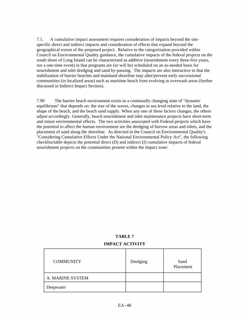
ΕΑ−48
7.1. A cumulative impact assessment requires consideration of impacts beyond the site-specific direct and indirect impacts and consideration of effects that expand beyond the geographical extent of the proposed project. Relative to the categorization provided within Council on Environmental Quality guidance, the cumulative impacts of the federal projects on the south shore of Long Island can be characterized as additive (nourishment every three-five years, not a one-time event) in that programs are (or will be) scheduled on an as-needed basis for nourishment and inlet dredging and sand by-passing. The impacts are also interactive in that the stabilization of barrier beaches and mainland shoreline may alter/prevent early successional communities (in localized areas) such as maritime beach from evolving in overwash areas (further discussed in Indirect Impact Section).
7.90 The barrier beach environment exists in a continually changing state of "dynamic equilibrium" that depends on: the size of the waves, changes in sea level relative to the land, the shape of the beach, and the beach sand supply. When any one of these factors changes, the others adjust accordingly. Generally, beach nourishment and inlet maintenance projects have short-term and minor environmental effects. The two activities associated with Federal projects which have the potential to affect the human environment are the dredging of borrow areas and inlets, and the placement of sand along the shoreline. As directed in the Council on Environmental Quality's "Considering Cumulative Effects Under the National Environmental Policy Act", the following checklist/table depicts the potential direct (D) and indirect (I) cumulative impacts of federal nourishment projects on the communities present within the impact zone:
TABLE 7
IMPACT ACTIVITY
COMMUNITY
Dredging
Sand Placement
A. MARINE SYSTEM
Deepwater

ΕΑ−49
D Intertidal Gravel/Sand Beach
D,I Rocky Intertidal
D Artificial Structure/Reef
D
Riprap/Artificial Shore
D B. TERRESTRIAL SYSTEM
Maritime Beach
D Maritime Dunes
I Maritime Shrubland
I Maritime Heathland
I Maritime Grassland
I
7.2. The dredging of the borrow areas could potentially and directly impact the Marine Deepwater and Artificial Structure/Reef communities present in open water areas. Although Deepwater communities would be disturbed, such disturbance would be of a temporary nature and would occur in dynamic/high energy environments whose species have adapted to these conditions. Pre-construction surveys, such as those proposed for the WOSI project, ensure that impacts to highly diverse areas containing substantial surf clam populations are avoided or minimized.
7.3. The borrow areas required for the federal projects located on the south shore, the total of which consist of 4 percent of the total available habitat between -18 foot MLW and -60 foot MLW (see Table 8), are spatially distributed so that dredging impacts are not concentrated in one portion of the impact zone. Additionally, the borrow areas are sloped in a manner to prevent anoxic conditions. Finally, the substrate in the borrow areas is similar in composition in pre and post construction conditions, allowing for the recolonization of these areas, which, studies have indicated, should occur within one year following dredging operations. The use of the borrow

ΕΑ−50
area for this project may have the potential to have cumulative impacts along with the use of the borrow areas utilized for maintenance renourishments of other projects (Westhampton Interim, Fire Island Interim, etc.). Due to the distance between the borrow areas and that the sand volume required for construction and maintenance of this project, no significant long-term cumulative impacts are expected
Table 8
Borrow Area Size by Project
Project
Status
Acres Coney Island
Constructed
528.0
East Rockaway
Constructed
521.1 Long Beach
Proposed
1,193.8
Westhampton Interim1
Constructed
308.5 Fire Island Interim1
Proposed
1,704.5
West of Shinnecock Interim1
The Proposed Project
3,294.6
Used and Proposed Borrow Area Total
7,550.5
Available Borrow Area on the South Shore
183,655.0 Note: 1 Interim projects can be subsumed by the Reformulation
Project. 7.4. Cumulative dredging impacts to Artificial Structure/Reef communities will not be significant since surveys will locate the majority of artificial reefs or shipwrecks, which will be avoided to allow for efficient dredging operations. 7.5. Direct Sand Placement Impacts. Sand placement activities have the potential of directly impacting several shoreline communities, including the Marine Intertidal Gravel/Sand Beach; Marine Rocky Intertidal; Marine Riprap/Artificial Shore; and Terrestrial Maritime Beach. As in the borrow areas, these communities are located in dynamic, high energy areas where substrates are continuously shifting, eroding and accreting along the south shore of Long Island. Beach and surf zone organisms are well adapted to their rigorous environments. Although a temporary loss of shallow nearshore/intertidal habitat would occur, studies cited within this document indicate that a new sandy bottom should begin to recolonize shortly after construction ceases. Loss of riprap/artificial shore habitat will occur due to the sand burial of groins and other artificial structures. Varying nourishment schedules and other project variables (contractor availability, funding, local conditions, etc.) may cause staggering of construction activities so that extensive stretches of the shoreline are not nourished at the same time. Additionally, for each individual project, only 500-1000 feet of beach is nourished at one time. This practice allows motile species to avoid areas where beach fill placement will occur. 7.6. Federally listed endangered and threatened species exist in these shoreline communities and include the federally threatened piping plover (Charadrius melodus), federally endangered roseate tern (Sterna dougallii) and the federally threatened seabeach amaranth (Amaranthus pumilus). The District coordinates and consults with the U.S. Fish and Wildlife Service in accordance with the Endangered Species Act (ESA) when projects along the South Shore of Long Island have the potential of impacting federally listed species. Section 7 (of the ESA) consultation usually requires that construction occur outside of the breeding/growing season of

ΕΑ−51
these species and/or monitoring of these species during construction with the implementation of buffer areas to minimize project specific and cumulative impacts to these species. 7.7. Indirect Sand Placement Impacts. Sand placement activities also have the potential of indirectly impacting Marine Intertidal Gravel/Sand Beach; Terrestrial Maritime Dunes; Maritime Shrubland; Maritime Heathland; and Maritime Grassland. The primary indirect impact of federal nourishment projects to the Intertidal Gravel/Sand Beach is the infusion of additional material into the predominantly east to west littoral drift. The positive cumulative effect of this condition is the additional accretion of materials along the South Shore of Long Island, which will provide additional storm damage protection and the creation of additional intertidal and maritime beach habitat. The addition of materials into the littoral drift would also increase the amount of materials that will accrete in the ebb/flood shoals and inlets along the South Shore. Additional maintenance of the inlets would be required. Due to the low benthic value of these inlets, no additional impacts other than those associated with maintenance dredging are expected. 7.8. The primary indirect impact that federal nourishment projects along the South Shore of Long Island would have on the Terrestrial Maritime Dunes; shrubland; heathland; and grassland is the stabilization of these communities and the limiting of early successional communities associated with overwashing. The nourishment projects will increase the stability of the shoreline habitat thereby promoting the succession of open sand, dunes and grassland to more stable shrublands. This change in dominant communities could indirectly impact shorebirds that require sparsely vegetated sand/beach cobble areas for nesting (such as the piping plover). However, these projects will not entirely prevent overwashing from occurring. This coastal process will still occur, although most likely with less frequency. Due to the continued occurrence of overwashing, and sand placement along the shoreline communities which could mimic overwash conditions, the impact to these communities and nesting shorebirds is not considered substantial. The Fire Island Inlet to Montauk Point Reformulation Study will include a Habitat Suitablity Index model of the piping plover which should quantify the cumulative impacts of the storm protection project on this species. The results of this study will be incorporated in future cumulative impact assessments. 7.9. Other Governmental Actions. The NYSDOS sand bypassing plant and jetty spur programs, should they be implemented, would complement the proposed beach nourishment project. The sand bypassing plant would transport sand to the area west of the placement area. Spur construction, if successful, could reduce the quantity of beach fill required for renourishment in the placement area. 7. 10. The proposed West of Shinnecock Inlet project would complement the South Shore Estuary Comprehensive Management Plan (CMP) in that the two programs share the goal of protecting the estuary. 7.11. The Local Waterfront Revitalization Plan and the revisions to Article 138, “Coastal Erosion Hazard Areas,” of the Town of Southampton are in draft stage, but are expected to be consistent with the objectives of the West of Shinnecock Inlet project. If the revised Town of Southampton code is available prior to the preparation of the Final EA for this project, then the potential effects will be included. 7.12. These governmental actions together with the proposed interim project could have a cumulative effect on the barrier island system and the back bay. The intent of the semi-fixed

ΕΑ−52
bypassing and modification of the western jetty is to provide some protection to the barrier island, the same goal as that of the proposed project. The Town of Southampton is updating its code and developing the Local Waterfront Revitalization Plan to ensure orderly development along its south shore waterfront and to minimize the potential for erosion related impacts. The goals and objectives of all of these projects are congruent with the intent of the proposed project, and therefore, they would not have a cumulative adverse impact. 7.13. Suffolk County periodically dredges local channels for maintenance purposes. This dredging is conducted subject to permits issued by the New York District and NYSDEC. The dredging takes place mostly in the bays and not on the open Atlantic Ocean coast. The dredged materials are used as beach fill, whenever materials are suitable and placement is cost effective. 7.14. Noise and air emissions are restricted to the construction site and occur only during the construction period. The projects would not cause noise or emissions during its operational period. The dredging is offshore, away from sensitive noise receptors, and would not have an impact. The main cause of noise during the placement is the operation of the bulldozers. This source is short-term and would occur during the daylight hours. Therefore, no long-term noise impacts are expected. 7.15. According to NYSDEC, Suffolk County is severe non-attainment for ozone. New York City and Westchester and Nassau Counties are also non-attainment for this pollutant. Emissions during construction activities will be produced by the dredge, crew boat, work boats, bulldozers, trucks, and small construction vehicles. These impacts are expected to be localized, temporary, and insignificant, and within NQ and ozone limits for this non-attainment area. The interim project is expected to be in conformity with the Clean Air Act. A draft Clean Air Conformity Act Statement is provided as Appendix E. 7.16. Measures to Mitigate Cumulative Impacts. Measures proposed to mitigate the cumulative effects of the federal nourishment projects are listed as follows:
1. The majority of unavoidable impacts are likely to occur within the borrow areas. Measures to minimize dredging impacts include dredging in a manner so as to avoid the crecolumn. Post- construction benthic monitoring between renourishment cycles documents the level of recovery to identified sensitive areas.
2. Adverse impacts to the surf clam population may be avoided or minimized along the south shore of Long Island by pre and post construction surf clam sampling. Sampling will allow the District to determine current populations, and if possible, avoid these areas. If commercially viable populations exist within proposed borrow areas, and are unavoidable, measures will be taken to minimize impacts to the clams. Some of these measures may include the commercial harvest of clams prior to dredging, or transplantation of the seed clams.
3. The New York District will coordinate with the U.S. Fish and Wildlife Service
in accordance with the Fish and Wildlife Coordination Act Report and Section 7 of the Endangered Species Act when applicable. Measures to mitigate impacts to federally listed species include growing/nesting season construction windows, implementation of buffers, and monitoring during construction activities.

ΕΑ−53
7.109 Cumulative Impact Conclusion. The cumulative impact assessment of federal nourishment projects on the south shore of Long Island indicate that federal project actions would occur in dynamic environments whose inhabitants have adapted to these conditions. Studies indicate that borrow areas and sand placement areas recolonize shortly after construction activities are completed. Additionally, mitigative measures described above will ameliorate temporary impacts. Therefore, it is concluded that since this project is designed to minimize adverse environmental impacts, the cumulative impacts to occur on the south shore of Long Island are not significant to the human environment/communities present within this region. 8.00 COORDINATION 8.01. The proposed interim plan for storm damage protection has been coordinated with the following agencies:
U.S. Fish and Wildlife Service (USFWS) U.S. Environmental Protection Agency National Marine Fisheries Service (NMFS) New York State Department of Environmental Conservation (NYSDEC) State of New York Department of State (NYSDOS) New York State Office of Parks, Recreation and Historic Preservation (NYSHPO) Suffolk County Executive Town of Southampton Village of Southampton
8.02. A Fish and Wildlife Coordination Act Section 2(b) Report has been prepared by the USFWS-Long Island Field Office and is attached as Appendix A. 8.03. The Water Quality Certificate (WQC) application process is ongoing. A Section 404 (b)(1) evaluation is attached as Appendix B. 8.04. The proposed project's Consistency Determination for the applicable New York State Coastal Zone Management (CZM) Policies is attached as Appendix C This will be coordinated with the State of New York Department of State (NYDOS). 8.05. Coordination with NYSHPO, in accordance with Section 106 of the National Historic Preservation Act of 1966, as amended, is ongoing. The remote sensing report has been coordinated with NYSHPO, who has concurred with the report recommendations of avoidance and additional investigations if avoidance is not possible. The coordination of the results of the shovel testing will be undertaken when the report of the investigations has been completed. 8.06. Table 9 indicates the relationships of the proposed plan to various Federal environmental protection and requirements statutes and Executive Orders, as well as State and local requirements. 8.07. The proposed project provides an interim plan for storm damage protection until the completion and potential implementation of the FIMP Reformulation Plan. It has been concluded that construction of this interim project is not a major Federal action significantly affecting the quality of the human environment, and that a fully coordinated EIS will not be necessary for this action to proceed in accordance with the National Environmental Policy Act. For more information, please see Appendix D, “Finding of No Significant Impact (FONSI).”

ΕΑ−54
Table 9 Compliance with Environmental Requirements and Protection Statutes
Federal Policies
Compliance
Archaeological and Historic Preservation Act, as amended
Full
Clean Air Act, as amended
Full Clean Water Act of 1977, as amended
Full
Coastal Zone Management Act of 1972, as amended
Full Coastal Resources Barrier Act
Full
Endangered Species Act of 1973, as amended
Full Estuary Protection Act (PL 90-454)
Full
Federal Water Project Recreation Act, as amended
N/A Fish and Wildlife Coordination Act, as amended
Full
Land and Water Conservation Fund Act of 1965, as amended
Full Marine Protection, Research, and Sanctuary Act of 1969, as amended
Full
National Environmental Policy Act of 1969, as amended
Full National Historic Preservation Act, as amended through 1992
Full
Organic Act of 1916
Full Fire Island National Seashore Act (PL 88-587)
Full
Wilderness Act (PL-88-577)
Full Fire Island Wilderness Act (PL 96-585)
Full
Rivers and Harbors Appropriation Act of 1899, as amended
N/A Watershed Protection and Flood Prevention Act, as amended
N/A
Wild and Scenic River Act, as amended
N/A Floodplain Management (E.O. 11988)
Full
Protection of Wetlands (E.O. 11990)
N/A Toxic Substances Control Act (PL 94-469), as amended
N/A
EXECUTIVE ORDERS, MEMORANDA, ETC. Floodplain Management (E.O. 11988)
N/A
Protection of Wetlands (E.O. 11990)
N/A Environmental Effects Abroad of Major Federal Actions (E.O. 12114)
N/A
Impacts on Prime and Unique Farmlands (CEQ Memo 8-30-76)
N/A STATE AND LOCAL POLICIES The proposed project will comply with all appropriate State and local policies.

ΕΑ−55
REFERENCES:
B.A. Vittor’s Associates, Inc. 1998. Atlantic Coast of Long Island, Fire Island to Montauk Point, New York Reformulation Study, Fire Island and West of Shinnecock Interim Storm Damage Protection project for U.S. Army Corps. of Engineers, New York Division.
Bigelow and Schroeder. 1953. Fishes of the Gulf of Maine. Fishery Bulletin of the U.S. Fish & Wildlife Service Vo. 53.
Briggs, P.T. and F.M. Mushacke. 1982. “Characteristics of the Jonah Crab and Rock Crab in New York Waters.” New York Fish & Game Journal, NYSDEC.
Cashin Associates, P.C. 1993. The Environmental Impacts of Barrier Island Breaching with Particular Focus on the South Shore of Long Island, New York. Prepared for the State of New York, Department of State.
Cashin Associates, P.C. September 1993. Scientific Literature Review: The Environmental Impacts of Barrier Island Breaching with Particular Focus on the South Shore of Long Island, New York. Report prepared for New York State Department of State. Cashin Associates, P.C., Hauppauge, New York.
Cerrato, R.M. October 1983. Benthic Borrow Area Investigations, South Shore of Long Island, New York. Marine Sciences Research Center, State University of New York at Stony Brook, Special Report No. 51. 654 pp.
Clarke, Ray, Gary & Douglas. 1995. Preconstruction Monitoring for Reach 1 of the Asbury/Manasquan Section of the Atlantic Coast of New Jersey Sandy Hook to Barnegat Inlet Beach Erosion Control Project. Interim report prepared for U.S. Army Corps of Engineers, New York District.
Code of the Town of Southampton Land Use Legislation. 1996. County Of Suffolk, State of New York. General Code Publishers Corp.
Duncan, W.H. and M.B. Duncan. 1987. The Smithsonian Guide to Seaside Plants of the Gulf and Atlantic Coasts. Smithsonian Institution Press, Washington, D.C.
Fallon, D. and F. Mushacke. 1996. Tidal Wetlands Trends in Shinnecock Bay, New York, 1974 to 1995. New York Department of Environmental Conservation.
Franz, D.R. and W.H. Harris. 1988. “Seasonal and Spatial Variability in Macrobenthos Communities in Jamaica Bay, New York. An Urban Estuary.” Vol. II, No. 1. P. 15-28.

ΕΑ−56
The Greeley-Polhemus Group, Inc. 1997. Cultural Resources Study, Fire Island to Montauk Point, Suffolk County, New York, Reformulation Study: Phase I Archaeological Survey. Prepared for the U.S. Army Corps of Engineers, New York District.
The Greeley-Polhemus Group, Inc. and Dolan Research. 1997. Fire Island Inlet to Montauk Point, Long Island, Suffolk County, New York, Reach 2: Interim Project West of Shinnecock Inlet. Prepared for the U.S. Army Corps of Engineers, New York District.
Long Island Lighting Company. 1975-1989. Preoperational Aquatic Ecology Study, Shoreham Nuclear Station, Unit-1.
Long Island Regional Planning Board, 1990. Proposed Long Island South Shore Hazard Management Program for Nassau and Suffolk Counties. Hauppauge, NY.
Morreale, S.J. and E.A., Standora. 1991. Okeanos Ocean Research Foundation Annual Report - Occurrence, Movement and Behavior of the Kemp’s Ridley and Other Sea Turtles in New York Waters. NYSDEC Return a Gift to Wildlife Program.
Moffatt & Nichol, Engineers. November 1994. Impacts of Barrier Island Breaching on the Tidal Hydrodynamics, Salinity & Residence Times of Moriches Bay, New York. Report prepared for the Department of the Army, New York District Corps of Engineers. Moffatt & Nichol, Baltimore, MD.
Naqvi, S.M. and E.J. Pullen. 1982. Effect of Beach Nourishment and Borrowing on Marine Organisms. Miscellaneous Report No. 82-14. U.S. Army Corps of Engineers Coastal Engineering Research Center.
New York Sea Grant Institute. 1993. Estuarine Resources of the Fire Island National Seashore and Vicinity. Report No. NYSGI-T-93-001. Stony Brook, New York.
New York State Department of Environmental Conservation. December 1994. 1992-1993 Long Island Colonial Waterbird and Piping Plover Survey. NYSDEC Stony Brook, New York.
New York State Department of Environmental Conservation. April 1997. 1996 Long Island Colonial Waterbird and Piping Plover Survey. NYSDEC Stony Brook, New York.
New York State Department of Environmental Conservation. 1990-1991 Long Island Colonial Waterbird and Piping Plover Survey. NYSDEC Stony Brook, New York.
NOAA - http://www.noaa.gov/public-affairs/pr97/jan97/noaa97-4.html

ΕΑ−57
NOAA. 1983. Navigation Chart No. 12352.
NYSDEC. 1977. Primary Productivity and Basic Food Chain Relationships in Two Long Island Bays.
Page et al. 1991. Peterson Field Guide to Freshwater fishes Vol 42. Page, LM & B.M. Burr Houghton Mifflin Co., Boston, Massachusetts
Pavacic, John W. July 15, 1998. Correspondence between J.W. Pavacic, Regional Permit Administrator of New York State Department of Environmental Conservation in Stony Brook, New York to F. Santomauro, Chief of Planning Division, U.S. Army Corps of Engineers, New York, New York.
RMC Environmental Services. 1996. Fire Island to Montauk Point Reformulation Borrow Sites Macroinvertebrate Community Characterization. Prepared for U.S. Army Corps of Engineers, New York District. Contract No. DACW51-94-D-0035.
Robbins, C.R., G.C. Ray and J. Douglass. 1986. A Field Guide to Atlantic Coast Fishes of North America. Houghton Mifflin co., Boston, Massachusetts.
Sirkin, L.1995. Eastern Long Island Geology with Field Trips. The Book & Tackle Shop, Road Island.
Smith, C.L. 1985. The Inland Fishes of New York State. New York State Department of Environmental Conservation, Albany, New York.
Spencer, Bob and Aram V. Terchunian. July 1997. The Sand Thieves of Long Island’s South Shore. Shore & Beach. Vol. 65, No. 3, pp.4-12.
Steimle, F.W. and R.B. Stone. 1973. Abundance and Distribution of Inshore Benthic Fauna off Southwestern Long Island, New York. NOAA Technical Report. NMFS SSFS-673.
United States Army Corps of Engineers, New York District, and United States Environmental Protection Agency Region 2. 1992. Guidance For Performing Tests of Dredged Material Proposed For Ocean Disposal. Draft Revised Regional Testing Manual.
United States Army Corps of Engineers. 1996. Fire Island Inlet to Montauk Point, Long Island, New York, Breach Contingency Plan, Executive Summary and Environmental Assessment. New York District. North Atlantic Division.
ΕΑ−58
United States Army Corps of Engineers. 1997 [1]. Fire Island Inlet to Montauk Point, Long Island, New York, Moriches Inlet to Shinnecock Inlet Reach—Area West of Shinnecock Inlet—Interim Plan for Storm Damage Protection. New York District.
United States Army Corps of Engineers. 1995. Fire Island Inlet to Montauk Point, New York, Moriches to Shinnecock Reach, Interim Plan for Storm Damage Protection, Technical Support Document with Final Environmental Assessment. New York District.
United States Army Corps of Engineers. 1990. Regulation 1105-2-100: Policy and Planning Guidance for Conducting Civil Works Planning Studies.
United States Army Corps of Engineers. 1988. Regulation 200-2-2: Environmental Quality, Procedures for Implementing the National Environmental Policy Act.
United States Army Corps of Engineers. 1996. Regulation 200-2-2: Environmental Quality, Procedures for Implementing the National Environmental Policy Act.
United States Army Corps of Engineers. 1997 [2]. West of Shinnecock Inlet Interim Economic Analysis. New York District.
United States Naval Oceanographic Office. 1966. Glossary of Oceanographic Terms. Second Edition.
U.S. Fish and Wildlife Service, February 1998. Draft Fish and Wildlife Coordination Act Section 2(b) Report: Fire Island Inlet to Montauk Point Beach Erosion Control and Hurricane Protection Project, Reach 2-Moriches Inlet to Shinnecock Inlet Interim Storm Damage Protection Plan. USFWS Long Island Field Office, Islip, New York.
U.S. Fish and Wildlife Service. February 1981. Environmental Inventory for the Fire Island Inlet to Montauk Point, New York Beach Erosion Control and Hurricane Protection Project Reformulation Study. U.S. Department of the Interior, Fish and Wildlife Service, Cortland, New York.
United States Fish and Wildlife Service. 1998. Fire Island Inlet to Montauk Point, Beach Erosion Control and Hurricane Protection Project, Reach 2 - Moriches Inlet to Shinnecock Inlet, Interim Storm Damage Protection Plan, Draft Fish and Wildlife Coordination Act Section 2(b) Report. Long Island Field Office.
Urban Land Institute. 1997. Dollars and Cents of Shopping Centers: 1997.
Woodhead, P.M.J. 1992. Assessments of the Fish Community and Fishery Resources of the Lower New York Bay Area in Relation to a Program of Sand Mining Proposed by New York State. Stony Brook: Marine Sciences Research, SUNY at Stony Brook.

ΕΑ−59
Woodhead, P.M.J. and S.S. McCafferty. 1986. “Report on the Fish Community of Lower New York Harbor in Relation to Borrow Pit Sites” in Draft Supplemental Environmental Impact Statement: Use of Subaqueous Borrow Pits in the Disposal of Dredged Material from the Port of New York-New Jersey, 1988. By the U.S. Army Corps of Engineers, New York District. New York: 1988
Woodhead P.M.J. and M. McEnroe. 1991. A Report on Task 5.1 of the NY-NJ Harbor Estuary Program: "Habitat Use by the Finfish Community.” SUNY at Stony Brook.
Woodward-Clyde Consultants. 1975. Results of Phase I Pre-Dredging Study. Rockaway Beach Erosion Control Project Dredge Material Resource Program-Offshore Borrow Area. Report prepared for the U.S. Army Corps of Engineers, New York District.

ΕΑ−60
BIBLIOGRAPHY:
Boggs, S. Jr. 1987. Principles of Sedimentology and Stratigraphy. Merrill Publishing Company, Columbus, Ohio.
Gosner, K.L. 1978. A Field Guide to the Atlantic Seashore. Houghton Mifflin Company, Boston.
Lerman, M. 1986. Marine Biology: Environment, Diversity, and Ecology. The Benjamin/Cummings Publishing Company, Inc. Massachusetts.
United States Army Corps of Engineers. 1997. Environmental Scoping Document, Atlantic Coast of Long Island, Fire Island Inlet to Montauk Point, New York, Storm Damage Reduction Reformulation Study. New York District.
United States Army Corps of Engineers. 1996. Fire Island Inlet to Montauk Point, Long Island, New York, Reach 1: Fire Island Inlet to Moriches Inlet, An Evaluation of an Interim Plan for Storm Damage Protection, Volume I Main Report with Preliminary Assessment of Environmental Impacts. New York District.
United States Army Corps of Engineers. 1996. Fire Island Inlet to Montauk Point, Long Island, New York, Reach 1: Fire Island Inlet to Moriches Inlet, An Evaluation of an Interim Plan for Storm Damage Protection, Volume II Technical Appendices. New York District.
United States Army Corps of Engineers. 1977. Fire Island Inlet to Montauk Point, New York: Beach Erosion Control and Hurricane Protection Project. Final Environmental Impact Statement. New York District.
United States Army Corps of Engineers. 1994b. Fire Island Inlet to Montauk Point, New York: Westhampton (Moriches to Shinnecock Reach) Emergency Breach Closure. New York District.
United States Army Corps of Engineers. 1996. Fire Island Inlet to Montauk Point Reformulation: Borrow Sites Macroinvertebrate Community Characterization. New York District.

ΕΑ−61
GLOSSARY:
avifauna: All the birds of any stated region.
bathymetry: The science of measuring ocean depths to determine the sea floor topography.
beach berm: A nearly horizontal portion of the beach or backshore formed by the deposit of material by wave action or can be formed by artificial placement..
ebb current: The tidal current associated with the decrease in the height of a tide. Ebb currents generally set seaward.
fauna: The animal life of any stated region.
inlet: A short, narrow waterway connecting a bay or lagoon with the sea.
jetty: A structure, such as a wharf or pier, so located as to influence current or protect the entrance to a harbor or river.
leeward: The direction toward which the wind is blowing; the direction toward which waves are traveling.
macrobenthic invertebrate: Bottom dwelling organism retained by screens with interstitial spaces from 1.00 to 0.425 mm (arbitrary).
megabenthic invertebrate: Bottom dwelling organism retained by screens with interstitial spaces larger than 1.00 mm (arbitrary). Usually refers to lobsters, clams, crabs, etc.
paleosurfaces: Layers of prehistoric land surfaces where Native American artifacts might be found. Such surfaces from the prehistoric period may be buried beneath soil at the proposed project site.
revetment: A retaining wall. A structure for retaining and protecting a bank or the slope of a cut.
shoal: A submerged ridge, bank, or bar consisting of unconsolidated sediments which is at or near enough to the water surface to constitute a danger to navigation.

ΕΑ−62
storm surge: A rise above normal water level on the open coast due only to the action of wind stress on the water surface. Storm surge resulting from a hurricane or other intense storm also includes the rise in level due to atmospheric pressure reduction as well as that due to wind stress.
tidal prism: The difference between the mean high water volume and the mean low water volume of an estuary.
turbidity: Reduced water clarity resulting from the presence of suspended matter.
Glossary Sources:
Cole, G.A. Textbook of Limnology. Third Edition. Waveland Press, Inc., Prospect Heights, Illinois, 1983.
The Webster’s New Encyclopedic Dictionary of the English Language (Unabridged), The Publishers Guild, Inc., New York, 1977.
U.S. Naval Oceanographic Office. Glossary of Oceanographic Terms. 1966.


ΕΑ−64

DRAFT ENVIRONMENTAL ASSESSMENT
FOR THE
WEST OF SHINNECOCK INLET
INTERIM PLAN FOR STORM DAMAGE PROTECTION
ATLANTIC COAST OF LONG ISLAND,
FIRE ISLAND INLET TO MONTAUK POINT, NEW YORK
U.S. ARMY CORPS OF ENGINEERS
NEW YORK DISTRICT
26 FEDERAL PLAZA
NEW YORK, NEW YORK 10278-0090
APRIL 1999