dr kay prag kay prag the manchester museum, manchester...
TRANSCRIPT

– 317 –
produced during Phase 1 at Iktanū (Prag 1986).A site buried beneath alluvium was
discovered by Jonathan Mabry in 1987 about 350m north-east of Tall Iktanū in the south-east Jordan Valley (FIG. 1; Prag 1990: 123, 2001: 182, fig. 3). Its existence was revealed in the section of an abandoned trench made by the Jordanian army; its presence was otherwise undetectable under two metres of deposit. It lies on the south bank of the deeply incised Wādī Ḥisbān. On the eroded north bank of the Ḥisbān at this point, Epipalaeolithic and Natufian sites reaching almost to the modern surface have been excavated (Edwards et al. 1999) while younger deposits survive on the south bank.
Some unpublished evidence from K. M. Kenyon’s 1950s excavations at Jericho has relevance to material uncovered during the excavations at Iktanū in 1989 and has some wider implications for the environment and activities at the end of the third millennium. The two sites lie almost directly opposite each other against the western and eastern foothills of the south Jordan Valley, ca. 20km apart. There is evidence beyond the purely geographical for a relationship between the two sites during the Intermediate Bronze Age (IBA / Intermediate EB.MB / EB IV), as Jericho is one of the currently rare sites at which is found a particular IBA Reserved Slip ware which is
Dr Kay PragThe Manchester Museum,Manchester University,ManchesterM13 9PLUnited Kingdom.
Kay Prag
Buried Intermediate Bronze Age Sites
1. Iktanū, Area G: alluvial de-posits over dark soils with IBA pottery (Photograph IKS 641: Kay Prag).

KAY PRAG
– 318 –
Bedrock levels in other nearby military cuts on the south bank suggest that bedrock was lower here than at other points. We planned a small investigation of the site (designated Site G) during the 1989 season. Unfortunately, owing to a failure of the local irrigation system (Prag 2007: fig. 2) the trench flooded when only initial cleaning and sampling had been undertaken. The flooding caused considerable collapse and put further investigation beyond our resources (FIG. 2).
The IBA deposits consisted of soft dark earth which contained pottery. The latter included some largish sherds in reasonable condition; in particular there were cooking pot fragments of Type 1D common in Phase 2 deposits in the settlement on the tall and the flotation sample also contained 31 crumbs of this low-fired ware (Prag 1971: 135-137, 151-153, figs 15, 23:1-7, 1974: figs 3, 6). There was no evidence of tombs in the vicinity, and cooking pots are not normally found in IBA tombs, suggesting that the collection derived from a more domestic source. In addition, amongst the 21 IBA fragments collected, there were fragments of jars and envelope ledge-handles, but no red-slipped pottery, all of which material is compatible with Phase 2 on the tall. The most notable fragment however was a cup rim with band combing and a small knob, of a type not found on the tall,
where band-combed decoration is not common (FIG. 3). It immediately recalled a similar cup published by Mallon (Mallon 1929: 226. pl. III:2), which he thought came from the nearby dolmens at al-Mataba. There are other well-known parallels for the type.
In Kenyon’s Jericho tall type-series, the closest links to the Site G cup are to her IBA Bowls II.A.I and II.B.I (Kenyon and Holland 1982, Jericho IV: fig. 94:9-12), one of which appears to have a loop-handle rather than a knob. However, a knob on wavy band-combing occurs on a slightly different shape, viz. Kenyon’s IBA Bowls VIII.B.I (Kenyon and Holland 1982: fig. 102:1). This band-combed material on the tall should relate to Nigro’s Sultan IIId2, his late IBA phase on the tall (Nigro 2003).
The large published corpus of IBA material from Lachish has some very similar cups (Tufnell 1958, Lachish IV: pl. 66:394-424, especially 397) but none of the beakers have a knob near the rim. There are beakers with pierced lugs at the carination on the lower body. The vessels come from Tufnell’s Cave 1529 in the North-West Settlement at Lachish (off the tall), and she thought the large collection of sherds dumped here were perhaps earlier in date than the pottery from Cemetery 2000. However there are two or three MBA fragments in the Cave 1529 group (nos. 406 and 407 are MBA
2. Iktanū, Area G after the flood (Photograph IKS 725: Kay Prag).

BURIED INTERMEDIATE BRONZE AGE SITES
– 319 –
carinated bowls; no. 415, which is hand-made, is an MB I cooking pot), and a percentage of the cave group is said to be wheel-made (nos. 397-398, 400-401, 403-404, 406-407, 411-412, 413, 418-420), which suggests the Cave 1529 group may belong in a late IBA phase.
Returning to Area G, the pottery from this deposit should be dated (by relative chronology) no earlier than Phase 2 on the tall at Iktanū, and probably later. The presence of the band-combed cups in Area G and al-Mataba is however odd; why do such vessels only occur off the tall? If the al-Mataba dolmen provenance is correct, it might suggest a specialist funerary offering for this type of cup, but this is not the case in Area G, nor at Jericho and Lachish.
Are the finds in Area G related to pastoralist use? The soft dark earth comprising the Area G site is also not typical of the occupation on the tall; it indicates a build-up of organic material.
The presence of the cups which have not been found on the tall also suggests that the deposits do not derive from manure taken out from the settlement to the fields. There were kilns at Iktanū in Phase 1, and it seems likely that pottery continued to be produced elsewhere on the site in Phase 2. However it seems certain that the band-combed sherd was not made on the tall at Iktanū. The large proportion of cooking pots in the pottery recovered does suggest that this deposit was derived from occupation, but the presence of the band-combed sherd and its relationship to the ceramics in the later Sultan IIId2 occupation phase at Jericho perhaps suggests a mobile element in the population, pastoralists possibly, living in accordance with the summer and winter grazing patterns which still mark the area today. Such occupation, in a sheltered dip in the landscape with immediate access to water in the nearby river, would be a reasonable choice.
3. Iktanū, Area G, IK.800.+.1. Band-combed cup fragment (Photograph: Kay Prag).

KAY PRAG
– 320 –
Turning then to the unpublished archival material from Jericho, in 1954 Kenyon (1954: 56, 58) described a camping area in the cemetery areas west and north of the Jericho tall where many sherds were found, but only the scantiest traces of structures. In her final reports, Kenyon published almost no evidence for earlier claims of squatter occupation and campsites on and around the tall which followed the intense destruction of the EB III site (e.g. Kenyon 1979: 121). Much of Kenyon’s nomadic pastoralist hypothesis was stimulated by her discoveries on and off the tall, so it is curious that so little supporting material was eventually published by her.
More recently, Nigro (2003) published a rather hastily written paper on the nature and date of the IBA settlement and necropolis at Jericho. He did not address the Kenyon issues of squatter occupation on the tall, nor of campsites located in the surrounding area following the EB III destruction.
In Kenyon’s final report just three pots from the cemetery area were illustrated as part of this evidence (Kenyon 1964: fig. 90:11-13), but it is of course difficult to prove these pots are evidence for camping occupation rather than debris from funerary feasts, or debris thrown out long ago when many IBA tombs were reused, mainly in the Middle Bronze Age. Some of the published pottery is of the earlier Iktanū Phase 1 type (Prag 1986: fig. 4: Jericho Area G and fig. 4: M 12.1 from Jericho Area M). Kenyon’s Outsize Type tombs in Jericho Area P also contained pottery directly comparable to Iktanū Phase 1 pottery, and these tombs were located a considerable distance from the tall, 600 to 900m to the north-north-east.
There is however some further information to be had from the Jericho archive. The new data to add to the Kenyon hypotheses are found in a few unpublished sketches and notes in some of the 14 notebooks in the Kenyon Jericho archive which provide more detailed information on work in the cemetery areas. It should be noted
that scale and orientation are approximate in these sketches.
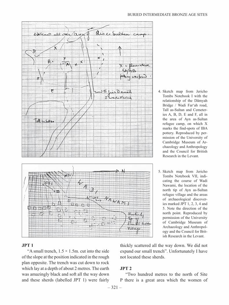
In the last three pages of Tombs Notebook I (Area A) there is a description of an IBA “settlement area” with sketch map (FIG. 4). The notes record that there was much surface pottery associated with a fine brown earth, a deposit which averaged about 30-60cm in depth; this deposit was much sought after by refugees for making mud-bricks and extended all over the area of Ain as-Sultan refugee village. A small trench was excavated in Tombs Area A, recording this soft brown earth and stones, which included one misplaced door-socket and, in the north-east corner of the trench, a “hearth of pebbles and black ashes”. This deposit overlay the bedrock. According to the sketch map, the IBA sherds were found in the same area as one of the jars already referred to, ca. 500m north and north-west of the tall, on the northern fringes of Cemetery Areas A and M. In the sketch map it is notable that the find-spots marked X appear to ring the southern edge of the area I previously attributed to the early use of the cemetery (Prag 1986: fig. 3).
Tombs Notebook III records three IBA bowls (one with ledge-handle) as being found outside Cemetery Area A, described as coming from “occupation”; one holemouth jar was found in IBA occupation in Area K (just 300 m north-west of the tall) and “one EB.MB spouted ledge handled jar” was found “near Area G in an occupation area near the school”.
In Tombs Notebook VII (Areas B and P, 1956), stray finds and excavations marked JPT (=Jericho - Page - Tombs) are described (FIG. 5). Kenyon (1964, 165) says “The plateau on which the northern cemetery and the modern Ayn as-Sultan refugee village is situated is bounded to the north by the Wadi Nawami, about 1150 m. to the north of the N end of the tall. Jars J.P.T.3 and 4 were found where the summit of the plateau is cut into by the wādī. They were lying in soft earth, with no signs of a tomb”.
BURIED INTERMEDIATE BRONZE AGE SITES
– 321 –
4. Sketch map from Jericho Tombs Notebook I with the relationship of the Dāmyah Bridge / Wadi Far‘ah road, Tall as-Sultan and Cemeter-ies A, B, D, E and F, all in the area of Ayn as-Sultan refugee camp, on which X marks the find-spots of IBA pottery. Reproduced by per-mission of the University of Cambridge Museum of Ar-chaeology and Anthropology and the Council for British Research in the Levant.
5. Sketch map from Jericho Tombs Notebook VII, indi-cating the course of Wadi Nawami, the location of the north tip of Ayn as-Sultan refugee village and the areas of archaeological discover-ies marked JPT 1, 2, 3, 4 and 5. Note the direction of the north point. Reproduced by permission of the University of Cambridge Museum of Archaeology and Anthropol-ogy and the Council for Brit-ish Research in the Levant.
JPT 1“A small trench, 1.5 × 1.5m. cut into the side
of the slope at the position indicated in the rough plan opposite. The trench was cut down to rock which lay at a depth of about 2 metres. The earth was amazingly black and soft all the way down and these sherds (labelled JPT 1) were fairly
thickly scattered all the way down. We did not expand our small trench”. Unfortunately I have not located these sherds.
JPT 2“Two hundred metres to the north of Site
P there is a great area which the women of

KAY PRAG
– 322 –
the village work for material for making mud bricks. In the south-east corner of this area two metres below a gravelly water-born surface accumulation this pot was discovered. It was lying in the soft earth and immediately covered by the gravelly stuff. It had a small stone blocking its broken mouth, so that none of the covering material entered the pot”. The pot is described as a “large flat based pot with two lug handles at the small neck-rim missing. Decorations – incised marks and red painted bands at shoulder”. This is published (Kenyon 1964: 165, fig. 90:12) but no mention is made in the publication of these red-painted bands at the shoulder. This may have been an error made in the field before the vessel was washed, owing to the red fabric of the vessel; red-painted decoration would in any case be unlikely on a typical IBA vessel of this type, which is a narrow-necked bottle of a shape found at Iktanū. The description of the site, with its dark earth and sherds, sounds remarkably like the buried IBA Site G at Iktanū, which was also located some distance from the tall and close to the course of a wadi (Prag 1990: 123, 2001: fig. 3).
JPT 3“Large EB.MB pot, from site indicated on
rough sketch plan on opposite page” (FIG. 5). It is not drawn, but is described in the final report (Kenyon 1964: 165, cf. fig. 16). It is an IBA Jericho Jar Type E, squat, with a wide flat base and two envelope ledge-handles. This comes from an area west of the northern end of Ayn as-Sultan refugee village, and a short distance north of the location of JPT 1.
JPT 4 (FIG. 5)“Small EB.MB pot from site indicated on
previous page. They are digging for soft earth on the slope – and these two pots were found in the soft earth. No sign of an EB.MB tomb”. The IBA vessel is published (Kenyon 1964: 165, fig. 90:13); it is a small IB jar with a pair of lug-handles at the neck.
It is notable that all these sites appear to be located along the course of Wadi Nawami, and the practice of digging this earth for bricks for building houses in ‘Ayn as-Sulṭan refugee camp is illustrated in two photographs taken by the late Dorothy Marshall in 1952 (FIGS. 6 and 7).
Tombs Notebook IX (Area H, vol. 2 and Area F, p. 124) lists further IBA items. Some IBA occupation was noted in Cemetery Area W (otherwise not mentioned?), located north of the refugee camp and in Cemetery Area A, and an IBA “flower pot” and other sherds of large ledge-handled pots were found in an occupation area with no sign of structures, no stratification and no signs of burning. More IBA pottery was brought in from a garden in the refugee village, so a small trench was opened there. Some charcoal and masses of pottery were
6. Women from ‘Ayn as-Sulṭan refugee camp digging earth for bricks from the sides of the wadi (JPT 4, Wadi Nawami?) in 1952 (Photograph: Dorothy N. Marshall).

BURIED INTERMEDIATE BRONZE AGE SITES
– 323 –
7. Brick-making in Ayn as-Sultan refugee camp in 1952 (Photograph: Dorothy N. Marshall).
8. Jericho Tombs Notebook Vol. IX. Area H, vol. 2 and Area F. Trenches A, B and C, locating “Wall? Stone” and “Wall with mud brick?”
found, including four jars with lug-handles. It was concluded that this was an occupation area, with no structures but some traces of fires (Tombs Notebook IX: 160-161).
In Cemetery Area H, ca. 300m north-west of the tall and overlapping with Cemetery Area G, there were further finds and another exploratory trench was dug (FIG. 8; Tombs Notebook IX:
Area H, vol. 2 and Area F, p. 162). The area is described as a hill in an area with no tombs, but prolific IBA sherds. Three trenches were dug, each a metre wide and apparently about 3m long, forming two parallel trenches (Trenches A and B) with a linking cross-trench (Trench C); these were briefly described by the excavator as follows:

KAY PRAG
– 324 –
“Traces of walls appeared, one of stone, and one with, apparently, stone foundation on the rock and one mud-brick clearly visible.
There may have been some enclosure in the cemetery, for impounding sacrificial animals, or where the caretaker of the cemetery lived. The sherds in this area were of the large cooking pot and storage vessel type”.
A stray coin was found (location marked 1 in a circle on the sketch map; no identification available but obviously of a later date). There were many sherds in Trench A, but few sherds in Trench B. The location of the walls is shown on the sketch plan of Trenches A and B.
In summary, the Jericho tomb notebooks record that four sondages were dug in the area north of the Jericho tall, and that sherds of the IBA period (note, not of the other periods when the cemetery was in use) were noted all over the area of the refugee village and beyond it, along the edge of Wadi Nawami around 1.2km north-west of the tall, and also beyond the cemetery to the north and to the west in areas where no tombs were located. The sherds, including cooking pots and occasionally complete or almost complete vessels, were always associated with fine brown, or soft very black earth. At least two trenches were excavated to the bedrock. Buried deposits are described in JPT 2 where the dark earth underlay 2 m of gravely silts. In at least two sites the earth contained charcoal, and in another the sherds included fragments of cooking pots. In only one area were the sherds associated with structures, but in another a hearth and ashes were recorded. Those working in the cemetery area were clear that most of these finds were not in or near tombs but were evidence of occupation. None of the vessels described above are noted as having red slip, but there is otherwise little to indicate a closer date within the IBA.
With so many IBA tombs (177 found and excavated, plus another possible 167 [Kenyon 1964: 33, though numbers vary slightly in different accounts]) there might well have been
long-established tomb workers or cemetery guardians living in the vicinity, the sort of establishment suggested by the excavator, particularly if shaft tomb-cutting was a specialised occupation as suggested by the depth and character of some of the shaft graves. The whole pots described could however be tomb offerings thrown out of the reused tombs, or tomb offerings not actually deposited in a tomb but near it. Cooking pots were not normally deposited in IBA tombs however, but like other vessels might represent containers of food, drink and oil for mourners’ feasts and rituals in the cemetery area.
Kenyon, on this evidence, concluded there was evidence for campsites on the surrounding hills at Jericho.
The widely distributed dark, soft earth with much IBA pottery is more problematic. It might be suggested that these are well-manured agricultural soils, but an association with the long-established and more ‘urban’ EB II - III settlement rather than that of the more ephemeral IBA might be anticipated. Flood alluvium might be represented along the course of a wadi, but not full of pottery. Silty, clayey deposits might be associated with marshy conditions, which do not seem attractive for occupation, but might have been important for flocks. Are these deposits to be associated with animal flocks, middens and campsites used over many generations? Particularly those located some distance from the tall, along the course of Wadi Nawami, and geographically perhaps associated with the early Outsize Type tombs? If the deposits were silty with a high clay content it would explain their popularity for brick-making in the 1950s.
Greenberg (2002), working in the Huleh Valley further north, found 11 IBA sites, which he interpreted as representing a limited population, three sites indicating sedentary occupation on the valley floor, two were cemetery sites and the rest were evidence of mobile pastoralist sites on the valley fringes.

BURIED INTERMEDIATE BRONZE AGE SITES
– 325 –
So what of other buried sites? Golan Heights on the Yarmuk had two phases of occupation, in the Neolithic and the IBA; both occupations were buried under layers of clayey alluvium, part of the ancient deposits of the Yarmuk fan (Eisenberg 2012: 1). The clayey soil may once have blocked the Yarmuk drainage system, forming a dam. Alluvial fans on the Ḥisbān and the Nawami might have provided similar conditions. Were there tectonic incidents which affected the drainage systems, created marshy conditions and which led to increased incision of streams? Such a suggestion would be in line with the work of Mabry (1992, 1996). The Jordan valley is of course an active tectonic zone. Changes of such a nature may have marked the end of the Chalcolithic settlement at Tulaylāt al-Ghasūl.
This explanation might appear to conflict with the widespread suggestion of increasingly dry conditions during the second half of the third millennium, but silting on some wadi systems would tend to increase the focus on surviving water sources. Faust and Ashkenazy (2007) have suggested that increased rainfall causing marshy conditions on the south coastal plain led to the abandonment of settlement there during the later third millennium. Whatever the cause, this is another suggestion of marshy conditions linked to drainage systems.
Whether there are other IBA sites beneath alluvium on the wadi systems of the region is speculative, but seems possible and IBA settlement sites are notoriously elusive in the more fertile areas. The shallow, short-lived remains of many sites of the period have been discovered in recent years: ar-Rujm under a heap of MB II stones; Nahal Refaim under later field systems and many other sites. Greenberg regarded the IBA evidence from Hazor as that of squatter occupation, but given the shallow nature of the occupation at Iktanū and the evidence recently emerging from Hazor of quite dense IB occupation (Ben-Tor 2007: 213, 2005: 211, 2004: 233, 2003: 219), there may have
been the same shallow, slightly built remains of a large sedentary settlement at Hazor as at Iktanū, but at Hazor hidden and destroyed by subsequent over-building on the site. It is likely that some of the IBA occupation on the north tall at Iktanū was largely obliterated by erosion and later Iron Age occupation.
How much does this affect the demographics of the period? Calculations have suggested that there was a catastrophic drop in population of the south Levant at the end of EB III (e.g. Gophna 1992: 156), but some IBA sites are of considerable extent and clearly there was more mobility of settlement. Perhaps it was a less significant drop in numbers when these buried sites are considered.
Returning however to Site G at Iktanū and the Jericho cemetery, these off-tall deposits of soft dark earth which appear to be organ-ic-rich, suggest ancient boggy areas, perhaps seasonally flooded depressions in the Jordan valley wadi systems, in seasonal or permanent use. Such soils are described by Richter et al. (2010: 324) at Azraq where dense concentra-tions of Epipalaeolithic artefacts were found in a dark brown, highly organic buried marsh deposit which was very comparable to modern-day marsh sediments in the Azraq oasis, both in composition and colour, and which partially derived from decayed plant matter mixed with fine sand and silt. Alternatively, the IBA depos-its may be associated with dams or blockages on drainage systems associated with tectonic activity, such as earthquakes. The deposits de-scribed at Jericho and Iktanū appear to be as-sociated with the IBA. Such areas may have been attractive to pastoralists, especially cattle herders, for which there is a long history in the Jordan valley and whose grazing patterns are more restricted than for goats and sheep (Prag 1971: 310, 2014: 394). Although the percent-age of cattle bones at Iktanū was small, in the tiny sample excavated at Iktanū in 1966, 75 per cent were sheep / goat and 17 per cent were of cattle. Grigson (1995: 251-252), in pointing out

KAY PRAG
– 326 –
the disparity of meat available from cattle and sheep / goat, writes that cattle provided at least 50 per cent of the meat weight generally in the south Levant and that the predominance of cat-tle is especially marked in the Jordan valley. At Tall al-Ḥayyāt further north in the Jordan valley in IBA / MBIIA she estimates that cattle bones represented over 71 per cent of the meat weight, and at Refaim near Jerusalem in the central hills of Palestine they represented 10 per cent.
The pottery associated with these areas at Iktanū and Jericho appears to have some elements distinct from those of the nearby settlements, possibly not even contemporary with them, or indicating different family or lifestyle groups. The Jericho deposits appear to be both extensive and long lasting. The use of the deposit in Area G at Iktanū was perhaps more limited, but suggests that pastoralists with links to Jericho continued to use the area after the settlement at Iktanū was abandoned. Teasing out the relationship between Iktanū and Jericho reveals considerable complexity.
AcknowledgmentsI am grateful to Dr Christopher Chippindale
then of the Cambridge University Museum of Archaeology and Anthropology for facilitating my visit to the Kenyon Jericho archive in 1991. Since then, the photographs taken by the late Dorothy Marshall during the many seasons at Jericho that she served as Registrar in Kenyon’s team have also been deposited with the archive in Cambridge. They are not just a delightful record of the team but also of the contemporary surroundings. Dr Caroline Grigson has been, as ever, a source of stimulating ideas.
BibliographyBen-Tor, A. 2003. Notes and news. Tel Hazor. Israel
Exploration Journal 53: 218-223.––– 2004. Notes and News. Tel Hazor. Israel Exploration
Journal 54: 233.––– 2005. Notes and News. Tel Hazor. Israel Exploration
Journal 55: 209-216.––– 2007 Notes and News. Tel Hazor. Israel Exploration
Journal 57: 211-215.
Edwards, P.C., Head, J.M. and Macumber, P.G. 1999. An Epipalaeolithic Sequence from Wadi Hisban in the East Jordan Valley. Annual of the Department of Antiquities of Jordan XLIII: 27-48.
Eisenberg, E. 2012. The Early Bronze Age IV Site at Sha’ar ha-Golan. ‘Atiqot 69: 1-73.
Faust, A. and Ashkenazy, Y. 2007. Excess in Precipitation as a Cause for Settlement Decline along the Israeli Coastal Plain during the Third Millennium BC. Quaternary Research 68: 37-44.
Gophna, R. 1992. The Intermediate Bronze Age. Pp. 126-158 in A. Ben-Tor (ed.), The Archaeology of Ancient Israel. New Haven and London: Yale University Press.
Greenberg, R. 2002. Early Urbanizations in the Levant. A Regional Narrative. New Approaches to Anthropological Archaeology. Leicester University Press. London and New York: Continuum.
Grigson, C. 1995. Plough and Pasture in the Early Economy of the Southern Levant. Pp. 245-268 in T.E. Levy (ed.), The Archaeology of Society in the Holy Land. New York: Facts on File.
Kenyon, K.M. 1954. Excavations at Jericho. Palestine Exploration Quarterly 86: 45-63.
––– 1964. Excavations at Jericho. Vol. II. London: British School of Archaeology in Jerusalem.
––– 1979. Archaeology in the Holy Land. Fourth edition. London: Benn.
Kenyon, K.M. and Holland, T.A. 1982. Excavations at Jericho. Vol. IV. London: British School of Archaeology in Jerusalem.
Mabry, J.B. 1992. Alluvial Cycles and Early Agricultural Settlement Phases in the Jordan Valley. Unpublished Doctoral Dissertation, Department of Anthropology, University of Arizona: Tucson.
Mabry, J.B., Donaldson, M.L. and Palumbo, G. 1996. Early Town Development and Water Management in the Jordan Valley: Investigations at Tall el-Handaquq North. Pp. 115-153 in W.G. Dever (ed.), Annual of the American Schools of Oriental Research 53. Preliminary Excavation Reports.
Mallon, A. 1929. Notes sur Quelques Sites du Ghor Oriental. Biblica 10: 94-99, 214-232.
Nigro, L. 2003. Tell es-Sultan in the Early Bronze Age IV (2300-2000 BC). Settlement vs Necropolis - A Stratigraphic Periodization. Contributi e Materiali di Archeologica Orientale 9: 121-158.
Prag, K. 1971. A Study of the Intermediate Early Bronze-Middle Bronze Age in Transjordan, Syria and Lebanon. Unpublished D. Phil. thesis, Oxford.
––– 1974. The Intermediate Early Bronze-Middle Bronze Age: an Interpretation of the Evidence from Transjordan, Syria and Lebanon. Levant 6: 69-116.
––– 1986. The Intermediate Early Bronze-Middle Bronze Age Sequences at Jericho and Tell Iktanu Reviewed. Bulletin of the American Schools of Oriental Research 264: 61-72.

BURIED INTERMEDIATE BRONZE AGE SITES
– 327 –
––– 1990. Preliminary Report on the Excavations at Tell Iktanu, Jordan 1989. Annual of the Department of Antiquities of Jordan 34: 119-128.
––– 2001. The Third Millennium in Jordan: a Perspective, Past and Future. Studies in the History and Archaeology of Jordan VII: 179-190. Jordan: Department of Antiquities.
––– 2007. Water Strategies in the Iktanu Region of Jor-dan. Studies in the History and Archaeology of Jordan Vol. IX: 405-412. Jordan: Department of Antiquities.
––– 2014. The Southern Levant During the Intermediate
Bronze Age. Ch. 26, Pp. 388-400 in M. Steiner and A. Killebrew (eds.), Oxford Handbook of the Archaeology of the Levant c. 8000-332 BCE. Oxford: Oxford University Press.
Richter, T., Stock, J.T., Maher, L. and Hebron, C. 2010. An Early Epipalaeolithic Sitting Burial from the Azraq Oasis, Jordan. Antiquity 84: 321-334.
Tufnell, O. 1958. Lachish. Vol. IV. The Bronze Age. The Wellcome-Marston Archaeological Reearch Expedition to the Near East. London: Oxford University Press.
