downtown revitalization - lynbrook revitalization_sm.pdf · existing land use the downtown...
TRANSCRIPT

LYNBROOK USADOWNTOWN REVITALIZATION
Regional Plan Association would like to thank Mayor Curran and the Village Board of Trustees including Deputy Mayor/Trustee William J. Hendrick, Trustee Alan C. Beach, Trustee Michael N. Hawxhurst, and Trustee Hilary H. Becker. Particular gratitude is extended to the dedicated members of the Stakeholder Committee assembled for this project and listed below. Your passion for and valuable insights into the community clearly helped to shape the recommendations in this report.
Credits
Douglas Adams, Sam Schwartz LLCDr. Santo Barbarino, Lynbrook SchoolsHilary Becker, Village TrusteeChief Kevin Bien, Lynbrook Fire DepartmentAlicemarie Bresnihan, Lynbrook Board of EducationJohn Cartmell Sr., St. James ChurchSister Mary Dowden, Our Lady of Peace SchoolBrian Fern, Pearsall’s Station John Ferrante, Flinch & Bruns Funeral HomeGloria Gardner, Grace PlayschoolWilliam Gaylor Jr., Lynbrook Chamber of CommerceSheldon Gordon, Building owner
Michael Grant, Flinch & Bruns Funeral HomeJeff Greenfield, Chamber of CommerceMichael Hawxhurst, Village TrusteeSteve Liguori, Lynbrook Architectural Board of ReviewThomas Lynch, Lynbrook Community CoalitionStuart Neufeld, Miller’s Housewares & HardwareChief Joseph Neve, Lynbrook Police DepartmentCathy Papandrew, Lynbrook Board of EducationTodd Slattery, St. James ChurchAndrew Sparberg, Temple Am-EchadPolly Talbott, A la Carte Cooking School
Prepared for Mayor Brian Curran and the Village Board of TrusteesOctober 19, 2009
Report designed and written by Robert Freudenberg and Rob LaneIllustrations by Rob Lane
Photo simulations by Paolo Ikezoe

Introduction 2
StakeholderAssessment 3
SiteAnalysis 5
Recommendations 10
Implementation 22
Contents

The Project
One of the most crucial aspects of a successful and vibrant downtown is the mixture of uses located in proximity to each other in a walkable and pedes-trian-oriented core. Previous planning efforts by the Village of Lynbrook and Regional Plan Association have begun to assess potential locations for new parking resources and opportunities to convert surface parking lots into higher and better uses to contribute to the village character, attractiveness, and tax base. This project aimed to take the analysis to the next level, analyzing conditions in the downtown to develop a blueprint for revitalization while also identifying those sites most appropriate for redevelopment.
Importantly, this work was done in conjunction with a steering committee composed of local stakeholders who helped to guide the process and weigh-in on the vision for their village’s future. This committee was composed of representatives from the village government, downtown businesses, civic organizations, and neighborhood groups and met a number times throughout the process both in person and via phone calls to give feedback on the progress of the consultant team.
The Project followed the following phases:
Phase I. Existing Condition Analysis/ Steering Committee EstablishmentThe first phase involved the two parallel processes of collecting base infor-mation for the downtown and composing the steering committee that will provide the public feedback to the project team.
Phase 2. Establish Redevelopment AlternativesBased on the analysis of site and public realm conditions coupled with the identification of major opportunities and constraints from the key stakehold-ers, a series of redevelopment alternatives were developed that capitalize on the downtown’s assets and meet the village’s goals and objectives. Recommen-dations were made concerning both the land use as well as building form and site development standards for each parcel.
Phase 3. Consensus Redevelopment Vision and Implementation Strategy
Following feedback from the steering committee working session, the redevel-opment alternatives were combined into a consensus redevelopment vision for the downtown.
Phase 4. Final Presentation and ReportThe consensus land use and redevelopment vision will be presented to the Mayor and Village Board, accompanied by this report which outlines the process and recommendations to the Village.
Introduction
2

The Steering Committee: Knowledge & Consensus
With guidance from the Village, key stakeholders from the downtown were selected to participate on a Steering Committee to provide guidance on the project. In addition to representation from the village government, the com-mittee included local business and building owners, members of the civic, religious and academic community, and residents who provided key input throughout the process.
The strength of this Steering Committee was that it provided the consultant team the ability to draw upon local knowledge and find areas of agreement from a diverse group of people linked by their commitment to a strong future for Lynbrook.
Through one-on-one interviews with members of the Steering Committee, the following results represent findings about the downtown through its stakeholders’ eyes.
Stakeholder Findings: Perceptions of Downtown
Downtown usageMost stakeholders use the downtown for convenience shopping or eating out. However, downtown was not considered a major shopping destination. Many seem to value the family-owned businesses that are there, and would like to shop downtown more if they could.
According to stakeholders, downtown cannot be used for:
These services and amenities were most often cited to be found in nearby Rockville Centre, Valley Stream, or the malls and regional shopping centers.
Getting around DowntownSome of the stakeholders were likely to walk downtown from home. Others enter or exit the downtown via LIRR. Many were found to drive downtown and park in a municipal lot or on the street, but walk after parking a single time.
Current Assets of Downtown
According to stakeholders, downtown Lynbrook has the following assets:
Current Challenges Downtown: The main challenges cited by stakeholders were the vacant and/or run-down buildings. Frequently mentioned were the stores under the rail road and the deteriorating conditions of the movie theater. Other challenges mentioned includes lack of parking, traffic congestions, and lack of walkability. However, these concerns were not universally agreed upon. Finally, a few stakeholders mentioned that existing vacancies are due to high rental rates asked by build-ing owners.
Stakeholder Findings: Redevelopment
What Would Like to See Downtown:
Many stakeholders suggested specific sites for development, most of which are discussed in the Recommendations section of this report.
Community Gathering PlaceThere was no commonly-identified downtown gathering place. Although sev-eral stakeholders mentioned the 5-Corners area or Atlantic Avenue between Merrick Rd. and Sunrise Highway as the “center” of downtown, there was interest in creating more of a meeting place to enhance the downtown. Some stakeholders also suggested creating a village green or a square, a park in the downtown, or closing down a street to create a plaza.
RatablesSeveral stakeholders were less concerned about particular amenities or the nature of these amenities (chain vs. independent) than they were interested in bringing in commercial development that generates ratables & controls tax rates. Several were concerned with controlling tax rates, particularly school tax rates.
Don’t Want to See DowntownWhen asked what they would not like to see downtown, committee members mentioned tattoo parlors, OTB & check cashing operations. One stake-holder objected to all rental and “low-income” housing. Several stakeholders expressed general wariness of crowding or congestion, expressing a desire to maintain Lynbrook’s existing “small town” character.
Development EnvironmentA few stakeholders expressed that the Village could do a great deal to show that it is welcoming of new development. Ideas included helping new busi-nesses get approvals from the buildings department, the zoning board, and
• A major “draw”• Grocery store• Coffee Shop• Specialty food shops• Sporting goods• Professional services• Activities for youth• Family entertainment• Improved pedestrian conditions
• Niche industry, such as bridal, to attract shoppers from outside village• More restaurants (variety)• Better theater• Dance studio (businesses bringing many people through)• Bars• More Parking
• Major grocery shopping• Sporting goods• Nightlife /entertainment• Shoes
• Appliances• Office supplies • Clothes shopping• Positive space for youth
• Strong sense of community• “Small town feel”• Responsive police force• Clean, pleasant surroundings
• High quality services• Safety/low crime• Good bus & rail transit options
StakeholderAssessment
3
the architectural review board. They also suggested that all stakeholders be involved early in the planning process to gain “buy-in” and input early in the process.
Specific Redevelopment Concepts
HotelStakeholders generally favor a hotel in theory, but are concerned that it be on an appropriate site. Some seemed more amenable to hotels that are higher-end brands.
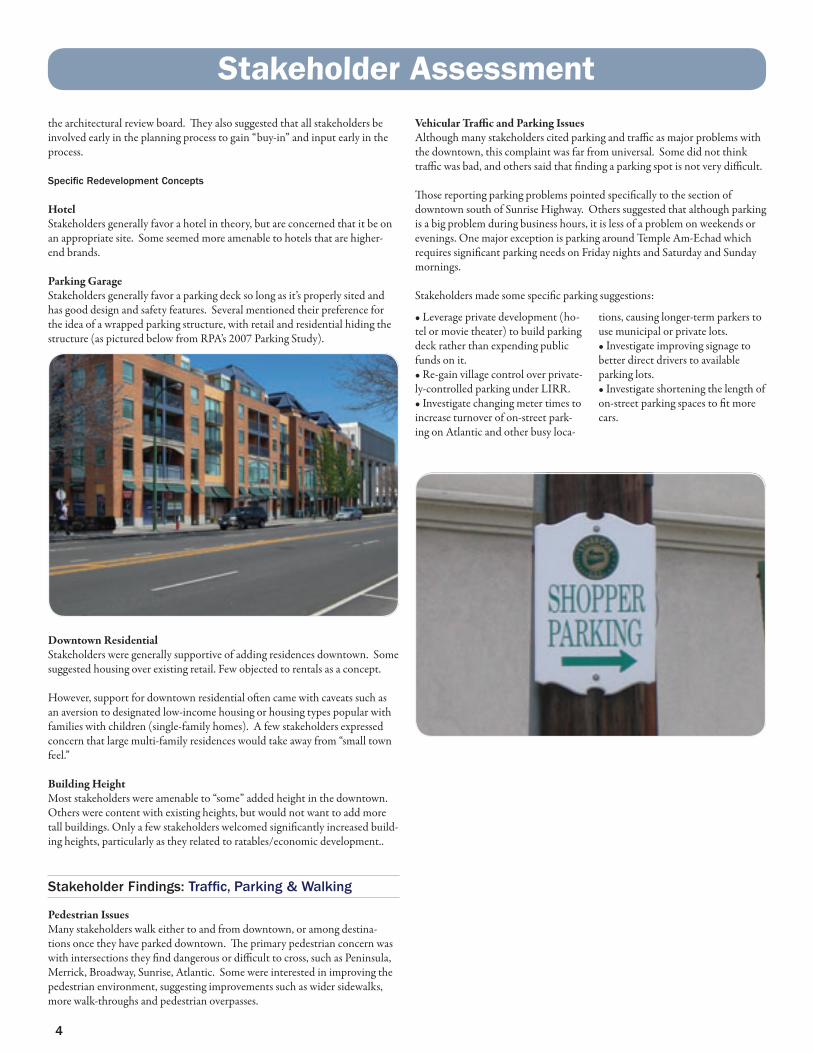
Parking Garage Stakeholders generally favor a parking deck so long as it’s properly sited and has good design and safety features. Several mentioned their preference for the idea of a wrapped parking structure, with retail and residential hiding the structure (as pictured below from RPA’s 2007 Parking Study).
Downtown Residential Stakeholders were generally supportive of adding residences downtown. Some suggested housing over existing retail. Few objected to rentals as a concept.
However, support for downtown residential often came with caveats such as an aversion to designated low-income housing or housing types popular with families with children (single-family homes). A few stakeholders expressed concern that large multi-family residences would take away from “small town feel.”
Building Height Most stakeholders were amenable to “some” added height in the downtown. Others were content with existing heights, but would not want to add more tall buildings. Only a few stakeholders welcomed significantly increased build-ing heights, particularly as they related to ratables/economic development..
Stakeholder Findings: Traffic, Parking & Walking
Pedestrian Issues Many stakeholders walk either to and from downtown, or among destina-tions once they have parked downtown. The primary pedestrian concern was with intersections they find dangerous or difficult to cross, such as Peninsula, Merrick, Broadway, Sunrise, Atlantic. Some were interested in improving the pedestrian environment, suggesting improvements such as wider sidewalks, more walk-throughs and pedestrian overpasses.
Vehicular Traffic and Parking Issues Although many stakeholders cited parking and traffic as major problems with the downtown, this complaint was far from universal. Some did not think traffic was bad, and others said that finding a parking spot is not very difficult.
Those reporting parking problems pointed specifically to the section of downtown south of Sunrise Highway. Others suggested that although parking is a big problem during business hours, it is less of a problem on weekends or evenings. One major exception is parking around Temple Am-Echad which requires significant parking needs on Friday nights and Saturday and Sunday mornings.
Stakeholders made some specific parking suggestions:
• Leverage private development (ho-tel or movie theater) to build parking deck rather than expending public funds on it. • Re-gain village control over private-ly-controlled parking under LIRR.• Investigate changing meter times to increase turnover of on-street park-ing on Atlantic and other busy loca-
tions, causing longer-term parkers to use municipal or private lots.• Investigate improving signage to better direct drivers to available parking lots.• Investigate shortening the length of on-street parking spaces to fit more cars.
StakeholderAssessment
4

Existing Land Use
The Downtown Revitalization Study Area includes the portion of the Village that is widely considered the downtown including those sections bounded by Peninsula Boulevard to the north and west, Earle Avenue to the east and the divergence of Union and Atlantic Avenues to the south. All sites studies were within a 5-minute walking distance (1/4 mile) of either the LIRR train station or the Atlantic Avenue shopping district.
The predominant land uses in the Study Area are Parking and Mixed-Use Re-tail/Service and Residential. Public and Institutional as well as Religious and Educational uses are also prevalent throughout the downtown and surround-ing area. Finally, there are also to a lesser degree Industrial uses - particularly on the eastern edge of the downtown and a small amount of Open Space, mostly noncontributing.
SiteAnalysis
5

Pedestrian Environment
The quality of the pedestrian environment varies considerably throughout the Study Area (as is demonstrated in the map below). From the low-quality pedestrian realm along and across Sunrise Highway to the more moderately walkable streets south of Sunrise Highway and the area surrounding the retail district in the north, to the positive pedestrian realm found along the Atlantic Avenue retail corridor and the tree-lined St. James Place, Lynbrook’s streetscape is inconsistent. A well-connected, positive pedestrian realm helps to contribute to a downtown’s vibrancy and success.
SiteAnalysis
6

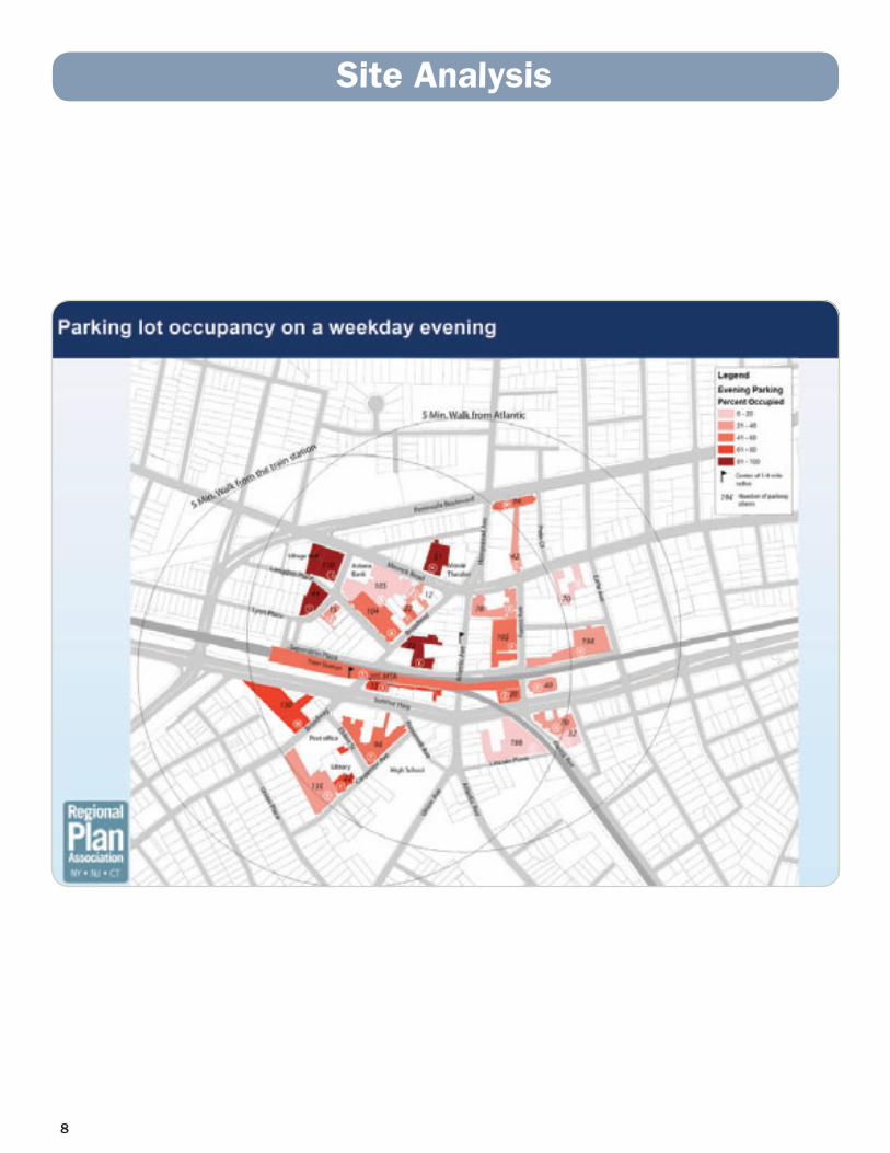
Parking Occupancy
As described above, parking is one of the predominant land uses in the down-town area. Parking is a beneficial use for commuters, shoppers, employers and employees, and the Village should ensure that there is adequate space for current and future users of parking. However, the most commonly occurring form of parking in the Village is offered at large lots, which occupy significant tracts of land that could better contribute to the vibrancy of the downtown, particularly if lots are not being used to capacity or if the spaces can be accom-modated in structured parking. The 2007 RPA Parking Study recommended using the lot at Broadway and Langdon for a new mixed-use retail/service residential that provided parking in a structured garage.
The following maps illustrate the occupancy rates of Lynbrook’s parking lots on an early summer weekday, weekday evening and weekend.
SiteAnalysis
7
SiteAnalysis
8

9
SiteAnalysis

Revitalization Concepts
As the Village proceeds in considering redevelopment and revitalization op-portunities to create greater vibrancy in its downtown, it should consider the following concepts. These concepts take a birds-eye view of the community, and apply proven planning principles, while laying out clear, achievable steps to implement them.
“Main Street”The heart of most vibrant downtowns is often found along an active, thriving “Main Street” that has defined anchors, a balanced mix of uses, walkable streets and buildings that relate well to the pedestrian realm. As Lynbrook’s “Main Street,” Atlantic Avenue has elements of these characteristics – par-ticularly on the stretch of Atlantic Avenue north of the rail tracks – but it lacks the consistency and connection between its north and south anchors, which themselves struggle to achieve vibrancy. In planning for the revitaliza-tion of Lynbrook, it is recommended that the Village continue to recognize the importance of Atlantic Avenue as the downtown’s “Main Street.” Sunrise Highway, which divides the north and south sides of the village center, is the single greatest obstacle to this goal (see discussion below).
In particular the Village should focus revitalization efforts into creating vibrant, mixed-use anchors at either end of Atlantic Avenue. The south anchor - located at the divergence of Atlantic and Union Avenues – is already a well-defined retail area, but is most effective at serving the nearby High School students and faculty during school hours. Further vibrancy could be encouraged through development opportunities to strengthen and better con-nect the area. Should the opportunity arise, redevelopment at the 443 Sunrise Highway (currently a privately-owned Tofu and Chinese Restaurant with a large, underutilized parking lot), could extend the reach of the retail area and facilitate connections towards the north. Further, providing more easily accessible parking to these stores could generate better use. The Village should consider opportunities to develop a “Walk Thru” between the stores and the Congressional parking lot. The “Walk Thru” north of Sunrise Highway should be looked to as precedent.
The north anchor – the Movie Theater and “5 Corners” area – is currently the Village’s most vibrant area, and efforts should be made to build on that vibrancy by actively seeking infill redevelopment opportunities within it (a number of which are described below). Further, the Village should work with Nassau County to pursue traffic-calming along Merrick Road through this stretch. As the north anchor and the place that many consider to be the “heart” of downtown, pedestrians should feel safe to move around to utilize the amenities the area offers. Measures on Merrick Road -such as planted medians, narrowing vehicle lanes, signal optimization and even encouraging motor vehicles to use Peninsula Avenue over Merrick Road through Lynbrook – would help to create a pedestrian-friendly zone that facilitates use of the downtown. Overall, both the north and south anchors should serve as a clear beginning and end of the “Main Street” realm, a place where residents can experience the downtown.
Recommendations
10

Connecting these anchors, should be what people think of and know as “Main Street Lynbrook.” Along this stretch, particular emphasis should be placed on developing a pedestrian realm that is walkable, aesthetically pleasing and offers a mix of uses in the adjoining buildings that draws visitors and residents to and from the north and south anchors. In this realm, sidewalks should be walkable, street trees and other amenities like benches should be abundant, on-street parking should be available and the facades of the buildings should relate to the pedestrian and serve to invite them in. All development proposals that the Village considers along this stretch of Atlantic Avenue should be measured against this “Main Street” concept to ensure a vibrant and active downtown.
“Civic Arc”One of the Village of Lynbrook’s strongest assets is its community members’ strong sense of pride in the Village, which extends back decades to the com-munity’s earliest days. Referring to the Village as “Lynbrook, USA” is just one example of this civic pride. From an urban design perspective, there is great opportunity to capitalize on this strength. Viewed from the air, Lynbrook’s civic buildings happen to be arranged in an arc formation. Starting at St. John’s Lutheran Church in the north end of the Village to the charismatic Village Hall building, Temple Am-Echad and the LIRR station to its south and then across Sunrise Highway to the US Post Office, Public Library and local High School. Many of these institutional uses have open spaces associated with them - playgrounds, sports fields, manicured and landscaped lawns. But for the most part, they are all disconnected from one another.
By linking them, each becomes part of a bigger experience – the whole can be more than just the sum of the parts. This civic arc would also link several of the key “gateway moments” in the town. Over time, the village can create the connective fabric between these civic buildings - using street trees plantings, pedestrian-friendly sidewalks, street furniture, even unique signage, etc - and in this way create not just new alternative way of moving between destina-tions, but creating as well a new defining feature of the Village - a “Civic Arc” that embodies the civic pride of Lynbrook’s residents.
11
Recommendations

Safe Crossing at Sunrise HighwayFor both the “Main Street” and “Civic Arc” concepts to be fully realized and for the downtown to truly achieve its greatest potential, significant steps will need to be taken to improve the safety and remove the psychological barrier of crossing Sunrise Highway. Clearly the Village understands the importance of residents and visitors safely crossing the highway - hiring a full-time crossing guard to serve as an escort across Sunrise Highway at Atlantic Avenue. While the Village is to be lauded for its concern for pedestrian safety, this measure is neither sustainable nor entirely effective at removing the fear of crossing the highway. It is recommended that Village work closely with the New York State Department of Transportation to explore opportunities to slow Sunrise Highway down through this stretch of the Village.
Rather than invest significant sums of money into pedestrian bridge infra-structure, a recommended approach would be to employ some of the “street diet” techniques also recommended for Merrick Road, but at a larger scale. These include planted medians, pedestrian islands to facilitate shorter crossing distances, narrower traveling lanes and bike lanes to reduce traveling speeds and heighten awareness of vehicle operators, all of which allow for a more pe-destrian-friendly realm that makes Sunrise Highway easier and more welcome to cross. The concepts can be tailored for individual roadways and at specific intersections. These ideas are conceptualized in the following illustrations demonstrated on a similar roadway in South Carolina.
The Village of Lynbrook is not alone in facing the challenges of the “great wall” that Sunrise Highway creates on Long Island downtowns. From Lynbrook’s neighbor to the west Valley Stream to all of those communities to the east up to Massapequa Park, there are nearly a dozen downtowns bisected by Sunrise Highway. It is recommended that the Village consider forming a coalition of these local municipalities to encourage the State to develop calm-ing measures for Sunrise Highway where it passes through downtowns.
By instituting changes that would make this road safer and more pedestrian-friendly, it is anticipated that the downtowns through which the Highway runs will benefit from increased economic and development opportunities, will be able to encourage alternative modes of transportation and will experi-ence a greater interconnectedness that could be region-shaping. Such steps have been taken in communities around the country and could be taken here as well.
Recommendations
12
Specific Site Recommendations
Through site surveys, prior planning efforts and conversations with Village stakeholders, 5 key redevelopment sites were identified throughout the down-town where the Village should take specific actions to encourage revitaliza-tion. While other sites - not detailed here - also present opportunities, these 5 were chosen and evaluated because of their potential to contribute to the vibrancy of the downtown, the support of the community to act at these sites and the ability of the Village to take action. It should be noted that the vision described below for each of these sites is concerned less with what exactly should be developed and more with how whatever is developed at the site should relate to the downtown. These descriptions present the Village with a blueprint for a vibrant, walkable downtown that presents opportunities to attract thriving businesses and capitalize on the proximity to the LIRR station. Following this blueprint will give the Village the skills to ensure that develop-ment proposals meet the proven planning principles of proper orientation, scale and design that best contribute to downtown vibrancy.
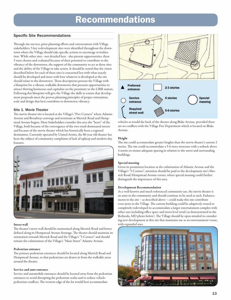
Site 1. Movie TheaterThe movie theater site is located at the Village’s “Five Corners” where Atlantic Avenue and Broadway converge and terminate at Merrick Road and Hemp-stead Avenue begins. Most Stakeholders consider this area the “heart” of the Village, both because of the convergence of the two retail-dominated streets and because of the movie theater which has historically been a regional destination. Currently operated by United Artists, the 86-year old theater has been the subject of community complaints of lack of upkeep and modern-day features.
Street wallThe theater’s street wall should be maintained along Merrick Road and better defined along its Hempstead Avenue frontage. The theater should maintain its orientation towards Merrick Road and the Village’s “5 Corners” and should remain the culmination of the Village’s “Main Street” Atlantic Avenue.
Pedestrian entranceThe primary pedestrian entrances should be located along Merrick Road and Hempstead Avenue, so that pedestrians are drawn in from the walkable areas around the theater.
Service and auto entranceService and automobile entrances should be located away from the pedestrian entrances to avoid disrupting the pedestrian realm and to reduce vehicle-pedestrian conflicts. The western edge of the lot would best accommodate
vehicles as would the back of the theater along Blake Avenue, provided there are no conflicts with the Village Fire Department which is located on Blake Avenue.
HeightThe site could accommodate greater heights than the movie theater’s current 2 stories. The site could accommodate a 5-6 story structure with a setback above 4 stories to ensure adequate spacing in relation to the street and surrounding buildings.
Special massingGiven its prominent location at the culmination of Atlantic Avenue and the Village’s “5 Corners”, attention should be paid to the development site’s Mer-rick Road/Hempstead Avenue corner, where special massing could further distinguish the importance of this area.
Development RecommendationAs a well-known and much-referenced community use, the movie theater is an asset to the community and should continue to be used as such. Enhance-ments to the site – as described above – could make this site contribute even more to the Village. The current building could be adaptively reused or completely redeveloped to accommodate a larger entertainment complex with other uses including office space and street level retail (as demonstrated in the Bethesda, MD photo below). The Village should be open-minded in consider-ing new development at this site that maintains use as an entertainment venue, with expanded uses.
13
Recommendations

Site 2. Broadway/Langdon Place/Merrick Road site This site is comprised of a Village-owned parking field at Broadway and Langdon and a privately-owned parking field along Merrick Road that serves the Astoria Federal bank office building. The Village lot - with 104 spaces - is one of the more heavily used Village lots (around 80% full according to our weekday survey), given its proximity to the rail station. The private lot’s 105 spaces are less frequently used (closer to 60% capacity on a weekday). Stake-holders frequently mentioned this location as a prime spot for redevelopment, provided parking spaces were not lost. It was the preferred location for decked parking in RPA’s 2007 Parking Study. This site will be discussed as a whole, but the most immediate actions can be taken by the Village on its lot.
Street wallThe street wall should be established along the length of Langdon Place and should wrap around along Broadway to connect to the existing frontages of the buildings there. A second street wall should be established along Merrick Road to create a new pedestrian realm along that stretch of the road.
Pedestrian entrancePedestrian entrances should be located along Broadway at the existing build-ing and proximate to the active corner of both Broadway and Langdon as well as along any new development along Merrick Road.
Service and auto entranceHeading Northwest on Langdon Place towards Columbus Street, the amount of pedestrian activity is likely to decrease as one moves away from the heart of
downtown. It is therefore recommended that service and auto entrances to any structure developed at the Broadway and Langdon site be situated at the far end of the structure closest to Columbus Street. Access to the Merrick Road development should be situated off of Merrick Road along the back of that development.
HeightBuildings on these sites could achieve a number different heights. In general, the center of the development can achieve 5-6 stories if setback, while 4 stories would be the appropriate height at the edge of the development along Lang-don Place, Broadway and Merrick Road.
Special massingDevelopment at this site can help to create a secondary mixed-use retail area along Broadway (particularly if the Feather Factory to the south were to be redeveloped). The corner of Broadway and Langdon Place would be the pre-eminent place to focus special massing details to the architecture of whatever building is developed here.
Development RecommendationAs mentioned above, this site was chosen as the preferred site by RPA for structured parking wrapped by mixed-uses in its 2007 parking study. This study envisioned developing the entire site with a 4-story, interior parking structure wrapped by a mixed-use building along Merrick Road. The structure should provide enough spaces to eliminate much of the surface parking on this block. The Village-owned parcel at Broadway and Langdon was recom-mended as a site for an additional mixed-use, residential building that further wrapped the parking structure. Following these recommendations would create new retail frontage along Merrick Road, Broadway and Langdon Place. RPA continues to recommend these whole-site uses, but also recognizes that more immediate action could be taken at the Village parking field. This site would also be suitable for a hotel with structured parking, should the Village choose to invite hotel proposals. RPA would recommend that however the Village parking field be developed, that it proceed in such a way that the adjacent private parcel could be developed as recommended here, should it become available. The rendering on the following page illustrates the concepts described above and conceptualizes a mixed-use retail/service residential development with a parking garage on the Village site.
A rendering from the 2007 RPA Parking Study showing a wrapped parking garage with residential
and retail mixed uses along Merrick road.
Recommendations
14

Before
After
15
Recommendations
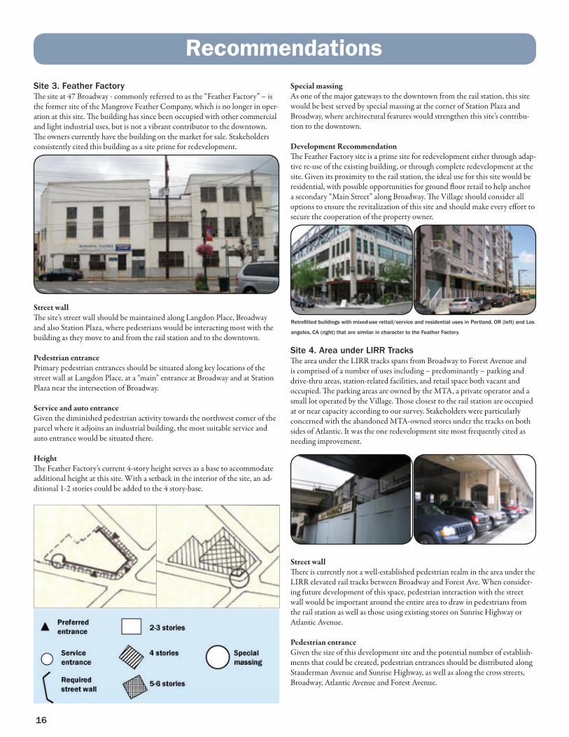
Site 3. Feather Factory The site at 47 Broadway - commonly referred to as the “Feather Factory” – is the former site of the Mangrove Feather Company, which is no longer in oper-ation at this site. The building has since been occupied with other commercial and light industrial uses, but is not a vibrant contributor to the downtown. The owners currently have the building on the market for sale. Stakeholders consistently cited this building as a site prime for redevelopment.
Street wallThe site’s street wall should be maintained along Langdon Place, Broadway and also Station Plaza, where pedestrians would be interacting most with the building as they move to and from the rail station and to the downtown.
Pedestrian entrancePrimary pedestrian entrances should be situated along key locations of the street wall at Langdon Place, at a “main” entrance at Broadway and at Station Plaza near the intersection of Broadway.
Service and auto entranceGiven the diminished pedestrian activity towards the northwest corner of the parcel where it adjoins an industrial building, the most suitable service and auto entrance would be situated there.
HeightThe Feather Factory’s current 4-story height serves as a base to accommodate additional height at this site. With a setback in the interior of the site, an ad-ditional 1-2 stories could be added to the 4 story-base.
Special massingAs one of the major gateways to the downtown from the rail station, this site would be best served by special massing at the corner of Station Plaza and Broadway, where architectural features would strengthen this site’s contribu-tion to the downtown.
Development RecommendationThe Feather Factory site is a prime site for redevelopment either through adap-tive re-use of the existing building, or through complete redevelopment at the site. Given its proximity to the rail station, the ideal use for this site would be residential, with possible opportunities for ground floor retail to help anchor a secondary “Main Street” along Broadway. The Village should consider all options to ensure the revitalization of this site and should make every effort to secure the cooperation of the property owner.
Site 4. Area under LIRR Tracks The area under the LIRR tracks spans from Broadway to Forest Avenue and is comprised of a number of uses including – predominantly – parking and drive-thru areas, station-related facilities, and retail space both vacant and occupied. The parking areas are owned by the MTA, a private operator and a small lot operated by the Village. Those closest to the rail station are occupied at or near capacity according to our survey. Stakeholders were particularly concerned with the abandoned MTA-owned stores under the tracks on both sides of Atlantic. It was the one redevelopment site most frequently cited as needing improvement.
Street wallThere is currently not a well-established pedestrian realm in the area under the LIRR elevated rail tracks between Broadway and Forest Ave. When consider-ing future development of this space, pedestrian interaction with the street wall would be important around the entire area to draw in pedestrians from the rail station as well as those using existing stores on Sunrise Highway or Atlantic Avenue.
Pedestrian entranceGiven the size of this development site and the potential number of establish-ments that could be created, pedestrian entrances should be distributed along Stauderman Avenue and Sunrise Highway, as well as along the cross streets, Broadway, Atlantic Avenue and Forest Avenue.
Retrofitted buildings with mixed-use rettail/service and residential uses in Portland, OR (left) and Los
angeles, CA (right) that are similar in character to the Feather Factory.
16
Recommendations
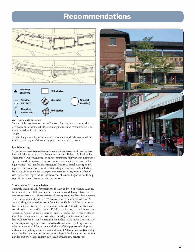
Service and auto entranceBecause of the high-intensity use of Sunrise Highway, it is recommended that service and auto entrances be located along Stauderman Avenue which is cur-rently an underutilized roadway.HeightHeight of any redevelopment or new development under the tracks will be limited to the height of the tracks (approximately 1 to 2 stories).
Special massingKey locations for special massing include both the corners of Broadway and Sunrise Highway and Atlantic Avenue and sunrise Highway. As Lynbrook’s “Main Street”, where Atlantic Avenue meets Sunrise Highway is something of a gateway to the downtown. The northwest corner - where the bank build-ing is located - has significant architectural features. Special massing on the opposite, southeast corner would enforce the gateway concept. Similarly, as Broadway becomes a more active pedestrian realm with greater number of uses, special massing at the northwest corner of Sunrise Highway would help to provide a second gateway to the downtown.
Development RecommendationCurrently used primarily for parking to the east end west of Atlantic Avenue, the area under the LIRR tracks presents a number of different, phased devel-opment opportunities. The most immediate opportunities for redevelopment are at the site of the abandoned “MTA stores” on either side of Atlantic Av-enue. As the gateway to downtown from Sunrise Highway, RPA recommends that the Village enter into an agreement with the MTA to rehabilitate these stores into better uses. With around 17,000 sq ft of space, the building on the east side of Atlantic Avenue is large enough to accommodate a variety of uses. Some have even discussed the potential of creating a performing arts center that could serve as a second entertainment anchor to the movie theater to the north. As parking spaces are accommodated in structured parking at other redevelopment sites, RPA recommends that the Village pursue development of the current parking lots to the east and west of Atlantic Avenue. Redevelop-ment could include commercial and/or retail space. In the interim, it is recom-mended that the Village reclaim ownership of these now private lots.
17
Recommendations

Site 5. Earle and Stauderman Parking Field The Village-owned parking field bounded by St. James Place, Earle Avenue and Stauderman contains 194 spaces, about which 60% are occupied on a giv-en weekday (according to our survey). Because this site lies on the outer edge of a 5-minute walk, it is a field that is less in demand for commuter parking, though it is well within a 5-minute walk of Atlantic Avenue. The surrounding area has residential, commercial and light industrial uses. Stakeholders saw opportunities for residential redevelopment opportunities here.
Street wallAny new development that occurs at the current parking field between St. James Place and Stauderman at the eastern edge of the downtown, should relate to its immediate surroundings. St. James Place has some of the highest quality pedestrian attributes in the downtown – due to its established street trees, vegetation and accommodating sidewalks. The street wall along St. James Place at the development site should contribute a similar pedestrian realm. The street wall should continue along Earle Ave to Stauderman. Pedestrian entrancePedestrian entrances should be situated on both ends of the street wall along St. James Place on the western edge of the parcel – closest to the existing resi-dential area – and along Earle Avenue near the intersection of Stauderman.
Service and auto entranceThe service and auto entrance to this site should be situated along Stauderman Avenue, given it’s location along the rail tracks and lack of connection to any pedestrian realm.
HeightPresuming that the site would accommodate residential uses, an appropriate height for buildings on this site- in relation to surrounding uses - would be 4-stories with an internal setback that could reach an additional 1-2 stories.
Special massingThe portion of the building at the corner of St. James Place and Earle Avenue should have distinctive features that define the building as residential, but that fit into the fabric of the community surrounding it.
Development RecommendationAlready an underutilized parking field adjacent to a cluster of single family homes, it is recommended that the Village pursue opportunities to develop this field into multi-family, residential units. The site is within walking distance of the rail station and Atlantic Avenue and developing residential units at this site could be a draw for young, working professionals as well as empty-nesters looking to scale down form single-family homes. Design of the homes should match the character of the surrounding community. The fol-lowing rendering illustrates the concepts described above and conceptualizes a residential development on the site.
18
Recommendations

Before
After
19
Recommendations

Streetscape Improvements
The “streetscape” can be defined as those elements of a street - including the sidewalks, roadway, adjacent building frontages and landscaping - that visually contribute to and define its character.
Streetscape improvements can often be relatively quick and less expensive steps that a municipality can take to immediately add vibrancy to the public realm of its downtown. They can also serve to calm traffic and make the downtown more walkable.
This illustration features the following enhancements that could be employed on streets throughout downtown Lynbrook - some of which are already being used:
•Improved building facades•Landscaping at the building’s edge•Street furniture, including benches•Brick pavers on the sidewalk•Distinctive streetlamps•Banners•Hanging planters•Vegetation along the sidewalk edge•Marked bicycle lane•Bumpout at the pedestrian crosswalk•Easily identifiable crosswalk•Painted median to calm traffic•Additional street trees
Before
After
20
Recommendations

21
IllustrativePlan

Using the Recommendations
The preceding recommendations have been provided to assist the Village of Lynbrook in its revitalizations efforts for the downtown area. They are not intended to offer specific prescriptions for individual developments, but rather they offer a blueprint for the entire Village that - if referred to - will provide proven design expertise to usher in vibrancy in the downtown. These recom-mendations should be used as guidance when inviting development proposals and as a “measuring stick” when reviewing them.
These recommendations analyze the downtown area as a whole and it is im-portant to remember that a vibrant downtown functions as a whole. Decisions made at the site level should also take into consideration the impact across the downtown, with the goal of vibrancy and interconnectedness. Additionally, the impact of any development on stakeholders - particularly those adjacent to the sites - needs to be considered.
Implementation Steps
1. Adopt a Village Downtown Revitalization Plan Building off of the recommendations in this report, the Village should adopt a Downtown Revitalization Plan that identifies the revitalization study area, prioritizes key redevelopment sites and conceptualizes the themes and devel-opment parameters for revitalization.
2. Review Zoning OrdinanceOnce a Downtown Revitalization Plan has been adopted, the Village should review its current zoning ordinance within the study area and particularly at the priority redevelopment sites to ensure that it enables the context-sensitive infill development desired. Particular focus should be placed on analyzing allowable building heights, mixed-use retail and residential, building setbacks, transparency requirements for “Main Street” storefronts, and parking require-ments. The Village should revise any zoning ordinance that would not allow the preferred development type.
3. Traffic Study and Parking Management PlanThe Village should commission a comprehensive Traffic Study and a Parking Management Plan .While this report and the 2007 RPA Parking Study did analyze parking in the downtown and take inventory of parking lot ownership and occupancy, a more comprehensive approach is recommended to under-stand current and future parking demand. Additionally, the Village would be well-served in better understanding and the current future traffic flow.
4. Use RFP Process to invite RedevelopmentOnce it has settled on a revitalization plan for downtown and has a firm grasp on zoning and parking issues, the Village should develop “Request For Proposals” (RFP) for its priority redevelopment sites. The RFP should be specific in detailing development requirements that coincide with the vision laid out in the Downtown Revitalization Plan. Properly written, the RFP will ensure that only proposals which conform to the Village’s revitalization vision are submitted.
5. Confer with StakeholdersThe Village should work with those property-holders and other stakeholders that will be impacted by nearby development. For example, developments near a temple, church or school should not improperly conflict with those uses.
6. Develop PartnershipsAlthough it is an incorporated Village, effective downtown revitalization will require forging partnerships with such entities as the MTA Long Island railroad, the New York State Department of Transportation and the Nassau County Planning Commission, particularly in seeking improvements to the Station area, Sunrise Highway and Merrick Road. Further, the Village should consider developing a coalition with other Nassau County downtowns bisected by Sunrise Highway. As a coalition with a shared interest, there is a greater chance that improvements to Sunrise highway could be made.
7. Seek Funding OpportunitiesThe Village should develop a comprehensive list of funding opportunities available to pursue these recommendations. Programs such as Nassau County’s Community Visioning Initiative Grant have helped a number of Long Island communities. The Village should also work together with local elected officials at the State and National levels to secure funding for downtown revitalization. The Village should also consult with the New York Metropolitan Transporta-tion Council to determine transportation-related funding opportunities.
Ea
r l eE
ar l e
M e r r i c kM e r r i c k
S u n r i s eS u n r i s e
P e n i n s u l aP e n i n s u l a
F o r e s t
F o r e s t
De
nt o
nD
en
t on
Vin
ce
nt
Vin
ce
nt
Ne w
Ne w
B r o a d w a y
B r o a d w a y
Ol i v
eO
l i ve
Atl
an
tic
Atl
an
tic
W a l n u tW a l n u t
L y o nL y o n
Un
i on
Un
i on
E l mE l m
Ro
ck
l yn
Ro
ck
l yn
N o b l eN o b l e
S h i p h e r d
S h i p h e r d
Ni e
ma
nn
Ni e
ma
nn
W i n t e rW i n t e r
Oa
kl a
nd
Oa
kl a
nd
Irwi n
I r wi n
B l a k eB l a k e
Sc r a
nt o
n
Sc r a
nt o
n
E v e r g r e e n
E v e r g r e e n
L a n g d o n
L a n g d o n
M a n o rM a n o r
He
mp
ste
ad
He
mp
ste
ad
Cu
r ti s
Cu
r ti s
Re
ms
en
Re
ms
en
Jo
hn
Jo
hn
Fo
wl e
rF
ow
l er
Pa
r kP
ar k
Ly
nb
ro
ok
Ly
nb
ro
ok
Me
l ro
se
Me
l ro
se
B e r r y
B e r r y
Sp
en
c er
Sp
en
c er
Ca r p e n t e
r
Ca r p e n t e
r
L e a c hL e a c h
A l i c eA l i c e
E l l aE l l a
W o o dW o o d
Ho w
a r d
Ho w
a r d
E n dV i e
w
E n dV i e
w
S t a t i o nS t a t i o n
L i n c o l nL i n c o l n
Ro
ss
Ro
ss
Ra
nd
al l
Ra
nd
al l
Ca r t
er
Ca r t
er
Pu
t na
m
Pu
t na
m
S t a u d e r m a nS t a u d e r m a n
G a r f i e l dG a r f i e l d
El d
er t
El d
er t
1s
t1
st
D o x e y
D o x e y
Pe t e r s o n
Pe t e r s o n
R a y mo n d
R a y mo n d
H a r r i e tH a r r i e t
S t J a m e sS t J a m e s
Bl o
ss
om
He
at h
Bl o
ss
om
He
at h
B u c k i n g h a mB u c k i n g h a m
B r o w e r
B r o w e r
Wa
t ki n
sW
at k
i ns
Et t a
Et t a
D e v i n eD e v i n e
Da
l ey
Da
l ey
Ro
os
ev
el t
Ro
os
ev
el t
B i rc h
B i rc h
S t e l l a
S t e l l a
Co
l um
bu
s
Co
l um
bu
s
Gl o
ve
rG
l ov
er
J e f f e r s o nJ e f f e r s o n
Su n r i s
e
Su n r i s
e
V i n c e n tV i n c e n t
22
Implementation

23

Regional Plan Association (RPA) is an independent regional planning organization that improves the quality of life and the economic competitiveness of the 31-county, New York-New Jersey-Connecticut region through research, plan-ning, and advocacy. Since 1922, RPA has been shaping trans-portation systems, protecting open spaces, and promoting better community design for the region's continued growth. We anticipate the challenges the region will face in the years to come, and we mobilize the region's civic, business, and govern-ment sectors to take action.
RPA’s current work is aimed largely at implementing the ideas put forth in the Third Regional Plan, with efforts focused in five project areas: community design, open space, transpor-tation, workforce and the economy, and housing. For more information about Regional Plan Association, please visit our website, www.rpa.org.
Chairman Peter W. Herman
Vice Chairman and Co-Chairman, New JerseyChristopher J. Daggett
Vice Chairman and Co-Chairman, New JerseyHon. James J. Florio
Vice Chairman and Co-Chairman, Connecticut John S. Griswold, Jr.
Vice Chairman and Co-Chairman, Long Island Robert A. Scott
President Robert D. Yaro
Treasurer Matthew S. Kissner
Executive Director Thomas K. Wright
Hilary M. BallonLaurie BeckelmanStephen R. BeckwithPaul CamutiFrank S. CiceroJill M. ConsidineJudith D. CooperKevin S. CorbettAlfred A. DelliBoviBrendan P. DougherRuth F. DouzinasBrendan J. DuganDouglas DurstFernando FerrerBarbara J. FifePaul FrancisPatrick J. FoyeTimur F. GalenJerome W. GottesmanMaxine GriffithJohn K. HalveyDylan HixonKenneth T. JacksonMarc JosephRichard D. KaplanShirley Strum KennyRobert KnappJohn Z. KukralRichard C. LeoneCharles J. MaikishJoseph J. Maraziti, Jr.Very Rev. James Parks MortonJan NicholsonBruce P. Nolop
Michael H. O’BoyleVicki O’MearaKevin J. PearsonJames S. PolshekGregg RechlerMichael J. ReganThomas L. RichRebecca R. RileyMichael M. RobertsClaire M. RobinsonElizabeth Barlow RogersLynne B. SagalynStevan A. SandbergH. Claude ShostalSusan L. SolomonThomas J. Stanton IIILuther Tai Marilyn J. TaylorSharon C. TaylorRichard T. ThigpenTimothy J. TouheyKaren E. WagnerWilliam M. Yaro
Directors EmeritiRoscoe C. Brown, Jr.Robert N. RichMary Ann Werner
4 Irving Place, 7th floorNew York, NY 10003212.253.2727fax 212.253.5666
Two Landmark Square, Suite 108Stamford, CT 06901203.356.0390fax 203.356.0390
179 Nassau Street, 3rd floorPrinceton, NJ 08542609.228.7080fax 609.228.7079
board of dIreCTorS