YOXALL NEIGHBOURHOOD DEVELOPMENT PLAN
CONTENTS
Foreword Page 1 Attributions Page 2 1 Introduction
• The purpose of the Neighbourhood Plan • The scope of the Neighbourhood Plan • How the Neighbourhood Plan was produced
Page 3
2 About Yoxall
• A short history of Yoxall • The character of Yoxall • Landscape • Public open space and footpaths • Population profile • Overview of Yoxall today • Community engagement – summary of consultation to date • Main issues for the Yoxall Neighbourhood Plan
Page 7
3 The Future of Yoxall
• Context • National Planning Policy Framework • Achieving sustainable development • Strategic Local Policy • A Vision for Yoxall • Aims and Objectives
Page 13
4 Neighbourhood Plan Policies
• Housing • Design • Traffic • Rural Environment • Community Facilities
Page 18
APPENDICES Appendix A – Yoxall Village Design Statement
Appendix B – Character Analysis, Development Constraints and Opportunities
Appendix C - Community Engagement Process
Appendix D – Options for Development and Site Selection Process
Appendix E – Location of Traffic Hazards in Yoxall Village
Page 31
Page 34
Page 45
Page 57
Page 65
1
FOREWORD
YOXALL NEIGHBOURHOOD PLAN
The Parish Council welcomes the opportunity for the people of Yoxall to have a meaningful say in the future growth and shape of their village.
Though the village has been able to sustain steady growth over the past twenty five years it is now become clear that considerable thought and application need to be applied in how new development can continue to be achieved without harming the character and structure of our community. The Neighbourhood Plan is our response to this challenge.
From the outset the Parish Council recognised that despite the wealth of local knowledge to call upon that we needed expert advice and guidance as well as funding for what proved to be a three year project. Our Steering Group deserves much credit for not only securing highly experienced consultants in Urban Vision but also having the determination to achieve the funding required from East Staffordshire Borough Council and Locality, which delivers the government's neighbourhood planning support programme.
From the original village survey to presentations, exhibitions, workshops, site visits, countless enquiries and consultations, it is clear that every effort was made to ensure that the Plan would take all aspects into consideration in producing our vision for the future of Yoxall.
This Neighbourhood Plan is the result of an enormous amount of work by a small team of villagers and demonstrates that we welcome new development and new people to our community. However the size and nature of new development needs to be carefully managed and controlled not only to protect those who already live in this beautiful village but also those who wish to share in the experience of living in a well balanced, fully sustainable community.
Cllr Philip Hughes
Chairman
Yoxall Parish Council
May 2015
2
ATTRIBUTIONS
The Yoxall Neighbourhood Plan was commissioned by Yoxall Parish Council who appointed a Steering Group comprised entirely of local residents and parish councillors.
The Steering Group was led by Cllr Bob Keys and David Harrison and included Howard Price, Tony Greasley, Jeremy Peachey and Cllr John Williams in supervising key elements of the Plan with contributions from Cllr Beryl Behague, Cllr Philip Hughes, Cllr David Hall, Caroline Woolley and Warren Bradley.
Further advice and feedback was provided by Planning Policy officers at East Staffordshire District Council , Cllr Tim Corbet at Staffordshire County Council , Yoxall Health Centre and neighbouring parish councils at Draycott, Hoar Cross, Branston and Kings Bromley.
Hannah Barter and Mick Downs of Urban Vision provided invaluable guidance and supervision throughout the consultation sessions and final assembly of the plan.
Finally thanks to St Peters Church, Yoxall and local retailers who assisted in the surveys, and the distribution and exhibition of the plans to local residents.
3
1 INTRODUCTION
1.01 The Localism Act 2011 empowers local communities in England to take the lead in
planning how their own neighbourhoods will develop. Many communities around the country have seized this opportunity to influence the future of their areas. The Yoxall Neighbourhood Development Plan will enable the local community to shape the future development of the village for the benefit of the local community.
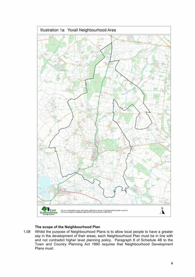
1.02 The Neighbourhood Area is the area that is covered by the Neighbourhood Plan. The Yoxall Neighbourhood Area, which is the same as the area defined by the Yoxall Parish boundary, was designated by East Staffordshire Borough Council in October 2013. The Borough Council’s decision confirms that Yoxall Parish Council is legally empowered to produce a Neighbourhood Plan for the Parish of Yoxall. The Yoxall Neighbourhood Area includes the village of Yoxall and the small rural hamlets of Morrey, Hadley End and Newchurch and is shown in Illustration 1a.
1.03 The current development plan in the Borough is the East Staffordshire Local Plan 2006 (saved policies). The emerging East Staffordshire Local Plan 2012-31 identifies Yoxall as a Tier 2 Local Service Village and contains a housing allocation of 40 new dwellings over the period of the plan period (to 2031). Following extensive consultation with the local community and key stakeholders, and the consideration of different development options, the Neighbourhood Plan identifies a site for this strategic housing allocation adjacent to the main settlement area of Yoxall village.
The purpose of the Neighbourhood Plan 1.04 Like many rural areas in England Yoxall has been the subject of increasing pressures
for development. In situations where no specific level of growth has been agreed and the planning policies of the local authority are not clearly defined new developments have come forward in an ad hoc fashion, sometimes not in the most suitable locations and bringing little benefit to the local community in the form of infrastructure.
1.05 Neighbourhood Plans are part of the statutory planning system. This means that when decisions are made on planning applications the policies and proposals in the Neighbourhood Plan must be taken into account by the local planning authority, East Staffordshire Borough Council.
1.06 Neighbourhood Plans are a new type of statutory plan. Not only are they intended to be produced by local people for their own areas, they also have to be approved by a referendum of the people living in that area. Unlike national planning policy, which is approved by Parliament, or local planning policy, which is approved by the local authority, a Neighbourhood Plan can only be brought into force following a majority vote by residents of the Neighbourhood Area.
1.07 The Yoxall Neighbourhood Plan will be a statutory planning policy document supported by a majority of local people which will enable Yoxall Parish Council to have a greater and more positive influence on how the village develops up to 2031. The Parish Council intends to monitor the progress of development over this period and review the Neighbourhood Plan against actual development and exigencies.
4
The scope of the Neighbourhood Plan
1.08 Whilst the purpose of Neighbourhood Plans is to allow local people to have a greater say in the development of their areas, each Neighbourhood Plan must be in line with and not contradict higher level planning policy. Paragraph 8 of Schedule 4B to the Town and Country Planning Act 1990 requires that Neighbourhood Development Plans must:
5
i. Have appropriate regard to national policies and advice contained in the National Planning Policy Framework (NPPF);
ii. Contribute to the achievement of sustainable development; iii. Be in general conformity with the strategic policies in the local plan for the area;
and iv. Be compatible with EU obligations, including human rights requirements.
It is a legal requirement for Neighbourhood Plans to have appropriate regard to the National Planning Policy Framework and to be in general conformity with strategic policies. A key implication of these requirements is that, where the Local Plan has a growth allocation for an area, the Neighbourhood Plan must provide scope for at least the level of growth specified in the Local Plan. This is discussed in more detail in Section 3 The Future of Yoxall.
1.09 The minimum level of growth in the Neighbourhood Area is determined by the local planning authority. In the case of Yoxall there are no housing figures for Yoxall in the adopted Local Plan (2006) but the emerging Local Plan (2012-2031) proposes a development allowance of 40 dwellings for Yoxall village, which is what the Neighbourhood Plan Steering Group worked with. The Neighbourhood Plan can determine where these dwellings or other development will go, and it can allow a higher level of growth than the local planning authority requires, but it cannot reduce the scale of these allocations.
1.10 Yoxall Neighbourhood Plan will be part of the statutory development plan for the area. Consequently it must deal with the same range of matters as all other statutory plans, namely the development and use of land. Other matters, such as the promotion of events, social and community activities, advisory support for businesses, etc., and matters which are covered by separate legislation, such as highway matters, cannot be included in the Neighbourhood Plan.
How the Neighbourhood Plan was produced 1.11 The neighbourhood plan process is set out in the Neighbourhood Planning (General)
Regulations 2012. This document defines the main stages that a Neighbourhood Plan must go through before it is voted on at the referendum. Neighbourhood Plans that do not closely follow the Regulations in the way they are produced may be vulnerable to legal challenge later.
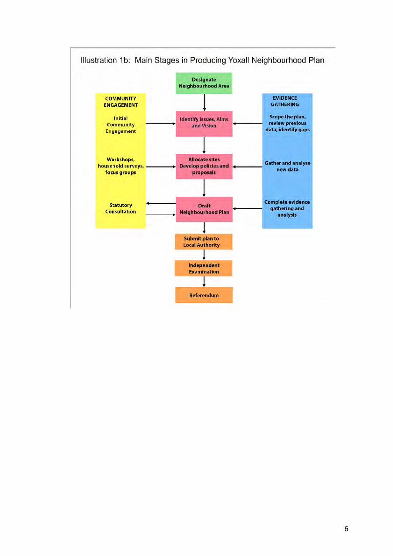
1.12 A summary of the main stages in preparing the Yoxall Neighbourhood Plan are shown in Illustration 1b below.
1.13 Neighbourhood plans must be based on relevant evidence about the neighbourhood area (the Parish of Yoxall) and must reflect the views of the local community. The Parish Council has therefore been careful to gather the necessary evidence to inform the Neighbourhood Plan and to underpin the policies in it. In addition the Parish Council has made community engagement a priority throughout the process of preparing the Neighbourhood Plan.
1.14 In producing the Neighbourhood Plan the Parish Council co-opted parishioners onto a Steering Group that had the responsibility of managing the process. It has been a priority of the Steering Group to ensure that as far as possible the Neighbourhood Plan is effective in delivering the needs, wants and aspirations of the local community and also meets legal requirements.
6
7
2 ABOUT YOXALL
2.01 In order to produce a robust Neighbourhood Plan it is necessary to have a good understanding of both the neighbourhood area and the local community’s views about what should be done to improve and protect it. This section of the Plan provides a brief history of Yoxall and an assessment of its character. This is followed by a summary of the community engagement that has taken place about the Neighbourhood Plan and the main issues that were highlighted in the various consultations with local people.
A short history of Yoxall 2.02 Yoxall is a large linear village located about 7 miles north of Lichfield on the west side
of the River Swarbourn, a tributary of the River Trent. It lies near the edge of the higher ground of Needwood Forest on the main A515 road from Lichfield to Ashbourne, which runs north - south parallel to the River Swarbourn.
2.03 Yoxall is an ancient parish that is listed in the Domesday Book and has developed into a vibrant community. Modern day Yoxall is a linear settlement extending along the A515 for almost a mile from Alexandra Drive in the north to Bondfield Lane in the south.
2.04 Yoxall was the home of Thomas Gisborne, a friend of the anti-slavery campaigner, William Wilberforce, who often visited the village. Other notable residents include Thomas Astle, who in the mid-18th century owned the finest private library of manuscripts in England, subsequently acquired by the Royal Institution, and both the grandfather and the wife of the famous angler, Izaac Walton.
2.05 The parish of Yoxall contains some 57 buildings which are included in the statutory list of buildings of special architectural or historic interest (listed buildings). Notable amongst these is St Peter’s Church the earliest surviving parts of which date from the 12th and 14th centuries. The church was extensively restored in 1866-68 and much of the current fabric dates from this period. Both St Peter’s and the 14th century timber-framed Pear Tree Farmhouse are listed Grade II*.
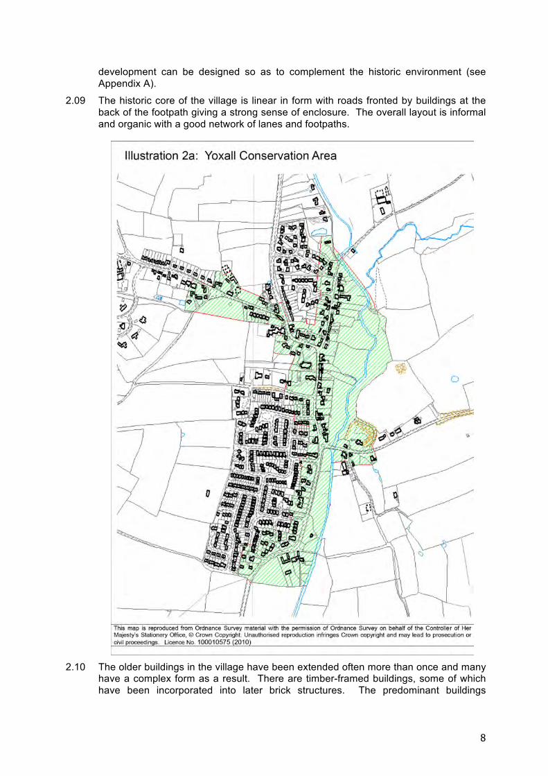
2.06 The majority of Yoxall’s listed buildings are located within the village and form the core of the Yoxall Conservation Area, which was designated by Staffordshire County Council in 1970. A map of the conservation area is shown in Illustration 2a below.
2.07 After the 2nd World War the village expanded, initially in the 1970s with a housing estate located on the west side of the A515 between Savey Lane and Bondfield Lane. Further housing developments took place in the 21st century at Alexandra Drive and Weaverslake Drive. In general the new developments followed the historic pattern of building along the valley parallel to the River Swarbourn and below the 70 metre OD contour line.
The character of Yoxall 2.08 In 1993 the Parish Council produced a Village Design Statement for Yoxall which
appraises the character of the village and provides advice and guidance on how new
8
development can be designed so as to complement the historic environment (see Appendix A).
2.09 The historic core of the village is linear in form with roads fronted by buildings at the back of the footpath giving a strong sense of enclosure. The overall layout is informal and organic with a good network of lanes and footpaths.
2.10 The older buildings in the village have been extended often more than once and many
have a complex form as a result. There are timber-framed buildings, some of which have been incorporated into later brick structures. The predominant buildings
9
materials in the village are walls of orange-red brick and roofs of Staffordshire blue plain tiles.
Landscape 2.11 A characterisation of the East Staffordshire landscape describes Yoxall as falling
within ‘The Middle Valleys and their Villages’. The area is defined by the small tributaries and associated valleys which lead to the Trent including the River Swarbourn. The valleys create well enclosed features, with meandering lanes bounded by hedgerows and hedge banks following the landform. The enclosure restricts views across the valley, and contains views of the village settlement on the lower ground.
2.12 Yoxall is a ‘gateway’ to the ancient forest of Needwood and there are remnants of the forest on higher ground either side of the Swarbourn valley. The valley floor and lower slopes are characterised by grassland and some arable farming, made up of many small to medium irregular shaped fields bounded by thick hedgerows and hedgerow trees.
2.13 Much of Yoxall Parish is within the National Forest, and there are many good local examples of new woodland with public access established within walking distance of the village. The National Forest Strategy (2012-24) is a strategic document setting out the aims and objectives of the initiative which links the ancient forests of Needwood in the west to Charnwood in the east.
2.14 A number of Landscape Character Areas are defined, and Yoxall is within the Needwood and South Derbyshire Claylands Regional Character Area. Landscape types are classified within this character area, and Yoxall is part of the Historic Settlements and enclosures type. Key characteristics of this type include: • Relatively unspoilt landscape with an ancient enclosed character • Many small irregular shaped pastoral fields bounded by thick hedgerows.
Roadside hedgebanks are a feature in Yoxall. • Hedgerow trees, small woods and tree lined water courses. • Significant heritage features e.g. historic parkland.
2.15 A detailed character analysis of Yoxall in its historic landscape setting has been carried out by the Parish Council and an assessment of the resulting constraints and opportunities for future development around the village has been made – see Appendix B. In summary Yoxall is a distinctly rural settlement with a strong linear character lying in a small valley and has low-key gateways on its northern and southern sides. The settlement boundary is well defined on the east by the River Swarbourn and on the west by a clear edge to the village. Existing development lies below the 70m AOD contour line. The most favourable opportunities for new development exist at the northern and southern edges of the village.
Public open space and footpaths 2.16 Yoxall Parish Council owns and manages some locally valued open spaces in the
village. Two of the spaces at Goose Green and Swarbourn meadow fall within the conservation area and are bounded by the attractive tree-lined Swarbourn river.
2.17 Other open spaces managed by the parish include Ferrers Field recreation ground off Ferrers Road, the closed churchyard and burial ground at St Peter’s Church, and the recently planted Mill Holme Pringle adjacent to the bridge over the Trent to the south of the village.
2.18 There is a dense network of well used public footpaths linking the village to the outlying countryside, and these definitive routes and stiles are managed by the highway authority, Staffordshire County Council. Yoxall is fortunate to have this
10
network of paths and accessible National Forest woodlands on the doorstep and available to all residents and visitors to the village.
Population profile 2.19 In 2001 Yoxall had a population of 2,490 persons, and by 2011 this had grown to
2,621, an increase of 5.3%. The number of households in Yoxall was 1,079 in 2011, making an average household size of 2.4 persons.
2.20 In 2011 the age profile of the parish showed a smaller proportion of persons under the age of 16 (17.7%) compared to East Staffordshire as a whole (19.2%) and a much higher proportion of persons over the age of 60 (32.5%) compared to 23% for the whole Borough. The proportion of young adults (aged 16 to 24 years) in Yoxall is just 6.9%, the lowest in the Borough, compared to 10.9% in East Staffordshire as a whole.
2.21 The proportion of persons of Black or Minority Ethnic origin in Yoxall was 3.4% in 2011 compared to 13.8% in East Staffordshire as a whole.
2.22 The average household income in Yoxall was £53,326 in 2011, the highest in East Staffordshire. The average household income for the Borough as a whole was £35,360.
Overview of Yoxall today 2.23 The Yoxall village survey demonstrated that the village is well served by the existing
range of retail and service outlets: general store, post office, florist and greengrocer, two hairdressers, delicatessen, butchers, and car sales and garage. Demand for additional retail outlets is negligible. Over 90% of respondents used the existing shops on a daily or weekly basis.
2.24 Similarly, the three public houses within the village are well patronised and the Parish Hall hosts a very wide cross-section of indoor sporting, cultural and social and entertainment activities. There is also a doctor’s surgery.
2.25 There is a sports pavilion serving cricket and football clubs, a crown green bowls club, children’s play area and associated facilities plus a wide range of indoor clubs and activity groups for all age ranges.
2.26 St. Peters School is highly regarded and currently has 155 pupils aged between 5 and 11. It is however nearing maximum capacity.
2.27 There are three churches: Church of England (St Peter’s), Roman Catholic (St Francis de Sales), and Woodmill Methodist Church.
2.28 Manufacturing and commercial sectors are represented by an aluminium coating works, and home based plumbing, electrical, joinery, building, landscaping, tree surgeons and professional services to support the local and wider economy.
Community engagement: a summary of consultation to date 2.29 In March 2012 the Parish Council began work on the Yoxall Neighbourhood Plan by
creating a Core Group to manage the process and produce the Neighbourhood Plan, and by forming a Consultation Group made up of representatives of the community to provide feedback and advice to the Core Group.
2.30 In April-May 2012 a questionnaire was delivered to all dwellings in the village. Responses were analysed and used to inform the emerging Neighbourhood Plan. The overriding response to the questionnaires was that Yoxall was a safe, sociable and pleasant place to live. Housing was a key issue both from those that wanted more and those that did not want to see any further development.
2.31 In order for the remote hamlets to have an opportunity to contribute to the consultation residents were informed by the Parish magazine, The Fisherman; the village news
11
section of the local newspaper, The Lichfield Mercury; the parish council website, posters on the village notice boards; survey questionnaires delivered to every home in the village of Yoxall and additional copies left in the Post Office, Parish Hall, Newsagents, Florist and Church and a poster advertising the survey displayed at the surgery.
2.32 Further consultation events and activities were held as follows: • Meeting held in the Committee Room of the Parish Hall on 27th January 2013. • Exhibition held on 12th and 13th July 2013 • Workshop 12th October 2013 • Drop-in event 20th January 2014 Smaller sites (windfall workshop) • Workshop 25th January 2014
2.33 Responses to these events highlighted the following issues and needs: • Shortage of public car parking in the village centre: there is a need for an
appropriately designed community car park serving the school and the village hall.
• Flooding: current and future risk arising from development, and the need for mitigation.
• Traffic on A515 particularly HGVs: frequency, speed and noise. • Improvement to junction of Sudbury Road/Hadley Street. • Softening of urban nature of A515. • Footpaths along the A515 are very narrow in places. • Parking on Sudbury Road/Hadley Street.
• Small business unit development, with the telephone exchange location being the most nominated, was favoured by 43% of respondents.
2.34 The workshop on 25 January 2014 confirmed the view that the Yoxall Settlement Boundary should be amended to include the preferred site to accommodate the housing growth allocation made by East Staffordshire Borough Council for the village. At the same event a position was agreed that provision should be made for a maximum of 10 windfall dwellings in Yoxall over the plan period (to 2031).
2.35 Consultation responses suggest that 38% of residents use open spaces and 82% of respondents use public footpaths. There was not much awareness of Mill Holme Pringle and some did not know of its existence. The majority opinion is that the village is well served by open spaces and public footpaths, which people would like to remain intact.
2.36 A chronological summary of the community engagement process is set out more fully in Appendix C. The responses to consultation are considered in more detail at relevant points in this Neighbourhood Plan.
The main issues for the Yoxall Neighbourhood Plan 2.37 From community consultation and other evidence the following issues were identified
for the Neighbourhood Plan to address: • The need to accommodate the strategic housing growth allocation whilst
ensuring the historic character of the village and its landscape setting is not damaged;
• The desirability of ensuring high quality design which enables proportionate and appropriate housing growth and protects the historic and rural character of the village
12
• Ensuring that any new development in Yoxall does not increase the traffic hazards on the A515 through the village centre;
• Taking opportunities to improve road safety in the village when associated new development takes place;
• The need to ensure that any new development does not exacerbate the risk of flooding.
• Providing for a modest amount of employment development at an appropriate scale and in an appropriate location.
13
3 THE FUTURE OF YOXALL
Context
3.01 Neighbourhood Plans must meet certain legal requirements before they can be brought into force. These are known as the “basic conditions” and the Neighbourhood Plan has been tested through an independent examination, checked by the local authority and will now proceed to referendum.
3.02 The Basic Conditions for Neighbourhood Plans are that • They must have appropriate regard to national policy • They must contribute to the achievement of sustainable development • They must be in general conformity with the strategic policies contained in the
development plan for the area • They must be compatible with EU obligations including human rights requirements.
3.03 When the Yoxall Neighbourhood Plan was submitted to East Staffordshire Borough Council it was accompanied by a Basic Conditions Statement which showed how the Neighbourhood Plan satisfies the Basic Conditions.
National policy 3.04 The National Planning Policy Framework (NPPF) strongly supports the principle of
neighbourhood planning. It states that Neighbourhood Plans should set out a positive vision for the future of the local area, they should set planning policies to determine decisions on planning applications, including policies which set out the quality of development that should be expected for the area, based on stated objectives for the area’s future and an understanding and evaluation of its defining characteristics.
3.05 Neighbourhood Plans should support the sustainable growth and expansion of all kinds of businesses and enterprise in rural areas, they should promote the development and diversification of agricultural businesses, they should support sustainable rural tourism and leisure developments that respect the character of the countryside, and they should promote the retention and development of local services and community facilities in villages.
Sustainable development 3.06 The Neighbourhood Plan must contribute to the achievement of sustainable
development. The NPPF states that pursuing sustainable development includes making it easier to create jobs in villages, to promote gains in biodiversity, to achieve better quality design, to improve people’s quality of life, and to provide a wider choice of high quality homes.
3.07 The aims, objectives, policies and proposals of the Neighbourhood Plan should be assessed against their ability to achieve sustainable development. Wherever possible the Neighbourhood Plan should actively promote the achievement of sustainable development.
14
Local strategic policy 3.08 East Staffordshire Borough Council are in the process of replacing the adopted Local
Plan 2006 with a new Local Plan for the Borough. Until the new Local Plan is formally adopted by the Borough Council certain “saved” policies from the adopted Local Plan remain in force, and these help form the framework of strategic local policy. Relevant saved Local Plan policies cover urban and rural regeneration, infrastructure and community provision, development outside development boundaries, design, conversion of rural buildings, affordable housing in rural areas, transport, parking, public transport, sports facilities, landscaping and green space, and community facilities.
3.09 The East Staffordshire Local Plan 2012-31 was submitted to the Planning Inspectorate for independent examination in April 2014. The emerging Local Plan contains 35 strategic policies, which the Yoxall Neighbourhood Plan has had regard to. The Yoxall Neighbourhood Plan, however, has to be in general conformity with the saved policies of the Local Plan 2006.
3.10 The emerging Local Plan provides relevant strategic guidance for sustainable development, the level and distribution of housing growth, development outside the settlement boundary, the rural economy, affordable housing, residential development on exception sites, supporting local communities, green infrastructure, the National Forest, high quality design, the historic environment, flooding, renewable energy, biodiversity, outdoor sports and open space, health and well being, and accessibility and sustainable transport.
3.11 The emerging Local Plan identifies Yoxall as a Tier 2 Local Service Village which will meet local needs by providing a limited range of facilities and services which sustain village life. Yoxall Neighbourhood Plan Steering Group have worked closely with ESBC and the development allowance indicated in the emerging Local Plan has been used as a basis for considering housing in the Neighbourhood Plan.
A Vision for Yoxall 3.12 From the issues and aspirations identified in the community consultation responses a
vision for Yoxall in 2031 has been produced. The local community value Yoxall’s rural village character and do not want new development to undermine it, they want well-designed new housing which meets local needs and does not increase the risk of flooding, they want improved car parking and pedestrian safety in the vicinity of the school and village hall, they want road safety standards to be maintained or improved, and they want good access to the surrounding countryside for pedestrians and cyclists.
3.13 The proposed Vision for Yoxall is as follows:
In 2031 Yoxall will be a village with a historic rural character, a good range of high quality homes and community facilities fulfilling local needs, a convenient local service centre with a network of safe pedestrian routes, and a variety of locally based employment opportunities.
3.14 The Neighbourhood Plan seeks to identify aims and objectives to achieve this vision
for Yoxall, and to provide a policy framework to guide the development necessary to deliver it.
Aims and objectives 3.15 The Neighbourhood Plan contains Strategic Aims for Yoxall based on the main issues
which the village faces, relating to the subjects of housing, the location and design of new development, road safety, green space, the historic environment, and
15
employment. Each Strategic Aim has a corresponding set of objectives, which provide more specific and measurable actions to achieve the aims.
Yoxall Strategic Aim 1: To accommodate new housing development which satisfies strategic growth requirements, fulfills local housing needs, and enables locally needed infrastructure to be delivered.
3.16 The purpose of this strategic aim is to ensure that the housing growth specified in the
Local Plan is delivered and that local housing needs and infrastructure are met.
3.17 The Objectives arising from YSA1 are as follows: 1A. To deliver the amount of housing required by East Staffordshire Borough
Council’s strategic housing policies. 1B. To provide the type and size of housing development required to meet local
housing needs including smaller, more manageable dwellings suitable for older persons.
1C. To ensure that new housing development contributes towards the provision or maintenance of locally needed infrastructure.
Yoxall Strategic Aim 2: To ensure that the great majority of new development in the Yoxall Neighbourhood Area is located inside the Settlement Boundary.
3.18 The purpose of this strategic aim is to focus development within the Settlement Boundary defined for the village, whilst allowing a limited amount of exceptional development elsewhere.
3.19 The Objectives arising from YSA2 are as follows:
2A. To define a Settlement Boundary for Yoxall which accommodates the strategic housing growth allocation for the village and a modest level of infill development.
2B. To clarify the type of development that may be permitted outside the Settlement Boundary.
Yoxall Strategic Aim 3: To ensure all new developments are well designed in order to complement and enhance the historic rural character of Yoxall and its landscape setting.
3.20 The purpose of this strategic aim is to ensure that new developments complement and respect the historic character of the village and that the rural nature of Yoxall is protected. It also seeks to ensure that new developments are of good quality design in their own right.
3.21 The Objectives arising from YSA3 are as follows: 3A. To ensure that each new development is of a scale, density and design
appropriate to the rural character of Yoxall. 3B. To ensure that the historic character of the village is preserved and enhanced.
3C. To ensure that the principles of good urban and architectural design are followed in new development in Yoxall.
16
Yoxall Strategic Aim 4: To ensure that all new development in Yoxall mitigates traffic impact and seeks to provide improved pedestrian connectivity.
3.22 The purpose of this strategic aim is to avoid any increase in road safety hazards, particularly in the vicinity of known traffic problems on the A515 as it passes through the village and to improve pedestrian connectivity and safety.
3.23 The objective arising from YSA4 is as follows: 4A. To require developers to demonstrate that their proposals will not adversely
affect road safety in the village.
Yoxall Strategic Aim 5: To improve public car parking in the vicinity of important community facilities.
3.24 The purpose of this strategic aim is to relieve traffic flow problems and obstructive car parking near to the shops and the school.
3.25 The objective arising from YSA5 is as follows: 5A. To provide public car parking facilities in the vicinity of Hadley Street and Sudbury
Road.
Yoxall Strategic Aim 6: To ensure that new development in Yoxall does not exacerbate the risk of flooding.
3.26 The purpose of this strategic aim is to make sure that the risk of flooding is considered and appropriate measures are taken to address potential increased surface water run-off.
3.27 The objective arising from YSA6 is as follows:
6A. To assess flood risk and take appropriate mitigation measures.
Yoxall Strategic Aim 7: To preserve and enhance wildlife habitats, the native landscape, public open spaces and the footpath network in Yoxall.
3.28 The purpose of this strategic aim is to protect existing areas of public open space and the existing footpath system in Yoxall, and to take advantage of opportunities to extend, improve, and increase the safety, use and attractiveness of these areas and routes.
3.29 The objectives arising from YSA7 are as follows: 7A. To take opportunities to add value to the public open spaces and footpaths in
Yoxall through environmental improvements and appropriate additional uses such as village events and activities.
7B. To enhance and strengthen the nature conservation value and biodiversity of green infrastructure in Yoxall.
7C. To improve connectivity between public open spaces, particularly along the riverside.
7D. To create safe routes to school.
17
Yoxall Strategic Aim 8: To accommodate small business development in Yoxall and to ensure high speed fibre optic broadband is available for existing and new businesses and for home workers.
3.30 The purpose of this strategic aim is to allow new employment development in Yoxall which will support the local economy and help Yoxall become a more sustainable settlement. The availability of high speed broadband is considered essential to maintain and improve competitiveness, whether for commercial premises or for home workers.
3.31 The objectives arising from this strategic aim are as follows:
8A. To create jobs available to members of the local community;
8B. To reduce travelling to work;
8C. To improve the range of local services and facilities available to local residents;
8D. To facilitate the provision of high speed broadband for new and existing businesses.
18
4 POLICIES FOR YOXALL
4.01 Following consultation with the community and an analysis of the evidence gathered,
issues were identified which the Neighbourhood Plan would address, and a vision, aims and objectives were generated to guide the future development of Yoxall. The Yoxall Neighbourhood Plan Steering Group then held a policy mapping workshop to decide how to translate the community’s aspirations for the village into policies that will be used to make decisions on future development proposals and planning applications.
4.02 The key policy areas concerned the location of new housing in Yoxall, the Settlement Boundary, windfall sites, the design of new development, and the traffic impact of new development.
4.03 East Staffordshire Borough Council may introduce a Community Infrastructure Levy policy which will provide CIL contributions as planning gain in respect of many kinds of development. The CIL must be used to pay for infrastructure which supports the development of the local area. Parish Councils which have a Neighbourhood Plan in place (i.e. has been made by the local authority after being approved at referendum) will be entitled to 25% of CIL contributions. CIL contributions will be determined by the Borough Council’s CIL charging schedule, which will be in place after the Local Plan has been adopted
Policy H1: Yoxall Settlement Boundary
Context and rationale 4.04 The emerging East Staffordshire Local Plan states that, to accommodate the proposed
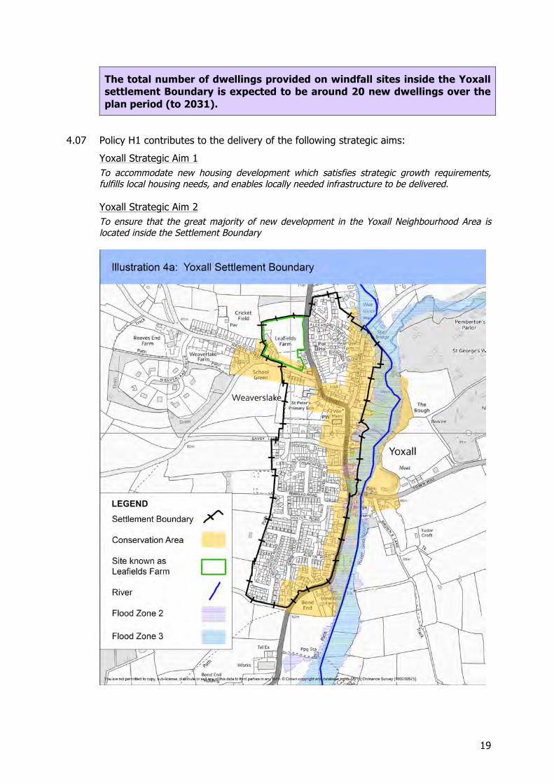
growth, the settlement boundary will be revised through the Neighbourhood Plan. The new Settlement Boundary Extension is shown in Illustration 4a. Development outside the Settlement Boundary will not be permitted, with the exception of certain specific forms of small scale development defined in Policies H1 and H2.
4.05 The new Settlement Boundary for Yoxall village includes the site known as Leafields Farm, which is outlined in green in Illustration 4a, where planning permission has been granted for 40 new dwellings. For clarity it should be understood that Policy H1 does not apply to the Leafields Farm site.
4.06 A range of development options for delivery of the strategic housing allocation were considered through a site assessment process, including a community workshop. The process of site selection is described in detail in Appendix D.
POLICY H1: DEVELOPMENT INSIDE YOXALL SETTLEMENT BOUNDARY
The Yoxall Settlement Boundary is shown in Illustration 5a. Appropriate new housing development will be permitted on infill or redevelopment sites inside the settlement Boundary provided it complies with the other policies of this Plan.
19
The total number of dwellings provided on windfall sites inside the Yoxall settlement Boundary is expected to be around 20 new dwellings over the plan period (to 2031).
4.07 Policy H1 contributes to the delivery of the following strategic aims:
Yoxall Strategic Aim 1 To accommodate new housing development which satisfies strategic growth requirements, fulfills local housing needs, and enables locally needed infrastructure to be delivered.
Yoxall Strategic Aim 2 To ensure that the great majority of new development in the Yoxall Neighbourhood Area is located inside the Settlement Boundary
20
Application of Policy H1 4.08 The purpose of Policy H1 is to limit the great majority of new development to sites
inside the Settlement Boundary. Development proposals on sites in locations outside the Settlement Boundary will be assessed against criteria defined in Policy H2 and in relevant policies in the East Staffordshire Local Plan, including policy for replacement dwellings in the countryside.
Policy H2: Housing Development Outside Yoxall Settlement Boundary
Context and rationale 4.09 In order to help meet local housing need and at the same time to achieve sustainable
development, the Neighbourhood Plan makes provision for a limited amount of small scale housing growth on small infill or redevelopment sites outside the Yoxall Settlement Boundary. Policy H2 sets out the criteria that proposals for new housing development outside the Yoxall Settlement Boundary must satisfy.
POLICY H2: HOUSING DEVELOPMENT OUTSIDE YOXALL SETTLEMENT BOUNDARY
The Yoxall Settlement Boundary is shown in Illustration 4a.
Housing development proposals outside the Settlement Boundary will be permitted if it can be demonstrated that
a) the development is on a small site and would provide affordable housing for evidenced local need. Small numbers of market homes may be permitted where this is essential to enable the delivery of affordable units, and
b) the development preserves or enhances the character or appearance of the area, and
c) where relevant, the development brings redundant or vacant historic buildings back into beneficial re-use, and
4.10 Policy H2 contributes to the delivery of the following strategic aims:
Yoxall Strategic Aim 1 To accommodate new housing development which satisfies strategic growth requirements, fulfills local housing needs, and enables locally needed infrastructure to be delivered.
Yoxall Strategic Aim 2 To ensure that the great majority of new development in the Yoxall Neighbourhood Area is located inside the Settlement Boundary
Application of Policy H2 4.11 The emerging Local Plan encourages the redevelopment of brownfield sites in
providing additional windfall housing, but recognises that in certain cases windfall housing development outside the settlement boundary may be appropriate including as specified in a neighbourhood plan which has been brought into force.
4.12 Housing development proposals on sites outside the Settlement Boundary will be assessed against relevant criteria set out in the East Staffordshire Local Plan and in Policies H2, D1 and D2 of this Neighbourhood Plan.
21
4.13 The purpose of this policy is to allow a degree of flexibility in the provision of new housing in Yoxall.
D1: Protecting and enhancing the historic rural character of Yoxall Context and rationale
4.14 Yoxall is a parish with a strong historic rural character and a historic core. It is important that all new development is well designed, in order to protect the existing character and to enhance the quality of the built environment. In consultation on the Neighbourhood Plan many people valued Yoxall’s rural village environment and were concerned that it is protected from insensitively designed new developments.
4.15 Appendix B provides a Settlement Character Analysis and identifies Settlement Development Constraints and Opportunities. In order to protect and enhance the historic rural character of Yoxall it is essential that the design of new development has regard to the character of the area in which or adjacent to which it is located. In this context it is important to note that good design is not about copying the style of neighbouring buildings, but rather a creative response to the defined character of the area. Another key document is the Yoxall Conservation Area Appraisal, which has recently been updated.
4.16 The National Planning Policy Framework confirms that good design is indivisible from good planning. It recognises that well-designed buildings and places improve the quality of people’s lives and that it is a core planning principle always to secure good design, particularly where developments are in an isolated location. Neighbourhood plans should develop robust and comprehensive policies that set out the quality of development that will be expected for the area. Such policies should be based on stated objectives for the future of the area and an understanding and evaluation of its defining characteristics.
4.17 The East Staffordshire Local Plan Pre-submission Draft 2013 emphasises the importance of good design and incorporates this requirement into local strategic policy. It recognises the need to conserve and enhance the historic environment in the light of pressure for growth and change, and it promotes high quality and locally distinctive design which responds to the character of local areas. This is important not only in designated historic areas, such as Yoxall’s conservation area, but also in rural settings where the design of new buildings is vital in preserving the rural character of the area.
4.18 Traditional farmsteads make a considerable and important contribution to the historic rural character of the Parish. Staffordshire County Council and English Heritage have produced Farmsteads Guidance for East Staffordshire, providing advice on identifying the historic character of traditional farmsteads and guidance on the first principles for sensitive conservation.
4.19 Within Yoxall parish 81% of the identified historic farmsteads are recorded as having high significance (where more than 50% of the historic plan form survives), although only eleven are associated with listed buildings.
D1: PROTECTING AND ENHANCING THE HISTORIC RURAL CHARACTER OF YOXALL
Development in and around Yoxall village must protect, complement or enhance the historic rural character of the settlement and its hinterland,
22
which is identified in Appendix A: Yoxall Village Design Statement, Appendix B: Yoxall Character Analysis, and Yoxall Conservation Area Appraisal.
Applicants must explain, in a Design and Access Statement or otherwise in writing, how the proposed development will protect, complement or enhance the historic and rural setting of the Parish with regard to
a) the scale and form of the development,
b) the density of the development,
c) the materials used in the development, and
d) elevated views of Yoxall village and its landscape setting.
4.20 Policy D1 contributes towards the achievement of the following strategic aim:
Yoxall Strategic Aim 3:
To ensure all new developments are well designed in order to complement and enhance the historic rural character of Yoxall and its landscape setting.
Application of Policy D1
4.21 The Village Design Statement for Yoxall (Appendix A) identifies many individual features which make up the special character of the village and provides carefully considered advice on how new development should be designed to best integrate with this.
4.22 The Yoxall Settlement Character Analysis (Appendix B) provides an assessment of the character of the village in its landscape setting, and an evaluation of development constraints and opportunities.
4.23 Both of these documents and other relevant studies, such as the Farmsteads Guidance for East Staffordshire (2009) and the Staffordshire Historic Environment Record, are essential reading in delivering appropriate development and protecting our historic rural landscape.
Policy D2: Design of New Development Context and rationale
4.24 The National Planning Policy Framework recognises that well-designed buildings and places improve the quality of people’s lives and that it is a core planning principle always to secure good design.
4.25 Building For Life 12 is the national standard against which proposals for new housing development can be assessed. Policy D2 draws on the design principles which underpin the Building For Life Standard.
POLICY D2: DESIGN OF NEW DEVELOPMENT
New development must deliver good quality design. In order to achieve this all new development must
1. Respond to the existing pattern of development in terms of enclosure and definition of streets and spaces;
2. Be well integrated with its surroundings by reinforcing existing
23
connections and taking any opportunities for creating new ones; 3. Provide convenient access to community services and facilities; 4. Have good access to public transport or otherwise help reduce car
dependency; 5. Provide a mix of housing types and tenures that suit local housing
needs, including housing suitable for older persons as appropriate; 6. Create a place with a locally inspired or distinctive character; 7. Take advantage of the local topography, landscape and water
features, trees and plants, wildlife habitats, existing buildings, site orientation and microclimate;
8. Provide buildings, landscaping and planting to create well defined streets and spaces;
9. Take advantage of views into and out of the site in order to make the development easy to access and to navigate through;
10. Provide streets which encourage low vehicle speeds and which can function as safe, social spaces;
11. Integrate car parking within landscaping so that it does not dominate the street;
12. Clearly distinguish between public and private spaces, provide appropriate access, and enable the site to be well managed and safe to use;
13. Provide convenient, well-screened storage space for bins and recycling, and for bicycles and motor vehicles;
14. Be of an appropriate scale and density in relation to its setting; 15. Use materials appropriate to the development’s context; 16. Help achieve a fibre optic connection to the nearest connection
chamber in the public highway. Applicants must explain, in a Design and Access Statement or otherwise in writing, how the design of the proposed development responds to the above criteria, and to the Yoxall Village Design Statement (Appendix A) and to the Character Analysis for Yoxall (Appendix B) and the advice these contain.
4.26 Policy D2 contributes towards the achievement of the following strategic aim:
Yoxall Strategic Aim 3:
To ensure all new developments are well designed in order to complement and enhance the historic rural character of Yoxall and its landscape setting.
Application of Policy D2 4.27 Good design is not just a matter of appearance, but also about the functionality of the
development and its relationship to its surroundings. Good quality design is not about copying past styles, or preventing innovative modern design. The aim is to create site-specific creative design, which is contextual by referencing the form and materials of its surroundings but does not merely imitate neighbouring buildings or their details. Policy D2 will be applied flexibly when very high quality innovative designs are proposed.
24
4.28 Each development proposal in Yoxall must be accompanied by a Design and Access Statement, or other written statement, which shows that the development has been designed to specifically relate to its setting. This is essential to ensure that the special character of the village is protected and its local distinctiveness is enhanced and reinforced.
4.29 High speed broadband is essential for efficient home working, competitive business, and recreational internet use. This is best delivered by fibre optic cables and new development should seek opportunities for providing fibre optic connections, Wherever possible developments must provide suitable ducting to enable more than one service provider to provide a fibre connection to the development.
Policy T1: Traffic Assessments
Context and rationale 4.30 Transportation is the responsibility of the highway authority (Staffordshire County
Council) and policies directly dealing with transportation in East Staffordshire are mainly provided in the Local Plan and the Local Transport Plan.
4.31 Traffic flows through Yoxall are consistently high. From 1 January to 16 October 2007 Staffordshire County Council monitored traffic flows on the A515 through the village for 24 hours each day and found that the average daily count of vehicles was 4,358. On 7th June 2007 a 12 hour survey from 07.00 to 19.00 hours recorded a total of 4907 vehicles of which 503 were heavy goods vehicles.
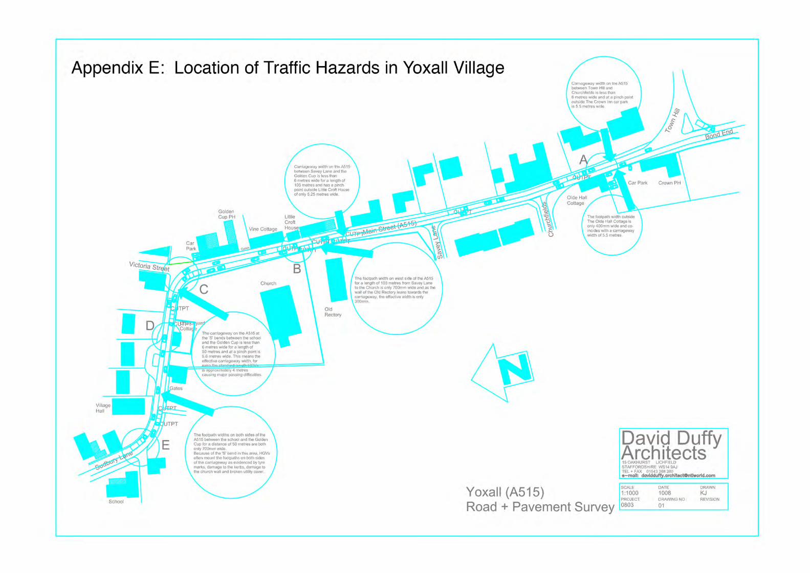
4.32 The A515 has significant physical constraints as it passes through Yoxall village. These include two double bends, narrow carriageway width, and footways that are either very narrow or completely lacking in several places. There are several “pressure points” on the A515, including the junction of Hadley Street and the A515, the junction of Victoria Street and the A515, the double bend around St Peter’s Church, and the double bend near to Bond Farm. Illustration 5b below shows the locations on known traffic hazards in Yoxall village; a larger version of Illustration 5b is provided in Appendix E.
4.33 The purpose of Policy T1 is to ensure that the impact of traffic associated with new development near to these or future “pressure points” is systematically assessed, so that measures can be taken by developers to reduce hazards, improve pedestrian connectivity and road safety, and the existing situation is not made worse.
POLICY T1: TRANSPORT CONSIDERATIONS
Development proposals in Yoxall village that would generate a significant amount of movement or would potentially affect a known and evidenced traffic hazard must be supported by a Transport Statement or Assessment as appropriate. The Statement or Assessment will set out details of the transport issues relating to the development including the measures to be taken to deal with the anticipated transport impacts of the scheme and to take any opportunities as appropriate for improving the pedestrian and cycle connectivity.
4.34 Policy D2 contributes towards the achievement of the following strategic aim:
Yoxall Strategic Aim 4:
25
To ensure that all new development in Yoxall mitigates traffic impact and seeks to provide improved pedestrian connectivity.
Application of Policy T1 4.35 For development proposals defined in Policy T1 a Transport Assessment or Statement
will be required which provides evidence that the development will not intensify traffic hazards or, where increased traffic movements are inevitable, measures are taken to eliminate or satisfactorily offset any predicted problems. This is particularly important in the vicinity of known traffic pressure points in the village (see 4.31).
4.36 The Transport Assessment or Statement will be required to consider the local context of the A515 throughout the village, and how pedestrian connectivity along the A515 could be improved as part of the proposed development, e.g. by pedestrian crossings, footpath widening, or by improving road junctions and sight lines. Where appropriate the development should investigate opportunities for extending and improving footpaths and green links to increase pedestrian connectivity to key local facilities, such as the school, church, parish hall, post office, shops, and recreational facilities, ad for improving road safety.
Policy RE1: Flood Risk
Context and rationale 4.37 The River Swarbourn flows from north to south on the eastern side of the village.
The East Staffordshire Flood Risk Assessment 2008 states that, due to the steepness of its catchment, the river has a rapid response to rainfall and as a result significant flooding occurs in Yoxall with flood waters rising fast and with very little warning. Illustration 4a shows the extent of Flood Zone 2 (0.1% chance of major flooding) and Flood Zone 3 (1% chance of major flooding) areas along the river valley.
26
4.38 Despite Flood Zone 3 areas having a predicted rate of flooding of once in 100 years local observations indicate that there have been flooding events which match or exceed the 1 in 100 years event.
4.39 Strategic local policy in the emerging East Staffordshire Local Plan aims to ensure that new development is not exposed unnecessarily to the risk of flooding or increases the risk of flooding elsewhere. The use of Sustainable Urban Drainage Systems (SUDS) is a recognised method of both minimizing the impact of on-site flooding and attenuating run-off which could result in flooding elsewhere.
POLICY RE1: FLOOD RISK
Development should not increase flood risk. Planning applications for development within the Neighbourhood Plan area must be accompanied by a site-specific flood risk assessment in line with the requirements of national policy and advice. This may also be required on a site-by-site basis based on locally available evidence. All proposals must demonstrate that flood risk will not be increased elsewhere and that the proposed development is appropriately flood resilient and resistant.
Information accompanying the application should demonstrate how any mitigation measures will be satisfactorily integrated into the design and layout of the development.
The use of sustainable urban drainage systems and permeable surfaces will be encouraged where appropriate.
4.40 Policy RE1 contributes to the delivery of the following strategic aim:
Strategic Aim 6
To ensure that new development in Yoxall does not exacerbate the risk of flooding
Application of Policy RE1 4.41 As Yoxall is immediately adjacent to a significant Flood Zone 3 area all new
development will be required to take into account the potential impact of surface water run-off not only on the site concerned but also on places that are likely to receive run-off as a result of the development.
4.42 Appropriate use of Sustainable Drainage Systems will be expected to ensure that run-off does not increase the risk of flooding elsewhere. Use of Sustainable Drainage Systems should be integrated with the hard and soft landscaping provided with the development.
Policy RE2: Green infrastructure
Context and rationale
4.43 Yoxall benefits from a number of accessible public open spaces in character with the rural setting of the village as well as a good network of public footpaths which are well used by the local community. People who made comments on the Neighbourhood Plan were strongly of the view that these routes and spaces should remain intact; they also thought that opportunities should be taken to add value to them by introducing appropriate new uses.
27
4.44 The emerging Local Plan aims to protect, conserve and enhance the local countryside, the character, distinctiveness and quality of the landscape, and the diversity of wildlife and habitats. The Local Plan contains policies which support these aims, including when new development is involved, as an important part of achieving sustainable development. East Staffordshire Borough Council’s Open Space Supplementary Planning Document provides detailed guidance for this.
4.45 The purpose of this policy is to enhance nature conservation value, to link the open spaces along the riverside, to provide spaces for village events and activities, to create safe routes to school away from the busy main road, and generally to raise awareness of the village assets.
POLICY RE2: GREEN INFRASTRUCTURE
Opportunities will be taken to develop, improve and extend the footpath and open space network in Yoxall in order to provide better pedestrian access to the countryside and to wildlife or nature conservation sites, either through the granting of planning permissions for development or through other proposals which enhance or increase the footpath network. Opportunities will be taken to introduce appropriate new uses in public open spaces, in order to encourage more use of these areas in ways that benefit the local community. `
New development should provide landscaping and boundary treatments which use native species, and as far as possible incorporate existing native vegetation, hedgerows and trees.
New development should ensure that existing wildlife and habitats are protected and enhanced, and provide opportunities for the creation of new habitats.
National Forest guidelines for the planting and maintenance of trees and shrubs should be followed.
4.46 Policy RE2 contributes to the delivery of the following strategic aim: Yoxall Strategic Aim 7:
To preserve and enhance wildlife habitats, the native landscape, public open spaces and the footpath network in Yoxall.
Application of Policy RE2 4.47 When proposals for development and planning applications are considered
opportunities to enhance and improve green infrastructure in Yoxall will be investigated and, if appropriate, planning conditions or agreements will be made to ensure that the relevant enhancements or improvements are delivered.
4.48 Wherever appropriate new boundary treatment should include native species, and efforts should be made to integrate existing hedges, trees and vegetation into the landscaping proposals for new development.
4.49 A large part of the parish of Yoxall lies within the National Forest. Policy RE2 seeks to retain mature trees and hedgerows which provide established landscape structure, and ensure that tree stock within the Plan area is maintained at a level appropriate to meet the National Forest Community Forest Objectives.
28
Policy CF1: Improvement of public car parking facilities
Context and rationale 4.50 Despite the general satisfaction with communities facilities and services in the village
people responding to consultation expressed an overwhelming need for a public car park in the Hadley St./ Sudbury Road vicinity. Traffic flow problems and obstructive parking are prevalent near to the shops and school particularly at the end of the school day and it is clear from survey responses that this facility is a priority requirement. In particular the survey particularly highlighted a requirement for car parking serving the Hadley Street/Sudbury Road shops, the Parish Hall and St. Peter’s School.
POLICY CF1: IMPROVEMENT OF PUBLIC CAR PARKING FACILITIES
Opportunities will be taken to provide public car parking facilities near to the village shops, parish hall and primary school with safe and direct pedestrian and, where appropriate, cycle access to these village amenities.
4.51 Policy CF1 contributes to the delivery of the following strategic aim:
Yoxall Strategic Aim 5:
To improve public car parking in the vicinity of important community facilities.
Application of Policy CF1 4.52 When proposals for development and planning applications are considered
opportunities to provide public car parking near to the parish hall and primary school will be taken, and appropriate planning conditions or agreements will be made to ensure that the required public car parking facilities are delivered.
Policy E1: Supporting Local Employment
Context and rationale 4.53 The community recognises the benefits of thriving local businesses both for the jobs
they provide for local people and, in some cases, for the services they make available. During consultation 43% of respondents favoured a small business unit development, with the telephone exchange location being the most nominated.
4.54 Local jobs for local people mean less commuting and a more sustainable lifestyle, saving individuals the cost of travel and increasing the leisure time that they have available. Young people can find it difficult to find their first job where they can develop workplace skills. The local community believes that if it can support local business to grow, then in turn those businesses will provide more jobs for local people and will provide some of the positions for school leavers moving into the workplace for the first time.
4.55 High speed broadband is still unavailable to parts of the parish. This disadvantages those businesses affected and also those that wish to improve work life balance and reduce carbon emissions by working from home. Access to high speed broadband is seen as a priority to ensure local businesses thrive.
4.56 Unemployment in Yoxall is very low: in May 2013 unemployment was 1% in the parish. Whilst this Neighbourhood Plan does not allocate sites for employment development, it seeks to support the viability of existing local businesses and their expansion where this is proportionate and appropriate in the individual circumstances.
29
It also encourages appropriate diversification of existing economic activities, as this will make the local economy more robust and more sustainable as well as providing new job opportunities for local people.
4.57 Both the emerging Local Plan and the National Planning Policy Framework encourage and promote sustainable economic growth. The National Planning Policy Framework states that planning policies should support economic growth in rural areas through the sustainable growth of local businesses and the retention and development of local services and community facilities (paragraph 28).
POLICY E1: SUPPORTING LOCAL EMPLOYMENT
Proposals for the development of new small businesses and for the expansion or diversification of existing businesses will be permitted, providing that
a) it can be demonstrated that there will be no adverse impact resulting from increased traffic, noise, smell, lighting, vibration or other emissions or activities generated by the proposed development; and
b) it would have an acceptable impact on the character and scale of the village and its rural hinterland and landscape; and
c) where relevant, opportunities are taken to secure the re-use of vacant or redundant historic buildings as part of the development.
Development proposals for new employment development must provide a Connectivity Statement setting out how the development will help achieve a fibre optic connection to the nearest connection chamber in the public highway. Wherever possible the development must provide suitable ducting to enable more than one service provider to provide a fibre connection to the development.
4.58 Policy E1 contributes to the delivery of the following strategic aim:
Yoxall Strategic Aim 8:
To accommodate small business development in Yoxall and to ensure high speed fibre optic broadband is available for existing and new businesses and for home workers.
Application of Policy E1 4.59 In applying Policy E1 the aim is to facilitate economic development within Yoxall which
is appropriate in scale, supports existing local businesses, and where appropriate brings vacant historic buildings back into beneficial use. Development considered against Policy E1 must be of a scale and intensity appropriate to its context, must not impact detrimentally on residential amenity, and must have an acceptable impact on the character and scale of the village and its rural hinterland.
4.60 The provision of good telecommunications is particularly important in rural areas and in supporting the viability and sustainability of rural enterprise and home-working. Currently fibre optic connections are the most robust and future-proof method of delivering high performance connectivity and this should be the aim for all new developments.
4.61 The Connectivity Statement shall be in the form of a method statement including drawings illustrating how this is to be implemented.
30
References 1 Neighbourhood Planning (General) Regulations (2012) 2 Yoxall Conservation Area Appraisal, Staffordshire County Council (1970) 3 Staffordshire, Arthur Mee (1937) 4 The National Forest Strategy (2004-24) 5 East Staffordshire Borough Profile (2013 ) 6 Yoxall Village Design Statement, Yoxall Parish Council (1993?) 7 East Staffordshire Local Plan Submission Draft (April 2014) 8 National Planning Policy Framework (2012) 9 East Staffordshire Flood Risk Assessment Level 1 Report (2008) 10 East Staffordshire Local Plan Saved Policies Edition (2006) 11 2001 Census for England and Wales 12 2011 Census for England and Wales 13 East Staffordshire Strategic Housing Land Availability Assessment (2014) 14 Staffordshire Farmsteads Guidance, Staffordshire County Council (2015) 15 Staffordshire Historic Environment Record 16 Staffordshire County Council Historic Environment Character Assessment: East
Staffordshire (2013)

31
APPENDIX A
YOXALL VILLAGE DESIGN STATEMENT
34
APPENDIX B
CHARACTER ANALYSIS, DEVELOPMENT CONSTRAINTS AND OPPORTUNITIES
1 YOXALL: SETTLEMENT CHARACTER ANALYSIS
Location, Setting and Topography
1.1 The Village of Yoxall lies on the A515 (known as King Street and Main Street
as it runs through the Village), orientated on a north/south axis, where it runs in
close proximity to the River Swarbourne, a tributary to the River Trent. Just
north of the village, the A515 lies at approximately +67metres AOD (Above
Ordnance Datum). At the southern end of the Village, it lies at approximately
+60 metres AOD. To the west, the topography rises to approximately +90
metres AOD west of Weaverlake where after it starts to flatten out; and to the
east to again to approximately +95 metres AOD at the top of Town Hill.
1.2 Consequently, the Village is set down in a small valley, the sides of which rise
to consistent heights either side in a series of gently undulating folds. This
valley comprises the immediate setting to the Village, with the wider setting
characterised by the mixed agricultural landscape that extends all the way
around the Village, across the valley and the wider landscape. The overall
setting is particularly rural and the village retains an element of ‘self-
containment’.
Settlement Character
1.3 The Village has a distinct and readily identifiable linear character along this
valley, which has established itself over a long period of time. The linearity is
driven by a number of things including: the local topography; the route of the
A515; and the River Swarbourne corridor. The historic core of the Village is
designated as a conservation area, and includes a number of local landmark
buildings within it, some of which are listed. There is limited ‘ribbon
development’ along Town Hill that extends from the central eastern edge of the
settlement; and likewise along Hadley Street that extends from the upper
western edge of the settlement. Weaverlake Drive comprises a more modern
35
addition off Hadley Street, and includes limited detached dwellings contained
in an establishing woodland belt.
1.4 Sequential development of the Village over the years has continued to respect
this linear character, notably at Alexandra Drive at the northern end of the
village, and before that more extensive development south of Savey Lane,
west of the A515. The emergence of such developments has not only
respected this underlying linear character, but has also served to consolidate it.
1.5 The eastern edge of the settlement is characterised by the wooded River
Swarbourne corridor. The River runs along this part of the valley to the south,
to join the River Trent just north of the Village of Alrewas. As it runs through
Yoxall, its character is typically wooded, punctuated by a series of attractive
flood meadows. A number of larger back gardens (including the Golden Cup
Public House) benefit from its amenity value. Its flood plain is generally
balanced either side of its course, and so influential has the River been
historically in defining the Village character, that it is only the individual
dwellings on Town Hill that lie to the east of the river corridor.
1.6 The western edge of the settlement is defined in a contrasting manner. It
comprises mainly residential development, but also the extended St. Peter’s
Church yard (burial ground), together with the playing field of Yoxall, St.
Peter’s Primary School. This edge generally lies on, or just below the 70 metre
contour. The edge is ‘balanced’ in part with some retained hedgerow
vegetation together with some more domestic (garden) scale planting, and also
includes the Ferrer’s Field play area. Whilst this edge is not defined on the
ground by as strong a landscape feature as the eastern edge is, the
consolidated linearity of the built form together with a generally consistent
topographical level has created a clear definition that, whilst different in
character to the eastern edge, is just as strong and just as important in its
contribution to the overall character pattern of the settlement.
1.7 Likewise the northern and southern edges of the settlement differ from one
another. To the north, Alexandra Drive forms the last main element of
residential development; further north a series of individual dwellings on large
plots (extending between the A515 to the River Swarbourne) provide a
‘transition’ from the Village into the wider countryside. To the south, the
36
residential edge of Bondfield Lane defines the edge of the settlement west of
the A515, with the older, more established group of buildings at Bond End to
the east.
1.8 In terms of ‘gateways’ or ‘entrance thresholds’ to the village along the A515,
form the north it is generally ‘transitional’ (almost creeping up on you) as
described above, although a combination of the northern edge of the
Alexandra Drive development and the mini-roundabout that serves it have
some threshold ‘presence’. To the south it is quite well defined by Bondfield
Lane to the west, and across to the alignment of a field hedgerow at Bond End
to the east. The commercial plant further south of Bondfield Lane represents a
more ‘isolated’ element of built form, well beyond the southern boundary of the
settlement.
1.9 There are three further entrances into the Village along its western edge: along
Hadley Street towards the north; along Savey Lane towards the centre; and
along Bondfield Lane to the south. Hadley Street is more enclosed and
characterised by elements of ‘ribbon’ development that also extends further
north-westwards along Back Lane. As Back Lane extends into Hadley Street,
it is particularly enclosed by tall, mature hedgerows. In contrast, the
approaches along Savey Lane and Bondfield are more open with views
extending across the wider landscape.
1.10 There are two further entrances into the Village along its eastern edge: along
Longcroft Lane right at the north; and along Town Hill towards the centre.
Longcroft Lane is particularly narrow, and changes in offers wider views across
the landscape in its more elevated positions, becoming more enclosed as it
falls down the valley sides to cross the River Swarbourne and joint Victoria
Street. In contrast again, Town Hill is steep, enclosed by mature vegetation,
and punctuated by a number of residential dwellings. Notwithstanding all
these individual, localised contrasts, all these approaches into the village are
particularly rural in character
Historic Core
1.11 In contrast to other villages in East Staffordshire, Yoxall appears to be more
nucleated in its form with a linear village being depicted on Yates’ map of 1775.
It lay, however, in a wider landscape dominated by dispersed settlement
37
comprising small hamlets such as Bond End to the south; Morrey to the south
west; Woodhouses to the east and Hadley End to the north west. This is a
pattern which is still discernible in the modern landscape. Furthermore
documentary evidence suggests that the development of Yoxall itself may be
the result of several settlement foci which have coalesced .In the 14th century
these foci were known as ‘Reeve End’ which lay to the north west of the
church, ‘Smelles or Snelles End’ (now Snails End) to the far north, ‘Bridge End’
presumed to lie near Town Hill and ‘Bond End’.
1.12 In the late 19th century the latter lay 325m to the south of Yoxall with little
development linking the two The northern part of Bond End became
incorporated into Yoxall village in the later 20th century with the construction of
small housing estates along the length of the western side of Main Street and
Bond End.
1.13 The historic core is included within the conservation area. This extends from
Bond End in the south, up the A515 (Main Street) to include the River
Swarbourne and associated open spaces, together with King Street, Victoria
Street and the eastern end of Hadley Street. Within this core, there are a
number of attractive buildings, both individually and in groups, most noticeably
St. Peters Church on the characteristic bend in the A515. More detail on this
part of the Village is found in the 1993 Village Design Statement (Appendix A).
It is this part of the Village that the more detailed elements on townscape
character, architectural and urban design can, and do influence more recent
development in the village.
Historic character of the hinterland
1.14 There are a number of historic field systems surviving around Yoxall exhibiting
evidence for a diversity of origins. Within the immediate vicinity of the
settlement they originated as open fields in the medieval period Three open
fields, known as Hall, Stockyng (sic) and “the field of the bondmen”, are
recorded in the 14th century. Other fields are recorded later including Church
field, Northcroft and Bridge field. Ridge and furrow earthworks, which fossilise
the line of the plough across the open field, have been identified on aerial
photography in a number of areas around Yoxall.
38
1.15 The open fields were enclosed incrementally by private agreements between
individual landholders, a process recorded as taking place by the mid 17th
century, resulting in a field pattern known as ‘Piecemeal Enclosure’.
‘Piecemeal Enclosure’ survives across two areas to the north east and south
east of Yoxall.
1.16 The large area described as ‘Early Piecemeal Enclosure’ has a morphology
which suggests some re-planning of the post medieval field pattern probably
associated with improvements to agricultural management from the later 18th
century. In this area it is straightened field boundaries which indicate the
changes to the field patterns, but the earlier ‘S’ curve and dog-legs boundaries
also survive.
1.17 These changes to the landscape represent change in the agricultural economy
from a rotational cropping system carried out by the whole community to the
creation of individual holdings and a greater emphasis on pasture.
1.18 Around Yoxall the pasture was to facilitate dairy farming; a process which was
under way in the 16th and 17th century and continued to be important to the
local economy into the 19th century.
1.19 The field system to the west of Yoxall had also originated as part of the
medieval open fields being enclosed as ‘Piecemeal Enclosure’. During the
post-war period this field pattern has seen the removal of many boundaries to
facilitate increased arable productivity. Despite this many of the distinctive
field boundaries (‘S’ curve and dog-leg) survive so that the origins of the field
pattern is still legible within the landscape.
1.20 Elsewhere around Yoxall the historic field patterns predominantly originated in
the later 18th/19th century and are typified by straight field boundaries, which
were clearly laid out by surveyors. These field systems lying to the south of
Yoxall are probably associated with the creation of a water meadow system
which lined the River Trent. The features comprising the water meadows in this
area are generally well-preserved and include the earthwork remains of the
panes as well as associated
structures.
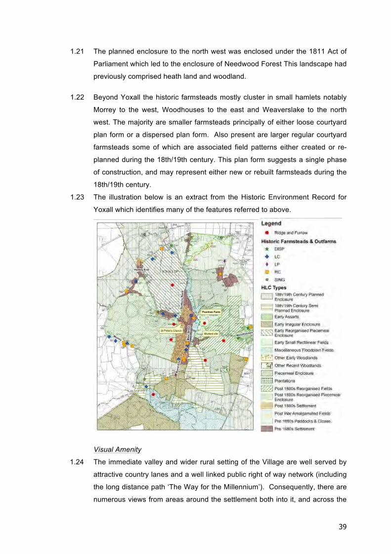
39
1.21 The planned enclosure to the north west was enclosed under the 1811 Act of
Parliament which led to the enclosure of Needwood Forest This landscape had
previously comprised heath land and woodland.
1.22 Beyond Yoxall the historic farmsteads mostly cluster in small hamlets notably
Morrey to the west, Woodhouses to the east and Weaverslake to the north
west. The majority are smaller farmsteads principally of either loose courtyard
plan form or a dispersed plan form. Also present are larger regular courtyard
farmsteads some of which are associated field patterns either created or re-
planned during the 18th/19th century. This plan form suggests a single phase
of construction, and may represent either new or rebuilt farmsteads during the
18th/19th century.
1.23 The illustration below is an extract from the Historic Environment Record for
Yoxall which identifies many of the features referred to above.
Visual Amenity
1.24 The immediate valley and wider rural setting of the Village are well served by
attractive country lanes and a well linked public right of way network (including
the long distance path ‘The Way for the Millennium’). Consequently, there are
numerous views from areas around the settlement both into it, and across the
40
valley within which it sits. To illustrate a few (of many) examples, these include
views from the north-east in the vicinity of Longcroft Lane, where the opposite
side of the valley can be seen together with some elements of the Village; the
higher ground known as ‘The Rough’ just east of the central part of the Village
from where the Church and School are visible; from the public footpath
network between Bondfield Lane and Morrey Lane; from Back Lane to the
north-west of the Village looking across the valley; and on the approach to the
Village from the public footpaths north-west of Yoxall Sports ground, from
where the Church Tower is again visible. A few of many examples of such
views are illustrated in Figure B.3: Yoxall Views 1 to 10 - Key Views of the
Settlement, which shows 10 publicly accessible viewpoints, together with a
short commentary on each describing the visual amenity value in relation to
the village and the character of its landscape setting.
1.25 Whilst all views are different, there are a number of common themes that are
evident. The most noticeable is the low lying, valley setting of the Village.
Where built form is visible to a greater or lesser extent in the views, it always
appears very discrete and subservient in scale to the surrounding landscape,
with the valley sides rising well above the village. In views from the east, this
is due in part by both topography and the wooded River corridor; and from the
west it is the rising valley topography, that then flattens out, together with the
‘layers’ of hedgerow vegetation in front of the carefully considered definition of
the settlement edge that ensures the Village remains visually discrete.
1.26 Over time, these views, and in particular those that extend right across the
valley will be favourably influenced by the establishment and maturity of
significant areas of woodland planting, including that around Weaverlake Drive
to the west; and St. Georges Wood to the east. Both areas of planting are in
more elevated locatio0ns, and both will serve to extend the Green
Infrastructure of the wider setting of the Village.
1.27 Within the village the historic core offers considerable visual amenity through
built form, open spaces and combinations of both generating a rich local public
realm. Again, the Village Design Statement (Appendix A) highlights all these
points in more detail. These points are illustrated on Figure B1: Yoxall;
Settlement Character Analysis which follows.
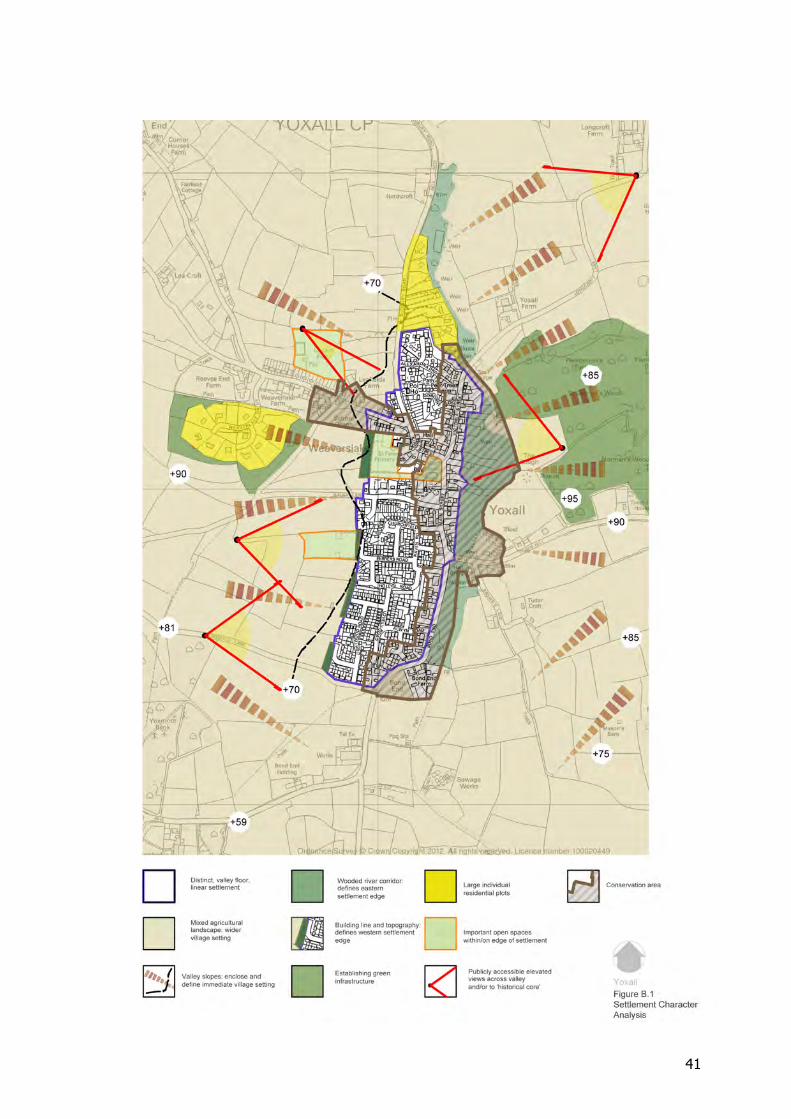
41
42
2 YOXALL: SETTLEMENT DEVELOPMENT CONSTRAINTS AND
OPPORTUNITIES
General
2.1 From the analysis of the settlement character, it is apparent that there are a
number of important elements that require due recognition and respect in the
context of any new development coming forward. Whilst any development
proposal must always come forward with its own contextual and site specific
analysis, at this more general level, it is the protection and enhancement of the
linear settlement pattern; its overriding rural character; and the low key
entrances that are important.
Constraints
2.2 The existing eastern and western settlement boundaries, and their current
physical alignments, are considered essential to the retention of the settlement
character. To the east, the River Swarbourne and the amenity value of its
course, together with its flood plain present a ‘welcome’ constraint in this
respect. It is considered that any form of development along this edge would
be a departure from a long established and robust settlement edge.
2.3 To the west, the existing settlement edge is considered to be just as important.
Whilst not defined by such a substantial landscape feature, it is also well
established by existing built form with an important relationship with the local
topography, on or around the 70 metre contour. Consequently, the retention of
the open agricultural landscape extending along the western edge of the
settlement from Bondfield Lane in the south to Hadley Street in the north is
also considered to be very important.
2.4 To the south, the presence of the small commercial units on the bend of the
A515, currently considered to be outside the Village ‘threshold’ is important
insofar as it does not become ‘embedded’ within the settlement pattern, and as
such, retention of a clear and legible ‘gap’ between it and southern edge of the
Village is important.
43
2.5 At the northern end of the Village, whilst the ‘threshold’ is ‘transitional’ a
combination of the northern edge of the Alexandra Drive development and the
mini roundabout at the entrance to it are considered to be elements that have
a ‘presence’ as an entrance threshold, beyond which development further
north should not extend.
2.6 It is important that these constraints are recognised not only in respect of the
‘physical’ character of the settlement, but also in respect of its visual character,
with reference to views of the settlement from its immediate valley and wider
rural settings, together with the visual character of the entrances into it.
Opportunities
2.7 Based on this, it is considered that small scale opportunities exist at both the
northern and southern end of the Villages in the areas identified. An
acceptable level of development, following the appropriate site specific
analysis etc. on these more discrete areas are likely to retain the linear
character of the settlement, and also offer the potential to enhance the
‘gateways’ or ‘entrance thresholds’ into the village (it is considered at the
detailed stages, such an objective is desirable).
2.8 All these points are illustrated on Figure B2; Yoxall Settlement Development
Constraints and Opportunities.
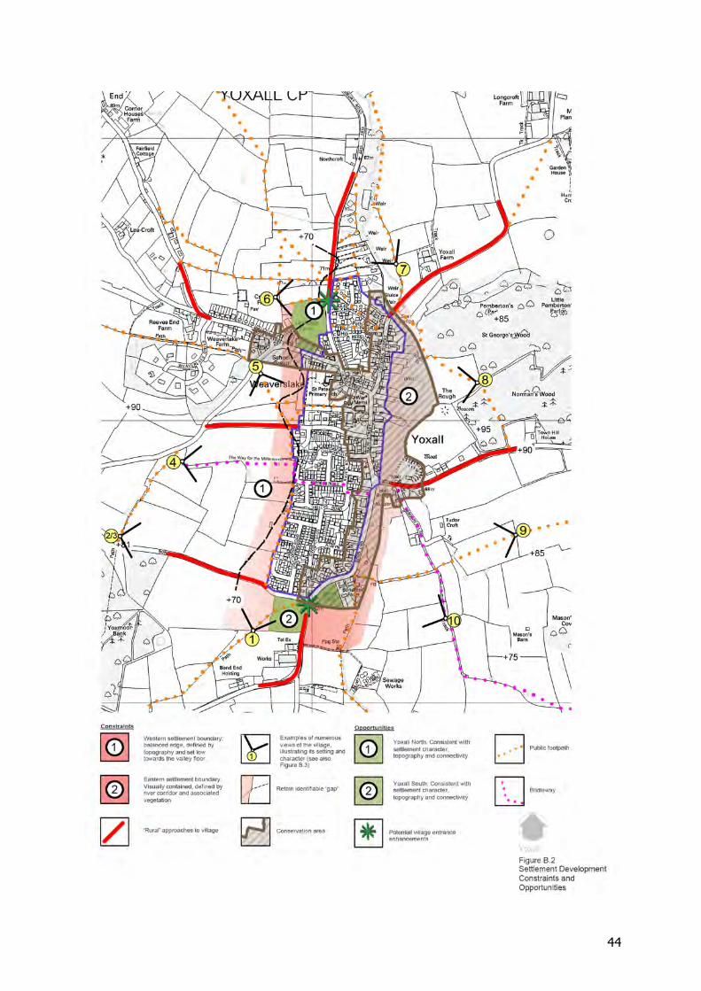
44
45
APPENDIX C
COMMUNITY ENGAGEMENT PROCESS
CHRONOLOGICAL SUMMARY OF COMMUNITY EVENTS
A chronological summary of the community engagement process is set out herein. The Parish Council began work on the Yoxall Neighbourhood Plan by creating a Core Group to manage the process and produce the Neighbourhood Plan, and by forming a Consultation Group made up of representatives of the community to provide feedback and advice to the Core Group. The Parish Council used a variety of means to engage and get feedback from local people, including questionnaires, exhibitions, workshops and drop-ins. Publicity for these events was through the Fisherman (the parish magazine), parish notice boards, local newspapers, direct household leaflet drops and documentation on the council website. April-May-June-July 2012 A questionnaire was delivered to all dwellings in the village. Responses were analysed by members of the Core Group and papers drafted setting out the results and used to inform the emerging Neighbourhood Plan (see sub-section 1 for Paper on analysis of housing questionnaire). 27th January 2013 Meeting held in the Committee Room of the Parish Hall to brief Consultation Group. 12th and 13th July 2013 Exhibition held in Parish Hall to illustrate the Plan, timetable and obtain feedback from community (see sub-section 2 for Report on Exhibition). 12th October 2013 Workshop held in Parish Hall to consult with community (see sub-section 3 for Report on Workshop). 20th January 2014 Drop-in at Parish Hall for smaller sites and explain windfall. 25th January 2014 Workshop held in Parish Hall for community feedback (see sub-section 4 for Report on Workshop). 1st November 2014 Exhibition held in Parish Hall to illustrate status of Plan and start of 6 week public consultation process. The following sub-sections summarise the main consultation events and responses received.
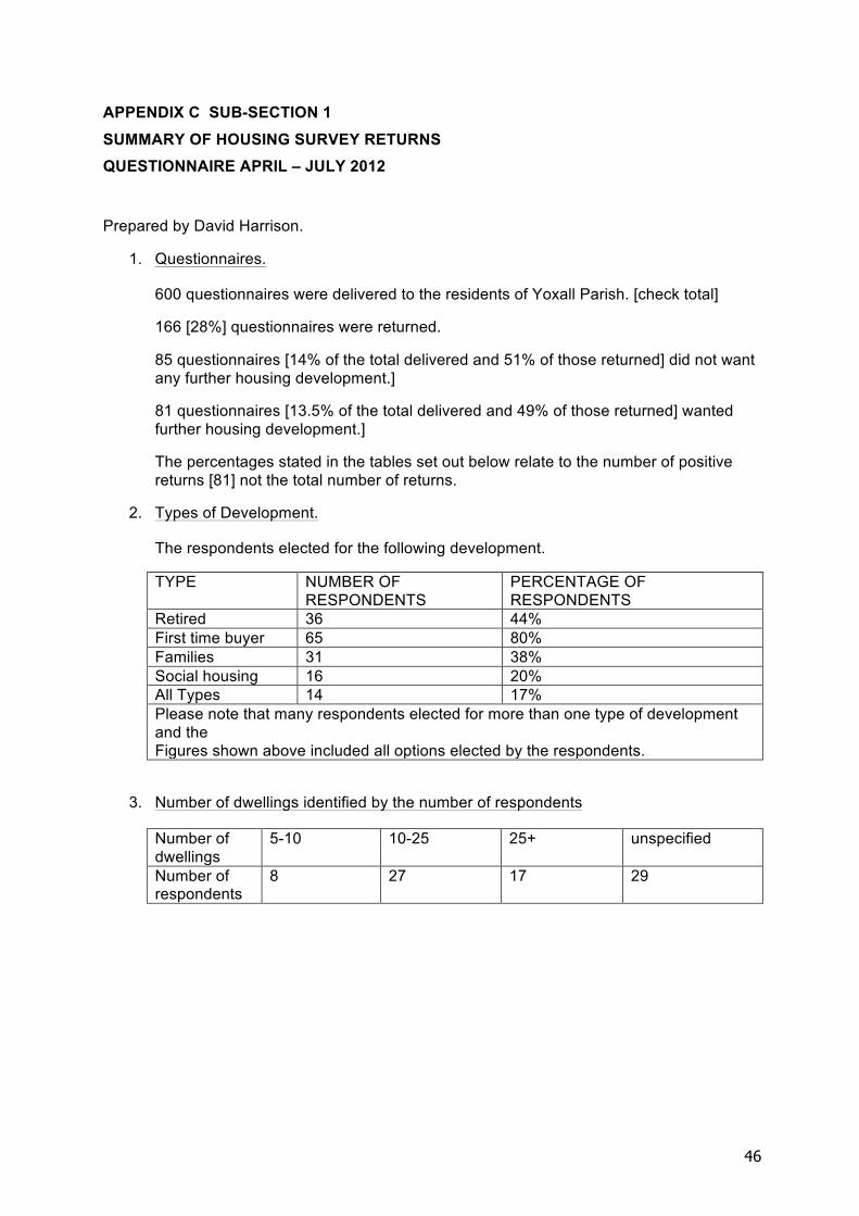
46
APPENDIX C SUB-SECTION 1 SUMMARY OF HOUSING SURVEY RETURNS QUESTIONNAIRE APRIL – JULY 2012
Prepared by David Harrison.
1. Questionnaires.
600 questionnaires were delivered to the residents of Yoxall Parish. [check total]
166 [28%] questionnaires were returned.
85 questionnaires [14% of the total delivered and 51% of those returned] did not want any further housing development.]
81 questionnaires [13.5% of the total delivered and 49% of those returned] wanted further housing development.]
The percentages stated in the tables set out below relate to the number of positive returns [81] not the total number of returns.
2. Types of Development.
The respondents elected for the following development.
TYPE NUMBER OF RESPONDENTS
PERCENTAGE OF RESPONDENTS
Retired 36 44% First time buyer 65 80% Families 31 38% Social housing 16 20% All Types 14 17% Please note that many respondents elected for more than one type of development and the Figures shown above included all options elected by the respondents.
3. Number of dwellings identified by the number of respondents
Number of dwellings
5-10 10-25 25+ unspecified
Number of respondents
8 27 17 29
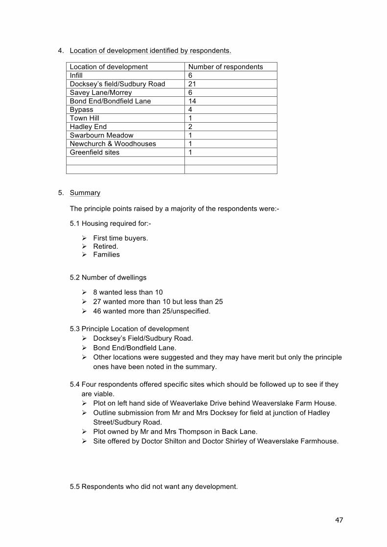
47
4. Location of development identified by respondents.
Location of development Number of respondents Infill 6 Docksey’s field/Sudbury Road 21 Savey Lane/Morrey 6 Bond End/Bondfield Lane 14 Bypass 4 Town Hill 1 Hadley End 2 Swarbourn Meadow 1 Newchurch & Woodhouses 1 Greenfield sites 1
5. Summary
The principle points raised by a majority of the respondents were:-
5.1 Housing required for:-
! First time buyers. ! Retired. ! Families
5.2 Number of dwellings
! 8 wanted less than 10 ! 27 wanted more than 10 but less than 25 ! 46 wanted more than 25/unspecified.
5.3 Principle Location of development
! Docksey’s Field/Sudbury Road. ! Bond End/Bondfield Lane. ! Other locations were suggested and they may have merit but only the principle
ones have been noted in the summary.
5.4 Four respondents offered specific sites which should be followed up to see if they are viable. ! Plot on left hand side of Weaverlake Drive behind Weaverslake Farm House. ! Outline submission from Mr and Mrs Docksey for field at junction of Hadley
Street/Sudbury Road. ! Plot owned by Mr and Mrs Thompson in Back Lane. ! Site offered by Doctor Shilton and Doctor Shirley of Weaverslake Farmhouse.
5.5 Respondents who did not want any development.
48
! The comments from respondents who did not want any development were in many cases vehement. Therefore if it is decided to progress with development the reaction of the” No Development” respondents should be anticipated.
5.6 Commentary from analyser ! Clearly the issue of residential development is a divisive issue within the
respondents 51% against and 49% in favour with a significant number of respondents wishing to see the village remain in its current state.
! However in the analyser’s opinion the issue of development cannot be viewed in isolation from the requirements of supporting the retail, social clubs, school and churches.
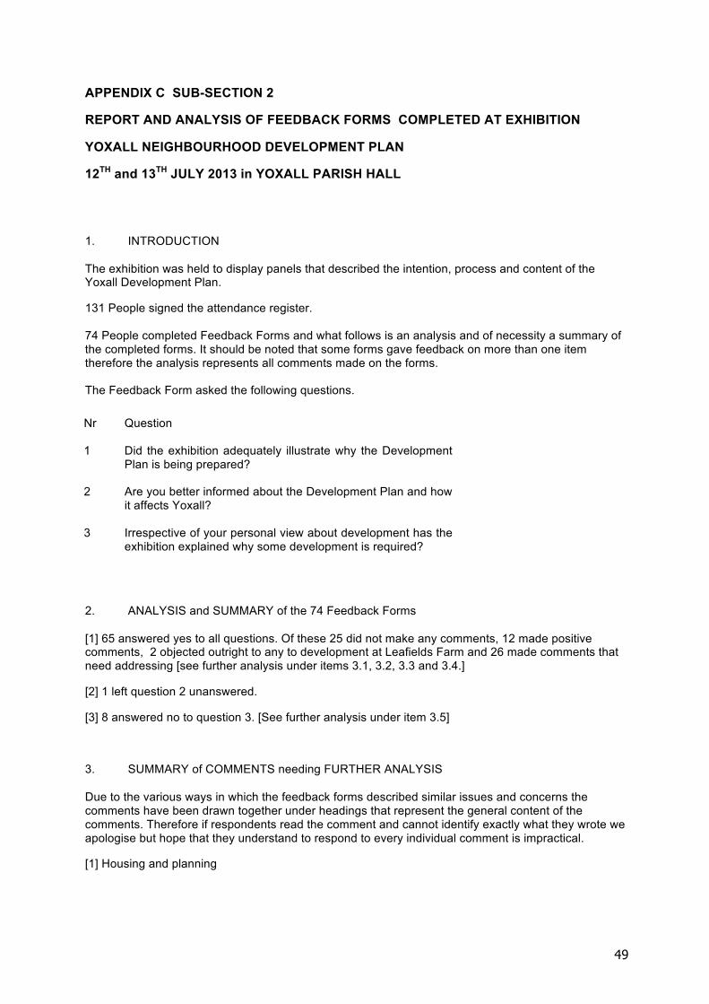
49
APPENDIX C SUB-SECTION 2
REPORT AND ANALYSIS OF FEEDBACK FORMS COMPLETED AT EXHIBITION
YOXALL NEIGHBOURHOOD DEVELOPMENT PLAN
12TH and 13TH JULY 2013 in YOXALL PARISH HALL
1. INTRODUCTION
The exhibition was held to display panels that described the intention, process and content of the Yoxall Development Plan.
131 People signed the attendance register. 74 People completed Feedback Forms and what follows is an analysis and of necessity a summary of the completed forms. It should be noted that some forms gave feedback on more than one item therefore the analysis represents all comments made on the forms. The Feedback Form asked the following questions.
2. ANALYSIS and SUMMARY of the 74 Feedback Forms
[1] 65 answered yes to all questions. Of these 25 did not make any comments, 12 made positive comments, 2 objected outright to any to development at Leafields Farm and 26 made comments that need addressing [see further analysis under items 3.1, 3.2, 3.3 and 3.4.]
[2] 1 left question 2 unanswered.
[3] 8 answered no to question 3. [See further analysis under item 3.5]
3. SUMMARY of COMMENTS needing FURTHER ANALYSIS
Due to the various ways in which the feedback forms described similar issues and concerns the comments have been drawn together under headings that represent the general content of the comments. Therefore if respondents read the comment and cannot identify exactly what they wrote we apologise but hope that they understand to respond to every individual comment is impractical.
[1] Housing and planning
Nr Question
1 Did the exhibition adequately illustrate why the Development Plan is being prepared?
2 Are you better informed about the Development Plan and how it affects Yoxall?
3 Irrespective of your personal view about development has the exhibition explained why some development is required?
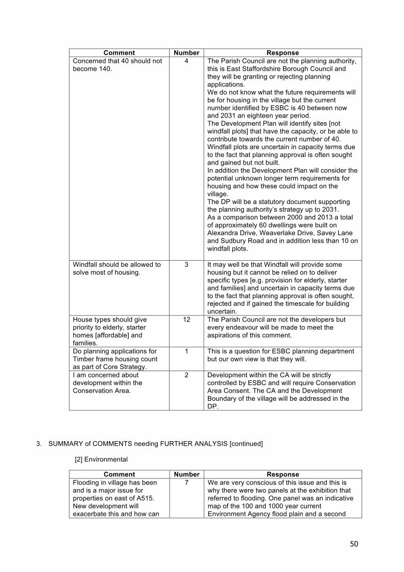
50
Comment Number Response Concerned that 40 should not become 140.
4 The Parish Council are not the planning authority, this is East Staffordshire Borough Council and they will be granting or rejecting planning applications. We do not know what the future requirements will be for housing in the village but the current number identified by ESBC is 40 between now and 2031 an eighteen year period. The Development Plan will identify sites [not windfall plots] that have the capacity, or be able to contribute towards the current number of 40. Windfall plots are uncertain in capacity terms due to the fact that planning approval is often sought and gained but not built. In addition the Development Plan will consider the potential unknown longer term requirements for housing and how these could impact on the village. The DP will be a statutory document supporting the planning authority’s strategy up to 2031. As a comparison between 2000 and 2013 a total of approximately 60 dwellings were built on Alexandra Drive, Weaverlake Drive, Savey Lane and Sudbury Road and in addition less than 10 on windfall plots.
Windfall should be allowed to solve most of housing.
3 It may well be that Windfall will provide some housing but it cannot be relied on to deliver specific types [e.g. provision for elderly, starter and families] and uncertain in capacity terms due to the fact that planning approval is often sought, rejected and if gained the timescale for building uncertain.
House types should give priority to elderly, starter homes [affordable] and families.
12 The Parish Council are not the developers but every endeavour will be made to meet the aspirations of this comment.
Do planning applications for Timber frame housing count as part of Core Strategy.
1 This is a question for ESBC planning department but our own view is that they will.
I am concerned about development within the Conservation Area.
2 Development within the CA will be strictly controlled by ESBC and will require Conservation Area Consent. The CA and the Development Boundary of the village will be addressed in the DP.
3. SUMMARY of COMMENTS needing FURTHER ANALYSIS [continued]
[2] Environmental
Comment Number Response Flooding in village has been and is a major issue for properties on east of A515. New development will exacerbate this and how can
7 We are very conscious of this issue and this is why there were two panels at the exhibition that referred to flooding. One panel was an indicative map of the 100 and 1000 year current Environment Agency flood plain and a second
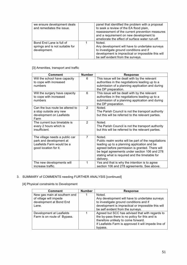
51
we ensure development deals and remediates the issue.
panel that identified the problem with a proposal to seek a review of the EA flood plain, reassessment of the current prevention measures and a requirement on new development to ameliorate the effect of surface water run-off.
Bond End Lane is full of springs and is not suitable for development.
1 Noted. Any development will have to undertake surveys to investigate ground conditions and if development is impractical or impossible this will be self evident from the surveys.
[3] Amenities, transport and traffic
Comment Number Response Will the school have capacity to cope with increased numbers
6 This issue will be dealt with by the relevant authorities in the negotiations leading up to a submission of a planning application and during the DP preparation.
Will the surgery have capacity to cope with increased numbers
6 This issue will be dealt with by the relevant authorities in the negotiations leading up to a submission of a planning application and during the DP preparation.
Can the bus route be altered to a stop outside any new development on Leafields Farm
2 Noted. The Parish Council is not the transport authority but this will be referred to the relevant parties.
The current bus timetable is every 2 hours which is insufficient.
2 Noted. The Parish Council is not the transport authority but this will be referred to the relevant parties.
The village needs a public car park and development at Leafields Farm would be a good location for it.
7 Noted. Public realm works will be part of the negotiations leading up to a planning application and be agreed before permission is granted. There will be legal agreements under section 106 and 278 stating what is required and the timetable for delivery.
The new developments will increase traffic.
1 Yes and that is why the intention is to agree section 106 and 278 agreements. See above.
3. SUMMARY of COMMENTS needing FURTHER ANALYSIS [continued]
[4] Physical constraints to Development
Comment Number Response New gas main at southern end of village will impede development at Bond End Lane.
1 Noted. Any development will have to undertake surveys to investigate ground conditions and if development is impractical or impossible this will be self evident from the surveys.
Development at Leafields Farm is on route of Bypass.
1 Agreed but SCC has advised that with regards to the by-pass there is no policy for this and is therefore unlikely to come forward. If Leafields Farm is approved it will impede line of bypass.
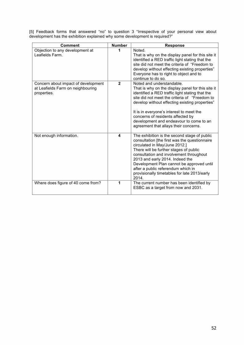
52
[5] Feedback forms that answered “no” to question 3 “Irrespective of your personal view about development has the exhibition explained why some development is required?”
Comment Number Response Objection to any development at Leafields Farm.
1 Noted. That is why on the display panel for this site it identified a RED traffic light stating that the site did not meet the criteria of “Freedom to develop without effecting existing properties” Everyone has to right to object and to continue to do so.
Concern about impact of development at Leafields Farm on neighbouring properties.
2 Noted and understandable. That is why on the display panel for this site it identified a RED traffic light stating that the site did not meet the criteria of “Freedom to develop without effecting existing properties” It is in everyone’s interest to meet the concerns of residents affected by development and endeavour to come to an agreement that allays their concerns.
Not enough information. 4 The exhibition is the second stage of public consultation [the first was the questionnaire circulated in May/June 2012.] There will be further stages of public consultation and involvement throughout 2013 and early 2014. Indeed the Development Plan cannot be approved until after a public referendum which in provisionally timetables for late 2013/early 2014.
Where does figure of 40 come from? 1 The current number has been identified by ESBC as a target from now and 2031.
53
APPENDIX C SUB-SECTION 3 REPORT ON WORKSHOP SATURDAY 12TH OCTOBER 2013 YOXALL PARISH HALL.
A workshop was held in the Parish Hall on Saturday 12th October 2013 when thirty villagers actively contributed to the development of the Yoxall Neighbourhood Plan.
The first stage of the workshop:
The villagers reviewed three potential development sites that were identified by the villagers in the questionnaires circulated in May 2012 and reviewed the sites against a set of criteria.
The three sites identified were located at Bond End Lane, Bond End Farm and Leafields Farm these sites are identified on the aerial location plan on page 2.
The criteria that the sites were reviewed against is set out on page 3, against the criteria, Leafields Farm achieved the highest score.
The second stage of the workshop:
Everybody had the opportunity to identify the type of site layout, construction and material finishes that villagers would like to see incorporated into new development. This was aided by the excellent photographs produced by members of the Yoxall Camera Club which included street scenes, roofs, dormer windows, chimneys, external wall materials, road finishes, pavements etc.
As part of this stage the villagers divided into six groups to write down the key issues each group would like to see incorporated into a Development Design Brief. Different groups elected for elements that were not compatible with the views of other groups so it may not be possible to incorporate all of the views into the Design Brief and future developments but this was an opportunity for the villagers to freely express their views. Please see table A on page 4.
The information was collated and will be used to produce a portfolio of best practice, indicating materials and design that the community would like to see incorporated into any new development and will inform the Development Design Brief that will underpin the Neighbourhood Plan.
In order to more easily assimilate all of the elements raised by the groups the following tables summarises their views.
Table A
ENVIRONMENT/AMENITIES DENSITY/TYPE OF DWELLINGS/LAYOUT
DESIGN
Solution to the A515 roundabout and also Hadley Street junction.
Mixed development. Traditional: pitched tiled roofs, brick elevations, small windows.
54
Public car park [for and against] Reflect topography of site.
Small pitched roof porches.
Open spaces, footpaths, landscaping, village green, benches.
Smaller, tighter density of dwellings to south and larger less dense to north.
Dormer windows not eyebrow.
Clover leaf rather than straight streets.
Low walls and open fencing.
No on street parking. Energy efficient.
55
APPENDIX C SUB-SECTION 4 SUMMARY OF NEIGHBOURHOOD DEVELOPMENT PLAN WORKSHOP SATURDAY 25TH JANUARY 2014 YOXALL PARISH HALL
As part of the community engagement programme a community housing workshop was held on Saturday 25th January 2014 at the Parish Hall, facilitated by the Neighbourhood Plan Steering Group and Yoxall Parish Council.
The aim of this open and free community event was to build on the previous work from past housing workshop sessions and to interrogate in detail what the aspirations of the community are for any future development on the selected preferred housing site in Yoxall known as Leafields Farm in the north west of the village.
The event was attended by 28 members of the community and included some new delegates as well as those who have previously attended workshop sessions. Together the group sub-divided into working parties to address a series of issues and themes set. For the purpose of this report each theme has be dealt with in turn below:
Yoxall Settlement Boundary:
The group examined the existing Yoxall settlement boundary and had an informative discussion on amending the boundary. Given the opportunity to explore the potential to amend a strategic boundary the groups all concluded that it would be beneficial to include the proposed Neighbourhood Development Plan preferred site at Leafields Farm, to provide a clear direction on the intention to make a site allocation for housing and to deter through planning means any future applications at other sites outside this area.
In doing so the aspiration is to provide clarity, enable balanced growth within the settlement and reflect the linear nature of the village whilst respecting the historic centre. Furthermore the proposed site is opposite the most recent housing development in the village and benefits from being able to utalise existing highways measures to provide a safe vehicular access into the site from the A515 via the roundabout.
Community Car Park:
The workshop confirmed the aspiration to provide a community car park for Yoxall servicing the school and village hall, however the proposed siting indicated in the current outline application for residential development at Leafields Farm whilst broadly supported it did raise some issues to be addressed. These included:
• Provide a clear open pedestrian link from car park at lower end of development site on to Hadley Street so that potential users in particular those visiting the school have a legible route to ensure usage. “if we can’t see it we won’t use it”.
• Free available space servicing the school, village hall, shops and surgery. • Vehicle access from the A515 roundabout as indicated in outline application.
56
• Surfacing materials to be appropriate for the Conservation Area and sympathetic in appearance to the rural character (permeable materials).
• No floodlighting of car park to reduce intrusion on neighbour amenity. • Introduce suitable soft landscaping scheme on boundaries to adjoining properties to
minimize impact. • Integrate a pedestrian link with the school. • Car parking provision should be for approximated 15 spaces (300sqm).
Leafields Farm Outline Planning Application:
Those who attended took part in a ‘Building for Life’ exercise evaluating the proposed Leafields Farm outline application. Building for Life stimulates a conversation between local communities, local authorities and developers about creating great places to live.
It reflects our vision of what new housing developments should be: attractive, functional and sustainable places. It is based on the National Planning Policy Framework and the Government’s commitment to build more homes, better homes and involve local communities in planning.
Using this criteria we tested the proposed application and interrogated precisely what our community aspirations would be using past evidence from the workshop in October 2013 building upon that to create the following observations:
• Vehicular access from the A515 to include upgrading of the existing roundabout creating a safe and appropriate vehicular access into the proposed site whilst contributing to improved highways facilities and vehicle movement, speeds and flow through the village.
• Importance of provision of green spaces and softer edges to reflect the rural character. • Provide new pedestrian links from site to community facilities such as the shops and
school, enhanced by car parking provision. • Contributions to education, concerns over additional housing growth in the area will
lead to a school at capacity and no ability to expand. • Housing mix and density should reflect the housing need of the area and character,
meet the needs of the community, affordable homes. • Integration and redevelopment of the grade II listed farm and associated building
adjacent to site. Scope to include the area as a phased development of the entire site. • SUDS system to alleviate any flooding issues, and to reduce any impact. • Provide sustainable energy production sources (P.V, ground source heat) where
possible, future proof homes with ‘green homes’. • Create well define streets and spaces. • Detailed soft landscaping for edges of development to lessen the impact into the open
countryside and for adjoining land owners opportunity to landscape and design spaces between buildings.
• Trees in the streetscene provide visual reference and definition and enhance the rural setting.
• In keeping with the character of the village. • Provision of adequate off street car parking for new properties. • Mixed housing tenure or 2/3 bed properties and bungalows. No 3 storey buildings. • Landscaping to enhance wildlife movement particularly if existing established
hedgerow is to be removed. • Evaluate the wider impact of new homes on flooding in the village.
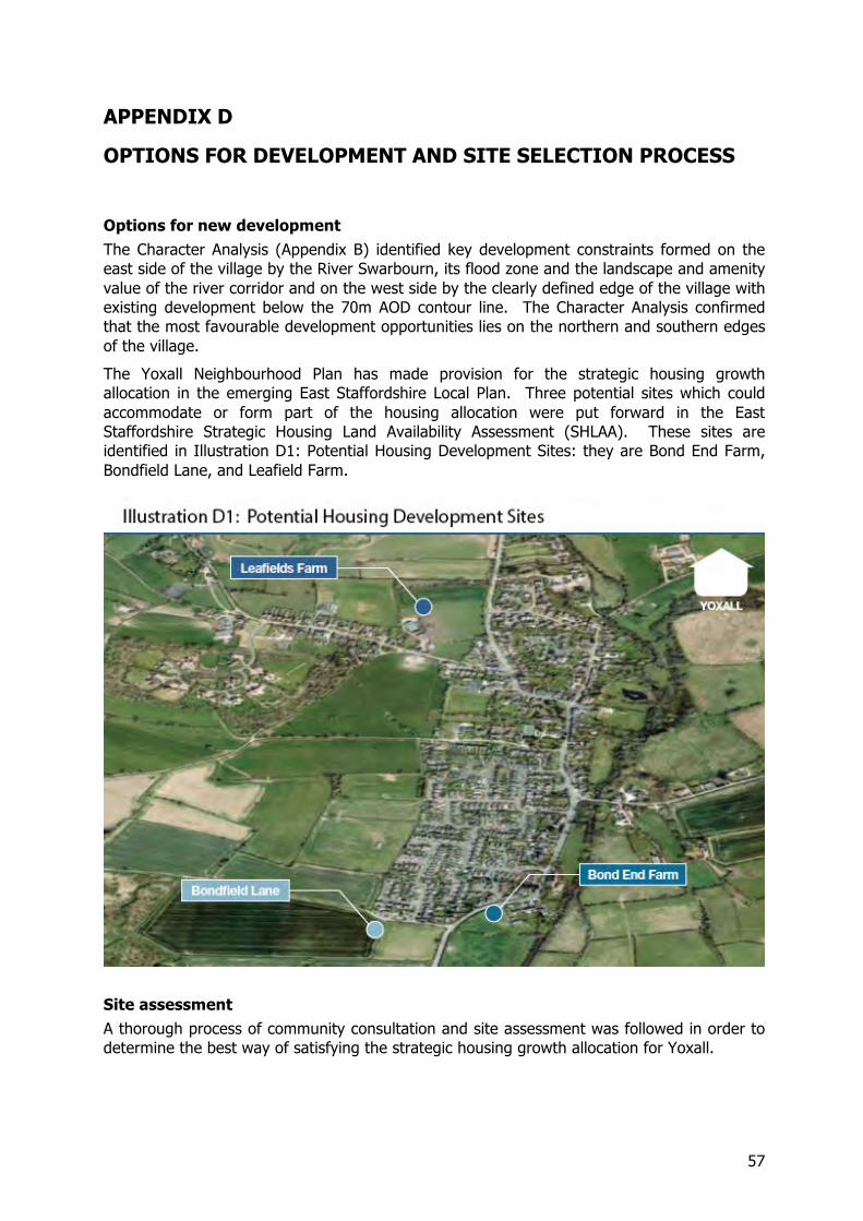
57
APPENDIX D
OPTIONS FOR DEVELOPMENT AND SITE SELECTION PROCESS
Options for new development The Character Analysis (Appendix B) identified key development constraints formed on the east side of the village by the River Swarbourn, its flood zone and the landscape and amenity value of the river corridor and on the west side by the clearly defined edge of the village with existing development below the 70m AOD contour line. The Character Analysis confirmed that the most favourable development opportunities lies on the northern and southern edges of the village.
The Yoxall Neighbourhood Plan has made provision for the strategic housing growth allocation in the emerging East Staffordshire Local Plan. Three potential sites which could accommodate or form part of the housing allocation were put forward in the East Staffordshire Strategic Housing Land Availability Assessment (SHLAA). These sites are identified in Illustration D1: Potential Housing Development Sites: they are Bond End Farm, Bondfield Lane, and Leafield Farm.
Site assessment A thorough process of community consultation and site assessment was followed in order to determine the best way of satisfying the strategic housing growth allocation for Yoxall.
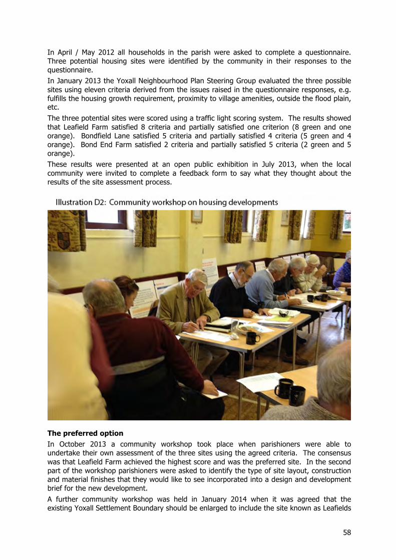
58
In April / May 2012 all households in the parish were asked to complete a questionnaire. Three potential housing sites were identified by the community in their responses to the questionnaire. In January 2013 the Yoxall Neighbourhood Plan Steering Group evaluated the three possible sites using eleven criteria derived from the issues raised in the questionnaire responses, e.g. fulfills the housing growth requirement, proximity to village amenities, outside the flood plain, etc. The three potential sites were scored using a traffic light scoring system. The results showed that Leafield Farm satisfied 8 criteria and partially satisfied one criterion (8 green and one orange). Bondfield Lane satisfied 5 criteria and partially satisfied 4 criteria (5 green and 4 orange). Bond End Farm satisfied 2 criteria and partially satisfied 5 criteria (2 green and 5 orange). These results were presented at an open public exhibition in July 2013, when the local community were invited to complete a feedback form to say what they thought about the results of the site assessment process.
The preferred option In October 2013 a community workshop took place when parishioners were able to undertake their own assessment of the three sites using the agreed criteria. The consensus was that Leafield Farm achieved the highest score and was the preferred site. In the second part of the workshop parishioners were asked to identify the type of site layout, construction and material finishes that they would like to see incorporated into a design and development brief for the new development. A further community workshop was held in January 2014 when it was agreed that the existing Yoxall Settlement Boundary should be enlarged to include the site known as Leafields
59
Farm, in order to make it clear where development would be permitted and where it would not be permitted over the plan period. The workshop also discussed the provision of a community car park near to the school and the church, which the developer of the Leafields Farm site would be asked to provide, and the aspirations of the local community for the housing development that would be provided on the preferred site.
Options identified by East Staffordshire Borough Council The Local Plan published by ESBC has allocated 40 dwellings to Yoxall as its contribution towards meeting the Borough’s housing needs for the period up to 2031. ESBC has produced Strategic Housing Land Availability Assessment [SHLAA] Reports for the following sites:
• Bond End Farm • Bondfield Lane • Browns Lane • Leafields Farm • Weaverlake Drive
All of the sites fall outside the Settlement Boundary although Leafields Farm, Bond End Farm and Bondfield Lane are contiguous with it and coincidently were the three principal sites identified by the villagers during consultations. Browns Lane and Weaverlake Drive were eliminated at an early stage because they are not contiguous with the Settlement Boundary and do not satisfy the constraints identified in the Yoxall Character Analysis (Appendix B).
Initial Options identified by villagers The Villagers in response to questionnaires independently identified three principle sites for new housing from the longer list of 5 sites.
The sites identified by the local community were:-
• Bond End Farm. • Bondfield Lane. • Leafields Farm [Dockseys Field]
In addition to the above certain windfall sites were identified and these are listed below. It is considered that these sites could accommodate up to a maximum of 10 dwellings in total:
• Lester’s Garage on the main road at Bond End. • Sudbury Road and King Street. • Town Hill. • Back Lane. • Hadley Street/Weaverlake Drive.
Testing the Initial Options
The community was actively encouraged to be involved in the testing and adjudicating of which sites would be most appropriate for development. A set of criteria were agreed and a traffic light system development to test each site and score it against the criteria. The site

60
assessment criteria were itemised in a proforma which was used to assess the 3 potential development sites – see below.
The following forums were held to test and critique the sites.
• Meeting held in the Committee Room of the Parish Hall on 27th January 2013. • Exhibition held on 12th and 13th July 2013. • Workshop held on 12th October 2013.
Arising out of this process Leafields Farm scored the highest and has been identified as the site most suitable for development. The results showed that Leafield Farm satisfied 8 criteria and partially satisfied one criterion (8 green and one orange). Bondfield Lane satisfied 5
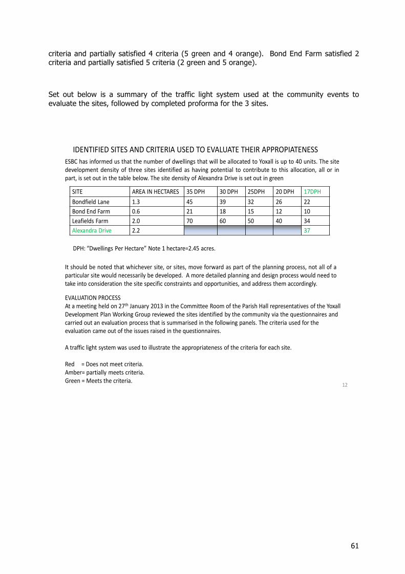
61
criteria and partially satisfied 4 criteria (5 green and 4 orange). Bond End Farm satisfied 2 criteria and partially satisfied 5 criteria (2 green and 5 orange).
Set out below is a summary of the traffic light system used at the community events to evaluate the sites, followed by completed proforma for the 3 sites.
12
SITE AREA IN HECTARES 35 DPH 30 DPH 25DPH 20 DPH 17DPHBondfield Lane 1.3 45 39 32 26 22Bond End Farm 0.6 21 18 15 12 10Leafields Farm 2.0 70 60 50 40 34Alexandra Drive 2.2 37
ESBC has informed us that the number of dwellings that will be allocated to Yoxall is up to 40 units. The sitedevelopment density of three sites identified as having potential to contribute to this allocation, all or inpart, is set out in the table below. The site density of Alexandra Drive is set out in green
IDENTIFIED SITES AND CRITERIA USED TO EVALUATE THEIR APPROPIATENESS
DPH: “Dwellings Per Hectare” Note 1 hectare=2.45 acres.
It should be noted that whichever site, or sites, move forward as part of the planning process, not all of aparticular site would necessarily be developed. A more detailed planning and design process would need totake into consideration the site specific constraints and opportunities, and address them accordingly.
EVALUATION PROCESSAt a meeting held on 27th January 2013 in the Committee Room of the Parish Hall representatives of the Yoxall Development Plan Working Group reviewed the sites identified by the community via the questionnaires and carried out an evaluation process that is summarised in the following panels. The criteria used for the evaluation came out of the issues raised in the questionnaires.
A traffic light system was used to illustrate the appropriateness of the criteria for each site.
Red = Does not meet criteria.Amber= partially meets criteria.Green = Meets the criteria.
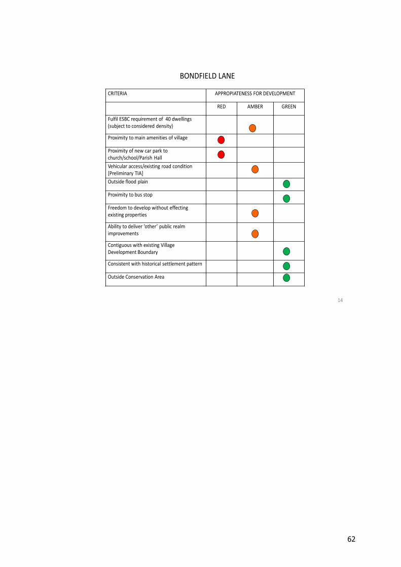
62
14
CRITERIA APPROPIATENESS FOR DEVELOPMENT
RED AMBER GREEN
Fulfil ESBC requirement of 40 dwellings(subject to considered density)
Proximity to main amenities of village
Proximity of new car park to church/school/Parish HallVehicular access/existing road condition [Preliminary TIA]Outside flood plain
Proximity to bus stop
Freedom to develop without effecting existing properties
Ability to deliver ‘other’ public realm improvements
Contiguous with existing Village Development Boundary
Consistent with historical settlement pattern
Outside Conservation Area
BONDFIELD LANE
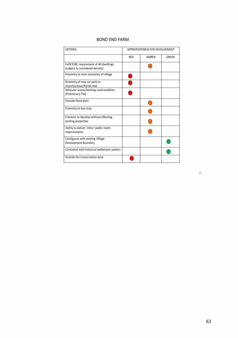
63
16
BOND END FARM
CRITERIA APPROPIATENESS FOR DEVELOPMENT
RED AMBER GREEN
Fulfil ESBC requirement of 40 dwellings(subject to considered density)
Proximity to main amenities of village
Proximity of new car park to church/school/Parish HallVehicular access/existing road condition [Preliminary TIA]
Outside flood plain
Proximity to bus stop
Freedom to develop without effecting existing properties
Ability to deliver ‘other’ public realm improvements
Contiguous with existing Village Development Boundary
Consistent with historical settlement pattern
Outside the Conservation Area
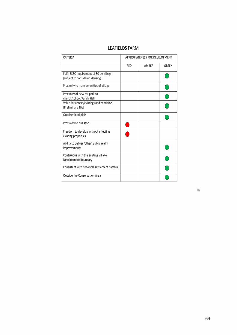
64
18
CRITERIA APPROPIATENESS FOR DEVELOPMENT
RED AMBER GREEN
Fulfil ESBC requirement of 50 dwellings(subject to considered density)
Proximity to main amenities of village
Proximity of new car park to church/school/Parish HallVehicular access/existing road condition [Preliminary TIA]
Outside flood plain
Proximity to bus stop
Freedom to develop without effecting existing properties
Ability to deliver ‘other’ public realm improvements
Contiguous with the existing Village Development Boundary
Consistent with historical settlement pattern
Outside the Conservation Area
LEAFIELDS FARM