
Washington Dulles International
Airport (IAD)
Noise Contour Map Update
For Publication on MWAA Website
April 4, 2018

2
Contents • Introduction
• Background – Existing Conditions
– Noise Contours
– Land Use Compatibility Planning
– Noise Contour Map Timeline
– Noise Contour Map Defined
• Existing Zoning Ordinances
• Transformation Since 1993
• Need For Noise Contour Map
• Dulles Airport – Global, National, Region
– Existing Conditions
– Growth Potential
• Aircraft Noise Overview
• Airport Environmental Decision Tool (AEDT)
• Roles and Responsibilities
• Next Steps

3
Purpose
• Update the Dulles Airport noise contour map to
incorporate changes in the aviation environment
so that the future vision reflects these changes.
- Flight tracks and overall utility of the airfield have evolved
- Evolution will continue with implementation of NextGen
- Flight procedures will soon allow for triple simultaneous runway
operations during low visibility conditions (IFR)

Introduction
4
Source: Google Earth (aerial photography); Loudoun
County Open Geospatial Data (noise overlay contours;
county boundary); Fairfax County Open Geospatial
Data (noise overlay contours; county boundary),
March 2018.
DNL 65
DNL 60
DNL 70
DNL 75
County Boundary
Legend
Note: Loudoun County does not use the DNL 70 and
75 contours to define their Aircraft Noise Impact
Overlay District. Loudoun County also applies a 1 mile
buffer around the DNL 60 contour line, which is not
depicted on the map.
Current IAD Aircraft
Noise Impact Overlay
District Contours

5
What is a DNL Noise Contour?
• DNL – Day-Night Average Sound Level
– Represents average noise for a 24-hour period
– Provides 10 dB weighting factor for nighttime (10:00 pm to 6:59
am) operations
• DNL Contour – a line representing equal DNL, similar to a
terrain contour representing equal elevation levels

6
Noise Contours
• Represent average annual noise rather than at a specific
moment or over a given day
• Highlight existing or potential areas of significant aircraft
noise exposure as defined by the FAA
• Assess the relative aircraft noise exposure of different
runway and/or flight corridor alternatives to compare
potential noise impacts of various alternatives
• Provide guidance for land use planners in the
development of land use control measures, such as
zoning ordinances, subdivision regulations, building
codes, and airport overlay zones

7
FAA Land Use Compatibility
Land Use
>65 65-70 70-75 75-80 80-85 Over 85
Residential (SFD, SFA, MFA) √
Public Use (schools) √ -25-30dB -25-30dB
Public Use (hospitals, nursing homes, churches, auditoriums and
concert halls)
√ -25dB -30dB
Public Use (transportation) √ √ √ -25dB √ -30dB √ -35dB √ -35dB
Public Use (parking) √ √ √ -25dB √ -30dB √ -35dB
Commercial Use (offices, business, professional, retail trade,
communication)
√ √ √ -25dB
√ -30dB
Commercial Use (wholesale, retail- building materials, hardware
and farm equipment, utilities)
√ √ √ -25dB √ -30dB √ -35dB
Manufacturing (general) √ √ √ -25dB √ -30dB √ -35dB
Manufacturing (livestock farming and breeding) √
Recreational (outdoor sports arenas and spectator sports) √ √ √
Recreational (outdoor music shells, amphitheaters) √
Recreational (amusements, parks, resorts and camps) √ √ √
Recreational (golf courses, riding stables and water recreation) √ √ √ -25dB √ -30dB
Yearly day-night sound level (Ldn) in decibels

8
Land Use Compatibility (Cont’d)

9
IAD Noise Contours and
Land Use Planning
• Aircraft noise, and its impact on regional communities,
was a primary consideration during the planning of the
airfield
• Long-range noise contours have been a resource and an
aid toward the development of compatible land use
• Land use planning based upon Potential Noise Contours
– Represent long-range development at IAD
– Account for maximum number of operations the runways can
accept

10
Noise Contour Map Timeline
• 1985: FAA (airport operator at the time) conducted and
completed a Title 14 Code of Federal Regulations (CFR)
Part 150 – not “accepted” or “approved”
– Loudoun and Fairfax Counties adopted the zoning overlay districts
based on the contours developed by MWAA.
• 1988: FAA Expanded East Coast Plan – changed
procedures and runway use at IAD
• 1990: Airport Noise and Capacity Act – require phase out
of older/louder Stage 2 aircraft weighing more than 75,000
pounds

11
Noise Contour Map Timeline
(continued)
• 1993: MWAA conducted a Noise Exposure Map (NEM)
update
– Calculated long range planning noise exposure contours –
“Potential Noise Exposure” reflecting an ultimate build scenario
– Loudoun and Fairfax Counties agreed to accept the Potential
Noise Exposure contours for Land Use Planning
• 2005: FAA prepared the new runways EIS

12
Noise Contour Map Defined
• The noise contour map will be developed based
on a potential scenario(s) which are encountered
during or at full-build of the Airport.

13
Noise Contour Map Timeline
(continued) 1985 Potential Noise Contours 1993 Potential Noise Contours

14
Fairfax and Loudoun County Zoning • Since 1985, Loudoun and Fairfax Counties have applied Potential
Noise Contours recommended by MWAA as a tool for effective land
use planning and zoning for long-term compatibility with IAD.
• IAD in partnership with Fairfax and Loudoun Counties is often used as
a model for effective planning and zoning related to compatible
development for the aerotropolis concept.
• Other major airports, such as DFW, were built in less-populated areas
but over time became surrounded by more dense population.
• Several airports are using an approach similar to IAD and the
surrounding communities to prevent residential incompatibility:
– Portland International Airport
– Orlando International Airport
– Phoenix-Mesa Gateway Airport

15
Loudoun County Zoning
• Established the Airport Impact
Overlay District in 1993
• Recognized as a national leader in
airport-compatible land use
planning for adopting its Airport
Impact Overlay District
• Uses IAD Potential Noise Contours
calculated for the full-build 5
runway layout to define the Airport
Impact Overlay District.
Source: Loudoun County, Virginia, Zoning Ordinance, AI-Airport Impact Overlay District § 4-1400.

16
Loudoun County Zoning (continued)
Residential Limitations:
– Areas outside of, but within one (1) mile of the DNL 60:
Disclosure statement that the home is located within an area that
will be impacted by aircraft overflights and aircraft noise.
– Areas between the DNL 60-65 aircraft noise contours:
• Disclosure statement that the home is located within an area that will
be impacted by aircraft overflights and aircraft noise.
• Incorporate acoustical treatment into all dwelling units to ensure that
interior noise levels within living spaces do not exceed DNL 45.
• Prior to issuing a zoning permit for a residential lot, owner(s) of such
parcel(s) shall dedicate an avigation easement to MWAA, indicating
the right of flight to pass over the property, as a means to securing the
long-term economic viability of IAD.
Source: Loudoun County, Virginia, Zoning Ordinance, AI-Airport Impact Overlay District § 4-1400.

17
Loudoun County Zoning (continued)
Residential Limitations (continued):
– Areas of DNL 65 or higher aircraft noise contours:
• Residential units are not permitted, however;
• New dwelling units and additions to existing may be permitted
provided:
– lot was recorded or had record plat approval prior to the effective date of
adoption of this Ordinance
– new dwelling unit or addition complies with the acoustical treatment
requirements for residential districts set forth in the Virginia Uniform
Statewide Building Code.
– No building or other structure shall be located in a manner or built
to a height which constitutes a hazard to aerial navigation.
Source: Loudoun County, Virginia, Zoning Ordinance, AI-Airport Impact Overlay District § 4-1400.

18
Loudoun County Zoning (continued) • Envision Loudoun: A New Comprehensive Plan that will serve as Loudoun
County government’s guiding document for land use for the foreseeable future

19
Fairfax County Zoning
• Updated the Airport Impact Overlay
District in 1993 based on largest
extents of the amended FAR Part
150 Study and the potential post
2000 noise contours
• Uses airport impact overlay to
define construction requirements
for new residential units
• Provides compatibility table for
different types of uses
Source: Fairfax County, Virginia, Zoning Ordinance, Airport Noise Impact Overlay District § 7-400.

20
Fairfax County Zoning (continued)
Residential Limitations:
– Areas between the DNL 65-70 aircraft noise contours:
Permitted only with acoustical treatment to achieve interior noise levels
within living spaces that do not exceed DNL 45.
– Areas between the DNL 70-75 aircraft noise contours:
Permitted only with acoustical treatment to achieve interior noise levels
within living spaces that do not exceed DNL 45.
– Areas within the DNL 75 aircraft noise contours:
• New units: Not permitted.
• Additions to existing units and new units on certain lots: permitted only
with acoustical treatment to achieve interior noise levels within living
spaces that do not exceed DNL 45.
Source: Fairfax County, Virginia, Zoning Ordinance, Airport Noise Impact Overlay District § 7-400.

21
Fairfax County Comprehensive Plan
• Fairfax County’s Comprehensive Plan includes land use
compatibility guidelines, and is used to establish the basis
for land use decisions within the designated Dulles Airport
Noise Impact Area.
• Areas with projected aircraft noise exposures exceeding
DNL 60 according to the Dulles Airport Noise Impact Area
are not recommended.
• Where new residential development does occur near
Washington Dulles International Airport, disclosure
measures should be provided.
• No structure shall be located in a manner or built to a
height which constitutes a hazard to aerial navigation.
Source: Fairfax County. Fairfax County Comprehensive Plan. “Land Use Planning within the Dulles Airport Noise Impact Area.” 2017 Edition. Amended through 3/14/2017. Pages 19-23.

22
Fairfax County Dulles Suburban Center Study • A land use planning study that will update recommendations for future land
uses and development

23
Transformation Since 1993
• 2002: FAA Potomac Terminal Radar Approach Control
(TRACON) Consolidation
• 2005: FAA IAD New Runways EIS (proposed Runway 1L-
19R relocation from 3,400’ to 4,300’ from 1C-19C)
• 2005: Airport Begins Acquiring 800 ac. Of Additional
Property
• 2008: Runway 1L-19R opened
• 2009: NextGen Area Navigation GPS
Approaches/Departures Implemented
• 2014: FAA Washington, DC Metroplex Area Navigational
Procedures
• 2017: FAA Begins Implementation Of Triple Simultaneous
Arrival/Departure During IFR conditions

24
2005 FAA EIS – Potential Aircraft Noise
Contour 2025 Alternative 3 Noise Contours compared to Loudoun/Fairfax County Noise Overlays

25
Transformation Since 1993
(continued)
Fleet Mix:
• Up-gauging of aircraft (e.g., from 50-seat regional jets to
70- and 90-seat aircraft, from 90-seat regional jets to 737
and A-320 aircraft)
• Introduction of very large aircraft (e.g., Airbus 380 and
Boeing 747-800)
• Increasing percentage of quieter Stage 4 models in the
fleet mix
• Cargo operations and facilities grow

26
Transformation Since 1993
(continued)
• Future Enhancements: – Simultaneous triple parallel runway approaches during low visibility
conditions or Instrument Meteorological Conditions (IMC) at IAD
– Wake turbulence separation reduction
– Equivalent Lateral Spacing Operations (ELSO)
– Required Navigation Performance (RNP) based procedures

27
Noise Contour Map Update
Need
• Incorporate changes since the 1993 update
critical to the region and the Airport – Significant Tool The Airport Uses To Assist Local Governments
With Their Off-Airport Land Planning and Zoning Decisions
• Continue to ensure compatibility between
the Airport and local jurisdictional land use

28
Changes to Incorporate
• New FAA procedures allow for simultaneous use of triple
parallel runways during low visibility conditions
• Flight tracks due to NextGen enhancements
• Capacity improvements due to NextGen
• Airfield layout
• Changes in forecast Airport development related aircraft
activity

29
1970
1980
1990
2000
2010
2020
2030
2040
1970
1980
1990
2000
2010
2020
2030
2040
1970
1980
1990
2000
2010
2020
2030
2040
1970
1980
1990
2000
2010
2020
2030
2040
1970
1980
1990
2000
2010
2020
2030
2040
1970
1980
1990
2000
2010
2020
2030
2040
1970
1980
1990
2000
2010
2020
2030
2040
1970
1980
1990
2000
2010
2020
2030
2040
Regional Population Growth - 2040

30
Regional Population Growth - 2045
Source: Table 3 and Figure 5 exert from Metropolitan Washington Council of Governments. Growth Trends to 2045-Cooperative Forecasting in
Metropolitan Washington. November 2016.

31
Regional Population Forecasted Growth
by Jurisdiction
Source: Figure 14 and 15 exert from Metropolitan Washington Council of Governments. Growth Trends to 2045-Cooperative Forecasting in Metropolitan Washington. November 2016.
Jurisdictions served by IAD based on Metropolitan Washington Council of Governments. Washington-Baltimore Regional Air Passenger Survey Geographic Findings – 2015. November
2016.
Counties/Cities served by IAD

32
IAD Air Service Growth in Region
Source: Presentation from Metropolitan Washington Airports Authority, Office of Air Service and Planning. 2015 Air Service
Development Industry and Community Briefing. November 2014.

33
IAD Air Service Growth in Region
New Domestic Service in 2018
April 3: Twice daily service to Shenandoah Valley, VA.
April 4: Three times weekly service to Greenbrier, WV.
April 9: Twice daily service to Wilmington, NC.
All on 50 seat regional jets.
April 8: Resume seasonal daily nonstop service to
Colorado Springs on a 150 seat Airbus A319 & Denver
on a 180 seat Airbus A320.
April 11: Starts twice weekly service to Tulsa, OK on a
150 seat Airbus A319

34
IAD Air Service Growth in Region
New International Service in 2018
June 10: Will start to operate its third daily flight on a
year-round basis using a 154 seat Boeing 737.
May 17: Twice weekly service from Dulles International to
San Salvador, El Salvador with continuing service to San
Jose, Costa Rica on a 144 seat Airbus A319.
September 16: Four weekly flights between Dulles
International and Hong Kong on a 334 seat Airbus A350.
May 1: Starts additional daily flight to Montreal, Canada
on a 50 seat regional jet.
August 22: Five times weekly service from Dulles
International to London, Stansted Airport on a 200 seat
Airbus A321
May 23: New seasonal daily service to Edinburgh,
Scotland on a 169 seat Boeing 757.

35
Major Surface Access Improvements In
Vicinity of IAD
Source: Roadway improvements based on Virginia Department of Transportation, accessed March 31, 2018. http://www.virginiadot.org/projects/northern%20virginia/default.asp.
North-south corridor based on State of Virginia, Office of Intermodal Planning and Investment. Northern Virginia North-South Corridor. Accessed 4/2/2018.
http://www.vtrans.org/northern_virginia_north-south_corridor.asp. Bi-County Parkway based on Virginia Department of Transportation. Bi-County Parkway Aerial Maps for
Community Meetings. Accessed 4/2/2018. http://www.virginiadot.org/projects/resources/NorthernVirginia/Bi_County/BCP_AerialMapsforCommunityMtgs_08142013.pdf. Silver
Line Phase 2 based on Silver Line rail map accessed March 31, 2018. http://dullesmetro.com/silver-line-stations/.
Silver Line – Phase 2
Route 50 Widening
Loudoun Co. Pkwy/Old Ox Rd Widening
Loudoun Co. Pkwy Expansion
N. Virginia North-South Corridor

36
Dulles Airport
On-Airport Land Use

37
Dulles Airport
Capital Improvement Program

38
Dulles Airport
Primary Runway Operating Configurations
North Flow South or Mixed Flow
Source: Ricondo and Associates, Inc., based on based on Washington Dulles
International Airport Air Traffic Control Tower, November 2009; and based on
FAA AL-5100, Airport
Diagram, 17 DEC 2009.
Source: Ricondo and Associates, Inc., based on based on Washington Dulles
International Airport Air Traffic Control Tower, November 2009; and based on
FAA AL-5100, Airport
Diagram, 17 DEC 2009.
Secondary Departures Secondary Departures

39
Dulles Airport
Traffic Patterns
North Flow South or Mixed Flow
Source: “Dulles International - Aircraft Procedures & Guidelines.” Metropolitan Washington Airport Authority. Accessed
March 28, 2018. http://www.flydulles.com/iad/dulles-international-aircraft-procedures-guidelines. Source: “Dulles International - Aircraft Procedures & Guidelines.” Metropolitan Washington Airport Authority. Accessed
March 28, 2018. http://www.flydulles.com/iad/dulles-international-aircraft-procedures-guidelines.
Arrivals
Departures
Arrivals
Departures

40
Dulles Airport
Air Service Domestic Destinations

41
Dulles Airport
Air Service Domestic Destinations

Dulles Airport
Air Service International Destinations
Source: Innovata Airline Schedules (February 2018 – January 2019), via Diio MI Online Portal as of February 5, 2018.

43
Dulles Airport
Air Service International Destinations

44
Aircraft Noise Overview – Noise
Terminology
• A-Weighted Decibel, dBA
• Maximum A-Weighted Sound Level, Lmax
• Sound Exposure Level, SEL
• Equivalent Sound Level, Leq
• Day-Night Average Sound Level, DNL

45
Aircraft Noise Overview – A-Weighted
Sound Level
• The human auditory system is not equally sensitive to all
frequencies
• To be a useful environmental analysis tool we need a
way to measure sound the same way the ear hears it
• The A-weighted sound level
achieves this goal
• Correlates well to human
perception of noisiness
• The EPA has adopted the
A-weighted sound level for
environmental analyses

46
Aircraft Noise Overview – Maximum
Sound Level (Lmax)
• Because of the variation in
level of a sound event, it is
often convenient to describe
the event with its maximum
sound level, abbreviated as
Lmax
• Accounts only for sound
amplitude
(A-weighted sound level)
• Two events may have the
same maximum level, but
much different exposures
47
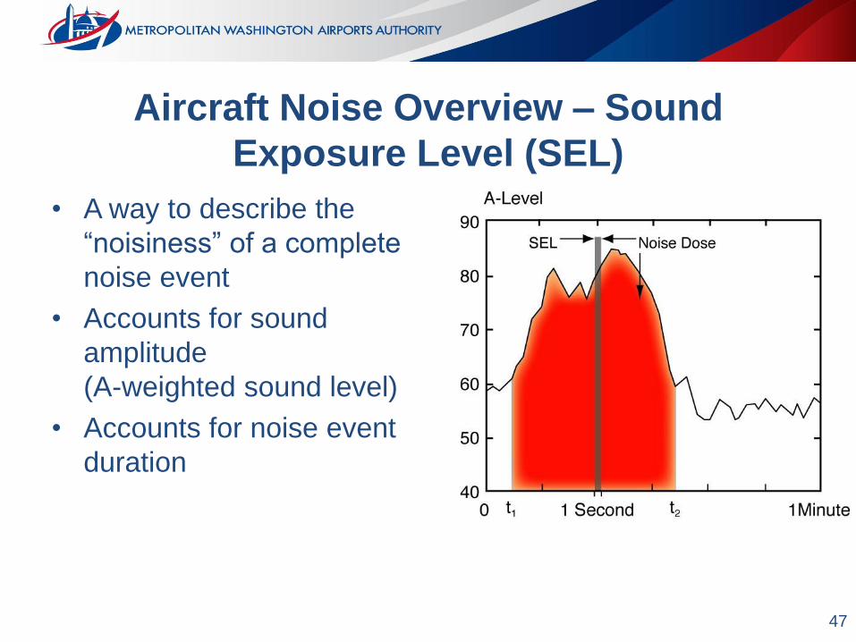
Aircraft Noise Overview – Sound
Exposure Level (SEL)
• A way to describe the
“noisiness” of a complete
noise event
• Accounts for sound
amplitude
(A-weighted sound level)
• Accounts for noise event
duration

48
Aircraft Noise Overview – Equivalent
Sound Level (Leq)
• A constant sound level
“equivalent” on an energy
basis of a time varying
sound level over the same
time period
• Leq is time-averaged
• Accounts for sound
amplitude and time

49
Aircraft Noise Overview – Day/Night
Average Noise Level (DNL)
• A way to describe the noise dose
for a 24-hour period
• Accounts for noise event
“noisiness” (SEL)
• Accounts for number of noise
events
• Provides an additional weighting
factor of 10 dB for nighttime
(10:00 pm to 6:59 am) operations
– 1 nighttime noise event is equivalent
to 10 daytime noise events

50
Aircraft Noise Overview - How is Aircraft
Noise Quantified?
• FAA specifies DNL metric to assess aircraft noise impacts
– Title 14 CFR Part 150, Airport Noise Compatibility Planning
– FAA Order 1050.1F, Environmental Impacts: Policies and
Procedures
• Environmental Protection Agency (EPA) specified DNL for
community noise and airport noise assessments
• DNL accounts for higher sensitivity to noise in the
nighttime
• Found to correlate with percentage of highly annoyed by
transportation noise

51
Aircraft Noise Overview - How is Aircraft
Noise Quantified?
• DNL calculated based on average annual day operations
(AAD)
• AAD represents the average aircraft operations and
patterns that occurred over a consecutive 12-month period
– Accounts for all operations and patterns and the frequency of
occurrence within 12 months
– Accounts for average weather conditions within 12 months
• DNL is calculated using the FAA’s aircraft noise mode
AEDT

52
AEDT Overview
Background
• The Aviation Environmental Design Tool (AEDT)
– Version 2d was released in September 2017
– Replaced
• Integrated Noise Model (INM – airport noise)
• Emissions and Dispersion Modeling System (EDMS)
• AEDT version 2b / Noise Integrated Routing System (NIRS)
– FAA tool for computation of
• Noise
• Emissions
• Air Quality
• Fuel Burn


